Alternatives Analysis Report and Remedial Action Work Plan · i report table of contents...
54
ALTERNATIVES ANALYSIS REPORT & REMEDIAL ACTION WORK PLAN BROWNFIELDS CLEANUP PROGRAM for 132 DINGENS ST., BUFFALO, NY (Site #: C915263) FEBRUARY 2015 (REVISED) Prepared for 132 Dingens St, LLC Buffalo, NY by Iyer Environmental Group, PLLC Orchard Park, NY 14127
Transcript of Alternatives Analysis Report and Remedial Action Work Plan · i report table of contents...

ALTERNATIVES ANALYSIS REPORT
&
REMEDIAL ACTION WORK PLAN BROWNFIELDS CLEANUP PROGRAM
for
132 DINGENS ST., BUFFALO, NY
(Site #: C915263)
FEBRUARY 2015 (REVISED)
Prepared for
132 Dingens St, LLC
Buffalo, NY
by
Iyer Environmental Group, PLLC
Orchard Park, NY 14127

i
REPORT TABLE OF CONTENTS
ALTERNATIVES ANALYSIS REPORT & REMEDIAL ACTION WORK PLAN
BROWNFIELDS CLEANUP PROGRAM 132 Dingens St. Site, Buffalo, NY
Page 1. Introduction ........................................................................................................ 1 2. Site Description and History .............................................................................. 1 3. Nature and Extent of Contamination ................................................................. 2 4. Remedial Action Areas and Volumes ................................................................ 4 5. Standards, Criteria and Guidance (SCGs) ........................................................ 5 6. Remedial Action Objectives .............................................................................. 6 7. Alternatives Analysis Report ............................................................................. 7
7.1 Development of Alternatives ..................................................................... 7 7.2 Individual Evaluation of Alternatives ......................................................... 10
7.2.1 S1, No Action .............................................................................. 10 7.2.2 S2, Institutional Action ................................................................. 11 7.2.3 S3, Containment/Capping ........................................................... 12 7.2.4 S4, Hot Spot Excavation/Off-site Disposal & Capping ................ 13 7.2.5 S5, High Level Excavation/Off-site Disposal ............................... 14 7.2.6 S6, Complete Excavation/Off-site Disposal ................................. 15
7.3 Analysis of Alternatives ............................................................................ 16 7.4 Summary of Alternatives Analysis ............................................................ 18
8. Proposed Remedial Action Work Plan ............................................................. 19 8.1 Description of Remedy ............................................................................. 19
8.2 Mobilization and Staging ...................................................................... 20 8.3 Soil Excavation, Off-Site Disposal and Confirmatory Sampling ............... 20 8.4 Excavation Water Treatment and Disposal .............................................. 21 8.5 Backfill ...................................................................................................... 21 8.6 Cover System ........................................................................................... 21 8.7 Vegetation and Restoration ...................................................................... 22 8.8 Health & Safety Plan ................................................................................ 22 8.9 Reporting .................................................................................................. 22 8.10 Schedule ................................................................................................... 22
9. Institutional Controls .......................................................................................... 22 10. Site Management Plan (SMP) ........................................................................... 22 11. References ........................................................................................................ 23 FIGURES 1. Site Location Map 2. Aerial Photo with Property Boundary 3. A. Surface Soil Samples - SVOCs/Metals Exceeding SCOs
B. Soil Samples at 0’ to 4’ - SVOCs/Metals Exceeding SCOs C. Soil Samples at 4’ to 12’ - SVOCs/Metals Exceeding SCOs D. All Soil Samples – PCBs Exceeding SCOs
4. Soils Exceeding Proposed Excavation Threshold Limit 5. Hot Spot Excavation Areas & Surface Features

ii
DRAWING 1. Site Topo and Layout TABLES
1. Parameters of Concern
2. A. Analytical Data Statistics – Test Pit & Geoprobe Soils (All Samples) B. Analytical Data Statistics – Test Pit & Geoprobe Soils (Excl. Outlier)
3. Nature/Extent of Soil Contamination and Cleanup Quantities
4. Capital & Annual O&M Cost Estimates for Remedial Alternatives A. S2 - Institutional Action B. S3 - Containment/Capping C. S4 - Hot-spot Excavation/Off-site Disposal & Capping D. S5 - High Level Excavation/ Off-site Disposal & Capping E. S6 – Complete Excavation/ Off-site Disposal
5. Remedial Alternatives Cost Summary
APPENDICES A. Geologic Cross-sections

IEG/132 Dingens St. Site – AAR/RAWP Page 1
ALTERNATIVES ANALYSIS REPORT & REMEDIAL ACTION WORK PLAN
BROWNFIELDS CLEANUP PROGRAM 132 DINGENS STREET SITE, BUFFALO, NY
February 2015
1.0 INTRODUCTION This Alternatives Analysis Report (AAR) and Remedial Action Work Plan (RAWP) follows up on the Remedial Investigation (RI, see Report dated January 2014) completed by Iyer Environmental Group PLLC (IEG) for the 132 Dingens St. Site located in Buffalo, NY. This AAR identifies alternatives for the Site based on the results of the RI, and evaluates the effectiveness of each with respect to the criteria established in the NYSDEC’s DER-10 technical guidance document. The RAWP provides details on recommended remedial action for the Site. 2.0 SITE DESCRIPTION AND HISTORY This irregular shaped, 13-acre parcel located at 132 & 136 Dingens Street (see location on Figure 1) contained an 85,000-sf manufacturing and warehouse facility which burned down in a 2010 fire (see aerial photo on Figure 2), leaving behind only the foundation. The existing site topography and layout are shown on Drawing 1. This Site was used for food storage and distribution dating back to 1966. Most recently, one half of the warehouse was used for warehousing/distribution of household/office trash containers, and the other half for recycling and refurbishing wood pallets. An ammonia refrigeration system located in the pump-house building in the northwest section provided cold storage for the food warehouse. The property was previously also used for a fuel service station. Historically there had been numerous petroleum tanks, both above ground and below ground dating back to the 1930s. The warehouse also had pad-mounted transformers outside. The Site is surrounded by commercial properties and is zoned as such. The debris from the warehouse fire was cleared by Pinto Construction Services. During the course of the BCP remedial investigation, Pinto continued to remove old refrigeration equipment from the pump-house building and pad-mounted transformers outside, and process them for recycling. Drums containing various chemicals were also properly disposed off-site. The Site with its one remaining building is secured by a chain link fence surrounding the paved areas. Half the space in the pump-house building is currently rented out to a commercial business. The ground surface slopes gently to the south, and surface water runoff from the Site is directed to numerous storm catch basins throughout the paved parking areas that discharge into the City of Buffalo’s municipal sewer system. The Site and its surrounding area contained numerous rail lines and yards dating back to 1917, and this area was built up to its current grade with various types of industrial fill. Soils on the Site are mapped by the Soil Conservation Service as “Urban Land” which can typically contain fill materials with little native soil conditions remaining. The nature

IEG/132 Dingens St. Site – AAR/RAWP Page 2
of the subsurface materials at the Site is shown on the geologic cross-sections in Appendix A. No sensitive ecological receptors were identified in and around the Site. Potable water is supplied from Lake Erie by the City of Buffalo, and there are no drinking water wells in the area. The groundwater table is approximately 7 to 10 feet below ground surface. The local regional groundwater flow is generally to the south toward the Buffalo River, although extensive past construction activities in the area may have significantly altered localized groundwater flow patterns. 3.0 NATURE AND EXTENT OF CONTAMINATION Previous investigations at the Site included the following:
Two Phase I ESAs (1997 by Acres International, and 2004 by Kay Ver Group) Two Phase II ESAs (2004 by Baron Associates, and 2011 by IEG). Remedial Investigation (2012/2013 by IEG)
The 2011 Phase II ESA and the 2012/2013 RI field work by IEG included:
Collected soil samples from seventeen (17) test pit locations across unpaved, vegetated areas of the Site
Collected soil samples from thirty one (31) borings,
Installed permanent monitoring wells at eight (8) soil boring locations and developed them for sampling
Analyzed soil samples from the test pits and borings for VOCs, SVOCs, PCBs, pesticides, total cyanides, TCLP lead, and landfill parameters.
Completed two rounds of groundwater sampling at the eight monitoring wells and analyzed the samples for VOCs, SVOCs, PCBs, pesticides, metals and total cyanides
Sampled and analyzed the contents of the chemical drums and transformer oil for disposal
Sampled and pumped out water accumulated in the underground tunnel connecting between the pump-house and the old warehouse building
The site investigations revealed various types of industrial type fill that was used to elevate the ground surface to its present grade in and around the Site. The fill includes randomly deposited heterogeneous materials, construction debris (bricks, concrete and wood), trash (rubbish, glass and paper), oil soaked materials and sludge. The fill is underlain by various types of natural soils (clay, silt, sand and gravel). The thickness of the fills ranged from four feet along the southeastern boundary to twenty feet along the northern boundary. The bulk of the contamination appears to be limited to the industrial fill material, while the underlying natural soil (clay, silt) appears to be minimally impacted. The highest levels of soil contamination exceeding SCOs for restricted commercial and industrial use appear to be in vegetated areas along the northern property boundary and the eastern section. Elevated levels were also found in the old UST area just northeast of the warehouse foundation. Relatively lower levels of contamination were

IEG/132 Dingens St. Site – AAR/RAWP Page 3
found in the paved areas surrounding the old warehouse foundation, and even lower along the southeastern property boundary Volatile organics, pesticides and cyanide were found only at trace levels and are therefore not of significance at this Site. No petroleum compounds of significance was found in any of the soil samples, even in the paved area northeast of the old building foundation that was the location of petroleum USTs. Groundwater does not appear to be adversely impacted at the Site. Filtered groundwater samples from the first round and unfiltered samples from the second round were found to have only trace levels of semivolatile organics and heavy metals typical of the area. These findings indicate that the site contaminants are not readily leaching from the fill materials into the groundwater. Of greater significance for this Site is widespread soil contamination with several semi-volatile compounds, PCBs and a few heavy metals, which are typically associated with the industrial type fill material making up the top four to twenty feet of the subsurface. The distribution of SVOCs and metals in soil exceeding SCOs is shown on Figures 3A, 3B and 3C for surface, 0’ to 4’ interval and 4’ to 12’ interval. The distribution of PCBs in soil samples is shown on Figure 3D. Table 1 lists the parameters of concern and their range of concentrations from the remedial investigation, along with Part 375 commercial/industrial use SCOs. Six SVOC compounds, two PCBs and seven heavy metals exceed either just their corresponding commercial use SCOs or also the industrial use SCOs. Semivolatile organics are present at a wide range of concentrations (35 to 7,163 mg/Kg total SVOCs) in the fill layer. SVOC exceedances of the Part 375 restricted commercial/industrial use SCOs occur predominantly in subsurface soils in the northern unpaved areas, with the highest SVOC concentrations found in two samples in the northwest portion of the Site. PCBs, with totals ranging from 0.077 to 59 mg/Kg, were found mostly in surficial soils. Exceedances of the SCOs for PCBs occurred only in the northwest unpaved area of the Site, including one location with the highest PCB contamination. The distribution of heavy metals in the soil is typical of industrial fill. Barium, copper and nickel represent heavy metals with exceedances of the Part 375 SCOs for restricted commercial use, while arsenic, lead, zinc and mercury also exceeded the industrial use SCOs. Among the heavy metals, lead is of primary concern because of potential exceedance of the RCRA Toxicity Characteristic Leaching Procedure (TCLP) limit at high concentrations. The data indicates that lead is not readily leachable from the fill material, and that only soil containing around 5,000 mg/Kg or more total lead has the likelihood of exceeding the TCLP limit of 5 mg/L. The qualitative human health risk assessment identified dermal contact, ingestion and inhalation as the pathways for human exposure to contaminated soil at the Site under current/future conditions. Human exposure to the soil contaminants is limited because a relatively large area of the Site is paved, site access is restricted by security fencing, and the unpaved areas are mostly vegetated.

IEG/132 Dingens St. Site – AAR/RAWP Page 4
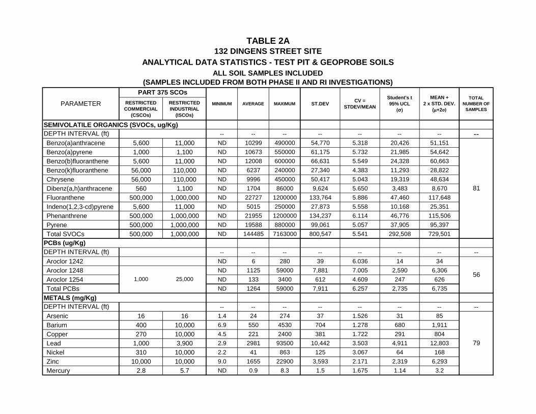
4.0 REMEDIAL ACTION AREAS AND VOLUMES As seen on Figures 3A, 3B and 3C, the vegetated areas in the northern and eastern portions of the Site have widespread subsurface soil contamination with SVOCs and heavy metals, largely associated with past industrial waste disposal practices. The Site and the surrounding area have been built up on this fill material that extends from four to twenty feet below ground surface. Nearly all the samples in the vegetated areas have exceedances of the commercial/industrial use SCOs for SVOCs and heavy metals. PCB exceedances are limited to a small area in the northeast corner. Any remedy to meet the Track 2 restricted commercial/industrial use SCOs would have to target significantly large quantities of fill at the Site. Track 4 restricted commercial/industrial use scenario could instead be considered. A remedial action alternative targeting significantly impacted materials and a soil cover meeting commercial/industrial use requirements would fall under this scenario. A statistical analysis was performed on the analytical data using the USEPA’s ProUCL software (version 5.0). The software was used to calculate the 95% statistical upper confidence limits (95% UCL) based on soil analytical data from the Phase II and RI investigations and sample size for individual parameters of concern in Table 1. Statistical parameters calculated based on the ProUCL methodology is presented in Table 2A (using all samples) for all parameters of concern listed in Table 1, and in Table 2B (excluding outliers) for selected parameters. In calculating the statistical parameters in Table 2B, four samples are excluded as outliers due to contaminant concentrations significantly higher than the rest of the sample set: TS-5 is considered an outlier because SVOC compounds are orders of magnitude higher than the rest of the sample set; TS-9 because of lead; TS-13 because of arsenic; and TS-15 because of PCBs. Proposed excavation threshold limits (PETLs) are developed for this Site based on the distribution of the parameters of concern across the Site, the feasibility of removing all soil exceeding the PETLs and intended Site use. All the parameters of concern listed in Table 1 are widespread across the site and are typically associated with the type of industrial fill used at this Site and the surrounding area. The proposed PETLs should be at levels that allow for the removal of meaningful quantities of contaminated soil/fill SVOCs and yet be protective of human health and the environment. For remediation of this Site to Track 4 SCOs, PETLS are proposed in Table 2B for Total SVOCs, PCBs, arsenic, lead and mercury. Barium, copper and nickel are below their corresponding ISCOs in all soil samples, while zinc exceeds its SCO in only 3 samples. The recommended soil cleanup level of 500 mg/Kg for total PAHs in the NYSDEC’s CP-51 Soil Cleanup Guidance is proposed as the PETL for SVOCs. For arsenic, the proposed PETL of 79 mg/Kg is the mean plus two standard deviations (excluding the outlier). In the case of lead, a soil cleanup level of 5,000 mg/Kg is proposed as the PETL for lead, based on a correlation between total lead and TCLP lead, instead of a statistically determined value. The PETL of 5.7 mg/Kg for mercury is set at its ISCO. Sample locations with SVOCs, PCBs, arsenic, lead or mercury exceeding their corresponding PETLs are listed in Table 2B. Dropping the

IEG/132 Dingens St. Site – AAR/RAWP Page 5
outliers did not seem to affect the PETLs much in that the number of samples exceeding one or more PETLs did not change significantly. A total of twelve one (12) sample locations (and 14 individual samples) were identified as having one or more exceedances of the PETLs for SVOCs, PCBS, arsenic, lead or mercury. These locations are listed in 2B, and highlighted on Figure 4 with tabulated data for individual locations that show PETL exceedance in one or more samples (some locations have multiple samples by depth). Of these soil sample locations, only two (2) locations have exceedances of the PETL for Total SVOCs and two (2) locations exceed the PETLS for PCBs. Five (5) locations exceed lead PETL, while arsenic and mercury PETLs are exceeded at two and three locations respectively. Only three locations exceed PETLs for two parameters. Figure 5 shows the different areas of the Site based on surface features and contamination levels, as well as proposed hot spot areas that warrant excavation due to PETL exceedances. The physical dimensions of these areas and the location of soil samples with exceedances of the PETLs were used to calculate the volumes of significantly impacted fill. Table 3 presents these volumes by area and the types and degree of PETL exceedance. In addition, Table 3 also includes estimated volumes for remedies that call for the excavation of high levels of soil contamination or for the excavation of all industrial fill identified as part of this investigation. 5.0 STANDARDS, CRITERIA AND GUIDANCE (SCG) Site investigation and remediation is being conducted through the Brownfields Cleanup Program, and is subject to requirements under 6 NYCRR Part 375 and DER-10 guidelines. The NYSDEC has established goals for acceptable contamination levels in soils based on a combination of human health risk factors and potential groundwater impacts. These goals are applicable when considering the need for a remedial measure at contaminated sites. Soil SCGs: The Brownfield Cleanup Program provides for a multi-track approach to the remediation of soil contamination. The NYSDEC has developed tables of soil cleanup goals from four tracks ranging from unrestricted use (Tracks 1) to different degrees of restricted use (Tracks 2, 3 and 4). The intent of this remedial effort is to clean up this property to Track 4 restricted commercial/industrial use. Any excavation and off-site disposal of the contaminated soils would be compliant with the Resource Conservation and Recovery Act (RCRA), the Toxic Substances Control Act (TSCA) and all other applicable regulations. Groundwater SCGs: The Site groundwater is not used as a primary source of drinking water. The groundwater results are compared to the NYSDEC’s Part 703 Groundwater Quality Standards. Based on the results from eight monitoring wells across the site, groundwater does not appear to be adversely impacted by the fill material. Site-related contaminants are at trace levels in the groundwater with marginal exceedance of a few metals. Action-Specific SCGs: Action-specific SCGs are technology or activity based requirements during remedy implementation. Potential remedial activities for this Site include excavation of soil/fill exceeding SCOs, off-site disposal as solid or hazardous

IEG/132 Dingens St. Site – AAR/RAWP Page 6
waste depending on the chemical constituents, and backfill/restoration. These activities have to comply with New York State Land Disposal regulations (6 NYCRR 376), RCRA Treatment, Storage and Disposal Requirements (40 CFR Parts 262 and 264), OSHA regulations (29 CFR Parts 1904, 1910 and 1916), New York State Air Pollution Control regulations (6 NYCRR Chapter 3, Part 212), and Department of Transportation rules for transport of hazardous materials (49 CFR Parts 107, 171 and 712). 6.0 REMEDIAL ACTION OBJECTIVES Remedial action objectives (RAOs) are media specific and are established to protect human health and the environment. The goal for remedial actions undertaken pursuant to NYSDEC’s DER-10 Technical Guidance is the restoration of the Site to pre-disposal/pre-release conditions to the extent feasible and authorized by law. At a minimum, the remedy should eliminate or mitigate all significant threats to public health and the environment presented by contaminants at the Site through the proper application of scientific and engineering principles. The RAOs for the Site are established by:
a) Identifying contaminants exceeding applicable SCGs and the environmental media impacted by these contaminants;
b) Identifying applicable SCGs taking into consideration the current and, where
applicable, future land use for the Site; c) Identifying the actual or potential public health and/or environmental
exposures resulting from contaminants in environmental media at, or impacted by, the Site; and
d) Identifying site-specific cleanup levels
The nature and extent of soil contamination is shown in Table 3 with associated quantities. Soil is the primary contaminated medium identified at the Site, with the potential to impact the underlying groundwater. The Site is currently vacant except for a commercial business renting one half of the old pump-house building. The area is surrounded by commercial properties. Groundwater is not adversely impacted at the Site and does not require long term monitoring. Taking these and the exposure assessment into consideration, the following RAOs are established for this Site:
Prevent ingestion/direct contact with contaminated soil Prevent inhalation of or exposure to contaminants in soil
Meet Track 4 Soil SCOs for restricted commercial use Prevent potential migration of contaminants that would result in
groundwater contamination

IEG/132 Dingens St. Site – AAR/RAWP Page 7
7.0 ALTERNATIVES ANALYSIS REPORT 7.1 Development of Alternatives Remedial alternatives are developed herein based on available technologies and processes which, when combined, would achieve the remediation goals for the Site. Semivolatile organics, PCBs and heavy metals are the contaminants of concern at the Site. It is anticipated that the property would be redeveloped after remediation with at least a new multi-story building over the existing foundation for restricted commercial/industrial use. The existing pump-house building has already been cleaned and partly rented to a commercial business, and would be fully renovated for future use. Soil treatment technologies are not considered technically and/or economically feasible options given the relatively large size of the property, the relatively large volume of the industrial type fill that occupies the Site and the surrounding area, the nature of the contaminants of concern and the intended future use. Remedial options considered most feasible for the Site include excavation and off-site disposal, and/or barrier layers of clean materials to prevent human exposure. The following six remedial alternatives are considered for this Site. Estimated quantities derived from the Remedial Investigation are provided in Table 3. Estimated capital and annual O&M cost estimates were developed based on these quantities and are included in detail in Tables 4A through 4E and summarized in Table 5 for five of these alternatives. The No Action alternative (S1) has no costs associated with it. Long-term groundwater monitoring is not required for this Site. Alternative S1 - No Action: The No Action alternative is included for the soil medium in accordance with DER-10. Under this alternative, the Site would require review every five years because contaminants would remain onsite. Alternative S1 would not achieve the remedial action objectives or be protective of human health. Alternative S2 - Institutional Action: Institutional Action essentially involves NYSDEC environmental easements and a Site Management Plan (SMP) to prevent human exposure to contaminated subsurface soil, and to control site use. Institutional Action would be protective of human health with restrictions limiting future construction or intrusive activities at the Site. The Site would require long-term inspection and maintenance of the vegetated and paved areas, and periodic review to continually assess site conditions and the need for further action. Alternative S3 - Containment/Capping: Under this alternative, the entire Site would be capped and the soil-based contaminants contained, consistent with DER-10 requirements for restricted-commercial/industrial use. Capping would include paved and vegetated areas. The vegetated areas along the northern property boundary and eastern section of the property have the most exceedances of the Track 2 SCOs. These exposed areas (approximately 187,000 sq.ft.) would be regraded under this alternative and capped with a minimum 1-foot layer of clean fill (up to 2 feet layer to allow for grading), a

IEG/132 Dingens St. Site – AAR/RAWP Page 8
minimum 4” layer of topsoil above that to establish a vegetative cover. Clean fill and topsoil would be procured from a known, pre-tested source, and would meet the contaminant-specific SCOs in DER-10 for preferably restricted residential use. The other areas (totaling approximately 304,000 sq. ft.) are already covered by the components of the site development including asphalt or concrete (around the foundation and pump-house building) or gravel (west of the pump-house building). The asphalt/concrete areas would be repaired and the gravel area paved with asphalt. This alternative can be implemented in less than one construction season. Institutional controls would be implemented through environmental easements and an SMP to restrict the use of the Site (i.e. restricted commercial/industrial), and to prevent human exposure to the site contaminants. Contaminated soil/fill would remain beneath the Site. The Site would require long-term inspection and maintenance of the vegetated and paved areas, and periodic review to continually assess site conditions and the need for further action. Alternative S4 – Hot Spot Excavation/Off-site Disposal & Capping: Excavation and off-site disposal is an effective permanent remedy for sites where the contaminated soil/fill is accessible and where the volume of contaminated soils/fill for removal is relatively manageable. Only significantly impacted areas (areas A, B, D, E, F, G, I and L shown on Figure 5) around soil sample locations (identified in Table 2B and shown on Figure 4) with SVOCs, PCBs or metals (arsenic, lead and mercury) exceeding their corresponding PETLs would be targeted for removal. The impacted areas would be located based on test pit and Geoprobe soil results. Confirmatory soil/fill samples would be collected from the excavations to determine the need for further excavation based on the PETLs in Table 2B, and to document residual contaminants levels in the remaining soil/fill. The excavated materials would be stock piled and analyzed for TCLP lead and other parameters as required to determine their suitability for disposal at a solid waste landfill. Any soil exceeding the TCLP limit for lead would be disposed at a hazardous waste facility. Confirmatory samples would be taken to document residual contamination in the remaining soil/fill. The excavation of soils would create a potential risk of worker exposure to the contaminated soil during remediation which would require appropriate control measures. The excavated areas would be backfilled with clean fill from a known, pre-tested source meeting the soil SCOs in DER-10 for preferably restricted use. The vegetated areas (approximately 187,000 sq.ft.) would then be regarded and first covered by a delineating layer of geotextile. Most of these areas would then be capped with a minimum 1-foot layer of crushed stone to provide firm ground for equipment storage. Vegetated areas along the property boundaries may be covered with a minimum 1-foot layer of clean back fill and a minimum 4” layer of topsoil meeting contaminant-specific SCOs as per DER-10 for preferably restricted residential use. Crushed stone, clean fill and topsoil would be procured from a known, pre-tested source, and would meet the contaminant-specific SCOs in DER-10 for preferably restricted residential use. The other areas with existing asphalt/concrete surface would be repaired, and the existing gravel area west of the pump-house would be paved with asphalt. This

IEG/132 Dingens St. Site – AAR/RAWP Page 9
alternative can be implemented in one construction season. Institutional controls would be implemented through an SMP to restrict the use of the Site (i.e. restricted commercial/industrial), and to prevent human exposure to the site contaminants. This alternative would also require routine maintenance of the vegetated and paved areas, and periodic review to assess site conditions and need for further action. Alternative S5 – High Level Excavation/Off-site Disposal: Contaminated soil/fill would be excavated from areas that exceed the restricted commercial/industrial use SCOs for SVOCs and lead, and include the area with elevated PCBs. These areas (totaling approximately 128,700 sq. ft.) are mostly in the vegetated areas (Areas A, B, D, E, F and G on Figure 5) of the Site except one (Area C). The asphalt/concrete areas of the Site and the soil beneath the foundation would not be targeted for excavation since the soil/fill in these areas mostly have low levels of SVOCs and heavy metals, with marginal exceedance of the corresponding SCOs. Soil/fill with contamination exceeding SCOs in the targeted areas range from surface to over 8 feet which would be removed and disposed off-site. A small fraction of the excavated soil with high lead concentration that could exceed the TCLP limit would be stock piled and analyzed for TCLP lead to determine the suitability for disposal at a solid waste landfill. Any soil exceeding the TCLP limit for lead would be disposed at a hazardous waste facility. Confirmatory samples would be taken to document residual contamination in the remaining soil/fill. The excavation of soils would create a potential risk of worker exposure to the contaminated soil during remediation which would require appropriate control measures. The excavated areas would be backfilled with clean fill from a known, pre-tested source meeting the soil SCOs in DER-10 for preferably restricted use. The vegetated areas would then be regraded and covered by a delineating layer of geotextile. These areas would then be capped so that they have at a minimum 1-foot layer of clean fill and a 2” layer of topsoil meeting contaminant-specific SCOs as per DER-10 for preferably restricted use. The other areas with asphalt/concrete would be repaired and the existing gravel area west of the pump-house would be paved with asphalt. The excavation and backfill work under this alternative may be implemented in one construction season, and the vegetation/restoration work could extend into the following year. Institutional controls would be implemented through an SMP to restrict the use of the Site (i.e. restricted commercial/industrial), and to prevent human exposure to the site contaminants. This alternative would also require routine maintenance of the vegetated and paved areas, and periodic review to assess site conditions and need for further action. Alternative S6 – Complete Excavation/Off-site Disposal: The DER-10 guidance document requires an alternative to be included that would achieve unrestricted use relative to soil contamination without the use of institutional/engineering controls. Complete excavation of all contaminated soil/fill

IEG/132 Dingens St. Site – AAR/RAWP Page 10
(estimated to be over 200,000 cubic yards at this Site based on the geologic cross-sections in Appendix A) under Alternative S6 would meet this DER-10 requirement, and would meet the Track 1 unrestricted use SCOs at the Site. The areas in and around the Site has been raised to their present grade with various types of industrial fill. Therefore the same type of industrial fill would remain at the properties surrounding this Site and could continue to slowly re-contaminate the Site through the groundwater. The excavation of soils would create a potential risk of human exposure to contaminants during construction which would require control measures. The excavated areas would be backfilled with clean fill from a known, pre-tested source meeting the soil SCOs in DER-10 for restricted residential use. The property would then be re-vegetated and paved to meet future redevelopment needs. Institutional controls would be implemented to a limited extent to restrict human exposure to the site contaminants beneath the foundation. No long-term O&M is anticipated under this alternative since no contaminated soil/fill would remain. 7.2 Individual Evaluation of Alternatives The detailed evaluation of alternatives consists of two steps. In the first step, each of
the six alternatives is evaluated against the following criteria as set forth in DER-10:
1. Overall protection of human health and the environment 2. Compliance with Standards, Criteria and Guidance (SCGs) 3. Long-term effectiveness and permanence 4. Reduction of toxicity, mobility, or volume 5. Short-term impact and effectiveness 6. Implementability 7. Cost Effectiveness 8. Land Use
7.2.1 Alternative S1 - No Action a) Overall Protection of Public Health and the Environment Implementation of the No-Action alternative would allow existing conditions to continue. It provides no means of preventing human exposure to contaminants at this Site and associated health risks. b) Compliance with SCGs This alternative would not comply with chemical or action-specific SCGs. c) Long-term Effectiveness and Permanence The No-Action alternative is neither an effective nor permanent remedy for the objectives developed for this Site. Continuation of current conditions would allow

IEG/132 Dingens St. Site – AAR/RAWP Page 11
human exposure to the contaminants through ingestion, dermal contact and/or inhalation. This alternative would however limit the extent to which this property can be redeveloped. d) Reduction of Toxicity, Mobility and Volume of Hazardous Waste On-site contaminants would neither be destroyed nor treated. Therefore the mobility and volume of the toxic constituents would remain unaltered. Natural attenuation under existing conditions would tend to lower SVOC concentrations, albeit at a very slow and unpredictable rate. Heavy metals would continue to linger. e) Short-term Impacts and Effectiveness There are no remedial construction activities under this alternative and therefore no risks associated with it to the community, environment or workers. f) Implementability This alternative would be easily implemented. Future remedial actions can be implemented to supplement these no-action alternatives without interfering with existing on-site controls. g) Cost There would be no cost associated with these alternatives. 7.2.2 Alternative S2 - Institutional Action Overall Protection of Public Health and the Environment: Potential risks to human health would continue with exposure to contaminants in the soil if this alternative is implemented. Deed restrictions with severe limitations on future intrusive work at the Site would minimize human exposure. Compliance with SCGs: This alternative would not result in compliance with chemical-specific SCGs, or any appropriate agency advisories, guidelines or objectives. Nor would it address any location and/or action specific SCGs regarding site controls. Long-term Effectiveness and Permanence: This alternative is neither an effective nor permanent remedy to the risks posed by the contaminants at the Site. The soil/fill would continue to exist over the long term due to the lack of onsite controls. This alternative would severely limit the extent to which this property can be redeveloped. Reduction of Toxicity, Mobility or Volume with Treatment: This alternative would not reduce the toxicity, mobility or volume of hazardous constituents in the soil/fill since the contaminants are neither destroyed nor treated. Natural attenuation under existing conditions would tend to lower SVOC concentrations, albeit at a very slow and unpredictable rate. Short-term Impact and Effectiveness: No remedial construction activities are

IEG/132 Dingens St. Site – AAR/RAWP Page 12
associated with this alternative for soil or groundwater. Therefore there would be no associated risks to the community, environment, or workers. However, current environmental and potential health effects from the contamination would continue. Implementability: This alternative can be implemented without difficulty as there are no construction issues involved and no administrative difficulties that are posed by the implementation of the monitoring program. The need for future remedial action is not addressed by these alternatives but may be implemented without interfering with the long-term groundwater monitoring. Cost: This alternative has no capital cost, and O&M cost is limited site inspection. It has the lowest relative cost compared to the other alternatives, excluding the No Action alternative. 7.2.3 Alternative S3 - Containment/Capping Overall Protection of Public Health and the Environment: Capping the entire Site with a vegetative or asphalt/concrete cover would go a long way in preventing human exposure to the contaminants. A third of the Site is currently vegetated and would continue to remain vegetated but with a minimum 1-foot layer of clean fill required for restricted-commercial/industrial use. Around 15% of the Site is occupied by the foundation and the pump-house building. The remaining areas would be paved with asphalt/concrete and thus prevent human exposure to the contaminated soil/fill. Compliance with SCGs: This alternative would not comply with chemical specific SCGs as contaminated soil/fill exceeding SCOs would continue to remain at the Site. Groundwater would not be adversely impacted given that the constituents of concern are relatively immobile. This alternative would comply with the DER-10’s minimum requirements for a protective barrier to prevent human exposure to the contaminants. This alternative would also be in compliance with location specific SCGs. Long-term Effectiveness and Permanence: This alternative would be effective over the long-term with the implementation of the SMP and so long as the protective barrier layers (i.e. minimum 1-foot soil cover or pavement) remain in place, and are maintained with proper erosion controls and repairs as and when necessary. Capping and containment is not a permanent remedy as the contaminated soil/fill exceeding SCOs would continue to remain at the Site in its entirety. Institutional controls would be in place to restrict exposure to soil/fill. Reduction of Toxicity, Mobility or Volume with Treatment: This alternative would not reduce the toxicity, mobility or volume of hazardous constituents in the soil/fill since the contaminants remain in place without being destroyed or treated. Natural attenuation under existing conditions would tend to lower SVOC concentrations, albeit at a very slow and unpredictable rate. Heavy metals tend to stay adsorbed in the soil/fill for a very long time. Short-term Impact and Effectiveness: This alternative would require limited intrusive work associated with regrading of the vegetated areas prior to placement of the soil barrier layer. After that, any short-term impact from the placement of the clean fill

IEG/132 Dingens St. Site – AAR/RAWP Page 13
layer or asphalt pavement would be negligible. Implementability: This alternative is easily implemented since it does not involve intrusive work such as excavation, stockpiling of contaminated materials, and off-site disposal. The protective clean soil layer and paving are common construction activities. Cost: This alternative has relatively the lowest capital cost because it entails only capping with no soil excavation. O&M costs are comparable to the other alternatives since only inspection, and repair and maintenance of the capping system is required for as long as necessary to prevent human exposure to contaminated soil/fill. 7.2.4 Alternative S4 - Hot Spot Excavation/Off-site Disposal & Capping Overall Protection of Public Health and the Environment: Removal of significantly impacted fill material with SVOCs, heavy metals and PCBs exceeding PETLs would go a step further than the previous capping only alternative in protecting public health. This alternative would also include capping of the entire Site with a foot of crushed stone or asphalt/concrete that would prevent human exposure to contaminants in the remaining soil/fill. The crushed stone is preferable to a vegetative cover to allow use of the area for storage of materials and equipment. Half the Site would be paved with asphalt/concrete and thus prevent human exposure to the contaminated soil/fill. Compliance with SCGs: This alternative would partly comply with chemical specific SCGs as only significantly impacted areas would be removed, and elevated levels of SVOCs and heavy metals exceeding SCOs would continue to remain at the Site. This alternative would comply with the DER-10’s restricted commercial/industrial use requirements under Track 4 for a protective barrier to prevent human exposure to the contaminants. This alternative would also be in compliance with location specific SCGs. Long-term Effectiveness and Permanence: This alternative would be more effective over the long-term than the capping only alternative since hot-spot areas would be cleaned up. It would also have protective barrier layers (i.e. minimum 1-foot layer of crushed stone/clean fill or pavement) that would be maintained over the long term with proper erosion controls and repairs as and when necessary. The combination of the removal of significantly impacted fill material and capping is not a permanent remedy as the bulk of the contaminated soil/fill exceeding SCOs would continue to remain at the Site. Institutional controls would be in place to restrict exposure to soil/fill particularly during redevelopment of the property that involved intrusive work in areas with the residual contamination. This alternative does allow flexibility in the extent to which the property can be developed with proper handling and disposal of excavated materials. Reduction of Toxicity, Mobility or Volume with Treatment: This alternative would partly reduce the toxicity, mobility or volume of hazardous constituents in the soil/fill since it would result in the removal of a relatively smaller quantity of soil/fill exceeding SCOs. Also, since the significantly impacted areas have relatively the largest contaminant levels, it would result in the removal of a proportionately greater
IEG/132 Dingens St. Site – AAR/RAWP Page 14
percentage of the actual mass of contaminants at the Site. The remaining soil/fill with low to high levels of contaminants would still remain in place without being destroyed or treated. Natural attenuation under existing conditions would tend to lower SVOC concentrations, albeit at a very slow and unpredictable rate. Heavy metals tend to stay adsorbed in the soil/fill for a very long time. Short-term Impact and Effectiveness: This alternative would have short-term impacts associated with the excavation of soil/fill from the hot-spot areas. The impacts include worker exposure through airborne soil/fill materials or contaminated excavation water. Dust control measures and protective clothing can be used to prevent such exposure and potential health risk from that exposure. Any short-term impact from the placement of the clean fill layer or asphalt pavement would be negligible. Implementability: This alternative could be easily implemented with the use of adequately sized construction equipment given the relatively small volume of material to be excavated and excavation depths less than 10’. The protective layers of clean fill or asphalt pavement are common construction activities that are easily implemented. Cost: This alternative has the second lowest capital cost, while O&M costs are in between the other alternatives. Capital cost is higher because it includes the excavation and off-site disposal of an estimated 1,300 cubic yards of heavily contaminated soil/fill, as well as capping the vegetated areas with crushed stone. 7.2.5 Alternative S5 – High Level Excavation/Off-site Disposal Overall Protection of Public Health and the Environment: The removal of all SVOC/heavy metals exceeding restricted commercial use SCOs and areas with elevated PCBs would significantly eliminate human exposure to contaminants and protect public health. This alternative would also include capping of the entire Site with a vegetative or asphalt/concrete cover that would prevent human exposure to residual contaminants in the remaining soil/fill. A third of the Site would continue to remain vegetated but with a minimum 2 feet of clean soil fill required for restricted-commercial/industrial use. Half the Site would be paved with asphalt/concrete and thus prevent human exposure to the remaining low levels of contamination. Compliance with SCGs: This alternative would comply with chemical specific SCGs as soil/fill exceeding SCOs would be removed and disposed off-site. This alternative would comply with the DER-10’s restricted commercial/industrial use requirements under Track 4 for a protective barrier to prevent human exposure to the contaminants. This alternative would also be in compliance with location specific SCGs. Long-term Effectiveness and Permanence: This alternative would be very effective over the long-term since the entire Site would be cleaned up to restricted commercial use SCOs. It would also have protective barrier layers (i.e. 2’ soil cover or pavement) that would be maintained over the long term with proper erosion controls and repairs as and when necessary. The potential for groundwater contamination from this Site is eliminated with the removal of high levels of SVOCs and heavy
IEG/132 Dingens St. Site – AAR/RAWP Page 15
metals. This alternative is not a permanent remedy in that residual contamination would persist in the remaining soil/fill at low levels. Although institutional controls would be in place to restrict exposure to soil/fill, the level of risk to worker exposure is minimized. This alternative therefore provides more flexibility in the extent to which the property can be developed. Reduction of Toxicity, Mobility or Volume with Treatment: This alternative would greatly reduce but not eliminate the toxicity, mobility or volume of hazardous constituents in the soil/fill since it would result in the removal of all soil/fill exceeding SCOs. The remaining soil/fill with low levels of contaminants would remain in place indefinitely. Short-term Impact and Effectiveness: This alternative would have short-term impacts associated with the excavation of relatively larger quantities of soil/fill. The impacts include worker exposure through airborne soil/fill materials or contaminated excavation water. Dust control measures and protective clothing could be used to prevent such exposure and potential health risk from that exposure. Any short-term impact from the placement of the clean fill layer or asphalt pavement would be negligible. Implementability: This alternative can be implemented with the use of adequately sized construction equipment given the volume of material to be excavated and excavation depths below 8 feet. It would however require a relatively longer construction time to accomplish. The protective layers of clean fill or asphalt pavement are common construction activities that are easily implemented. Cost: This alternative has the second highest capital cost given the larger quantity of soil/fill targeted for removal than alternative S4 but less than alternative S6. It includes the excavation and off-site disposal of an estimated 19,500 cubic yards of highly contaminated soil/fill, as well as capping. O&M costs remain the same as the others since only cap inspection and maintenance is required. 7.2.6 Alternative S6 – Complete Excavation/Off-site Disposal Overall Protection of Public Health and the Environment: Removal of all contaminated soil/fill would eliminate human exposure to contaminants and allow for unrestricted use of the Site. Compliance with SCGs: This alternative would comply with chemical specific SCGs, and meet the unrestricted use criteria in DER-10. This alternative would also be in compliance with location specific SCGs. Long-term Effectiveness and Permanence: This alternative would be the most effective over the long-term since the historic industrial fill would be removed from the Site. Excavation and off-site disposal of contaminated soil/fill is a permanent remedy. With the implementation of this remedy, institutional controls would not be required on future use of the Site. Reduction of Toxicity, Mobility or Volume with Treatment: This alternative would eliminate the volume of hazardous constituents by removing the contaminated media

IEG/132 Dingens St. Site – AAR/RAWP Page 16
off-site. Short-term Impact and Effectiveness: This alternative would have the most short-term impact due to the excavation of much larger quantities of soil/fill from depths of up to 12 feet below ground surface. The impacts include worker and public exposure through airborne soil/fill materials or contaminated excavation water. Dust control measures and protective clothing could be used to prevent such exposure and potential health risk from that exposure. Any short-term impact from the placement of the clean fill layer or asphalt pavement would be negligible. Implementability: This alternative needs extensive planning and adequately sized construction equipment given the relatively large volume of material to be excavated and higher excavation depths. At least two construction seasons would be required to implement the remedy, including the excavation and disposal of all soil/fill, backfilling of the excavation areas and site restoration. It allows a much greater flexibility in the redevelopment of the Site for future unrestricted use. Cost: The capital cost for this alternative is the highest based on the estimated volume of historical industrial type fill across the entire 13 acres of the Site. It exceeds the other alternatives by an order of magnitude. There are no long-term O&M costs since this alternative eliminates the need for long-term monitoring and maintenance requirements. 7.3 Analysis of Alternatives
The following is a comparative evaluation among the alternatives described above. The purpose is to select the alternative that best meets the remedial action objectives defined in Section 5 above. Overall Protection of Public Health and the Environment: The No Action (S1) and Institutional Action (S2) alternatives would not be protective of human health and the environment. They would severely limit redevelopment of the property because of the high health risk from exposure to high levels of contaminants in the soil/fill. Both these alternatives would not be acceptable to the community. The other four alternatives (S3, S4, S5 and S6) with varying levels of on-site remediation would provide overall protection of public health and meet the remedial objectives with respect to human exposure. Alternative S6 would provide the greatest long term protection as involves the removal of all industrial fill, more than 200,000 cubic yards from over 13 acres. Alternatives S3, S4 and S5 entail varying degrees of soil/fill removal but all three offer the same degree of protection with an SMP appropriately tailored to prevent human exposure (through inhalation, ingestion or dermal contact) to the contaminated soil/fill remaining at the Site. The potential for migration of contaminants to groundwater is greatly minimized with alternatives S5 and S6 with the removal of highly contaminated soil/fill. Alternative S2, which leaves all soil/fill in place, and S3, which by targets only significantly impacted areas, would be protective of groundwater to a lesser extent. However, given that the parameters of concern at this Site are relatively immobile and do not appear to adversely impact groundwater, any effect of these alternatives on

IEG/132 Dingens St. Site – AAR/RAWP Page 17
groundwater quality may not be noticeable. Another factor is the same type of industrial fill was used to raise the ground level to its current grade across this entire area and makes up the subsurface in the properties surrounding the Site. Compliance with SCGs: There would be no compliance with SCGs by alternatives S1 and S2. Only alternatives S5 and S6 would ensure compliance with all SCGs since contaminated soil/fill exceeding SCOs would be remediated. Alternatives S3 and S4 with proper implementation of a site-specific SMP would comply with action-specific SCGs. Long-Term Effectiveness and Permanence: Alternatives that target all soil/fill exceeding SCOs (i.e. S5 and S6) would permanently and irreversibly remove contaminants and therefore have the most long-term effectiveness and allow the greatest flexibility in redevelopment of the property. In the long-term, these two alternatives as well as alternatives S3 and S4 with appropriate institutional controls would continue to meet the remedial action objectives for the Site. Alternatives S3 and S4 offer somewhat lower flexibility in property redevelopment and require an SMP to manage risks associated with the Site. These two alternatives include site controls to prevent human exposure to contaminants, and institute procedures for the proper handling and disposal of excavated materials. Reduction of Toxicity, Mobility or Volume with Treatment: The toxicity of contaminated soil/fill is irreversibly reduced by excavation-based alternatives S4, S5 and S6. Alternative S3 reduces toxicity only for the hot-spots. With alternatives S1, S2 and S3, the contaminated soils remain in place with no reduction in toxicity, mobility or volume. Short-Term Impact and Effectiveness: Alternatives S1 and S2 would have no short term impact on the community and the environment since there would be no activity at the Site. Similarly, Alternative S3 has the least short term impact, if any, since it entails only the placement of a cap (protective 1’ crushed stone or asphalt/concrete). Alternatives S4, S5 and S6 would have a relatively moderate short term impact on the businesses surrounding the property and the adjacent community with the removal of contaminated soil/fill exceeding SCOs. The most short-term impact would be from alternative S6 which entails the removal of over 200,000 cubic yards of industrial type fill from across the Site over at least two construction seasons. The implementation of measures like erosion logs, dust suppression and protective clothing for workers would mitigate the short-term impacts during remedial work. Implementability: The order of implementability follows the short-term impact for the soil alternatives, from no issues with alternatives S1 and S2, to relatively moderate issues with alternatives S3 and S4, and larger issues with alternatives S5 and S6. Alternative S3 has only the installation of a soil cover in the vegetated areas and asphalt pavement in the remaining areas, both common construction practices. Equipment is readily available from many vendors for excavation of soil/fill under alternatives S3 through S6. Alternative S6 becomes complicated because of the logistics involved with large scale excavation of contaminated fill materials and the extended construction duration. Cost: The Institutional Action (S2) alternative has the least cost (aside from the No-

IEG/132 Dingens St. Site – AAR/RAWP Page 18
Action alternative which has no cost) of all alternatives as it entails only long-term monitoring of site contaminants. Alternative S6 has the highest cost which is an order of magnitude greater than the other alternatives, and is associated with the removal of soil/fill from across the entire Site. Alternatives S3, S4 and S5 fall in between from low to high, as their capital costs increase with increasing volumes of contaminated soil/fill removal and correspondingly decreasing O&M costs (i.e. reduced monitoring/maintenance requirements). 7.4 Alternatives Analysis Summary The comparison between alternatives in the previous section lead to two possible alternatives for consideration to meet the remedial action objectives for the Site: Alternative S3 – Containment/Capping or Alternative S4 – Hot-Spot Excavation/Off-site Disposal & Capping. The other alternatives (S5 and S6) do not offer the same technical and cost advantage as alternatives S3 or S4. Alternative S6 (complete excavation) is impractical given the volume and depth of the industrial type fill across the Site, and huge cost. Alternative S5 (high level excavation/off-site disposal and capping) is nearly double the cost of S3 and S4 but is not more protective of human health than S3 or S4 given that institutional controls can be put in place to prevent exposure. The total capital and O&M cost for alternative S4 is higher than alternative S3 but that difference would be off-set by its increased flexibility with respect to future redevelopment and reuse of the Site. Alternative S4 would be more acceptable to the community from a perception standpoint since the hot-spot areas of SVOC/heavy metals contamination and areas with elevated PCBs are remediated. The recommended alternative is Alternative S4 – Hot-Spot Excavation/Off-site Disposal & Capping, because:
(1) It is protective of human health and the environment (2) It complies with SCGs, and DER-10 requirements for Track 4
restricted commercial/industrial use
(3) It provides permanent and irreversible reduction in the toxicity and volume of contaminated media on the property.
(4) It uses established construction methods and is easily implemented
over one construction season with readily available equipment.
(5) Its effectiveness can be easily monitored through routine site inspections and groundwater sampling on-site.
(6) It can prove to be cost-effective in comparison to the other alternatives
to meet the RAOs for the Site.

IEG/132 Dingens St. Site – AAR/RAWP Page 19
8.0 Proposed Remedial Action Work Plan 8.1 Description of Remedy The proposed remedy is Hot Spot Excavation/Off-site Disposal & Capping (alternative S4). Hot-spot areas (approximately 14,000 sq. ft. in area) with significantly high SVOCs, arsenic, lead and/or mercury (Areas A, B, D, E, F, I and L on Figure 5) or with elevated PCBs (Areas F and G on Figure 5) in the soil would be targeted for removal based on test pit and Geoprobe soil sample results. Confirmatory soil/fill samples would be collected from the excavations to determine the need for further excavation based on PETLs in Table 2B for restricted commercial use, and to document residual contaminants levels in the remaining soil/fill. The proposed PETLs from Table 2B are as follows:
PARAMETER PROPOSED PETL (mg/Kg)
Total SVOCs 500
Total PCBs 1.0
Arsenic 79
Lead 5,000
Mercury 5.7
All excavated materials would be disposed off-site. Any excavated soil with potential to exceed the TCLP limit for lead would be stock piled and analyzed for TCLP lead to determine its suitability for disposal at a solid waste landfill. Any soil/fill exceeding the TCLP limit for lead would be disposed at a hazardous waste facility. Excavation water, if any, would be pumped out for on-site treatment (bag filters and activated carbon drums) and discharged to the storm sewer with appropriate testing and permit from the Buffalo Sewer Authority. The excavated areas would be backfilled with clean fill from a known source meeting the SCOs in DER-10 for preferably restricted use. The vegetated areas would then be regraded and covered by a delineating layer of geotextile. These areas would then be capped with a minimum 1-foot layer of crushed stone. The existing vegetated areas along the property boundaries may be covered with a minimum 1-foot layer of clean back fill and a minimum 4” layer of topsoil to establish vegetative growth. The crushed stone, clean fill and top-soil will meet contaminant-specific SCOs as per DER-10 requirements for restricted commercial use at a minimum, and preferably restricted residential use. All clean soil from off-site to be used as fill on-site would be pre-tested at the frequency and for the parameters stipulated in DER-10. Areas with asphalt/concrete would be repaired and the existing gravel area west of the pump-house would be paved with asphalt. Institutional controls would be implemented through an SMP to restrict site use, and to prevent human exposure to the site contaminants. Long-term monitoring will be needed to continually assess the need for further action. The monitoring would entail quarterly (at least for the first five years) sampling and analysis of groundwater at the Site for the parameters of concern. The sampling frequency is anticipated to be reduced to an annual event after the first five years. This alternative would also require routine maintenance of the vegetated and paved areas.

IEG/132 Dingens St. Site – AAR/RAWP Page 20
8.2 Mobilization and Staging A staging area with a small office trailer would be set up in a clean area near the pump-house building for on-site personnel. An HDPE liner would be placed in the stockpile area before any soil placement. A decontamination pad would be set up in an area northwest of the pump-house building (see location on Figure 2) as it would be central to areas that would require excavation. The decontamination pad would include provisions for cleaning equipment and personnel before leaving the Site. Decon water would be collected in a sump and pumped to the storage/settling tank used for the excavation water. This would then be treated through a bag filter and activated carbon and discharged into the city sewer. Dust control measures (e.g., wetting of dry surfaces in the work areas) would be implemented to prevent off-site migration of contaminated airborne particulates. 8.3 Soil Excavation, Off-Site Disposal and Confirmatory Sampling Excavation & Off-site Disposal: All excavation would be carried out with a backhoe large enough to reach required depth of industrial type fill at the Site. The walls of the excavation would be adequately sloped or stepped to prevent cave-ins and washouts, and to allow access for excavators into the excavation. To the extent possible and depending on access, the contaminated soils would be excavated and directly loaded on to dump trucks for off-site disposal. Otherwise the contaminated soils would be stockpiled near the excavation over a plastic liner, sampled and analyzed as necessary, and then loaded on to the dump truck. The dump trucks would be lined and covered during transport to the disposal facility. All excavated soil would be disposed at a permitted solid waste (and hazardous waste landfill if necessary) facility with approval from the landfill. The drums of drill cuttings from the monitoring well installation during the BCP RI were staged within the fenced corner northeast of the pump-house. These drums have been characterized and will be disposed off-site along with the excavated materials during site remediation. Post-excavation Sampling: The excavation walls (and bottom if appropriate) would be sampled in accordance with NYSDEC requirements to determine the need for further excavation based on PETLs for restricted commercial use, and to document residual levels of contaminants at the Site. Given the size of the anticipated excavation and the relative uniformity of historical industrial fill across this Site, post-excavation samples would be collected using a grid spacing of 30’x30’, subject to the approval of the NYSDEC’s field representative. All samples would be analyzed for the parameters of concern – SVOCs, metals and PCBs at a minimum, and any other parameters based on the remedial investigation and in concurrence with the NYSDEC representative. A Quality Assurance Project Plan will be prepared to establish QA/QC procedures for the post-excavation sampling and analysis. Community Air Monitoring: Particulates and volatile organics would be monitored downwind of the work areas during soil excavation and backfilling operations in

IEG/132 Dingens St. Site – AAR/RAWP Page 21
accordance with the NYSDOH’s Generic Community Air Monitoring Plan. The purpose of this real-time air monitoring is to prevent the surrounding community from potential exposure to airborne contaminants from the Site. 8.4 Excavation Water Treatment and Disposal Excavation of the soils to the known depths of hot-spot contamination may result in perched groundwater, if any, ex-filtrating into the excavation. At the Site, the water table appears to be around 8 feet below ground level. This excavation water would be pumped into a storage tank where it would be allowed to settle, and then treated in an on-site treatment system consisting of a settling/storage tank, bag filter and two granular activated carbon canisters/drums in series. Treated water would be discharged to a sanitary sewer on site after obtaining a permit from the Buffalo Sewer Authority. Settled solids and spent carbon would be disposed off-site along with contaminated soils. All treatment equipment would be washed and cleaned prior to demobilization from the Site. 8.5 Backfill The excavated areas would be backfilled with clean fill from an off-site source, properly sampled and tested to ensure that it is appropriate for use at this Site. All off-site clean soil for backfill, soil cover or topsoil would meet the 6NYCRR Part 375-6.7(d) requirements, and would be obtained from known sources that do not show evidence of disposal or release of hazardous substances or wastes. The backfill source would be required to provide backup analytical data to demonstrate acceptability, or would be sampled and analyzed (VOCs, SVOCs, metals and PCBs/pesticides) prior to acceptance and delivery to the Site, and would be subject to NYSDEC approval. Clean backfill may be stockpiled at the site in advance of the remediation work so as to take advantage of its availability and lower cost. 8.6 Cover System The cover system across the existing vegetated areas would consist of a layer of geotextile over the existing ground surface (after grading) to delineate the subsurface soil/fill, and over most of that area, a minimum 1-foot layer of crushed stone. Areas along property boundaries will be covered with a minimum 1-foot layer of clean fill and 4” of top-soil to establish vegetation. The delineating layer will allow identification, segregation and proper handling of contaminated soil/fill that may be excavated during any intrusive work at the Site for redevelopment in the future. The crushed stone, clean fill and top-soil will be obtained from known sources and pre-characterized to confirm with DER-10 requirements for imports from off-site. This cover system will be maintained and repaired as necessary to provide the protective barrier to human contact that is a key element of the selected remedy.

IEG/132 Dingens St. Site – AAR/RAWP Page 22
8.7 Vegetation and Restoration The Site would be regraded after backfilling and prepared for its redevelopment. Exposed areas would be seeded and vegetated in a manner consistent with future development plans for the Site. The existing gravel areas of the Site would be paved with asphalt. Existing paved areas with asphalt/concrete would be repaired and restored to prevent exposure and be protective of human health. 8.8 Health & Safety Plan A site-specific Health & Safety Plan (HASP) would be prepared separately for the protection of workers and other personnel on-site during the course of the remedial work. The HASP would be developed in accordance with 29CFR1910, and would be based on site conditions, chemical hazards known or suspected, and anticipated construction activities. 8.9 Reporting During remedial activities, daily field reports would be prepared and maintained. Construction activities during construction would be summarized in monthly reports which would be submitted to the NYSDEC. The final remedy includes long-term monitoring and maintenance. Within 90 days after completion of the remedial work, a final report would be submitted with details of the implemented remedy and as-built drawings. The report and drawings would be certified by a professional engineer. 8.10 Schedule The following schedule is anticipated for the remedial action:
Work Plans February – April 2015 Site Work (excavation/backfill/restoration) April – June 2015 Construction Completion Report July 2015 Certificate of Completion September 2015 Site Redevelopment Spring 2016
9.0 INSTITUTIONAL CONTROLS Institutional controls (IC) would be established as required for the final remedy since this Site is anticipated to be cleaned up to Track 4, restricted commercial/industrial use. The institutional controls would restrict activities on the Site and protect current and future users from exposure to the residual environmental contamination at the Site. The following would be part of the IC:
An environmental easement as per NYSDEC requirements in DER-10 Limitations on site use based on the proposed remedial action
10.0 SITE MANAGEMENT PLAN A Site Management Plan (SMP), with associated long term groundwater monitoring and soils management, would be prepared in accordance with DER-10 after the
IEG/132 Dingens St. Site – AAR/RAWP Page 23
completion of the field work. The SMP would include the activities listed below that are necessary for the proper and effective management of the institutional controls and to monitor the effectiveness of the implemented remedy.
Institutional and engineering control (IEC): Restrictions on site access and use would be described in detail in the IEC plan along with steps necessary for its implementation and periodic certification.
Inspection: Regular inspections (at least monthly at the outset) to ensure the remedy, including the cover system, remains in place and is effective in preventing human exposure to site contaminants.
Operation & Maintenance (O&M): The O&M plan would include procedures for routine maintenance requirements to minimize damage to or failure of the implemented remedy.
Corrective Measures: Procedures for corrective measures such as repairs to erosion of the soil cover or damages to the asphalt/concrete surfaces.
Reporting: The results of all inspections, corrective actions and monitoring would be reported in the Periodic Review Report (PRR) for the Site.
11.0 REFERENCES a. BCP Remedial Investigation Report, 132 Dingens St. Site, Iyer Environmental
Group, January 2013
b. DER-10 Technical Guidance for Site Investigations and Remediation, NYSDEC, May 2010
c. ProUCL Version 5.0.00 User Guide, Statistical Software for Environmental Applications, USEPA.

FIGURES

FIGURE 1
132 DINGENS STREET SITE, BUFFALO, NY
SITE LOCATION MAP
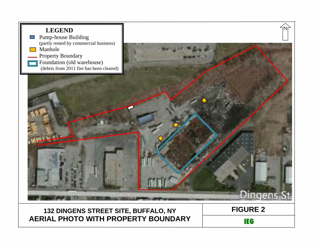
FIGURE 2
132 DINGENS STREET SITE, BUFFALO, NY
AERIAL PHOTO WITH PROPERTY BOUNDARY
LEGEND Pump-house Building (partly rented by commercial business)
Manhole
Property Boundary
Foundation (old warehouse) (debris from 2011 fire has been cleared)

FIGURE 3A
132 DINGENS STREET SITE, BUFFALO, NY SURFACE SOIL SAMPLES - SVOCs/METALS EXCEEDING SCOs
LEGEND Exceed Commercial SCOs
Exceed Industrial SCOs
Geoprobe soil sample
Test pit soil sample
Monitoring well
SVOCs in µg/Kg; metals in mg/Kg

FIGURE 3B
132 DINGENS STREET SITE, BUFFALO, NY SOIL SAMPLES at 0’ to 4’ - SVOCs/METALS EXCEEDING SCOs
LEGEND Exceed Commercial SCOs
Exceed Industrial SCOs
Geoprobe soil sample
Test pit soil sample
Monitoring well
SVOCs in µg/Kg; metals in mg/Kg

FIGURE 3C
132 DINGENS STREET SITE, BUFFALO, NY SOIL SAMPLES at 4’ to 12’ - SVOCs/METALS EXCEEDING SCOs
LEGEND Exceed Commercial SCOs
Exceed Industrial SCOs
Geoprobe soil sample
Test pit soil sample
Monitoring well
SVOCs in µg/Kg; metals in mg/Kg

FIGURE 3D
132 DINGENS STREET SITE, BUFFALO, NY ALL SOIL SAMPLES - PCBs EXCEEDING SCOs
LEGEND Exceed Commercial SCOs
Exceed Industrial SCOs
Geoprobe soil sample
Test pit soil sample
Monitoring well
PCBs in µg/Kg

FIGURE 4
132 DINGENS STREET, BUFFALO, NY SOIL EXCEEDING PROPOSED EXCAVATION THRESHOLD LIMIT
MW-3
592.5’
MW-6 593.7’
MW-7 592.3’
MW-8 591.5’
MW-4 589.1’
MW-5 592.8’
MW-2 594.3’
MW-1 594.0’
GS-34
GS-23
GS-22
GS-21 GS-20
GS-18 GS-17
GS-30
GS-29
GS-28
GS-27
GS-26
GS-25
GS-24
GS-33
GS-32
GS-31
GS-13
GS-12
GS-16
GS-15
GS-11
GS-10
GS-9
GS-1
GS-2
GS-3
GS-8
GS-14
GS-4,
5, 6, 7
TS-7
TS-1
TS-2
TS-3
TS-4
TS-5
TS-6
GS-35
GS-38
GS-37
GS-36
GS-40
GS-39
TS-17
TS-13
TS-12
TS-11 TS-10
TS-9
TS-8
TS-16
TS-15
TS-14
GS-19
LEGEND One or more SVOCs/Metals/PCBs exceed Proposed Excavation Threshold Limit (PETL)
Geoprobe soil sample
Test pit soil sample
Monitoring well
ND – Not-detected; NA = Not analyzed
SVOCs, PCBs and metals in mg/Kg

FIGURE 5
132 DINGENS STREET, BUFFALO, NY HOT SPOT EXCAVATION AREAS & SURFACE FEATURES
SVOCs/
PCBs/Pb
SVOCs As/Hg
Pb
Pb
F
E C
B A
G
D
PCBs
K
J
I
H
L
NOTE:
VEGETATED AREAS: A, B, D, E, F, G (187,000 SF)
ASPHALT/CONCRETE AREAS: C, I, J, K, L, M (242,000 SF)
GRAVEL AREA: L (62,000 SF)
PUMPHOUSE BUILDING: N (4,000 SF)
WAREHOUSE FOUNDATION: H (80,000 SF)
Site Boundary
Proposed hot-spot areas to be excavated due to
exceedance of PETLs for SVOCs/PCBs/As/Pb/Hg
M
PCBs
N
Pb
Hg

DRAWING

DRAWING 1
132 DINGENS STREET SITE, BUFFALO, NY
SITE TOPO AND LAYOUT

TABLES

RESTRICTED
COMMERCIAL
RESTRICTED
INDUSTRIALMINIMUM AVERAGE MAXIMUM
Benzo(a)anthracene 5,600 11,000 ND 10,299 490,000 23 8
Benzo(a)pyrene 1,000 1,100 ND 10,673 550,000 21 43
Benzo(b)fluoranthene 5,600 11,000 ND 12,008 600,000 23 9
Benzo(k)fluoranthene 56,000 110,000 ND 6,237 240,000 4 1
Chrysene 56,000 110,000 ND 9,996 450,000 5 1
Dibenz(a,h)anthracene 560 1,100 ND 1,704 86,000 19 11
Fluoranthene 500,000 1,000,000 ND 22,727 1,200,000 1 1
Indeno(1,2,3-cd)pyrene 5,600 11,000 ND 5,015 250,000 21 5
Phenanthrene 500,000 1,000,000 31 21,955 1,200,000 1 1
Pyrene 500,000 1,000,000 35 19,588 880,000 2 0
TOTAL SVOCs 500,000 1,000,000 35 144,485 7,163,000 2 0
Aroclor 1248 ND 1,125 59,000 3 1
Aroclor 1254 ND 133 3,400 2 0
METALS (mg/Kg)
Arsenic 16 16 1 24 274 40 40
Barium 400 10,000 7 550 4,530 31 0
Copper 270 10,000 5 221 2,400 12 0
Lead 1,000 3,900 3 2,981 93,500 86 36 9
Nickel 310 10,000 2 41 863 2 0
Zinc 10,000 10,000 9 1,655 22,900 3 3
Mercury 2.8 5.7 ND 0.90 8.30 5 3
TCLP Lead (mg/L) ND 8 34 13
TABLE 1132 DINGENS STREET - BCP REMEDIAL INVESTIGATION
PARAMETERS OF CONCERN
5 3
NUMBER OF
SAMPLES
EXCEEDING
INDUSTRIAL
USE SCOs
SEMIVOLATILE ORGANICS (SVOCs, ug/Kg)
PCBs (ug/Kg)
1,000 25,000 56
PARAMETER
PART 375 SCOsRANGE of DETECTED
CONCENTRATIONS IN SOILTOTAL
NUMBER OF
SAMPLES
NUMBER OF
SAMPLES
EXCEEDING
COMMERCIAL
USE SCOs
81
79
79
Page 1 of 1
RESTRICTED
COMMERCIAL
(CSCOs)
RESTRICTED
INDUSTRIAL
(ISCOs)
SEMIVOLATILE ORGANICS (SVOCs, ug/Kg)
-- -- -- -- -- -- -- --Benzo(a)anthracene 5,600 11,000 ND 10299 490000 54,770 5.318 20,426 51,151
Benzo(a)pyrene 1,000 1,100 ND 10673 550000 61,175 5.732 21,985 54,642
Benzo(b)fluoranthene 5,600 11,000 ND 12008 600000 66,631 5.549 24,328 60,663
Benzo(k)fluoranthene 56,000 110,000 ND 6237 240000 27,340 4.383 11,293 28,822
Chrysene 56,000 110,000 ND 9996 450000 50,417 5.043 19,319 48,634
Dibenz(a,h)anthracene 560 1,100 ND 1704 86000 9,624 5.650 3,483 8,670
Fluoranthene 500,000 1,000,000 ND 22727 1200000 133,764 5.886 47,460 117,648
Indeno(1,2,3-cd)pyrene 5,600 11,000 ND 5015 250000 27,873 5.558 10,168 25,351
Phenanthrene 500,000 1,000,000 ND 21955 1200000 134,237 6.114 46,776 115,506
Pyrene 500,000 1,000,000 ND 19588 880000 99,061 5.057 37,905 95,397
Total SVOCs 500,000 1,000,000 ND 144485 7163000 800,547 5.541 292,508 729,501
-- -- -- -- -- -- -- --
Aroclor 1242 ND 6 280 39 6.036 14 34
Aroclor 1248 ND 1125 59000 7,881 7.005 2,590 6,306
Aroclor 1254 ND 133 3400 612 4.609 247 626
Total PCBs ND 1264 59000 7,911 6.257 2,735 6,735
METALS (mg/Kg)
-- -- -- -- -- -- -- --
Arsenic 16 16 1.4 24 274 37 1.526 31 85
Barium 400 10,000 6.9 550 4530 704 1.278 680 1,911
Copper 270 10,000 4.5 221 2400 381 1.722 291 804
Lead 1,000 3,900 2.9 2981 93500 10,442 3.503 4,911 12,803
Nickel 310 10,000 2.2 41 863 125 3.067 64 168
Zinc 10,000 10,000 9.0 1655 22900 3,593 2.171 2,319 6,293
Mercury 2.8 5.7 ND 0.9 8.3 1.5 1.675 1.14 3.2
79
56
81
1,000 25,000
ANALYTICAL DATA STATISTICS - TEST PIT & GEOPROBE SOILS
ALL SOIL SAMPLES INCLUDED
(SAMPLES INCLUDED FROM BOTH PHASE II AND RI INVESTIGATIONS)
PARAMETER
PART 375 SCOs
MINIMUM AVERAGE MAXIMUM ST.DEV
DEPTH INTERVAL (ft)
TABLE 2A132 DINGENS STREET SITE
DEPTH INTERVAL (ft)
PCBs (ug/Kg)
DEPTH INTERVAL (ft)
CV =
STDEV/MEAN
Student's t
95% UCL
(σ)
MEAN +
2 x STD. DEV.
(µ+2σ)
TOTAL
NUMBER OF
SAMPLES

RESTRICTED
COMMERCIAL
(CSCOs)
RESTRICTED
INDUSTRIAL
(ISCOs)
Total SVOCs 500,000 1,000,000 ND 56,753 1,031,800 132,872 2.341 81,479 219,711 500,000 80 1 TS-15
Total PCBs 1,000 25,000 ND 215 5,100 948 4.415 429 1,072 1,000 55 2 GS-17, GS-19
Arsenic 16 16 1.4 22 274 33 1.488 28 79 79 78 2 TS-13, MW-2
Lead 1,000 3,900 2.9 1,916 25,800 3,413 1.781 2,551 7,018 5,000 85 7 TS-4, TS-15, MW-7, GS-20, GS-30
Mercury 2.8 5.7 ND 0.9 8.3 1.5 1.675 1 3 5.7 79 3 TS-13, MW-2, GS-21
METALS (mg/Kg)(PETLs: Pb based on Total vs TCLP correlation; As based on 95% UCL; & Hg based on ISCO)
SEMIVOLATILE ORGANICS (SVOCs, ug/Kg)(PETL is based on NYSDEC's CP-51 Soil Cleanup Guidance
PCBs (ug/Kg)(PETL is based on CSCO)
LOCATIONS EXCEEDING PROPOSED
EXCAVATION LIMIT THRESHOLD
(excluding outliers)
CV =
STDEV/MEAN
Student's t
95% UCL
(σ)
MEAN +
2 x STD.
DEV.
(µ+2σ)
PROPOSED
EXCAVATION
THRESHOLD
LIMIT
(PETL)
TOTAL
NUMBER
OF
SAMPLES
(for stats)
NO. OF
SAMPLES
> PETL
TABLE 2B132 DINGENS STREET SITE
ANALYTICAL DATA STATISTICS - TEST PIT & GEOPROBE SOILS
ALL SOIL SAMPLES EXCLUDING OUTLIERS: TS-5 (SVOCs), TS-9 (Pb), TS-13 (As) & TS-15 (PCBs)
(SAMPLES INCLUDED FROM BOTH PHASE II AND RI INVESTIGATIONS)
PARAMETER
PART 375 SCOs
MINIMUM AVERAGE MAXIMUM ST.DEV

AREA LOCATION Sq. Ft. Sq. Yd.HOT-SPOT
SOIL/FILL
HIGH LEVEL
SOIL/FILL
TOTAL
SOIL/FILL
Area A Eastern vegetated portionMid (25%) to high (50%) SCO exceedances
TS#9 and MW-7 exceed PETL for Total SVOCs8' to 18'; 12' average 125,000 13,900 200 11,100 55,600
Area B Vegetated strip NE boundaryMid (25%) to high (75%) SCO exceedances
Second highest Pb at TS-410' to 13'; 12' average 34,000 3,800 120 5,100 15,200
Area C Paved, old UST area NE of foundationNo PETL exceedance
No petroleum compounds12' to 16'; 14' average 10,000 1,100 0 0 3,700
Area D Area northeast of pump-house buildingMid (25%) to high (50%) SCO exceedances
As & Hb PETLs exceeded at MW-210' to 12'; 11' average 4,000 400 120 300 1,500
Area E Area north of cell towerMid to high level (50%) SCO exceedances
SVOCs maximum at TS-5 (outlier) at >4' depth10' to 12'; 11' average 10,000 1,100 250 1,200 4,000
Area F Area NW of cell tower
low (75%) to high level (25%) SCO exceedances
Second highest SVOCs at TS-15
Highest PCB level at TS-15
PETL for PCBs also exceeded at GS-19
8' to 11'; 10' average 9,000 1,000 300 1,000 3,300
Area G Strip on western end of propertyMid level to high (50%) SCO exceedances
PETL for PCB exceeded at GS-177' to 12'; 10' average 5,000 600 130 800 2,000
Area H Warehouse building foundation NOT SIGNIICANT 16' average 80,000 8,900 0 0 0
Area I Paved area east of foundationMid (25%) SCO exceedances
Pb exceeds PETL at GS-308' to 15'; 12' average 74,000 8,200 100 0 32,800
Area J Paved area pump-house building low (100%) level SVOCs & metals 10' to 12'; 11' average 104,000 11,600 0 0 46,400
Area K Paved area west of foundation low (100%) level SVOCs & metals 10' to 16'; 13' average 44,000 4,900 0 0 21,200
Area L Gravel area west of pump-house buildingMid (25%) level level SVOCs/metals
Hg PETL exceeded at GS-218' to 12; 10' average 62,000 6,900 100 0 23,000
Area M Asphalt/concrete south of foundation low (100%) level SVOCs & metals 8' to 12'; 10' average 10,000 1,100 0 0 3,700
Area N Pump-house building NONE -- 4,000 400 0 0 0
575,000 63,900 1,320 19,500 212,400
14,000 1,555
128,700 14,300
187,000 20,800
304,000 33,800
84,000 9,300
575,000 63,900
TABLE 3132 DINGENS STREET SITE AAR/RAWP
NATURE/EXTENT OF SOIL CONTAMINATION AND CLEANUP QUANTITIES
AREAS BY SITE FEATURES TYPE/LEVEL OF EXCEEDENCE
OF PROPOSED EXCAVATION
THRESHOLD LIMIT (PETL)
DEPTH OF
CONTAMINATED
SOIL/FILL
TOTAL AREA ESTIMTED EXCAVATION VOLUME (CY)
BUILDING AREA: Areas H, N
TOTAL
TOTAL OF ALL AREAS
TOTAL HOT-SPOT AREAS (EXCEEDING PETLs, PROPOSED EXCAVATION THRESHOLD LIMITS)
TOTAL HIGH LEVEL AREAS (INCL. HOT-SPOT)
DISTRIBUTION OF AREAS BY EXISTING SURFACE COVER
VEGETATION: Areas A, B, D, E, F, G
ASPHALT/STONE: Areas C, l, J, K, L, M

ITEM QUANTITY UNIT UNIT COST COST BASIS
Inspection/Maintenance 200 MH $80 $16,000
$16,000
TOTAL PRESENT WORTH of O & M (30 years) $277,000 For n=30 years and i=4%; PW=17.29
TABLE 4A132 DINGENS STREET SITE AAR/RAWP
ANNUAL O&M COST ESTIMATE
CAPITAL COST ESTIMATE
ALTERNATIVE S2 - INSTITUTIONAL ACTION
NONE
Long-term Monitoring (estimated for 30 years)
Quarterly sampling,
2 person crew, 40 manhours per round
for preparation, sampling and reporting.
ANNUAL MONITORING (YEARS 1 TO 30)

CATEGORY / ITEM QUANTITY UNIT UNIT COST COST ASSUMPTIONS / COMMENTS
SOIL COVER
2 ft. Soil - Delivery 14,000 CY $8 $112,000 187,000 sq.ft. total area vegetated;
2 ft. Soil - Placement 14,000 CY $4 $56,000 Assume 2 ft. soil cover
2 in. Topsoil - Delivery 1,200 CY $20 $24,000 Allow for settlement
2 in. Topsoil - Placement 1,200 CY $5 $6,000
Seeding & Restoration 187,000 SF $0.10 $19,000
$217,000
ASPHALT CAP
Binder - delivery 600 Tons $75 $45,000 304,000 sq.ft. total asphalt/concrete/gravel area
Binder - Placement 600 Tons $20 $12,000
$57,000
SUBTOTAL DIRECT CAPITAL COSTS $274,000
INDIRECT CAPITAL COSTS
Survey LS $10,000 Engineering, deed restrictions, permits, meetings
DEC Oversight LS $20,000
Management & QA/QC LS $40,000 Incl. confirmatory sampling; RA Report
Health & Safety $5,000 HASP development and implementation
Bonds and Insurance (5%) $14,000
Contingency (10 %) $27,000
SUBTOTAL INDIRECT CAPITAL COSTS $116,000
TOTAL CAPITAL COST $390,000
ITEM QUANTITY UNIT UNIT COST COST BASIS
Labor 500 MH $30 $15,000
Materials 12 LS $1,000 $12,000
$27,000
$27,000
For n=30 years and i=4%; PW=17.29
ANNUAL O & M (YEARS 1 TO 30)
TOTAL PRESENT WORTH of O&M (30 years) $467,000
Subtotal
ANNUAL O&M COST ESTIMATE
Long-term Monitoring (30 years)
Repair/maintain soil cover in vegetated areas,
and repair/maintain asphalt/concrete areas
NONE
Long-term Maintenance (estimated for 30 years)
TABLE 4B132 DINGENS STREET SITE AAR/RAWP
ALTERNATIVE S3 - CONTAINMENT/CAPPING
CAPITAL COST ESTIMATE
Subtotal
Subtotal Annual Maintenance (years 1 to 30)

CATEGORY / ITEM QUANTITY UNIT UNIT COST COST ASSUMPTIONS / COMMENTS
SOIL EXCAVATION/DISPOSAL 11,500 sq.ft. area for excavation
Security Fence 2,500 LF $15 $38,000
Erosion control 2,500 LF $2 $5,000
Excavation 1,900 Tons $4 $7,600 Assume 1.5 tons/CY density
Transport & Disposal (non-haz) 1,700 Tons $30 $51,000 Disposal at solid waste landfill
Transport & Disposal (non-haz) 200 Tons $80 $16,000 Assume 500 tons fails TCLP lead
Excavation water handling LS $20,000
Backfill - Delivery 1,900 CY $5 $9,500
Backfill - Placement 1,900 CY $2 $3,800
$150,900
COVER 187,000 sq.ft. total area to be covered;
1 ft. crushed stone - Installed 7,000 CY $35 $245,000 Assume 1 ft. cover for restricted commercial use
Geotextile demarcation layer 21,000 SY $1 $21,000
$266,000
ASPHALT CAP 304,000 sq.ft. total asphalt/concrete/gravel area
Binder - delivery 600 Tons $75 $45,000
Binder - Placement 600 Tons $20 $12,000
$57,000
SUBTOTAL DIRECT CAPITAL COSTS $474,000
INDIRECT CAPITAL COSTS
Survey LS $10,000 Engineering, deed restrictions, permits, meetings
DEC Oversight LS $25,000
Management & QA/QC LS $50,000 Incl. confirmatory sampling; RA Report
Health & Safety $10,000 HASP development and implementation
Bonds and Insurance (5%) $24,000
Contingency (10 %) $47,000
SUBTOTAL INDIRECT CAPITAL COSTS $166,000
TOTAL CAPITAL COST $640,000
ITEM QUANTITY UNIT UNIT COST COST BASIS
Labor 500 MH $30 $15,000
Materials 12 LS $1,000 $12,000
$27,000
$27,000
For n=30 years and i=4%; PW=17.29
NONE
Long-term Maintenance (estimated for 30 years)
TOTAL PRESENT WORTH of O&M (30 years) $467,000
Repair/maintain soil cover in vegetated areas,
and repair/maintain asphalt/concrete areas
Subtotal Annual Maintenance (years 1 to 30)
ANNUAL O & M (YEARS 1 TO 30)
TABLE 4C132 DINGENS STREET SITE AAR/RAWP
ANNUAL O&M COST ESTIMATE
CAPITAL COST ESTIMATE
ALTERNATIVE S4 - HOT-SPOT EXCAVATION/OFF-SITE DISPOSAL & CAPPING
Long-term Monitoring (30 years)
Subtotal
Subtotal
Subtotal

CATEGORY / ITEM QUANTITY UNIT UNIT COST COST ASSUMPTIONS / COMMENTS
SOIL EXCAVATION/DISPOSAL 128,700 sq.ft. area for excavation
Security Fence 3,500 LF $15 $53,000
Erosion control 3,500 LF $2 $7,000
Excavation 29,000 Tons $4 $116,000 Assume 1.5 tons/CY density
Transport & Disposal (non-haz) 28,500 Tons $30 $855,000 Disposal at solid waste landfill
Transport & Disposal (non-haz) 500 Tons $80 $40,000 Assume 500 tons fails TCLP lead
Excavation water handling LS $50,000
Backfill - Delivery 20,000 CY $5 $100,000
Backfill - Placement 20,000 CY $2 $40,000
$1,261,000
SOIL COVER
2 ft. Soil - Delivery 14,000 CY $8 $112,000 187,000 sq.ft. total area vegetated;
2 ft. Soil - Placement 14,000 CY $4 $56,000 Assume 2 ft. soil cover for restricted residential use;
2 in. Topsoil - Delivery 1,200 CY $20 $24,000 Allow for settlement
2 in. Topsoil - Placement 1,200 CY $5 $6,000
Seeding & Restoration 187,000 SF $0.10 $19,000
$217,000
ASPHALT CAP 304,000 sq.ft. total asphalt/concrete/gravel area
Binder 600 Tons $75 $45,000 repair/pave 30,000 sq.ft. area with asphalt
Placement 600 Tons $20 $12,000 with 3" binder
$57,000
SUBTOTAL DIRECT CAPITAL COSTS $1,535,000
INDIRECT CAPITAL COSTS
Survey LS $10,000 Engineering, deed restrictions, permits, meetings
DEC Oversight LS $30,000
Management & QA/QC LS $100,000 Incl. confirmatory sampling; RA Report
Health & Safety $25,000 HASP development and implementation
Bonds and Insurance (5%) $77,000
Contingency (10 %) $154,000
SUBTOTAL INDIRECT CAPITAL COSTS $396,000
TOTAL CAPITAL COST $1,931,000
ITEM QUANTITY UNIT UNIT COST COST BASIS
Labor 500 MH $30 $15,000
Materials 12 LS $1,000 $12,000
$27,000
$27,000
For n=30 years and i=4%; PW=17.29
Subtotal Annual Maintenance (years 1 to 30)
ANNUAL O & M (YEARS 1 TO 30)
TOTAL PRESENT WORTH of O&M (30 years) $467,000
Subtotal
ANNUAL O&M COST ESTIMATE
Long-term Monitoring
NONE
Long-term Maintenance (estimated for 30 years)Repair/maintain soil cover in vegetated areas,
and repair/maintain asphalt/concrete areas
TABLE 4D132 DINGENS STREET SITE AAR/RAWP
ALTERNATIVE S5 - HIGH LEVEL EXCAVATION/OFF-SITE DISPOSAL & CAPPING
CAPITAL COST ESTIMATE
Subtotal
Subtotal
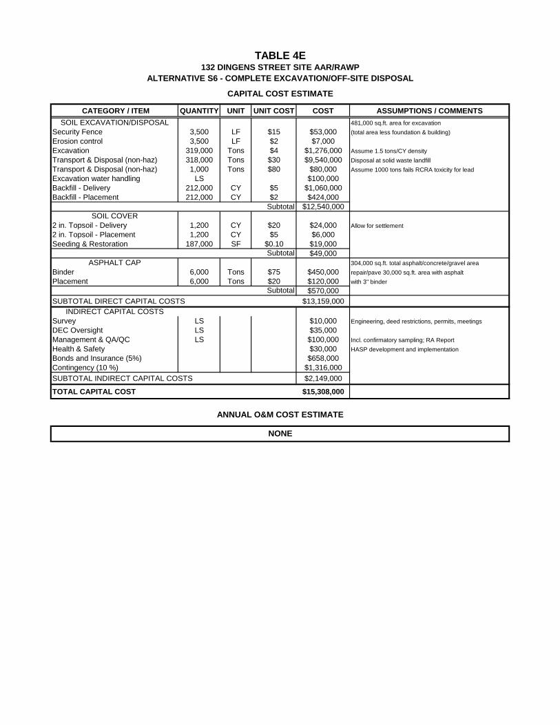
CATEGORY / ITEM QUANTITY UNIT UNIT COST COST ASSUMPTIONS / COMMENTS
SOIL EXCAVATION/DISPOSAL 481,000 sq.ft. area for excavation
Security Fence 3,500 LF $15 $53,000 (total area less foundation & building)
Erosion control 3,500 LF $2 $7,000
Excavation 319,000 Tons $4 $1,276,000 Assume 1.5 tons/CY density
Transport & Disposal (non-haz) 318,000 Tons $30 $9,540,000 Disposal at solid waste landfill
Transport & Disposal (non-haz) 1,000 Tons $80 $80,000 Assume 1000 tons fails RCRA toxicity for lead
Excavation water handling LS $100,000
Backfill - Delivery 212,000 CY $5 $1,060,000
Backfill - Placement 212,000 CY $2 $424,000
$12,540,000
SOIL COVER
2 in. Topsoil - Delivery 1,200 CY $20 $24,000 Allow for settlement
2 in. Topsoil - Placement 1,200 CY $5 $6,000
Seeding & Restoration 187,000 SF $0.10 $19,000
$49,000
ASPHALT CAP 304,000 sq.ft. total asphalt/concrete/gravel area
Binder 6,000 Tons $75 $450,000 repair/pave 30,000 sq.ft. area with asphalt
Placement 6,000 Tons $20 $120,000 with 3" binder
$570,000
SUBTOTAL DIRECT CAPITAL COSTS $13,159,000
INDIRECT CAPITAL COSTS
Survey LS $10,000 Engineering, deed restrictions, permits, meetings
DEC Oversight LS $35,000
Management & QA/QC LS $100,000 Incl. confirmatory sampling; RA Report
Health & Safety $30,000 HASP development and implementation
Bonds and Insurance (5%) $658,000
Contingency (10 %) $1,316,000
SUBTOTAL INDIRECT CAPITAL COSTS $2,149,000
TOTAL CAPITAL COST $15,308,000
NONE
Subtotal
ANNUAL O&M COST ESTIMATE
TABLE 4E132 DINGENS STREET SITE AAR/RAWP
ALTERNATIVE S6 - COMPLETE EXCAVATION/OFF-SITE DISPOSAL
CAPITAL COST ESTIMATE
Subtotal
Subtotal

ALTERNATIVECAPITAL
COST
ANNUAL
O&M COST(estimated for 30
years)
PRESENT
WORTH OF
ANNUAL O&M
TOTAL
CAPITAL +
PRESENT
WORTH O&M
S1 :
NO ACTION$0 $0 $0 $0
S2:
INSTITUTIONAL ACTION$0 $16,000 $277,000 $277,000
S3 - CONTAINMENT/CAPPING $390,000 $27,000 $467,000 $857,000
S6:
COMPLETE EXCAVATION/
OFF-SITE DISPOSAL
$15,308,000 $0 $0 $15,308,000
TABLE 5132 DINGENS STREET SITE AAR/RAWP
REMEDIAL ALTERNATIVES COST SUMMARY
S4:
HOT-SPOT EXCAVATION/
OFF-SITE DISPOSAL & CAPPING
$640,000 $467,000 $1,107,000$27,000
$27,000S5:
HIGH LEVEL EXCAVATION/
OFF-SITE DISPOSAL & CAPPING
$1,931,000 $467,000 $2,398,000

APPENDIX A
GEOLOGIC CROSS-SECTIONS