Aligning NAPSG’s SOG with GeoCONOPS · Items emphasized for purposes of this document. ... ANG...
73
Classroom B
Transcript of Aligning NAPSG’s SOG with GeoCONOPS · Items emphasized for purposes of this document. ... ANG...

Classroom B

Building and Using a GeoCONOPS
in Your Agency
Lt. Col. Michael Domingue, New Hampshire
National Guard
David Cook, DC Office of the Chief Technology
Office
National Geospatial Preparedness Summit

State National Guard GeoCONOPS
4 August 2015
LtCol Mike DomingueGIS Manager
New Hampshire National Guard

Draft Mission Statement
The States’ National Guard GeoCONOPS is intended to identify and align the geospatial resources that support the National Response Framework as required by the National Guard and supporting state and federal mission partners in coordination with PPD-8 direction.
The end state is that users will understand and apply common information sharing practices and enhanced coordination mechanisms to facilitate geospatial information sharing.
By defining these mechanisms and authorities, this GeoCONOPS aims to reduce redundancy and confusion and ensure efficient inter and intra agency access to geospatial information for planning and incident response management.

1. Gain an understanding:
- Understand the operating environment- Business Requirements- Internal and external customers- Customers’ data needs- Business analytical needs (metrics support)
UnderstandAlign and Support
Determine Constraints
Develop Solution

1. Gain an understanding:
- Understand the operating environment- Understand the operations environment
- Leadership’s intent on & acceptance of change- IT capability- IT capacity- IT, Data and GeoSpatial
design support
UnderstandAlign and Support
Determine Constraints
Develop Solution
IT
GISData

1. Gain an understanding:
- Understand the operating environment- Understand the operations environment- Understand the data management program
- Storage- Sensitivity- Current/required/desired controls- Management and development
UnderstandAlign and Support
Determine Constraints
Develop Solution

“…providing information efficiently can be a real challenge. The challenge becomes even bigger in large events and emergencies when an entire organization shifts from day-to-day work to storm assignments.
Data quality is another important factor. While most organizations have useful data, it may not always be accurate or complete. The key here is culture. Data itself must be seen as an asset, a key to driving the operational and asset decisions made day to day and in times of crisis.
Over the last few years, “big data” and “data fusion” have been at the forefront of the technical landscape. While these terms may seem like the flavor of the month, the concept is critical. They focus on bringing different data streams together, like a puzzle, building the big picture to be considered. In the past, information was compartmentalized: operations, engineering and so on. In the real world, all of these areas are related.”
Taken from an article on Effective Communication by Cheryl A. Warren and Preston Large, National Grid; Nov 4, 2013. http://m.tdworld.com/utilities-call-center/effective-communication
Ed. Items emphasized for purposes of this document.
…speaking of data

By design our military culture exists because of big data; subsequently the goal is to shape our culture to operate more effectively with big data.
Within the realm of Emergency (Domestic) Operations developing and sharing situational awareness is becoming well defined through the use of Geographic Information Services (GIS) at the local, state, regional and national levels.
Current standard sharing practices (Departments of the Interior and Homeland Security and FEMA) utilize portal technology to host map services both for Esri and Google related products, in-turn allowing information to be efficiently shared, discovered and consumed. This technology enables maximum interoperability when it is needed most and can be used for planning, steady state and response efforts
What is effective situational awareness for the National Guard?

“The initiative seizes the opportunity to: Change the how of delivering services to citizens by adopting lean processes and using new technologies…
Digital government offers the prospect of better delivery of current services as well as brand new ones; therefore, it will be a major force in changing the way state government will do business in the future. But changing the how is not limited to digital services—it includes a variety of other technologies, notably geographic information systems to improve land use planning and disaster response.”
Ed: Red font used to emphasize message.
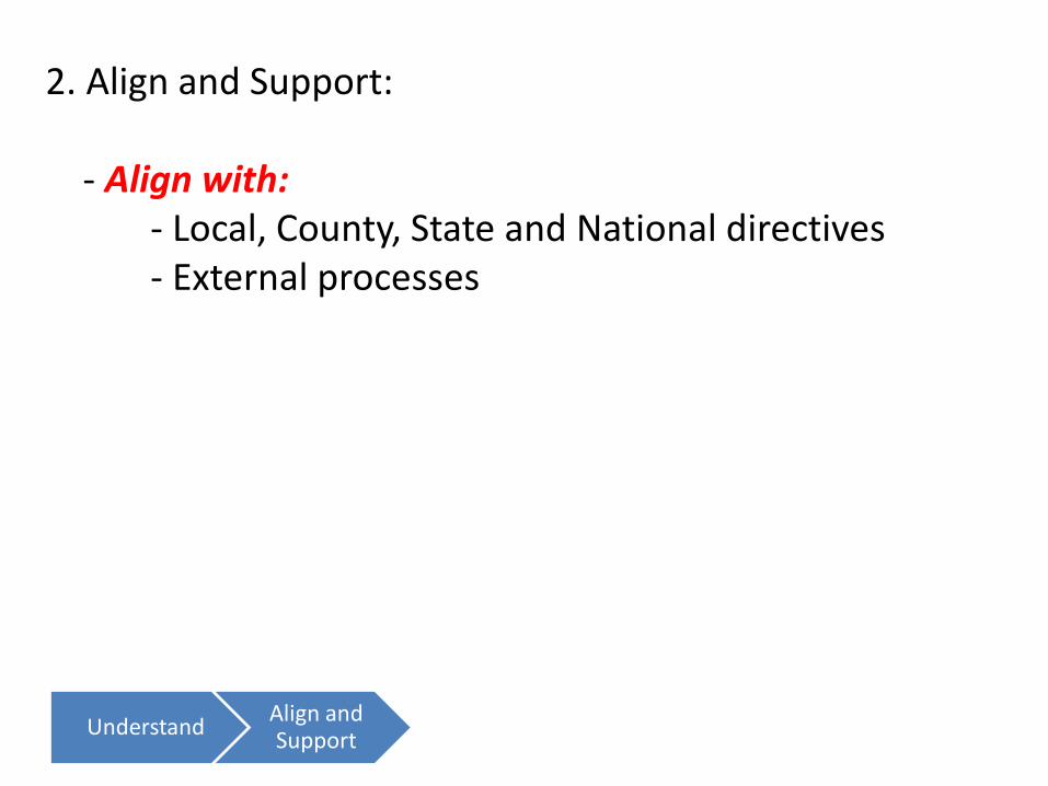
2. Align and Support:
- Align with:- Local, County, State and National directives- External processes
UnderstandAlign and Support
Determine Constraints
Develop Solution

2. Align and Support:
- Align with:- Local, County, State and National directives- External processes
- Support:- Customers’ data needs- Business analytical needs (metrics support)
UnderstandAlign and Support
Determine Constraints
Develop Solution

Align With:
- Presidential Policy Directive 8 (PPD8)- National Preparedness Guidelines- National Preparedness Goal- Homeland Security GeoCONOPS- Joint Publication 3-28, Defense Support to Civil Authorities - Council of Governors Joint Action Plan- National Guard Regulation 500-1/ANGI 10-8101- Air Land and Sea Application Center DSCA Multi-Service Tactics, Techniques and Procedures Document

Support sharing of Essential Elements of Information
Council of Governors:- Incident Overview- Threat information- Logistics- Publicly Available / Open Source Information- Location and availability of State and Federal military units potentially available to provide military support to civil authorities- Critical infrastructure (unclassified)- Force Tracking (unclassified)- Interagency and incident management data (unclassified)
Homeland Security GeoCONOPS:- Air National Guard Bases - ANG Installation Areas- ARNG Installations - ARNG Sites- Armed Forces Recruiting Centers - ANG Sites - Army National Guard Convoy Routes- Joint Task Force Joint Operating Centers (JTF JOC)- State National Guard Receiving Points- State National Guard Logistics Supply Points- State National Guard Staging Areas- State National Guard unit locations
9
12

Essential Elements of Information (continued)(Desired items successfully used during CAUSE III for Situational Awareness)
DoD:- Location of Reserve Units- Availability of Reserve Units - Deployed Active Units (DSCA) for current or projected response
FEMA:
- National composite of States with Federal or State Emergency Declarations
- National composite of States Mission Area (Prevention, Protection, Mitigation, Response, Recovery) as it pertained to significant events (used during CAUSE III) (POC: NEMA?)- National composite of States SITREP of Event and Trending Status (Improve, Decline, Static) (used during CAUSE III) (POC: NEMA?)
* The Canada U.S. Enhanced Resiliency Experiment (CAUSE) is a DHS co-sponsored experiment series designed to test and validate that cross-border collaboration through the use of communications and
situational awareness technologies can greatly enhances regional resiliency. CAUSE III focused on shared situational awareness technologies, alerts, warnings and notifications, social media, mutual aid and
deployable Long Term Evaluation (LTE) communications systems.
3
3

Shared Essential Elements of Information:
- Electric Grid- Natural Gas Grid- Public Water Grid- Communications Grid- Road Network- Navigable Waterways- Air Transportation- Area Command Locations
Essential Elements of Information (continued)
State Level Element of Essential Information valuable for National Guard Situation Awareness(Successfully tested during the CUSEC’s Capstone 2014 Exercise*)
* In support of Presidential Policy Directive 8 (PPD8) the Central United States Earthquake Consortium (CUSEC) presents CAPSTONE-14. Under the direction of the CUSEC Board of Directors, CAPSTONE-14 was a three-year, multi-state scope of planning and preparedness activities culminating in a major, multi-state earthquake exercise in June 2014. It was designed to strengthen partnerships between local, state, and
federal governments, while engaging public and private sector entities in planning response and recovery from a catastrophic earthquake occurring within the New Madrid Seismic Zone (NMSZ).
-Staging Areas-Points of Distribution-JRSOI-Evacuation Orders-Injuries and Fatalities-Shelters-Hospitals-Private Sector Infrastructure
18

States National Guard (in additional to previously stated):
- Locations / contact for CST units (sanitized for various recipients)- Locations / contact for HRF units (sanitized for various recipients)- Locations / contact for CERFP units (sanitized for various recipients)- Steady State Mission information (mostly community support)- Major HS/DOMOPS Event Operations Phase (based on JP3-28)- Major HS/DOMOPS Event Dual Status activation- Major HS/DOMOPS Event SITREP and Trending Status (Improve, Decline, Static) (used during CAUSE III) - Major HS/DOMOPS Event Personnel Summaries (SAD, T32, T10) (used during CAUSE III) - States Planning Information
Essential Elements of Information (continued)(Items desired or successfully used during CAUSE III* for Situational Awareness)
9
54Total

What are we concerned about?Planning Scenarios:-15 National Planning Scenarios were unveiled in the September 2007 publication of the National Preparedness Guidelines. They were later grouped into 8 key scenario sets for the 15 original planning scenarios.- In the draft Air Land and Sea Application Center DSCA Multi-Service Tactics, Techniques and Procedures Document, 8 Domestic Activities and Special Events were described. For the purposes of this document, we will focus on these activities.
National Guidelines (DHS & FEMA) Military DSCA/NGCS TTPs
Key Scenario Sets National Planning Scenarios Domestic Activities and Special Events
1. Explosive Attack Scenario 12: Explosives Attack – Bombing Using Improvised Explosive Device CBRN Incidents
2. Nuclear Attack Scenario 1: Nuclear Detonation – Improvised Nuclear Device CBRN Incidents
3. Radiological Attack – Radiological Dispersal Device Scenario 11: Radiological Attack – Radiological Dispersal Device CBRN Incidents
4. Biological Attack – With annexes for different pathogens
Scenario 2: Biological Attack – Aerosol Anthrax
CBRN IncidentsScenario 4: Biological Attack – Plague
Scenario 13: Biological Attack – Food Contamination
Scenario 14: Biological Attack – Foreign Animal Disease
5. Chemical Attack – With annexes for different agents
Scenario 5: Chemical Attack – Blister Agent
CBRN IncidentsScenario 6: Chemical Attack – Toxic Industrial Chemicals
Scenario 7: Chemical Attack – Nerve Agent
Scenario 8: Chemical Attack – Chlorine Tank Explosion
6. Natural Disaster – With annexes for different disasters
Scenario 9: Natural Disaster – Major Earthquake Earthquakes
Scenario 10: Natural Disaster – Major Hurricane
Wind Storms
Wildland Firefighting (WFF)
Floods
Winter Storms
7. Cyber Attack Scenario 15: Cyber Attack Cyberspace
8. Pandemic Influenza Scenario 3: Biological Disease Outbreak – Pandemic Influenza CBRN Incidents
N/A N/A Special Events

3. Determine (be aware of) Constraints:
- Possible Constraints:- Data Management- Current Technology- Culture- Funding
UnderstandAlign and Support
Determine Constraints
Develop Solution

Segregating Critical Information
Military Values
Military operations survive on ‘need to know’ values; similar governance for sharing geospatial data should be adopted. While various definitions have been established for operations one should be developed to guide the placement of and access to map services and the data contained.
Geospatial Information Levels
To assist with the identification of information levels and select accessibility the following model is suggested for use:

4. Develop Solution:
- Review other solutions:- Similar operating environments- Successes, in whole or partial- Open sharing environment
UnderstandAlign and Support
Determine Constraints
Develop Solution

CAUSE* II (MAR ‘13)CAUSE* III (NOV ‘14)
*CAUSE = CANADA–U.S. ENHANCED RESILIENCY EXPERIMENT SERIES
Central US Earthquake Consortium Exercise (JUN ‘14)
The New Hampshire National Guard has been specifically invited to participate in many Sharing Capability proofs of concept
NG Patriot Exercises ’11, ‘12

Enhanced NG Response Essential Elements of Information
Simulated data that can be produced by each state JOC:
- State National Response Framework Phase- Emergency Declarations- State SITREP- Event Trending- NG Activated?- NG Operations Phase- Dual Status Cmdr?- Nbr of Missions- Total NG Pers- Total T10 Pers
24
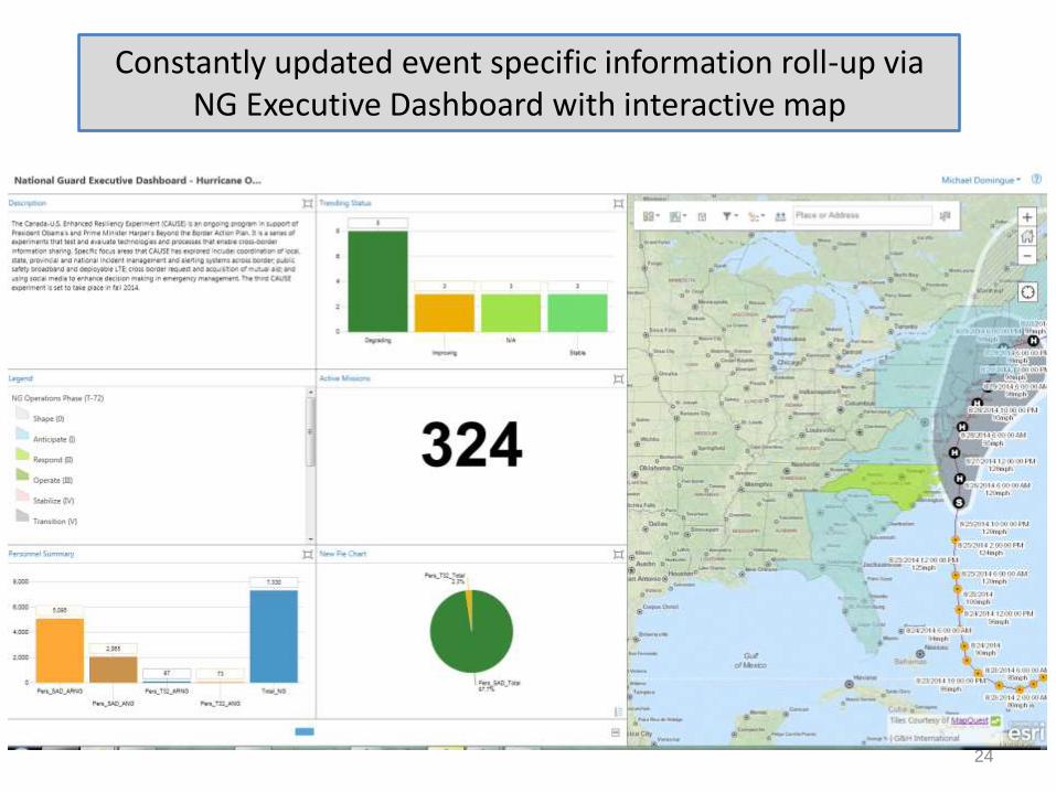
Constantly updated event specific information roll-up via NG Executive Dashboard with interactive map

FEMA GeoPlatformDepartment of the Interior
GeoPlatform
Northeast States GeoPlatform
New Hampshire National Guard Geospatial Portal
…utilizing existing data sharing environments, the New Hampshire National Guard has successfully proven that we can share critical information and situational awareness effectively, seamlessly and in near real time.

4. Develop Solution:
- Review other solutions:- Similar operating environments- Successes, in whole or partial- Open sharing environment
- Develop Courses of Action:- Select top 3- Look at advantages and disadvantages - Test, compare and select
UnderstandAlign and Support
Determine Constraints
Develop Solution

Federal Agencies
DOD
Stakeholders and Agency Partners & Geospatial Information Levels
National Guard
Enterprise
State Agencies
Open Public
Level 4 DataLevel 3 Data
Level 2 DataState National
GuardLevel 1 Data

With our GeoPortal we are joining the ranks of many collaborative Emergency Response and Homeland Security agencies all using ArcGIS.
National Geospatial-Intelligence Agency
American Red Cross
FEMAPacific Data Center
NGIA Crisis Dashboard
US DOIGeoplatform
National Guard DOMOPS

Data Input at the State NG Level
Sharing Example
Through Federation of Services the capability exists to input once and automatically update many
Example of planning and response information sharing
Level 1 Data Level 2 Data Level 3 Data Level 4 Data
Internal Data Enterprise Data Partnership Data Open Unrestricted Data
State NG Use Only All NG and DoD State and FederalUnit Name Unit Name Unit Name
UIC / PAS Code
Unit Commander
Readiness Center Name Readiness Center Name Readiness Center Name Readiness Center Name
Readiness Center Address Readiness Center Address Readiness Center Address
Building Number
Pers Auth
Pers Avail for State Active Duty Pers Avail for State Active Duty
Critical Equipment Auth
Critical Equipment Avail SAD Critical Equipment Avail SAD
Planned Critical Capability 1 Planned Critical Capability 1 Planned Critical Capability 1
Critical Capability 1 Available Critical Capability 1 Available
Planned Critical Capability 2 Planned Critical Capability 2 Planned Critical Capability 2
Critical Capability 2 Available Critical Capability 2 Available
Planned Critical Capability 3 Planned Critical Capability 3 Planned Critical Capability 3
Critical Capability 2 Available Critical Capability 3 Available
JOC Contact Number JOC Contact Number JOC Contact Number JOC Contact Number

Information Sharing Proof of Concept
30
State National Guard Cloud
National Guard Enterprise
(ANG and ARNG)and DoD
“Military Unifier”
.GOV or .COM (State and FED
Agencies)
Sanitized data appropriate to share
COP
Data Layers

Draft concept for GeoCONOPS Proof of Concept

Document Process Review Key Phases
Phase I
-Creation of Document Outline – “What is the concept of the National Guard GeoCONOPS?”
Phase II
-Review of the Concept – “Do we have it right?” (Reviewed by National Agencies / Experts)
Phase III
- Review by States – “Do we have it right for the National Guard of the Several States?”Concept and remarks reviewed by 10 – 20 various states
-- Draft document created -- Draft document updated -- Final Draft document created and reviewed
Phase IV
- Final Document Published

Key elements for the Proof of Concept
- Test ability to post; host; discover and consume data
- Develop or find a Java Script query application that will search through all AGOL and personally accessed groups for content
- Give people the right information at the right time – share critical information that will support the timely creation of actionable knowledge

5. Create Governance:
- Governance:- Track items while developing CONOPS- ‘Dummy’ it down for all to follow, be aware of
talking a different language- Test all actions and retest salient items- Ensure actions and policy meet internal and
external customer’s needs- Authorship is not important, borrow someone
else’s work and adjust to make it fit
UnderstandAlign and Support
Determine Constraints
Develop Solution
Create Governance


NH NG Geospatial Portal Goals
1. Utilize ArcGIS Portal to catalog web map services, story maps, operations dashboards, viewers and data input.
2. Create an intuitive environment where product discovery and selection is user-friendly
3. Develop specific groups for:a) Organizational requirements (JOC, Facilities, etc.)b) Exercisesc) Data inputd) Commander’s Critical Information Requirementse) Developers area
4. Create a Developers SOP

Publishing Governance
1. Develop in the developers group – don’t clutter up the other groups
2. Utilize standard naming convention
3. Provide succinct yet descriptive descriptions
4. Make it discoverable – put thought into the tags
5. Share only where needed
6. Question need for unused maps
7. Review member access and logins
8. Periodically review data/layout with customers

GeoPortal Primary Products
WEBMAPS - built for singular or multiple analysis and can be published for future use by the developer or user and accessed on-line through a GIS Portal.
Feeder WEBMAPS - a colloquial term used to describe a web map that was created for the sole purpose of being incorporated into a Story Map of Operations Dashboard.
Operations Dashboard - monitor real-time data feeds for events or day-to-day operations on a desktop or tablet device and integrate maps, charts, and graphs.

GeoPortal Primary Products
GeoForm - a configurable template which can increase the effectiveness of inputting data however unlike a map’s pop-up widget it does not pre-populate input fields with existing data allowing individuals to update (change) desired fields.
Editable WEBMAPS - specifically developed for data managers to input information that cannot be virtually accessed.
User Defined Operating Picture - are similar to Common Operating Pictures (COPs) but can be utilized for a variety of purposes.
Story Maps - an integration of interactive maps and multimedia that tells a story or supports a web-based presentation.

Standard Naming Conventions
- Provides immediate recognition of product- Does not confuse maps with similar titles

Intuitive Icons
- Immediate Recognition- Customer focused

Wrap Up
- Be aware of silo’s of information and culture
- Work towards a win-win sharing situation
- Constantly strive for synergy
- Good governance will establish operational norms and enable sustainment
- Timely response saves lives; holding data is not an option

GEOCONOPS:A Story of Resiliency

Plenty of books on mapping…

We All Have Our Stories…

CHARACTER
PLOT
SETTING
CONFLICT
RESOLUTION OR THEME
GEOCONOPS

CHARACTERPlanning
PLOTPreparedness
SETTINGMitigation
CONFLICTResponse
RESOLUTION OR THEMERecovery and Resiliency
A Better Story…

Washington DC7/4/15- 0700hrs

Washington Navy Yard7/2/15- 0800hrs
…I thought I heard gunshots….

Situational AwarenessHSEMA, DOH, OUC, OCTO
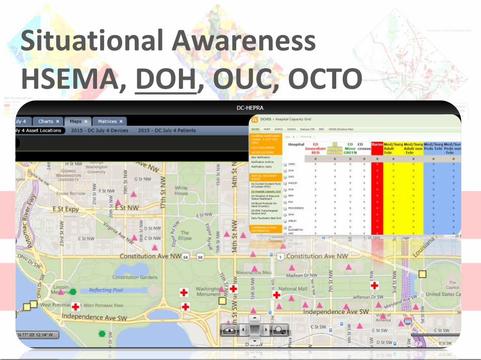
Situational AwarenessHSEMA, DOH, OUC, OCTO

Situational ManagementHSEMA, DOH, OUC, OCTO

Situational ManagementHSEMA, DOH, OUC, OCTO

PlanningData
Status?Gaps and Needs?Prioritization?Readiness?
CharacterDC PlanningStrategies
-Data Architect-Data Library-Data Services-Open Data Plan

Our Data Participants…• DCAR ‒ DC Association of Realtors®
• DC Water ‒ District of Columbia Water And Sewage Authority
• DCHA ‒ DC Housing Authority
• DCOP ‒ District of Columbia Office of Planning
• DCRA ‒ Department Of Consumer and Regulatory Affairs
• DDOE ‒ District Department of the Environment
• DDOT ‒ District Department of Transportation
• DISB ‒ Department of Insurance, Securities and Banking
• DPW ‒ Department of Public Works
• HSEMA ‒ Homeland Security/Emergency Management Agency
• OCTO ‒ Office of the Chief Technology Officer
• FEMA – Federal Emergency Management Agency
• USGS – United States Geological Survey
• MPD- Metropolitan Police Dept.
• NPS – National Park Service opendata.dc.gov

Our Data Access Points…
http://maps2.dcgis.dc.gov/DCGIS/rest/services/DCGIS_DATA/DC_Basemap_WebMercator/MapServer
dcgis.maps.arcgis.com/home/index.html

PreparednessInformation
Mission Tools?Mission Resources?Ownership/MOUs?Authoritative?Shareable?
PlotDC PlanningStrategies
-Open Data Plan-GIS Steering Committee-GIS Strategic Plan-Internal Outreach

The Foundation of DC GIS• 1995 First ortho-flight (NCPC)
• 2001 OCTO DC GIS Program
• 2002 Steering Committee Mayoral Order
• 2005 Strategic Plan (Federated Data Model)
• 2009 Executive Order expansion
• 2009 Updated GIS Strategic Plan
• 2010 Esri Enterprise License Agreement
• 2012 GIS Business Plan
• 2014 Open Data Directive - Order 2014-170

MitigationKnowledge
Function Apps?Focused Apps?Mobility?Consume/Publish?Distributable?
SettingDC PlanningStrategies
-Usability Testing-Mission Apps-Long Term Engagements and Relationships-External Outreach

311 Engagement Strategy….

Civic Hacking….
Our DC Schools - helps the public personalize and visualize changes in school district boundaries within the District
Open Schools -Choosing a school in DC can be confusing… support family decisions with data.

Community Efforts Underway…

Crafting new cross-understanding…
http://riskmappingprogress.msc.fema.gov

ResponseIntelligence
Stress Tests?Readiness Checks?Tabletop Exercises?Staffing?Post-Assessments?
ConflictDC PlanningStrategies
-Point Solutions-Geospatial Data Exchanges-Jurisdictional Evaluations

Infrastructure Evaluation…

RecoveryInsight
Sustainment?Standards and Practices?Redundant Capabilities?
Resolution..until…DC PlanningStrategies
-Early Planning Engagement and Leadership-Standards-Dedicated Resources-Scoring Methods

The spatial multiplier in risk….Over 95% of the data collected has a geographic component…
Businesses lose their lifeline when critical infrastructure is hit…
Surveyed businesses noted disruptions in power and water supply and telecommunications as top concerns…
Over 90% of damage occurs with local disasters…
Global Assessment Report on Disaster Risk

GAR at a Glance….THE WAKE UP CALL!
Disasters are even costlier than we thought!
Lack of a firm, engaged geospatial community foundation is expensive!
http://www.unisdr.org/2014/campaign-cities/Resilience%20Scorecard%20V1.5.pdf

DC Planning Efforts under PDM….

Single System for Resilience….

PlanningData
PreparednessInformation
MitigationKnowledge
ResponseIntelligence
Recovery and ResiliencyInsight and Best Practices
Epilogue…

GEOCONOPS:Discussion

Do you have executive leadership support in your
agency to improve data sharing, analytical services, and
institutionalize GIS?
What are the mission critical business and operation
issues that you are trying to use GIS to solve?
What are your technology capabilities? Do you have
sufficient technology and data capabilities to fulfill your
business and operational issues?
Who are your “user groups” (internal and external
customers) and do you have a great working relationship
with them to introduce change?