AIRPORT DIAGRAM STUART, FLORIDA - FlightAware
63
CAUTION: BE ALERT TO RUNWAY CROSSING CLEARANCES. READBACK OF ALL RUNWAY HOLDING INSTRUCTIONS IS REQUIRED. STUART, FLORIDA STUART, FLORIDA (SUA) (SUA) AIRPORT DIAGRAM AIRPORT DIAGRAM 21168 21168 AL-9217 (FAA) 12 30 3 4 16 7 25 4 6 5 3X1 00 5000 X 100 5828X100 A D D C 12 ELEV 10 ELEV 15 ELEV 12 ELEV 117 . 3 ° 297 . 3 ° 075 . 2 ° 25 5 . 2 ° 341 . 4 ° C 46 16 ELEV FIELD HANGARS C 1 FBO FBO AREA HOLD A A A1 ADMINISTRATION TWR HS 2 80°14'W 80°13'W 27°11'N 27°10'N 60 100 X 60 100 X C C D A X X X X X EMAS EMAS HANGAR HS 1 161 . 4 ° AREA NON MOVEMENT A2 A3 D 1 121.025 CLNC DEL 121.7 GND CON 126.6 STUART TOWER 134.475 ATIS S-55, D-90, 2D-160 PCN 30 F/B/X/T RWY 16-34 S-65, D-105, 2D-190 PCN 27 F/B/X/T RWY 12-30 S-58, D-95, 2D-170 PCN 14 F/B/X/T RWY 07-25 0.1° W ANNUAL RATE OF CHANGE JANUARY 2020 15 ELEV 11 ELEV WITHAM FLD WITHAM FLD VAR 7 . 0 ° W SE-3, 24 FEB 2022 to 24 MAR 2022 SE-3, 24 FEB 2022 to 24 MAR 2022
Transcript of AIRPORT DIAGRAM STUART, FLORIDA - FlightAware

CAUTION: BE ALERT TO RUNWAY CROSSING CLEARANCES.
READBACK OF ALL RUNWAY HOLDING INSTRUCTIONS IS REQUIRED.
STUART, FLORIDA
STUART, FLORIDA
(SUA)
(SUA)
AIRPORT DIAGRAM
AIRPORT DIAGRAM
21168
21168
AL-9217 (FAA)
12
30
34
16
7
25
4653 X
100
5000 X 1
00
5828 X 100
A
D
D
C
12
ELEV
10
ELEV
15
ELEV
12
ELEV
117.3°
297.3°
075.2°
255.2
°
341.4
°
C
46
16
ELEV
FIELD
HANGARS
C1
FBO
FBO
AREA
HOLD
A
A
A1
ADMINISTRATION
TWR
HS 2
80°14'W 80°13'W
27°11'N
27°10'N
60
100 X
60
100 X
CC
D
A
X
X
XX
X
EMAS
EMAS
HANGAR
HS 1
161.4
°
AREA
NON MOVEMENT
A2
A3
D1
121.025
CLNC DEL
121.7
GND CON
126.6
STUART TOWER
134.475
ATIS
S-55, D-90, 2D-160
PCN 30 F/B/X/T
RWY 16-34
S-65, D-105, 2D-190
PCN 27 F/B/X/T
RWY 12-30
S-58, D-95, 2D-170
PCN 14 F/B/X/T
RWY 07-25
0.1° W
ANNUAL RATE OF CHANGE
JANUARY 2020
15
ELEV
11
ELEV
WITHAM FLD
WITHAM FLD
VA
R 7.0° W
SE-3, 24 FEB 2022 to 24 MAR
2022 SE-3
, 24
FEB
202
2 to
24
MAR
202
2

NOTE: Chart not to scale.
(RN
AV
)(S
UA
)
ST
UA
RT
, FL
OR
IDA
ST
UA
RT
, FL
OR
IDA
(SU
A)
(RN
AV
)
253°
073°
115°
295°
159°
339°
BRDEE
PINGL
MKLEE520
520
520
520
520
N
281°(11)
272°
(7)
(12)
323°
(9)
305°(13)
(13)
298°
SHEDS
OLADY
SNDLR
SPYKS
*
43001300
(5)
(4)
21
16
8A
L-9
21
7 (F
AA
)
minimum climb of 500 feet per NM to 520.
Rwys 7, 12, 16, 25, 30: Standard with
Rwy 34: Standard.
TAKEOFF MINIMUMS
NOTE: Transponder code will be issued via SUA ground control or PBI APP CON when tower closed.
NOTE: For turbojet/turboprop aircraft only.
NOTE: RNAV 1.
NOTE: RADAR required.
NOTE: GPS required.
(SN
DL
R2
.SN
DL
R) 2
1JU
L1
6
SN
DL
R T
WO
DE
PA
RT
UR
E
SN
DL
R T
WO
DE
PA
RT
UR
E
(SN
DL
R2
.SN
DL
R)
3000
TOP ALTITUDE:
(NARRATIVE CONTINUED ON FOLLOWING PAGE)
123.625 132.8
PALM BEACH DEP CON
126.6 (CTAF)
STUART TOWER
121.7
GND CON
134.475
ATIS
WIT
HA
M F
LD
WIT
HA
M F
LD
SE-3, 24 FEB 2022 to 24 MAR 2022SE-3, 24 FEB 2022 to 24 MAR 2022

(RNAV)(SUA)
(RNAV)(SUA)
STUART, FLORIDA
STUART, FLORIDA
T DEPARTURE ROUTE DESCRIPTION
21168
(SNDLR2.SNDLR)
SNDLR TWO DEPARTURE
SNDLR TWO DEPARTURE
(SNDLR2.SNDLR)
21JUL16
AL-9217 (FAA)
WITHAM FLD
WITHAM FLD
SHEDS TRANSITION (SNDLR2.SHEDS)
filed altitude/flight level ten minutes after departure.
. . . .via SHEDS transition, maintain 3000 or as assigned by ATC. Expect clearance to
Thence. . . .
TAKEOFF RUNWAY 34: Climb heading 339° to intercept the 281° course to SNDLR.
TAKEOFF RUNWAY 30: Climb heading 295° to 520, then direct SNDLR. Thence. . . .
depicted route to SNDLR. Thence. . . .
TAKEOFF RUNWAY 25: Climb heading 253° to 520, then right turn direct MKLEE, then via
depicted route to SNDLR. Thence. . . .
TAKEOFF RUNWAY 16: Climb heading 159° to 520, then right turn direct SPYKS, then via
turn direct SPYKS, then via depicted route to SNDLR. Thence. . . .
TAKEOFF RUNWAY 12: Climb heading 115° to 520, then left turn direct PINGL, then right
OLADY, then via depicted route to SNDLR. Thence. . . .
TAKEOFF RUNWAY 7: Climb heading 073° to 520, then direct BRDEE, then left turn direct
SE-3, 24 FEB 2022 to 24 MAR
2022 SE-3
, 24
FEB
202
2 to
24
MAR
202
2

HOT SPOTS
An "airport surface hot spot" is a location on an aerodrome movement area with a history or potential risk of collision or runway incursion, and where heightened attention by pilots/drivers is necessary.
A "hot spot" is a runway safety related problem area on an airport that presents increased risk during surface opera-tions. Typically it is a complex or confusing taxiway/taxiway or taxiway/runway intersection. The area of increased risk has either a history of or potential for runway incursions or surface incidents, due to a variety of causes, such as but not limited to: airport layout, traffic flow, airport marking, signage and lighting, situational awareness, and training. Hot spots are depicted on airport diagrams as open circles or polygons designated as "HS 1", "HS 2", etc. and tabulated in the list below with a brief description of each hot spot. Hot spots will remain charted on airport diagrams until such time the increased risk has been reduced or eliminated.
CITY/AIRPORT HOT SPOT DESCRIPTION*
(SEE CONTINUATION PAGE FOR MORE LISTINGS)
21168
21168
DAYTONA BEACH, FL DAYTONA BEACH INTL (DAB) HS 1 Int of Twy W and Twy S. FORT LAUDERDALE, FL FORT LAUDERDALE HS 1 Int of Twy B and Rwy 09-27. EXEC (FXE) HS 2 Int of Twy A and Rwy 13-31. HS 3 Int of Twy C, Twy B and Rwy 13-31. FORT LAUDERDALE, FL FORT LAUDERDALE- HS 1 Twy Q at Rwy 10L-28R. HOLLYWOOD INTL (FLL) FORT MYERS, FL PAGE FLD (FMY) HS 1 Multiple twy ints. FORT MYERS, FL SOUTHWEST FLORIDA HS 1 Twy G1 is directly aligned with Twy F2. INTL (RSW) HS 2 When ldg Rwy 06, Twy F6 high speed exit sign is immediately before the Twy F5 reverse high speed. FORT PIERCE,FL TREASURE COAST INTL (FPR) HS 1 Maintain vigilance confusing int. HS 2 Maintain vigilance pilots confuse Rwy 14 as Twy B. HS 3 Confusing int; pilots have used Twy A as a rwy. GAINESVILLE, FL GAINESVILLE RGNL (GNV) HS 1 Rwy 11 Apch Hold Position. HS 2 Rwy 07 and Rwy 11 apch ends. HS 3 Twy D and Twy B lead to Rwy 25 and Rwy 29. HOLLYWOOD, FL NORTH PERRY (HWO) HS 1 Southbound on Twy D for Rwy 28R departures. HS 2 The hold line for Rwy 01L is also the hold line for Rwy 10R. HS 3 Aircraft taxiing on Twy L westbound to depart on Rwy 01L-19R. JACKSONVILLE, FL JACKSONVILLE EXEC AT HS 1 Twy C, Twy E, and Twy F. CRAIG (CRG) HS 2 Twy G, Twy D, and Twy R. MIAMI, FL MIAMI EXEC (TMB) HS 1 Twy H and Twy E hold lines are in close proximity to Rwy 13-31. MIAMI, FL MIAMI INTL (MIA) HS 1 Short twy risk. HS 2 Rwy 27 and Rwy 30 wrong rwy departure risk. HS 3 Short twy between rwys. HS 4 Multiple rwy ends close together. Some hold lines dependent upon rwy in use. MIAMI, FL MIAMI-OPA LOCKA EXEC (OPF) HS 1 Surface painted LOCATION and DIRECTION signs ONLY. NAPLES, FL NAPLES MUNI (APF) HS 1 Maint vigilance confusing twy int.
24 FEB 2022 to 24 MAR
2022 24 F
EB 2
022
to 2
4 M
AR 2
022

HOT SPOTS
(CONTINUED)
*See appropriate Chart Supplement HOT SPOT table for additional information.
CITY/AIRPORT HOT SPOT DESCRIPTION*
22027
22027
NEW SMYRNA BEACH, FL NEW SMYRNA BEACH MUNI (EVB) HS 1 Twy E and Rwy 25 and Rwy 20. HS 2 Twy B, Twy E and Rwy 20. ORLANDO, FL EXEC (ORL) HS 1 Rwy 25 and Twy E. ORLANDO SANFORD INTL (SFB) HS 1 Twy C is beyond the Rwy 09C APCH hold sign and marking. PENSACOLA, FL PENSACOLA INTL (PNS) HS 1 Be alert to multiple twy and rwy crossing points surrounding the int of Rwy 17-35 and Rwy 08-26. POMPANO BEACH, FL POMPANO BEACH AIRPARK (PMP) HS 1 Maintain vigilance confusing twy configuration. HS 2 Maintain vigilance confusing twy configuration. ST. AUGUSTINE, FL NORTHEAST FLORIDA RGNL (SGJ) HS 1 Maintain vigilance ramp/twy close proximity to rwy. HS 2 Maintain vigilance ramp close proximity to Rwy 02 and Rwy 06 possible wrong surface departure. HS 3 Twy B6 APCH hold. ST. PETERSBURG-CLEARWATER, FL ST. PETE-CLEARWATER INTL (PIE) HS 1 Twy A at Rwy 04 hold short. SAN JUAN, PR LUIS MUNOZ MARIN INTL (SJU) HS 1 Maintain vigilance highly congested area. HS 2 Maintain vigilance highly congested area. SARASOTA/BRADENTON, FL SARASOTA/BRADENTON INTL (SRQ) HS 1 Int of Rwy 14-32 and Rwy 04-22. STUART, FL WITHAM FLD (SUA) HS 1 Int rwys, wrong rwy departure risk. HS 2 Rwy 12 and Twy A1. TITUSVILLE, FL SPACE COAT RGNL (TIX) HS 1 Maintain vigilance confusing twy int. WEST PALM BEACH, FL PALM BEACH INTL (PBI) HS 1 Rwy 10L and Twy L. HS 2 Missing left turn from Twy F to Twy L.
24 FEB 2022 to 24 MAR
2022 24 F
EB 2
022
to 2
4 M
AR 2
022

P
P
P
P
12
34
30
7
25
16
X X
X
X
5828 X 100
4653
X 100
5000 X 1
00
420-1
480-1 464 (500-1)CIRCLING
MAINR
STUART, FLORIDA
STUART, FLORIDA
(SUA)
(SUA)
AL-9217 (FAA)
MSA RW1225NM
404 (500-1 )
664 (700-1 )
RNAV (GPS) RWY 12
RNAV (GPS) RWY 12
CH
(CTAF)L
1548
157
PETNE
LEBAN
4 NM
27°11'N-80°13'W
1600
VNAV
LNAV/DA
RW12 153°
333°
L
L
ELEV
5368
268- 252 (300- )
466-1 450 (500-1 )
404 (500-1)
1600116°
Apt Elev
TDZE
Rwy Idg
16
GP 3.00°
(VGSI Angle 3.00/TCH 35).
VGSI and RNAV glidepath not coincident
2000 direct LEBAN and hold.
MISSED APPROACH: Climb to
RW12
1.8 NM to
ZEVPU
REIL Rwys 12-30
C DBCATEGORY A
420-11818
680-1
70516
W12A116°
16
WAASAPP CRS
T34
W-497B
2600
SHEDS
(IAF)
MAINR
(FAF)
IVETY
(IAF)
RW12
116° to
16
MIRL Rwys 12-30 and 7-25
TDZE 16
TCH 60
LPV DA
LNAV MDA
ATIS PALM BEACH APP CON GND CON CLNC DEL
121.025134.475 132.8
STUART TOWER
126.6 121.7
or above 54°C.
SM NA. For uncompensated Baro-VNAV systems, LNAV/VNAV NA below -15°C
Circling Rwy 7, 16, 25, 30, 34 NA at night. Rwy 12 helicopter visibility reduction below
RNP APCH.
Holding Pattern
116°
*
6.1 NM 1.1 NM3 NM
LNAV only.*
296
116°
RW12
1.1 NM to
RW12
2000 LEBAN
660*
RW12
1.8 NM to
ZEVPU
1600
2000
6000
0.7 NM
4 NM
34
34
38
38
C34
34
680-2
664 (700-2)
ANGEEFFAIR
(13.2)25
0°2000
(7.5)
142°
2000
HADAT
(IAF)
PETNE
(IF/IAF)
(6.1)
and V51 northbound.
SHEDS on V531 northwest bound
Procedure NA for arrivals at
southeast bound.
northbound and BR62V
at ANGEE on V492
Procedure NA for arrivals
MISSED APCH FIX4 NM
116°
296°
(8)
026°
2000 NoPT
(8)
206°
2000
NoPT
(9.5)
117°
2000 NoPT
HOLD2000
6000
21168
Amdt 2 28FEB19
482368
309
166
WITHAM FLD
WITHAM FLD
SE-3, 24 FEB 2022 to 24 MAR
2022 SE-3
, 24
FEB
202
2 to
24
MAR
202
2

P
P
P
P
12
34
30
7
25
16
X X
X
X
5828 X 100
4653
X 100
5000 X 1
00
W-497B
MSA RW30 25 NM
2600
2000
1600
RW30
TCH 40
480-1 464 (500-1)480-1 580-2
564 (600-2)CIRCLING
296°
RW30296° to
LEBAN
AROSS
APP CRS
T
A
STUART, FLORIDA
STUART, FLORIDA
(SUA)
(SUA)
AL-9217 (FAA)
2000 PETNE
464 (500-1 )
RNAV (GPS) RWY 30
RNAV (GPS) RWY 30
LNAV MDA
VNAV
LNAV/DA
PETNE
296°
296°
1600
BERBE(IAF)
MONAD(IAF)
LEBAN(IF)
AROSS(FAF)
PBIPALM BEACH
296°
116°
4 NM
1548
1600
RW30
21168
12
12
LPV DA
27°11'N-80°13'W
ELEV 16
(VGSI Angle 3.00/TCH 28).
VGSI and RNAV glidepath not coincident
58281616
Amdt 1A 26JUN14
TDZE 16
266-78
404-138 388 (400-1 )38
400-1384 (400-1) 400-1 18 384 (400-1 )1
8
Apt Elev
TDZE
Rwy Idg
34
14
(20.4)
010°
3000
(5.9)
026°
2000
(5.8)
206°
2000
(6)
RW301.6 NM toWOLOB
139
LNAV only.*RW30
1.6 NM toWOLOB
560*
6 NM3.3 NM1.6 NM
to 2000 direct PETNE and hold.
MISSED APPROACH: Climb
Cats and LNAV Cats C/D visibility mile.
and increase all DA 71 feet and all MDA 80 feet and increase LPV and LNAV/VNAV all
SM NA. When local altimeter setting not received, use Palm Beach Intl altimeter setting
or above 54°C (130°F). DME/DME RNP-0.3 NA. Helicopter visibility reduction below
setting. For uncompensated Baro-VNAV systems, LNAV/VNAV NA below 4°C (40°F)
Circling to Rwy 07 NA at night. Baro-VNAV NA when using Palm Beach Intl altimeter
250 (300- )78
(8.3)
117°
3000
radials 327 CW 093.
on PBI VORTAC airway
Procedure NA for arrivals
on V295 northwest bound.
Procedure NA for arrivals at STOOP
MIRL Rwys 12-30 and 7-25L
L
Max 230 KIAS
STOOP
GP 3.00°
REIL Rwys 12-30
DCBACATEGORY
77716
W30A
WAAS
CH
134.475
ATIS PALM BEACH APP CON
132.8
STUART TOWER
(CTAF)126.6 L
GND CON
121.7
CLNC DEL
121.025
1038
482
368
309
166
WITHAM FLD
WITHAM FLD
SE-3, 24 FEB 2022 to 24 MAR
2022 SE-3
, 24
FEB
202
2 to
24
MAR
202
2

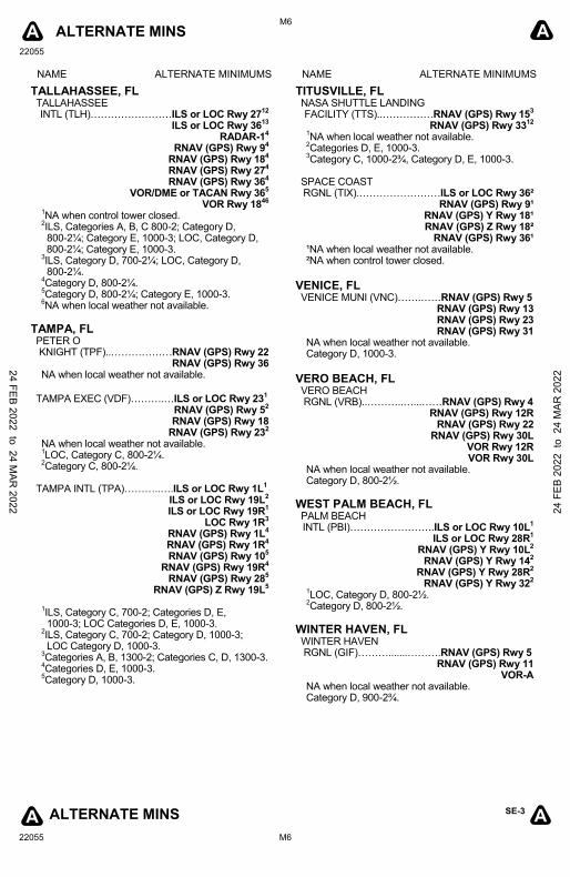
ALTERNATE MINS
22055
M1
SE-3
22055 M1
A A
ALTERNATE MINS A A
NAME ALTERNATE MINIMUMS NAME ALTERNATE MINIMUMS
APALACHICOLA, FL APALACHICOLA RGNL-CLEVE RANDOLPH FLD (AAF)…………………...…RNAV (GPS) Rwy 6
RNAV (GPS) Rwy 14 RNAV (GPS) Rwy 24 RNAV (GPS) Rwy 32
NA when local weather not available.
BARTOW, FL BARTOW EXEC (BOW).……...RNAV (GPS) Rwy 5
RNAV (GPS) Rwy 9L RNAV (GPS) Rwy 23
RNAV (GPS) Rwy 27R VOR Rwy 9L
1
NA when local weather not available. 1Category D, 800-2¼.
BOCA RATON, FL BOCA RATON (BCT).…....……RNAV (GPS) Rwy 5
RNAV (GPS) Y Rwy 231
NA when local weather not available. 1Category D, 900-2¾.
BONIFAY, FL TRI-COUNTY (BCR)…………..RNAV (GPS) Rwy 1
RNAV (GPS) Rwy 19
NA when local weather not available.
BROOKSVILLE, FL BROOKSVILLE-TAMPA BAY RGNL (BKV)……………………RNAV (GPS) Rwy 3
RNAV (GPS) Rwy 9 RNAV (GPS) Rwy 21 RNAV (GPS) Rwy 27
NA when local weather not available.
CHARLOTTE AMALIE, VI CYRIL E KING (STT) (TIST)….ILS or LOC Rwy 10
1
RNAV (GPS) Rwy 1023
VOR-A4
1LOC, Category C, 900-2½; Category D, 1500-3.
2NA when control tower closed.
3Categories A, B, 1000-2¼, Category C, 1000-2¾, Category D, 1000-3.
4Categories A, B, C, 1200-3; Category D, 1500-3.
A
INSTRUMENT APPROACH PROCEDURE CHARTS
IFR ALTERNATE AIRPORT MINIMUMS
Standard alternate minimums for non-precision approaches and approaches with vertical guidance [NDB, VOR, LOC, TACAN, LDA, SDF, VOR/DME, ASR, RNAV (GPS) or RNAV (RNP)] are 800-2. Standard alternate minimums for precision approaches (ILS, PAR, or GLS) are 600-2. Airports within this geographical area that require alternate minimums other than standard or alternate minimums with restrictions are listed below. NA - means alternate minimums are not authorized due to unmonitored facility, absence of weather reporting service, or lack of adequate navigation coverage. Civil pilots see FAR 91. IFR Alternate Minimums: Ceiling and Visibility Minimums not applicable to USA/USN/USAF. Pilots must review the IFR Alternate Minimums Notes for alternate airfield suitability.
CHRISTIANSTED, ST. CROIX, VI HENRY E ROHLSEN (STX) (TISX)…..…ILS or LOC Rwy 10¹²
NDB Rwy 1013
RNAV (GPS) Rwy 10
4
VOR Rwy 285
¹ILS, NA when control tower closed. ²LOC, NA. 3Category A, B, 1200-2; Category C, D, 1200-3.
4Category A, B, 1000-2; Category C, D, 1000-3.
5Category A, B, 900-2; Category C, D, 900-3.
CRESTVIEW, FL BOB SIKES (CEW).…..…...…RNAV (GPS) Rwy 17
RNAV (GPS) Rwy 35
VOR-A1
NA when local weather not available. 1Category D, 800-2¼.
CRYSTAL RIVER, FL CRYSTAL RIVER-CAPTAIN TOM DAVIS FIELD (CGC)...…......................RNAV (GPS) Rwy 9
RNAV (GPS) Rwy 27
NA when local weather not available. Category C, 800-2¼; Category D, 900-2¾.
DAYTONA BEACH, FL DAYTONA BEACH INTL (DAB)…………...………ILS or LOC Rwy 7L
1
ILS or LOC Rwy 25R2
NA when control tower closed. ¹ILS, Categories A, B, C, D, 700-2. ²ILS, LOC, Categories A, B, 1100-2; Category C, D, 1100-3.
DEFUNIAK SPRINGS, FL DEFUNIAK SPRINGS (54J).……....…........RNAV (GPS) Rwy 9
RNAV (GPS) Rwy 27
NA when local weather not available.
24 FEB 2022 to 24 MAR
2022 24 F
EB 2
022
to 2
4 M
AR 2
022

ALTERNATE MINS
22055
M2
SE-3
22055 M2
A A
ALTERNATE MINS A A
NAME ALTERNATE MINIMUMS NAME ALTERNATE MINIMUMS
DELAND, FL DELAND MUNI- SIDNEY H. TAYLOR FIELD (DED).……….RNAV (GPS) Rwy 5
RNAV (GPS) Rwy 12 RNAV (GPS) Rwy 23 RNAV (GPS) Rwy 30
NA when local weather not available.
DESTIN, FL DESTIN EXEC (DTS)..……….RNAV (GPS) Rwy 14
RNAV (GPS) Rwy 32 NA when local weather not available.
FERNANDINA BEACH, FL FERNANDINA BEACH
MUNI (FHB)..…….……………RNAV (GPS) Rwy 4 RNAV (GPS) Rwy 13 RNAV (GPS) Rwy 22
NA when local weather not available.
FORT LAUDERDALE, FL FORT LAUDERDALE EXEC (FXE)..………..........……ILS or LOC Rwy 9
1
RNAV (GPS) Rwy 92
RNAV (GPS) Rwy 272
NA when local weather not available. 1ILS, Category B, 700-2; Category C, 800-2¼; Category D, 800-2½; LOC, Category C,
800-2 ¼; Category D, 800-2 ½. 2Category C, 800-2¼; Category D, 800-2½.
FORT LAUDERDALE/HOLLYWOOD INTL (FLL).……………………ILS or LOC Rwy 10L
1
ILS or LOC Rwy 10R1
ILS or LOC Rwy 28L1
ILS or LOC Rwy 28R1
RNAV (GPS) Rwy 10R2
RNAV (GPS) Rwy 28L2
RNAV (GPS) Z Rwy 10L2
RNAV (GPS) Y Rwy 28R2
1LOC, Category C, 800-2¼.
2Category D, 800-2¼.
FORT MYERS, FL PAGE FLD (FMY)….....................ILS or LOC Rwy 5 NA when control tower closed.
SOUTHWEST FLORIDA INTL (RSW)……ILS or LOC/DME Rwy 6 NA when control tower closed. LOC, Category E, 800-2¾.
A
FORT PIERCE, FL TREASURE COAST INTL (FPR)…………..…..…ILS or LOC Rwy 10R
12
RNAV (GPS) Rwy 10R34
RNAV (GPS) Rwy 1434
RNAV (GPS) Rwy 28L34
RNAV (GPS) Rwy 3234
VOR/DME Rwy 1434
1LOC, NA when local weather not available.
2LOC, Category C, 900-2½; Category D, 900-2¾.
3NA when local weather not available.
4Category C, 900-2½; Category D, 900-2¾.
GAINESVILLE, FL GAINESVILLE RGNL (GNV)……………...........ILS or LOC Rwy 29
RNAV (GPS) Rwy 7 RNAV (GPS) Rwy 11 RNAV (GPS) Rwy 25 RNAV (GPS) Rwy 29
NA when local weather not available.
IMMOKALEE, FL IMMOKALEE RGNL (IMM).…RNAV (GPS) Rwy 36 NA when local weather not available.
INVERNESS, FL INVERNESS (INF)...……...……RNAV (GPS) Rwy 1
RNAV (GPS) Rwy 19 NA when local weather not available.
JACKSONVILLE, FL CECIL (VQQ).………………ILS or LOC Rwy 36R
12
RNAV (GPS) Rwy 9R RNAV (GPS) Rwy 18L RNAV (GPS) Rwy 27L RNAV (GPS) Rwy 36R
TACAN Rwy 27L3
VOR Rwy 27L NA when local weather not available. 1NA when control tower closed.
2LOC, Category E, 900-3.
3Category E, 900-3.
JACKSONVILLE EXEC AT CRAIG (CRG).……………..…ILS or LOC Rwy 32
12
RNAV (GPS) Rwy 143
RNAV (GPS) Rwy 323
VOR Rwy 144
NA when local weather not available. 1NA when control tower closed.
2LOC, Category D, 800-2½.
3Category D, 800-2½.
4Categories C, D, 800-2½.
24 FEB 2022 to 24 MAR
2022 24 F
EB 2
022
to 2
4 M
AR 2
022

ALTERNATE MINS
22055
M3
SE-3
22055 M3
A A
ALTERNATE MINS A A
NAME ALTERNATE MINIMUMS NAME ALTERNATE MINIMUMS
JACKSONVILLE, FL (CON’T) JACKSONVILLE INTL (JAX).………………………ILS or LOC Rwy 8
1
ILS or LOC Rwy 142
VOR/DME Rwy 323
1ILS, Category D, 700-2, Category E, 800-2½.
2ILS, Category D, 700-2.
3Category E, 800-2½.
KEY WEST, FL KEY WEST INTL (EYW).…...…RNAV (GPS) Rwy 9
RNAV (GPS) Rwy 27 NA when local weather not available.
LAKE CITY, FL LAKE CITY GATEWAY (LCQ).……………RNAV (GPS) Rwy 10
RNAV (GPS) Rwy 28 NA when local weather not available. Category D, 800-2½.
LAKELAND, FL LAKELAND LINDER INTL (LAL).………….....………ILS or LOC Rwy 10
1
RNAV (GPS) Rwy 52
RNAV (GPS) Rwy 102
RNAV (GPS) Rwy 232
RNAV (GPS) Rwy 282
VOR Rwy 92
VOR Rwy 272
NA when local weather not available. 1LOC, Category D, 800-2¼.
2Category D, 800-2¼.
LAKE WALES, FL LAKE WALES MUNI (X07).…………........……RNAV (GPS) Rwy 6
RNAV (GPS) Rwy 24 NA when local weather not available. Category D, 900-2¾.
LEESBURG, FL LEESBURG INTL (LEE).………RNAV (GPS) Rwy 4
RNAV (GPS) Rwy 13 RNAV (GPS) Rwy 31
NA when local weather not available.
LIVE OAK, FL SUWANNEE COUNTY (24J).…..….........…RNAV (GPS) Rwy 25
NA when local weather not available.
MARATHON, FL THE FLORIDA KEYS MARATHON INTL (MTH)……………………NDB-A
RNAV (GPS) Rwy 7 RNAV (GPS) Rwy 25
NA when local weather not available.
A
MARCO ISLAND, FL MARCO ISLAND EXEC (MKY)...…….……...….RNAV (GPS) Rwy 17
RNAV (GPS) Rwy 35 NA when local weather not available. Category D, 900-2¾.
MARIANNA, FL MARIANNA MUNI (MAI).……RNAV (GPS) Rwy 18
NDB-C1
VOR-A
VOR-B
Category D, 800-2½. 1NA when local weather not available.
MAYAGUEZ, PR EUGENIO MARIA DE HOSTOS (MAZ) (TJMZ)….RNAV (GPS) Rwy 9
VOR Rwy 9 NA when local weather not available. Categories A, B, 1100-2; Category C, 1500-3.
MELBOURNE, FL MELBOURNE ORLANDO INTL (MLB).……....................ILS or LOC Rwy 9R
12
LOC BC Rwy 27L13
RNAV (GPS) Rwy 9L3
RNAV (GPS) Rwy 9R3
RNAV (GPS) Rwy 27L3
RNAV (GPS) Rwy 27R3
VOR Rwy 9R3
VOR Rwy 27L3
1NA when control tower closed.
2LOC, Category D, 900-2¾.
3Category D, 900-2¾.
MIAMI, FL MIAMI EXEC (TMB).……….....ILS or LOC Rwy 9R
1
RNAV (GPS) Rwy 9L RNAV (GPS) Rwy 9R
RNAV (GPS) Rwy 27L RNAV (GPS) Rwy 27R
NA when local weather not available. 1NA when control tower closed.
MIAMI INTL (MIA)………………ILS or LOC Rwy 27
LOC, Categories A, B, 1300-2; Categories C, D, 1300-3.
MIAMI-OPA LOCKA EXEC (OPF)…………............ILS or LOC Rwy 9L
12
ILS or LOC Rwy 1212
ILS or LOC Rwy 27R12
RNAV (GPS) Rwy 9L3
RNAV (GPS) Rwy 123
RNAV (GPS) Rwy 27R3
NA when local weather not available. 1NA when control tower closed.
2LOC, Category D, 800-2¼.
3Category D, 800-2¼.
24 FEB 2022 to 24 MAR
2022 24 F
EB 2
022
to 2
4 M
AR 2
022

ALTERNATE MINS
22055
M4
SE-3
22055 M4
A A
ALTERNATE MINS A A
NAME ALTERNATE MINIMUMS NAME ALTERNATE MINIMUMS
NAPLES, FL NAPLES MUNI (APF)...…….……….RNAV (GPS)-A
RNAV (GPS)-B
RNAV (GPS) Rwy 5 RNAV (GPS) Rwy 23
VOR Rwy 5
VOR Rwy 23
NA when local weather not available. Category D, 900-2¾.
NEW SMYRNA BEACH, FL NEW SMYRNA BEACH MUNI (EVB)...…………...........RNAV (GPS) Rwy 2
1
RNAV (GPS) Rwy 71
RNAV (GPS) Rwy 25 RNAV (GPS) Rwy 29
NA when local weather not available. 1Category D, 800-2¼.
OCALA, FL OCALA INTL-JIM TAYLOR FLD (OCF)..………….…ILS or LOC/DME Rwy 36
1
RNAV (GPS) Rwy 182
RNAV (GPS) Rwy 362
VOR Rwy 362
NA when local weather not available. 1LOC, Category D, 900-2¾.
2Category D, 900-2¾.
OKEECHOBEE, FL OKEECHOBEE COUNTY (OBE).………………RNAV (GPS) Rwy 5
RNAV (GPS) Rwy 14 RNAV (GPS) Rwy 23 RNAV (GPS) Rwy 32
NA when local weather not available.
ORLANDO, FL EXEC (ORL)..……….............…ILS or LOC Rwy 7
12
ILS or LOC Rwy 2512
RNAV (GPS) Rwy 253
1NA when control tower closed.
2ILS, LOC, Category C, 800-2¼; Category D,
800-2½. 3Category C, 800-2¼; Category D, 800-2½.
KISSIMMEE GATEWAY (ISM).………………ILS or LOC Rwy 15
RNAV (GPS) Rwy 6 RNAV (GPS) Rwy 15 RNAV (GPS) Rwy 33
NA when local weather not available.
ORLANDO INTL (MCO).….....ILS or LOC Rwy 17R ILS or LOC Rwy 35L ILS or LOC Rwy 36R
ILS, Categories A, B, C, D, 700-2.
A
ORLANDO, FL (CON’T) ORLANDO SANFORD INTL (SFB).……………………ILS or LOC Rwy 9L¹²
ILS or LOC Rwy 9R¹² ILS or LOC Rwy 27R
2
RNAV (GPS) Rwy 9L¹ RNAV (GPS) Rwy 9R¹ RNAV (GPS) Rwy 18¹
RNAV (GPS) Rwy 27L¹
¹NA when local weather not available. ²NA when control tower closed.
ORMOND BEACH, FL ORMOND BEACH MUNI (OMN)……………………RNAV (GPS) Rwy 9
RNAV (GPS) Rwy 17 RNAV (GPS) Rwy 27
NA when local weather not available.
PALATKA, FL PALATKA MUNI - LT KAY LARKIN FLD (28J).…………...…………RNAV (GPS) Rwy 9 NA when local weather not available.
PALM COAST, FL FLAGLER EXEC (FIN)..…….…RNAV (GPS) Rwy 6
RNAV (GPS) Rwy 11
RNAV (GPS) Rwy 24
RNAV (GPS) Rwy 29
Category D, 800-2¼.
PANAMA CITY, FL NORTHWEST FLORIDA BEACHES INTL (ECP)………..…............…ILS or LOC Rwy 16
RNAV (GPS) Rwy 16 RNAV (GPS) Rwy 34
NA when local weather not available. NA when control tower closed.
PENSACOLA, FL PENSACOLA
INTL (PNS)……………………ILS or LOC Rwy 171
LOC Rwy 2623
RNAV (GPS) Rwy 83
RNAV (GPS) Rwy 173
RNAV (GPS) Rwy 263
RNAV (GPS) Rwy 353
VOR Rwy 83
1LOC, NA when control tower closed; Category D, 800-2¼.
2NA when control tower closed.
3Category D, 800-2¼.
PERRY, FL PERRY-FOLEY (FPY)....……RNAV (GPS) Rwy 18
1
RNAV (GPS) Rwy 362
NA when local weather not available. 1Categories A, B, C, 1000-3; Category D, 900-2¾.
2Category C, 900-2½; Category D, 900-2¾.
24 FEB 2022 to 24 MAR
2022 24 F
EB 2
022
to 2
4 M
AR 2
022

ALTERNATE MINS
22055
M5
SE-3
22055 M5
A A
ALTERNATE MINS A A
NAME ALTERNATE MINIMUMS NAME ALTERNATE MINIMUMS
PLANT CITY, FL PLANT CITY (PCM)..…...……RNAV (GPS) Rwy 10
RNAV (GPS) Rwy 28 NA when local weather not available.
POMPANO BEACH, FL POMPANO BEACH AIRPARK (PMP)………………………LOC Rwy 15¹
RNAV (GPS) Rwy 6 RNAV (GPS) Rwy 15 RNAV (GPS) Rwy 24 RNAV (GPS) Rwy 33
NA when local weather not available. ¹NA when control tower closed.
PUNTA GORDA, FL
PUNTA GORDA (PGD).……....ILS or LOC Rwy 412
RNAV (GPS) Rwy 43
RNAV (GPS) Rwy 153
RNAV (GPS) Rwy 223
RNAV (GPS) Rwy 333
VOR Rwy 43
VOR Rwy 223
NA when local weather not available. 1NA when control tower closed.
2ILS, LOC, Category D, 800-2¼.
3Category D, 800-2¼.
QUINCY, FL QUINCY MUNI (2J9).…….....………RNAV (GPS)-A
NA when local weather not available.
ST. AUGUSTINE, FL NORTHEAST FLORIDA RGNL (SGJ)………………..…ILS or LOC Rwy 31
12
RNAV (GPS) Rwy 133
RNAV (GPS) Rwy 313
NA when local weather not available. 1NA when control tower closed.
2LOC, Category D, 800-2½.
3Category D, 800-2½.
ST. PETERSBURG, FL ALBERT
WHITTED (SPG).……………RNAV (GPS) Rwy 71
RNAV (GPS) Rwy 1812
RNAV (GPS) Rwy 362
VOR Rwy 183
1NA when local weather not available.
2Categories A, B, 900-2.
3Categories A, B, 1000-2.
A
ST. PETERSBURG-CLEARWATER, FL ST. PETE- CLEARWATER INTL (PIE)..……………………ILS or LOC Rwy 18
12
ILS or LOC Rwy 3613
RNAV (GPS) Rwy 364
VOR Rwy 445
1NA when control tower closed.
2LOC, Category E, 1000-3.
3ILS, Categories A, B, C, D, 700-2;
Category E, 1000-3; LOC, Category E, 1000-3. 4NA when local weather not available.
5Categories A, B, 1000-2; Category C, D, 1000-3.
SAN JUAN, PR LUIS MUNOZ MARIN INTL (SJU) (TJSJ).…..ILS or LOC Rwy 10¹
RNAV (GPS) Rwy 82
RNAV (GPS) Rwy 102
RNAV (GPS) Rwy 262
RNAV (GPS) Rwy 282
VOR or TACAN Rwy 83
VOR or TACAN Rwy 104
VOR or TACAN Rwy 263
1ILS, Category E, 700-2¼.
LOC, Category E, 800-2¼. 2Category D, 1000-3.
3Category E, 900-3.
4Category E, 800-2¼.
SARASOTA/BRADENTON, FL SARASOTA/BRADENTON INTL (SRQ)..……………………ILS or LOC Rwy 14
ILS or LOC Rwy 32 NA when control tower closed.
SEBRING, FL SEBRING RGNL (SEF).....…RNAV (GPS) RWY 14
1
RNAV (GPS) RWY 32
Category D, 900-2¾. 1NA when local weather not available.
STUART, FL WITHAM FLD (SUA).…...……RNAV (GPS) Rwy 30 NA when local weather not available.
24 FEB 2022 to 24 MAR
2022 24 F
EB 2
022
to 2
4 M
AR 2
022
ALTERNATE MINS
22055
M6
SE-3
22055 M6
A A
ALTERNATE MINS A A
NAME ALTERNATE MINIMUMS NAME ALTERNATE MINIMUMS
TALLAHASSEE, FL TALLAHASSEE INTL (TLH)……………………ILS or LOC Rwy 27
12
ILS or LOC Rwy 3613
RADAR-14
RNAV (GPS) Rwy 94
RNAV (GPS) Rwy 184
RNAV (GPS) Rwy 274
RNAV (GPS) Rwy 364
VOR/DME or TACAN Rwy 365
VOR Rwy 1846
1NA when control tower closed.
2ILS, Categories A, B, C 800-2; Category D,
800-2¼; Category E, 1000-3; LOC, Category D, 800-2¼; Category E, 1000-3.
3ILS, Category D, 700-2¼; LOC, Category D,
800-2¼. 4Category D, 800-2¼.
5Category D, 800-2¼; Category E, 1000-3.
6NA when local weather not available.
TAMPA, FL PETER O KNIGHT (TPF)..………………RNAV (GPS) Rwy 22
RNAV (GPS) Rwy 36 NA when local weather not available.
TAMPA EXEC (VDF)……….…ILS or LOC Rwy 23
1
RNAV (GPS) Rwy 52
RNAV (GPS) Rwy 18 RNAV (GPS) Rwy 23
2
NA when local weather not available. 1LOC, Category C, 800-2¼.
2Category C, 800-2¼.
TAMPA INTL (TPA)………..….ILS or LOC Rwy 1L
1
ILS or LOC Rwy 19L2
ILS or LOC Rwy 19R1
LOC Rwy 1R3
RNAV (GPS) Rwy 1L4
RNAV (GPS) Rwy 1R4
RNAV (GPS) Rwy 105
RNAV (GPS) Rwy 19R4
RNAV (GPS) Rwy 285
RNAV (GPS) Z Rwy 19L5
1ILS, Category C, 700-2; Categories D, E,
1000-3; LOC Categories D, E, 1000-3. 2ILS, Category C, 700-2; Category D, 1000-3;
LOC Category D, 1000-3. 3Categories A, B, 1300-2; Categories C, D, 1300-3.
4Categories D, E, 1000-3.
5Category D, 1000-3.
A
TITUSVILLE, FL NASA SHUTTLE LANDING FACILITY (TTS)..……………RNAV (GPS) Rwy 15
3
RNAV (GPS) Rwy 3312
1NA when local weather not available.
2Categories D, E, 1000-3.
3Category C, 1000-2¾, Category D, E, 1000-3.
SPACE COAST RGNL (TIX).……………………ILS or LOC Rwy 36²
RNAV (GPS) Rwy 9¹ RNAV (GPS) Y Rwy 18¹ RNAV (GPS) Z Rwy 18²
RNAV (GPS) Rwy 36¹ ¹NA when local weather not available. ²NA when control tower closed.
VENICE, FL VENICE MUNI (VNC)…….……RNAV (GPS) Rwy 5
RNAV (GPS) Rwy 13 RNAV (GPS) Rwy 23 RNAV (GPS) Rwy 31
NA when local weather not available. Category D, 1000-3.
VERO BEACH, FL VERO BEACH RGNL (VRB)..………..…...……RNAV (GPS) Rwy 4
RNAV (GPS) Rwy 12R RNAV (GPS) Rwy 22
RNAV (GPS) Rwy 30L VOR Rwy 12R VOR Rwy 30L
NA when local weather not available. Category D, 800-2½.
WEST PALM BEACH, FL PALM BEACH INTL (PBI)…………………….ILS or LOC Rwy 10L
1
ILS or LOC Rwy 28R1
RNAV (GPS) Y Rwy 10L2
RNAV (GPS) Y Rwy 142
RNAV (GPS) Y Rwy 28R2
RNAV (GPS) Y Rwy 322
1LOC, Category D, 800-2½.
2Category D, 800-2½.
WINTER HAVEN, FL WINTER HAVEN RGNL (GIF)……….......……….RNAV (GPS) Rwy 5
RNAV (GPS) Rwy 11
VOR-A NA when local weather not available. Category D, 900-2¾.
24 FEB 2022 to 24 MAR
2022 24 F
EB 2
022
to 2
4 M
AR 2
022
ALTERNATE MINS
22055
M7
SE-3
22055 M7
A A
ALTERNATE MINS A A
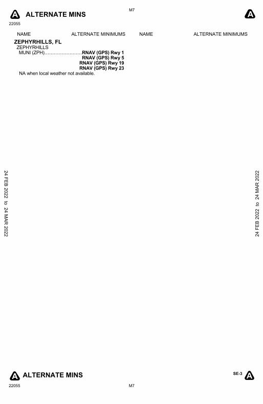
NAME ALTERNATE MINIMUMS NAME ALTERNATE MINIMUMS
ZEPHYRHILLS, FL ZEPHYRHILLS MUNI (ZPH)……………………RNAV (GPS) Rwy 1
RNAV (GPS) Rwy 5 RNAV (GPS) Rwy 19 RNAV (GPS) Rwy 23
NA when local weather not available.
A
24 FEB 2022 to 24 MAR
2022 24 F
EB 2
022
to 2
4 M
AR 2
022
22055
L1
SE-3 L1
T T
T T
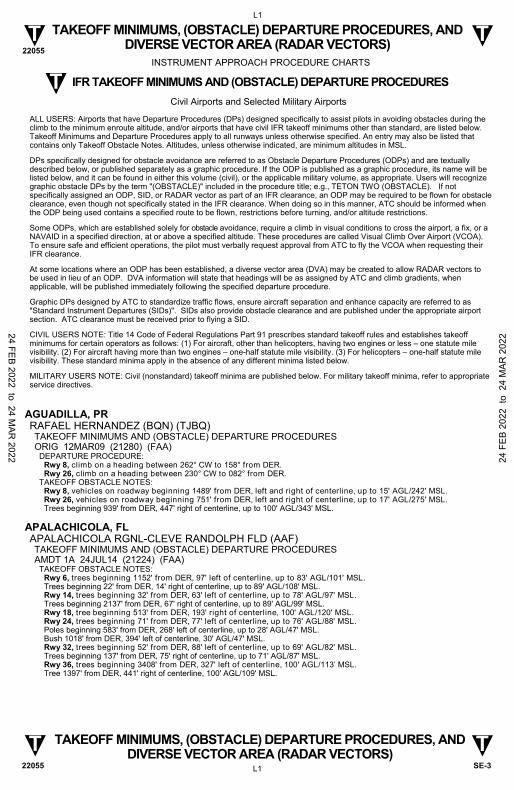
TAKEOFF MINIMUMS, (OBSTACLE) DEPARTURE PROCEDURES, AND DIVERSE VECTOR AREA (RADAR VECTORS)
TAKEOFF MINIMUMS, (OBSTACLE) DEPARTURE PROCEDURES, AND DIVERSE VECTOR AREA (RADAR VECTORS)
22055
AGUADILLA, PR RAFAEL HERNANDEZ (BQN) (TJBQ) TAKEOFF MINIMUMS AND (OBSTACLE) DEPARTURE PROCEDURES ORIG 12MAR09 (21280) (FAA)
DEPARTURE PROCEDURE: Rwy 8, climb on a heading between 262° CW to 158° from DER. Rwy 26, climb on a heading between 230° CW to 082° from DER.
TAKEOFF OBSTACLE NOTES: Rwy 8, vehicles on roadway beginning 1489' from DER, left and right of centerline, up to 15' AGL/242' MSL. Rwy 26, vehicles on roadway beginning 751' from DER, left and right of centerline, up to 17' AGL/275' MSL. Trees beginning 939' from DER, 447' right of centerline, up to 100' AGL/343' MSL.
APALACHICOLA, FL APALACHICOLA RGNL-CLEVE RANDOLPH FLD (AAF) TAKEOFF MINIMUMS AND (OBSTACLE) DEPARTURE PROCEDURES AMDT 1A 24JUL14 (21224) (FAA)
TAKEOFF OBSTACLE NOTES: Rwy 6, trees beginning 1152' from DER, 97' left of centerline, up to 83' AGL/101' MSL. Trees beginning 22' from DER, 14' right of centerline, up to 89' AGL/108' MSL. Rwy 14, trees beginning 32' from DER, 63' left of centerline, up to 78' AGL/97' MSL. Trees beginning 2137' from DER, 67' right of centerline, up to 89' AGL/99' MSL. Rwy 18, tree beginning 513' from DER, 193' right of centerline, 100' AGL/120' MSL. Rwy 24, trees beginning 71' from DER, 77' left of centerline, up to 76' AGL/88' MSL. Poles beginning 583' from DER, 268' left of centerline, up to 28' AGL/47' MSL. Bush 1018' from DER, 394' left of centerline, 30' AGL/47' MSL. Rwy 32, trees beginning 52' from DER, 88' left of centerline, up to 69' AGL/82' MSL. Trees beginning 137' from DER, 75' right of centerline, up to 71' AGL/87' MSL. Rwy 36, trees beginning 3408' from DER, 327' left of centerline, 100' AGL/113’ MSL. Tree 1397' from DER, 441' right of centerline, 100' AGL/109' MSL.
INSTRUMENT APPROACH PROCEDURE CHARTS
IFR TAKEOFF MINIMUMS AND (OBSTACLE) DEPARTURE PROCEDURES
Civil Airports and Selected Military Airports
ALL USERS: Airports that have Departure Procedures (DPs) designed specifically to assist pilots in avoiding obstacles during the climb to the minimum enroute altitude, and/or airports that have civil IFR takeoff minimums other than standard, are listed below. Takeoff Minimums and Departure Procedures apply to all runways unless otherwise specified. An entry may also be listed that contains only Takeoff Obstacle Notes. Altitudes, unless otherwise indicated, are minimum altitudes in MSL.
DPs specifically designed for obstacle avoidance are referred to as Obstacle Departure Procedures (ODPs) and are textually described below, or published separately as a graphic procedure. If the ODP is published as a graphic procedure, its name will be listed below, and it can be found in either this volume (civil), or the applicable military volume, as appropriate. Users will recognize graphic obstacle DPs by the term "(OBSTACLE)" included in the procedure title; e.g., TETON TWO (OBSTACLE). If not specifically assigned an ODP, SID, or RADAR vector as part of an IFR clearance, an ODP may be required to be flown for obstacle clearance, even though not specifically stated in the IFR clearance. When doing so in this manner, ATC should be informed when the ODP being used contains a specified route to be flown, restrictions before turning, and/or altitude restrictions.
Some ODPs, which are established solely for obstacle avoidance, require a climb in visual conditions to cross the airport, a fix, or a NAVAID in a specified direction, at or above a specified altitude. These procedures are called Visual Climb Over Airport (VCOA). To ensure safe and efficient operations, the pilot must verbally request approval from ATC to fly the VCOA when requesting their IFR clearance.
At some locations where an ODP has been established, a diverse vector area (DVA) may be created to allow RADAR vectors to be used in lieu of an ODP. DVA information will state that headings will be as assigned by ATC and climb gradients, when applicable, will be published immediately following the specified departure procedure.
Graphic DPs designed by ATC to standardize traffic flows, ensure aircraft separation and enhance capacity are referred to as "Standard Instrument Departures (SIDs)". SIDs also provide obstacle clearance and are published under the appropriate airport section. ATC clearance must be received prior to flying a SID.
CIVIL USERS NOTE: Title 14 Code of Federal Regulations Part 91 prescribes standard takeoff rules and establishes takeoff minimums for certain operators as follows: (1) For aircraft, other than helicopters, having two engines or less – one statute mile visibility. (2) For aircraft having more than two engines – one-half statute mile visibility. (3) For helicopters – one-half statute mile visibility. These standard minima apply in the absence of any different minima listed below.
MILITARY USERS NOTE: Civil (nonstandard) takeoff minima are published below. For military takeoff minima, refer to appropriate service directives.
T
24 FEB 2022 to 24 MAR
2022 24 F
EB 2
022
to 2
4 M
AR 2
022

22055
L2
SE-3 L2
T T
T T
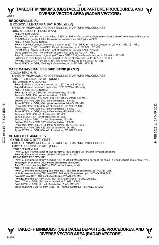
TAKEOFF MINIMUMS, (OBSTACLE) DEPARTURE PROCEDURES, AND DIVERSE VECTOR AREA (RADAR VECTORS)
TAKEOFF MINIMUMS, (OBSTACLE) DEPARTURE PROCEDURES, AND DIVERSE VECTOR AREA (RADAR VECTORS)
22055
APOPKA, FL ORLANDO APOPKA (X04) TAKEOFF MINIMUMS AND (OBSTACLE) DEPARTURE PROCEDURES ORIG 20SEP12 (12264) (FAA)
TAKEOFF MINIMUMS: Rwy 15, 300-2 or std. w/min. climb of 263’ per NM to 400. Rwy 33, 400-1¾ or std. w/min. climb of 325’ per NM to 600.
TAKEOFF OBSTACLE NOTES: Rwy 15, trees beginning at DER, 173' left of centerline, up to 100' AGL/229' MSL. Railroad and vehicles beginning at DER, 181' left of centerline, up to 23' AGL/152' MSL. Trees beginning 214' from DER, 552' right of centerline, up to 100' AGL/189' MSL. Poles beginning 230' from DER, 239' left of centerline, up to 49' AGL/178' MSL. Tower 5781' from DER, 1326' left of centerline, 199' AGL/317' MSL. Rwy 33, trees beginning 2' from DER, 183' left of centerline, up to 100' AGL/249' MSL. Poles beginning 7' from DER, 61' right of centerline, up to 49' AGL/198' MSL. Railroad and vehicles beginning 36' from DER, 90' right of centerline, up to 23' AGL/172' MSL. Antenna 1166' from DER, 539' left of centerline, 29' AGL/173' MSL. Tower 1.2 NM from DER, 2338' left of centerline, 350' AGL/421' MSL.
ARCADIA, FL ARCADIA MUNI (X06) TAKEOFF MINIMUMS AND (OBSTACLE) DEPARTURE PROCEDURES ORIG 29MAY14 (14149) (FAA)
TAKEOFF OBSTACLE NOTES: Rwy 5, trees beginning 6’ from DER, 107’ left of centerline, up to 20’ AGL/81’ MSL. Rwy 23, vehicle on road 234’ from DER, 538’ right of centerline 15’ AGL/74’ MSL. Trees beginning 315’ from DER, 120’ left of centerline, up to 50’ AGL/109’ MSL. Trees beginning 340’ from DER, 435’ right of centerline, up to 40’ AGL/95’ MSL. Building 449’ from DER, 409’ left of centerline, 25’ AGL/84’ MSL.
AVON PARK, FL AVON PARK EXECUTIVE (AVO) TAKEOFF MINIMUMS AND (OBSTACLE) DEPARTURE PROCEDURES AMDT 1 17DEC09 (09351) (FAA)
TAKEOFF MINIMUMS: Rwy 5, 300-1 or std. w/ min. climb of 430' per NM to 500.
TAKEOFF OBSTACLE NOTES: Rwy 5, trees beginning 219' from DER, 84' left of centerline, up to 100' AGL/284' MSL. Trees beginning 1007' from DER, 298' right of centerline, up to 100' AGL/289' MSL. Building 327' from DER, 431' right of centerline, 21' AGL/182' MSL. Rwy 10, buildings beginning 293' from DER, 251' left of centerline, up to 30' AGL/285' MSL. Line of trees beginning 298' from DER, 149' right to 229' left of centerline, up to 100' AGL/269' MSL. Rwy 23, trees beginning 52' from DER, 118' right of centerline, up to 26' AGL/186' MSL. Trees beginning 23' from DER, 93' left of centerline, up to 38' AGL/198' MSL. Power lines beginning 2691' from DER, 1019' left to 2034' right of centerline, up to 79' AGL/235' MSL. Rwy 28, numerous trees beginning 371' from DER, 218' right of centerline, up to 100' AGL/259' MSL. Buildings and light poles beginning 1491' from DER, 187' left of centerline, up to 40' AGL/194' MSL. Power pylons beginning 2082' from DER, 935' left to 252' right of centerline, up to 79' AGL/233' MSL.
24 FEB 2022 to 24 M
AR 2022 24
FEB
202
2 to
24
MAR
202
2

22055
L3
SE-3 L3
T T
T T
TAKEOFF MINIMUMS, (OBSTACLE) DEPARTURE PROCEDURES, AND DIVERSE VECTOR AREA (RADAR VECTORS)
TAKEOFF MINIMUMS, (OBSTACLE) DEPARTURE PROCEDURES, AND DIVERSE VECTOR AREA (RADAR VECTORS)
22055
BARTOW, FL BARTOW EXEC (BOW) TAKEOFF MINIMUMS AND (OBSTACLE) DEPARTURE PROCEDURES ORIG-A 15AUG19 (21168) (FAA)
TAKEOFF OBSTACLE NOTES: Rwy 5, tree 164’ from DER, 397’ right of centerline, 156’ MSL. Tree 285’ from DER, 303’ right of centerline, 157’ MSL. Trees beginning 290’ from DER, 406’ right of centerline, up to 165’ MSL. Trees beginning 414’ from DER, 166’ right of centerline, up to 166’ MSL. Trees beginning 631’ from DER, 59’ right of centerline, up to 169’ MSL. Tree 937’ from DER, 432’ left of centerline, 152’ MSL. Trees beginning 969’ from DER, 19’ left of centerline, up to 172’ MSL. Trees beginning 1095’ from DER, 9’ left of centerline, up to 176’ MSL. Trees beginning 1225’ from DER, 234’ left of centerline, up to 186’ MSL. Trees beginning 1226’ from DER, 68’ right of centerline, up to 175’ MSL. Trees beginning 1263’ from DER, 115’ right of centerline, up to 176’ MSL. Trees beginning 1442’ from DER, 16’ left of centerline, up to 190’ MSL. Tree 1676’ from DER, 8’ right of centerline, 178’ MSL. Trees beginning 1737’ from DER, 31’ right of centerline, up to 184’ MSL. Trees beginning 1842’ from DER, 53’ left of centerline, up to 192’ MSL. Tree 2498’ from DER, 278’ left of centerline, 196’ MSL. Tree 2613’ from DER, 213’ left of centerline, 198’ MSL. Rwy 9L, tree 15’ from DER, 497’ left of centerline, 148’ MSL. Tree 49’ from DER, 466’ right of centerline, 140’ MSL. Trees beginning 227’ from DER, 19’ left of centerline, up to 149’ MSL. Trees beginning 911’ from DER, 53’ right of centerline, up to 173’ MSL. Tree 1260’ from DER, 155’ left of centerline, 155’ MSL. Tree 1603’ from DER, 265’ left of centerline, 156’ MSL. Trees beginning 1715’ from DER, 261’ left of centerline, up to 169’ MSL. Tree 1790’ from DER, 163’ left of centerline, 170’ MSL. Tree 2256’ from DER, 304’ left of centerline, 174’ MSL. Rwy 9R, tree 637’ from DER, 533’ left of centerline, 140’ MSL. Tree 1310’ from DER, 253’ right of centerline, 167’ MSL. Trees beginning 1499’ from DER, 166’ left of centerline, up to 173’ MSL. Tree 1695’ from DER, 197’ right of centerline, 178’ MSL. Rwy 23, tree 143’ from DER, 442’ left of centerline, 144’ MSL. Tree 289’ from DER, 363’ left of centerline, 146’ MSL. Tree 299’ from DER, 525’ left of centerline, 147’ MSL. Tree 416’ from DER, 561’ left of centerline, 153’ MSL. Trees beginning 418’ from DER, 320’ left of centerline, up to 158’ MSL. Trees beginning 419’ from DER, 395’ right of centerline, up to 167’ MSL. Trees beginning 567’ from DER, 86’ left of centerline, up to 172’ MSL. Tree 842’ from DER, 629’ right of centerline, 171’ MSL. Trees beginning 865’ from DER, 32’ right of centerline, up to 175’ MSL. Trees beginning 1730’ from DER, 122’ left of centerline, up to 180’ MSL. Trees beginning 1777’ from DER, 425’ right of centerline, up to 176’ MSL. Trees beginning 2136’ from DER, 493’ right of centerline, up to 179’ MSL. Rwy 27L, tree 939’ from DER, 643’ left of centerline, 170’ MSL. Tree 2007’ from DER, 906’ right of centerline, 166’ MSL. Tree 2065’ from DER, 517’ right of centerline, 167’ MSL. Trees beginning 2338’ from DER, 602’ right of centerline, up to 175’ MSL. Pole 2554’ from DER, 996’ right of centerline, 49’ AGL/177’ MSL. Tower 2881’ from DER, 1015’ left of centerline, 50’ AGL/187’ MSL. Rwy 27R, pole 1259’ from DER, 668’ right of centerline, 36’ AGL/150’ MSL. Trees beginning 1993’ from DER, 410’ right of centerline, up to 186’ MSL. Trees beginning 2109’ from DER, 158’ right of centerline, up to 193’ MSL.
BOCA RATON, FL BOCA RATON (BCT) TAKEOFF MINIMUMS AND (OBSTACLE) DEPARTURE PROCEDURES ORIG 28SEP06 (06271) (FAA)
TAKEOFF MINIMUMS: Rwy 23, 300-1, or std. w/ a min. climb of 230' per NM to 300. Alternatively, with standard takeoff minimums and a normal 200'/NM climb gradient, takeoff must occur no later than 1700' prior to DER.
TAKEOFF OBSTACLE NOTES: Rwy 5, numerous trees and poles beginning 185' from DER, 20' left of centerline, up to 35' AGL/49' MSL. Numerous trees and poles beginning 6' from DER, 267' right of centerline, up to 28' AGL/45' MSL. Rwy 23, numerous trees, poles, and buildings beginning 278' from DER, 41' left of centerline, up to 137' AGL/154' MSL. Numerous trees, poles and buildings beginning 626' from DER, 171' right of centerline, up to 154' AGL/171' MSL.
24 FEB 2022 to 24 MAR
2022 24 F
EB 2
022
to 2
4 M
AR 2
022

22055
L4
SE-3 L4
T T
T T
TAKEOFF MINIMUMS, (OBSTACLE) DEPARTURE PROCEDURES, AND DIVERSE VECTOR AREA (RADAR VECTORS)
TAKEOFF MINIMUMS, (OBSTACLE) DEPARTURE PROCEDURES, AND DIVERSE VECTOR AREA (RADAR VECTORS)
22055
BONIFAY, FL TRI-COUNTY (BCR) TAKEOFF MINIMUMS AND (OBSTACLE) DEPARTURE PROCEDURES AMDT 1 02DEC21 (21336) (FAA)
TAKEOFF MINIMUMS: Rwy 1, 300 and 1¼ or std. w/min. climb of 220’ per NM to 300. DEPARTURE PROCEDURE:
Rwy 1, climb on heading 013° to 1300 before turning west. Rwy 19, climb on heading 193° to 800 before turning west. TAKEOFF OBSTACLE NOTES: Rwy 1, trees, fence beginning 27’ from DER, 250’ right of centerline, up to 64’ AGL/144’ MSL.
Poles, terrain, vehicle on road, fence, tree beginning 42’ from DER, 213’ left of centerline, up to 35’ AGL/124’ MSL. Trees beginning 373’ from DER, 308’ right of centerline, up to 67’ AGL/146’ MSL. Trees, pole beginning 470’ from DER, 125’ right of centerline, up to 81’ AGL/160’ MSL. Tree 991’ from DER, 721’ left of centerline, 61’ AGL/152’ MSL. Trees, pole beginning 1032’ from DER, 463’ left of centerline, up to 63’ AGL/154’ MSL. Trees, pole beginning 1258’ from DER, 66’ left of centerline, up to 71’ AGL/163’ MSL. Trees beginning 1515’ from DER, 119’ right of centerline, up to 74’ AGL/161’ MSL. Trees beginning 1551’ from DER, 190’ right of centerline, up to 83’ AGL/165’ MSL. Trees beginning 1562’ from DER, 7’ right of centerline, up to 85’ AGL/171’ MSL. Trees beginning 1626’ from DER, 476’ left of centerline, up to 93’ AGL/183’ MSL. Trees beginning 1704’ from DER, 2’ left of centerline, up to 99’ AGL/189’ MSL. Trees beginning 2138’ from DER, 2’ right of centerline, up to 97’ AGL/176’ MSL. Trees beginning 2259’ from DER, 2’ right of centerline, up to 101’ AGL/181’ MSL. Trees beginning 2571’ from DER, 11’ left of centerline, up to 103’ AGL/194’ MSL. Trees beginning 2647’ from DER, 2’ right of centerline, up to 103’ AGL/184’ MSL. Tree 2957’ from DER, 879’ left of centerline, 110’ AGL/199’ MSL. Trees beginning 2960’ from DER, 10’ right of centerline, up to 115’ AGL/195’ MSL. Trees beginning 2961’ from DER, 1’ left of centerline, up to 114’ AGL/201’ MSL. Trees beginning 3244’ from DER, 837’ right of centerline, up to 115’ AGL/196’ MSL. Trees beginning 3464’ from DER, 1092’ right of centerline, up to 117’ AGL/197’ MSL. Trees beginning 3552’ from DER, 872’ left of centerline, up to 86’ AGL/202’ MSL. Trees beginning 3636’ from DER, 32’ right of centerline, up to 119’ AGL/200’ MSL. Trees beginning 3672’ from DER, 1’ left of centerline, up to 79’ AGL/204’ MSL. Tree 4231’ from DER, 470’ left of centerline, 69’ AGL/206’ MSL. Tree 4259’ from DER, 560’ left of centerline, 75’ AGL/212’ MSL. Trees beginning 4293’ from DER, 193’ left of centerline, up to 80’ AGL/217’ MSL. Trees beginning 4576’ from DER, 416’ right of centerline, up to 75’ AGL/202’ MSL. Trees beginning 4691’ from DER, 487’ right of centerline, up to 78’ AGL/205’ MSL. Trees beginning 4864’ from DER, 487’ right of centerline, up to 84’ AGL/211’ MSL. Trees beginning 4926’ from DER, 281’ left of centerline, up to 85’ AGL/221’ MSL. Tree 5164’ from DER, 532’ right of centerline, 84’ AGL/216’ MSL. Trees beginning 5186’ from DER, 539’ right of centerline, up to 98’ AGL/225’ MSL. Tree 5719’ from DER, 351’ left of centerline, 73’ AGL/227’ MSL. Tree 5747’ from DER, 332’ left of centerline, 78’ AGL/232’ MSL. Trees beginning 5765’ from DER, 263’ left of centerline, up to 87’ AGL/239’ MSL. Trees beginning 5985’ from DER, 343’ left of centerline, up to 86’ AGL/240’ MSL. Tree 1 NM from DER, 493’ left of centerline, 85’ AGL/244’ MSL. Tree 1 NM from DER, 581’ left of centerline, 89’ AGL/247’ MSL. Rwy 19, tree 52’ from DER, 454’ left of centerline, 57’ AGL/138’ MSL. Terrain beginning 75’ from DER, 296’ right of centerline, up to 102’ MSL. Terrain beginning 163’ from DER, 331’ right of centerline, up to 103’ MSL. Trees beginning 173’ from DER, 339’ left of centerline, up to 64’ AGL/145’ MSL. Terrain beginning 274’ from DER, 353’ right of centerline, up to 106’ MSL. Trees beginning 311’ from DER, 378’ left of centerline, up to 74’ AGL/153’ MSL. Tree 391’ from DER, 553’ right of centerline, 67’ AGL/163’ MSL. Tree 489’ from DER, 512’ right of centerline, 71’ AGL/164’ MSL. Trees beginning 531’ from DER, 382’ left of centerline, up to 79’ AGL/156’ MSL. Trees beginning 566’ from DER, 506’ right of centerline, up to 80’ AGL/169’ MSL. Trees beginning 829’ from DER, 431’ left of centerline, up to 69’ AGL/157’ MSL. Trees beginning 830’ from DER, 459’ right of centerline, up to 94’ AGL/183’ MSL. Tree 1414’ from DER, 615’ left of centerline, 76’ AGL/158’ MSL. Trees beginning 1505’ from DER, 643’ left of centerline, up to 79’ AGL/160’ MSL. Trees beginning 1546’ from DER, 550’ left of centerline, up to 89’ AGL/164’ MSL. Trees beginning 1606’ from DER, 6’ right of centerline, up to 104’ AGL/187’ MSL. Trees beginning 1654’ from DER, 579’ left of centerline, up to 94’ AGL/171’ MSL. Trees beginning 2011’ from DER, 6’ left of centerline, up to 102’ AGL/176’ MSL. Trees beginning 2579’ from DER, 5’ left of centerline, up to 100’ AGL/180’ MSL. Trees beginning 2744’ from DER, 53’ left of centerline, up to 101’ AGL/181’ MSL. Trees beginning 3313’ from DER, 134’ right of centerline, up to 111’ AGL/189’ MSL.
24 FEB 2022 to 24 MAR
2022 24 F
EB 2
022
to 2
4 M
AR 2
022
22055
L5
SE-3 L5
T T
T T
TAKEOFF MINIMUMS, (OBSTACLE) DEPARTURE PROCEDURES, AND DIVERSE VECTOR AREA (RADAR VECTORS)
TAKEOFF MINIMUMS, (OBSTACLE) DEPARTURE PROCEDURES, AND DIVERSE VECTOR AREA (RADAR VECTORS)
22055
BROOKSVILLE, FL BROOKSVILLE-TAMPA BAY RGNL (BKV) TAKEOFF MINIMUMS AND (OBSTACLE) DEPARTURE PROCEDURES ORIG-A 24JUL14 (14205) (FAA)
TAKEOFF MINIMUMS: Rwy 9, 300-1¼ or std. w/ a min. climb of 220' per NM to 300, or alternatively, with standard takeoff minimums and a normal 200'/NM climb gradient, takeoff must occur no later than 1200' prior to DER.
TAKEOFF OBSTACLE NOTES: Rwy 3, obstruction light and trees beginning 297' from DER, 34' right of centerline, up to 81' AGL/151' MSL. Trees beginning 1681' from DER, 29' left of centerline, up to 83' AGL/153' MSL. Rwy 9, trees 9' from DER, 287' right of centerline, up to 69' AGL/73' MSL. Trees beginning 2021' left and right of centerline, up to 92' AGL/171' MSL. Rwy 21, pole and trees beginning 46' from DER, 27' right of centerline, up to 70' AGL/138' MSL. Building and trees beginning 108' from DER, 39' left of centerline, up to 85' AGL/155' MSL. Rwy 27, trees 2143' from DER, 891' left of centerline, up to 89' AGL/189' MSL. Trees 4755' from DER, 1684' right of centerline, up to 99' AGL/199' MSL.
CAPE CANAVERAL SFS SKID STRIP (KXMR) COCOA BEACH, FL
TAKEOFF MINIMUMS AND (OBSTACLE) DEPARTURE PROCEDURES AMDT 3 24FEB22 (22055) (USSF)
DEPARTURE PROCEDURES: Rwy 13, diverse departure authorized 125° CW to 310° only.
Rwy 31, diverse departure authorized 322° CCW to 143° only. TAKEOFF OBSTACLE NOTES:
Rwy 13, terrain at DER, 434’ left of centerline, 13’ MSL. Terrain at DER, 500’ right of centerline, 15’ MSL. Rwy 31, light pole 1795’ from DER, 498’ left of centerline, 8’ MSL. Bushes 144’ from DER, 500’ left of centerline, 18’ MSL. Pylon 4172’ from DER, 380’ right of centerline, 56’ AGL/79’ MSL. Pylon 3795’ from DER, 363’ left of centerline, 56’ AGL/77’ MSL. Bushes 221’ from DER, 509’ left of centerline, 18’ MSL. Pylon 3974’ from DER, 8’ right of centerline, 56’ AGL/83’ MSL. Terrain at DER, 500’ left of centerline, 17’ MSL. Terrain at DER, 434’ left of centerline, 16’ MSL. Terrain 25’ from DER, 101’ left of centerline, 13’ MSL. Bushes 305’ from DER, 508’ left of centerline, 19’ MSL. Pylon 3426’ from DER, 1073’ left of centerline, 56’ AGL/66’ MSL. Bushes 573’ from DER, 622’ right of centerline, 26’ MSL. Pylon 3627’ from DER, 688’ left of centerline, 56’ AGL/71’ MSL.
CHARLOTTE AMALIE, VI CYRIL E KING (STT) (TIST) TAKEOFF MINIMUMS AND (OBSTACLE) DEPARTURE PROCEDURES AMDT 1 05JUN08 (21280) (FAA)
TAKEOFF MINIMUMS: Rwy 10, 400-1 w/min. climb of 462' per NM to 1400 or 2100-2½ for climb in visual conditions. Rwy 28, 800-3 or std. w/min. climb of 366' per NM to 1000.
DEPARTURE PROCEDURE: Rwy 10, climbing right turn heading 120° to 2000 before turning north or for climb in visual conditions, cross Cyril E King airport at or above 2000 before proceeding on course. Rwy 28, climb heading 280° to 2000 before turning north.
TAKEOFF OBSTACLE NOTES: Rwy 10, antenna on building 258' from DER, 485' left of centerline, 25' AGL/41' MSL. Multiple trees beginning 729' from DER, 244' right of centerline up to 100' AGL/259' MSL. Pole 300' from DER, 430' right of centerline, 23' AGL/39' MSL. Rwy 28, antenna 33' from DER, 412' left of centerline, 16' AGL/29' MSL. Bush 175' from DER, 178' right of centerline, 2' AGL/29' MSL. Bush 206' from DER, 121' left of centerline, 2' AGL/29' MSL. Trees beginning 2.39 NM from DER, 4351' right of centerline, 100' AGL/710' MSL.
24 FEB 2022 to 24 MAR
2022 24 F
EB 2
022
to 2
4 M
AR 2
022

22055
L6
SE-3 L6
T T
T T
TAKEOFF MINIMUMS, (OBSTACLE) DEPARTURE PROCEDURES, AND DIVERSE VECTOR AREA (RADAR VECTORS)
TAKEOFF MINIMUMS, (OBSTACLE) DEPARTURE PROCEDURES, AND DIVERSE VECTOR AREA (RADAR VECTORS)
22055
CHRISTIANSTED, ST. CROIX, VI HENRY E. ROHLSEN (STX) (TISX) TAKEOFF MINIMUMS AND (OBSTACLE) DEPARTURE PROCEDURES AMDT 9 29MAY14 (21280) (FAA)
TAKEOFF MINIMUMS: Rwy 10, 300-1¾ or std. w/min. climb of 300' per NM to 300.
DEPARTURE PROCEDURE: Rwy 10, climb heading 108° to 1300 before proceeding on course. Rwy 28, climb heading 277° to 1200 before proceeding on course.
TAKEOFF OBSTACLE NOTES: Rwy 10, bushes beginning 103’ from DER, 283’ right of centerline, up to 10’ AGL/32’ MSL. Pole 794’ from DER, 572’ right of centerline, up to 29’ AGL/44’ MSL. Bushes beginning 127’ from DER, 324’ left of centerline, up to 10’ AGL/34’ MSL. Pole 595’ from DER, 653’ left of centerline, up to 41’ AGL/62’ MSL. Trees beginning 935’ from DER, 562’ left of centerline, up to 29’ AGL/70’ MSL. Refinery buildings beginning 5289’ from DER, 798’ left of centerline, up to 203’ AGL/231’ MSL. Rwy 28, trees beginning 517’ from DER, 553’ right of centerline, up to 53’ AGL/114’ MSL. Tower 1499’ from DER, 802’ right of centerline, 50’ AGL/140’ MSL.
CLEWISTON, FL AIRGLADES (2IS) TAKEOFF MINIMUMS AND (OBSTACLE) DEPARTURE PROCEDURES ORIG 12MAR09 (09071) (FAA)
TAKEOFF OBSTACLE NOTES: Rwy 31, vehicle on road, 362' from DER, 578' right of centerline, 15' AGL/38' MSL.
CRESTVIEW, FL BOB SIKES (CEW) TAKEOFF MINIMUMS AND (OBSTACLE) DEPARTURE PROCEDURES ORIG 31JUL08 (08213) (FAA)
TAKEOFF OBSTACLE NOTES: Rwy 17, trees beginning 92' from DER, 248' right of centerline up to 100' AGL/203' MSL. Trees beginning 171' from DER, 9' left of centerline, up to 100' AGL/205' MSL. Rwy 35, trees beginning 329' from DER, 222' right of centerline up to 100' AGL/272' MSL. Trees beginning 152' from DER, 184' left of centerline, up to 100' AGL/278' MSL.
CROSS CITY, FL CROSS CITY (CTY) TAKEOFF MINIMUMS AND (OBSTACLE) DEPARTURE PROCEDURES ORIG 05JUN08 (08157) (FAA)
TAKEOFF OBSTACLE NOTES: Rwy 4, trees beginning 527' from DER, left and right of centerline, up to 100' AGL/149' MSL. Rwy 13, trees beginning 158' from DER, left and right of centerline, up to 100' AGL/149' MSL. Tank 3302' from DER, 927' right of centerline, 101' AGL/141' MSL. Rwy 22, trees beginning 1510' from DER, left and right of centerline, up to 100' AGL/149' MSL. Power lines 2807' from DER, 58' left of centerline, 73' AGL/114' MSL. Rwy 31, trees beginning 195' from DER, left and right of centerline, up to 100' AGL/149' MSL.
CRYSTAL RIVER, FL CRYSTAL RIVER-CAPTAIN TOM DAVIS FIELD (CGC) TAKEOFF MINIMUMS AND (OBSTACLE) DEPARTURE PROCEDURES ORIG-A 11DEC14 (14345) (FAA)
TAKEOFF MINIMUMS: Rwy 9, std. w/ min. climb of 260' per NM to 600, or 500-2¾ with min. climb of 210' per NM to 900, or 900-2½ for climb in visual conditions. Rwys 18, 36, NA-Environmental.
DEPARTURE PROCEDURE: Rwy 9, climb heading 096º to 700 before turning right, or for climb in visual conditions cross Crystal River-Tom Davis Field at or above 800 before proceeding on course.
TAKEOFF OBSTACLE NOTES: Rwy 9, vehicles on road beginning 6' from DER, from left to right of centerline, up to 15' AGL/24' MSL. Multiple trees beginning 364' from DER, from 680' left of centerline to 820' right of centerline, up to 100' AGL/129' MSL. Rwy 27, trees 17' from DER, 484' right of centerline, up to 100' AGL/109' MSL. Vehicles on road beginning 368' from DER, from left to right of centerline, up to 15' AGL/24' MSL. Power line beginning 474' from DER, from left to right of centerline, up to 26' AGL/45' MSL. Building 916' from DER, on centerline, 26' AGL/35' MSL. Multiple trees beginning 762' from DER, from 915' left of centerline to 641' right of centerline, up to 100' AGL/119' MSL.
24 FEB 2022 to 24 MAR
2022 24 F
EB 2
022
to 2
4 M
AR 2
022

22055
L7
SE-3 L7
T T
T T
TAKEOFF MINIMUMS, (OBSTACLE) DEPARTURE PROCEDURES, AND DIVERSE VECTOR AREA (RADAR VECTORS)
TAKEOFF MINIMUMS, (OBSTACLE) DEPARTURE PROCEDURES, AND DIVERSE VECTOR AREA (RADAR VECTORS)
22055
DAYTONA BEACH, FL DAYTONA BEACH INTL (DAB) TAKEOFF MINIMUMS AND (OBSTACLE) DEPARTURE PROCEDURES AMDT 4 27AUG09 (09239) (FAA)
TAKEOFF OBSTACLE NOTES: Rwy 7L, multiple trees beginning 1834' from DER, 646' right of centerline, up to 64' AGL/95' MSL. Rwy 7R, tower, trees beginning 1042' from DER, 413' right of centerline, up to 100' AGL/135' MSL. Hanger, multiple trees beginning 901' from DER, 55' left of centerline, up to 67' AGL/101' MSL. Rwy 16, multiple trees beginning 57' from DER, 19' left of centerline, up to 75' AGL/104' MSL. Multiple trees beginning 871' from DER, 3' right of centerline, up to 83' AGL/112' MSL. Rwy 25L, multiple trees beginning 123' from DER, 75' left of centerline, up to 80' AGL/109' MSL. Multiple trees and antenna beginning 1002' from DER, 85' right of centerline, up to 72' AGL/101' MSL. Rwy 25R, multiple trees, signs, and poles beginning 428' from DER, 38' right of centerline, up to 88' AGL/115' MSL. Multiple trees beginning 1254' from DER, 41' left of centerline, up to 84' AGL/108' MSL. Rwy 34, multiple trees, building and obstruction light beginning 1013' from DER, 90' left of centerline, up to 82' AGL/111' MSL. Multiple trees, beginning 1108' from DER, 6' right of centerline, up to 78' AGL/107' MSL.
DEFUNIAK SPRINGS, FL DEFUNIAK SPRINGS (54J) TAKEOFF MINIMUMS AND (OBSTACLE) DEPARTURE PROCEDURES ORIG 07MAY09 (09127) (FAA)
TAKEOFF MINIMUMS: Rwy 9, 400-2¼ or std. w/ min. climb of 254' per NM to 800. Rwys 18,36, NA - dirt.
TAKEOFF OBSTACLE NOTES: Rwy 9, multiple roads, railroad, building, fence, light on pole, poles, signs, towers and trees beginning 25' from DER, 1' left of centerline, up to 431' AGL/617' MSL. Multiple trees and roads beginning 71' from DER, 118' right of centerline, up to 74' AGL/343' MSL. Rwy 27, multiple trees, poles, fences, roads and building beginning 8' from DER, 39' left of centerline, up to 64' AGL/353' MSL. Multiple trees, poles, roads, buildings and light on pole beginning 82' from DER, 15' right of centerline, up to 53' AGL/342' MSL.
DELAND, FL DELAND MUNI/SIDNEY H. TAYLOR FIELD (DED) TAKEOFF MINIMUMS AND (OBSTACLE) DEPARTURE PROCEDURES AMDT 3 08JUN06 (06159) (FAA)
DEPARTURE PROCEDURE: Rwy 5, climb via heading 054° to 1800 before proceeding on course. Rwy 12, climb via heading 122° to 1800 before proceeding on course. Rwy 23, climb via heading 234° to 1800 before proceeding on course. Rwy 30, climb via heading 302° to 1800 before proceeding on course.
TAKEOFF OBSTACLE NOTES: Rwy 5, numerous trees beginning 64' from DER, 245' left of centerline, up to 100' AGL/143' MSL. Numerous trees beginning 869' from DER, 410' right of centerline, up to 100' AGL/154' MSL. Rwy 12, numerous trees beginning 154' from DER, 129' left of centerline, up to 100' AGL/153' MSL. Numerous trees beginning 456' from DER, 289' right of centerline, up to 100' AGL/162' MSL. Rwy 30, numerous trees beginning 624' from DER, 9' left of centerline, up to 100' AGL/156' MSL. Numerous trees beginning 159' from DER, 341' right of centerline, up to 100' AGL/162' MSL. Rwy 23, light pole and numerous trees beginning 381' from DER, 44' right of centerline, up to 100' AGL/132' MSL. Pole, building, vent on building, hangar, and trees beginning 164' from DER, 26' left of centerline, up to 100' AGL/129' MSL.
24 FEB 2022 to 24 MAR
2022 24 F
EB 2
022
to 2
4 M
AR 2
022

22055
L8
SE-3 L8
T T
T T
TAKEOFF MINIMUMS, (OBSTACLE) DEPARTURE PROCEDURES, AND DIVERSE VECTOR AREA (RADAR VECTORS)
TAKEOFF MINIMUMS, (OBSTACLE) DEPARTURE PROCEDURES, AND DIVERSE VECTOR AREA (RADAR VECTORS)
22055
DESTIN, FL DESTIN EXEC (DTS) TAKEOFF MINIMUMS AND (OBSTACLE) DEPARTURE PROCEDURES ORIG-C 07DEC17 (21168) (FAA)
TAKEOFF MINIMUMS: Rwy 14, 200-1 or std. w/min. climb of 253’ per NM to 300.
DEPARTURE PROCEDURE: Rwy 14, climb heading 141° to 500 before turning.
TAKEOFF OBSTACLE NOTES: Rwy 14, tree 173’ from DER, 381’ left of centerline, 48’ MSL. Pole 214’ from DER, 477’ right of centerline, 26’ AGL/43’ MSL. Trees beginning 290’ from DER, 350’ left of centerline, up to 57’ MSL. Tree 524’ from DER, 602’ left of centerline, 69’ MSL. Trees beginning 630’ from DER, 362’ left of centerline, up to 71’ MSL. Pole 2410’ from DER, 522‘ right of centerline, 59’ AGL/82’ MSL. Poles beginning 2832’ from DER, 77’ right of centerline, up to 70’ AGL/94’ MSL. Buildings beginning 3752’ from DER, 1146’ left of centerline, up to 128’ AGL/149’ MSL. Building 4098’ from DER, 103’ right of centerline, 122’ AGL/137’ MSL. Building 4526’ from DER, 579’ left of centerline, 148’ AGL/169’ MSL. Building 4711’ from DER, 236’ right of centerline, 129’ AGL/139’ MSL. Vertical structure, buildings beginning 4942’ from DER, 412’ left of centerline, up to 162’ AGL/176’ MSL. Rwy 32, trees, building, pole beginning 66’ from DER, 455’ left of centerline, up to 56’ MSL. Trees beginning 79’ from DER, 359’ right of centerline, up to 78’ MSL. Trees beginning 220’ from DER, 439’ right of centerline, up to 82’ MSL. Trees beginning 480’ from DER, 31’ right of centerline, up to 84’ MSL. Trees beginning 586’ from DER, 64’ left of centerline, up to 81’ MSL. Trees beginning 1592’ from DER, 91’ left of centerline, up to 83’ MSL.
DUNNELLON, FL MARION COUNTY (X35) TAKEOFF MINIMUMS AND (OBSTACLE) DEPARTURE PROCEDURES AMDT 1A 13SEP18 (18256) (FAA)
TAKEOFF OBSTACLE NOTES: Rwy 5, trees beginning 308’ from DER, 265’ right of centerline, up to 100’ AGL/179’ MSL. Trees beginning 114’ from DER, 170’ left of centerline, up to 100’ AGL/199’ MSL. Rwy 10, trees beginning 85’ from DER, 276’ right of centerline, up to 100’ AGL/164’ MSL. Trees beginning 82’ from DER, 311’ left of centerline, up to 100’ AGL/164’ MSL. Rwy 23, trees beginning 1100’ from DER, 431’ right of centerline, up to 100’ AGL/179’ MSL. Trees beginning 601’ from DER, 610’ left of centerline, up to 100’ AGL/169’ MSL. Rwy 28, trees beginning 268’ from DER, 404’ right of centerline, up to 100’ AGL/169’ MSL. Trees beginning 363’ from DER, 273’ left of centerline, up to 100’ AGL/179’ MSL.
FERNANDINA BEACH, FL FERNANDINA BEACH MUNI (FHB) TAKEOFF MINIMUMS AND (OBSTACLE) DEPARTURE PROCEDURES AMDT 1 19SEP13 (13262) (FAA)
TAKEOFF OBSTACLE NOTES: Rwy 4, trees beginning 317’ from DER, 11’ left of centerline, up to 100’ AGL/110’ MSL. Wall 77’ from DER, 301’ left of centerline, 6’ AGL/20’ MSL. Vehicle on road 552’ from DER, 437’ left of centerline, 15’ AGL/29’ MSL. Poles beginning 178’ from DER, 441’ left of centerline, 39’ AGL/52’ MSL. Fence 71’ from DER, 311‘ left of centerline, 10’ AGL/23’ MSL. Trees beginning 660’ from DER, 4’ right of centerline, up to 105’ AGL/115’ MSL. Signs beginning 112’ from DER, 292’ right of centerline, up to 78’ AGL/92’ MSL. Rwy 9, trees beginning 210’ from DER, 15’ left of centerline, up to 92’ AGL/107’ MSL. Vehicle on road 463’ from DER, 252’ left of centerline, 15’ AGL/30’ MSL. Trees beginning 39’ from DER, 17’ right of centerline, up to 82’ AGL/97’ MSL. Vehicle on road beginning 422’ from DER, 129’ right of centerline, 15’ AGL/30’ MSL. Rwy 13, trees beginning 503’ from DER. 7’ left of centerline, up to 84’ AGL/99’ MSL. Vehicle on road beginning 426’ from DER, 309’ left of centerline 15’ AGL/up to 35’ MSL. Trees beginning 19’ from DER, 12’ right of centerline, up to 85’ AGL/100’ MSL. Vehicle on road beginning 355’ from DER, 70’ right of centerline, up to 15’ AGL/31’ MSL. Multiple buildings beginning 4513’ from DER, 286’ right of centerline, up to 119’ AGL/141’ MSL. Rwy 22, trees beginning 55’ from DER, 118’ left of centerline, up to 78’ AGL/83’ MSL. Fence beginning 64‘ from DER, 267’ left of centerline, 10’ AGL/22’ MSL. Trees beginning 42’ from DER, 210’ right of centerline, up to 95’ AGL/100’ MSL. Navaid 10’ from DER, 85’ right of centerline, 2’ AGL/14’ MSL. Boat mast 2903’ from DER, 336’ right of centerline, up to 86’ MSL. CON’T
24 FEB 2022 to 24 MAR
2022 24 F
EB 2
022
to 2
4 M
AR 2
022

22055
L9
SE-3 L9
T T
T T
TAKEOFF MINIMUMS, (OBSTACLE) DEPARTURE PROCEDURES, AND DIVERSE VECTOR AREA (RADAR VECTORS)
TAKEOFF MINIMUMS, (OBSTACLE) DEPARTURE PROCEDURES, AND DIVERSE VECTOR AREA (RADAR VECTORS)
22055
FERNANDINA BEACH, FL (CON’T) FERNANDINA BEACH MUNI (FHB) (CON’T)
Rwy 27, trees beginning 195’ from DER, 30’ left of centerline, up to 99’ AGL/104’ MSL. Trees beginning 836’ from DER, 42’ right of centerline, up to 96’ AGL/101’ MSL. Bush 338’ from DER, 186’ right of centerline, 11’ AGL/21’ MSL. Rwy 31, trees beginning 29’ from DER, 216 left of centerline, up to 96’ AGL/101’ MSL. Bush 24’ from DER, 379’ left of centerline, 11’ AGL/21’ MSL. Trees beginning 646’ from DER, 561’ right of centerline, up to 71’ AGL/81’ MSL.
FORT LAUDERDALE, FL FORT LAUDERDALE EXEC (FXE) TAKEOFF MINIMUMS AND (OBSTACLE) DEPARTURE PROCEDURES AMDT 5 25JUN15 (21168) (FAA)
DEPARTURE PROCEDURE: Rwy 27, climb heading 271° to 600 before turning left.
TAKEOFF OBSTACLE NOTES: Rwy 9, building 833’ from DER, 721’ left of centerline, 40’ AGL/51’ MSL. Tree 1903’ from DER, 484‘ right of centerline, 85’ AGL/89’ MSL. Building 4130’ from DER, 41’ right of centerline, 122’ AGL/129‘ MSL. Building 4720’ from DER, 78’ right of centerline 150’ AGL/157’ MSL. Rwy 13, buildings beginning 2’ from DER, 465’ left and 303 right of centerline, up to 32’ AGL/42’ MSL. Trees, poles and buildings beginning 452’ from DER, 290’ left and 167’ right of centerline up to 45‘ AGL/54’ MSL. Trees beginning 1976’ from DER, 259’ right of centerline, up to 92’ AGL/101’ MSL. Tower 5130’ from DER, 1826’ right of centerline, 139’ AGL/147’ MSL. Rwy 27, trees beginning 2040’ from DER, 256’ left of centerline up to 105’ AGL/116’ MSL. Rwy 31, trees and pole beginning 703’ from DER, 338’ right of centerline, up to 66’ AGL/81’ MSL. Building 1289’ from DER, 290’ left of centerline, 43’ AGL/53’ MSL.
FORT LAUDERDALE/HOLLYWOOD INTL (FLL) TAKEOFF MINIMUMS AND (OBSTACLE) DEPARTURE PROCEDURES AMDT 7 30JAN20 (20030) (FAA)
DEPARTURE PROCEDURE: Rwy 10L, climb on heading 096° to 500 before turning left. Rwy 28L, climb on heading 276° to 700 before turning left. Rwy 28R, climb on heading 276° to 500 before turning left.
TAKEOFF OBSTACLE NOTES: Rwy 10L, sign 54’ from DER, 323’ left of centerline, 4’ AGL/7’ MSL. NAVAID 295’ from DER, on centerline, 15’ MSL. Building 469’ from DER, 378’ left of centerline, 13’ AGL/18’ MSL. NAVAID 495’ from DER, 27’ right of centerline, 19’ MSL. Lighting 496’ from DER, 28’ left of centerline, 16’ AGL/20’ MSL. Lighting beginning 496’ from DER, on centerline, up to 16’ AGL/20’ MSL. Vehicle on traverse way beginning 509’ from DER, 63’ left of centerline, up to 30’ MSL. Lighting 667’ from DER, on centerline, 19’ AGL/23’ MSL. Pole, lighting beginning 845’ from DER, on centerline, up to 28’ MSL. Vehicle on traverse way beginning 948’ from DER, on centerline, up to 30’ MSL. Pole 1045’ from DER, on centerline, 36’ MSL. Lighting 1047’ from DER, on centerline, 33’ AGL/37’ MSL. Pole 1289’ from DER, 548’ left of centerline, 45’ AGL/47’ MSL. Pole 1332’ from DER, 633’ right of centerline, 44’ AGL/46’ MSL. Tree 1850’ from DER, 680’ left of centerline, 53’ MSL. Tree 1980’ from DER, 274’ right of centerline, 65’ MSL. Trees beginning 2163’ from DER, 780’ right of centerline, up to 81’ MSL. Bridge 2428’ from DER, 1123’ left of centerline, 65’ AGL/70’ MSL. Pole 2558’ from DER, 827’ left of centerline, 75’ MSL. Tree 3027’ from DER, 920’ right of centerline, 83’ MSL. Tree 3043’ from DER, 1221’ right of centerline, 87’ MSL. Rwy 10R, lighting 29’ from DER, 23’ left of centerline, 2’ AGL/67’ MSL. Lighting 30’ from DER, 23’ right of centerline, 1’ AGL/67’ MSL. Tree 953’ from DER, 613’ right of centerline, 90’ MSL. Rwy 28L, lighting 29’ from DER, 22’ right of centerline, 2’ AGL/11’ MSL. Lighting 30’ from DER, 23’ left of centerline, 1’ AGL/11’ MSL. Trees beginning 202’ from DER, 397’ left of centerline, up to 89’ MSL. Trees beginning 774’ from DER, 399’ left of centerline, up to 90’ MSL. Pole, building, tree beginning 866’ from DER, 366’ right of centerline, up to 40’ AGL/45’ MSL. Building, tree, pole, vehicle on traverse way beginning 1317’ from DER, 455’ left of centerline, up to 109’ MSL. Tree 1377’ from DER, 753’ right of centerline, 68’ AGL/71’ MSL. Trees beginning 1409’ from DER, 625’ right of centerline, up to 91’ MSL. Tree, pole beginning 1636’ from DER, 314’ right of centerline, up to 100’ MSL. Tower, antenna beginning 3191’ from DER, 682’ right of centerline, up to 108’ AGL/111’ MSL. CON’T
24 FEB 2022 to 24 MAR
2022 24 F
EB 2
022
to 2
4 M
AR 2
022

22055
L10
SE-3 L10
T T
T T
TAKEOFF MINIMUMS, (OBSTACLE) DEPARTURE PROCEDURES, AND DIVERSE VECTOR AREA (RADAR VECTORS)
TAKEOFF MINIMUMS, (OBSTACLE) DEPARTURE PROCEDURES, AND DIVERSE VECTOR AREA (RADAR VECTORS)
22055
FORT LAUDERDALE, FL (CON’T) FORT LAUDERDALE/HOLLYWOOD INTL (FLL) (CON’T)
Rwy 28R, sign 29’ from DER, 376’ right of centerline, 3’ AGL/8’ MSL. Building 261’ from DER, 252’ left of centerline, 14’ AGL/18’ MSL. Lighting 262’ from DER, on centerline, 12’ AGL/18’ MSL. Vehicle on traverse way, fence beginning 324’ from DER, 2’ left of centerline, up to 15’ AGL/21’ MSL. Vehicle on traverse way beginning 396’ from DER, 101’ right of centerline, up to 21’ MSL. Vehicle on traverse way, lighting beginning 441’ from DER, 8’ left of centerline, up to 25’ MSL. Lighting, vehicle on traverse way beginning 442’ from DER, on centerline, up to 20’ AGL/25’ MSL. Vehicle on traverse way beginning 481’ from DER, 138’ left of centerline, up to 17’ AGL/27’ MSL. Vehicle on traverse way beginning 566’ from DER, 39’ left of centerline, up to 29’ MSL. Vehicle on traverse way, lighting beginning 583’ from DER, on centerline, up to 33’ MSL. Vehicle on traverse way beginning 605’ from DER, 42’ left of centerline, up to 31’ MSL. Vehicle on traverse way beginning 849’ from DER, 74’ left of centerline, up to 34’ MSL. Lighting, NAVAID, vehicle on traverse way beginning 872’ from DER, on centerline, up to 28’ AGL/34’ MSL. Sign, tree beginning 1018’ from DER, 193’ left of centerline, up to 41’ AGL/46’ MSL. Trees beginning 1192’ from DER, 274’ left of centerline, up to 54’ MSL. Trees beginning 1374’ from DER, 827’ right of centerline, up to 95’ MSL. Trees beginning 1579’ from DER, 681’ left of centerline, up to 74’ MSL. Trees beginning 1784’ from DER, 122’ left of centerline, up to 76’ MSL. Trees beginning 2232’ from DER, 599’ left of centerline, up to 97’ MSL. Trees beginning 2444’ from DER, 354’ left of centerline, up to 101’ MSL. Trees beginning 3347’ from DER, 531’ right of centerline, up to 112’ MSL.
FORT MYERS, FL PAGE FLD (FMY) TAKEOFF MINIMUMS AND (OBSTACLE) DEPARTURE PROCEDURES AMDT 5A 08NOV18 (21168) (FAA)
TAKEOFF OBSTACLE NOTES: Rwy 5, traverse way 253’ from DER, 408’ right of centerline, 40’ MSL.
Building 331’ from DER, 215’ left of centerline, 16’ AGL/32’ MSL. Trees beginning 371’ from DER, 514’ left of centerline, up to 79’ MSL. Trees beginning 562’ from DER, 81’ left of centerline, up to 86’ MSL. Trees beginning 612’ from DER, 52’ right of centerline, up to 76’ MSL. Trees beginning 1408’ from DER, 374’ right of centerline, up to 80’ MSL. Trees beginning 1735’ from DER, 148’ right of centerline, up to 90’ MSL. Rwy 13, vegetation 66’ from DER, 420’ left of centerline, 23’ MSL. Pole 307’ from DER, 375’ right of centerline, 23’ AGL/37’ MSL. Trees, traverse way, and buildings beginning 322’ from DER, 233’ left of centerline, up to 57’ MSL. Tree 599’ from DER, 313’ right of centerline, 55’ MSL. Trees beginning 644’ from DER, 375’ right of centerline, up to 74’ MSL. Trees and traverse way beginning 790’ from DER, 38’ right of centerline, up to 87’ MSL. Tree 1251’ from DER, 467’ left of centerline, 63’ MSL. Tree 1360’ from DER, 433’ left of centerline, 64’ MSL. Rwy 23, pole 132’ from DER, 95’ right of centerline, 16’ AGL/27’ MSL. Traverse way and pole beginning 288’ from DER, 8’ left of centerline, up to 28’ MSL. Poles beginning 320’ from DER, 427’ right of centerline, up to 24’ AGL/34’ MSL. Tower and transmission line beginning 376’ from DER, 201’ right of centerline, up to 29’ AGL/40’ MSL. Transmission line, sign, and pole beginning 484’ from DER, 105’ right of centerline, up to 33’ AGL/43’ MSL. Transmission line 711’ from DER, 142’ left of centerline, 21’ AGL/31’ MSL. Transmission line beginning 778’ from DER, 108’ right of centerline, up to 38’ AGL/48’ MSL. Transmission line beginning 850’ from DER, 659’ left of centerline, up to 39’ AGL/49’ MSL. Pole and transmission line beginning 1093’ from DER, 560’ left of centerline, up to 46’ AGL/56’ MSL. Tree 1368’ from DER, 569’ left of centerline, 62’ MSL. Tree 1438’ from DER, 78’ left of centerline, 69’ MSL. Trees beginning 1721’ from DER, 272’ left of centerline, up to 70’ MSL. Tree 1817’ from DER, 766’ left of centerline, 73’ MSL. Tree 2111’ from DER, 260’ left of centerline, 74’ MSL. Tree 2178’ from DER, 514’ left of centerline, 75’ MSL. Rwy 31, poles, traverse way, tree beginning 137’ from DER, 286’ right of centerline, up to 31’ AGL/47’ MSL. Tree and poles beginning 229’ from DER, 235’ left of centerline, up to 88’ MSL. Trees, pole, and bridge beginning 795’ from DER, 345’ right of centerline, up to 98’ MSL. Tower 2518’ from DER, 788’ right of centerline, 113’ AGL/125’ MSL.
SOUTHWEST FLORIDA INTL (RSW) TAKEOFF MINIMUMS AND (OBSTACLE) DEPARTURE PROCEDURES AMDT 1 15MAR07 (07074) (FAA)
TAKEOFF OBSTACLE NOTES: Rwy 6, trees beginning 1398' from DER, 582' left of centerline, up to 84' AGL/104' MSL. Trees beginning 1763' from DER, 860' right of centerline, up to 95' AGL/115' MSL. Rwy 24, tree 1692' from DER, 916' right of centerline, 78' AGL/98' MSL.
24 FEB 2022 to 24 MAR
2022 24 F
EB 2
022
to 2
4 M
AR 2
022

22055
L11
SE-3 L11
T T
T T
TAKEOFF MINIMUMS, (OBSTACLE) DEPARTURE PROCEDURES, AND DIVERSE VECTOR AREA (RADAR VECTORS)
TAKEOFF MINIMUMS, (OBSTACLE) DEPARTURE PROCEDURES, AND DIVERSE VECTOR AREA (RADAR VECTORS)
22055
FORT PIERCE, FL TREASURE COAST INTL (FPR) TAKEOFF MINIMUMS AND (OBSTACLE) DEPARTURE PROCEDURES AMDT 4A 23JUN16 (16175) (FAA)
TAKEOFF MINIMUMS: Rwys 10L, 28R, NA-Environmental.
TAKEOFF OBSTACLE NOTES: Rwy 10R, fence, bush, pole, and trees beginning 24' from DER, 195' left of centerline, up to 79' AGL/133' MSL. Tower and trees beginning 287' from DER, 265' right of centerline, up to 98' AGL/117' MSL. Rwy 14, trees beginning 1081' from DER, 528' left of centerline, up to 39' AGL/63' MSL. Pole and trees beginning 274' from DER, 488' right of centerline, up to 57' AGL/81' MSL. Rwy 28L, airport sign and trees beginning 41' from DER, 256' left of centerline, up to 72' AGL/91' MSL. Navaid and trees beginning 40' from DER, 152' right of centerline, up to 58' AGL/77' MSL. Rwy 32, trees beginning 1344' from DER, 123' left of centerline, up to 62' AGL/86' MSL. Fence and trees beginning 186' from DER, 153' right of centerline, up to 72' AGL/96' MSL.
GAINESVILLE, FL GAINESVILLE RGNL (GNV) TAKEOFF MINIMUMS AND (OBSTACLE) DEPARTURE PROCEDURES AMDT 1 08JUN06 (06159) (FAA)
TAKEOFF OBSTACLE NOTES: Rwy 7, multiple trees beginning 1397' from DER, 348' left of centerline, up to 99' AGL/229' MSL. Multiple trees beginning 1444' from DER, 144' right of centerline, up to 72' AGL/202' MSL. Rwy 11, multiple trees beginning 653' from DER, 438' right of centerline, up to 30' AGL/134' MSL. Tree 522' from DER, 402' left of centerline, 18' AGL/122' MSL. Rwy 25, tower and multiple trees beginning 2415' from DER, 9' left of centerline, up to 126' AGL/291' MSL. Obstruction light on localizer and multiple trees beginning 208' from DER, 463' right of centerline, up to 82' AGL/243' MSL. Rwy 29, multiple trees beginning 1279' from DER, 8' right of centerline, up to 76' AGL/233' MSL. Multiple trees beginning 2679' from DER, 366' left of centerline, up to 88' AGL/240' MSL.
HOLLYWOOD, FL NORTH PERRY (HWO) TAKEOFF MINIMUMS AND (OBSTACLE) DEPARTURE PROCEDURES AMDT 5A 06DEC18 (18340) (FAA)
TAKEOFF MINIMUMS: Rwys 10L/R, std. w/min. climb of 500’ per NM to 1400 or 1400-2½ for climb in visual conditions. Rwys 19L/R, 400-2¾ or std. w/min. climb of 220’ per NM to 500.
DEPARTURE PROCEDURE: Rwy 1R, climb heading 006° to 900 before turning right. Rwy 1L, climb heading 006° to 900 before turning right. Rwys 10L/R, right turn on departure NA. Rwys 19L/R, climb heading 186° to 1300 before turning left. Rwys 28L/R, climb heading 276° to 1000 before proceeding on course.
TAKEOFF OBSTACLE NOTES: Rwy 1R, multiple trees beginning 54’ from DER, 215’ right of centerline, up to 60’ AGL/68’ MSL. Multiple trees beginning 1312’ from DER, 85’ left of centerline, up to 68’ AGL/74’ MSL. Multiple poles beginning 50’ from DER, 341’ right of centerline up to 62’ AGL/68’ MSL. Multiple poles beginning 979’ from DER, 646’ left of centerline, up to 49’ AGL/55’ MSL. Sign 106’ from DER, 342’ right of centerline, 7’ AGL/13’ MSL. Rwy 1L, vehicles on roadway beginning 45’ from DER, 322’ left of centerline, up to 15’ AGL/22’ MSL. Multiple trees beginning 169’ from DER, 284’ left of centerline up to 31’ AGL/39’ MSL. Multiple poles beginning 740’ from DER, 376’ left of centerline, up to 48’ AGL/56’ MSL. Multiple buildings beginning 163’ from DER, 375’ right of centerline up to 36’ AGL/43’ MSL. Multiple poles beginning 765’ from DER, 386’ right of centerline, up to 48’ AGL/55’ MSL. Multiple trees beginning 860’ from DER, 2’ left of centerline, up to 58’ AGL/66’ MSL. Multiple trees beginning 886’ from DER, 46’ right of centerline, up to 68’ AGL/74’ MSL. Crane 3214’ from DER, 762’ left of centerline, 111’ AGL/117’ MSL. Tower 3233’ from DER, 1264’ left of centerline, up to 150’ AGL/158’ MSL. CON’T
24 FEB 2022 to 24 MAR
2022 24 F
EB 2
022
to 2
4 M
AR 2
022
22055
L12
SE-3 L12
T T
T T
TAKEOFF MINIMUMS, (OBSTACLE) DEPARTURE PROCEDURES, AND DIVERSE VECTOR AREA (RADAR VECTORS)
TAKEOFF MINIMUMS, (OBSTACLE) DEPARTURE PROCEDURES, AND DIVERSE VECTOR AREA (RADAR VECTORS)
22055
HOLLYWOOD, FL (CON’T) NORTH PERRY (CON’T)
Rwy 10R, pole 168’ from DER, 543’ right of centerline, 31’ AGL/38’ MSL. Buildings beginning 541’ from DER, 377’ right of centerline, up to 25’ AGL/33’ MSL. Multiple trees beginning 649’ from DER, 20’ right of centerline, up to 77’ AGL/85’ MSL. Multiple poles beginning 168’ from DER, 543’ left of centerline, up to 62’ AGL/70’ MSL. Multiple trees beginning 847’ from DER, 152’ left of centerline, up to 76’ AGL/84’ MSL. Rwy 10L, fence 113’ from DER, 325’ left of centerline, 8’ AGL/14’ MSL. Multiple trees beginning 272’ from DER, 359’ left of centerline, up to 39’ AGL/46’ MSL. Multiple poles beginning 660’ from DER, 515’ right of centerline, up to 61’ AGL/69’ MSL. Multiple trees beginning 1124’ from DER, 67’ right of centerline, up to 77’ AGL/84’ MSL. Pole 1085’ from DER, 450’ left of centerline, 40’ AGL/47’ MSL. Multiple trees beginning 1100’ from DER, 44’ left of centerline, up to 72’ AGL/80’ MSL. Tower 1.2 NM from DER, 2371’ left of centerline, 194’ AGL/204’ MSL. Rwy 19L, vehicles on roadway 174’ from DER, 222’ right of centerline, up to 15’ AGL/22’ MSL. Multiple trees beginning 217’ from DER, 35’ right of centerline, up to 78’ AGL/85’ MSL. Multiple trees beginning 369’ from DER, 20’ left of centerline, up to 75’ AGL/82’ MSL. Building 288’ from DER, 448’ right of centerline, 15’ AGL/23’ MSL. Multiple buildings beginning 459’ from DER, 478’ left of centerline, up to 25’ AGL/32’ MSL. Multiple poles beginning 521’ from DER, 29’ left of centerline, up to 39’ AGL/46’ MSL. Multiple poles beginning 848’ from DER, 99’ right of centerline, up to 35’ AGL/41’ MSL. Rwy 19R, multiple poles beginning 843’ from DER, 35’ right of centerline, up to 36’ AGL/43’ MSL. Multiple poles beginning 1070’ from DER, 49’ left of centerline, up to 36’ AGL/43’ MSL. Multiple trees beginning 962’ from DER, 24’ right of centerline, up to 68’ AGL/76’ MSL. Multiple trees beginning 1169’ from DER, 165’ left of centerline, up to 78’ AGL/85’ MSL. Tower 1335’ from DER, 211’ left of centerline, 68’ AGL/74’ MSL.
Rwy 28L, tower 911’ from DER, 605’ right of centerline, 55’ AGL/61’ MSL. Multiple poles beginning 978’ from DER, 39’ right of centerline, up to 72’ AGL/80’ MSL. Multiple poles beginning 1115’ from DER, 49’ left of centerline, up to 39’ AGL/48’ MSL. Multiple trees beginning 1259’ from DER, 309’ left of centerline, up to 82’ AGL/90’ MSL. Multiple trees beginning 1309’ from DER, 391’ right of centerline, up to 104’ AGL/112’ MSL. Building 1626’ from DER, 29’ left of centerline, 60’ AGL/69’ MSL. Multiple buildings beginning 1996’ from DER, 22’ right of centerline, up to 60’ AGL/67’ MSL. Rwy 28R, multiple trees beginning 15’ from DER, 28’ left of centerline, up to 105’ AGL/112’ MSL. Multiple trees beginning 17’ from DER, 116’ right of centerline, up to 82’ AGL/90’ MSL. Multiple poles beginning 687’ from DER, 38’ left of centerline, up to 59’ AGL/65’ MSL. Multiple poles beginning 965’ from DER, 65’ right of centerline, up to 39’ AGL/47’ MSL. Building 1804’ from DER, 981’ left of centerline, 50’ AGL/59’ MSL.
HOMESTEAD, FL MIAMI HOMESTEAD GENERAL AVIATION (X51) TAKEOFF MINIMUMS AND (OBSTACLE) DEPARTURE PROCEDURES ORIG-B 22JUN17 (17173) (FAA)
DEPARTURE PROCEDURE: Rwy 36, climb on a heading between 186° CW 046° from DER or minimum climb of 461' per NM to 2500 for headings 047° through 185°. Rwy 10, climb on a heading between 096° CW 275° from DER or minimum climb of 512' per NM to 2500 for headings 276° through 095°. Rwy 18, climb heading 185° to 1100 before proceeding North or Northeast. Rwy 28, climb heading 276° to 1100 before proceeding East or Northeast.
TAKEOFF OBSTACLE NOTES: Rwy 36, fence 231' from DER, 457' left of centerline, 5' AGL/14' MSL. Rwy 10, building 170' from DER, 415' right of centerline, 17' AGL/26' MSL. Rwy 28, light pole 118' from DER, 371' left of centerline, 26' AGL/35' MSL.
HOMESTEAD ARB (KHST) HOMESTEAD, FL TAKEOFF MINIMUMS AND (OBSTACLE) DEPARTURE PROCEDURES AMDT 1 08NOV18 (18312)
DEPARTURE PROCEDURE: Rwy 6, DER climb on a heading of 340° CW 235° with a std. climb gradient of 200 ft/NM. Rwy 24, DER climb on a heading of 060° CW 280° with a std. climb gradient of 200 ft/NM.
TAKEOFF OBSTACLE NOTES: Rwy 6, C-5 tail at hold line taxiway e 20’ inward of DER, 527’ left of centerline, 65’ AGL/70’ MSL. C-5 at hold line taxiway e 32’ inward of DER, 271’ left of centerline, 65’ AGL/70’ MSL. Multiple trees 1697’ from DER, 211’ right of centerline, 25’ AGL/28’ MSL. Multiple trees 2005’ from DER, 984’ right of centerline, 89’ AGL/94’ MSL. Multiple trees 2129’ from DER, 223’ right of centerline, 32’ AGL/38’ MSL. Sign 54’ from DER, 310’ right of centerline, 5’ AGL/8’ MSL. Terrain + multiple trees 3468’ from DER, 1336’ right of centerline, 89’ AGL/94’ MSL. Terrain + multiple trees 3558’ from DER, 354’ left of centerline, 89’ AGL/94’ MSL. Terrain + multiple trees 3562’ from DER, 394’ right of centerline, 89’ AGL/94’ MSL.
CON’T
24 FEB 2022 to 24 MAR
2022 24 F
EB 2
022
to 2
4 M
AR 2
022
22055
L13
SE-3 L13
T T
T T
TAKEOFF MINIMUMS, (OBSTACLE) DEPARTURE PROCEDURES, AND DIVERSE VECTOR AREA (RADAR VECTORS)
TAKEOFF MINIMUMS, (OBSTACLE) DEPARTURE PROCEDURES, AND DIVERSE VECTOR AREA (RADAR VECTORS)
22055
HOMESTEAD ARB (KHST) (CON’T) Rwy 24, terrain 0’ from DER, 500’ left of centerline, 7’ MSL.
Multiple trees 2401’ from DER, 1143’ right of centerline, 52’ AGL/62’ MSL. Multiple trees 2481’ from DER, 790’ right of centerline, 62’ AGL/67’ MSL.
HURLBURT FLD (KHRT) MARY ESTHER, FL TAKEOFF MINIMUMS AND (OBSTACLE) DEPARTURE PROCEDURES AMDT 1 18AUG16 (16231)
TAKEOFF OBSTACLE NOTES: Rwy 36, tree 85’ AGL, 3141’ from DER, 708’ right of centerline. Tree 70’ AGL, 3104’ from DER, 1231’ right of centerline. Tree 70’ AGL, 3196’ from DER, 78’ right of centerline. Tree 70’ AGL, 3251’ from DER, 864’ left of centerline.
IMMOKALEE, FL IMMOKALEE RGNL (IMM) TAKEOFF MINIMUMS AND (OBSTACLE) DEPARTURE PROCEDURES AMDT 2A 13SEP18 (18256) (FAA)
TAKEOFF MINIMUMS: Rwy 18, 300-2¼ or std. w/min. climb of 230’ per NM to 420, or alternatively, with std. takeoff minimums and a normal 200’ per NM climb gradient, takeoff must occur no later than 2200’ prior to DER.
TAKEOFF OBSTACLE NOTES: Rwy 9, tree 58’ from DER, 445’ left of centerline, 46’ MSL. Trees beginning 166’ from DER, 408’ left of centerline, up to 47’ MSL. Tree 1129’ from DER, 299’ left of centerline, 37’ AGL/67’ MSL. Rwy 18, aprt sign, REIL beginning 27’ from DER, 116’ left of centerline, up to 2’ AGL/34’ MSL. REIL 38’ from DER, 115’ right of centerline, 1’ AGL/34’ MSL. Buildings beginning 253’ from DER, 475’ left of centerline, up to 51’ MSL. Tree 1180’ from DER, 767’ left of centerline, 63’ MSL. Tree 1242’ from DER, 620’ left of centerline, 66’ MSL. Tree 1309’ from DER, 814’ left of centerline, 69’ MSL. Tower 1.7 NM from DER, 2983’ right of centerline, 297’ AGL/322’ MSL. Communication twr 1.7 NM from DER, 2996’ right of centerline, 285’ AGL/311’ MSL. Rwy 27, fence 4’ from DER, 472’ right of centerline, 7’ AGL/41’ MSL. Aprt sign 33’ from DER, 467’ left of centerline, 3’ AGL/38’ MSL. Tree 231’ from DER, 486’ right of centerline, 60’ MSL. Tree 308’ from DER, 425’ right of centerline, 61’ MSL. Trees beginning 393’ from DER, 340’ right of centerline, up to 63’ MSL. Trees beginning 505’ from DER, 286’ right of centerline, up to 30’ AGL/68’ MSL. Tree 719’ from DER, 624’ left of centerline, 45’ AGL/80’ MSL. Tree 769’ from DER, 527’ left of centerline, 81’ MSL. Tree, pole beginning 870’ from DER, 258’ left of centerline, up to 54’ AGL/89’ MSL. Tree 967’ from DER, 363’ right of centerline, 33’ AGL/70’ MSL. Pole 1029’ from DER, 670’ right of centerline, 71’ MSL. Tree, pole beginning 1053’ from DER, 49’ right of centerline, up to 45’ AGL/76‘ MSL. Rwy 36, trees beginning 265’ from DER, 383’ left of centerline, up to 63’ MSL. Trees beginning 355’ from DER, 306‘ left of centerline, up to 30’ AGL/68’ MSL. Tree 400’ from DER, 232’ right of centerline, 16’ AGL/51’ MSL. Trees beginning 446’ from DER, 209’ right of centerline, up to 18’ AGL/53’ MSL.
INVERNESS, FL INVERNESS (INF) TAKEOFF MINIMUMS AND (OBSTACLE) DEPARTURE PROCEDURES ORIG 05APR12 (12096) (FAA)
TAKEOFF MINIMUMS: Rwy 1, 300-1½ or std. w/min. climb of 420' per NM to 500.
TAKEOFF OBSTACLE NOTES: Rwy 1, terrain beginning 110' from DER, 27' left of centerline, up to 49' MSL. Terrain beginning 137' from DER, 238' right of centerline, up to 49' MSL. Trees beginning 110' from DER, 293' left of centerline, up to 100' AGL/149' MSL. Vehicles on roadway 598' from DER, across centerline, up to 15' AGL/65' MSL. Trees beginning 785' from DER, on centerline, up to 100' AGL/149' MSL. Tower 5479' from DER, 1312' left of centerline, up to 220’ AGL/279’ MSL. Tower 5764' from DER, 1596' left of centerline, up to 164' AGL/250' MSL. Trees beginning 164' from DER, 238' right of centerline, up to 100' AGL/149' MSL. Rwy 19, trees beginning 340' from DER, 239' left of centerline, up to 100' AGL/169' MSL. Trees beginning 793' from DER, 596' right of centerline, up to 100' AGL/189' MSL. Trees beginning 2066' from DER, on centerline, up to 100' AGL/209' MSL. Trees beginning 2523' from DER, 274' right of centerline, up to 100' AGL/209' MSL.
24 FEB 2022 to 24 MAR
2022 24 F
EB 2
022
to 2
4 M
AR 2
022

22055
L14
SE-3 L14
T T
T T
TAKEOFF MINIMUMS, (OBSTACLE) DEPARTURE PROCEDURES, AND DIVERSE VECTOR AREA (RADAR VECTORS)
TAKEOFF MINIMUMS, (OBSTACLE) DEPARTURE PROCEDURES, AND DIVERSE VECTOR AREA (RADAR VECTORS)
22055
ISLA DE VIEQUES, PR ANTONIO RIVERA RODRIGUEZ (VQS) (TJVQ) TAKEOFF MINIMUMS AND (OBSTACLE) DEPARTURE PROCEDURES AMDT 2A 10SEP20 (21280) (FAA)
TAKEOFF MINIMUMS: Rwy 9, 500-2¼ w/min. climb of 260’ per NM to 900 or 1600-2½ for climb in visual conditions. Rwy 27, 500-2½ w/min. climb of 280’ per NM to 2700 or 1600-2½ for climb in visual conditions.
DEPARTURE PROCEDURE: Rwy 9, climb on heading 090° to 900 before proceeding on course. Rwy 27, climb on heading 270° to 2900 before proceeding on course.
VCOA: Rwys 9, 27, obtain ATC approval for VCOA when requesting IFR clearance. Climb in visual conditions to cross Antonio Rivera Rodriquez airport at or above 1500 before proceeding on course.
TAKEOFF OBSTACLE NOTES: Rwy 9, vehicles on roadway beginning 26' from DER, left and right of centerline, up to 15' AGL/80' MSL. Trees beginning 70' from DER, 504' right of centerline, up to 100' AGL/165' MSL. Trees beginning 579' from DER, on centerline, up to 100' AGL/165' MSL. Trees beginning 1750' from DER, 956' right of centerline up to 100' AGL/493' MSL. Rwy 27, trees beginning 15' from DER, 225' left of centerline, up to 100' AGL/165' MSL. Trees beginning 16' from DER, 274' right of centerline up to 100' AGL/165' MSL. Trees beginning 186' from DER, left and right of centerline, up to 100' AGL/165' MSL. Trees beginning 1206' from DER, 794' left of centerline, up to 100' AGL/493' MSL.
JACKSONVILLE, FL CECIL (VQQ) TAKEOFF MINIMUMS AND (OBSTACLE) DEPARTURE PROCEDURES ORIG 05JUL07 (07186) (FAA)
TAKEOFF OBSTACLE NOTES: Rwy 18L, tree 1499' from DER, 699' right of centerline, 34' AGL/113' MSL.
HERLONG RECREATIONAL (HEG) TAKEOFF MINIMUMS AND (OBSTACLE) DEPARTURE PROCEDURES AMDT 2 05APR12 (12096) (FAA)
DEPARTURE PROCEDURE: Rwy 7, climb heading 071° to 800 before turning right. Rwy 11, climb heading 116° to 700 before turning left.
TAKEOFF OBSTACLE NOTES: Rwy 7, trees beginning 236 ' from DER, 53' right of centerline, up to 100' AGL/184' MSL. Trees beginning 376' from DER, 237' left of centerline, up to 100' AGL/179' MSL. Rwy 11, trees beginning 18' from DER, 70' left of centerline, up to 100' AGL/184' MSL. Trees beginning 163' from DER, 77' right of centerline, up to 100' AGL/184' MSL. Rwy 25, trees beginning 436' from DER, 433' right of centerline, up to 100' AGL/174' MSL. Trees beginning 1363' from DER, 355' left of centerline, up 100' AGL/174' MSL. Rwy 29, trees beginning 1491' from DER, 178' right of centerline, up to 100' AGL/184' MSL. Trees beginning 1872' from DER, 64' left of centerline, up to 100' AGL/179' MSL.
JACKSONVILLE EXEC AT CRAIG (CRG) TAKEOFF MINIMUMS AND (OBSTACLE) DEPARTURE PROCEDURES AMDT 4 07MAR13 (21168) (FAA)
TAKEOFF MINIMUMS: Rwy 23, std. w/min. climb of 360’ per NM to 1500 or 1300-2½ for climb in visual conditions.
DEPARTURE PROCEDURE: Rwy 23, for climb in visual conditions: cross Jacksonville Exec at Craig airport at or above 1200 before proceeding on course. When executing VCOA, notify ATC prior to departure. Rwy 5, climb heading 051° to 500 before proceeding on course. Rwy 14, climb heading 141° to 700 before turning right.
TAKEOFF OBSTACLE NOTES: Rwy 5, trees beginning 1617’ from DER, 182’ right of centerline, up to 100’ AGL/143’ MSL. Terrain beginning 17’ from DER, beginning 179’ left and right of centerline, 9’ MSL. Trees beginning 1911’ from DER, 113’ left of centerline, up to 100’ AGL/143’ MSL. Pole and navaid beginning 571’ from DER, 560’ left of centerline, up to 41’ AGL/82’ MSL. Rwy 14, tree 2375’ from DER, 905’ right of centerline, 100’ AGL/119’ MSL. Terrain beginning 5’ from DER, beginning 44’ right and left of centerline, 56’ MSL. Trees beginning 1848’ from DER, 610’ left of centerline, up to 100’ AGL/128’ MSL. Rwy 23, trees beginning 1601’ from DER, 15’ right of centerline, up to 100’ AGL/119’ MSL. Terrain beginning 9’ from DER, beginning 278’ left and right of centerline, 53’ MSL. Trees beginning 519’ from DER, 510‘ left of centerline, up to 100’ AGL/133’ MSL. Pole 1994’ from DER, 580’ left of centerline, 47’ AGL/85’ MSL. Rwy 32, trees beginning 494’ from DER, 104’ right of centerline, up to 67’ AGL/99’ MSL. Building 501’ from DER, 251’ right of centerline, 16’ AGL/52’ MSL. Terrain beginning 117’ from DER, beginning 51’ left and right of centerline, 50’ MSL. Trees and bushes beginning 218’ from DER, 222’ left of centerline, up to 100’ AGL/101’ MSL.
24 FEB 2022 to 24 MAR
2022 24 F
EB 2
022
to 2
4 M
AR 2
022

22055
L15
SE-3 L15
T T
T T
TAKEOFF MINIMUMS, (OBSTACLE) DEPARTURE PROCEDURES, AND DIVERSE VECTOR AREA (RADAR VECTORS)
TAKEOFF MINIMUMS, (OBSTACLE) DEPARTURE PROCEDURES, AND DIVERSE VECTOR AREA (RADAR VECTORS)
22055
JACKSONVILLE, FL (CON’T) JACKSONVILLE INTL (JAX) TAKEOFF MINIMUMS AND (OBSTACLE) DEPARTURE PROCEDURES AMDT 2 30JAN20 (20030) (FAA)
TAKEOFF OBSTACLE NOTES: Rwy 8, poles beginning 10’ from DER, right and left of centerline, 1’ AGL/28’ MSL. Bushes beginning 82’ from DER, 261’ right of centerline, 30’ MSL. Trees beginning 768’ from DER, 504’ right of centerline, 65’ MSL. Trees beginning 2210’ from DER, 680’ right of centerline, up to 85’ AGL/127’ MSL. Trees beginning 3378’ from DER, 208’ left of centerline, 97’ AGL/115’ MSL. Tree 3786’ from DER, 1031’ right of centerline, 115’ AGL/134’ MSL. Rwy 14, lighting 39’ from DER, left and right of centerline, 4’ AGL/26’ MSL. Sign, electrical system beginning 76’ from DER, 292’ left of centerline, up to 5’ AGL/27’ MSL. Pole 754’ from DER, 699’ left of centerline, 30’ AGL/52’ MSL. Trees beginning 899’ from DER, 102’ right of centerline, up to 89’ AGL/121’ MSL. Tree 1761’ from DER, 783’ left of centerline, 97’ MSL. Trees beginning 2065’ from DER, 808’ left of centerline, up to 105’ MSL. Trees beginning 2635’ from DER, 158’ left of centerline, up to 128’ MSL. Trees beginning 3376’ from DER, 4’ left of centerline, up to 130’ MSL. Rwy 26, trees beginning 2195’ from DER, 722’ right of centerline, up to 81’ AGL/104’ MSL. Tree 3533’ from DER, 794’ left of centerline, 120’ MSL. Rwy 32, sign 39’ from DER, 442’ right of centerline, 5’ AGL/30’ MSL. Trees beginning 2225’ from DER, 640’ right of centerline, up to 93’ AGL/110’ MSL. Trees beginning 2773’ from DER, left and right of centerline, up to 100’ AGL/115‘ MSL.
JACKSONVILLE NAS (TOWERS FIELD) (KNIP) JACKSONVILLE, FL TAKEOFF MINIMUMS AND (OBSTACLE) DEPARTURE PROCEDURES AMDT 3 10OCT19 (19283)
DEPARTURE PROCEDURE: Rwy 10, diverse departures only between 116° through 275° CW. Rwy 14, diverse departures only between 095° through 320° CW. Rwy 28, diverse departures auth. Rwy 32, diverse departures only between 351° through 141° CCW.
TAKEOFF OBSTACLE NOTES: Rwy 10, terrain 0' from DER, 500' left ofcntrln, 30' MSL. Terrain 300' from DER, 580' left of cntrln, 30' MSL. Terrain 350' from DER, 580' left of cntrln, 30' MSL. Twr 383' from DER, 501' right of cntrln, 25' AGL/33' MSL. Rwy 14, terrain 0' from DER, 500' right of cntrln, 37' MSL. Terrain 367' from DER, 579' right of cntrln, 33' MSL. Twr 652' from DER, 313' left of cntrln, 25' AGL/33' MSL. Rwy 28, terrain 0' from DER, 500' left of cntrln, 32' MSL. Terrain 125' from DER, 29' right of cntrln, 36' MSL. Twr 1924' from DER, 514' left of cntrln, 30' AGL/63' MSL. Twr 1972' from DER, 694' left of cntrln, 30' AGL/63' MSL. Twr 2014' from DER, 879' left of cntrln, 30' AGL/ 66' MSL. Twr 2054' from DER, 1050' left of cntrln, 30’ AGL/68' MSL. Rwy 32, terrain 0’ from DER, 500’ right of cntrln, 30’ MSL. Terrain 427’ from DER, 614’ left of cntrln, 30’ MSL. Terrain 442’ from DER, 527’ right of cntrln, 26’ MSL. Twr 2980’ from DER, 1272’ left of cntrln, 58’ AGL/ 78’ MSL. Twr 3343’ from DER, 780’ left of cntrln, 60’ AGL/73’ MSL. Twr 4680’ from DER, 1674’ left of cntrln, 93’ AGL/110’ MSL. Twr 4732’ from DER, 874’ left of cntrln, 70’ AGL/86’ MSL. Trees 4772’ from DER, 322’ left of cntrln, 0’ AGL/130’ MSL.
KEY WEST, FL KEY WEST INTL (EYW) TAKEOFF MINIMUMS AND (OBSTACLE) DEPARTURE PROCEDURES AMDT 1 08JUN06 (06159) (FAA)
DEPARTURE PROCEDURE: Rwys 9, 27, climb on a heading between 087° clockwise to 033° from DER to avoid R-2916 and unmarked tethered balloon up to 14000 MSL.
TAKEOFF OBSTACLE NOTES: Rwy 9, rod on antenna, dome on building, poles, and numerous trees beginning 38' from DER, 199' right of centerline, up to 75' AGL/82' MSL. Obstruction light on building, pole, and numerous trees beginning 4' from DER, 220' left of centerline, up to 38' AGL/45' MSL. Rwy 27, pole and numerous trees beginning 27' from DER, 116' right of centerline, up to 83' AGL/90' MSL. Numerous bushes and trees beginning 202' from DER, 78' left of centerline, up to 37' AGL/44' MSL.
24 FEB 2022 to 24 MAR
2022 24 F
EB 2
022
to 2
4 M
AR 2
022

22055
L16
SE-3 L16
T T
T T
TAKEOFF MINIMUMS, (OBSTACLE) DEPARTURE PROCEDURES, AND DIVERSE VECTOR AREA (RADAR VECTORS)
TAKEOFF MINIMUMS, (OBSTACLE) DEPARTURE PROCEDURES, AND DIVERSE VECTOR AREA (RADAR VECTORS)
22055
KEY WEST NAS (BOCA CHICA FLD) (KNQX) KEY WEST, FL TAKEOFF MINIMUMS AND (OBSTACLE) DEPARTURE PROCEDURES AMDT 3 21MAY20 (20142)
DEPARTURE PROCEDURE: Rwy 4, diverse departures authorized between 017° CCW 218°. Left turn to departure heading only. Rwy 8, diverse departures authorized 100° CW 259°. Rwy 14, diverse departures authorized 084° CW 315°. Rwy 22, diverse departures authorized 084° CW 035°. Rwy 26, diverse departures authorized 084° CW 315°. Rwy 32, diverse departures authorized 035° CCW 137°.
TAKEOFF OBSTACLE NOTES: Rwy 4, numerous power poles along US HWY 1 reported as high as 121’ MSL from 2470’ to 4258’ of DER. Rwy 14, road and vehicle 753’ from DER, 14’ left of cntrln, 21’ MSL. Rwy 32, numerous power poles along US HWY 1 reported as high as 120’ MSL from 2942’ to 3604’ of DER. Stadium lights 1485’ from DER, 528’ to 717’ right of cntrln, 39’ to 56’ MSL.
KEYSTONE HEIGHTS, FL KEYSTONE HEIGHTS (42J) TAKEOFF MINIMUMS AND (OBSTACLE) DEPARTURE PROCEDURES ORIG-A 16JUL20 (20198) (FAA)
TAKEOFF OBSTACLE NOTES: Rwy 5, trees beginning 363’ from DER, 503’ left of centerline, up to 100’ AGL/309’ MSL. Trees beginning 1165’ from DER, 331’ right of centerline, up to 100’ AGL/309’ MSL. Rwy 11, trees beginning 995’ from DER, on centerline, up to 100’ AGL/309’ MSL. Rwy 23, trees beginning 375’ from DER, on centerline, up to 100’ AGL/270’ MSL. Powerlines beginning 2436’ from DER, 24’ right of centerline, up to 100’ AGL/279’ MSL. Rwy 29, trees beginning 0’ from DER, 263’ right of centerline, up to 100’ AGL/289’ MSL. Trees beginning 563’ from DER, on centerline, up to 100’ AGL/290’ MSL. Powerlines beginning 3048’ from DER, 122’ left of centerline, up to 100’ AGL/280’ MSL.
LA BELLE, FL LA BELLE MUNI (X14) TAKEOFF MINIMUMS AND (OBSTACLE) DEPARTURE PROCEDURES ORIG 14FEB08 (08045) (FAA)
TAKEOFF OBSTACLE NOTES: Rwy 14, vehicles on roadway, beginning 98' from DER, 483' left of centerline, up to 15' AGL/39' MSL. Trees beginning 70' from DER, 357' right of centerline, up to 100' AGL/124' MSL. Poles and trees beginning 305' from DER, 157' left of centerline, up to 40' AGL/94' MSL. Building 562' from DER, 238' left of centerline, 14' AGL/38' MSL. Poles and trees beginning 745' from DER, 93' right of centerline, up to 40' AGL/60' MSL. Rwy 32, airplanes on taxiway beginning 18' from DER, 130' left of centerline, up to 12' AGL/31' MSL. Trees beginning 35' from DER, 135' right of centerline, up to 100' AGL/119' MSL. Trees beginning 61' from DER, 6' left of centerline, up to 100' AGL/119' MSL. Vehicle on roadway beginning 136' from DER, 450’ right of centerline, up to 15’ AGL/34’ MSL. Building 446’ from DER, 214’ right of centerline, 18’ AGL/37’ MSL. Pole 1578’ from DER, 789’ left of centerline, 43’ AGL/62’ MSL.
LAKE CITY, FL LAKE CITY GATEWAY (LCQ) TAKEOFF MINIMUMS AND (OBSTACLE) DEPARTURE PROCEDURES AMDT 1 29MAY14 (14149) (FAA)
TAKEOFF OBSTACLE NOTES: Rwy 5, trees beginning 1358’ from DER, 522’ right of centerline, up to 100’ AGL/294’ MSL. Rwy 10, trees beginning 2490’ from DER, 32’ right of centerline, up to 94’ AGL/284’ MSL. Trees beginning 84’ from DER, 58’ left of centerline, up to 83’ AGL/273’ MSL. Rwy 23, trees beginning 575’ from DER, 363’ right of centerline, up to 100’ AGL/285’ MSL. Trees beginning 1139’ from DER, 88’ left of centerline, up to 100’ AGL/285’ MSL. Rwy 28, trees, pole and tower beginning 1001’ from DER, 23’ right of centerline, up to 158’ AGL/350’ MSL. Trees beginning 981’ from DER, 4’ left of centerline, up to 94’ AGL/292’ MSL.
24 FEB 2022 to 24 MAR
2022 24 F
EB 2
022
to 2
4 M
AR 2
022

22055
L17
SE-3 L17
T T
T T
TAKEOFF MINIMUMS, (OBSTACLE) DEPARTURE PROCEDURES, AND DIVERSE VECTOR AREA (RADAR VECTORS)
TAKEOFF MINIMUMS, (OBSTACLE) DEPARTURE PROCEDURES, AND DIVERSE VECTOR AREA (RADAR VECTORS)
22055
LAKE WALES, FL LAKE WALES MUNI (X07) TAKEOFF MINIMUMS AND (OBSTACLE) DEPARTURE PROCEDURES AMDT 1 02DEC21 (21336) (FAA)
TAKEOFF OBSTACLE NOTES: Rwy 6, vegetation, sign beginning 15’ from DER, 200’ left of centerline, up to 125’ MSL. Tree 39’ from DER, 254’ right of centerline, 126’ MSL. Trees, vegetation beginning 66’ from DER, 14’ left of centerline, up to 149’ MSL. Trees beginning 69’ from DER, 16’ right of centerline, up to 27’ AGL/144’ MSL. Pole 939’ from DER, 551’ right of centerline, 32’ AGL/146’ MSL. Pole 1012’ from DER, 274’ right of centerline, 34’ AGL/147’ MSL. Tree 1216’ from DER, 637’ left of centerline, 39’ AGL/154’ MSL. Tree 1240’ from DER, 703’ left of centerline, 162’ MSL. Trees beginning 1246’ from DER, 690’ left of centerline, up to 51’ AGL/166’ MSL. Tree 1336’ from DER, 808’ left of centerline, 170’ MSL. Trees beginning 1344’ from DER, 574’ left of centerline, up to 177’ MSL. Trees beginning 1455’ from DER, 544’ left of centerline, up to 60’ AGL/179’ MSL. Trees beginning 1663’ from DER, 681’ left of centerline, up to 57’ AGL/183’ MSL. Trees beginning 1718’ from DER, 23’ left of centerline, up to 62’ AGL/185’ MSL. Trees beginning 1761’ from DER, 50’ left of centerline, up to 72’ AGL/189’ MSL. Poles beginning 2679’ from DER, 606’ left of centerline, up to 205’ MSL. Tree 3240’ from DER, 1330’ right of centerline, 204’ MSL. Antenna 3918’ from DER, 476’ right of centerline, 90’ AGL/225’ MSL. Rwy 17, tree 36’ from DER, 259’ left of centerline, 132’ MSL. Trees, vegetation beginning 41’ from DER, 262’ right of centerline, up to 133’ MSL. Tree 90’ from DER, 259’ left of centerline, 136’ MSL. Tree 251’ from DER, 226’ right of centerline, 136’ MSL. Tree 572’ from DER, 617’ right of centerline, 139’ MSL. Trees beginning 627’ from DER, 527’ right of centerline, up to 148’ MSL. Rwy 24, tree 565’ from DER, 384’ left of centerline, 28’ AGL/153’ MSL. Tree 1044’ from DER, 729’ right of centerline, 34’ AGL/151’ MSL. Trees beginning 1060’ from DER, 374’ right of centerline, up to 55’ AGL/172’ MSL. Tree 1101’ from DER, 438’ right of centerline, 59’ AGL/175’ MSL. Trees beginning 1102’ from DER, 25’ right of centerline, up to 59’ AGL/176’ MSL. Tree 1218’ from DER, 482’ left of centerline, 38’ AGL/157’ MSL. Tree 1561’ from DER, 8’ left of centerline, 46’ AGL/163’ MSL. Trees beginning 1564’ from DER, 34’ left of centerline, up to 52’ AGL/173’ MSL. Rwy 35, tree 9’ from DER, 257’ left of centerline, 154’ MSL. Building 29’ from DER, 398’ right of centerline, 133’ MSL. Tree 43’ from DER, 338’ left of centerline, 171’ MSL. Building 52’ from DER, 265’ right of centerline, 135’ MSL. Trees beginning 54’ from DER, 254’ left of centerline, up to 173’ MSL. Buildings beginning 65’ from DER, 235’ right of centerline, up to 145’ MSL. Tree 113’ from DER, 434’ right of centerline, 154’ MSL. Trees, poles beginning 114’ from DER, 96’ right of centerline, up to 163’ MSL. Trees beginning 123’ from DER, 236’ left of centerline, up to 181’ MSL. Trees beginning 228’ from DER, 86’ left of centerline, up to 186’ MSL. Trees, building, poles, spire beginning 381’ from DER, 3’ left of centerline, up to 188’ MSL. Trees beginning 859’ from DER, 314’ right of centerline, up to 164’ MSL. Trees, pole beginning 891’ from DER, 107’ right of centerline, up to 167’ MSL. Trees, poles, building beginning 1011’ from DER, 169’ right of centerline, up to 170’ MSL. Tree 1369’ from DER, 359’ right of centerline, 172’ MSL. Poles, trees beginning 1380’ from DER, 10’ right of centerline, up to 191’ MSL. Trees beginning 1719’ from DER, 31’ left of centerline, up to 193’ MSL. Tree 2829’ from DER, 476’ right of centerline, 202’ MSL.
LAKELAND, FL LAKELAND LINDER INTL (LAL) TAKEOFF MINIMUMS AND (OBSTACLE) DEPARTURE PROCEDURES AMDT 1C 07OCT21 (21280) (FAA)
TAKEOFF MINIMUMS: Rwys 8, 26, NA-Environmental.
TAKEOFF OBSTACLE NOTES: Rwy 5, trees beginning 719’ from DER, 343’ right of centerline, up to 182’ MSL. Poles beginning 1099’ from DER, 580’ left of centerline, up to 33’ AGL/174’ MSL. Pole, tree beginning 1143’ from DER, 48’ right of centerline, up to 42’ AGL/185’ MSL. Tree, pole beginning 1260’ from DER, 475’ left of centerline, up to 175’ MSL. Tree 1444’ from DER, 437’ right of centerline, 191’ MSL. Tree 1546’ from DER, 427’ left of centerline, 180’ MSL. Building 1850’ from DER, 69’ left of centerline, 45’ AGL/196’ MSL. Crane 2166’ from DER, 751’ left of centerline, 100’ AGL/244’ MSL. Rwy 10, tree 2520’ from DER, 258’ right of centerline, 206’ MSL. Tree 2550’ from DER, 583’ left of centerline, 210’ MSL. Tree 2673’ from DER, 526’ right of centerline, 212’ MSL.
24 FEB 2022 to 24 MAR
2022 24 F
EB 2
022
to 2
4 M
AR 2
022

22055
L18
SE-3 L18
T T
T T
TAKEOFF MINIMUMS, (OBSTACLE) DEPARTURE PROCEDURES, AND DIVERSE VECTOR AREA (RADAR VECTORS)
TAKEOFF MINIMUMS, (OBSTACLE) DEPARTURE PROCEDURES, AND DIVERSE VECTOR AREA (RADAR VECTORS)
22055
LEESBURG, FL LEESBURG INTL (LEE) TAKEOFF MINIMUMS AND (OBSTACLE) DEPARTURE PROCEDURES AMDT 5 27JAN22 (22027) (FAA)
TAKEOFF MINIMUMS: Rwy 4, 400-2¼ or std. w/min. climb of 227’ per NM to 500, or alternatively, with std. takeoff minimums and a normal 200’ per NM climb gradient, takeoff must occur no later than 2100’ prior to DER.
TAKEOFF OBSTACLE NOTES: Rwy 4, terrain 34’ from DER, 281’ right of centerline, 78’ MSL. Tree, fence beginning 58’ from DER, on centerline, up to 123’ MSL. Terrain 58’ from DER, 68’ left of centerline, 86’ MSL. Vehicles on road beginning 64’ from DER, 211’ left of centerline, up to 93’ MSL. Pole, vehicles on road, sign beginning 133’ from DER, 4’ left of centerline, up to 20’ AGL/99’ MSL. Tree, vehicles on road, pole, sign beginning 180’ from DER, 108’ right of centerline, up to 125’ MSL. Tree, pole beginning 245’ from DER, 384’ left of centerline, up to 108’ MSL. Tree, pole, sign, building beginning 271 ‘ from DER, 90’ left of centerline, up to 120’ MSL. Trees beginning 520’ from DER, 207’ right of centerline, up to 133’ MSL. Tree 574’ from DER, 516’ left of centerline, 150’ MSL. Tree, pole beginning 586’ from DER, 184’ left of centerline, up to 154’ MSL. Tree, pole beginning 838’ from DER, 202’ right of centerline, up to 139’ MSL. Antenna 1.7 nm from DER, 2783’ left of centerline, 307’ AGL/381’ MSL. Tower 1.7 NM from DER, 2783’ left of centerline, 309’ AGL/385’ MSL. Rwy 13, trees, 2’ from DER, 9’ right of centerline, up to 137’ MSL. Trees, sign beginning 20’ from DER, 250’ left of centerline, up to 117’ MSL. Trees beginning 150’ from DER, 87’ left of centerline, up to 137’ MSL. Trees beginning 314’ from DER, 32’ left of centerline, up to 142’ MSL. Rwy 22, trees, sign, vehicles on road beginning 3’ from DER, 129’ left of centerline, up to 113’ MSL. Trees beginning 13’ from DER, 20’ right of centerline, up to 102’ MSL. Trees beginning 172’ from DER, 26’ left of centerline, up to 121’ MSL. Trees beginning 436’ from DER, 22’ left of centerline, up to 126’ MSL. Trees beginning 688’ from DER, 13’ left of centerline, up to 170’ MSL. Trees beginning 786’ from DER, 202’ left of centerline, up to 172’ MSL. Trees beginning 936’ from DER, 10’ left of centerline, up to 182’ MSL. Tree 3110’ from DER, 22’ right of centerline, 151’ MSL. Tree 3271’ from DER, 31’ right of centerline, 160’ MSL. Tree 3527’ from DER, 133’ right of centerline, 167’ MSL. Trees beginning 3614’ from DER, 125’ right of centerline, up to 173’ MSL. Rwy 31, trees beginning 46’ from DER, 290’ left of centerline, up to 137’ MSL. Fences 156’ from DER, 467’ right of centerline, 7’ AGL/84’ MSL. Fences 337’ from DER, 460’ right of centerline, 9’ AGL/86’ MSL. Trees beginning 405’ from DER, 268’ left of centerline, up to 139’ MSL. Trees 413’ from DER, 576’ right of centerline, 116’ MSL. Trees, pole, building beginning 519’ from DER, 287’ right of centerline, up to 128’ MSL. Trees, building beginning 1408’ from DER, 6’ left of centerline, up to 143’ MSL. Trees beginning 1425’ from DER, 341’ right of centerline, up to 139’ MSL. Trees 1506’ from DER, 546’ right of centerline, 153’ MSL. Trees 1519’ from DER, 789’ right of centerline, 155’ MSL. Trees, pole beginning 1560’ from DER, 26’ right of centerline, up to 160’ MSL. Trees, building beginning 1789’ from DER, 85’ right of centerline, up to 165’ MSL. Trees beginning 1848’ from DER, 128’ right of centerline, up to 172’ MSL. Trees, pole, transmission line beginning 1898’ from DER, 10’ right of centerline, up to 182’ MSL. Trees, pole, transmission line beginning 2358’ from DER, 4’ left of centerline, up to 160’ MSL. Transmission lines 3761’ from DER, 1248’ left of centerline, 111’ AGL/201’ MSL.
LIVE OAK, FL SUWANNEE COUNTY (24J) TAKEOFF MINIMUMS AND (OBSTACLE) DEPARTURE PROCEDURES ORIG 12DEC13 (13346) (FAA)
DEPARTURE PROCEDURE: Rwy 7, Climb heading 074° to 600 before turning right.
TAKEOFF OBSTACLE NOTES: Rwy 7, REILs, fence and taxiway sign beginning 21’ from DER, left and right of centerline, up to 5’ AGL/106’ MSL. Tree 53’ from DER, 438’ left of centerline, 50’ AGL/152’ MSL. Building and pole beginning 123’ from DER, 448’ left of centerline, up to 21’ AGL/126’ MSL. Trees beginning 189’ from DER, 237’ right of centerline, up to 18’ AGL/106’ MSL. Poles beginning 334’ from DER, 484’ left of centerline, up to 13’ AGL/118’ MSL. Trees beginning 420’ from DER, 398’ left of centerline, up to 71’ AGL/173’ MSL. Trees beginning 1041’ from DER, 25’ left of centerline, up to 66’ AGL/179’ MSL. Trees beginning 1340’ from DER, 4’ right of centerline, up to 61’ AGL/170’ MSL. Trees beginning 2643’ from DER, 820’ right of centerline, up to 70’ AGL/179’ MSL.
CON’T
24 FEB 2022 to 24 MAR
2022 24 F
EB 2
022
to 2
4 M
AR 2
022
22055
L19
SE-3 L19
T T
T T
TAKEOFF MINIMUMS, (OBSTACLE) DEPARTURE PROCEDURES, AND DIVERSE VECTOR AREA (RADAR VECTORS)
TAKEOFF MINIMUMS, (OBSTACLE) DEPARTURE PROCEDURES, AND DIVERSE VECTOR AREA (RADAR VECTORS)
22055
LIVE OAK, FL (CON’T) SUWANNEE COUNTY (24J) (CON’T)
Rwy 25, REILs beginning 20’ from DER, left and right of centerline, 103’ MSL. Trees and pole beginning 104’ from DER, 230’ left of centerline, up to 84’ AGL/193’ MSL. Tree 452’ from DER, 489’ right of centerline, 39’ AGL/141’ MSL. Trees beginning 1070’ from DER, 445’ right of centerline, up to 60’ AGL/165’ MSL. Trees beginning 1079’ from DER, 416’ left of centerline, up to 74’ AGL/187’ MSL. Trees beginning 1507’ from DER, left and right of centerline, up to 83’ AGL/195’ MSL.
MARATHON, FL THE FLORIDA KEYS MARATHON INTL AIRPORT (MTH) TAKEOFF MINIMUMS AND (OBSTACLE) DEPARTURE PROCEDURES AMDT 1C 31MAR16 (16091) (FAA)
DEPARTURE PROCEDURE: Rwy 7, climbing right turn direct MTH NDB then via 307° bearing from MTH NDB to TIGAR INT before proceeding on course. Rwy 25, climb direct MTH NDB then via 307° bearing from MTH NDB to TIGAR INT before proceeding on course.
TAKEOFF OBSTACLE NOTES: Rwy 7, trees beginning 337' from DER, 324' right of centerline, up to 74' AGL/81' MSL. Bush 166' from DER, 323' right of centerline, 9' AGL/16' MSL. Pole 726' from DER, 589' right of centerline, 39' AGL/46' MSL. Rod on obstruction light 1404' from DER, 655' right of centerline, 55' AGL/62' MSL. Transmission pole 2360' from DER, 1029' right of centerline, 89' AGL/96' MSL. Rod on obstruction light antenna 3366' from DER, 1010' right of centerline, 136' AGL/143' MSL. Antenna 3270' from DER, 1253' right of centerline, 121' AGL/128' MSL. Tower 3427' from DER, 1033' right of centerline, 115' AGL/121' MSL. Trees beginning 242' from DER, 99' left of centerline, up to 75' AGL/82' MSL. Antennas 1660' from DER, 371' left of centerline, up to 86' AGL/93' MSL. Pole 876' from DER, 468' left of centerline, 39' AGL/46' MSL. Concrete pole 1391' from DER, 534' left of centerline, 51' AGL/58' MSL. Pole 1441' from DER, 586' right of centerline, 55' AGL/62' MSL.
Rwy 25, trees beginning 122' from DER, 224' right of centerline, up to 65' AGL/72' MSL. Poles beginning 702' from DER, 470' right of centerline, up to 37' AGL/44' MSL.
Antenna 1752' from DER, 135' right of centerline, 49' AGL/56' MSL. Trees beginning 223' from DER, 324' left of centerline, up to 66' AGL/73' MSL. Rod on obstruction light antenna beginning 2353' from DER, 22' right of centerline, up to 138' AGL/145' MSL. Antenna 2953' from DER, 745' left of centerline, 75' AGL/82' MSL. Transmission pole 1545' from DER, 693' left of centerline, 60' AGL/67' MSL. Monopole 3997’ from DER, 660’ left of centerline, 136’ AGL/140 MSL.
MARCO ISLAND, FL MARCO ISLAND EXEC (MKY) TAKEOFF MINIMUMS AND (OBSTACLE) DEPARTURE PROCEDURES AMDT 3 03JAN19 (21168) (FAA)
DEPARTURE PROCEDURE: Rwy 35, climb heading 005° to 700 before turning west.
TAKEOFF OBSTACLE NOTES: Rwy 17, tree 16’ from DER, 478’ right of centerline, 12’ MSL. Trees beginning 20’ from DER, 265’ left of centerline, up to 13’ MSL. Pole and tree beginning 77’ from DER, 309’ right of centerline, up to 25‘ AGL/25’ MSL. Trees beginning 186’ from DER, 431’ left of centerline, up to 28’ MSL. Trees beginning 473‘ from DER, 5’ left of centerline, up to 32’ MSL. Tree 689’ from DER, 582’ right of centerline, 26’ MSL. Trees beginning 826’ from DER, on centerline, up to 30’ MSL. Trees beginning 951’ from DER, 265’ left of centerline, up to 35’ MSL. Trees beginning 972’ from DER, 270’ right of centerline, up to 36’ MSL. Tree 1106’ from DER, 702’ right of centerline, 38’ MSL. Tree 1113’ from DER, 321’ left of centerline, 36’ MSL. Trees beginning 1154’ from DER, 249’ left of centerline, up to 39’ MSL. Trees beginning 1246’ from DER, 499’ left of centerline, up to 47’ MSL. Tree 1303’ from DER, 394’ right of centerline, 39’ MSL. Tree 1354’ from DER, 658’ right of centerline, 43’ MSL. Trees beginning 1396’ from DER, 98’ right of centerline, up to 48’ MSL. Trees beginning 1476’ from DER, 239’ right of centerline, up to 50’ MSL. Rwy 35, tower, sign and tree beginning 10’ from DER, 31’ left of centerline, up to 56’ AGL/57’ MSL. Trees beginning 178’ from DER, 51’ right of centerline, up to 43’ MSL. Tree 1568’ from DER, 795’ right of centerline, 45’ MSL. Tree 1895’ from DER, 337’ right of centerline, 58’ MSL.
24 FEB 2022 to 24 MAR
2022 24 F
EB 2
022
to 2
4 M
AR 2
022

22055
L20
SE-3 L20
T T
T T
TAKEOFF MINIMUMS, (OBSTACLE) DEPARTURE PROCEDURES, AND DIVERSE VECTOR AREA (RADAR VECTORS)
TAKEOFF MINIMUMS, (OBSTACLE) DEPARTURE PROCEDURES, AND DIVERSE VECTOR AREA (RADAR VECTORS)
22055
MARIANNA, FL MARIANNA MUNI (MAI) TAKEOFF MINIMUMS AND (OBSTACLE) DEPARTURE PROCEDURES ORIG 12MAR09 (09071) (FAA)
TAKEOFF MINIMUMS: Rwy 18, 300-1½ or std. w/ min. climb of 222' per NM to 400.
TAKEOFF OBSTACLE NOTES: Rwy 8, trees beginning 2518' from DER, 1016' right of centerline, up to 100' AGL/219' MSL. Rwy 18, trees beginning 57' from DER, 275' right of centerline, up to 100' AGL/279' MSL. Trees beginning 1241' from DER, 366' left of centerline, up to 100' AGL/209' MSL. Rwy 26, trees beginning 3180' from DER, 1278' right of centerline, up to 100' AGL/209' MSL. Rwy 36, trees beginning 2230' from DER, 1003' left of centerline, up to 100' AGL/209' MSL. Trees beginning 2352' from DER, 1007' right of centerline, up to 100' AGL/209' MSL.
MAYAGUEZ, PR EUGENIO MARIA DE HOSTOS (MAZ) (TJMZ) TAKEOFF MINIMUMS AND (OBSTACLE) DEPARTURE PROCEDURES AMDT 3 15OCT92 (21280) (FAA)
TAKEOFF MINIMUMS: Rwy 9, 1400-3 or std. with a min. climb of 500' per NM to 1400.
DEPARTURE PROCEDURE: Rwy 9, climb via MAZ R-083 to 2500, aircraft northeast bound on G633 continue climb on course. All others turn left direct MAZ VOR/DME before proceeding on course. Rwy 27, climb via MAZ R-277 to 1500. Aircraft westbound on G633 continue climb on course. All others climbing right turn direct MAZ VOR/DME so as to cross at or above MEA for direction of flight.
MAYPORT NS (ADM DAVID L. MC DONALD FLD) (KNRB) MAYPORT, FL TAKEOFF MINIMUMS AND (OBSTACLE) DEPARTURE PROCEDURES AMDT 2 07OCT21 (21280) (USN)
TAKEOFF OBSTACLE NOTES: Rwy 5, vessels with masts up to 150’ MSL, located 500’ to 2900’ from DER, fence 73’ from DER, 391’ right of cntrln, 27’ MSL. Vehicle 88’ from DER, 467’ right of cntrln, 37’ MSL. Fence 153’ from DER, 451’ right of cntrln, 27’ MSL. Shipping channel 1496’ from DER, 11’ left of cntrln, 150’ MSL. Rwy 23, vessels with masts up to 150’ MSL, located 4000’ from DER, 1600’ right of cntrln.
MELBOURNE, FL MELBOURNE ORLANDO INTL (MLB) TAKEOFF MINIMUMS AND (OBSTACLE) DEPARTURE PROCEDURES AMDT 1 05JUL07 (21224) (FAA)
TAKEOFF OBSTACLE NOTES: Rwy 5, multiple trees 1584' from DER, 222' left of centerline, up to 43' AGL/64' MSL. Rwy 9L, tree 108' from DER, 479' left of centerline, 25' AGL/62' MSL. Rwy 9R, multiple trees 1855' from DER, 434' left of centerline, up to 43' AGL/73' MSL. Tree 1332' from DER, 434' right of centerline, 36' AGL/56' MSL. Rwy 23, bush 20' from DER, 217' right of centerline, 8' AGL/33' MSL. Tower 6034' from DER, 750' right of centerline, 152' AGL/177' MSL. Multiple trees beginning 284' from DER, 121' left of centerline, up to 47' AGL/72' MSL. Rwy 27R, multiple trees beginning 543' from DER, 169' left of centerline, up to 51' AGL/81' MSL. Multiple trees beginning 1202' from DER, 114' right of centerline, up to 58' AGL/88' MSL.
MERRITT ISLAND, FL MERRITT ISLAND (COI) TAKEOFF MINIMUMS AND (OBSTACLE) DEPARTURE PROCEDURES ORIG 13APR06 (06103) (FAA)
TAKEOFF OBSTACLE NOTES: Rwy 29, rod on airport beacon obstruction light, 138' from DER, 514' right of centerline, 61' AGL/67' MSL. Pole, 82' from DER, 403' left of centerline, 34' AGL/40' MSL. Pole, 468' from DER, 508' right of centerline, 37' AGL/43' MSL. Hangar, 221' from DER, 278' right of centerline, 22' AGL/28' MSL. Pole 490' from DER, 306' left of centerline, 28' AGL/34' MSL. Tree, 987' from DER, 476' left of centerline, 40' AGL/46' MSL. Tree 1287' from DER, 432' left of centerline, 47' AGL/53' MSL. Tree 1415' from DER, 560' left of centerline, 48' AGL/54' MSL. Building, 556' from DER, 530' right of centerline, 25' AGL/31' MSL. Tree, 1654' from DER, 464' right of centerline, 48' AGL/54' MSL. Obstruction light on windsock, 551' from DER, 234' right of centerline, 19' AGL/25' MSL. Pole, 1306' from DER, 259' right of centerline, 37' AGL/43' MSL. Building, 429' from DER, 436' right of centerline, 15' AGL/21' MSL. Tree, 1953' from DER, 524' left of centerline, 49' AGL/55' MSL.
24 FEB 2022 to 24 MAR
2022 24 F
EB 2
022
to 2
4 M
AR 2
022

22055
L21
SE-3 L21
T T
T T
TAKEOFF MINIMUMS, (OBSTACLE) DEPARTURE PROCEDURES, AND DIVERSE VECTOR AREA (RADAR VECTORS)
TAKEOFF MINIMUMS, (OBSTACLE) DEPARTURE PROCEDURES, AND DIVERSE VECTOR AREA (RADAR VECTORS)
22055
MIAMI, FL MIAMI EXEC (TMB) TAKEOFF MINIMUMS AND (OBSTACLE) DEPARTURE PROCEDURES AMDT 8A 20AUG15 (21168) (FAA)
DEPARTURE PROCEDURE: Rwy 9L, climb heading 093° to 800 before turning right. Rwy 9R, climb heading 093° to 900 before turning right. Rwy 13, climb heading 133° to 1400 before turning right. Rwy 27L, climb heading 273° to 1400 before turning left. Rwy 27R, climb heading 273° to 1300 before turning left. Rwy 31, climb heading 313° to 900 before turning left.
TAKEOFF OBSTACLE NOTES: Rwy 9L, trees beginning 1731' from DER, 717' left of centerline, up to 100' AGL/119' MSL. Tree 3013' from DER, 687' right of centerline, 100' AGL/119' MSL. Rwy 9R, signs beginning 35' from DER, 182' left of centerline, up to 3' AGL/11' MSL. Trees beginning 1296' from DER, 516' left of centerline, up to 100' AGL/119' MSL. Tree 2712' from DER, 1185' right of centerline, 100' AGL/119' MSL. Rwy 13, tree 1100' from DER, 764' right of centerline, 100' AGL/119' MSL. Pole 1249' from DER, 588' right of centerline, 56' AGL/70' MSL. Rwy 27L, transmission towers beginning 1858' from DER, 910' left of centerline, up to 72' AGL/82' MSL. Tree 2106' from DER, 998' right of centerline, 100' AGL/119' MSL. Rwy 27R, trees beginning 149' from DER, 352' right of centerline, up to 100' AGL/119' MSL. Obstruction light on tower 372' from DER, 458' right of centerline, 54' AGL/64' MSL. Obstruction light antenna 385' from DER, 450' right of centerline, 49' AGL/59' MSL. Rwy 31, trees beginning 163' from DER, 410' left of centerline, up to 100' AGL/119' MSL. Tree 3583' from DER, 360' right of centerline, 100' AGL/119' MSL.
MIAMI INTL (MIA) TAKEOFF MINIMUMS AND (OBSTACLE) DEPARTURE PROCEDURES AMDT 18 12AUG21 (21224) (FAA)
TAKEOFF MINIMUMS: Rwy 8L, std. w/min. climb gradient of 274’ per NM to 1400.
Rwy 8R, std. w/min. climb gradient of 294’ per NM to 1400. Rwy 9, std. w/min. climb gradient of 295’ per NM to 1400. Rwy 12, 300-1¼ or std. w/min. climb gradient of 205’ per NM to 300, or alternatively, with std. takeoff minimums and a 200’
per NM climb gradient, takeoff must occur no later than 1200 feet prior to DER. DEPARTURE PROCEDURE:
Rwy 12, climbing right turn to intercept DHP VORTAC R-125 to 1300 before turning left. TAKEOFF OBSTACLE NOTES:
Rwy 8L, terrain 6’ from DER, on centerline, 9’ MSL. Lighting 9’ from DER, 55’ left of centerline, 2’ AGL/10’ MSL. Lighting beginning 10’ from DER, 55’ right of centerline, up to 2’ AGL/10’ MSL. NAVAID 804’ from DER, 499’ right of centerline, 41’ AGL/46’ MSL. Building 1317’ from DER, 689’ left of centerline, 59’ AGL/65’ MSL. Transmission line 3282’ from DER, 1330’ left of centerline, 88’ AGL/94’ MSL. Building 4493’ from DER, 830’ left of centerline, 118’ AGL/123’ MSL. Building 4535’ from DER, 817’ left of centerline, 119’ AGL/124’ MSL. Tower 5340’ from DER, 1058’ left of centerline, 140’ AGL/144’ MSL. Rwy 8R, trees beginning 1880’ from DER, 921’ left of centerline, up to 82’ MSL. Tree 2721’ from DER, 274’ left of centerline, 62’ AGL/83’ MSL. Tree 2881’ from DER, 207’ left of centerline, 84’ MSL. Tree 3006’ from DER, 251’ left of centerline, 88’ MSL. Tree 3249’ from DER, 370’ left of centerline, 94’ MSL. Elevator 3393’ from DER, 1347’ left of centerline, 93’ AGL/98’ MSL. Pole, transmission line beginning 3709’ from DER, 1302’ left of centerline, up to 114’ MSL. Transmission lines beginning 3835’ from DER, 1378’ left of centerline, up to 108’ AGL/116’ MSL. Rwy 9, wind indicator 103’ from DER, 487’ right of centerline, 21’ AGL/27’ MSL. Pole 694’ from DER, 599’ right of centerline, 35’ AGL/38’ MSL. Transmission line 3301’ from DER, 1103’ left of centerline, 90’ AGL/94’ MSL. Transmission line 3361’ from DER, 1308’ left of centerline, 95’ AGL/99’ MSL. Tower 4027’ from DER, 1526’ right of centerline, 119’ AGL/125’ MSL. Buildings beginning 4053’ from DER, 1501’ right of centerline, up to 120’ AGL/126’ MSL. Rwy 12, traverse way, trees beginning 5’ from DER, 299’ right of centerline, up to 28’ MSL. Traverse way 615’ from DER, 239’ right of centerline, 29’ MSL. Sign 644’ from DER, 591’ right of centerline, 33’ AGL/43’ MSL. Sign, traverse way beginning 693’ from DER, 184’ right of centerline, up to 33’ AGL/46’ MSL. Building 2911’ from DER, 1140’ right of centerline, 101’ AGL/106’ MSL. Building 3158’ from DER, 991’ right of centerline, 104’ AGL/108’ MSL. Building 4688’ from DER, 1547’ left of centerline, 120’ AGL/126’ MSL. Building 1 NM from DER, 2106’ right of centerline, 154’ AGL/164’ MSL. Rwy 26L, pole, trees beginning 1079’ from DER, 680’ left of centerline, up to 40’ AGL/47’ MSL. Tower 1304’ from DER, 639’ right of centerline, 42’ AGL/48’ MSL. Pole 1772’ from DER, 824’ left of centerline, 46’ AGL/53’ MSL. CON’T
24 FEB 2022 to 24 MAR
2022 24 F
EB 2
022
to 2
4 M
AR 2
022
22055
L22
SE-3 L22
T T
T T
TAKEOFF MINIMUMS, (OBSTACLE) DEPARTURE PROCEDURES, AND DIVERSE VECTOR AREA (RADAR VECTORS)
TAKEOFF MINIMUMS, (OBSTACLE) DEPARTURE PROCEDURES, AND DIVERSE VECTOR AREA (RADAR VECTORS)
22055
MIAMI, FL (CON'T) MIAMI INTL (MIA) (CON'T)
Rwy 26L (CON’T), tree 2448’ from DER, 433’ right of centerline, 71’ MSL. Tree 2456’ from DER, 123’ left of centerline, 72’ MSL.
Tree 2461’ from DER, 523’ right of centerline, 73’ MSL. Trees beginning 2468’ from DER, 243’ right of centerline, up to 80’ MSL. Trees beginning 2468’ from DER, 353’ left of centerline, up to 83’ MSL. Trees beginning 2474’ from DER, 239’ left of centerline, up to 86’ MSL. Rwy 26R, lighting beginning 9’ from DER, 54’ left of centerline, up to 2’ AGL/10’ MSL. Lighting 10’ from DER, 54’ right of centerline, 2’ AGL/10’ MSL. Pole, building beginning 534’ from DER, 431’ right of centerline, up to 38’ MSL. Trees, pole beginning 1048’ from DER, 36’ right of centerline, up to 40’ AGL/47’ MSL. Tower, building, pole beginning 1291’ from DER, 78’ right of centerline, up to 49’ AGL/55’ MSL. Tower 1305’ from DER, 160’ left of centerline, 42’ AGL/48’ MSL. Pole 2003’ from DER, 779’ right of centerline, 53’ AGL/60’ MSL. Tree 2449’ from DER, 366’ left of centerline, 71’ MSL. Tree 2457’ from DER, 923’ left of centerline, 72’ MSL. Tree 2462’ from DER, 276’ left of centerline, 73’ MSL. Trees beginning 2469’ from DER, 234’ left of centerline, up to 80’ MSL. Rwy 27, lighting 3’ from DER, 54’ left of centerline, 1’ AGL/9’ MSL. Pole, traverse way beginning 376’ from DER, 494’ left of centerline, up to 37’ AGL/44’ MSL. Crane, pole, traverse way, sign beginning 1939’ from DER, 92’ left of centerline, up to 131’ AGL/140’ MSL. Poles beginning 2049’ from DER, 96’ right of centerline, up to 40’ AGL/60’ MSL. Crane 4538’ from DER, 1600’ left of centerline, 153’ AGL/159’ MSL. Rwy 30, pole 560’ from DER, 563’ left of centerline, 40’ AGL/47’ MSL. Pole 1414’ from DER, 774’ right of centerline, 38’ AGL/46’ MSL. Tower 1452’ from DER, 434’ right of centerline, 42’ AGL/48’ MSL. Tower 1734’ from DER, 912’ right of centerline, 49’ AGL/55’ MSL. Trees beginning 1978’ from DER, 823’ left of centerline, up to 72’ MSL. Trees beginning 2228’ from DER, 251’ left of centerline, up to 80’ MSL.
MIAMI-OPA LOCKA EXEC (OPF) TAKEOFF MINIMUMS AND (OBSTACLE) DEPARTURE PROCEDURES AMDT 9A 29MAR18 (21168) (FAA)
DEPARTURE PROCEDURE: Rwy 9L, climb heading 093° to 1100 before turning north. Rwy 9R, climb heading 093° to 1000 before turning north. Rwy 12, climb heading 128° to 600 before turning north. Rwy 27R, climb heading 273° to 500 before turning north.
TAKEOFF OBSTACLE NOTES: Rwy 9L, fence 48' from DER, 498' left of centerline, 10' AGL/17' MSL. Utility line 57' from DER, 505' left of centerline, 9' AGL/16' MSL. Airport sign 40' from DER, 311' right of centerline, 2' AGL/9' MSL. Tree 103' from DER, 481' left of centerline, 9' AGL/16' MSL. Trees beginning 1632' from DER, 657' left of centerline, up to 43' AGL/57' MSL. Trees beginning 3215' from DER, 885' right of centerline, up to 81' AGL/ 95' MSL. Rwy 9R, airfield light 6' from DER, 59' right of centerline, 1' AGL/7' MSL. Light pole 1439' from DER, 739' right of centerline, 38' AGL/45' MSL. Pole 1436' from DER, 735' right of centerline, 40' AGL/47' MSL. Pole 1581' from DER, 892' left of centerline, 40' AGL/47’ MSL. Tree 11' from DER, 502' right of centerline, 8' AGL/15' MSL. Trees beginning 1590' from DER, 511' left of centerline, up to 109' AGL/116' MSL. Trees beginning 1577' from DER, 243' right of centerline, up to 57' AGL/64' MSL.
Rwy 12, REIL 3' from DER, 118' left of centerline 1' AGL/9' MSL. REIL 3' from DER, 118' right of centerline, 1' AGL/9' MSL. Poles 1560' from DER, 266' right of centerline, 40' AGL/48' MSL. Pole 461' from DER, 609' right of centerline, 31' AGL/39' MSL. Trees beginning 1080' from DER, 118' right of centerline, up to 62' AGL/70' MSL. Trees beginning 1051' from DER, 93' left of centerline, up to 56' AGL/64' MSL. Rwy 27L, fence 194' from DER, 483' right of centerline, 10' AGL/16' MSL. Poles beginning 336' from DER, 94' left and 530' right of centerline, up to 67' AGL/73' MSL. Trees beginning 1056' from DER, 756' left of centerline, up to 37' AGL/43' MSL. Building 1106' from DER, 739' right of centerline, 36' AGL/42' MSL. Rwy 27R, airport sign 38' from DER, 310' left of centerline, 1' AGL/8' MSL. Antenna on building 1568' from DER, 756' left of centerline, 44' AGL/51' MSL. Trees beginning 165' from DER, 45' left of centerline, up to 115' AGL/122' MSL. Trees beginning 1059' from DER, 229' right of centerline, up to 107' AGL/114' MSL. Rwy 30, airport sign 40' from DER, 233' right of centerline, 1' AGL/9' MSL. Tower 2543' from DER, 565' right of centerline, 76' AGL/84' MSL. Antenna on building 2526' from DER, 572' right of centerline, 74' AGL/82' MSL. Tower 3760' from DER, 969' right of centerline, 100' AGL/105' MSL. Trees beginning 1312' from DER, 590' left of centerline, up to 43' AGL/51' MSL. Trees beginning 1711' from DER, 614' right of centerline, up to 78' AGL/86' MSL.
24 FEB 2022 to 24 MAR
2022 24 F
EB 2
022
to 2
4 M
AR 2
022
22055
L23
SE-3 L23
T T
T T
TAKEOFF MINIMUMS, (OBSTACLE) DEPARTURE PROCEDURES, AND DIVERSE VECTOR AREA (RADAR VECTORS)
TAKEOFF MINIMUMS, (OBSTACLE) DEPARTURE PROCEDURES, AND DIVERSE VECTOR AREA (RADAR VECTORS)
22055
MILTON, FL PETER PRINCE FLD (2R4) TAKEOFF MINIMUMS AND (OBSTACLE) DEPARTURE PROCEDURES ORIG-A 01JUL10 (22055) (FAA)
TAKEOFF OBSTACLE NOTES: Rwy 18, trees beginning 102' from DER, 51' left of centerline, up to 93' AGL/163' MSL. Trees beginning 1014' from DER, 13' right of centerline, up to 83' AGL/153' MSL. Pole 711' from DER, 164' left of centerline, 40' AGL/106' MSL. Poles beginning 766' from DER, 68' right of centerline, 40' AGL/109' MSL. Railroad 572' from end of runway, 23' AGL/110' MSL.
Road 549' from DER, 17' AGL/94' MSL. Rwy 36, trees beginning 27' from DER, 329' left of centerline up to 45' AGL/101' MSL. Trees beginning 40' from DER, 98' right of centerline, up to 30' AGL/90' MSL.
NAPLES, FL NAPLES MUNI (APF) TAKEOFF MINIMUMS AND (OBSTACLE) DEPARTURE PROCEDURES AMDT 2 17DEC09 (09351) (FAA)
DEPARTURE PROCEDURE: Rwy 14, climb heading 137° to 600 before turning left.
TAKEOFF OBSTACLE NOTES: Rwy 5, trees beginning 92' from DER, left and right of centerline, up to 82' AGL/92' MSL. Tanks 1308' from DER, 293' left of centerline, up to 34' AGL/44' MSL. Rwy 14, trees beginning 97' from DER, left and right of centerline, up to 101' AGL/108' MSL. Rwy 23, trees beginning 126' from DER, left and right of centerline, up to 66' AGL/70' MSL. Rwy 32, trees beginning 339' from DER, left and right of centerline, up to 119' AGL/123' MSL.
NEW SMYRNA BEACH, FL MASSEY RANCH AIRPARK (X50) TAKEOFF MINIMUMS AND (OBSTACLE) DEPARTURE PROCEDURES ORIG-A 23JUN16 (16175) (FAA)
TAKEOFF OBSTACLE NOTES: Rwy 18, Bush 11’ from DER, 128’ left of centerline, 14’ MSL. Trees beginning 24’ from DER, 282’ right of centerline, up to 42’ MSL. Tree 78’ from DER, 443’ right of centerline, 53’ MSL. Tree and bush beginning 148’ from DER, 137’ left of centerline, up to 57’ MSL. Trees beginning 189’ from DER, 196’ right of centerline, up to 71’ AGL/78’ MSL. Tree and pole beginning 286’ from DER, 5’ left of centerline, up to 83’ MSL. Trees beginning 1457’ from DER, 7’ right of centerline, up to 84’ MSL. Tree and pole beginning 1932’ from DER, 39’ right of centerline, up to 89’ MSL. Trees beginning 2659’ from DER, 64’ right of centerline, up to 91’ MSL. Tree 3307’ from DER, 542’ right of centerline, 96’ MSL. Rwy 36, Vehicles on road and in parking lot, tree, pole, and t-l tower beginning 7’ from DER, 48’ left of centerline, up to 48’ AGL/58’ MSL. Tree, pole, and t-l tower beginning 199’ from DER, 12’ right of centerline, up to 67’ MSL. Tree and pole beginning 289’ from DER, 172’ right of centerline, up to 75’ MSL. Tree, t-l tower, and pole beginning 355’ from DER, 4’ left of centerline, up to 68’ AGL/77’ MSL. Tree, pole, and building beginning 606’ from DER, 34’ left of centerline, up to 81’ MSL. Tree and building beginning 1215’ from DER, 4’ right of centerline, up to 82’ MSL. Trees beginning 1418’ from DER, 144’ right of centerline, up to 87’ MSL. Trees beginning 1499’ from DER, 7’ left of centerline, up to 88’ MSL. Antenna 4763’ from DER, 506’ right of centerline, 154’ AGL/160‘ MSL. Tower 4777’ from DER, 430’ right of centerline, 152’ AGL/161’ MSL.
NEW SMYRNA BEACH MUNI (EVB) TAKEOFF MINIMUMS AND (OBSTACLE) DEPARTURE PROCEDURES AMDT 3 20JUN19 (19171) (FAA)
TAKEOFF OBSTACLE NOTES: Rwy 2, sign 55’ from DER, 494’ left of centerline, 3’ AGL/12’ MSL. Sign 70’ from DER, 289’ right of centerline, 3‘ AGL/11’ MSL. Trees beginning 462’ from DER, 429’ left of centerline, up to 42’ MSL. Trees beginning 572’ from DER, 283’ left of centerline, up to 44’ MSL. Trees beginning 952’ from DER, 256’ left of centerline, up to 69’ MSL. Trees beginning 1067’ from DER, 282’ left of centerline, up to 72’ MSL. Tree 1250’ from DER, 607’ left of centerline, 79’ MSL. Trees and poles beginning 1270’ from DER, 22’ left of centerline, up to 91’ MSL. Tree 1786’ from DER, 564’ right of centerline, 55’ MSL. Tree 1816’ from DER, 584’ right of centerline, 56’ MSL. CON’T
24 FEB 2022 to 24 MAR
2022 24 F
EB 2
022
to 2
4 M
AR 2
022
22055
L24
SE-3 L24
T T
T T
TAKEOFF MINIMUMS, (OBSTACLE) DEPARTURE PROCEDURES, AND DIVERSE VECTOR AREA (RADAR VECTORS)
TAKEOFF MINIMUMS, (OBSTACLE) DEPARTURE PROCEDURES, AND DIVERSE VECTOR AREA (RADAR VECTORS)
22055
NEW SMYRNA BEACH, FL (CON’T) NEW SMYRNA BEACH MUNI (EVB) (CON’T)
Rwy 7, tree, fence, road beginning 38’ from DER, 0’ of centerline, up to 45’ MSL. Fences, roads beginning 167’ from DER, on centerline and left of centerline, up to 7’ AGL/26’ MSL. Trees beginning 309’ from DER, 17’ left of centerline, up to 36’ MSL. Transmission line, tree beginning 348’ from DER, 198’ right of centerline, up to 45’ AGL/51’ MSL. Trees, transmission line beginning 793’ from DER, 54’ left of centerline, up to 56’ MSL. Transmission line 890’ from DER, 151’ right of centerline, 56’ AGL/58’ MSL. Transmission line 1201’ from DER, 173’ left of centerline, 55’ AGL/57’ MSL. Transmission line, pole beginning 1480’ from DER, 150’ left of centerline, up to 58’ AGL/60’ MSL.
Transmission line, pole beginning 1832’ from DER, 145’ left of centerline, up to 54’ AGL/61’ MSL. Rwy 11, lighting beginning 6’ from DER, left and right of centerline, 1’ AGL/12’ MSL. Road, tree beginning 408’ from DER, 400’ left of centerline, up to 61’ MSL. Tree, pole, road beginning 532’ from DER, 222’ left of centerline, up to 65’ MSL. Trees beginning 634’ from DER, 350’ left of centerline, up to 68’ MSL. Tree 1283’ from DER, 353’ right of centerline, 51’ MSL. Trees beginning 1360’ from DER, 421’ right of centerline, up to 64’ MSL. Pole, tree beginning 1671‘ from DER, 789’ right of centerline, up to 70’ AGL/75’ MSL. Rwy 20, trees, road, sign, pole beginning 12’ from DER, on centerline, up to 75’ MSL. Trees beginning 253’ from DER, 341’ left of centerline, up to 52’ MSL. Tree, pole, road beginning 343’ from DER, 12’ left of centerline, up to 71’ MSL. Tree, pole beginning 542’ from DER, 63’ right of centerline, up to 80’ MSL. Tree, pole beginning 1052’ from DER, 7‘ right of centerline, up to 82’ MSL. Trees beginning 1195’ from DER, 29’ left of centerline, up to 80’ MSL. Trees, pole beginning 1345’ from DER, 9’ left of centerline, up to 84’ MSL. Trees beginning 1826’ from DER, 479’ right of centerline, up to 85’ MSL. Rwy 25, tree 30’ from DER, 302’ right of centerline, 28’ MSL. Trees, fence, pole beginning 76’ from DER, left and right of centerline, up to 44’ MSL. Trees beginning 160’ from DER, 84’ right of centerline, up to 53’ MSL. Trees beginning 354’ from DER, left and right of centerline, 58’ MSL. Trees beginning 420’ from DER, 366’ left of centerline, up to 66’ MSL. Pole, tree beginning 1376’ from DER, 120’ left of centerline, up to 72’ AGL/77’ MSL. Trees, pole beginning 1566’ from DER, 24’ left of centerline, up to 83’ MSL. Trees beginning 1712’ from DER, 3’ right of centerline, up to 96’ MSL.
Rwy 29, trees, runway lighting beginning 4’ from DER, left and right of centerline, up to 2’ AGL/30’ MSL. Trees beginning 452’ from DER, 462’ right of centerline, 62’ MSL. Tree, pole beginning 560’ from DER, 292’ right of centerline, up to 69’ MSL. Trees beginning 1289’ from DER, left and right of centerline, up to 85’ MSL. Trees beginning 1534’ from DER, 17’ right of centerline, 89’ MSL. Trees beginning 1788’ from DER, 88’ left of centerline, up to 98’ MSL. Trees beginning 1852’ from DER, 72’ left of centerline, up to 100’ MSL.
OCALA, FL OCALA INTL-JIM TAYLOR FLD (OCF) TAKEOFF MINIMUMS AND (OBSTACLE) DEPARTURE PROCEDURES ORIG 15JAN09 (21140) (FAA)
DEPARTURE PROCEDURE: Rwy 8, climb heading 069° to 500 before proceeding on course.
TAKEOFF OBSTACLE NOTES: Rwy 18, trees beginning 316' from DER, 527' right of centerline, up to 30' AGL/106' MSL. Rwy 26, trees beginning 83' from DER, 255' left of centerline, up to 100' AGL/204' MSL. Trees beginning 272' from DER, 10' right of centerline, up to 100' AGL/194' MSL. Rwy 36, taxiing aircraft, 43' from DER, 305' right of centerline, up to 10' AGL/94' MSL. Trees beginning 196' from DER, 500' left of centerline, up to 70' AGL/164' MSL. Trees beginning 2668' from DER, 305' right of centerline, up to 70' AGL/162' MSL.
ORLANDO, FL EXEC (ORL) TAKEOFF MINIMUMS AND (OBSTACLE) DEPARTURE PROCEDURES AMDT 4 15NOV12 (21168) (FAA)
DEPARTURE PROCEDURE: Rwy 25, climb heading 253° to 700 before turning right. Rwy 31, climb heading 317° to 600 before turning left.
TAKEOFF OBSTACLE NOTES: Rwy 7, trees beginning 189’ from DER, 542’ right of centerline, up to 114’ AGL /132’ MSL. Tree 882’ from DER, 709’ left of centerline, 44’ AGL /143’ MSL. Rwy 25, trees beginning 1314’ from DER, 597’ right of centerline, up to 119’ AGL /191’ MSL. Rwy 13, numerous roads, poles, towers, signs, trees and buildings left and right of centerline, beginning 300’ from DER, 481’ right of centerline, up to 119’ AGL /173’ MSL. Rwy 31, building 2.1 NM from DER, 5569’ left of centerline, 435’ AGL/524’ MSL. Numerous trees, poles, towers, antennas and buildings left and right of centerline, beginning 613’ from DER, 442’ left of centerline, up to 126’ AGL /189’ MSL.
24 FEB 2022 to 24 MAR
2022 24 F
EB 2
022
to 2
4 M
AR 2
022

22055
L25
SE-3 L25
T T
T T
TAKEOFF MINIMUMS, (OBSTACLE) DEPARTURE PROCEDURES, AND DIVERSE VECTOR AREA (RADAR VECTORS)
TAKEOFF MINIMUMS, (OBSTACLE) DEPARTURE PROCEDURES, AND DIVERSE VECTOR AREA (RADAR VECTORS)
22055
ORLANDO, FL (CON’T) KISSIMMEE GATEWAY (ISM) TAKEOFF MINIMUMS AND (OBSTACLE) DEPARTURE PROCEDURES ORIG-A 15AUG19 (19227) (FAA)
TAKEOFF MINIMUMS: Rwy 6, 300-1.
TAKEOFF OBSTACLE NOTES: Rwy 6, vehicles on road, terrain beginning 23’ from DER, 165’ left of centerline, up to 93’ MSL. Vehicles on road beginning 55’ from DER, 421’ right of centerline, up to 91’ MSL. Poles, building beginning 592’ from DER, 280’ right of centerline, up to 44’ AGL/113’ MSL. Tree 1061’ from DER, 654’ left of centerline, 123’ MSL. Poles, trees beginning 1188’ from DER, 360’ left of centerline, up to 54’ AGL/127’ MSL. Pole 1242’ from DER, 656’ right of centerline, 45’ AGL/114’ MSL. Trees beginning 1636’ from DER, 207’ left of centerline, up to 129’ MSL. Tree 1836’ from DER, 708’ left of centerline, 135’ MSL. Trees beginning 1846’ from DER, 11’ left of centerline, up to 144’ MSL. Tree 2304’ from DER, 822’ right of centerline, 136’ MSL.
Rwy 15, tree 117’ from DER, 417’ right of centerline, 125’ MSL. Tree, poles beginning 483’ from DER, 19’ right of centerline, up to 136’ MSL. Trees beginning 1216’ from DER, 203’ left of centerline, up to 135’ MSL. Rwy 24, trees, fence beginning 36’ from DER, 251’ left of centerline, up to 123’ MSL. Trees beginning 584’ from DER, 285’ right of centerline, up to 110’ MSL. Tree 1200’ from DER, 276’ right of centerline, 121’ MSL. Poles, trees beginning 1347’ from DER, 83’ right of centerline, up to 63’ AGL/130’ MSL. Tree 1503’ from DER, 475’ left of centerline, 124’ MSL. Trees beginning 1561’ from DER, 281’ left of centerline, up to 125’ MSL. Tree, pole beginning 1634’ from DER, 328’ left of centerline, up to 127’ MSL. Pole, trees beginning 1710’ from DER, 232’ left of centerline, up to 75’ AGL/145’ MSL. Tree 2168’ from DER, 997’ right of centerline, 143’ MSL. Trees beginning 2209’ from DER, 703’ right of centerline, up to 153’ MSL. Trees beginning 2320’ from DER, 80’ right of centerline, up to 156’ MSL. Tree 2628’ from DER, 89’ left of centerline, 149’ MSL. Tree 2935’ from DER, 1’ left of centerline, 157’ MSL.
Rwy 33, pole 910’ from DER, 713’ right of centerline, 40’ AGL/119’ MSL. Trees beginning 1141’ from DER, 656’ left of centerline, up to 140’ MSL. Tree 1166’ from DER, 777’ right of centerline, 136’ MSL. Tree 2608’ from DER, 222’ right of centerline, 148’ MSL.
ORLANDO INTL (MCO) TAKEOFF MINIMUMS AND (OBSTACLE) DEPARTURE PROCEDURES AMDT 3A 07DEC17 (17341) (FAA)
TAKEOFF OBSTACLE NOTES: Rwy 17L, NAVAID 9’ from DER, on centerline, 1’ AGL/90’ MSL. Light pole 9’ from DER, 120’ left of centerline, 3’ AGL/91’ MSL. Tree 1534’ from DER, 902’ left of centerline, 74’ AGL/152’ MSL. Rwy 17R, tree 1373’ from DER, 855’ right of centerline, 58’ AGL/133’ MSL. Trees beginning 1473’ from DER, 873’ right of centerline, up to 60’ AGL/136’ MSL. Rwy 18L, light pole 13’ from DER, 283’ right of centerline, 3’ AGL/94’ MSL. Tree 2863’ from DER, 1079’ left of centerline, 89’ AGL/169’ MSL. Trees beginning 2930’ from DER, 1166’ left of centerline, up to 95’ AGL/171’ MSL. Rwy 18R, light pole 14’ from DER, 282’ left of centerline, 3’ AGL/92’ MSL. Rwy 35L, light pole 15’ from DER, 283’ right of centerline, 5’ AGL/92’ MSL. Pole 1250’ from DER, 686’ left of centerline, 45’ AGL/129’ MSL. Rwy 35R, NAVAID 9’ from DER, on centerline, 1’ AGL/90’ MSL. NAVAID 1191’ from DER, 768’ right of centerline, 36’ AGL/125’ MSL. Pole 1661’ from DER, 922’ right of centerline, 44’ AGL/133’ MSL. Pole 1712’ from DER, 916’ left of centerline, 25’ AGL/134’ MSL. Trees beginning 2235’ from DER, 1012’ right of centerline, up to 167’ MSL. Rwy 36L, sign 3’ from DER, 373’ left of centerline, 3’ AGL/93’ MSL. Pole 1061’ from DER, 779’ left of centerline, 45’ AGL/137’ MSL. Sign 1063’ from DER, 775’ right of centerline, 38’ AGL/123’ MSL. Rwy 36R, building and tree beginning 962’ from DER, 582’ right of centerline, up to 30’ AGL/121’ MSL. Sign 1054’ from DER, 704’ left of centerline, 29’ AGL/119’ MSL. Sign 1062’ from DER, 725’ left of centerline, 38’ AGL/123’ MSL.
24 FEB 2022 to 24 MAR
2022 24 F
EB 2
022
to 2
4 M
AR 2
022

22055
L26
SE-3 L26
T T
T T
TAKEOFF MINIMUMS, (OBSTACLE) DEPARTURE PROCEDURES, AND DIVERSE VECTOR AREA (RADAR VECTORS)
TAKEOFF MINIMUMS, (OBSTACLE) DEPARTURE PROCEDURES, AND DIVERSE VECTOR AREA (RADAR VECTORS)
22055
ORLANDO, FL (CON’T) ORLANDO SANFORD INTL (SFB) TAKEOFF MINIMUMS AND (OBSTACLE) DEPARTURE PROCEDURES AMDT 10 02MAY13 (13122) (FAA)
DEPARTURE PROCEDURE: Rwy 27L, climb heading 275° to 800 before proceeding northbound. Rwy 27C, climb heading 275° to 900 before proceeding northbound. Rwy 27R, climb heading 275° to 900 before proceeding northbound. Rwy 36, climb heading 005° to 2000 before proceeding on course.
TAKEOFF OBSTACLE NOTES: Rwy 9R, pole at DER, 277’ left of centerline, 7’ AGL/25’ MSL. Utilities beginning 430’ from DER, 206’ left of centerline, up to 39’ AGL/55’ MSL. Utilities beginning 430’ from DER, 109’ right of centerline, up to 39’ AGL/55’ MSL. Trees beginning 986’ from DER, 13’ left of centerline, up to 52’ AGL/83’ MSL. Trees beginning 1078’ from DER, 463’ right of centerline, up to 66’ AGL/80’ MSL. Rwy 9C, vehicles on roadway beginning 22’ from DER, left and right of centerline, up to 15’ AGL/62’ MSL. Bush 163’ from DER, 276’ left of centerline, 9’ AGL/57’ MSL. Pole 1079’ from DER, 314’ right of centerline, 36’ AGL/78’ MSL. Trees beginning 1130’ from DER, 90’ right of centerline, up to 82’ AGL/112’ MSL. Rwy 27R, antenna on building 131’ from DER, 441’ right of centerline, 18’ AGL/67’ MSL. Poles and trees beginning 1157’ from DER, 146’ left of centerline, up to 65’ AGL/120’ MSL. Trees beginning 1395’ from DER, 66’ right of centerline, up to 67’ AGL/116’ MSL. Rwy 27C, buildings beginning 1548’ from DER, 336’ left of centerline, up to 47’ AGL/101’ MSL. Trees beginning 1753’ from DER, 295’ right of centerline, up to 76’ AGL/105’ MSL. Towers and antenna beginning 2340’ from DER, 544’ left of centerline, up to 135’ AGL/194’ MSL. Rwy 27L, approach lights beginning 32’ from DER, on centerline, up to 17’ AGL/56’ MSL. Fence 229’ from DER, 16’ right of centerline, 12’ AGL/51’ MSL. Vehicles on roadway beginning 359’ from DER, left and right of centerline, up to 15’ AGL/60’ MSL. Trees beginning 865’ from DER, 574’ left of centerline, up to 50’ AGL/94’ MSL. Pole 1006’ from DER, 692’ right of centerline, 43’ AGL/86’ MSL. Trees beginning 2733’ from DER, left and right of centerline, up to 91’ AGL/135’ MSL. Rwy 18, poles beginning 945’ from DER, 482’ left of centerline, up to 44’ AGL/71’ MSL. Trees beginning 997’ from DER, 280’ left of centerline, up to 63’ AGL/93’ MSL. Trees beginning 1277’ from DER, 621’ right of centerline, up to 83’ AGL/112’ MSL. Rwy 36, trees beginning 330’ from DER, 508’ right of centerline, up to 43’ AGL/77’ MSL. Trees beginning 1104’ from DER, 617’ left of centerline, up to 85’ AGL/114’ MSL.
ORMOND BEACH, FL ORMOND BEACH MUNI (OMN) TAKEOFF MINIMUMS AND (OBSTACLE) DEPARTURE PROCEDURES ORIG-B 10OCT19 (19283) (FAA)
TAKEOFF MINIMUMS: Rwy 9, 300-1¼ or std. w/min. climb of 239’ per NM to 300, or alternatively, with std. takeoff minimums and a normal 200’ per NM climb gradient, takeoff must occur no later than 2000’ prior to DER.
TAKEOFF OBSTACLE NOTES: Rwy 9, tree 60’ from DER, 370’ left of centerline, 67’ MSL. Tree 188’ from DER, 448’ left of centerline, 86’ MSL. Trees beginning 254’ from DER, 1’ left of centerline, up to 93’ MSL. Tree 431’ from DER, 544’ right of centerline, 65’ MSL. Trees beginning 457’ from DER, 390’ right of centerline, up to 66’ MSL. Trees beginning 773’ from DER, 333’ right of centerline, up to 70’ MSL. Trees beginning 811’ from DER, 472’ right of centerline, up to 73’ MSL. Trees beginning 932’ from DER, 340’ right of centerline, up to 80’ MSL. Trees beginning 1023’ from DER, 223’ right of centerline, up to 81’ MSL. Trees beginning 1088’ from DER, 377’ right of centerline, up to 82’ MSL. Trees beginning 1146’ from DER, 65’ right of centerline, up to 87’ MSL. Trees beginning 1358’ from DER, 16’ right of centerline, up to 88’ MSL. Trees beginning 1883’ from DER, on and right of centerline, up to 92’ MSL. Trees beginning 2365’ from DER, 254’ left of centerline, up to 108’ MSL. Pole 5855’ from DER, 1589’ left of centerline, 195’ MSL. Rwy 17, trees beginning 40’ from DER, 334’ left of centerline, up to 72’ MSL. Trees beginning 46’ from DER, 328’ right of centerline, up to 94’ MSL. Trees beginning 185’ from DER, 49’ left of centerline, up to 85’ MSL. Trees, poles, building beginning 232’ from DER, 104’ right of centerline, up to 97’ MSL. Trees beginning 1090’ from DER, 6’ left of centerline, up to 86’ MSL. Trees beginning 1459’ from DER, 15’ left of centerline, up to 93’ MSL. Trees beginning 1609’ from DER, 7’ left of centerline, up to 95’ MSL. Trees beginning 1724’ from DER, 286’ right of centerline, up to 99’ MSL. Trees beginning 1828’ from DER, 668’ left of centerline, up to 96’ MSL. Trees beginning 1835’ from DER, 183’ left of centerline, up to 104’ MSL. Trees beginning 1870’ from DER, 32’ left of centerline, up to 105’ MSL. Trees beginning 1965’ from DER, 98’ right of centerline, up to 100’ MSL. Trees beginning 2051’ from DER, 85’ left of centerline, up to 111’ MSL. CON’T
24 FEB 2022 to 24 MAR
2022 24 F
EB 2
022
to 2
4 M
AR 2
022
22055
L27
SE-3 L27
T T
T T
TAKEOFF MINIMUMS, (OBSTACLE) DEPARTURE PROCEDURES, AND DIVERSE VECTOR AREA (RADAR VECTORS)
TAKEOFF MINIMUMS, (OBSTACLE) DEPARTURE PROCEDURES, AND DIVERSE VECTOR AREA (RADAR VECTORS)
22055
ORMOND BEACH, FL (CON’T) ORMOND BEACH MUNI (OMN) (CON’T)
Rwy 17 (CON’T). trees beginning 2095’ from DER, 160’ right of centerline, up to 101’ MSL. Trees beginning 2136’ from DER, 45’ left of centerline, up to 113’ MSL.
Tree 2188’ from DER, 207’ right of centerline, 102’ MSL. Trees beginning 2200’ from DER, 16’ right of centerline, up to 110’ MSL. Rwy 27, vegetation beginning 7’ from DER, 269’ right of centerline, up to 39’ MSL. Tree 48’ from DER, 387’ right of centerline, 47’ MSL. Trees beginning 58’ from DER, 10’ left of centerline, up to 99’ MSL. Trees, vegetation beginning 83’ from DER, 163’ right of centerline, up to 90’ MSL. Trees, vegetation beginning 312’ from DER, 155’ right of centerline, up to 103’ MSL. Trees beginning 812’ from DER, 307’ right of centerline, up to 108’ MSL. Trees beginning 1277’ from DER, 14’ left of centerline, up to 104’ MSL. Trees beginning 1280’ from DER, 11’ right of centerline, up to 109’ MSL. Trees beginning 2315’ from DER, 381’ left of centerline, up to 111’ MSL. Rwy 35, trees beginning 48’ from DER, 264’ right of centerline, up to 47’ MSL. Pole, tree beginning 242’ from DER, 380’ right of centerline, up to 54’ MSL. Vegetation 266’ from DER, 395’ left of centerline, 35’ MSL. Vegetation beginning 279’ from DER, 272’ left of centerline, up to 40’ MSL. Trees, poles beginning 379’ from DER, 17’ right of centerline, up to 101’ MSL. Trees beginning 486’ from DER, 385’ left of centerline, up to 93’ MSL. Trees, poles beginning 602’ from DER, 41’ left of centerline, up to 97’ MSL. Trees, poles beginning 1735’ from DER, 17’ left of centerline, up to 99’ MSL.
PALATKA, FL PALATKA MUNI - LT KAY LARKIN FLD (28J) TAKEOFF MINIMUMS AND (OBSTACLE) DEPARTURE PROCEDURES ORIG-A 19SEP13 (21280) (FAA)
TAKEOFF MINIMUMS: Rwy 9, 200-1¼ or std. w/min. climb of 207' per NM to 300, or alternatively, with std. takeoff minimums and a normal 200' per NM climb gradient, takeoff must occur no later than 1300' prior to DER.
TAKEOFF OBSTACLE NOTES: Rwy 9, trees beginning 558' from DER, 39' right of centerline, up to 100' AGL/105' MSL. Trees beginning 625' from DER, 7' left of centerline, up to 100' AGL/137' MSL. Tower 1.1 NM from DER, 1398' right of centerline, 164' AGL/199' MSL. Rwy 17, trees beginning 237' from DER, 100' right of centerline, up to 100' AGL/164' MSL. Trees beginning 796' from DER, 478' left of centerline, up to 100' AGL/169' MSL. Rwy 27, trees beginning 15' from DER, 56' left of centerline, up to 78' AGL/112' MSL. Trees beginning 49' from DER, 269' right of centerline, up to 72' AGL/101' MSL.
Rwy 35, buildings beginning 504' from DER, 403' right of centerline, up to 75' AGL/104' MSL. Trees beginning 788' from DER, 222' left of centerline, up to 100' AGL/129' MSL. Trees beginning 1387' from DER, 81' right of centerline, up to 100' AGL/119' MSL. Buildings beginning 1454' from DER, 850' left of centerline, up to 75' AGL/104' MSL.
PALM COAST, FL FLAGLER EXEC (FIN) TAKEOFF MINIMUMS AND (OBSTACLE) DEPARTURE PROCEDURES AMDT 2A 23APR20 (21168) (FAA)
TAKEOFF MINIMUMS: Rwys 18W, 36W - NA.
DEPARTURE PROCEDURE: Rwy 24, climb heading 241° to 600 before turning right. Rwy 29, climb heading 280° to 1600 before turning right.
TAKEOFF OBSTACLE NOTES: Rwy 6, pole 9’ from DER, 29’ right of centerline, 2’ AGL/33’ MSL. Trees beginning 244’ from DER, 440’ right of centerline, up to 43’ MSL. Tree 375’ from DER, 570’ right of centerline, 44’ MSL. Trees beginning 474’ from DER, 43’ left of centerline, up to 99’ MSL. Trees beginning 497’ from DER, 474’ right of centerline, up to 52’ MSL. Tree 706’ from DER, 143’ right of centerline, 56’ MSL. Tree 726’ from DER, 418’ right of centerline, 72’ MSL. Tree 728’ from DER, 546’ right of centerline, 74’ MSL. Trees beginning 792’ from DER, 482’ right of centerline, up to 57’ AGL/85’ MSL. Trees beginning 925’ from DER, 31’ right of centerline, up to 89’ MSL. Tree 1796’ from DER, 363’ left of centerline, 102’ MSL. Tree 1802’ from DER, 420’ left of centerline, 103’ MSL. Trees beginning 1817’ from DER, 505’ left of centerline, up to 108’ MSL. Tree 2016’ from DER, 16’ right of centerline, 97’ MSL. Trees beginning 2475’ from DER, 405’ right of centerline, up to 122’ MSL. Tree 3253’ from DER, 565’ left of centerline, 115’ MSL. CON’T
24 FEB 2022 to 24 MAR
2022 24 F
EB 2
022
to 2
4 M
AR 2
022

22055
L28
SE-3 L28
T T
T T
TAKEOFF MINIMUMS, (OBSTACLE) DEPARTURE PROCEDURES, AND DIVERSE VECTOR AREA (RADAR VECTORS)
TAKEOFF MINIMUMS, (OBSTACLE) DEPARTURE PROCEDURES, AND DIVERSE VECTOR AREA (RADAR VECTORS)
22055
PALM COAST, FL (CON’T) FLAGLER EXEC (FIN) (CON’T)
Rwy 11, trees beginning 18’ from DER, 192’ left of centerline, up to 54’ MSL. Trees beginning 34’ from DER, 120’ right of centerline, up to 35’ AGL/60’ MSL. Trees, water tower beginning 246’ from DER, 18’ right of centerline, up to 63’ MSL. Tree 319’ from DER, 493’ left of centerline, 55’ MSL.
Trees beginning 336’ from DER, 1’ left of centerline, up to 57’ MSL. Trees, poles beginning 561’ from DER, 410’ left of centerline, up to 87’ MSL. Trees beginning 723’ from DER, 297’ left of centerline, up to 92’ MSL. Trees beginning 775’ from DER, 353’ left of centerline, up to 98’ MSL. Trees beginning 803’ from DER, 285’ left of centerline, up to 101’ MSL. Trees beginning 1115’ from DER, 549’ right of centerline, up to 64’ MSL. Trees beginning 1272’ from DER, 320’ right of centerline, up to 89’ MSL. Trees beginning 1465‘ from DER, 134’ right of centerline, up to 103’ MSL. Trees beginning 1862’ from DER, 390’ left of centerline, up to 107‘ MSL. Trees beginning 1906’ from DER, 293’ left of centerline, up to 112’ MSL. Trees beginning 2151’ from DER, 23’ left of centerline, up to 113’ MSL. Trees beginning 2273’ from DER, 11’ right of centerline, up to 107’ MSL. Trees beginning 2495’ from DER, 24’ left of centerline, up to 114’ MSL. Trees beginning 2699’ from DER, 101’ left of centerline, up to 116’ MSL. Trees beginning 2789’ from DER, 120’ left of centerline, up to 120’ MSL. Trees beginning 3370’ from DER, 638’ left of centerline, up to 108’ AGL/131’ MSL. Rwy 24, tree 142’ from DER, 441’ right of centerline, 88’ MSL. Tree 1315’ from DER, 839’ left of centerline, 111‘ MSL. Rwy 29, tree 46’ from DER, 408’ left of centerline, 88’ MSL. Tree 163’ from DER, 424’ left of centerline, 67’ AGL/92’ MSL. Trees beginning 294’ from DER, 19’ left of centerline, up to 86’ AGL/110’ MSL. Tree 1121’ from DER, 128‘ right of centerline, 39’ AGL/62’ MSL. Tree 1122’ from DER, 103’ right of centerline, 43’ AGL/67’ MSL.
Tree 1148’ from DER, 6’ right of centerline, 46’ AGL/69’ MSL. Trees beginning 1170’ from DER, 13’ right of centerline, up to 48’ AGL/71’ MSL. Tree 1426’ from DER, 28’ right of centerline, 53’ AGL/78’ MSL. Trees beginning 1431’ from DER, 1’ right of centerline, up to 56’ AGL/79’ MSL. Tree 1582’ from DER, 848’ right of centerline, 83’ MSL. Tree 1772’ from DER, 786‘ right of centerline, 92’ MSL. Trees beginning 1952’ from DER, 46’ left of centerline, up to 116’ MSL. Trees beginning 1962’ from DER, 567’ right of centerline, up to 106’ MSL. Tree 4263’ from DER, 873’ left of centerline, 124’ AGL/141’ MSL.
PAHOKEE, FL PALM BEACH COUNTY GLADES (PHK) TAKEOFF MINIMUMS AND (OBSTACLE) DEPARTURE PROCEDURES AMDT 2 01FEB18 (18032) (FAA)
TAKEOFF OBSTACLE NOTES: Rwy 18, vegetation 131’ from DER, 371’ right of centerline, 26’ MSL. Tree 565’ from DER, 292’ right of centerline, 30’ MSL. Sign 634’ from DER, 502’ right of centerline, 6’ AGL/42’ MSL. Terrain 721’ from DER, 513’ right of centerline, 40’ MSL. Tree 751’ from DER, 320’ right of centerline, 42’ MSL. Tower 1589’ from DER, 691’ left of centerline, 132’ AGL/142’ MSL. Rwy 36, tree 701’ from DER, 645’ right of centerline, 74’ MSL. Tree 1076’ from DER, 325’ left of centerline, 63’ MSL. Pole 1098’ from DER, 131’ left of centerline, 35’ AGL/51’ MSL. Tree 1099’ from DER, 157’ right of centerline, 56‘ MSL. Tree 1116’ from DER, 149’ left of centerline, 46’ MSL. Pole 1241’ from DER, 50’ right of centerline, 35’ AGL/52‘ MSL. Tree 2059’ from DER, 103’ left of centerline, 68’ MSL. Tree 2210’ from DER, 108’ right of centerline, 84’ MSL. Tree 2816’ from DER, 280’ right of centerline, 93’ MSL. Tree 2970’ from DER, 314’ right of centerline, 100’ MSL.
PANAMA CITY, FL NORTHWEST FLORIDA BEACHES INTL (ECP) TAKEOFF MINIMUMS AND (OBSTACLE) DEPARTURE PROCEDURES AMDT 1 18NOV10 (10322) (FAA)
TAKEOFF MINIMUMS: Rwys 3, 21, NA-Environmental.
TAKEOFF OBSTACLE NOTES: Rwy 16, trees beginning 2644' from DER, 382' right of centerline, up to 82' AGL/131' MSL.
DIVERSE VECTOR AREA (RADAR VECTORS) ORIG 14SEP17 (17257) (FAA)
Rwys 16, 34, heading as assigned by ATC.
24 FEB 2022 to 24 MAR
2022 24 F
EB 2
022
to 2
4 M
AR 2
022

22055
L29
SE-3 L29
T T
T T
TAKEOFF MINIMUMS, (OBSTACLE) DEPARTURE PROCEDURES, AND DIVERSE VECTOR AREA (RADAR VECTORS)
TAKEOFF MINIMUMS, (OBSTACLE) DEPARTURE PROCEDURES, AND DIVERSE VECTOR AREA (RADAR VECTORS)
22055
PATRICK SFB (KCOF) COCOA BEACH, FL TAKEOFF MINIMUMS AND (OBSTACLE) DEPARTURE PROCEDURES AMDT 1 02DEC21 (21336) (USSF)
TAKEOFF MINIMUMS: Rwy 3, 200-1¼, or std. w/min. climb of 210’/NM to 500. Alternatively, with standard takeoff minimums and normal 200’/NM climb gradient, takeoff must occur no later than 1300’ prior to DER.
Rwy 11, diverse departure authorized. Rwy 21, 200-1¼, or std. w/min. climb of 220’/NM to 500. Alternatively, with standard takeoff minimums and normal 200’/NM
climb gradient, takeoff must occur no later than 1600’ prior to DER. Rwy 29, diverse departure authorized. TAKEOFF OBSTACLE NOTES:
Rwy 3, antenna 3074’ from DER, 1290’ left of centerline, 84’ MSL. Tree 2816’ from DER, 1136’ left of centerline, 75’ AGL/79’ MSL. Tree 1901’ from DER, 994’ left of centerline, 50’ AGL/56’ MSL. Tree 2749’ from DER, 731’ left of centerline, 70’ AGL/76’ MSL. Terrain 16’ from DER, 500’ left of centerline, 16’ MSL. Terrain 38’ from DER, 510’ left of centerline, 16’ MSL. Terrain 46’ from DER, 512’ left of centerline, 16’ MSL. Vehicles on road 756’ from DER, 574’ right of centerline, 28’ MSL. Vehicles on road 735’ from DER, 620’ right of centerline, 25’ MSL. Terrain 5877’ from DER, 2075’ left of centerline, 167’ MSL. Rwy 11, vehicles on road 621’ from DER, 212’ left of centerline, 29’ MSL. Vehicles on road 512’ from DER, 437’ left of centerline, 29’ MSL. Vehicles on road 1031’ from DER, 664’ right of centerline, 29’ MSL. Vehicles on road 832’ from DER, 240’ right of centerline, 29’ MSL. Vehicles on road 666’ from DER, 91’ right of centerline, 37’ MSL. Vehicles on road 934’ from DER, 472’ right of centerline, 29’ MSL. Terrain 26’ from DER, 13’ right of centerline, 16’ MSL. Terrain abeam inward of DER, 500’ left of centerline, 16’ MSL. Vehicles on road 640’ from DER, 90’ right of centerline, 26’ MSL. Rwy 21, sailboat 1787’ from DER, 984’ right of centerline, 43’ MSL. Terrain 584’ from DER, 509’ left of centerline, 20’ MSL. Terrain 46’ from DER, 512’ left of centerline, 20’ MSL. Terrain 19’ from DER, 505’ left of centerline, 20’ MSL. Terrain 16’ from DER, 500’ left of centerline, 20’ MSL. Terrain 228’ from DER, 500’ right of centerline, 18’ MSL. Terrain 127’ from DER, 534’ right of centerline, 17’ MSL. Terrain 5878’ from DER, 2075’ left of centerline, 172’ MSL. Rwy 29, cable 299’ from DER, 107’ right of centerline, 9’ MSL. Vehicles on road 352’ from DER, 11’ right of centerline, 20’ MSL. Vehicles on road 418’ from DER, 162’ right of centerline, 18’ MSL. Vehicles on road 444’ from DER, 310’ right of centerline, 20’ MSL. Cable 149’ from DER, 460’ right of centerline, 9’ MSL. Terrain abeam from DER, 500’ left of centerline, 13’ MSL. Terrain 95’ from DER, 326’ left of centerline, 13’ MSL. Terrain abeam DER, 25’ right of centerline, 16’ MSL. Terrain 17’ from DER, 332’ right of centerline, 16’ MSL. Boat 362’ from DER, 476’ left of centerline, 10’ MSL. Bird cannon 98’ from DER, 455’ right of centerline, 8’ MSL. Cable 177’ from DER, 133’ left of centerline, 10’ MSL. Vegetation 389’ from DER, 350’ left of centerline, 45’ MSL.
PENSACOLA, FL PENSACOLA INTL (PNS) TAKEOFF MINIMUMS AND (OBSTACLE) DEPARTURE PROCEDURES AMDT 1 26JUL12 (12208) (FAA)
DEPARTURE PROCEDURE: Rwy 26, climb heading 260° to 600 before turning south.
TAKEOFF OBSTACLE NOTES: Rwy 26, trees beginning 84’ from DER, left and right of centerline, up to 100’ AGL/146’ MSL. Rod 398’ from DER, 596’ left of centerline, 56’ AGL/132’ MSL. Rwy 35, trees beginning 490’ from DER, left and right of centerline, up to 100’ AGL/182’ MSL.
PENSACOLA NAS (FORREST SHERMAN FLD) (KNPA) TAKEOFF MINIMUMS AND (OBSTACLE) DEPARTURE PROCEDURES AMDT 1 02DEC21 (21336) (USN)
TAKEOFF MINIMUMS: Rwy 7R, std. w/min. climb of 214’/NM to 500. TAKEOFF OBSTACLE NOTES:
Rwy 7R, pylon 4859’ from DER, 1448’ right of centerline, 96’ AGL/142’ MSL.
24 FEB 2022 to 24 MAR
2022 24 F
EB 2
022
to 2
4 M
AR 2
022

22055
L30
SE-3 L30
T T
T T
TAKEOFF MINIMUMS, (OBSTACLE) DEPARTURE PROCEDURES, AND DIVERSE VECTOR AREA (RADAR VECTORS)
TAKEOFF MINIMUMS, (OBSTACLE) DEPARTURE PROCEDURES, AND DIVERSE VECTOR AREA (RADAR VECTORS)
22055
PERRY, FL PERRY-FOLEY (FPY) TAKEOFF MINIMUMS AND (OBSTACLE) DEPARTURE PROCEDURES AMDT 1B 21MAY20 (20142) (FAA)
DEPARTURE PROCEDURE: Rwy 36, climb on heading 350° to 600 before turning right.
TAKEOFF OBSTACLE NOTES: Rwy 12, trees beginning 1227’ from DER, left and right of centerline, up to 100’ AGL/144’ MSL. Rwy 18, traverse_way 2’ from DER, 105’ right of centerline, 41’ MSL. Tree 5’ from DER, 256’ right of centerline, 43’ MSL. Tree 127’ from DER, 235’ right of centerline, 47’ MSL. Trees beginning 471’ from DER, 618’ left of centerline, up to 105’ MSL. Tree 764’ from DER, 703’ right of centerline, 91’ MSL. Trees beginning 801’ from DER, 400’ right of centerline, up to 105’ MSL. Trees beginning 856’ from DER, 8’ left of centerline, up to 110’ MSL. Trees beginning 914’ from DER, 0’ of centerline, up to 113’ MSL. Trees beginning 1061’ from DER, 42’ left of centerline, up to 121’ MSL. Trees beginning 1364’ from DER, 111’ right of centerline, up to 114’ MSL. Trees beginning 1843’ from DER, 24’ right of centerline, up to 85’ AGL/116’ MSL. Trees beginning 1844’ from DER, 5’ left of centerline, up to 92’ AGL/125’ MSL. Trees beginning 2236’ from DER, 109’ right of centerline, up to 117’ MSL. Trees beginning 2484’ from DER, 73’ right of centerline, up to 119’ MSL. Trees beginning 2643’ from DER, 74’ right of centerline, up to 81’ AGL/120’ MSL. Trees beginning 2696’ from DER, 167’ right of centerline, up to 129’ MSL. Trees beginning 2717’ from DER, 66’ right of centerline, up to 153’ MSL. Trees beginning 2834’ from DER, 104’ right of centerline, up to 155’ MSL. Rwy 30, sign 112’ from DER, 265’ right of centerline, 5’ AGL/47’ MSL. Tree 768’ from DER, 683’ left of centerline, 116’ MSL. Trees beginning 836’ from DER, 408’ left of centerline, up to 122’ MSL. Tree, pole beginning 1090’ from DER, 54’ right of centerline, up to 99’ MSL. Tree, pole beginning 1178’ from DER, 38’ left of centerline, up to 128’ MSL. Tree 1323’ from DER, 606’ right of centerline, 101’ MSL. Trees beginning 1324’ from DER, 3’ right of centerline, up to 116’ MSL. Tree, pole beginning 1584’ from DER, 191’ left of centerline, up to 132’ MSL. Trees beginning 1588’ from DER, 173’ right of centerline, up to 123’ MSL. Trees beginning 1663’ from DER, 563’ right of centerline, up to 135’ MSL. Trees beginning 1805’ from DER, 393’ right of centerline, up to 100’ AGL/144’ MSL.
Rwy 36, vegetation 78’ from DER, 149’ left of centerline, 5’ AGL/47’ MSL. Sign 101’ from DER, 258’ right of centerline, 5’ AGL/47’ MSL. Tree 308’ from DER, 543’ right of centerline, 88’ MSL. Trees beginning 391’ from DER, 516’ right of centerline, up to 97’ MSL. Trees beginning 574’ from DER, 501’ left of centerline, up to 65’ MSL. Trees beginning 579’ from DER, 540’ right of centerline, up to 106’ MSL. Pole, catenary beginning 725’ from DER, 497’ left of centerline, up to 70’ MSL. Tree, pole beginning 741’ from DER, 2’ right of centerline, up to 113’ MSL. Tree 849’ from DER, 712’ left of centerline, 102’ MSL. Tree 932’ from DER, 749’ left of centerline, 109’ MSL. Tree, catenary, pole beginning 963’ from DER, 75’ left of centerline, up to 116’ MSL. Tree, antenna beginning 1401’ from DER, 10’ left of centerline, up to 135’ MSL. Trees beginning 2049’ from DER, 5’ left of centerline, up to 146’ MSL. Tree 2728’ from DER, 959’ right of centerline, 119’ MSL. Trees beginning 2984’ from DER, 83’ right of centerline, up to 120’ MSL. Trees beginning 3042’ from DER, 94’ right of centerline, up to 121’ MSL. Trees beginning 3049’ from DER, 133’ right of centerline, up to 122’ MSL. Trees beginning 3068’ from DER, 66’ right of centerline, up to 87’ AGL/128’ MSL. Trees beginning 3176’ from DER, 5’ right of centerline, up to 89’ AGL/133’ MSL. Tower 2.4 NM from DER, 4368’ right of centerline, 415’ AGL/454’ MSL.
PLANT CITY, FL PLANT CITY (PCM) TAKEOFF MINIMUMS AND (OBSTACLE) DEPARTURE PROCEDURES ORIG 07MAY09 (09127) (FAA)
TAKEOFF OBSTACLE NOTES: Rwy 10, trees beginning 264' from DER, 561' left of centerline, up to 100' AGL/229' MSL. Trees beginning 490' from DER, 13' right of centerline, up to 100' AGL/239' MSL. Rwy 28, trees beginning 50' from DER, 278' right of centerline, up to 100' AGL/254' MSL. Trees beginning 515' from DER, 15' left of centerline, up to 100' AGL/249' MSL. Train on railroad tracks, 380' from DER, 547' left of centerline, up to 23' AGL/172' MSL. Vehicles on roadway, 266' from DER, 137' left of centerline, up to 15' AGL/169' MSL.
24 FEB 2022 to 24 MAR
2022 24 F
EB 2
022
to 2
4 M
AR 2
022

22055
L31
SE-3 L31
T T
T T
TAKEOFF MINIMUMS, (OBSTACLE) DEPARTURE PROCEDURES, AND DIVERSE VECTOR AREA (RADAR VECTORS)
TAKEOFF MINIMUMS, (OBSTACLE) DEPARTURE PROCEDURES, AND DIVERSE VECTOR AREA (RADAR VECTORS)
22055
POMPANO BEACH, FL POMPANO BEACH AIRPARK (PMP) TAKEOFF MINIMUMS AND (OBSTACLE) DEPARTURE PROCEDURES AMDT 5 18SEP14 (14261) (FAA)
TAKEOFF MINIMUMS: Rwy 10, 300-1¼ or std. w/ min. climb of 261' per NM to 300. Rwy 15, 400-1½ or std. w/ min. climb of 441' per NM to 500.
TAKEOFF OBSTACLE NOTES: Rwy 6, trees beginning 101’ from DER, 26’ left and 232’ right of centerline, up to 70’ AGL/88’ MSL. Rwy 10, pole 154’ from DER, 131’ left of centerline, 9’ AGL/18’ MSL. Trees, pole, and building beginning 427’ from DER, 12’ left and 343’ right of centerline, up to 49’ AGL/63’ MSL. Poles and buildings beginning 1264’ from DER, 166’ left and 286’ right of centerline, up to 64’ AGL/72’ MSL. Building 5670’ from DER, 604’ right of centerline, 186’ AGL/190’ MSL. Buildings 1 NM from DER, 887’ left of centerline, up to 201’ AGL/210’ MSL. Rwy 15, building, trees, and poles beginning 502’ from DER, 306’ left and 434’ right of centerline, 44’ AGL/54’ MSL. Trees beginning 1229’ from DER, 152’ left and 190’ right of centerline, up to 71’ AGL/162’ MSL. Building 5994’ from DER, 1491’ left of centerline, 213’ AGL/221’ MSL. Building 1.1 NM from DER, 1259’ left of centerline, 300’ AGL/310’ MSL. Building 1.7 NM from DER, 1385’ right of centerline, 255’ AGL/265’ MSL. Rwy 24, trees beginning 190’ from DER, 304’ right of centerline, up to 30’ AGL/49’ MSL. Trees beginning 423’ from DER, 3’ left of centerline, up to 47’ AGL/66’ MSL. Tanks, building, tree, and pole beginning 630’ from DER, 23’ right of centerline, 60’ AGL/80’ MSL. Trees beginning 2179’ from DER, 253’ left of centerline, up to 91’ AGL/110’ MSL. Rwy 28, trees beginning 358’ from DER, 255’ left of centerline, up to 25’ AGL/44’ MSL. Poles, buildings, trees, and tank beginning 722’ from DER, 33’ left and 238’ right of centerline, up to 45’ AGL/64’ MSL. Rwy 33, buildings beginning 29’ from DER, 398’ left of centerline, 18’ AGL/34’ MSL. Trees beginning 629’ from DER, 518’ left of centerline, up to 59’ AGL/77’ MSL. Trees beginning 202’ from DER, 548’ right of centerline, up to 38’ AGL/56’ MSL.
PONCE, PR MERCEDITA (PSE) (TJPS) TAKEOFF MINIMUMS AND (OBSTACLE) DEPARTURE PROCEDURES AMDT 6 15AUG19 (21280) (FAA)
TAKEOFF MINIMUMS: Rwy 12, std. w/min. climb of 300’ per NM to 5300 or 5100-3 for VCOA. Rwy 30, 500-1⅛ w/min. climb of 350’ per NM to 1300 or std. w/min. climb of 808’ per NM to 500 or 5100-3 for VCOA.
DEPARTURE PROCEDURE: Rwy 12, climb heading 119° to 2500 then proceed on a heading between 304° CW to 248° from DER to avoid R-7105 and unmarked tethered balloon up to 15000 MSL. Rwy 30, climbing left turn on a heading between 120° CW to 200° from DER. Do not proceed northbound (headings 316° CW 119°) until leaving 5000; do not proceed westbound (headings 200° CW 315°) until leaving 12000 to avoid R-7105 and unmarked tethered balloon up to 15000 MSL.
VCOA: All runways: obtain ATC approval for VCOA when requesting IFR clearance. Climb in visual conditions to cross Mercedita airport at or above 5100 then climb heading 090° to SJU VORTAC R-239 to CLAYO INT/SJU 35 DME.
TAKEOFF OBSTACLE NOTES: Rwy 12, trees beginning 126’ from DER, 480’ left of centerline, 5’ AGL/31’ MSL. Poles beginning 126’ from DER, 435’ right of centerline, up to 68’ AGL/87’ MSL. Trees beginning 306’ from DER, 500’ left of centerline, up to 33’ AGL/64’ MSL. Poles and trees beginning 323’ from DER, 219’ right of centerline, up to 59’ AGL/88’ MSL. Trees beginning 1003’ from DER, 368’ left of centerline, up to 33’ AGL/71’ MSL. Stack 5536’ from DER, 1749’ right of centerline, 184’ AGL/210’ MSL. Rwy 30, pole 143’ from DER, 238’ left of centerline, 43’ AGL/76’ MSL. Pole 144’ from DER, 281’ right of centerline, 44’ AGL/87’ MSL. Tree 3014’ from DER, 1264’ left of centerline, 133’ MSL. Poles and trees beginning 3217’ from DER, 705’ right of centerline, up to 46’ AGL/353’ MSL. Trees, poles, and transmission line beginning 3282’ from DER, 135’ right of centerline, up to 41’ AGL/355’ MSL. Tree 3492’ from DER, 327’ left of centerline, 164’ MSL. Tree 4406’ from DER, 194’ left of centerline, 55’ AGL/172’ MSL. Tree 4765’ from DER, 109’ left of centerline, 34’ AGL/176’ MSL. Pole 5243’ from DER, 513’ left of centerline, 106’ AGL/197’ MSL. Poles beginning 5256’ from DER, 188’ left of centerline, up to 73’ AGL/216’ MSL. Buildings beginning 1.2 NM from DER, 1986’ left of centerline, up to 194’ AGL/259’ MSL.
24 FEB 2022 to 24 MAR
2022 24 F
EB 2
022
to 2
4 M
AR 2
022

22055
L32
SE-3 L32
T T
T T
TAKEOFF MINIMUMS, (OBSTACLE) DEPARTURE PROCEDURES, AND DIVERSE VECTOR AREA (RADAR VECTORS)
TAKEOFF MINIMUMS, (OBSTACLE) DEPARTURE PROCEDURES, AND DIVERSE VECTOR AREA (RADAR VECTORS)
22055
PUNTA GORDA, FL PUNTA GORDA (PGD) TAKEOFF MINIMUMS AND (OBSTACLE) DEPARTURE PROCEDURES AMDT 4 31DEC20 (20366) (FAA)
TAKEOFF MINIMUMS: Rwys 9, 27, NA - airport authority request.
TAKEOFF OBSTACLE NOTES: Rwy 4, lighting 39’ from DER, 115’ left of centerline, 3’ AGL/27’ MSL. Tree 1560’ from DER, 885’ right of centerline, 76’ MSL. Rwy 15, vegetation 172’ from DER, 286’ left of centerline, 33’ MSL. Tree 377’ from DER, 353’ left of centerline, 48’ MSL. Trees beginning 1416’ from DER, 558’ left of centerline, up to 76’ MSL. Trees beginning 1851’ from DER, 520’ right of centerline, up to 104’ MSL. Tree 2378’ from DER, 43’ left of centerline, 83’ MSL. Rwy 22, sign 34’ from DER, 242’ left of centerline, 3’ AGL/25’ MSL. Lighting 40’ from DER, 113’ right of centerline, 3’ AGL/25’ MSL. Rwy 33, sign 22’ from DER, 248’ right of centerline, 4’ AGL/20’ MSL. Sign 34’ from DER, 253’ left of centerline, 3’ AGL/21’ MSL. Tree 938’ from DER, 750’ left of centerline, 50’ MSL.
QUINCY, FL QUINCY MUNI (2J9) TAKEOFF MINIMUMS AND (OBSTACLE) DEPARTURE PROCEDURES ORIG 12MAR09 (09071) (FAA)
TAKEOFF MINIMUMS: Rwy 32, 300-2 or std. w/ min. climb of 217' per NM to 600, or alternatively, with standard takeoff minimums and a normal 200'/NM climb gradient, takeoff must occur no later than 1700' prior to DER.
TAKEOFF OBSTACLE NOTES: Rwy 14, trees beginning abeam DER, 421' left of centerline, up to 100' AGL/299' MSL. Vehicles on road abeam DER, 340' left of centerline, 15' AGL/214' MSL. Trees beginning abeam DER, 255' right of centerline, up to 100' AGL/309' MSL. Vehicles on road abeam DER, 174' right of centerline, 15' AGL/224' MSL. Rwy 32, trees beginning abeam DER, 307' left of centerline, up to 100' AGL/329' MSL. Vehicles on road abeam DER, 398' left of centerline, 15' AGL/244' MSL. Trees beginning 910' from DER, 722' right of centerline, up to 100' AGL/329' MSL. Power line beginning 1225' from DER, left and right of centerline, up to 79' AGL/327' MSL.
ST. AUGUSTINE, FL NORTHEAST FLORIDA RGNL (SGJ) TAKEOFF MINIMUMS AND (OBSTACLE) DEPARTURE PROCEDURES ORIG 25OCT07 (07298) (FAA)
TAKEOFF OBSTACLE NOTES: Rwy 2, trees 1355' from DER, 314' right of centerline, 100' AGL/104' MSL. Rwy 20, aircraft on ramp abeam DER, 158' right of centerline, up to 32' AGL/41' MSL. Aircraft on taxiway 182' from DER, on centerline, up to 32' AGL/42' MSL. Buildings beginning 220' from DER, 402' right of centerline, up to 34' AGL/44' MSL. Hangars beginning 174' from DER, 180' left of centerline, up to 16' AGL/26' MSL. Vehicles on road and train on railroad beginning 419' from DER, 599' right of centerline, up to 23' AGL/37' MSL. Numerous trees beginning 589' from DER, 652' right of centerline, up to 100' AGL/114' MSL. Numerous trees beginning 754' from DER, 586' left of centerline, up to 100' AGL/109' MSL. Rwy 24, hangars beginning abeam DER, 400' left of centerline, up to 16' AGL/26' MSL. Aircraft on ramp 55' from DER, 119' right of centerline up to 32' AGL/41' MSL. Buildings beginning 150' from DER, 191' right of centerline, up to 34' AGL/44' MSL. Vehicles on road and train on railroad beginning 571' from DER, on centerline, up to 23' AGL/37' MSL. Numerous trees beginning 742' from DER, left and right of centerline, up to 100' AGL/114' MSL. Rwy 31, numerous trees beginning 87' from DER, 418' left of centerline, up to 89' AGL/98' MSL. Vehicles on road and train on railroad beginning at DER, 237' left of centerline, up to 23' AGL/37' MSL. Numerous trees beginning 242' from DER, 2' right of centerline, up to 85' AGL/99' MSL.
24 FEB 2022 to 24 MAR
2022 24 F
EB 2
022
to 2
4 M
AR 2
022

22055
L33
SE-3 L33
T T
T T
TAKEOFF MINIMUMS, (OBSTACLE) DEPARTURE PROCEDURES, AND DIVERSE VECTOR AREA (RADAR VECTORS)
TAKEOFF MINIMUMS, (OBSTACLE) DEPARTURE PROCEDURES, AND DIVERSE VECTOR AREA (RADAR VECTORS)
22055
ST. PETERSBURG, FL ALBERT WHITTED (SPG) TAKEOFF MINIMUMS AND (OBSTACLE) DEPARTURE PROCEDURES AMDT 3 03JAN19 (19003) (FAA)
TAKEOFF MINIMUMS: Rwy 36, 300-1 or std. w/min. climb of 289’ per NM until 700’.
DEPARTURE PROCEDURE: Rwy 7, climb heading 067° to 600 before turning right. Rwy 18, climb heading 185° to 600 before turning right. Rwy 25, climb heading 247° to 700 before turning right. Rwy 36, climb heading 005° to 700 before turning left.
TAKEOFF OBSTACLE NOTES: Rwy 7, ships beginning 243’ from DER, on centerline, up to 100’ MSL. Rwy 18, trees beginning 147’ from DER, 227’ right of centerline, 35’ MSL. Ships beginning 227’ from DER, on centerline, up to 100’ AGL/100’ MSL. Rwy 25, fence 10’ from DER, on centerline, 15’ AGL/19’ MSL. Trees beginning 30’ from DER, 9’ left of centerline, up to 50’ AGL/57’ MSL. Trees, building beginning 127’ from DER, 70’ right of centerline, up to 50’ AGL/57’ MSL. Building, trees beginning 299’ from DER, 9’ left of centerline, up to 102’ AGL/106’ MSL. Building, beginning 457’ from DER, 116’ right of centerline, up to 73’ AGL/81’ MSL. Buildings beginning 1169’ from DER, 85’ right of centerline, up to 73’ AGL/86’ MSL. Tree 2123’ from DER, 182’ left of centerline, 50’ AGL/60’ MSL. Pole 3187’ from DER, 159’ right of centerline, 77’ AGL/103’ MSL. Rwy 36, rwy, sign 33’ from DER, 248’ left of centerline, 6’ AGL/10’ MSL. Sign 41’ from DER, 238’ right of centerline, 7’ AGL/11’ MSL. Building 1818’ from DER, 859’ right of centerline, 88’ AGL/94’ MSL. Building 3582’ from DER, 1263’ left of centerline, 104’ AGL/109’ MSL. Building 4460’ from DER, 1279’ left of centerline, 153’ AGL/166’ MSL.
ST. PETERSBURG-CLEARWATER, FL ST PETE-CLEARWATER INTL (PIE) TAKEOFF MINIMUMS AND (OBSTACLE) DEPARTURE PROCEDURES AMDT 3B 29MAR18 (18088) (FAA)
TAKEOFF MINIMUMS: Rwy 22, 200-1¼ or std. w/ min. climb of 230’ per NM to 300, or alternatively, with std. takeoff minimums and a normal 200’ per NM climb gradient, takeoff must occur no later than 1700’ prior to DER.
TAKEOFF OBSTACLE NOTES: Rwy 4, trees beginning 174’ from DER, 279’ right of centerline, up to 61’ AGL/65’ MSL. Bush 495’ from DER, 258’ right of centerline, 27’ AGL/31’ MSL. Bush 511’ from DER, 326’ left of centerline, 17’ AGL/21’ MSL. Trees beginning 523’ from DER, 225’ left of centerline, up to 17’ AGL/21’ MSL. Boats beginning 775’ from DER, on centerline up to 25’ AGL/25’ MSL. Rwy 18, building 689’ from DER, 418’ right of centerline, 34’ AGL/44’ MSL. Signs beginning 909’ from DER, 98’ right of centerline, up to 50’ AGL/58’ MSL. Poles beginning 970’ from DER, 114’ right of centerline, up to 51’ AGL/58’ MSL. Poles beginning 1015’ from DER, 103’ left of centerline, up to 40’ AGL/47’ MSL. Sign 1336’ from DER, 198’ left of centerline, 46’ AGL/53’ MSL. Tree 2100’ from DER, 996’ right of centerline, 96’ AGL/105’ MSL. Antenna on hopper 2583‘ from DER, 801’ right of centerline, 76’ AGL/89’ MSL. Rwy 22, tower 123’ from DER, 359’ left of centerline, 24’ AGL/33’ MSL. Trees beginning 1235’ from DER, 270’ left of centerline, up to 65’ AGL/70’ MSL. Tree 1629’ from DER, 88’ right of centerline, 61’ AGL/70’ MSL. Tower 5591‘ from DER, 266’ right of centerline, 153’ AGL/168’ MSL. Rwy 36, boats beginning 646’ from DER, 655’ left of centerline, up to 25’ AGL/25’ MSL.
SAN JUAN, PR FERNANDO LUIS RIBAS DOMINICCI (SIG) (TJIG) TAKEOFF MINIMUMS AND (OBSTACLE) DEPARTURE PROCEDURES AMDT 1 15OCT15 (21280) (FAA)
TAKEOFF MINIMUMS: Rwy 9, 300-1¾ w/min. climb of 400’ per NM to 2000. Rwy 27, 300-1 w/min. climb of 300’ per NM to 1200.
DEPARTURE PROCEDURE: Rwy 9, climb heading 095° to 2000 before turning south. Rwy 27, climb heading 275° to 1200 before turning south.
TAKEOFF OBSTACLE NOTES: Rwy 9, vehicles on road beginning 190’ from DER, crossing centerline, up to 15’ AGL/23’ MSL. Trees beginning 200’ from DER, up to 35’ AGL/55’ MSL. Mobile crane 511’ from DER, 570’ right of centerline, 180’ AGL/199’ MSL. Buildings with obstruction light beginning 1100’ from DER, 430’ right of centerline, up to 275’ AGL/285’ MSL. Buildings beginning 2400’ from DER, 640’ right of centerline, up to 286’ AGL/298’ MSL. Buildings beginning 3400’ from DER, 200’ left of centerline, up to 174’ AGL/202’ MSL.
CON’T
24 FEB 2022 to 24 MAR
2022 24 F
EB 2
022
to 2
4 M
AR 2
022

22055
L34
SE-3 L34
T T
T T
TAKEOFF MINIMUMS, (OBSTACLE) DEPARTURE PROCEDURES, AND DIVERSE VECTOR AREA (RADAR VECTORS)
TAKEOFF MINIMUMS, (OBSTACLE) DEPARTURE PROCEDURES, AND DIVERSE VECTOR AREA (RADAR VECTORS)
22055
SAN JUAN, PR (CON’T) FERNANDO LUIS RIBAS DOMINICCI (SIG) (TJIG) (CON’T)
Rwy 27, bushes beginning 20’ from DER, left and right of centerline, up to 8’ AGL/21’ MSL. Trees beginning 80’ from DER, 390’ right of centerline, up to 35’ AGL/44’ MSL. Ships maneuvering from 2000’ to 5200’ from DER, up to 236’ MSL.
LUIS MUNOZ MARIN INTL (SJU) (TJSJ) TAKEOFF MINIMUMS AND (OBSTACLE) DEPARTURE PROCEDURES AMDT 8 26MAR20 (21280) (FAA)
DEPARTURE PROCEDURE: Rwy 8, climb on a heading between 258° CW to 108° from DER, or min. climb of 352’ per NM to 5000 for headings 109° through 257°. Rwy 10, climb on a heading between 282° CW to 105° from DER, or min. climb of 357’ per NM to 4900 for headings 106° through 281°. Rwy 26, climb on a heading between 258° CW to 077° from DER, or min. climb of 304’ per NM to 4800 for headings 078° through 257°. Rwy 28, climb on a heading between 261° CW to 101° from DER, or min. climb of 311’ per NM to 4800 for headings 102° through 260°.
TAKEOFF OBSTACLE NOTES: Rwy 8, tree 16’ from DER, 349’ right of centerline, 17’ MSL. Tree 32’ from DER, 433’ right of centerline, 20’ MSL. Trees beginning 36’ from DER, 273’ left of centerline, up to 38’ MSL. Trees, NAVAID, vegetation beginning 37’ from DER, 2’ right of centerline, up to 26’ MSL. Trees beginning 152’ from DER, 304’ right of centerline, up to 33’ MSL. Trees beginning 180’ from DER, 325’ left of centerline, up to 40’ MSL. Trees beginning 341’ from DER, 324’ right of centerline, up to 42’ MSL. Trees beginning 406’ from DER, 119’ right of centerline, up to 45’ MSL. Trees beginning 558’ from DER, 561’ right of centerline, up to 53’ MSL. Tree 626’ from DER, 616’ right of centerline, 54’ MSL. Tree 638’ from DER, 557’ right of centerline, 55’ MSL. Trees beginning 642’ from DER, 472’ right of centerline, up to 57’ MSL. Tree 2576’ from DER, 719’ left of centerline, 88’ MSL.
Tree 2846’ from DER, 787’ left of centerline, 91’ MSL. Tree 3677’ from DER, 173’ left of centerline, 102’ MSL. Tree 3716’ from DER, 168’ left of centerline, 111’ MSL. Rwy 10, tree 166’ from DER, 290’ right of centerline, 37’ MSL. Trees beginning 171’ from DER, 69’ right of centerline, up to 60’ MSL. Tree 685’ from DER, 657’ left of centerline, 59’ MSL. Tree 918’ from DER, 694’ left of centerline, 63’ MSL. Trees beginning 1089’ from DER, 19’ left of centerline, up to 74’ MSL. Tree 1388’ from DER, 25’ right of centerline, 62’ MSL. Trees beginning 1392’ from DER, 59’ right of centerline, up to 66’ MSL. Trees beginning 1491’ from DER, 7’ right of centerline, up to 67’ MSL. Trees beginning 1636’ from DER, 114’ left of centerline, up to 75’ MSL. Trees beginning 1736’ from DER, 32’ left of centerline, up to 81’ MSL. Trees beginning 1770’ from DER, 5’ right of centerline, up to 70’ MSL. Trees beginning 1880’ from DER, 395’ right of centerline, up to 85’ MSL. Tree 2919’ from DER, 1208’ left of centerline, 85’ MSL. Building 3495’ from DER, 1294’ left of centerline, 120’ MSL. Building 3809’ from DER, 1333’ left of centerline, 121’ MSL. Rwy 26, sign 1’ from DER, 349’ left of centerline, 10’ MSL. Lighting 9’ from DER, 74’ right of centerline, 9’ MSL. Vegetation 12’ from DER, 9’ right of centerline, 11’ MSL. Vegetation 32’ from DER, 127’ left of centerline, 11’ MSL. Tree 92’ from DER, 266’ right of centerline, 28’ MSL. Tree 157’ from DER, 375’ left of centerline, 31’ MSL. Tree 322’ from DER, 584’ left of centerline, 49’ MSL. Trees beginning 417’ from DER, 44’ left of centerline, up to 70’ MSL. Trees, pole beginning 484’ from DER, 611’ right of centerline, up to 48’ MSL. Pole beginning 1325’ from DER, 766’ right of centerline, up to 50’ MSL. Pole 1679’ from DER, 815’ right of centerline, 60’ MSL. Pole 1797’ from DER, 813’ right of centerline, 64’ MSL. Trees, pole, lighting beginning 1809’ from DER, 782’ right of centerline, up to 71’ MSL. Trees, pole beginning 2308’ from DER, 621’ right of centerline, up to 79’ MSL. Tree 2412’ from DER, 285’ left of centerline, 74’ MSL. Trees beginning 2530’ from DER, 689’ right of centerline, up to 84’ MSL.
CON’T
24 FEB 2022 to 24 MAR
2022 24 F
EB 2
022
to 2
4 M
AR 2
022

22055
L35
SE-3 L35
T T
T T
TAKEOFF MINIMUMS, (OBSTACLE) DEPARTURE PROCEDURES, AND DIVERSE VECTOR AREA (RADAR VECTORS)
TAKEOFF MINIMUMS, (OBSTACLE) DEPARTURE PROCEDURES, AND DIVERSE VECTOR AREA (RADAR VECTORS)
22055
SAN JUAN, PR (CON’T) LUIS MUNOZ MARIN INTL (SJU) (TJSJ) (CON’T)
Rwy 28, lighting 10’ from DER, 5’ right of centerline, 1’ AGL/11’ MSL. Vehicles on road, sign, trees, pole, building beginning 171’ from DER, 294’ left of centerline, up to 46’ MSL. Trees beginning 423’ from DER, 344’ right of centerline, up to 35’ MSL. Trees beginning 480’ from DER, 362’ right of centerline, up to 45’ MSL. Trees beginning 700’ from DER, 576’ right of centerline, up to 46’ MSL. Trees beginning 784’ from DER, 581’ right of centerline, up to 54’ MSL. Trees beginning 927’ from DER, 480’ right of centerline, up to 57’ MSL. Building, sign, trees beginning 954’ from DER, 456’ left of centerline, up to 92’ MSL. Tree 1903’ from DER, 842’ right of centerline, 59’ MSL. Trees beginning 1905’ from DER, 688’ right of centerline, up to 61’ MSL.
SARASOTA/BRADENTON, FL SARASOTA/BRADENTON INTL (SRQ) TAKEOFF MINIMUMS AND (OBSTACLE) DEPARTURE PROCEDURES AMDT 2A 15DEC11 (21112) (FAA)
TAKEOFF OBSTACLE NOTES: Rwy 4, vehicles on road 79' from DER, 500' right of centerline, up to 17' AGL/42' MSL. Buildings beginning 142' from DER, 462' left of centerline, up to 23' AGL/48' MSL. Trees beginning 357' from DER, 356' right of centerline, up to 78' AGL/101' MSL. Trees beginning 925' from DER, 55' right of centerline, up to 79' AGL/102' MSL. Poles beginning 317' from DER, 461' right of centerline, up to 57' AGL/80' MSL. Poles beginning 1215' from DER, 113' left of centerline, up to 42' AGL/65' MSL. Camera 1012' from DER, 251' left of centerline, 29' AGL/52' MSL. Rwy 14, trees beginning 119' from DER, 430' left of centerline, up to 32' AGL/55' MSL. Trees beginning 345' from DER, 362' left of centerline, up to 74' AGL/94' MSL. Railroad 431' from DER, 533' left of centerline, 24' AGL/44' MSL. Rwy 22, vehicles on road 125' from DER, through centerline, up to 17' AGL/38' MSL. Trees beginning 235' from DER, 518' right of centerline, up to 103' AGL/113' MSL. Trees beginning 819' from DER, 18' left of centerline, up to 95' AGL/102' MSL. Poles/signs beginning 346' from DER, 528' right of centerline, up to 39' AGL/53' MSL. Poles/signs beginning 882' from DER, 38' left of centerline, up to 46' AGL/63' MSL. Buildings beginning 1689' from DER, 61' left of centerline, up to 65' AGL/75' MSL. Pole 2225' from DER, 751' left of centerline, 65' AGL/85' MSL. Rwy 32, wall 199' from DER, 465' left of centerline, up to 39' AGL/49' MSL. Antenna 732' from DER, 168' left of centerline, 44' AGL/54' MSL. Trees beginning 775' from DER, 274' left of centerline, up to 78' AGL/88' MSL. Trees beginning 606' from DER, 645' right of centerline, 61' AGL/71' MSL.
SEBASTIAN, FL SEBASTIAN MUNI (X26) TAKEOFF MINIMUMS AND (OBSTACLE) DEPARTURE PROCEDURES ORIG-B 11OCT18 (18284) (FAA)
TAKEOFF MINIMUMS: Rwy 10, 300-1 or std. w/min. climb of 293’ per NM to 300.
TAKEOFF OBSTACLE NOTES: Rwy 5, trees beginning 1700’ from DER, 494’ right of centerline, up to 100’ AGL/124’ MSL. Trees beginning 4060’ from DER, 391’ right of centerline, up to 100’ AGL/125’ MSL. Trees beginning 3702’ from DER, 1281’ left of centerline, up to 100’ AGL/125’ MSL. Rwy 10, trees beginning 42’ from DER, 418’ left of centerline, up to 57’ AGL/70’ MSL. Rwy 23, trees beginning 570’ from DER, 225’ right of centerline, up to 100’ AGL/119’ MSL. Trees beginning 647’ from DER, 354’ left of centerline, up to 100’ AGL/124’ MSL. Rwy 28, trees beginning 1035’ from DER, 391’ left of centerline, up to 100’ AGL/119’ MSL. Trees beginning 1057’ from DER, 515’ right of centerline, up to 100’ AGL/119’ MSL.
24 FEB 2022 to 24 MAR
2022 24 F
EB 2
022
to 2
4 M
AR 2
022

22055
L36
SE-3 L36
T T
T T
TAKEOFF MINIMUMS, (OBSTACLE) DEPARTURE PROCEDURES, AND DIVERSE VECTOR AREA (RADAR VECTORS)
TAKEOFF MINIMUMS, (OBSTACLE) DEPARTURE PROCEDURES, AND DIVERSE VECTOR AREA (RADAR VECTORS)
22055
SEBRING, FL SEBRING RGNL (SEF) TAKEOFF MINIMUMS AND (OBSTACLE) DEPARTURE PROCEDURES AMDT 1 02MAY13 (13122) (FAA)
TAKEOFF OBSTACLE NOTES: Rwy 1, fence, sign, Navaid, and trees beginning 28’ from DER, 108’ left of centerline, up to 9’ AGL/63’ MSL. Tree 107’ from DER, 263’ right of centerline, 9’ AGL/63’ MSL. Trees beginning 938’ from DER, 520’ right of centerline, up to 43’ AGL/102’ MSL. Trees beginning 1184’ from DER, 452’ left of centerline, up to 45’ AGL/104’ MSL. Rwy 14, fence and trees beginning 12’ from DER, 318’ right of centerline, up to 10’ AGL/65’ MSL. Fence beginning 18’ from DER, 320’ left of centerline, up to 10’ AGL/64’ MSL. Rwy 19, trees beginning 11’ from DER, 216’ right of centerline, up to 10’ AGL/66’ MSL. Trees beginning 1891’ from DER, 332’ right of centerline, up to 77’ AGL/132’ MSL. Rwy 32, fence, train on track, vehicle on road, and trees beginning 66’ from DER, 5’ right of centerline, up to 26’ AGL/79’ MSL. Building, sign, pole, train on tracks, vehicles on road, fence, and trees beginning 105’ from DER, 72’ left of centerline, 39’ AGL/91’ MSL. Tank, building, poles, and trees beginning 576’ from DER, 48’ right of centerline, up to 82’ AGL/126’ MSL. Trees beginning 759’ from DER, 2’ left of centerline, up to 55’ AGL/108’ MSL.
STUART, FL WITHAM FLD (SUA) TAKEOFF MINIMUMS AND (OBSTACLE) DEPARTURE PROCEDURES AMDT 2B 02MAY13 (21168) (FAA)
DEPARTURE PROCEDURE: Rwy 25, climb heading 290° to 1700 before proceeding on course. Rwy 30, climb heading 296° to 1300 before proceeding on course.
TAKEOFF OBSTACLE NOTES: Rwy 7, trees beginning 75' from DER, 289' left of centerline, up to 100' AGL/114' MSL. Trees beginning 268' from DER, 287' right of centerline, up to 100' AGL/109' MSL. Rwy 12, pole and trees beginning 35' from DER, 55' left of centerline, up to 59' AGL/73' MSL. Trees beginning 763' from DER, 45' right of centerline, up to 67' AGL/81' MSL. Rwy 16, trees beginning 627' from DER, 42' left of centerline, up to 46' AGL/60' MSL. Trees beginning 70' from DER, 202' right of centerline, up to 92' AGL/106' MSL. Rwy 25, storage racks and trees beginning 176’ from DER, 17’ left of centerline, up to 36’ AGL/55’ MSL. Antenna tower 4948’ from DER, 1539’ left of centerline, 151’ AGL/167’ MSL. Trees beginning 123’ from DER, 316’ right of centerline, up to 55’ AGL/79’ MSL. Rwy 30, trees beginning 155' from DER, 47' left of centerline, up to 72' AGL/86' MSL. Poles and trees beginning 5' from DER, 28' right of centerline, up to 64' AGL/78' MSL. Rwy 34, trees beginning 362' from DER, 473' left of centerline, up to 100' AGL/109' MSL. Trees beginning 281' from DER, 385' right of centerline, up to 100' AGL/109' MSL.
TALLAHASSEE, FL TALLAHASSEE INTL (TLH) TAKEOFF MINIMUMS AND (OBSTACLE) DEPARTURE PROCEDURES AMDT 1A 17SEP15 (15260) (FAA)
TAKEOFF OBSTACLE NOTES: Rwv 9, control box 12’ from DER, 123’ right of centerline, 3’ AGL/49’ MSL. Trees beginning 732’ from DER, 658’ left of centerline, up to 62’ AGL/121’ MSL. Agricultural equipment, pole, mobile crane, and trees beginning 1237’ from DER, 651’ right of centerline, up to 74’ AGL/134’ MSL. Rwy 18, trees beginning 2358’ from DER, 761’ left of centerline, up to 84’ AGL/143’ MSL. Poles and trees beginning 1336’ from DER, 790’ right of centerline, up to 62’ AGL/121’ MSL. Rwy 27, trees beginning 2463’ from DER, 9’ left of centerline, up to 62’ AGL/171’ MSL. Trees beginning 2780’ from DER, 3’ right of centerline, up to 55’ AGL/154’ MSL. Rwy 36, trees beginning 1270’ from DER, 198’ left of centerline, up to 81’ AGL/140’ MSL. Trees beginning 1076’ from DER, 94’ right of centerline, up to 71’ AGL/140’ MSL.
24 FEB 2022 to 24 MAR
2022 24 F
EB 2
022
to 2
4 M
AR 2
022

22055
L37
SE-3 L37
T T
T T
TAKEOFF MINIMUMS, (OBSTACLE) DEPARTURE PROCEDURES, AND DIVERSE VECTOR AREA (RADAR VECTORS)
TAKEOFF MINIMUMS, (OBSTACLE) DEPARTURE PROCEDURES, AND DIVERSE VECTOR AREA (RADAR VECTORS)
22055
TAMPA, FL PETER O KNIGHT (TPF) TAKEOFF MINIMUMS AND (OBSTACLE) DEPARTURE PROCEDURES AMDT 7A 20JUN19 (19171) (FAA)
TAKEOFF MINIMUMS: Rwys 4, 36, NA – Environmental Rwy 18, 300-1 or std. w/min. climb of 264’ per NM to 300.
TAKEOFF OBSTACLE NOTES: Rwy 18, sign 19’ from DER, 104’ right of centerline, 8’ MSL. Buildings, poles, vegetation, small boats beginning 35‘ from DER, 189’ right of centerline, up to 32’ AGL/37’ MSL. Sign 62’ from DER, 161’ left of centerline, 15’ MSL. Tree 103’ from DER, 219’ left of centerline, 28’ MSL. Small boats, sign, poles, vegetation beginning 251’ from DER, 93’ left of centerline, up to 30’ AGL/30’ MSL. Tree 926’ from DER, 334’ left of centerline, 33’ MSL. Tree 1050’ from DER, 293’ left of centerline, 36’ MSL. Trees beginning 1695’ from DER, 531’ right of centerline, up to 52’ MSL. Tree 1792’ from DER, 969’ right of centerline, 62’ MSL. Rwy 22, fence 4’ from DER, 460’ right of centerline, 7’ AGL/12’ MSL. Signs beginning 21’ from DER, 120’ left of centerline, up to 9’ MSL. Poles, vehicles on traverse way, small boats, trees beginning 104’ from DER, 274’ left of centerline, up to 26’ AGL/32’ MSL. Trees, buildings beginning 288’ from DER, 260’ right of centerline, up to 37’ MSL. Tree 585’ from DER, 379’ right of centerline, 42’ MSL. Tree, pole beginning 628’ from DER, 444’ right of centerline, up to 48’ MSL. Tree, buildings beginning 646’ from DER, 220’ right of centerline, up to 52’ MSL. Trees, buildings, poles beginning 676’ from DER, 211’ right of centerline, up to 56’ MSL. Trees, buildings, poles beginning 854’ from DER, 294’ right of centerline, up to 76’ MSL.
TAMPA EXEC (VDF) TAKEOFF MINIMUMS AND (OBSTACLE) DEPARTURE PROCEDURES AMDT 1 13JAN11 (21168) (FAA)
TAKEOFF MINIMUMS: Rwy 18, std. w/min. climb of 230' per NM to 900, or 900-2½ for climb in visual conditions.
DEPARTURE PROCEDURE: Rwy 5, climb heading 046° to 500 before turning left. Rwy 18, for climb in visual conditions cross Tampa Exec airport at or above 800 before proceeding on course.
TAKEOFF OBSTACLE NOTES: Rwy 5, trees beginning 1920' from DER, 45' right of centerline, up to 70' AGL/95' MSL. Trees beginning 925' from DER, 343' left of centerline, up to 64' AGL/149' MSL. Rwy 18, three light poles beginning 2894' from DER, 12' right of centerline, up to 149' AGL/149' MSL. Trees beginning 193' from DER, 287' left of centerline, up to 68' AGL/91' MSL. Three light poles beginning 2894' from DER, 5' right of centerline, up to 129' AGL/149' MSL. Light on hanger 287' from DER, 336' left of centerline, 24' AGL/44' MSL. Rwy 23, trees beginning at DER, 421' right of centerline, up to 58' AGL/73’ MSL. Obstruction light on navaid 611' from DER, 258' left of centerline, 23' AGL/37' MSL. Windsock 731' from DER, 258' right of centerline, 24' AGL/38' MSL. Rwy 36, trees beginning 37' from DER, 329' right of centerline, up to 72' AGL/82' MSL. Lighted tower 3260' from DER, 348' right of centerline, 105' AGL/122' MSL. Trees beginning 1273' from DER, 158' left of centerline, up to 76' AGL/86' MSL. Antenna 627' from DER, 629' left of centerline, 78' AGL/88' MSL.
TAMPA INTL (TPA) TAKEOFF MINIMUMS AND (OBSTACLE) DEPARTURE PROCEDURES AMDT 10 30APR15 (15120) (FAA)
TAKEOFF MINIMUMS: Rwy 19L, 200-1½ or std. w/min. climb of 220’ per NM to 300, or alternatively, with standard takeoff minimums and a normal 200’ per NM climb gradient, takeoff must occur no later than 1500’ prior to DER.
DEPARTURE PROCEDURE: Rwy 10, climb heading 097° to 800 before turning right.
TAKEOFF OBSTACLE NOTES: Rwy 1L, light 6’ from DER, 5’ left of centerline, 1’ AGL/22’ MSL. Sign 51’ from DER, 397’ right of centerline, 4’ AGL/23’ MSL. Trees beginning 625’ from DER, 661’ right of centerline, up to 57’ AGL/81’ MSL. Trees beginning 1238’ from DER, 436’ left of centerline, up to 40’ AGL/60’ MSL. Rwy 1R, trees beginning 100’ from DER, 499’ left of centerline, up to 37’ AGL/61’ MSL. Rwy 10, sign 47’ from DER, 251’ right of centerline, 3’ AGL/28’ MSL. Trees beginning 1325’ from DER left and right of centerline, up to 74’ AGL/96’ MSL. Trees beginning 3091’ from DER, left and right of centerline, up to 91’ AGL/116’ MSL. Rwy 19L, sign 47’ from DER, 274’ left of centerline, 3’ AGL/19’ MSL. Multiple buildings 3237’ from DER, 1150’ left of centerline, up to 168’ AGL/176’ MSL. Rwy 19R, sign 46’ from DER, 398’ left of centerline, 4’ AGL/12’ MSL. Tree 488’ from DER, 578’ right of Centerline, 32’ AGL/37’ MSL.
CON’T
24 FEB 2022 to 24 MAR
2022 24 F
EB 2
022
to 2
4 M
AR 2
022

22055
L38
SE-3 L38
T T
T T
TAKEOFF MINIMUMS, (OBSTACLE) DEPARTURE PROCEDURES, AND DIVERSE VECTOR AREA (RADAR VECTORS)
TAKEOFF MINIMUMS, (OBSTACLE) DEPARTURE PROCEDURES, AND DIVERSE VECTOR AREA (RADAR VECTORS)
22055
TAMPA, FL (CON’T) TAMPA INTL (TPA) (CON’T)
Rwy 28, poles beginning 69’ from DER, 437’ left of centerline, up to 41’ AGL/52’ MSL. Signs beginning 503’ from DER, 403’ right of centerline, up to 29’ AGL/41’ MSL. Trees beginning 1008’ from DER, 86’ left of centerline, up to 52’ AGL/61’ MSL. Poles beginning 4312’ from DER, 1161’ left of centerline, up to 156’ AGL/157’ MSL.
TITUSVILLE, FL ARTHUR DUNN AIR PARK (X21) TAKEOFF MINIMUMS AND (OBSTACLE) DEPARTURE PROCEDURES AMDT 2 31JAN19 (19031) (FAA)
TAKEOFF MINIMUMS: Rwys 4, 22 NA-Turf. Rwy 15, 400-2¼ or std. w/min. climb of 350' per NM to 700.
TAKEOFF OBSTACLE NOTES: Rwy 15, trees beginning 40' from DER, left and right of centerline, up to 77' AGL/111' MSL. Towers beginning 4975' from DER, 132' right of centerline, up to 399' AGL/419' MSL. Buildings and poles beginning 170' from DER, left and right of centerline, up to 40' AGL/71' MSL. Rwy 33, signs, poles, and antennas beginning 7' from DER, left and right of centerline, up to 56' AGL/85' MSL. Trees beginning 128' from DER, left and right of centerline, up to 60' AGL/89' MSL. Vehicles beginning 414' from DER, left and right of centerline, up to 15' AGL/39' MSL.
NASA SHUTTLE LANDING FACILITY (TTS) TAKEOFF MINIMUMS AND (OBSTACLE) DEPARTURE PROCEDURES AMDT 1 29JUL10 (10210) (FAA)
DEPARTURE PROCEDURE: Rwy 15, climb heading 155° to 700 before turning Eastbound.
TAKEOFF OBSTACLE NOTES: Rwy 15, trees beginning 2177' from DER, across centerline, up to 100' AGL/104' MSL. Rwy 33, trees beginning 445' from DER, 482' right of centerline, up to 100' AGL/106' MSL. Trees beginning 1275' from DER, 80' left of centerline, up to 100' AGL/106' MSL.
SPACE COAST RGNL (TIX) TAKEOFF MINIMUMS AND (OBSTACLE) DEPARTURE PROCEDURES ORIG 28JAN99 (99028) (FAA)
TAKEOFF OBSTACLE NOTES: Rwy 36, 60' AGL trees 254' from DER, 526' right of centerline.
TYNDALL AFB (KPAM) PANAMA CITY, FL TAKEOFF MINIMUMS AND (OBSTACLE) DEPARTURE PROCEDURES AMDT 1 24FEB22 (22055) (USAF)
TAKEOFF OBSTACLE NOTES: Rwy 14L, vehicle 124’ from DER, 533’ right of centerline, 10’ AGL/25’ MSL. Terrain 0’ from DER, 500’ right of centerline, 15’ MSL. Rwy 14R, acft tail 37' from DER, 200' right of centerline, 20' AGL/34' MSL. Acft tail 38' from DER, 245' left of centerline, 20' AGL/34' MSL. Terrain 11' from DER, 502' right of centerline, 18' MSL. Rwy 32L, bldg 188’ from DER, 519’ left of centerline, 11’ AGL/26’ MSL.
UMATILLA, FL UMATILLA MUNI (X23) TAKEOFF MINIMUMS AND (OBSTACLE) DEPARTURE PROCEDURES ORIG 12DEC13 (13346) (FAA)
TAKEOFF OBSTACLE NOTES: Rwy 1, trees beginning abeam DER, 319’ right of centerline, up to 57’ AGL/191’ MSL. Trees beginning abeam DER, 240’ left of centerline, up to 57’ AGL/176’ MSL. Fence beginning abeam DER, 233’ left of centerline, up to 6’ AGL/120’ MSL. Fence beginning abeam DER, 196’ right of centerline, up to 6’ AGL/120’ MSL. Terrain 275’ from DER, 495’ right of centerline, up to 131’ MSL. Rwy 19, buildings beginning abeam DER, 258’ right of centerline, up to 25’ AGL/129’ MSL. Vehicles on roadway, beginning abeam DER, 172’ left of centerline, up to 15’ AGL/114’ MSL. Fence beginning abeam DER, 177’ left of centerline, up to 6’ AGL/105’ MSL. Trees beginning abeam DER, 361’ left of centerline, up to 57’ AGL/156’ MSL. Terrain 7’ from DER, 417’ right of centerline, 108’ MSL.
24 FEB 2022 to 24 MAR
2022 24 F
EB 2
022
to 2
4 M
AR 2
022

22055
L39
SE-3 L39
T T
T T
TAKEOFF MINIMUMS, (OBSTACLE) DEPARTURE PROCEDURES, AND DIVERSE VECTOR AREA (RADAR VECTORS)
TAKEOFF MINIMUMS, (OBSTACLE) DEPARTURE PROCEDURES, AND DIVERSE VECTOR AREA (RADAR VECTORS)
22055
VENICE, FL VENICE MUNI (VNC) TAKEOFF MINIMUMS AND (OBSTACLE) DEPARTURE PROCEDURES AMDT 4 17JUN21 (21168) (FAA)
TAKEOFF MINIMUMS: Rwy 5, std. w/min. climb of 220’ per NM to 800, or 1000-3 for VCOA.
DEPARTURE PROCEDURE: Rwy 31, climb on heading 305° to 1500 before proceeding on course.
VCOA: Rwy 5, obtain ATC approval for VCOA when requesting IFR clearance. Climb in visual conditions to cross Venice
Muni airport at or above 800 before proceeding on course. TAKEOFF OBSTACLE NOTES:
Rwy 5, vegetation 4’ from DER, 307’ right of centerline, 27’ MSL. Sign 49’ from DER, 162’ left of centerline, 2’ AGL/19’ MSL. Tree 292’ from DER, 400’ left of centerline, 34’ MSL.
Tree 347’ from DER, 537’ left of centerline, 42’ MSL. Tree 391’ from DER, 557’ left of centerline, 47’ MSL. Trees, pole, building beginning 454’ from DER, 334’ left of centerline, up to 48’ MSL. Tree 457’ from DER, 610’ right of centerline, 40’ MSL. Pole 471’ from DER, 538’ right of centerline, 48’ MSL. Trees beginning 590’ from DER, 430’ right of centerline, up to 52’ MSL. Trees, poles beginning 668’ from DER, 14’ right of centerline, up to 62’ MSL. Trees, pole beginning 1043’ from DER, 317’ left of centerline, up to 51’ MSL. Trees, poles beginning 1054’ from DER, 73’ left of centerline, up to 56’ MSL. Building, pole, trees beginning 1355’ from DER, 323’ right of centerline, up to 66’ MSL. Trees beginning 1647’ from DER, 885’ left of centerline, up to 72’ MSL. Rwy 13, tree, fence beginning 2’ from DER, 245’ left of centerline, up to 33’ MSL. Tree 6’ from DER, 282’ right of centerline, 36’ MSL. Tree, fence beginning 18’ from DER, 283’ right of centerline, up to 37’ MSL. Trees beginning 39’ from DER, 227’ left of centerline, up to 38’ MSL. Trees beginning 85’ from DER, 283’ right of centerline, up to 64’ MSL. Tree 139’ from DER, 468’ left of centerline, 47’ MSL. Trees beginning 146’ from DER, 22’ right of centerline, up to 80’ AGL/94’ MSL. Trees beginning 151’ from DER, 436’ left of centerline, up to 63’ MSL. Trees beginning 234’ from DER, 377’ left of centerline, up to 69’ MSL. Tree, 2129’ from DER, 609’ left of centerline, 74’ MSL. Tree 2160’ from DER, 170’ left of centerline, 61’ AGL/78’ MSL. Trees beginning 2278’ from DER, 401’ right of centerline, up to 98’ MSL.
Tree 2404’ from DER, 539’ left of centerline, 87’ MSL. Tree 2910’ from DER, 594’ right of centerline, 99’ MSL.
Rwy 23, tree 9’ from DER, 277’ left of centerline, 27’ MSL. Tree 22’ from DER, 331’ right of centerline, 35’ MSL. Tree 42’ from DER, 385’ left of centerline, 34’ MSL. Trees beginning 89’ from DER, 317’ right of centerline, up to 38’ MSL. Trees, pole beginning 104’ from DER, 215’ left of centerline, up to 39’ MSL. Trees beginning 132’ from DER, 196’ right of centerline, up to 39’ MSL. Tree 926’ from DER, 330’ left of centerline, 47’ MSL. Rwy 31, tree 0’ from DER, 348’ left of centerline, 36’ MSL. Trees, fence beginning 6’ from DER, 282’ left of centerline, up to 50’ MSL. Tree 345’ from DER, 515’ left of centerline, 53’ MSL. Trees, pole beginning 383’ from DER, 351’ left of centerline, up to 57’ MSL. Trees beginning 608’ from DER, 640’ right of centerline, up to 36’ MSL. Trees beginning 702’ from DER, 385’ left of centerline, up to 64’ MSL. Trees, poles, antennas, tower beginning 745’ from DER, 80’ left of centerline, up to 73’ MSL. Pole 804’ from DER, 561’ right of centerline, 28’ AGL/42’ MSL. Trees, poles beginning 830’ from DER, 427’ right of centerline, up to 61’ MSL. Tree 1084’ from DER, 548’ right of centerline, 67’ MSL. Trees beginning 1089’ from DER, 424’ right of centerline, up to 74’ MSL.
Trees beginning 1133’ from DER, 88’ right of centerline, up to 78’ MSL. Trees beginning 1699’ from DER, 346’ right of centerline, up to 80’ MSL. Tree 1752’ from DER, 646’ left of centerline, 74’ MSL. Trees beginning 1773’ from DER, 434’ left of centerline, up to 75’ MSL. Tree 2164’ from DER, 560’ left of centerline, 68’ AGL/78’ MSL. Tree 2487’ from DER, 81’ left of centerline, 75’ AGL/86’ MSL. Trees beginning 2495’ from DER, 33’ left of centerline, up to 88’ AGL/99’ MSL. Trees beginning 2539’ from DER, 14’ left of centerline, up to 89’ AGL/100’ MSL. Trees beginning 2754’ from DER, 129’ left of centerline, up to 107’ MSL.
24 FEB 2022 to 24 MAR
2022 24 F
EB 2
022
to 2
4 M
AR 2
022

22055
L40
SE-3 L40
T T
T T
TAKEOFF MINIMUMS, (OBSTACLE) DEPARTURE PROCEDURES, AND DIVERSE VECTOR AREA (RADAR VECTORS)
TAKEOFF MINIMUMS, (OBSTACLE) DEPARTURE PROCEDURES, AND DIVERSE VECTOR AREA (RADAR VECTORS)
22055
VERO BEACH, FL VERO BEACH RGNL (VRB) TAKEOFF MINIMUMS AND (OBSTACLE) DEPARTURE PROCEDURES ORIG-B 17AUG17 (17229) (FAA)
TAKEOFF OBSTACLE NOTES: Rwy 4, multiple trees beginning 813’ from DER, 178’ left of centerline, up to 100’ AGL/120’ MSL. Multiple trees beginning 3003’ from DER, 93’ right of centerline, up to 83’ AGL/100’ MSL. Rwy 12L, multiple trees beginning 171’ from DER, 455’ right of centerline, up to 57’ AGL/74’ MSL. Multiple trees and lights beginning 547’ from DER, 259’ left of centerline, up to 39’ AGL/56’ MSL. Storage tank 1813’ from DER, 763’ right of centerline, 45’ AGL/74’ MSL. Rwy 12R, pole 709’ from DER, 522’ left of centerline, 28’ AGL/45’ MSL. Spire 1622’ from DER, 574’ right of centerline, 44’ AGL/61’ MSL. Rwy 22, vehicles on road abeam DER, 421’ left of centerline, up to 15’ AGL/39’ MSL. Vehicles on road 408’ from DER, left and right of centerline, up to 15’ AGL/39’ MSL. Multiple trees beginning 1404’ from DER, 272’ left of centerline, up to 64’ AGL/84’ MSL. Multiple trees beginning 1989’ from DER, 126’ right of centerline, up to 68’ AGL/88’ MSL. Rwy 30L, multiple trees beginning 1206’ from DER, 46’ right of centerline, up to 100’ AGL/120’ MSL. Multiple trees beginning 1575’ from DER, 135’ left of centerline, up to 61’ AGL/81’ MSL. Rwy 30R, multiple antennas and trees beginning 1656’ from DER, 111’ right of centerline, up to 70’ AGL/90’ MSL. Multiple trees beginning 1782’ from DER, 247’ left of centerline, up to 65’ AGL/85’ MSL.
WAUCHULA, FL WAUCHULA MUNI (CHN) TAKEOFF MINIMUMS AND (OBSTACLE) DEPARTURE PROCEDURES AMDT 1 18JAN07 (07018) (FAA)
TAKEOFF OBSTACLE NOTES: Rwy 18, trees 450' from DER, 130' left of centerline, 22' AGL/126' MSL. Rwy 36, tree 183' from DER, 350' left of centerline, 49' AGL/145' MSL. Power line 582' from DER, on centerline, 51' AGL/140' MSL. Tree, 323' from DER, 490' left of centerline, 100' AGL/200' MSL. Tree 39' from DER, 486' right of centerline, 100' AGL/185' MSL.
WEST PALM BEACH, FL NORTH PALM BEACH COUNTY GENERAL AVIATION (F45) TAKEOFF MINIMUMS AND (OBSTACLE) DEPARTURE PROCEDURES AMDT 1 01FEB18 (18032) (FAA)
TAKEOFF MINIMUMS: Rwys 9L, 27R NA-turf runway.
TAKEOFF OBSTACLE NOTES: Rwy 9R, traverse way beginning 14’ from DER, 308’ left of centerline, up to 35’ MSL. Vegetation 54’ from DER, 438’ right of centerline, 24’ MSL. Tree 462’ from DER, 591’ left of centerline, 46’ MSL. Tree 582’ from DER, 420’ right of centerline, 40’ MSL. Trees beginning 734’ from DER, 57’ left of centerline, up to 57’ MSL. Tree 810’ from DER, 419’ right of centerline, 43’ MSL. Tree 926’ from DER, 396’ right of centerline, 48’ MSL. Trees beginning 944’ from DER, 47’ right of centerline, up to 55’ MSL. Trees beginning 1060’ from DER, 203’ right of centerline, up to 68’ MSL. Tree 1082’ from DER, 277’ left of centerline, 63’ MSL. Trees beginning 1128’ from DER, 125’ left of centerline, up to 70’ MSL. Tree 1619’ from DER, 764’ left of centerline, 79’ MSL. Tree 1767’ from DER, 628’ right of centerline, 70’ MSL. Trees beginning 1784’ from DER, 358’ right of centerline, up to 72’ MSL. Tree 1969’ from DER, 870’ right of centerline, 77’ MSL. Tree 2011’ from DER, 391’ right of centerline, 80’ MSL. Tree, pole beginning 2264’ from DER, 442’ left of centerline, up to 88’ MSL. Trees beginning 2488’ from DER, 55’ left of centerline, up to 95’ MSL. Rwy 14, trees beginning 0’ from DER, 405’ right of centerline, up to 53’ MSL. Trees beginning 89’ from DER, 14’ right of centerline, up to 54’ MSL. Tree 144’ from DER, 266’ left of centerline, 26’ MSL.
Trees beginning 553’ from DER, 257’ left of centerline, up to 39’ MSL. Tree 607’ from DER, 31’ left of centerline, 40’ MSL. Tree 652’ from DER, 672’ left of centerline, 46’ MSL. Trees beginning 735’ from DER, 30’ left of centerline, up to 48’ MSL. Tree 1124’ from DER, 285’ left of centerline, 54’ MSL. Trees beginning 1157’ from DER, 124’ left of centerline, up to 60’ MSL. Trees beginning 1185’ from DER, 4’ right of centerline, up to 63’ MSL. Trees beginning 1299’ from DER, 323’ left of centerline, up to 68’ MSL. Tree 1656’ from DER, 704’ left of centerline, 75’ MSL. Tree 1758’ from DER, 726’ left of centerline, 91’ MSL.
CON’T
24 FEB 2022 to 24 MAR
2022 24 F
EB 2
022
to 2
4 M
AR 2
022

22055
L41
SE-3 L41
T T
T T
TAKEOFF MINIMUMS, (OBSTACLE) DEPARTURE PROCEDURES, AND DIVERSE VECTOR AREA (RADAR VECTORS)
TAKEOFF MINIMUMS, (OBSTACLE) DEPARTURE PROCEDURES, AND DIVERSE VECTOR AREA (RADAR VECTORS)
22055
WEST PALM BEACH, FL (CON’T) NORTH PALM BEACH COUNTY GENERAL AVIATION (F45) (CON’T)
Rwy 27L, NAVAID 10’ from DER, 99’ left of centerline, 4’ AGL/22’ MSL. Tree 43’ from DER, 419’ left of centerline, 23’ MSL. Traverse way 76’ from DER, 438’ right of centerline, 34’ MSL.
Tree 985’ from DER, 711’ right of centerline, 49’ MSL. Tree 1448’ from DER, 825’ right of centerline, 59’ MSL. Tree 1454’ from DER, 888’ left of centerline, 65’ MSL. Trees beginning 1586’ from DER, 874’ left of centerline, up to 70’ MSL. Tree 2040’ from DER, 906’ left of centerline, 75’ MSL. Rwy 32, tree 91’ from DER, 414’ right of centerline, 57’ MSL. Trees beginning 103’ from DER, 26’ right of centerline, up to 67’ MSL. Trees beginning 807’ from DER, 91’ left of centerline, up to 59’ MSL. Trees beginning 1818’ from DER, 121’ left of centerline, up to 72’ MSL. Trees beginning 1820’ from DER, 0’ of centerline, up to 79’ MSL.
PALM BEACH COUNTY PARK (LNA) TAKEOFF MINIMUMS AND (OBSTACLE) DEPARTURE PROCEDURES AMDT 3 01FEB18 (18032) (FAA)
TAKEOFF MINIMUMS: Rwys 10, 28, NA - noise abatement.
DEPARTURE PROCEDURE: Rwy 22, climb heading 219° to 1100 before turning right. Rwy 34, climb heading 339° to 700 before turning left.
TAKEOFF OBSTACLE NOTES: Rwy 4, tree 39’ from DER, 227’ right of centerline, 23’ MSL. Tree 75’ from DER, 223’ right of centerline, 29’ MSL. Trees beginning 78’ from DER, 46’ right of centerline, up to 44’ MSL. Tree 519’ from DER, 573’ left of centerline, 39’ MSL. Trees beginning 667’ from DER, 38’ left of centerline, up to 46’ MSL. Trees beginning 925’ from DER, 106’ left of centerline, up to 58’ MSL. Trees beginning 1260’ from DER, 337’ left of centerline, up to 59’ MSL. Pole 1284’ from DER, 794’ right of centerline, 42’ AGL/49’ MSL. Tree 1376’ from DER, 494’ left of centerline, 71’ MSL. Tree 1639’ from DER, 143’ right of centerline, 57’ MSL. Tree 1732’ from DER, 535’ left of centerline, 87’ MSL. Tree 1804’ from DER, 230’ right of centerline, 64’ MSL. Tree 3083’ from DER, 430’ right of centerline, 100’ MSL.
Tree 3214’ from DER, 294’ right of centerline, 102’ MSL. Rwy 16, buildings beginning 14’ from DER, 233’ right of centerline, up to 25’ AGL/37’ MSL.
Trees beginning 19’ from DER, 353’ left of centerline, up to 20’ MSL. Building, trees, pole beginning 111’ from DER, 316’ right of centerline, up to 34’ AGL/45’ MSL. Trees beginning 158’ from DER, 127’ left of centerline, up to 21’ MSL. Poles beginning 678’ from DER, 335’ right of centerline, up to 35’ AGL/47’ MSL. Poles, tree, building beginning 759’ from DER, 56’ right of centerline, up to 37’ AGL/50’ MSL. Pole 957’ from DER, 93’ left of centerline, 26’ AGL/40’ MSL. Pole 1079’ from DER, 115’ left of centerline, 27’ AGL/42’ MSL. Poles beginning 1112’ from DER, 337’ left of centerline, up to 31’ AGL/46’ MSL. Tree 1785’ from DER, 388’ left of centerline, 77’ MSL. Tree 1860’ from DER, 186’ right of centerline, 60’ MSL. Trees beginning 1891’ from DER, 82’ left of centerline, up to 91’ MSL. Rwy 22, tree 411’ from DER, 607’ left of centerline, 52’ MSL. Poles, vehicle on road, transmission lines, tree beginning 425’ from DER, 103’ left of centerline, up to 47’ AGL/57’ MSL. Tree 805’ from DER, 46’ right of centerline, 33’ MSL. Tree 866’ from DER, 138’ right of centerline, 36’ MSL. Poles, trees beginning 955’ from DER, 5’ right of centerline, up to 32’ AGL/46’ MSL. Transmission line, trees beginning 1058’ from DER, 9’ left of centerline, up to 48’ AGL/59’ MSL. Pole 1262’ from DER, 777’ right of centerline, 47’ AGL/61’ MSL. Poles, tree beginning 1292’ from DER, 26’ right of centerline, up to 51’ AGL/65’ MSL. Tree 1648’ from DER, 514’ right of centerline, 97’ MSL. Tower 1711’ from DER, 689’ left of centerline, 55’ AGL/69’ MSL. Tree 2926’ from DER, 53’ right of centerline, 102’ MSL. Tree 2980’ from DER, 148’ left of centerline, 88’ MSL. Tree 3050’ from DER, 9’ left of centerline, 107’ MSL.
Rwy 34, tree 23’ from DER, 400’ right of centerline, 21’ MSL. Trees beginning 37’ from DER, 341’ left of centerline, up to 26’ MSL. Trees beginning 359’ from DER, 355’ right of centerline, up to 39’ MSL. Tree 384’ from DER, 390’ left of centerline, 28’ MSL. Tree 390’ from DER, 523’ left of centerline, 40’ MSL. Trees, building beginning 470’ from DER, 243’ right of centerline, up to 45’ MSL. Trees beginning 486’ from DER, 55’ left of centerline, up to 43’ MSL. Trees beginning 673’ from DER, 352’ left of centerline, up to 46’ MSL. Trees beginning 758’ from DER, 183’ left of centerline, up to 49’ MSL. Tree 788’ from DER, 485’ right of centerline, 52’ MSL.
CON’T
24 FEB 2022 to 24 MAR
2022 24 F
EB 2
022
to 2
4 M
AR 2
022
22055
L42
SE-3 L42
T T
T T
TAKEOFF MINIMUMS, (OBSTACLE) DEPARTURE PROCEDURES, AND DIVERSE VECTOR AREA (RADAR VECTORS)
TAKEOFF MINIMUMS, (OBSTACLE) DEPARTURE PROCEDURES, AND DIVERSE VECTOR AREA (RADAR VECTORS)
22055
WEST PALM BEACH, FL (CON’T) PALM BEACH COUNTY PARK (LNA) (CON’T)
Rwy 34 (CON’T), trees beginning 796’ from DER, 298’ right of centerline, up to 57’ MSL. Trees, pole beginning 888’ from DER, 87’ left of centerline, up to 51’ MSL. Tree 1013’ from DER, 133’ left of centerline, 53’ MSL.
Trees beginning 1100’ from DER, 67’ left of centerline, up to 58’ MSL. Tree, poles beginning 1133’ from DER, 204’ right of centerline, up to 59’ MSL. Trees beginning 1412’ from DER, 32’ left of centerline, up to 69’ MSL.
PALM BEACH INTL (PBI) TAKEOFF MINIMUMS AND (OBSTACLE) DEPARTURE PROCEDURES AMDT 3 17DEC09 (09351) (FAA)
DEPARTURE PROCEDURE: Rwy 28L, climb heading 279° to 1200 before turning left. Rwy 28R, climb heading 279° to 1200 before turning left.
TAKEOFF OBSTACLE NOTES: Rwy 10R, antenna on hanger 177' from DER, 450' right of centerline, 38' AGL/57' MSL. Rwy 10L, light pole 1461' from DER, 843' right of centerline, 45' AGL/64' MSL. Rwy 14, transmission line tower, traffic signal, poles, and trees beginning 649' from DER, 24' left of centerline, up to 71' AGL/90' MSL. Vehicles on road, light poles, and trees beginning 168' from DER, 76' right of centerline, up to 87' AGL/106' MSL. Rwy 28R, light pole and trees beginning 1205' from DER, 323' left of centerline, up to 63' AGL/82' MSL. Sign, light pole, and trees beginning 1233' from DER, 155' right of centerline, up to 44' AGL/63' MSL. Rwy 32, trees beginning 1993' from DER, 444' left of centerline, up to 69' AGL/88' MSL. Trees beginning 1108' from DER, 548' right of centerline, up to 70' AGL/89' MSL.
WHITING FLD NAS-NORTH (KNSE) MILTON, FL TAKEOFF MINIMUMS AND (OBSTACLE) DEPARTURE PROCEDURES 10SEP20 (20254)
TAKEOFF OBSTACLE NOTES: Rwy 5, trees 1816’ from DER, 386’ right of cntrln, 230’ MSL. Trees 2054’ from DER, 646’ left of cntrln, 248’ MSL. Trees 2158’ from DER, 525’ left of cntrln, 256’ MSL. Trees 2257’ from DER, 84’ left of cntrln, 246’ MSL. Trees 2281’ from DER, 376’ left of cntrln, 252’ MSL. Rwy 14, terrain 0’ from DER, 500’ right of cntrln, 161’ MSL. Trees 2372’ from DER 692’ right of cntrln, 241’ MSL. Trees 2426’ from DER, 559’ right of cntrln, 222’ MSL. Trees 2430’ from DER, 782’ right of cntrln, 246’ MSL. Rwy 23, terrain 0’ from DER, 500’ left of cntrln, 170’ MSL. Terrain 0’ from DER, 500’ right of cntrln, 172’ MSL. Terrain 0’ from DER, 500’ left of cntrln, 202’ MSL. Trees 1501’ from DER, 770’ left of cntrln, 255’ MSL. Rwy 32, trees 1443’ from DER, 531’ right of cntrln, 254’ MSL. Trees 1480’ from DER, 791’ right of cntrln, 254’ MSL. Trees 1492’ from DER, 479’ left of cntrln, 259’ MSL.
WHITING FLD NAS-SOUTH (KNDZ) MILTON, FL TAKEOFF MINIMUMS AND (OBSTACLE) DEPARTURE PROCEDURES 10SEP20 (20254)
TAKEOFF OBSTACLE NOTES: Rwy 5, trees 511' from DER, 491' right of cntrln, 209' MSL. Trees 741’ from DER, 498’ right of cntrln, 235’ MSL. Rwy 14, trees 654’ from DER, 493’ right of cntrln, 200’ MSL. Trees 1182’ from DER, 493’ right of cntrln, 200’ MSL. Trees 1546’ from DER, 502’ left of cntrln, 250’ MSL. Rwy 23, trees 0’ from DER, 500’ right of cntrln, 168’ MSL. Trees 841’ from DER, 370’ left of cntrln, 192’ MSL. Trees 1171’ from DER, 462’ right of cntrln, 192’ MSL. Trees 1173’ from DER, 127’ right of cntrln, 198’ MSL.
CON’T
24 FEB 2022 to 24 MAR
2022 24 F
EB 2
022
to 2
4 M
AR 2
022

22055
L43
SE-3 L43
T T
T T
TAKEOFF MINIMUMS, (OBSTACLE) DEPARTURE PROCEDURES, AND DIVERSE VECTOR AREA (RADAR VECTORS)
TAKEOFF MINIMUMS, (OBSTACLE) DEPARTURE PROCEDURES, AND DIVERSE VECTOR AREA (RADAR VECTORS)
22055
WHITING FLD NAS-SOUTH (KNDZ) (CON’T) Rwy 32, terrain 0’ from DER, 500’ right of cntrln, 191’ MSL.
Terrain 442’ from DER, 612’ right of cntrln, 200’ MSL. Twr 605’ from DER, 457’ right of cntrln, 213’ MSL. Trees 752’ from DER, 621’ right of cntrln, 221’ MSL. Trees 1229’ from DER, 512’ right of cntrln, 212’ MSL. Trees 1336’ from DER, 564’ left of cntrln, 206’ MSL. Trees 1546’ from DER, 429’ right of cntrln, 217’ MSL. Trees 1576’ from DER, 535’ right of cntrln, 230’ MSL. Trees 1618’ from DER, 295’ left of cntrln, 224’ MSL. Sign 2000’ from DER, 271’ right of cntrln, 12’ AGL/219’ MSL. Trees 2125’ from DER, 73’ right of cntrln, 242’ MSL. Twr 2438’ from DER, 1172’ right of cntrln, 62’ AGL/234’ MSL. Twr 2729’ from DER, 1156’ right of cntrln, 62’ AGL/246’ MSL.
WILLISTON, FL WILLISTON MUNI (X60) TAKEOFF MINIMUMS AND (OBSTACLE) DEPARTURE PROCEDURES AMDT 2B 05NOV20 (20310) (FAA)
TAKEOFF MINIMUMS: Rwy 5, 400-2½ or std. w/min. climb of 257’ per NM to 600. Rwy 14, 300-2 or std. w/min. climb of 205’ per NM to 500.
Rwys 18, 36, NA - Environmental. DEPARTURE PROCEDURE:
Rwy 5, climb heading 049° to 500 before proceeding on course. Rwy 14, climb heading 142° to 600 before proceeding on course. Rwy 23, climb on a heading between 253° CW 048° from DER, or min. climb of 249’ per NM to 1900 for all other courses.
TAKEOFF OBSTACLE NOTES: Rwy 5, trees beginning 22’ from DER, 355’ left of centerline, up to 130’ MSL. Trees beginning 35’ from DER, 300’ right of centerline, up to 120’ MSL. Trees beginning 138’ from DER, 355’ left of centerline, up to 134’ MSL. Trees beginning 346’ from DER, 238’ left of centerline, up to 146’ MSL. Trees beginning 384’ from DER, 285’ right of centerline, up to 134’ MSL. Trees beginning 531’ from DER, 187’ left of centerline, up to 148’ MSL. Trees beginning 535’ from DER, 46’ right of centerline, up to 144’ MSL. Trees beginning 666’ from DER, 54’ left of centerline, up to 150’ MSL. Trees beginning 841’ from DER, 8’ left of centerline, up to 155’ MSL.
Trees beginning1439’ from DER, 93’ right of centerline, up to 146’ MSL. Trees beginning 1570’ from DER, 16’ left of centerline, up to 158’ MSL. Trees beginning 1673’ from DER, 7’ right of centerline, up to 152’ MSL. Trees beginning 2641’ from DER, 822’ left of centerline, up to 166’ MSL. Trees beginning 2831’ from DER, 896’ left of centerline, up to 171’ MSL. Antenna 1.9 NM from DER, 2380’ left of centerline, 300’ AGL/376’ MSL. Tower 1.9 NM from DER, 2346’ left of centerline, 324’ AGL/448’ MSL. Rwy 14, trees beginning 52’ from DER, 448’ right of centerline, up to 95’ MSL. Tree 58’ from DER, 428‘ left of centerline, 98’ MSL. Trees beginning 58’ from DER, 283’ left of centerline, up to 102’ MSL. Tree 632’ from DER, 636’ left of centerline, 103’ MSL. Trees beginning 730’ from DER, 468’ left of centerline, up to 125’ MSL. Trees beginning 896’ from DER, 490’ left of centerline, up to 129’ MSL. Trees beginning 1102’ from DER, 221’ right of centerline, up to 131’ MSL. Trees beginning 1244’ from DER, 344’ left of centerline, up to 133’ MSL. Trees beginning 1613‘ from DER, 258’ left of centerline, up to 137’ MSL. Tree 1689’ from DER, 730’ left of centerline, 138’ MSL. Tree 1703’ from DER, 657’ left of centerline, 140’ MSL. Trees beginning 1706’ from DER, 42’ left of centerline, up to 142’ MSL. Tower 1.7 NM from DER, 1090’ right of centerline, 260’ AGL/326’ MSL. Rwy 23, vegetation 99’ from DER, 169’ left of centerline, 78’ MSL. Vegetation 489’ from DER, 562’ right of centerline, 86’ MSL. Tree 535’ from DER, 355’ left of centerline, 111’ MSL. Trees beginning 551’ from DER, 227’ left of centerline, up to 112’ MSL. Trees beginning 565’ from DER, 239’ right of centerline, up to 98’ MSL. Tree 739’ from DER, 334’ right of centerline, 101’ MSL. Tree 753’ from DER, 569’ right of centerline, 109’ MSL. Trees beginning 760’ from DER, 535’ left of centerline, up to 134’ MSL. Trees beginning 788’ from DER, 300’ left of centerline, up to 139’ MSL. Tree 803’ from DER, 471’ right of centerline, 116’ MSL. Trees beginning 805’ from DER, 264’ right of centerline, up to 121’ MSL. Trees beginning 839’ from DER, 305’ right of centerline, up to 123’ MSL. Trees beginning 952’ from DER, 297’ right of centerline, up to 126’ MSL. Trees beginning 1020’ from DER, 416’ right of centerline, up to 135’ MSL. Trees beginning 1086’ from DER, 169’ right of centerline, up to 139’ MSL. Trees beginning 1300’ from DER, 48’ right of centerline, up to 142’ MSL. Trees beginning 1329’ from DER, 19’ left of centerline, up to 145’ MSL.
CON’T
24 FEB 2022 to 24 MAR
2022 24 F
EB 2
022
to 2
4 M
AR 2
022

22055
L44
SE-3 L44
T T
T T
TAKEOFF MINIMUMS, (OBSTACLE) DEPARTURE PROCEDURES, AND DIVERSE VECTOR AREA (RADAR VECTORS)
TAKEOFF MINIMUMS, (OBSTACLE) DEPARTURE PROCEDURES, AND DIVERSE VECTOR AREA (RADAR VECTORS)
22055
WILLISTON, FL (CON’T) WILLISTON MUNI (X60) (CON’T)
Rwy 23 (CON’T), trees beginning 1433’ from DER, 243’ right of centerline, up to 143’ MSL. Trees beginning 1503’ from DER, 429’ right of centerline, up to 147’ MSL. Trees beginning 1601’ from DER, 20’ right of centerline, up to 149’ MSL. Tree 2453’ from DER, 1135’ right of centerline, 151’ MSL. Trees beginning 2456’ from DER, 73’ right of centerline, up to 160’ MSL. Trees beginning 2527’ from DER, 418’ right of centerline, up to 178’ MSL. Rwy 32, vegetation 23’ from DER, 314’ left of centerline, 87’ MSL. Vegetation 43’ from DER, 486’ left of centerline, 88’ MSL. Vegetation, tree beginning 55’ from DER, 247’ left of centerline, up to 100’ MSL. Vegetation 63’ from DER, 375’ right of centerline, 72’ MSL. Tree 214’ from DER, 550’ right of centerline, 85’ MSL. Trees beginning 424’ from DER, 381’ right of centerline, up to 97’ MSL. Trees beginning 586’ from DER, 462’ right of centerline, up to 144’ MSL. Trees beginning 762’ from DER, 441’ right of centerline, up to 155’ MSL.
Tree 883’ from DER, 530’ right of centerline, 161’ MSL. Trees beginning 892’ from DER, 10’ right of centerline, up to 169’ MSL. Trees beginning 1165’ from DER, 741’ left of centerline, up to 137’ MSL.
Tree 1357’ from DER, 589’ left of centerline,139’ MSL. Trees beginning 1438’ from DER, 338’ left of centerline, up to 162’ MSL. Tree 1674’ from DER, 781’ left of centerline, 170’ MSL. Trees beginning 1680’ from DER, 13’ left of centerline, up to 172’ MSL.
WINTER HAVEN, FL WINTER HAVEN RGNL (GIF) TAKEOFF MINIMUMS AND (OBSTACLE) DEPARTURE PROCEDURES AMDT 1A 28FEB19 (19059) (FAA)
TAKEOFF MINIMUMS: Rwy 23, 300-1¼ or std. w/min. climb of 325’ per NM to 500. Rwy 29, 400-2½ or std. w/min. climb of 250’ per NM to 700.
TAKEOFF OBSTACLE NOTES: Rwy 5, tree, vehicle on traverse way beginning 55’ from DER, 340’ left of centerline, up to 175’ MSL. Tree 207’ from DER, 465’ right of centerline, 155’ MSL. Trees beginning 300’ from DER, 75’ left of centerline, up to 196’ MSL. Trees beginning 2091’ from DER, 451’ left of centerline, up to 200’ MSL. Rwy 11, trees beginning 73’ from DER, 361’ left of centerline, up to 184’ MSL. Vehicle on traverse way 215’ from DER, 277’ right of centerline, 155’ MSL. Trees beginning 278’ from DER, 330’ left of centerline, up to 186’ MSL. Tree 445’ from DER, 406’ right of centerline, 187’ MSL. Tree 459’ from DER, 489’ right of centerline, 195’ MSL. Trees beginning 461’ from DER, 506’ left of centerline, up to 187’ MSL. Trees beginning 545’ from DER, 363’ right of centerline, up to 203’ MSL. Rwy 23, tree 176’ from DER, 372’ left of centerline, 177’ MSL. Tree 409’ from DER, 358’ left of centerline, 182’ MSL. Trees beginning 978’ from DER, 335’ left of centerline, up to 220’ MSL. Trees beginning 1153’ from DER, 563’ left of centerline, up to 221’ MSL. Tank 1 NM from DER, 972’ left of centerline, 176’ AGL/328’ MSL. Tower 1.2 NM from DER, 1316’ right of centerline, 199’ AGL/353’ MSL. Rwy 29, building 20’ from DER, 500’ left of centerline, 20’ AGL/158’ MSL. Trees beginning 75’ from DER, 282’ left of centerline, up to 187’ MSL. Tree 182’ from DER, 284’ right of centerline, 181’ MSL. Tree, pole beginning 217’ from DER, 307’ right of centerline, up to 184’ MSL. Tower 1.9 NM from DER, 2510’ left of centerline, 310’ AGL/457’ MSL.
ZEPHYRHILLS, FL ZEPHYRHILLS MUNI (ZPH) TAKEOFF MINIMUMS AND (OBSTACLE) DEPARTURE PROCEDURES AMDT 2 18SEP14 (14261) (FAA)
TAKEOFF OBSTACLE NOTES: Rwy 1, trees beginning 836’ from DER, 160’ right of centerline, up to 77’ AGL/157’ MSL. Trees beginning 374’ from DER, 586’ left of centerline, up to 55’ AGL/136’ MSL. Trees beginning 1332’ from DER, 7’ left of centerline, up to 87’ AGL/167’ MSL. Rwy 5, trees beginning 1087’ from DER, 101’ left of centerline, up to 65’ AGL/141’ MSL. Trees beginning 455’ from DER, 432’ right of centerline, up to 53’ AGL/125’ MSL. Trees beginning 1030’ from DER, 19’ right of centerline, up to 77’ AGL/151’ MSL. Rwy 19, fence 77’ from DER, 464’ left of centerline, 6’ AGL/90’ MSL. Trees beginning 196’ from DER, 339’ left of centerline, up to 74’ AGL/158’ MSL. Trees beginning 1345’ from DER, 188’ left of centerline, up to 89’ AGL/168’ MSL. Tree 35’ from DER, 423’ right of centerline, 44’ AGL/129’ MSL. Trees beginning 266’ from DER, 127’ right of centerline, up to 72’ AGL/151’ MSL.
Rwy 23, trees and poles beginning 1069’ from DER, 75’ left of centerline, up to 52’ AGL/142’ MSL. Trees beginning 478’ from DER, 23’ right of centerline, up to 78’ AGL/168’ MSL.
24 FEB 2022 to 24 MAR
2022 24 F
EB 2
022
to 2
4 M
AR 2
022

WEST PALM BEACH, FLORIDA
WEST PALM BEACH, FLORIDA
NOTE: Chart not to scale.
ARRIVAL ROUTE DESCRIPTION
AL-449 (FAA)
FEBAD ONE ARRIVAL
FEBAD ONE ARRIVAL
(FEBAD.FEBAD1)
(FEBAD.FEBAD1)
(RNAV)
(RNAV)
BOCA RATON
PALM BEACH INTL
IKUREFEBAD
*
117°(15)
GENERAL AVIATION
NORTH PALM BEACH COUNTY
PARK
PALM BEACH COUNTY
then on track 117°. Expect RADAR vectors to final approach course.
LANDING ALL AIRPORTS: From FEBAD on track 117° to cross HUNIS at 5000,
IKURE TRANSITION (IKURE.FEBAD1)
5000
HUNIS
117°
21224
12AUG21
NOTE: Landing All Airports: Expect RADAR vectors prior to HUNIS.
NOTE: Props and turboprops ONLY.
WITHAM FLD
134.475
SUA ATIS
123.75
PBI D-ATIS
127.35 317.4
PALM BEACH APP CON
KBCT/F45
Ldg KPBI/KLNA/KSUA/
093°(10)
13005000
RADAR required.
RNAV 1 - DME/DME/IRU or GPS.
SE-3, 24 FEB 2022 to 24 MAR
2022 SE-3
, 24
FEB
202
2 to
24
MAR
202
2

WE
ST
PA
LM
BE
AC
H, F
LO
RID
A
WE
ST
PA
LM
BE
AC
H, F
LO
RID
A
(SH
RV
Y.S
HR
VY
1)
(SH
RV
Y.S
HR
VY
1)
(RN
AV
)
(RN
AV
)
AL
-44
9 (F
AA
)
SH
RV
Y O
NE
AR
RIV
AL
SH
RV
Y O
NE
AR
RIV
AL
MOLIE
SANTR
107°
287°
15 NMEXONS
050°
230°
10 NM
170°
349°
10 NM
349°
10 NM
169°
10 NM
N
(CONTINUED ON FOLLOWING PAGE) NOTE: Chart not to scale.SABEE TRANSITION (SABEE.SHRVY1)
MOLIE TRANSITION (MOLIE.SHRVY1)
LUCYS TRANSITION (LUCYS.SHRVY1)
GAWKS TRANSITION (GAWKS.SHRVY1)
BILPE
140°
320°
10 NM
108°(14)
FL200
FL310
GAWKSSHRVY
for Arrival Routes.
See following page
11000
13000
BAGGS
115°(6)
FL200
114°(24)
FL200
118°
(15)
FL200 118°
118°(9)
2600
FL180
(24)
2600
FL180
169°
(26)
FL200
(17)
FL200
(19)
FL200
169°
111°(12)
FL200
135°
136°
081°
081°
FL220
TROPS
*
*
2600
FL180
(18)*
FL240
FANTESABEE
FL190 280K
RACNO
PEBOE
FL260 280K
HORUT
FL260 280K
(16)
2600
FL180
*
FL220
HUCUR
15000
LUCYS
(14)
140010000
*(13)
140010000
*
Tra
nsitio
n R
ou
tes
Tra
nsitio
n R
ou
tes
FL280
NOILS
FL240
PACLA
169°
21
22
4
12
AU
G2
1
134.475
SUA ATIS
123.75
PBI D-ATIS
127.35 317.4
PALM BEACH APP CON
NOTE: Jet aircraft only.
NOTE: SABEE transition, TPA area airports departures only.
NOTE: LUCYS transition, ATC assigned only.
until slowed by the STAR or assigned by ATC.
intercepting 280K. Maintain 280K
NOTE: Descend via MACH number until
136°
316°
RADAR required.
RNAV 1 - DME/DME/IRU or GPS.
SE-3, 24 FEB 2022 to 24 MAR 2022SE-3, 24 FEB 2022 to 24 MAR 2022

WE
ST
PA
LM
BE
AC
H, F
LO
RID
A
WE
ST
PA
LM
BE
AC
H, F
LO
RID
A
(SH
RV
Y.S
HR
VY
1)
(SH
RV
Y.S
HR
VY
1)
(RN
AV
)
AL
-44
9 (F
AA
)
SH
RV
Y O
NE
AR
RIV
AL
SH
RV
Y O
NE
AR
RIV
AL
Arriv
al R
ou
tes
(NARRATIVE ON FOLLOWING PAGE) NOTE: Chart not to scale.
(RN
AV
)A
rriva
l Ro
ute
s
N
ROKSY
VETCH
CUPEDWILBA
273°
10 NMSHRVY
11000
13000
093°(8)
TARTY
9000
11000250K
OWLLL
9000 250K
093°(5)
093°
(5)
(10)116° 9000
HLIBT
117°
(6)
INTL
PALM BEACH 118°(15)
118°(7)8000
JANDS
BEKAH
6000
BOCA RATON
099°
(8)
GENERAL AVIATION
NORTH PALM BEACH COUNTY
WILLIAM P GWINN
WITHAM FLD
090°
(17)
093°
159°
(15)
111°(21)
091°
Ldg KSUA
Ldg KPBI Rwys 10L, 14
GULLO
5000
032°
(19)
051°
Ldg KPBI Rwys 28R, 32
COTEB
6000 210K
099°
21
22
4
12
AU
G2
1
DIZAM
Ldg KBCT
MSQTO
YIGBO
134.475
SUA ATIS
123.75
PBI D-ATIS
127.35 317.4
PALM BEACH APP CON
NOTE: Jet aircraft only.
NOTE: Landing F45 and 06FA: Expect RADAR vectors after YIGBO.
NOTE: Landing BCT: Expect RADAR vectors after DIZAM.
after MSQTO.
NOTE: Landing SUA: Expect RADAR vectors
vectors after COTEB.
NOTE: PBI landing Rwys 28R, 32: Expect RADAR
vectors prior to GULLO.
NOTE: PBI landing Rwys 10L, 14: Expect RADAR
by ATC.
until slowed by the STAR or assigned
intercepting 280K. Maintain 280K
NOTE: Descend via MACH number until
Ldg 06FA/F45
RADAR required.
RNAV 1 - DME/DME/IRU or GPS.
SE-3, 24 FEB 2022 to 24 MAR 2022SE-3, 24 FEB 2022 to 24 MAR 2022

WEST PALM BEACH, FLORIDA
WEST PALM BEACH, FLORIDA
(SHRVY.SHRVY1)
(SHRVY.SHRVY1)
(RNAV)
(RNAV)
AL-449 (FAA)SHRVY ONE ARRIVAL
SHRVY ONE ARRIVAL
ARRIVAL ROUTE DESCRIPTION
21224
12AUG21
conduct ILS or RNAV 28R approach.
KPBI Landing 28R/32: Continue track to COTEB, then proceed direct to CUPED,
conduct ILS or RNAV 10L approach.
KPBI Landing Rwys 10L/14: Continue track to GULLO, then proceed direct to WILBA,
LOST COMMUNICATIONS
051° or as assigned by ATC. Expect RADAR vectors to final approach course.
cross OWLLL at 9000 and at 250K, then on track 032° to MSQTO, then on heading
LANDING KSUA: From SHRVY on track 093° to ROKSY, then on track 093° to
approach course.
DIZAM, then on heading 091° or as assigned by ATC. Expect RADAR vectors to final
OWLLL at 9000 and at 250K, then on track 159° to VETCH, then on track 111° to
LANDING KBCT: From SHRVY on track 093° to ROKSY, then on track 093° to cross
093°or as assigned by ATC. Expect RADAR vectors to final approach course.
to cross OWLLL at 9000 and at 250K, then on track 090° to YIGBO, then on heading
LANDING 06FA/F45: From SHRVY on track 093° to ROKSY, then on track 093°
vectors to final approach course.
099° to cross COTEB at 6000 and at 210K, then on track 099°. Expect RADAR
at or above 8000, then on track 118° to cross BEKAH at 6000, then on track
LANDING KPBI RUNWAY 28R, 32: From HLIBT on track 118° to cross JANDS
at 5000. Expect ILS or LOC Rwy 10L or RNAV (RNP) Z Rwy 14 approach.
LANDING KPBI RUNWAY 10L, 14: From HLIBT on track 117° to cross GULLO
below 9000.
between 9000 and 11000 and at 250K, then on track 116° to cross HLIBT at or
KPBI: From SHRVY on track 093° to ROKSY, then on track 093° to cross TARTY
SE-3, 24 FEB 2022 to 24 MAR
2022 SE-3
, 24
FEB
202
2 to
24
MAR
202
2

WEST PALM BEACH, FLORIDA
WEST PALM BEACH, FLORIDA
NOTE: Chart not to scale.
ARRIVAL ROUTE DESCRIPTION
AL-449 (FAA)
TTYLR ONE ARRIVAL
TTYLR ONE ARRIVAL
(TTYLR.TTYLR1)
(TTYLR.TTYLR1)
PALM BEACH INTL
124°
NOTE: DME required.
NOTE: RADAR required.
COUNTY PARK
PALM BEACH
WITHAM FLD
WILLIAM P GWINN
GENERAL AVIATION
COUNTY
NORTH PALM BEACH
BOCA RATON
TTYLR
RACNO
PBIPALM BEACH
Chan 104
W80°05.19'
N26°40.80'
115.7 PBI
PUNTA GORDA
110.2 PGD
W80°58.35'
N26°55.98'
W81°29.47'
N26°40.41'
3000
(31)
3000
063°*
(32)
1500
3000
111°(50)
Ldg KPBI/KLNA/F45/KSUA/KBCT/06FA
N26°55.01'-W81°59.47'
L-21-23, H-23
22027
12AUG21
49
L-21-23
Chan 88(Y)
114.15 RSW
LEE COUNTY
R-063
134.475
SUA ATIS
123.75
PBI D-ATIS
127.35 317.4
PALM BEACH APP CON
PBI VORTAC at 3000. Expect RADAR vectors.
LANDING ALL AIRPORTS: From TTYLR on PALM BEACH VORTAC (PBI) R-291 to cross
RACNO TRANSITION (RACNO.TTYLR1): From over RACNO on RSW R-063 to TTYLR.
RACNO,then on RSW R-063 to TTYLR
PUNTA GORDA TRANSITION (PGD.TTYLR1): From over PGD VOR on PGD R-124 to
R-291
SE-3, 24 FEB 2022 to 24 MAR
2022 SE-3
, 24
FEB
202
2 to
24
MAR
202
2