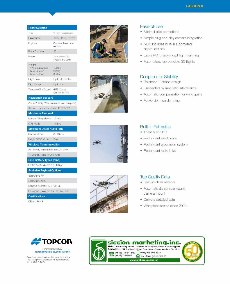
AERIAL IMAGING SOLUTION - smi-group.com.ph
4
FALCON 8 AERIAL IMAGING SOLUTION
Transcript of AERIAL IMAGING SOLUTION - smi-group.com.ph
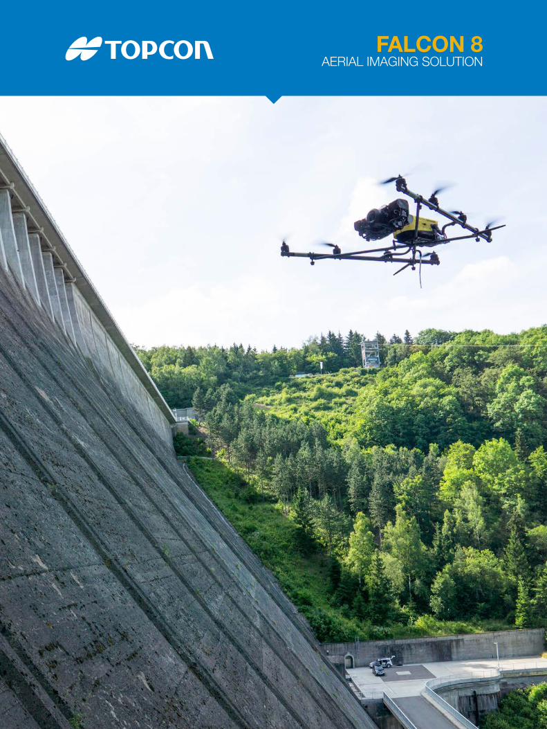
FALCON 8AERIAL IMAGING SOLUTION

• Configurable for inspection or surveying
• Use multiple sensors at the same time
• Resistant to magnetic interference
• Operational in windy areas
• Low noise, emission free operation
Innovative Design with Top Quality Data
Mobile Ground Station (MGS) Data links, remote control of the camera, video link, video display and the controls for the Falcon 8 are completely integrated into the MGS and provide absolute freedom of movement. Optional independent camera control and video goggles allow two-person operation for inspection flights.
FALCON 8
The Falcon 8 is a rotary-wing UAS designed for inspection and monitoring or survey and mapping applications, depending on which camera payloads are used.
Offering flexibility to get into small spaces and compromising situations, the Falcon 8 uses best-in-class sensors, active vibration damping and an actively compensating camera mount. The Falcon 8 InspectionPRO can be used for mulitple types of inspection projects that require high resolution imaging and/or videography. The GeoEXPERT is well suited for mapping projects up to 30 hectares (86 acres) per flight.
InspectionPRO The InspectionPRO payload consists of the Panasonic Lumix DMC-TZ71 for true color RGB images and the FLIR Tau 2 640 for infrared imaging.
With the InspectionPRO, users can accomplish close-up inspections to detect millimeter damage, fine hairline cracks, leaks or heat power losses. A panoramic picture can also be taken for a wider view. Georeferenced true color RGB and 14-bit raw thermal images are delivered simultaneously. The PJ810 is an optional payload for live videography for both the InspectionPRO and GeoEXPERT configurations while the Panasonic Lumix DMC-TZ71 features a zoom lens. GeoEXPERT The GeoEXPERT is a innovative solution for small mapping projects and volume calculations. High-resolution geo-referenced aerial images can be taken from various heights within set GPS tolerances and offer a complement to conventional methods. The GeoEXPERT includes a 36 MP RGB camera (Sony Alpha 7R) and delivers orthophotos or 3D models in the Agisoft Photogrammetric Kit for Topcon.
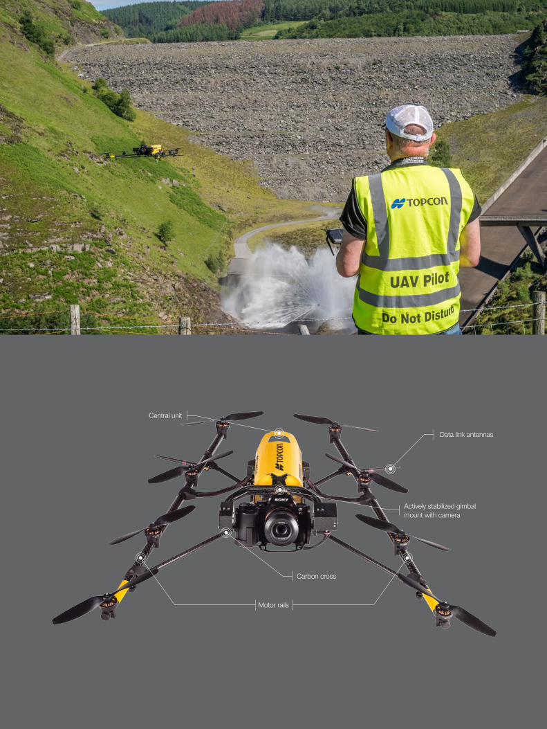
Motor rails
Data link antennas
Central unit
Actively stabilized gimbal mount with camera
Carbon cross