Aerial Laser Imaging for Better Natural Disaster ...
9
Skip to content ↓ Updates on campus operations, resources & stories related to COVID-19 Campus Updates Campus Stories UT News UT News News Opinions Series The University of Texas at Austin May 21, 2021 Aerial Laser Imaging for Better Natural Disaster Preparation and Respon... https://news.utexas.edu/2021/04/12/aerial-laser-imaging-for-better-natura... 1 of 9 5/21/2021, 1:29 PM
Transcript of Aerial Laser Imaging for Better Natural Disaster ...
Skip to content ↓
Updates on campus operations, resources & stories related to COVID-19
Campus Updates Campus Stories
UT News
UT News
NewsOpinionsSeries
The University of Texas at Austin May 21, 2021
Aerial Laser Imaging for Better Natural Disaster Preparation and Respon... https://news.utexas.edu/2021/04/12/aerial-laser-imaging-for-better-natura...
1 of 9 5/21/2021, 1:29 PM

UT Stories: COVID-19Science & TechnologyHealth & WellnessArts & HumanitiesEducation & LeadershipBusiness & EconomyCampus & CommunityPolicy & Law
For JournalistsPress ReleasesMedia ContactsExperts GuidePitch FormArchive
UT Austin on Twitter
UT Austin on Instagram
UT Austin on Facebook
UT Austin on LinkedIn
Search for content on UT News
Apr 12, 2021
Aerial Laser Imaging for Better Natural Disaster Preparation and Response
How a research group at the Bureau of Economic Geology uses lidar technology to help the state to plan and recover
Science & Technology
Aerial Laser Imaging for Better Natural Disaster Preparation and Respon... https://news.utexas.edu/2021/04/12/aerial-laser-imaging-for-better-natura...
2 of 9 5/21/2021, 1:29 PM
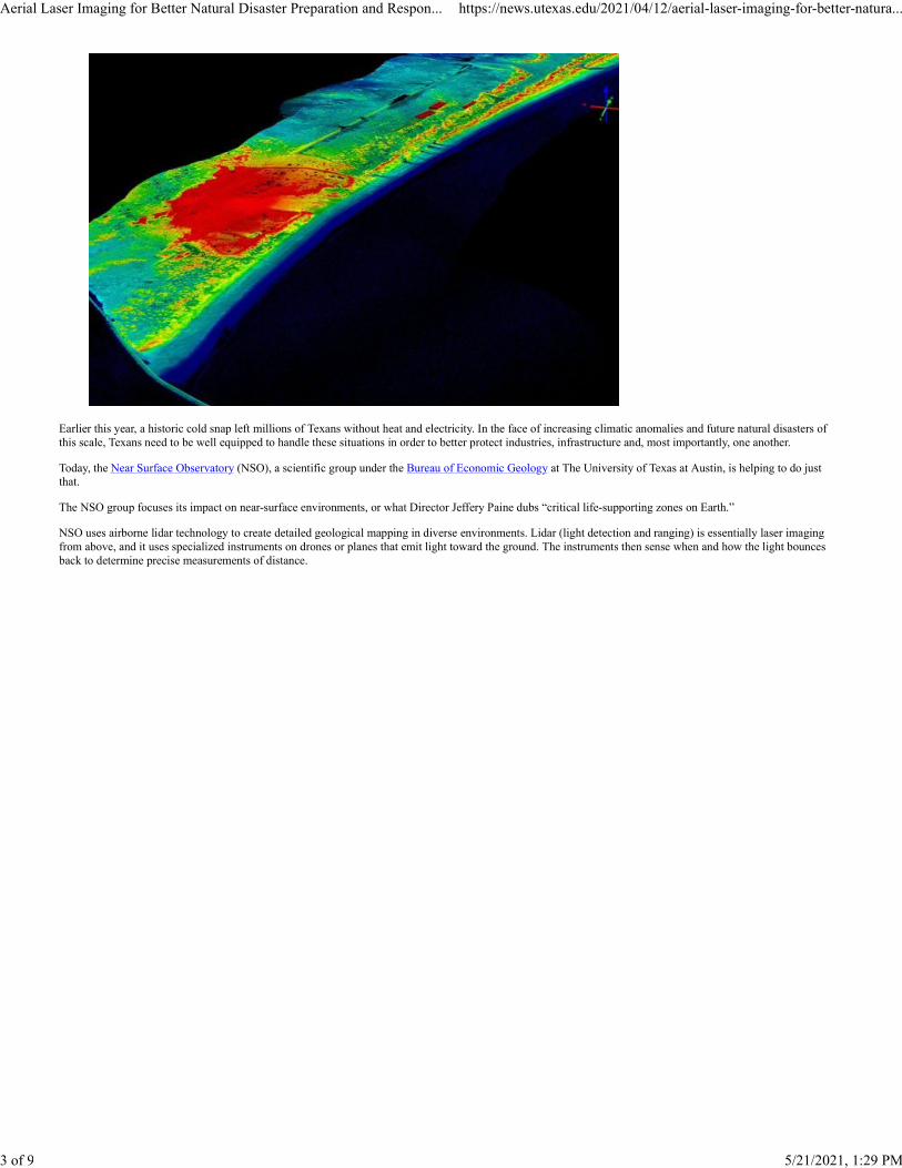
Earlier this year, a historic cold snap left millions of Texans without heat and electricity. In the face of increasing climatic anomalies and future natural disasters ofthis scale, Texans need to be well equipped to handle these situations in order to better protect industries, infrastructure and, most importantly, one another.
Today, the Near Surface Observatory (NSO), a scientific group under the Bureau of Economic Geology at The University of Texas at Austin, is helping to do justthat.
The NSO group focuses its impact on near-surface environments, or what Director Jeffery Paine dubs “critical life-supporting zones on Earth.”
NSO uses airborne lidar technology to create detailed geological mapping in diverse environments. Lidar (light detection and ranging) is essentially laser imagingfrom above, and it uses specialized instruments on drones or planes that emit light toward the ground. The instruments then sense when and how the light bouncesback to determine precise measurements of distance.
Aerial Laser Imaging for Better Natural Disaster Preparation and Respon... https://news.utexas.edu/2021/04/12/aerial-laser-imaging-for-better-natura...
3 of 9 5/21/2021, 1:29 PM

The Bureau’s Chiroptera airborne lidar system installed in an aircraft for a coastal survey. (Credit: Bureau of Economic Geology)
Using airborne lidar, NSO routinely surveys Texas lands and updates the state with important geological evolution data. It is crucial that the state always has access tothe latest information and mappings, so it can more accurately predict weather patterns, assess infrastructure development and planning, and monitor ecosystems,such as wetlands and bodies of water, and soils for agriculture.
But perhaps the most crucial function of lidar is to better prepare the state for natural disasters or climate anomalies, which have become more common over theyears.
In other words, “NSO instruments provide crucial information on the location, extent, susceptibility and severity of these hazards, which allows governments,businesses and individuals to take steps to mitigate the impact of these hazards,” Paine says.
NSO scientists also use lidar after disasters to provide information about damage and predictions for recovery.
After Hurricane Harvey in 2017, NSO researchers worked around the clock to rapidly acquire lidar data and imagery. The team flew the aircraft during the day andhanded the acquired data over for processing that night, making critical information available to emergency responders by the very next day.
This data was used for a variety of purposes, including assessing storm impacts on beach and dune systems, identifying debris and infrastructure wreckage, and evenhelping establish a recovery baseline.
Aerial Laser Imaging for Better Natural Disaster Preparation and Respon... https://news.utexas.edu/2021/04/12/aerial-laser-imaging-for-better-natura...
4 of 9 5/21/2021, 1:29 PM
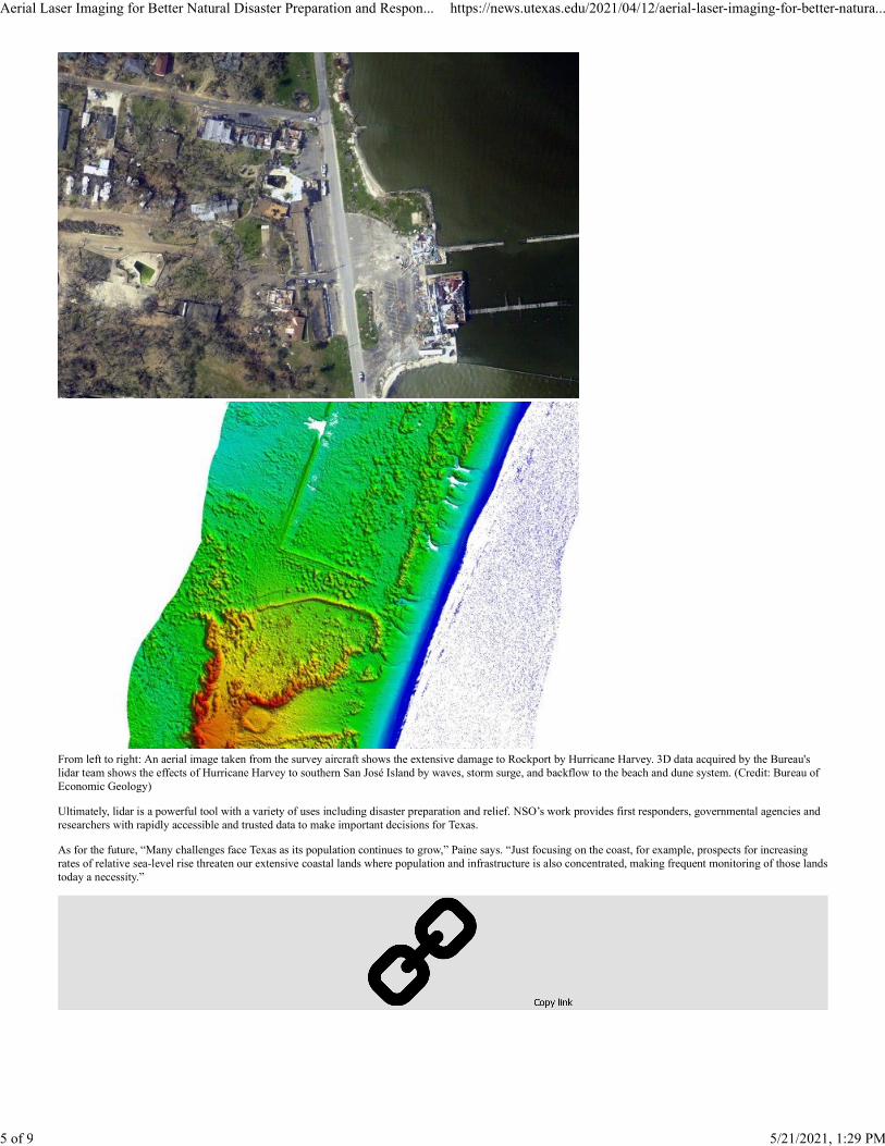
From left to right: An aerial image taken from the survey aircraft shows the extensive damage to Rockport by Hurricane Harvey. 3D data acquired by the Bureau'slidar team shows the effects of Hurricane Harvey to southern San José Island by waves, storm surge, and backflow to the beach and dune system. (Credit: Bureau ofEconomic Geology)
Ultimately, lidar is a powerful tool with a variety of uses including disaster preparation and relief. NSO’s work provides first responders, governmental agencies andresearchers with rapidly accessible and trusted data to make important decisions for Texas.
As for the future, “Many challenges face Texas as its population continues to grow,” Paine says. “Just focusing on the coast, for example, prospects for increasingrates of relative sea-level rise threaten our extensive coastal lands where population and infrastructure is also concentrated, making frequent monitoring of those landstoday a necessity.”
Aerial Laser Imaging for Better Natural Disaster Preparation and Respon... https://news.utexas.edu/2021/04/12/aerial-laser-imaging-for-better-natura...
5 of 9 5/21/2021, 1:29 PM

Email Share Link Twitter Share Link
Facebook Share Link LinkedIn Share LinkTags: Bureau of Economic Geology, Science, Statewide Impact, Technology
Email Share Link Twitter Share Link
Facebook Share Link LinkedIn Share Link
Media Contact
University CommunicationsEmail: [email protected]: (512) 471-3151
The University of Texas at Austin
Explore Latest Articles
May 20, 2021
Advanced Technique for Developing Digital Twins Makes Tech Universally Applicable
Read More Advanced Technique for Developing Digital Twins Makes Tech Universally Applicable
Aerial Laser Imaging for Better Natural Disaster Preparation and Respon... https://news.utexas.edu/2021/04/12/aerial-laser-imaging-for-better-natura...
6 of 9 5/21/2021, 1:29 PM

May 20, 2021
Sheltering People With COVID-19 Experiencing Homelessness Curbs Spread
Read More Sheltering People With COVID-19 Experiencing Homelessness Curbs Spread
May 17, 2021
Protecting Local Water Can Help Slow Climate Change and Provide Trillions of Dollars in Benefits
Read More Protecting Local Water Can Help Slow Climate Change and Provide Trillions of Dollars in Benefits
Aerial Laser Imaging for Better Natural Disaster Preparation and Respon... https://news.utexas.edu/2021/04/12/aerial-laser-imaging-for-better-natura...
7 of 9 5/21/2021, 1:29 PM

Subscribe to the TEXAS Newsletter
UT Austin on Twitter
UT Austin on Instagram
UT Austin on Facebook
UT Austin on LinkedIn
UT News HomeFor JournalistsPress ReleasesMedia ContactsExperts GuideNews ArchivePitch Form
UT Austin HomeSite PoliciesWeb Privacy PolicyEmergency InformationWeb Accessibility PolicyDisability Resources
Aerial Laser Imaging for Better Natural Disaster Preparation and Respon... https://news.utexas.edu/2021/04/12/aerial-laser-imaging-for-better-natura...
8 of 9 5/21/2021, 1:29 PM

© The University of Texas at Austin 2021
Aerial Laser Imaging for Better Natural Disaster Preparation and Respon... https://news.utexas.edu/2021/04/12/aerial-laser-imaging-for-better-natura...
9 of 9 5/21/2021, 1:29 PM