Aeolian processes as drivers of landform evolution at … processes as drivers of landform evolution...
16
Aeolian processes as drivers of landform evolution at the South Pole of Mars Isaac B. Smith a,b, ⁎, Aymeric Spiga b , John W. Holt c a Southwest Research Institute, 1050 Walnut St. #300, Boulder, CO 80302, USA b Université Pierre et Marie Curie and Laboratoire de Météorologie Dynamique, LMD Boîte postale 99 Tour 45-55, 3e ét., Bur. 303A, 4 place Jussieu, 75252 Paris cedex 5, France c University of Texas Institute for Geophysics, Jackson School of Geosciences, University of Texas at Austin, J.J. Pickle Research Campus, Bldg. 196, 10100 Burnet Rd. R2200, Austin, TX 78758-4445, USA abstract article info Article history: Received 4 December 2013 Received in revised form 6 August 2014 Accepted 28 August 2014 Available online xxxx Keywords: Mars Polar Ice Winds Clouds Radar We combine observations of surface morphology, topography, subsurface stratigraphy, and near surface clouds with mesoscale simulations of south polar winds and temperature to investigate processes governing the evolu- tion of spiral troughs on the South Pole of Mars. In general we find that the south polar troughs are cyclic steps that all formed during an erosional period, contrary to the troughs at the North Pole, which are constructional features. The Shallow Radar instrument (SHARAD) onboard Mars Reconnaissance Orbiter detects subsurface stratigraphy indicating relatively recent accumulation that occurred post trough formation in many locations. Using optical instruments, especially the Thermal Emission Imaging System (THEMIS), we find low altitude trough clouds in over 500 images spanning 6 Mars years. The locations of detected clouds correspond to where recent accumulation is detected by SHARAD, and offers clues about surface evolution. The clouds migrate by season, moving poleward from 71° S at ~L s 200° until L s 318°, when the last cloud is detected. Our atmospheric simulations find that the fastest winds on the pole are found roughly near the external boundary of the seasonal CO 2 ice cap. Thus, we find that the migration of clouds (and katabatic jumps) corresponds spatially to the retreat of the CO 2 seasonal ice as detected by Titus (2005) and that trough morphology, through recent accumulation, is integrally related to this seasonal retreat. © 2014 Elsevier B.V. All rights reserved. 1. Introduction Polar layered deposits (PLD) on Mars are primarily composed of water ice and dust (Grima et al., 2009; Fishbaugh et al., 2010; Hvidberg et al., 2012). The PLD together comprise the majority of sur- face ice on Mars, each rising above the surrounding terrain ~3 km, and are together comparable in volume to the Greenland ice sheet on Earth (Smith et al., 2001a). The north PLD (NPLD) and south PLD (SPLD) undergo seasonal variability, especially between winter (when CO 2 ice frost covers the polar regions) and summer (when the CO 2 ice has sublimed) (Kieffer et al., 2000; Kieffer and Titus, 2001; Byrne, 2009). The surfaces of the PLD have enigmatic medium scale features, in- cluding chasmae larger than the grand canyon on Earth (Fishbaugh and Head, 2001; Farrell et al., 2008) and deep spiral depressions with 20–50 km wavelengths (Cutts, 1973; Howard et al., 1982; Smith et al., 2013)(Fig. 1). On the SPLD specifically, other features are found, includ- ing scallops with similar cross section to the spiral troughs but much smaller in breadth (Howard, 2000; Grima et al., 2011) and the aptly- named wirebrush terrain (Kolb and Tanaka, 2006). These features, resulting from erosional and depositional patterns of ice, are potentially a key to understanding the history of the PLD and the water cycle on Mars. Various processes have been invoked to explain observations associ- ated with each PLD feature: basal melting (Clifford, 1987; Fishbaugh and Head, 2002), tectonics (Grima et al., 2011), viscous ice flow (Fisher, 1993, 2000), and brittle deformation (Murray et al., 2001), among others. Recent evidence on the NPLD has shown that the spiral troughs and Chasma Boreale likely formed within a constructional setting, with winds and atmospheric deposition likely playing the major roles (Holt et al., 2010; Smith and Holt, 2010; Smith et al., 2013). Observations of low altitude clouds and atmospheric modeling (Smith et al., 2013), surface morphology (Howard, 2000), in addition to radar stratigraphy (Smith and Holt, 2010) demonstrate that ice is transported across the NPLD by wind to form and modify these features; however, no studies have provided the same detailed combination of techniques to address the SPLD. Here, we provide evidence that SPLD features, like those on the NPLD, are the result of persistent katabatic winds that contain katabatic jumps. In particular, we find that the SPLD spiral troughs belong to a set of morphological features called cyclic steps, which form because of fast winds and repeated katabatic jumps (Smith et al., 2013). Unlike on the NPLD, the SPLD troughs formed within a regime that has experienced more erosion than deposition, especially during the early stages. Our evidence includes topographic profiles, subsurface stratigraphy with Geomorphology xxx (2014) xxx–xxx ⁎ Corresponding author at: Southwest Research Institute, 1050 Walnut St. #300, Boulder, CO 80302, USA. E-mail address: [email protected] (I.B. Smith). GEOMOR-04899; No of Pages 16 http://dx.doi.org/10.1016/j.geomorph.2014.08.026 0169-555X/© 2014 Elsevier B.V. All rights reserved. Contents lists available at ScienceDirect Geomorphology journal homepage: www.elsevier.com/locate/geomorph Please cite this article as: Smith, I.B., et al., Aeolian processes as drivers of landform evolution at the South Pole of Mars, Geomorphology (2014), http://dx.doi.org/10.1016/j.geomorph.2014.08.026
Transcript of Aeolian processes as drivers of landform evolution at … processes as drivers of landform evolution...

Geomorphology xxx (2014) xxx–xxx
GEOMOR-04899; No of Pages 16
Contents lists available at ScienceDirect
Geomorphology
j ourna l homepage: www.e lsev ie r .com/ locate /geomorph
Aeolian processes as drivers of landform evolution at the South Pole of Mars
Isaac B. Smith a,b,⁎, Aymeric Spiga b, John W. Holt c
a Southwest Research Institute, 1050 Walnut St. #300, Boulder, CO 80302, USAb Université Pierre et Marie Curie and Laboratoire de Météorologie Dynamique, LMD Boîte postale 99 Tour 45-55, 3e ét., Bur. 303A, 4 place Jussieu, 75252 Paris cedex 5, Francec University of Texas Institute for Geophysics, Jackson School of Geosciences, University of Texas at Austin, J.J. Pickle Research Campus, Bldg. 196, 10100 Burnet Rd. R2200, Austin, TX 78758-4445,USA
⁎ Corresponding author at: Southwest Research InsBoulder, CO 80302, USA.
E-mail address: [email protected] (I.B. Smith).
http://dx.doi.org/10.1016/j.geomorph.2014.08.0260169-555X/© 2014 Elsevier B.V. All rights reserved.
Please cite this article as: Smith, I.B., et al., Aehttp://dx.doi.org/10.1016/j.geomorph.2014.0
a b s t r a c t
a r t i c l e i n f oArticle history:Received 4 December 2013Received in revised form 6 August 2014Accepted 28 August 2014Available online xxxx
Keywords:MarsPolarIceWindsCloudsRadar
We combine observations of surface morphology, topography, subsurface stratigraphy, and near surface cloudswith mesoscale simulations of south polar winds and temperature to investigate processes governing the evolu-tion of spiral troughs on the South Pole of Mars. In general we find that the south polar troughs are cyclic stepsthat all formed during an erosional period, contrary to the troughs at the North Pole, which are constructionalfeatures. The Shallow Radar instrument (SHARAD) onboard Mars Reconnaissance Orbiter detects subsurfacestratigraphy indicating relatively recent accumulation that occurred post trough formation in many locations.Using optical instruments, especially the Thermal Emission Imaging System (THEMIS), we find low altitudetrough clouds in over 500 images spanning 6 Mars years. The locations of detected clouds correspond towhere recent accumulation is detected by SHARAD, and offers clues about surface evolution. The clouds migrateby season,moving poleward from71° S at ~Ls 200° until Ls 318°, when the last cloud is detected. Our atmosphericsimulations find that the fastest winds on the pole are found roughly near the external boundary of the seasonalCO2 ice cap. Thus, we find that themigration of clouds (and katabatic jumps) corresponds spatially to the retreatof the CO2 seasonal ice as detected by Titus (2005) and that troughmorphology, through recent accumulation, isintegrally related to this seasonal retreat.
© 2014 Elsevier B.V. All rights reserved.
1. Introduction
Polar layered deposits (PLD) on Mars are primarily composed ofwater ice and dust (Grima et al., 2009; Fishbaugh et al., 2010;Hvidberg et al., 2012). The PLD together comprise the majority of sur-face ice on Mars, each rising above the surrounding terrain ~3 km, andare together comparable in volume to the Greenland ice sheet onEarth (Smith et al., 2001a). The north PLD (NPLD) and south PLD(SPLD) undergo seasonal variability, especially between winter (whenCO2 ice frost covers the polar regions) and summer (when the CO2 icehas sublimed) (Kieffer et al., 2000; Kieffer and Titus, 2001; Byrne, 2009).
The surfaces of the PLD have enigmatic medium scale features, in-cluding chasmae larger than the grand canyon on Earth (Fishbaughand Head, 2001; Farrell et al., 2008) and deep spiral depressions with20–50 km wavelengths (Cutts, 1973; Howard et al., 1982; Smith et al.,2013) (Fig. 1). On the SPLD specifically, other features are found, includ-ing scallops with similar cross section to the spiral troughs but muchsmaller in breadth (Howard, 2000; Grima et al., 2011) and the aptly-named wirebrush terrain (Kolb and Tanaka, 2006). These features,resulting from erosional and depositional patterns of ice, are potentially
titute, 1050 Walnut St. #300,
olian processes as drivers of l8.026
a key to understanding the history of the PLD and the water cycle onMars.
Various processes have been invoked to explain observations associ-ated with each PLD feature: basal melting (Clifford, 1987; Fishbaughand Head, 2002), tectonics (Grima et al., 2011), viscous ice flow(Fisher, 1993, 2000), and brittle deformation (Murray et al., 2001),among others. Recent evidence on the NPLD has shown that the spiraltroughs and Chasma Boreale likely formed within a constructionalsetting, with winds and atmospheric deposition likely playing themajor roles (Holt et al., 2010; Smith and Holt, 2010; Smith et al.,2013). Observations of low altitude clouds and atmospheric modeling(Smith et al., 2013), surface morphology (Howard, 2000), in additionto radar stratigraphy (Smith and Holt, 2010) demonstrate that ice istransported across theNPLDbywind to form andmodify these features;however, no studies have provided the same detailed combination oftechniques to address the SPLD.
Here, we provide evidence that SPLD features, like those on theNPLD, are the result of persistent katabatic winds that contain katabaticjumps. In particular, we find that the SPLD spiral troughs belong to a setof morphological features called cyclic steps, which form because of fastwinds and repeated katabatic jumps (Smith et al., 2013). Unlike on theNPLD, the SPLD troughs formed within a regime that has experiencedmore erosion than deposition, especially during the early stages. Ourevidence includes topographic profiles, subsurface stratigraphy with
andform evolution at the South Pole of Mars, Geomorphology (2014),

a b
3a3b
3c
4a4c
4b
11cFig. 112552901
Fig. 22759301
14
5
12c
13b
Promethia Lingula
500 km
Ultima Lingula
Australe Scopuli
Fig. 1. SPLD surface and locations of the following figures. a) SPLD hillshade map. Ground tracks of SHARAD radargrams and footprints of optical imagery for future figures are listedwithnumbers. b) Viking color mosaic of SPLDwith labeled geographic names. Residual CO2 ice cap remains white through theMartian year, but the rest of the ice cap is covered by red dust inspring and summer. Large chasmae, spiral troughs, and scallops are visible. Green dashed lines delineate the approximate extent of the SPLD ice deposits.
2 I.B. Smith et al. / Geomorphology xxx (2014) xxx–xxx
the shallow radar instrument (SHARAD), and optical data that imagesthe surface and atmospheric phenomena (i.e. clouds).
As a supplement to these observations, we employ a cap-wide high-resolution mesoscale atmospheric model on the SPLD. Global andregional (mesoscale) climate models have been developed for manyyears to predict circulation and clouds in the Martian atmosphere. Inparticular, NPLD features related to winds have been studied in detail(Massé et al., 2012; Brothers et al., 2013; Smith et al., 2013), yet fewstudies have attempted to relate the landforms on the SPLD tomodeledwinds (Koutnik et al., 2005).
As a reference we adopt a nomenclature of trough orientationbased on elevation rather than one based on orientation. Troughhigh sides are always topographically higher than the low sides(Fig. 2). Descriptions based on orientation, such as “poleward” or“equatorward,” are insufficient because troughs in some regionsare oriented east-west, so these characterizations break down.
a
b
High SideLow Side
RF
Clutter
12a
13a
Fig. 2. SHARAD observation and clutter simulation 2579301. a) Troughs are topographically aelevation than low side slopes. Low side slopes generally face toward the pole. RFZ3 unit has breflectors and provides no information about the subsurface. Boxes with numbers are later figu
Please cite this article as: Smith, I.B., et al., Aeolian processes as drivers of lhttp://dx.doi.org/10.1016/j.geomorph.2014.08.026
Furthermore, the terrain of each trough varies by location, so charac-terizations of morphology or stratigraphic exposure are fundamen-tally limited to the individual trough being examined. The high/lowside topographic description has the advantage of being consistentacross all troughs.
In Section 2 we provide a background for the rest of the paper.Section 3 introduces themethods utilized in this study, including opticalobservations detecting near surface clouds, radar observations of sub-surface structure, and atmospheric modeling of surface temperatureand near surface winds. In Section 4 we describe cloud detections, spe-cifically spatial and temporal variability. Section 5 provides results of at-mospheric simulations of an individual day and throughout the season.Modeled winds are compared temporally to cloud detections. InSection 6, we use SHARAD to associate the spatial detection of cloudswith recent accumulation. Section 7 discusses these correlations andsignificance, and Section 8 provides some concluding remarks.
500 km
2000 mZ3
5d
symmetric. High side slopes generally face toward the equator and are always higher ineen interpreted as being massive CO2 ice (Phillips et al., 2011). b) Clutter is from surfaceres.
andform evolution at the South Pole of Mars, Geomorphology (2014),

3I.B. Smith et al. / Geomorphology xxx (2014) xxx–xxx
2. Background
2.1. Comparison of NPLD and SPLD
The north and south PLD have many similarities in composition andphysical properties. For example, each cap rises about 3 km above therespective bases, and they are primarily composed of water ice (Grimaet al., 2009; Fishbaugh et al., 2010; Hvidberg et al., 2012). They reachaerial extents of 1.12 × 10¹² and 1.16 × 10¹² km2, respectively. Thevolumes of the NPLD and SPLD are on the same scale at 1.14 × 10¹⁵
and 1.20 × 10¹⁵ m3 (Zuber et al., 1998; Smith et al., 2001a).The PLD are similar in manyways, but they also have striking differ-
ences. Of primary importance are the basal elevations for each. The SPLDis found on the southern highlands, and its base is between 1 and 1.5 kmabove the average elevation of the planet, more than 6 km higher thanthe NPLD. The NPLD is located within Vastitas Borealis, the largestlowland on the planet ~5 km below the average elevation of Mars(Smith et al., 2001a). Even though the PLD encompass similar areas,the SPLD extends to ~−71°, whereas the NPLD are generally all northof ~80°. Furthermore, the SPLD have a larger total topographic relief,being thicker by about 500 m. Atmospheric conditions, especiallytemperature and pressure, are strongly affected by these differences.
The interpreted ages of each pole are also distinct. Using cratercounting statistics, the surface age of the uppermost NPLD has beendetermined to be less than 105 Earth years (EY) (Tanaka, 2005).Where-as the NPLD surface is relatively young, modeling evidence based onstability of ice at the North Pole found that the bulk of NPLD materialmust have been deposited within the last ~4 × 10⁶ EY (Levrard et al.,2007). The surface age of the SPLD has been dated to be N107 EY(Herkenhoff and Plaut, 2000), at least two times older than themajorityof the NPLD. Thin surface deposits, however, may have covered smallercraters in some regions during the last 105–106 EY (Koutnik et al., 2002).
Another important distinction between the north and south PLD isthat both poles experience a seasonal CO2 ice frost, but only the SPLDretains a CO2 ice cap throughout the year (Kieffer, 1979). The SouthPolar Residual Ice Cap (SRIC) contains b10 m thick CO2 ice and repre-sents a small portion to the entire cap. It retains its high albedo through-out the year (Fig. 1b) (Byrne and Ingersoll, 2003; Byrne, 2009).Furthermore, SHARAD detects large volumes of sequestered CO2 icefilling in Australe Mensa troughs (RFZ3 in Fig. 2) (Phillips et al., 2011),in contrast to the NPLD where no evidence of buried CO2 ice has beenfound.
2.2. Processes on the poles
Recent studies have found that three observed processes are suffi-cient to explain all of the non-impact features on both poles: deposition,sublimation, and wind transport (Howard, 2000; Holt et al., 2010;Brothers et al., 2013; Smith et al., 2013). Atmospheric deposition isobserved directly and indirectly. First, deposition is a necessary require-ment of creating a deposit that contains alternating layers of ice anddust. Second, seasonal variations in albedo and elevation indicate thatdeposition and sublimation occur on an annual basis (Neugebaueret al., 1971; Farmer and Doms, 1979; Kieffer and Titus, 2001; Smithet al., 2001b).
Deposition of water ice from the atmospheremay come indirectly assnowfall (Whiteway et al., 2009) or directly as of frost. Locations withhigher abundances of water vapor or that experience local coolingnear the surface are the most likely to receive deposition. Sublimationoccurs through several processes, primarily from increased tempera-tures during the day because of insolation and from thermal effects ofwinds on sloping terrains (Spiga et al., 2011).
Finally, wind transport of ice drives feature migration. On both PLDs,optical imagery provided evidence of ice transport in the form of windstreaks and erosion, in addition to morphologies and exposed layerspostulated to be the result of migration (Howard et al., 1982;
Please cite this article as: Smith, I.B., et al., Aeolian processes as drivers of lhttp://dx.doi.org/10.1016/j.geomorph.2014.08.026
Howard, 2000). SHARAD investigations detect subsurface stratigra-phy that supported this interpretation for NPLD troughs (Smith andHolt, 2010).
2.3. Katabatic jumps and trough clouds
Low altitude clouds, called trough clouds because of spatial relation-ships with NPLD spiral troughs, are prevalent in spring and early sum-mer for the SPLD (Figs. 3 and 4). Smith et al., 2013 interpreted themto be analogs to Antarctic clouds caused by katabatic jumps (Lied,1964; Pettré and André, 1991), concluding that they are evidence forlocalized interactions between the atmosphere and surface.
Antarctic clouds are found at the site of katabatic jumps, or rapidchanges in flow conditions of katabatic winds. A katabatic jump isdescribed as “a narrow zone with large horizontal changes in windspeed, pressure, and temperature,” (Pettré and André, 1991). Flowthickness often triples over a short distance, but wind velocities maydecrease from asmany as 20ms−1 to as few as ~1ms−1.With sufficientwater vapor, these strong perturbations, especially those associatedwith temperature decrease and pressure increase, are sufficient toexplain the formation of clouds.
Smith et al. (2013) argued that Martian trough clouds form by thesameprocesses as those on Earth and that these clouds are amechanismof deposition on the low side of troughs. Evidence to support this claimcame from terrestrial studies that found “walls of snow” beneath terres-trial clouds (Lied, 1964) (see Fig. 13 from Smith et al. (2013) or Fig. 2from Pettré and André (1991)). If the clouds contribute to localdeposition, they are an important part of understanding PLD surfacemorphology.
2.4. Cyclic steps
The three processes of wind transport, sublimation, and ice deposi-tion at clouds are capable of explaining the stratigraphy and morpholo-gy that are observed at a single trough, but more was needed tounderstand the entire systemof troughs. The cyclic stepmodel providedthe necessarymechanism. Cyclic steps are a distinct bedform that existswithin “a train of upstream migrating bed undulations bounded byhydraulic [or katabatic for wind] jumps” (Parker, 1996; Kostic et al.,2010). Cyclic steps have been thoroughly studied on Earth, includingthose in erosional environments (Parker and Izumi, 2000) and deposi-tional settings (Kostic et al., 2010). The spiral troughs of the NPLDbelong to the depositional cyclic steps (Smith et al., 2013). Becausecyclic steps repeat with a common wavelength (based on regionalslope) and are created as a result of katabatic jumps, it is also likelythat SPLD troughs also belong to this feature class.
2.5. Trough morphology and variety
Spiral troughs on the SPLD vary greatly from region to region and areoften distinctly different from those on the NPLD. North polar studieshave demonstrated that few or no troughs are purely erosional (Smithand Holt, 2010, in preparation), but the question of whether SPLDtroughs are erosional or have migrated remains open.
The troughs on Promethei Lingula are primarily erosional features,with little evidence for migration (Kolb and Tanaka, 2001, 2006). Innearby Australe Sulci, where wirebrush terrain dominates, considerableevidence exists for erosion, including abrasive removal of material,supporting the eroded trough interpretation. Evidence does exist, how-ever, for accumulation following trough incision. Kolb and Tanaka(2006) noted a thin lamination (Aa2) on the low side of PrometheiLingula troughs (Fig. 5 from that paper). This lamination has coveredor degraded craters smaller than 800m in diameter, which skews cratercounts toward larger craters (Koutnik et al., 2002). Evidence then sup-ports the interpretation that the surface of Promethei Lingula is
andform evolution at the South Pole of Mars, Geomorphology (2014),

a b c
x
x
x
x
x’
x’
x’
x’10 km10 km
1000 m200 md e f 200 m
10 km 10 km10 km
LS 235 LS 236 LS 253
10 km
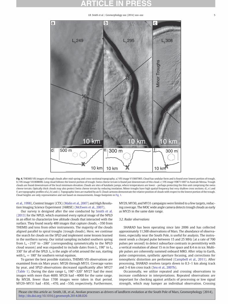
Fig. 3. THEMIS VIS images of trough clouds and cross-sectional topography. a) VIS image V07272010. Trough clouds are found just above the lowest portion of the troughs. b) VIS imageV23982013. Cloud is found on high side slope, even though no slope break is present, demonstrating that changing topography is not a requirement for trough clouds to form. c) VIS imageV15959007. Cloud has undular form and is found over lowest portion of trough. d), e) and f) are topographic profiles of a), b) and c). Topographic extrema are marked by X or X’. Cloudcartoons demonstrate the relative position of clouds with respect to the lowest portion of the trough. Cloud heights are only representative and not based on measurements. Imagefootprints in Fig. 1.
4 I.B. Smith et al. / Geomorphology xxx (2014) xxx–xxx
primarily made up of old erosional features with a small amount of re-cent accumulation.
Australe Lingula troughs are not as well studied as those ofPromethei Lingula (Locations in Fig. 1b); however, they offer clues toatmospheric processes. Recent accumulation has been detected ontrough low sides in this region, making them interesting targets forstudy (Fig. 9 of Byrne and Ivanov (2004)).
On Australe Mensa, at higher latitude and within the SPLD residualcap, troughs take on other forms and may be divided into two catego-ries. Troughs spaced at regular intervals are readily visible from orbit,similar in scale to those on Australe Lingula (Fig. 1). Using SHARADobservations, Phillips et al. (2011) observed massive CO2 ice that filledand partially buried these troughs. The second type of trough is muchmore shallow and closely spaced, located between the larger troughs.These troughs are only found at high latitudes and are unique to AA3
(RFZ3 in Fig. 2) deposits within the residual cap (Figs. 4c, 5 and 3 fromPhillips et al. (2011)).
2.6. Atmospheric modeling
Mesoscale atmospheric models have provided context for under-standing wind patterns on the North Pole as a whole (Tyler andBarnes, 2005; Kauhanen et al., 2008; Spiga et al., 2011; Massé et al.,2012; Smith et al., 2013) and for understanding development of specificfeatures on the north (Brothers et al., 2013) and South Poles (Koutnik
Please cite this article as: Smith, I.B., et al., Aeolian processes as drivers of lhttp://dx.doi.org/10.1016/j.geomorph.2014.08.026
et al., 2005). These studies simulated the thermal properties of theatmosphere and, more relevant to troughs, the wind directions thataffect geomorphic processes. When put into context of geologicfeatures, wind vector maps tell of current processes near the surface,i.e. how winds respond to surface features. When put in context of thegeologic record, atmospheric simulations are able to illuminate howice and other volatiles are transported, i.e. how surface features respondto wind. Locally, mesoscale models may be designed with sufficientlyhigh resolution to take into account medium scale topographic influ-ences, including spiral troughs and scallops.
3. Methods
3.1. Optical imagery
As of this writing, more than 16,000 visible wavelength ThermalEmission Imaging System (THEMIS) images that capture portions ofthe SPLD are publically available (Christensen et al., 2004). We analyzethe majority of these images to find near surface trough clouds. TheSPLD is not symmetric about the South Pole, so regions of interestinclude the entire SPLD south of −80°, and between −80° and −71°for longitudes 90° to 220° (Fig. 6b). To supplement our THEMIS survey,we examine imagery from the High Resolution Stereo Camera (HRSC)(Neukum and Jaumann, 2004), Mars Orbital Camera (MOC) (Malin
andform evolution at the South Pole of Mars, Geomorphology (2014),
a b c
d
10 km
500 m
10 km
300 m
x
x10 km
300 m
x
x
x
x
10 km 10 km 10 km
LS 295LS 249 LS 308
Min
or T
roug
hs
fe
Fig. 4. THEMIS VIS images of trough clouds after mid-spring and cross-sectional topography. a) VIS image V15887005. Cloud has undular form and is found over lowest portion of trough.b) VIS image V41808006. Long cloud follows the lowest portion of trough. Swiss cheese terrain is found just downstream of this cloud. c) VIS image V08711007 in AustraleMensa. Troughclouds are found downstream of the local minimum elevation. Clouds are sites of katabatic jumps, where temperatures are lower – perhaps protecting the thin unit comprising the swisscheese terrain. Optically thick clouds may also protect Swiss cheese terrain by reducing insolation. Minor troughs have high spatial frequency but very shallow cross sections. d), e) andf) are topographic profiles of a), b) and c). Topographic lows aremarked by anX. Cloud cartoons demonstrate the relativeposition of cloudswith respect to the lowest portion of the trough.Cloud heights are only representative and not based on measurements. Image footprints in Fig. 1.
5I.B. Smith et al. / Geomorphology xxx (2014) xxx–xxx
et al., 1998), Context Imager (CTX) (Malin et al., 2007) andHigh Resolu-tion Imaging Science Experiment (HiRISE) (McEwen et al., 2007).
Our survey is designed after the one conducted by Smith et al.(2013) for the NPLD, which examined every optical image of the NPLDin an effort to characterize low altitude clouds that interacted with thesurface. They found nearly 400 images that capture clouds, ~350 fromTHEMIS and tens from other instruments. The majority of the cloudsaligned parallel to spiral troughs (trough clouds). Here, we continuethe search for clouds on the SPLD and implement some lessons learnedin the northern survey. Our initial sampling included southern springfrom Ls ~210° to ~280° (corresponding symmetrically to the NPLDcloud season) and was expanded to include dates from Ls 190° to Ls330° for all of the SPLD. Ls is the angle of orbit around the sun, startingwith Ls = 180° for southern vernal equinox.
To garner the best possible statistics, THEMIS VIS observations areexamined from six Mars years: MY26 through MY31. Coverage variesby year, and SPLD observations decreased significantly after MY27(Table 1). During the date range Ls 190°–320° MY27 had the mostimages with more than 4600. MY26 had ~4000 for the same range.By MY28, fewer than 1700 images were taken in that period.MY29–MY31 had ~850, ~470, and ~550, respectively. Furthermore,
Please cite this article as: Smith, I.B., et al., Aeolian processes as drivers of lhttp://dx.doi.org/10.1016/j.geomorph.2014.08.026
MY29,MY30, andMY31 campaignswere limited to a few targets, reduc-ing coverage. TheMOCwide angle camera detects trough clouds as earlyas MY25 in the same date range.
3.2. Radar observations
SHARAD has been operating since late 2006 and has collectedapproximately 11,500 observations of Mars. The abundance of observa-tions, especially near the South Pole, is useful for analysis. The instru-ment sends a chirped pulse between 15 and 25 MHz (at a rate of 700pulses per second) to detect subsurface contrasts in permittivity witha vertical resolution of about 15 m in free space and 8.4 m in ice. Multi-ple pulses are coherently summed onboard MRO. After relay to Earth,pulse compression, synthetic aperture focusing, and corrections forionospheric distortion are performed (Campbell et al., 2011). Afterprocessing, SHARAD resolves targets down to 0.3–1 km along trackand 3–6 km cross track (Seu et al., 2007b).
Occasionally, we utilize repeated and crossing observations toincrease confidence in interpretations. Repeated observations areimportant for checking against artifacts of processing or low signalstrength, which may hamper an individual observation. Crossing
andform evolution at the South Pole of Mars, Geomorphology (2014),

20 km
100 km
1000 m
a b c
x”
x
x’”
x’
Minor Trough
Spiral Trough
MY 30: L 287s MY29: L 295.5s MY 29: L 312s
A
B
20 km
300 m
x”
xx”’
x’A
B
d
e
Fig. 5. Observations in Australe Mensa. a) CTX image G11_022371_0932_XI_ 86S057W at Ls 287 showing minor and major troughs, localized Swiss cheese terrain, and trough clouds.b) CTX image B11_013734_0932 _XI_86S057W, similar to a) but at Ls 295.5. c) CTX image B11_014090_0932_ XI_86S057W at Ls 312. In each image undular clouds are found at theminor troughs (changing slightly between dates) but not at the major trough. Seasonal frost is reduced on trough high sides as the season progresses. Contact of overlying RFZ3 andunderlying water ice is shown with blue dashed line. White line in c) corresponds to ground track of inset and d), and inset is blow up of interpretation from d). d) Portion of radargram2579301. RFZ3 is distinct from lowerwater-ice deposits (contact in solid blue line). Troughswerefilled in during deposition of CO2 ice and havemigrated 10s of kms during a small amountof accumulation (white arrows). e) Uninterpreted radargram 2579301. (For interpretation of the references to color in this figure legend, the reader is referred to the web version of thisarticle.)
6 I.B. Smith et al. / Geomorphology xxx (2014) xxx–xxx
observations are important for eliminating ambiguous interpretations.Furthermore, multiple observations of a target help to separate sidereflections, or reflections from targets other than the one of interest,from scientifically interesting subsurface reflections. Because sidereflections received by SHARAD often have an undesirable nature,they are considered “clutter”.
Clutter cannot be removed froma radargram, but it can bemitigated.We compare SHARAD observations to clutter predicted from surfacetopography (Smith et al., 2001a) to determine which part of the signalcomes from the subsurface (Fig. 2b) (Holt et al., 2006). A syntheticradargram only predicts what reflections the instrument will receivefrom the surface; thus, echoes in the actual radargram that are not pres-ent in the cluttergram are considered as arising from the subsurface.Weemploy clutter mitigation techniques in our analysis and presentradargrams that are favorable for interpretation.
Radar data are recorded in time. Our interpretations are done in thisnative format, to reduce uncertainties. To display more accurategeometry in this paper, we convert time-delay radargrams to depth byassuming a dielectric constant, ε, which determines wave velocity. Weassume ε for a composition of water ice, 3.15, consistent with thevalue determined for the NPLD (Grima et al., 2009) and previous SPLDradar investigations (Plaut et al., 2007; Seu et al., 2007a; Phillips et al.,2011). Modifying this value, would only affect the depths measuredby a few percent.
Please cite this article as: Smith, I.B., et al., Aeolian processes as drivers of lhttp://dx.doi.org/10.1016/j.geomorph.2014.08.026
3.3. Atmospheric modeling
To simulate atmospheric conditions on the SPLD,we use amesoscalemodel developed at the Laboratoire de Meterologie Dynamique (LMD)(Spiga and Forget, 2009) based on the Weather Research and Forecastmodel (Skamarock and Klemp, 2008). Our SPLD simulations are compa-rable to those that have been conducted on theNPLD (Spiga et al., 2011;Massé et al., 2012; Smith et al., 2013). Several aspects are simulated:wind speed and direction, and surface temperature. Hourly results areoutput for an equally divided “24-hour”Mars day (Fig. 7). We simulatethe conditions at several dates throughout spring and summer, includ-ing Ls 230°, 260°, 290°, and 330° (Fig. 8).
To model near-surface winds, it is particularly important to accountfor the evolution of the seasonal CO2 ice deposit. As was shown throughmesoscale modeling by Siili et al. (1999) and Toigo et al. (2002), near-surface regional winds overMartian polar caps are controlled by topog-raphy and surface temperature, hence CO2 ice deposits, which fix thesurface temperature to below 150 K (Fig. 8t1). Our mesoscale simula-tions, therefore, use a prescribed CO2 seasonal deposit that evolves byLs date according to infrared measurements of the surface temperatureduring three Mars years (24, 25, and 26) (Titus, 2005). We use theanalytical functions provided by that study to obtain the crocus line,i.e. the external boundary of seasonal CO2 ice deposits (named after acrocus flower that blooms as ice recedes (Kieffer et al., 2000)).
andform evolution at the South Pole of Mars, Geomorphology (2014),

a b
e fdLs 190-220 Ls 220-245
Ls 270-286 Ls 286-320Ls 245-270
Region 1
Region 4 Region 3
Region 2
c
Fig. 6. SPLD basemaps showing footprints of THEMIS cloud detections and poleward progression in spring and summer. a) Cloud detections in all regions (color coded with Fig. 9).b) Clouds detected between Ls 190° and Ls 220° in purple. Regions 1 through 4 are color coded and outlined. Black lines outline the total area surveyed for trough clouds. c)–f) Cloudsdetected between Ls 220° and Ls 245° in red; Ls 245°–Ls 270° in blue; Ls 270°–Ls 286° in orange; Ls 286°–Ls 320° in green. No clouds are found outside of Regions 1 and 2 after Ls 245°,nor are clouds detected outside of Region 4 after to Ls 286°. The four regions are distinct based on timing and location of clouds.
7I.B. Smith et al. / Geomorphology xxx (2014) xxx–xxx
Our simulations cover the entire SPLD and surrounding regions:~1800 km by 1800 km centered on 86° south and 173° east. The gridis 101 by 101 cells, yielding a resolution of ~18 km per cell. At thisresolution the large chasmae and general topography of the SPLD arerepresented, but smaller features are not present. Because the intentof this initial study is to focus on regional wind patterns and variationson the seasonal and diurnal scales, our simulations are adequate. Withthe goal of understanding local effects of topography on the atmo-sphere, future work will focus on individual features.
4. Observations of SPLD clouds
Trough clouds are detected over large ranges of latitude, elevation,and date (Figs. 3, 4, 6 and 8). Spatially, trough clouds are found at all lat-itudes of the SPLD, from−71° to 89°S. They manifest near topographicchanges, especiallywhere slopes decrease (near the bottomof troughs).
Table 1Count of THEMIS images for seven Mars years: total images analyzed, images in cloudyseason, images containing clouds, percentage of images that contain clouds in the cloudyseason. Cloudy seasons in MY 26may have been an extreme year. High percentage inMY30 is likely due to biasing. Clouds are most abundant in Region 4 where targeting wasconcentrated.
Mars year Total images Ls 190–320 Trough clouds Percentage inLs 190–320
25 31 0 0 0.026 5284 3983 217 5.427 6887 4658 155 3.328 2337 1669 29 1.729 1087 853 15 1.830 551 475 30 6.331 787 552 17 3.1
16,933 12,190 463
Please cite this article as: Smith, I.B., et al., Aeolian processes as drivers of lhttp://dx.doi.org/10.1016/j.geomorph.2014.08.026
Corresponding to the symmetric season of observed clouds on theNPLD,many SPLD clouds are found frommid-springuntil early summer.This encompasses Ls range 220°–280°. SPLD trough clouds, however, areobserved earlier and later than NPLD counterparts, and four clouds aredetected prior to Ls 210°, as early as Ls 198 (Fig. 9). Quite unexpectedly,trough clouds are observed until Ls 318, much later than the corre-sponding NPLD date (Figs. 6 and 9). The total seasonal range for southpolar trough clouds is ~120° Ls, far greater than the ~60° of Ls on theNPLD (Smith et al., 2013).
Besides the addition of a second, later season, trough clouds aredetected at locations that vary spatially in correspondence to date(Figs. 6 and 8m1–m4).Wedivide the SPLD into four regions based looselyon the timing of detected clouds and latitude and elevation (Fig. 6b). Ingeneral, clouds at lower latitudes occur earlier in the spring, and cloudsof higher latitudes appear later. Based on THEMIS images, Regions 1through 4 each contains 80, 64, 89, and 230 observed clouds, respectively.
Region 1 corresponds to Ultimi Lingula, between 120° and 235° Eand 70°–83.5° S (Figs. 1b and 6b). 80 trough clouds are found in thisregion between Ls 210° and 254° for a total duration of 44° of Ls(Fig. 3a and b). The bulk of detections (74) are between Ls 229° and245°. Only 4 images capture clouds in Region 1 after Ls 245°, so thisregion sees the most activity in the early part of the cloudy season(Figs. 6c and 9).
Region 2 is much smaller than the other regions. It resides from 85°to 110°E and 85.5° to 87°S and is distinguished by its location at thehead of Chasma Australe (Fig. 6b). This small region was heavilytargeted by THEMIS, allowing for more observations throughout theMars years. More than 60 clouds are detected there, spanning from Ls225° through 268° (Figs. 3c and 6c, d). Prior to Ls 243° only five cloudsare detected in Region 2, so a more concise range is Ls 243°–268°, orabout 25°. Region 2 clouds occur during a transition period betweenRegions 1 and 3 (Fig. 9).
andform evolution at the South Pole of Mars, Geomorphology (2014),

20
0 08
12 16
04
20 m/s
Ls 260
5000 m2500 m0 m
Fig. 7. LMDmesoscale simulations at Ls 260° of wind speed and direction 20 m above the surface. Each panel represents winds at 0° E longitude local time (0–20 h) overlaying colorizedterrain. Winds exhibit a diurnal cycle in intensity. Fastest winds are found within and just outside of the crocus line (the extent of the CO2 seasonal cap as seen in Fig. 8). At this date fastwinds are funneled near the wirebrush terrain (at star) throughout the entire day and parallel to erosional scours.
8 I.B. Smith et al. / Geomorphology xxx (2014) xxx–xxx
Region 3 experiences trough clouds over a longer duration thanother regions. It resides at a higher latitude than Region 1, between80° and 86.5°S and extends over an enormous elevation range(~3500 m). Longitudinally, Region 3 spans 5° to 110°E (excludingRegion 2). The majority of Region 3 clouds are observed betweenLs 241° and 295°, for a duration of 54° (Figs. 9 and 4a). The earliestdetected clouds on the SPLD are here: Ls 198° through 228°. No cloudsare detected from Ls 228° to 241°.
Finally, Region 4 primarily contains Australe Mensa and the residualCO2 ice cap but extends to themargin near 83° (Fig. 6b). All detections oftrough clouds after Ls 286° are found in Region 4, for a total of 173 im-ages (Figs. 4a, b, 5, 6f, and 9). The remaining 60 detections are as earlyas Ls 250°, with 55 between Ls 265° and 286°. During the earliest partof Region 4's window of detection, Ls range 250° to 265°, only 5 cloudsare imaged. Those 5 events are found nearer to the margin than theother clouds and appear to be isolated. The majority of Region 4 troughclouds are at high latitudes and between Ls 265° and 318°, the last dateof observed clouds on the SPLD.
The four regions were delineated based on timing and location, butsome regions exist in which no clouds are observed, including a dearthof detections in Promethei Lingula (except near the head of ChasmaAustrale) and Australe Scopuli. This reinforces the observation of stronglocal control on frequency and timing of cloud formation. Furthermore,no trough clouds are found in the vast, smooth plains between AustraleMensa and Ultimi Lingula. Coverage in these regions is comparable tothose where clouds are detected, so sampling density is an unlikelyexplanation (Fig. 8m1–m4). Additionally, THEMIS and other optical in-struments have poor coverage south of ~88°, due to orbital inclination,inhibiting detection there.
A southward progression of detected clouds is observed (Figs. 6 and8m1–m4). Between date ranges Ls 220° and 230° all but one cloud isfound in Region 1. Between Ls 250° and 257° no clouds are detected inRegion 1, but many are found in Regions 2 and 3. During this periodRegion 4 has few detections, primarily at the SPLD margin. BetweenLs 280° and 300°, the majority of clouds are in Region 4, with only afew in Region 3. Eventually, after Ls 320°, no clouds are detected.
Spatial coverage is robust, but THEMIS coverage of the SPLD variesgreatly by year. Because of that, our statistics will not be as solid asthey were for the NPLD, where coverage was more even. Nevertheless,
Please cite this article as: Smith, I.B., et al., Aeolian processes as drivers of lhttp://dx.doi.org/10.1016/j.geomorph.2014.08.026
we have analyzed thousands of THEMIS images and hundreds fromother instruments and are confident that the four regions are distinctand that the clouds follow a southward progression throughout theyear.
5. Simulated winds spatially related to trough clouds
Using mesoscale simulations described in Section 3.3, we mapsurface temperature and wind vectors 20 m above the SPLD surface.Fig. 7 shows that near-surface winds undergo a moderate daily cycle,so that we focus our analysis on comparing winds at various seasonsfor a fixed local time, 23 h (Fig. 8).
On a seasonal basis, it appears that the location of the crocus line hasa strong impact on surface wind speeds, and the fastest winds on theSPLD are often found in the vicinity of this line. As the season progressesand the seasonal cap retreats toward the pole, so do the fastest winds(Fig. 8t1–t4), consistent with the mesoscale simulations of Toigo et al.(2002), who found that the cap-edge thermal contrast yielded highsurface wind stresses likely to give birth to high dust storm activity(Cantor et al., 2001).
The physical mechanism for thermal circulations is well known onEarth with “sea-breeze” circulations. Thermal surface heterogeneitiesin a given region (e.g. sea vs. continent on Earth; ground CO2 ice vs.bare soil on Mars) lead to regional temperature gradients. Throughhydrostatic equilibrium, this in turn leads to regional pressure gradi-ents. Thermally-direct circulations arise (Fig. 10b), with a possibledeflection by the Coriolis force if the atmospheric motions extendfrom regional to planetary scales.
As it was described by Siili et al. (1999) through idealized simula-tions, the SPLD regional circulation in the vicinity of the crocus lineboundary likely results from a combination of cap-edge circulationsand slopewinds. This is confirmed by ourmesoscale simulations. The to-pographical heights of the SPLD primarily drives slope-wind (katabatic)circulations, as is the case for most regions on Mars featuring uneventopography, e.g. Spiga et al. (2011). This existing circulation is reinforcedby an additional thermally-direct circulation analogous to the sea-breeze circulation on Earth. The combination of those two kinds ofregional circulations in driving the near-surface winds is expressed inFig. 8 and summarized by the schematic Fig. 10, explaining why
andform evolution at the South Pole of Mars, Geomorphology (2014),

Ls 220-240
Ls 250-270
Ls 280-300
Ls 320-340
Ls 230
Ls 260
Ls 290
Ls 330
20 m/s
m1
m2
m3
m4 e4
e3
e2
e1 t1
t2
t3
t4
300220K14050002500 m0
Fig. 8. Maps of SPLD for cloud detections, wind speeds corresponding to topography and temperature. m1–m4: Cloud detections (in red, blue, and green) overlaying available THEMISimage footprints (yellow). For these date ranges, a plethora of observations are available (yellow), and detections of clouds are not limited by spatial coverage. A strong polewardprogression of cloud is detected as time of year increases. Solid black line corresponds to the crocus line, or line of CO2 seasonal ice extent. e1–e4: Map of SPLD wind vectors 20 mabove the surface overlying colorized topography. Winds generally have higher velocities near strong slopes. t1–t4: Map of SPLD wind vectors 20 m above the surface and surfacetemperature. As the season progresses (Ls 230°, 260°, 290°, and 330°) CO2 seasonal ice retreats (seen in blue with surface temperature ~150 K) (Titus, 2005). The highest wind speedson the pole are found near the greatest temperature contrast, at the crocus line. Basemap same as Fig. 1a.
9I.B. Smith et al. / Geomorphology xxx (2014) xxx–xxx
enhanced winds are mostly found in the vicinity of the crocus line, butnot necessarily at the precise location of this line.
The simulation for Ls 290° is maybe the most illustrative example ofthis combination (Fig. 8t3). The crocus line is located so that the slopewinds produced by the SPLD topographical summit is optimallyenhanced by thermally-direct circulations caused by the nearly 100 Kcontrast between surface temperature above the CO2 seasonal cap andthe lower-latitude dusty terrains. Near-surface winds can reach speedsapproaching 20 ms−1. Later in the season, at Ls 320°, the temperaturesoutside the crocus line are cool enough that the cap-edge thermalcontrast is significantly reduced, causing no near-surface winds to bepredicted above 10 ms−1 in the model.
Please cite this article as: Smith, I.B., et al., Aeolian processes as drivers of lhttp://dx.doi.org/10.1016/j.geomorph.2014.08.026
A comparison of trough cloud locations with measured seasonal capretreat shows a strong spatial correlation (Fig. 8m1–m4). Clouds retreatat about the same rate as the crocus line. Furthermore, our simulationsagree that strong winds, enhanced by thermal contrasts and slopes, arenear the sites of cloud detections.
This scenario is supported in most cases, shown in Fig. 8, but therelationship between strong winds and trough clouds is less clear atLs 230°. Near Australe Mensa the modeled winds are extremely fastand divergent from the pole, but no trough clouds are detected. Thisreminds us that strong winds conducive to the formation of katabaticjumps are a necessary but not sufficient condition for trough clouds.Those clouds need the water vapor mixing ratio in the atmosphere to
andform evolution at the South Pole of Mars, Geomorphology (2014),

Region 1Region 2Region 2Region 3Region 4
Cloud count by Date C
loud
cou
nt
Date (L ) s
320-
190
190-
200
200-
210
210-
220
220-
230
230-
240
240-
250
250-
260
260-
270
270-
280
280-
290
290-
300
300-
310
310-
320
80
70
60
50
40
30
20
10
0
Fig. 9. Histogram of detected clouds by date. Colors correspond to Regions 1 through 4(depicted in Fig. 6b). Most clouds before Ls 240° are within Regions 1 and 2. A few cloudsare found in Region 3 before any other clouds. All clouds after Ls 286° are detected inRegion 4.
a
10 I.B. Smith et al. / Geomorphology xxx (2014) xxx–xxx
be high enough to form. It is very likely that the cold trap of groundwaterice by seasonal CO2 ice (e.g. Montmessin et al., 2004) is very effective onAustrale Mensa at Ls 230°, which would account for low water vapormixing ratios in the atmosphere and consequent lack of cloud detection.
Another point for consideration is that katabatic winds enhance sub-limation on trough high sides, removing CO2 ice and exposing the un-derlying water ice there earlier. This exposure provides some of therequired water vapor necessary to form clouds at troughs detectedwithin the crocus line.
Sea Breeze
Katabatic Winds
Katabatic Winds
Sea Breeze
a
b
c
Fig. 10. Cartoon depiction of topographic and temperature forcing on polar winds.a) Katabatic (slope)winds formbecause of pressure gradients set upby radiational coolingof the lower atmosphere. b) Thermal contrasts between seasonal CO2 ice (b150 K) andexposed soil (as much as 300 K seen in Fig. 8t) set up a common “sea breeze” circulation.c) At some dates, a combination of slopewinds and strong temperature gradient reinforcethe winds, and velocities as high as 20 ms−1 can be attained (Fig. 8).
Please cite this article as: Smith, I.B., et al., Aeolian processes as drivers of lhttp://dx.doi.org/10.1016/j.geomorph.2014.08.026
These simulations are not employed with the very high spatialresolution necessary to resolve individual troughs or the katabaticjumps that take place within those troughs. Because of this we cannotpredict clouds in our model. Predicting individual clouds requiresdedicated and unprecedented modeling that we leave for future work.
6. Trough observations
We find that the locations of trough clouds are good predictors forwhere recent accumulation has occurred. In particular, SHARAD detectsshallow subsurface layering on many low side slopes in regions whereclouds are found. Where clouds are not found, e.g. over the majority ofPromethei Lingula, SHARAD does not detect such layering. In Region 4,where clouds are abundant, large amounts of ice have filled the troughs.Intermediate volumes of ice are found in Australe Lingula, where cloudsare present but are not detected as frequently as in Australe Mensa.
6.1. Promethei Lingula
The troughs of Promethei Lingula are broad and symmetric. Theyhave wide cross sections, and relatively shallow depths (Fig. 11).Those at lower latitudes, nearest Chasma Australe, have decreasedlow-side slopes. This overall symmetry makes Promethei Lingulatroughs distinct from other regions. In optical imagery, these troughsdisplay clear evidence of outcropped layering on the trough high sides(exposed layers I and X in Fig. 11c), but the trough low sides only
50 km
1000 mb
c
Fig. 11.Observations of Promethei Lingula. a) Radargram2552901. Troughs are broad andmore symmetric than in other regions (including the NPLD). Internal reflectors showingsubhorizontal layering are very faint and demonstrate that troughs were eroded intoexisting deposits. Low side accumulation is minimal on the lowest two troughs (arrows)indicating that relatively little recent accumulation has occurred. b) Topographic profileof ground track in c). X marks the lowest points within a trough. I's mark where layersare exposed on the trough high side. c) HRSC image H2286_0000_ND3 showing surfaceexposure on Promethei Lingula. Trough high sides have exposed layers (I), but low sidesare smooth without layers. Some wind streaks are visible on low sides. A thin depositcovers the trough high sides (arrows) (Koutnik et al., 2002).
andform evolution at the South Pole of Mars, Geomorphology (2014),

11I.B. Smith et al. / Geomorphology xxx (2014) xxx–xxx
show somewind streaking. Neither layers nor banded terrain (as on theNPLD) are visible on the low sides.
The combination of reduced slopes and lack of layering on thetrough low sides indicates some accumulation after the troughs formed.Furthermore, SHARAD detects conformable layering of ~50 m on thelow side of the lowest two troughs, indicative of recent deposition.Where reflections are visible in the radar (white arrows in Fig. 11a)a hint that the troughs have migrated slightly toward the high sideexists. These observations are in agreement with the detection of athin deposit, Aa2, onlapping the low side of the troughs (Koutnik et al.,2002; Kolb and Tanaka, 2006).
6.2. Australe Lingula
At latitudes equatorward of ~86° S in Australe Lingula, layeredoutcrops common to all troughs are exposed on trough high sides(red in Fig. 12). Meanwhile, low sides expose no layers. Radar reflec-tions on the low sides and inter-trough regions are conformal to deepereroded surfaces, separating recent deposition from the erosion of thespiral troughs at an angular unconformity (blue in Fig. 12a). Accumula-tion is much thicker than in Promethei Lingula, ~140 m. This is mostclear at the lowest latitudes, where the thickness of the upper sectionis greatest between troughs and reduces as it approaches the high orlow sides of adjacent troughs. This contrasts with the NPLD, wherethicknesses are generally greatest at the trough low side (Smith andHolt, 2010). Accumulation on the low side points to poleward migra-tion, albeit reduced from north polar observations. Higher latitudetroughs are also described in the same way, but the troughs are deeperand increasingly asymmetric.
The two highest troughs on Australe Lingula are quite distinct(Fig. 13a). In some locations, these troughs have sub-horizontal lowsides and steep high sides, giving them highly asymmetric, step-likecross sections. Even with these irregularities, these troughs havesimilarities to other major troughs on the SPLD: layered terrain is
a
b
1000 m
c MY 27Ls 290
x x
Fig. 12.Observations of troughs inAustrale Lingula. a) and b) Portion of radargram2579301. Trotrough regions (blue) have N100 m of accumulation post trough formation. An angular unconfo(2004)). Lower section corresponds to Promethei Lingula Layers fromMilkovich and Plaut (200This represents the transition from Promethei Lingula Layers to Bench Forming Layers. c) HRSCnot detect recent accumulation (red). Locationswithout exposed layers correspondwell towhelocal topographic minima. Two sets of clouds appear in the northernmost troughs.
Please cite this article as: Smith, I.B., et al., Aeolian processes as drivers of lhttp://dx.doi.org/10.1016/j.geomorph.2014.08.026
exhibited on the high side and no layers are exposed on the low side(Figs. 13b and 9 from Byrne and Ivanov (2004)). SHARAD agrees withthis interpretation and detects reflectors that intersect the trough highside and extend into the next trough's low side (X’ to X”). Little variationin thickness is detected, suggesting minimal wind transport since thismaterial was deposited (Fig. 13a).
Another contributing factor to the asymmetry of these highesttroughs is a pair of high side ridges, or raised edges (Fig. 13a)(Howard, 2000). Unlike troughs on the NPLD and in nearby locationson the SPLD, the high sides of these troughs are raised more than 50 mabove the surrounding terrain, immediately above the high side slope.
6.3. Residual cap troughs
SRIC troughs offer more variety to the already complex SPLD troughsystem and have characteristics all-together different from thosediscussed previously. We find two distinct types of troughs on theSRIC: major asymmetric troughs, within the Bench Forming Layer(described by Milkovich and Plaut (2008); and minor troughs, withinthe AA3 sequence (Fig. 4c, 5a and 3 from Phillips et al. (2011)).
Topographically, minor troughs are much smaller in wavelength,extent, depth, and breadth than any other troughs on the SPLD.Where elevation data are available, minor troughs range from~10 m–N100 m deep, but only a few are at the high end of that range(Figs. 4b and 5a). Because these troughs are smaller in size, they havea much higher spatial frequency. Between 5 and 20 minor troughsmay be found between two major troughs. SHARAD detects some ofthe minor troughs, albeit only the largest amplitudes are greater thanthe resolution of the radar (Fig. 5b inset and 5d). Minor troughs exhibitneither the traditional layering nor banded terrains in optical imagery.
Evidence from SHARAD has shown that the low sides of AustraleMensa major troughs are filled with up to 700 m of CO2 ice (Phillipset al., 2011). The former topography of these troughs can be detectedand mapped with SHARAD (blue in Fig. 5d), revealing that the
200 km
Small clouds
xx x
ugh high sides (red) shownoevidence of recent accumulation. Trough low sides and inter-rmity separates the youngest section from underlying deposits (F from Byrne and Ivanov8). Northernmost troughs (left) are more symmetric than more southern troughs (right).image H2155_0000_ND3. Surface exposures of layers correspond to where SHARAD doesre SHARADdetects accumulation (blue). Horizontal line is ground track for a), and Xsmark
andform evolution at the South Pole of Mars, Geomorphology (2014),

10 km
x’”
x’x
x”
500 ma
b
x”’
x’
x
x”
Fig. 13. Observations of asymmetric troughs in Australe Mensa. This region corresponds to the Bench Forming Layers, which gives these troughs a stair-step like cross section (alsoobserved in Fig. 5d) (Milkovich and Plaut, 2008). a) Portion of radargram 2579301 showing weak reflectors that detail recent accumulation corresponding to low side deposits. Presenceof ridges on the troughs high side remains an enigma (Howard, 2000). b) THEMIS image V16611013. High side layers expose water ice, while low sides are smooth. Black line is groundtrack in a).
2 km
Fig. 14. HiRISE image ESP_031232_0945 capturing Australe Mensa (Region 4) troughcloud. Like in other images, cloud is found near Swiss cheese terrain. With sufficientstatistics, clouds become highly predictable and can be targeted with HiRISE.
12 I.B. Smith et al. / Geomorphology xxx (2014) xxx–xxx
cross sections of these troughs have been modified from their origi-nal, erosional morphology. Previously, the major troughs were veryasymmetric with steep high sides and relatively shallow low sides,similar to the morphologies of the troughs of Australe Mensa(Fig. 13).
After infill, the troughs are topographically more symmetric than ina previous state (Fig. 5d). Strong asymmetry in the exposures and inradar, however, remain on each side of these troughs (Fig. 5c). Thetrough high sides have low albedo and layered outcrops correspondingto water ice. Low sides, on the other hand, have a high albedo andmanysublimation features, including pits and Swiss cheese terrain (Figs. 4band 5c). SHARAD demonstrates that low sides are part of the RFZ3unit. No other troughs on Mars have such a strong asymmetry incomposition.
Adding to the complexity, some SRIC troughs may be capped withreflection free, CO2 ice. This is apparent in optical imagery (Figs. 4band X’ of 5b inset). On the surface at these locations (Between X’and B) no sublimation features are found, leaving smoother ice than atnearby locations.
Another observation shows that Swiss cheese terrain is frequentlyfound adjacent to the deepest part of a trough on the low side(corresponding to where trough clouds appear) (Figs. 4b, c, 5 and 14).Thomas et al. (2005) mapped the distribution of Swiss cheese terrainbut did not discuss the spatial connection (see red points in Fig. 4from that paper).
The reflection-free zones, discussed by Phillips et al. (2011), are notentirely devoid of reflections. Within the highest troughs, two bright,parallel reflectors trace former surfaces. Utilizing these reflectors, it ispossible to constrain the accumulation and migration patterns of thesetroughs. First, the internal reflectors demonstrate that the depositscomprising reflection free zones and CO2 ice are not uniform in thick-ness. They are thickest directly over the former trough bottom andthin toward the trough low side – qualitatively the same as was foundon NPLD troughs (Smith and Holt, 2010).
Second, reflections clearly indicate that the current location of themajor troughs is closer to the pole than the reflector directly below it(arrows in Fig. 5d). The highest trough in this observation hasmigrated N16 km during the accumulation of ~750 m of ice. Thenext trough migrated N8 km during deposition of ~310 m. Thesenumbers correspond to 220 and 260 m of migration, respectively,during deposition of 10 m of ice, significantly more migration thanNPLD troughs, which have migrated 70–115 m during accumulationof 10 m (Smith and Holt, 2010, in preparation). The major differencebetween these troughs and NPLD troughs is that their accumulationoccurred post trough formation, but troughs of the NPLD developedconcurrent to migration.
Please cite this article as: Smith, I.B., et al., Aeolian processes as drivers of lhttp://dx.doi.org/10.1016/j.geomorph.2014.08.026
7. Discussion
7.1. Spiral troughs
The SPLD spiral troughs are much more diverse than those on theNPLD. They range from symmetric and deep in Promethei Lingula tohighly asymmetric, on Australe Lingula, to mostly buried in AustraleMensa. In spite of this diversity, and in contrast to troughs on theNPLD, no evidence exists that any SPLD trough formed during aconstructional or depositional period. Layered high sides are presentfor all SPLD troughs. As detected by SHARAD, on the low sides, frequentevidence exists for accumulation and migration, but that accumulationonly drapes preexisting topography (Figs. 5, 11, 12 and 13). Thepresence of purely erosional troughs has been known for some time(Kolb and Tanaka, 2006), but the formationmechanism for the spatially
andform evolution at the South Pole of Mars, Geomorphology (2014),

13I.B. Smith et al. / Geomorphology xxx (2014) xxx–xxx
periodic erosion was not well developed until a cyclic step model wasproposed (Smith et al., 2013).
We find that even though they exhibit diversity across severalregions, SPLD spiral troughs all fall within the category of features callederosional cyclic steps and are the result of repeating katabatic jumps(sometimes visible as trough clouds). Formerly, the SPLD was muchsmoother, so trough diversity arises from differences in the underlyingsubstrate that was eroded and subsequent accumulation. In particular,troughs in Australe Mensa formed asymmetrically within the resistiveBench Forming Layers detected byMilkovich and Plaut (2008). Troughsat lower latitudes, in Promethei and Australe Lingula, formedwithin thePromethei Lingula Layers, which are slope-forming. There, the troughsbecame deeper, broader, and more symmetric (Fig. 15 left).
In comparison to northern constructional troughs, the erosionalcyclic steps of the south likely formedwhenwater vaporwas less abun-dant disallowing deposition on the low side (Fig. 15 left). Nevertheless,katabatic jumps are still a necessary requirement for cyclic steps, sowinds must have been sufficiently fast for them to form. Because theSPLD troughs are significantly older than NPLD troughs (based on cratercounting of the surface), and likely older than all of the NPLD, theyindicate that conditions were favorable for troughs to form at anothertime.
It was only after formation (potentially much later based on cratercounts) that Promethei Lingula troughs and those at the lowest latitudeAustrale Lingula began to diverge. Whereas Australe Lingula troughsaccumulated ice on the low sides and inter-trough regions (Fig. 15right), Promethei Lingula troughs received very little accumulation.Finally, Australe Mensa troughs, which initially matched those at thehighest latitudes in Australe Lingula, received even more accumulation.We find troughs that migrated very quickly to reach the current shapeand location after the trough forming erosion.
7.2. Cloud seasonality
Of primary importance in understanding SPLD surface processes arethe trough clouds. Trough clouds indicate a high degree of atmosphericactivity near thepole, especially strongwinds, transport of ice, upstreamsublimation, and local deposition. Clouds formwithin several regions onthe SPLD at increasingly higher latitudes as the season changes fromearly spring until mid-summer, demonstrating that the atmosphereabove and near the SPLD experiences significant variability throughoutthe year. To form clouds, the proper conditions must be met regardingpressure, temperature, and vapor saturation. Therefore, the changing
Wind
Wind
current
initiation
Fig. 15. Cartoon depiction of SPLD trough development. Top: troughs were cut intoexisting deposits as cycle steps, leaving layered terrain on both sides. Katabatic jumpsare required to form the cycle, but water vapor was insufficient for clouds to form, andno material was deposited on the trough low side. Bottom: When conditions becamefavorable for trough clouds to form, deposition in Australe Lingula and Australe Mensafully or partially infilled the troughs. Troughs in Promethei Lingula are closer to theirinitiation state than elsewhere on the SPLD.
Please cite this article as: Smith, I.B., et al., Aeolian processes as drivers of lhttp://dx.doi.org/10.1016/j.geomorph.2014.08.026
seasons affect more than temperature; it affects the deposition andretention of ice on the pole during warm months.
Smith et al. (2013) found that trough clouds are the result ofkatabatic jumps, or rapid changes in flow properties of strong katabaticwinds. Locations with the strongest winds are more likely to exhibittrough clouds. We find a strong agreement between where fast windsaremodeled and the locations of trough clouds (Fig. 8). Our simulationssuggest that the fastest winds are found in the vicinity of the seasonalCO2 ice crocus line, especially when topography is present to accelerateslope winds. As the seasonal frost retreats toward the pole, so do thefastest winds and trough clouds.
Clouds are not found everywhere that fast winds are modeled,however. In these cases, katabatic jumps are still likely to form, but anoptically thick cloud is not present because insufficient water vapor isavailable. For example CO2 seasonal frost covers much of the polar capin early spring, and only the lowest latitudes are defrosted. This iswhere clouds are detected (Fig. 8t1). Locations fully covered with CO2
exhibit no clouds.This relationship is not without exceptions. Enhanced sublimation
on trough high sides (where insolation and warming from wind aregreatest) can expose underlyingwater ice before the crocus line reachesthat latitude. This is evident in Fig. 4a, where water ice layers are visibleon the high side, but the crocus line has not reached that latitude(Fig. 8m2). Water ice, once exposed, may sublime and offer the neces-sary vapor to form a cloud (if katabatic jumps are present). Futurework will concentrate on individual troughs to test this hypothesis.
Clouds are not detected on the SPLD after Ls 318° (Fig. 8m4). Becausewater ice is abundant on the surface and surface slopes have changedonly minutely, another factor must be important. Temperature con-trasts, responsible for fast winds near the poles, are minimal (Fig. 8t4)and responsible for the lack of katabatic jumps.
Relative to the NPLD, Region 4 clouds manifest well beyond theexpected date range intomid-summer. Except for a few clouds detectedat the SPLD margin, Region 4 clouds appear later than all other SPLDtrough clouds (Figs. 6f and 9). In their initial survey of SPLD troughclouds, Smith et al. (2013) suggested that the formation and timing ofRegion 4 clouds might be related to CO2 properties. This offers twoplausible explanations for the late occurrence of Region 4 clouds. First,as discussed above, water vapor is likely not available in sufficient quan-tities early in the season. In this case, the troughs are defrosted later inthe season. An enduring residual CO2 cap creates strong thermalcontrast, permitting fast winds and the late Ls appearance of clouds.
Also plausible, Region 4 trough clouds may be composed of CO2
ice rather than water ice. Certainly sufficient CO2 gas exists in theatmosphere, and nearby CO2 ice on the surface suggests that stabilityis possible, but the thermal and pressure requirements to form CO2
ice in the atmosphere may not be met within katabatic jumps. Alsodetracting from this idea is that abundant wind speeds and CO2 vaporare present earlier in the season, but no clouds form at that time(Fig. 8t1 and t2). CO2 ice clouds should be present then, when tempera-ture and pressure conditions aremore favorable. This question cannot beanswered without a more detailed investigation including spectral anal-ysis of Region 4 clouds and higher resolution atmospheric simulations.
Region 3 also provides an enigma. Clouds are detected in 5 THEMISVIS images here early in the season, from Ls 198° to 220°. The cloudsare then completely absent for more than 20° Ls and return in abun-dance after Ls 240°. Whereas the early clouds are few, this observationprovokes more questions about water vapor availability and windspeeds. It is possible that the temporal separation of cloud detectionsin Region 3 results from uneven sampling; however, we believe thisphenomenon to be real. Coverage of Region 3 is poor in some years(MY 28–31); however, coverage is very healthy in MY26 and MY27and in previous years with MOC data. Each has the same observedrelationship.
Our examination of THEMIS images over six Mars years and anongoing analysis using MOC data provides ample imagery to study the
andform evolution at the South Pole of Mars, Geomorphology (2014),

14 I.B. Smith et al. / Geomorphology xxx (2014) xxx–xxx
presences of clouds. We find that the clouds are perennial south polarfeatures in the current epoch and expect that future surveys will beable to use these results for predicting the locations of trough clouds.In fact, we were able to successfully target several clouds with HiRISEin Mars Year 31 from predictions based on the THEMIS survey (Fig. 14and others not shown here ESP_031048_0945, ESP_031100_0945).
7.3. Cloud correspondence to accumulation
Smith et al. (2013) found that trough clouds are a sign of interactionbetween the atmosphere and surface, i.e. clouds indicate the sites of de-position and ice retention. This relationship means that locations withfew or no cloud detections receive little deposition, whereas locationswith abundant clouds should have strong evidence of accumulation.We find this to be true on the SPLD as well. SHARAD detects recentaccumulation (deposition post trough incision) in Australe Lingula andAustrale Mensa, where trough clouds are abundant (Figs. 5 and 12). Incontrast, no trough clouds have been detected in the majority ofPromethei Lingula, nor has significant recent accumulation been detect-ed there (Fig. 11). The resulting conclusion is that trough morphology,through deposition at trough clouds and katabatic jumps, is the resultof seasonal processes directly related to the retreat of the SPLD seasonalCO2.
7.4. Relation to southern dust storms
A previous study has used Martian mesoscale modeling to simulatedust lifting at the South Pole of Mars (Toigo et al., 2002). This studyfound that the CO2 seasonal cap edge was the primary control onenhanced winds, describing “sea breeze” like conditions. Toigo et al.(2002) found that as the southern spring progressed and seasonal capretreated, the area of sufficiently fast winds also retreated, creating theseasonal, polar dust storm (Martin et al., 1992). Additionally, topo-graphic slopes were determined to be secondary to the ground temper-ature in enhancing winds. This is in good agreement with oursimulations, but those were completed with lower spatial resolutionand at only three dates: Ls 225°, 255°, and 310°. Further investigationswith our simulations may provide more insight into the annual southpolar dust storm and increased dust activity near the crocus line atother times.
7.5. Secondary SPLD morphologies
Various secondary features are of interest on the SPLD. They includeminor troughs of the SRIC and Swiss cheese terrain. These features arenot ubiquitous; both the immature troughs and the Swiss cheese belongto the residual CO2 ice cap and theAA3 unit (Thomas et al., 2005; Phillipset al., 2011). Therefore, they are most likely created by local processes.Because insolation is mostly a uniform forcing, and because depositionis generally smooth, we favor an interpretation of local winds influenc-ing the formation of these features through sublimation. Beingwithin orbetween troughs, these secondary features must form on relativelyshort time scales. For example, it was only after infill of AA3 that theminor troughs took the current shape (Fig. 5). They must, then, be theresult of recent atmospheric processes, perhaps indications of shortterm climate.
Minor troughs have short wavelengths and penetrate only a fewtens of meters into the RFZ3 unit (Figs. 4 and 5). There is no directcorrelation between these features and troughs on the NPLD can bemade, but minor trough dimensions and locations between troughsare reminiscent of the NPLD undulations (Cutts et al., 1979; Howard,2000). Recent work has suggested that NPLD undulations are similarto Antarctic megadunes, or aeolian antidunes (Herny et al., 2014), andSmith et al. (2013)modeled Froudenumbers close to the range requiredfor antidunes (0.9–1.5) in that region. The presence of undular cloudsnear nearby south polar troughs (Fig. 5) is a strong indication of similar
Please cite this article as: Smith, I.B., et al., Aeolian processes as drivers of lhttp://dx.doi.org/10.1016/j.geomorph.2014.08.026
Froude numbers near theminor troughs.Wehypothesize, then, that theminor troughs on the SPLD formed as a result of flow properties similarto the NPLD undulations, except perhaps in an environment of sublima-tion rather than deposition.
We observe that Swiss cheese structures are frequently found nearto where clouds are detected in Region 4, on the low sides of spiraltroughs (Figs. 4, 5, and 14). This association is not likely to be a coinci-dence, and three factors may contribute to the correspondence, eachhelping to preserve the CO2 longer than in surrounding regions. First,the trough low sides slope toward the pole. This geometry favorsreduced insolation during the warmest part of the day. In comparison,nearby trough high sides (mostly equator facing slopes) and inter-trough regions (with minimal slopes) are exposed to more directsunlight at local noon.
The other two factors relate to trough clouds, which are alwaysfound near trough low sides. Optically thick clouds reduce insolationat the surface, protecting the thin deposits that contain swiss cheese.Further protection comes from the lower temperature associated withthe downstream side of katabatic jumps (Lied, 1964), increasing thestability of surface CO2. With these protections, the formerly moreextensive deposit may sublime more slowly, leaving Swiss cheese pits.These cases are not mutually exclusive, and all three complementeach other to preserve Swiss cheese terrain longer than in surroundingregions. A possibility exists, although unlikely, that the clouds them-selves aremade up of CO2 and are, therefore, depositing (or have depos-ited) CO2 ice on trough low sides prior to Swiss cheese sublimation.
8. Conclusions
Previous south polar studies have been limited to surface exposuresand topography. To offer more insight into processes affecting relevantfeatures, we include observations from above the surface in the form oflow altitude clouds, indicating the presence of katabatic jumps, andmesoscale modeling. Furthermore, using SHARAD, we have detectedsubsurface stratigraphy that is relevant to past accumulation, modeledwind patterns, and the location of trough clouds indicating currentdeposition.
We find that, unlike the NPLD, all of the SPLD troughs initiallyformed during erosion. Repeated katabatic jumps, in a cyclic steppattern, removed ice at wavelengths determined by regional slopeand other factors, eventually forming the troughs. Katabatic winds,driven by pressure contrasts and deflected by the Coriolis force, deter-mined initial orientation of the katabatic jumps (perpendicular to thewind vectors). Based on crater dating and stratigraphic evidence, thetroughs were likely in place for timescales of 106–107 years beforesignificant changes were made in their history (Herkenhoff and Plaut,2000; Koutnik et al., 2002). During this time they grew in depth andwidth, with trough morphologies depending on the initial substrate.
After the troughs underwent this expansion, katabatic windstransported ice (via clouds) to troughs in Australe Mensa and AustraleLingula. At the same time, Promethei Lingula troughs continued eroding(Fig. 15 right and left, respectively). Troughs in Australe Mensa haveaccumulated as much as 700 m of CO2 ice on the low sides. On AustraleLingula measurable accumulation is detected from after trough forma-tion. Low sides accumulated very little while the inter-trough depositsreach thicknesses of 140 m.
Ourmesoscale atmospheric simulations demonstrate that winds arevery fast near the boundary between the seasonal CO2 crocus line andthe exposed, underlying, permanent ice cap. As this crocus line retreatspoleward during spring and summer, so do the fast winds. Where thewinds are fastest and water vapor availability is high, katabatic jumps(and trough clouds) are expected to form. Our observations of cloudappearances match well with the location of the crocus line and fastestwinds.
Clouds play an important role in determining where accumulationwill occur. Locations where clouds are not observed, Promethei Lingula
andform evolution at the South Pole of Mars, Geomorphology (2014),

15I.B. Smith et al. / Geomorphology xxx (2014) xxx–xxx
and western Australe Scopuli, correspond to those where the oldestSPLD unit, Aa1, is exposed on the surface (Tanaka et al., 2007). Regionswith frequent clouds, Australe Mensa and Australe Lingula, coincidewith where younger deposits (AA2 and AA3) are thickest. Thus theclouds indicate sites of deposition and retention of ice. In this way,clouds locations influenced by the retreating CO2 seasonal cap tell uswhere annual and long-term accumulation occurs. Thus, it is possible,and eventually testable with adequate modeling, that trough morphol-ogy is interdependent on a seasonal CO2 ice cap and that the troughsthemselves may require a seasonal cap to initiate.
Acknowledgments
This work was supported by NASA ESSF Fellowship NNX10AT24H,NASA MDAP grant NNX10AO26G, the Jackson School of Geosciences,and theWilliam J. Fulbright Foundation. We thank the SHARAD scienceteam and Arizona State University's JMARS software and web-basedMars Image Explorer. Eachwas instrumental in collecting and analyzingthe data and images used in this manuscript.
References
Brothers, T.C., Holt, J.W., Spiga, A., 2013. Orbital radar, imagery, and atmosphericmodelingreveal an aeolian origin for Abalos Mensa, Mars. Geophys. Res. Lett. http://dx.doi.org/10.1002/grl.50293 (n/a–n/a).
Byrne, S., 2009. The polar deposits of Mars. Annu. Rev. Earth Planet. Sci. 37 (1), 535–560.http://dx.doi.org/10.1146/annurev.earth.031208.100101.
Byrne, S., Ingersoll, A.P., 2003. A Sublimation Model for Martian South Polar Ice Features,p. 5609.
Byrne, S., Ivanov, A.B., 2004. Internal structure of the Martian south polar layered depositsJ. Geophys. Res. Planets 109 (E11). http://dx.doi.org/10.1029/2004JE002267 (n/a–n/a).
Campbell, B.A., Putzig, N.E., Carter, L.M., Phillips, R.J., 2011. Autofocus correction of phasedistortion effects on SHARAD echoes. IEEE Geosci. Remote Sens. Lett. 8 (5), 939–942.http://dx.doi.org/10.1109/LGRS.2011.2143692.
Cantor, B.A., James, P.B., Caplinger, M., Wolff, M.J., 2001. Martian dust storms: 1999 MarsOrbiter Camera observations. J. Geophys. Res. 106, 23653–23688. http://dx.doi.org/10.1029/2000JE001310.
Christensen, P.R., et al., 2004. The Thermal Emission Imaging System (THEMIS) for theMars 2001 Odyssey mission. Space Sci. Rev. 110 (1/2), 85–130. http://dx.doi.org/10.1023/B:SPAC.0000021008.16305.94.
Clifford, S.M., 1987. Polar basal melting on Mars. J. Geophys. Res. 92 (B9), 9135–9152.Cutts, J.A., 1973. Wind erosion in the Martian polar region. J. Geophys. Res. 78.Cutts, J., Blasius, K., Roberts, W., 1979. Evolution of Martian polar landscapes—Interplay of
long-term variations in perennial ice cover and dust storm intensity. J. Geophys. Res.84 (B6), 2975–2994.
Farmer, C.B., Doms, P.E., 1979. Global seasonal variation of water vapor on Mars and theimplications for permafrost. J. Geophys. Res. Solid Earth 84 (B6), 2881–2888. http://dx.doi.org/10.1029/JB084iB06p02881.
Farrell, W.M., et al., 2008. MARSIS subsurface radar investigations of the South Polarreentrant Chasma Australe. J. Geophys. Res. Planets 113 (E4). http://dx.doi.org/10.1029/2007JE002974 (n/a–n/a).
Fishbaugh, K.E., Head III, J.W., 2001. Comparison of the North and South Polar caps ofMars: new observations from MOLA data and discussion of some outstandingquestions. Icarus 154 (1), 145–161. http://dx.doi.org/10.1006/icar.2001.6666.
Fishbaugh, K.E., Head III, J.W., 2002. Chasma Boreale, Mars: topographic characterizationfrom Mars Orbiter Laser Altimeter data and implications for mechanisms offormation. J. Geophys. Res. 107 (E3), 5013.
Fishbaugh, K.E., Byrne, S., Herkenhoff, K.E., Kirk, R.L., Fortezzo, C., Russell, P.S., McEwen, A.,2010. Evaluating the meaning of “layer” in the Martian north polar layered depositsand the impact on the climate connection. Icarus 205, 269–282. http://dx.doi.org/10.1016/j.icarus.2009.04.011.
Fisher, D.A., 1993. If Martian ice caps flow: ablation mechanisms and appearance. Icarus105 (2), 501–511.
Fisher, D.A., 2000. Internal layers in an “accublation” ice cap: a test for flow. Icarus 144 (2),289–294.
Grima, C., Kofman,W., Mouginot, J., Phillips, R.J., Hérique, A., Biccari, D., Seu, R., Cutigni, M.,2009. North polar deposits of Mars: extreme purity of the water ice. Geophys. Res.Lett. 36 (3), L03203.
Grima, C., Costard, F., Kofman, W., Saint-Bézar, B., Servain, A., Rémy, F., Mouginot, J.,Herique, A., Seu, R., 2011. Large asymmetric polar scarps on Planum Australe, Mars:characterization and evolution. Icarus 212 (1), 96–109. http://dx.doi.org/10.1016/j.icarus.2010.12.017.
Herkenhoff, K., Plaut, J.G., 2000. Surface ages and resurfacing rates of the polar layereddeposits on Mars. Icarus 144 (2), 243–253. http://dx.doi.org/10.1006/icar.1999.6287.
Herny, C., Massé, M., Bourgeois, O., Carpy, S., LeMouélic, S., Appéré, T., Smith, I.B., Spiga, A.,Rodriguez, S., 2014. Sedimentation waves on the Martian North Polar Cap: analogywith megadunes in Antarctica. Earth Planet. Sci. Lett. 403, 56–66.
Holt, J.W., Peters, M.E., Kempf, S.D., Morse, D.L., Blankenship, D.D., 2006. Echo sourcediscrimination in single-pass airborne radar sounding data from the Dry Valleys,
Please cite this article as: Smith, I.B., et al., Aeolian processes as drivers of lhttp://dx.doi.org/10.1016/j.geomorph.2014.08.026
Antarctica: implications for orbital sounding of Mars. J. Geophys. Res. Planets 111(E6), E06S24.
Holt, J.W., Fishbaugh, K.E., Byrne, S., Christian, S., Tanaka, K., Russell, P.S., Herkenhoff, K.E.,Safaeinili, A., Putzig, N.E., Phillips, R.J., 2010. The construction of Chasma Boreale onMars. Nature 465 (7297), 446–449. http://dx.doi.org/10.1038/nature09050.
Howard, A.D., 2000. The role of Eolian processes in forming surface features of theMartian polar layered deposits. Icarus 144 (2), 267–288.
Howard, A.D., Cutts, J.A., Blasius, K.R., 1982. Stratigraphic relationships within Martianpolar cap deposits. Icarus 50 (2–3), 161–215.
Hvidberg, C.S., Fishbaugh, K.E., Winstrup, M., Svensson, A., Byrne, S., Herkenhoff, K.E.,2012. Reading the climate record of the Martian polar layered deposits. Icarus 221(1), 405–419. http://dx.doi.org/10.1016/j.icarus.2012.08.009.
Kauhanen, J., Siili, T., Järvenoja, S., Savijärvi, H., 2008. The Mars limited area model andsimulations of atmospheric circulations for the Phoenix landing area and season ofoperation. J. Geophys. Res. Planets 113. http://dx.doi.org/10.1029/2007JE003011.
Kieffer, H.H., 1979. Mars south polar spring and summer temperatures: a residual CO2
frost. J. Geophys. Res. Solid Earth 84 (B14), 8263–8288. http://dx.doi.org/10.1029/JB084iB14p08263.
Kieffer, H.H., Titus, T.N., 2001. TES mapping of Mars' north seasonal cap. Icarus 154 (1),162–180. http://dx.doi.org/10.1006/icar.2001.6670.
Kieffer, H.H., Titus, T.N., Mullins, K.F., Christensen, P.R., 2000. Mars south polar spring andsummer behavior observed by TES: seasonal cap evolution controlled by frost grainsize. J. Geophys. Res. Planets 105 (E4), 9653–9699. http://dx.doi.org/10.1029/1999JE001136.
Kolb, E.J., Tanaka, K.L., 2001. Geologic history of the polar regions of mars based on marsglobal surveyor data II. Amazonian Period. Icarus 154 (1), 22–39.
Kolb, E.J., Tanaka, K.L., 2006. Accumulation and erosion of south polar layered deposits inthe Promethei Lingula region, Planum Australe, Mars. Int. J. Mars Sci. Explor. 2, 1–9.
Kostic, S., Sequeiros, O., Spinewine, B., Parker, G., 2010. Cyclic steps: a phenomenon ofsupercritical shallow flow from the high mountains to the bottom of the ocean. J.Hydro Environ. Res. 3 (4), 167–172.
Koutnik, M., Byrne, S., Murray, B., 2002. South polar layered deposits of Mars: thecratering record. J. Geophys. Res. 107, 5100.
Koutnik, M.R., Byrne, S., Murray, B.C., Toigo, A.D., Crawford, Z.A., 2005. Eolian controlledmodification of the Martian south polar layered deposits. Icarus 174 (2), 490–501.http://dx.doi.org/10.1016/j.icarus.2004.09.015.
Levrard, B., Forget, F., Montmessin, F., Laskar, J., 2007. Recent formation and evolution ofnorthern Martian polar layered deposits as inferred from a global climate model. J.Geophys. Res. 112 (E6), E06012.
Lied, N.T., 1964. Stationary hydraulic jumps in a katabatic flow near Davis, Antarctica,1961. Aust. Meteorol. Mag. 47, 40–51.
Malin, M.C., et al., 1998. Early views of the Martian surface from the Mars Orbiter Cameraof Mars global surveyor. Science 279 (5357), 1681–1685. http://dx.doi.org/10.1126/science.279.5357.1681.
Malin, M.C., et al., 2007. Context camera investigation on board the Mars ReconnaissanceOrbiter. J. Geophys. Res. Planets 112 (E5). http://dx.doi.org/10.1029/2006JE002808(n/a–n/a).
Martin, L.J., James, P.B., Clancy, T.R., Lee, S.W., Kahn, R.A., Zurek, R.P., Singer, R.B., 1992.Hubble Space Telescope observations of Martian clouds, hazes, and polar caps duringcycle I. Bulletin of the American Astronomical Society vol. 24, p. 1007.
Massé, M., Bourgeois, O., Le Mouélic, S., Verpoorter, C., Spiga, A., Le Deit, L., 2012. Widedistribution and glacial origin of polar gypsum on Mars. Earth Planet. Sci. Lett.317–318, 44–55. http://dx.doi.org/10.1016/j.epsl.2011.11.035.
McEwen, A.S., Eliason, E.M., Bergstrom, J.W., Bridges, N.T., Hansen, C.J., Delamere, W.A.,Grant, J.A., Gulick, V.C., Herkenhoff, K.E., Keszthelyi, L., 2007. Mars ReconnaissanceOrbiter's high resolution imaging science experiment (HiRISE). J. Geophys. Res.Planets 112 (E5).
Milkovich, S.M., Plaut, J.J., 2008. Martian south polar layered deposit stratigraphyand implications for accumulation history. J. Geophys. Res. Planets 113 (E6),E06007.
Montmessin, F., Forget, F., Rannou, P., Cabane, M., Haberle, R.M., 2004. Origin and role ofwater ice clouds in the Martian water cycle as inferred from a general circulationmodel. J. Geophys. Res. 109 (E10), E10004. http://dx.doi.org/10.1029/2004JE002284.
Murray, B., Koutnik, M., Byrne, S., Soderblom, L., Herkenhoff, K., Tanaka, K.L., 2001.Preliminary geological assessment of the northern edge of Ultimi Lobe, Mars southpolar layered deposits. Icarus 154 (1), 80–97.
Neugebauer, G., Münch, G., Kieffer, H., Chase, S.C., Miner, E., 1971. Mariner 1969 infraredradiometer results: temperatures and thermal properties of the Martian surface.Astron. J. 76, 719. http://dx.doi.org/10.1086/111189.
Neukum, G., Jaumann, R., 2004. HRSC: the High Resolution Stereo Camera of MarsExpress. Mars Express Sci. Payload 1240, 17–35.
Parker, G., 1996. Some speculations on the relation between channel morphology andchannel-scale flow structures. Coherent Flow Structures in Open Channels,pp.429–432.
Parker, G., Izumi, N., 2000. Purely erosional cyclic and solitary steps created by flow over acohesive bed. J. Fluid Mech. 419, 203–238.
Pettré, P., André, J.C., 1991. Surface-pressure change through Loewe's phenomena andkatabatic flow jumps—Study of two cases in Adelie Land, Antarctica. J. Atmos. Sci.48, 557–571.
Phillips, R.J., et al., 2011. Massive CO2 ice deposits sequestered in the South polar layereddeposits of Mars. Science 332 (6031), 838–841. http://dx.doi.org/10.1126/science.1203091.
Plaut, J.J., et al., 2007. Subsurface radar sounding of the south polar layered deposits ofMars. Science 316 (5821), 92–95. http://dx.doi.org/10.1126/science.1139672.
Seu, R., et al., 2007a. Accumulation and erosion of Mars' south polar layered deposits.Science 317 (5845), 1715–1718.
andform evolution at the South Pole of Mars, Geomorphology (2014),

16 I.B. Smith et al. / Geomorphology xxx (2014) xxx–xxx
Seu, R., Phillips, R.J., Biccari, D., Orosei, R., Masdea, A., Picardi, G., Safaeinili, A., Campbell, B.A.,Plaut, J.J., Marinangeli, L., 2007b. SHARAD sounding radar on the Mars ReconnaissanceOrbiter. J. Geophys. Res. 112 (E5), E05S05.
Siili, T., Haberle, R.M., Murphy, J.R., Savijarvi, H., 1999. Modelling of the combinedlate-winter ice cap edge and slope winds in Mars Hellas and Argyre regions. Planet.Space Sci. 47 (8–9), 951–970. http://dx.doi.org/10.1016/S0032-0633(99)00016-1.
Skamarock, W.C., Klemp, J.B., 2008. A time-split nonhydrostatic atmospheric model forweather research and forecasting applications. J. Comput. Phys. 227 (7), 3465–3485.
Smith, I.B., Holt, J.W., 2010. Onset and migration of spiral troughs on Mars revealed byorbital radar. Nature 465 (7297), 450–453. http://dx.doi.org/10.1038/nature09049.
Smith, I.B., Holt, J.W., 2014n. SHARAD detection of regional spiral trough diversity,(in preparation).
Smith, D.E., Zuber, M.T., Frey, H.V., Garvin, J.B., Head, J.W., Muhleman, D.O., Pettengill, G.H.,Phillips, R.J., Solomon, S.C., Zwally, H.J., 2001a. Mars Orbiter Laser Altimeter:experiment summary after the first year of global mapping of Mars. J. Geophys.Res. Planets 106 (E10).
Smith, D.E., Zuber, M.T., Neumann, G.A., 2001b. Seasonal variations of snow depth onMars. Science 294 (5549), 2141–2146. http://dx.doi.org/10.1126/science.1066556.
Smith, I.B., Holt, J.W., Spiga, A., Howard, A.D., Parker, G., 2013. The spiral troughs of Mars ascyclic steps. J. Geophys. Res. Planets http://dx.doi.org/10.1002/jgre.20142 (n/a–n/a).
Spiga, A., Forget, F., 2009. A newmodel to simulate theMartian mesoscale and microscaleatmospheric circulation: validation and first results. J. Geophys. Res. 114 (E2),E02009. http://dx.doi.org/10.1029/2008JE003242.
Spiga, A., Forget, F., Madeleine, J.-B., Montabone, L., Lewis, S.R., Millour, E., 2011. Theimpact ofMartianmesoscale winds on surface temperature and on the determination
Please cite this article as: Smith, I.B., et al., Aeolian processes as drivers of lhttp://dx.doi.org/10.1016/j.geomorph.2014.08.026
of thermal inertia. Icarus 212 (2), 504–519. http://dx.doi.org/10.1016/j.icarus.2011.02.001.
Tanaka, K.L., 2005. Geology and insolation-driven climatic history of Amazonian northpolar materials on Mars. Nature 437 (7061), 991–994. http://dx.doi.org/10.1038/nature04065.
Tanaka, K.L., Kolb, E.J., Fortezzo, C., 2007. Recent advances in the stratigraphy of the polarregions of Mars. LPI Contrib. 1353, 3276.
Thomas, P.C., Malin, M.C., James, P.B., Cantor, B.A., Williams, R.M.E., Gierasch, P., 2005.South polar residual cap of Mars: features, stratigraphy, and changes. Icarus 174(2), 535–559. http://dx.doi.org/10.1016/j.icarus.2004.07.028.
Titus, T.N., 2005. Mars polar cap edges tracked over 3 full Mars years. 36th Annual Lunarand Planetary Science Conference vol. 36, p. 1993.
Toigo, A.D., Richardson, M.I., Wilson, R.J., Wang, H., Ingersoll, A.P., 2002. A first look at dustlifting and dust storms near the south pole of Mars with a mesoscale model. J.Geophys. Res. Planets 107 (E7), 4-1–4-13. http://dx.doi.org/10.1029/2001JE001592.
Tyler, D.J., Barnes, J.R., 2005. A mesoscale model study of summertime atmosphericcirculations in the North Polar Region of Mars. J. Geophys. Res. 110 (E6), E06007.http://dx.doi.org/10.1029/2004JE002356.
Whiteway, J.A., et al., 2009. Mars water-ice clouds and precipitation. Science 325 (5936), 68.Zuber, M.T., Smith, D.E., Solomon, S.C., Abshire, J.B., Afzal, R.S., Aharonson, O., Fishbaugh, K.,
Ford, P.G., Frey, H.V., Garvin, J.B., 1998. Observations of the North Polar Region of Marsfrom the Mars Orbiter Laser Altimeter. Science 282 (5396), 2053.
andform evolution at the South Pole of Mars, Geomorphology (2014),