Exploring Idiosyncrasies and Potentialities of HACCP Team ...

LIFE/12/ENV/IT/001054LIFE/12/ENV/IT/001054
WORKSHOP: Interoperable data for environmental management and
planning of coastal zone: the LIFE+IMAGINE experience
ADVANTAGES AND POTENTIALITIES OF INSPIRE DATA IN ENVIRONMENTAL IMPACT ANALYSIS
Carlo Cipolloni, ISPRA – Geological Survey of Italy
LIFE/12/ENV/IT/001054
INSPIRE Conference 2016 September 26th Barcelona – Workshop Interoperable data for environmental management and planning of coastal zone: the LIFE+IMAGINE experience
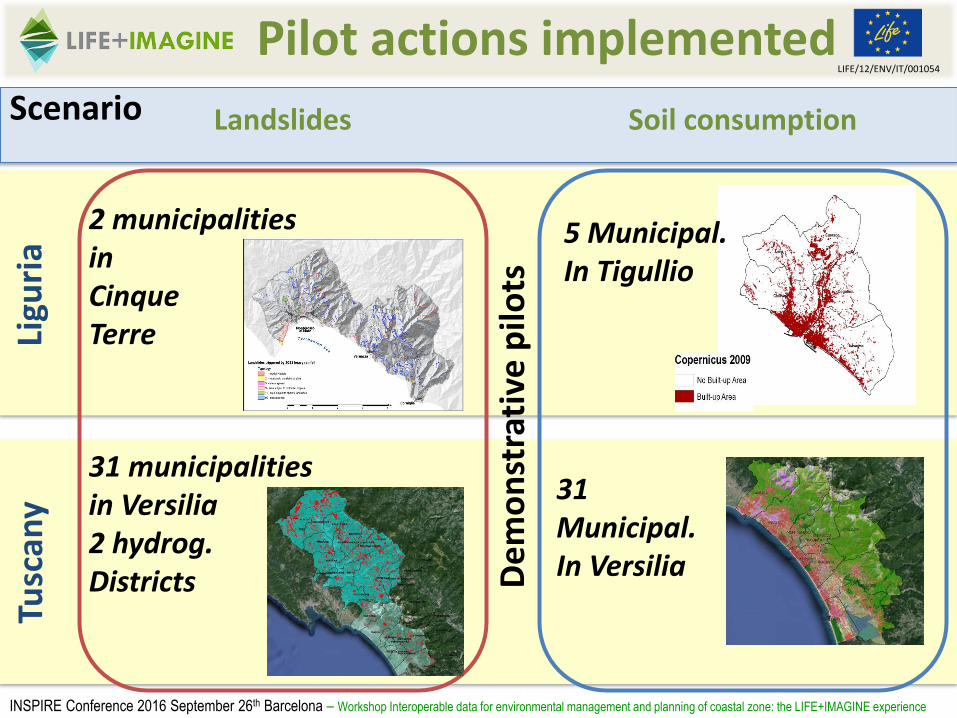
Pilot actions implemented
Soil consumptionLandslidesScenario
Tusc
any
Ligu
ria
De
mo
nst
rati
ve p
ilots
5 Municipal.In Tigullio
31Municipal.In Versilia
31 municipalities in Versilia2 hydrog. Districts
2 municipalitiesin Cinque Terre

LIFE/12/ENV/IT/001054
Extra Pilot actions
Costal sedimentary budget due to landslides event
Ligu
ria
2 municipalitiesin Cinque Terre
INSPIRE Conference 2016 September 26th Barcelona – Workshop Interoperable data for environmental management and planning of coastal zone: the LIFE+IMAGINE experience
LIFE/12/ENV/IT/001054LIFE/12/ENV/IT/001054
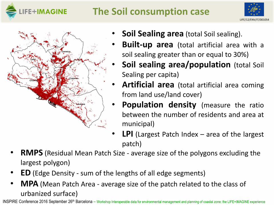
The Soil consumption case
INSPIRE Conference 2016 September 26th Barcelona – Workshop Interoperable data for environmental management and planning of coastal zone: the LIFE+IMAGINE experience
• Soil Sealing area (total Soil sealing).
• Built-up area (total artificial area with a
soil sealing greater than or equal to 30%)
• Soil sealing area/population (total Soil
Sealing per capita)
• Artificial area (total artificial area coming
from land use/land cover)
• Population density (measure the ratio
between the number of residents and area atmunicipal)
• LPI (Largest Patch Index – area of the largest
patch)• RMPS (Residual Mean Patch Size - average size of the polygons excluding the
largest polygon)
• ED (Edge Density - sum of the lengths of all edge segments)
• MPA (Mean Patch Area - average size of the patch related to the class of
urbanized surface)
LIFE/12/ENV/IT/001054LIFE/12/ENV/IT/001054
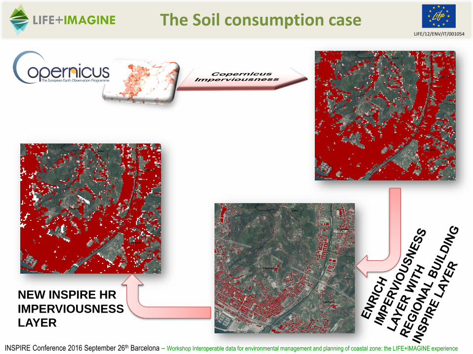
The Soil consumption case
INSPIRE Conference 2016 September 26th Barcelona – Workshop Interoperable data for environmental management and planning of coastal zone: the LIFE+IMAGINE experience
NEW INSPIRE HR
IMPERVIOUSNESS LAYER

LIFE/12/ENV/IT/001054LIFE/12/ENV/IT/001054
The Soil consumption case
INSPIRE Conference 2016 September 26th Barcelona – Workshop Interoperable data for environmental management and planning of coastal zone: the LIFE+IMAGINE experience
Change Land Cover map thisis based on Land cover flowreporting.The user can look at the changesthat have occurred between twoyears in the land cover of anarea.

LIFE/12/ENV/IT/001054LIFE/12/ENV/IT/001054
The Landslide case
INSPIRE Conference 2016 September 26th Barcelona – Workshop Interoperable data for environmental management and planning of coastal zone: the LIFE+IMAGINE experience
Landslide 2011 event
Landslide Hazard map
Integrating with facilities, utilities and infrastructures
Landslide damage (Number, area and density of landslides)Landslides and Communication Infrastructures (Critical points along the tranportnetworks).Landslides and Residential Areas (Number of building interested by landslides)
Landslides and Cultural Heritage (Number and % of exposed cultural heritage)
Landslides and Agriculture (Terrace surface and revenues interested by landslides)
Population exposed to landslides (Number and % of exposed inhabitants present in the area)Damage estimation (Estimation of potential damages)
LIFE/12/ENV/IT/001054LIFE/12/ENV/IT/001054
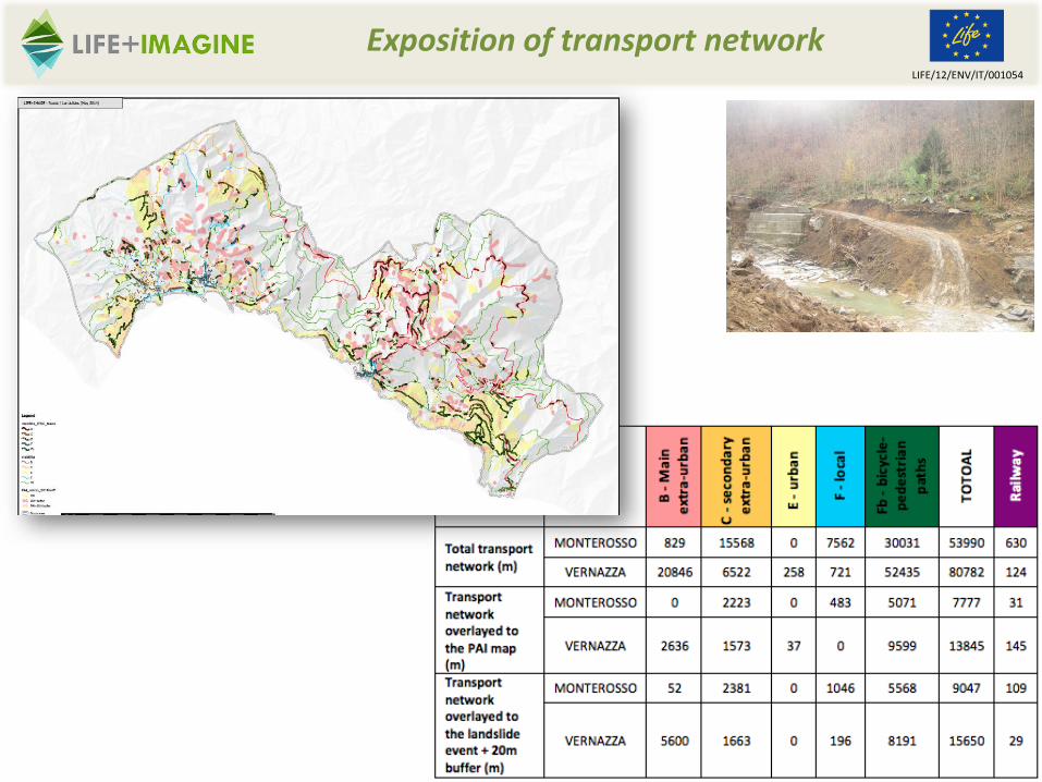
Exposition of transport network

LIFE/12/ENV/IT/001054LIFE/12/ENV/IT/001054
Exposition of Building (private and public)

LIFE/12/ENV/IT/001054LIFE/12/ENV/IT/001054
Exposition of population
56% of the populationbuilding is located inhigh hazard landslidearea
45% of population livesin building affect by the2011 landslide event

LIFE/12/ENV/IT/001054LIFE/12/ENV/IT/001054
Exposition of cultural heritage
FID DENOM TIPO FRANE
3 STATUA DI NETTUNO (C.D. GIGANTE) Statua/Complesso scultoreo/Monumento civile-
7 Chiesa e convento della Maddalena CHIESA -
8 ORATORIO DI S.MARIA DI PORTO SALVO Oratorio -
16 CAMPANILE DELLA PARROCCHIALE Campanile/Torre campanaria -
17 PALAZZO DELLA LOGGIA DEL PODESTA' (RESTI) Palazzo/Palazzina -
1 Torre Aurora TORRE Pg3b
13 Chiesa dei Cappuccini CHIESA Pg3b
0 Ospizio nel Santuario di Nostra Signora del Soviore foresteria Pg4
4 Torre quadrata del castello TORRE Pg4
9 Castello dei Fieschi RESTI Pg4
2 Oratorio di Santa Caterina oratorio -
10 Torre medioevale TORRE -
11 CASE Complesso di edifici -
14 Chiesa parrocchiale di S. Margherita di Antiochia CHIESA -
15 PALAZZO Palazzo/Palazzina -
18 Santuario Nostra Signora di Reggio RESTI -
19 CINTA MURARIA (RESTI) Mura -
5 Santuario di S. Bernardino chiesa tipo 99 (buffer) + Pg3a
6 EDIFICIO Residenza/Abitazione/Casa/Edificio Pg3b
12 CAPPELLA (RESTI) Cappella Pg3b
S. Bernardino
sanctuary

LIFE/12/ENV/IT/001054LIFE/12/ENV/IT/001054
Exposition of Agriculture terraces

LIFE/12/ENV/IT/001054LIFE/12/ENV/IT/001054
Data IntegrationData HarmonisationRisk
Level
They can help us to integrate data in the analysis
INSPIRE Conference 2016 September 26th Barcelona – Workshop Interoperable data for environmental management and planning of coastal zone: the LIFE+IMAGINE experience

LIFE/12/ENV/IT/001054LIFE/12/ENV/IT/001054
The Advantages
INSPIRE Conference 2016 September 26th Barcelona – Workshop Interoperable data for environmental management and planning of coastal zone: the LIFE+IMAGINE experience
Common process thatI can apply in differentgeographic contest orin different timewindows I need just toupload the newINSPIRE layers.
A set of WPS tools re-usable in othercontest in EU, becauseare build on CommonINSPIRE Data.

LIFE/12/ENV/IT/001054LIFE/12/ENV/IT/001054
The Potentialities
INSPIRE Conference 2016 September 26th Barcelona – Workshop Interoperable data for environmental management and planning of coastal zone: the LIFE+IMAGINE experience
- The common inputand output layercould be used in otherweb and mobileapplication
- The methodologicalapproach based onINSPIRE layer can beimprove the riskanalysis chain.
- LIFE+IMAGINE ICZMcase represents a firstoperative example ofre-use of some data.

LIFE/12/ENV/IT/001054
INSPIRE Conference 2016 September 26th Barcelona – Workshop Interoperable data for environmental management and planning of coastal zone: the LIFE+IMAGINE experience
Questions…