Adelaide’s Residential Heritage€™s Residential Heritage ‘When you look at a house, can you...
18
Adelaide’s Residential Heritage ‘When you look at a house, can you guess how old it is? Houses can tell the whole history of South Australia if you know how to read the signs.’ 1 Residential Adelaide The city of Adelaide was surveyed in 1837 as the capital of the new colony of South Australia and quickly became its early political, business and industrial centre with a residential population to engage in these activities. Surveyor-General William Light established key physical characteristics of the city when he selected the site and commenced surveying it in 1837, laying out a city in a spacious and regular form, in two sections north and south of the River Torrens, each subdivided into town acres interspersed with public squares and thoroughfares, and the whole surrounded by Park Lands. The southern section extended one mile (1.6 kilometres) in each direction and comprised 700 town acres. Light’s town acres as well as his layout of streets, squares and Park Lands have continued to define the city. Apart from roads along Park Land frontages, he surveyed only four roads running from north to south through the town. Yet these formed the constraints for later subdivisional development when the town acres were subdivided into small allotments. Narrower streets were created, usually at first as private roads, as town acres were sold and subdivided by developers. These conformed to the rectilinear grid pattern established by Light. The only major change to Light’s road pattern involved extending the major north and south roads and some east and west roads through the Park Lands to provide access to suburbs that developed beyond. The physical growth of Adelaide was constrained and contained by the surrounding Park Lands which acted like city walls to prevent continuous urban development from the city centre. Within the city boundaries there quickly developed regions and communities each with distinctive characteristics, based largely on the chief activities in these areas. The earliest urban development generally concentrated in parts of the city close to the River Torrens where there was relatively easy access to a water supply. State and cultural institutions were concentrated on the north side of North Terrace and in the vicinity of Victoria Square. Commerce and business concentrated in the northern part of South Adelaide with easy access to the main road to the port. Successful business and commercial leaders sought to establish their grand homes overlooking the Park Lands along North, East and South Terraces, primarily east of King William Street, the major north-south thoroughfare. The grand home at 103-105 South Terrace, built in 1885 for Matthew Madge, exemplified this. Residential development occurred throughout the city, but particularly south of Gouger and Angas streets and east of Hutt Street, with the south western portion of the city characterised by the co- existence of factories and industries with residential development. A report in the 1 Advertiser, 4.10.1952, p. 8.
Transcript of Adelaide’s Residential Heritage€™s Residential Heritage ‘When you look at a house, can you...
Adelaide’s Residential Heritage ‘When you look at a house, can you guess how old it is? Houses can tell the whole history of South Australia if you know how to read the signs.’
1
Residential Adelaide The city of Adelaide was surveyed in 1837 as the capital of the new colony of South Australia and quickly became its early political, business and industrial centre with a residential population to engage in these activities. Surveyor-General William Light established key physical characteristics of the city when he selected the site and commenced surveying it in 1837, laying out a city in a spacious and regular form, in two sections north and south of the River Torrens, each subdivided into town acres interspersed with public squares and thoroughfares, and the whole surrounded by Park Lands. The southern section extended one mile (1.6 kilometres) in each direction and comprised 700 town acres. Light’s town acres as well as his layout of streets, squares and Park Lands have continued to define the city. Apart from roads along Park Land frontages, he surveyed only four roads running from north to south through the town. Yet these formed the constraints for later subdivisional development when the town acres were subdivided into small allotments. Narrower streets were created, usually at first as private roads, as town acres were sold and subdivided by developers. These conformed to the rectilinear grid pattern established by Light. The only major change to Light’s road pattern involved extending the major north and south roads and some east and west roads through the Park Lands to provide access to suburbs that developed beyond. The physical growth of Adelaide was constrained and contained by the surrounding Park Lands which acted like city walls to prevent continuous urban development from the city centre. Within the city boundaries there quickly developed regions and communities each with distinctive characteristics, based largely on the chief activities in these areas. The earliest urban development generally concentrated in parts of the city close to the River Torrens where there was relatively easy access to a water supply. State and cultural institutions were concentrated on the north side of North Terrace and in the vicinity of Victoria Square. Commerce and business concentrated in the northern part of South Adelaide with easy access to the main road to the port. Successful business and commercial leaders sought to establish their grand homes overlooking the Park Lands along North, East and South Terraces, primarily east of King William Street, the major north-south thoroughfare. The grand home at 103-105 South Terrace, built in 1885 for Matthew Madge, exemplified this. Residential development occurred throughout the city, but particularly south of Gouger and Angas streets and east of Hutt Street, with the south western portion of the city characterised by the co-existence of factories and industries with residential development. A report in the
1 Advertiser, 4.10.1952, p. 8.

Adelaide’s Residential Heritage
2
Register in 1873 noted residential development in the city’s south east and north at the time:
In Adelaide—particularly in the eastern, southern, and northern portions, the unoccupied areas are being speedily filled up with a really creditable and handsome class of dwelling houses. These parts seem to be increasing in favour with those who wish to enjoy the advantages of a town residence without the inconvenience of living in or near the business parts of the city. The beauty of some of the streets has been greatly enhanced by the plantations laid down by the Corporation in various places and it is to be hoped this means of embellishing the thoroughfares will be used to even a greater extent in the future.
2
Residential development was continuous in the period from the foundation of the colony to the outbreak of World War I, though generally occurred in cycles during the nineteenth century. An 1851 report described the city ‘as a large place and not yet one quarter built upon. Building plots are for sale in all directions except in the main streets’.
3 The 1840’s recession and high prices within the ‘square mile’ had
encouraged many small purchasers to buy and build instead across the Park Lands forming the inner suburbs of Norwood, Kensington, Thebarton, Hindmarsh and Brompton. The city’s residential population rose from 8,480 in 1840 to 23,229 in 1866, 38,479 in 1881 and peaked at 43,133 in 1914. Housing construction reflected this population growth and doubled in the year from 1875 to 1876 bringing numbers of city dwellings to 5,747, along with 971 shops and warehouses. Recession after 1882 slowed dwelling construction until the end of the 1880s, but by 1895, the population of 40,167 was living in 7,900 homes. This was part of a sustained housing boom that continued from 1891 to 1902 as the colony emerged from depression. Most residents in the southern portion of South Adelaide in the nineteenth century lived in small one-storey attached, row, or single cottages, but two-storey terraces became economical as land prices rose. Stone was the major construction material. The character of the residential development of South Adelaide was greatly influenced by a succession of migrant arrivals. Many new migrants were assisted to travel to South Australia and were attracted to the capital because of generally inexpensive costs and proximity to employment. The first period of predominantly English settlement was followed by Irish immigration in the 1840s, religious refugees and others attracted by the mining boom in the 1850s, followed by the 1870’s Chinese and German female servants migration. New residents moved into the city at times of economic downturn in rural areas and country towns, for example, during the drought of the 1860s and the depressions of the late 1880s and 1930s. The largest impact of new migrant settlers occurred from the late 1940s after World War II, with large numbers of Greeks, Poles, Italians and other European migrants. Each particular ethnic group has had an effect on Adelaide’s development and the character of its residential buildings. They acquired for residential use many of the old cottages and terraces and transformed the city’s social life. Small businesses predominated in the southern portions of the city, with shops, stores, factories, workshops and warehouses co-existing with residential development. The Smith Survey of 1880 shows a tobacco factory and a vinegar and ice works off Halifax Street and steam mills close to King William Street. The juxtaposition of small industries and workshops with residential development was most evident in the south west. The contractor and builder Charles Farr, who arrived
2 Register, 4.1.1873, p. 5
3 Adelaide Times, 7 June 1851 p. 6g.

Adelaide’s Residential Heritage
3
in South Australia in 1839 built a two-storey shop and attached residence at 185-187 Sturt Street. By 1859 his firm employed 70 men, working from an area of two acres extending from Franklin to Grote Streets.
4 The Burfords soap factory was located on
Sturt Street. Most early factories were small and labour intensive, until the 1920s witnessed a rapid growth of heavy industry and factory size, exemplified by new Holden’s Motor Body works in King William Street.
A page from the Smith Survey, 1880, showing building development at that time in part of the south west of the city. It shows the location of larger dwellings on South Terrace facing the Park Lands, with smaller dwellings generally
located on the minor streets and lanes between the major east-west streets. There also remain large vacant areas.
A page from the Smith Survey, 1880, showing relatively intensive small dwelling development in the south western
part of the city between Sturt and Gilbert Streets with several small streets and lanes having been surveyed between the major streets.
4 Observer, 12 November1859, p. 7a.

Adelaide’s Residential Heritage
4
City residential development and building types included a great variety of dwellings, hotels and boarding-houses from modest two and three roomed brick, limestone, or timber structures to mansions, some occupying an entire town acre. Victorian houses dated from the period of most extensive residential development in Adelaide from the 1870s to 1890s, when a wide range of masonry houses was constructed in bluestone, limestone or sandstone, often with side and rear walls of brick or rubble and with window and door surrounds highlighted with moulded render or brick dressings. Detailing was derived from 'classical' Italianate ideas, but the forms were varied, and included single and two-storeys, single fronted, symmetrically fronted, and asymmetrically fronted houses, some with bay fronts. Most had verandahs with cast iron or timber posts and cast iron brackets and frieze decoration. The onetime grand home on the western corner of Hutt Street and South Terrace intersection was built in 1876 to the design by noted architect Daniel Garlick for prominent wine and spirits merchant William Johnston and was later home to prominent politician and Speaker of the House of Assembly Sir Jenkin Coles.
Grand villa on South Terrace, c.1890, later the TPI Hostel: B26668, (SLSA)
Edwardian house styles from about 1900 to the 1920s reflected new architectural designs current in Britain, Europe and North America, and adopted more picturesque approaches to roof forms and elevations. Styles included Queen Anne, Arts & Crafts and Art Nouveau. Walling was of ashlar stone with brick dressings or moulded render, 'rock face' sandstone (or freestone), or face brick walling with decorative brick detailing. A fine example is the Queen Anne style sandstone and brick villa built at 346-348 South Terrace for CD Whiting, a commercial traveller, in 1897-98. Inter-war residential housing styles and that which followed World War II included the bungalow based on the Californian version and Tudor Revival styles. Bungalows incorporated a broad spreading roof and verandah with masonry columns supporting

Adelaide’s Residential Heritage
5
the verandahs. Although common in the suburbs very few such houses of these styles were built in the city where there were few undeveloped sites by this time.
Churches and hotels both provided a continuing focus for social and recreational activity, from the earliest colonial period, as reflected in the early date of sections of many surviving buildings. By 1900, there were 33 city churches and chapels, as well as church halls, schools and charitable premises, six churches were Methodist, five Anglican and two Roman Catholic. There were five substantial churches along Flinders Street alone.
The numbers of children living in the city required schools for their education. Early schools in the city were the responsibility of churches and individual settlers teaching in their own homes. The 1851 Education Act abolished state aid to church schools but some early city church schools continued, such as St Mary's Dominican School which remains on the site of the Poor School established by the Sisters of St Joseph in 1869. Another private city school that continues is Pulteney Grammar School which moved to its South Terrace site in the 1920s, after being established in Pulteney Street. The first major government school was the 'Model School' built in Grote Street in 1874. The 1875 Education Act introduced compulsory primary education and other government schools were built to cater for the large numbers of children living in the city. Sturt Street School to cater for the needs of children in the south west opened in June 1883: the Gilles Street School in the south east opened on 14 May 1900. The city’s population underwent a slow but steady decline until the end of the twentieth century prompted by the growth of new suburbs beyond Adelaide and its Park Lands and encouraged by the extension of public transport infrastructure. Factories, workshops and offices replaced many dwellings, especially in the south west region of the city. In other instances former dwellings were converted for new uses, especially offices. Successive City Councils in more recent years have sought to repopulate the city. Some former industrial sites like the refuse destructor in Halifax Street have been used for housing development. Elsewhere single story dwellings have been replaced by multi-storey town houses and apartments. The architectural style of these new buildings may differ from the old, but the essential residential character of southern Adelaide has been maintained.

Adelaide’s Residential Heritage
6
The City of Adelaide’s south-east The south-east region of the city, particularly that portion south of Angas Street and east of Hutt Street, effectively took on its current residential character in the late nineteenth century, and continues to reflect key features of the residential character of Adelaide. The area retains a broad range of residential stock, from grand villas overlooking the Park Lands to modest cottages lining smaller streets established during the course of successive subdivisions by property developers and speculators. The area also includes a collection of building types important for any community. These include St John’s Anglican Church — first established in 1841, but rebuilt in its present form in 1887 — and hotels, such as the Arab Steed, and retail premises along Hutt Street.
Arab Steed Hotel, Hutt Street, 1901: B21540, (SLSA)
The subdivision of town acres in the south-east area into a network of minor streets and lanes lined with cottages occurred in distinct phases, most rapidly during the later 1870s and 1880s, though small cottages were built from the 1850s and 1860s fronting directly onto the footpath on tiny blocks on the smaller streets and lanes, usually close to main thoroughfares. The Advertiser noted on 15 January 1866:
It is astonishing to see the number of new buildings which have sprung up in Gilles-street. They are mostly cottages, built of stone and brick, and are very neat and plain specimens of cottage architecture. There are, however, two or three more pretentious looking houses than these, being two storeys and having verandahs. Two houses having pretensions to architectural beauty have been built in King William-street, near the Brecknock Arms.
5
5 Advertiser, 15.1.1866, p. 3.

Adelaide’s Residential Heritage
7
Illustration from Pictorial Australian, October 1880, showing the relative lack of church and public buildings in the southern portion of South Adelaide.
The South Australian Company held title to many town acres, and until the 1860s leased them for grazing and hay-making. On 4 January 1870, the Register newspaper noted that of the south-eastern portion of the city, that the company had released allotments for sale and that this ‘led to the erection of numerous cottages, many if not most of which have been built and are owned by the occupants’. The surviving cottages built in those years are typically small-scale, low-set with high-pitched roofs and shallow eaves, small casement windows, and low ceilings, and built close to neighbours, with many being built on the street alignment.
A page from the Smith Survey, 1880, showing building development at that time in part of the south east of the city.
It shows several large vacant areas, but also close and small scale development on the minor streets and lanes between the major east-west streets.

Adelaide’s Residential Heritage
8
Killua Place (now Ada Street) forms part of the land originally comprising Town Acres 578 and 589. One house was built in 1857, but most lots remained vacant for many years. A later resident wrote:
A flurry of building activity from 1874 and 1884 meant that all the houses on TA 578 and on the western side of TA 589 had been built. The five houses (a pair and a trio of row cottages) on the eastern side of TA 589, numbers 22-30, were built in 1907 … The streetscape, therefore, remains substantially as it was 100 years ago …
6
A page from the Smith Survey, 1880, showing building development at that time in part of the south east of the city,
with smaller dwellings generally located on the minor streets and lanes between the major east-west streets.
The most elaborate dwellings in the south east of the city were erected for prosperous residents, set back from South and East terraces and overlooking the Park Lands. Most of these grand terrace residences were built during the economic boom period of the later 1870s and 1880s and reflected this prosperous period. The Register reported in 1873:
In Adelaide – particularly in the eastern, southern and northern portions, the unoccupied areas are being speedily filled up with really creditable and handsome class of dwelling house. These parts seem to be increasing in favour with those who wish to enjoy the advantages of a town residence without the inconvenience of living in or near the business parts of the city. The beauty of some of the streets has been greatly enhanced by the plantations laid down by the Corporation…
7
The development continued. Three years later the Register reported:
Besides the more important works which call for a more extended notice, there has been a very great movement in the erection of ordinary buildings. We think there is hardly a street in the city in which waste land has not been made use of and house property erected. This is, of course, not so much the case in the older localities; but even there new houses have gone up and new shops have taken the place of the old, while in the newer portions of the town the building has been carried out not by single houses but rather by terraces and streets.
6 Philip Butterss, ‘Ada Street (formerly Killua Place)’, unpublished history prepared by a resident and
forwarded to John Greenshields, Adelaide City Council, 2007. 7 Register, 8.1.1873, p. 5.
Adelaide’s Residential Heritage
9
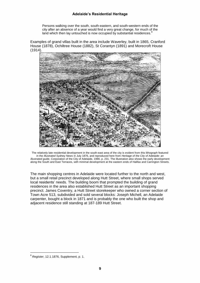
Persons walking over the south, south-eastern, and south-western ends of the city after an absence of a year would find a very great change, for much of the land which then lay untouched is now occupied by substantial residences.
8
Examples of grand villas built in the area include Waverley, built in 1865, Cranford House (1878), Ochiltree House (1882), St Corantyn (1891) and Morecroft House (1914).
The relatively late residential development in the south-east area of the city is evident from this lithograph featured
in the Illustrated Sydney News in July 1876, and reproduced here from Heritage of the City of Adelaide: an illustrated guide, Corporation of the City of Adelaide, 1990, p. 231. The illustration also shows the early development along the South and East Terraces, with minimal development at the eastern ends of Halifax and Carrington Streets.
The main shopping centres in Adelaide were located further to the north and west, but a small retail precinct developed along Hutt Street, where small shops served local residents’ needs. The building boom that prompted the building of grand residences in the area also established Hutt Street as an important shopping precinct. James Coventry, a Hutt Street storekeeper who owned a corner section of Town Acre 513, subdivided and sold several blocks: Joseph Michell, an Adelaide carpenter, bought a block in 1871 and is probably the one who built the shop and adjacent residence still standing at 187-189 Hutt Street.
8 Register, 12.1.1876, Supplement, p. 1.

Adelaide’s Residential Heritage
10
A warehouse for AW Allen in Gilles Street contrasts with adjacent residential development. B.2507, 25.2.1925 (SLSA)
The dominant residential character of the city’s south-east region was essentially established during the late nineteenth century. This residential character remains, though many surviving grand dwellings have been converted for office and commercial use during the latter twentieth century. The development of St Andrews Hospital during the twentieth century has meant this has become a dominant feature on South Terrace east of Hutt Street and has prompted the conversion of several villas into professional rooms associated with the hospital. However, the hospital’s impact is restricted to the southern fringe of the area.
Other development has continued on South Terrace. Pulteney Grammar School acquired the property on South Terrace originally granted to MD Hill in 1837 and relocated the school there in 1921 after the new Nicholls buildings was dedicated and opened by the Governor General on 3 July 1921. Like St Andrews hospital, the school has expanded and acquired other property on South Terrace.
Opening of the Nicholls Building at Pulteney Grammar School, July 1921. PRG 280/1/26/202, 1921 (SLSA).
Large premises designed by Louis Laybourne Smith for the Deaf and Dumb Mission were opened in 1928. The grand residence built by William Rogers in the 1880s was acquired by the Mothers and Babies’ Health Association in 1937 and was converted for use as a mothercraft training centre.

Adelaide’s Residential Heritage
11
Magarey House, 284–296 South Terrace, B.12500, 31.12.1952 (SLSA)
New development in the south east portion of South Adelaide continues to reflect the pattern established in earlier periods. Large scale development has continued on South Terrace, especially with the construction of major hotels and some apartments overlooking the Park Lands. However, this has served to protect the smaller domestic scale character of other ports of the area. The south-east region of the city has largely remained devoid of industry and noxious trades with townhouses now on the site of the City of Adelaide’s refuse destructor.
Slatters Limited, Halifax Street. Later phase of building. View to the north-east, 3.4.1935, B.6715 (SLSA), since converted into office use.
What new development that has taken place in this part of the city tends to be in the form of apartments and townhouses — sometimes at the expense of older dwellings — and though of a different architectural style has served to retain the essential residential character of the area.

Adelaide’s Residential Heritage
12
The City of Adelaide’s south west Adelaide’s south west has a more diverse character to that area east of King William Street. The area, bounded by West and South Terrace, Gouger and Morphett Streets, retains few grand residences. Those that were built for prosperous residents, were set back from South Terrace and overlooked the Park Lands. The two-storey residence built for the merchant John Dungey at 141 South Terrace was built in 1863. However, as in the area to the east, most of the grander terrace residences were built in the 1870s and 1880s, though many were later demolished or converted for use by offices, institutions and associations. There were few large dwellings on West Terrace, bar the Roman Catholic Archbishop’s house immediately north of Currie Street, that faced the westerly sun and the cemetery.
Part of the ‘Kingston Map’ of 1842 showing minimal contemporary development in the south western region of South Adelaide.
Small houses for the less wealthy classes were built from early years in the hinterland of the terraces, usually close to main thoroughfares. The simple cottage at 5 Whitmore Square was erected by mason John Chapman in the late 1870s, at a time when the Register noted several new cottages on the west side on the square, adding that ‘The whole appearance of this once neglected square is greatly improved, and throughout this quarter, as in the south-east, a great many cottages have been built during the year. [1877]’.
9
Subdivision of town acres from the mid 1850s transformed the south-western region into an area characterised by narrow streets of small workers' cottages. The average family size before 1900 was seven members, meaning the number of people living within an acre was often more than 50. By 1852 the town acre in Wright Street, the site of the Prince Albert Hotel, was divided into 12 speculative allotments.
10 Many
detached, semi-detached or row cottages lined narrow streets, lanes and cul-de-sacs. Some of the city's earliest surviving worker cottages dating from the 1850s and 1860s were built with front walls or verandahs to the street alignment. This is most evident in the south west region.
9 Register 1 January 1878.
10 Bridget Jolly, Historic south west corner, Adelaide South Australia, 2003, p. 5.

Adelaide’s Residential Heritage
13
Harriett Street, October 1973: B28617, (SLSA)
The subdivision of town acres into a network of streets and lanes lined with cottages occurred in distinct phases, most rapidly during the 1870s and 1880s. Hobson’s Place was created in 1859–60 by the owner of parts of Town Acres 533 and 543. There were 15 residents listed by 1880, when Hobson’s Place had gained a certain notoriety as one of the city’s ‘back slums’. Hamilton Place is another typical street: it appears as a private road in Sands and McDougall’s South Australian Directory in 1877, which recorded the five dwellings on each side of the street which are shown in the Smith Survey of 1880. They formed one of many enclaves of workers’ dwellings and a closely-settled community that included labourers, a painter, a driver, a boot maker, a poulterer, a butcher and a french polisher, and several single women.
Plan of a subdivision of Town Acre 460.
The south west of the city developed a colourful reputation quite distinct from that of the region east of King William Street. Areas about Light Square and the north west were well known as haunts of prostitutes and sly grog sellers between the 1840s and the 1900s. Samuel Boddington, publican from 1867 to 1888, owned a row of cottages in Phillips Street, which the Observer claimed were 'leased out at a high

Adelaide’s Residential Heritage
14
rent to women of ill fame.'11
However, by the 1920s prostitution was concentrated in the city’s south-western region, particularly in Sturt Street. In July 1929, Clara Hopkins was prosecuted for keeping a brothel in Sturt Street: it was her third conviction.
12 Others engaged in sly-grog-selling. In June 1925, Maud Jenkins who
kept a boarding house in Sultram Place off Sturt Street was charged with selling liquor without a license.
13
People in the south west worked in a variety of occupations, many of them in industries close at hand. Men worked as mechanics, building labourers and tradesmen, as factory hands, and in public employment as railway workers, council gangers and policemen. Single women took up positions as teachers, servants, dressmakers, shop assistants, publicans, telephonists and nurses. Women also found employment in the growing number of factories, where, like men, they endured the current working conditions. Others sought alternative employment. Occupations changed, but the mixed-use built character of this area prevailed. Sturt Street and the narrow streets in its vicinity present typical streetscapes, that include hotels, factory buildings and single and attached cottages. The Smith Survey of 1880, and a ‘Bird's Eye View of Central Adelaide’, taken from the Burford factory’s new smokestack across the street in 1885 show a whole section of the street (part Town Acres 532 and 533) still undeveloped.
View of Adelaide from Sturt Street to north, 1888: B286, (SLSA).
As in the south east, so in the south west, a range of building types fundamental to any community were built. Rundle Street and the Central Market were the main shopping centres in Adelaide, but smaller retail precincts serving local residents developed along main streets. Local residents who adhered to the Church of England worshipped at St Luke’s Church on Whitmore Square which was consecrated on 14 February 1856: Catholics attended St Patrick’s Church in western
11
Observer 25 January 1879. 12
Advertiser, 25.7.1929, p. 12. 13
Advertiser, 10.6.1925, p. 17.

Adelaide’s Residential Heritage
15
Currie Street. A measure of the unique social mix of the south west was the presence of an Islamic mosque which was built in Little Gilbert Street in 1888–89. The location of services for the homeless and disadvantaged about Whitmore Square was other indicator of the particular social character of the south west. The Salvation Army acquired the former Bushmen’s Club on Whitmore Square in 1899. The St Vincent de Paul Society opened a night shelter on the eastern side of Whitmore Square in 1961. Urban redevelopment pressures were less intense in the southern part of the city, but, through the 20
th century many shops, factories and other business premises
encroached on the working-class residences of the south west. A survey undertaken into substandard housing in Adelaide in 1939 indicated that as many as 335 houses were adversely affected by the proximity of factories or business premises.
14
New premises for Hodge & Sons in Gilbert Street replaced a wood and iron building. B.13957, December 1957 (SLSA)
Noxious industries such as Burford’s Soap and Candle Factory in Sturt Street impacted negatively on the amenity of surrounding areas. The city’s south west had an inordinate number of these types of industries, which led to persistent efforts by the Adelaide City Council to oust them.
Remains of Burford’s factory, since converted into offices. B.12819, 28.10.1953 (SLSA)
The 1939 survey by a committee inquiring into sub-standard housing conditions in the metropolitan Area provided a description of conditions that prevailed in the south west at the time. The survey focused on 7,716 houses and classified 3,009 (39 per
14
South Australian Parliamentary Paper, 32–1940, Report of the Building Act. Inquiry Committee on
Sub-Standard Housing Conditions in the Metropolitan Area. p. 24.

Adelaide’s Residential Heritage
16
cent) as ‘undesirable to be used for habitation by reason of structural condition, bad state of repair or lack of amenities’ — or worse.
15 Many of these dwellings were
situated in narrow lanes, alleys and cul-de-sacs, many of then in areas ‘invaded by factories and industrial buildings’. 447 of 3,004 substandard houses were detached houses, 1,403 were semi-detached dwellings, while 1,154 were part of a row.
16
Demolition of much of the substandard housing was envisaged, but was largely constrained by the onset of World War II, and later by the influx of migrants attracted to the area by the inexpensive housing, the communities already established there and the opportunity to live in a close urban community. The introduction of new services did much to upgrade the amenity of the area. Greeks formed the largest and most cohesive group of migrants in the twentieth century. A small Greek community, settled around the western end of Franklin Street from the early 1920s where land was cheap, and here they built a church which became a major focal point. Greek settlement was concentrated in the city’s south west, rising from 211 Greeks in 1933, to 703 in 1954. A young Nick Bolkus, who was born on 17 July 1950 and grew up in the south west of Adelaide, recalled this part of the city being characterised by a rich mixture of Irish, Italians, Greeks, Maltese and Aborigines during the 1950s. The first Greek migrant came to SA as early as 1842. He is buried at Ceduna, but his children are buried at West Terrace under the name of North, the anglicisation of the Greek surname. Others followed in the 1920s. The Bambacas family migrated to SA in 1924 and later became a feature of the south west. Nick Bolkus’ father when five years arrived in South Australia with his mother in 1922, migrating first to Port Pirie where there was already a significant Greek population, before moving to Adelaide in the 1930s when he acquired a greengrocer shop next to the Cumberland Arms Hotel in Waymouth Street. The cultural centres were three hotels, the Cumberland Arms, the Flagstaff and the Launceston. The Greek Church in Franklin Street became the religious centre of the Greek community. Nick attended Sturt Street school before going to Adelaide High School. He played sport in the south Park Lands while cows were still grazed there. He rarely if ever crossed to the east of King William Street until the 1960s when he became involved in politics. He immediately became aware of the cultural disparity between the south east and south west regions of Adelaide. The increased ethic diversity of the south west of Adelaide occurred while the population decreased. Adelaide’s residential population more than halved during a 20-year period from 35,032 in 1948 to 17,000 in 1968. At the same time, dwelling occupancy dropped from 2.9 persons to 1.9 persons. Nick Bolkus’ father maintained his greengrocer shop until 1975. By this time his customer base had dwindled as they moved to various western suburbs.
17 The reality of the population decline was
highlighted by the closure of the Sturt Street School in 1996. This underscored the sense of difference with south east Adelaide where the Gilles Street School continued. A measure of the particular character of the south west was evident when the Sturt Street school reopened in 2004 as the Sturt Street Community School after intense lobbying from local residents.
15
South Australian Parliamentary Paper, 32–1940, p. 8. 16
South Australian Parliamentary Paper, 32–1940, p.11. 17
Bridget Jolley, Historic south west corner, Adelaide South Australia Adelaide City Council, 2003.
Adelaide’s Residential Heritage
17
The southern part of South Adelaide remains largely residential, though with commercial activities characterising the major terraces and thoroughfares. The residential population waxed and waned in accordance with economic cycles, but underwent a steady decline following World War I with the continued encroachment of industries and improved circumstances of residents persuading them to live in areas beyond the Park Lands. Residents of the south west developed a strong community spirit and a special social and cultural history that is reflected in the remaining small dwellings and row cottages, particularly those concentrated in the many small lanes and streets that connect with the main thoroughfares.

Adelaide’s Residential Heritage
18
Sources of information Peter Donovan’s interview with Nick Bolkus, March 2010, National Library of Australia, TRC 6100/17. The Advertiser, newspaper. The Register, newspaper. Adelaide City Council, Department of City Planning, The City of Adelaide: the Development of its Heritage, Report prepared for visit by City of Brisbane representatives, 8 December 1982. Butterss, Philip, ‘Ada Street (formerly Killua Place)’, unpublished history prepared by a resident and forwarded to John Greenshields, Adelaide City Council, 2007. Donovan, Peter, Marsden, Susan & Stark, Paul, City of Adelaide Heritage Study, Report on location and documentation of Heritage Items as part of Stage 1: Finalisation of Folios 1-5, for Adelaide City Council, September, 1982. Jolly, Bridget, Historic south west corner, Adelaide South Australia Adelaide City Council, 2003. Linn, Rob, Those Turbulent Years: a History of the City of Adelaide 1929-1979, Adelaide City Council, 2006. McDougall, Kate & Vines, Elizabeth, City of Adelaide, Townscape Context and Local Heritage Assessment, for Adelaide City Council, 1993. McDougall, K, & Vines, E, The City of Adelaide: a Thematic History, Report for Adelaide City Council, August 2006. Marsden, S, Stark, P and Sumerling, P, (eds), Heritage of the City of Adelaide: an illustrated guide Adelaide City Council, Adelaide 1990 (2
nd ed 1996).
Morton, Peter, After Light: A History of the City of Adelaide and its Council, 1878-1928, Wakefield Press, Adelaide 1996. South Australian Parliamentary Paper, 32–1940, Report of the Building Act. Inquiry Committee on Sub-Standard Housing Conditions in the Metropolitan Area.