Adelaide Convention Centre September 30 to October 2, 2019 · Development of low-cost testing...
221
Adelaide Convention Centre September 30 to October 2, 2019
Transcript of Adelaide Convention Centre September 30 to October 2, 2019 · Development of low-cost testing...
Adelaide Convention Centre
September 30 to October 2, 2019

2
Contents
Session Overview 3
Detailed Program 4
Monday 4
Tuesday 5
Wednesday 11
Poster Presentations 17
Tuesday 17
Wednesday 19
ABSTRACT LIST 21

Session Overview - September 30 to October 2
Time Monday / Joint Space Forum & ASRC Time Tuesday Wednesday
08.00 ‐ 08.45
Registration Foyer L
08.00 ‐ 08.30
Registration City Rooms Foyer
Registration City Rooms Foyer
08.45 ‐ 08.50
Opening Hon Steve Marshall MP Hall L
08.30 ‐ 10.00
Gender Equity and Diversity Graziella Caprarelli
Anna‐Maria Arabia (Plenary), Rose O'Dea (invited), Eriita Jones, Alice Gorman, Sumen Rai
City Rooms 1&2
Plenaries Iver Cairns
Isabelle Kingsley, Alina Donea, Anatoly Rozenfeld City Rooms 1&2
08.50 ‐10.15
National and International Space Trends Hon Karen Andrews MP, Dr Megan Clark, Mr Richard Price, Mr
Luca Del Monte, Dr Sarah Pearce, Dr James Johnson, Dr Graeme Kernich
Hall L
10.15 ‐ 11.00
Morning Tea Exhibition Halls M&N
10.00 ‐ 10.30
Morning Tea City Rooms Foyer
Morning Tea City Rooms Foyer
11.00 ‐ 12.30
Space Science, Industry and Applications: National Context
Facilitator: Anna‐Maria Arabia. Panellists: Dr Murray Parkinson, Prof Andrew Dempster, Prof
Caroline McMillen, Prof Graham Durrant, Mr Darin Lovett, Prof Fred Menk
Hall L
10.30 ‐ 12.30
Stream 1 City Room 1
Stream 2 City Room 2
Stream 3 City Room 3
Stream 4 City Room 4
Stream 1 City Room 1
Stream 2 City Room 2
Stream 3 City Room 3
Stream 4 City Room 4
Space engineering 1
Gavin Conibeer
Space business &
industry Suelynn Choy
Education & training Isabelle Kingsley
Remote sensing, Earth observations Julia Mitchell
Space missions 2
Sarah Pearce
Space situational awareness
Melrose Brown
Space policy, GNSS & history
Carol Oliver
Space & atmos phys 2, Space
eng 4 Trevor Harris
12.30 ‐ 13.30
Lunch Exhibition Halls M&N
12.30 ‐ 13.30
Lunch City Rooms Foyer
Lunch City Rooms Foyer
Women in Space Networking Event City Room 4
13.30 ‐ 14.50
Australian Space Research Conference Plenaries Fred Menk
Dr Jason Held, Prof Phil Bland, A/Prof Suelynn Choy, Dr John Le Marshall
Hall L
13.30 ‐ 15.00
Stream 1 City Room 1
Stream 2 City Room 2
Stream 3 City Room 3
Stream 4 City Room 4
Stream 1 City Room 1
Stream 2 City Room 2
Stream 3 City Room 3
Stream 4 City Room 4
Space engineering 2
Kimberley Clayfield
Entrepreneur pitch sessions
Jason Held
Planets & exoplanets Brad Carter
Space missions 1
Andrew Dempster
Space engineering
5 Shanae King
Meteorites, asteroids &
space resources Jonti Horner
Space medicine &
human factors Gordon Cable
Space & atmospheric physics 3
Alina Donea
14.50 ‐ 15.30
Afternoon Tea Exhibition Halls M&N
15.00 ‐ 16.30
Afternoon Tea & Posters 1 City Rooms Foyer
Afternoon Tea & Posters 2 City Rooms Foyer
15.30 ‐ 16.50
SmartSat CRC ‐ Building Australia's Space Industry Facilitator: Peter Nikoloff. Panellists: Prof Anna
Moore, Dr Andrew Seedhouse, Ms Aude Vignelles, Mr Brad Yelland, Dr Koukou Suu, Mr Shaun Wilson,
Dr Doug Griffin, Mr Martin Duursma Hall L
16.30 ‐ 18.00
Stream 1 City Room 1
Stream 2 City Room 2
Stream 3 City Room 3
Stream 4 City Room 4
Town hall discussion City Rooms 1&2
Spaceengineering 3
Monique Hollick
Space law Liz Pearce
Mars Lucyna
Chudczer
Space &atmospheric
physics 1 Brett Carter
Fred Menk, Carol Oliver Development of Australia's next decadal plan for space science
16.55 ‐ 18.30
Networking event Exhibition Halls M&N
19.00 ‐ 21.30
Gala Dinner
19.15 ‐ 20.45
MSA "David Cooper Memorial lecture", Adelaide University Jon Clarke
Dr Gordon Cable University of Adelaide

4
Detailed Program
Monday
Time Speakers Name Title
8:15-8:45 Registration 8:45-8:50 Opening
Hon Steve Marshall MP
National and International Space Trends
8:50-10:15 Hon Karen Andrews MP, Dr Megan Clark, Mr Richard Price, Mr Luca Del Monte, Dr Sarah Pearce, Dr James Johnson, Dr Graeme Kernich
10:15-11:00 Morning Tea National Context – Q & A Expert Panel 11:00-12:30 Anna-Maria Arabia, Dr Murray Parkinson, Prof Andrew
Dempster, Prof Caroline McMillen, Prof Graham Durrant, Mrs Maureen Dougherty, Prof Fred Menk
12:30-13:30 Lunch ASRC Plenaries 13:30-13:50 Dr Jason Held,
Saber astronautics Responsive Space Operations Centre (RSOC)
13:50-14:10 Prof Phil Bland, Curtin University
FireOPAL: A sovereign Australian space situational awareness solution
14:10-14:30 A/Prof SueLynn Choy, RMIT University
Satellite Navigation Technology: Past, Present and Future
14:30-14:50 Dr John Le Marshall, Bureau of Meteorology
The Considerable Benefits of Earth Observations from Space in Meteorology - Status and Future
14:50-15:30 Afternoon Tea SmartSat CRC – Q & A Expert Panel 15:30-16:50 Dr Koukou Suu, Peter Nikoloff, Prof Anna Moore, Dr
Andrew Seedhouse, Ms Aude Vignelles, Mrs Gaby Costigan, Mr Shaun Wilson, Prof Russell Boyce
16:55-18:30 Networking Session
19:15-20:45 MSA “David Cooper memorial lecture” Dr Gordon Cable Venue: Adelaide University

5
Tuesday - Plenary (City Rooms 1 & 2)
Time Speakers Name Title 7:45-8:30 Registration Gender Equity and Diversity Session 8:30-9:00 Anna Maria Arabia,
Australian academy of Science
Ten Years, six opportunities: why gender equity in STEM can't be achieved without you
9:00-9:20 Rose O’Dea University of NSW
Why are fewer women than men employed in fields associated with brilliance?
9:20-9:40 Eriita Jones University of South Australia
Gender balance and inclusion is still a problem: An overview of delegates at the Australian Space Research Conference over the past 4 years
9:40-10:30 Panel discussion Anna-Maria Arabia, Rose O'Dea, Eriita Jones, Alice Gorman, Sumen Rai
10:00-10:30 Morning Tea
Tuesday - Stream 1 (City Rooms 1)
Time Speakers Name Title Space Engineering 1 10:30-10:45 Jan-Erik Ronningen,
Gilmour Space Technologies
Hybrid Rockets – past, present, future
10:45-11:00 Aiden O'Brien, Saber Astronautics
Automated conceptual design of cubesats
11:10-11:15 Stuart Buchan, Curtin University
The Binar CubeSat Program: design and development of a CubeSat digital twin
11:15-11:30 R K Manchanda,
Role of tethered balloons and aerostats in communication, surveillance and disaster management
11:30-11:45 Kawsihen Elankumaran, University of New South Wales
Autonomous navigation of distributed spacecraft for proximity operations in small celestial bodies
11:45-12:00 Job Nijhuis, University of Adelaide
Microfluidic chip-based synthesis and spray of quantum nanodots as spectral decoy to protect satellites
12:15-12:30 Brian Tran, RMIT University
Novel concept for a partly reusable Lunar lander
12:30-13:30 Lunch
6
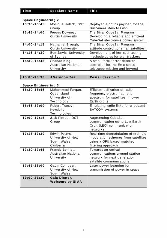
Time Speakers Name Title Space Engineering 2 13:30-13:45 Monique Hollick, DST
Group Deployable optics payload for the Buccaneer Main Mission
13:45-14:00 Fergus Downey, Curtin University
The Binar CubeSat Program: Developing a reliable and efficient CubeSat electronics power system
14:00-14:15 Nathaniel Brough, Curtin University
The Binar CubeSat Program: attitude control for small satellites
14:15-14:30 Ben Jarvis, University of Sydney
Development of low-cost testing methodologies for star trackers
14:30-14:45 Shanae King, Australian National University
A small form-factor detector controller for the Emu space telescope mission and beyond
15:00-16:30 Afternoon Tea Poster Session 1 Space Engineering 3 16:30-16:45 Muhammad Furqan,
Queensland University of Technology
Efficient utilization of radio frequency electromagnetic spectrum for satellites in lower Earth orbits
16:45-17:00 Robert Tracey, Keysight Technologies
Emulating radio links for wideband SATCOM systems
17:00-17:15 Jack Rintoul, DST Group
Augmenting CubeSat communication using Low Earth Orbit (LEO) communication networks
17:15-17:30 Edwin Peters, University of New South Wales Canberra
Real-time demodulation of multiple modulation schemes from satellites using a GPU based matched filtering approach
17:30-17:45 Francis Bennet, Australian National University
Towards an optical communications ground station network for next generation satellite communications
17:45-18:00 Gavin Conibeer, University of New South Wales
Laser power beaming for transmission of power in space
19:00-21:30 Gala Dinner. Welcome by SIAA

7
Tuesday - Stream 2 (City Rooms 2)
Time Speakers Name Title Space Business and Industry 10:30-10:45 Daniel Floreani,
CyberOps The Australian space cybersecurity environment
10:45-11:00 Richard Matthews, University of Adelaide
How security ready is the Australian Space Industry? The challenges of digital security in space
11:00-11:15 Taofiq Huq, SpiralBlue
Spiral Blue: Space Edge Computing
11:15-11:30 Christopher Tylor, NEO Resources Atlas Pty Ltd
The NEO Resource Atlas - A commercial solution to a legal problem
11:30-11:45 Sophia Casanova, University of New South Wales
Developing exploration strategies and development guidelines for Lunar and Martian volatile resource extraction and utilisation
11:45-12:00 Nicholas Bennett, University of New South Wales
On the virtue of supplying just oxygen from a lunar polar water mine
12:00-12:15 Scott Wallis, Equatorial Launch Australia
NASA launches from the Arnhem Space Centre in 2020
12:15-12:30 Vickal Kumar, Bureau of Meteorology
Impacts of space weather on aviation
12:30-13:30 Lunch Entrepreneur Pitch Sessions 13:30-13:45 Max Arshavsky,
Zenno Astronautics Limited
Novel satellite propulsion technology
13:45-14:00 Bohan Deng, Sperospace Pty Ltd
Sperospace
14:00-14:15 Benjamin Koschnick, Spectral Aerospace
Spectral Aerospace: changing the way we see our world
14:15-14:30 Brian Lim, Wise Networking
On demand telecommunication infrastructure for planetary exploration and colonisation
14:30-14:45 Sai Krishna Vallapureddy, Ground Zero Space
The Australian space cybersecurity environment
15:00-16:30 Afternoon Tea Poster Session 1
8
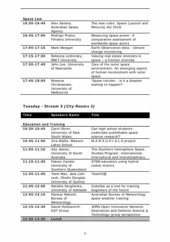
Space Law 16:30-16:45 Alex Seneta,
Australian Space Agency
The new rules: Space (Launch and Returns) Act 2018
16:45-17:00 Rodrigo Praino, Flinders University
Measuring space power: A comparative assessment of worldwide space actors
17:00-17:15 Mark Meegan Earth Observation data - climate change monitoring
17:15-17:30 Rebecca Leshinsky, RMIT University
Valuing real estate interests in space – a frontier exercise
17:30-17:45 John Lee, University of Newcastle
Care of the outer space environment: An emerging aspect of human involvement with outer space.
17:45-18:00 Rowena Christiansen, University of Melbourne
'Space tourism - is it a disaster waiting to happen?
Tuesday - Stream 3 (City Rooms 3)
Time Speakers Name Title Education and Training 10:30-10:45 Carol Oliver,
University of New South Wales
Can high school students undertake publishable space science research?
10:45-11:00 Vira Wallis, Mawson Lakes School
M.A.R.S.U.P.I.A.L.S project
11:00-11:15 Ady James, University of South Australia
The Southern hemisphere Space Studies Program: international, intercultural and interdisciplinary.
11:15-11:30 Fabian Zander, University of Southern Queensland
STEM education using hybrid rocket motors
11:30-11:45 Yiwei Mao, Jack Liell-cock, Sholto Douglas University of Sydney
TweetS@
11:45-12:00 Nataliia Sergiienko, University of Adelaide
CubeSat as a tool for training engineers of the future
12:00-12:15 Panwar Rakesh, Bureau of Meteorology
Australian Bureau of Meteorology space weather training
12:15-12:30 David Holdsworth, DST Group
JORN Open Innovation Network: Description and Defence Science & Technology group perspective
12:30-13:30 Lunch

9
Time Speakers Name Title Planets and Exoplanets 13:30-13:45 Shin-Chan Han,
University of Newcsatle
High-resolution gravitational fields of the Moon from crustal density estimates and topographic data
13:45-14:00 Jonti Horner, University of Southern Queensland
Minerva-Australis - searching for alien worlds
14:00-14:15 Graziella Caprarelli, Hypatia Scientifica P/L
Exploratory analysis of the NASA Exoplanet Archive
14:15-14:30 Graeme Melville, University of New South Wales
Characterising Hot Jupiter exoplanets
14:30-14:45 James O'Connor, University of Southern Queensland
Orbital constraints on terrestrial exoplanet climates
14:45-15:00 Jake Clark, University of Southern Queensland
Can stellar abundances help explain the architecture of planetary systems discovered by TESS?
15:00-16:30 Afternoon Tea Poster Session 1 Mars 16:30-16:45 Nick Carter, CSIRO CubeSat to Mars - A feasibility
study 16:45-17:00 Jon Clarke, Mars
Society Australia Lonar Crater in India as an analogue for Mars analogue studies
17:00-17:15 Eriita Jones, University of South Australia
A battle between machine learning, traditional clustering and citizen scientists in the detection and segmentation of polar spring-time fans on Mars
17:15-17:30 Lucy Forman, Curtin University
Lava flows on Mars
17:30-17:45 Anthony Lagain, Curtin University
Automatic surface age dating of impact events on Mars
17:45-18:00 Ken Orr, Curtin University
Spectral characterization of Martian meteorites: Searching for the source craters on Mars

10
Tuesday - Stream 4 (City Rooms 4)
Time Speakers Name Title Remote Sensing and Earth Observations 10:30-10:45 Amy Parker, CSIRO Australia’s NovaSAR-1 national
research facility 10:45-11:00 Trent McDougall,
Mars Society Australia
Flown in space: Can low cost electronics perform useful science in the near-space environment?
11:00-11:15 Mark Ramsey, Sitael Australia
An Australian national satellite water monitoring system concept
11:15-11:30 Stephen Gensemer, CSIRO
CSIRO's small-satellite optical instrumentation development
11:30-11:45 Victor Fok, DST Group
SAR constellation designs for barrier surveillance applications
11:45-12:00 Joon Wayn Cheong, ACSER, University of New South Wales
Target detection applications using GNSS-reflectometry
12:00-12:15 Elizaveta Klantsataya, University of Adelaide
Upconversion fluorescence spectroscopy for active remote detection of acetone and other small size organic compounds in space
12:15-12:30 Andrew Robson, University of New England
Satellite imagery, if not properly trained then it can ‘eat your sheep’
12:30-13:30 Lunch Space Missions 1 13:30-13:45 Xueliang Bai,
University of Sydney The CUAVA-1 CubeSat
13:45-14:00 Nathaniel Brough, Curtin University
The Binar CubeSat program: Past, present and beyond
14:00-14:15 Michele Trenti, University of Melbourne
The SkyHopper space telescope CubeSat
14:15-14:30 Duncan Wright, University of Southern Queensland
Twinkle and Australia
14:30-14:45 Joice Mathew, Australian National University
Emu - A time delay imaging near-infrared survey mission on the international space station
14:45-15:00 Shin-Chan Han, University of Newcastle
An overview of NASA and DLR’s Gravity Recovery And Climate Experiment (GRACE) and GRACE Follow-On missions
15:00-16:30 Afternoon Tea Poster Session 1

11
Time Speakers Name Title Space and Atmospheric Physics I 16:30-16:45 Patrick Shober,
Curtin University Skipping fireballs and what they tell us about the evolution of the solar system
16:45-17:00 Eleanor Sansom, Curtin University
Hayabusa II re-entry observation campaign
17:00-17:15 George Bowden, University of New South Wales
Numerical simulation of ionospheric disturbances resulting from rocket launches
17:15-17:30 Ronald Maj, RMIT University
Comparison of the predictive power of RMIT's and existing atmospheric mass density (AMD) models using satellite measurements
17:30-17:45 Andrew Spargo, University of Adelaide
Multistatic meteor radar observations of gravity wave-tide interactions in the lower E-region
17:45-18:00 Baden Gilbert, University of Adelaide
Simultaneous ionospheric sounder and airglow observations of sporadic-E layers
Wednesday - Plenary (City Rooms 1 & 2)
Time Speakers Name Title 7:45-8:30 Registration Plenaries 8:30-9:00 Isabelle Kingsley,
University of NSW Deep impact: how to achieve effective and meaningful space science education and outreach
9:00-9:30 Alina Donea, Monash University
Advances and results in enhancing and developing helioseismic methods for the space weather predictions
9:30-10:00 Anatoly Rozenfeld, University of Wollongong
Innovative radiation sensors for prediction of radiation hazard to astronauts and electronics during space missions
10:00-10:30 Morning Tea

12
Wednesday - Stream 1 (City Rooms 1)
Time Speakers Name Title Space Missions 2 10:30-10:45 Stephen Gensemer,
CSIRO CSIROSat-1 CubeSat mission update
10:45-11:00 William Crowe, HEO Robotics
Asteroid Century whitepaper: a flagship mission for Australia
11:00-11:15 Andrew Dempster, ACSER, University of New South Wales
The Wilde Project: A Moon Mission for Australia
11:15-11:30 Ed Kruzins, CSIRO Deep space missions from Australia, the capability of the Canberra Deep Space Communication Complex at Tidbinbilla and the future of new tracking technologies
11:30-11:45 Guifré Molera Calvés, University of Tasmania
Spacecraft tracking capabilities by the UTAS radio telescope network
11:45-12:00 Ben Adams, Inovor Technologies
Apogee satellite bus missions
12:00-12:15 Rasit Abay, University of New South Wales Canberra
Space mission architecture with AI on the edge
12:15-12:30 Elias Aboutanios, University of New South Wales
A high altitude balloon borne synthetic aperture radar
12:30-13:30 Lunch Space Engineering 5 13:30-13:45 Volker Hessel,
University of Adelaide Asteroid@ChemEng: Orders of magnitude water savings by intensified metal extraction from mimicked asteroid ores?
13:45-14:00 Heiki Ebendorff-Heidepriem, University of Adelaide
Next-generation extreme-low loss optical fibres through automated manufacture in space
14:00-14:15 Daniel Liang, CSIRO Shape memory alloy foils produced by near-net-shape casting
14:15-14:30 Yang Yang, RMIT University
PHiFA – A high-fidelity orbit-attitude propagator
14:30-14:45 Benjamin Dix-Matthews, University of Western Australia
Coherent optical Doppler orbitography
14:45-15:00 15:00-16:30 Afternoon Tea Poster Session 2

13
Wednesday – Townhall discussion (City Rooms 1 & 2)
Time Speakers Name Title 16:30-17:55 Development of Australia's next decadal plan for
space science
17:55-18:05 Iver Cairns, Wayne Short
Conference closing remarks
Wednesday - Stream 2 (City Rooms 2)
Time Speakers Name Title Space Situational Awareness 10:30-10:45 Steve Gower, SERC Space Environment Research
Centre (SERC) research 10:45-11:00 Albert Sztolc,
University of Adelaide Optical space fence development
11:00-11:15 Doris Grosse, Australian National University
Adaptive optics for space situational awareness
11:15-11:30 Brendan Hennessy, DST Group
Surveillance of space with passive radar using the Murchison Widefield Array
11:30-11:45 David Holdsworth, DST Group
Buckland Park VHF radar observations of low-earth orbit objects during SpaceFest 2019: operating configuration and signal processing
11:45-12:00 Samantha Le May, RMIT University
A quantitative analysis of space object registration using a graph database.
12:00-12:15 Richard Samuel, Australian National University
A new method of refining near-earth object characteristics and behaviours using differential correction
12:15-12:30 Emma Kerr, RMIT University
Limitations on the use of drag augmentation for post-mission disposal
12:30-13:30 Lunch Meteorites, Asteroids and Space Resources 13:30-13:45 Eleanor Sansom,
Curtin University Near-Earth Objects characterisation with small space assets
13:45-14:00 Seamus Anderson, Curtin University
Drones and deep learning for meteorite recovery
14
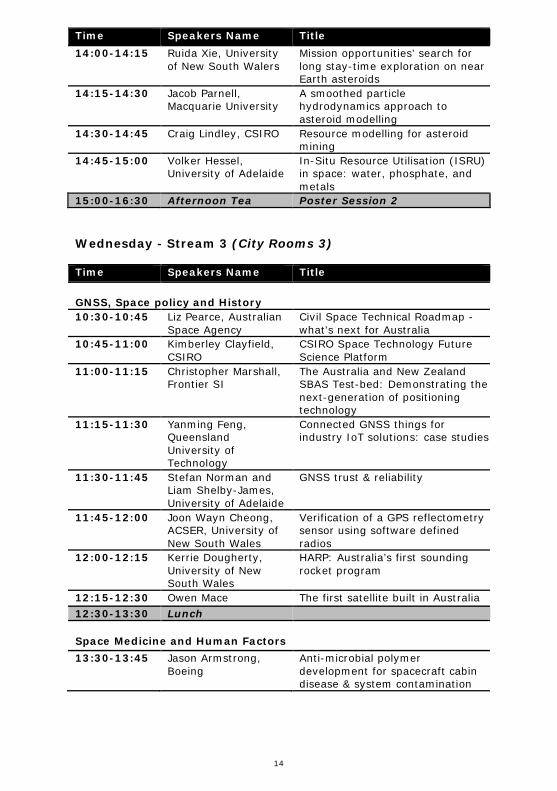
Time Speakers Name Title 14:00-14:15 Ruida Xie, University
of New South Walers Mission opportunities’ search for long stay-time exploration on near Earth asteroids
14:15-14:30 Jacob Parnell, Macquarie University
A smoothed particle hydrodynamics approach to asteroid modelling
14:30-14:45 Craig Lindley, CSIRO Resource modelling for asteroid mining
14:45-15:00 Volker Hessel, University of Adelaide
In-Situ Resource Utilisation (ISRU) in space: water, phosphate, and metals
15:00-16:30 Afternoon Tea Poster Session 2
Wednesday - Stream 3 (City Rooms 3)
Time Speakers Name Title GNSS, Space policy and History 10:30-10:45 Liz Pearce, Australian
Space Agency Civil Space Technical Roadmap - what's next for Australia
10:45-11:00 Kimberley Clayfield, CSIRO
CSIRO Space Technology Future Science Platform
11:00-11:15 Christopher Marshall, Frontier SI
The Australia and New Zealand SBAS Test-bed: Demonstrating the next-generation of positioning technology
11:15-11:30 Yanming Feng, Queensland University of Technology
Connected GNSS things for industry IoT solutions: case studies
11:30-11:45 Stefan Norman and Liam Shelby-James, University of Adelaide
GNSS trust & reliability
11:45-12:00 Joon Wayn Cheong, ACSER, University of New South Wales
Verification of a GPS reflectometry sensor using software defined radios
12:00-12:15 Kerrie Dougherty, University of New South Wales
HARP: Australia’s first sounding rocket program
12:15-12:30 Owen Mace The first satellite built in Australia 12:30-13:30 Lunch Space Medicine and Human Factors 13:30-13:45 Jason Armstrong,
Boeing Anti-microbial polymer development for spacecraft cabin disease & system contamination
15
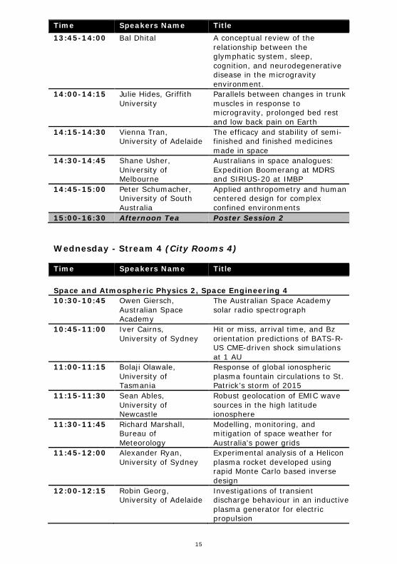
Time Speakers Name Title 13:45-14:00 Bal Dhital A conceptual review of the
relationship between the glymphatic system, sleep, cognition, and neurodegenerative disease in the microgravity environment.
14:00-14:15 Julie Hides, Griffith University
Parallels between changes in trunk muscles in response to microgravity, prolonged bed rest and low back pain on Earth
14:15-14:30 Vienna Tran, University of Adelaide
The efficacy and stability of semi-finished and finished medicines made in space
14:30-14:45 Shane Usher, University of Melbourne
Australians in space analogues: Expedition Boomerang at MDRS and SIRIUS-20 at IMBP
14:45-15:00 Peter Schumacher, University of South Australia
Applied anthropometry and human centered design for complex confined environments
15:00-16:30 Afternoon Tea Poster Session 2
Wednesday - Stream 4 (City Rooms 4)
Time Speakers Name Title Space and Atmospheric Physics 2, Space Engineering 4 10:30-10:45 Owen Giersch,
Australian Space Academy
The Australian Space Academy solar radio spectrograph
10:45-11:00 Iver Cairns, University of Sydney
Hit or miss, arrival time, and Bz orientation predictions of BATS-R-US CME-driven shock simulations at 1 AU
11:00-11:15 Bolaji Olawale, University of Tasmania
Response of global ionospheric plasma fountain circulations to St. Patrick’s storm of 2015
11:15-11:30 Sean Ables, University of Newcastle
Robust geolocation of EMIC wave sources in the high latitude ionosphere
11:30-11:45 Richard Marshall, Bureau of Meteorology
Modelling, monitoring, and mitigation of space weather for Australia's power grids
11:45-12:00 Alexander Ryan, University of Sydney
Experimental analysis of a Helicon plasma rocket developed using rapid Monte Carlo based inverse design
12:00-12:15 Robin Georg, University of Adelaide
Investigations of transient discharge behaviour in an inductive plasma generator for electric propulsion

16
Time Speakers Name Title 12:15-12:30 Kyll Schomberg,
Shoal Group Estimating non-axial thrust loss in bell rocket nozzles
12:30-13:30 Lunch Space and Atmospheric Physics 3 13:30-13:45 Daniel Field,
University of Adelaide A new empirical climatological model of ionospheric foF2 and hmF2
13:45-14:00 Zahra Bouya, Bureau of Meteorology
A prediction model of global ionospheric maps
14:00-14:15 Andrew Heitmann, DST Group
Characterising ionospheric gradients from oblique angle-of-arrival ionosondes
14:15-14:30 Chris Crouch, DST Group
Using neural networks to improve ionospheric models with radar backscatter sounder observations
14:30-14:45 Anne Unewisse, DST Group
Variation in the maximum range of HF spread Doppler clutter
14:45-15:00 Lenard Pederick, DST Group
TAPDANCE: A polarimetric vector-sensing ionosonde
15:00-16:30 Afternoon Tea Poster Session 2
17
Poster Presentations
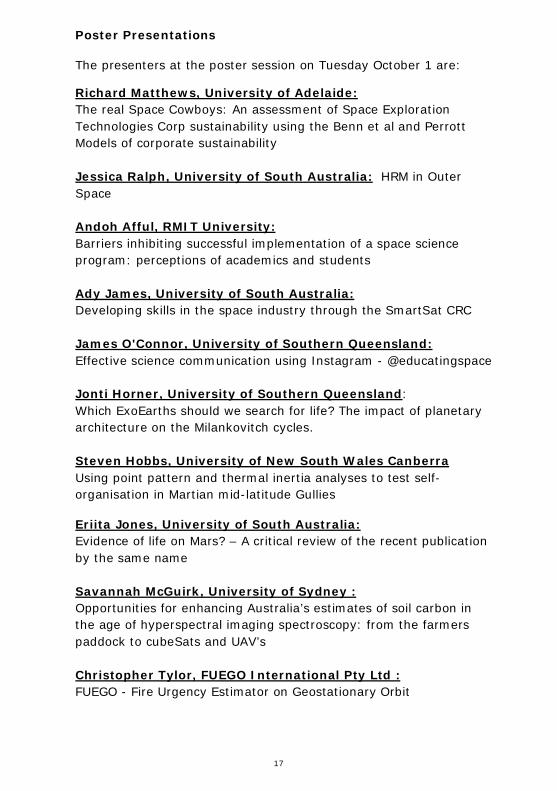
The presenters at the poster session on Tuesday October 1 are:
Richard Matthews, University of Adelaide: The real Space Cowboys: An assessment of Space Exploration Technologies Corp sustainability using the Benn et al and Perrott Models of corporate sustainability Jessica Ralph, University of South Australia: HRM in Outer Space Andoh Afful, RMIT University: Barriers inhibiting successful implementation of a space science program: perceptions of academics and students Ady James, University of South Australia: Developing skills in the space industry through the SmartSat CRC James O'Connor, University of Southern Queensland: Effective science communication using Instagram - @educatingspace Jonti Horner, University of Southern Queensland: Which ExoEarths should we search for life? The impact of planetary architecture on the Milankovitch cycles. Steven Hobbs, University of New South Wales Canberra Using point pattern and thermal inertia analyses to test self-organisation in Martian mid-latitude Gullies
Eriita Jones, University of South Australia: Evidence of life on Mars? – A critical review of the recent publication by the same name Savannah McGuirk, University of Sydney : Opportunities for enhancing Australia’s estimates of soil carbon in the age of hyperspectral imaging spectroscopy: from the farmers paddock to cubeSats and UAV’s Christopher Tylor, FUEGO International Pty Ltd : FUEGO - Fire Urgency Estimator on Geostationary Orbit

18
Eriita Jones, University of South Australia : Is higher spatial resolution always better? A quantitative analysis of the impact of pan-sharpening worldview-2 imagery on a neural networks detection and segmentation of vineyards Aditya Kedlaya, AstrogateLabs : Precision pointing system for a low-cost optical terminal for high-speed downlink from smallsats in LEO Dylan Lawrence, Flinders University : Dynamic modelling of systems with pitch control aerofoils Xiaozhou Liu, University of New South Wales : Integrated patch antennas and solar cells for Cubesats – Optimising solar cell efficiency and antennae gain Patrick Neumann, Neumann Space : Initial pulsed cathodic arc thruster impulse measurements using a calibrated torsional thrust stand Eric Russo, Flinders University : A detailed investigation and solution strategy of thermal impacts on pressure regulator valve in liquid space engine hydro-control system James Veasey, Flinders University : Dynamic analysis and component modelling of a thrust system in a liquid space engine Dylan Vinall, Flinders University : The application of surface dielectric barrier discharge plasma actuators, for improved active flow control on highly pitched aerofoil blades. Ivan Voropaev, Wave Power Engineering : New propulsion system
Andrew Zhang, University of Technology Sydney : Novel architecture and key technologies for achieving high capacity and low cost space and terrestrial integrated networks
19
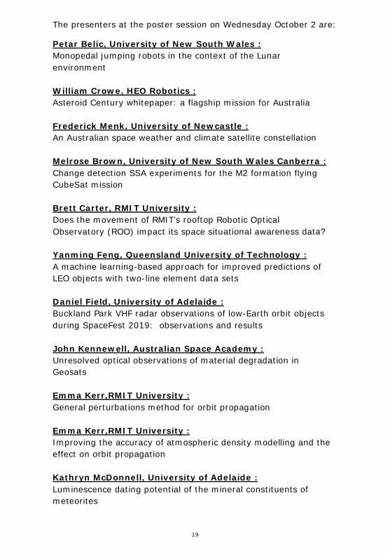
The presenters at the poster session on Wednesday October 2 are:
Petar Belic, University of New South Wales : Monopedal jumping robots in the context of the Lunar environment William Crowe, HEO Robotics : Asteroid Century whitepaper: a flagship mission for Australia Frederick Menk, University of Newcastle : An Australian space weather and climate satellite constellation Melrose Brown, University of New South Wales Canberra : Change detection SSA experiments for the M2 formation flying CubeSat mission Brett Carter, RMIT University : Does the movement of RMIT’s rooftop Robotic Optical Observatory (ROO) impact its space situational awareness data? Yanming Feng, Queensland University of Technology : A machine learning-based approach for improved predictions of LEO objects with two-line element data sets Daniel Field, University of Adelaide : Buckland Park VHF radar observations of low-Earth orbit objects during SpaceFest 2019: observations and results John Kennewell, Australian Space Academy : Unresolved optical observations of material degradation in Geosats Emma Kerr,RMIT University : General perturbations method for orbit propagation Emma Kerr,RMIT University : Improving the accuracy of atmospheric density modelling and the effect on orbit propagation Kathryn McDonnell, University of Adelaide : Luminescence dating potential of the mineral constituents of meteorites

20
Brett Carter, RMIT University : On the evaluation of deterministic ionospheric scintillation forecasts Tam Dao, International University (HCMIU) : On the variations of the total electron content observed over Ho Chi Minh City in 2018 Alina Donea, Monash University : CNN machine learning techniques for identification of magnetic field polarities on the solar surface Darrell Elton, La Trobe University : Buckland Park HF radar: Enhanced capabilities and results Owen Giersch, Australian Space Academy The Australian Space Academy sunspot number Vasily Lobzin, Bureau of Meteorology : Predictions of relativistic electron fluence at geo-synchronous orbit Ronald Maj, RMIT University : Dust detection via voltage power spectroscopy on a CubeSat in Earth’s ionosphere Dave Neudegg, DST Group : Coronal mass ejection and resultant geomagnetic-ionospheric response Kehe Wang, Bureau of Meteorology : Analysis of Australian historical foF2 data John Hildebrandt, Amazon Web Services : Introduction to AWS (Amazon Web Services) Ground Station

21
ABSTRACT LIST
ABAY: Space mission architecture with AI on the edge .......................... 29
ABLES: Robust Geolocation of EMIC Wave Sources in the High Latitude Ionosphere ...................................................................................... 30
ABOUTANIOS: A High Altitude Balloon Borne Synthetic Aperture Radar ... 31
ADAMS: Apogee Satellite Bus Missions ................................................ 32
AFFUL: Barriers inhibiting successful implementation of a space science program: Perceptions of Academics and Students ................................. 33
ANDERSON: Drones and Deep Learning for Meteorite Recovery .............. 34
ARMSTRONG: Anti-microbial Polymer Development for Spacecraft Cabin Disease & System Contamination ....................................................... 35
ARSHAVSKY: Novel satellite propulsion technology ............................... 36
BELIC: Monopedal jumping robots in the context of the Lunar environment ...................................................................................................... 37
BENNET: Towards an Optical Communications Ground Station Network for Next Generation Satellite Communications........................................... 38
BENNETT: On the virtue of supplying just oxygen from a lunar polar water mine ............................................................................................... 40
BLAND: FireOPAL: A sovereign Australian space situational awareness solution ........................................................................................... 41
BOUYA: A Prediction Model of global ionospheric maps .......................... 42
BOWDEN: Numerical simulation of ionospheric disturbances resulting from rocket launches ................................................................................ 43
BROUGH: The Binar CubeSat Program: Attitude Control for Small Satellites ...................................................................................................... 44
BROUGH: The Binar CubeSat Program: Past, Present and Beyond .......... 45
BROWN: Change Detection SSA Experiments for the M2 Formation Flying CubeSat Mission ............................................................................... 45
BUCHAN: The Binar CubeSat Program: Design and Development of a CubeSat Digital Twin ......................................................................... 47
BUCHBERGER: Firing Up for the Space Race: Australia's National Rocket Static Test Facility ............................................................................ 48
CAIRNS: The CUAVA-1 CubeSat ......................................................... 49
CAIRNS: Hit or Miss, Arrival Time, and $B_z$ Orientation Predictions of BATS-R-US CME-driven Shock Simulations at 1 AU ............................... 50
CALVÉS: Spacecraft tracking capabilities by the UTAS radio telescope network ........................................................................................... 51
CAPRARELLI: Exploratory analysis of the NASA Exoplanet Archive .......... 52
CARTER: On the evaluation of deterministic ionospheric scintillation forecasts ......................................................................................... 53
CARTER: CubeSat to Mars - A Feasibility Study .................................... 54
22
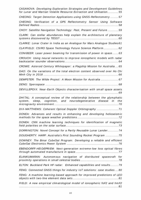
CASANOVA: Developing Exploration Strategies and Development Guidelines for Lunar and Martian Volatile Resource Extraction and Utilisation........... 55
CHEONG: Target Detection Applications using GNSS-Reflectometry ........ 57
CHEONG: Verification of a GPS Reflectometry Sensor Using Software Defined Radios ................................................................................. 58
CHOY: Satellite Navigation Technology: Past, Present and Future ........... 59
CLARK: Can stellar abundances help explain the architecture of planetary systems discovered by TESS? ............................................................ 60
CLARKE: Lonar Crater in India as an Analogue for Mars Analogue Studies 61
CLAYFIELD: CSIRO Space Technology Future Science Platform ............... 62
CONIBEER: Laser power beaming for transmission of power in space ...... 63
CROUCH: Using neural networks to improve ionospheric models with radar backscatter sounder observations ....................................................... 64
CROWE: Asteroid Century Whitepaper: a Flagship Mission for Australia ... 65
DAO: On the variations of the total electron content observed over Ho Chi Minh City in 2018 ............................................................................. 66
DEMPSTER: The Wilde Project: A Moon Mission for Australia .................. 67
DENG: Sperospace ........................................................................... 68
DEVILLEPOIX: Near-Earth Objects characterisation with small space assets ...................................................................................................... 69
DHITAL: A conceptual review of the relationship between the glymphatic system, sleep, cognition, and neurodegenerative disease in the microgravity environment. ................................................................. 70
DIX-MATTHEWS: Coherent Optical Doppler Orbitography ...................... 71
DONEA: Advances and results in enhancing and developing helioseismic methods for the space weather predictions .......................................... 72
DONEA: CNN machine learning techniques for identification of magnetic field polarities on the solar surface...................................................... 73
DORRINGTON: Novel Concept for a Partly Reusable Lunar Lander........... 74
DOUGHERTY: HARP: Australia’s First Sounding Rocket Program ............. 75
DOWNEY: The Binar CubeSat Program: Developing a reliable and efficient CubeSat Electronics Power System ..................................................... 76
EBENDORFF-HEIDEPRIEM: Next-generation extreme-low loss optical fibres through automated manufacture in space ............................................ 77
ELANKUMARAN: Autonomous navigation of distributed spacecraft for proximity operations in small celestial bodies ....................................... 78
ELTON: Buckland Park HF radar: Enhanced capabilities and results ........ 79
FENG: Connected GNSS things for industry IoT solutions: case studies ... 80
FENG: A machine learning-based approach for improved predictions of LEO objects with two-line element data sets ............................................... 81
FIELD: A new empirical climatological model of ionospheric foF2 and hmF2 ...................................................................................................... 81

23
FIELD: Buckland Park VHF radar observations of low-Earth orbit objects during SpaceFest 2019: observations and results ................................ 83
FLOREANI: The Australian Space Cybersecurity Environment ................. 84
FOK: SAR Constellation Designs for Barrier Surveillance Applications ...... 85
FORMAN: Lava flows on Mars ............................................................. 86
FURQAN: Efficient Utilization of Radio Frequency Electromagnetic Spectrum for Satellites in Lower Earth Orbits ...................................................... 87
FURQAN: Efficient Utilization of Radio Frequency Electromagnetic Spectrum for Satellites in Lower Earth Orbits ...................................................... 88
GENSEMER: CSIRO's small-satellite Optical Instrumentation Development ...................................................................................................... 89
GENSEMER: CSIROSat-1 CubeSat Mission Update ................................ 90
GEORG: Investigations of Transient Discharge Behaviour in an Inductive Plasma Generator for Electric Propulsion .............................................. 91
GIERSCH: The Australian Space Academy Solar Radio Spectrograph ....... 92
GIERSCH: The Australian Space Academy Sunspot Number ................... 93
GILBERT: Simultaneous ionospheric sounder and airglow observations of sporadic-E layers .............................................................................. 94
GOWER: SERC Research .................................................................... 95
GROSSE: Adaptive Optics for Space Situational Awareness .................... 97
HAN: High-resolution gravitational fields of the Moon from crustal density estimates and topographic data .......................................................... 98
HAN: An overview of NASA and DLR’s Gravity Recovery And Climate Experiment (GRACE) and GRACE Follow-On missions ............................ 99
HASTINGS: Project Priscilla : An open source rover project .................. 100
HEITMANN: Characterising ionospheric gradients from oblique angle-of-arrival ionosondes .......................................................................... 101
HELD: Responsive Space Operations Centre (RSOC) ........................... 102
HENNESSY: Surveillance of Space with Passive Radar using the Murchison Widefield Array............................................................................... 103
HESSEL: Asteroid@ChemEng: Orders of Magnitude Water Savings by Intensified Metal Extraction from Mimicked Asteroid Ores? ................... 104
HESSEL: In-Situ Resource Utilisation (ISRU) in Space: Water, Phosphate, and Metals ..................................................................................... 105
HIDES: Parallels between changes in trunk muscles in response to microgravity, prolonged bed rest and low back pain on Earth ............... 107
HILDEBRANDT: Introduction to AWS (Amazon Web Services) Ground Station .......................................................................................... 108
HOBBS: Using point pattern and thermal inertia analyses to test self-organisation in Martian mid-latitude Gullies ....................................... 109
HOBBS: Flown in space: Can low cost electronics perform useful science in the near-space environment? ........................................................... 110
24
HOLDSWORTH: Buckland Park VHF radar observations of low-earth orbit objects during SpaceFest 2019: operating configuration and signal processing ..................................................................................... 111
HOLDSWORTH: JORN Open Innovation Network: Description and Defence Science & Technology group perspective ........................................... 112
HOLLICK: MANTIS: Manoeuverable Antenna and Terrestrial Imaging System ......................................................................................... 113
HORNER: Minerva-Australis - searching for alien worlds ...................... 114
HORNER: Which ExoEarths should we search for life? The impact of planetary architecture on the Milankovitch cycles. .............................. 115
HUANG: Novel Architecture and Key Technologies for Achieving High Capacity and Low Cost Space and Terrestrial Integrated Networks ........ 116
HUQ: Spiral Blue: Space Edge Computing .......................................... 117
JAMES: Developing skills in the space industry through the SmartSat CRC .................................................................................................... 118
JAMES: The Southern hemisphere Space Studies Program: international, intercultural and interdisciplinary. ..................................................... 119
JARVIS: Development of low-cost testing methodologies for star trackers .................................................................................................... 120
JONES: A Battle Between Machine Learning, Traditional Clustering and Citizen Scientists In The Detection and Segmentation of Polar Spring-time Fans On Mars. ................................................................................ 121
JONES: Gender Balance and Inclusion Is Still A Problem: An Overview Of Delegates At The Australian Space Research Conference Over The Past 4 Years. ........................................................................................... 122
JONES: ‘Evidence of Life On Mars?’ – A Critical Review of The Recent Publication By The Same Name. ....................................................... 123
JONES: Is Higher Spatial Resolution Always Better? A Quantitative Analysis Of The Impact of Pan-Sharpening Worldview-2 Imagery On A Neural Networks Detection and Segmentation of Vineyards. ........................... 124
KARANDAIS: Emulating Radio Links for Wideband SATCOM Systems..... 125
KEDLAYA: Precision pointing system for a low-cost optical terminal for high-speed downlink from smallsats in LEO ........................................ 126
KERR: General Perturbations Method for Orbit Propagation .................. 127
KERR: Limitations on the use of drag augmentation for post-mission disposal ......................................................................................... 128
KERR: Improving the accuracy of atmospheric density modelling and the effect on orbit propagation............................................................... 129
KING: A small form-factor detector controller for the Emu space telescope mission and beyond ........................................................................ 130
KINGSLEY: Deep impact: how to achieve effective and meaningful space science education and outreach ........................................................ 131
KLANTSATAYA: Upconversion fluorescence spectroscopy for active remote detection of acetone and other small size organic compounds in space .. 132

25
KOSCHNICK: Spectral Aerospace: Changing the Way We See Our World 134
KRUZINS: Deep Space Missions from Australia, the Capability of the Canberra Deep Space Communication Complex at Tidbinbilla and the Future of New Tracking Technologies ............................................... 135
KUMAR: Impacts of Space Weather on Aviation .................................. 136
LAGAIN: Automatic surface age dating of impact events on Mars .......... 137
LAWRENCE: Dynamic modelling of systems with pitch control aerofoils . 138
LEE: Care of the Outer Space Environment: An emerging aspect of Human involvement with Outer Space. ......................................................... 139
LESHINSKY: Valuing real estate interests in space – a frontier exercise . 140
LIM: On demand telecommunication infrastructure for planetary exploration and colonisation ............................................................. 141
LINDLEY: Resource Modelling for Asteroid Mining ............................... 142
LIU: Integrated Patch Antennas and Solar Cells for Cubesats – Optimising solar cell efficiency and antennae gain .............................................. 143
LOBZIN: Predictions of Relativistic Electron Fluence at Geo-Synchronous Orbit ............................................................................................. 144
MACE: The First Satellite Built in Australia ......................................... 145
MAJ: Comparison of the predictive power of RMIT's and existing atmospheric mass density (AMD) models using satellite measurements . 146
MAJ: Dust Detection via Voltage Power Spectroscopy on a CubeSat in Earth’s Ionosphere.......................................................................... 147
MANCHANDA: Role of Tethered balloons and Aerostats in Communication, Surveillance and Disaster management ............................................. 148
MAO: TweetS@ .............................................................................. 149
MARSHALL: The Considerable Benefits of Earth Observations from Space in Meteorology - Status and Future ...................................................... 150
MARSHALL: The Australia and New Zealand SBAS Test-bed: Demonstrating the next-generation of positioning technology .................................... 151
MARSHALL: Modelling, monitoring, and mitigation of space weather for Australia's power grids .................................................................... 152
MATHEW: Emu - A time delay imaging near-infrared survey mission on the international space station ............................................................... 153
MATTHEWS: How security ready is the Australian Space Industry? The challenges of digital security in space ................................................ 154
MATTHEWS: The real Space Cowboys: An Assessment of Space Exploration Technologies Corp Sustainability using the Benn et al and Perrott Models of Corporate Sustainability .................................................................. 155
MAY: A quantitative analysis of space object registration using a graph database. ...................................................................................... 156
MCDONNELL: Luminescence dating potential of the mineral constituents of meteorites ..................................................................................... 157
26
MCGUIRK: Opportunities for enhancing Australia’s estimates of soil carbon in the age of Hyperspectral Imaging Spectroscopy: from the Farmers paddock to CubeSats and UAV’s ....................................................... 158
MEEGAN: Earth Observation data - Climate Change monitoring ............ 159
MELVILLE: Characterising Hot Jupiter Exoplanets ................................ 160
MENK: An Australian space weather and climate satellite constellation .. 161
NEUDEGG: Coronal Mass Ejection and resultant Geomagnetic-Ionospheric response ....................................................................................... 162
NEUMANN: Initial pulsed cathodic arc thruster impulse measurements using a calibrated torsional thrust stand ............................................ 163
NIJHUIS: Microfluidic chip-based synthesis and spray of quantum nanodots as spectral decoy to protect satellites ................................................ 164
O'BRIEN: Automated Conceptual Design of Cubesats .......................... 165
O'CONNOR: Effective Science Communication using Instagram - @educatingspace............................................................................ 166
O'CONNOR: Orbital Constraints on Terrestrial Exoplanet Climates ......... 167
O'DEA: Why are fewer women than men employed in fields associated with brilliance? ...................................................................................... 168
OLAWALE: Response of global ionospheric plasma fountain circulations to St. Patrick’s storm of 2015 .............................................................. 169
OLIVER: Can high school students undertake publishable space science research? ...................................................................................... 170
ORR: Spectral Characterization of Martian meteorites: Searching for the Source Craters on Mars ................................................................... 171
PANWAR: Australian Bureau of Meteorology space weather training ...... 172
PARKER: Australia’s NovaSAR-1 National Research Facility .................. 173
PARNELL: A smoothed particle hydrodynamics approach to asteroid modelling ...................................................................................... 174
PEARCE: Civil Space Technical Roadmap – what’s next for Australia...... 175
PEDERICK: TAPDANCE: A Polarimetric Vector-sensing Ionosonde ......... 176
PETERS: Real-time demodulation of multiple modulation schemes from satellites using a GPU based matched filtering approach ...................... 177
PRAINO: Measuring Space Power: A Comparative Assessment of Worldwide Space Actors .................................................................................. 178
RALPH: HRM in Outer Space ............................................................ 179
RAMSEY: An Australian National Satellite Water Monitoring System Concept .................................................................................................... 180
RINTOUL: Augmenting CubeSat communication using Low Earth Orbit (LEO) communication networks ........................................................ 182
ROBSON: Satellite imagery, if not properly trained then it can ‘eat your sheep’. .......................................................................................... 183
RONNINGEN: Hybrid Rockets - Past, Present, Future........................... 184

27
ROZENFELD: Innovative radiation sensors for prediction of radiation hazard to astronauts and electronics during space missions............................ 185
RUSSO: A Detailed Investigation and Solution Strategy of Thermal Impacts on Pressure Regulator Valve in Liquid Space Engine Hydro-Control System .................................................................................................... 187
RYAN: Experimental analysis of a Helicon Plasma Rocket developed using rapid Monte Carlo based Inverse Design ............................................ 188
SAMUEL: A new method of refining near-earth object characteristics and behaviours using differential correction ............................................. 189
SANSOM: Hayabusa II re-entry observation campaign ........................ 190
SCHOMBERG: Estimating non-axial thrust loss in bell rocket nozzles ..... 191
SCHUMACHER: Applied Anthropometry and Human Centered Design for Complex Confined Environments ...................................................... 192
SENETA: The new rules: Space (Launch and Returns) Act 2018............ 193
SERGIIENKO: CubeSat as a tool for training engineers of the future ..... 194
SHELBY-JAMES: GNSS Trust & Reliability ........................................... 195
SHOBER: Skipping Fireballs and What They Tell Us About the Evolution of the Solar System ............................................................................ 196
SPARGO: Multistatic meteor radar observations of gravity wave-tide interactions in the lower E-region ..................................................... 197
SZTOLC: Optical Space Fence Development ....................................... 198
TRAN: Space tourism' - is it a disaster waiting to happen? ................... 199
TRAN: The Efficacy And Stability Of Semi-Finished And Finished Medicines Made In Space ............................................................................... 199
TRENTI: The SkyHopper Space Telescope CubeSat ............................. 202
TYLOR: The NEO Resource Atlas - A commercial solution to a legal problem .................................................................................................... 203
TYLOR: FUEGO - Fire Urgency Estimator on Geostationary Orbit ........... 204
UNEWISSE: Variation in the maximum range of HF spread Doppler clutter .................................................................................................... 205
USHER: Australians in Space Analogues: Expedition Boomerang at MDRS and SIRIUS-20 at IMBP ................................................................... 206
VALLAPUREDDY: Groundzero space .................................................. 207
VEASEY: Dynamic Analysis and Component Modelling of a Thrust System in a Liquid Space Engine ..................................................................... 208
VERVEER: UNRESOLVED OPTICAL OBSERVATIONS OF MATERIAL DEGRADATION IN GEOSATS ............................................................ 209
VINALL: The application of surface dielectric barrier discharge plasma actuators, for improved active flow control on highly pitched aerofoil blades. .......................................................................................... 210
VOROPAEV: New propulsion system .................................................. 211
WALLIS: NASA Launches from the Arnhem Space Centre in 2020 ......... 212

28
WALLIS: M.A.R.S.U.P.I.A.L.S project ................................................. 213
WANG: Analysis of Australian Historical foF2 Data .............................. 215
WARD: Does the Movement of RMIT’s Rooftop Robotic Optical Observatory (ROO) impact its Space Situational Awareness data?........................... 216
WRIGHT: Twinkle and Australia ........................................................ 217
XIE: Mission opportunities’ search for long stay-time exploration on near earth asteroids ............................................................................... 218
YAN: Shape Memory Alloy Foils Produced by Near-Net-Shape Casting For Space Deployment Operations.......................................................... 219
YANG: PHiFA – A High-Fidelity Orbit-Attitude Propagator ..................... 220
ZANDER: STEM Education using Hybrid Rocket Motors ........................ 221

29
ABAY: Space mission architecture with AI on the edge
Space mission architecture with AI on the edge
Rasit Abay, Elizabeth Wylie, Sudantha Balage and Russell Boyce UNSW Canberra
Small and cheap electronics, less expensive launching capabilities, and the advent of application-specific integrated circuits make constellations of capable small satellites conducting missions in a distributed fashion. Distributed satellite systems have the capacity of introducing significant improvements to most missions because space missions are constrained by orbital motion and uplink/downlink capacity. In addition, intelligent computational capabilities reduce the necessary computational load on the spacecraft and optimize the use of resources. Artificial Intelligence (AI) on edge is a recent term that refers to the use of intelligent algorithms on the end node. Therefore, small satellites can be empowered by AI-capable devices to map raw sensor readings to actionable decisions in near-real-time. However, many AI-powered spacecraft can not be efficiently controlled using classical space mission operation approaches, which utilize precomputed schedules, and this is not responsive. Therefore, an autonomous scheduling approach for managing a constellation of AI-powered small satellites is needed to provide the actionable information to the user satisfying the optimality conditions that are expected from the system without any human intervention. This work introduces an autonomous space mission architecture, which can be optimized based on the desired optimality conditions using deep reinforcement learning, to manage a constellation of AI-powered spacecraft. Two test cases, namely human footprint detection and ship detection on edge, are investigated to determine the performance of the mission architecture. This work is significant for any space mission that is designed to control many spacecraft simultaneously.
Presented by: Rasit Abay
30
ABLES: Robust Geolo cation of EMIC Wave Sources in the H igh Latitude Ionosphere
Robust Geolocation of EMIC Wave Sources in the High Latitude Ionosphere
Sean Ables University of Newcastle
Brian Fraser University of Newcastle
Ian Mann University of Alberta
Electromagnetic ion cyclotron (EMIC) waves play an important role in the dynamics of the magnetosphere. Through pitch angle diffusion they contribute to the precipitation of energetic radiation belt electrons, and keV ring current proton loss following wave-particle interaction. To understand the effects of EMIC waves on magnetospheric particle populations a detailed knowledge of EMIC wave source locations and distributions are needed. In situ satellite observations are limited in space/time, while ground observations cannot directly locate source field lines. We consider ground-based techniques to determine the source location of EMIC wave events, and their relationship to satellite observed magnetospheric sources. Source field lines of middle latitude EMIC waves are determined using distant low latitude ground magnetometer networks. At high latitudes source field lines are generally located within the network and source location is more complicated. Using ten magnetometers in the CARISMA array and GOES 14 geostationary satellite data we examine an hour-long interval of EMIC/Pc1 activity in the pre-midnight LMT magnetic time sector which is seen concurrently by all ground stations. Cross-spectral and time cross-correlation analyses identifies the foot point of the EMIC wave source region projected onto the ionosphere. Later the emission becomes multi-banded in spectral structure and the foot point solution is found to jump discretely to multiple new locations, dependent on the frequency band analysed. This illustrates the complications in determining magnetospheric source locations using ground data. However, there are outcomes from the study that provide a way forward for approximate EMIC wave source location.
Presented by: Dr Sean Ables

31
ABOUTA NI OS: A High Alt itude Balloon Borne Synthetic Aperture Radar
A High Altitude Balloon Borne Synthetic Aperture Radar
Elias Aboutanios School of Electrical Engineering and Telecommunications, UNSW
Sydney
Adithya Rajendran, Shuyu Wu, Jackson Cai, Emma Su, Victor Tse, Matthew Richards, Alicia Davies Aggarwal Anshita, Lucas Pun, Arijit
Sharma, Anuraj Talati, Angus Wu and Jackson Zhang BLUEsat, UNSW Sydney
High altitude platforms (HAPs) have been proposed for various applications including information gathering, remote sensing, scientific applications and educational activities. HAPs enjoy a number of unique advantages with respect to aircraft and satellites. They operate at altitudes exceeding 20km which allows them to provide a wider field of view compared to aircraft and puts them above the bulk of the atmosphere, something that is desirable for many scientific applications. They are cheaper than traditional satellite systems as their development and deployment costs are much lower than those of a spacecraft. Their comparatively low altitude makes them more versatile and recoverable meaning that they can be maintained and even upgraded. They require less transmit power than satellites and experience smaller round-trip delays. For remote sensing applications, they do not suffer from long revisit times that are a drawback of satellite systems.
This paper reports on the progress of a collaborative project between UNSW Sydney and the University of Pisa to develop a low-cost, rapidly deployable, high-altitude (in excess of 20km) balloon-borne Synthetic Aperture Radar (SAR) system. The new BALSAR system comprises the balloon, a parachute and the payload that houses the radar. The payload is modelled on a satellite configuration and includes an onboard computer, a precision navigation device, an electrical power subsystem, a stabilization subsystem and the miniaturised radar itself. Where possible, commercial off-the-shelf (COTS) and cubesat components will be used. Additionally, we are developing mission planning software that will facilitate the optimization of the flight to achieve the mission goals, and a mobile ground station to service the flight. The BALSAR system is intended to find application in scenarios where rapid deployment is highly desirable and logistic support is far from the deployment area. Such scenarios include border surveillance and protection, disaster and environmental monitoring, and scientific missions.
Presented by: Elias Aboutanios

32
ADAMS: Apogee Satellite Bus Mission s
Apogee Satellite Bus Missions
Ben Adams and Matthew Tetlow Inovor Technologies
Australia is seeing an increased interest in the space industry by both government and the wider community. Inovor Technologies has developed Australian space technology to support future missions both in Australia and the international space industry. It has developed a complete satellite bus, including the power, pointing and mission control systems, and primary structure. The platform is called the Apogee Bus, and it is currently being used to support Australian missions in both the Defence and Civilian areas.
The presentation will discuss the Apogee Bus technology as well as the design and test processes used during development. CSIROsat1 is a 3U remote sensing satellite with a Short Wave Infra-Red Sensor. The presentation will discuss the status of this project with particular focus on the platform aspects. HyperionEM is a 12U Space Situational Awareness satellite with integrated on-board processing, that will be used to derisk the future Hyperion mission technology. The presentation will discuss objectives and the status of this project.
Presented by: Ben Adams
33
AFFUL: Barriers inh ibiting su ccessful imp lementation of a spa ce science program: Perceptions of Academ ics and Students
Barriers inhibiting successful implementation of a space science program: Perceptions of Academics and Students
Andoh Michael Afful Space Research Centre, Dept. of Geospatial Science, RMIT
University, Melbourne, VIC, 3000, Australia
Andoh Michael Afful Space Environment Research Centre, Weston Creek, Canberra,
ACT,2611, Australia
Alex Kootsookos Dept. of Manufacturing, Materials and Mechatronics Engineering,
RMIT University, Melbourne, VIC, 3000, Australia
Margaret Hamilton Dept. of Computer Science and Information Technology, RMIT
University, Melbourne, VIC, 3000, Australia
Previous research has demonstrated the significance of space education for improving national and economic growth. The knowledge generated has contributed in many ways to space innovations leading to a paradigm shift in space science and technology education. Although space science education is emerging, its curriculum implementation is problematic. This research explores obstacles in relation to integration and implementation of a space science programme. In a series of semi-structured interviews, academics and students identified a few common barriers which inhibit implementation of a space science program. Significant barriers identified include scarcity of professional development, lack of good resources enabling the capacity for change, technical and infrastructural support, and pedagogical impediments to effective teaching and learning. The findings indicate that academics and students have a strong desire to see the integration and implementation of a space science and will require an understanding of the demands before expected implementation occurs. Likewise, these barriers will need to be overcome. Implications of this study will inform in-service professional development opportunities for space science, divisional and planning support academic programs. Generally, this study will provide information and recommendations to those responsible for integration of new programmes in science education especially in higher education sectors.
Presented by: Andoh Michael Afful

34
ANDERS ON: Drones and Deep Learning for Meteorite Recovery
Drones and Deep Learning for Meteorite Recovery
Seamus Anderson, Phil Bland and Martin Towner Curtin University
The Desert Fireball Network is an all sky observatory in South and Western Australia that images the night sky in order to observe meteoroids entering Earth’s atmosphere as fireballs. Once we observe a fireball, we can predict a likely fall area to go searching for a possible meteorite. Current searching methodologies are labor intensive and inefficient, requiring 5 or more individuals to cover the area on foot, over the course of nearly 2 weeks. We have devised a new searching methodology that employs drones to survey a predicted fall area 50 times faster than a traditional search. We have also constructed and trained a neural network to find likely candidates in the survey dataset, dramatically reducing the requirement for human labor. This revised methodology will be crucial to recovering meteorite falls through fireball observatories all over the world, in order to help characterize the composition of the asteroid populations in the solar system.
Presented by: Seamus Anderson

35
ARMSTRONG: Ant i-microbial Polymer Development for Spacecraft Cabin D isease & Syste m Contamination
Anti-microbial Polymer Development for Spacecraft Cabin Disease & System Contamination
Jason Armstrong Boeing
Michael Monteiro University of Queensland
In 2015 NASA awarded a $1.18 billion contract to Boeing as the International Space Station's prime contractor to continue providing key engineering support services. The system environment provides a series of challenges in regards to microbial infection and contamination. On top of crew health, the following mix of factors make this topic relevant to space travel and the return to Earth of crew safely:
- Astronaut immunosuppression
- Higher microbial replication and biomass in microgravity
- Increased virulence of microbes due to microgravity and ionizing radiation
- Risk of returning mutated microbes to Earth
- Microbial fouling of filters and fluid systems.
The novel polymer technology to be discussed is under development in a collaboration between Boeing and the University of Queensland is aimed at both spacecraft and aircraft, with a consideration given to the role aviation plays in pandemics. The polymers under development will have the capability to respond to environmental cues for anti-microbial targeting.
Presented by: Dr Jason Armstrong

36
ARSHAVS KY: Novel satell ite propuls ion technology
Novel satellite propulsion technology Zenno Astronautics Limited
Max Arshavsky CEO, CTO
Will Haringa CBO
John Humphrey Director
Presented by: Max Arshavsky

37
BELIC: Monopedal jumping robots in the context of the Lunar environment
Monopedal jumping robots in the context of the Lunar environment
Stefan Petar Belic UNSW
To date remote lunar surface exploration has been done by stationary landers and wheel-based rovers with limited success. Renewed interest in lunar exploration and resources provides a context for innovation. With contemporary developments in power storage and on-board computation capabilities, the possibility of a monopedal jumping robot as a prospecting platform should be assessed. Early work on monopedal jumping robots from Raibert et al has led to robust control algorithms still in use decades later, which is of particular interest where reliability is a key factor in exploration theatres. Jumping robots may provide several advantages over conventional wheeled rovers, including minimal surface contact and object avoidance. In this study, the suitability of a jumping robot as an exploration platform is investigated, by characterising its movement on the lunar surface. This is done firstly via simulation, using unique lunar surface 3D datasets developed through photogrammetry specifically for this investigation. Building on Raibert et. al., and work done by the Biomimetics Laboratory at UC Berkeley, a decoupled ‘Deadbeat’ controller will provide robotic control for accurate foot placement by trajectory planning. This controller, combined with the surface simulation, will allow estimates of accuracy in object avoidance, as well as demonstrations of longer path planning. In parallel, a working robot - inspired by UC Berkeley's Salto-1p - is being constructed based on the simulation parameters, and tested in a lunar-like and obstacle-rich environment. These results will form the basis of recommendations for future development of the jumping platform in a lunar context.
Presented by: Stefan Petar Belic

38
BENNET: Towards an Opti cal Co mmunications Ground Station Network for Next Generation Satellite Co mmun ications
Towards an Optical Communications Ground Station Network for Next Generation Satellite Communications
Francis Bennet Research School of Astronomy and Astrophysics, Australian
National University, Canberra, Australia, & ANU Institute for Space, Australian National University, Canberra, Australia
Ken Grant Cyber and Electronic Warfare Division, Defence Science and
Technology Group, Edinburgh, Australia
Sascha Schediwy Department of Physics, and International Centre for Radio
Astronomy Research, University of Western Australia, Perth, Australia
Nicholas Rattenbury Pūnaha Ātea - Auckland Space Institute, The University of
Auckland, New Zealand
Ed Kruzins CSIRO NASA Operations & Canberra Deep Space Communications
Complex, Canberra, Australia
Our social, economic, scientific and defence systems depend on satellite communications, and. optical communications are poised to deliver a data revolution to satellite-based networks. Most global satellite communications, however, currently rely on radio frequency technology that are limited in the bandwidth and level of security it can provide. These limitations can be overcome by a laser’s comparatively small beam divergence and high carrier frequency. The use of laser satellite communications also brings with it the potential of achieving a global communications network with absolute security using quantum encryption, also known as Quantum Key Distribution (QKD). A drawback of ground-to-satellite laser communications, however, is that clouds provide effectively complete blockage of the beam. This can be mitigated by means of receiver site diversity, in which a network of geographically dispersed receivers provides far higher link availability.
We present a proposal for a national network of optical ground stations for laser communications as the first step to establishing Australia as a leading provider of secure satellite links for a large and growing market. Together with New Zealand, Australia is

39
taking a leading role in the development of technology and infrastructure to meet high and growing demand for laser communications, especially in space-to-ground applications. Optical ground station nodes in the ACT and SA have been funded and are currently being planned. Partial funding for other nodes in Western Australia and New Zealand has also been achieved. National network infrastructure is being sought to tie these stations together to produce a world leading optical communication network. This presents an opportunity for our nation to become space-to-ground data highway and become a leading provider of secure satellite links for a large and growing market. Each network node will be capable of communications with optical and current radio-frequency methods, making the most of hardware currently in orbit including Australian satellites, while enabling future proof optical communications hardware and building industry in Australia.
Presented by: Francis Bennet

40
BENNETT: On the virtue of supp lying just oxygen from a lunar po lar water m ine
On the virtue of supplying just oxygen from a lunar polar water mine
Nicholas Bennett Australian Centre for Space Engineering Research, UNSW Sydney
The utility of ISRU oxidizer has long been recognized, but the excess oxygen byproduct of propellant production from water is generally neglected. This paper uses independently published financial models to show how to use the byproduct to build a stronger business case for a lunar polar water based propellant "mine".
There is a long history of research into producing oxidizer from ubiquitously available lunar regolith, but recent data indicate very strongly that there is a significant amount of water in lunar polar permanently shadowed regions. This has prompted publication of papers around water ISRU because by electrolyzing water one can produce a complete propellant - LH2LOX (cryogenic liquid hydrogen and oxygen).
However; LH2LOX rocket motors burn non stoichiometric oxygen:hydrogen mass ratios, e.g. water is 8:1 but LH2LOX is 5:1. This means any LH2LOX "mine" based on water will be unable to use - of it's production output. In most studies future life support or industrial uses are indicated, but the oxygen byproduct plays no part in the financial analysis.
Oxidizer alone has high utility and flexibility. Cryogenic liquid oxygen (LOX) oxidizer can be used with LH2, CH4, LNG, & kerosene; this means customers can include ULA, SpaceX, and Blue Origin. LOX is around 80% of the mass of these common fuel mixtures. Compared with complete ISRU propellant supply, LOX alone can deliver 80% of the cost savings from a mining operation about 55% the size.
We use independently published financial models to compare the "complete propellant" and "just LOX" businesses and show that by focusing on supplying LOX the business has higher returns and is more resilient in competition with falling Earth launch costs.
Presented by: Nicholas Bennett
41
BLAND: Fire OPAL: A sovereign Austra lian space s ituational awareness so lution
FireOPAL: A sovereign Australian space situational awareness solution
Greg Madsen and Abraham Chan Lockheed Martin Australia
FireOPAL is a new, distributed network of standalone, optical sensors that is designed to monitor a large number of artificial satellites simultaneously, providing wide area surveillance and precision tracking in near real time. FireOPAL observatories are fully autonomous intelligent imaging systems, taking high resolution images at high cadence, capable of operating for 24 months in a harsh environment without maintenance. An onboard processing system delivers thousands of measurements each night of angles, range, and light curves for objects in LEO, MEO, and GEO. This occurs in real time (every 10 seconds). The system measures absolute time within milliseconds, absolute flux to within 10%, and detects point sources with visual magnitude of around 16 or brighter. FireOPAL observations are synchronised over a distributed geographic network - this enables range estimation through triangulation, significantly reducing uncertainties in orbit determination and catalogue maintenance, achieving cross-track and along-track errors of ~100m for objects at 2000km altitude. The network reports measurements to a central server capable of providing alerts of anomalous behaviour and other warnings within minutes of the observations. FireOPAL observatories are designed to maximise sensitivity and functionality within a cost effective package that minimises build, maintenance and servicing costs. Networked together, the result is a system that can easily be scaled to arbitrary size, allowing for persistent observations with a high level of disruption tolerance. The Australian FireOPAL node scans 6000 square degrees of sky every 10 seconds, detects around 1000 objects across that expanse, automatically determining their orbits with arcsecond precision, and delivering the data in realtime to the customer.
Presented by: Phil Bland

42
BOUYA: A Prediction Model of global ionospheri c maps
A Prediction Model of global ionospheric maps
Zahra Bouya and Philip Maher Australian Bureau of Meteorology Space Weather Services
The spatiotemporal variability of the ionospheric F2 layer critical frequency (foF2) greatly limits the efficiency of communications, radars, and navigation systems that employ high‐frequency radio waves. There is a recognised need for predictions of changes in foF2 for scientific purp0ses and practical applications. Several models have been developed to predict the changes in foF2. However, most of these models only focus on how to improve the prediction accuracy at a certain location or over a regional area. In this paper, a method is proposed and developed to predict global ionospheric foF2 maps. Specifically, the model coefficients are predicted based on an autoregressive model. To understand the real-time applicability of the method, the performance of forecasting products using the proposed method in an operational environment is investigated.
Presented by: Zahra Bouya

43
BOWDEN: Numer ical simulation of ionospheri c d isturbances resu lting from rocket laun ches
Numerical simulation of ionospheric disturbances resulting from rocket launches
George Bowden, Melrose Brown and Phillippe Lorraine UNSW Canberra
Rocket plumes can result in significant disturbances to the ionosphere. Rocket exhaust products deplete electron concentration by enhancing the chemical recombination rates of ions. Moreover, the plume may generate shock acoustic waves resulting in traveling ionospheric disturbances. These disturbances may interfere with radio communications and satellite navigation. This presentation outlines work done developing numerical models for these phenomena.
The chemical depletion of the ionosphere was modelled using the Global Ionosphere Thermosphere Model (GITM). This fluid model of the coupled ionosphere-thermosphere system was modified to include source terms representing major rocket exhaust products (H2O, H2, CO2 and CO) and their chemical reactions with O+ (which were assumed to be the dominant ionospheric component at relevant altitudes). Ionospheric depletions in the 24 hours following the JASON-3 and FORMOSAT-5 launches were simulated. In the latter case, the unusually steep initial ascent resulted in a long-lived large-scale ionospheric hole. The simulation results were compared with previously reported GPS based vertical total electron content (VTEC) measurements.
Shock acoustic wave propagation was modelled using a ray tracing method. Differential equations for acoustic rays in an inhomogeneous moving atmosphere were derived for spherical coordinates. Trajectories were obtained by numerical integration with atmospheric data from GITM. Acoustic pressure perturbations along these rays were computed using the modified-linear supersonic projectile theory of Whitham. The resulting changes in VTEC due to the motion of ions along magnetic field lines were computed. This method was applied to the JASON-3 and FORMOSAT-5 launches.
Presented by: George William Bowden

44
BROU GH: The B inar CubeSat Program: Att itude Control for S mall Satellites
The Binar CubeSat Program: Attitude Control for Small Satellites
Stuart Buchan, Fergus Downey, Benjamin Hartig, Martin Towner, Martic Cupak, Robert Howie, Jonathan Paxman and Phil Bland
Curtin University
Cubesats offer a highly cost effective standardised form factor for developing satellite technology. The Binar Cubesat Program is currently pushing the limits of the already minimal Cubesat form factor. By utilising modern, high performance commercial off the shelf components the entire Cubesat bus has been compressed into a 25x100x100mm form factor (0.25U). Notably this includes all necessary systems to operate a small satellite. This includes; power management and distribution, flight computer and an attitude control and determination system (ADCS).
The ADCS developed for this spacecraft is designed as a precursor to the development of an interplanetary capable spacecraft. As such the technology aboard this spacecraft is intended as a demonstration.
The control component of this platform features a highly integrated three-axis magnetorquer. A secondary redundant set of drivers are configured to control external magnetorquers. These redundant magnetorquer drivers will be used with PCB magnetorquers embedded within the solar panels.
The attitude determination system features a 9-axis inertial measurement unit including a magnetometer, gyroscope and accelerometer. Designed in conjunction with the inertial measurement unit is a space capable GPS unit that is used for geomagnetic variation correction. The measurements from the inertial measurement unit are combined using an unscented Kalman filter to provide accurate attitude estimation.
Presented by: Nathaniel Brough
45
BROU GH: The B inar CubeSat Program: Past , Pre sent and Beyond
The Binar CubeSat Program: Past, Present and Beyond
Benjamin Hartig, Phil Bland, Jonathan Paxman, Robert Howie, Martin Towner, Martin Cupak, Daniel Busan, Nathaniel Brough,
Fergus Downey and Stuart Buchan SSTC Curtin University
The Space Science and Technology Centre (SSTC) at Curtin University initiated the Binar CubeSat Program with the ambition of tackling planetary science objectives with a small budget. The word ‘Binar’ is the Noongar word for ‘fireball’; which ties us to our heritage in Western Australia, having grown from the Desert Fireball Network (DFN) based out of Perth.
Designing, building and operating the DFN and FireOPAL remote observatories, provided a
lot of the required experience for developing space hardware. Strong analogues exist between remote operations terrestrially and in orbit operations. The team’s background also includes development of mission instrumentation, satellite software engineering and on mission science teams with ESA, NASA & JAXA.
The program’s first year saw a team of engineering honours students explore the design of a CubeSat. Through this initial phase, it became apparent that the best investment of our efforts would be the in-house development of hardware. A series of proof of concept projects followed, culminating in the development of a highly integrated CubeSat bus and imaging payload.
In anticipation of a sub-orbital launch by the end of 2019, the team is currently focused on destructive testing of the hardware using thermal, vacuum, vibration and helmholtz coil equipment. The software is being developed in a virtual environment with a digital twin to allow for ground testing of the flight program. This rigorous pre-qualification testing will prepare our technology for success in Low Earth Orbit in 2020.
Presented by: Nathaniel Brough

46
BROWN: Change Detection SSA Experiments for the M2 Formation Fly ing CubeSat Mission
Change Detection SSA Experiments for the M2 Formation Flying CubeSat Mission
Melrose Brown University of NSW, Canberra
Change detection is a crucial Space Situational Awareness (SSA) activity. Break-up events from fuel tank explosions or on-orbit collisions between space objects threaten the safety and security of the orbital environment, prompting global efforts to improve and enhance the detection and attribution of such events. UNSW Canberra has embarked on an ambitious program of experiments aboard the ‘M2’ formation flying CubeSat mission, funded through a combined research and education programme with the Royal Australian Air Force. The mission comprises 2x6U CubeSats and uses a 3-axis attitude control system to exploit differential atmospheric drag forces between the spacecraft to control the along-track formation. This paper highlights a unique SSA opportunity that exists during the early operation phase of the M2 mission. The pair of CubeSats are initially conjoined and, following a scheduled command from the UNSW Canberra ground station, will be impulsively pushed apart in the along-track direction by a spring. After separation, each spacecraft will undergo significant configuration changes to their external shape, with the solar panel deployment increasing the maximum frontal area of the spacecraft from 0.04m^2 in stowed configuration to 0.26m^2 when fully deployed. The formation is stabilized in the early operation phase through attitude manoeuvres that maximize the differential drag force between the spacecraft to arrest the along-track drift between the leader and follower spacecraft in preparation for detailed formation flying experiments in the later stages of the mission. The paper highlights the opportunity for the SSA community to participate in a joint observation and data analysis campaign to detect the changes to the spacecraft configuration and orbit. The M2 experiment provides an important opportunity to advance the national SSA capability through active collaboration and data sharing among the community.
Presented by: Melrose Brown

47
BUCHA N: The B inar CubeSat Program: Des ign and Development of a CubeSat Dig ital Tw in
The Binar CubeSat Program: Design and Development of a CubeSat Digital Twin
Stuart Buchan, Phil Bland, Jonathan Paxman, Ben Hartig, Nathaniel Brough, Fergus Downey, Daniel Busan, Martin Towner, Martin
Cupak and Robert Howie SSTC Curtin University
Unlike Earth constrained engineering development, the design of spacecraft poses a significant problem - due to the cost of launch, testing in the operative environment becomes difficult. This therefore shows the advantage of simulation software to emulate the environment the satellite is to operate in. Writing separate code for onboard and simulation purposes introduces the possibility of deviation from the modelled environment, lowering mission confidence. Through the use of abstraction layers the Binar CubeSat Program leverages the simulation environment further in the production of a “Digital Twin” - tailor made software that runs simultaneously in a simulated environment, as well as the hardware environment. Breaking the barrier between simulation code and implementation code allows us to accurately portray how the spacecraft will respond to its environment, increasing confidence in our mission.
Presented by: Stuart Buchan

48
BUCHBER GER: Fir ing Up for the Space Ra ce: Austral ia's National Rocket Stati c Test Facil ity
Firing Up for the Space Race: Australia's National Rocket Static Test Facility
Ali Buchberger University of Southern Queensland
The Australian Civil Space Strategy has identified access to space as a priority for the development of the Australian space industry from 2021. However, launch vehicle providers require access to a static test facility prior to launch; without the ability to test, Australian companies will not be able to launch. USQ and its partners have established Australia's only research and commercial static test site, which will provide companies and research institutions a world-class testing environment for satellite and other launch applications. The facilities will cater for fundamental research, development and testing in the use of solid, hybrid, and liquid propellants and will also include test platforms needed for the static testing of rocket engines.
Presented by: Ali Buchberger
49
CAIRNS: The C UAVA-1 CubeSat
The CUAVA-1 CubeSat
Iver Cairns1, Xueliang Bai1, James Harpur2, Youngho Eun1, Joon Wayn Cheong3, Anthony Monger1, Christopher Betters1, Paris
Michaels4, Jason Held5, Andreas Antoniades5, Andrew Dempster3, Xiaofeng Wu1 and Joe Khachan1
1University of Sydney
3Australian Centre for Space Engineering Research, UNSW Sydney
4Air@wave Communications
5Saber Astronautics
The ARC Training Centre for CubeSats, UAVs, and Their Applications (CUAVA) is developing its first CubeSat, currently named CUAVA-1. This will be a 3U CubeSat with two 3U deployables covered by solar cells. CUAVA-1 will carry 4 payloads: a hyperspectral imager (HSI) containing 3 sub-instruments, a high-speed communications payload that aims to transfer data at 100 MB/s, a GPS instrument to obtain position and velocity information, and a radiation instrument to study space weather events. The presentation will summarise the goals, design, and status of CUAVA-1. Launch is expected in Q1 2019 via the Japanese company Space-BD.
Presented by: Iver Cairns

50
CAIRNS: Hit or Miss , A rrival T ime, and $B_z$ Or ientation Predict ions of BATS-R-US CME-driven Shock S imu lations at 1 AU
Hit or Miss, Arrival Time, and $B_z$ Orientation Predictions of BATS-R-US CME-driven Shock Simulations at 1 AU
Joachim Schmidt and Iver H. Cairns University of Sydney
Using a refined setup process, we simulated the propagation of six observed Coronal Mass Ejections (CMEs) with the 2012 Block-Adaptive-Tree-Solarwind-Roe-Upwind-Scheme (BATS-R-US) code from the Sun to the Earth or STEREO A and compared the outputs with observations. A linear relation between the average CME speed below 6 solar radii and the flux rope current is demonstrated and used to tune the simulation setup for each CME, differing with each CME and the simulation's grid refinement level. The simulations correctly predict if and when an observable CME shock reaches one astronomical unit (AU). The arrival time predictions of the CME shocks at 1 AU have an accuracy of 1.8 $\pm$ 0.3 hours and 3.8 $\pm$ 0.3 hours for 5th and 2nd initial grid refinement level, better than the value 10 $\pm$ 1 hours for ENLIL. The simulated initial CME speeds and average accelerations are close to the model and data of Gopalswamy et al. (2000). The approach shows promise for predicting the sense of the predominant shock-associated change in the magnetic field component $B_z$. However, the magnetic fields and plasma conditions in the solar wind and CME are not predicted well quantitatively.
Presented by: Iver H. Cairns

51
CALVÉS: Spacecraft tracking capabi litie s by the UTAS radio telescope network
Spacecraft tracking capabilities by the UTAS radio telescope network
Simon Ellingsen University of Tasmania
The University of Tasmania operates five radio telescopes located in four locations across the Australia continent: a 12-m and a 26-m dishes in Hobart (TAS), a 12-m dish in Katherine (NT), another 12-m dish in Yarragadee (WA) and a 30-m dish in Ceduna (SA). These antennas are continuously used in single-dish or interferometric mode for a number of astronomic and geodetic purposes. However, they are all also capable of tracking satellites and spacecraft. A number of experiments have been conducted in the past decade to demonstrate their tracking capabilities at L-, S- and X-band with satellites orbiting in Low-Earth orbit (LEO), as well as, planetary space missions controlled by NASA, ESA or JAXA. These observations have yielded to several scientific studies: interplanetary plasma, planetary atmospheric, detections of Coronal Mass Ejections, among others.
The ground radio telescopes provide high-gain downlink capability, but also the four sites combined can form an interferometric array that enables ultra-high precision tracking of the spacecraft orbits. This interdisciplinary technique provides a link between the needs of space agencies and industry, with the scientific interest of an academy institution as the University of Tasmania. In addition to the current network of radio telescopes, University of Tasmania together with the Australian Space Agency is in the planning phase of a new dedicated ground tracking station with up and downlink capability to be installed in Tasmania.
Presented by: Guifré Molera Calvés
52
CAPRARELLI: Exploratory analysis of the NASA Exoplanet Ar chive
Exploratory analysis of the NASA Exoplanet Archive
Graziella Caprarelli1,2,3 1Hypatia Scientifica Pty Ltd, Australia, graziella@hypatia-
scientifica.space 2International Research School of Planetary Sciences, Italy
3Centre for Astrophysics, University of Southern Queensland, Australia
The NASA Exoplanet Archive (NEA) is an online catalog of exoplanets developed and maintained by NExScI [1]. It includes exoplanets discovered by CoRoT, Kepler, K2 and TESS [2], with data complemented by ground based surveys. It is not the only catalog of this type [3], but is the only one with systematically updated data, analysis and plotting tools, and extensive documentation. The catalog facilitates examination of planetary and stellar parameters, revealing information that can further the search and characterization of extrasolar planetary systems [4], expanding our knowledge of planetary formation conditions and habitability [5].
This work started in February 2019, when the dataset comprised 3916 confirmed planets in 2917 extrasolar systems. The records are easy to download, and the online tools allow to readily explore the relationships between multiple planetary and stellar physical parameters. Scatterplots and histograms are promptly constructed by selecting the names of the desired variables in the online form. Interpretation of the diagrams is however not always straightforward, because multiple trends often emerge from the scatterplots, and the histograms of some of the planetary measurements may show bimodal or skewed distributions.
Here I present the results of a methodological analysis of the NEA dataset, using statistical and data mining tools available within R and Python software environments [6,7]. Specifically, I present the pre-processing steps undertaken to clean the data set, deal with incomplete records, and treat detection technique uncertainties. I then show the workflow for data reduction and clustering techniques. Finally, I discuss possible interpretations of the trends emerging from the analysis.
[1] https://exoplanetarchive.ipac.caltech.edu [2] Berriman and Ciardi (2019) Amer Astronom Soc Meeting, #233, id.207.01. [3] http://exoplanet.eu/sites/ [4] Akeson et al. (2013) Publ Astronom Soc Pacific 125, 989-999. [5] Zsom (2015) Astrophys J 813:9 (11 pp). [6] https://www.r-project.org [7] https://www.python.org Presented by: Graziella Caprarelli

53
CARTER: On the evaluation of deterministic ionospher ic sc inti llation foreca sts
On the evaluation of deterministic ionospheric scintillation forecasts
B. A. Carter and J. Currie RMIT University
M. Terkildsen Bureau of Meteorology
Equatorial Plasma Bubbles (EPBs) in the nighttime equatorial ionosphere are known to cause random fluctuations in radio signal amplitude and phase (called ‘scintillations’). These radio scintillations can hamper systems that utilise GPS and Satellite Communications. As such, the understanding of EPBs and their cause(s) has been a priority in recent decades. In terms of forecasting EPB occurrence, the primary challenge is capturing the day-to-day variability. Recently, both modelling- and observation-based studies from various researchers have demonstrated a good level of success in capturing this day-to-day variability. Now that such techniques have been developed, questions arise as to how to best assess and compare these modelling/forecasting techniques. While there has been lots of discussion in the meteorology literature on using skill scores in conducting forecast evaluations, ionospheric researchers are yet to fully explore this topic. In the meteorology literature, this discussion centres around the sensitivity of skill scores to aspects such as hedging, systematic biases and dataset size, which are all relevant issues in the context of ionospheric scintillation forecasting. In this analysis, the commonly used Heidke Skill Score, the True Skill Statistic (TSS) and the Odds Ratio Skill Score (ORSS) are investigated as potential measures of forecast success for scintillation predictions. It is shown that both the TSS and the ORSS can be useful once their 95% confidence intervals (ORSS95 and TSS95, respectively) are applied. While ORSS95 appears to be the least sensitive to dataset size, it is found that a minimum of 50 days is required to achieve a statistically significant result. However, comparing ORSS95 from one study against that of another study is problematic without several careful considerations. One promising method for inter-study comparisons is the measure of forecast “sufficiency” as compared against the easily accessible “persistence” forecast, which is also explored in this work.
Presented by: Brett Carter

54
CARTER: CubeSat to Mars - A Feasib il ity Study
CubeSat to Mars - A Feasibility Study
Dr Eriita Jones University of South Australia
Dr William Crowe HEO Robotics
Dr David Clark CSIRO
Dr Ed Kruzins CSIRO
Dr Phil Crosby CSIRO
As part of its Future Science Platform, CSIRO with its partners University of South Australia and HEO Robotics are performing a Phase A study investigating an Australian CubeSat to Mars. The feasibility study aims to identify potential missions and payloads and produce a satellite concept design to suit. It would aim to leverage existing Nano-satellite technology while also identifying and integrating Australian payload and technology into the satellite.
The satellite would act as a flagship of Australian satellite technology, displaying how the nation can be at the cutting edge of space exploration within 5-7 years. The mission to land humans on Mars is eventually going to be a transnational one and this feasibility study aims at identifying one way in which Australia could be a part of it.
The presentation will cover some of the science cases that such a mission could accomplish as well as an assessment of the key mission budgetary requirements to suit such a mission.
Presented by: Nick Carter

55
CASANOVA: Developing Exploration Strategies and Development Gu idelines for Lunar and Martian Volat ile Re source Extraction and Uti li sation
Developing Exploration Strategies and Development Guidelines for Lunar and Martian Volatile Resource
Extraction and Utilisation
Sophia Casanova School of Minerals and Energy Resources, University of New South
Wales, Sydney, Australia.
Daniel Nunes Jet Propulsion Laboratory/California Institute of Technology,
Pasadena CA, USA
Andrew Dempster Australian Centre for Space Engineering Research, UNSW Sydney
Robert C. Anderson Jet Propulsion Laboratory/California Institute of Technology,
Pasadena CA, USA
Graziella Caparelli International Research School of Planetary Sciences, Pescara, Italy; Hypatia Scientifica Pty Ltd, Adelaide-Sydney, Australia; Centre for Astrophysics, University of Southern Queensland,
Toowoomba, Australia
Serkan Saydam School of Minerals and Energy Resources, University of New South
Wales, Sydney, Australia.
Growing interest to expand current robotic and human activities on The Moon and eventually Mars, has resulted in a need to find low-cost solutions to meet near-term and future resource demands of an emerging cislunar and Martian in-space economy. The production of hydrogen and oxygen derived from water, in particular from water ice, is considered the primary commodity of interest for initial off-earth mining activities, as it can be utilized to support a number of mission-critical requirements, including propellant, life support, potable water and radiation shielding. For off-earth resource extraction projects to be successful, a commercial enterprise must find, produce and sell the desired commodity at profit. Endeavours of this kind, as is also seen in the terrestrial extractive industries, carry substantial financial risk, particularly in the early stages when a project has both large geological and development uncertainties. It is now becoming critically important, as the off-earth extractive industry advances, to develop the right processes and frameworks to communicate
56
uncertainties and risk in prospective projects, in order to encourage investment and reduce market uncertainty. This study presents a set of recommendations for undertaking resource exploration and evaluation activities with a focus on identifying the key parameters and processes to develop a resource estimate for water ice deposits on the Moon and Mars. Additionally, this study provides guidance for developing reporting standards of resource estimates taking into consideration the unique geological, technological, economic, political, social, environmental and legal conditions in which these activities will take place. Important in this discussion is the establishment of industry standard behaviours and expectations, particularly with regard to the social and environmental license to operate. Guidelines of this kind will enable effective communication between stakeholders, and facilitate robust decision-making at all stages of investment, both in the present day and into the future as the industry matures.
Presented by: Sophia Casanova

57
CHEONG: Target Detection Appli cations us ing G NSS-Reflectometry
Target Detection Applications using GNSS-Reflectometry
Joon Wayn Cheong, Benjamin Southwell, Eamonn Glennon and Andrew Dempster
Australian Centre for Space Engineering Research, UNSW Sydney
It has been demonstrated that Delay Doppler (DD) Maps (DDM)s retrieved from spaceborne GNSS-R missions contain sea clutter and also potential sea targets.
Examples of sea targets include sea ice, oil rigs, and oil slicks.
To distinguish sea targets from sea clutter, one can estimate the sea clutter and subtract it from the DDM, leaving behind only the sea target's signature on the DDM. This is computationally expensive and will not be robust when the sea clutter estimate is poor or if there are DD tracking errors.
This research will present new suppression algorithms applied to enable the detection of sea targets in a forward scattering geometry.
In addition, we also present a new method that enhances the DDM signature of a stationary sea target to further improve the output signal to noise ratio of the target on the DDM.
We use real DDMs collected by TDS-1 to show the viability of sea target detection. The algorithms presented also have low complexity and can easily be implemented by simple processors or FPGAs to perform sea clutter suppression in real-time. Our algorithms also outperform the existing technique of subtracting sea clutter.
Presented by: Joon Wayn Cheong

58
CHEONG: Verif ication of a GPS Reflectometry Sensor Us ing Software Defined Radio s
Verification of a GPS Reflectometry Sensor Using Software Defined Radios
Ben Southwell, Eamonn Glennon, Ahmed Afifi, Joon Cheong and Andrew Dempster
Australian Centre for Space Engineering Research, UNSW Sydney
GPS Reflectometry (GPS-R) is an application that is not well served by modern GNSS simulator hardware. This represents a challenge for the developers of GPS reflectometry sensors as it makes testing and verification of the sensor difficult.
To overcome this problem, we developed a process by which previously recorded IF data can be replayed using a software defined radio (SDR) that is capable of recording and transmitting multiple inputs and multiple outputs (MIMO). The setup of the replay system is described as are the various challenges associated with the particular SDR that we employed. This system was then used to verify the correct operation of our GPS-R sensor.
The system has broad application and can be employed to replace more expensive record and playback devices that are typically used for GPS verification and validation, especially when used in conjunction with a traditional hardware based GPS simulator.
Presented by: Joon Cheong

59
CHOY: Satell ite Navigation Technology: Past, Present and Future
Satellite Navigation Technology: Past, Present and Future
Suelynn Choy RMIT University
Accurate position information underpins so much of what we do today from navigation to saving lives in an emergency response.
Satellite navigation technology has revolutionised many aspects of the modern economy. It provides essential support for everything from agriculture, construction and mining, to our understanding of the processes of plate motions. By 2023, there will be more than 10 million self-driving cars on the road. The drone market has grown from $17 billion in 2018 to $48 billion. Precise automated agriculture is expected to exceed $11 billion. All these applications demand for rapid, reliable and accurate position information.
In this talk, A/Prof Suelynn Choy will take you on a journey through the precision revolution of satellite navigation technology spawning all sort of connected systems today; and will attempt to show how recent progress in new space provides a glimpse into possible versions of tomorrow’s positioning technology.
Presented by: Suelynn Choy
60
CLARK: Can stel lar abundances help explain the ar chitecture of p lanetary systems discovered by TESS?
Can stellar abundances help explain the architecture of planetary systems discovered by TESS?
Jake Clark, Rob Wittenmyer, Jonti Horner, Brad Carter and Mathieu Clerte
University of Southern Queensland
Ever since the exoplanet era began, we astronomers have come across some truly bizarre and diverse exoplanetary systems. The physical and chemical processes that produce these systems, along with planetary atmospheres, surfaces and bulk compositions are incredibly complex. Yet, there seems to be some tantalizing evidence suggesting that stellar abundances are playing an integral role in determining certain aspects of the chemical, geological and physical constraints of exoplanets and exoplanetary systems. For example, C/O ratios of stellar hosts and planetary atmospheres could potentially aid us in understanding the formation mechanisms of hot-Jupiters whilst Mg/Si and Fe/Si ratios can help determine the geological and chemical structure of larger terrestrial and smaller gassier worlds. Obtaining high precision measurements of stellar chemical abundances, in addition to stellar physical properties, is crucial for this understanding. However, relative uncertainties in stellar properties, some as high as 100% (e.g TESS Candidate Target List), hinders astronomers and planetary scientists alike in accurately shaping an exoplanetary system’s structure. Until now. By cross-matching stars from Australia's GALactic Archaeology with HERMES (GALAH) with stars being observed by NASA's Transiting Exoplanet Survey Satellite, we have derived the stellar mass and radii of 40,000 potential planet-hosting stars to 3-5% precision using high resolution spectra. The self-consistent stellar parameters (Teff, Logg, Vsini, Radius, Mass, Age etc.) combined with the chemical abundances for 30 elements ([X/Fe]) including iron, silicon, magnesium, carbon, oxygen, aluminium, nickel to name a few, will assist follow-up teams to determine the chemical and geological makeup of newly found exoplanets like never before. This newly derived catalogue already contains several planet-hosting stars, which I will summarise general patterns with other known planet hosts from the K2-HERMES survey. Lastly, I describe how the Southern Hemisphere's only dedicated observatory to TESS follow-up, Minerva-Australis, is aiding other astronomers in determining stellar abundances from spectra used to discover and confirm TESS candidates.
Presented by: Jake Clark

61
CLARKE: Lonar Crater in Ind ia as an Analogue for Mars Analogue Studies
Lonar Crater in India as an Analogue for Mars Analogue Studies
Jon Clarke Mars Society Australia
Siddharth Pandey Amity University Mumbai, India
Annalea Beattie Mars Society Australia
Jennifer Blank Blue Marble Space Institute of Science, USA, Space Science &
Astrobiology Division, NASA Ames Research Center, USA
Lonar Crater in India well-preserved impact crater excavated in the basalts of the Cretaceous Deccan Traps. As a relatively young (~500,000 Kya) crater 1.8 km in diameter, with rare, pristine morphology, Lonar is a valuable analogue site for studying Jezero crater on Mars, the landing site for NASA’s 2020 rover mission. Lonar Crater has been the focus of comparative planetology studies and studies of impact processes. It has a fan shaped delta on its northeast side fed by springs and two perennial streams. Numerous gullies drain into the crater from the rim, especially on the eastern side. The crater is partly infilled by clastic sediments and sodium sulphate evaporites. Our group visited Lonar Crater in February 2019, to assess its relevance as an astrobiology and geological analogue for the upcoming Mars 2020 rover mission to Jezero Crater on Mars and to collect aerial imagery data for digital elevation model construction. Compared to Lonar, Jezero Crater is larger with a 45 km in diameter and, like Lonar, has deposited in the crater from a river system from beyond the rim Along its western edge. The Mars 2020 rover mission will examine and sample Jezero’s delta and paleo-lake environments to look for evidence of habitability and the presence of biosignatures. Martian delta deposits have also been encountered by the Curiosity rover mission in Gale crater and may be encountered by the joint European Space Agency and Roscosmos to Mars ExoMars mission by the Rosalind Franklin rover, also scheduled for 2020. In our presentation we will highlight astrobiology target sites at Lonar and make direct comparisons to Jezero Crater.
Presented by: Jon Clarke

62
CLAYFIELD: CSIRO Spa ce Technology Future Sc ience Platform
CSIRO Space Technology Future Science Platform
Dr Kimberley Clayfield CSIRO Astronomy and Space Science
The CSIRO Space Technology Future Science Platform (Space FSP) was launched in November 2018 with an initial $16 million investment over 3.5 years. The overarching aim is to build world-leading capability and catalyse cutting-edge research within CSIRO targeting future opportunities in support of the Australian Space Agency’s goal of tripling the size of the Australian space industry by 2030.
The Space FSP will identify and develop the science to leapfrog traditional technologies and find new areas for Australian industry to work in, targeting the priority areas of space-derived services, space object tracking, and space exploration and utilisation. The Space FSP has been in rapid start-up phase since its establishment, initiating 11 novel projects in February 2019 in the areas of Earth observation, satellite technologies, space tracking technologies, space biomedicine, and off-Earth resource utilisation. These have been supported by industry and research sector collaborators. The program increased to 18 projects in July 2019, incorporating additional new research in space missions, robotics and communications, and will continue to expand throughout FY19-20.
This presentation will provide a brief overview of the Space FSP’s activities to date, and future opportunities for collaboration with the Australian space sector.
Presented by: Dr Kimberley Clayfield

63
CONI BEER: Laser power beaming for transm ission of power in space
Laser power beaming for transmission of power in space
Wenhui He, Nicholas Ekins-Daukes and Gavin Conibeer UNSW
Wireless transmission of electrical power between spacecraft or between a base station and planetary rover can be achieved using laser transmission from the base station and solar cell reception of this power on the rover. This has a particular advantage when the receiving rover is in a permanently shadowed region such as a crater base at the lunar pole where ice mining appears to be attractive.
It is desirable to maximise the overall power transmission efficiency to minimise the size of solar system required at the base station and maximise power available at the rover. Design considerations to this end include: high electrical efficiency for the laser; high efficiency for the receiving solar cell for monochromatic light; estimation and optimisation of the divergence of the laser beam over the transmission distance; considerations of heat load for the laser and for the solar cell.
These aspects are under investigation in a lab based project into laser beaming at UNSW. A diode laser at 532nm (green) illuminates a GaAs solar cell with a band gap of 1.45eV. The efficiency of power transmission and divergence of the laser beam are determined. The laser beam is then directed through a beam expander to simulate divergence of the beam at a given distance. Focusing optics are then used to focus the beam back to the size of the solar cell. In this way losses and the requisite optics can be determined over a range of distances appropriate for a base station to a crater bottom - up to 20km – or even possibly from an orbiting satellite into a crater – up to 1000km. Visible green light (532nm) and a GaAs cell are used primarily for safety reasons, although this combination is not optimal. Later experiments with more rigorous safety controls will use a 800nm (IR) laser with the GaAs cell, which is a more closely optimised combination.
Initial results from this work will be presented on the 523nm laser / GaAs solar cell efficiency and the degree of laser beam divergence expected. Implications of these on power beaming for a lunar mission will be discussed.
Presented by: Gavin Conibeer
64
CROUC H: U sing neural networks to improve ionospher ic models with radar backscatter sounder observations
Using neural networks to improve ionospheric models with radar backscatter sounder observations
Chris Crouch DST
The accuracy of high frequency over-the-horizon radar is limited by how well the current ionospheric state is modelled. One underutilised source of information about the state of the ionosphere is the backscatter sounder, however it is difficult to robustly extract features from these soundings and use them to improve the current ionospheric model. This work looks at using neural networks to perform the task of modelling the ionospheric state using backscatter sounder ionograms.
Data collected from a trial in September 2015 was used, totalling nearly 8000 backscatter sounder observations along with corresponding data-driven ionospheric models for truth. A variety of neural network architectures were trialled and the resulting trained neural networks were evaluated. These neural networks included both fully-connected and convolutional models, as well as some that use transfer learning from networks pre-trained in another domain.
These neural networks were shown to model the ionospheric state significantly better than the baseline climatological model. Using this work a real-time model of the ionosphere could be significantly improved in areas of the world where it is otherwise difficult to measure the ionospheric state. This would then lead to improved accuracy of track geolocation for over-the-horizon radar.
Presented by: Chris Crouch
65
CROWE: Asteroid Century Whitepaper: a Flagship Miss ion for Au stralia
Asteroid Century Whitepaper: a Flagship Mission for Australia
William Crowe1, Anna Moore2, Hiranya Jayakody1 and Chris Quirk1
1HEO Robotics 2ANU
Asteroids have significant potential for their use as sources of minerals for use in space. However, there is little international cooperation on exploring these valuable objects, with few scalable exploration architectures. When nations do cooperate, there are often issues with the interfaces between separate spacecraft and mission support facilities. This presentation launches a space exploration whitepaper for an asteroid investigation architecture that has been designed as a flagship mission for Australia, but which multiple nations and organizations can contribute to. The mission has a single goal of visiting a hundred asteroids over ten years. This architecture is scalable and robust to heterogeneous spacecraft design and is called the “Asteroid Century”.
The Asteroid Century takes advantage of the recent and dramatic increase in the number of asteroids discovered passing between the Earth and the Moon every year. The architecture requires several spacecraft to operate cooperatively in Earth orbit, as the nature of asteroid discoveries makes trajectories to them probabilistic. However, this may open the possibility for nations to separately build their spacecraft and then launch and operate them cooperatively. By remaining within Earth orbit, the cost of the mission is reduced significantly, putting it within reach of nations with space programs that have smaller budgets. By working together, emerging space nations can work with Australia to make an impact on the future of space that eclipses past efforts of nations with larger budgets and political will.
This paper outlines the Asteroid Century architecture, overviews technical and engineering requirements and then shows how cooperation can drastically improve outcomes for the program. Finally, the expected scientific outcomes will be noted and several ways that the scientific benefits might be distributed among members of any shared Asteroid Century collaboration.
Presented by: William Crowe

66
DAO: On the variation s of the total electron content observed over Ho Chi Minh C ity in 2018
On the variations of the total electron content observed over Ho Chi Minh City in 2018
Tam Dao International University (HCMIU)
Que Le International University (HCMIU)
Thanh Thuy Trinh International University (HCMIU)
Presented by: Tam Dao

67
DEMPSTER: The Wilde Project: A Moon Mission for Austra lia
The Wilde Project: A Moon Mission for Australia
Andrew Dempster Australian Centre for Space Engineering Research, UNSW Sydney
Off-earth mining has been of interest for a significant time, but it is only in the past seven years that companies have been established to pursue space resource utilisation. Initially, those companies were focussed on asteroid mining, with a range of resources being targeted. Water then emerged as the lowest hanging fruit in terms of exploitable resources.
In the past two years, “everyone” has pivoted to the moon. Admittedly ESA’s Moon Village had been an active area of interest, but NASA refocused away from Mars back to the moon, and other countries such as India, China and Israel announced exciting moon plans. In terms of resource utilisation, water was still the target.
The off-earth mining work at UNSW tracked this history. Since beginning our research in 2013, we have had fifteen PhD students focussing on a wide range of topics, initially looking at Mars (where our partners at JPL were focussing) and asteroids (where companies such as Planetary Resources and Deep Space Industries were focussing). In early 2019, we decided to narrow our work. We decided to build a project around extracting water from the shadowed craters of the moon: the Wilde project.
Research within the Wilde project is focussed on reducing the risk perceived by a potential investor in a space resource utilisation venture. Only technologies that can be accommodated in a closed business case are to be investigated. The range of topics to be studied are business cases, risk analysis, mission design, the legal framework, ethics (social licence to operate), infrastructural technologies (power, communications, navigation) and extraction technologies (exploration, mining methods, processing, transport).
Two exploration missions are being developed as part of this risk-reduction exercise: an orbiter and a lander.
Presented by: Andrew Dempster

68
DENG: Sperospace
Sperospace
Bohan Deng Sperospace Pty Ltd
Presented by: Bohan Deng

69
DEVILLEPOIX: Near-Earth Objects characterisat ion with small space a ssets
Near-Earth Objects characterisation with small space assets
Hadrien Devillepoix Space Science and Technology Centre, Curtin University
The Near-Earth Objects population contains some asteroids that are potentially dangerous to the Earth if they impact; they are the non-Earth related bodies in our solar system with the smallest delta-Vs and therefore are likely targets for asteroid mining.
Characterising these populations is therefore crucial to assess both impact risk and mining opportunities.
The only way to observe the smallest asteroids (1-100 metre) is to catch them while they fly by the Earth, otherwise they remain too far and therefore too faint to be caught even by the most powerful telescopes.
During a fly-by, the observing window is limited to days at best, but only hours in some cases. This, combined with the large sky motion of the target objects, makes it difficult for ground-based telescopes to track them.
Space-based telescopes on the other hand do not have any down time because of day/night cycles, and can point virtually anywhere in the sky over the course of an orbit.
Presented by: Hadrien Devillepoix
70
DHITAL: A conceptual review of the relation ship between the glymphati c system , s leep, cognition , and neurodegenerative disease in the m icrogravity environment.
A conceptual review of the relationship between the glymphatic system, sleep, cognition, and neurodegenerative
disease in the microgravity environment.
Bal Dhital and Gordon Cable
As the duration of crewed spaceflight continues to increase, it is crucial to understand the risks posed to normal health and performance by extended exposure to the microgravity environment. This paper considers the relationship between the glymphatic system and sleep in the microgravity environment, with a focus on possible effects on cognition and neurodegenerative disease.
The glymphatic system is thought to serve two key functions: the provision of some nutrients to neural tissue, and the removal of waste products. The accumulation of some of these waste products, particularly proteins, has been identified as a pathological hallmark of some neurodegenerative diseases. This system is understood to be mediated by certain factors such as interstitial and circulatory pressures, both of which may be affected by microgravity-induced changes to normal physiology that have not been fully elucidated.
Good sleep hygiene has been repeatedly demonstrated as a key to normal cognition, memory formation, and attention. Sleep is also the state in which the glymphatic system has been observed to be most active.
Studies of past spaceflight crews have shown that the microgravity environment can induce a shift in both circadian rhythm and sleeping habits. Such a change in the quality and quantity of sleep, may, therefore, pose a threat to the sound functioning of the glymphatic system. This, in turn, may worsen issues of cognition in spaceflight, and may predispose crews to neurodegenerative disease.
This paper reviews the available literature to better describe the relationship between the glymphatic system and sleep in the microgravity environment, and offers a view of the possible clinical sequelae.
Presented by: Bal Dhital

71
DIX-MATTHEWS: Coherent Opti cal Doppler Orbitography
Coherent Optical Doppler Orbitography
Benjamin Dix-Matthews1,2,3, Sascha Schediwy1,2,3, Simon Driver3, Michael Tobar2,3
1Department of Physics, University of Western Australia, Perth, Australia
2ARC Centre of Excellence for Engineered Quantum Systems, University of Western Australia, Perth, Australia
3International Centre for Radio Astronomy Research, University of Western Australia, Perth, Australia
Doppler orbitography uses the Doppler shift in a transmitted signal to determine the orbital parameters of artificial satellites including range-rate (or inline velocity). We describe a technique for atmospheric-limited optical Doppler orbitography measurements based on a system that is capable of suppressing atmospheric phase noise imprinted on the transmitted optical signals. We demonstrate the performance of this system over a 2.2 km horizontal link with a simulated satellite Doppler shift at the far end. A horizontal link of this length has been estimated to comprise around half the total integrated atmospheric turbulence as a vertical link to space. We obtained an estimated range rate precision of 4.5 nm.s−1 at one second of integration, and 0.35 nm.s−1 when integrated over a five-minute low earth orbit transit. This represents five orders-of-magnitude improvement over traditional microwave techniques in terms of range-rate precision.
The performance of this system is a promising proof of concept for optical Doppler orbitography. The next steps are to extend this system to a more realistic vertical link with a moving remote terminal. This will more accurately reflect the Doppler shifts and environmental challenges associated with performing this technique to artificial satellites in low earth orbit.
Presented by: Benjamin Dix-Matthews
72
DONEA: Advances and result s in enhancing and developing helio seismic methods for the space weather prediction s
Advances and results in enhancing and developing helioseismic methods for the space weather predictions
Alina Donea Monash University
Charles Lindsey North West Research Association
Space Weather refers to the variable condition on the Sun and in the space environment that can influence the performance and reliability of space-based and ground-based technology, as well as endanger life. Space weather has seasons and is strongly linked to the solar activity and its energetic input at the Earth location. The driving force behind the solar activity lies inside the Sun. But how can we scan the inside of our star, how can we diagnose its "health"? We have a fantastic tool, the helioseismology, which helps us to listen to the Sun. Helioseismology uses observations of the oscillations of the solar surface to determine the internal structure and dynamics of the Sun, providing critical knowledge about the mechanisms of solar variability and activity cycles.
An active Sun will generate numerous magnetic regions which may trigger spectacular explosive events. We are vulnerable to eruptions of flares and coronal mass ejections. Scientists watch closely for these eruptions because modern systems are increasingly sensitive to solar disturbances. But we can still be taken by surprise as the Sun rotates, bringing hidden active regions into view.
Imaging active regions on the far side of the Sun gives us a very early warning system, for telling us when such storms are more likely to occur over the next two weeks.
I will present the latest developments in helioseismology that have provided tremendous amount of information about our Sun, which is relevant for the space weather forecasting.
Presented by: Alina Donea

73
DONEA: CNN machine learning techn iques for identification of magnetic field po larities on the solar surface
CNN machine learning techniques for identification of magnetic field polarities on the solar surface
Alina Donea, Cameron Smith and Daniela Lacatus Monash University
Space weather models require precise information about the solar magnetic field. This research provides complex details about the magnetic field at the surface of the Sun.
We apply a deep learning model, a deep convolutional neural network to the solar satellite images. The model successfully is able to extract magnetic features on the solar surface, and it processes images quickly using automated feature detection strategies. The machine learning algorithm is an invaluable tool for post-processing of solar images, which precisely identifies active magnetic regions and finds polarities.
We train our neural network using Data from the Solar Dynamics Observatory/Atmospheric Imaging Assembly and the Helioseismic and Magnetic Imagers. The model is designed to learn the magnetic polarity of hundreds of active regions. After the model has been trained, a data set of solar images can be passed to the network and it will identify their magnetic maps. In this work we will present how we performed control correlations and focused on the training process of the high-dimensional space of parameters. Our method is also compared with other results of training models used already in the solar community.
Presented by: Alina Donea
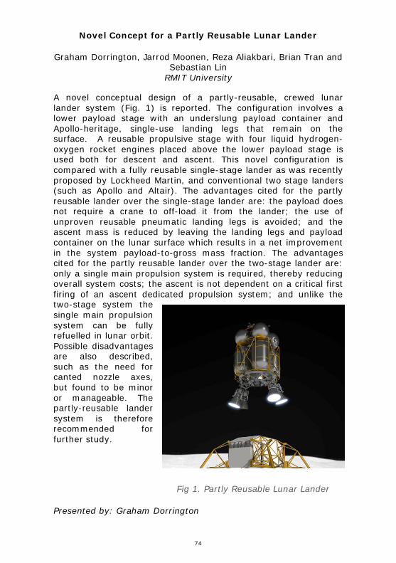
74
DOR RINGTON: Novel Con cept for a Partly Reusable Lunar Lander
Novel Concept for a Partly Reusable Lunar Lander
Graham Dorrington, Jarrod Moonen, Reza Aliakbari, Brian Tran and Sebastian Lin
RMIT University
A novel conceptual design of a partly-reusable, crewed lunar lander system (Fig. 1) is reported. The configuration involves a lower payload stage with an underslung payload container and Apollo-heritage, single-use landing legs that remain on the surface. A reusable propulsive stage with four liquid hydrogen-oxygen rocket engines placed above the lower payload stage is used both for descent and ascent. This novel configuration is compared with a fully reusable single-stage lander as was recently proposed by Lockheed Martin, and conventional two stage landers (such as Apollo and Altair). The advantages cited for the partly reusable lander over the single-stage lander are: the payload does not require a crane to off-load it from the lander; the use of unproven reusable pneumatic landing legs is avoided; and the ascent mass is reduced by leaving the landing legs and payload container on the lunar surface which results in a net improvement in the system payload-to-gross mass fraction. The advantages cited for the partly reusable lander over the two-stage lander are: only a single main propulsion system is required, thereby reducing overall system costs; the ascent is not dependent on a critical first firing of an ascent dedicated propulsion system; and unlike the two-stage system the single main propulsion system can be fully refuelled in lunar orbit. Possible disadvantages are also described, such as the need for canted nozzle axes, but found to be minor or manageable. The partly-reusable lander system is therefore recommended for further study.
Presented by: Graham Dorrington
Fig 1. Partly Reusable Lunar Lander

75
DOU GHERTY: HARP: Austral ia’s Fir st Sounding Ro cket Program
HARP: Australia’s First Sounding Rocket Program
Kerrie Dougherty University of NSW
In 1955, both Australia and Britain announced that they would develop sounding rockets to study the upper atmosphere during the International Geophysical Year (1957-58). The British developed the extremely successful Skylark sounding rocket, that, in several different versions, was operational from 1957-2005. Australia’s Weapons Research Establishment inaugurated the High Altitude Research Project (HARP), focussed on the development of a rockoon — a combination of a high altitude balloon and a small sounding rocket. Due to repeated failures of the HARP rockoon, the project was abandoned in early 1958 and quickly forgotten when the more-conventional Long Tom sounding rocket proved successful, marking the real beginning of Australia’s sounding rocket activities.
However, despite its ultimate failure, HARP was a significant contributor to the perception of Australia as a space-active nation at the very beginning of the Space Age. The HARP progam had an interesting technological background that demonstrated the innovativeness of the Australian Defence Scientific Service. It also represented an important political turning point in Australia’s relationship with Britain within the Anglo-Australian Joint Project, for which the Woomera Rocket Range was developed.
This paper will present a history of the previously overlooked High Altitude Research Project. It will examine the political and technical origins of the program, as well as the reasons for selecting a rockoon design for Australia’s first sounding rocket. It will discuss the technical innovation represented by the small ‘Harpy’ rocket developed for the project and also highlight the reasons for HARP’s failure — reasons that were connected with the meteorological environment at the Woomera Range, rather than technical issues.
Presented by: Kerrie Dougherty

76
DOWNEY: The B inar CubeSat Program: Developing a rel iable and effic ient CubeSat Electronics Power System
The Binar CubeSat Program: Developing a reliable and efficient CubeSat Electronics Power System
Fergus Downey, Benjamin Hartig, Nathaniel Brough, Stuart Buchan, Martin Cupak, Daniel Busan, Phil Bland, Jonathan Paxman
and Robert Howie Curtin University
CubeSats are fast becoming the new frontier for space science and exploration. The small low cost platform has key advantages in price and accessibility that make it optimal for many research groups and Universities. The Space Science and Technology Centre (SSTC) at Curtin University are beginning their own CubeSat program “The Binar CubeSat Program” which aims to develop CubeSats for its research purposes. The first CubeSat to be developed in this program is Binar-1 which will be a tech demonstration of the SSTC’s new combined CubeSat bus. The bus will house all of the main CubeSat subsystems (excludes a payload) into 1/3U.
One of the main systems of the bus is the Electronics Power System (EPS). This system is one of the most important, as without it nothing else can function. As such, the system needs to be highly reliable and have redundancy in place to ensure that it can still operate if something is to go wrong. The system also has limited methods of generating and storing electricity. This challenge requires the system to be efficient, and to not use the limited power it has in the process of distributing it to other parts of the CubeSat bus. The final CubeSat bus to be tested on Binar-1 will verify the developed EPS as well as the other main subsystems. This will prepare the SSTC for future space research missions as well as offer a service to other interested parties looking to do space research and develop space hardware.
Presented by: Fergus Downey

77
EBENDORFF-HEIDEPR IEM: Next-generation extreme-low loss opti cal f ibres through automated manufacture in spa ce
Next-generation extreme-low loss optical fibres through automated manufacture in space
Erik Schartner University of Adelaide
The fabrication of extreme low-loss fibres for telecommunications applications has been an area of major research interest in recent years. Ultra-high speed long-distance undersea cables could be built without the need for very expensive repeater stations. Conventional silica fibres are very close to their theoretical loss limits, with 0.17 dB/m being the best shown for terrestrial-grade fibres. Fluoride fibres present an ideal alternative, with theoretical losses 10-100× better than silica fibres, but real-world results from these fibres have never lived up to expectations despite heavy industry investment. Research has suggested that the primary issues with these fluoride fibres has been convection currents causing crystallisation and defects, which are unavoidable with any terrestrial-based manufacturing process. Manufacturing these fluoride fibres in microgravity environment of space has the potential to transform this, reducing the obtainable loss to close to the theoretical limits and opening up new possibilities for long-distance, low-loss telecommunications.
In this talk we will discuss work towards realising low-loss manufacture in space, and the requirements of the ground-based research aspects needed to develop this technology, and how this will enable manufacture of these extreme-low loss fibres in the new few years. The University of Adelaide is partnering with Flawless Photonics to explore development of these novel space-drawn fibres, with Flawless Photonics having recently demonstrated use of their compact draw towers onboard the International Space Station (ISS) to draw meaningful lengths of fluoride fibre in microgravity for the first time. While drawing in microgravity will reduce the fibre loss, improvements in material purity, drawing techniques and packaging will also need to be explored to fully realise the promise that space-drawn fluoride fibres present, creating a challenging but potentially extremely rewarding opportunity for this new development in the optical fibre space.
Presented by: Heike Ebendorff-Heidepriem
78
ELANKUMAR AN: Autonomou s navigation of d istributed spacecraft for proximity operations in sma ll celest ial bodie s
Autonomous navigation of distributed spacecraft for proximity operations in small celestial bodies
Kawsihen Elankumaran and Andrew Dempster Australian Centre for Space Engineering Research, UNSW Sydney
Small celestial bodies (SCB) like asteroids and comets are interesting destinations both for scientific exploration to unlock the mysteries of the origin of our solar system and for the extraction of valuable materials for space resource utilization. Operating in the proximity of SCBs presents many challenges owing to the highly uncertain environment in the vicinity of these bodies. Two enabling capabilities for the success of future proximity missions to such bodies are autonomous navigation methods and distributed spacecraft architectures. Autonomous navigation is beneficial in terms of its availability, scalability and cost for the execution of sophisticated mission activities. Distributed spacecraft offer many advantages in terms of redundancy, versatility and robustness in addition to their ability to observe higher dimensions in spatial and temporal domains. Stereophotoclinomery (SPC) has been the algorithm of choice for proximity navigation in SCBs in many past missions. SPC works by constructing a model of a SCB during an initial surveying phase and then uses the developed model for navigation. Although SPC offers a good accuracy, in addition to requiring an initial surveying phase, it necessitates ground intervention for the model building process from massive amounts of downlinked data. In this paper, we investigate the suitability of Simultaneous Localization and Mapping (SLAM) as an alternative algorithm for the cooperative autonomous navigation of distributed spacecraft in the proximity of SCBs. SLAM is an actively researched topic in terrestrial robotics and is used to simultaneously perform both localization and mapping. SLAM not only allows for a truly autonomous navigation but also has an established framework for cooperative navigation of multiple agents. Results from our simulations suggest that a cooperative navigation around SCBs using SLAM returns acceptable navigation accuracy.
Presented by: Kawsihen Elankumaran

79
ELTON: Buckland Park HF radar: Enhanced capabil ities and result s
Buckland Park HF radar: Enhanced capabilities and results
Darrell M. Elton, Quang Vu, John C. Devlin and Jim S. Whittington La Trobe University
With the resurgence of High Frequency (HF) communication, there is a demand of enhanced capabilities of HF radars to more accurately observe ionospheric phenomena. La Trobe University has been operating a series of HF radars as part of the superDARN group for more than two decades. The most advanced of these radars is TIGER-3, currently located at Buckland Park, SA. A complete re-design of the firmware and control software of this radar has been undertaken since mid-2018, facilitating improved stereo operation, dynamic calibration, post beam forming, spectrum-based clear frequency search and enhanced remote diagnostics. The modularity of the new TIGER-3 design combined with its rapid dynamic configuration enables an increase in scientific capability in both quality and the number of different experiment that can be conducted in a given time frame. This paves the way for a more diverse set scientific experiments to be conducted with the radar, in parallel, but completely independent of regular SuperDARN operations. We believe that the expanded capability provided by the TIGER-3 radar can make a key contribution to the JORN Open Innovation Network (JOIN), as a facility for scientific training and diverse experiments. This poster details some of the latest capabilities and results of the TIGER-3 radar. These results include demonstrations of standard superDARN IQ data, rawACF and fitACF plots for various stereo operational modes.
Presented by: Darrell Elton
80
FENG: Connected GNSS things for indu stry IoT solution s: case studie s
Connected GNSS things for industry IoT solutions: case studies
Yanming Feng and Charles Wang Queensland University of Technology
About 70% of Internet of Things (IoT) applications require location intelligence. GNSS and low-power wide area network modules are two standard IoT components in today's IoT sensors markets. The GNSS unit is not only to provide position, navigation and time (PNT) intelligence to support other sensing capability, but also capable to output raw measurement streams for advanced applications. The GNSS-IoT sensors may be installed at a fixed location or on a moving object anywhere. The term connected GNSS things generally refers to applications, services, and technologies that connect a GNSS sensor to the Internet. This presentation outlines the reference framework of connected GNSS solutions, common requirements and key challenges. In addition to the review of traditional connected GNSS services, the presentation discusses the new use cases in transportation, construction and water industry sectors, showing the benefits of connected GNSS for industry automation.
Presented by: Yanming Feng

81
FENG A mach ine learning-based approach for improved predictions of LEO objects with two- line ele ment data sets
A machine learning-based approach for improved predictions of LEO objects with two-line element data sets
Bin Li Wuhan University; Queensland University of Technology
Jizhang Sang Wuhan University
Yanming Feng Queensland University of Technology
Accurate orbital knowledge of space objects is essential for space situation awareness (SSA) related tasks like the collision warning. However, due to effects of uncertain perturbing force models, such as solar radiation pressure and atmosphere drags, long-term orbit prediction (OP) based on the conventional orbital mechanics surfers from rapid error growth. For instance, GPS predict orbital errors can reach about 10 km after 30 days. With Two-Line Element (TLE) data, LEO predicting errors with SGP4 orbit propagator can grow up to 1 to 2km per day. Considering that the orbital errors over longer tracking arcs often show certain variation patterns, we propose to use a machine learning (ML)-based approach to model the underlying pattern of orbital errors from the historical TLE observations and apply the trained model to correct the OP errors beyond the training data period. The approach includes three steps of constructing historical OP error dataset, training a model to fit the error dataset, and correcting the future OP errors with the trained model. The ensemble ML method of gradient boosting decision tree (GBDT) is chosen for modelling the underlying pattern of OP errors. Experiments with two LEO objects demonstrate that more than 60% orbital accuracy improvement in prediction of 7 days can be achieved after the ML-predicted orbital errors are removed from the original OP results, showing promising potential of the ML approach for improved SSA capability.
Presented by: Yanming Feng

82
FIELD: A new empi rica l c limatologica l model of ionospher ic foF2 and h mF2
A new empirical climatological model of ionospheric foF2 and hmF2
Daniel J. Field The University of Adelaide
Manuel Cervera Defence Science and Technology Group
Andrew D. MacKinnon The University of Adelaide
This paper presents Mocha, a new empirical climatological monthly median and variance model of two ionospheric parameters viz. foF2 and hmF2. Understanding ionospheric variance is important for assessing the climatological performance of systems which use trans-ionospheric paths such as satellite navigation systems, or utilise the refractive properties of the ionosphere to propagate high frequency radio waves long distances such as over-the-horizon radar. Mocha is compared to the International Reference Ionosphere (IRI) 2016. Which is a widely used, industry standard, global empirical climatological monthly median model of the ionosphere. Mocha produces slightly more accurate foF2 predictions and significantly more accurate hmF2 predictions than IRI. It also outputs the variance in these parameters which is not currently produced by IRI. Mocha is intended to be used in conjunction with IRI: its foF2 and hmF2 output parameters may be input directly into IRI overriding IRI's internal model of these parameters.
Presented by: Daniel J. Field
83
FIELD: Buckland Park V HF radar observations of low-Earth orbit objects during SpaceFest 2019: observations and resu lts
Buckland Park VHF radar observations of low-Earth orbit objects during SpaceFest 2019: observations and results
Daniel J. Field The University of Adelaide
David A. Holdsworth Defence Science and Technology Group
David Neudegg Defence Science and Technology Group
Andrew D. MacKinnon The University of Adelaide
Andrew J. Spargo The University of Adelaide
Iain M. Reid ATRAD Pty. Ltd
Richard Mayo ATRAD Pty. Ltd
There is increasing interest in space situation awareness (SSA), motivating investigation of the use of non-traditional sensors for space surveillance. In the context of the Australian Defence Force, this is illustrated through Joint Project 9351 for the development of indigenous space sensors, and through the conduct of two recent Defence trials (SpaceFest 2018 and 2019) to evaluate the use of non-traditional indigenous sensors at Woomera, South Australia. The Buckland Park 55 MHz VHF stratosphere-troposphere (BPST) radar is a low-cost meteorological wind profiling radar that has been successfully used for SSA observations of low Earth orbit (LEO) objects. The radar was operated in SSA mode for the five days of SpaceFest 2019, and over the following week. This paper describes results from the BPST trial which indicates that the BPST system is useful for catalogue maintenance and LEO object detection. Further results about the operating configuration, signal processing and statistics are described in the companion paper.
Presented by: Daniel J. Field

84
FLOREANI: The Au stralian Space Cybersecur ity Environment
The Australian Space Cybersecurity Environment
Dr Daniel Floreani and Mr Derek Grocke CyberOps
The space segment is an integral component of critical infrastructure in Australia, mainly using assets owned and controlled by other countries. As Australia accelerates the development of its own sovereign space assets, it is vital to protect these new investments in space with the development of a capacity to design, build and maintain secure space assets, services and intellectual property.
Multiple cyberattacks have already been carried out on traditional highly engineered multi-million dollar satellite assets and services, and we expect that with the introduction of multitudes of smaller flexible COTS nano-satellites, that cyber security issues will only increase.
Cybersecurity needs to be considered throughout the design, build, operate decommissioning and disposal lifecycle of the product. The integrity of software and hardware use to produce the product or service, is also highly dependent on the security of the supply chain.
Satellites and launch vehicles operate in a harsh and remote environment, so traditional cyber security techniques need to be contextually adapted. Low resource autonomous capabilities are required to detect and defend against unique threat vectors in space when out of reach of ground-stations.
Technology is evolving rapidly in the space segment, and new applications are being developed and tested all the time. With the evolution of cheap and readily accessible Software Defined Radio (SDR) technology and signal processing compute, access to space communications and space situational awareness intelligence is now far easier.
As these technologies are adopted into nano-satellite missions and launch systems., security architectures and assessment frameworks need to be adapted to integrate into the evolving technology capabilities.
We will discuss an approach for space cybersecurity, adaptive use of industry standards and some of the recent technology advances in the space cyber domain.
Presented by: Dr Daniel Floreani

85
FOK: SAR Con stellation Des igns for Barrier Survei llance Appli cations
SAR Constellation Designs for Barrier Surveillance Applications
Victor Fok and Anthony Antoniou Defence Science Technology Group
The availability of smaller, low-cost, high-performance Synthetic Aperture Radar (SAR) satellites coupled with lower cost-of-launch options increases the viability of large SAR constellations that can provide global day/night all-weather surveillance capability at high revisit rates.
This paper investigates the sizing, configuration and operational requirements of SAR constellations capable of providing global surveillance necessary for barrier surveillance applications in civilian and military domains.
Constellation design methods for discontinuous coverage have been adapted to the constraints of SAR payloads and a unique methodology for coordinating SAR collections has been developed to support satellite-based barrier surveillance applications. A range of constellation configurations have been simulated and analysed against several barrier surveillance scenarios.
The results support capability decision makers with trade-offs for achieving utility in their regions of interest based on sensor configuration, constellation scale, revisit rate and sensor performance considerations.
Presented by: Victor Fok

86
FORMAN: Lava flows on Mars
Lava flows on Mars
Lucy V. Forman, Ken J. Orr, Gretchen K. Benedix and Ravi R. Patel Space Science & Technology Centre, Curtin University
Martian meteorites are our only samples from the red planet to date, and the majority are volcanic or magmatic. Mineralogy, geochemistry, age dating and deformation have all been explored through the study of these rocks and have provided invaluable constraints as to the magmatic and volcanic evolution of Mars, and also placed some constraints on shock and other secondary processes. Comprehensive data analysis of these rocks is not yet possible on Mars rovers or landers, making the study of Martian meteorites of great importance. Furthermore, these studies form an excellent foundation for analysis of Martian rocks, which will be very useful when sample return missions bring back new samples in 2031.
We can use our understanding of volcanic processes on Earth as a proxy to understand the formation of similar igneous rocks on Mars. Here, we focus on the crystallisation of the Martian meteorites and the environment of emplacement, considering scenarios both below and above the Martian surface. In addition to the extensive information gathered from orbiter, rover and lander missions on Mars, data gathered from these meteorites provide further context to what happened in the Martian crust and interior many years ago.
Using high-resolution crystallographic microscopy techniques (electron backscattered diffraction), we present the analysis of Martian shergottites; relatively young rocks (~170-300 Ma old) that have been heavily shocked and contain crystallographic clues as to the environment that they formed within. Fabric analyses, or the assessment of grain alignments across the shergottites, allow for assessment of the processes that were acting at the time of formation. Such processes include flow (e.g. lava) and the settling of grains within a lava flow (e.g. via gravity). Crystallographic results from our suite of shergottites will be presented at the meeting, and placed in context of what this could mean for Mars’ history.
Presented by: Lucy Forman

87
FURQA N: Efficient Uti li zation of Radio Frequency Electromagnetic Spectrum for Satellites in Lower Earth Orbit s
Efficient Utilization of Radio Frequency Electromagnetic Spectrum for Satellites in Lower Earth Orbits
Muhammad Furqan, Yanming Feng PhD and Dhammika Jayalath PhD
Queensland University of Technology
With the upcoming debut of more than 20,000 commercial satellites by lower earth orbit, high throughput satellites mega-constellations as well as small smart satellites for research and development, there will be challenges of efficient usage of satellite communication allocated radio frequency electromagnetic spectrum and frequency interference with each other and already existing communication networks. Satellites need to communicate with each other in same constellation, earth stations and end-users. Being in the lower earth orbit and continuously moving at high velocities, these satellites have smaller coverage footprints as compared to traditional geostationary satellites, hence, they will require more complex communication architecture to communicate with earth stations for telemetry, tracking, and control and data connectivity. This work aims to review technical literature of these constellations, regarding their communications and to provide algorithm for efficient utilization of radio frequency electromagnetic spectrum for communication with each other, earth stations and end-users for satellites, which are not a part of these constellations and will be deployed for research and development and other limited usage.
Presented by: Muhammad Furqan

88
FURQA N: Efficient Uti li zation of Radio Frequency Electromagnetic Spectrum for Satellites in Lower Earth Orbit s
Efficient Utilization of Radio Frequency Electromagnetic Spectrum for Satellites in Lower Earth Orbits
Muhammad Furqan, Yanming Feng PhD and Dhammika Jayalath PhD
Queensland University of Technology
With the upcoming debut of more than 20,000 commercial satellites by lower earth orbit, high throughput satellites mega-constellations as well as small smart satellites for research and development, there will be challenges of efficient usage of satellite communication allocated radio frequency electromagnetic spectrum and frequency interference with each other and already existing communication networks. Satellites need to communicate with each other in same constellation, earth stations and end-users. Being in the lower earth orbit and continuously moving at high velocities, these satellites have smaller coverage footprints as compared to traditional geostationary satellites, hence, they will require more complex communication architecture to communicate with earth stations for telemetry, tracking, and control and data connectivity. This work aims to review technical literature of these constellations, regarding their communications and to provide algorithm for efficient utilization of radio frequency electromagnetic spectrum for communication with each other, earth stations and end-users for satellites, which are not a part of these constellations and will be deployed for research and development and other limited usage.
Presented by: Muhammad Furqan
89
GENSEMER: CSIR O's smal l-satell ite Opt ical Instru mentation Development
CSIRO's small-satellite Optical Instrumentation Development
Stephen Gensemer CSIRO
Martin O'Connor University of Adelaide
Earth Observation (EO) data delivers essential information and services for Australia's future. The "Australia Earth Observation Community Plan 2026" states that, "For Australia, the minimum economic impact of EO from space-borne sensors alone is approximately AU$5.3 billion each year". To this day, Australia has been heavily reliant on overseas organisations running very expensive missions to provide this data. However, Space 2.0, the commercialisation of space, is sweeping the globe and provides a brand new opportunity for Australia to leverage its sophisticated capabilities in advanced manufacturing, data analytics, ground stations and advanced sensors to build a sovereign small-satellite capability.
CSIRO has been developing niche, customised, low-cost spectral sensors and hyperspectral camera architectures for agriculture and water quality over the past 5 years. One instrument named 'RazorSpectra' was developed for crop studies from drones. It is a unique spectral mapping instrument that captures the precise shape spectra of objects at very high spectral and spatial resolution.
Under the CSIRO's Space Technologies FSP program, we are establishing a new laboratory in Adelaide for development of optical satellite instrumentation. One key mission for the new lab will be the deployment of RazorSpectra in a cubesat for Earth observation. It allows fully hyperspectral imaging whilst simultaneously capturing detailed RGB or panchromatic images of the scene. RazorSpectra has been designed to operate from the visible, near infrared and short wave infrared bands and provide a low-cost, lightweight instrument with precise image registration.
Our focus is on making manufacturable, simple instruments with as many off-the-shelf components as possible, yet that perform at the cutting edge in resolution and sensitivity. By keeping development and manufacture costs low, we can lower the barriers to entry for Australian Earth observing missions.
This paper will present an overview of this project and the key technologies being developed.
Presented by: Dr Stephen Gensemer
90
GENSEMER: CSIR OSat-1 CubeSat Mission Update
CSIROSat-1 CubeSat Mission Update
Dr Stephen Gensemer, Dr Adam Macleod and Dr Adrian Rispler CSIRO
In 2018, CSIRO initiated a project to acquire its own 3U CubeSat, called 'CSIROSat-1' (CSIRO Scientific InfraRed Observing Satellite), in partnership with Australian industry. The payload will include a shortwave infrared (SWIR) imaging system and on-board data processing capabilities. CSIROSat-1 is to be built and launched within 2 years.
The 3U CubeSat will comprise a hyperspectral payload imager, composed of a SWIR camera, lens and a filter, together with an on-board re-programmable processing board and will be launched into a LEO orbit from the ISS in the northern summer of 2020.
The process of developing a LEO-based, 3U hyperspectral imaging device forces a push to the limits of the possible around every aspect of the hardware: optical design, sensor noise and thermal characteristics, pointing accuracy and stability, data throughput, onboard processing capability, and downlink bandwidth. As such we have found CSIROSat-1 an excellent exercise in development of a highly capable instrument which we hope will serve as a pathfinder toward much higher capability, future Earth observing missions of national importance.
The paper will cover a mission update including lessons learned from the recently held CDR and early sub-system testing.
Presented by: Dr Stephen Gensemer

91
GEORG: Investigations of Transient Discharge Behaviour in an Inductive P lasma Generator for Electri c Propu lsion
Investigations of Transient Discharge Behaviour in an Inductive Plasma Generator for Electric Propulsion
Robin Georg School of Mechanical Engineering, The University of Adelaide,
Adelaide, Australia
Ashley Chadwick German Aerospace Centre (DLR), Stuttgart, Germany
Bassam Dally Centre for Energy Technology, University of Adelaide, Adelaide,
Australia
Georg Herdrich Institute for Space Systems (IRS), University of Stuttgart,
Stuttgart, Germany
Francesco Romano Institute for Space Systems (IRS), University of Stuttgart,
Stuttgart, Germany
A thruster based on an inductive plasma generator (IPG) is a promising new concept for electric propulsion (EP). A radio-frequency antenna delivers energy to a propellant gas, forming a plasma that is expanded through a nozzle to produce thrust. A key difference from other EP concepts is the electrodeless nature of the IPG, eliminating contact between the propellant and electrical components, and therefore improving longevity and propellant flexibility. The propellant flexibility is particularly attractive because it enables the use of propellant material gathered from the space environment (in-situ resource utilisation or ISRU), or continuous drag-compensation in a very low-altitude orbit (air-breathing electric propulsion or ABEP). Both possibilities represent a leap forward in terms of space propulsion capabilities.
Presently, understanding of the transient behaviour within the IPT is limited due to lack of non-intrusive, high-sampling-frequency experimental measurement techniques. We present a new approach using simultaneous measurements of antenna current, magnetic field strength, and visible emission intensity. The approach is used to investigate the transient behaviour of the discharge.
Presented by: Robin Georg
92
GIERSCH: The Austral ian Space A cademy Solar Radio Spectrograph
The Australian Space Academy Solar Radio Spectrograph
Owen Giersch and John Kennewell Australian Space Academy
We present the initial results of the Australian Space Academy (ASA) Solar Radio Spectrograph (SRS). This instrument was developed using mostly off-the-shelf components and is deployed near Meckering, Western Australia. It operates from 20 MHz to 80 MHz, sampling the entire bandwidth once per second. We describe the components and operation of the spectrograph, and present some initial results. We compare these results to the Learmonth SRS for the same time period. Finally we detail some future work on solar radio monitoring at ASA.
Presented by: Owen Giersch

93
GIERSCH: The Austral ian Space A cademy Sunspot Number
The Australian Space Academy Sunspot Number
Owen Giersch and John Kennewell Australian Space Academy
Sunspot number and sunspot area are used to drive many space weather predictive models of the ionosphere, auroral phenomena, upper atmospheric density and satellite drag, terrestrial climatology and solar cycles, among others. In 2015 the Solar Influences Data Analysis Center of the Royal Observatory of Belgium significantly modified the 300-400 year European sunspot number time series in retrospect. The new index is thus unusable in many of the above models. Part of the modification was due to a belief that Max Waldmeier adjusted observed data around the time of cycle 19, and part a belief that cycle 19 was a statistical anomaly that needed correction. A scale factor was also changed in the new index series. Sunspot area has been subject to even more controversy, because of a divergence between different observatory measured areas and also a desire to make the data fit certain preconceived ideas, particularly in the area of terrestrial climatology.
We believe that to avoid and resolve such problems it is essential to have a continuous multiplicity of data streams from independent sources. Our contribution to this is the development of an automated measurement system for sunspot number and area that is fed by images from the ground-based Global Oscillation Network Group helioseismological observatories. These series are updated monthly on the Australian Space Academy web site. We present the why and how of this data, and relate it to similar data streams produced by other solar data centres.
Presented by: Owen Giersch

94
GILBERT: Simu ltaneous ionospher ic sounder and airg low observations of sporadic-E layers
Simultaneous ionospheric sounder and airglow observations of sporadic-E layers
David Holdsworth, Manuel Cervera and Trevor Harris Intelligence, Surveillance & Space Division, Defence Science &
Technology Group, Edinburgh, South Australia & School of Physical Sciences, The University of Adelaide, Adelaide, South Australia
Andrew MacKinnon School of Physical Sciences, The University of Adelaide, Adelaide,
South Australia
The sporadic-E layer is one of the most rapidly changing layers of the ionosphere, significantly changing over the scale of minutes. The observed variability provides a challenge for ionospheric modelling, and has noticeable effects on satellite communication and over-the-horizon propagation. The variability in the formation and evolution of the sporadic-E layer is hypothesised to be primarily due to a coupling between electromagnetic and neutral dynamics, known as the windshear mechanism. Detailed observations of sporadic-E layers and the various forces believed to be driving them are required to explain the amount of temporal and spatial variability observed.
To better understand the dynamics driving this layer, a co-located vertical ionosonde and airglow instruments have been installed near Murray Bridge, South Australia, with plans to add a meteor wind radar in the future. The airglow data contains information about the intensity of the airglow emissions at 589.3 nm (sodium) and 557.7 nm (oxygen). Disturbances such as gravity waves or bores can be observed in this dataset. Potential correlations between these features and the occurrence, intensity and height of simultaneously observed sporadic-E layers are explored, both in terms of individual case studies and longer-term statistical analyses. Additionally, wind profiles from a meteor wind radar and returns from a 2 MHz radar located approximately 100 km from Murray Bridge are considered in conjunction with the previous datasets on a case study basis.
Presented by: Baden Gilbert

95
GOWER: SERC Research
SERC Research
Steve Gower Space Environment Research Centre
Craig Smith EOS Space Systems
David Ball Space Environment Research Centre
James Bennett EOS Space Systems
Robert Norman RMIT University
The Space Environment Research Centre (SERC) is completing its five-year R&D program to develop techniques and technologies to reduce the threat to space-based infrastructure from space debris.
SERC research is organised into four interdependent Research Programs (RPs):
• RP1: Tracking, Characterising and Identifying Objects in Orbit - This RP has developed innovative active and passive object tracking techniques to improve accuracy for orbit propagation and conjunction prediction; including development of space debris-tracking hardware and adaptive optics (AO) based solutions for precise tracking of space objects.
• RP2: Orbit Determination & Predicting Behaviours of Space Objects - RP2 has developed advanced atmospheric mass density models as well as high precision orbit tools and propagators to improve the accuracy and reliability of orbit predictions for LEO objects.
• RP3: Space Asset Management - This RP has developed techniques, algorithms and databases to predict and avoid potential collisions. The outcome of the research provides satellite operators with the means to make actionable decisions about asset management in order to preserve the space environment.
• RP4: Space Segment - This RP is applying knowledge and systems developed in RP1-RP3 to engage space objects with
96
directed laser energy to establish momentum transfer models for the interaction between space objects and propagated energy.
The laser, AO and conjunction analysis subsystems are currently being integrated with the photon pressure remote manoeuvre system scheduled to commence operations in the second half of 2019.
This paper provides an update on SERC’s conjunction and threat warning capability, and the systems being used to demonstrate the remote manoeuvre of space debris using photon pressure for active collision avoidance.
SERC is a collaboration between Participants from industry (EOS Space Systems, Lockheed Martin, Optus Satellite Systems), academia (ANU, RMIT, National Institute of Information and Communications Technology), and the Department of Industry, Innovation and Science, Commonwealth of Australia.
Presented by: Steve Gower

97
GROSSE: Adaptive Optics for Space Situational Awareness
Adaptive Optics for Space Situational Awareness
Doris Grosse, Francis Bennet, Michael Copeland, Celine d’Orgeville, Visa Korkiakoski and Marcus Lingham
Australian National University, Space Environment Research Center
Craig Smith Electro Optics Systems
Tony Travouillon and James Webb Australian National University
The Advanced Instrumentation and Technology Centre (AITC) of the Research School of Astronomy and Astrophysics of the Australian National University (ANU) has built astronomical instrumentation for ground-based telescopes for many years. In particular, the AITC has been developing instrumentation for the 4-meter Australian Astronomical Observatory telescope in Australia, the 8-10 meter Gemini, Subaru, and Keck telescopes in Hawaii, and the 8-meter Very Large Telescope and 25-meter Giant Magellan Telescope in Chile. Many of these intrumensts rely on or incorporate adaptive optics technology.In more recent years, the AITC has expanded its endeavours to include space applications, notably the ground based monitoring of satellites and space debris. Such space situational awareness (SSA) activities are built upon the AITC’s mature and internationally recognised expertise in lasers and adaptive optics. This paper provides an overview of the capabilities and research areas of the ANU within the field of SSA. With ANU being a project partner of the Space Environment Research Centre (SERC), most recent activities within SSA are within the scope of debris and satellite imaging in low Earth orbits using adaptive optics and positioning and tracking of satellites in Geostationary orbit using adaptive optics and lucky imaging. Furthermore, the ANU is also developing an adaptive optics system to help mitigate space debris collisions from ground by using photon pressure. This paper provides an overview of these activities and the latest advances in these projects.
Presented by: Doris Grosse
98
HAN: High-reso lution gravitational fields of the Moon from crusta l dens ity estimates and topographic data
High-resolution gravitational fields of the Moon from crustal density estimates and topographic data
Michal Šprlák University of Newcastle
Shin-Chan Han University of Newcastle
Will Featherstone Curtin University
Gravitational field represents an important property of any planetary body. Physical quantities, such as the gravitational potential, gravitational gradient or higher-order gravitational tensors, are various images of the attracting masses and help revealing the inner structure and (sub)-surface processes. Hence, this field is an indispensable tool for understanding surface and interior structures and processes within the bodies and for addressing challenging problems in geodesy, geophysics and planetary sciences. The gravitational field of any planetary body can be determined by forward modelling. Such modelling is based on the Newton integral for the gravitational potential and exploits information about the volumetric density and geometry of the attracting body.
In this contribution, we present the gravitational field models inferred by crustal masses of the Moon. The lunar geometry is provided by the Lunar Orbiter Laser Altimeter (LOLA) topography. We first determine global estimates of spatially variable densities within the lunar crust using global gravitational field from Gravity Recovery And Interior Laboratory (GRAIL). Then, using the density models, we compute high resolution gravitational field up to degree and order 2519 of the spherical harmonic expansion, which corresponds to the spatial resolution of ~2.2 km on the surface of the Moon. We analyse our crustal gravitational models in terms of the spectral characteristics (correlation, admittance and Bouguer correlation) and in terms of the band-limited radial gravitation. From the practical point of view, our high-resolution gravitational field models of the Moon represent an augmentation to the GRAIL-derived counterparts and can be used for geodetic, geophysical or navigational applications.
Presented by: Shin-Chan Han
99
HAN: An overview of NASA and DLR’ s Gravity Recovery And Cl imate Experiment (GRACE ) and G RACE Fol low-On miss ions
An overview of NASA and DLR’s Gravity Recovery And Climate Experiment (GRACE) and GRACE Follow-On
missions
Shin-Chan Han University of Newcastle
The GRACE satellite mission is a result from collaboration between US NASA and German Aerospace Centre (DLR). It consists of two identical satellites separated over ~200 km and orbiting at ~500 km above the surface with the inclination of 89 degree. The GRACE satellite mission had measured the Earth’s gravitational fields every month almost continuously since its launch in April 2002 until its end in October 2017. The monthly snapshots of time-variable, global gravitational fields have been used to quantify surface mass redistribution and transport from terrestrial water storage, icesheet and glacier melts, oceanic and atmospheric mass variations, after removing the non-surficial processes such as glacial isostatic adjustment (GIA) and earthquake deformation. Various signals associated with climate and Earth system changes are manifested in gravity changes and measured by GRACE satellites at a spatial resolution of 300-500 km (smaller in polar regions by virtue of orbit convergence).
In this presentation, I start by discussing the principle of gravity measurement using two identical satellites and highlight the main science payload of microwave (K-Band) satellite-to-satellite tracking system. Different levels of data products available from the GRACE mission will be described for new users. I summarize major science results discovered from 15 years of nearly continuous GRACE measurements of the Earth’s gravity field changes; covering quantification of icesheets and glaciers melt, global sea level rise, terrestrial water storage and climate variability, and solid Earth deformation by earthquakes and GIA. The initial results from the new mission, GRACE Follow-On from 2018, are also presented.
Presented by: Shin-Chan Han
100
HASTINGS: Project Pr isc il la : An open source rover project
Project Priscilla : An open source rover project
Jaden J. A. Hastings x0.lab Initiative
Luke Weston University of Melbourne
Mark Splittgerber x0.lab Initiative
Project Priscilla is a collaborative endeavour to build small rovers in Australia that are suitable for metagenomic study of extremeophiles and environmental monitoring of remote regions in Australia. As a starting point, we used open source specifications made available by NASA's Jet Propulsion Laboratory to build the rover body and operating system. Then, we designed a bespoke retracting arm with a coring drill for the sterile collection of samples from microbial mats. To provide sufficient contextual environmental metadata, we are adding a suite of sensors to the exterior of the rover body to report ambient temperature, spectroscopy, surface pH, salinity, temperature, luminance. Adding a depth and tracking camera as well as GPS endows the rover with the capacity to navigate autonomously as well as return to the same position. Our aim is to make future iterations of Priscilla’s specifications completely open source and easily customizable to support the need for environmental monitoring and extremophile studies across vast spans of the Australian interior
Presented by: Jaden J. A. Hastings

101
HEITMANN: Characteris ing ionospheric gradients fro m obl ique angle-of-arrival ionosondes
Characterising ionospheric gradients from oblique angle-of-arrival ionosondes
Andrew Heitmann(1,2), David Holdsworth(1,2), Andrew MacKinnon(2) & Iain Reid(2)
(1) Defence Science and Technology Group, Edinburgh
(2) The University of Adelaide
Ionospheric variability exists on a range of spatial and temporal scales, and can routinely alter or degrade high-frequency (HF) radio wave propagation characteristics, often in an unpredictable way. Real-time data-assimilative models of the ionosphere, such as the one used in the Jindalee Operational Radar Network (JORN), capture a great proportion of the day-to-day and hour-to-hour variations in electron density by spatially mapping between a fixed set of conventional ground-based ionosondes. However, with each sounder estimating electron density profiles under the assumption of a symmetric great-circle propagation path, it is of interest to evaluate the ability of the model to characterise medium- to large-scale gradients.
This presentation shows observations from an oblique-incidence angle-of-arrival (AoA) ionosonde network, which have been transformed using an off-angle reflection point geometry to give estimates of the zonal and meridional tilt angles about the path midpoint. Direct comparisons of tilt angles estimated from individual AoA paths against tilt angles extracted from the spatially mapped model (i.e. without AoA inputs) display an encouraging level of agreement, particularly about the dawn/dusk terminators and in the signatures attributed to travelling ionospheric disturbances. As well as being used for model assessment, such AoA-derived tilt estimates also offer valuable ionospheric information in their own right; this may be particularly beneficial for regions of the Earth where conventional ionosondes are more sparsely distributed (e.g. over oceans) and spatial mapping techniques are thus less effective.
Presented by: Andrew Heitmann

102
HELD: Respons ive Space Operation s Centre (RS OC)
Responsive Space Operations Centre (RSOC)
Jason Saber Astronautics
The number of satellite is expected to triple in the next decade. Already the increase in volume affects operational complexity for the many nontraditional space operators entering the market. New operators typically have strong avionics skills but are new to operations. Common problems can range from trying to find your satellite amongst a drifting swarm to deeper analysis required to diagnose health.
This talk discusses the latest in Saber Astronautics Mission Control Centre called the Responsive Space Operations Centre (RSOC) and how it will operate in the USA and Australia to support Australian missions. The RSOC is built using Saber’s Predictive Ground station Interface (PIGI) which brings 3D gaming graphics and machine learning to the space operations problem. RSOC merges PIGI with integrated services from conjunction alerts, dish management, space environment and SSA with a goal of making the control of large constellations as easy as driving a car. Services reduce cost and training time for new operators in both traditional, military, and non-traditional space sectors.
Presented by: Dr Jason Held
103
HENNESSY: Survei llance of Space with Pass ive Radar us ing the Mur chison Widefield A rray
Surveillance of Space with Passive Radar using the Murchison Widefield Array
Brendan Hennessy1, Steven Tingay1, Paul Hancock1, Mark Rutten2, Robert Young3, Ian Morrison1, Randall Wayth1, Steven Tremblay1,
John Morgan1, Brian Crosse1, Steve Prabu1
1Curtin University
2InTrack Solutions
3Defence Science and Technology Gorup
Space Situational Awareness is becoming increasingly important at a global level and there is a growing interest in a broad range of surveillance sensors. The Murchison Widefield Array (MWA) is a radio telescope in Western Australia and a precursor for the Square Kilometre Array, designed primarily for astrophysics and the exploration of the Universe. However, the MWA has also been shown to be a highly sensitive receive element of passive radar systems, utilising FM radio transmitters as illuminators of opportunity in order to detect and track objects in Earth orbit. This talk describes the use of the MWA as a passive radar for the surveillance of space. This talk covers recent progress, including the novel techniques which are being developed for the use of the MWA with passive radar as well as initial results including orbit determination. The MWA, and dedicated new facilities based on these techniques, can take a place in a unique national suite of SSA technologies.
Presented by: Brendan Hennessy

104
HESSEL: Asteroid@ChemEng: Orders of Magnitude Water Savings by Intens ified Metal Extract ion from M im icked A steroid Ores?
Asteroid@ChemEng: Orders of Magnitude Water Savings by Intensified Metal Extraction from Mimicked Asteroid Ores?
Volker Hessel, Nam Nghiep Tran, Yanweiting Zhang, Sanaz Orandi, Mahdieh Raziasrami and Hung Nguyen
University of Adelaide
Two current space missions will land on two asteroids to return the samples of their mineral resources: the NASA OSIRIS-Rex mission on near-Earth asteroid Bennu and JAXA's Hayabusa-2 on asteroid 1999 JU3. More than 100 publicly accessible reports from satellite observations were reviewed to produce an asteroid mine atlas, i.e. an elemental map of their resources. This map led us to propose chemical processing innovations – required for solvent extraction as the last step of a future space mining scenario. A highly intensified process scheme was developed for hydrometallurgical solutions, aiming to match the compositions of metallic asteroids, such as (6178)1086 DA (89% Fe, 10% Ni, Co/Pt traces; value 35 trillion dollars).
Analysing the respective process mass flows pointed at the key differences between the space- and earth process: (a) much higher metal concentration ; (b) different relative loads of adjacent metals; (c) different metal compositions; (d) alloy micro-environment.
Guided by this, we tested if the continuous-flow processing, commonly considered as the ideal space chemistry approach, can act as an enabler toward those unknown process duties. The metals from the asteroid-mimicked leaching solutions were purified by solvent extraction in a coiled segmented-flow inverter. Cobalt is extracted efficiently out of a Co/Ni nitrate solution with Cyanex 272 as scavenger. The processing time is by order-of-magnitude faster than the conventional equipment, at better Co-vs-Ni selectivity. Most notably, the favorable hydro dynamics (micro-slugs/–droplets) can be maintained even at 10 molar solution, comprising almost 2 kg metal salt in one litre water. This means water savings by a factor of 500-1000 compared to the state of the art, decreasing the OPEX costs.
For more advanced separation issues (Pt, Rh, Pd in one run), a new and disruptive technology is at hand, a ‘circular’ compartmentalized flow system with ionic liquids as ‘Designer Solvent’ (choice of 50 million) which exhibit outstanding performance in metal extraction.
Presented by: Volker Hessel

105
HESSEL: In-Situ Resour ce Ut ili sation ( ISRU ) in Space: Water, Phosphate, and Metals
In-Situ Resource Utilisation (ISRU) in Space: Water, Phosphate, and Metals
Nam Nghiep Trana,b, Sanaz Orandia, Daniel Kinaszb, Mahdieh Razi Asramib, Hung Nguyena,c, Volker Hessela,b
a ECMS Space and Defence Theme, University of Adelaide b School of Chemical Engineering and Advanced Materials,
University of Adelaide c Teletraffic Research Centre, University of Adelaide
Space Manufacturing is by no means anymore a vision of a Jules Verne novel, but becoming a business. Pros and cons for in-situ resource utilisation (ISRU) on planets and asteroids are analysed.
Three ISRU scenarios will be presented – moon water harvesting-hydrogen splitting, phosphate mining from moon crust, and metal mining from asteroid ores. The first two are think-tank studies, while the latter, being the centre of this presentation, is an experimental study. It is shown how disruptive chemical/process engineering innovations can lead to game-changing cost scenarios. Central innovation is continuous-flow processing (flow chemistry), commonly perceived as ideal space manufacturing approach.
Adjacent metals from asteroid-mimicked leaching solutions were purified by solvent extraction in a coiled segmented-flow inverter. Cobalt is efficiently extracted out of a Co/Ni nitrate solution with Cyanex-272 as scavenger. >100 publicly accessible reports from satellite observations were considered to produce an asteroid mine atlas. When analysing the respective process mass flows, key differences turn out between the space- and earth process: (a) much higher metal load; (b) different relative loads of adjacent metals; (c) different metal compositions. The processing time of the new space extraction process is by order-of-magnitude faster, at better Co-vs-Ni selectivity. Most notably, the favorable hydro dynamics can be maintained even at 10-molar solution, comprising almost 2 kg metal salt in one liter. Water savings of 500-1000 compared to the state of the art are gained, decreasing OPEX.
Chemical engineering innovations are also proposed for an ISRU water purification and Hydrogen Oxygen Production System: (i) planet-abundant catalysts and selective heating for the electrolyser; (ii) semiconductor-based sun/star-light water photolysis; (iii) concentrated solar radiation via heliostats.
Finally, a process design is given for moon-based phosphate extraction. A re-entrance flow extractor strips out nutrients as

106
pregnant-liquor solution to be accumulated using plant roots in a hydroponic system.
Presented by: Prof. Volker Hessel

107
HIDES: Paral lels between changes in trunk mu sc les in re sponse to microgravity, prolonged bed rest and low ba ck pain on Earth
Parallels between changes in trunk muscles in response to microgravity, prolonged bed rest and low back pain on
Earth
Julie Hides Griffith University
Background: Exposure to microgravity is associated with both low back pain (LBP) and muscle atrophy of the intrinsic and antigravity muscles of the spine, including the lumbar multifidus. It is possible to draw parallels between changes which occur to the trunk muscles in microgravity, prolonged bed rest and in conditions such as LBP, which occurs frequently on Earth. Studying astronauts and people exposed to Earth based analogue models provides a unique perspective and allows testing of interventions such as tailored exercise on the trunk muscles.
Methods: Two analogue studies were conducted where participants were exposed to 56 and 60 days of prolonged bedrest. Magnetic resonance imaging was used to assess the size of the trunk muscles. In a third study, a questionnaire was used to evaluate LBP in astronauts during short duration space flight, and results were compared with results from prolonged bed rest studies.
Results: Results of prolonged bed rest studies showed that preferential atrophy of antigravity trunk muscles occurred in response to this stimulus, with progressively greater decrements in muscle size over time. The rate of muscle atrophy was greatest in the multifidus (L4 and L5 vertebral levels) and the lumbar erector spinae (at L1 and L2). Questionnaire results from astronauts indicated that prior LBP on Earth appeared to be a risk factor for LBP in spaceflight.
Conclusions: Drawing parallels between changes which occur to the neuromuscular system in the absence of gravity could help health professionals better understand and tailor improved interventions for terrestrial populations.
Presented by: Julie Hides

108
HILDEBRA NDT: Introduction to AWS (A mazon Web Service s) Ground Station
Introduction to AWS (Amazon Web Services) Ground Station
John Hildebrandt Amazon Web Services
AWS Ground Station is a fully managed service that lets you control satellite communications, downlink and process satellite data, and scale your satellite operations quickly, easily and cost-effectively without having to worry about building or managing your own ground station infrastructure. Ground stations are at the core of global satellite networks, which are facilities that provide communications between the ground and the satellites by using antennas to receive data and control systems to send radio signals to command and control the satellite. Today, you must either build your own ground stations and antennas, or obtain long-term leases with ground station providers, often in multiple countries to provide enough opportunities to contact the satellites as they orbit the globe. Once all this data is downloaded, you need servers, storage, and networking in close proximity to the antennas to process, store, and transport the data from the satellites.
AWS Ground Station eliminates these problems by delivering a global Ground Station as a Service. We provide direct access to AWS services and the AWS Global Infrastructure including our low-latency global fiber network right where your data is downloaded into our AWS Ground Station. This enables you to control satellite communications, ingest and process your satellite data, and integrate that data with your applications and services running in the AWS Cloud. For example, you can use Amazon S3 to store downloaded data, Amazon SageMaker for building custom machine learning applications, and Amazon EC2 to command and download data from satellites.
Presented by: John Hildebrandt
109
HOBBS: Us ing point pattern and thermal inert ia analyses to test self-organisation in Martian mid- latitude Gu llie s
Using point pattern and thermal inertia analyses to test self-organisation in Martian mid-latitude Gullies
Dr Steven Hobbs UNSW Canberra
Dr David J. Paull UNSW Canberra
Dr Eriita G. Jones University of South Australia
Mr Andrew Wheeler Mars Society Australia
Self-organisation in geomorphology is the natural occurrence of regular spacing in landforms over time and occurs in terrestrial and Martian landform evolution. Martian gullies are found on moderate slopes (most commonly crater walls), are V or U-shaped channel features with depositional aprons, that resemble their terrestrial counterparts. Despite their morphological similarities, there are multiple conflicting hypotheses for their formation: those that invoke fluvial processes; dry mass movements, or lubricated CO2 flows. In this work we use a combination of nearest neighbour and thermal analysis on six mid-latitude Martian crater gullies to help further characterize the degree of self-organisation of these features and whether this is influenced by the type of regolith in which Martian gullies reside. Additionally, we performed similar analysis on gullies in Meteor Crater, a terrestrial analogue to Martian crater gullies. Nearest neighbour analysis appears to suggest that there is a tendency towards clustering of hillside gullies in all instances examined and that it is unlikely that an organized, regular morphological pattern exists. At these locations, topography and lithology are likely to be the controlling mechanisms for the formation of these hillside gullies rather than the eroding media. Thermal inertia analysis revealed that our studied Martian gullies consistently resided in thermophysical properties consistent with indurated material to sand particle sizes that were typically lower than the equator facing crater wall. The lower thermal inertia materials of the pole facing crater wall compared to the equator-facing wall is consistent with gully erosion and transport of the crater wall materials. Our work supports the idea that Martian gullies may not have been formed by just one single process but may evolve through a more complex interaction of processes and environment.
Presented by: Steven Hobbs
110
HOBBS: F lown in space: Can low cost ele ctronics perform useful sc ience in the near-space environment ?
Flown in space: Can low cost electronics perform useful science in the near-space environment?
Dr Steven Hobbs UNSW Canberra
Dr David J. Paull UNSW Canberra
Mr John Haythorpe Mars Society Australia
Mr Trent McDougall Mars Society Australia
Mr Robert Brand Thunderstruck Aerospace
The ability to access, design and create low cost sensors capable of returning scientifically useful data has led to an exponential increase in citizen science, education and environmental monitoring groups. Examples include low-cost spectroscopy and multispectral imagery analysis, and mobile phone camera-based instruments have been used in pollution monitoring, medical applications in developing countries and vegetation analysis. Can such instruments perform effectively in space? We flew three remote sensing instruments based on open source electronics to near-edge of space on a high-altitude balloon. Flown instruments included a near-infrared spectrometer, multispectral camera, temperature and pressure sensors and an RGB camera. Sampled measurements included atmospheric horizon analysis, and absorption analysis based on height above ground. We found that the low-cost hardware and instruments were able to perform in the near-space environment, enabling applications in citizen science, education and outreach or even low-cost space research.
Presented by: Steven Hobbs

111
HOLDSWORTH: Bu ckland Park V HF radar observations of low-earth orbit objects during SpaceFest 2019: operating configuration and signa l processing
Buckland Park VHF radar observations of low-earth orbit objects during SpaceFest 2019: operating configuration and
signal processing
Andrew Spargo University of Adelaide
Iain Reid ATRAD Pty Ltd/University of Adelaide
Christian Adami ATRAD Pty Ltd
There is increasing interest in space situation awareness (SSA), motivating investigation of the use of non-traditional sensors for space surveillance. In the context of the Australian Defence Force (ADF), this is illustrated through Joint Project (JP) 9351 for the development of indigenous space sensors, and through the conduct of two recent Defence trials (SpaceFest 2018 and 2019) to evaluate the use of non-traditional indigenous sensors at Woomera, South Australia. The Buckland Park 55 MHz VHF stratosphere-troposphere (BPST) radar is a low-cost meteorological wind profiling radar that has been successfully used for SSA observations of low earth orbit (LEO) objects. The radar was operated in SSA mode for the five days of SpaceFest 2019, and over the following week. This presentation describes the BPST SSA operating configuration, signal processing, and the resulting object detection statistics. The results reveal that around 6000 individual object transits were detected over the 12 days of observations, with 4500 unique objects detected. The daily detection count rates ranged from 550 to 650, and the maximum detection height observed was 2500 km. The results indicate the performance and sensitivity of the BPST radar exceeds that of similarly sized radars such as the European Space Agency radar breadboard and the Chilbolton S-band radar. The radars utility for object catalogue maintenance is demonstrated by its ability to determine propagation state vector errors, and through observations of the Chinese space station Tiangong-1 in the last months of its decay to Earth. Detailed results will be presented in a companion presentation.
Presented by: David Holdsworth
112
HOLDSWORTH: J OR N Open Innovation Network: De scr iption and Defence Scien ce & Technology group perspect ive
JORN Open Innovation Network: Description and Defence Science & Technology group perspective
Bruce Ward DST/University of Adelaide
Michael Webb University of Adelaide
Shane Braendler BAE Systems Australia
The Jindalee Operational Radar Network (JORN) is a network of three over-the-horizon (OTH) radars operated by the Royal Australian Air Force for monitoring Australia’s Northern air and sea approaches. BAE Systems proposed the JORN Open Innovation Network (JOIN) as a component of their successful tender for the mid-life upgrade of the JORN, Defence Air Project 2025 Phase 6. BAE systems proposed a strategy to work with Universities and small-to-medium enterprises (SMEs) to develop and sustain a workforce and technologies allowing BAE Systems to support JORN until 2040. DST is a key stakeholder in the OTH radar community and has similar interests in ensuring the requirements of DST and the wider community are met, and are therefore collaborating with BAE Systems and the Universities of Adelaide and South Australia to develop and support JOIN. This presentation details the proposal for how JOIN will operate, focusing on how DST will support JOIN and detailing the expected benefits from DST’s participation in JOIN.
Presented by: David Holdsworth

113
HOLLICK: MA NTIS: Manoeuverable Antenna and Terrestrial I maging System
MANTIS: Manoeuverable Antenna and Terrestrial Imaging System
Monique Hollick, Timothy Teske, Philip Stephenson, Steven Despotellis and Jack Rintoul
Defence Science and Technology Group
Defence Science and Technology Group (DST Group) is currently developing the Buccaneer Main Mission (BMM), the successor to the Buccaneer Risk Mitigation Mission (BRMM) which was launched in November 2017 and undertaken in collaboration with UNSW(Canberra). BMM will host a High-Frequency (HF) antenna and receiver to contribute towards research into calibration of the Jindalee Operational Radar Network (JORN). Verification of the successful deployment and stability of the large HF antenna is critical to the success of the mission. A bespoke deployable optics payload is being developed at DST Group to perform direct verification of the deployed state of the HF antenna (and other deployable mechanisms on the satellite) though a self-imaging capability. The device is planned to also have a secondary Earth-imaging function via a rotatable mirror and a variable focus liquid lens. The system integrates research into retractable, high-reliability deployment mechanisms, materials for stable optical assemblies, precision position sensing and deployed electronics in space. This presentation will discuss details of the design, material selection and trade-offs considered for the deployable optics payload.
Presented by: Monique Hollick

114
HOR NER: Minerva-Austra lis - searching for alien worlds
Minerva-Australis - searching for alien worlds
Jonti Horner, Rob Wittenmyer, Duncan Wright, Brett Addison, Jake Clark, Jack Okumura, Belinda Nicholson, Matthew Mengel, Mathieu
Clerte, Brad Carter, Stephen Marsden
University of Southern Queensland
and the Minerva Australis consortium
Minerva-Australis is the southern hemisphere's only dedicated exoplanet confirmation and characterisation facility. Located at the University of Southern Queensland's Mount Kent Observatory, it consists of an array of five 0.7 metre telescopes, which feed into a Kiwispec high-resolution spectrograph. The array saw first light in 2018, and during its commissioning, helped to confirm the discovery of ten new planetary systems, working in concert with the NASA TESS mission, and collaborators around the world. The facility's commissioning period concluded with an official opening on July 23, 2019, and the array is now in full scientific operation.
In this talk, I will present an overview of the first results from Minerva-Australis, describing the planetary systems discovered to date, and demonstrating the capabilities of this fully-functional exoplanet discovery machine.
Presented by: Jonti Horner

115
HOR NER: Which ExoEarths shou ld we search for life? The impa ct of planetary archite cture on the Mi lankovitch cy cles .
Which ExoEarths should we search for life? The impact of planetary architecture on the Milankovitch cycles.
Jonti Horner University of Southern Queensland
Stephen Kane, Pam Vervoort, Sandra Kirtland Turner University of California, Riverside
James Gilmore Australian Centre for Astrobiology
David Waltham Royal Holloway, University of London
In the coming years, we will begin to discover the first truly Earth-like planets orbiting other stars, and the race will be on to search for any evidence of life upon them. But how will we choose where to look? In this presentation, I will examine one piece of that puzzle, showing how we might be able to use dynamical methods to filter the list of potentially habitable worlds for those that should be considered the most promising targets for that search. I will present the results of detailed n-body simulations of alternative versions of the Solar system. By examining how the long-term evolution of the Earth's orbit changes as a function of the initial orbits of the other planets, I will demonstrate how we can assess the amplitude and frequency of the Milankovitch cycles that will control the scale and pace of periodic climate variation on the alien worlds we discover.
Presented by: Jonti Horner
116
HUA NG: Novel Ar chitecture and Key Technologies for Ach ieving H igh Capac ity and Low Cost Space and Terrestrial Integrated Networks
Novel Architecture and Key Technologies for Achieving High Capacity and Low Cost Space and Terrestrial Integrated
Networks
Xiaojing Huang, J. Andrew Zhang, Renping Liu and Y. Jay Guo University of Technology Sydney
With the increasing demand on wireless connectivity for people and vehicles on the sea, in rural and remote areas, and in the air, wireless communication technology is moving towards the integration of terrestrial networks with space networks that consist of various satellite systems and airborne platforms. Such space and terrestrial integrated network (STIN) is of critical importance for industries such as logistics, mining, fishery, and defense, and will improve digital equality for our society. To achieve high capacity STIN effectively, there are a number of grand technological challenges, one of which is how to connect the space network and terrestrial network through airborne platforms with high data rates and low cost. This presentation first reviews the wireless communication technologies suitable for providing such backbone links to the STIN and discuss the two bottlenecks that limit the current STIN capacity. Then, a novel STIN architecture that makes use of the civil airliner network to form a low cost airborne network is proposed. Combined with the emerging high-speed long range millimeter wave communication systems as the backbone and access links, the proposed architecture can achieve high capacity STIN with low cost, providing a viable solution to the bandwidth and spectral efficiency problems currently encountered in the effort to build future STIN. Some key technologies, which enable the realization of such high capacity and low cost STIN, are also suggested before drawing the conclusions.
Presented by: Xiaojing Huang
117
HUQ: Spiral Blue: Space Edge Comput ing
Spiral Blue: Space Edge Computing
Taofiq Huq Spiral Blue
This presentation will provide an description of Spiral Blue's in development Space Edge product, as well as an update on progress since our previous presentation at the 2018 ASRC. Space Edge is an onboard computing component aimed at Earth observation satellites.
Presented by: Taofiq Huq

118
JAMES: Developing sk il ls in the space industry through the SmartSat C RC
Developing skills in the space industry through the SmartSat CRC
Adrian James UniSA
Jill Slay LaTrobe University
The SmartSat CRC is a consortium of industry and research organisations that will develop game changing technologies to bootstrap Australia’s space industry and catapult it into the ½ trillion dollar global space economy. The goal of the CRC is to develop ‘leap-frogging’ technologies in advanced communication, remote sensing and advance satellite systems. A key component of the SmartSat CRC will be it’s Education and Training Program. To this end a SmartSat CRC ‘College’ will be formed which will coordinate and manage the SmartSat CRC’s Education and Training activities. It will review the whole skills ‘pipeline’, looking at industry needs, mapping the current provider base and identify existing and potential initiatives. This group will also provide advice to the CEO and Board on issues of tertiary and industry education and training relevant to establishing priorities, policies and planning. It will form a virtual community of interest, engaging with peak bodies, ARC CoEs and the wider educational establishment, enabling a coherent approach to lifetime skills development pathways. In this paper we will introduce the SmartSat CRC, describe the current thinking around the Education and Training Program and identify early opportunities.
Presented by: Dr Ady James

119
JAMES: The Southern hemisphere Space Studies Progra m: international, intercu ltural and interdiscip linary.
The Southern hemisphere Space Studies Program: international, intercultural and interdisciplinary.
Adrian James UniSA
The Southern Hemisphere Space Studies Program (SHSSP) is an intensive, five week, live-in experience built around an international, intercultural and interdisciplinary education philosophy, conducted by UniSA in partnership with the International Space University (ISU). The program provides multidisciplinary understanding of the key activities and areas of knowledge required by today’s space professions. Since 2011, the Southern Hemisphere Space Studies Program (SHSSP) has been held eight times in Adelaide, Australia. The last program, which ran from January 14 to February 15, 2019, enrolled 46 participants from over 10 countries around the world. Attendees were engaged by over 45 international experts, whose backgrounds encompassed the entire spectrum of disciplines relevant to space exploration, industry and technology. The participants had a broad range of experiences, being represented by undergraduate students all the way to professionals employed in national space agencies, and entrepreneurs. This provided an exciting mix of motivations and abilities, which clearly epitomised the purpose of the program: to expose highly achieving students in training as well as accomplished professionals to a proxy of the multidisciplinary and multifaceted environment typical of space enterprises. The international, intercultural, and interdisciplinary philosophy of the program was reflected in a diversity of lectures, hands-on workshops, public events and team exercises. Two capstone projects, involving participants, faculty and consulting experts, were synthesised in papers entitled ‘Space 2030, space for the future, space for all’ and ‘Without Space, in a world without space, what will happen?’ In this paper we look at the highlights of the 2019 program and the underlying learning philosophy, the skills it develops and opportunities it represents for the participants, and as we enter a period of stability, the strategic improvements to the program structure to enable us to continue supporting the Australian Space communities.
Presented by: Ady James

120
JARVIS: Development of low- cost test ing methodologies for star trackers
Development of low-cost testing methodologies for star trackers
Ben Jarvis, Julian Guinane, Dr. Xiaofeng Wu and Joshua Critchley-Marrows The University of Sydney
CROSS (Calculated Reference Of multi-Stellar System) is a new generation star tracker system being developed by the University of Sydney School of Aeronautical, Mechanical and Mechatronic Engineering. The design is based on initial research by then Honours student Joshua Critchley-Marrows, which involved applying smartphone technology to a star tracker system.
Star trackers are typically regarded as the most accurate form of attitude determination, this means it can be very hard to verify their performance as they are often more accurate than any device used for comparison. The preferred method is to fix the star tracker to a high accuracy telescope and use it’s tracking capabilities to verify the performance of the star tracker. As such telescopes are expensive and not readily available, two alternative methods were explored which focus on low-cost COTS components, aligning with the ethos of CROSS. One of the proposed test-beds is an optical simulation test bed using large LCD screens. While well suited to functional testing, the calibration required means accurate performance metrics of the Star Tracker cannot be determined due to error coupling. Night sky testing does not require calibration and provided conditions are suitable can be used for performance testing. The rotation of the Earth is known to a high fidelity due to long-term monitoring by a wide array of sources. By applying coordinate transforms and correcting for precession and nutation, this rotation can be eliminated in post processing. This method was used to verify the accuracy of a smartphone camera to less than 10 arcminutes in both boresight and cross-boresight. While much less than the target accuracy of CROSS, this was a result of the camera used, not the testing procedure
Presented by: Ben Jarvis

121
JONES: A Battle Between Mach ine Learning, Tradit ional C lustering and Citi zen Sc ientist s In The Detection and Segmentation of Polar Spring-time Fans On Mars .
A Battle Between Machine Learning, Traditional Clustering and Citizen Scientists In The Detection and Segmentation of
Polar Spring-time Fans On Mars.
Eriita G. Jones1 , Megan E. Schwamb2, Klaus-Michael Aye3, Ganna Portyankina3, Candice J. Hansen4 , Muhammad Abul Hasan1, Mark
D. McDonnell1, 5
1 Computational Learning Systems Laboratory, School of IT and Mathematical Sciences, University of South Australia, Mawson
Lakes, Australia; 2 Gemini Observatory, Hilo, USA; 3 Laboratory for Atmospheric and Space Physics, University of Colorado at Boulder, Boulder, USA; 4 Planetary Science Institute, 1700 E. Fort Lowell,
Suite 106, Tucson, AZ 85719, USA; 5 Consilium Technology, Adelaide, Australia.
Dark fans and blotches occur in the springtime in Mars’ south polar region, and are thought to be produced by explosive jets of carbon dioxide breaking through the thawing seasonal ice cap. The jets transport dust and dirt from below the ice up to the surface where it is then distributed by the local surface winds and deposited back onto the ice. This enigmatic and visually striking process is a uniquely Martian phenomenon which occurs nowhere on planet Earth. Understanding these features will provide valuable insights into surface wind patterns, ice thickness and composition, and the climate cycles of Mars. However, they also provide an arena for pitting state-of-the art machine learning techniques, more traditional methods of automated clustering and classification, and the manual labours of many online citizen scientists against each other in a segmentation battle. The ‘ground-truth’ dataset is the hand-labelled fans and blotches across over 200 HiRISE images (comprising over forty thousand image tiles), provided by the Planet Four Project (http://www.planetfour.org) citizen science and professional Mars scientist team. The two machine learning techniques employed are deep Convolutional Neural Networks (CNNs) U-Net (providing pixel-wise segmentation) and Mask-RCNN (instance segmentation). The traditional classifier utilises ISODATA spectral clustering. Can the automated techniques discover fans and blotches that the citizen scientists missed? Does machine learning really perform better than more traditional methods? Which machine learning method does a better job at delineating the complex shapes of fans and blotches? This presentation will reveal the quantitative results of this battle.
Presented by: Eriita Jones
122
JONES: Gender Balance and Inc lusion Is Sti ll A Proble m: An Overview Of Delegates At The Austra lian Space Research Conference Over The Past 4 Years.
Gender Balance and Inclusion Is Still A Problem: An Overview Of Delegates At The Australian Space Research
Conference Over The Past 4 Years.
Eriita G. Jones1 , Jonathan Horner2, Ann Cairns 3, Wayne Short 4
1 Computational Learning Systems Laboratory, School of IT and Mathematical Sciences, University of South Australia, Mawson
Lakes, Australia; 2 University of Southern Queensland, Centre for Astrophysics, Toowoomba, Queensland 4350, Australia; 3 Sydney Observatory, Museum of Applied Arts and Sciences, New South Wales, Australia; 4 National Space Society of Australia Ltd, GPO
Box 7048, Sydney, New South Wales, 2001, Australia.
Significant gender disparities occur within the fields of science, technology, engineering and mathematics (STEM). Women are under-represented in Australian STEM education (compared to their fraction within the population at large), face a higher attrition rate from STEM subjects, and their proportion decreases with increasing qualification and career level (the so called ‘leaky pipeline’ effect). The existing barriers to equity and inclusion are concerning for the future of space research within Australia. Balanced representation is necessary to inspire future space researchers to enter and persist within their field, and to maintain a diversity of thought. In response to this issue, in 2015 the organisers and members of the Australian Space Research Community began to analyse the data from participants of the Australian Space Research Conference and to derive statistics relating to the gender balance of the conference. Here the data from the 2015-2018 Australian Space Research Conferences will be presented and analysed, considering the gender demographics of delegates, presenters, awards, and the career types and academic levels of attendees. The results are compared to those of another national space research conference – the Scientific Meeting of the Astronomical Society of Australia. The importance of scientific and technical meetings for both inspiring and supporting change will be discussed, and recommendations for encouraging greater gender balance and diversity in future will be made. “We cannot all succeed when half of us are held back.” – Malala Yousafzai
Presented by: Eriita Jones

123
JONES: ‘Evidence of Life On Mars?’ – A Criti cal Review of The Recent Publi cation By The Sa me Na me.
‘Evidence of Life On Mars?’ – A Critical Review of The Recent Publication By The Same Name.
Eriita G. Jones Computational Learning Systems Laboratory, School of IT and Mathematical Sciences, University of South Australia, Mawson
Lakes, Australia.
In February 2019 authors Joseph, R.G., Dass, R.S, Rizzo, V, Cantasano, N. and Biancardi, G. published a paper in the Journal of Astrobiology and Space Science Reviews, volume 1, pp. 40-81 entitled ‘Evidence of Life On Mars’. This review paper examined numerous sources of potential evidence for the activity of recent and present biology on Mars, including: fluctuating methane emissions; Martian meteorite compositions; sedimentary structures that bear morphological similarity to terrestrial microbial mats; hematite concentrations; and circular structures observed by Spirit, Opportunity and Curiosity rovers that bear morphological similarity to terrestrial fungi. The paper also presents an argument for potential transfer mechanisms for biology from Earth to Mars. Here the aforementioned potential evidence for biology is critically examined, and alternative abiotic geologic interpretations discussed. Particular attention will be paid to the hypothesised fungal structures, and initial results of a project on the automated detection of all quasi-circular features in imagery from the surface of Mars will be presented.
Presented by: Eriita Jones
124
JONES: Is Higher Spatial Re solution Always Better? A Quantitative Analysis Of The I mpact of Pan-Sharpening Worldview-2 Imagery On A Neural Networks Detection and Segmentation of V ineyards.
Is Higher Spatial Resolution Always Better? A Quantitative Analysis Of The Impact of Pan-Sharpening Worldview-2
Imagery On A Neural Networks Detection and Segmentation of Vineyards.
Eriita G. Jones 1, Sebastien Wong2, Anthony Milton2, Joseph Sclauzero2, Holly Whittenbury2, Mark D. McDonnell1, 2
1 Computational Learning Systems Laboratory, School of IT and Mathematical Sciences, University of South Australia, Adelaide,
Australia; 2 Consilium Technology, Adelaide, Australia.
Precision viticulture, and the utilization of unique management practices for each vineyard block, vinerow or individual plant, requires accurate geolocation of the vineyard vegetation. Although higher spatial resolution can be achieved from uncrewed aerial vehicles (UAVs) or aerial systems, using satellite based remote sensing enables grapevines over very large areas to be detected and regularly monitored with high temporal frequency and spectral sensitivity. With pan-sharpening of imagery, the spatial resolution of the Worldview-2 satellite imagery becomes sub-metre, allowing the individual vinerows to be delineated. Although improved resolution provides a visible benefit for the human detection of grapevines, does it improve automated vineyard detection? Here we quantitatively assess the costs and benefits of both pan-sharpening and spectral resolution on the ability of a deep convolutional neural network (CNN) to detect and segment vineyards across Australia. A number of models are presented, including the segmentations from models trained on coarse un-sharpened multispectral imagery, a single panchromatic band, high-resolution pan-sharpened red-green-blue (‘natural look’ images), other combinations of pan-sharpened multispectral bands, or high-resolution vegetation spectral indices (e.g. Normalized Difference Vegetation Index). The relationship between different models, different image acquisition parameters (eg. Solar elevation and off-nadir angle), and quantitative metrics for assessing classification performance will be examined. The results provide valuable information for others working more broadly on crop detection, and the derivation of grapevines or other vegetation characteristics at fine spatial scales, from space.
Presented by: Eriita Jones

125
KARANDAIS: E mulating Radio Link s for Wideband SATCOM System s
Emulating Radio Links for Wideband SATCOM Systems
Steve Karandais and Robert Tracey Keysight Technologies
Wireless-link testing is an essential challenge in the development of SATCOM systems. To meet this need, test equipment must cover a universe of possible challenges: link distances that vary from a hundreds to tens of thousands of kilometers, radio signals that travel at up to 10 km/s, and more. In the prototype stage, radio testing that includes accurate simulations of link conditions will reveal weaknesses in the design. After implementing design changes, the ability to repeat tests under the same conditions helps verify system viability and performance. This paper presents methods that enable developers to prepare SATCOM systems for successful operation in a variety of real-world scenarios
Presented by: Steve Karandais
126
KEDLAYA: Prec ision pointing system for a low- cost opt ical terminal for high- speed downlink from small sats in LEO
Precision pointing system for a low-cost optical terminal for high-speed downlink from smallsats in LEO
Aditya Kedlaya1*, Amaresh Mandal1, Nardhini Shanmugasundaram1
*[email protected] 1Astrogate Labs, Bangalore, Karnataka, 560092, India
To enable high-speed communication for smallsats, a low SWaP optical communication terminal with precision pointing system is the need of hour. Though, demonstrations in space to ground laser communication exists, lack of affordable, reliable, and commercially available optical terminals is prevalent. Astrogate Labs addresses this issue by developing a low-cost COTS optical flight terminal for space to ground communication.
This paper presents the design of a fine pointing system for a low form factor 1U Flight Terminal (FT) consisting of two-stage pointing systems, namely fine pointing and course pointing systems. The Fine pointing system consists of MEMS based Fine Steering Mirror ( FSM) in closed-loop with position sensor detector which is capable of precise pointing in the order of tens of milli degrees. The satellite’s ADCS unit and a beacon camera form the coarse pointing system which has a large range of operation but reduced pointing accuracy in comparison with the fine pointing system. The terminal is being designed to reduce the control stability of host platform up to 1.5 degrees.
Smallsats constraints have also been taken as design input for electronics system. For compatibility and flexibility with existing COTS on-board-computer and payload, systems provision for low rate physical layer protocol and high speed LVDS interfaces are provided with data buffering support. The downlink data frames are encoded by convolutional codes and modulated by Pulse Position Modulation (PPM) as per CCSDS standard.
The smallsat terminal has been tested for functional and performance on an optical bench in lab and further scaled long-range test with the optical transmitter on UAV. The overall test includes validation of attitude estimation, fine pointing system range and pointing accuracy, and entire signal processing chain. The terminal is undergoing qualification and flight model buildout for an in-orbit demonstration in 2020.
Presented by: Aditya Kedlaya

127
KERR: General Perturbations Method for Orb it Propagation
General Perturbations Method for Orbit Propagation
Emma Kerr University of Strathclyde, now at RMIT
Malcolm Macdonald University of Strathclyde
The average number of spacecraft launched per year has recently and rapidly increased, a trend largely the result of the increased use of small and micro-satellites. This growth trend is unlikely to reverse in the near-term. To mitigate the risk that spacecraft pose to the availability and accessibility of the space environment, debris mitigation standards currently recommend that spacecraft be removed from low-Earth orbit within 25 years of end-of-mission. In order to demonstrate compliance with these standards, spacecraft operators must establish the evolution of their spacecraft’s orbit through the use of orbit propagation software. A new general perturbations method for orbit lifetime analysis has been derived, including a new analytical model for atmospheric mass density with an integrated solar activity model. When combined with the derived general perturbations method for orbit propagation, validation against historical data shows an improvement in orbit lifetime estimates from an average error of 50.44 percent with a standard deviation of 24.96 percent, to an average error of 3.46 percent with a standard deviation of 3.25 percent. Furthermore, the new method with applied atmospheric and solar activity models is found to compare favourably against other general and special perturbations methods, including third party, and commercial software, the most accurate of which was found to have an average error of 6.63 percent and standard deviation of 7.00 percent.
Presented by: Emma Kerr

128
KERR: Lim itations on the use of drag augmentation for post-m iss ion d isposal
Limitations on the use of drag augmentation for post-mission disposal
Emma Kerr University of Strathclyde, now at RMIT
Malcolm Macdonald University of Strathclyde
With the advent of small and micro-satellites there has been a rapid increase in the number of spacecraft launched into Earth orbit. The resultant increased number of objects in orbit, both spacecraft and space debris, pose a real and present threat to active satellites. Thus, over the years space debris mitigation guidelines have been developed to attempt to mitigate this threat. In order to demonstrate compliance with space debris mitigation standards, spacecraft operators must establish a post-mission disposal plan. A popular de-orbit concept due to its simplicity is drag augmentation, the use of a deployable surface to increase atmospheric friction resulting in a shorter time-to-deorbit. Such concepts have received notable attention, with various funding bodies and licensing authorities supporting technology and flight demonstrations, as well as in the specialist and popular media. However, studies lack a full analysis of the implications of increasing projected area on collision risk, focusing principally on time to de-orbit and assuming a direct correlation with collision risk. Using the volume swept (equivalent to area-time product) during de-orbit as a metric for collision risk it is shown that, contrary to the widely held belief, drag augmentation typically increases collision risk. It is shown that if applied in the worst-case scenario, specifically at the wrong time during the solar activity cycle, drag augmentation can increase the collision risk by an order of magnitude.
Presented by: Emma Kerr
129
KERR: Improving the accura cy of atmospheri c dens ity model ling and the effect on orbit propagation
Improving the accuracy of atmospheric density modelling and the effect on orbit propagation
Emma Kerr RMIT
Robert Norman RMIT
Typically, the most dominant error in orbit propagation is the error due to the uncertainty in the atmospheric mass density (AMD). AMD varies with a range of factors including, but not limited to, geomagnetic activity, solar activity, Earth oblateness and diurnal effects. Many of these factors are difficult to accurately model and/or predict, and thus the AMD is difficult to model. Many AMD models have been developed over the years, and in recent years atmospheric drag data from a few specialised missions has been included to enhance these models. A new approach to AMD modelling is proposed herein. A new AMD model is developed to include the ion density, as well as the neutral component of AMD. To date several AMD models capture the ion density within the total mass density derived from spacecraft drag data, however only NRLMSISE-00 includes the ion density separately. The method proposed herein explores calculating the neutral and ion density separately, using the IRI model to capture ion density. This study then compares the accuracy of the various open source empirical atmospheric mass density models with the newly developed model using precise orbit propagation and historical spacecraft positioning data. Furthermore, the effects of solar activity, geomagnetic activity and various other parameters are studied, in order to determine the effects these parameters have on the accuracy of the AMD model.
Presented by: Emma Kerr

130
KING: A smal l form-factor detector controller for the Emu space tele scope m ission and beyond
A small form-factor detector controller for the Emu space telescope mission and beyond
Shanae King, James Gilbert, Rob Sharp, David Chandler, Michael Ellis, Annino Vaccarella
Research School of Astronomy and Astrophysics, Australian National University,
Mt Stromlo Observatory, Cotter Rd, Canberra, ACT, 2617, Australia
The “Emu” mission, a space-based infrared photometer to be hosted on the International Space Station, will produce a near-infrared stellar survey at 1.4 microns. This survey will enable the measurement of atmospheric water abundance of cool-stars, providing a unique perspective on the physics of these ubiquitous objects. A space-based telescope is necessary for such observations, avoiding the absorption effects of terrestrial water in the Earth’s atmosphere.
The Emu payload will employ a state-of-the-art SAPHIRA complementary metal-oxide-semiconductor (CMOS) electron avalanche photodiode (eAPD) array manufactured by Leonardo. Currently, no commercial space-grade controller exists for this technology. In similar stead, optical missions such as SkyHopper, using Teledyne’s HxRG family of detectors, are limited in their choice of appropriate solution. We present the design of a flexible and cost-effective space-based controller, compatible with a 1-U cubesat form-factor, for configuration and readout of both charge-coupled device and CMOS detectors, lowering the bar to entry for future space-based imaging missions.
The controller’s core logic is implemented on a commercial Xilinx field-programmable gate array chip. The architecture allows for user-settable clock sequences and voltage levels for readout of up to 66-channels at a framerate approaching 1kHz for the 320 x 256 Leonardo eAPD. Off-chip data transfer is achieved via a 16Gbps optical-fibre link. For reliability in low Earth orbit, radiation hardening is implemented in software using a combination of triple modular redundancy and scrubbing techniques.
An early four-channel prototype controller was tested on-sky at Siding Spring Observatory in April 2019. The first application of the space-grade controller is planned to be launched as part of the Emu mission in early 2021.
Presented by: Shanae King

131
KINGSLEY: Deep impact: how to achieve effective and meaningful space sc ience education and outreach
Deep impact: how to achieve effective and meaningful space science education and outreach
Isabelle Kingsley University of New South Wales
Space inspires—it is an ideal context to engage students and publics with the processes of science. Around the world, there are countless efforts and increased investment in space science education and outreach to improve interest in, attitudes towards and understanding of science.
How can we maximise efforts and achieve the deepest impact from education and outreach? Research evidence clearly points to one answer—getting people to actually ‘do real science’. Recent studies have found that opportunities where students and publics actively engage in authentic scientific investigations and interact with scientists gain a better understanding of scientific practice [1-4], which can positively impact their identify with science and scientists [5, 6] and encourage them to engage in science studies in late high school and university [7, 8]. Such experiences have been found to create cognitive conflict—a trigger to the learning process and the first steps in understanding the subjective, creative and fundamentally human side of scientific endeavour [9].
1. Fergusson, J., C. Oliver, and M.R. Walter. Astrobiology, 2012. 12(12): p. 1143-53. 2. Oliver, C., et al., SCAN, 2015. 34(1): p. 26-35. 3. Crall, A.W., et al. Public Understanding of Science, 2013. 22(6): p. 745-764. 4. Cronje, R., et al. Applied Environmental Education & Communication, 2011. 10(3): p. 135-145. 5. Masnicka, A.M., et al. International Journal of Science Education, 2010. 32(5): p. 653-667. 6. Wong, S.L. and D. Hodson, Science Education. 2009. 93(1): p. 109-130. 7. Lyons, T. and F. Quinn. 2010: National Centre of Science, ICT and Mathematics Education for Rural and Regional Australia (SiMERR Australia). 8. Schreiner, C. and S. Sjøberg. The re-emergence of values in science education, 2007: p. 231. 9. Kingsley, I., C. Oliver, and E. Slavich. Astrobiology, 2019. 19(9).
Presented by: Isabelle Kingsley

132
KLANTSATAYA: Upconversion f luorescence spectroscopy for active re mote detection of acetone and other small s ize organ ic compounds in space
Upconversion fluorescence spectroscopy for active remote detection of acetone and other small size organic
compounds in space
Elizaveta Klantsataya Institute for Photonics and Advanced Sensing, School of Physical Sciences, The University of Adelaide, Adelaide, South Australia,
Australia
Thomas de Prinse Institute for Photonics and Advanced Sensing, School of Physical Sciences, The University of Adelaide, Adelaide, South Australia,
Australia
Georgios Tsiminis Institute for Photonics and Advanced Sensing, School of Physical Sciences, The University of Adelaide, Adelaide, South Australia, Australia; RC for Optimising Resource Extraction, Australia; RC Centre of Excellence for Nanoscale BioPhotonics, School of Me
Jillian Moffatt Institute for Photonics and Advanced Sensing, School of Physical Sciences, The University of Adelaide, Adelaide, South Australia,
Australia; CRC for Optimising Resource Extraction, Australia
Thomas Payten Institute for Photonics and Advanced Sensing, School of Physical Sciences, The University of Adelaide, Adelaide, South Australia,
Australia; CRC for Optimising Resource Extraction, Australia
David Ottaway Institute for Photonics and Advanced Sensing, School of Physical Sciences, The University of Adelaide, Adelaide, South Australia,
Australia; CRC for Optimising Resource Extraction, Australia; ARC Centre of Excellence for Gravitational Wave Discovery, OzGr
Nigel Spooner Institute for Photonics and Advanced Sensing, School of Physical Sciences, The University of Adelaide, Adelaide, South Australia, Australia; CRC for Optimising Resource Extraction, Australia; Defence Science and Technology Group, Edinburgh, Adelaide,
South Australia
Organic compounds play an important role in space. The presence of small interstellar organic molecules was reported over 30 years ago. Acetone and polycyclic aromatic hydrocarbons (PAHs), for

133
example, are common building blocks in organic chemistry and potentially valuable resources in space, and therefore, remote detection with high reliability and specificity is important. A variety of optical spectroscopic techniques are currently employed for extra-terrestrial detection of chemicals, including absorption and fluorescence spectroscopy in different parts of electromagnetic spectrum. However, it is still challenging to detect a diversity of organic molecules in a complex environment with background signatures.
In this work we present a novel technique for remote detection of organic compounds, including acetone and PAHs, based on upconversion fluorescence spectroscopy. Upconversion fluorescence occurs under appropriate laser illumination in a process involving absorption of two photons and subsequent emission of a photon of higher energy. There are two advantages of the technique over conventional fluorescence methods. Firstly, since the emitted photons are of higher energy than either of the excitation photons, emission is spectrally isolated from scattered stimulation light, presenting a signal to noise advantage. Secondly, upconversion fluorescence, being a multi-photon effect that relies on multiple material energy levels, is inherently more material-specific.
Acetone and small PAHs exhibit blue photoluminescence emission around 400-500 nm when excited by ultraviolet light. By absorbing two laser photons of lower energy from the visible part of the spectrum (550-700 nm), we observed characteristic blue emissions at both room and cryogenic temperatures, validating the applicability of the upconversion fluorescence spectroscopy technique to organic molecules in space conditions. Bright green and red lasers for the excitation of fluorescence in small organics, as well as detectors covering their emission band, are readily available making the proposed technique inexpensive and easily deployable on small satellite systems.
Presented by: Elizaveta Klantsataya

134
KOSCHNICK: Spectra l Aerospa ce: Changing the Way We See Our World
Spectral Aerospace: Changing the Way We See Our World
Benjamin Hans Koschnick Spectral Aerospace
Presented by: Benjamin Hans Koschnick

135
KRUZI NS: Deep Space M issions from Au stralia , the Capabi lity of the Canberra Deep Space Co mmun ication Co mplex at Tidb inbil la and the Future of New Tracking Technologie s
Deep Space Missions from Australia, the Capability of the Canberra Deep Space Communication Complex at Tidbinbilla
and the Future of New Tracking Technologies
Ed Kruzins CSIRO
Over more than five decades, Australia has developed an enviable track record for the ground station support of international deep space missions including Apollo. The Canberra Deep Space Communication Complex (CDSCC) located at Tidbinbilla ACT, managed by CSIRO, currently supports 40 robotic space missions for NASA, ESA, JAXA and ISRO.
This presentation will discuss the new technologies proposed to be deployed at CDSCC over the next few years and the coming decade, as well as the new missions to be tracked in 2020-30. A key driver to these will be the addition of human spaceflight tracking support from Australia as the international space community develops the Lunar Gateway concept and sees the return of humans to the Moon. The drive toward highly reliable and very high data rates for these missions will also see the need for optical communications from ground to deep space.
Presented by: Ed Kruzins

136
KUMAR: I mpacts of Space Weather on Aviation
Impacts of Space Weather on Aviation
Vickal Vikash Kumar and Michael Terkildsen Space Weather Service, Bureau of Meteorology
Space weather phenomena (solar storms, solar flare radio blackouts, and cosmic radiation) can impact aviation operations, possibly on financial scales comparable to disruptions caused by volcanic ash clouds. Effects include: i) loss of the lower spectrum (or even complete fadeout of the spectrum) of HF radio frequency links on the day-side lasting for few hours during intense solar flares, ii) loss of upper spectrum (or again complete fadeout) of HF radio frequency links lasting for several hours due to reduction of the ionospheric electron densities following the main-phase of some solar storms, iii) satellite navigation position and timing errors associated with ionospheric scintillation-related effects, iv) noisy radio links and GPS navigation errors caused by travelling ionospheric disturbances – these gravity wave activity are sourced by solar disturbances from above and the terrestrial disturbances from below, v) cosmic radiation hazards to humans and avionics particularly for high-latitude and cross-polar flight paths, and vi) an extreme space weather event can cause loss of satellites and/or can induce significant additional currents into long-distance power lines leading to damages to the power transformers – extreme space weather events are very rare and could occur once every 100 to 500 years, but could bring the world back to 1950’s level of technological capability. The purpose of this talk is to highlight some of the research and development work been carried out at Australian Space Weather Services branch in relation to the aforementioned effects. A key focus is to define more objective thresholds for various space weather alerts so that they are of direct relevance to the aviation industry, and therefore, can be easily incorporated into the operational flight planning decisions.
Presented by: Vickal Kumar

137
LAGAIN: Automatic surface age dating of impact events on Mar s
Automatic surface age dating of impact events on Mars
Lagain, A.1, Benedix, G.K. 1, Bland, P.A. 1, Towner, M. 1, Norman, C.2, Paxman, J. 2, Chai, K. 3, Meka, S. 3 and Anderson, S. 1
1Space Science and Technology Center / SAE / Curtin University
2School of Civil and Mechanical Engineering / Curtin University
3Curtin Institution of Computation / Curtin University
Counting impact craters on surfaces of terrestrial bodies is currently the only way to estimate the age of a planetary surface and the duration of geological processes occurred in the past. This approach requires a tedious mapping and morphological inspection of a large number of impact craters. We created a Crater Detection Algorithm trained on Martian orbital imagery in order to compile all small impact craters on the Martian surface down to around 100m in diameter. We applied our algorithm on the CTX mosaic (6m/px) between 45 degrees of North and South covering more than 70% of the entire Martian surface, and detected around 17M of impact structures >50m. From these detection, we are now able to obtain an estimation of the age of any geological structures having shaped the surface of Mars at different spatial scales. We primarily focused on impact event dating. Results on the estimation of the age of two impact craters formed recently in the geological history of Mars, Tooting and Mojave crater, will be presented. A spatial analysis of the distribution of impact craters detected on these two regions will be also introduced in the aim to distinguish primary impact crater population from secondaries.
Presented by: Anthony Lagain
138
LAWRENCE: Dynamic model ling of system s w ith pitch control aerofoils
Dynamic modelling of systems with pitch control aerofoils
Dylan Lawrence and Amir Zanj Flinders University
Optimising lift through the control of blade pitch can enhance the efficiency of an aerodynamic system, however designing such systems can be challenging due to the time and computational power required to perform simulations. The aim of this project was to produce a simulation tool that designers could use to conduct quick primary tests on their designs in order to determine whether they are worth spending further time on in slower but more detailed software programs. In this study, the bond graph method was used to create a model of a system with pitch-controlled aerofoils. The bond graph method allowed for an analytical model to be created and thus the time and computational power needed were significantly reduced while still maintaining a high level of physics and interconnectivity between the multiple parts of the system that exist within different energy domains. One particular aspect that was focused on in this model was the required torque from the pitch control motor to overcome the rotational forces on the aerofoil from the wind in order to achieve desired pitch angles. In its current state, the model was created for simulations on wind turbines, however the concepts learnt in this study are readily transferable to turbines, propellers or aircraft wings if there was a demand for it. All aspects of the model are customisable for any given wing parameters, wind conditions or gear format, which allows designers to simulate almost any wind turbine design. The model created in this study will give designers a primary simulation tool to test the performance of their designs before moving to more time consuming numerical and even physical models for more detailed results.
Presented by: Dylan Lawrence

139
LEE: Care of the Outer Space Environment: An emerg ing aspect of Human involvement with Outer Spa ce.
Care of the Outer Space Environment: An emerging aspect of Human involvement with Outer Space.
John Kevin Lee University of Newcastle
Currently, in 2019 as we progress further into the 21st Century, an increasing number of organizations, both Government and Private, are finessing plans for the exploration and economic development of Outer Space.
This presentation is focussed on the Outer Space Environment, and in particular, on the need for all parties in Outer Space activities to be seen to be addressing the interests of the general world community. This could involve formulation of a quasi-unified environmental approach, by acknowledging and adopting to an appropriate extent, a principle of Care of the Outer Space Environment, consistent with agreed values and ethics.
This approach would assist Outer Space Engineers and Planners in understanding the triple boundaries between technical-financial capability, ethical practice and legal obligation, when planning and executing Outer Space missions.
The presentation aims to raise awareness within the Outer Space community of the emergent need to raise questions and issues regarding care of the outer space environment, so that these questions and issues can be addressed in a timely manner, before any criticality is reached.
Presented by: John Kevin Lee

140
LESHINSKY: Valu ing real estate interests in space – a frontier exerc ise
Valuing real estate interests in space – a frontier exercise
Dr Rebecca Leshinsky RMIT University School of Property, Construction and Project
Management
Real estate is a proven valuable earth asset. Real estate opportunities await in space, from satellites which carry advertising billboards, to space hotels, satellites which can capture valuable real estate data etc. This paper is interested in the legal and regulatory issues relevant for such real estate endeavours and transactions, particularly as they relate to sustainable and equitable use of space in the commons. Of interest is how to value real estate interests, and how to ensure and insure property interests, in an un-bounded environment, which lacks land administration and registration processes. Registries of ‘things’ exist on earth, and there is no reason why they cannot in space. Blockchain registries may in fact offer opportunities to record real estate interests in space. Earth property law and lore may need to be twigged to capture chattel and real property interests in space, and this should not deter from the consideration of how a real estate market can offer fresh opportunities beyond the earth’s atmosphere.
Presented by: Dr Rebecca Leshinsky

141
LIM: On demand teleco mmunication infrastructure for p lanetary exploration and colonisation
On demand telecommunication infrastructure for planetary exploration and colonisation
Brian Lim Wise networking
Presented by: Brian Lim

142
LINDLEY: Resource Modelling for A steroid Min ing
Resource Modelling for Asteroid Mining
Craig A. Lindley, Charlotte Sennersten and Ben Evans CSIRO
Asteroid mining is a topic of high current interest since it holds the potential to greatly reduce the costs of human technology and activity in space. The highest value material found in asteroids in the short term is water, which can be broken down into its component hydrogen and oxygen to provide fuel and oxidiser as propellants and for use in fuel cells, as well as providing water and oxygen for living systems. If water can be obtained from near Earth Asteroids (NEAs), the costs of launching water from the surface of the Earth can be eliminated, significantly reducing the cost of space missions if the water content of asteroids can be obtained cost effectively.
The determination of the financial feasibility of asteroid mining requires a prospecting and evaluation process that begins at a high level followed by an iterative process of investigation and elimination to develop a small number of the most viable targets based upon their predicted resource content, accessibility and projected methods/costs of materials extraction and delivery. Investigation of a small number of the best candidates can be continued by fly-by and landing/sample return missions, ideally including drilling or other methods of interior investigation.
The most promising prospects identified by this process need to have detailed three dimensional models of their spatial and materials composition developed, together will all other factors for the complete body and its voxelised sub-volumes that bear upon the design and financial/physical feasibility of mining, such as: structural features, mass/gravity/density distributions, rotation rates and distances from rotation axes, rotational acceleration and inertia, vectors to the centre of gravity of the body, specific heat, thermal conductivity, heat flux, predicted particle size distributions, cohesion, etc.. Financial viability and mine planning will be developed from these resource models and their anticipated changes through the mining process.
Presented by: Craig A. Lindley

143
LIU: Integrated Patch Antennas and Solar Cell s for Cube sats – Opt im ising solar cel l effic iency and antennae gain
Integrated Patch Antennas and Solar Cells for Cubesats – Optimising solar cell efficiency and antennae gain
Xiaozhou Liu UNSW
Joon Wayn Cheong Australian Centre for Space Engineering Research, UNSW Sydney
Gavin Conibeer UNSW
Failure of mechanically deployed antennae on Cubesats is a common occurrence and is mission threatening. Use of omnidirectional patch antennae, at least for receiving signals, largely avoids this issue. But the surface area available for patches on Cubesats is very limited and must be shared with the solar arrays that provide the satellite’s power. The integration of the patch antenna in the same space as the solar cell array is a potential solution, with the patch either above or underneath the solar cell. For the configuration with the solar cell underneath the patch, there are two designs for such integration. Either an Indium Tin oxide (ITO) patch antenna which is optically transparent but electrically conducting. Or a patch made from a metal mesh, which is also partially transparent and conducting. Transparency and conduction are a compromise that must be optimised to give both reasonable performance for the patch (high conductivity to give high gain in the patch radiation profile) and a reasonable power output for the solar array (high patch transparency and hence lower gain). Modelling indicates a surprisingly small amount of attenuation of the solar cell output behind such a transparent patch. This will be discussed in the context of the fabrication requirements for multijunction space solar cells. The radiation patterns for the ITO and conventional patch antennae are also modelled and show a small decrease in gain for radiation profiles of semi-transparent ITO as compared to opaque high conductivity copper patches. This will be discussed as will the potential to improve gain through further optimisation of patch transparency and conductivity. More advanced possibilities for full integration of the patch in other configurations will also be discussed and their potential assessed.
Presented by: Xiaozhou Liu
144
LOBZIN: Predictions of Relativ isti c E lectron Fluence at Geo-Synchronous Orbit
Predictions of Relativistic Electron Fluence at Geo-Synchronous Orbit
Vasily Lobzin and Graham Steward Bureau of Meteorology
This presentation describes empirical models for predicting relativistic electron fluences at geo-synchronous orbit. Such fluences are usually calculated using GOES/EPEAD measurements of fluxes of high energy electrons in the energy range >2 MeV. The fluxes exhibit highly variable intensities which are known to depend on geomagnetic activity. In this study, adaptive linear functions are used to predict the daily fluences for the next UT day by using geomagnetic activity indices, the solar wind speed, and the number of dark pixels in image slices centred at the solar central meridian. The input parameters for prediction are measured during the previous solar rotation. The images of the Sun are taken by the Atmospheric Imaging Assembly (AIA) on board the Solar Dynamics Observatory (SDO) spacecraft. The solar wind speed is measured by the Faraday Cup on board the Deep Space Climate Observatory (DSCOVR) spacecraft monitoring the solar wind near the L1 point. This technique will be implemented and used in the Bureau of Meteorology's Space Weather Services Australian Space Forecast Centre.
Presented by: Vasily Lobzin

145
MACE: The First Satell ite Bui lt in Au stralia
The First Satellite Built in Australia
Owen Mace and Richard Tonkin
In July 1967, two years before men named Armstrong and Aldrin walked upon the moon, a device a little bigger than a shoebox sat on a shelf in a suburban garage in Palo Alto, California. The device was a satellite – its makers called it Australis – it was the first spacecraft to be built in Australia and it was waiting to be launched into orbit a few weeks later as Australia’s first satellite. History records that it was not to be. In November 1967 the Australian government sponsored the launch of WRESAT, from Woomera. There is a conspiracy theory about that, which is touched on in the paper.
What was truly remarkable about Australis was that, in 1965, when construction began, less than eight years after Sputnik heralded the dawn of the space age, no one had the audacity to think that anybody in this country, so used to relying on others for technical innovation, could actually construct a satellite, make it work, get it launched and have it operate in orbit.
And even more remarkable was the fact that the people who built Australis were not professionals from CSIRO or Defence, but a disparate group of mostly undergraduate engineering, science and one law student from Melbourne University. Now, half a century later, another group of students from that same university have just had their ACRUX-1 cubesat launched.
The paper traces the origins of Australis - how a highly improbable idea developed into a project, the trials and tribulations that were faced and overcome, leading eventually to a foggy early morning at Vandenberg Air Force Base in California on 23 January, 1970, almost fifty years ago, when the renamed Australis-OSCAR 5 was successfully launched into polar orbit – with an estimated lifetime of 100,000 years.
Presented by: Owen Mace

146
MAJ: Comparison of the predict ive power of RMIT 's and existing atmospheric ma ss density ( AMD) models us ing satellite measurements
Comparison of the predictive power of RMIT's and existing atmospheric mass density (AMD) models using satellite
measurements
Ronald Maj, Robert Norman, Yang Yang and Emma Kerr RMIT
Atmospheric drag is a significant perturbation to the simple two-body orbit of objects in low Earth orbits (LEO) thereby affecting predictions of their orbit in time. This has consequences on the ability of satellites and manned spacecraft to be tracked and communicated with from the ground. Therefore, since the beginning of the space age much research effort has been placed in developing ever more accurate models. From empirical models such as the Jacchia series of 1970, 1971 and 1977 based on spacecraft drag data, to the semi empirical 'Mass Spectrometer Incoherent Scatter' (MSIS) series of 1986, 1990 and 2000 based on mass spectrometer and incoherent scatter radar measurements, there have been many attempts at incorporating various data sources to increase accuracy. Research conducted at RMIT's SPACE research centre in conjunction with the Space Environment Research Centre has lead to the development of a new AMD model which includes the contribution of ions at high altitudes.
In this presentation an analysis of AMD models is carried out, including the one developed at RMIT, by comparing model predictions against the in-situ measurements of neutral and ion species from the Dynamics Explorer (DE) 2 satellite's spectrometers. The processes of obtaining, cleaning and analysing the DE 2 data are outlined and the results of the analysis are shown revealing their predictive power. The data is segmented into different altitudes, latitudes, times of day and season to reveal the models that do best under these different conditions. Time permitting other satellites will also be investigated via inference of the total mass density of the ionosphere from their orbit determination.
Presented by: Ronald Maj

147
MAJ: Dust Detection via Vo ltage Power Spectroscopy on a CubeSat in Earth’ s Iono sphere
Dust Detection via Voltage Power Spectroscopy on a CubeSat in Earth’s Ionosphere
Ronald Maj RMIT
Iver Cairns University of Sydney
Dust detection is an important area of research, especially for determining the space environment in Earth orbit. Satellites such as the GPS constellation are vital for millions of people everyday and dust impacts on spacecraft can lead to catastrophic failure when particles are large enough. However, dust particles micron-sized or smaller can be detected due to the plasma cloud that is released from their impact.
In this presentation, we investigate the practicality of using voltage power spectroscopy on a CubeSat with dipole antennas to measure the dust particles from such collisions and to characterize the Earth’s ionosphere from 300- to 1,500-km altitude.
We find that detection using the power spectrum is only possible for large enough single-particle impact events, which are rare. For the average spectrum to be 3 times larger than the shot noise spectrum, the particle would need to be at least 5.4, 4.0, and 3.2 μm in diameter for a polar orbit at 300-, 800-, and 1,500-km altitude, respectively. Direct time domain observation of the voltage signal of dust impact plasma clouds would be a more effective method for measuring dust particles in the ionosphere.
Presented by: Ronald Maj
148
MANCHA NDA: Role of Tethered balloons and Aero stats in Com munication , Survei llance and Disaster management
Role of Tethered balloons and Aerostats in Communication, Surveillance and Disaster management
R. K. Manchanda USQ
Mass scale deployment of mobile telephony and the convergence of telecom, media and broadcasting, has lead to an ever-increasing demand for higher bandwidth within the available spectrum. Further, it not only imposes limitation on the backbone for carrying telecom traffic but also has environmental impact of excessive radiation. To overcome the above problems there is a need for defining new topologies for telecom and broadband deployment befitting the terrain and population density, particularly in the thinly populated, remote and hilly areas where making available regular power supply for operating telecom infrastructure round the clock and installing backbone infrastructure in the conventional form is impractical and not cost effective. Similarly the future solutions in Surveillance will need a highly distributed approach and data movement to field control and live data streaming to strategic centres. In the case of Disaster management, the first and foremost requirement is restoration of communication and data links apart from power and other infrastructure.
In this talk, I will discuss the possible role of tethered balloons as the most economic platform to provide the first response in catastrophic events and a formal communication network for sparsely populated terrains in Australian outback. A single flexible tower can provide uniform umbrella coverage with low traffic capacity over a large area of ~5000 Sq km and is capable of operating with alternate sources of energy like wind, solar etc.
Presented by: Ravi Manchanda

149
MAO: TweetS@
TweetS@
Yiwei Mao, Jack Anthony Liell-cock, Sholto Douglas, Stephen Zi Yang Huang, Ryan Jeffreson, Qian Gavin Cheng, Chung Hang Chu, Thomas Richard Mccredie, Jamie Michael De Piero and Muddasir
Jamal Tahir The University of Sydney
Except for national security and health purposes, funding provided to scientific R&D is strongly correlated to community interest and involvement. Without the ability to broadcast Neil Armstrong’s first steps on the lunar surface to televisions around the world, the 1969 Moon landing would not have had the cultural impact it did. The ability to witness rocket launches and other scientific events first hand drew huge community interest, helping to justify funding of the space program for decades. Today, social media is the primary driver of community interaction and engagement with the ability to record, upload and communicate thoughts, ideas and experiments across the world almost instantly. Our work details the design and successful testing of a modular, low cost 2U cubesat to exploit social media to fuel greater interest in space engineering.
TweetS@ is a 3D printed prototype cubesat interfaced with Twitter. Users are able to tweet to TweetS@'s twitter handle requesting a photo of a given coordinate and when TweetS@ passes over the given location, a photo is taken which is then downlinked to reply to the original tweet. Image transfer and tweet functionality have been successfully demonstrated on the ground within the limits of the Twitter API. In-house magnetorquers and reaction wheels were developed for pointing, as well as a neural net based sun sensor from solar panel current measurements. The original structure was loaded with additional weight prior to being launched for the SpacePort 2019 rocketry competition and survived with minor damages in areas predicted by ANSYS simulations. We will present our results on the performance of a 3D printed cubesat structure and demonstrate the social media functionality.
Presented by: Yiwei Mao, Jack Liell-cock, Sholto Douglas

150
MARSHALL: The Considerable Benefits of Earth Observations from Space in Meteorology - Status and Future
The Considerable Benefits of Earth Observations from Space in Meteorology - Status and Future
John Le Marshall Bureau of Meteorology
Earth Observations from Space (EOS) are an essential part of a modern meteorological forecast and warning system and a modern climate monitoring system. Impact experiments using numerical weather prediction (NWP) models have shown that in the southern hemisphere the accuracy of a 24-hour forecast with no satellite data is the same accuracy as a four-day forecast with satellite data. That is forecast duration for the same quality forecast has been increased by a factor of four by using satellite data. These improvements in NWP capability shown by large-scale average verification statistics are also reflected in forecasting of individual extreme weather events such as tropical cyclones and very heavy rainfall. These improvements and the satellite database supporting them will be discussed in detail as will the methods used to exploit the data in NWP. This data base comprises more than 60 different near real time satellite data streams in a state of the art data assimilation system.
Finally, the increasing benefits due to current and anticipated improvements in our region such as new wind and sounding data (from a Doppler wind lidar and hyperspectral geo-sounder) will be noted. These instruments will be discussed as will the opportunity for expanding satellite observations and increasing benefits in the Australian region. The opportunity includes an opportunity for a balanced contribution from Australia, which will improve Australian meteorological services as well as general meteorological services in our region, with improved forecast and warning services for all.
Presented by: John Le Marshall

151
MARSHALL: The Austral ia and New Zealand SBAS Test-bed: Demonstrating the next-generation of positioning te chnology
The Australia and New Zealand SBAS Test-bed: Demonstrating the next-generation of positioning
technology
Christopher Marshall, Eldar Rubinov, Julia Mitchell FrontierSI
This presentation summarises the work carried out by FrontierSI as part of the Australia and New Zealand Satellite-Based Augmentation System (SBAS) Test-bed from January 2017 to January 2019. SBAS is a technology designed to augment Global Navigational Satellite Systems (GNSS) positioning by broadcasting correction data from a geostationary satellite to users within a fixed service region. Three different correction services were broadcast, one of which has not yet undergone widespread testing anywhere in the world. SBAS was originally designed as an aviation technology to help improve vertical guidance, however since its inception it has been used in many non-aviation fields. SBAS improves standalone GNSS positioning in a number of key areas including accuracy, availability and integrity.
FrontierSI was tasked with managing 27 projects testing SBAS technology across 10 industry sectors in Australia and New Zealand including aviation, road, rail, maritime, agriculture, construction, consumer, resources, utilities, and spatial. Critically for aviation purposes, the SBAS signals also provide a continuous measure of system integrity, allowing use for vertical guidance during aerodrome approaches. Performance baselines from the demonstrator projects formed an input for an economic benefits study, which forecast the expected financial impact of the SBAS on each industry sector as well as the economies of both countries. This study also highlighted further applications of the SBAS which may be realised in the coming years, as well as areas that will require further research and development. This presentation highlights the results relevant to selected industry use-cases, the indicative performance of the SBAS in those applications, and the potential benefits unlocked as a result of the new signals.
Presented by: Christopher Marshall

152
MARSHALL: Modelling , monitoring, and m itigation of space weather for Au stralia' s power grids
Modelling, monitoring, and mitigation of space weather for Australia's power grids
Richard Marshall, Jeanne Young, Michael Terkildsen Bureau of Meteorology
Space weather manifests in power networks as quasi-DC currents flowing in and out of the power system through the grounded neutrals of high voltage (HV) transformers, referred to as Geomagnetically Induced Currents (GICs). GICs can shift the operation of HV transformers into half-cycle saturation which may lead to unwanted impacts to power systems such as increased reactive power consumption and system harmonics, voltage instabilities, and mis-operation of relays. Mitigating these impacts requires an understanding of the flow of GIC through the power network during geomagnetic storms. Such understanding can be obtained through monitoring the quasi-DC current flowing through the neutral of HV transformers and/or modelling the power system response to the geoelectric fields imposed on the system during geomagnetic storms. A collaborative project involving the Australian Energy Market Operator, Transmission and Distribution Network Service Providers, the Bureau of Meteorology's Space Weather Services, Geoscience Australia, and academia has been conducted over the past several years to develop models, monitoring and mitigating procedures for space weather impacts on Australia's National Electricity Market. This paper will present some of the outcomes of this project including comparison of modelled GICs, determined using geoelectric fields derived from four different Earth impedance models, with GIC measurements from within the power system of the eastern states of Australia. This paper will also discuss some of the broader international initiatives to address the threat of space weather to power systems.
Presented by: Richard Marshall
153
MATHEW: Emu - A time delay imaging near-infrared survey m ission on the international space station
Emu - A time delay imaging near-infrared survey mission on the international space station
Joice Mathew, James Gilbert, David Chandler, Alexey Grigoriev, Shanae King, Rob Sharp and Annino Vaccarella
Australian National University
Emu is a compact near-infrared payload to be hosted on the International Space Station to undertake a sky survey in the 1.4-µm ‘water band’. The main science objective of the mission is to determine the oxygen abundance of cool-stars. This innovative 6U form factor payload employs the high-speed time-delay imaging technique to scan the sky without active pointing control. This is enabled by the ‘noise-free’ SAPHIRA electron Avalanche Photodiode (eAPD) array. The necessary high frame rate readout is achieved via custom control electronics. We will present the mission overview and instrument details of Emu.
Presented by: Joice Mathew
154
MATTHEWS: How secu rity ready i s the Au stralian Spa ce Industry ? The challenges of d igital secur ity in space
How security ready is the Australian Space Industry? The challenges of digital security in space
Dr Richard Matthews, Dr Braden Philips and Dr Matthew Sorell The University of Adelaide
Schoolof Electrical and Electronic Engineering
The Australian space industry is a subset of the global space industry and as a whole is expected to be an immature entity. The security readiness of the space industry, predicated by technology predating the modern internet, is seen to be at a level ill-equipped to tackle the fundamental challenges posed by today’s advanced adversaries skilled in technical and adaptive methodologies for attacking organisations. A literature review of publically available material on previous security attacks was undertaken and reclassified according to the Gartner framework for digital security. This review provides the context for a more comprehensive sampling of companies within the Australian space industry at a later date to establish their level of readiness to face the adaptive challenge of digital security.
This presentation discusses the literature review and provides a historical framework to assist evaluations of the level of security awareness readiness of the Australian space industry. Such a structure will assist commercial players in bringing about the organisational change needed to approach the issues of digital security. The findings have implications on establishing a security mindset within the Australian space industry, managing the adaptive challenge from front line staff up to the executive level. This approach will assist space leaders with the adaptive challenge digital security poses in today’s modern society.
Presented by: Dr Richard Matthews
155
MATTHEWS: The real Space Cowboys: An Assessment of Space Exploration Techno logies Corp Sustainabi lity u sing the Benn et al and Perrott Models of Corporate Susta inabil ity
The real Space Cowboys: An Assessment of Space Exploration Technologies Corp Sustainability using the Benn
et al and Perrott Models of Corporate Sustainability
Dr Richard Matthews University of Adelaide
School of Electrical and Electronic Engineering
Increasingly we are focused on the sustainability of our industries. Rapidly the global space industry is seeing an increase of commercialisation. This focus raises the question, how can the commercial use of space be sustainable when, as Lord phrases, “the principles, values and aims … of the long-term sustainability of space activities, are better served when entities defer to larger social interests?”
When we think of innovative space enterprises, SpaceX is often at the top of the list. However, as SpaceX seeks to colonise Mars as a commercial venture, we are often left wondering if SpaceX is acting for the common good. A sustainability assessment of Space Exploration Technologies Corp (SpaceX) has been conducted using validated models of corporate sustainability to assess the sustainability level of this space company. Such an evaluation showed that SpaceX is only operating at stage 3 of 6 on the sustainability models. It is now crucial we expand this finding to the broader industry, particularly those within the new Australian Space context.
As the South Australian economy rapidly retools towards new innovative industries, I argue that sustainability needs to be at the forefront of our minds. Only then can we ensure this new space race does not meet the same fate as previous South Australian industries.
Presented by: Dr Richard Matthews

156
MAY: A quantitative analysis of space object registration u sing a graph database.
A quantitative analysis of space object registration using a graph database.
Samantha Le May RMIT University
Brett Carter RMIT University
Steve Gehly UNSW Canberra
Sven Flegel SERC
The big-picture view of safe space operations is not limited to Space Situational Awareness (SSA) but extends to include Space Traffic Management (STM), which concerns the operational, policy and regulatory measures related to space sustainability and security. Although STM should utilize observational data from SSA sensor networks, it is also necessary to build upon existing object catalogues to include new data related to operational practices, policies and regulation. In this work, a graph database has been developed to serve as a space object catalogue that synthesises SSA and STM datasets. The graph database is then used to provide a quantitative analysis of the adherence of member states to the United Nations Registration Convention for space objects, which plays a crucial role in international space governance. The timeliness of adherence to the registration of objects on the international register is investigated by quantifying the delay between the date an object is launched and the date member states provide the registration to the international space object register maintained by the United Nations. It is found that while overall adherence to the registration convention is reasonable, the timeliness of provision of registration data occurs on average more than one year after an object is launched. While the requirement of the United Nations registration convention stipulates that member states should provide data "as soon as practicable", given results indicate that timeliness of registration has been decreasing in parallel with number of objects being launched increasing, it is recommend that UN COPUOS together with member states should resolve to make a commitment to provide such information within a specific timeframe.
Presented by: Samantha Le May

157
MCDONNELL: Luminescen ce dating potential of the mineral con stituents of meteorites
Luminescence dating potential of the mineral constituents of meteorites
Kathryn McDonnell and Nigel Spooner University of Adelaide
Luminescence dating is the study of the time lapsed since a luminescent mineral underwent a heating or bleaching event, which results in the resetting of the energy stored within the mineral. The high temperatures experienced as a meteorite falls through the Earth's atmosphere are significant enough to be considered such a resetting event. Olivine is a silicate abundant in the make-up of stony and stony-iron meteorites. Silicates are known to have luminescence properties. Despite this, it has not been widely investigated for its luminescence potential to dating the time since atmospheric entry.
This work uses a synthetic olivine sample from the San Carlos Mission, Arizona as a standard to compare with olivine extracted from the Australian stony-iron meteorite, Huckitta, in an attempt to characterise the luminescence properties of olivine and evaluate the potential for using it to establish the time of fall of the meteorite.
It successfully presents the appearance of low and high temperature thermoluminescence, particularly in the red and near UV, as well as optically stimulated luminescence in the near UV. A kinetics study using the Hoogenstraaten method shows rapid fading of the low temperature peak, as well as the inadvertant discovery of an `anomalously regenerated' glow peak. It also proposes that the presence of severe anomalous fading precludes the use of this mineral for dating over the timescales of interest.
Presented by: Kathryn McDonnell
158
MCGUIRK: Opportunitie s for enhanc ing Au stralia’ s est imates of soi l carbon in the age of Hyperspectral Imaging Spectroscopy: from the Farmers paddock to CubeSats and U AV’s
Opportunities for enhancing Australia’s estimates of soil carbon in the age of Hyperspectral Imaging Spectroscopy:
from the Farmers paddock to CubeSats and UAV’s
Savannah McGuirk CUAVA, University of Sydney
As a direct indicator of soil health and quality, soil organic carbon is of significant interest to farmers and other landholders. At the present time, soil carbon monitoring is a laborious, expensive and resource intensive task, inhibiting research and experimentation in this field. New opportunities for hyperspectral remote sensing of soil carbon have recently emerged however, as a result of vast improvements in data transmission, processing, analysis and storage technology. With hyperspectral data soon to be available from satellites, UAV’s and handheld instruments, my research will investigate the viability of monitoring soil carbon at a paddock, farm and regional scale, with this hyperspectral technology. By fostering collaborative partnerships between farmers, scientists, government and industry, combining data from these groups and applying novel Machine Learning and Artificial Intelligence data processing techniques, the proposed approaches to soil carbon mapping and monitoring have the potential to transform present-day approaches to land management, remote sensing and soil carbon monitoring.
Presented by: Savannah McGuirk
159
MEEGAN: Earth Ob servation data - Cl imate Change mon itoring
Earth Observation data - Climate Change monitoring
Mark Meegan
Doctor K. Kasturirangan, the former Head of the Indian Space Research Organisation (ISRO) identified that the great challenge facing the space community is understanding the interrelationship between the data and international legal framework to mitigate climate change. The United Nations Framework Convention on Climate Change provides guidance for to governments to Earth observation data to monitor climate change. The Global Earth Observation Partnership recognises the current capabilities and future opportunities for Earth observation to support climate change agreements. In response to the Sustainable Development Goals (SDG) the World Meteorological Organisation has developed a strategic plan to address these issues. The impact of climate change effects the safety of citizens, water security and the economy of nations. Predictive monitoring services are vital to address these concerns. Enhanced earth observation systems greatly improve the quality of data from these services. The Kopernkius project enabled the European Union and the European Space Agency to globally monitor the environment using earth observation data. The MARPOL Convention requires state parties to detect any violations under the convention using satellite data to determine environmental monitoring. National legislation should provide space agencies the right to access data to effectively monitor climate change.
Presented by: Mark Meegan

160
MELVILLE: Characterising Hot Jupiter Exoplanets
Characterising Hot Jupiter Exoplanets
Graeme Melville, Lucyna Chudczera and Jeremy Bailey UNSW
The last decade has seen a large number of exoplanet discoveries. Although these have come in many shapes and sizes, a class of exotic worlds known as “hot Jupiters”, were among the first discovered because of their size and proximity to their parent star.
Characterisation of their atmospheres remains a challenge. So far it has only been possible for the transiting, short period planets that are most likely tidally locked. Their atmospheres are hot and dynamic with departures from thermodynamic equilibrium and are further complicated by the possible presence of smog, dust, aerosols and clouds.
Our group at the School of Physics, which is part of the Australian Centre for Astrobiology, has been measuring temperatures of the “hot Jupiters” by observations of the planetary eclipses in near infrared with the IRIS2/AAT.
We present a theoretical modelling that allows the quick predictions of planetary metallicity and C/O ratios for the planets with different ranges of pressure-temperature profiles. This is done by using broadband observations of their eclipses in near and far infrared and placing them on colour-colour diagrams. We will show how metallicities and C/O ratios follow trends on specific colour-colour diagrams and will discuss the ways to break the degeneracies of parameters by using different combinations of the colours.
This would potentially allow one to predict a “hot Jupiter’s” metallicity and C/O ratios, by only making a limited number of flux measurements for a particular exoplanet at different infrared bands. This research comprises both theoretical and experimental work, which could be extended to other types of exoplanets.
Presented by: Graeme Melville

161
MENK: An Au stral ian space weather and cl imate satel lite constellat ion
An Australian space weather and climate satellite constellation
Fred Menk University of Newcastle
Julia Mitchell Sitael Australia
An Australian microsatellite program is proposed to provide:
• Improved weather forecasting and climate modelling • Improved space weather forecasting and models, with
international leadership in this field • Greater reliability for HF communications, GNSS, military
surveillance radars (JORN) and other services • Better understanding of atmospheric drag, supporting
Space Situational Awareness programs • Ability to correlate (retrospectively) behaviour of
anomalies to electricity and telecommunications networks and satellites
• STEM, public and citizen science engagement • Option for restricted access to sensitive high-level data.
The program would be a follow-up to the Cosmic-2 (US/Taiwan) 6-satellite constellation launched on 26 June 2019. It would comprise one constellation of 4-6 LEO minisats at 25-35° inclination, and a second constellation of 2-3+ LEO minisats in polar orbit. The payload for each satellite includes GPS/Galileo/Glonass GNSS radio occultation receivers, and Langmuir probe and ion velocity meters for monitoring charged particle populations. The polar orbiting satellites would include radiation counters/microdosimeters and optical cameras. Existing Australian ground stations would be used with the option of new stations in Antarctica (providing possible commercial applications), Fiji, South Africa and Amazon Web Services. A realistic budget is $100M or less with launch in 2024/5 preferably from northern Australia and a proposed 5 year mission lifetime. There would likely be strong interest from BoM, Defence, and international partners such as NOAA, NASA, JAXA, ESA, DLR, and commercial organisations.
A Town Hall forum at the 2017 ASRC recommended a program of this nature.
Presented by: Frederick Menk

162
NEUDEG G: Coronal Ma ss Ejection and resu ltant Geomagnetic-Iono spheric response
Coronal Mass Ejection and resultant Geomagnetic-Ionospheric response
Dave Neudegg Defence Science & Technology (DST)
An erupting solar filament on 11th May 2019 launched at least one coronal mass ejection (CME). The filament was located near the solar central meridian, so the CMEs were expected to impact the Earths' geomagnetic field. The first CME contacted the geomagnetic field on 14th May and produced a Storm level event. The regional Australian ionosphere began to respond fully on 15th May and this response is examined using the extensive Ionospheric monitoring network for the Jindalee Operational Radar Network (JORN). The disturbances initially appear at near-equatorial latitudes. The expected CME(s) on subsequent days did not appear to substantially contact the geomagnetic field. However, the ionosphere continued to exhibit disturbed conditions, particularly on the third day 17th May, with disturbances spreading southwards away from the initial near-equatorial sources.
Presented by: Dave Neudegg

163
NEUMANN: In itial pulsed cathodic arc thru ster impulse measurement s us ing a calibrated tor sional thru st stand
Initial pulsed cathodic arc thruster impulse measurements using a calibrated torsional thrust stand
Patrick Neumann, Thomas Cullum, Evan Schumann and Paul Alvino Neumann Space
Novel propulsion systems are required to enable missions requiring greater delta v than is available from current propulsion solutions. This is especially the case for cubesats, which lack the capacity for sustained manoeuvres due to limitations imposed by the scale of the vehicle. Current research focuses on developing propulsion systems scaled to meet the manoeuvre demands of cubesat owner-operators. In this work we describe the initial measurements performed using a torsional thrust stand to determine the impulse imparted by the plasma produced in the Neumann Thruster, a Centre-Triggered Pulsed Cathodic Arc Thruster (CT-PCAT) technology. Discussion of the thrust stand, and comparison to results in the literature and to other technologies shall also be included in this paper.
Presented by: Patrick Neumann

164
NIJ HUIS: M icroflu idic ch ip-based synthes is and spray of quantum nanodots a s spectral decoy to protect satel lites
Microfluidic chip-based synthesis and spray of quantum nanodots as spectral decoy to protect satellites
Job Nijhuis1,2, Don Tran1, Shaokun Shen1, Nam Tran1, Hung Nguyen1, Nam-Trung Nguyen3, Volker Hessel1
1 The University of Adelaide, Australia; 2 Eindhoven University of Technology, The Netherlands; 3 Griffith University, Australia
Protection systems for the growing number of satellites and other space assets against hostile threats and collisions should have the ability to precisely replicate the spectral signature of the target to act as an effective decoy. Quantum dots (QDs) are well known for their size-dependent electro-optical properties, and by controlling the geometrical size, shape and the strength of the confinement potential, they can be easily tuned to emit radiation at desired wavelengths. This study introduces an on-board flow chemistry-based counter-measure system employing quantum dots to divert the missile attack from a spacecraft or satellite.
This study developed a concept for fluid flow in micro-capillary without gravity as the driven force and, with that evidence, we designed a microchip, which is tailored for use in the outer space conditions. A simplified (mock-up) version of the microchip has been microfabricated using silicon carbide (SiC) thin-film technology. The microchip contains a SiC thin-film microheater, consisting of copper printed circuit boards, two aluminium micro wires, and a small reaction cell, which is temperature-monitored by IR thermography. Pneumatic-driven micro-flow through an air-expansion force was verified as suitable motionless microfluidics approach under zero-gravity condition. Both the volume of air and heating temperature have a significant effect on the flow rate of the fluid inside a micro-channel. At 150°C and 3 cm3 of air, the maximum velocity obtained was 7.8 cm/min. In the mock-up microchip, the proof of principle of the QDs synthesis was given as high-temperature flow chemistry. CdSe QDs have been synthesised at 150°C within 2 mins. The particle size of the QDs ranged between 3 to 5 nm, when changing the reaction time from 2 to 7 min, and the maximum absorption was observed within the wavelength of 450 to 500 nm which is within the spectral profiled needed as a decoy.
Presented by: Job Nijhuis
165
O'BR IEN: Automated Con ceptual Des ign of Cubesats
Automated Conceptual Design of Cubesats
Andreas Antoniades Saber Astronautics
Daniel O'Neill Saber Astronautics
Dr. Jason Held Saber Astronautics
Conceptual design of a Cubest is a process which translates initial customer requirements to high level specifications which can mathematically validate the mission. Conceptual design specifications are required for a range of approvals to include launch certification, frequency certification, and is also required to justify financial investments.
Conceptual design is typically a creative and innovative process which establishes the initial set of design ideas. The iterative process uses ideas that are compared against one another and the preferred design is then refined. Customer requirements, which are often vague or arbitrarily assigned, form the initial criteria for a design. Automation methods do exist for detailed design stage to optimise iteration for the final product. However few automated tools exist for conceptualisation because of the difficulty linking abstract goals to more quantitative requirements.
This talk demonstrates a method of automating conceptual design to rapidly narrow the design space for a CubeSat mission. The method uses fuzzy logic to encode customer requirements into a numerical format useful in comparing designs. Genetic algorithms are then used to generate conceptual designs and determine specifications of a locally optimal design which meets the criteria.
Two sets of experiments were conducted to validate the approach. The first explored the effects caused by changing customer requirements to test the links between customer requirements and design performance. The second set of experiments created conceptual designs with an evolutionary algorithm to demonstrate design automation. Results show valid conceptual designs using the QB50 project requirements and COTS suppliers, the algorithm developed a conceptual design that had a parts match which successfully replicated all sub-systems with commercially available QB50 designs.
Presented by: Aidan O'Brien
166
O'CONNOR: Effective S cience Co mmunication u sing Instagram - @educatingspa ce
Effective Science Communication using Instagram - @educatingspace
James O'Connor University of Southern Queensland
Presenting examples of Instagram SCICOMM this interactive workshop will help you to create an effective presence. The Instagram account @educatingspace is presented, analysed and critically discussed. We'll give you some suggestions about how you could set up your own effective SCICOMM Instagram presence to help showcase or support your research.
Presented by: James O'Connor

167
O'CONNOR: Orbital Constraint s on Terrestr ial Exoplanet C limates
Orbital Constraints on Terrestrial Exoplanet Climates
James O'Connor University of Southern Queensland
The project aims to explore orbital constraints on exoplanet habitability. Variations in host star incident radiation with exoplanet orbital eccentricity and rotational obliquity will be modelled. Results will be provided in the form of maps of incident radiative flux as a function of exoplanet orbital phase and latitude. The flux maps in turn provide a basis for global climate modelling of terrestrial exoplanet atmospheres.
Presented by: James O'Connor

168
O'DEA: Why are fewer women than men e mployed in f ields asso ciated with bril liance ?
Why are fewer women than men employed in fields associated with brilliance?
R.E. O'Dea Evolution & Ecology Research Centre, School of Biological and
Environmental Sciences, University of New South Wales, Sydney, Australia
M. Lagisz Evolution & Ecology Research Centre, School of Biological and
Environmental Sciences, University of New South Wales, Sydney, Australia
M.D. Jennions Research School of Biology, Australian National University,
Canberra, Australia
S. Nakagawa Evolution & Ecology Research Centre, School of Biological and
Environmental Sciences, University of New South Wales, Sydney, Australia
On average girls earn higher grades in maths than boys in school, yet fewer women than men are employed in maths-intensive careers in Science, Technology, Engineering, and Mathematics (STEM). According to the ‘variability hypothesis’, this over-representation of males is driven by gender differences in variance; greater male variability leads to greater numbers of men who exceed the performance threshold, particularly in careers associated with innate talent or brilliance (e.g. ‘rocket science’). In this talk I will present results from a meta-analysis suggesting greater variability is insufficient to explain male over-representation in STEM, as gender differences in both mean and variance of student grades are smaller in STEM than non-STEM subjects. I will then discuss research more broadly on why gender gaps in STEM persist, and what can be done to increase the participation of women in male-dominated fields.
Presented by: Rose O'Dea

169
OLAWALE: Response of global ionospheri c p lasma fountain cir culation s to St . Patri ck’s stor m of 2015
Response of global ionospheric plasma fountain circulations to St. Patrick’s storm of 2015
1,2O.S. Bolaji, 3Jiahao Zhong, 3Jiuhou Lei, 4B.O. Adebesin, 5P.H. Doherty, 6,7M. Abass and 3Charles Owolabi
1Department of Physics, University of Lagos, Lagos, Nigeria 2Department of Mathematics and Physics, University of Tasmania,
Hobart, Australia 3CAS Key Laboratory of Geospace Environment, School of Earth and Space Sciences, University of Science and Technology of
China, Hefei, China 4Department of Physical Sciences, Landmark University, Omu-
Aran, Kwara, Nigeria 5Institute for Scientific Research, Boston College, Chestnut Hill,
Massachusetts, USA 6Department of Physics, Kebbi State University of Science and
Technology, Kebbi, Nigeria 7Radio Cosmology Laboratory, Department of Physics, University of
Malaya, Malaysia
We present resultant total electron content (TEC) variations triggered by the operation of a forward plasma fountain. These are results from 66 ground-based Global Positioning System (GPS) TEC and Low-Earth Orbit (LEO) satellites-based TEC and electron density around the world before, during and after 17 March 2015 St. Patrick’s Day storm. The TEC signature of a super forward plasma fountain, which was absent in African-European sector on 17 March 2015 (storm’s main phase) was present in American sector and stronger than that of Asian-Australian sector. The TEC signature of this stronger and unclear super forward fountain in American sector during the main phase of the storm between 15:00 UT (~10:00 LT) and 20:00 UT (~15:00 LT) was characterized by higher southern crest than northern crest (~ 12:00 LT, ~13:00 LT and ~20:00 LT) and an interesting equatorial peak (~10:00 LT, ~11:00 LT and ~14:00 LT) provoked by overshielding effect. Another novel feature associated with one of these equatorial peaks is a super equatorial peak that was confirmed from a significant surge in the value of an equatorial (Huancanyo, IHYO) TEC (~99 TECU) at 16:00 UT (~11:00 LT). An African-European equatorial peak related to a weak forward plasma fountain during the main and recovery phase of the St Patrick’s storm dominated local nighttime and afternoon hours, respectively. There is no visible TEC signature of a reverse plasma fountain in any of the region during the main and recovery phases of the storm.
Presented by: Bolaji Olawale

170
OLIVER: Can high school students undertake publishab le space sc ience re search?
Can high school students undertake publishable space science research?
Dr Carol Oliver UNSW
Kerry Sheehan NSW Education Standards Authority
New South Wales high school students are leading a change in the way we educate at university-level. Potentially, it may also impact the way we think about space science education and outreach. This year, 800 students have thrown down the gauntlet by taking a new NSW Higher School Certificate (HSC) research subject, Science Extension.
Students spend nine months researching the science subject of their individual choice, supported by qualified researchers to learn research methods and facilitated by their teachers. More than 200 schools participated in offering the subject in 2019 - the first year of offering. Potentially, some of the reports may lead to research publications, leading to implications for both education and outreach.
The idea that high school students are capable of research was foreshadowed at the Australian Space Research Conference seven years ago. At that conference, a group of high school students presented a research paper on locating hydrothermal systems on Mars. The lead author of that paper went on to win a scholarship and recently graduated from the University of Sydney with upper first-class honours in Advanced Science (physics).
This paper reviews the longitudinal result of the ASRC paper, the success of the Science Extension subject and the implications for the space science community in education and outreach in the future.
Presented by: Dr Carol Oliver

171
ORR: Spectral Characteri zation of Martian meteorites: Searching for the Source Craters on Mars
Spectral Characterization of Martian meteorites: Searching for the Source Craters on Mars
K. J. Orr Curtin University
L. V. Forman Curtin University
G. K. Benedix Curtin University
M. J. Hackett Curtin University
V. E. Hamilton Southwest Research Institute
There are ~130 confirmed Martian meteorites, yet their source craters on Mars remain unknown. Locating their source would be extremely significant in providing the essential geological context to the only samples of Mars that we have. This will enhance our understanding of Mars and its evolution. Infrared spectroscopy is a powerful remote sensing tool, used in many industries to unravel the composition of target surfaces. NASA and ESA have sent multiple satellite and rover missions to Mars with infrared spectrometers on board, which have generated large global thermal infrared (TIR) datasets of the Martian surface. To interpret these datasets, the Martian bulk spectra are compared to known terrestrial spectra. In doing so, you can pick apart the Martian surface spectra to determine its mineralogy and composition. There has been limited use of comparing TIR spectra of Martian meteorites directly to the Martian surface. This is due to a number of issues such as the destructive process of acquiring TIR spectra on particulate materials and the rarity of Martian meteorites. However, recent advances in non-destructive analysis has opened up new opportunities. We present new TIR spectra of Martian meteorites acquired using non-destructive micro-Fourier Transform Infrared (µFTIR) spectroscopy on thin sections of meteorites. Not only can we acquire TIR spectra of the bulk meteorite, but also its individual mineralogy. This allows us to create our own Martian meteorite mineral spectral library. This can be used to fill in the compositional blanks in the terrestrial mineral spectral library and then also create whole synthetic Martian rock spectra derived from real Martian meteorites to map the surface geology of Mars, and search for their source craters.
Presented by: Kenneth James Orr

172
PANWAR: Au stralian Bureau of Meteorology space weather training
Australian Bureau of Meteorology space weather training
Rakesh Panwar, Garth Patterson, Vasily Lobzin and Vickal Kumar Bureau of Meteorology
With rapid advancements in modern technology and our continuously growing reliance on it, our susceptibility to space weather has also been increasing. Technological systems such as satellites, power grids, communication systems and GNSS are all susceptible to space weather events. These technological systems are heavily used by government, defence, industry and individuals. It is very important for customers and stakeholders to develop their knowledge of space weather to understand and mitigate its impacts on their operations. To this end, the Space Weather Services section of the Bureau has developed three space weather related training courses: 'Introduction to Space Weather (I2SW)', 'HF Radio Propagation Course' and the specialised 'ASAPS propagation prediction software training course' (ASAPS provides prediction of sky wave communication system performance in the HF radio spectrum, 1 to 30 MHz). Each course can be tailored to suit the audience by emphasising topics of special interest. This presentation will outline the content of the training courses and seek feedback on how they can be improved to meet the requirements of government and industry.
Presented by: Rakesh Panwar

173
PARKER: Au stralia’ s NovaSAR-1 National Re search Faci lity
Australia’s NovaSAR-1 National Research Facility
Amy Parker1, Alex Held1, Zheng-Shu Zhu2 and Laura Brindle1
1CSIRO Astronomy and Space Science 2CSIRO Data61
In September 2017, Australia’s Commonwealth Scientific and Industrial Research Organisation (CSIRO) announced an agreement to secure a 10% share in the acquisition capacity of NovaSAR-1, a new concept, low-cost Earth Observation (EO) satellite. NovaSAR-1 utilises Synthetic Aperture Radar (SAR), an advanced form of radar remote sensing technology, to provide high resolution images of Earth from space, day and night and in all weathers. Unlike other operational SAR sensors that employ X- C- or L-band imaging frequencies, NovaSAR-1 operates at S-band (3.1 - 3.3 GHz) and is therefore anticipated to deliver unique observational capabilities. The satellite’s novel payload also includes an Automatic Identification System (AIS) for tracking seafaring vessels.
The NovaSAR-1 mission is an international partnership led by the owner and operator of the satellite Surrey Satellite Technology Ltd, UK. Through this partnership, CSIRO is able to direct the satellite to collect imagery anywhere in the world, with priority over acquisitions collected over Australia. CSIRO will then downlink data direct to Australia for use in closer to near-real-time. Australia’s NovaSAR-1 service will be operated as a National Research Facility, with acquisition time assigned on a merit basis and data made available freely to researchers and public services.
Australia is one of the world’s largest users of EO data by volume and variety, yet until NovaSAR-1, has lacked a sovereign EO-satellite capability. CSIRO’s share of the NovaSAR-1 satellite will therefore provide significant opportunities to advance Australia’s space capability, support a wide range of existing research, further develop Australia’s EO data analytics expertise, and create new opportunities in the field of remote sensing. This presentation will provide an overview of the NovaSAR-1 National Research Facility, share initial imagery from the satellite and explore key applications such as flood monitoring, agriculture and forestry.
Presented by: Amy Parker

174
PARNELL: A smoothed partic le hydrodynamics approach to asteroid model ling
A smoothed particle hydrodynamics approach to asteroid modelling
Jacob Parnell, Craig O'Neill
Macquarie Planetary Research Centre Macquarie University
Asteroid exploration and mining requires a detailed knowledge of the mechanical behaviour and internal conditions on these bodies. Many asteroids are irregularly shaped, of variable compositions - from differentiated, to undifferentiated - and with very different continuum behaviours, from crystalline to completely granular 'rubble piles'. Asteroid engineering will require detailed models of the response of such bodies to landing, loads, mass redistribution, tunneling, and blasting. Few existing codes are able to address these problems.
Here we present the initial results of a smooth-particle hydrodynamic simulation to address the interior pressure structure of an asteroid - Bennu, the target of Osiris Rex. Bennu has a detailed surface shape model, based on previous mapping, and we have developed a python approach to load this mesh into a SPH simulation.
The first step in developing our smoothed particle hydrodynamics approach is to import the shape file of Bennu and populate it with a cloud of particles, utilising a series of Python packages, namely numpy, to generate our particle cloud of approximately 1e6 particles, and trimesh, to determine if they reside within our shape file’s dimensions. This approach was able to accurately represent Bennu’s shape, and a final value of testing 1e6 particles was considered appropriate enough to generate an accurate representation of the asteroid’s shape.
Being satisfied with the shape of the particle cloud, we are able to calculate a few simple features such as Bennu’s centre of mass, and its moment of inertia, through utilising the Python module Trimesh. The particle distribution is then imported into an SPH simulator. We assume a simple condensed Tillotson EOS, self-gravity, and assume the Bennu shape-mesh is a boundary condition to the internal particles. We vary the mass and smoothing length of these particles to minimise surface pressure, and fit Bennu's total mass. We neglect the energy equation in this simple initial approach. The simulations are able to determine several key features, such as Bennu’s internal pressure structure, density, and surface gravity.
Presented by: Jacob Parnell

175
PEARCE: Civil Space Technical Roadmap – what’ s next for Au stral ia
Civil Space Technical Roadmap – What’s next for Australia?
Aude Vignelles Australian Space Agency
The activities of the Agency are shaped by the Australian Civil Space Strategy 2019-2028 (Strategy), which outlines a 10 year plan to triple the size of Australia’s space sector.
The Strategy also outlines seven National Civil Space Priority Areas, including: communication technology to increase the connection between the ground and space; using images from satellites to support land management and manage drought; position, navigation and timing focused on improving the resolution of global positioning to enable innovation in other sectors such as agriculture; the use of robotics and automation in space; exciting new areas under leapfrog R&D such as the use of AI in space; and supporting access to space through launch.
The Australian Government has committed $73.2m to support the Agency and its programs, which includes the delivery of projects under Space Infrastructure Fund and the International Space Investment Initiative. The sector itself is also considering opportunities to expand its horizons, for example plans are underway for a national institute for remote operation in space, as well as an Optical Ground Station Communication Network.
To deliver on the priorities identified in the Strategy, the Agency is undertaking a road mapping process to understand our capabilities and opportunities. This presentation will provide an update on the development of these roadmaps.
Presented by: Liz. Pearce

176
PEDERICK: TAP DANCE: A Polar imetri c Vector- sensing Ionosonde
TAPDANCE: A Polarimetric Vector-sensing Ionosonde
Lenard Pederick DST Group / University of Adelaide
Ionospheric sounders (ionosondes) are instruments which determine the state of the ionosphere by measuring the time delay of HF radio signals refracted through it, across a wide frequency range (2-22 MHz for vertical incidence sounders, 2-45 MHz for oblique incidence sounders). Adding direction of arrival to the characteristics of the radio waves that these sounders measure can improve their ability to measure various ionospheric phenomena, however due to the long wavelengths of HF radio waves the usual method of measuring direction of arrival, interferometry, requires a physically large array (on the order of 100 m in length) to produce precise measurements.
An alternate approach to measuring direction of arrival is to use a polarimetric “vector-sensing” receive antenna system, consisting of co-located orthogonal dipole and loop antennas. This would allow such measurements to be made using a much smaller and simpler system. However, the vector-sensing antenna system concept poses several technical challenges and has only shown limited success in other applications, and adapting the concept to a swept-frequency ionospheric sounder adds several other complications. In this talk I will discuss some aspects of the design of a vector-sensing ionosonde and present some preliminary results from a prototype system.
Presented by: Lenard Pederick

177
PETERS: Real-time demodulation of mu ltiple modulation scheme s from satell ites u sing a GPU based matched filter ing approach
Real-time demodulation of multiple modulation schemes from satellites using a GPU based matched filtering
approach
Edwin G.W. Peters and Craig R. Benson UNSW Canberra
We present a software defined radio (SDR) that in addition to automatic Doppler and code rate estimation and compensation, features the ability to demodulate multiple modulation schemes from multiple satellites simultaneously. Besides the modulation schemes, merely a course estimate of the centre frequency and code rates are required for the Doppler search and demodulator to work. The demodulator is designed using matched filters that can be tuned to fit any modulation scheme. These matched filters can be designed in sets, allowing a set of filters for each demodulation scheme. In addition, the matched filters can be designed to fit certain markers in the signal sent by the satellites. This is useful when simultaneously communicating with multiple satellites with small frequency offsets or different Dopplers due to orbital differences.
The proposed SDR is currently in use and has been used to communicate with multiple satellites. Further, it is used for test and development of current and future spacecraft. The SDR can run on any computer with a Nvidia GPU and supports data rates in excess of 100 kb/s on a Nvidia Quadro P600 GPU or multiple streams in the excess of 1 Mb/s on a Nvidia GTX 1060.
Future applications for the proposed SDR extend to GPS localization refinement, passive radar applications and channel estimation applications.
Presented by: Edwin G.W. Peters

178
PRAINO: Measuring Space Power: A Comparative Assessment of Worldw ide Space A ctors
Measuring Space Power: A Comparative Assessment of Worldwide Space Actors
Rodrigo Praino Flinders University
Marco Aliberti European Space Policy Institute
Ottorino Cappelli Università di Napoli "L'Orientale"
With the dramatic upsurge of worldwide space activities, reference to the term “space power” have become exceedingly common. Despite its apparent self-explanatory nature, there is no widely accepted definition of the concept, let alone a comprehensive theory explaining its significance and implications.
Drawing on extensive research carried out in cooperation with the European Space Policy Institute (ESPI), this paper proposes a novel conceptual framework that can be used to empirically measure and compare the status of different space actors on the basis of well-defined indicators and criteria. It starts from the assumption that power cannot be measured through a single dimension, as it is common in many indices, but instead is the result of the intersection between two dimensions: (1) the degree of power distribution and (2) the level of stateness of such power, taking into account both “capacity”, which is technical in nature, and “autonomy”. We apply this framework—which is being tested in several national and international contexts, particularly in arenas where states play a major role in agenda setting, rule making, and policy steering processes—to the space sector, identifying 4 different typologies of space actors: (1) space powers, (2) spacefaring nations, (3) emerging space nations, and (4) limited space actors.
Our research aims to make it possible to empirically identify, measure and compare the strengths and weaknesses of different space actors, ultimately conducting a comparative assessment of various space actors that allows policymakers and practitioners to understand how to strategically enhance the relative position of a space actor. This is extremely valuable to current space powers trying to maintain their status into the future and to emerging space powers trying to consolidate their position in this realm.
Presented by: Rodrigo Praino

179
RALPH: HRM in Outer Spa ce
HRM in Outer Space
Jessica Ralph
This poster will discuss incorporating Human Resource Management (HRM) into outer space missions. The creation of space organisations and the corresponding development of outer space HRM will be an opportunity for private and government organisations to ensure maximum organisational development and performance management.
It is too early in the space race to predict the exact HRM principles that will be adopted or created to suite the unique workplace of outer space missions. Nonetheless, this poster will hopefully highlight the importance of HRM in outer space missions as well as the necessity of governmental and nongovernmental entities to provide research into HRM in outer space missions.
HRM initiatives are implemented in established organisations to create a culture of change and develop strong Corporate Social Responsibility (CSR) initiatives. This is also essential for any new organisation in order to maintain effective organisational culture and a strong working climate on Earth and in outer space. HRM professionals are able to establish and grow organisational systems that assist in performance development and career succession planning. This results in encouraging employees to productively engage in their work and maintaining employee motivation which ultimately contributes to a company’s success.
Space Law is currently in its infancy stages, however alongside this growing discipline of law HRM will play a crucial role in ensuring an organisation complies with these new laws. HRM could also play a significant role in minimising liability issues and safety management issues.
All of the above, when handled by HRM professionals can increase an organisations brand and image in the community. As a result, of funding research into outer space HRM and implementing HRM policies government and non-governmental space organisations will be able to increase their brand image, employee motivation, productivity and ultimately the organisation success.
Presented by: Jessica Ralph

180
RAMSEY: An Au stralian National Satellite Water Monitoring System Con cept
An Australian National Satellite Water Monitoring System Concept
Mark Ramsey Sitael Australia
Matt Tetlow Inovor Technologies
Julia Mitchell Sitael Australia
Stephen Gensemer CSIRO
Australia ranks as the driest inhabited continent on Earth, with over 70% of the continent effectively classed as desert. In this context, precious surface water is considered a highly valuable resource, particularly for urban consumption and irrigation of farm land close to major cities. As a result, Australia has a significant water property rights regime and trading market, which is arguably one of the leading water trading markets in the world. However, recognising the economic value of water, has also led to water theft, misuse of environmental flows, trading violations and compliance issues, as well as state versus state allocation debates, particularly during drought.
The widespread monitoring of surface water is therefore critical in providing confidence to the water rights trading market, legal and regulatory compliance, agricultural planning and proper resource allocation. Furthermore, climate change is exacerbating the scarcity of water resources, increasing the importance of a water monitoring system for the future.
This paper examines practical mission concepts for a satellite-based water monitoring system, designed for Australian conditions with applications worldwide.
Data needs in terms of radiometric, spectral and spatial resolution have been documented by CSIRO [1] in a major report for CEOS. In this work we describe how these can be achieved by small or medium sized satellite instruments by evaluating benchmark performance expectations from practical satellite sensors using available technology.

181
We discuss the design of a satellite system with an appropriate sensor for high resolution mapping and monitoring of water resources, and consider data products that can be created from such a system. Leveraging the Space 2.0 low cost revolution in space technologies, a cost-effective solution to a growing national and commercial problem is within reach.
________________________________________
[1] Dekker, Arnold G., et al. "Feasibility Study for an Aquatic Ecosystem Earth Observing System Version 1.2." (2018).
Presented by: Mark Ramsey

182
RINTOUL: Augmenting CubeSat commun ication u sing Low Earth Orb it (LEO) co mmunication networks
Augmenting CubeSat communication using Low Earth Orbit (LEO) communication networks
Jack Rintoul and Garland Hu DST Group
Many CubeSats only have access to a traditional line-of-sight ground station a few times a day, limiting their capacity to downlink telemetry and payload data as well as receive commands. An inter-satellite link (ISL) to existing LEO communication constellations has the potential to allow the operator to increase communication with the satellite to many times per orbit. Orbital modelling using AGI’s STK has been conducted to assess how ISLs can be best used to increase the frequency and duration of small satellite communication and how this can be implemented in the upcoming Defence Science and Technology Group (DST Group) Buccaneer Main Mission. Receiving state of health telemetry consistently over an orbit will allow more relevant pass plans to be developed and assist in anomaly diagnosis. Additionally, ISLs provide a layer of redundancy to the primary UHF system and allow contact with the satellite in the vital period immediately after launch, independent of orbital position. This presentation will discuss existing LEO constellation options and the trade-offs in considering frequency of communication and what are considered important state of health measures.
Presented by: Jack Rintoul

183
ROBSON: Satell ite imagery, if not properly trained then it can ‘eat your sheep’.
Satellite imagery, if not properly trained then it can ‘eat your sheep’.
Professor Andrew Robson Director of the UNE Applied Agricultural Remote Sensing Centre
Since the launch of Landsat, satellite based remote sensing for earth observation has been rapidly evolving in terms of sensors available, analytics and applications developed. This evolution also encompasses agriculture, where more and more industries have adopted the technology or are actively evaluating its potential to support improved crop monitoring and yield forecasting. However, the imagery itself is only a ‘tool’, and like the faithful Kelpie, if untrained and appropriately integrated with core farming knowledge it may ‘eat your sheep’ in terms of resulting in poor decision making and lost productivity. The recent Agritech boom has seen the release of countless platforms and the mass delivery of free NDVI imagery. Whilst these products offer great potential, they have rarely been developed with guidance from the end user, have been appropriately calibrated and validated or in some cases are devoid of any understanding of basic remote sensing principles. Based on research that has extended over two decades and many farming systems, this presentation will provide examples of how satellite imagery can be appropriately applied to both agricultural and horticultural crops. Examples will highlight the pros and cons of different platforms and sensors, in terms of their ability to supply critical information that addresses specific industry need, as well as indicate how Australia’s new space agency and associated platforms can help fill some missing gaps.
Presented by: Andrew James Robson

184
RONNI NGEN: Hybrid Rockets - Past , Present, Future
Hybrid Rockets - Past, Present, Future
Jan-Erik Ronningen Head of Propulsion, Gilmour Space Technologies
Hybrid rocket propulsion systems have been around for decades, but until recently, have often demonstrated poor performance relative to their liquid and solid propulsion counterparts. Gilmour Space Technologies is developing new hybrid technologies for their ERIS-S satellite launch vehicle, which it believes will outperform state-of-the-art liquid and solid propulsion systems in terms of overall cost, scalability, on-demand impulse management and performance.
Presented by: Jan-Erik Ronningen

185
ROZENFELD: Innovative radiation sensors for predict ion of radiation ha zard to astronauts and electronics during space mission s
Innovative radiation sensors for prediction of radiation hazard to astronauts and electronics during space missions
Anatoly Rozenfeld1, Linh Tran1, Stefania Peracchi1, Benjamin James1, Vladimir Pan1, David Bolst1, Dale Prokopovich2, Jeremy
Davis1, Susanna Guatelli1, Marco Petasecca1, Michael Lerch1, Naruhiro Matsufuji3, Timothy Squire4 and Michael Jackson5
1Centre for Medical Radiation Physics, , University of Wollongong, Wollongong , NSW 2522
2ANSTO, Lucas Heights, NSW 2234 3National Institutes for Quantum and Radiological Science and
Technology, Chiba, Japan, Japan 4Canberra Region Cancer Centre. Canberra Hospital, Garran, ACT
2605 5University of New South Wales, Sydney, NSW 2052, Australia
The National Aeronautics and Space Administration (NASA) human research program identifies space radiation exposure as one of the major risks to human deep space mission success due to significant biological consequences for astronauts.
There are two main types of radiation that pose a risk to astronauts and space electronics on a venture beyond the protective shield of the Earth’s magnetosphere. Galactic cosmic radiation (GCR), which is made up of protons and energetic high Z (HZE) ions and solar particle events (SPE) which are mostly protons. Although the abundance of heavy ions is less than protons in GCR, heavy ions such as He, C, O, Si, Fe may contribute a disproportionate large amount to dose equivalent due to high linear energy transfer (LET) and difficulties in shielding them.
Biologically relevant dosimetry for complex mixed space radiation fields is paramount to predict astronaut carcinogenesis risk. This dosimetry can also verify radiation shielding efficacy for electronics.
The Centre for Medical Radiation Physics (CMRP) at the University of Wollongong (UOW) has long history in developement of innovative silicon microdosimeters in collaboration with NASA and recently with the European Space Agency (ESA). These silicon dosimeters are attractive for astronaut personal dosimetry due to small size, low power consumption, real time operation and can be embedded in to a space suit.

186
We demonstrated the ability of recent generation of microdosimeters to measure dose equivalent in protons, 16O, 20Ne, 28Si and 56Fe ion fields with energies up to 0.5GeV/u during irradiation at the Heavy Ion Medical Accelerator (HIMAC) in Japan. Conditions were replicated to reflect GCR outside and inside of the Columbus module of the International Space Station (ISS) including exact wall composition. Variation in layers composing the wall altered the quality of the radiation field to which astronauts were exposed.
Presented by: Anatoly Rozenfeld

187
RUSSO: A Detai led Investigation and Solution Strategy of Thermal Impact s on P ressure Regulator Valve in Liquid Space Engine Hydro-Control System
A Detailed Investigation and Solution Strategy of Thermal Impacts on Pressure Regulator Valve in Liquid Space Engine
Hydro-Control System
Eric Russo, James Veasey, Ben Rasmussen and Amir Zanj Flinders University
The present study investigates a solution strategy to control the effects of internal thermal behaviour of a piloted pressure regulator control valve in a liquid space engine. In aerospace propulsion systems, pressure regulators are used to control the outlet pressure to meet the required propellant mass flow rate. These valves are subject to many lethal problems during space flight that can cause total system failure, so it is important that these control valves work perfectly. To achieve this, the dynamic characteristics of these valves should be predictable and controllable. However, these control valves are complex multi-domain systems with many governing characteristics and phenomena making it difficult to achieve perfect behavioural predictability. One commonly neglected phenomenon in analysing these valves is internal thermal behaviour. The heat exchange of the flowing propellant causes a continuous shrinking and expansion of the regulator valves spool’s material. Depending on the thermal conditions, this spool geometry change causes a small gradual pressure and flowrate change within the valve. This behavior can ultimately cause the hydro control system to fail so a solution strategy is very important. To this aim a case study will be investigated by using its respected simulation code to identify the necessary controllable parameters. Then utilizing control theory and thermofluid knowledge a thermal controller will be developed and simulated under various conditions by altering the case studies bond graph model. Finally, the obtained simulation results will be compared to the case study results for validation.
Presented by: Eric Russo
188
RYAN: Experimental analysis of a Heli con P lasma Rocket developed using rapid Monte Carlo based Inverse Design
Experimental analysis of a Helicon Plasma Rocket developed using rapid Monte Carlo based Inverse Design
Marcela Bilek1, Iver Cairns2, David McKenzie1
and Stephen Bathgate1
1University of Sydney 2ARC Training Centre for CubeSats, UAVs & Their Applications
Research into efficient and cost-effective propulsion systems is inspired by the significant projected increase in operational satellites, driven by a race to develop large constellations including Starlink and OneWeb. The lifetime of these satellites is dictated by the period that a desired orbit can be maintained, a quantity proportional to the propulsion subsystems efficiency. The novel propulsion system presented makes use of a Monte Carlo based Inverse Design algorithm to develop a desirable magnetic flux topology for efficiently confining an accelerating Helicon rf plasma discharge. The algorithm used a selection of readily available annular permanent magnets with varying magnetisations, allowing for inexpensive material costs and a short lead time. The resulting propulsion system design took three months to develop, from initial algorithm implementation to testing.
The magnetically confined plasma discharge was assessed using Langmuir probe measurements at different plume locations and Argon propellant flowrates of 0.5 to 3 sccm. Measured electron temperatures were between 55 and 67 eV, indicating a potential ion velocity of 30,000 m/s and specific impulse of 3000s for collisionless plasma. These results are in agreement with earlier particle-in-cell (PIC) simulations performed for design validation. The promising efficiency of the system was further tested using a new 20 µN resolution thrust measurement device incorporating an optical lever. Initial thermal plasma results demonstrated thrust in the region of 350 µN at an input power of 10 Watts. Further tests will assess the thrust with a collisionless plasma mode.
Due to weight and power requirements, this 1U sized system could be used on satellite platforms from 6U CubeSats upwards for efficient orbital maintenance. Components and materials used have resulted in highly competitive system costs, with the use of multiple units remaining inexpensive.
Presented by: Alexander Ryan
189
SAMUEL: A new method of refin ing near-earth object characteri stics and behaviours us ing differential correction
A new method of refining near-earth object characteristics and behaviours using differential correction
Richard Samuel Space Environment Research Centre
Australian National University
Maintaining near-earth object custody is an essential requirement for orbital collision avoidance. In this context, maintaining custody means that orbital propagation methods will sufficiently predict the position of the object for the period in between direct observation opportunities. However, a poor understanding of an objects’ physical characteristics, such as mass, size, shape and radiation-reflective properties too often results in a loss of object custody. Frequently, there are more than one thousand near-earth orbiting objects for which custody is lost for longer than thirty days.
A new method of refining the physical and behavioural characteristics of near-earth orbiting objects is being developed. The method performs orbit propagation using special perturbations and refines arbitrary-precision orbital states and characteristic parameters through differential correction until a set of constituent equations are satisfied. The method uses geophysical, atmospheric and third-body models of greater fidelity and more object characteristic parameters than are typically used in conventional orbit determination. The method is like cell-based engineering analyses - such as computational fluid dynamics - in that it uses constituent equations such as continuity, energy and momentum, and is solved by iterative linear algebraic techniques. In order to add determinacy to the system of equations for development purposes, the method is being tested using three of the four accidental conjunction scenarios that have occurred to date. The solution strategy, implementation challenges and the uniqueness of solutions will be discussed. Further applications, such as the potential to refine individual object characteristics and behaviours in isolation and the ability to identify discrepancies in established geophysical, atmospheric and third-body models will also be discussed.
Presented by: Richard Samuel

190
SANSOM: Hayabusa II re-entry observation campaign
Hayabusa II re-entry observation campaign
Eleanor Sansom, Trent Jansen-Sturgeon, Hadrien Devillepoix, Phil Bland, Patrick Shober, Martin Towner, Martin Cupak, Robert Howie
and Ben Hartig Curtin University Space Science & Technology Centre
The modelling of meteoroids through the atmosphere presents significant challenges as there are so many unknown trajectory parameters. The shape, density, spin and mass of the body all affect its path through the atmosphere. Any fragmentation events are unpredictable and can be catastrophic, presenting further complexities to determining how much material will survive to the ground. Networks of cameras, such as the Desert Fireball Network across Australia, are able to triangulate a meteoroid’s position as it comes through the atmosphere. The re-entry of the Hayabusa capsule and spacecraft in 2010 presented a unique opportunity to observe a known object with these systems to observe uncertain dynamical behaviour. The data from fireball cameras at the time were reduced according to the methods at the time (assuming straight-line-trajectories), and were able to provide good constraints on orbit models as shown by Jansen-Sturgeon et al., (in press). In 2020, the DFN will be part of the Hayabusa-II re-entry campaign. Being able to plan for this presents a fantastic opportunity to again cross check our methods with a ground-truth. We are now able to model trajectories using 3D techniques that are not restricted by assumptions on the data. We will also be able to test our darkflight models with the recovery of the capsule. Seismic and infrasound data will also be analysed to quantify the effect of ballistic air waves from such events.
Presented by: Eleanor Sansom

191
SCHOMBER G: Estimating non-axial thrust loss in bell rocket nozzles
Estimating non-axial thrust loss in bell rocket nozzles
Kyll Schomberg, Sam Randell and Kevin Robinson Shoal Group
Understanding sources of efficiency loss in rocket propulsion systems is a critical component of space vehicle design and mission planning, as even a faction of a percentage change in thrust efficiency can translate to tens or hundreds of kilograms in payload capacity. One source of efficiency loss in rocket nozzles is the non-axial, or divergence losses that is caused by a misaligned thrust vector due to the need to restrict the nozzle length to reduce overall engine mass. Estimating non-axial losses is trivial if the nozzle has a constant angle of divergence i.e. a conical nozzle in an axisymmetric design, as a simple equation based on the contour angle can be used; however, all practical rocket nozzles utilise a bell-shaped curved nozzle design to improve the engine thrust-to-mass ratio. Estimating non-axial losses in bell rocket nozzles typically relies on numerical or experimental results that are costly to produce, especially during the conceptual design phase.
In this work, a new equation has been derived to estimate the non-axial thrust loss in bell-shaped rocket nozzles using both geometric and fluid-based variables. A relatively simple rocket nozzle contour consisting of conjugate circular arcs was used to produce a set of baseline results by comparing the estimated loss predicted by the new equation to both a conical-based prediction and existing numerical results. Applicability to full-scale nozzle designs was achieved by using two different fluids, varying the exit Mach number from 3.8-5.4 and the axial length between 60-100% of an equivalent conical nozzle. The new equation was further verified by applying the method to existing thrust-optimised parabola (TOP) and truncated ideal contour (TIC) nozzle designs. The efficiency loss estimated by the new equation was within the numerical uncertainty bounds for all nozzle configurations and represented an order-of-magnitude improvement over the traditional conical-based equation.
Presented by: Kyll Schomberg

192
SCHUMAC HER: Appl ied Anthropometry and Hu man Centered Des ign for Comp lex Confined Environments
Applied Anthropometry and Human Centered Design for Complex Confined Environments
Siobhan Banks University of South Australia
A submarine is a closed life support system and the constraints and issues considered in the design of submarine habitable spaces are very similar to those present in off planet living environments such as the Moon and Mars. There is much to learn from the design of submarines that will assist with the development of off planet living environments.
In the submarine, as with off world living, there are many stressors including constrained living spaces, reduced sleep, shiftwork, social pressure, environmental conditions and months away from home and long work hours that can result in impaired cognitive performance. To explore the possibilities of better-designed spaces, Industrial Design at the University of South Australia was engaged by the DSTG to develop user-centered design and assurance methodologies for habitable spaces including consideration of anthropometry and utility of tightly constrained spaces. A project for the design of sleeping berths and cabins, mess and galley was conducted to develop and demonstrate the methods that could make life better for submariners while making better use of spaces.
The project used a range of human-centered design and co-design methods to investigate the user needs, wants, activities, habits, physical requirements and psycho/social needs. The design team worked closely with RAN’s Submarine Force to embed their ideas into the center of the design cycle. The outcome was a set of evidence-based criteria that in turn informed the development and evaluation of design proposals. Physical models and Virtual Reality were used as part of an iterative process that involved ongoing engagement with users in a co-design process. Also, data from the Anthropometric Survey of the RAN personnel was applied by using digital-human-mannequins within CAD software and evaluating the designs using JACK.
Presented by: Peter Schumacher

193
SENETA: The new rules: Space (Launch and Returns) Act 2018
The new rules: Space (Launch and Returns) Act 2018
Alex Seneta Australian Space Agency
In 2015, the Australian Government commenced a review of the Space Activities Act 1998 to ensure Australia’s space regulation was appropriate for technology advancements and did not unnecessarily inhibit innovation in Australia’s space activities. A Bill to amend the Space Activities Act 1998 was drafted that provided improvements appropriate to Australia’s national context and supported participation in the Australian space industry, while balancing the Australian Space Agency’s role as a globally responsible regulator.
The Space Activities Amendment (Launches and Returns) Act 2018 passed both houses of Parliament in August 2018 and received Royal Assent on 31 August 2018, commencing on 31 August 2019. The Space (Launches and Returns) Act 2018 (the amended Act) provides greater clarity and flexibility for the Australian space industry. It reflects consideration of removal of barriers to participation in activities,
encouraging innovation and entrepreneurship, the safety of activities and the risk of damage to persons and property as a result of activities, and the implementation of certain obligations under the United Nations Space Treaties.
Recognising technological development in the space sector, the amended Act broadens the regulatory framework to specifically include launches from aircraft in flight and provides for launches of high power rockets. It also streamlines the approvals processes and insurance requirements for launches and returns. This regulatory framework is further articulated in ‘rules’ instead of regulations to provide increased flexibility. The ‘rules’ aim to identify information needed when applying for licences, permits and authorisations. The updated regulatory framework is the focus of this presentation to the Australian Space Research Conference.
Presented by: Alex Seneta
194
SERGIIENKO: CubeSat as a tool for tra ining engineers of the future
CubeSat as a tool for training engineers of the future
Maziar Arjomandi, Matthew Smalls, Max Wayne, Siddharth Dabiru, Benjamin Allan, Alister Coad and Anthony King
University of Adelaide
CubeSat projects have become an effective hands-on educational platform for not only aerospace students but also students from other disciplines, including mechanical, electrical, and computer science to develop their technical skills. This teaching tool allows students to learn the basics of systems engineering and how interdependent subsystems come together to form a successful space mission. An honours project ‘Design, build and test a CubeSat’ is used as an example to demonstrate education-focused satellite development program at the University of Adelaide.
A GPS receiver which can monitor ionosphere electron density variations is chosen as the primary payload for a 2U CubeSat. This space mission can be utilised to forecast space weather processes including disturbances in Earth’s magnetic field and ionosphere. This crucial information can prevent power grid blackouts and predict failures in the communication satellites. The CubeSat in this project is designed in accordance with CalPoly specifications and is able to provide 5-degree pointing accuracy, generate 5Wh/orbit of power, and is capable of transmitting 2.5 MB of data per day.
The subsystems are designed, built, and tested with limited funding and the knowledge of six undergraduate students. The attitude determination and control system uses air-core magnetorquers and a reaction wheel for actuation, and a magnetometer, coarse sun sensors, and a gyroscope for sensing. The command and data handling system consists of a Raspberry Pi 3B+ that is programmed in C++. The structure and mechanisms is comprised of an aluminium 6061-T6 frame and spring activated hinges for the solar array, designed to withstand predicted launch conditions. The communications system is designed around a CN1125 transceiver, operating in the VHF/UHF amateur satellite ranges. The electronic power subsystem integrates a commercial off-the-shelf EPS board from Clyde Space while power is generated via gallium-arsenide solar panels, stored in a lithium-polymer battery.
Presented by: Nataliia Sergiienko

195
SHELBY-JAMES: GNSS Trust & Reliab ility
GNSS Trust & Reliability
Liam Shelby-James, Stefan Norman, Richard Matthews and Matthew Sorell
The University of Adelaide, School of Electrical & Electronic Engineering
Global Navigation Satellite Systems (GNSS) are a ubiquitous & essential tool across many platforms and systems in the modern era. Many systems, and in fact, industries rely on these satellites for positional or timing data, and for this reason, GNSS requires protection & verification. Due to this reliance, it comes as no surprise that attacks on GNSS are of growing concern in cyber warfare.
For example, in 2013, academics in the Mediterranean Sea took a yacht off course without being detected. In early 2019, reports indicate that Russian intelligence has interfered with NATO military training, and elsewhere throughout Russia, Crimea & Syria.
Our objective is to formulate a framework that determines how trustworthy received GNSS location data is and to create a simple user-friendly metric using this framework to display to a user. A secondary objective is to implement the metric in an Android app, utilising low-level GNSS data made available in recent chipsets.
We have used the GNSS Analysis suite provided by Google as the basis for our data collection and analysis as it requires no translation to implement in an Android app. To test our program however, we need to broadcast our own GNSS signals in an electrically shielded environment to meet regulatory requirements.
In order to provide a realistic testing environment, real-world GNSS signals must be injected into our container in near real-time. We are using software defined radios (SDRs) with existing GNSS simulator tools capable of transmitting realistic signals for this purpose, combined with our own simulators using existing libraries.
If there are any malicious signs detected during data analysis, the application will utilise our framework to place a value on the level of interference, which will manifest in a certain colour grade, providing a user-friendly metric.
Presented by: Stefan Norman & Liam Shelby-James
196
SHOBER: Sk ipping Firebal ls and What They Tell U s About the Evolution of the Solar System
Skipping Fireballs and What They Tell Us About the Evolution of the Solar System
Patrick M Shober, Trent Jansen-Sturgeon, Hadrien A.R. Devillepoix, Martin C. Towner, Eleanor K. Sansom, Phil A. Bland, Martin Cupak,
Robert M. Howie and Benjamin A.D. Hartig Curtin University Space Science & Technology Centre
Extremely long-lived fireball events have been described previously in scientific literature, the first of which being the Great Daylight Fireball of 1972 Ceplecha (1979,1994). Since then, there have been several similar grazing events reported. In just four years of operation of the Desert Fireball Network (DFN), the largest fireball network in the world, we have recorded two skipping events. One of which covered over 1300 km before returning to space. These events are incredibly interesting for numerous reasons: they are natural aerobraking experiments, they push the limits of our understanding of how to accurately model the atmospheric passage of meteoroids, and close encounters like these events may play a significant role in diffusing different planetary materials throughout the solar system. There are three situations that can occur when an object has a grazing encounter with the Earth’s atmosphere: the object has a high amount of energy when it impacts the atmosphere allowing it to successfully escape back to interplanetary space, the object has a low total energy and it begins to graze the atmosphere but does not have sufficient energy to escape and either fully ablates or falls to the surface, and finally the object could have the ‘Goldilock’s energy’ and just barely escape the atmosphere but be captured into a geocentric orbit. The events observed by the DFN fall into the first two categories described respectively.
Presented by: Patrick Shober

197
SPARGO: Multi static meteor radar observations of gravity wave-tide interactions in the lower E-region
Multistatic meteor radar observations of gravity wave-tide interactions in the lower E-region
Andrew John Spargo University of Adelaide
Iain Murray Reid Atrad Pty. Ltd., University of Adelaide
Andrew David MacKinnon University of Adelaide
Routine observations of turbulence in the D- and E-regions of the ionosphere may become an important component of spacecraft re-entry planning, especially for space vehicles that have precisely-designated landing areas or aerodynamic control surfaces that are useable in this part of the atmosphere. To this end, a new low-cost multistatic meteor detection radar capable of estimating turbulence in the lower E-region winds (approx. 80-100 km) has recently been installed in the Adelaide region. This radar is an initiative of Adelaide-based company Atrad Pty. Ltd., with support from the University of Adelaide.
This talk will overview the multistatic radar system and the turbulence estimation procedure, and will present results from a case study of unexpectedly strong turbulence and atmospheric tidal activity observed during April 2018.
Presented by: Andrew John Spargo
198
SZTOLC: Optical Space Fence Development
Optical Space Fence Development
Albert Sztolc and Tim Phillips University of Adelaide
Since the first artificial satellite was launched into orbit in 1957, Earth’s orbital density has continued to increase. This has led to an estimated 21,000 orbital objects larger than 10 cm, unable to be tracked. This presents a problem to space missions as collisions with orbiting objects occur at hyper velocities and have catastrophic consequences. In order to allow current and future space missions to mitigate the risk of orbital collisions, a system is required to track and categorise objects.
First developed in 2017, the Optical Fence system - comprised of 4 DSLR cameras - was designed as an economical method of identifying and tracking Geostationary objects in an effort to increase Australia’s Space Situational Awareness (SSA). In 2019, the project is being undertaken by students at the University of Adelaide and supported by Inovor Technologies and Defence Science and Technology (DST). The project aims to improve the system so it is capable of identifying and tracking objects in all Earth orbits.
Improvements were completed to reduce the system’s systematic errors due to timing by applying a high accuracy timestamp to captured images. Three GEO belt objects with ephemeris data from the ILRS database were used as candidates for determining the system’s measurement error.
Additionally, the system was expanded to the identification of LEO/MEO objects and the development of light curves for GEO belt objects.
Presented by: Albert Sztolc

199
TRAN: Space touri sm ' - is it a di saster wait ing to happen?
Space tourism' - is it a disaster waiting to happen?
Dr Rowena Christiansen University of Melbourne
Humanity’s efforts to journey to the edge of space and beyond have implications for disaster management which have not yet been widely considered. Space tourism has the potential to lie at the intersection between terrestrial disaster management and space medicine as it is evolving rapidly with little regulatory restraint.
Although space tourism sounds like the ultimate adventure for the would-be astronaut, and outwardly appears relatively benign, as it presently driven by an entrepreneurial ‘Wild West’ approach, there are two aspects which raise the potential for disaster. The first is that mass gatherings can lead to mass casualties, whether this is in the air or on the ground or a combination of the two. The second is the potential individual ‘human cost’ - balancing the desire to fly with the question of “should you fly?”.
Spaceports will be remote but busy places which are well-populated with employees and observers watching flights take off and land. As is the case at airports, flammable fuel and other chemicals will be stored in large quantities. Comprehensive emergency management plans will be essential.
Intrepid space adventurers have many options to choose from, ranging from parabolic flights to trips to the Moon for the stupendously wealthy. However, there is presently no regulation of medical standards or training for orbital flight participants (other than regarding emergency procedures). This leaves a lack of clarity as to just how fit and health people need to be in order to fly, and how well they should be trained. It is likely these questions will not be well-answered until there is a sufficient body of data from actual orbital flights, but in these circumstances there is also the ethical question of whether the flight participants are able to provide a truly informed consent and waiver for the risks involved. (300 words)
Presented by: Vienna Tran

200
TRAN: The Efficacy And Stabi lity Of Semi-Fin ished And Finished Medic ines Made In Space
The Efficacy And Stability Of Semi-Finished And Finished Medicines Made In Space
Professor Volker Hessel and Mr Nam Nghiep Tran ECMS Faculty, School of Chemical Engineering and Advanced
Materials
Miss Vienna Tran Faculty of Health and Medical Sciences, University of Adelaide
Dr William Tieu and Mr Prab Takhar SAHMRI, Adelaide
Dr Sean Geoghegan Royal Adelaide Hospital
Ms Jana Stoudemire SpaceTango, Kentucky, USA
Supporting health is crucial for long space missions and, even more, when considering future space habitats and colonisation on Moon or Mars. A think-tank study will pinpoint perspectives for future research in space medicine.
Microbes in Space: Microbes cause infectious diseases, in space as on Earth. Stress, micro-gravity, and the isolated nature compromise the immunity of the astronaut, while microbes have demonstrated rapid adaptation to their unfamiliar environment, including genetic mutation and increased virulence. The question is whether a gnotobiotic environment provides a solution to the problem, or might amplify it.
Earth-Made Medicines in Space: A conceptual design and experimental methodology is proposed to study drug decay under simulated cosmic-ray conditions through a microfluidic screening platform. Its integration into specialised radiation equipment in Adelaide’s Health Centres offers opportunity to investigate kinetics of proton-drug, electron-drug and gamma-ray-drug interactions. Result might be a drug design of higher space stability.
Space-Made Formulations in Space: Microfluidic technology may also be used for at-space made, self-protected radiation medicine formulations, using metal nanoparticles as proton scavengers. Through partnership with

201
SpaceTango, we aim to test inflight stability of these pharmaceuticals on the International Space Station.
Space-Made Medicines in Space: Once the first space habitats grow to colonies, medicines have to be fully produced in space. This section investigates how the first pharmaceutical production factories may look, and which current formulation equipment suits the task best. A vision will be given how excipients could be made from space-planetary resources, and if a flow-chemistry drug synthesis is feasible from minimal launched resources.
Presented by: Vienna Tran
202
TRENTI: The SkyHopper Space Telescope CubeSat
The SkyHopper Space Telescope CubeSat
Michele Trenti and SkyHopper Team University of Melbourne
I will present an update on the project status and ongoing design for the SkyHopper 12U CubeSat, a proposal for Australia's first space telescope, which will demonstrate feasibility of cryogenic infrared imaging from a nano-satellite platform. SkyHopper will carry a four channel camera covering the spectral range from 0.8 to 1.7 micron simultaneously, and be capable of autonomously pointing to new targets within two minutes. The combination of timeliness on target and low-noise infrared image quality from space will offer a facility unique in the world for multiple areas of astronomy, from discovery of potentially habitable Earth-size planets around nearby cool stars to measurement of the Cosmic Infrared Background, which encodes information of galaxy formation processes across time. The project will also boost Australia’s strategic engagement and international visibility in space instrumentation, fostering interdisciplinary collaborations, industry engagement, and raising public awareness of space science.
Presented by: Michele Trenti

203
TYLOR: The NEO Resour ce Atla s - A commer cial solut ion to a legal problem
The NEO Resource Atlas - A commercial solution to a legal problem
Jonti Horner University of Southern Queensland
Brad Carter NEORA
Near-Earth objects (NEOs) come with a range of compositions and can typically only be observed for short periods of time when they swing past the Earth on their orbit around the Sun. New objects are continually being discovered, typically found during close encounters with our planet, leaving only a short window open for us to gather information before they recede into the dark depths of space. Clearly, when planning missions that will cost hundreds of millions of dollars to objects that are worth billions of dollars, prudent target selection will be crucial to success. NEORA (NEO Resource Atlas) has developed a process that allows for the high-quality analysis of numerous properties of asteroids. Our process will provide a comprehensive database - the NEO Resource Atlas - to maximise the probability of selecting a valuable mining target and allow asteroids to be identified that would not be viable mining targets for the industry. This proprietary database will offer prospective miners a significant commercial advantage by providing high-quality target information. Considering the cost of off-world mining operations, the risk of numerous companies choosing the same mining target is commercially unacceptable. This voluntary register, under the authority of a reliable government, provides certainty by enabling companies to choose, claim, and register their mining targets.
Presented by: Christopher Tylor

204
TYLOR: FUEGO - Fire Urgency E stimator on Geostationary Orb it
FUEGO - Fire Urgency Estimator on Geostationary Orbit
Brad Carter USQ
Carl Pennypacker UC Berkley
Tim Ball FUEGO International
The same methods for searching for supernovae in distant galaxies can be applied to spot wildfires on the surface of the Earth. FUEGO is applying Carl Pennypacker’s principal research, which was the study of supernovae and the building of techniques for their automated discovery. FUEGO is applying this research in collaboration with UC Berkeley, Lawrence Livermore National Laboratory, Fireball Information Technologies LLC, and A PM Pty Ltd (A±).
Using modern digital technology, FUEGO will utilize platforms at various altitudes to detect wildfires very early, measure those fires with high precision and specificity, and then feed such results into current fire simulation programs. FUEGO offers a comprehensive Fire Information Acquisition and Management System (FIAMS), which works by applying machine learning and artificial intelligence to a combination of remote sensing data from different sources. FIAMS delivers early fire detection and forecasting for firefighting operations data from satellites, drones, and planes, all mounted with special infrared cameras and sensors.
FIAMS is analysing the collected data, disseminating electronic maps that support individual firefighters, commanders, and agency managers with intelligence to support tactical, strategic, and life-saving actions. The system provides the ability to systematically collect detailed real-time documentation of fire location, flame size, rates of spread, spotting; also firefighting asset deployment, infrastructure, resources, and populations threatened. The system also provides intelligence for the successful commencement of evacuations of residents as well as of personnel.
Presented by: Christopher Tylor

205
UNEWISSE: Variation in the maximum range of HF spread Doppler c lutter
Variation in the maximum range of HF spread Doppler clutter
Anne Unewisse DST
At certain times, High Frequency (HF) signal propagation may be severely affected by range-folded Spread Doppler Clutter (SDC) caused by ionospheric disturbances located in regions far from the receiver. This creates problems for HF communications and over-the-horizon radar target detection, especially at night. The Defence Science and Technology Group has monitored night-time SDC received at Alice Springs, Australia for more than two decades using its Frequency Management System (FMS) mini-radar. The sampled region covers 90 degrees from west to north and includes the northern and southern equatorial anomalies and the northern auroral oval. The maximum range of SDC received at Alice Springs is presented as a function of azimuth, sunspot number, time of year and frequency for data collected over 18 years.
Presented by: Anne Unewisse

206
USHER: Au stralian s in Space Analogues: Expedition Boo merang at MDRS and SIRI US-20 at IMBP
Australians in Space Analogues: Expedition Boomerang at MDRS and SIRIUS-20 at IMBP
Shane Usher The University of Melbourne
With the success of the Apollo Moon landings, it seemed a natural extension to assume that humans would soon be exploring the solar system to Mars and beyond. However, in the ensuing five decades, humans have been restricted to low earth orbit. We have failed to develop confidence in our capacity to support life in deep space outside the protection of Earth’s magnetic field and there is currently no operational human life support infrastructure outside low Earth orbit.
Many terrestrial analogue facilities have been developed to mimic the hostile environments of space, the Moon and Mars. Two of the most famous facilities are the isolation chambers of the Institute of Biomedical Problems (IMBP) in Moscow (Mars 500 mission) and the Mars Desert Research Station (MDRS) in Utah (Mars Society). There are currently no analogue facilities in Australia. However, an Australian led mission to Utah, "Expedition Boomerang" is planned for October-November 2019 and an Australian candidate is currently shortlisted for an 8-month isolation mission in Moscow in 2020. These missions are used to research a broad range of issues involving psychology, physiology, biology, microbiology, geology, engineering, and monitoring/control of environmental systems. Research objectives and plans for these missions will be overviewed.
It is important to note that these terrestrial analogue facilities do not simulate the key hazards of outer space, namely reduced-gravity, vacuum pressures and high energy radiation. If we were to develop analogue facilities in Australia, it is important to ask what phenomena should we seek to replicate to enable a sustained human presence in space? One proposal is to develop a walk-in vacuum chamber on the scale of a shipping container. There are a multitude of research applications including equipment certification, spacesuit testing, experience in a vacuum environment and even research simulating the surface of Mars or radiation induced plasma on the Moon.
Presented by: Shane Usher

207
VALLAPUREDDY: Groundzero space
Groundzero space
Sai Krishna Reddy Vallapureddy Groundzero space
Presented by: Sai Krishna Reddy Vallapureddy

208
VEASEY: Dynamic Analys is and Component Modell ing of a Thru st System in a Liquid Space Engine
Dynamic Analysis and Component Modelling of a Thrust System in a Liquid Space Engine
James Veasey, Eric Russo, Ben Rasmussen and Amir Zanj Flinders University
In this study a liquid propellant space engine thrust system will be analytically modelled and dynamically analysed through the use of MATLAB/Simulink. The thrust system consists of the fuel injector plate, combustion chamber and nozzle. Fuel injectors direct and disperse the propellant into the pressurised combustion chamber where the mixture ignites. This high pressure, high temperature gas escapes into the throat and is channelled out of the nozzle, resulting in the generation of thrust. It is imperative that these components operate without fail as potential faults increase the likelihood of system failure. Such faults include combustion instabilities due to fuel flow rate and pressure alteration, which can damage the motor, reduce efficiency and stall the engine. This alteration can lead to shockwaves at the end of the nozzle, which are sucked back in and cause further damage. Given the complexities within a liquid space engine a method of fault detection is highly desired. This can be achieved through the implementation of an analytical model, which will be derived from existing models for this project. Relevant parameters will be determined, and a case study will be used to verify the model established. By constructing a model in Simulink experimentation will be performed through adjusting parameters to control the values of the model. Future goals for the project include joining components with associates for a combined dynamic model, which will display a system of interconnected detail.
Presented by: James Veasey

209
VERVEER: UNRESOLVED OPTIC AL OBSER VATIONS OF MATERI AL DEG RADATION IN GEOSATS
UNRESOLVED OPTICAL OBSERVATIONS OF MATERIAL DEGRADATION IN GEOSATS
Arie Verveer Australian Space Academy
David Coward University of Western Australia
John Kennewell Australian Space Academy
Even a large telescope is not able to resolve any detail of a object in geosynchronous orbit. Thus essentially all optical observations of geosats are limited to photometry and spectroscopy. Because of this there has been an effort in the last few years to try and characterise the nature of a space object in geosynchronous orbit from its light curve and its colour. The desired result of such observations is to try and determine the type, shape, size, origin and function of geosynchronous space objects. Related to this is the fact that the surface materials on orbiting objects are subject to degradation due to particulate and electromagnetic fluxes. We have undertaken low resolution spectral photometry - using standard astronomical filters - to follow the changes in spectral reflectance of a homogeneous group of geosats launched over a period of 20 years. We discuss the results and compare them to similar observations reported on a different set
of satellites.
Presented by: Arie Verveer

210
VINALL: The appli cation of surface dielectr ic barrier di scharge p lasma actuators, for improved active flow control on h ighly p itched aerofoil b lades.
The application of surface dielectric barrier discharge plasma actuators, for improved active flow control on highly
pitched aerofoil blades.
Dylan Mark Vinall and Amir Zanj Flinders University
Increasing the controllability of flow across an aerofoil, is a topic of high interest in aerospace literature and research. Given boundary layer separation is the main barrier to attain efficiency in higher pitch angle, this paper focuses on a practical solution to manage the boundary layer separation. To this aim, the ultimate goal is to investigate a mechanism that is able to maintain a constant level of performance under oscillating loads due to varying aerodynamic conditions at higher pitch angles. Controlling the unsteady loads across an aerofoil in the past has been minimised by fitting mechanically operated flaps/tabs or adding momentum to the flow at specific locations on the blade. However, these conventional flow control devices are subject to limitations due to their complexity, weight and/or aerodynamic inefficiency. With this in context, a additional type of flow control system is proposed, and consists of surface dielectric barrier discharge plasma actuators. Such actuators generate a low temperature plasma in order to regulate the velocity and direction of flow close to the actuator. Despite the complex physics related to the plasma, the actuator itself comprises of a very simple design without any moving parts, therefore not disturbing the laminar flow when inactive. Another main advantage of plasma-based flow control is that it is very responsive when activated. This allows for control over a wide range of frequencies in addition to a wide range of processes such as, a delay in flow separation, also known as boundary-layer transition control. The work aims to examine the feasibility of plasma actuated flow control using an experimental approach. Experiments are conducted to quantify the mean increase in lift force at varying angles of attack, where flow separation or stall would usually occur, as a result of surface dielectric barrier discharge plasma actuators. From this experimental information, conclusions can be made on whether the integrated system will reduce the restricted flow separation ambiguities of higher pitch angles, and furthermore, whether the technology is adaptable to other aerofoil applications.
Presented by: Dylan Mark Vinall

211
VOR OPAEV: New propuls ion system
New propulsion system
Ivan Voropaev
Satellite propulsion system converts electricity into the satellite’s motion.
We built, tested and will bring for demonstration our laboratory prototype.
In our presentation we will demonstrate pendulum test and other types of tests to show thrust and performance.
Our drive can be used as a main drive or for orbit correction. As individual propulsion system it simulates “artificial gravity” on the space station.
We have recorded test data and video.
The physical processes related to the conversion of electrical power into the propulsion are not defying any physical laws.
Presented by: Ivan Voropaev

212
WALLIS: NASA Launches fro m the Arnhem Space Centre in 2020
NASA Launches from the Arnhem Space Centre in 2020
Scott Wallis, Carley Scott, John Carsten and Rohan George Equatorial Launch Australia
Equatorial Launch Australia was selected by NASA to provide support to a sounding rocket campaign from the Arnhem Space Centre in mid 2020. The presentation will provide background to the launch campaign, status of activities, support proposed by ELA, and the engagement and support of the local community. Also presented will be an update on the status of the Arnhem Space Centre.
Presented by: Scott Wallis

213
WALLIS: M.A.R .S.U .P.I.A .L.S project
M.A.R.S.U.P.I.A.L.S project Magnetosphere Analysis and Radiation Shielding
Understanding: Partnership Investigation with Adelaide’s Little Scientists
Vira Wallis Mawson Lakes School
Luigi Pilla Norwood Morialta High School
Nathan Taylor University of South Australia
Associate Professor Delene Weber Environmental Sciences, Uni SA
A partnership was established between Mawson Lakes School R-7, Norwood Morialta High School, University of SA (Uni SA), Inovor Technologies and Southcott Hydraulics and Control Systems for the Advanced Technology Program/ Department of Education SA Schools Space Mission (SASSM). This multi-level partnership was dedicated to support two experiments contained in a sub payload assembly to be launched and attached to the Airbus DS Bartolomeo Platform on the International Space Station (ISS).
Experiment 1: aims to investigate whether Novel Radiation Shielding Materials (NRSM) would be capable of enduring the impact of cosmic radiation over extended periods. Radiation detectors would be used to measure levels to determine the effectiveness of NRSM in shielding against cosmic radiation.
Experiment 2: aims to investigate the magnetic field at the ISS as a function of time. A magnetometer would be used to measure these changes. Data would be compared with information obtained from schools across South Australia to explain the structure of Earth’s magnetic field and how it varies globally.
The data from both experiments would be transmitted via printed circuit boards to a Beagle Bone Black and streamed back to Earth for collation and analysis over 12 months. Student involvement with SASSM has been ongoing from 2017 with proven results in expanding the educational understanding of space science and technologies.
The involvement of space science experts from Uni SA and Inovor Technologies have inspired students through sharing their knowledge in weekly meetings and organized workshops. Student

214
participation in the 68th Aeronautical Congress in Adelaide in 2017 allowed them to visualise a future with wide ranging possibilities. Future plans are to continue with space science workshops and engaging students globally through a YouTube channel and interactive website. These would feature science content, games, and video interviews of space scientists and engineers.
Presented by: Vira Wallis
215
WANG: Analy sis of Au stralian Historica l foF2 Data
Analysis of Australian Historical foF2 Data
Kehe Wang and Vickal Kumar Bureau of Meteorology
The maximum frequency returned at vertical incident from the ionosphere is called foF2. Measurements from various sites can be used to create a map of foF2, calculate the ionospheric T-Index, and predict available High Frequency (HF) communication support. SWS has archived manually scaled hourly ionospheric data since 1938. The foF2 values are affected by solar activity, season, time of day and latitude. Here we report on the characteristics of the ionosphere over the Australian region using historical manually scaled data.
Fourteen active ionosonde stations in operation between 1944 and 2014 were selected for this analysis. The result show that:
• Sunspot number has significant impact to foF2 values. • For low latitude stations, such as Cocos Islands and
Darwin, the daytime foF2 values at equinox are higher compared to local summer months.
• For middle latitude stations, such as Learmonth and Hobart, the daytime foF2 values in autumn are higher than in spring and summer. The lowest foF2 values appear in winter.
• For high latitude stations, such as Mawson and Casey stations, the daytime foF2 values in autumn and spring are higher than in summer and the summer values are higher than in winter.
• For low and middle latitude stations, the foF2 values decrease slowly after sunset, and there is a quick drop just before a rapid increase after sunrise in the early morning.
• The average foF2 value and the percentage of scalable ionograms decreases as station latitude increases.
• In general, the foF2 values at each station exhibit a unique pattern over time, which shows the high degree of variability in overhead ionosphere.
Presented by: Kehe Wang

216
WARD: Does the Movement of RMIT’ s Rooftop Roboti c Optica l Observatory (ROO) impact it s Space S ituational Awareness data?
Does the Movement of RMIT’s Rooftop Robotic Optical Observatory (ROO) impact its Space Situational Awareness
data?
J. Ward1, B. A. Carter1, L. Holden1, E. Klein2, Y. Yang1, E. Kerr1, J. Currie1 and R. Norman1
1RMIT University
2Technical University of Braunschweig
RMIT University has installed its Robotic Optical Observatory (ROO) on the roof of an 11-storey building at its Bundoora campus (Building 201), approximately 20km northeast of Melbourne, for the purposes of Space Situational Awareness (SSA) research and education. ROO comprises a 0.4m optical telescope assembly with a Field of View (FoV) of 0.52 x 0.48 degrees mounted on a robotic Paramount ME-II, permanently housed within a 3m automatic dome. Optical telescopes for SSA research are typically installed at ground-level in dark and remote areas to reduce the impact of building movements/vibrations and light pollution. ROO’s location on top of a multi-storey building in Melbourne’s outer suburbs makes it susceptible to both of these adverse impacts. However, the magnitude of these impacts on SSA research applications has not been quantified. In this investigation, a high-precision dual-axis inclinometer was installed to continuously measure the tilt of ROO’s observing platform. The inclinometer reveals a strong diurnal variation in the tilt on the North-South axis, with maxima close to midday and minima just before sunrise, with typical peak-to-peak changes of ~40 arcseconds; negligible movement was observed in the East-West direction. It was found that these movements strongly correlate to the ambient temperature, changing by ~5 arcseconds per degree Celsius. Observations from ROO were used to verify this result. While the ROO data showed a good correlation with the inclinometer data, they showed a larger tilt variation with temperature. It is hypothesised that this larger variation could be due to a combination of the observing platform tilting and changes in atmospheric refraction with temperature. In the context of SSA applications, the platform’s angular movement is shown to lie well within ROO’s observing FoV. Therefore, the motion of ROO’s platform is not large enough to adversely impact its SSA research operations.
Presented by: Jonathan Ward

217
WRIGHT: Twink le and Au stralia
Twinkle and Australia
Brad Carter, Jonathan Horner and Carolyn Brown USQ
Marcell Tessenyi, Giovannna Tinetti, Max Joshua, Jonathan Tennyson and Giorgio Savini
Blue Skies Space
Lucyna Chudczer Astronomy Australia Limited
Laura McKemmish UNSW
The Twinkle satellite will be a 45cm space telescope launching late 2022 that will provide high-quality spectroscopy of exoplanetary atmospheres, stars and Solar System objects. The project is managed by Blue Skies Space, based in the UK, and involves a consortium of international research institutes and companies. Australia has an opportunity to be involved as a partner in this satellite. This will allow us to develop our capacity in space telescope design, instrumentation, and deployment, to further our high school, undergraduate and HDR education and training in satellite technologies, as well as being at the forefront of the next surge in exoplanetary science - moving from simple detection to detailed characterization. I will discuss the Twinkle mission, the USQ-led proposal to be involved, and the science that can come out of this opportunity.
Presented by: Duncan Wright
218
XIE: Mission opportunit ies’ search for long stay-time exploration on near earth a steroids
Mission opportunities’ search for long stay-time exploration on near earth asteroids
Ruida Xie, Nicholas Bennett and Andrew G. Dempster Australian Centre for Space Engineering Research, University of New South Wales, Sydney, Australia
There are currently over 20,000 known near earth asteroids and more are being discovered. Near earth asteroids are the small bodies whose orbits bring them to proximity with Earth, which makes them a unique opportunity for science and commercial missions. This paper focuses on searching for NEAs with long stay-time opportunities by calculating round-trip delta-Vs for different combinations of departure date, stay time and time of flight. Asteroids with such opportunities are better targets for mining, because a higher proportion of mission duration can be spent on mining activities and/or lower mining rates are required. The known 20,227 NEAs were processed using the high-performance distributed computing system with a total number of 2000 CPU cores. Statistical results of the identified asteroids will be analysed in the paper.
Presented by: Ruida Xie
219
YAN: Shape Memory A lloy Foil s Produ ced by Near-Net-Shape Cast ing For Space Deployment Operations
Shape Memory Alloy Foils Produced by Near-Net-Shape Casting For Space Deployment Operations
Shiqin Yan, Michael Kellam, Cherry Chen, Michel Givord, Ritaban Dutta, Dechan Angmo, Mei Gao and Daniel Liang
CSIRO
In actuation of large-area structures by shape memory alloys (SMAs) in aerospace applications, the SMA foil is preferred over other SMA forms, such as rods or wires, due to its large actuation force and fast response. Fabrication of the SMA foil materials, however, is time consuming, expensive by conventional rolling processes, and the foil length is normally less than 500-800mm.
CSIRO has been developing a near-net-shape casting process to produce thin Ni-Ti based SMA foils of 50-100µm thickness, which is of low cost, high production rate, and the foil length is continuous over several meters.
In this study, thermal and X-ray analysis were carried out on near-net-shape as-cast SMA foils to evaluate phase transformation as a function of temperature. Guided by the measured transformation temperature, a combination of heat treatment and deformation was explored to “train” the SMA foils to undergo 1-way or 2-way actuation. Finally, the characteristics and performance of the as-cast SMA foils were compared with of commercial rolled SMA foils.
Preliminary findings of the study will be presented on the correlations between actuation behaviour, processing parameters, “training” conditions that lead to demonstrate the potentials of the SMA foils for aerospace applications.
Presented by: Shiqin Yan

220
YANG: P HiFA – A H igh-Fidelity Orbit-Attitude P ropagator
PHiFA – A High-Fidelity Orbit-Attitude Propagator
Yang Yang RMIT University
This paper presents a tool for Propagation of High-Fidelity Astrodynamics (PHiFA). Coupled orbit-attitude dynamics for satellites are modelled by considering various types of perturbative forces and torques, including the Earth gravitational force and gravity-gradient torque, aerodynamic drag and torque, direct and indirect solar radiation forces and torques, magnetic torque, etc. Three methods have been implemented to precisely calculate surface forces/torques, i.e., the Area Matrix method, Beam method and Net method. Among them, the most accurate one is the Beam method, which discretises the source media (e.g., sunlight and aerodynamic wind) and the surface of the target into multiple rays and finite elements, respectively, then accumulates the effect of each hit. Two examples are given to demonstrate the effectiveness of this tool: attitude-orbit prediction for a 3U CubeSat and a monolithic satellite in low Earth orbit. This fundamental tool is promising and can be used in many space missions.
Presented by: Yang Yang

221
ZANDER: STEM Edu cation us ing Hybrid Ro cket Motors
STEM Education using Hybrid Rocket Motors
Nick Green Products for Industry
David Buttsworth The University of Southern Queensland
In this paper we are presenting the development of the ‘Science of Rockets’ program. The objective of this program is to use in-school real rocket firings to inspire the next generation into pursuing the STEM pathway. At this stage there are two program options being offered to schools, 1) a demonstration firing of a 3kN hybrid rocket motor, and 2) a year 9 design technology course package.
The demonstration firing is a mechanism for exposing large groups of students to a rocket firing and for developing their curiosity. This is an effective tool for engaging with students and leading them towards undertaking rocket related course work.
The design technology package is the first roll-out of curriculum aligned course work based on gathering actual experience with small scale rocket motors. The course is designed to give students an introduction into and cover some fundamental principles and design aspects of rocketry. The students can then select a design aspect to investigate and test their theories through actual firings of a rocket motor (smaller scale, supplied with the course package) whilst measuring the performance.
The plan is to extend this program over a number of year levels and high school courses to expose the next generation of space scientists and engineers to the practical realities of rocketry. This will help provide a new level of inspiration, motivation and education to propel Australia’s developing space industry.
Presented by: Fabian Zander