Additional Ecosystems in the CWHxm...
56
Additional Ecosystems in the CWHxm subzone TEM Map Code Site Unit Name CWHxm Site Series HK Western hemlock−Douglas-fir−Oregon beaked moss 01 SITE DESCRIPTION SITE CHARACTERISTICS The Western hemlock – Douglas-fir – Oregon beaked moss unit occurs typically on gentle slopes, with medium textured soils. The zonal CWH forest is distinguished from the zonal CDF forest by the presence of western hemlock. Western hemlock occurs as the dominant trees species in association with Douglas-fir and western redcedar. Western hemlock occurs in all layers of the tree canopy including regeneration layers (B1 and B2). The understory is well developed with a continuous feathermoss layer carpeting the forest floor. Shrubs such as dull Oregon grape and red huckleberry are present and abundant while the abundance of salal is lower than zonal sites in the CDF. Assumed modifiers: d, j, m Elevation (m): Slope (%): Aspect (°): Surficial material: Drainage: SMR: SNR: 150-500 Variable Variable M, F G m-w 3-4 A-C Plots: 4827, 4831, 4832, CHG071, CHV142, ERSK_GRV0, GBG027, GBG028, GBG029, GBV030, HRG130, HRV131, HRV174, QAG003, WMG004, WME009, WMV038, WMV044, MTV060, MTV061
Transcript of Additional Ecosystems in the CWHxm...

Additional Ecosystems in the CWHxm subzone
TEM Map Code Site Unit Name CWHxm Site Series
HK Western hemlock−Douglas-fir−Oregon beaked moss 01SITE DESCRIPTION SITE CHARACTERISTICS The Western hemlock – Douglas-fir – Oregon beaked moss unit occurs typically on gentle slopes, with medium textured
soils. The zonal CWH forest is distinguished from the zonal CDF forest by the presence of western hemlock. Western
hemlock occurs as the dominant trees species in association with Douglas-fir and western redcedar. Western hemlock
occurs in all layers of the tree canopy including regeneration layers (B1 and B2). The understory is well developed with a
continuous feathermoss layer carpeting the forest floor. Shrubs such as dull Oregon grape and red huckleberry are
present and abundant while the abundance of salal is lower than zonal sites in the CDF.
Assumed modifiers: d, j, m
Elevation (m): Slope (%): Aspect (°): Surficial material: Drainage: SMR: SNR:
150-500 Variable Variable M, FG m-w 3-4 A-C
Plots: 4827, 4831, 4832, CHG071, CHV142, ERSK_GRV0, GBG027, GBG028, GBG029,
GBV030, HRG130, HRV131, HRV174, QAG003, WMG004, WME009, WMV038, WMV044,
MTV060, MTV061
TEM Map Code Site Unit Name CWHxm Site Series
HK Western hemlock−Douglas-fir−Oregon beaked moss 01CHARACTERISTIC VEGETATION WITHIN EACH STRUCTURAL STAGE
HK4 (Immature Forest)
HK5 (Young Forest)
HK6 (Mature Forest)
Mature Undisturbed HK6
Dominant Species Douglas-fir salal Oregon beaked-moss western hemlock Associate Species red alder oceanspray lodgepole pine western redcedar dull Oregon-grape
Dominant Species Douglas-fir salal dull Oregon-grape western hemlock Associate Species step moss oceanspray lodgepole pine red huckleberry western redcedar electrified cat's-tail moss Oregon beaked-moss red alder Scotch broom stinging nettle arbutus
Dominant Species salal Douglas-fir Oregon beaked-moss step moss Associate Species western redcedar western hemlock dull Oregon-grape sword fern oceanspray red alder
Tree Layer Douglas-fir western hemlock western redcedar Shrub Layer salal dull Oregon-grape red huckleberry baldhip rose oceanspray Herb Layer vanilla-leaf sword fern twinflower bracken fern Moss Layer step moss Oregon beaked moss lanky moss

TEM Map Code Site Unit Name CWHxm Site Series
HK Western hemlock−Douglas-fir−Oregon beaked moss 01HKh hummocky HKqv very steep cool aspect; very shallow soil HKvx very shallow soil; drier than typical
HKhs hummocky; shallow soil HKrs ridge; shallow soil HKvz very shallow soil; very steep warm aspect
HKhv hummocky; very shallow soil HKs shallow soil HKw warm aspect
HKk cool aspect HKsw shallow soil; warm aspect HKxz drier than typical; very steep warm aspect
HKks cool aspect; shallow soil HKv very shallow soil HKz very steep warm aspect
HKkv cool aspect; very shallow soil HKvw very shallow soil; warm aspect Atypical Characteristics/Additional Comments: N/A

TEM Map Code Site Association CWHxm Site Series
DC Douglas-fir—Lodgepole pine—Cladina 02SITE DESCRIPTION SITE CHARACTERISTICS The Dougals-fir-Lodgepole pine-Cladina unit was infrequently mapped, generally occurring on water-shedding ridge
crests and convex upper slopes with very thin till-derived Brunisols or bedrock outcrops. Douglas-fir and shore pine were
dominant in the canopy, with more pine occurring where soil conditions were driest. Canopy cover was sparse (20-
40%), with much of the forest floor exposed. Dominant shrubs included salal and dull Oregon-grape. Arbutus and
regenerating canopy species were frequent associates that occupied the shrub layer. Herb cover was sparse to nil during
winter when sites were surveyed. Rocks and substrate were often covered by Cladina lichen species and dominant
mosses including step moss, juniper haircap moss, curly heron’s bill-moss, broom moss and red-stemmed feather moss.
Assumed modifiers: j, m, r, s
Elevation (m) Slope (%) Aspect (°) Surficial material Drainage SMR SNR
250-650 5-65 999 Mv r 0 A (-B)
Plots: WMG001, WM006, WM007, ERSK_GR02, ERSK_GR03, WM036,
JK304, JKG309, JKG314, ERSK_GR05

TEM Map Code Site Association CWHxm Site Series
DC Douglas-fir—Lodgepole pine—Cladina 02CHARACTERISTIC VEGETATION WITHIN EACH STRUCTURAL STAGE
DC4 (Immature Forest)
DC5 (Young Forest)
Mature Undisturbed DC6
Dominant Species curly heron's-bill moss juniper haircap moss shore pine brome fire-moss salal Associate Species Douglas-fir hoary rock-moss reindeer lichens step moss
Dominant Species salal Douglas-fir Associate Species dull Oregon-grape curly heron's-bill moss juniper haircap moss broom-moss red-stemmed feathermoss arbutus shore pine sweet vernalgrass yellow curl-moss hoary rock-moss prince's pine rock-moss ragged-moss
Tree Layer shore/lodgepole pine Douglas-fir arbutus Shrub Layer salal oceanspray dull Oregon-grape red huckleberry baldhip rose Herb Layer hairy cat’s ear Moss Layer Oregon beaked moss step moss juniper haircap moss electrified cat’s-tail moss red-stemmed feathermoss lichen

TEM Map Code Site Association CWHxm Site Series
DC Douglas-fir—Lodgepole pine—Cladina 02DChv hummocky; very shallow soil DCv very shallow soil
DCkv cool aspect; very shallow soil DCvw very shallow soil; warm aspect
DCs shallow soil DCvz very shallow soil; very steep warm aspect
DCsw shallow soil; warm aspect DCw warm aspect
Atypical Characteristics/Additional Comments: N/A

TEM Map Code Site Association CWHxm Site Series
DS Douglas-fir—Western hemlock—Salal 03SITE DESCRIPTION SITE CHARACTERISTICS The Douglas-fir – Western hemlock – Salal sites occurred on well-drained, nutrient very poor to medium upper
slopes with mor humus types. Substrate was generally till of various depths, infrequently co-occurring with
colluvium. The canopy closure of structural stage 4-5 stands was dense (often greater than 50%), opening up with
succession. Dominant ree species included Douglas-fir, western redcedar and western hemlock. Regeneration of
hemlock tended to be abundant in the understorey, with little Douglas-fir regeneration, reflecting the low shade
tolerance of Douglas-fir and its mineral seedbed requirement. Salal formed dense thickets and was a constant
dominant in the shrub layer, with little other plant cover except dull Orgegon grape as a frequent associate. Step
moss, Oregon beaked-moss, electrified cat’s tail moss and curly heron’s bill moss were common in the bryophyte
layer.
Assumed modifiers: d, m, w
Elevation (m) Slope (%) Aspect (°) Surficial material Drainage SMR SNR
130-600 5-100 variable M (C) w-r 1-2 A-C
Plots: 6105, 6107, CAG022, CA057, CA076, CHG068, CHV069,
GBG026, JKV013, JK301, JK302, MTV059, WM001, WM002, WM003,
WM042, ERSK_GR15, WM043, ERSK_GR13

TEM Map Code Site Association CWHxm Site Series
DS Douglas-fir—Western hemlock—Salal 03CHARACTERISTIC VEGETATION WITHIN EACH STRUCTURAL STAGE
DS4 (Immature Forest)
DS5 (Young Forest)
DS6 (Mature Forest)
Mature Undisturbed DS6
Dominant Species salal Douglas-fir Oregon beaked-moss arbutus dull Oregon-grape Associate Species western hemlock oceanspray step moss Siberian miner's-lettuce trailing blackberry hairy honeysuckle
Dominant Species Douglas-fir oceanspray dull Oregon-grape salal Oregon beaked-moss western redcedar Associate Species electrified cat's-tail moss step moss arbutus heron's-bill moss twinflower
Dominant Species Douglas-fir step moss curly heron's-bill moss Oregon beaked-moss salal western redcedar western hemlock dull Oregon-grape knight's plume sibbaldia Associate Species golden short-capsuled moss juniper haircap moss red-stemmed feathermoss western fescue yellow curl-moss
Tree Layer Douglas-fir western hemlock western redcedar shore/lodgepole pine Shrub Layer salal red huckleberry dull Oregon-grape baldhip rose Herb Layer twinflower bracken fern vanilla-leaf sword fern Moss Layer step moss Oregon beaked moss lanky moss electrified cat’s-tail moss

TEM Map Code Site Association CWHxm Site Series
DS Douglas-fir—Western hemlock—Salal 03DShs hummocky; shallow soil DSkv cool aspect; very shallow soil DSv very shallow soil
DShv hummocky; very shallow soil DSqv very steep cool aspect; very shallow soil DSvz very shallow soil; very steep warm aspect
DSj gentle slope DSrs ridge; shallow soil DSxz drier than typical; very steep warm aspect
DSjv gentle slope, very shallow soil DSrv ridge; very shallow soil DSyz moister than typical; very steep warm aspect
DSk cool aspect DSs shallow soil
DSks cool aspect; shallow soil DSsz shallow soil; very steep warm aspect
Atypical Characteristics/Additional Comments: N/A

TEM Map Code Site Association CWHxm Site Series
DF Douglas-fir—Sword fern 04SITE DESCRIPTION SITE CHARACTERISTICS The Douglas-fir – Sword fern ecosystems were mapped on well drained upper to mid-slopes with variable thicknesses
of till, typically of finer texture than sites supporting site series 03. Humus forms were mulls to moders. Douglas-fir was
the most common canopy dominant, but western hemlock was a frequent associate in all canopy layers, although
sparser than expected on Saltspring Island. Grand fir was an infrequent associate. Shrubs occupied low to moderate
cover (15-30%), with dull Oregon-grape, red huckleberry, common snowberry, and trailing blackberry constant
associates. Sword fern dominated the herb layer, with relatively few other species. The bryophyte layer was dominated
by Oregon beaked moss.
Assumed modifiers: d, j, m
Elevation (m) Slope (%) Aspect (°) Surficial material Drainage SMR SNR
140-575 35-55 variable M w 1-2 C-E
Plots: GB028, GBV031, BBJK11, CA079, WM030, WM031, ERSK_GR07,
JK305, K30

TEM Map Code Site Association CWHxm Site Series
DF Douglas-fir—Sword fern 04DFhs hummocky; shallow soil DFkv cool aspect; very shallow soil DFsz shallow soil; very steep warm aspect
DFhv hummocky; very shallow soil DFqs very steep cool aspect; shallow soil DFw warm aspect
DFk cool aspect DFs shallow soil
DFks cool aspect; shallow soil DFsw shallow soil; warm aspect
Atypical Characteristics/Additional Comments: N/A

TEM Map Code Site Association CWHxm Site Series
RS Western redcedar—Sword fern 05SITE DESCRIPTION SITE CHARACTERISTICS The Western redcedar – Sword fern ecosystem was mapped most often on north-facing mid-slopes with well to
moderately well-drained soils derived from till and occasionally colluvium. Western redcedar was not always
dominant in the canopy, likely reflecting the disturbance history of sites in the study area. Western hemlock, grand
fir, and Douglas-fir were frequent, represented in all canopy layers. Coarse woody debris was often moderately
abundant to abundant on these sites. The understorey was dominated by salal, with variable amounts of
salmonberry, and occasionally dull Oregon-grape in the shrub layer. The herb layer featured the dominant species
sword fern and bracken fern, occasionally with spiny wood fern and introduced grass species. Both bracken fern
and graminoids decreased with increasing canopy closure. The moss layer was dominated by Oregon beaked moss
with lesser amounts of constant associates curly heron’s bill moss, knight’s plume, and with coastal leafy moss on
decaying wood. Some sites were influenced by seepage, and developed this ecosystem on warm aspects or
shallower soils than typical.
Assumed modifiers: d, m
Elevation (m) Slope (%) Aspect (°) Surficial material Drainage SMR SNR
125-550 10-100 285-135 (135-285) M, C w-m 3-4 D (E)
Plots: CHG074, GB029, WM013
TEM Map Code Site Association CWHxm Site Series
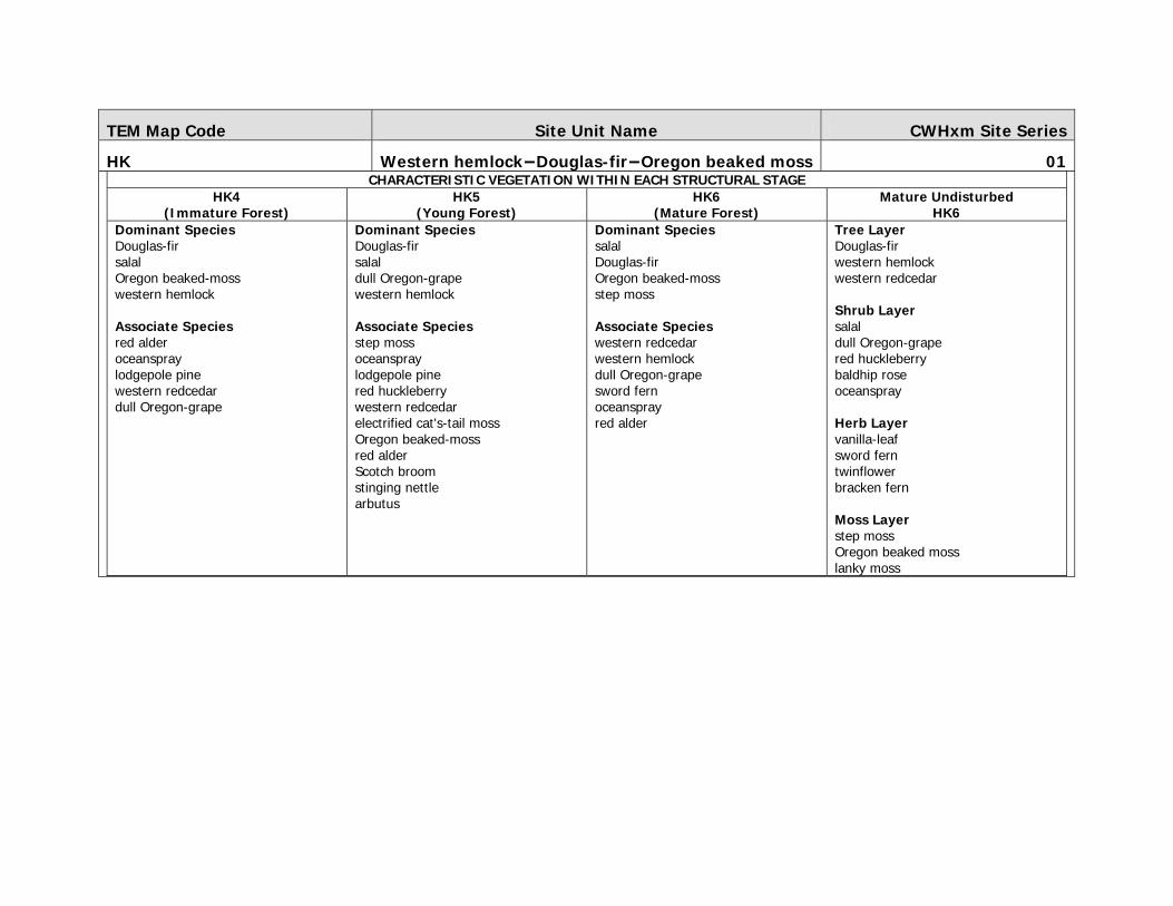
RS Western redcedar—Sword fern 05CHARACTERISTIC VEGETATION WITHIN EACH STRUCTURAL STAGE
RS3 (Shrub/Herb)
Mature Undisturbed RS6
Dominant Species salmonberry Oregon beaked-moss bracken fern red alder dull Oregon-grape salal Scotch broom trailing blackberry western redcedar Himalayan blackberry Associate Species red huckleberry western hemlock
Tree Layer Douglas-fir western hemlock western redcedar red alder Shrub Layer red huckleberry salal dull Oregon-grape baldhip rose oceanspray Herb Layer sword fern vanilla-leaf bracken fern twinflower wall-lettuce sweet-scented bedstraw three-leafed foam flower Moss Layer step moss Oregon beaked moss lanky moss coastal leafy moss

TEM Map Code Site Association CWHxm Site Series
RS Western redcedar—Sword fern 05RShj hummocky; gentle slope RSks cool aspect; shallow soil RSsw shallow soil; warm aspect
RSj gentle slope RSkv cool aspect; very shallow soil RSvw very shallow soil; warm aspect
RSjs gentle slope; shallow soil RSqv very steep cool aspect; very shallow soil RSw warm aspect
RSk cool aspect RSs shallow soil RSwx warm aspect; drier than typical
Atypical Characteristics/Additional Comments: N/A

TEM Map Code Site Association CWHxm Site Series
HD Western hemlock—Western redcedar—Deer fern 06SITE DESCRIPTION SITE CHARACTERISTICS The Western hemlock – Western redcedar – Deer fern site tended to develop on north-facing mid- to lower slopes with
moderately to imperfectly drained Brunisols and Podzols derived from till. Douglas-fir and western hemlock were the
most abundant tree and constant dominant, with lesser amounts of frequent associates western redcedar and grand fir.
Bigleaf maple and red alder were often present in seral stands. Diagnostic species deer fern was infrequent in these
stands. The understorey featured salal, salmonberry, and dull Oregon-grape in the shrub layer, with sword fern, bracken
dominants in the herb layer. Occasionally spiny wood fern and introduced grass species also occurred. The moss layer
was dominated by Oregon beaked moss with lesser amounts of associated species curly heron’s bill moss and knight’s
plume. Coastal leafy moss was common on decaying wood.
Assumed modifiers: d, j, m
Elevation (m) Slope (%) Aspect (°) Surficial material Drainage SMR SNR
250-575 15-45 variable M w-m 5-6 A-C
Plots: JK016, JK017, MT058, QAF005, TTG005, WM037

TEM Map Code Site Association CWHxm Site Series
HD Western hemlock—Western redcedar—Deer fern 06CHARACTERISTIC VEGETATION WITHIN EACH STRUCTURAL STAGE
HD5 (Young Forest)
Mature Undisturbed HD6
Dominant Species Douglas-fir baneberry sweet-cicely Sitka columbine Oregon beaked-moss Columbia brome western hemlock Associate Species bedstraw Nootka rose prickly rose sword fern wild strawberry
Tree Layer Douglas-fir western hemlock western redcedar grand fir red alder Shrub Layer salal red huckleberry false azalea dull Oregon-grape salmonberry Herb Layer deer fern sword fern Moss Layer step moss lanky moss Oregon beaked moss

TEM Map Code Site Association CWHxm Site Series
HD Western hemlock—Western redcedar—Deer fern 06HDh hummocky HDs shallow soil
HDk cool aspect HDsw shallow soil; warm aspect
HDks cool aspect; shallow soil HDw warm aspect
HDkv cool aspect; very shallow soil
Atypical Characteristics/Additional Comments: N/A

TEM Map Code Site Association CWHxm Site Series
RF Western redcedar—Foamflower 07SITE DESCRIPTION SITE CHARACTERISTICS The Western redcedar - Foamflower ecosystems occurred on moisture-receiving toe slopes, some seepage sites, and
level sites with thick relatively rich, moderately well to imperfectly drained soils. Common soil types were Humo-Ferric
Podzols or occasionally Gleysols on level sites grading to gleyed Brunisols derived from till. Humus forms ranged from
moders to mulls. Western redcedar was often associated in the semi-open canopy with constant associates western
hemlock, red alder, grand fir and bigleaf maple; Douglas-fir was infrequent to absent on most sites. Hemlock also was
infrequent in the study area on these site types. Trees on these productive sites tended to be larger their cohorts in
most other site series. Shrubs included dense cover of the dominant species dull Oregon-grape, salmonberry and
thimbleberry. Herbs also occupied a high cover proportion, with ladyfern, spiny wood fern, foamflower, vanilla-leaf, oak
fern, and small-flowered rush typically present in varying amounts on most sites. Step moss, curly heron’s-bill moss,
lanky moss and Oregon-beaked moss was dominant in the bryophyte layer.
Assumed modifiers: d, j, m
Elevation (m) Slope (%) Aspect (°) Surficial material Drainage SMR SNR
120-325 0-35 variable M m 5-6 D-E
Plots: JKG014, TTG008, WM040

TEM Map Code Site Association CWHxm Site Series
RF Western redcedar—Foamflower 07CHARACTERISTIC VEGETATION WITHIN EACH STRUCTURAL STAGE
RF4 (Immature Forest)
RF6 (Mature Forest)
Mature Undisturbed RF6
Dominant Species stinging nettle red alder coastal leafy moss small-flowered bitter-cress Associate Species dovefoot geranium red-stemmed feathermoss arbutus bedstraw bigleaf maple Douglas-fir field chickweed Nootka rose Oregon beaked-moss Pacific bleeding heart Scouler's corydalis sweet-cicely
Dominant Species red alder western hemlock western redcedar step moss curly heron's-bill moss knight's plume lanky moss Oregon beaked-moss salal Associate Species dull Oregon-grape flat-moss stinging nettle
Tree Layer Douglas-fir western hemlock western redcedar grand fir red alder bigleaf maple Shrub Layer dull Oregon-grape red huckleberry salmonberry devil’s club Herb Layer sword fern vanilla-leaf wall-lettuce three-leaved foamflower sweet-scented bedstraw bracken fern lady fern oak fern Moss Layer step moss coastal leafy moss Oregon beaked moss palm tree moss lanky moss

TEM Map Code Site Association CWHxm Site Series
RF Western redcedar—Foamflower 07RFh hummocky
RFk cool aspect
RFs shallow soil
RFw warm aspect
Atypical Characteristics/Additional Comments: N/A

TEM Map Code Site Association CWHxm Site Series
SS Sitka spruce—Salmonberry 08SITE DESCRIPTION SITE CHARACTERISTICS Sitka spruce - Salmonberry high bench site series was infrequently mapped in the study area. Fluvial materials and
landscape position contribute to highly productive, moderately-well drained sites with relatively open canopies (more
open as stands age) Soils were frequently well-developed with moder to mull humus forms. Sitka spruce was not found
in the study area; broadleaf species including black cottonwood, red alder and bigleaf maple were dominant, with
varying amounts of frequent associate western redcedar. Shrubs were highly variable in cover and diversity, with
salmonberry and thimbleberry dominating, and less abundant associates’ ninebark, red-osier dogwood, cascara, red
elderberry, bitter cherry, and Pacific crabapple. Herbs also varied, with relatively low cover compared to shrubs. The
common associate species were vanilla-leaf, ladyfern, sweet-cicely, and false lily-of-the-valley. Season of sampling also
influenced cover and species recorded. Coastal leafy moss was a common colonizer on woody substrate.
Assumed modifiers: d, j, m
Elevation (m) Slope (%) Aspect (°) Surficial material Drainage SMR SNR
150-350 5-35 variable F m 5-6 C-E
Plots: WM040

TEM Map Code Site Association CWHxm Site Series
CW Black cottonwood—Willow 10SITE DESCRIPTION SITE CHARACTERISTICS Low fluvial benches and floodplain sites support the Black cottonwood - Willow site series, featuring deep coarse-
textured gravelly sandy parent material with relatively high coarse fragment content. Soils vary from Non-soil in
recently disturbed locations to gravelly sandy Regosols and Brunisols. This ecosystem type was extremely infrequent
on Saltspring Island. Frequent inundation limits the dominant species to red alder, willows (more often in or adjacent
to inundation zones) and black cottonwood, with associated flood-tolerant shrubs such as salmonberry. Canopy
closure varies with flood regime, terrain, and seral stage. Structural stage 4 supports the densest stands (canopy
closure approximately 50%) with fluvial erosion contributing to stand disturbance. This species association is a
disturbance-maintained disclimax that would support conifer species in the absence of disturbance. Herbs and
mosses are infrequent or absent depending on water table and fluvial characteristics, with blue wildrye most
common associate in less frequently flooded sites. Soils are well drained, but the coarse texture limits productivity on
sandstone-derived soils, and flooding action often precludes development of an organic soil horizon. Erosion is a
typical disturbance agent, leading to a predominance of younger seral stands (structural stages 4-5) in the study
area.
Assumed modifiers: a, c, d, j
Elevation (m) Slope (%) Aspect (°) Surficial material Drainage SMR SNR
150-500 <15 variable FA w - m 5-6 C-D
No photo available Plots: JK136

TEM Map Code Site Association CWHxm Site Series
RC Western redcedar—Sitka spruce—Skunk cabbage 12SITE DESCRIPTION SITE CHARACTERISTICS Western redcedar – Sitka spruce – Skunk cabbage are rich, moist to wet sites which occurred in moisture-receiving
depressions with fine to medium soils, possibly including a minor component of organics. Although Sitka spruce was
not observed on Saltspring Island, western redcedar was a typical dominant with lesser amounts of associated red
alder, bigleaf maple, and grand fir on the margins. Alder abundance decreased with stand age. Sites often had
abundant moderate to large woody debris. Shrubs observed included salmonberry, thimbleberry, and occasionally salal
on hummocks. Species visible in the herb layer were limited by the sampling window, but the most common associate
species were vanilla-leaf, lady fern, deer fern, and skunk cabbage. Bryophytes associated with this site series were
coastal and large leafy moss and slender beaked moss.
Assumed modifiers: d, j, m
Elevation (m) Slope (%) Aspect (°) Surficial material Drainage SMR SNR
120-450 0-10 variable M (0) p 7 C-E
Plots: N/A

TEM Map Code Site Association CWHxm Site Series
RC Western redcedar—Sitka spruce—Skunk cabbage 12RCp peaty material
RCs shallow soil
Atypical Characteristics/Additional Comments: N/A

TEM Map Code Site Association CWHxm Site Series
RB Western redcedar—Salmonberry 13SITE DESCRIPTION SITE CHARACTERISTICS Western redcedar – Salmonberry ecosystems are nutrient medium- to-rich, very moist (winter) to fresh (summer)
sites and were fairly common in hummocky, imperfectly drained, level terrain or moisture receiving toe slopes as
well as in riparian areas. These sites tended to support a mosaic of site series 13 and 07, with the former in hollows
and the latter on raised microsites. Soils were often gleyed or weakly mottled Brunisols (typically Gleyed Eluviated
Dystric Brunisols, similar to CWHxm/12 but with more pronounced mottling), reflecting the seasonally fluctuating
water tables. There were accumulations of fines beneath the organic horizons in depressions. The canopy was open
(5-15%), with western redcedar the dominant tree species growing on elevated hummocks. Dense thickets of
salmonberry were the dominant shrub component, with occasional Douglas maple, thimbleberry, and red elderberry.
Herbs were variable, but few were apparent during sampling (largely in winter). Sword fern grew on hummocks and
bleeding heart and sweet-cicely were also common associates. Bryophytes were sparse to absent except on
decaying wood.
Assumed modifiers: d, j, m
Elevation (m) Slope (%) Aspect (°) Surficial material Drainage SMR SNR
120-450 0-10 variable M i 5 C-D
Plots: N/A

TEM Map Code Site Association CWHxm Site Series
RB Western redcedar—Salmonberry 13RBh hummocky
RBhs hummocky; shallow soil
RBhv hummocky; very shallow soil
RBks cool aspect; shallow soil
RBs shallow soil
Atypical Characteristics/Additional Comments: N/A

TEM Map Code Site Association CWHxm Site Series
RT Western redcedar—Black twinberry 14SITE DESCRIPTION SITE CHARACTERISTICS Western recedar – Black twinberry sites are rich, wet (winter) to moist (summer) sites were infrequent, occurring in
hummocky, imperfectly drained, level terrain or moisture receiving toe slopes and in riparian areas. These sites tended
to support a mosaic of site series 14 and 07 or 12, with the former in hollows and the latter on raised microsites. The
canopy was open to sparse, with western redcedar the dominant tree species growing on elevated hummocks. Shrubs
had fairly high cover, with salmonberry, black twinberry, red elderberry, and willows the most common dominants, and
occasional components of ninebark and Pacific crabapple associated with richer sites. Herbs varied among sites;
foamflower, lady fern, vanilla-leaf, and sword fern were the most frequent. Bryophytes were sparse to absent except on
decaying wood.
Assumed modifiers: d, j, m
Elevation (m) Slope (%) Aspect (°) Surficial material Drainage SMR SNR
200-450 0-15 variable M, O i 6 D-E
Plots: N/A

TEM Map Code Site Association CWHxm Site Series
RT Western redcedar—Black twinberry 14RTs shallow soil
Atypical Characteristics/Additional Comments: N/A

TEM Map Code Site Association CWHxm Site SeriesCS Western redcedar—Slough sedge 15SITE DESCRIPTION SITE CHARACTERISTICS Western redcedar – Slough sedge are swamp forests which occupy poorly drained flat sites to depressions.
Western redcedar and sword fern dominate elevated microsites, while sedges, lady fern, and horsetails occupy
hollows with occasional skunk cabbage where there is limited surface flow. Soils are moderately deep to deep
(>0.5m) with medium texture, typically gleyed, with seasonally fluctuating water tables, even where bedrock
restricts soil depth. Tree species are limited to shade- and moisture-tolerant trees with relatively shallow roots:
western redcedar, grand fir on margins, and black cottonwood with minor amounts of red alder. Shrubs in this site
series are diverse, with Indian-plum, common snowberry, currants/gooseberry, and thimbleberry the most frequent
associates; ninebark, black twinberry, and red-osier dogwood increased in frequency with increased seasonal
flooding. Herbaceous species were variable, with slough sedge commonly dominating the herb layer, and Cooley’s
hedge-nettle in more well-drained and small-flowered rush in more poorly-drained sites also common associates.
Moss tended to occupy little of the substrate, and only Oregon beaked moss was a constant associate; large leafy
moss and coastal leafy moss were occasionally present.
Assumed modifiers: d, j, m
Elevation (m) Slope (%) Aspect (°) Surficial material Drainage SMR SNR
150-450 0-35 variable Ov, M. L m-p 6-7 C-E
Plots: CA008, CA039, MT036

Tem Map Code Site Association CWHxm Site Series
AM Arbutus—Hairy manzanita 00SITE DESCRIPTION SITE CHARACTERISTICS These very xeric Arbutus – Hairy Manzanita sites occurred on ridge crests and water-shedding steep upper slopes
directly on bedrock. Canopies were very open (<5%) with arbutus and occasionally shore pine dominant, rarely
reaching past structural stage 4 with respect to structural development criteria. The shrub layer was dominated by hairy
manzanita, arbutus regeneration, and occasionally Scotch broom. Herbs were typically sparse, but annuals may be
evident in the spring, particularly graminoids, but comprising low (<20%) cover. The substrate was typically dominated
almost completely by curly heron’s-bill moss and, to a lesser extent, and on rock outcrops, foliose lichens.
From plot data for a shrub/herb (structural stage 3) dominated Arbutus – Hairy Manzanita site the dominant vegetation
included sweet vernalgrass, hairy Manzanita, shore pine, curly heron's-bill moss, hoary rock-moss, Douglas-fir, Alaska
oniongrass, grey rock-moss and juniper haircap moss. Associate species included green sorrel and lesser green
reindeer. From plot data for a young forest (structural stage 5) site the dominant vegetation included arbutus, curly
heron's-bill moss, red-stemmed feathermoss, hairy Manzanita, western hemlock, Douglas-fir, Oregon beaked-moss and
salal, with oceanspray as an associate species.
Assumed modifiers: j, r, s
Elevation (m) Slope (%) Aspect (°) Surficial material Drainage SMR SNR
Variable Variable 120-250 R r 1 A
Plots: 4839, ERSK_GR01, WMG006

Tem Map Code Site Association CWHxm Site Series
AM Arbutus—Hairy manzanita 00AMv very shallow soil
AMvw very shallow soil; warm aspect
AMvz very shallow soil; very steep warm aspect
AMw warm aspect
AMz very steep warm aspect
Atypical Characteristics/Additional Comments: N/A

pDistribution of Map Units Containing AM Units

Anthropogenic and Non-Vegetated/Sparsely Vegetated Map Units of the CDFmm
TEM Map Code Site Unit Name Site Series
BE Beach N/ASITE DESCRIPTION SITE CHARACTERISTICS Beach units are characterized by sorted sediments reworked by wave action. All beach units were mapped along the
ocean edge, beach units were not present along fresh water bodies. This unit is typically void of vegetation and consists
of either sand or coarse fragments such as gravels, cobbles and stones, with scattered driftwood, seaweed and various
washed up items along the shoreline.
Elevation (m): Slope (%): Aspect (°): Surficial material: Drainage: SMR: SNR:
0-3 m Variable Variable W n/a n/a n/a
Plots: N/A
TEM Map Code Site Unit Name Site Series
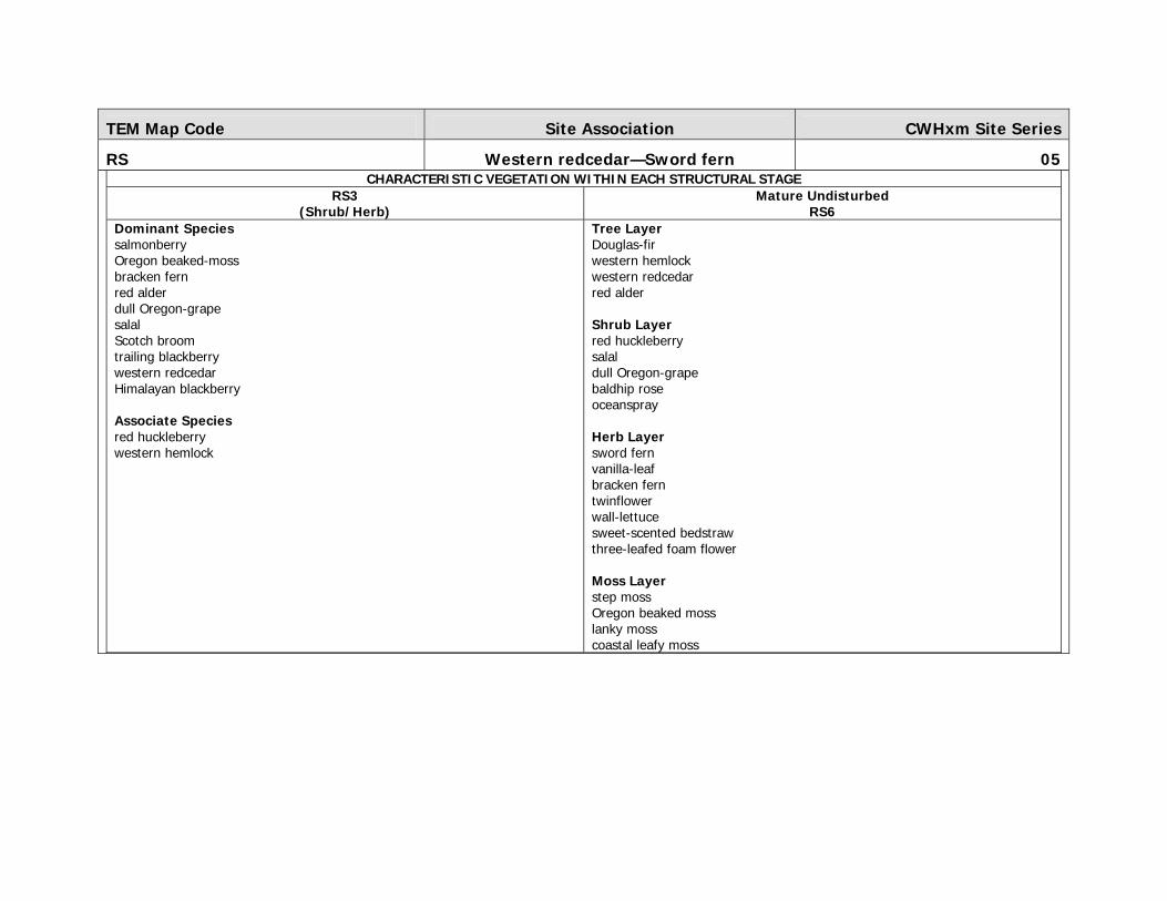
CF Cultivated Field N/ASITE DESCRIPTION SITE CHARACTERISTICS Cultivated fields are non forested, open areas that are subject to agricultural practices including plowing, fertilization,
and non native crop production which often results in long-term soil and vegetation changes. Cultivated fields are
common throughout the CDFmm, and extensive throughout the Cowichan Valley and Central and North Saanich. The
typical structural stage for cultivated fields is 2b, graminoid, infrequently 3. Small islands of forest occur in fields, as do
narrow shrub dominated riparian channels and scattered large trees. Noteworthy are the cultivated fields of Cowichan
and Saanich with scattered Garry oak trees and Garry oak groves. Rural residential is also a very common association
with cultivated fields. Although cultivated fields are typically agriculture based CF was mapped for other green spaces as
well. These included city parks, baseball fields, and residential lawns. This unit was often complexed with Rural (RW)
and Urban (UR) units.
Elevation (m): Slope (%): Aspect (°): Surficial material: Drainage: SMR: SNR:
50-150 <15 Variable WG, W (Ox) i - w 2-6 B-D
Plots: BB_HR_G1, BB_HR_G2, BB_HR_G3, BB_HR_G6, DHV022, GBG044, GBV055,
CHV093, JCV101, JCV060, DHV050, HRV077, HRV209

TEM Map Code Site Unit Name Site Series
CL Cliff N/ASITE DESCRIPTION SITE CHARACTERISTICS Cliffs are steep, vertical or overhanging rock faces. Cliff units are most common along the coast complexed with coastal
bluffs or steep rock controlled gully sidewalls and infrequently along mountain slopes. Cliffs are non-vegetated
ecosystems.
Elevation (m): Slope (%): Aspect (°): Surficial material: Drainage: SMR: SNR:
Variable >130 Variable R n/a n/a n/a
Plots: JCV036

TEM Map Code Site Unit Name Site Series
CO Cultivated Orchard N/ASITE DESCRIPTION SITE CHARACTERISTICS Agricultural areas composed of single or multiple tree species planted in rows. Typically this would include, for example,
apple orchards or mixed species orchards. Old homesteads are common in the CDF and although many of them have
become overgrown, these have been mapped as CO wherever possible. It also includes tree farms such as Christmas
tree farms, or any coniferous tree farm where conifer trees are planted in rows for commercial production.
Elevation (m): Slope (%): Aspect (°): Surficial material: Drainage: SMR: SNR:
Variable <15 Variable n/a n/a n/a n/a
Plots: N/A

TEM Map Code Site Unit Name Site Series
CV Cultivated Vineyard N/ASITE DESCRIPTION SITE CHARACTERISTICS Cultivated vineyards are agricultural areas composed of single or multiple species or grapes planted in rows, usually
supported on wood or wire trellises. Although in the grand scheme of things within the mapping area, cultivated
vineyards are not common, they do occur in the Cowichan Valley and to a less extent in Central Saanich. Wine vineyards
quite often do not occur as a major polygon component, instead they are a minor component complexed with cultivated
fields and rural residential. Occasionally cultivated vineyards have been mapped as pure polygons.
Elevation (m): Slope (%): Aspect (°): Surficial material: Drainage: SMR: SNR:
Variable <15 Variable n/a n/a n/a n/a
No photo available Plots: N/A

TEM Map Code Site Unit Name Site Series
ES Exposed Soil N/ASITE DESCRIPTION SITE CHARACTERISTICS Exposed soil is any area of exposed soil that is devoid of vegetation and is not bedrock but mineral soil. Exposed soil
was most often mapped near rural and urban areas, predominantly disturbance sites associated with new housing
developments. Exposed soil was also mapped for pull-outs along forestry roads and to a lesser extent along steep side
slopes. For example steep side slopes composed of glaciomarine sediments, were mapped as exposed soil. Due to
surface erosion, vegetation was not present.
Elevation (m): Slope (%): Aspect (°): Surficial material: Drainage: SMR: SNR:
Variable Variable Variable FG, WG, A n/a n/a n/a
Plots: CHV108, CHV166, HRV106, JCV160

TEM Map Code Site Unit Name Site Series
GB Gravel Bar N/ASITE DESCRIPTION SITE CHARACTERISTICS Gravel bars typically occur along active river channels. Gravel bars are non-vegetated and characterized by a dynamic
consortium of well rounded cobbles, pebbles, stones and sand. Notable rivers with gravel bars include Englishman River,
Chemainus River, Cowichan River and Koksilah River.
Elevation (m): Slope (%): Aspect (°): Surficial material: Drainage: SMR: SNR:
Variable <15 Variable n/a n/a n/a n/a
Plots: N/A

TEM Map Code Site Unit Name Site Series
GC Golf Course N/ASITE DESCRIPTION SITE CHARACTERISTICS Golf courses are a common feature particularly along southeastern Vancouver Island - a favorite pastime of island
dwellers. Golf courses are characterized by flat to gently rolling grass-covered throughways and open areas for playing
golf. The fairways are typically separated by isolated rows or patches of trees and ponds. More often than not, forested
areas were too small to identify to site series and were mapped as GC with a structural stage 5 or 6. Although golf
courses have altered the native landscape and vegetation communities to a large extent, scattered trees that remain are
noteworthy. For example, scattered trees found in golf courses of the Victoria area were large diameter and of
significant height and age whereas other golf course were dotted with healthy specimens of Parkland Garry Oak and
arbutus.
Elevation (m): Slope (%): Aspect (°): Surficial material: Drainage: SMR: SNR:
Variable <15 Variable WG n/a n/a n/a
No photo available Plots: JCV069, HRV113, HRV215

TEM Map Code Site Unit Name Site Series
GP Gravel Pit N/ASITE DESCRIPTION SITE CHARACTERISTICS Gravel pits are areas of exposed soil through the commercial removal of sand and gravel.
Elevation (m): Slope (%): Aspect (°): Surficial material: Drainage: SMR: SNR:
Variable Variable Variable WG, FG, A n/a n/a n/a
No photo available Plots: CAG029, CHV072, JCV062, HRV034, HRV059

TEM Map Code Site Unit Name Site Series
IN Industrial N/ASITE DESCRIPTION SITE CHARACTERISTICS Industrial sites were added as an anthropogenic unit due to the requirement to address sites that were dominated by
industrial development namely, pulp and paper, lumber mills, oil/gas refineries and so on. These units are characterized
by a high degree of ground disturbance; concrete parking lots, large commercial buildings, work yards and other
specialized industry infrastructure.
Elevation (m): Slope (%): Aspect (°): Surficial material: Drainage: SMR: SNR:
Variable Variable Variable n/a n/a n/a n/a
No photo available Plots: N/A

TEM Map Code Site Unit Name Site Series
LA Lake N/ASITE DESCRIPTION SITE CHARACTERISTICS A lake is a naturally occurring body of water, greater than 2 m deep. Several lakes occur within the mapping area such
as Elk, Beaver, Prospect, Cowichan, Quamichan, Somenos, Long and Brannen Lake to name a few.
Elevation (m): Slope (%): Aspect (°): Surficial material: Drainage: SMR: SNR:
Variable 0 999 n/a n/a n/a n/a
Plots: N/A

TEM Map Code Site Unit Name Site Series
MI Mine N/ASITE DESCRIPTION SITE CHARACTERISTICS Mine sites are un-vegetated areas used for the purpose of extracting mineral ore or other materials. Mine sites were
mapped in the study area, some of which were limestone quarries.
Elevation (m): Slope (%): Aspect (°): Surficial material: Drainage: SMR: SNR:
Variable Variable Variable A n/a n/a n/a
Plots: JCV023

TEM Map Code Site Unit Name Site Series
MU Mudflat Sediment N/ASITE DESCRIPTION SITE CHARACTERISTICS Mudflat sediment is a flat plain-like area dominated by fine textured sediments. These areas were mapped at the
interface of salt and fresh water, namely active channel sediment located at the mouth of a creek as they drain into
saltwater bays.
Elevation (m): Slope (%): Aspect (°): Surficial material: Drainage: SMR: SNR:
Variable Variable Variable n/a n/a n/a n/a
No photo available Plots: N/A

TEM Map Code Site Unit Name Site Series
OW Shallow Open Water N/ASITE DESCRIPTION SITE CHARACTERISTICS Shallow open water is a wetland class composed of permanent, shallow (less than 2 m at midsummer levels), standing
water that has less than 10% surface cover of emergent vegetation (plants rooted in the bottom). Open water with
more than 10% surface cover of emergent vegetation are classified as marsh wetlands. Open water is typically a minor
polygon component in association with other non-forested wetlands such as marsh ecosystems (e.g. Wm05 & Wm06)
and swamp forests (Cw-Skunk cabbage (11) and Cw-Slough sedge (14)).
Elevation (m): Slope (%): Aspect (°): Surficial material: Drainage: SMR: SNR:
Variable 0 999 n/a n/a n/a n/a
Plots: DHV013, DHV039

TEM Map Code Site Unit Name Site Series
PD Pond N/ASITE DESCRIPTION SITE CHARACTERISTICS Ponds are small bodies of water greater than 2 m deep yet smaller than lakes (less than 50 ha). Ponds are scattered
across the landscape and were often surprisingly difficult to distinguish between natural ponds and man-made
impoundments. Man-made impoundments were typically mapped as reservoirs however berms & dykes were often not
readily visible and left some doubt as to their origin. Ponds are a common feature throughout the rural residential areas
and in association with cultivated fields.
Elevation (m): Slope (%): Aspect (°): Surficial material: Drainage: SMR: SNR:
Variable 0 999 n/a n/a n/a n/a
No photo available Plots: N/A

TEM Map Code Site Unit Name Site Series
RE Reservoir N/ASITE DESCRIPTION SITE CHARACTERISTICS A reservoir is an artificial basin created by the impoundment of water behind a human-made structure such as a dam,
berm, dyke, or wall. As noted above, reservoirs were often difficult to distinguish from ponds. Reservoirs most
commonly occur throughout cultivated fields and rural residential areas.
Elevation (m): Slope (%): Aspect (°): Surficial material: Drainage: SMR: SNR:
Variable 0 999 n/a n/a n/a n/a
No photo available Plots: N/A

TEM Map Code Site Unit Name Site Series
RI River N/ASITE DESCRIPTION SITE CHARACTERISTICS A river is a natural stream of water, usually freshwater, flowing toward the ocean, a lake, or another stream. In some
cases a river flows into the ground or dries up completely before reaching another body of water. The water in a river is
usually confined to a channel, made up of a stream bed between banks. Notable rivers include Englishman River,
Chemainus River, Cowichan River and Koksilah River.
Elevation (m): Slope (%): Aspect (°): Surficial material: Drainage: SMR: SNR:
Variable Variable Variable n/a n/a n/a n/a
Plots: N/A
TEM Map Code Site Unit Name Site Series
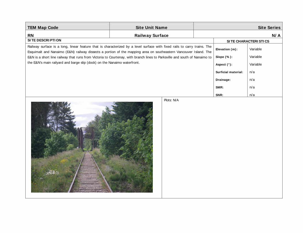
RN Railway Surface N/ASITE DESCRIPTION SITE CHARACTERISTICS Railway surface is a long, linear feature that is characterized by a level surface with fixed rails to carry trains. The
Esquimalt and Nanaimo (E&N) railway dissects a portion of the mapping area on southeastern Vancouver Island. The E&N is a short line railway that runs from Victoria to Courtenay, with branch lines to Parksville and south of Nanaimo to
the E&N's main railyard and barge slip (dock) on the Nanaimo waterfront.
Elevation (m): Slope (%): Aspect (°): Surficial material: Drainage: SMR: SNR:
Variable Variable Variable n/a n/a n/a n/a
Plots: N/A

TEM Map Code Site Unit Name Site Series
RO Rock Outcrop N/ASITE DESCRIPTION SITE CHARACTERISTICS Rock outcrops are bedrock outcroppings with little soil development and sparse vegetation cover. Rock outcrops can be
steep such as the one in the photo below or gentle such as those found along ridges. Often rock outcrops are associated
with dry 02 sites or QB and SC units. Most importantly SEI units classified as coastal bluffs were mapped as rock
outcrops with aspect modifiers. These coastal rock outcrops begin at the waters edge and are exposed to salt spray and
high winds.
Elevation (m): Slope (%): Aspect (°): Surficial material: Drainage: SMR: SNR:
Variable Variable Variable R (Mvx) x-r n/a n/a
Plots: CORV003, JCV086, JCV251, CHV261, JCG004, JCV008, JCV012, CXV034
TEM Map Code Site Unit Name Site Series
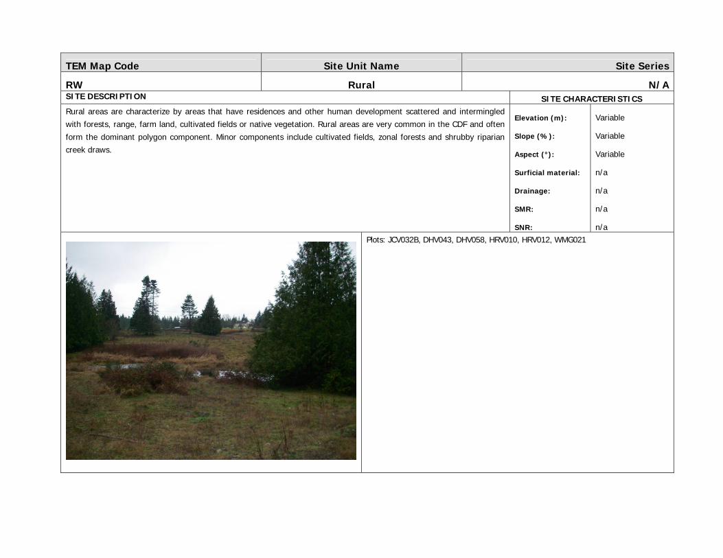
RW Rural N/ASITE DESCRIPTION SITE CHARACTERISTICS Rural areas are characterize by areas that have residences and other human development scattered and intermingled
with forests, range, farm land, cultivated fields or native vegetation. Rural areas are very common in the CDF and often
form the dominant polygon component. Minor components include cultivated fields, zonal forests and shrubby riparian
creek draws.
Elevation (m): Slope (%): Aspect (°): Surficial material: Drainage: SMR: SNR:
Variable Variable Variable n/a n/a n/a n/a
Plots: JCV032B, DHV043, DHV058, HRV010, HRV012, WMG021

TEM Map Code Site Unit Name Site Series
RZ Road Surface N/ASITE DESCRIPTION SITE CHARACTERISTICS Road surfaces are defined as areas cleared and compacted for the use of vehicles. Road surfaces are linear features that
cross the landscape and occur in varying degrees. From small farms roads, to gravel forestry roads, to two-lane
residential paved roads & highways and to main thoroughfares such as the Island highway (Hwy 1 & 19) with a
significant portion being four-lanes. The Island highway was for the most part, pulled out and mapped as its own long,
narrow and continuous corridor. Other, lesser roads were not.
Elevation (m): Slope (%): Aspect (°): Surficial material: Drainage: SMR: SNR:
Variable Variable Variable n/a n/a n/a n/a
Plots: CHV098

TEM Map Code Site Unit Name Site Series
TA Talus N/ASITE DESCRIPTION SITE CHARACTERISTICS Talus is angular, colluvial rock fragments that have accumulated at the foot of steep rock slopes. Talus ecosystems are
not a common feature of the CDFmm.
Elevation (m): Slope (%): Aspect (°): Surficial material: Drainage: SMR: SNR:
Variable Variable Variable C n/a n/a n/a
Plots: N/A

TEM Map Code Site Unit Name Site Series
TZ Mine Tailings N/ASITE DESCRIPTION SITE CHARACTERISTICS Mine tailings are solid waste materials directly produced and deposited during the mining and milling of ore bodies. Mine
tailings are not common however did occur on occasion.
For example, near Ladysmith there is an old site where coal was hauled in, then exported out. There is a thick layer of
coal debris underneath with disturbed shrub vegetation.
Elevation (m): Slope (%): Aspect (°): Surficial material: Drainage: SMR: SNR:
Variable Variable Variable n/a n/a n/a n/a
No photo available Plots: N/A

TEM Map Code Site Unit Name Site Series
UR Urban N/ASITE DESCRIPTION SITE CHARACTERISTICS Urban units are characterized by an almost continuous covering over the landscape by residences and human
development. The greater Victoria area is the most significant urban area mapped. Given the extensive cover of
concrete and altered landscape, bioterrain labels were intended to reflect this by labeling urban polygons Anthroprogenic
(A). Whereby the landform is man-modified and drainage is no longer applicable. Other urban areas occurred in Duncan,
Crofton, Ladysmith, Nanaimo, Parksville, Qualicum and Powell River for example. Urban units most often formed pure
polygons however sometimes patches of forest are present as a minor component (10%). For example the QB unit was
most often found to occur in urban areas of Victoria and Saanich while the DS unit more often occurred as a minor
component with urban centers up island.
Elevation (m): Slope (%): Aspect (°): Surficial material: Drainage: SMR: SNR:
Variable Variable Variable n/a n/a n/a n/a
Plots: JCV031, HRV137