Radar-Rainfall Estimation from S-band Radar and its Impact ...

Activities to Improve WSR-88DRadar Rainfall Estimation in the
National Weather Service
Richard Fulton
Hydrology LaboratoryOffice of Hydrologic Development
National Weather ServiceSilver Spring, Maryland
2nd Federal Interagency Hydrologic Modeling ConferenceJuly 29, 2002
Las Vegas, Nevada

Outline
POverview of operational NWS quantitativeprecipitation estimation (QPE) algorithmsand products
PNear-term (0-2 yrs) scientific enhancements
PLong-term (3+ yrs) QPE science frontiers

Quantitative Precipitation Estimationin the National Weather Service
Multisensor Approach to Optimally CombineInformation from Multiple Sensors
WSR-88D Radar
Rain Gauges
Satellite

160 NWS WSR-88D Doppler Radars
UCAR/NCAR/RAP
230 km

Quantitative Precipitation Estimationin the NWS
A Blend of Automated & Interactive Procedures

Quantitative Precipitation Estimationin the NWS
Multistep, Integrated Sequential Processingfrom Local to Regional to National Levels
P Local: Weather Forecast Offices (WFO)
< Precipitation Processing System (PPS)
PRegional: River Forecast Centers (RFC)
< Multisensor Precipitation Estimator (MPE)
PNational: National Center for Environmental Prediction (NCEP)
< Stage IV Precipitation Processing

PPSgeneratesgraphical16-levelimage
productsfor each
radar site
1-hr, 3-hr,storm-total, &user-definedaccumulation
periods

PPS’s Hourly Digital PrecipitationArray (DPA) Product
! Rectilinear 4-km national polar stereographic grid ! 256 rainfall data levels
! Used in follow-on quantitative rainfall applications (MPE)

MultisensorPrecipitationEstimator(MPE)generatesone-hourregionalradar + raingauge +satelliterainfallaccumulationmosaics

Tropical Storm Allison
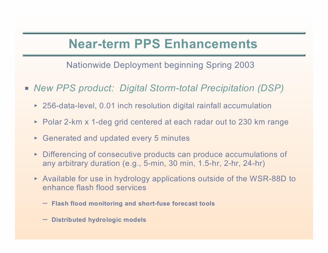
Near-term PPS Enhancements
Nationwide Deployment beginning Spring 2003
P New PPS product: Digital Storm-total Precipitation (DSP)
< 256-data-level, 0.01 inch resolution digital rainfall accumulation
< Polar 2-km x 1-deg grid centered at each radar out to 230 km range
< Generated and updated every 5 minutes
< Differencing of consecutive products can produce accumulations ofany arbitrary duration (e.g., 5-min, 30 min, 1.5-hr, 2-hr, 24-hr)
< Available for use in hydrology applications outside of the WSR-88D toenhance flash flood services
– Flash flood monitoring and short-fuse forecast tools
– Distributed hydrologic models

Range Correction Algorithm (RCA)
Field Deployment in Fall 2003
POne of the largest error sources for radar rainfall estimationis range-dependent bias due to vertical reflectivity gradients,including bright band
PSystematic underestimation biases...
< Generally increase with range
< Are greatest for stratiform rain events
< Are greatest in cool seasons
< Are greatest in northern latitudes
< Are small for summer convection
PRCA will generate range- & elevation-dependent rainratecorrection factors updated every 5 minutes and used toadjust PPS rainfall products
Convective
Stratiform Bright Band
Vertical Reflectivity Profiles
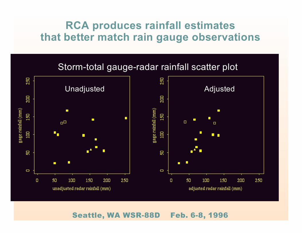
Storm-total gauge-radar rainfall scatter plot
Unadjusted Adjusted
RCA produces rainfall estimatesthat better match rain gauge observations
Seattle, WA WSR-88D Feb. 6-8, 1996

Multisensor Precipitation Estimator (MPE)Enhancements
P Incorporate satellite QPEs into MPE< Using optimal estimation, regression, or neural network
multisensor merging techniques
PDeliver MPE to Weather Forecast Offices andenhance it to serve their flash flood monitoringneeds< First version: Hourly 4-km regionally-mosaicked multisensor
products (same as current RFC capability)
< Future version: Shorter accumulation periods and update times(minutes) and higher spatial resolution (1 km)

Major NWS QPE-relatedScience Frontiers For Next 5-10 Years
P Probabilistic/Ensemble QPE algorithms< To provide uncertainty information to aid water managers in cost-benefit
decision making
P Polarimetric QPE algorithms< Future dual-polarized NWS radars (~2007) will provide improved rainfall
estimates
P Use of other observed meteorological data (soundings, surfaceobservations, lightning) and atmospheric model analysis fields toimprove QPE analyses (e.g., rain vs snow, freezing level ident.)
P Snowfall estimation algorithms (depth and liquid water equivalent)
P Higher spatial and temporal resolution QPE products to bettersupport the NWS flash flood warning program


![Narayan Shrestha [Radar based rainfall estimation for river catchment modelling]](https://static.fdocuments.in/doc/165x107/554a3921b4c90582328b49a3/narayan-shrestha-radar-based-rainfall-estimation-for-river-catchment-modelling.jpg)