Active surface deformation and sub-lithospheric processes ... · 1989; Seber et al., 1996; Calvert...
4
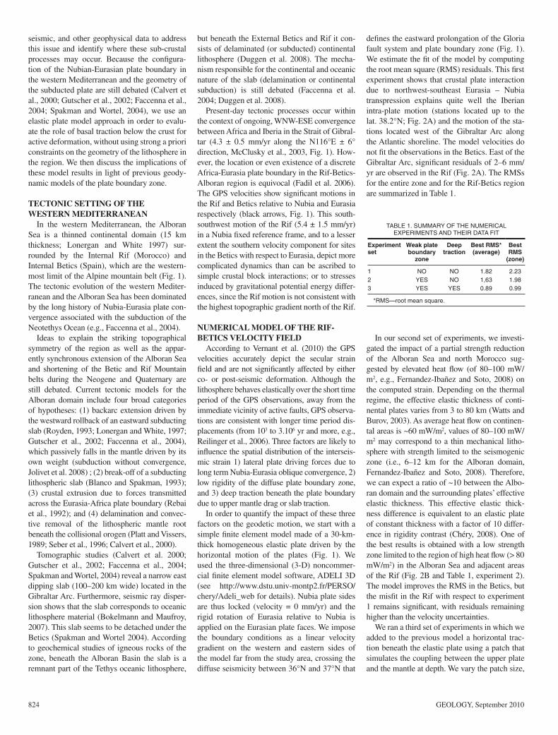
823 INTRODUCTION Deformations around transpressive plate boundaries are thought to be due to the mechan- ical interaction of plates (i.e., elastic strain and associated faulting, e.g Savage and Burford, 1973), sub-crustal processes (e.g., subduction and slab rollback, mantle delamination, Roy- den,1993), and/or stresses induced by gravita- tional potential energy differences (e.g., England and McKenzie 1982). South-southwest–ori- ented crustal motions in the western Mediter- ranean (Fig; 1; Vernant et al., 2010) appear to be incompatible with simple plates interaction as they involve motion normal to the direction of Nubia-Eurasia relative motion in a region dominated by strike-slip and extensional tecton- ics (for further discussion see Fadil et al., 2006 and Vernant et al., 2010), or to gravitational potential energy differences as motion of the Rif Mountains is directed away from the low- lying, thinner lithosphere of the Alboran Sea. Although the importance of subduction related processes for the tectonic evolution of the west- ern Mediterranean has been discussed (e.g., Royden, 1993; Lonergan and White 1997; Fac- cenna et al. 2004; Spakman and Wortel 2004), the rather localized, present-day motions of the Betic–Alboran Sea–Rif domain have not been subject to quantitative modeling studies. Here, we use numerical models constrained by global positioning system (GPS) observations and Geology, September 2010; v. 38; no. 9; p. 823–826; doi: 10.1130/G30963.1; 3 figures; 1 table. © 2010 Geological Society of America. For permission to copy, contact Copyright Permissions, GSA, or [email protected]. Active surface deformation and sub-lithospheric processes in the western Mediterranean constrained by numerical models Eugénie Pérouse 1 , Philippe Vernant 1 , Jean Chéry 1 , Robert Reilinger 2 , and Simon McClusky 2 1 Laboratoire Géosciences Montpellier CNRS (Centre National de la Recherche Scientifique)-Université Montpellier 2, 34095 Montpellier, France 2 Department of Earth, Atmospheric, and Planetary Sciences, Massachusetts Institute of Technology, Cambridge, Massachusetts 02139, USA ABSTRACT We present the results of dynamic modeling of the western Mediterranean that accounts for observed global positioning system (GPS) surface deformation of the Alboran Sea and sur- rounding Rif and Betic Mountains as the result of the combined effects of relative motion of the Eurasian and Nubian plates, low strength in the Alboran Sea region and sub-lithospheric processes occurring beneath the External Rif domain. Assuming that the lithosphere behaves elastically over the short time period of the GPS observations, an elastic plate model is con- sidered in our study, including an area of weak lithosphere (factor of 10) centered on the Alboran Sea and in which lateral boundary conditions consist of the Nubia-Eurasia oblique convergence. Sub-crustal processes are modeled by application of a horizontal traction on a small area (patch) at the base of the elastic plate. Our modeling studies demonstrate the need for sub-crustal or sub-lithospheric, southwestward-directed forcing to account for observed southwestward motion of the Rif and Betic domains. Based on the location, orientation, and small area of the traction patch, we hypothesize that forcing is associated with delamination and rollback of the subducted African continental lithospheric mantle beneath the External Rif zone, due to the pull of the oceanic part of the Western Mediterranean slab, a dynamic process that may be similar to that where the over-riding plate is driven toward the subduc- tion zone during slab rollback. 350° E 352°E 354°E 356°E 358°E 0° 30°N 32°N 34°N 36°N 38°N 40°N Alb EURASIAN PLATE 4 mm/yr 0 30 60 90 120 660 Depth (km) Betics PLATE Observed velocities Boundary conditions of the model Mw Internal zone External zone AH eq NUBIAN Rif Major thrust faults 4 5 6 Spain Med. sea Mo Figure 1. Global positioning system velocities (Vernant et al. 2010) in Nubia fixed reference frame and 95% confidence ellipses. Gray ar- rows indicate velocities consistent with Iberia or Nubia plate motion; black arrows indicate velocities inconsistent with either Iberia or Nu- bia. Colored circles depict earthquakes with Mw > 3.5 (National Earthquake Information Center–U.S. Geological Survey, 1973–2009; http://earthquake.usgs.gov/regional/neic/). Major geological structures are simplified from Jolivet et. al (2008) and Zitellini et al. (2009); red fault—Boussekkour fault; AH eq—M = 6 Al Hoceima earthquake of 1994 (from www.globalcmt.org); Alb—Alboran Sea. Boundary conditions of the elastic plate model are shown in red. Inset: Tectonic sketch of the western Mediterranean. Black box outlines study area; Mo—Morocco; Med. sea—Mediterranean sea; hachured areas— Alpine orogenic belts.
Transcript of Active surface deformation and sub-lithospheric processes ... · 1989; Seber et al., 1996; Calvert...

GEOLOGY, September 2010 823
INTRODUCTIONDeformations around transpressive plate
boundaries are thought to be due to the mechan-ical interaction of plates (i.e., elastic strain and associated faulting, e.g Savage and Burford, 1973), sub-crustal processes (e.g., subduction and slab rollback, mantle delamination, Roy-den,1993), and/or stresses induced by gravita-tional potential energy differences (e.g., England and McKenzie 1982). South-southwest–ori-ented crustal motions in the western Mediter-ranean (Fig; 1; Vernant et al., 2010) appear to be incompatible with simple plates interaction as they involve motion normal to the direction of Nubia-Eurasia relative motion in a region dominated by strike-slip and extensional tecton-ics (for further discussion see Fadil et al., 2006 and Vernant et al., 2010), or to gravitational potential energy differences as motion of the Rif Mountains is directed away from the low-lying, thinner lithosphere of the Alboran Sea. Although the importance of subduction related processes for the tectonic evolution of the west-ern Mediterranean has been discussed (e.g., Royden, 1993; Lonergan and White 1997; Fac-cenna et al. 2004; Spakman and Wortel 2004), the rather localized, present-day motions of the Betic–Alboran Sea–Rif domain have not been subject to quantitative modeling studies. Here, we use numerical models constrained by global positioning system (GPS) observations and
Geology, September 2010; v. 38; no. 9; p. 823–826; doi: 10.1130/G30963.1; 3 fi gures; 1 table.© 2010 Geological Society of America. For permission to copy, contact Copyright Permissions, GSA, or [email protected].
Active surface deformation and sub-lithospheric processes in the western Mediterranean constrained by numerical modelsEugénie Pérouse1, Philippe Vernant1, Jean Chéry1, Robert Reilinger2, and Simon McClusky2
1 Laboratoire Géosciences Montpellier CNRS (Centre National de la Recherche Scientifi que)-Université Montpellier 2, 34095 Montpellier, France
2 Department of Earth, Atmospheric, and Planetary Sciences, Massachusetts Institute of Technology, Cambridge, Massachusetts 02139, USA
ABSTRACTWe present the results of dynamic modeling of the western Mediterranean that accounts for
observed global positioning system (GPS) surface deformation of the Alboran Sea and sur-rounding Rif and Betic Mountains as the result of the combined effects of relative motion of the Eurasian and Nubian plates, low strength in the Alboran Sea region and sub-lithospheric processes occurring beneath the External Rif domain. Assuming that the lithosphere behaves elastically over the short time period of the GPS observations, an elastic plate model is con-sidered in our study, including an area of weak lithosphere (factor of 10) centered on the Alboran Sea and in which lateral boundary conditions consist of the Nubia-Eurasia oblique convergence. Sub-crustal processes are modeled by application of a horizontal traction on a small area (patch) at the base of the elastic plate. Our modeling studies demonstrate the need for sub-crustal or sub-lithospheric, southwestward-directed forcing to account for observed southwestward motion of the Rif and Betic domains. Based on the location, orientation, and small area of the traction patch, we hypothesize that forcing is associated with delamination and rollback of the subducted African continental lithospheric mantle beneath the External Rif zone, due to the pull of the oceanic part of the Western Mediterranean slab, a dynamic process that may be similar to that where the over-riding plate is driven toward the subduc-tion zone during slab rollback.
350° E 352°E 354°E 356°E 358°E 0°
30°N
32°N
34°N
36°N
38°N
40°N
Alb
EURASIAN PLATE
4 mm/yr
0 30 60 90 120 660
Depth (km)
Betics
PLATE Observedvelocities
Boundary conditionsof the model
MwInternal zone
External zone
AH eq
NUBIAN
Rif
Major thrustfaults
4 5 6Spain
Med. sea
Mo
Figure 1. Global positioning system velocities (Vernant et al. 2010) in Nubia fi xed reference frame and 95% confi dence ellipses. Gray ar-rows indicate velocities consistent with Iberia or Nubia plate motion; black arrows indicate velocities inconsistent with either Iberia or Nu-bia. Colored circles depict earthquakes with Mw > 3.5 (National Earthquake Information Center–U.S. Geological Survey, 1973–2009; http://earthquake.usgs.gov/regional/neic/). Major geological structures are simplifi ed from Jolivet et. al (2008) and Zitellini et al. (2009); red fault—Boussekkour fault; AH eq—M = 6 Al Hoceima earthquake of 1994 (from www.globalcmt.org); Alb—Alboran Sea. Boundary conditions of the elastic plate model are shown in red. Inset: Tectonic sketch of the western Mediterranean. Black box outlines study area; Mo—Morocco; Med. sea—Mediterranean sea; hachured areas—Alpine orogenic belts.
824 GEOLOGY, September 2010
seismic, and other geophysical data to address this issue and identify where these sub-crustal processes may occur. Because the confi gura-tion of the Nubian-Eurasian plate boundary in the western Mediterranean and the geometry of the subducted plate are still debated (Calvert et al., 2000; Gutscher et al., 2002; Faccenna et al., 2004; Spakman and Wortel, 2004), we use an elastic plate model approach in order to evalu-ate the role of basal traction below the crust for active deformation, without using strong a priori constraints on the geometry of the lithosphere in the region. We then discuss the implications of these model results in light of previous geody-namic models of the plate boundary zone.
TECTONIC SETTING OF THE WESTERN MEDITERRANEAN
In the western Mediterranean, the Alboran Sea is a thinned continental domain (15 km thickness; Lonergan and White 1997) sur-rounded by the Internal Rif (Morocco) and Internal Betics (Spain), which are the western-most limit of the Alpine mountain belt (Fig. 1). The tectonic evolution of the western Mediter-ranean and the Alboran Sea has been dominated by the long history of Nubia-Eurasia plate con-vergence associated with the subduction of the Neotethys Ocean (e.g., Faccenna et al., 2004).
Ideas to explain the striking topographical symmetry of the region as well as the appar-ently synchronous extension of the Alboran Sea and shortening of the Betic and Rif Mountain belts during the Neogene and Quaternary are still debated. Current tectonic models for the Alboran domain include four broad categories of hypotheses: (1) backarc extension driven by the westward rollback of an eastward subducting slab (Royden, 1993; Lonergan and White, 1997; Gutscher et al., 2002; Faccenna et al., 2004), which passively falls in the mantle driven by its own weight (subduction without convergence, Jolivet et al. 2008) ; (2) break-off of a subducting lithospheric slab (Blanco and Spakman, 1993); (3) crustal extrusion due to forces transmitted across the Eurasia-Africa plate boundary (Rebai et al., 1992); and (4) delamination and convec-tive removal of the lithospheric mantle root beneath the collisional orogen (Platt and Vissers, 1989; Seber et al., 1996; Calvert et al., 2000).
Tomographic studies (Calvert et al. 2000; Gutscher et al., 2002; Faccenna et al., 2004; Spakman and Wortel, 2004) reveal a narrow east dipping slab (100–200 km wide) located in the Gibraltar Arc. Furthermore, seismic ray disper-sion shows that the slab corresponds to oceanic lithosphere material (Bokelmann and Maufroy, 2007). This slab seems to be detached under the Betics (Spakman and Wortel 2004). According to geochemical studies of igneous rocks of the zone, beneath the Alboran Basin the slab is a remnant part of the Tethys oceanic lithosphere,
but beneath the External Betics and Rif it con-sists of delaminated (or subducted) continental lithosphere (Duggen et al. 2008). The mecha-nism responsible for the continental and oceanic nature of the slab (delamination or continental subduction) is still debated (Faccenna et al. 2004; Duggen et al. 2008).
Present-day tectonic processes occur within the context of ongoing, WNW-ESE convergence between Africa and Iberia in the Strait of Gibral-tar (4.3 ± 0.5 mm/yr along the N116°E ± 6° direction, McClusky et al., 2003, Fig. 1). How-ever, the location or even existence of a discrete Africa-Eurasia plate boundary in the Rif-Betics-Alboran region is equivocal (Fadil et al. 2006). The GPS velocities show signifi cant motions in the Rif and Betics relative to Nubia and Eurasia respectively (black arrows, Fig. 1). This south-southwest motion of the Rif (5.4 ± 1.5 mm/yr) in a Nubia fi xed reference frame, and to a lesser extent the southern velocity component for sites in the Betics with respect to Eurasia, depict more complicated dynamics than can be ascribed to simple crustal block interactions; or to stresses induced by gravitational potential energy differ-ences, since the Rif motion is not consistent with the highest topographic gradient north of the Rif.
NUMERICAL MODEL OF THE RIF-BETICS VELOCITY FIELD
According to Vernant et al. (2010) the GPS velocities accurately depict the secular strain fi eld and are not signifi cantly affected by either co- or post-seismic deformation. Although the lithosphere behaves elastically over the short time period of the GPS observations, away from the immediate vicinity of active faults, GPS observa-tions are consistent with longer time period dis-placements (from 103 to 3.106 yr and more, e.g., Reilinger et al., 2006). Three factors are likely to infl uence the spatial distribution of the interseis-mic strain 1) lateral plate driving forces due to long term Nubia-Eurasia oblique convergence, 2) low rigidity of the diffuse plate boundary zone, and 3) deep traction beneath the plate boundary due to upper mantle drag or slab traction.
In order to quantify the impact of these three factors on the geodetic motion, we start with a simple fi nite element model made of a 30-km-thick homogeneous elastic plate driven by the horizontal motion of the plates (Fig. 1). We used the three-dimensional (3-D) noncommer-cial fi nite element model software, ADELI 3D (see http://www.dstu.univ-montp2.fr/PERSO/chery/Adeli_web for details). Nubia plate sides are thus locked (velocity = 0 mm/yr) and the rigid rotation of Eurasia relative to Nubia is applied on the Eurasian plate faces. We impose the boundary conditions as a linear velocity gradient on the western and eastern sides of the model far from the study area, crossing the diffuse seismicity between 36°N and 37°N that
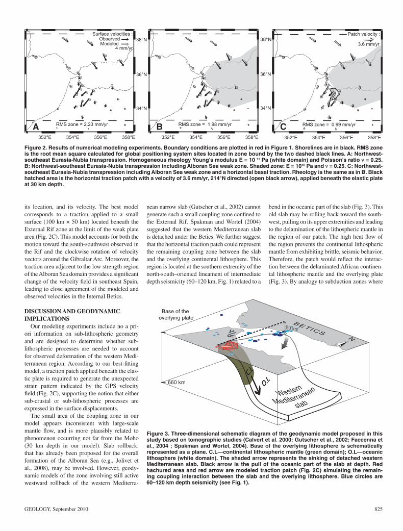
defi nes the eastward prolongation of the Gloria fault system and plate boundary zone (Fig. 1). We estimate the fi t of the model by computing the root mean square (RMS) residuals. This fi rst experiment shows that crustal plate interaction due to northwest-southeast Eurasia – Nubia transpression explains quite well the Iberian intra-plate motion (stations located up to the lat. 38.2°N; Fig. 2A) and the motion of the sta-tions located west of the Gibraltar Arc along the Atlantic shoreline. The model velocities do not fi t the observations in the Betics. East of the Gibraltar Arc, signifi cant residuals of 2–6 mm/yr are observed in the Rif (Fig. 2A). The RMSs for the entire zone and for the Rif-Betics region are summarized in Table 1.
In our second set of experiments, we investi-gated the impact of a partial strength reduction of the Alboran Sea and north Morocco sug-gested by elevated heat fl ow (of 80–100 mW/m2, e.g., Fernandez-Ibañez and Soto, 2008) on the computed strain. Depending on the thermal regime, the effective elastic thickness of conti-nental plates varies from 3 to 80 km (Watts and Burov, 2003). As average heat fl ow on continen-tal areas is ~60 mW/m2, values of 80–100 mW/m2 may correspond to a thin mechanical litho-sphere with strength limited to the seismogenic zone (i.e., 6–12 km for the Alboran domain, Fernandez-Ibañez and Soto, 2008). Therefore, we can expect a ratio of ~10 between the Albo-ran domain and the surrounding plates’ effective elastic thickness. This effective elastic thick-ness difference is equivalent to an elastic plate of constant thickness with a factor of 10 differ-ence in rigidity contrast (Chéry, 2008). One of the best results is obtained with a low strength zone limited to the region of high heat fl ow (> 80 mW/m2) in the Alboran Sea and adjacent areas of the Rif (Fig. 2B and Table 1, experiment 2). The model improves the RMS in the Betics, but the misfi t in the Rif with respect to experiment 1 remains signifi cant, with residuals remaining higher than the velocity uncertainties.
We ran a third set of experiments in which we added to the previous model a horizontal trac-tion beneath the elastic plate using a patch that simulates the coupling between the upper plate and the mantle at depth. We vary the patch size,
TABLE 1. SUMMARY OF THE NUMERICAL EXPERIMENTS AND THEIR DATA FIT
Experiment set
Weak plate boundary
zone
Deep traction
Best RMS*(average)
Best RMS
(zone)
1 NO NO 1.82 2.232 YES NO 1,63 1.983 YES YES 0.89 0.99
*RMS—root mean square.
GEOLOGY, September 2010 825
its location, and its velocity. The best model corresponds to a traction applied to a small surface (100 km ! 50 km) located beneath the External Rif zone at the limit of the weak plate area (Fig. 2C). This model accounts for both the motion toward the south-southwest observed in the Rif and the clockwise rotation of velocity vectors around the Gibraltar Arc. Moreover, the traction area adjacent to the low strength region of the Alboran Sea domain provides a signifi cant change of the velocity fi eld in southeast Spain, leading to close agreement of the modeled and observed velocities in the Internal Betics.
DISCUSSION AND GEODYNAMIC IMPLICATIONS
Our modeling experiments include no a pri-ori information on sub-lithospheric geometry and are designed to determine whether sub-lithospheric processes are needed to account for observed deformation of the western Medi-terranean region. According to our best-fi tting model, a traction patch applied beneath the elas-tic plate is required to generate the unexpected strain pattern indicated by the GPS velocity fi eld (Fig. 2C), supporting the notion that either sub-crustal or sub-lithospheric processes are expressed in the surface displacements.
The small area of the coupling zone in our model appears inconsistent with large-scale mantle fl ow, and is more plausibly related to phenomenon occurring not far from the Moho (30 km depth in our model). Slab rollback, that has already been proposed for the overall formation of the Alboran Sea (e.g., Jolivet et al., 2008), may be involved. However, geody-namic models of the zone involving still active westward rollback of the western Mediterra-
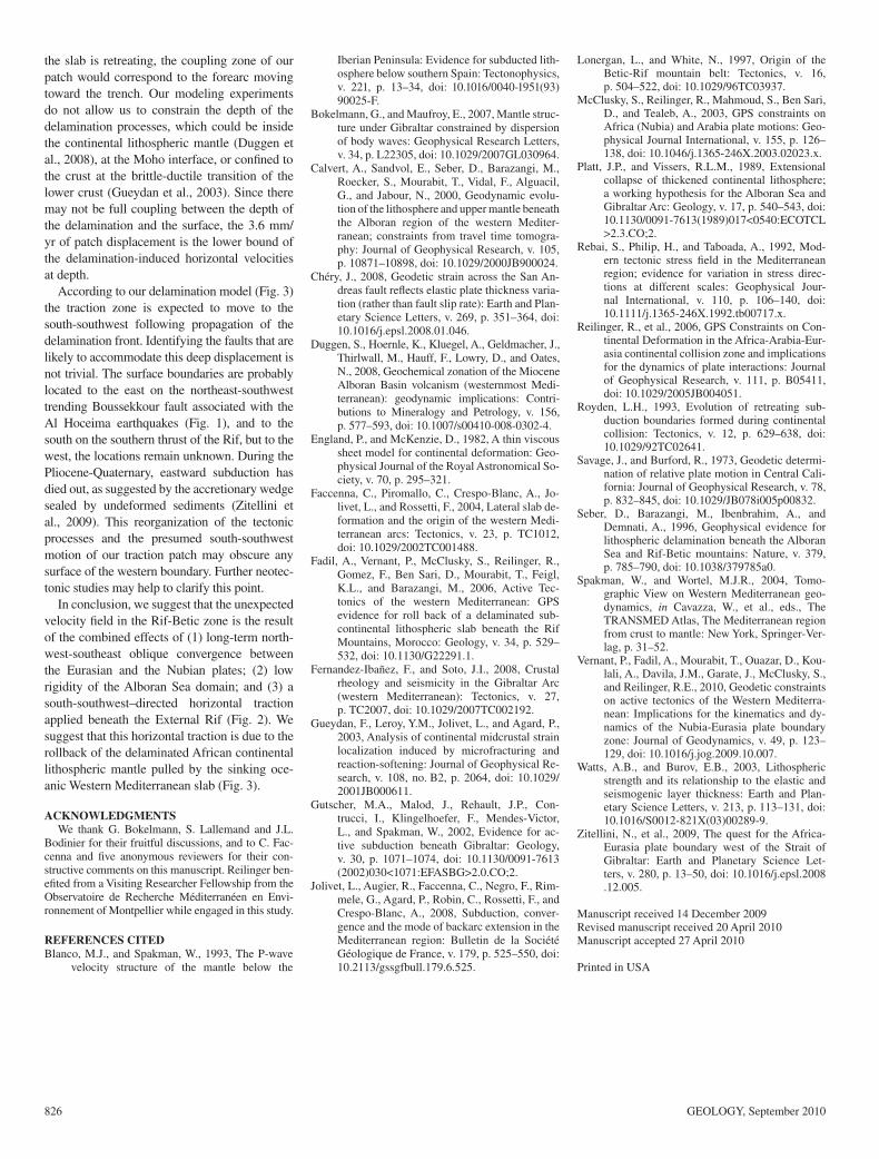
nean narrow slab (Gutscher et al., 2002) cannot generate such a small coupling zone confi ned to the External Rif. Spakman and Wortel (2004) suggested that the western Mediterranean slab is detached under the Betics. We further suggest that the horizontal traction patch could represent the remaining coupling zone between the slab and the overlying continental lithosphere. This region is located at the southern extremity of the north-south–oriented lineament of intermediate depth seismicity (60–120 km, Fig. 1) related to a
bend in the oceanic part of the slab (Fig. 3). This old slab may be rolling back toward the south-west, pulling on its upper extremities and leading to the delamination of the lithospheric mantle in the region of our patch. The high heat fl ow of the region prevents the continental lithospheric mantle from exhibiting brittle, seismic behavior. Therefore, the patch would refl ect the interac-tion between the delaminated African continen-tal lithospheric mantle and the overlying plate (Fig. 3). By analogy to subduction zones where
34°N
36°N
38°N
RMS zone = 1.98 mm/yr
352°E 354°E 356°E 358°E
RMS zone = 2.23 mm/yr
4 mm/yrModeledObserved
Surface velocities :
354°E 356°E 358°E
A B C352°E
34°N
36°N
38°N3.6 mm/yr
RMS zone = 0.99 mm/yr
Patch velocity :
352°E 354°E 356°E 358°E
660 km
Base of the overlying plate
Figure 3. Three-dimensional schematic diagram of the geodynamic model proposed in this study based on tomographic studies (Calvert et al. 2000; Gutscher et al., 2002; Faccenna et al., 2004 ; Spakman and Wortel, 2004). Base of the overlying lithosphere is schematically represented as a plane. C.L—continental lithospheric mantle (green domain); O.L—oceanic lithosphere (white domain). The shaded arrow represents the sinking of detached western Mediterranean slab. Black arrow is the pull of the oceanic part of the slab at depth. Red hachured area and red arrow are modeled traction patch (Fig. 2C) simulating the remain-ing coupling interaction between the slab and the overlying lithosphere. Blue circles are 60–120 km depth seismicity (see Fig. 1).
Figure 2. Results of numerical modeling experiments. Boundary conditions are plotted in red in Figure 1. Shorelines are in black. RMS zone is the root mean square calculated for global positioning system sites located in zone bound by the two dashed black lines. A: Northwest-southeast Eurasia-Nubia transpression. Homogeneous rheology Young’s modulus E = 10 11 Pa (white domain) and Poisson’s ratio ! = 0.25. B: Northwest-southeast Eurasia-Nubia transpression including Alboran Sea weak zone. Shaded zone: E = 1010 Pa and ! = 0.25. C: Northwest-southeast Eurasia-Nubia transpression including Alboran Sea weak zone and a horizontal basal traction. Rheology is the same as in B. Black hatched area is the horizontal traction patch with a velocity of 3.6 mm/yr, 214°N directed (open black arrow), applied beneath the elastic plate at 30 km depth.
826 GEOLOGY, September 2010
the slab is retreating, the coupling zone of our patch would correspond to the forearc moving toward the trench. Our modeling experiments do not allow us to constrain the depth of the delamination processes, which could be inside the continental lithospheric mantle (Duggen et al., 2008), at the Moho interface, or confi ned to the crust at the brittle-ductile transition of the lower crust (Gueydan et al., 2003). Since there may not be full coupling between the depth of the delamination and the surface, the 3.6 mm/yr of patch displacement is the lower bound of the delamination-induced horizontal velocities at depth.
According to our delamination model (Fig. 3) the traction zone is expected to move to the south-southwest following propagation of the delamination front. Identifying the faults that are likely to accommodate this deep displacement is not trivial. The surface boundaries are probably located to the east on the northeast-southwest trending Boussekkour fault associated with the Al Hoceima earthquakes (Fig. 1), and to the south on the southern thrust of the Rif, but to the west, the locations remain unknown. During the Pliocene-Quaternary, eastward subduction has died out, as suggested by the accretionary wedge sealed by undeformed sediments (Zitellini et al., 2009). This reorganization of the tectonic processes and the presumed south-southwest motion of our traction patch may obscure any surface of the western boundary. Further neotec-tonic studies may help to clarify this point.
In conclusion, we suggest that the unexpected velocity fi eld in the Rif-Betic zone is the result of the combined effects of (1) long-term north-west-southeast oblique convergence between the Eurasian and the Nubian plates; (2) low rigidity of the Alboran Sea domain; and (3) a south-southwest–directed horizontal traction applied beneath the External Rif (Fig. 2). We suggest that this horizontal traction is due to the rollback of the delaminated African continental lithospheric mantle pulled by the sinking oce-anic Western Mediterranean slab (Fig. 3).
ACKNOWLEDGMENTSWe thank G. Bokelmann, S. Lallemand and J.L.
Bodinier for their fruitful discussions, and to C. Fac-cenna and fi ve anonymous reviewers for their con-structive comments on this manuscript. Reilinger ben-efi ted from a Visiting Researcher Fellowship from the Observatoire de Recherche Méditerranéen en Envi-ronnement of Montpellier while engaged in this study.
REFERENCES CITEDBlanco, M.J., and Spakman, W., 1993, The P-wave
velocity structure of the mantle below the
Iberian Peninsula: Evidence for subducted lith-osphere below southern Spain: Tectonophysics, v. 221, p. 13–34, doi: 10.1016/0040-1951(93)90025-F.
Bokelmann, G., and Maufroy, E., 2007, Mantle struc-ture under Gibraltar constrained by dispersion of body waves: Geophysical Research Letters, v. 34, p. L22305, doi: 10.1029/2007GL030964.
Calvert, A., Sandvol, E., Seber, D., Barazangi, M., Roecker, S., Mourabit, T., Vidal, F., Alguacil, G., and Jabour, N., 2000, Geodynamic evolu-tion of the lithosphere and upper mantle beneath the Alboran region of the western Mediter-ranean; constraints from travel time tomogra-phy: Journal of Geophysical Research, v. 105, p. 10871–10898, doi: 10.1029/2000JB900024.
Chéry, J., 2008, Geodetic strain across the San An-dreas fault refl ects elastic plate thickness varia-tion (rather than fault slip rate): Earth and Plan-etary Science Letters, v. 269, p. 351–364, doi: 10.1016/j.epsl.2008.01.046.
Duggen, S., Hoernle, K., Kluegel, A., Geldmacher, J., Thirlwall, M., Hauff, F., Lowry, D., and Oates, N., 2008, Geochemical zonation of the Miocene Alboran Basin volcanism (westernmost Medi-terranean): geodynamic implications: Contri-butions to Mineralogy and Petrology, v. 156, p. 577–593, doi: 10.1007/s00410-008-0302-4.
England, P., and McKenzie, D., 1982, A thin viscous sheet model for continental deformation: Geo-physical Journal of the Royal Astronomical So-ciety, v. 70, p. 295–321.
Faccenna, C., Piromallo, C., Crespo-Blanc, A., Jo-livet, L., and Rossetti, F., 2004, Lateral slab de-formation and the origin of the western Medi-terranean arcs: Tectonics, v. 23, p. TC1012, doi: 10.1029/2002TC001488.
Fadil, A., Vernant, P., McClusky, S., Reilinger, R., Gomez, F., Ben Sari, D., Mourabit, T., Feigl, K.L., and Barazangi, M., 2006, Active Tec-tonics of the western Mediterranean: GPS evidence for roll back of a delaminated sub-continental lithospheric slab beneath the Rif Mountains, Morocco: Geology, v. 34, p. 529–532, doi: 10.1130/G22291.1.
Fernandez-Ibañez, F., and Soto, J.I., 2008, Crustal rheology and seismicity in the Gibraltar Arc (western Mediterranean): Tectonics, v. 27, p. TC2007, doi: 10.1029/2007TC002192.
Gueydan, F., Leroy, Y.M., Jolivet, L., and Agard, P., 2003, Analysis of continental midcrustal strain localization induced by microfracturing and reaction-softening: Journal of Geophysical Re-search, v. 108, no. B2, p. 2064, doi: 10.1029/2001JB000611.
Gutscher, M.A., Malod, J., Rehault, J.P., Con-trucci, I., Klingelhoefer, F., Mendes-Victor, L., and Spakman, W., 2002, Evidence for ac-tive subduction beneath Gibraltar: Geology, v. 30, p. 1071–1074, doi: 10.1130/0091-7613(2002)030<1071:EFASBG>2.0.CO;2.
Jolivet, L., Augier, R., Faccenna, C., Negro, F., Rim-mele, G., Agard, P., Robin, C., Rossetti, F., and Crespo-Blanc, A., 2008, Subduction, conver-gence and the mode of backarc extension in the Mediterranean region: Bulletin de la Société Géologique de France, v. 179, p. 525–550, doi: 10.2113/gssgfbull.179.6.525.
Lonergan, L., and White, N., 1997, Origin of the Betic-Rif mountain belt: Tectonics, v. 16, p. 504–522, doi: 10.1029/96TC03937.
McClusky, S., Reilinger, R., Mahmoud, S., Ben Sari, D., and Tealeb, A., 2003, GPS constraints on Africa (Nubia) and Arabia plate motions: Geo-physical Journal International, v. 155, p. 126–138, doi: 10.1046/j.1365-246X.2003.02023.x.
Platt, J.P., and Vissers, R.L.M., 1989, Extensional collapse of thickened continental lithosphere; a working hypothesis for the Alboran Sea and Gibraltar Arc: Geology, v. 17, p. 540–543, doi: 10.1130/0091-7613(1989)017<0540:ECOTCL>2.3.CO;2.
Rebai, S., Philip, H., and Taboada, A., 1992, Mod-ern tectonic stress fi eld in the Mediterranean region; evidence for variation in stress direc-tions at different scales: Geophysical Jour-nal International, v. 110, p. 106–140, doi: 10.1111/j.1365-246X.1992.tb00717.x.
Reilinger, R., et al., 2006, GPS Constraints on Con-tinental Deformation in the Africa-Arabia-Eur-asia continental collision zone and implications for the dynamics of plate interactions: Journal of Geophysical Research, v. 111, p. B05411, doi: 10.1029/2005JB004051.
Royden, L.H., 1993, Evolution of retreating sub-duction boundaries formed during continental collision: Tectonics, v. 12, p. 629–638, doi: 10.1029/92TC02641.
Savage, J., and Burford, R., 1973, Geodetic determi-nation of relative plate motion in Central Cali-fornia: Journal of Geophysical Research, v. 78, p. 832–845, doi: 10.1029/JB078i005p00832.
Seber, D., Barazangi, M., Ibenbrahim, A., and Demnati, A., 1996, Geophysical evidence for lithospheric delamination beneath the Alboran Sea and Rif-Betic mountains: Nature, v. 379, p. 785–790, doi: 10.1038/379785a0.
Spakman, W., and Wortel, M.J.R., 2004, Tomo-graphic View on Western Mediterranean geo-dynamics, in Cavazza, W., et al., eds., The TRANSMED Atlas, The Mediterranean region from crust to mantle: New York, Springer-Ver-lag, p. 31–52.
Vernant, P., Fadil, A., Mourabit, T., Ouazar, D., Kou-lali, A., Davila, J.M., Garate, J., McClusky, S., and Reilinger, R.E., 2010, Geodetic constraints on active tectonics of the Western Mediterra-nean: Implications for the kinematics and dy-namics of the Nubia-Eurasia plate boundary zone: Journal of Geodynamics, v. 49, p. 123–129, doi: 10.1016/j.jog.2009.10.007.
Watts, A.B., and Burov, E.B., 2003, Lithospheric strength and its relationship to the elastic and seismogenic layer thickness: Earth and Plan-etary Science Letters, v. 213, p. 113–131, doi: 10.1016/S0012-821X(03)00289-9.
Zitellini, N., et al., 2009, The quest for the Africa-Eurasia plate boundary west of the Strait of Gibraltar: Earth and Planetary Science Let-ters, v. 280, p. 13–50, doi: 10.1016/j.epsl.2008.12.005.
Manuscript received 14 December 2009Revised manuscript received 20 April 2010Manuscript accepted 27 April 2010
Printed in USA