Active Incident Resource Summary · National Interagency Coordination Center Incident Management...
13
National Interagency Coordination Center Incident Management Situation Report Sunday, July 15, 2018 – 0530 MT National Preparedness Level 3 National Fire Activity Initial Attack Activity: Light (148) new fires New large incidents: 7 Large fires contained: 3 Uncontained large fires:** 35 Area Command teams committed: 0 NIMOs committed: 0 Type 1 IMTs committed: 2 Type 2 IMTs committed: 4 Nationally, there are 21 large fires being managed under a strategy other than full suppression. **Uncontained large fires include only fires being managed under a full suppression strategy. Link to Geographic Area daily reports. On July 14th a firefighter with CAL FIRE Madera-Mariposa-Merced Unit was fatally injured while assigned to the Ferguson fire on the Sierra National Forest. The firefighting community extends condolences to the friends and family of the deceased. Active Incident Resource Summary GACC Incidents Cumulative Acres Crews Engines Helicopters Total Personnel AICC 2 2,809 5 0 0 122 NWCC 8 7,818 16 85 6 734 ONCC 9 132,096 53 139 16 2,247 OSCC 7 6,566 21 42 7 857 NRCC 0 0 0 0 0 0 GBCC 15 556,525 34 76 23 1,620 SWCC 9 25,418 8 21 2 306 RMCC 13 275,039 33 111 18 1,911 EACC 1 526 2 16 2 177 SACC 5 12,185 0 6 0 20 Total 69 1,018,983 172 496 74 7,994 Rocky Mountain Area (PL 3) New fires: 15 New large incidents: 0 Uncontained large fires: 6 Type 2 IMTs committed: 2
Transcript of Active Incident Resource Summary · National Interagency Coordination Center Incident Management...

National Interagency Coordination Center
Incident Management Situation Report
Sunday, July 15, 2018 – 0530 MT
National Preparedness Level 3
National Fire Activity
Initial Attack Activity: Light (148) new fires New large incidents: 7 Large fires contained: 3 Uncontained large fires:** 35 Area Command teams committed: 0 NIMOs committed: 0 Type 1 IMTs committed: 2 Type 2 IMTs committed: 4
Nationally, there are 21 large fires being managed under a strategy other than full suppression.
**Uncontained large fires include only fires being managed under a full suppression strategy.
Link to Geographic Area daily reports.
On July 14th a firefighter with CAL FIRE Madera-Mariposa-Merced Unit was fatally injured while assigned to the Ferguson fire on the Sierra National Forest. The firefighting community extends condolences to the friends and family of the deceased.
Active Incident Resource Summary
GACC Incidents Cumulative
Acres Crews Engines Helicopters
Total Personnel
AICC 2 2,809 5 0 0 122
NWCC 8 7,818 16 85 6 734
ONCC 9 132,096 53 139 16 2,247
OSCC 7 6,566 21 42 7 857
NRCC 0 0 0 0 0 0
GBCC 15 556,525 34 76 23 1,620
SWCC 9 25,418 8 21 2 306
RMCC 13 275,039 33 111 18 1,911
EACC 1 526 2 16 2 177
SACC 5 12,185 0 6 0 20
Total 69 1,018,983 172 496 74 7,994
Rocky Mountain Area (PL 3)
New fires: 15 New large incidents: 0
Uncontained large fires: 6
Type 2 IMTs committed: 2

Lake Christine, Eagle County. Transfer of command from IMT 2 (Almas) back to the local unit will occur
tomorrow. One mile northwest of Basalt, CO. Timber and brush. Moderate fire behavior with isolated torching,
creeping and smoldering. Energy and communication infrastructure threatened. Road, area and trail closures
in effect.
Spring Creek, Costilla County. Transfer of command from IMT 2 (Esperance) back to the local unit will occur
tomorrow. Nine miles northeast of Fort Garland, CO. Timber, brush and tall grass. Minimal fire behavior.
Numerous residences and communications infrastructure threatened. Area and trail closures in effect.
Precipitation occurred over the fire area yesterday.
Weston Pass, Pike-San Isabel NF. Nine miles southwest of Fairplay, CO. Timber and brush. Minimal fire
behavior. Numerous residences threatened. Road, area and trail closures in effect.
Badger Creek, Medicine Bow-Routt NF. Two miles northwest of Mountain Home, WY. Timber and brush.
Minimal fire behavior. Numerous structures threatened. Area and trail closures in effect.
416, San Juan NF. Thirteen miles north of Durango, CO. Timber and brush. Minimal fire behavior. Road, area
and trail closures in effect.
Burro, San Juan NF. Fourteen miles south of Rico, CO. Timber. Minimal fire behavior. Road, area and trail
closures in effect. Precipitation occurred over the fire area yesterday.
Incident Name
Unit
Size
% Ctn/
Comp Est
Personnel Resources Strc Lost
$$ CTD
Origin Own Acres Chge Total Chge Crw Eng Heli
Lake Christine
CO-EAX 6,778 85 57 Ctn 7/31 279 -55 4 11 3 3 6.3M CNTY
Spring Creek CO-CTX 108,045 0 91 Ctn 7/31 594 -245 10 33 2 225 30.4M CNTY
Weston Pass CO-PSF 13,023 0 93 Ctn 7/29 272 0 4 8 2 1 96M FS
Badger Creek WY-MRF 21,310 0 90 Ctn 7/17 159 -1 2 17 2 3 10.2M FS
416 CO-SJF 54,129 0 50 Ctn 7/31 29 0 0 0 2 0 31.3M FS
Burro CO-SJF 4,593 0 90 Ctn 8/1 11 0 2 0 0 1 3.3M FS
Fawn CO-WRD 1,119 0 100 Ctn --- 177 -15 3 5 4 0 746K BLM
Large Fires Being Managed With a Strategy Other Than Full Suppression Without a Type 1 or 2 IMT Assigned
Tabeguache CO-GMF 497 --- 90 Comp 7/15 16 --- 0 2 0 0 362K FS
Sugarloaf CO-ARF 1,280 0 35 Comp 8/31 37 -49 0 1 2 0 560K FS
ARF – Arapaho-Roosevelt NF GMF – Grand Mesa, Uncompahgre and Gunnison NF
WRD – White River District Office, BLM
Great Basin Area (PL 3)
New fires: 23
New large incidents: 1
Uncontained large fires: 8
Type 1 IMTs committed: 1
Type 2 IMTs committed: 1
Dollar Ridge, Northeast Area, Utah DOF. Transfer of command from IMT 1 (DeMasters) to IMT 2 (Bird) will
occur tomorrow. Thirty-six miles southeast of Heber, UT. Timber, brush and tall grass. Moderate fire behavior
with isolated torching, creeping and smoldering. Numerous residences. Evacuations, road, area and trail
closures in effect. Precipitation occurred over the fire area yesterday.

* Lodgepole, Boise NF. Sixteen miles northeast of Garden Valley, ID. Timber, brush and tall grass. Active fire
behavior with torching, flanking and creeping. Structures threatened.
Martin, Humboldt County. Four miles northeast of Paradise Valley, NV. Brush and grass. Minimal fire
behavior.
Trail Mountain, Manti-La Sal NF. Fifteen miles northwest of Orangeville, UT. Timber and brush. Minimal fire
behavior. Road, area and trail closures in effect. Precipitation occurred over the fire area yesterday.
West Valley, Dixie NF. Ten miles north of St. George, UT. Timber, chaparral and brush. Minimal fire behavior.
Road, area and trail closures in effect. Precipitation occurred over the fire area yesterday.
Deer Creek, Northeast Area, Utah DOF. Ten miles southwest of Heber City, UT. Brush, chaparral, and tall
grass. Minimal fire behavior. Structures threatened.
Patterson Pass, Salt Lake Field Office, BLM. Thirty-two miles north of Wendover, UT. Brush and grass.
Moderate fire behavior.
Hogan, Elko District Office, BLM. Twenty-five miles southeast of Wells, NV. Timber, brush and short grass.
Minimal fire behavior.
Incident Name
Unit
Size
% Ctn/
Comp Est
Personnel Resources Strc Lost
$$ CTD
Origin Own Acres Chge Total Chge Crw Eng Heli
Dollar Ridge UT-NES 56,732 6 65 Ctn 7/25 721 -29 16 34 10 438 13.6M ST
* Lodgepole ID-BOF 1,600 --- 0 Ctn 10/1 135 --- 4 2 3 0 800K FS
Martin NV-HUMX 435,569 0 95 Ctn 7/18 277 -51 2 15 2 1 9.2M CNTY
Trail Mountain
UT-MLF 18,311 0 90 Ctn 8/1 68 0 1 4 1 4 14.5M FS
West Valley UT-DIF 11,771 0 85 Ctn 7/27 36 -6 0 1 2 1 8.3M FS
Deer Creek UT-NES 381 0 56 Ctn UNK 20 -10 1 0 0 0 200K ST
Patterson Pass
UT-SLD 651 0 95 Ctn UNK 133 0 4 4 3 0 450K BLM
Hogan NV-EKD 10,882 0 90 Ctn 7/18 12 0 0 0 1 5 2.6M BLM
Large Fires Being Managed With a Strategy Other Than Full Suppression Without a Type 1 or 2 IMT Assigned
Willow Creek
UT-UWF 1,311 --- 96 Comp 10/11 2 --- 0 0 0 0 835K FS
UWF – Uinta/Wasatch-Cache NF
Northern California Area (PL 3)
New fires: 17 New large incidents: 1 Uncontained large fires: 3 Type 1 IMTs committed: 1
Klamathon, Siskiyou Unit, Cal Fire. Transfer of command from Cal Fire IMT 1 (Derum) back to local unit will
occur tomorrow. Two miles southeast of Hornbrook, CA. Timber, chaparral, and tall grass. Minimal fire
behavior. Evacuations have been lifted. Trail closures in effect.
* Eagle, Northern California District, BLM. Fifteen miles south of Cedarville, CA. Active fire behavior with group
torching and uphill runs. Residences and sage-grouse habitat threatened.
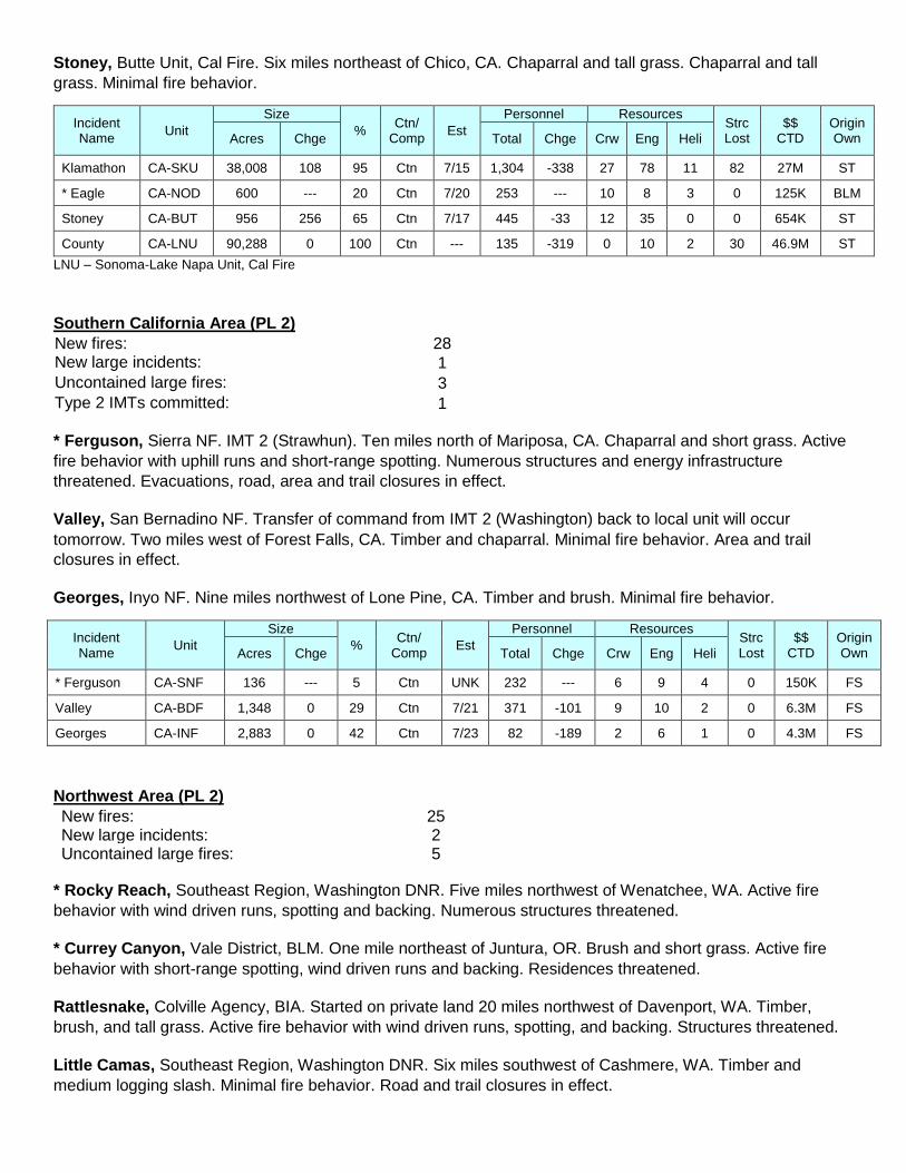
Stoney, Butte Unit, Cal Fire. Six miles northeast of Chico, CA. Chaparral and tall grass. Chaparral and tall
grass. Minimal fire behavior.
Incident Name
Unit
Size
% Ctn/
Comp Est
Personnel Resources Strc Lost
$$ CTD
Origin Own Acres Chge Total Chge Crw Eng Heli
Klamathon CA-SKU 38,008 108 95 Ctn 7/15 1,304 -338 27 78 11 82 27M ST
* Eagle CA-NOD 600 --- 20 Ctn 7/20 253 --- 10 8 3 0 125K BLM
Stoney CA-BUT 956 256 65 Ctn 7/17 445 -33 12 35 0 0 654K ST
County CA-LNU 90,288 0 100 Ctn --- 135 -319 0 10 2 30 46.9M ST
LNU – Sonoma-Lake Napa Unit, Cal Fire
Southern California Area (PL 2)
New fires: 28 New large incidents: 1
Uncontained large fires: 3
Type 2 IMTs committed: 1
* Ferguson, Sierra NF. IMT 2 (Strawhun). Ten miles north of Mariposa, CA. Chaparral and short grass. Active
fire behavior with uphill runs and short-range spotting. Numerous structures and energy infrastructure
threatened. Evacuations, road, area and trail closures in effect.
Valley, San Bernadino NF. Transfer of command from IMT 2 (Washington) back to local unit will occur
tomorrow. Two miles west of Forest Falls, CA. Timber and chaparral. Minimal fire behavior. Area and trail
closures in effect.
Georges, Inyo NF. Nine miles northwest of Lone Pine, CA. Timber and brush. Minimal fire behavior.
Incident Name
Unit
Size
% Ctn/
Comp Est
Personnel Resources Strc Lost
$$ CTD
Origin Own Acres Chge Total Chge Crw Eng Heli
* Ferguson CA-SNF 136 --- 5 Ctn UNK 232 --- 6 9 4 0 150K FS
Valley CA-BDF 1,348 0 29 Ctn 7/21 371 -101 9 10 2 0 6.3M FS
Georges CA-INF 2,883 0 42 Ctn 7/23 82 -189 2 6 1 0 4.3M FS
Northwest Area (PL 2)
New fires: 25 New large incidents: 2 Uncontained large fires: 5
* Rocky Reach, Southeast Region, Washington DNR. Five miles northwest of Wenatchee, WA. Active fire
behavior with wind driven runs, spotting and backing. Numerous structures threatened.
* Currey Canyon, Vale District, BLM. One mile northeast of Juntura, OR. Brush and short grass. Active fire
behavior with short-range spotting, wind driven runs and backing. Residences threatened.
Rattlesnake, Colville Agency, BIA. Started on private land 20 miles northwest of Davenport, WA. Timber,
brush, and tall grass. Active fire behavior with wind driven runs, spotting, and backing. Structures threatened.
Little Camas, Southeast Region, Washington DNR. Six miles southwest of Cashmere, WA. Timber and
medium logging slash. Minimal fire behavior. Road and trail closures in effect.

Solitude, Prineville District Office, BLM. Five miles west of Spray, OR. Timber, brush and tall grass. Minimal
fire behavior. Structures threatened.
Incident Name
Unit
Size
% Ctn/
Comp Est
Personnel Resources Strc Lost
$$ CTD
Origin Own Acres Chge Total Chge Crw Eng Heli
* Rocky Reach
WA-SES 400 --- 10 Ctn 7/19 147 --- 4 15 0 0 200K ST
* Currey Canyon
OR-VAD 1,500 --- 0 Ctn 7/20 98 --- 1 19 3 0 125K BLM
Rattlesnake WA-COA 2,295 2,095 49 Ctn 7/19 206 131 5 18 2 0 350K PRI
Little Camas WA-SES 317 0 97 Ctn 7/20 59 -50 1 7 0 0 3.6M ST
Solitude OR-PRD 708 0 90 Ctn 7/20 52 -10 2 2 0 0 600K BLM
Large Fires Being Managed With a Strategy Other Than Full Suppression Without a Type 1 or 2 IMT Assigned
Weber Canyon
WA-SPD 544 -206 100 Comp --- 0 -66 0 0 0 0 155K BLM
SPD – Spokane District, BLM
Southwest Area (PL 2)
New fires: 25
New large incidents: 1
Uncontained large fires: 6
* Mohave, Colorado River District, BLM. Eight miles south of Ehrenberg, AZ. Timber and brush. Extreme fire
behavior with torching, running and backing. Road and area closure in effect.
Morris Creek, Cimarron District, New Mexico State Forestry. Fifteen miles west of Miami, NM. Timber and
brush. Minimal fire behavior with backing, creeping and smoldering. Trail closure in effect. Precipitation
occurred over the fire area yesterday.
Emily, Las Vegas District, New Mexico State Forestry. Twenty-five miles north of Las Vegas, NM. Timber and
brush. Minimal fire behavior. Structures and communications infrastructure threatened. Precipitation occurred
over the fire area yesterday.
Owl, Gila NF. Twelve miles west of Reserve, NM. Timber and grass. No new information.
Chediski, Fort Apache Agency, BIA. Twelve miles northeast of Young, AZ. Brush. No new information.
Sardinas Canyon, Carson NF. Eighteen miles southeast of Taos, NM. Timber. No new information. Last
report unless significant activity occurs.
Incident Name
Unit
Size
% Ctn/
Comp Est
Personnel Resources Strc Lost
$$ CTD
Origin Own Acres Chge Total Chge Crw Eng Heli
* Mohave AZ-CRD 700 --- 0 Ctn 7/16 91 --- 2 5 1 0 80K BLM
Morris Creek NM-N2S 1,671 0 80 Ctn 7/31 63 -73 1 3 0 0 4M ST
Emily NM-N4S 8,432 0 85 Ctn 7/18 54 -47 3 1 0 0 1.7M ST
Owl NM-GNF 4,786 --- 79 Ctn 8/1 29 --- 1 0 1 0 2.2M FS
Chediski AZ-FTA 628 --- 70 Ctn 7/18 23 --- 1 1 0 0 50K BIA
Sardinas Canyon
NM-CAF 2,337 --- 50 Ctn 8/23 7 --- 0 1 0 0 2.5M FS
Large Fires Being Managed With a Strategy Other Than Full Suppression Without a Type 1 or 2 IMT Assigned
Willow NM-GNF 600 --- 0 Comp UNK 0 --- 0 0 0 0 150K FS

Southern Area (PL 2)
New fires: 9 New large incidents: 1
Uncontained large fires: 2
* Dike 4, Florida Forest Service. Six miles southwest of Mulberry, FL. Tall grass. Minimal fire behavior.
Riverbed, Texas A&M Forest Service. Started on private land 12 miles northeast of Childress, TX. Brush and
tall grass. Minimal fire behavior.
Incident Name
Unit
Size
% Ctn/
Comp Est
Personnel Resources Strc Lost
$$ CTD
Origin Own Acres Chge Total Chge Crw Eng Heli
* Dike 4 FL-FLS 400 --- 95 Ctn 7/15 0 --- 0 0 0 0 3K ST
Riverbed TX-TXS 563 163 90 Ctn 7/15 2 -5 0 2 0 0 NR PRI
Alaska Area (PL 1)
New fires: 1 New large incidents: 0
Uncontained large fires: 1
Tiechovun Lake, Upper Yukon Fire Zone, BLM. Started on FWS land 16 miles south of Chalkyitsik, AK.
Timber and short grass. Minimal fire behavior. Residences threatened.
Incident Name
Unit
Size
% Ctn/
Comp Est
Personnel Resources Strc Lost
$$ CTD
Origin Own Acres Chge Total Chge Crw Eng Heli
Tiechovun Lake
AK-UYD 2,709 0 55 Ctn 7/16 94 -3 4 0 0 0 2M FWS
Large Fires Being Managed With a Strategy Other Than Full Suppression Without a Type 1 or 2 IMT Assigned
Zitziana River AK-TAD 37,524 --- 4 Comp 10/1 5 --- 0 0 0 2 2.6M ST
Kevinjik AK-UYD 10,230 --- 0 Comp 10/1 0 --- 0 0 0 0 NR FWS
Little Melozitna River
AK-TAD 21,000 --- 0 Comp 7/31 0 --- 0 0 0 0 NR ST
Dulby Hot Springs
AK-GAD 44,364 --- 0 Comp 9/1 0 --- 0 0 0 0 31K BLM
Deniktaw Ridge
AK-GAD 21,376 --- 0 Comp 9/1 0 --- 0 0 0 0 448K PRI
Kilolitna River AK-TAD 11,370 --- 0 Comp 10/1 0 --- 0 0 0 0 NR BLM
Webber Creek
AK-UYD 6,659 --- 0 Comp 10/1 0 --- 0 0 0 0 5K NPS
White Mountain Creek
AK-TAD 5,873 --- 0 Comp 10/1 0 --- 0 0 0 0 NR BLM
Swift Fork AK-TAD 3,430 --- 0 Comp 10/1 0 --- 0 0 0 0 NR ST
Lynx Creek AK-TAD 2,535 --- 0 Comp 7/15 0 --- 0 0 0 0 NR ST
Bear Paw AK-TAD 421 --- 0 Comp UNK 0 --- 0 0 0 0 7K NPS
Door Mountains
AK-SWS 10,454 --- 0 Comp UNK 0 --- 0 0 0 0 2K ST
Bella Creek AK-SWS 2,631 --- 0 Comp UNK 0 --- 0 0 0 0 6K ST
Trimokish Hills
AK-SWS 1,427 --- 0 Comp UNK 0 --- 0 0 0 0 4K PRI
Gweek AK-SWS 446 --- 0 Comp UNK 0 --- 0 0 0 0 1K FWS

Incident Name
Unit
Size
% Ctn/
Comp Est
Personnel Resources Strc Lost
$$ CTD
Origin Own Acres Chge Total Chge Crw Eng Heli
Our Creek AK-SWS 181 --- 0 Comp UNK 0 --- 0 0 0 0 1K ST
Devils Elbow AK-SWS 180 --- 0 Comp UNK 0 --- 0 0 0 0 10K PRI
GAD – Galena Fire Zone, BLM TAD - Tanana Fire Zone, BLM SWS – Southwest Area Forestry, Alaska DOF
Eastern Area (PL 1)
New fires: 0 New large incidents: 0
Uncontained large fires: 1
Flat Rock, New York Forest Rangers. One mile south of Altona, NY. Chaparral and dormant brush. Moderate
fire behavior with isolated torching, creeping and smoldering. Residences threatened. Road and area closures
in effect. Precipitation occurred over the fire area yesterday.
Incident Name
Unit
Size
% Ctn/
Comp Est
Personnel Resources Strc Lost
$$ CTD
Origin Own Acres Chge Total Chge Crw Eng Heli
Flat Rock NY-NYS 526 198 40 Ctn 7/16 177 14 2 16 2 0 200K ST

Fires and Acres Yesterday (by Protection):
Area BIA BLM FWS NPS ST/OT USFS TOTAL
Alaska Area FIRES 0 0 0 0 1 0 1
ACRES 0 6,550 0 0 0 0 6,550
Northwest Area FIRES 4 1 0 0 14 6 25
ACRES 22 7 0 0 1,024 4 1,057
Northern California Area FIRES 0 0 0 0 15 2 17
ACRES 0 0 0 0 6 1 7
Southern California Area FIRES 0 0 0 0 23 5 28
ACRES 0 0 0 0 45 501 546
Northern Rockies Area FIRES 0 2 0 0 3 0 5
ACRES 0 11 0 0 67 0 78
Great Basin Area FIRES 1 10 0 1 4 7 23
ACRES 16 81 0 0 14 1,600 1,711
Southwest Area FIRES 4 3 0 0 3 15 25
ACRES 0 700 0 0 8 4 712
Rocky Mountain Area FIRES 4 4 0 0 4 3 15
ACRES 0 34 0 0 5,966 0 6,000
Eastern Area FIRES 0 0 0 0 0 0 0
ACRES 0 0 0 0 0 0 0
Southern Area FIRES 3 0 0 0 5 1 9
ACRES 11 0 0 0 420 0 431
TOTAL FIRES: 16 20 0 1 72 39 148
TOTAL ACRES: 49 7,383 0 0 7,550 2,110 17,092

Fire and Acres Year-to-Date (by Protection):
Area BIA BLM FWS NPS ST/OT USFS TOTAL
Alaska Area FIRES 0 103 0 0 170 21 294
ACRES 0 260,159 0 0 18,917 59 279,135
Northwest Area
FIRES 137 101 18 6 608 236 1,106
ACRES 1,146 121,583.4 1,532.2 2 13,625.6 908.2 138,797.4
Northern California Area
FIRES 48 13 2 21 1,358 173 1,615
ACRES 24 748.5 0 2 173,418.1 1,471 175,663.6
Southern California Area
FIRES 16 31 4 12 2,106 171 2,340
ACRES 847 985.5 4 265 34,789 9,538.7 46,429.2
Northern Rockies Area
FIRES 511 5 0 1 177 63 757
ACRES 2,505 18 0 0 1,802.2 33.6 4,358.8
Great Basin Area FIRES 15 346 3 23 763 143 1,293
ACRES 121 214,709 0 39 271,858 29,843.4 516,570.4
Southwest Area FIRES 591 163 6 29 656 694 2,139
ACRES 31,015 3,196 216 3,976 279,320 124,372.2 442,095.2
Rocky Mountain Area
FIRES 215 223 8 17 523 234 1,220
ACRES 2,660 64,065.4 1,712 78 316,843 102,319 487,677.4
Eastern Area FIRES 433 0 4 23 3,373 333 4,166
ACRES 4,141 0 22 186 18,132 7,226 29,707
Southern Area FIRES 413 67 43 50 17,281 310 18,164
ACRES 115,114 310 8,212 20,045 1,046,541.1 28,034.9 1,218,257
TOTAL FIRES: 2,379 1,052 88 182 27,015 2,378 33,094
TOTAL ACRES: 157,573 665,774.8 11,698.2 24,593 2,175,246 303,806 3,338,691
Ten Year Average Fires (2008 – 2017 as of today) 35,474
Ten Year Average Acres (2008 – 2017 as of today) 3,137,229

Prescribed Fires and Acres Yesterday (by Ownership):
Area BIA BLM FWS NPS ST/OT USFS TOTAL
Alaska Area FIRES 0 0 0 0 0 0 0
ACRES 0 0 0 0 0 0 0
Northwest Area FIRES 0 0 0 0 0 0 0
ACRES 0 0 0 0 0 0 0
Northern California Area FIRES 0 0 0 0 0 0 0
ACRES 0 0 0 0 0 0 0
Southern California Area FIRES 0 0 0 0 0 0 0
ACRES 0 0 0 0 0 0 0
Northern Rockies Area FIRES 0 0 0 0 0 0 0
ACRES 0 0 0 0 0 0 0
Great Basin Area FIRES 0 0 0 0 0 0 0
ACRES 0 0 0 0 0 0 0
Southwest Area FIRES 0 0 0 0 0 0 0
ACRES 0 0 0 0 0 0 0
Rocky Mountain Area FIRES 0 0 0 0 0 0 0
ACRES 0 0 0 0 0 0 0
Eastern Area FIRES 0 0 0 0 0 0 0
ACRES 0 0 0 0 0 0 0
Southern Area FIRES 0 0 0 0 7 0 7
ACRES 0 0 0 0 32 0 32
TOTAL FIRES: 0 0 0 0 7 0 7
TOTAL ACRES: 0 0 0 0 32 0 32
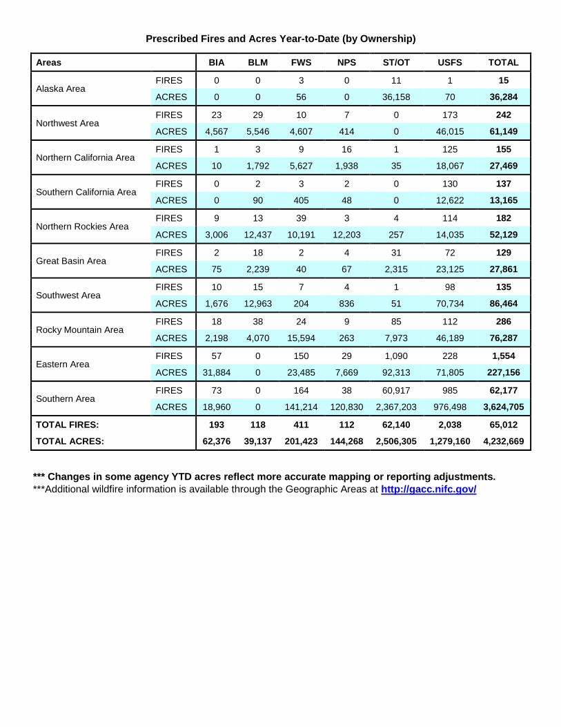
Prescribed Fires and Acres Year-to-Date (by Ownership)
Areas BIA BLM FWS NPS ST/OT USFS TOTAL
Alaska Area FIRES 0 0 3 0 11 1 15
ACRES 0 0 56 0 36,158 70 36,284
Northwest Area FIRES 23 29 10 7 0 173 242
ACRES 4,567 5,546 4,607 414 0 46,015 61,149
Northern California Area FIRES 1 3 9 16 1 125 155
ACRES 10 1,792 5,627 1,938 35 18,067 27,469
Southern California Area FIRES 0 2 3 2 0 130 137
ACRES 0 90 405 48 0 12,622 13,165
Northern Rockies Area FIRES 9 13 39 3 4 114 182
ACRES 3,006 12,437 10,191 12,203 257 14,035 52,129
Great Basin Area FIRES 2 18 2 4 31 72 129
ACRES 75 2,239 40 67 2,315 23,125 27,861
Southwest Area FIRES 10 15 7 4 1 98 135
ACRES 1,676 12,963 204 836 51 70,734 86,464
Rocky Mountain Area FIRES 18 38 24 9 85 112 286
ACRES 2,198 4,070 15,594 263 7,973 46,189 76,287
Eastern Area FIRES 57 0 150 29 1,090 228 1,554
ACRES 31,884 0 23,485 7,669 92,313 71,805 227,156
Southern Area FIRES 73 0 164 38 60,917 985 62,177
ACRES 18,960 0 141,214 120,830 2,367,203 976,498 3,624,705
TOTAL FIRES: 193 118 411 112 62,140 2,038 65,012
TOTAL ACRES: 62,376 39,137 201,423 144,268 2,506,305 1,279,160 4,232,669
*** Changes in some agency YTD acres reflect more accurate mapping or reporting adjustments.
***Additional wildfire information is available through the Geographic Areas at http://gacc.nifc.gov/

Canadian Fires and Hectares
PROVINCES FIRES
YESTERDAY HECTACRES YESTERDAY
FIRES YEAR-TO-DATE
HECTACRES YEAR-TO-DATE
BRITISH COLUMBIA 0 0 614 50,499
YUKON TERRITORY 2 20 33 19,735
ALBERTA 4 108 907 45,249
NORTHWEST TERRITORY 0 0 23 2,700
SASKATCHEWAN 2 1,186 363 88,086
MANITOBA 9 21,738 336 123,436
ONTARIO 8 17,842 606 110,169
QUEBEC 7 6,616 444 75,315
NEWFOUNDLAND 0 0 82 473
NEW BRUNSWICK 0 0 213 292
NOVA SCOTIA 0 0 140 243
PRINCE EDWARD ISLAND 0 0 0 0
NATIONAL PARKS 1 0 64 56,845
TOTALS 33 47,510 3,825 573,042
*1 Hectare = 2.47 Acres
Predictive Services Discussion: High pressure over the West will keep scattered showers associated with
the summer monsoon active across the Four Corners, the southern Great Basin, and the southern and central
Rockies. Most storms in the area will produce around a quarter to a half an inch of rain but a few could produce
one to two inches of rain. Widely scattered thunderstorms will also develop over Northern California, southern
Oregon, northern Nevada, and southwestern Idaho. These storms will be a mix of little to no rain to some
producing a few tenths of an inch. Farther north, westerly flow aloft will produce breezy conditions across the
northern Rockies behind a dry front that moves through Montana into Wyoming. In the central and eastern
U.S., scattered thunderstorms will develop from the central Plains to the Appalachians and south to the Gulf
Coast. Hot weather will cover most of the lower 48 except warm conditions across the northern Rockies, the
northern Plains, and New England. In Alaska, scattered showers and thunderstorms will form over most of the
state. Temperatures will continue mild except warm in the central and eastern interior.
http://www.predictiveservices.nifc.gov/outlooks/outlooks.htm

Resources:
Incident Response Pocket Guide
Video: Correct use of PPE (from the 2011 Annual Fire Refresher)
The “Take 5@2” safety messages are a cooperative project of 6 Minutes for Safety, the Wildland Fire Safety Training Annual Refresher (WFSTAR), NIFC External Affairs, the NWCG Leadership Committee, the NWCG Risk Management Committee, and the Wildland Fire Lessons
Learned Center.
Have an idea? Have feedback? Share it. EMAIL | Facebook | MAIL: 6 Minutes for Safety Subcommittee • 3833 S. Development Ave • Boise, ID 83705 | FAX: 208-387-5250
5@2 PPE
Firefighter Health and First Aid


![A possible causative mechanism of Raton Basin, New Mexico and … · 2019-11-12 · 2013]. The Yellowstone Caldera (Wyoming) and the Valles Caldera both have high heat flow. Yellowstone](https://static.fdocuments.in/doc/165x107/5f0614ac7e708231d4163160/a-possible-causative-mechanism-of-raton-basin-new-mexico-and-2019-11-12-2013.jpg)