2.0 VALLES CALDERA BACKGROUND · 2.0 VALLES CALDERA BACKGROUND The VCNP basin was intensively...
9
2.0 VALLES CALDERA BACKGROUND The VCNP basin was intensively sampled by the Surface Water Quality Bureau (SWQB) from May 2001 through April 2002 and is addressed in this document. The Valles Caldera Basin includes portions of seven streams from the VCNP boundary to their respective headwaters. Surface water quality monitoring stations were selected to characterize water quality of the stream reaches. Assessment units that will have a TMDL prepared in this document are discussed in their respective individual watershed sections. The dissolved oxygen and pH impairments will remain on the Integrated CWA §303(d)/§305(b) List of Assessed Surface Waters (NMED/SWQB 2004) until additional data are available 2.1 Location Description The Jemez watershed (US Geological Survey [USGS] Hydrologic Unit Code [HUC] 130020202) is located in northern New Mexico (NM). The entire Valles Caldera basin encompasses approximately 138 square miles (mi 2 ) in Sandoval County. The VCNP bain consists of seven assessment units on the following streams: East Fork Jemez, Jaramillo Creek, La Jara Creek, Redondo Creek, Rito de los Indios, San Antonio Creek, and Sulphur Creek. As presented in Figure 2.1, land use is 60% evergreen forest, 29% grassland, 9% shrubland, and 1% deciduous/mixed forest. Figure 2.2 shows ownership as 98% VCNP, 1% Forest Service, and less than 1% National Park Service and private. The Natural Heritage New Mexico Program website (http://nhnm.unm.edu/query_bcd/bcd_watershed_query.php) places 37 plant and animal species within the Jemez watershed. However, none of these species are listed as either threatened or endangered by either State or Federal agencies. These plant species are found within varying terrain, including high elevation sub-alpine forests, mixed conifer, open foothill pine woodlands, high montane grasslands, and wetlands (Muldavin and Tonne 2003). VCNP is one of the most diverse areas in the Southern Rocky Mountains Ecoregion (Muldavin and Tonne 2003). Virgin forests are located in the upper East Fork Jemez and San Antonio Creek watersheds (Muldavin and Tonne 2003). Although the VCNP basin is in relatively good condition, the long-term grazing of both cattle and sheep have impacted the streams within VCNP in terms of a decline in native bunchgrasses and increases in exotic species (Muldavin and Tonne 2003). 5
Transcript of 2.0 VALLES CALDERA BACKGROUND · 2.0 VALLES CALDERA BACKGROUND The VCNP basin was intensively...

2.0 VALLES CALDERA BACKGROUND
The VCNP basin was intensively sampled by the Surface Water Quality Bureau (SWQB) from May 2001 through April 2002 and is addressed in this document. The Valles Caldera Basin includes portions of seven streams from the VCNP boundary to their respective headwaters. Surface water quality monitoring stations were selected to characterize water quality of the stream reaches. Assessment units that will have a TMDL prepared in this document are discussed in their respective individual watershed sections. The dissolved oxygen and pH impairments will remain on the Integrated CWA §303(d)/§305(b) List of Assessed Surface Waters (NMED/SWQB 2004) until additional data are available
2.1 Location Description
The Jemez watershed (US Geological Survey [USGS] Hydrologic Unit Code [HUC] 130020202) is located in northern New Mexico (NM). The entire Valles Caldera basin encompasses approximately 138 square miles (mi2) in Sandoval County. The VCNP bain consists of seven assessment units on the following streams: East Fork Jemez, Jaramillo Creek, La Jara Creek, Redondo Creek, Rito de los Indios, San Antonio Creek, and Sulphur Creek. As presented in Figure 2.1, land use is 60% evergreen forest, 29% grassland, 9% shrubland, and 1% deciduous/mixed forest. Figure 2.2 shows ownership as 98% VCNP, 1% Forest Service, and less than 1% National Park Service and private. The Natural Heritage New Mexico Program website (http://nhnm.unm.edu/query_bcd/bcd_watershed_query.php) places 37 plant and animal species within the Jemez watershed. However, none of these species are listed as either threatened or endangered by either State or Federal agencies. These plant species are found within varying terrain, including high elevation sub-alpine forests, mixed conifer, open foothill pine woodlands, high montane grasslands, and wetlands (Muldavin and Tonne 2003). VCNP is one of the most diverse areas in the Southern Rocky Mountains Ecoregion (Muldavin and Tonne 2003). Virgin forests are located in the upper East Fork Jemez and San Antonio Creek watersheds (Muldavin and Tonne 2003). Although the VCNP basin is in relatively good condition, the long-term grazing of both cattle and sheep have impacted the streams within VCNP in terms of a decline in native bunchgrasses and increases in exotic species (Muldavin and Tonne 2003).
5
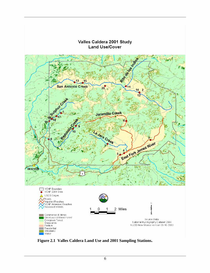
Figure 2.1 Valles Caldera Land Use and 2001 Sampling Stations.
6

Figure 2.2 Valles Caldera Land Ownership.
7

2.2 Geology and History
The geology of the VCNP basin consists of a unique and complex distribution of Paleozoic limestone, Quaternary alluvium, and significant Quaternary volcanic deposits (Table 2.1, Figure 2.3). The VCNP is in the Jemez Mountains- a volcanic field overlying the western edge of the Rio Grande Rift. The Jemez Volcano, a composite volcano, had alternating layers of thick lava and ash, resulting from alternating fairly quiet and quite explosive eruptions. It rose above a base of older volcanic rock, which can be seen in the lower gorge of the Frijoles River and reached its maximum height a little more than a million years ago. At its peak, the volcano was likely the shape and size of Mt. St. Helens before its 1980 eruption (Chronic 1987). The 15-mile diameter caldera was formed one million years ago when an eruption of ash caused the volcanic pile to collapse (NMED/SWQB 2006a). The great dome of Redondo Peak, which formed by resurgence of the floor of the caldera soon after the great collapse, is at the center of the caldera (Chronic 1987). The rhyolites were vented from a series of temporally and spatially separated magma chambers (Spell et al. 1993). Magma continued to rise and form domes along the caldera ring fracture. The caldera was formerly a closed basin that formed a high altitude lake. The walls of this lake eventually were breached and the drained lake exposed the long accumulated sediments (NMED/SWQB 2006a). The Bandelier Tuff exists in three layers east and west of Jemez Springs; the thick layers of ash were deposited on an irregular surface full of valleys and ridges (Chronic 1987). The red Abo Formation differs from most other Paleozoic formations in New Mexico- the Abo is continental and was deposited on land rather than in the sea (Chronic 1987). Its red color comes from oxidized iron. The Jemez Mountains contain a number of active hot springs resulting from groundwater flow above a subsurface body of partially molten igneous rock. The entire area of geothermal activity in the VCNP is estimated to be 12-15 square miles. The geothermal reservoir is recharged by rainwater that moves down through the aquifers to a depth of 6,500 feet at temperatures reaching 330ºC (USGS 2000). Redondo Peak is sacred to the native people of the area (Muldavin and Tonne 2003). Throughout the 1700’s and 1800’s, Basque colonists in New Mexico supported a thriving sheep grazing industry, including areas within the VCNP. Under the Land Grant Treaty of Guadalupe Hidalgo of 1821, the Luis Maria Cabeza de Baca family was awarded much of what is now the VCNP (NMED/SWQB 2006a). Sheep grazing was phased out in the early 1900’s in favor of Anglo cattle grazing and logging. The Dunigan family of Abilene, Texas bought the Baca Grant. The Dunigans on the Baca Ranch leased grazing, drilled wells to explore the geothermal potential, and clashed with the New Mexico Timer Company over timber issues (NMED/SWQB 2006a). After two years of negotiations, the White House reached an agreement in 1999 to buy the 89,000-acre Baca Ranch to permanently protect the area as Valles Caldera National Preserve per the Valles Caldera Preservation Act. A nine member Board of Trustees is responsible for the protection and development of this unique experiment in land management (NMED/SWQB 2006a).
8

Table 2.1 Geologic Unit Definitions for the Valles Caldera Geologic
Unit Code Definition &m Madera Formation (Limestone or Group) Pa Permian Abo Formation; red beds, arkosic at base, finer and more mature above. Qa Upper and middle Quaternary alluvium. Qbt Bandelier Tuff; Jemez Mountains area only. Qp Basalt and andesite flows and locally vent deposits. Qr Silicic volcanic rocks. Qvr Valles Rhyolite; Jemez Mountains area only. TKi Paleogene and Upper Cretaceous intrusive rocks. Tnr Silicic to intermediate volcanic rocks; mainly quartz latite and rhyolite Neogene. Tnv Neogene volcanic rocks; primarily in Jemez Mountains. Tsf Lower and Middle Santa Fe Group.
9

Figure 2.3 Valles Caldera Geology
10

2.3 Water Quality Standards
Water quality standards (WQS) for all assessment units in this document are set forth in sections 20.6.4.108 and 20.6.4.124 of the NM Standards for Interstate and Intrastate Surface Waters (NM Administrative Code [NMAC] 20.6.4) (NMAC 2005). 20.6.4.108 RIO GRANDE BASIN - Perennial reaches of the Jemez river and all its
tributaries above Soda dam near the town of Jemez Springs, except Sulphur creek about its confluence with Redondo creek, and perennial reaches of the Guadalupe river and all its tributaries. A. Designated Uses: domestic water supply, fish culture, high quality coldwater aquatic life, irrigation, livestock watering, wildlife habitat and secondary contact. B. Criteria: (1) In any single sample: specific conductance 400 μmhos/cm or less, pH within the range of 6.6 to 8.8 and temperature 20oC (68oF) or less. The use-specific numeric criteria set forth in 20.6.4.900 NMAC are applicable to the designated uses listed above in Subsection A of this section. (2) The monthly geometric mean of E. coli bacteria 126/100 mL or less; single
sample 235/100 mL or less (see Subsection B of 20.6.4.14 NMAC).
20.6.4.124 RIO GRANDE BASIN - Perennial reaches of Sulphur creek from its headwaters to its confluence with Redondo creek. A. Designated Uses: limited aquatic life, wildlife habitat, livestock watering and secondary contact. B. Criteria: (1) In any single sample: pH within the range of 2.0 to 9.0 and temperature 30oC (86oF) or less. The use-specific numeric criteria set forth in 20.6.4.900 NMAC are applicable to the designated uses listed above in Subsection A of this section. (2) The monthly geometric mean of E. coli bacteria 548/100 mL or less; single
sample 2507/100 mL or less (see Subsection B of 20.6.4.14 NMAC). (3) The chronic aquatic life criteria of Subsections I and J of 20.6.4.900
NMAC shall also apply. NMAC 20.6.4.900 provides standards applicable to attainable or designated uses unless otherwise specified in 20.6.4.101 through 20.6.4.899. NMAC 20.6.4.13 lists general standards that apply to all surface waters of the state at all times, unless a specified standard is provided elsewhere in NMAC (2005).
11

2.4 Intensive Water Quality Sampling
The VCNP basin was intensively sampled by the SWQB in 2001-2002. A brief summary of the survey and the hydrologic conditions during the intensive sample period is provided in the following subsections.
2.4.1 Survey Design
Surface water quality samples were collected monthly May-October 2001 and March-April 2002 for the intensive SWQB study. Temperature data also were collected in 2001. Surface water quality monitoring stations were selected to characterize water quality of various assessment units (i.e., stream reaches and reservoirs) throughout the basin (Table 2.2, Figures 2.1 through 2.3). The locations of 2001 thermograph deployment in the VCNP basin are described in Section 4.0 (Table 4.1 and Figure 4.1). Stations were located to evaluate the impact of tributary streams and to determine ambient water quality conditions. Data results from grab sampling are housed in the SWQB provisional water quality database and will be uploaded to USEPA’s Storage and Retrieval (STORET) database. A water quality survey report has been prepared for this study (NMED/SWQB 2006a). VCNP also staff deployed sondes and collected grab samples April-November 2005.
Table 2.2 SWQB 2001 Valles Caldera Sampling Stations Station Station Location
1 Alamo Canyon above Sulphur Creek 2 Artesian well on San Antonio Creek 3 East Fork Jemez above Jaramillo Creek 4 East Fork Jemez below La Jara Creek 5 East Fork Jemez blw unnamed drainage sw of hq 6 Jaramillo above Cerro Pinon @ Rd B 7 La Jara above headquarters. VCNP #15 8 Redondo Creek above VCNP boundary 9 Redondo Creek above steam wells
10 Redondo Creek below steam wells 11 Rito de los Indios above San Antonio Creek 12 San Antonio Creek above artesian well 13 San Antonio Creek below warm springs 14 San Antonio below Artisian Well 15 San Antonio warm springs 16 Sulphur Creek above VCNP boundary 17 Sulphur Creek below Alamo Canyon 18 Sulphur Springs 19 Sulphur pond 20 Valle Santa Rosa above San Antonio Creek
All temperature and chemical/physical sampling and assessment techniques are detailed in the Quality Assurance Project Plan (QAPP) (NMED/SWQB 2001) and the SWQB assessment protocols (NMED/SWQB 2006b). As a result of the 2001-2002 and 2005 monitoring efforts and subsequent assessment of results, several surface water impairments were determined.
12

Accordingly, these impairments were added to New Mexico’s 2004-2006 Integrated CWA §303(d)/305(b) Report (NMED/SWQB 2004).
2.4.2 Hydrologic Conditions
There are no USGS gaging stations within the VCNP. The nearest USGS gaging station, Jemez River below East Fork near Jemez Springs (08321500), has a period of record from 1951-1990 and a daily mean streamflow of 33 cubic feet per second (cfs). Since USGS Gage 08321500 has been discontinued, the real-time, daily mean streamflow was not measured. The mean daily streamflow for the nearest, active gage is displayed in Figure 2.4.
0
100
200
300
400
500
600
700
Jan-01 Mar-01 May-01 Jul-01 Sep-01 Nov-01 Jan-02 Mar-02 May-02
Date
Mea
n D
aily
Str
eam
flow
(cfs
)
Mean Daily Streamflow Mean Daily Streamflow (1937-2006)
Figure 2.4 Daily Mean Streamflow: USGS 08324000 Jemez River near Jemez, NM Flows in the Jemez River (USGS Gage 08324000) during the 2001-2002 survey years were below average based on the period of record that spans from 1937 to present. Instantaneous discharge was measured by SWQB during the intensive survey in all of the assessment units except for Sulphur Creek. Values ranged from 17 cfs on East Fork Jemez in May 2001 to less than one cfs on all assessment units at least once during the intensive survey. As stated in the Assessment Protocol (NMED/SWQB 2006b), data collected during all flow conditions, including low flow conditions (i.e., flows below the 4-day, 3-year low-flow frequency [4Q3]), will be used to determine designated use attainment status during the assessment process. In terms of assessing designated use attainment in ambient surface waters, WQS apply at all times under all flow conditions.
13