Acosta, J., Norris, F., Taylor, J Measuring Community ... · Disaster resilience planning focuses...
57
Transcript of Acosta, J., Norris, F., Taylor, J Measuring Community ... · Disaster resilience planning focuses...


Acosta, J., Norris, F., Taylor, J. Measuring Community Resilience
Presenter(s): D.M. Abramson, F. Norris, J. Taylor Time of Presentation: Panel - Wednesday October 24 1335h – 1500h
For emergency management, resilience is defined as the capacity of a system, community or society to adapt to disturbances resulting from hazards by persevering, recuperating or changing in order to restore and sustain a level of functioning that existed before an emergency. To better foster and support community resilience we need to establish how best to measure community resilience and what indicators serve this purpose. This panel seeks to explore how the elements of community resilience have been identified and measured in previous and ongoing research and how they can be used for policy development, planning and performance measurement.
Contact Information: [email protected] 613-990-3979 Public Safety Canada, 269 Laurier Ave. West, Ottawa, ON Canada K1A0P8
----------------------
Allport, D. Alternative Business Models for Enabling National Public Safety Capabilities
Presenter(s): D. Allport Time of Presentation: Thursday October 25 1035h – 1055h
The Communications Interoperability Strategy for Canada presents a national governance model for Canadian communications capabilities, including 700 MHZ spectrum, the Multi-Agency Situational Awareness System (MASAS) initiative, and the Canadian Profile of the Common Alerting Protocol (CAP-CP). It does not however spell out how these initiatives will be funded.
In the past year two national studies have been conducted to look at the ongoing funding and management of public safety digital spectrum (700 MHZ) and the MASAS National Information eXchanges (MASAS-X). Members of the Canadian emergency management and response community were then assembled to assess the alternatives, which included Public Private Partnerships (P3) and Not-for-Profits.
During this breakout session a panel of participants will present study findings and current activities to leverage alternative business models to improve public safety communications in Canada.
Contact Information: [email protected] 613-271-1040 Centre for Security Science and Natural Resources Canada 222 Nepean Street, Ottawa, ON Canada K1A 0K2
----------------------

1
Allport, D. MASAS Update
Presenter(s): D. Allport Time of Presentation: Thursday October 25 1435h – 1455h
The national Multi-Agency Situational Awareness System (MASAS) initiative has been identified as a national priority in the Communications Interoperability Action Plan for Canada, and an international priority for Canada and the U.S. in the Beyond the Border - Action Plan on Perimeter Security and Economic Competitiveness. The Centre for Security Science – Canadian Safety and Security Program is funding MASAS developments. Their efforts are supported by Public Safety Canada – Interoperability Development Office (PS-IDO) and Natural Resources Canada – Mapping Information Branch, in consultation with the Senior Officials Responsible for Emergency Management (SOREM). The MASAS – National Information eXchanges (MASAS-X) Pilot, that was launched in November 2011, now links hundreds of emergency management agencies with one another for operational and exercise purposes.
This plenary session will provide a brief update on MASAS-X and other MASAS activities
Contact Information: [email protected] 613-271-1040 Centre for Security Science and Natural Resources Canada 222 Nepean Street, Ottawa, ON Canada K1A 0K2
----------------------
Anderson, G., Bowles, R. Online tools for Disaster Resilience Planning in Canada
Presenter(s): Greg Anderson & Ron Bowles Time of Presentation: Friday October 26 1135h – 1155h
Disaster resilience planning focuses on reducing the vulnerabilities of people and critical assets, and promoting the safety, security and longer-term vitality of communities. The Rural Disaster Resilience Project is a CRTI-funded initiative aimed at supporting disaster resilience planning activities at the grassroots level across Canada. The project helps communities build disaster resilience through the exchange of knowledge and expertise, co-development of best practice guidelines, and sharing of lessons learned through collaborative planning projects. In this session, we present two of the deliverables of the project.
The Disaster Risk Resilience Planning Network is a virtual community of practice (VCoP) that allows communities to access information and expertise related to community resilience planning. Community groups can access a wide range of communication and collaboration tools that support their planning process. In addition, the VCoP houses the Rural Disaster Resilience Planning framework - a comprehensive risk and resilience management framework designed to support the ability of rural, remote and small coastal communities to implement disaster preparedness and resilience enhancement planning. The framework provides a flexible, user-friendly resilience enhancement planning process that includes participatory, qualitative disaster risk and resilience assessment tools.
In this session, we take participants on a guided tour of the Disaster Risk Resilience Planning Network and demonstrate how communities can use the Rural Disaster Resilience Planning Guide to get started, assess a community’s current state of resiliency, assess what hazards are likely to take place, and then develop an Action Plan to adopt strategies that increase overall community resiliency.
Contact Information: [email protected] 604-528-5691 JIBC 715 McBride Blvd, New Westminster, British Columbia, Canada V3L 5T4
2
Andrews, M., Fox V.A., Lyle H &, Jamal, S. The Value of Participation: ShakeOut BC 2012, Exercises and the Engagement of the Private Sector
Presenter(s): M. Andrews, V.A. Fox, H. Lyle, S. Jamal Time of Presentation: Plenary - Friday October 26 1300h – 1400h
Description: To highlight the importance of public and private sector engagement in emergency management awareness campaigns and emergency exercises. This session will first focus on the annual ShakeOut BC mass earthquake drill and then on emergency exercises, such as the recent Washington State “ Evergreen Exercise”. This cross-border exercise involved the Washington State government, more than 60 Washington State Organizations and the Province of BC. One of the goals of the exercise was to showcase coordination between governments at all levels and the private sector and to demonstrate how public/private collaboration enhances the level of emergency preparedness and resiliency in BC.
Contact Information: [email protected] 604- 969-7000 North Shore Emergency Management Office 2nd Floor, 147 East 14th ,North Vancouver, BC Canada V7L 2N4
----------------------
Baingo, D., Parenteau, M-P. Seismic Risk for downtown Ottawa - Level 1 vs. Level 2-3 Analyses
Presenter(s): D. Baingo Time of Presentation: Wednesday October 24 1115h – 1135h
The paper reports the results of a seismic impact investigation, for a section of downtown Ottawa, using HAZUS-MH. The scenario assumes a potential earthquake with a moment magnitude (M) of 6.5 and an epicentral distance of 15 km, consistent with the 2005 NBCC ground motions. The research focuses on a critical comparison between the results derived from analyses using the level 1 default building stock vs. analyses based on level 2-3 detailed building inventory and local soil characteristics. The impact parameters include estimation of the physical and social losses (casualties), the volume of debris generated, and the direct and indirect economic losses. Parametric and sensitivity studies, as well as recommendations for future work, are also presented.
Contact Information: [email protected] 613-797-4178 DRDC Centre for Security Science 222 Nepean Street, 11th floor, Ottawa, ON Canada K1A 0K2
----------------------

3
Bausch, D. B. The Great Utah ShakeOut and Hazus Applications
Presenter(s): D. B. Bausch Time of Presentation: Thursday October 25 1115h – 1135h
The Federal Emergency Management Agency (FEMA) developed Hazus and released the first earthquake loss estimation version in 1997. Since then we have added flood loss and hurricane loss capabilities while continuing to improve the earthquake model. For more than a decade, a broad range of applications have emerged including the development of mitigation strategies, scenario driven catastrophic planning, exercise support, recovery and preparedness planning. This paper will introduce several potentially valuable applications for earthquake scenarios, specifically our recent Great Utah ShakeOut www.shakeout.org\utah in April 2012.
The Utah application incorporated extensive updates to the Hazus inventory, hazard and vulnerability information. The Hazus modeling analyses were updated with the 2010 census information, a site specific FEMA 154 vulnerable building inventory, a hospital inventory, Salt Lake County assessor data, and a detailed database of building on the University of Utah campus. In addition, we deployed the results in mapping interfaces that supported the development of a catastrophic plan, the functional exercise, and for the general public. The public outreach components included publication through media outlets, an interactive website and a new video “Utah: Preparedness Now”. Almost 1/3 of the State’s population participated in the exercise and many were engaged as a result of successful communication concerning the potential impacts. The results also continue to support mitigation strategies, including addressing Utah’s large inventory of Unreinforced Masonry (URM) buildings.
Contact Information: [email protected] 425-487-4636 FEMA Region X
---------------------- Beaudoin, L. Victim of a cyber-attack? What your organization may do and what resources may be available
Presenter(s): L. Beaudoin Time of Presentation: Wednesday October 24 1115h – 1135h
Many Canadian organizations are the victim of recurring cyber security incidents. Whether it belongs to a large multi-national, or a small municipality, networks are constantly submitted to cyber attacks. Various actions may be taken in response to these incidents with multiple types of resources available. This presentation introduces the Canadian Cyber Incident Response Centre (CCIRC) and its role as a national CSIRT and federal lead in the event of a national cyber emergency. Through this presentation an overview of mitigation strategies organizations may consider in response to a cyber-incident will be discussed along with the various information sharing, risk assessment and resourcing challenges associated with cyber-incident response.
Contact Information: [email protected] 613-991-9949 PS CCIRC, 269 Laurier, Ottawa, ON Canada K1A 0P8
----------------------

4
Bird, A.L., Majewski, C., Hayek, Use of social media and emerging communication technologies to K., Edwards, W., McCormack, D. disseminate natural hazard information by Natural Resources Canada Presenter(s): Alison Bird Time of Presentation: Thursday October 25 1415h – 1435h
Public expectation of reliable, real-time information is constantly rising. This expectation puts increasing demands on organizations charged with monitoring hazardous events to provide this information to the public as quickly as possible, while still ensuring quality and accuracy of content.
Natural Resources Canada (NRCan) has responded by augmenting existing information distribution mechanisms with new and varied methods for relaying natural hazard information. How these tools allow NRCan to distribute earthquake information to multiple levels of government, emergency measures organizations, news media and the public, will be discussed. In addition, interactive tools which allow the public to engage in the science of natural hazards being investigated by NRCan, are also explored.
Contact Information: [email protected] 250.363.6432 Natural Resources Canada
9860 West Saanich Road, P.O.Box 6000, Sidney, BC Canada V8L 4B2 ---------------------- Blackburn, D.S. A Tale of Two Philosophies: A Review of the Status of Risk-based and
Capabilities-based Planning In Canada
Presenter(s): D.S. Blackburn Time of Presentation: Poster - Thursday October 25 1700h – 1900h
Following a disaster, response and support agencies work together in a fashion that allows for the strategic delivery of services while accommodating the responsibility and authority of each agency to their respective jurisdictional and legal roles. This integration of services does not come about by accident; rather, many of the processes used to coordinate these agencies are designed and fostered by Emergency Management practitioners. These processes are structured based on different planning philosophies - risk-based planning, and capabilities-based planning.
Risk-based planning is a bottom-up planning approach, in which the authority for disaster mitigation, preparation, response and recovery is delegated to the local level. This model has wide-spread acceptance, both in Canada and internationally, as it provides a powerful mechanism for identifying appropriate emergency management activities for local hazards while respecting the limited resources of available to local authorities. Alternately, capabilities-based planning is a top-down planning approach, in which the federal government requires local authorities to achieve pre-identified preparedness levels. This model often requires a transfer of authority from the local level to the federal government and large massive investment of resources. While committed to a risk-based planning approach, Canada has been exploring various capabilities-based planning options. Given their differences, these two philosophies are not easily “married”; however, there may be common middle-ground that would allow Canadians to take advantage of the strengths of each. This poster defines basic concepts of each philosophy, provides selected examples of projects undertaken pursuant to each philosophy, and proposes possible directions for future development.
Contact Information: [email protected] 604-528-5702 JIBC 715 McBride BLVD, New Westminster, British Columbia Canada V3L5T4
5
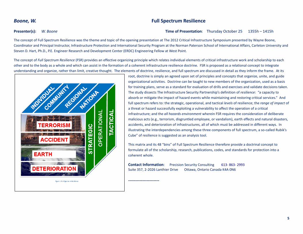
Boone, W. Full Spectrum Resilience
Presenter(s): W. Boone Time of Presentation: Thursday October 25 1355h – 1415h
The concept of Full Spectrum Resilience was the theme and topic of the opening presentation at The 2012 Critical Infrastructure Symposium presented by Wayne Boone, Coordinator and Principal Instructor, Infrastructure Protection and International Security Program at the Norman Paterson School of International Affairs, Carleton University and Steven D. Hart, Ph.D., P.E. Engineer Research and Development Center (ERDC) Engineering Fellow at West Point.
The concept of Full Spectrum Resilience (FSR) provides an effective organizing principle which relates individual elements of critical infrastructure work and scholarship to each other and to the body as a whole and which can assist in the formation of a coherent infrastructure resilience doctrine. FSR is proposed as a relational concept to integrate understanding and organize, rather than limit, creative thought. The elements of doctrine, resilience, and full spectrum are discussed in detail as they inform the frame. At its
root, doctrine is simply an agreed upon set of principles and concepts that organize, unite, and guide organizational activities. Doctrine can be taught to new members of the organization, used as a basis for training plans, serve as a standard for evaluation of drills and exercises and validate decisions taken. The study dissects The Infrastructure Security Partnership’s definition of resilience: “a capacity to absorb or mitigate the impact of hazard events while maintaining and restoring critical services.” And full spectrum refers to: the strategic, operational, and tactical levels of resilience; the range of impact of a threat or hazard successfully exploiting a vulnerability to affect the operation of a critical infrastructure; and the all hazards environment wherein FSR requires the consideration of deliberate malicious acts (e.g., terrorism, disgruntled employee, or vandalism), earth effects and natural disasters, accidents, and deterioration of infrastructures, all of which must be addressed in different ways. In illustrating the interdependencies among these three components of full spectrum, a so-called Rubik’s Cube” of resilience is suggested as an analysis tool.
This matrix and its 48 “bins” of Full Spectrum Resilience therefore provide a doctrinal concept to formulate all of the scholarship, research, publications, codes, and standards for protection into a coherent whole.
Contact Information: Precision Security Consulting 613- 863- 2993 Suite 357, 2-2026 Lanthier Drive Ottawa, Ontario Canada K4A 0N6 ----------------------

6
Bouwsema, B. Target Based Risk Assessments: Understanding Vulnerability
Presenter(s): B. Bouwsema Time of Presentation: Thursday October 25 1415h – 1435h
Target Based Risk is an innovative approach that can be used to assess the threats and vulnerabilities to key assets and critical infrastructure within your organization. Target Based Risk provides a framework against which your prevention, preparedness, response, and recovery needs can be assessed as well as a method for determining your future organizational investment priorities in emergency management and loss prevention.
This presentation will provide an overview of the Target Based Risk Assessment process as it applies to emergency management and discuss how it can assist in developing a shared understanding of threats and vulnerabilities within your organization. Creating solutions amongst partners and contributing to enhanced emergency preparedness are among the key benefits of this process. When implemented, the Target Based Risk Assessment process will provide scientific validation to support informed decision-making and will enable organizations to better prevent, prepare for, respond to, and recover from threats and vulnerabilities in a collaborative and coordinated approach.
SPONSOR(S): This presentation is supported by the CBRNE Research and Technology Intitiative (CRTI) and the Centre for Security Science (CSS). The Public Security Technical Program (PSTP) is an initiative by the Government of Canada that is led by the DRDC Centre for Security Science. The CSS is a joint endeavour with Public Safety Canada (PSC) to provide science and technology (S&T) services for national public safety and security. Through this initiative future trends and threats are identified, and support and services to are provided for all hazards vulnerability and risk assessment, technology forecasting and operational analysis. AFFILIATIONS: CRTI – Canada
Contact Information: [email protected] Bouwsema Consulting Ltd. 9 Courtenay Close,Sherwood Park, AB T8A 5K6
----------------------
Bowles, R. The Rural Resilience Index
Presenter(s): R. Bowles Time of Presentation: Poster - Thursday October 25 1700h – 1900h
Disaster resilience is associated with a wide range of factors including characteristics of a community that at first glance may not be obviously connected to disaster and emergency management. When a community is stronger, closer, more creative and adaptable in their day-to-day functioning, they are also more likely to be resilient in the face of a disaster or other large-scale emergencies. The Rural Resilience Index (RRI) was developed as part of the Rural Disaster Resilience research project. It is designed to help communities assess their strengths, assets, and vulnerabilities across a wide range of community characteristics and resources in order to build whole-of-community, place-based resilience enhancement plans. Part of a comprehensive disaster resilience planning process, the RRI is based in the principle that resilience starts from the ground-up, not the top-down. Further, it acknowledges that to be successful, community resilience planning should capitalize on local knowledge, existing skills and the resilience that is often characteristic of people and communities that have to cope with geographic isolation, weather extremes, and limited access to technical expertise and resources. This presentation will discuss the research and field-testing that resulted in the RRI, and will provide participants with a detailed overview of this simple, flexible, and comprehensive tool. Case study examples from five rural Canadian communities will illustrate the application and potential outputs of the RRI and ground the discussion of next steps and implications for rural residents and disaster management practitioners.
Contact Information: [email protected] JIBC 715 McBride Boulevard New Westminster, BC V3L 5T4

7
Brekke, P.K. Risk Governance in Norway on the basis of a National Risk Assessment
Presenter(s): Per K. Brekke Time of Presentation: Thursday October 25 1115h – 1135h
The presentation will address the work conducted by the Norwegian Directorate for Civil Protection to develop a National Risk Assessment (NRA). The process started in 2009 and in May this year the second edition was published. The aim with the NRA is to create a common - all hazard approach - backdrop for emergency planning across sectors. The work has recently gained further momentum - highlighted in a new White Paper and stated by the Norwegian Minister of Justice to be the future framework of Risk Governance hereon also encompassing the annual reports and assessments from the security environment. The NRA is a comparative picture based on best available knowledge and judgments. Beside a run through of the process, scenarios and methodology the presentation will also discuss how the NRA can be an effective tool in Risk Governance in all levels of society. The presentation will also elaborate on how the NRA can be a basis for the identification and subsequent protection of critical infrastructure and critical functions in society hence also depicting systems for evaluation and supervision with focus on the ministerial level.
Contact Information: [email protected] (+47) 33 41 27 20 Directorate for Civil Protection 9 Rambergveien, Tonsberg, Tonsberg Norway 3103
----------------------
Budhwani, T., Dechesne, M., Ruths, D. Mitigating Psycho-Social Risks in the Aftermath of a Terrorist Attack
Presenter(s): M. Budhwani, M. Dechesne, D. Ruths Time of Presentation: Panel - Thursay October 25 1035h – 1200h
This panel discussion will focus on questions dealing with the state of a society in the aftermath of a terrorist attack, and the role that governments and first responders can play in minimizing the risk that widespread fear, anger and tensions can result from such an event. How does the societal context differ in the aftermath of a terrorist attack, as opposed to the aftermath of a natural disaster – and how does this impact the work of governments and first responders? What lessons from past examples of societal reactions to such events can be brought to bear on current and future policy and practice? In what ways do the words and actions of governments at all levels exacerbate or alleviate fear, anger and tension that could lead to violence? What is the role of police and first responders in such a scenario?
Contact Information: [email protected] 613-990-3979 Public Safety Canada 269 Laurier Ave. West, Ottawa, ON Canada K1A0P8

8
Carpenter J. & Dowdall E. The 2011 Amendments to the Environmental Emergency Regulations
Presenter(s): J. Carpenter Time of Presentation: Poster – Thursday October 25 1700h – 1900h
In 2003, the Environmental Emergency Regulations came into force under the authorities of the Canadian Environmental Protection Act, 1999 (CEPA 1999). The fundamental objective of the Regulations is to require that effective environmental emergency plans are in place to protect the environment and the health of Canadians by preventing, preparing for, responding to and recovering from an environmental emergency. If they meet the threshold criteria outlined in the Regulations, any person who owns or has the charge, management or control of a substance listed in Schedule 1 of the Regulations will be required to develop, implement, test and update an environmental emergency plan.
This poster reviews the Regulations Amending the Environmental Emergency Regulations (“the amendments”), which came into force on December 8, 2011, and were published in the Canada Gazette, Part II, on December 21, 2011. The amendments enhance the existing protection provided by the Regulations for the substances listed in Schedule 1 of the Regulations. The amendments include: the addition of 33 substances and classes of substances (41 substances in total) to Schedule 1 of the E2 Regulations; modifications to Schedule 1 of the Regulations to include substances that are aquatically toxic, carcinogenic, persistent or bioaccumulative; and, changes in the requirements to notify members of the public in the event of an environmental emergency. In addition, the amendments clarify some existing provisions and provide exceptions from the requirements of the Regulations.
Contact Information: [email protected] Environmental Protection Operations, Environmental Stewardship Branch Environment Canada Gatineau, Quebec ----------------------
Carter, L. GIS-Based Watermain Replacement Program – Calibration Using Public Input
Presenter(s): L. Carter Time of Presentation: Wednesday October 24 1035h – 1055h
Watermain breaks can cause substantial environmental damage, risk to public safety, damage to critical infrastructure, and significant public disruption. The District of North Vancouver’s (DNV) Utilities Department is unique with our proactive plans to incorporate public input into weighting criteria used in our GIS-based watermain replacement program. The DNV Utilities Department owns, operates, and maintains about $270 M worth (363 km) of watermain that dates back to 1945. In the mid ‘90s, DNV’s Utilities Department implemented an ACCESS-based model that helped reduce the number of breaks from 48 in 1996 to 27 in 2011. This model used staff’s prediction of impact from a watermain break with consideration to fire protection, domestic supply, and road and property damage as the basis for selecting watermains for replacement.
In 2010, we implemented a GIS-based graphical model that uses watermain pressure, material, diameter, previous breaks, and disrupted domestic and fire supply areas modules to assist in selecting watermains for replacement. The Phase II application, currently being developed, adds ground slope, road type, creeks, buildings, landslide sensitive areas, and soils as additional modules. Completion of this application will result in 20 modules, each with inter-module weightings, that use a Risk = Probability x Consequence approach. In a collaboration effort with National Resources Canada, the District will solicit input from the public to calibrate weighting for environmental/public based modules creating a holistic approach. Our model will consider impacts to the environment, rate payers, and private and municipal infrastructure in the watermain replacement decision process.
Contact Information: [email protected] 604-990-3864 District of North Vancouver 355 West Queens Road, North Vancouver, BC, Canada V7N 4N5

9
Cauwenberghs, K. Flood Risk and Flood Crisis Management in Flanders
Presenter(s): K. Cauwenberghs Time of Presentation: Wednesday October 24 1335h – 1355h
Flanders has faced the past 20 years frequent flooding causing significant economic damages and social impacts. About 6% of the territory was flooded in this period, causing annual damages in the order of 50-80 mio € and threatening between 80.000 en 125.000 people. Many protective measures were put in place the last 2 decades but it is felt that additional preventative and preparedness measures are needed. The methodology for selecting, combining and optimizing all measures will be explained, resulting in a flood risk management plan as requested by the European Floods Directive. Special attention will be given to preparedness measures such as flood forecasting systems and the flood response. The operational framework of the current systems will be discussed and an outlook will be given to the new crisis portal and its associated new technologies that will be in place by mid 2013. All knowledge instruments such as sensors and models in use for both flood risk and flood crisis management will be illustrated.
Contact Information: [email protected] 0032 2 553 21 29 Flemish Environment Agency K. Albert-II laan 20, Brussels, - BELGIUM B-1000 ----------------------
Céré V. Disaster: To be or not to be? Attawapiskat: What Are the Underlying Issues?
Presenter(s): V. Céré Time of Presentation: Friday October 26 1115h – 1135h
When faced with an imminent disaster, communities and municipalities in Canada can declare a state of emergency. In so doing, they initiate legal mechanisms that access to assistance from provincial/territorial governments, in the form of mutual aid, financial support and material resources. But what if a disaster occurs in an aboriginal community? Does the declaration of state of emergency have the same effect, since these communities fall under federal jurisdiction? In this presentation, we will discuss of the case of Attawapiskat Ontario and its underlying issues: Why did housing and potable water issues lead to a disaster? How was coverage of the event treated by mass media? Was it really a disaster? Or was declaring a disaster a way to garner public support for an ongoing crisis in the community that was not receiving public attention?
Contact Information: [email protected] 613-863-6863 CRHNet Board of Directors , #726 – 200 Clearview Ave, Ottawa, Ontario Canada K1Z 8M2
----------------------
10
Chang, S.E., Lotze, A., Yip, Z.K., de Ruiter, M. Modeling potential economic loss to businesses in Metro Vancouver from seismic events
Presenter(s): S.E. Chang Time of Presentation: Wednesday October 24 1355h – 1415h
This presentation describes an economic loss model for seismic risk, with application to Metro Vancouver. The model, which was previously developed and applied to the case of Los Angeles, focuses on direct business disruption loss. It utilizes detailed data on expected physical damage produced by other models, such as HAZUS-Canada, and assesses the associated disruption to businesses. The model is probabilistic and is distinguished by a strong empirical basis, attention to sectoral differences, and the ability to take into account multiple sources of loss (e.g., building damage occurring simultaneously with infrastructure disruption). A key contribution of this research has been to develop a spatial database of businesses in the Metro Vancouver region based on publicly available information sources; specifically, from business registries held by the region’s municipalities. Economic loss results are estimated for hypothetical earthquake scenarios. These results provide an indication of the scale and the spatial, temporal, and sectoral variation of economic loss in potential earthquake events. Such results can provide useful insights for emergency response and recovery planning and resource allocation for government departments, commercial organizations, the insurance industry, and individual business owners in Metro Vancouver.
Contact Information: [email protected] School of Community and Regional Planning The University of British Columbia 2329 West Mall Vancouver, B.C. Canada V6T 1Z4 ---------------------- Chang, S.E., Elwood, E., Johns, R., Ryan, R. The Christchurch earthquake: Implications for disaster preparedness
planning in British Columbia
Presenter(s): S.E. Chang, K. Elwood, R. Johns, P. Ryan Time of Presentation: Panel -Friday October 26 1035h – 1200h
The earthquake that struck Christchurch, New Zealand, on February 22, 2011 poses many potential lessons for urban areas at risk of earthquakes in Canada. In British Columbia, many observers have noted similarities in vulnerable building stocks between Christchurch and central areas of cities such as Victoria. The February 2011 earthquake caused 185 deaths and substantial structural damage, especially to the large number of unreinforced masonry buildings. In the Central Business District (CBD), 47 percent of buildings were tagged red (unsafe) or yellow (limited entry) in the initial safety inspections. The CBD was cordoned off for safety reasons, displacing 50,000 workers, and a large part of the cordon remains in effect some 16 months after the earthquake. This panel focuses on lessons from Christchurch for disaster preparedness planning in British Columbia. First, researchers from the University of British Columbia will report on findings from a study on key decisions influencing recovery in Christchurch. This will be followed by responses from representatives of governmental organizations in British Columbia (listed below). The panelists represent perspectives from, respectively, emergency management and engineering standards for buildings. They will discuss lessons, ongoing activities, and priorities for BC disaster preparedness.
Contact Information: [email protected] School of Community and Regional Planning The University of British Columbia 2329 West Mall Vancouver, B.C. Canada V6T 1Z4
----------------------

11
Childs P., Sanders M., Paus D. Critical Infrastructure Data Sharing: A New Approach
Presenter(s): D. Paus Time of Presentation: Wednesday October 24 1415h – 1435h
Critical Infrastructure (CI) providers - both public- and private-sector - have both a need and a desire to share appropriate information with responders and each other to facilitate emergency planning and response activities. However, the realities of an extremely competitive business environment and an increasing restrictive legal environment present challenges that many providers feel preclude an ability to share any significant information, especially using traditional information system technology. A unique new open-architecture approach will be described, which is built on the concepts of loosely-coupled systems sharing information through a mechanism based on legal agreements between parties. Methods will be described that allow CI providers to exert extremely fine-grained control over what information is presented to whom, where, when, how and under what circumstances - all using an open-standard information model (NIEM), in a highly secure environment, and with a complete audit trail showing who viewed what information and when.
Contact Information: [email protected] CriSys 8901 Woodbine Ave, #110, Markham, ON Canada L3R 9Y4
---------------------- Chowdhury, P.D., Haque, C.E., Uddin, M.S. Human Health Risk due to Climate Change-Induced Heat Wave in Winnipeg:
A Comparison between Expert and Layperson’s Knowledge Models
Presenter(s): C.E. Haque Time of Presentation: Poster - Thursday October 25 1700h – 1900h
As heat waves poses threat of heat-related illnesses and the aggravation of pre-existing health problems, in the face of recent trend of more frequent and intense heat waves, these issues have become a major research and policy concern. The nature and degree of concerns, however, may vary between specialists and lay persons. In the context of the Prairie urban communities of Canada, it is critical to determine such gaps in Knowledge Models to assist in formulating more acceptable health policies and more effective local level programs. The specific objectives of our study were: i) to examine the state of knowledge, perception, and awareness of climate change-induced heat wave hazards among the expert community and among the local community members in the City of Winnipeg, Manitoba; and to ii) identify the gap that exists between ‘scientific/technical’ and ‘local community’ knowledge regarding heat waves. The study design involved three distinct steps: i) the development of an Expert ‘‘Knowledge Model’’; ii) carrying out face-to-face interviews with local community members; and iii) conducting a confirmatory questionnaire survey at the local community level. A comparison between experts’ and lay knowledge models has revealed that there are significant gaps in the understanding of the complex earth and atmospheric systems; and ii) that there are misconceptions about the rise of global atmospheric mean temperature; and heat wave “risk underestimation” by the residents while recent hydro-meteorological data confirmed that Winnipeg is one of the most susceptible cities to heat wave hazards in Canada.
Contact Information: [email protected] 001 290-4723 University of Manitoba NRI, 70 Dysart Road, Winnipeg, MB Canada R3T 3X8
----------------------

12
Cox, R. S. Disaster Resilience Planning for Rural and Remote Communities
Presenter(s): R.S. Cox Time of Presentation: Friday October 26 1055h – 1115h
The Rural Disaster Resilience Planning framework is a comprehensive risk and resilience management framework designed to support the ability of rural, remote and small coastal communities to implement disaster preparedness and resilience enhancement planning. The framework provides a flexible, user-friendly guided resilience enhancement planning process that includes participatory, qualitative disaster risk and resilience assessment tools. It outlines a step-by- step process based on the application of a comprehensive community resilience assessment tool, the Rural Resilience Index, and a hazard specific resilience assessment tool, the Hazard Resilience Index. Both tools are specifically designed for use at the community level. From mapping exercises, to group facilitation techniques and disaster resilience enhancement strategies, some innovative assessment tools and over 20 resources are available to support communities through the planning process. The output of the planni! ng process is a community-centered, resilience enhancement plan that identifies concrete short- and long-term resilience enhancement strategies to reduce local risks and increase community resilience along social, contextual, disaster planning, and hazard specific dimensions. Designed to bring together the best of hazard risk and disaster resilience assessment, the Rural Disaster Resilience Planning framework is an innovative answer to the identified need for applied, accessible, place-based disaster risk reduction and resilience planning tools in Canada.
Contact Information: [email protected] 250-391-2600 Ext 4855 Royal Roads University 2005 Sooke Road, BLD 28, Victoria , British Columbia, CANADA V9B 5Y2
----------------------
Cranton, J., & Goudreau, A. An All Hazards Risk Assessment Approach for the Government of Canada
Presenter(s): J. Cranton, A. Goudreau Time of Presentation: Thursday October 25 1035h – 1055h
In Canada, the overarching legislative umbrella in emergency management is the 2007 Emergency Management Act (EMA) which establishes the federal role in emergency management, and the role and responsibilities of the Minister of Public Safety as well as those of all Ministers. The development of the All Hazards Risk Assessment (AHRA) framework, including a process and methodology, led by Public Safety Canada (PS), in close partnership with Defence Research Development Canada – Centre for Security Science (DRDC CSS), supports all federal government institutions in fulfilling their legislative responsibility to conduct mandate specific risk assessments as the basis for Emergency Management planning. The intention of the AHRA process is to produce a whole-of-government risk picture to support EM planning across federal government institutions and to ensure that interdependencies are recorded and managed. The risk picture provides an enhanced planning baseline for federal government institutions to support the development of EM plans and future capability and capacity investment decisions in areas where attention may be required.
This presentation will address the work conducted by PS and DRDC CSS in developing the All Hazards Risk Assessment Framework, provide an overview of the methodology and also share lessons learned.
*1 Public Safety Canada; 2 Defence Research and Development Canada
Contact Information: [email protected] 613-949-6512 Public Safety Canada 269 Laurier Ave. West, Ottawa, ON Canada K1A 0P8

13
Czaja, M., Cottrell, S., Bright, A., Clement, J. Public Perceptions of the Mountain Pine Beetle in Three Study Areas in Northern Colorado and Southern Wyoming
Presenter(s): M. Czaja Time of Presentation: Wednesday October 24 1035h – 1055h
We examined public perceptions of the mountain pine beetle’s (MPB) impact on wildland fire management in northern Colorado and southern Wyoming. Households in counties adjacent to three study areas were the target of this social research. These locations cover the area most impacted by the MPB outbreak in the region and allowed comparisons with previous research on related subjects. Results suggest that respondents viewed prescribed burning favorably and that they understand the natural role of fire on the landscape. While results suggest respondents support management of forest conditions to decrease the effects of a wildfire, they don’t feel that individuals have a right to expect their home to be protected from fire by land managers, nor do they agree with restricting home building near national forest land. Findings should assist forest managers with the development of management actions and communication strategies.
Contact Information: 1 Department of Human Dimensions of Natural Resources, Colorado State University, Fort Collins, CO 80523 2 Department of Forestry and Rangeland Stewardship, Colorado State University, Fort Collins, CO 80523
----------------------
Dawe, P & Journeay, M. HAZUS and MASAS-X Come Together
Presenter(s): P. Dawe, M. Journeay Time of Presentation: Thursday October 25 1035h – 1055h
A comprehensive situational awareness system enables three key functions: Perception, Comprehension, and Projection (Endsley, 2011). HAZUS is a FEMA-developed standardized methodology for estimating potential losses (supports Comprehension and Projection) from earthquakes, floods, and hurricanes. It is in the process of being implemented for use in Canada.
The Multi-Agency Situational Awareness System - National Information Exchanges (MASAS-X) provide a means to quickly collect and share situational awareness information (Perception, Comprehension and Projection) from hundreds of emergency management and responder stakeholder agencies, sensors and warning systems. Combined, the two improve multi-agency situational awareness. This session will speak to a project in which these two national capabilities were combined.
Contact Information: [email protected], 604-666-1130 Earth Sciences Sector, NRCan, 625 Robson St, Vancouver, BC Canada V6B 5J3
----------------------

14
De Smet, H., Plessers, B., Letens, G., Leysen, J. System Dynamics Modeling applied to Disaster Management
Presenter(s): Hans De Smet Time of Presentation: Wednesday October 24 1055h – 1115h
It has been proven that the nature of modern disasters has noticeably changed over recent years. Disasters are not only increasing in number, they also are qualitatively different in nature. As a result, they seem to distress our complex societies much harder than in the past. Consequently, disaster management has become a critical and complex issue, requiring a multitude of decisions and actions to stabilize the situation and restore the society in a way that normal functioning becomes possible again. However, in a complex and dynamic environment, acting on well-considered disaster management measures through traditional cause and effect relationships does not always generate the expected outcome and may even, on the contrary, result in multiple unintended and unwanted side-effects. In order to manage future disasters in an efficient and effective way, it is essential to better understand the dynamic context of modern disaster management. Therefore, the goal of this contribution is to consider disaster management as a complex system consisting of a multitude of subsystems, each containing multiple mutually interacting elements. We discuss the creation and analysis of a disaster management model based on system dynamics modeling. We first provide an introduction to system dynamics modeling, then clarify the methodology used to build the disaster management model, present the insights that emerge from the preliminary analysis and finally discuss avenues for future research.
Contact Information: [email protected], 0032/2-742.6457 Royal Military Academy Av de la Renaissance, 30, BRUSSELS, Brussels Capital Region, Belgium 1000 ---------------------- Descurieux, J., Houde, E., Masse, C. Severe Weather Preparedness and Planning for Large Outdoor Public Assembly
Venues and Events (LOPAVE): A collaborative preparedness approach in MSC’s Quebec region.
Presenter(s): J. Descurieux Time of Presentation: Friday October 26 1035h – 1055h
In the past few years, severe and hazardous weather has seriously affected and resulted in casualties at large outdoors public events. In at least one other case, these disastrous consequences were avoided; 30000 festival goers were safely evacuated in 28 minutes while under the immediate threat of very severe thunderstorms and tornadoes. This paper analyses how a collaborative problem solving process undertaken by the Quebec Region of the Meteorological Service of Canada and the “Centre des opérations gouvernementales (urgence)” of the Province of Quebec results in jointly arrived at risk reduction and preparedness planning approaches. Resting on a program theory based “expected outcome” analysis, this process identifies the increased and artificially created vulnerabilities and the “window of opportunity” for protective action decision and implementation. It leads to increased preparedness. It enables a better identification of all stakeholders and “at risk” audiences. It helps to better target and improves the efficacy of the risk communication. Ultimately, it accrues the social benefits derived from the meteorological information provided and helps determine the value-in-use of the knowledge exchange leading to the expected outcome.
Contact Information: [email protected] 250 491 1503 Environment Canada - Meteorological Service of Canada 1238 Discovery Avenue, Kelowna, BC Canada V1W 1V9
----------------------

15
Díaz, P., Aedo, I., Arias-Hernandez, R., Fisher, B., Diez, D. Perception of Lower Mainland practitioners on the incorporation of social media in emergency management
Presenter(s): R. Arias- Hernandez Time of Presentation: Wednesday October 24 1135h -1155h
Emergency management is a critical activity in which the participation of citizens is becoming more and more decisive. Citizens are moving from a reactive behavior, guided and oriented by official agencies and services, to a proactive outlook characterized by free involvement and self-responsibility. Nevertheless, this engagement has so far been focused on fostering communication with and among citizens, leaving aside activities such as hazard identification, risk assessment, or even emergency coordination and planning where they can also play an important role. In this presentation we discuss the results of a survey conducted in July 2011 showing the main barriers that Lower Mainland emergency management practitioners perceive in the integration of social media in crisis and emergency management and their implications for research challenges in this area.
Contact Information: [email protected] 778-960-8974 Simon Fraser University 227-625 Park Crescent, New Westminster, BC Canada V3L 5W4 ----------------------
Dudley, D., Fricksa, G. Canadian Lightning Risk Display – A New Approach
Presenter(s): Dennis Dudley Time of Presentation: Thursday October 25 1135h – 1155h
Meteorological data such as radar, satellite and lightning are available on the internet for users to self serve. Unfortunately, casual consumers of weather information sometimes make decisions that reflect their own preference although not necessarily in their best interest or based on all the information. For example, damaging outflow winds from thunderstorms can advance several kilometres ahead of the main storm, making it very difficult to anticipate the timing of impact accurately using radar data. In terms of lightning, a false sense of security could result from the public watching lightning data plotted on a map and attempt to “walk between the dots.” To motivate protective action, the Meteorological Service of Canada is redesigning its lightning service available to Canadians to offer risk-based information rather than simply the lightning data itself. This risk communication and education approach is founded in the science of lightning (e.g. 80% of successive lightning strikes occur within a 10 km range) and will display areas of lightning risk, with call to action statements consistent with Environment Canada’s lightning safety messaging.
Contact Information: [email protected] 250 491 1522 Environment Canada 1238 Discovery Ave, Kelowna , BC Canada V1V 1V9
----------------------
16
Etkin, D., Timmerman, P. Moral Being and Emergency Management
Presenter(s): D. Etkin Time of Presentation: Thursday October 25 1435h – 1455h
Emergency management, a very human centered discipline, is (or should be) primarily concerned with the reduction of suffering. As well as being an academic discipline society has created institutions, programs, laws and policies to promote it. The primary purpose of this discussion is to highlight an issue that has received insufficient attention (in the opinion of the authors) within the emergency management discourse – that of ethics and human relationships.
The argument of this paper is rooted in a dichotomy and a notion. The dichotomy is that some relationships, as proposed by the philosopher Martin Buber can best be described as “I-It” (referring to a relationship with a thing) while others are better described as “I-Thou” (referring to a relationship with a being). The notion is that to a very large degree emergency management, as it is written about, taught and practiced has become focused upon the development of relationships between things (even when they are people), thereby largely excluding an important class of interactions. We suggest that aspects that deal with human relations, values and ethics are as important as those that deal with other parts of the discipline.
Contact Information: [email protected] 416-736-2100 x44016 York University 4700 Keele St, Toronto, Ontario Canada M3J 1P3 ----------------------
Fugimi, T., Tatano, H. Evaluation of a warranty effect on promoting seismic retrofit implementation
Presenter(s): T. Fujimi Time of Presentation: Wednesday October 24 1055h– 1115h
In this study, we propose a new type of warranty policy that applies “Nudge” approach developed by Thaler and Sunstein (2008) to encourage homeowners in Japan to implement seismic retrofitting. It is well known that homeowner adaptation to natural disasters through loss reduction measures is inadequate. To encourage proactive risk management, Nudge capitalizes on how human tendencies in decision making can be influenced by choice architecture. For example, people tend to value a warranty for consumer goods much more than the actuarial value. We propose a “warranty for seismic retrofitting” as a nudge policy to encourage homeowners to adopt loss reduction measures. Under this contract, the government will guarantee all repair costs in the case of house damage due to an earthquake if a homeowner implements seismic retrofitting. To estimate how much the warranty will increase the seismic retrofitting value, we use field survey data of 1,200 homeowners. Our results show that the warranty increases the seismic retrofitting value by 33% on average. A rough cost-benefit analysis indicates that a warranty for seismic retrofitting can be more economically efficient than an ex-ante subsidy. Furthermore, we address the failure of the standard expected utility model to explain homeowners’ decisions based on warranty evaluation, and explore the significant influence of ambiguity aversion on the efficacy of seismic retrofitting and non-analytical factors.
Contact Information: [email protected] 604-346-7522 Kumamoto University Japan Toroku 2-19-1, Kumamoto, Kumamoto Japan 862-0970
----------------------

17
Genik, L. Cyber Security Information Sharing a Case Study of Olympic Proportions
Presenter(s): L. Genik Time of Presentation: Wednesday October 24 1415h – 1435h
During the lead up to the Vancouver 2010 Olympic and Paralympic Winter Games (V2010), most cyber security preparations were taking place in silos and a holistic assessment of cyber security was identified as a gap. Defence Research and Development Canada (DRDC) undertook a project in support of the Integrated Security Unit (ISU) to review the cyber security of key private and public sector stakeholders, providing observations and recommendations to the ISU and the Canadian Cyber Incident Response Centre (CCIRC). The culmination of the work was in the establishment of a V2010 cyber security community for regular information sharing and coordinated response during the Games. This presentation will describe the situation that led to DRDC’s involvement, the approach taken, observations, lessons learned and outcomes, with recommendations for cyber security oversight of other major events.
Contact Information: [email protected] 613-943-2499 DRDC CSS, 222 Nepean St, Ottawa, Ontario, Canada K1A0A2
----------------------
Genik, L. Challenges to Critical Infrastructure Assessment
Presenter(s): L. Genik Time of Presentation: Thursday October 25 1115h – 1135h
Critical infrastructure (CI) assessment provides significant challenges in Canada. It is difficult to emulate the approaches of nations such as the United Kingdom and United States, who have significant national resources dedicated to CI, and provide both expertise and intelligence information to CI asset owners in exchange for the sharing of proprietary CI information. Nonetheless, CI asset owners and governments require an understanding of CI, including upstream and downstream dependencies, in order to effectively mitigate/prevent, prepare for, respond to and recover from emergency incidents. CI assessments by individual asset owners focus primarily on their own business continuity, while governments must consider the effects to the asset owners as well as the greater impacts to society and other CI asset owners. This presentation will discuss a number of challenges that must be taken into account for the development of effective CI assessment methodologies, and possible approaches.
Contact Information: [email protected] 613-943-2499 DRDC CSS, 222 Nepean St, Ottawa, Ontario, Canada K1A0A2
----------------------

18
Haque, C.E., Uddin, M.S., An Application of Delphi Process in Flood Risk Perception Research in Chowdhury, P.D. the Red River Basin, Manitoba: Implications for Disaster Management
Presenter(s): C.E. Haque Time of Presentation: Wednesday October 24 1355h – 1415h
The Delphi Process has seen revitalization in recent years in the areas of resource management, mapping of future trends, and socioeconomic forecasting. In the fields where significant uncertainty exists and public consensus is required, the Deplhi Process outcomes have proven to be very effective in supporting decision-making. In this research, we have adopted a modified Delphi-Delbec Process to study flood risk perception and management issues in the Red River Basin. The primary data of our study were collected during the post-1997 Red River floods in Manitoba and they were supplemented by secondary information on the floods of 2009 and 2011. A total of 30 flood plain residents and 12 representatives of decision-making institutions were directly involved in the Delphi-Delbec Process to reveal their ideas, assessment and future predictions of floods in the basin. Our study concluded that the institutional efforts aimed at reducing risk and vulnerability at the local level, are less likely to be successful if decision makers are not aware of how local residents perceive risk and if they do not recognize the significance of such perceptual maps of the floodplain inhabitants. Understanding the gaps between the public and experts is imperative towards ensuring public acceptance of government policies; there is a need for coordinated response to disasters. The results of our study further revealed that the gaps between the public and experts concerning risk perception are not as significant as the literature suggests; however, significant gaps do exist in respect to understanding and communication on both sides.
Contact Information: [email protected], [email protected] 204-474-8375 Natural Resources Institute, University of Manitoba 70 Dysart Road, Winnipeg, Manitoba Canada R3T 2M6
----------------------
Hassan, A., Cheung, C. Building Resilience and Capacity in Flood Affected Areas of Sindh through Disaster Risk Reduction (DRR) and the Mobile Knowledge Resource Centre(MKRC)
Presenter(s): C. Cheung. Time of Presentation: Friday October 26 1135h -1155h
Pakistan is situated in a region that is prone to natural disasters. The focus of this paper will be on the effects of floods on communities situated in the southern region of Sindh. In addition, this paper will discuss strategies taken based on local level assessments, experience and training. A combination of these efforts continues to be refined to mitigate floods in these flood prone areas. Unfortunately many communities are not familiar with Disaster Risk Reduction (DRR) strategies and as a first step, changing behaviour is essential in order to address the issue or mortality and morbidity related to flood affected communities. Mobile Knowledge Resource Centre (MKRC) is a methodology used to disseminate disaster related information and education. MKRC is built on the premises of the KIDA model (Knowledge-Interest-Desire-Action) whereby participants are made aware of hazards and related risks (causes of disaster vulnerability) through knowledge. Furthermore MKRC engages communities which in turn generate curiosity to learn and prepare for disasters through interest. Through interest, participants have the desire to take action to respond to threats and hazards they face within the community. Finally, participants learn and develop the capacity to proactively identify local hazards and take action against threats and hazards faced within their community. This is the first time this model is being implemented in Pakistan and is a joint effort by Church World Service – Pakistan/Afghanistan and SEEDS Asia.
Contact Information: [email protected] 613-236-7978 on behalf of Church World Service - Afghanistan/Pakistan 172 Fifth Avenue, Ottawa, Ontario Canada K1S 2M9
----------------------

19
Hastings, N., Journeay, J.M., Nastev, M., Prieto, J., Disaster Scenarios to Guide Decisions in Emergency Struik, L.C., Wagner, C., Chow, W., Wojtarowicz, M., Ulmi, M. and Land-use Risk Reduction
Presenter(s): N. Hastings Time of Presentation: Poster - Thursday October 25 1700h – 1900h
We explore the creation and use of realistic model earthquake, flood and hurricane disaster scenarios for disaster risk reduction in the fields of managing emergencies and land-use. The scenarios are derived using the Hazus-MH loss estimation tool created by the US Federal Emergency Management Agency (FEMA) in conjunction with other tools and methods. Natural Resources Canada (NRCan) and collaborative partners through a formal agreement with FEMA are adapting and sharing the Hazus methodology and outreach for Canada. These tools are based on state of the art scientific and engineering knowledge and provide robust and standardized methods for estimating disaster extent from measures of the losses of physical assets, lives, and related social, economic and environmental consequences.
Understanding potential disaster consequences is key to satisfying many existing requirements in land-use and emergency management. It is the fundamental to understanding disaster risk. Methods are being tested and evaluated through targeted case studies in several Canadian provinces. We show two ways to integrate disaster scenario knowledge into existing planning and emergency management tools.
Contact Information: [email protected] 604-375-6413 Geological Survey of Canada 1500- 605 Robson Street, Vancouver, BC Canada V6B 5J3
----------------------
Hastings, N., Nastev, M., Journeay, M., Struik, B., Using Hazus in Canada for reducing risks from natural hazards Wagner, C., Chow, W., Prieto, J., Wojtarowicz, M., Ulmi, M. Presenter(s): N. Hastings Time of Presentation: Wednesday October 24 1035h – 1055h
Canada, with its vast landmass, and diverse geography, geology and climate is exposed to many natural hazards. As populations and infrastructures continue to grow and develop, there is a greater need to know and understand the risk of these hazards. Assessing risks is key to the decision making process for emergency managers, land use planners and engineers. Natural Resources Canada (NRCan) in conjunction with collaborative partners, has started the adaptation of the US Federal Emergency Management Agency (FEMA) loss estimation tool Hazus for use in Canada. In 2011, NRCan signed a formal agreement with FEMA to share the methodology and outreach between the two agencies. Hazus is a best practice geospatial tool for estimating physical damage, economic and social losses from earthquakes, floods, and hurricanes; and will soon have a capability to estimate losses from tsunamis. Hazus and accompanying tools developed by NRCan are based on state-of-the-art scientific and engineering knowledge and provide a robust and standardized approach for estimating losses. Methods are being tested and evaluated through targeted case studies North Vancouver and Eastern Canada. The presentation examines the adaptation of the methodology and how capability is being built to address the needs and requirements of risk based decision makers in Canada.
Contact Information: [email protected], 604-666-3955 Natural Resources Canada, Geological Survey of Canada, 605 Robson Street, V6B 5J3, Vancouver. BC Natural Resources Canada, Geological Survey of Canada, 490 de la Couronne, G1K 9A9, Quebec. Quebec Natural Resources Canada, Geological Survey of Canada, 9860 W. Saanich, P.O. Box 6000 V8L 4B2, Sidney. BC
----------------------

20
Hayko, W. Emergency Social Services Costs in Ontario
Presenter(s): W.L. Hayko Time of Presentation: Thursday October 25 1415h – 1435h
Results of a survey of municipal emergency response and recovery operations after emergency events in Ontario, as they relate to the offer of Emergency Social Services, will be reviewed along with an overview of the current organizational structure for providing Emergency Social Services in Ontario. The possible impacts of the organizational structure for providing Emergency Social Services on response and recovery operations after a large emergency event will be discussed. Suggestions for possible methods to help municipalities improve predictability of costs will be offered.
Contact Information: [email protected] 905-626-8697 ActionReady.ca 141 Vipond Rd, Brooklin, ON Canada L1M 1K9 ----------------------
Heideman, M., Clague, J.J. Role of science and technology in flood hazard management in the Lillooet River valley
Presenter(s): M. Heideman, J.J. Clague Time of Presentation: Wednesday October 24 1415h – 1435h
The transfer of new scientific and technological knowledge to society is commonly a unidirectional process, without a return link from society to scientists. Knowledge of natural hazards in the Lillooet River valley in southwest British Columbia has greatly increased in the past two decades, but most recent studies address hazard and risk from a scientific perspective and do not offer practical solutions to reduce the vulnerability of communities in the valley that must manage risk. We explore how new scientific knowledge and technological developments are used by local governments in policy making in Lillooet River valley in the context of: 1) the local geographic setting; 2) societal changes and demands; 3) resources available to policy makers; and 4) the nature of the information provided.
Contact Information: [email protected] 778 892 5560 Simon Fraser University, Dept. of Earth Science 8888 University Drive, Burnaby, BC Canada V5A1S6
----------------------

21
Hill, H. Dr.,Christensen, P. Dr., Kayter, C. LIRA: A Risk-based Cost-benefit Methodology for Decision Makers to Assess and Rank Local Climate Adaptation Options
Presenter(s): H. Hill, C. Kayter Time of Presentation: Wednesday October 24 1115h – 1135h
Extreme climatic events and the resulting damage due to flooding over recent years clearly illustrate that agricultural areas in Canada are vulnerable to climate variability. Climate change may increase the magnitude and frequency of extreme climate events and therefore cause even greater damage in future. This raises some important questions: Is it possible to be proactive and ‘adapt’ a local landscape to mitigate flood-related damage? And would the benefits outweigh the costs of implementation?
The focus of The Land and Infrastructure Resiliency Assessment (LIRA) Project is to provide decision makers across Canada with a means that will help answer these types of questions through the development of a standardized cost-benefit assessment methodology. A key feature of the LIRA method is a probability-based Net Present Value (NPV) analysis of the difference in damages (and corresponding damage costs) caused by excessive moisture events with and without adaptation planning and/or investments. The economic valuation component has been developed within a customized software environment to provide a uniform platform for analysis and is currently being tested in Phase 4 pilot studies.
The LIRA methodology is an integrated and innovative approach that includes climate, hydrology, land use, rural infrastructure, watershed and regional planning, geomatics, and social and environmental vulnerability. Current pilot studies in Saskatchewan and Nova Scotia involve participation from various federal and provincial government agencies, NGO’s and local stakeholders.
Contact Information: [email protected], 306-975-4076 Agriculture Canada - Agri-Environmental Services Branch 11 Innovation Blvd, Saskatoon, SK Canada S7N 3H5
----------------------
Journeay, M., Prieto J., Wojtarowicz, M., Comparing Preliminary Shakeout Scenarios for the Metro Wagner, C., Hastings, N., Ulmi, M. Vancouver Region
Presenter(s): M. Journeay Time of Presentation: Poster - Thursday October 25 1700h – 1900h
Shakeout scenarios are narrative accounts that explain in a general way what could happen if a major earthquake were to occur. They are based on numerical loss estimation models that provide insights on expected physical impacts and associated socioeconomic consequences for a credible earthquake event. Outputs of these models provide the necessary context for pre-event planning in the fields of emergency management, land use decision-making, and infrastructure development. We present preliminary results of several shakeout scenarios generated to support regional earthquake planning efforts in the Vancouver metropolitan region. The earthquake loss models were developed using Hazus – a standardized loss estimation methodology recently adapted for use in Canada. We compare the impacts and consequences of a hypothetical earthquake event in the Strait of Georgia based on different levels of knowledge about hazard threat and vulnerability. In this way, we explore the added value of investing in more detailed knowledge about the risk environment, including information about critical assets in the built environment and the effects of site amplification and permanent ground deformation.
Contact Information: [email protected], 604-666-1130 Earth Sciences Sector, NRCan, 625 Robson St, Vancouver, BC Canada V6B 5J3
22
Journeay, M., Hastings, N., Prieto, J., Wojtarowicz, The North Shore Shakeout Scenario: A risk-based approach to M., Wagner, C., Chow, W., Weston, M., Mason, D. emergency planning
Presenter(s): M. Journeay Time of Presentation: Thursday October 25 1135h – 1155h
Shakeout scenarios are narrative accounts that explain in a general way what could happen in a major earthquake. They are based on numerical outputs of loss estimation models that provide insights on expected impacts and consequences for a credible earthquake scenario. Shakeout scenarios and the underlying analytical models support a risk-based approach to emergency management and land use planning that is increasingly used by local and regional authorities to evaluate strategies for reducing intrinsic vulnerabilities and minimizing potential disaster losses to people and critical assets. In this paper, we outline a general process for earthquake risk modeling and scenario development that is being tested as part of a collaborative case study with the District Municipality of North Vancouver and the North Shore Emergency Management Office in southwest British Columbia. Earthquake risk scenarios were generated using Hazus - a standardized loss estimation methodology recently adapted for use in Canada. We compare impacts and consequences of earthquake risk scenarios in order to identify methods of analysis and modes of communication that are best suited for risk-based planning in an urban context. Outputs of this work will inform the development of a shakeout scenario to support pre-event emergency planning and to promote an increased understanding of earthquake risk in the region. Lessons learned from this work will also contribute to the development of a general practitioner's guide to risk-based planning for natural hazards in Canada.
Contact Information: [email protected], 604-666-1130 Earth Sciences Sector, NRCan, 625 Robson St, Vancouver, BC Canada V6B 5J3 ---------------------- Karki, R. J., Bista, S. Landslides In Nepal: A Neglected Dimension In Humanitarian Intervention
Presenter(s): R.J. Karki, S. Bista Time of Presentation: Poster - Thursday October 25 1700h – 1900h
Nepal experiences landslides with claiming of hundreds of lives every year. Some 50% of total population live in hilly and mountain areas that are highly prone to landslides. There are some 40 large scale live landslides with its increasing trend in Nepal. There is lack of adequate networking of actors in making awareness campaign. There is no early warning mechanism nor is there any land use planning.
The study focuses on the causes, effects and mitigation measures of landslides induced disasters in Nepal. Most of the landslides caused due to floods of monsoon rain. The time of most monsoon rain induced landslides is June to September. In 2012, pre-monsoon rain caused death of more than 150 people. In addition, there are a lot of temporary road constructions done in the recent years in Nepal. A steep landscape that is cut haphazardly caused landslides. The landslide causes not only economic and loss of life but also causes life long trauma and psychosocial effects. A person becomes beggar/ vulnerable, overnight. To take measures and mitigate the damage of landslides, a nation-wide awareness campaign on the causes and effect of landslides is felt necessary. Nepal Red Cross Society works with District Disaster Management Committee. Indigenous knowledge of local people and tested new technologies are useful to mitigate the effect of disaster. International agencies can play a key role.
Local media such as FM radio, school network could be means of raising awareness. A well planned preparedness is must for mitigating loses of landslides.
Contact Information: [email protected] 00977 9851074293 International Committee of the Red Cross Meen Bhawan, Kathmandu, Bagmati, Nepal 44600 ----------------------

23
Khan, I. A., Jafri, R., Ahmed, S. T. Voucher Scheme for pregnant women in IDP Camps and flood affected districts of rural Sindh, Pakistan.
Presenter(s): I.A. Khan Time of Presentation: Friday October 26 1115h - 1135h
During the year 2010, Pakistan received unprecedented torrential rains resulting in divesting floods. According to National and United Nations reports, 20% of country was submerged in water, leading to displacement of over 20 million people. Pakistan’s inadequately functioning public health system worsened in post flood scenario. The worst affected were pregnant women and neonates for whom government help was non- existing. A Reproductive Health Project was initiated, focusing on Safe Motherhood. The objectives of the project were to mobilize flood affected communities to use identified EMOC public / private health facilities, to provide health care facilities to pregnant women and to strengthen referrals mechanism from Relief / Medical Camps to selected EMOC Public / Private Health facilities in three worst affected districts.
Pregnant women in IDP camps and flood affected areas were registered by medical teams, had antenatal checkup, given counseling on danger signs and nutrition during pregnancy and were given a “Voucher “for use at the time of delivery in 3 selected public sector and 6 private HCF’s where project staff assisted the referred. 2076 individuals (1717 women and 359 neonates) benefited from the project between Sep 10 to Apr 11 in 830 IDP Camps of flood affected districts Thatta, Jacobabad and Kashmore of Sindh Pakistan. 1127 (66%) of delivered women were normal vaginal deliveries and 590 (33%) were caesarian sections. The lesson learnt was that inaccessibility of flood affected areas, debilitated flood affected HCF and shortage of trained HCF staff were the main challenges of this project.
Contact Information: irfan.ahmed@hands,org,pk +9221 34532804 Health & Nutrition Development Society (HANDS) 140 C- Block II, PECHS, Karachi, Sindh, Pakistan 75500
----------------------
Kirschenbaum, A. Taken For a Ride: Does Airport Security Really Work?©
Presenter(s): Kirschenbaum, A. Time of Presentation: Plenary – Thursday October 25 0840h – 1000h
Airports are engineering marvels that utilizes sophisticated technology and software to insure the safety and security of passengers. This design, however, does not take into account the social behaviours of passengers and employees. The results have been that mass processing within an airports' security framework, founded on rational and logical systems, is failing. The Behavioral Modeling for Security in Airports (BEMOSA) project – an EU FP7 research consortium – was designed to study why this was so by exploring behaviors related to security. It combined an ethnographic study, a field survey, interviews and a longitudinal panel of airport employees. The outcome has shown that airport employees and passengers simply do not fit into the existing rigid airport administrative security framework. For example, nearly half of employees bend, break and even go against the security rules and protocols. More than half regard most threats as false alarms. Degree of trusting technology impacts on security decisions and rule compliance. And the most unsettling threat security employees face is rowdy/drunk passengers. If airport security is founded solely on rule compliance, then basic security decisions made – dictated by rule compliance training and automated security technology devises – is not working effectively. So how do airports still maintain their operational continuity?
To answer this question we analyzed the data sets to predict security decisions and discover what influences them. This provided evidence to suggest cost-effective means of how to bring about a change in security decision making. Some of these factors will be divulged in the talk; some not! The bottom line is that airport security can be made more effective. And the primary answer lies in the adaptive behaviors of employees.
Contact: [email protected] Technion-Israel Institute of Technology Haifa, Israel

24
Kleffner, A. Business, Resiliency and Effective Disaster Recovery
Presenter(s): A. Kleffner Time of Presentation: Plenary - Wednesday October 24 1530h – 1630h
Summary: An important component of building resilient communities is resilient businesses, and, vice-versa, resilient communities also help to foster resilient businesses. This session will explore the interrelationships between the private sector and the public sector in terms of creating more resilient communities. Topics explored include the role of: i) Robust supply chains in meeting basic necessities; ii) Business interruption insurance in economic recovery; iii) Effective business continuity plans in creating stability and fostering economic recovery; and iv) Coordination and communication between the private and public sectors in integrating disaster response and business continuity plans. By identifying opportunities for how the private sector may contribute to recovery and mitigate the impact of disasters, community resilience will be improved.
Contact Information: [email protected] Haskayne School of Business University of Calgary ----------------------
Kwamena, F. How Resilient are Canadian Energy and Utilities Critical Infrastructure Systems to Cyber Threats?
Presenter(s): Kwamena F. Time of Presentation: Wednesday October 24 1355h – 1415h
Hardly a day passes by without an article or media report about “cyberattacks”, “cyberwar”, cyber-spies”, “Hackers Target Natural Gas Pipelines”, “More than just a Bunch of Hacks?” “Gas Pipeline Cyber Intrusion Campaign”, “MI5 Chief warns of cybercrime threats”, MacAfee Reports – “In the Dark (“one in four respondents have been victims of extortion by cyber attack” In the Crossfire “ networks under repeated cyber attacks from foreign states”, and the list goes on and on... The question then is how prepared are energy and utilities infrastructure owners and operators to deal with cyber threats? How resilient are the critical infrastructure systems?
This presentation will discuss energy and utilities sector stakeholders’ collaboration to address cybersecurity threats pursuant to the responsibilities and commitments contained in the National Strategy and Action Plan for Critical Infrastructure, Canada’s Cyber Security Strategy, and the Emergency Management Act. Specifically, the presentation will discuss the Natural Resources Canada – Royal Canadian Mounted Police – Defence Research and Development Canada SCADA Test Bed with Smart Grid Technologies Laboratory and the training and research initiatives.
Contact Information: [email protected] 613-995-3190 Natural Resources Canada 580 Booth Street, 11D8-2 , Ottawa, ON Canada K1A 0E4 ----------------------
25
Lacasse, S. Learning to live with geohazards - Reducing risk, protecting people
Presenter(s): S. Lacasse Time of Presentation: Plenary –Thursday October 25 1530h -1630h
Landslides represent a major threat to human life, property and constructed facilities, infrastructure and the environment. Statistics from the Centre for Research on the Epidemiology of Disasters (CRED) show that landslides are responsible for at least 17% of all fatalities from natural hazards worldwide. The socio-economic impact of landslides is underestimated because landslides are usually not separated from other natural hazard triggers, such as extreme precipitation, earthquakes or floods. Many lives could have been saved if more had been known about the risks and risk mitigation measures had been implemented. Reducing the impact of landslide with mitigation measures and improved communication is both an economical and social necessity.
The post-disaster effects can be especially severe in a vast, densely-populated area where sewer systems fail and disease spreads. Slums spring up in disaster-prone areas such as steep slopes, which are prone to landslides or particularly severe damage in an earthquake. Many of the world's fastest growing cities are located on coastal land or rivers where climate variability and extreme weather events, from cyclones to heat waves to droughts, pose increasing risks of disaster. Well-documented studies show that developing countries are more severely affected by natural disasters than developed countries, especially in terms of lives lost.
The Project SafeLand “Living with landslide risk in Europe: Assessment, effects of global change, and risk management strategies” was triggered by the need to protect people and property as demography, and the pattern of landslide hazard and risk caused by climate change, evolve. The everyday reality for the population is that societies in Europe have to learn to cope with living with the risk associated with natural hazards.
The presentation goes through the steps of risk assessment and management with applications to geological hazard and risk. The methodology is exemplified the risk associated with landslides. In particular, the lecture looks into landslide triggering processes and run-out distance, prediction of threshold rainfall events triggering precipitation-induced landslides and changes in landslide frequency as a function of the changes in the demography and population density, guidelines for the evaluation of susceptibility and societal vulnerability to landslides, guidelines for the use of remote sensing techniques, monitoring and early warning systems, landslide risk reduction measures, and implementation of stakeholder participatory processes to involve the exposed population in the decision-making process for choosing the most appropriate risk mitigation measure(s). The communication and translation of technical information into something the broader community can really understand is an area with urgent development needs.
Contact: [email protected] Technical Director, International Centre for Geohazards Norwegian Geotechnical Institute (NGI), Oslo Norway
----------------------
26
Lyle, H.A. British Columbia's Critical Infrastructure Program
Presenter: H.A. Lyle Time of Presentation: Thursday October 25 1055h – 1115h
The presentation will highlight current status and future development of the Province of BC's Critical Infrastructure Program, including:
• Critical Infrastructure work accomplished during the preparation and readiness for the 2010 Vancouver Winter Olympics • BC's CI program components and linkages to the four phases of Emergency Management • Composition, mandate and responsibilities of the Integrated Provincial CI Steering Committee • Establishing 10 CI Sector Working Groups - lead agency, composition and scope of activity • References to the Provincial CI Program Action Plan for 2012 and 2013 • Emphasis on the importance of building trust with CI stakeholders, respecting the sensitivity of CI data and ensuring the protection of critical asset information • Linkages to regional CI Programs such as the Integrated Partnership for Regional Emergency Management (IPREM) CI Assurance Working Group • Interface between hazard risk assessments, risk reduction strategies and critical infrastructure assessments and protection measures • Emphasizing the importance of consistent CI awareness and education
Reference to EMBC's partnership with Defence Research Development Canada (DRDC) to help research, evaluate, develop and pilot new CI assessment methodologies.
The presentation will share important lessons from two pilot CI projects with Corportation of Delta (Local Authority) and Translink (Corporate Transportation Entity)
• BC's interface and program comparisons with other Province's, Public Safety Canada's and cross-border CI programs • Transition from CI planning to CI operations in activated Emergency Operations Centres (EOC's), Provincial Regional Emergency Operations Centre's (PREOC’s) and the
Provincial Emergency Coordination Centre (PECC) • CI role and responsibilities during the recent 2012 Freshet and Flood Response, including identification of key lessons learned
Contact Information: [email protected] 604-586-4358 Emergency Management BC, Ministry of Justice 14275 - 96th Avenue, Surrey, BC Canada V3V 7Z2
----------------------
27
Lyle, H., Lai, C. Utilizing Capability Based Planning Methodology to Conduct a Regional Hazard Risk Assessment for Metro Vancouver Region
Presenter(s): H.A. Lyle Time of Presentation: Thursday October 25 1355h – 1415h
The presentation will focus on Integrated Partnership for Regional Emergency Management's (IPREM) experience in conducting an all hazard integrated regional risk assessment for the Metro Vancouver region, using the Capability Based Planning Consolidated Risk Assessment methodology. The presentation will provide an overview of both the successes and challenges in applying this model to a multi-jurisdictional, multi-agency urban environment. Highlights will include:
• Introduction to IPREM. What is IPREM? Who does it involve? What are IPREM's current priority initiatives, and how does the all hazard risk assessment support these initiatives?
• Step-by-step approach that IPREM took to develop and facilitate a detailed Regional Consolidated Risk Assessment • How IPREM customized the CBP/CRA process --- establishing a consistent primary assessment team (comprised of representatives from across the 23 Metro Vancouver
Communities and Stakeholder Agencies), scenario development, definitions, terminology and assessment tools • Importance of stakeholder engagement and commitment throughout the hazard risk assessment process
Analyzing the data and next steps to compiling the consolidated regional hazard risk assessment
Contact Information: [email protected] 604-586-4358 Integrated Partnership for Regional Emergency Management, Metro Vancouver Region 14275 - 96th Avenue, Surrey, BC Canada V3V 7Z2
----------------------
Lyle, T. S. Flood Management - Have We Got It Wrong?
Presenter(s): T.S. Lyle Time of Presentation: Wednesday October 24 1135h – 1155h
Flooding is a river system’s natural response to occasional large precipitation events. When people use highly productive land on natural floodplains for socio-economic activities, protection from inundation becomes necessary. A traditional engineering-focused approach to flood control considers physical, technical, economic, and political limitations, but fails to adequately consider social, cultural, ecological and morphological constraints. This requires a better Integrated Flood Management (IFM) approach, that adopts a basin and multidisciplinary approach to flood management to maximise the net benefits from floodplains while reducing the vulnerability and risks due to flooding, and promoting community involvement and preserving ecosystems. IFM combines traditional flood management tools with land use planning tools, and integrates environmental and cultural data with modern engineering tools.
IFM is widely accepted around the world as the best means to manage floods by balancing risk against the many diverse values associated with riparian areas and floodplains. However, this approach has for the most part been ignored in Canada, where traditional engineering solutions are more common. Have we got it wrong? Do we need to change our approach?
Contact Information: [email protected] 604-980-6011 Northwest Hydraulic Consultants 30 Gostick Place, North Vancouver, BC Canada V7M 3G3

28
Martel, P.M. Common Hazard Myths and Their Potential Influence on Emergency Response
Presenter(s): P.M. Martel Time of Presentation: Wednesday October 24 1115h – 1135h
Hazard myths and misconceptions are still widespread despite attempts by emergency management agencies and scientific organizations to dispel them and replace them with accurate hazard knowledge. Further adding to the challenge faced by these organizations is that in the absence of accurate hazard information people will make assumptions based on the information they do have. This can lead them to delay taking protective actions, if they take them at all.
Many studies have pointed out that human behaviour in the event of an emergency is generally rational and that decisions are based on factors such as knowledge, risk perception, understanding and believing warning communications, and risk perception, among others. Despite the fact that most people undergo a rational thought process when faced with an imminent emergency situation, why do so few take appropriate response actions and could hazard myths and misinformation play a role in this?
This presentation will discuss some of the more common natural hazard myths and misconceptions for tornadoes, earthquakes and floods which have the potential to negatively influence protective action behaviour. The potential consequences of these myths on the individual, community, and emergency management organization level will be discussed. The need to address these myths and misconceptions and possible methods of doing so will also be covered.
Contact Information: [email protected] 416-901-2701 Emergency Management Ontario 77 Wellesley St. W, Box 222, Toronto, Ontario Canada M7A1N3
---------------------- Marti, J.R., Srivastava, K.D., Lusina, P., Kini, P. Disaster Response Network Enabled Platform (DR-NEP)
for Web-Based Decision Support during Large Disasters
Presenter(s): J. R. Marti Time of Presentation: Thursday October 25 1435h – 1455h
Effective response to large disasters (earthquakes, tsunamis, hurricanes, ice storms, terrorist attacks, floods, forest fires, and others) requires the expertise to analyse vast and complex amounts of information and the ability to assess the interactions among multiple critical infrastructure (electricity, water, transportation, etc.) that may be affected during the disaster. A Disaster Response Network Enabled Platform, DR-NEP, has been deployed to provide assistance to disaster responders and disaster managers by pooling together resources and expertise distributed among geographically dispersed expert centres. The DR-NEP platform interconnects these centres using the very high speed optical fibre network of Canada’s Advanced Research and Innovation Network (CANARIE) and allows for a seamless integration in real time of multiple sources of sensory information, simulators, and databases of information. A disaster responder can remotely access the DR-NEP platform with a simple web browser connected to the internet. In a typical use case, the model for a given city or region has been previously built into the platform. At this point, the remote user can populate the model with different sets of disaster data and infrastructures data and run simulations directly from the web browser. These simulations can be used for detection of vulnerabilities and preparation exercises. During an actual disaster, the platform can be used to obtain real time advice on best possible courses of action for dealing with the developing situation.
Contact Information: [email protected] (604) 822-2364 University of British Columbia2332 Main Mall, Vancouver, BC Canada V6T 1Z4
29
Mason, D. The Role of Social Media in Emergency Risk Communications
Presenter(s): Mason D. Time of Presentation: Thursday October 25 1355h – 1415h
The North Shore Emergency Management Office (NSEMO)is a tri-municipal organization that provides emergency management for the City of North Vancouver, District of North Vancouver, and District of West Vancouver. With the ever increasing use of social media in our society, NSEMO has fully embraced the importance of utilizing this as a public communication tool to impart emergency preparedness, response and recovery information. By utilizing website, RSS feeds, Facebook and Twitter, NSEMO is reaching out to the public and encouraging them to 'like' and 'follow' us so that we have a base following who knows they will get accurate information from an official source.
Contact Information: [email protected] 604- 969-7000 North Shore Emergency Management Office 2nd Floor, 147 East 14th, North Vancouver, BC Canada V7L 2N4
----------------------
Mason, D., Weston. M., Dercole, F. Utilization of Hazus as a tool for Municipal Risk Reduction
Presenter(s): F. Dercole, D. Mason Time of Presentation: Wednesday October 24 1055h – 1115h
The District of North Vancouver has been working with National Resources Canada in the detailed assessment of risk management and utilization of Hazus as a tool to assist in making decisions for risk reduction. NRCan focused on a number of natural hazards including earthquake, flooding at a high level and then went into a more detailed examination for earthquakes. The general overview allowed a a brief assessment of Hazus as an all hazards tool. Data obtained from the risk outputs have been shared with the planning department to take into consideration during developments and the update of the official community plan. It is anticipated that the Hazus out put risk data would also be used during emergency response to assist in decision making to save lives and property.
Contact Information: [email protected] 604- 969-7000 North Shore Emergency Management Office
2nd Floor, 147 East 14th ,North Vancouver, BC Canada V7L 2N4 ----------------------

30
Masson, A. Risk Analysis: Quantifying Extratropical Transitions
Presenter(s): A. Masson Time of Presentation: Poster - Thursday October 25 1700h – 1900h
The Canadian Risk and Hazards Network (CRHNet) has established an objective of initiating a network of academics, researchers and practitioners in an effort to more completely understand all dimensions of emergency management. Many natural disasters requiring risk assessment and management are the result of meteorological events such as cyclones, tornadoes and floods. Meteorological research and technology can benefit the network goal of more completely understanding emergency assessment.
One of the most important aspects of meteorological forecasting is that it provides fore-warning of potential natural disasters to populated areas. The better the forecasting, the more valuable is the information relayed to public officials and response organizations regarding disaster risk assessment and emergency management.
The dynamics and threats of extratropical transitions have not been extensively studied. Consequently, forecasters continue to call approaching storms “hurricanes,” when in fact they are frequently extratropical cyclones by the time they reach Atlantic Canada. Few recognize the peril associated with the events that occur when a tropical cyclone enters colder subtropical waters. The objective of this study is to quantify extratropical transitions to determine if the frequency, magnitude and intensity of potential shifts can be calculated for the purpose of more accurate forecasting and the benefit of public awareness, safety management, and preparedness.
The government of Canada, climatologists and meteorologists can benefit from a deeper understanding of extratropical transitions. Better forecasts will warn the population of when and where a transition could take place and how best to prepare for consequences of such an event.
Contact Information: [email protected] 904-460-2157 Memorial University of Newfoundland 43 Graves Street , St. John's , NL Canada A1B 3C4
---------------------
Masys, A.J. Dynamic Risk-based Planning-Supporting Major Events and Disaster Operations
Presenter(s): A.J. Masys Time of Presentation: Friday October 26 1115h – 1135h
The Stanley Cup riot of 2011 highlighted the requirement for a robust planning strategy that was sensitive to the realities of the event. A key component of this is the requirement to ensure plans and response mechanisms are sufficiently robust, flexible and resilient to adjust to the unfolding dynamic operation. This necessitates the requirement for a dynamic risk assessment and planning capability during operations that leverages the key plans developed for the major event. Whether for a planned major event or disaster scenario, planning, foresight and mindful awareness of unfolding events are critical. Lessons learned and best practices derived from operationalizing ‘dynamic risk assessment’ for the 2011 Grey Cup have highlighted how the quality of ‘mindfulness’ from Weick and Sutcliffe (2007) discussion of High Reliability Organizations and risk-based planning are critical to effectively manage risk.
This work represents a significant leap forward in managing dynamic risk during planned and unplanned major events and will have significant impact both for how EMBC and RCMP plan for and manage major events and disaster operations.
Contact Information: [email protected] 613-697-5133 Centre for Security Science 222 Nepean St, Ottawa, Ontario Canada K1A 0K2
31
Masys, A.J., Chouinard, P., Verga, S., Goudreau, A., Genik, L. Scenario-based planning: Adding Context to Planning
Presenter(s): A.J. Masys Time of Presentation: Thursday October 25 1335h – 1355h
Scenario-based planning, is the use of a scenario (i.e., a hazard or threat in context) to provide a focus for collective discussion about the space of possibilities. One should note that context matters and it matters significantly. What’s right for one context might be wrong for another. Combining scenario-based and assumption-based planning provides a very powerful tool for the exploration of future possibilities related to a threat / hazard in a context that’s relevant to planners and articulating key assumptions that are needed to bound planning so that solutions are realistically achievable. Scenarios aid synthesis by providing a focal point (i.e., a camp fire for telling stories) for planners who may have different perspectives. A realistic context allows a means to overcome differences in language or perceptions and allows different worldviews to be tabled.
Short term planning answers the question of “how can we deal with this threat/hazard with what we have?” Long term planning answers the questions, “how would I like to deal with this threat / hazard?” and “what do I need to do (i.e., training, buy equipment, better procedures, etc.) to achieve that vision of dealing with this threat / hazard?”
The purpose of this facilitated syndicate exercise is to explore the use of “scenarios” to improve the quality of “planning”.
Contact Information: [email protected] 613-697-5133 Centre for Security Science 222 Nepean St, Ottawa, Ontario Canada K1A 0K2
----------------------
McIntyre, S.G. Conditions for Successful Knowledge Transfer in Cross-Organizational Collaboration
Presenter(s): S. G. McIntyre Time of Presentation: Thursday October 25 1415h – 1435h
Organizations and their employees are often overwhelmed by an influx of data and information, and a fear of what they don’t know. Turning that inundation of facts into knowledge to facilitate decision-making and add value to the organization, particularly in times of crisis, requires more than a silver bullet. While information management tools can facilitate organized storage and retrieval of data and documentation, knowledge transfer takes place in human interactions and shared experiences. The meta-organizational (organization of organizations) collaborative experience has demonstrated that certain conditions and approaches can aid the process. Drawing upon lessons from cross-organizational and whole-of-government public safety and security planning and response, such as for the 2010 Winter Games and the federal science and technological response to the Fukushima incident, this presentation provides an overview of some demonstrated best practices in knowledge management and collaboration. The resilience of organizations and our communities depends upon effective knowledge transfer during times of duress; preparation includes creating the conditions for success prior to these incidents taking place. Case studies from lessons learned processes will illustrate successes and challenges for knowledge transfer in meta- or cross-organizational situations.
Contact Information: [email protected] 613-995-8008 DRDC Centre for Security Science 222 Nepean Street, Ottawa, Ontario Canada K1A 0K2
----------------------

32
McPherson, K., Stevens, D. Tools and guidelines to support risk-based planning for special events
Presenter(s): K. McPherson Time of Presentation: Poster - Thursday October 25 1700h – 1900h
Special events are an important element of a vibrant city. These events also pose unique challenges for public safety and security. The City of Vancouver’s Office of Emergency Management is working closely with the Special Events Office to support a robust special event program in which public safety and security considerations are integrated at all levels of planning. Using lessons learned from past events, and through the coordinated effort of multiple stakeholders, the City of Vancouver has developed and tested risk-based planning processes and tools for a series of events held in 2012. This poster will highlight the learning process, challenges, outcomes, tools, and next steps for continuing to improve and promote risk-based public safety and security planning and operations for special events in the City of Vancouver. Contact Information: [email protected] 604-829-4372 Office of Emergency Management, City of Vancouver, BC ---------------------- Meunier, N. Integration and Collaboration DEM training for CFB
Integration of government resources to disaster preparedness.
Presenter(s): N. Meunier Time of Presentation: Poster - Thursday October 25 1700h – 1900h
The interconnections between non-governmental organizations, federal & local agencies, responders and communities have been attracting my attention due to my opportunity in a front-end position and my various experiences. Enhanced coordination and collaboration between these groups creates better efficiency of resources, motivation, communication and time-management for the communities that are impacted by disaster. Case studies have shown that the inclusion of a large group of responders before, or during a disaster, influences the recovery’s quality by controlling negative collateral effects of a disaster (Embrey, 2010; Perry, 2004; Shover, 2007). Integrative and collaborative approaches appear to provide positive gains for some of the groups that have been observed and studied in the past (Kaplan et al., 2012; Perry, 2004; Shover, 2007). However, the Canadian Forces coordination between itself and civilian organizations surrounding military installations and communities appears to never have been studied. An investigation of the potential deficiencies of executing efficient disaster and emergency coordination within Canadian civilian-military communities would be very beneficial for the advancement of disaster and/or emergency management. My motivation has not only been my years of experience in the field and as a manager on the ‘sharp end’ of the response role but also through my academic advancement.
With this contribution and investigation, I will be completing my Master of Arts in Disaster and Emergency Management with Royal Roads University. This process is my Major Research Project, which is similar to a thesis. The CF base of Comox can be my professional sponsor by guiding my research that seeks to answer a question such as: How can current disaster and emergency training for Canadian Forces Base disaster response personnel address the issues of integration and collaboration with the surrounding local/public communities?
Contact Information: [email protected] 250-650-5603 DND PO Box 262, Union Bay, BC Canada V0R 3B0 ----------------------

33
Murphy B. & Chretien A. Resilience to Environmental Change: A Comparison of Aboriginal and Western Perspectives
Presenter(s): B. Murphy, A. Chretien Time of Presentation: Friday October 26 1035h – 1055h
A range of factors can lead to environmental change including small scale emergencies and decisions as well as major policy shifts and disasters. Change can be characterized along several continuums including slow to fast; short-term to long-term; incremental to transformational; and local to global scale. Within Western frameworks, physical and social scientists maintain that adaptation and resilience to environmental change involves the ability to resist or recover from system disturbances and the potential to innovate, reorganize and develop new trajectories in response to the opportunities provided by disturbance. Of late, the idea of resilience has expanded to study the dynamics of socio-ecological systems and to include the cultural dimension. However, the extent to which such thinking dovetails with Aboriginal perspectives is an understudied question. Aboriginal knowledge systems are more explicitly holistic and are characterized by a dynamic interrelationship between the people, other living beings, the ecosystem and the spirits that co-exist in particular places. In addition, Aboriginal approaches are often more adept at dealing with environmental change. This presentation will provide an overview of the concept of resilience and compare and contrast it to ideas prevalent in the Aboriginal studies literature including wise practices, community wellbeing and health.
Contact Information: [email protected] 519-756-8228 X5718 Wilfrid Laurier University, Brantford Campus 73 George St. Brantford, ON N3T2Y3
----------------------
Neily, J.D. Should Governments' Roles Change in the Disaster EM Risk Domains?
Presenter(s): J.D. Neily Time of Presentation: Thursday October 25 1355h – 1415h
As Canadians become better informed about the concepts of resilience, emergency management, continuity planning, critical infrastructure protection and disaster risk reduction it appears that governments are changing their approach to their traditional leadership roles in these areas. Often times those changes appear to many out of the blue. What should the role of governments be in the future of all of these domains in Canada? Are there examples of integrated governance models that allow governments to be a participant and not necessarily a leader than can be modelled or at the least considered in moving forward? This session will explore some of those concepts in today's context and that of the future. Are Canadians ready to stand up and shoulder into the void that some believe are happening as the traditional roles and programs seem to be changing?
Contact Information: [email protected] 613-286-9892 Independent Consultant 2340 Overdale Drive, Cumberland, ON Canada K4C 1B8
----------------------

34
Neudorf, G., Shaw, A. Building Community Knowledge - the role of Civil Society in Early Warning
Presenter(s): G. Neudorf , A. Shaw Time of Presentation: Thursday October 25 1335h – 1355h
Building community resilience requires networks, relationships and linkages, particularly in delivering early warning, early action messages that are life and asset saving when disasters occur. Using examples from the national and global context, the Canadian Red Cross will present its practical experiences on the use of government provided scientific data by civil society. Civil society has an important but often overlooked role in forwarding consistent information and ensuring that communities trust what they hear and react appropriately. The session will reflect how government information is further disseminated by others for disaster planning and early warning, how information is articulated and shared, particularly around growing climate change and weather risks. The audience will be asked to discuss its own examples of what works and what has not.
Contact Information: [email protected] 1 613 740 1956 Canadian Red Cross 170 Metcalfe Street, Ottawa, Ontario Canada K2P 2P2
---------------------- Newton, J., Zook, E.M. Building Resilience on Salt Spring Island through Implementation of a
Neighbourhood Preparedness Program
Presenter(s): E.M. Zook Time of Presentation: Wednesday October 24 1355h – 1415h
There are many benefits to living on a small island, however in the aftermath of a major regional disaster the underlying vulnerability becomes apparent. Resources, both material and human are limited, and off-island assistance faces significant transport issues. Consequently, residents must be prepared to cope for an extended period, perhaps a week or more, with only local resources. This presentation explores how such a situation is being addressed on Salt Spring Island through a locally developed program initiated by the Island's Emergency Advisory Commission. The POD (Neighbourhood) Program is designed to eventually encompass 55-60 independent geographic areas, each confirmed by residents and respecting topographic, social and cultural conditions. Through neighbourhood leaders and volunteer teams development of preparedness at the POD level, integration with adjacent PODs, enhanced communications capacity, and linkages with response agencies are encouraged and supported.
Despite the challenges of a diversified semi-rural population with significant seasonal fluctuation, the POD Program has evolved over three years in 35 neigbourhoods. Nonetheless, given the volunteer based required – 500 to 600 – progress is slow and penetration across the island irregular, often subject to the commitment of individual leaders. In addition, maintaining established PODs represents an ongoing challenge currently addressed through exercises, training events and POD leader developmental sessions. Moreover, balancing the challenges and advantages of engaging a diverse island population remains crucial to the success of the POD Program. The resilience model evolving could well be applicable to other small rural and remote communities throughout Canada and elsewhere.
Contact Information: [email protected] 250.653.4594 Salt Spring Island Emergency Program 215 Meadow Drive, Salt Spring Island, BC Canada V8K 1T9 ----------------------
35
Nirupama, N. The Triple Disaster of Japan and People’s Resilience
Presenter(s): N. Nirupama Time of Presentation: Friday October 26 1035h – 1055h
The magnitude 8.9 earthquake on March 11, 2011 in Japan was a “low probability, high consequence” event. The sudden movement of the Pacific tectonic plate under the North American plate caused a massive earthquake and a tsunami followed by a nuclear meltdown. The rupture occurred along a section of the fault zone about 180 miles long and 50 miles wide, setting off the tsunami. The earthquake released about 30 times as much energy as the 1906 San Francisco earthquake.
Whenever there is significant loss of life there is grieving by family, friends and the entire country, and grieving is a universal process that is not only influenced by culture and religion — certain physical and emotional components are an integral part of it. Along with initial first aid, food, shelter, government support, foreign aid and insurance, continuing psychological support is vital for the surviving people. Japanese people showed tremendous resilience in dealing with their contrasting emotions of despair and hope while they waited patiently in lines to receive emergency relief. Their previous experiences with various disasters may have shaped their perception and equipped them to weave-in a component of resilience building in their daily lives. Commemorative services and dedicated rebuilding efforts by the government also paved the way for a recovery that included strengthening people’s resilience. This paper discusses the resilience and coping strategies of the population impacted by the triple disaster in order to better understand, plan, and prepare for reducing future disaster risk.
Contact Information: [email protected] 416-736-2100x30330 York University 4700 Keele St., Toronto, Ontario Canada M3J 1P3 ---------------------- Oldfield, E. Interoperable mapping of health information during pandemic and inter-pandemic periods
Presenter(s): E. Oldfield Time of Presentation: Thursday October 25 1355h – 1415h
A presentation on our research (2003-2008) demonstrating interoperable mapping of health information (respiratory and pandemic), environmental determinants of health, and communities planning for energy efficiency and climate change (e.g. emissions reduction or impacts adaptation). This lays the foundation for interoperable spatial data infrastructure, information services, and applications that support decision making. Part of the research was shortlisted for BioMED Central Medicine Prize 2009, using HL7 standard schema for geospatial mapping, and web processing services supporting web and mobile applications + common operating picture.
This presentation will examine the feasibility of health mapping capabilities, using private and public cloud (in Canada). I would like to test-bed on CANARIE, so speaking at the forum is a good opportunity to share our research, and hopefully garner interest among CRHNet delegates, and during the National Policy Forum (Working Group face-to-face).
Results of our work include the mapping and a pandemic table-top exercise, as well as presentation to various forums in the past five years, with much interest, but a standard approach remains to be adopted. While our map services are no longer online (due to funding constraints at my charity), I continue to be involved in the development of promising practices for mapping environmental, health, and community resilience geospatial data. I am also completing early-stage research on integrated community energy planning (with funding from Canmet-Energy), and presenting results of this research during the OGC Technical Conference, March 20th (2012), during the Smart Grid ad-hoc and Earth Science Systems Domain Working Groups.
Contact Information: [email protected] 506-453-0887 NB Climate Change Hub / New Brunswick Lung Association 65 Brunswick Street, Fredericton, NB CA E3B1G5 ----------------------
36
Panjwani, D., Aijazi, O. An Exploration of the Role of Aid Delivery in Recovery and Resilience in Flood Affected Pakistan
Presenter(s): D. Panjwani, O. Aijazi Time of Presentation: Wednesday October 24 1415h – 1435h
In the summer of 2010 heavy monsoon rains and extreme floods impacted several regions of Pakistan, including the province of Khyber Pakhtunkhwa (KPK). The disaster triggered significant immediate attention from the international aid community. Two years later, many of these international organizations are now leaving the region or are cutting back on their programmatic interventions. This study explores the impacts that humanitarian aid delivery has had on community recovery and resilience of community members in the Charsadda District of KPK. Findings are based on exploratory fieldwork conducted during the summer of 2012. The analysis explores how local community members have perceived aid delivery and the resulting implications for long-term resilience.
Both authors are to be regarded as primary authors. *D. Panjwani, PhD Candidate School of Community and Regional Planning, University of British Columbia **O. Aijazi, PhD Student Department of Educational Studies, University of British Columbia
Contact Information: [email protected] 778-242-1062 UBC 5243 Nancy Greene Way, North Vancouver, BC Canada V7R 4N2
---------------------- Parent, M., Rivard, J.R., Nastev, M., Benoit, N., Quantifying geohazard risk on a broad scale using a Hunter, J., Crow, H., Wagner, C., Chow, W., standardised methodology: the Eastern Canada Pilot Project Hastings, N., Pugin, A., Russell, R., Smirnoff, A., Wojarwoicz, M., Prieto, J.
Presenter(s): N. Hastings Time of Presentation: Poster - Thursday October 25 1700h – 1900h
To increase community resilience to earthquakes, sustainable planning and mitigation decisions require well-informed geohazard risk assessments. To this aim, the Eastern Canada Pilot Project (ECPP) of the Geological Survey of Canada (GSC) is developing quantitative model of earthquake damage loss estimates. The study utilises the standardised methodology of FEMA’s Hazus-MH loss estimation software, with special attention to knowledge of site conditions, a prerequisite in the analysis and prediction of ground shaking potential during strong earthquakes. Firstly, a compilation map of Quaternary surficial geology is produced for the central St. Lawrence Lowlands between Ottawa and Quebec City. Geostatistical methods bring together this initial surficial compilation with existing 3D stratigraphic models, provincial water well logs, geotechnical boreholes, geophysical surveys, oil and gas well logs, and the 3 arc-second SRTM – NASA digital elevation model, to represent bedrock topography and thickness for three major surficial units: (i) stiff glacial and glaciofluvial sediments and earlier Pleistocene sediments, (ii) soft postglacial marine muds, (iii) and offlap marine, lacustrine and alluvial sands. Preliminary site conditions are then determined using recent shear-wave velocity measurements linked to surficial deposit types and depths. A range of probabilistic and deterministic earthquake scenarios, some with both short and long period seismic amplification factors derived from the National Building Code of Canada, are combined with inventory data of structures, infrastructures and population for the 1 957 census subdivisions and tracts within the study area. Forthcoming ECPP results should quantify geographic variations in loss estimates and promote further detailed local seismic risk assessments.
Contact Information: [email protected] 604-666-3955 Geological Survey of Canada #1500, 605 Robson Street, Vancouver, British Columbia Canada V6B 5J3
37
Parenteau, M.-P., Wombacher, M. A Common Approach to the Assessment of Critical Infrastructure in Canada and the U.S.
Presenter(s): M-P Parenteau, M. Wombacher, Donald Kim Erskine Time of Presentation: Thursday October 25 1135h – 1155h
The Canada-United States Action Plan for Critical Infrastructure establishes a collaborative cross-border approach to better prevent, respond to, and recover from critical infrastructure disruption. The inaugural Canada-US Regional Resilience Assessment Program (RRAP), a pilot project under the Action Plan, has been an opportunity for Public Safety Canada (PS) and the U.S. Department of Homeland Security (DHS) to share and align methodologies and assessment tools for critical infrastructure. This presentation will provide an overview of the RRAP process and will discuss in detail one of its key components, the ECIP, a methodology developed in partnership by Argonne National Laboratory (ANL) and DHS to evaluate the protective posture and the resilience of critical infrastructure. The implementation of this methodology in Canada and the U.S. will be discussed.
Contact Information: [email protected] 613-998-0049 Public Safety Canada 269 Laurier Ouest, Ottawa, Ontario Canada K1A 0P8 ---------------------- Pearce, L.D.R. Simulation Training and Exercise Collaboratory (SIMTEC):
Enhancing CBRNE Psychosocial Capacity and Capability Management
Presenter(s): Laurie Pearce Time of Presentation: Thursday October 25 1335h – 1355h
Unaddressed, the psychosocial consequences of working in crisis situations can increasing the risk of adverse health outcomes, post-traumatic stress, and exacerbate economic and social disruption. Despite potential costs, psychosocial consequence management is rarely systematically or comprehensively addressed in exercise training or acknowledged as a critical component of effective disaster leadership and decision making.
This research project is multi-faceted and includes: the development of a series of tabletop exercises including multi-media injects; psychosocial protocols for decontamination; a guide for family physicians for treating traumatized victims of mass casualty incidents (MCI); provision of forensic psychosocial interventions at the scene of MCIs; and an assessment and guide for the provision of psychosocial interventions in an EOC over a four year timeframe.
All EOC exercises are taped and the research methodology involves using NVivo 9 to thematically code the transcripts and record the visual analyses (e.g., body language) from these exercises. Coding was carried out for a number of decision making possibilities and for recognition of psychosocial considerations.This presentation will present the preliminary findings based on the running of a pilot and test exercise involving seven community EOC teams and the results from five focus group sessions which were held following the exercise and individual interviews that were conducted with EOC participants from two communities.
The project is funded by the (CBRNE) Research and Technology Initiative (CRTI) led by Defence Research and Development Canada’s (DRDC) Centre for Security Science and our Project Champion is Health Canada’s Employee Assistance Services (EAS) Bureau.
Contact Information: [email protected] 604-929-4560 5730 Sunshine Falls Lane, North Vancouver, BC Canada V7G 2T9 ----------------------

38
Pearce, L.D.R., Cox, R.S., Anderson, G., Bowles, R. The Rural Disaster Resiliency Process – HRI
Presenter(s): Laurie Pearce Time of Presentation: Friday October 26 1035h – 1055h
Completing a Hazard, Risk and Vulnerability Analysis is a cornerstone of a community’s disaster and emergency planning process. Informed practice would suggest that completing such an analysis is best served when experts and local citizens are brought together to identify the potential hazards, their likelihood of occurrence and potential impacts; in other words, a combined qualitative and quantitative analysis. But, many small, rural communities don’t have access to experts, haven’t had geo-tech assessments and soil sampling tests completed. GIS and flood plain mapping is not available.
The HRI is a three-step, user-friendly, tool to allow communities to complete a qualitative analysis of potential hazards (natural, diseases, pest infestations, and human-caused) using local citizens and, whenever, possible subject matter experts. The first step is to identify potential hazards and using a simple check-list to determine which hazards are most likely to occur and those least likely to occur. The second step is to consider those hazards which are identified as likely to occur and, using another check-list, to identify the community’s vulnerability, or level of resiliency regarding these hazards. The final step is to then review potential strategies to increase the community’s level of disaster resiliency, prioritize those strategies and determine a plan of action for the community.
Contact Information: [email protected] 604-929-4560 5730 Sunshine Falls Lane, North Vancouver, BC Canada V7G 2T9 ---------------------- Pearce, L.D.R. Simulation Training and Exercise Collaboratory (SIMTEC):
Enhancing CBRNE Psychosocial Capacity and Capability Management
Presenter(s): Laurie Pearce Time of Presentation: Poster - Thursday October 25 1700h – 1900h
Unaddressed, the psychosocial consequences of working in crisis situations can increasing the risk of adverse health outcomes, post-traumatic stress, and exacerbate economic and social disruption. Despite potential costs, psychosocial consequence management is rarely systematically or comprehensively addressed in exercise training or acknowledged as a critical component of effective disaster leadership and decision making.
This research project is multi-faceted and includes: the development of a series of tabletop exercises including multi-media injects; psychosocial protocols for decontamination; a guide for family physicians for treating traumatized victims of mass casualty incidents (MCI); provision of forensic psychosocial interventions at the scene of MCIs; and an assessment and guide for the provision of psychosocial interventions in an EOC over a four year timeframe.
All EOC exercises are taped and the research methodology involves using NVivo 9 to thematically code the transcripts and record the visual analyses (e.g., body language) from these exercises. Coding was carried out for a number of decision making possibilities and for recognition of psychosocial considerations. This presentation will present the preliminary findings based on the running of a pilot and test exercise involving seven community EOC teams and the results from five focus group sessions which were held following the exercise and individual interviews that were conducted with EOC participants from two communities.
The project is funded by the (CBRNE) Research and Technology Initiative (CRTI) led by Defence Research and Development Canada’s (DRDC) Centre for Security Science and our Project Champion is Health Canada’s Employee Assistance Services (EAS) Bureau.
Contact Information: [email protected] 604-929-4560 5730 Sunshine Falls Lane, North Vancouver, BC Canada V7G 2T9

39
Pearce, L.D.R. Disaster Resilient Communities
Presenter(s): L.D.R. Pearce Time of Presentation: Poster - Thursday October 25 1700h – 1900h
The ISDR has recognized the need for cities and local governments need to get ready to deal with potential disasters, reduce the risks and become resilient to disasters. Starting in 2009 the United Nations International Strategy for Disaster Reduction (UNISDR) is campaigning together with its partners for this to happen. Canada, as a member state which participates actively in ISDR was called upon in to establish a multi-stakeholder National Platform for Disaster Risk Reduction to facilitate coordination across various sectors engaged in disaster risk reduction activities. The Canadian National Platform for Disaster Risk Reduction is to provide strategic advice to policy makers, elected officials and senior decision makers at federal, provincial and local levels. Members of the Canadian National Platform Advisory Committee are able chair various working groups that fit within the mandate of the National Platform and one of those working groups is the Resilient Communities Working Group (RCWG)..
The RCWG has recognized the need for cities and local governments need to get ready to deal with potential disasters, reduce the risks and become resilient to disasters. The 2010-2015 World Disaster Reduction Campaign “Making Cities Resilient” addresses issues of local governance and urban risk while drawing upon previous ISDR Campaigns on safer schools and hospitals, as well as on the sustainable urbanizations principles developed in the UN-Habitat World Urban Campaign 2009-2013.
This poster represents Canada’s RCWG’s initiative to increase community awareness of the importance of moving ahead with the “Making Communities Resilient Campaign.”
Contact Information: [email protected] 604-929-4560 5730 Sunshine Falls Lane, North Vancouver, BC Canada V7G 2T9 ----------------------
Prieto J. A., Journeay, J.M. , Ulmi, M. Fragility Curves for Assessing the Risks of Debris Flow Hazards
Presenter(s): J.A. Prieto Time of Presentation: Wednesday October 24 1335h – 1355h
Quantitative risk assessment methods for debris flow hazards are increasingly used as the basis for disaster mitigation planning in mountainous terrain. Current methods of risk assessment are based on empirical models that relate the depth of debris flow materials at a specific location to an expected level of proportional economic loss. A more rigorous model based on principles of physical vulnerability has recently been developed that utilizes the overall intensity of a debris flow at a specific location (Intensity = max depth x max flow velocity2) to estimate the probable state of physical damage to common building types at the point of impact. This study extends the capabilities of the physical vulnerability model by introducing a set of corresponding fragility curves that can be used to estimate the probabilities of exceeding specific states of building damage over a continuous range of debris flow intensities. The debris flow fragility curves framework is consistent with those developed for quantitative risk assessment of earthquake, flood and hurricane hazards. It has the potential to be incorporated into standardized loss estimation methods like HAZUS that are used to support emergency and disaster mitigation planning and land use decision making at local and regional scales. * Geological Survey of Canada, contribution number 20120125
Contact Information: [email protected] 604-666-2958 Geological Survey of Canada, 1500-605 Robson Street, Vancouver, BC V6B 5J3 ----------------------
40
Prieto, J.A., Ventura, C.E., Foschi, R.O., Liam Finn, W.D. Towards Buildings Fragility Curves for assessing the risks of earthquake hazards in British Columbia
Presenter(s): J.A. Prieto Time of Presentation: Wednesday October 24 1435h – 1455h
Risk assessment methods for earthquake hazards are increasingly used as the basis for disaster mitigation planning. Tools used in the process of risk assessment like HAZUS need fragility curves to obtain probabilities of damage and expected losses given specific ground motion parameters. Currently, HAZUS uses fragility curves developed originally for other countries, mainly the USA. Fragility curves for structural damage in terms of Modified Mercalli Intensity, MMI, for British Columbia have been already produced. A joint research between the Earthquake Engineering Research Facility of the University of British Columbia and the Geological Survey of Canada is in process to extend the capabilities of the existent vulnerability model by introducing fragility curves expressed in terms of spectral values, acceleration and displacements. The buildings damage fragility curves new framework is consistent with HAZUS format. Therefore, it has the potential to be used in the process of supporting emergency and disaster mitigation planning and land use decision making in British Columbia.
Contact Information: [email protected] 604-666-2958 Geological Survey of Canada,
1500-605 Robson Street, Vancouver, British Columbia, Canada V6B 5J3 ----------------------
Quigley, K., Quigley, J. Print Media Reporting of CI Failures in Four Countries
Presenter(s): K. Quigley Time of Presentation: Thursday October 25 1335h – 1355h
The collapse of the parking lot in Elliott Lake is a stark reminder of the fragility of built infrastructure, and the blaming by the press that follows industrial failures. Ironically, natural disasters, which kill more and cost more, receive decidedly less scrutiny, despite the number of important planning and construction decisions that are taken well in advance of natural disasters. This paper examines domestic print media coverage of natural disasters, industrial failures and pandemics in four countries: Australia, Canada, the US and the UK. We examined the media coverage from a number of perspectives: the volume of coverage; the rate of the coverage; the tone of the headlines; and a content analysis of the perceived performance of key public and private institutions during and following the events. Our initial findings suggest that natural disasters received the most coverage. There is also no significant difference in the publication rate across event type or newspaper. In each case, government was assessed more frequently and negatively than non-government actors during and following industrial failures in particular. The manner in which government and non-government actors were assessed following these events suggests, first, contrary to government claims that owners and operators of critical infrastructure (CI) are responsible for its successful operation government in fact is scrutinized more than the industry owners and operators. Secondly, this level of scrutiny may prompt overreaction by policymakers to industrial failures and under-reaction to natural disasters. This research is part of an interdisciplinary SSHRC Partnership Development Grant.
Contact Information: [email protected] 902-494-3782 Public Administration / Dalhousie University 6100 University Ave, 3rd Floor, Halifax, NS Canada B3M2V4
----------------------

41
Quinn, P., Bunce, C., Edward, T., Porter, M., Savigny, K.W. Critical Rail Arteries and Landslides – a Case Study
Presenter(s): P. Quinn Time of Presentation: Wednesday October 24 1135h – 1155h
Canada’s national railways, CN and Canadian Pacific, both traverse a section of Thompson River valley in south-central British Columbia that is affected by more than 20 multi-million cubic metre landslides. Several of these landslides have been intermittently active since the CPR line was first constructed in the late 1800s, and they continue to pose a significant threat to railway operations and safety, as well as a risk to local residents, First Nations, and fisheries resources. The risk to rail operations is particularly high along several kilometers where both railways share a right of way on the east side of the river, and cross several of the same landslides. Sudden, significant movement of one or more landslides could sever the trans-national rail network, which would have a significant effect the Canadian economy that relies on rail transport to and from the west coast. The landslides are complex, varied and none are fully understood. Further work is required to understand the technical complexities of the problem. Any effort to stabilize the landslides will be difficult and costly, and must be done with effective risk communication and engagement of affected stakeholders, including residents, First Nations, the railways and all levels of government. The Governments of British Columbia and Canada should take a strategic interest in this concentration of landslides because they affect transportation and fish migration arteries and local land-use of national economic, environmental and cultural significance.
Contact Information: [email protected] 778-977-6641 BGC Engineering 20-675 Superior St, Victoria, BC Canada V8V 1V1 ---------------------- Randall, J. Canada’s Platform for Disaster Risk Reduction – Building a Culture of Resilience in Canada
Presenter(s): J. Randall Time of Presentation: Thursday October 25 1335h – 1355h
To be successful in prevention and mitigation it is necessary to develop capacity in all sectors of society, facilitate informal networks, and foster trust and collaboration. Canada’s Platform for Disaster Risk Reduction is a forum for professionals in disaster and emergency management and interested Canadians to come together to discuss reducing risk, influence national policy-making, build networks, and learn how everyone can help make Canada safer.
Canada’s Platform was announced in June 2009 and is one component of Canada’s commitment to implementing the Hyogo Framework for Action. An Annual Roundtable provides an opportunity to advance Canada’s Platform objectives and to evaluate progress on key action items, creating a forum for discussion, knowledge exchange and planning for the future. We know ways to make our society more resilient, less exposed to hazards and less vulnerable. However that doesn’t mean we should stop researching, engaging Canadians and building capacity across all sectors. Accomplishing these objectives requires action. Canada’s Platform for Disaster Risk Reduction provides a vehicle for people to participate in a process to achieve these goals.
This session will present Canada’s Platform for Disaster Risk Reduction, the priorities for the Platform and disaster risk reduction in Canada and how to move forward. The session will also outline some of the key successes to date, the key outcomes from the 2012 Roundtable event and how this will feed into a broader international discussion on disaster risk reduction and priorities for the United Nations.
Contact Information: [email protected] 613-949-3180 Public Safety Canada 269 Laurier Avenue West, Ottawa, Ontario Canada K1A 0P8 ----------------------

42
Robert, B., Morabito, L., Cloutier, I. An EWS Inspired Tool for Anticipating Domino Effects among Critical Infrastructures
Presenter(s): B. Robert, L Morabito, I.Cloutier Time of Presentation: Thursday October 25 1055h – 1115h
Our modern societies are faced with risks that can arise from several sources. They can be natural (earthquakes, hurricanes, etc.) or anthropogenic/technological (climate change, industrial accidents, electricity outages, vandalism, etc.). Also, many linkages that exist between organizations and their various spheres (social, economic, technical and environmental) are at the base of the phenomena of domino effects that can make a situation, in appearance very local, degenerate and cause a chain reaction affecting the entire globe. The increasing consequences associated with these disruptive events make it no longer possible to adopt a reactive approach to risks. The existence of many Early Warning Systems (EWS) dedicated to predict various hazards show the willingness to try to anticipate any situation posing a potential threat to the welfare of the people and to act promptly to limit its effects. This presentation will examine the propagation of failures within interdependent critical infrastructures and present a prototype of a EWS inspired tool adapted to this context. Called DOMINO, this modeling and mapping tool was developed in collaboration with the main public and private networks and governmental stakeholders in Montreal (Québec). The tool makes it possible to anticipate in time and space the propagation of a failure and communicate that information preventively to infrastructure operators. This enables them to put mitigation measures in place beforehand in order to limit the consequences for their own infrastructures and the essential ressources and services they provide to the population.
Contact Information: [email protected] 514-340-4711 e.4226 École Polytechnique de Montréal C.P. 6079, Succ. Centre-ville, Montréal, Québec Canada H3C 3A7
----------------------
Robert, B., Lemyre, L. Developing Inter-Organizational Collaboration when Facing the Challenge of Critical Infrastructure Resilience
Presenter(s): L. Lemyre Time of Presentation: Thursday October 25 1035h – 1055h
From coordination, to cooperation, to collaboration, the various stages of the problem solving process in a given situation call for different inter-organizational approaches according to the various levels of situation complexity. In the case of critical infrastructure resilience, the level of complexity is usually always high, due to the important and various interdependencies existing between the different public and private networks of any given city, region or country. According to most literature and field reports, it should be based on trust and voluntary information sharing between critical infrastructure managers. In order to face this challenge, a collaborative and multi-disciplinary approach must be put in place before an incident occurs. Hence, anticipation and preventive mobilization are key to managing cascading effects caused by critical infrastructure interdependencies. Through the collaboration process which implies the sharing of information, activities, resources and power, it requires that all stakeholders alter their approach to accommodate different visions. Therefore, by working together preemptively, organizations break down silos and become slightly transformed.
As a case study, concrete examples taken from a public-private partnership between transportation and utilities in Montreal (Quebec) will be given to illustrate the importance of the collaborative process when aiming for critical infrastructure resilience. Qualitative interviews of stakeholders will be reported to help identify key ingredients and precursors of successful resilience.
Contact Information: [email protected] 514-340-4711 e.4226 Centre risque & performance / École Polytechnique de Montréal C.P. 6079, Succ. Centre-ville, Montréal, Québec Canada H3C 3A7
----------------------

43
Roberts, N.J., Chang, S.E., Effectiveness of land-use planning in two Andean communities with high landslide risk Clague, J.J.
Presenter(s): Nicholas Roberts Time of Presentation: Friday October 26 1135h – 1155h
Landslide risk is a major concern in land-use planning in the Andes, but it commonly is not effectively mitigated, even with detailed knowledge of the hazard. We compare the implementation and effectiveness of land-use planning for landslide risk reduction in two communities in the Bolivian Andes, and examine underlying social, demographic, and economic factors responsible for their differences. La Paz, Bolivia’s economic centre and largest city, contains a multi-ethnic, socially stratified population of 1.4 million people. Yocarhuaya, a rural village typical of small, indigenous, agrarian settlements, contains a mono-ethnic, socially homogenized population of about 700 people. Although mass movement processes in the two communities differ, both have a high landslide hazard due to frequent mass movements. Both communities also have a high exposure to landslides due to their physical environment and settlement histories, and have limited settlement alternatives. In spite of municipal mitigation efforts, landslide risk in La Paz has increased in recent decades. Yocarhuaya, however, is effecting a drastic reduction in landslide risk through land-use rezoning and infrastructure relocation. Differences in the effectiveness of land-use plans are attributable to underlying societal factors: population size; population diversity and stratification; political organization and stability; and effective utilization of external funding. La Paz has far greater tax and political capital than Yocarhuaya, but these advantages do not counterbalance the city’s many challenges to social and political organization.
Contact Information: [email protected] 778-782-3856 Centre for Natural Hazards Research, Department of Earth Sciences, SFU, 888 University Drive, Burnaby, BC Canada V5A 1S6
----------------------
Roseland, M. Sustainability and Resiliency: Common Ground or Shifting Ground?
Presenter(s): M. Roseland Time of Presentation: Plenary - Wednesday October 24 900h – 1000h
Sustainability and Resiliency have been developing on somewhat parallel tracks over the last couple of decades. Dr. Roseland will give an overview of sustainable community development and explore where it both converges with and differs from community resilience. He will also discuss recent changes in sustainable community development which may have relevance for the community resilience movement, particularly in the area of researcher-practitioner collaboration.
Contact Information: [email protected] Director, Centre for Sustainable Community Development Professor, School of Resource and Environmental Management Simon Fraser University Burnaby BC V5A 1S6 Canada
----------------------
44
Scharbach, J., Waldram, J.B. Experiences of Emergency Evacuation and Stress among Members of the Hatchet Lake First Nation
Presenter(s): J. Scharbach, J.B. Waldram Time of Presentation: Friday October 26 1055h – 1115h
In this presentation, we outline the preliminary findings from an anthropological study conducted with members of the Hatchet Lake First Nation, from northern Saskatchewan. The study focuses on a community-wide emergency evacuation that took place in response to a forest fire in the spring of 2011. According to Scudder and Colson (1982), evacuation and relocation cause ‘multidimensional stress,’ composed of physiological, sociocultural, and psychological stress. Our findings suggest that members of the Hatchet Lake First Nation faced both physiological and sociocultural stress, and that these types of stress contributed to experiences of psychological stress. In addition, the findings suggest that women and men experienced the stress of emergency evacuation differently. These findings are based data that was collected qualitatively, through interviews conducted with community members during the summer of 2012.
Contact Information: [email protected] (416) 220-1369 University of Saskatchewan 55 Campus Drive, Saskatoon, Saskatchewan Canada S7N 5B1 ----------------------
Sciberras, J. Applying the All Hazards Risk Assessment Approach to a Public Health Emergency Risk Assessment Process
Presenter(s): J. Sciberras Time of Presentation: Thursday October 25 1135h – 1155h
The Health Portfolio (HP) Joint Emergency Preparedness Committee (JEPC) is responsible for maintaining the safety and health security of Canadians through the coordination of emergency preparedness and response activities at Health Canada (HC) and the Public Health Agency of Canada (PHAC). In 2011 a Risk Assessment Sub-committee of JEPC was established and charged with completing the first formal HP All Hazard Risk Assessment. Historically, decisions regarding emergency management have been made without formal risk assessments. However, with the wide variety of threats and hazards that can result in public health emergencies related to the Federal Health Portfolio’s mandate, it was considered crucial to identify, analyze and evaluate potential public health risks in order to make informed and strategic emergency management decisions.
The methodology used to perform the Health Portfolio Public Health Emergency Risk Assessment was based on the methodology for the All-Hazards Risk Assessment developed by Public Safety Canada and described in the Emergency Management Planning Guide 2010-2011.
A Health Portfolio Risk Taxonomy was created to organize the risk space made up by the wide variety of threats and hazards faced by the Health Portfolio and to assist in identifying a comprehensive set of public health risks for analysis. The Health Portfolio Risk Taxonomy was based on the All-Hazards Risk Taxonomy developed by Public Safety Canada for the All-Hazards Risk Assessment. It was modified to create a more detailed taxonomy to reflect the specific risks of interest to the Health Portfolio; over 40 public health risks were analyzed as part of this process.
The HP Public Health Emergency Risk Assessment was completed in 2012 and the sub-committee is now focused on using this assessment to examine associated risk treatments and mitigation opportunities. The information and insight gained from this experience was utilized in preparation of the health content for input into the All-Hazard Risk Assessment led by Public Safety in 2012. Contact Information: [email protected] 905-841-0999 Public Health Agency of Canada 100 Colonnade Road, Ottawa, ON Canada K1A 0K9
45
Shannon, M., Wisneiwski, C. The Anatomy of an Cyber Attack – How Hackers Threaten your security
Presenter(s): M. Shannon, C. Wisneiwski Time of Presentation: Wednesday October 24 1035h – 1055h
Learn how today's cybercriminals target your computer, identity and money and get practical advice on how to combat anything that comes your way. Sophos security experts will explore how malware threats actually work and what you can do to protect your organization.
We'll show you: * What the threat landscape looks like, how it's changing, and trends to watch for * A live demonstration of how a malware attack occurs, step-by-step * The top 5 things you can do today to make your organization more secure
Contact Information: [email protected] 580 Granville St, Vancouver, BC V6C 1W6
----------------------
Stone, K.S. Using HAZUS in the Evergreen Earthquake Scenario
Presenter(s): K.S. Stone Time of Presentation: Thursday October 25 1055h – 1115h
The presentation will provide an overview of how HAZUS was used in a regional earthquake exercise. HAZUS was used to analyze five earthquakes scenarios within the Puget Sound area in Washington State. HAZUS was used to help inform the exercise planners in charge of building the scenario documents to support the 2 day functional exercise and 1 day logistical exercise. In addition, HAZUS was used to generate pre-decisional resource cards (“run cards”) which are used by FEMA and State Emergency managers. Run cards summarize scenario specific impact data in a one page “high level” format providing upper management a snapshot of damages, fatalities, resource needs, etc; within the first few hours following a incident. HAZUS impacts are then displayed for Federal, State, and local agencies to produce a common picture to work from at the beginning of the incident and allow responders to update the data in real-time. HAZUS has been expanded from assessing mitigation strategies to helping FEMA Region X and our Federal partners identify resources before a no-notice event, such as an earthquake.
Contact Information: [email protected] 425-487-4636 FEMA Region X 130 228th St. SW, Bothell, WA USA 98021
----------------------
46
Struik, L. C. Your Risk Assessment Safety Net
Presenter(s): L.C. Struik Time of Presentation: Poster-Thursday October 25 1700h – 1900h
The presentation shares the benefits, social structure and mechanics of support groups in helping to deal with the complexities of understanding and managing hazard risk. Within the theme of the 9th Annual CRHNet Symposium (lifeline connections) it examines support groups (user groups) as one element of networking (social networks) that help you mitigate, prepare, and respond to disasters. It uses examples from active hazard and risk assessment and Hazus user groups. Support groups provide a lifeline in times of uncertainty and stress, whether that be caused by knowledge gaps, complex situations or threats. They can create multi-sectoral and multi-disciplinary partnerships for mutual benefit, including forming and executing projects. Support groups have key properties distinct from operational networks. They are flexible and fluid and can adapt to the concerns and opportunities of the day. They are the home of practical best practice. They rely on facilitative leadership of a community of practice and shared experiences. They require give and take. Support groups have terms of reference that define the boundaries of their specialty and ways of sharing ideas and work; live or virtually. The social media of Web 2.0 provides many ways to interact quickly both locally and globally, making it easier to participate in user groups and gain access to the experiences of others in similar situations. The complex toolkit of risk assessment is in increased demand to support decisions that manage risk and increase resilience. User groups are your lifeline, your safety net, for putting you at the forefront of making those decisions.
Contact Information: [email protected] 604.375.6413 Geological Survey of Canada, Natural Resources Canada 1500, 605 Robson Street, Vancouver, British Columbia Canada V6B 5J3
----------------------
Struik, L. C. Your Risk Assessment Safety Net
Presenter(s): L.C. Struik Time of Presentation: Wednesday October 24 1135h – 1155h
The presentation shares the benefits, social structure and mechanics of support groups in helping to deal with the complexities of understanding and managing hazard risk. Within the theme of the 9th Annual CRHNet Symposium (lifeline connections) it examines support groups (user groups) as one element of networking (social networks) that help you mitigate, prepare, and respond to disasters. It uses examples from active hazard and risk assessment and Hazus user groups. Support groups provide a lifeline in times of uncertainty and stress, whether that be caused by knowledge gaps, complex situations or threats. They can create multi-sectoral and multi-disciplinary partnerships for mutual benefit, including forming and executing projects. Support groups have key properties distinct from operational networks. They are flexible and fluid and can adapt to the concerns and opportunities of the day. They are the home of practical best practice. They rely on facilitative leadership of a community of practice and shared experiences. They require give and take. Support groups have terms of reference that define the boundaries of their specialty and ways of sharing ideas and work; live or virtually. The social media of Web 2.0 provides many ways to interact quickly both locally and globally, making it easier to participate in user groups and gain access to the experiences of others in similar situations. The complex toolkit of risk assessment is in increased demand to support decisions that manage risk and increase resilience. User groups are your lifeline, your safety net, for putting you at the forefront of making those decisions.
Contact Information: [email protected] 604.375.6413 Geological Survey of Canada, Natural Resources Canada 1500, 605 Robson Street, Vancouver, British Columbia Canada V6B 5J3
----------------------

47
Struik, L.C., Pearce, L.D., Clague, J.J., Allan, J.D., Dercole, F., A Canadian Risk-based Land-use Guide Ulmi, M., Pearce, L.D., Shoubridge, J., Hastings, N., Journeay, J.M., Wojtarowicz, M., Weston, M., Jeromin, C., Walker, R.
Presenter(s): L.C. Struik Time of Presentation: Friday October 26 1115h – 1135h
We describe the draft version of a risk-based land-use guide for British Columbia. It was prepared by a team who want the guide to strengthen community safety and resilience by supporting informed land-use decisions. An objective is to facilitate community dialogue that clarifies the roles of stakeholders and leads to implementation of best practices to reduce risk. This presentation continues that dialogue to improve the guide. The land-use guide shows how to measure and understand the risks of actual and proposed land-use, and how to maintain acceptable levels of risk. Effective risk management is best achieved through open and transparent sharing of knowledge by citizens, developers, and municipal and regional staff and elected officials, and requires a clear division and sharing of responsibility. The land-use guide targets municipal and regional officials because they are responsible for strategic and operational land-use recommendations and decisions. Those officials have been involved in the creation of the land-use guide to ensure practicality and relevance. Key to practicality is the use of existing local legislative, regulatory, and managerial instruments that balance social, economic, and environmental concerns. The guide provides methods for evaluating land-use risk, guidelines for improving hazard and risk management, and metrics for determining the success of the decision-making process, It defines hazard and risk concepts and demonstrates the value of informed land-use decisions for managing risk. It contains case studies and a glossary of terms. The team will continue to seek input to improve the draft until the spring of 2013.
Contact Information: [email protected] 604.375.6413 Geological Survey of Canada, Natural Resources Canada 1500, 605 Robson Street, Vancouver, British Columbia Canada V6B 5J3
----------------------
Tarrant, M. Initiatives from the Australian Disaster Resilience Strategy
Presenter(s): M. Tarrant Time of Presentation: Plenary – Friday October 26 0840h – 1000h
The Australian Disaster Resilience Strategy attempts to reframe thinking and action in managing the risk of disruption to the Australian economy, society by disasters. The presentation will explore two initiatives from the Strategy: the National Emergency Risk Assessment Guidelines and Organisational Resilience.
The National Emergency Risk Assessment Guidelines are an important step towards building an evidence base for allocating resources and providing a national approach to funding both mitigation and recovery in Australia. This program is being rolled out over the next three years.
The Organisational Resilience Program aims to build an understanding what constitutes Organisational Resilience and how to enhance it in an organisation. Research and the development of capacity development programs are underway. This work is an acknowledgement that organisations are the building blocks of our society and economy and as such are fundamental to minimising the effects of major disruptions to what we value.
Contact: [email protected]

48
Taylor, J. Earthquake Recovery in Christchurch New Zealand: governance challenges and opportunities
Presenter(s): J. Taylor Time of Presentation: Poster - Thursday October 25 1700h – 1900h
Beginning in September 2010 the region of Canterbury and the City of Christchurch have been struck by a sequence of over 10,000 earthquakes and aftershocks. The sequence has been punctuated by several major earthquakes, including the February 2011 event which took the lives of 185 people. The impact of the sequence relative to New Zealand, and the number of aftershocks have created significant challenges for decision-makers guiding the recovery at both the local and national level. This poster will present thesis research on the governance challenges that have been faced in recovery, including the establishment of national-level recovery agency. The research will also examine the interaction between the public and private sector in the recovery of Christchurch. Specific areas of focus include the insurance industry, private home-owners, and the business community.
Contact Information: [email protected] 604-355-2214 University of British Columbia 242 Balaclava Street, Vancouver, British Columbia Canada V6K 4C5
----------------------
Trichtchenko, L., Kalugin, G., Nikolic, L., Preparing for Extreme Space Weather Fiori, R., McKee, L., Danskin, D., Lam, H.- L. Presenter(s): L. Trichtchenko, G. Kalugin, L. Nikolic, Time of Presentation: Thursday October 25 1415h – 1435h
R. Fiori, L. McKee, D. Danskin, H.-L. Lam
Space Weather can affect the operation of a wide range of Critical Infrastructure (CI). Specifically, energetic particles in the space environment can damage satellites and the disturbances in the ionosphere can affect GPS navigation and HF radio communication used by cross-polar flights. Geomagnetic storms pose a hazard to ground-based infrastructures such as power grids and pipelines. The magnetic disturbances also directly affect operations that use the magnetic field, such as magnetic surveys, directional drilling, or compass use. Canada, due to its geographic location near the north geomagnetic pole (the most favourable location for interaction with solar particles) is more affected by geomagnetic storms than any other country in the world. Most of the geomagnetic storms follow Coronal Mass Ejections (CMEs). Sufficient early warning of arriving interplanetary CMEs (up to several days) is of great importance as it would allow CI operators to take preventive measures. A number of studies are being undertaken to improve the forecasts provided by the Canadian Space Weather Forecast Centre. These include a feasibility study for using ground-based measurements of cosmic-ray produced muons to obtain timely warning of extreme space weather conditions and modeling the propagation of CMEs from the Sun to the Earth. This talk will explain how space weather affects different technologies and describe the work being done to improve Canadian Space Weather services.
Contact Information: [email protected] (613) 837-9452 Canadian Space Weather Forecast Centre (NRCan) 2617 Anderson Road, Ottawa, Ontario Canada K1A 0Y3
----------------------
49
Uddin, M.S., Haque, C.E., Chowdhury, P.D. Early warning systems and preparedness to cope with cyclones in coastal Bangladesh: Do they work?
Presenter(s): M.S. Uddin Time of Presentation: Thursday October 25 1115h – 1135h
People of coastal plains in Bangladesh are extremely vulnerable due to their social, economic, and physical structures, and because they live in an extremely dynamic estuarine environment facing many natural disasters. They deal with various types of natural hazards every year that include cyclones, tidal surges and/or floods which deter the region’s economic progress and development. Our investigation attempted to map the prevailing cyclone early warning systems, assess their effectiveness in terms of peoples’ response to them, inhabitants’ perception of the hazards, local preparedness based on the experience of Cyclone Sidr that struck the coast of Bangladesh on 15th November 2007. A qualitative case study approach was adopted to procure the necessary data, which included Participatory Rural Appraisal tools, such as focus group discussions, household interviews and key informant interviews, from two severely affected coastal communities of Bangladesh. A total of 162 households distributed across eight villages were randomly selected to conduct the interviews and focus group discussions. Our research findings have revealed that the selection of livelihood strategies, and location and patterns of settlement are the two most important factors of vulnerability to a cyclone. A high degree of preparedness, community level mobilization of the early warning systems, and enhanced awareness through multiple partnerships-based programs have saved many lives and considerable amount of property from the effects of Cyclone Sidr. Although the early warning systems and local preparedness were much better during Cyclone Sidr, still there are many loopholes in the overall disaster management systems that would need serious attention if fatalities caused by disasters are to be eliminated. In addition to constructing more cyclone shelters, strong cross scale institutional partnerships, whereby the voices of the local institutions would be heard, must be developed to achieve such goals.
Contact Information: [email protected] (204) 414 5786 Natural Resources Institute, University of Manitoba 70 Dysart Road, Winnipeg, Manitoba CA R3T 2M6
----------------------
Ulmi, M., Wagner, C., Journeay, M., CRHNet Poster: Canadian Inventory Data Inputs for Hastings, N. Estimating Losses from Natural Hazards using Hazus-MH
Presenter(s): Malaika Ulmi Time of Presentation: Poster - Thursday October 25 1700h – 1900h
A generalized description of the input data and parameters required for a hazard event loss estimation analysis of a Canadian jurisdiction. Hazus-MH provides basic inventory on the built environment of Canada. Inputting more detailed local data will improve the loss estimation modeling for a community from a natural hazard event such as an earthquake. The poster describes the parameters and details with which to improve the asset inventory and provides an insight into the level of detail and effort required to populate these datasets.
Contact Information: [email protected] 250-363-6471 Geological Survey of Canada 9860 West Saanich Road, Sidney, British Columbia Canada V8L-4B2 ----------------------

50
Ventura, C.E., Molnar, S., Finn, W.D.L., Ching, J., Estimating earthquake site response across Greater Guo, D., Feng, I., Kerrlou, J., Richardson, N., Zhao, A. Vancouver from ambient vibration recordings
Presenter(s): Carlos E. Ventura Time of Presentation: Wednesday October 24 1115h – 1135h
Understanding the variation in earthquake ground shaking due to subsurface ground conditions across an urban environment is of great importance in earthquake engineering. The fundamental period of the subsurface soil column beneath a site may be estimated from the horizontal-to-vertical spectral ratio (HVSR) of ambient vibration recordings collected using a single tri-axial sensor ($2000 - $10,000) for as little as 15-30 minutes, i.e. the Nakamura method. At strong-motion instrument sites in British Columbia, the frequency and amplification of ambient-vibration HVSR peaks are similar to low-level earthquake HVSR peaks; hence, free-field ambient vibration recordings may approximate low-level earthquake site response here. Over the past three summers, the University of British Columbia earthquake engineering department has collected ambient-vibration recordings at about 600 locations across Greater Vancouver; spanning North, West, and central Vancouver, and Richmond. This data set provides an overview of the fundamental period and amplification indicative of low-level (linear) earthquake site response across Greater Vancouver. The data will be freely available to the public via the internet as part of the UBC British Columbia Seismic Risk Analysis Project (BCSRAP). This dataset can be used to determine the shear-wave velocity (VS) structure of the subsurface soil column at each location, which, for example, allows for estimation of soil classification according to the building code, development of earthquake damage maps, or construction of a 3D velocity model.
Contact Information: [email protected] 604-319-6946 University of British Columbia 6250 Applied Science Lane, Vancouver, British Columbia Canada V6T-1Z4 ----------------------
Verbeek, M. Developing Hazard or Incident-Specific Emergency Response Plans
Presenter(s): M. Verbeek Time of Presentation: Wednesday October 24 1335h – 1355h
All levels of government, the private sector, and non-governmental organizations involved in emergency management have responsibilities for preparing and updating emergency response plans. When a major crisis or emergency occurs, many organizations execute various emergency response plans. What becomes critical in building and implementing an effective and resilient emergency management system is the seamless integration of the emergency response plans, and the extent to which the plans are complimentary, integrated and coordinated. The focus of this presentation is to provide guidance and information to emergency planners as they develop and refine their multi-agency hazard or incident-specific emergency response plans.
This presentation will describe what hazard or incident-specific emergency response plans are, and why particular kinds of emergencies or events require strategic guidance beyond “all-hazard” emergency response plans. It will also explore the relationships and hierarchies of emergency response plans, and the practical benefits of developing such plans. This presentation will also describe an approach for developing emergency response plans, and recommend how to undertake scenario-based planning for developing such plans. This presentation will provide an overview of the planning process, and describe each of the key elements of a hazard or incident-specific plan. Additionally, this presentation will explain the benefits of a hosting a discussion-based exercise while a plan is in a draft stage. Lastly, this presentation will provide tips for developing successful emergency response plans, and lesson learned.
Contact Information: [email protected] 519-653-7405 Global Emergency Management Consulting Corp. 73 Winifred Street, Kitchener, ON CA N2P 2M7 ----------------------
51
Verga, S. An All-Hazards Risk Assessment in Support of Regional Capability Based Planning
Presenter(s): S. Verga Time of Presentation: Thursday October 25 1055h – 1115h
In Canada, all levels of Government – federal, provincial/territorial and municipal – share the responsibility to protect Canadians and Canadian society. Within each jurisdiction, the governments’ public safety and security functions are shared among many departments and agencies. Hence, preparedness at the national level depends on synchronized efforts among many partners. For example, public safety and security functions are shared horizontally, within one jurisdiction, among several departments and agencies, and they cross jurisdictional boundaries based on severity of the event. This adds to the complexity of planning and managing even single emergencies that escalate across jurisdictions and organizational boundaries.
This presentation describes an all-hazards risk assessment focused on developing a mechanism for a comparative assessment of risks at the regional level, as experienced with the conduct of regional risk assessment pilots by local authorities at various locations across Canada. The results of the regional risk assessments will inform planning for capability levels that will ensure the resources required to mitigate the risk of terrorist attacks, major disasters, and other emergencies. A standardized methodology is pursued in order to ensure interoperability with efforts in other regions, share expertise and knowledge across a community of practice, and generate a common view of risks. Standard methods and tools will also facilitate interoperability with other efforts at the local, provincial/territorial, as well as the federal levels, and will potentially contribute to building a national all-hazards risk assessment.
Contact Information: [email protected] 613-944-8165 DRDC CSS, 222 Nepean St., Ottawa, ON Canada K1A 0K2
----------------------
Vilímek, V., Emmer, A. GLOFs from moraine-dammed lakes; their causes and mechanisms
Presenter(s): V. Vilimek Time of Presentation: Wednesday October 24 1435h – 1455h
Glacial lake outburst floods (GLOFs) from moraine-dammed lakes are a significant threat to inhabitants of high mountain areas across the globe. Based on research into scientific literature (and personal field experience from Cordillera Blanca, Peru), the first part of this paper summarises causes and mechanisms of GLOFs. There are eight main causes of moraine-dam destructions and about twenty consequent failure mechanisms. Five causes are dynamic, three long-term ones. Dynamic causes are landslides into the lake, earthquake, intensive rainfall (or snowmelt), flood wave from lakes situated upstream and blocking of outflow channels (in case of lakes with underground outflow channel). Long-term causes are buried ice melting, hydrostatic pressure impact and time effect. In the second part, we compare historical GLOF events from moraine-dammed lakes in three regions - Cordillera Blanca in Peru, North American Cordillera and Central Asia. Dynamic causes are four times more frequent than the long-term ones. The most frequent cause of GLOFs in these studied regions was mass movements into lakes (about half of all events). Other causes were registered, too, nevertheless with varied frequency. Time distribution is region-specific as well.
Contact Information: [email protected] 420221951361 Charles University, Faculty of Science Albertov 6, Prague, Czech Republic, Czech Republic 128 43 ----------------------

52
Wallace, D., Maddox, S. Marine Environmental Observation Prediction and Response (MEOPAR)
Presenter(s): D. Wallace Time of Presentation: Friday October 26 1055h – 1115h
The MEOPAR Network is a federal Network of Centres of Excellence, linking more than 40 researchers across the country dedicated to addressing critical issues related to human activity in the marine environment, and the impact of marine hazards on human activities in coastal regions. Through research and observation, MEOPAR is working to help reduce Canada’s vulnerability to hazards and decrease response time when marine emergencies occur. This is achieved through both new and existing partnerships with organizations including academia, government, the insurance and oil and gas industries, marine technology firms, coastal communities and non-governmental organizations.
The Network will:
• Develop and test new technologies and strategies to guide response to marine hazards including the establishment of the first nodes of a new pan-Canadian network of integrated observing and prediction systems and development and testing of new tools for rapid environmental assessment and forecasting of the marine environment during emergencies.
• Develop new tools to anticipate, plan and adapt to changing patterns of marine emergencies and extremes of the future. This will include predictions and projections of changes in marine events with consideration of associated issues and the assessment of impact of long term oceanic change on Canadian coastal communities, ecosystems and economic interests.
Through multi-disciplinary training, MEOPAR fosters highly qualified personnel capable of placing Canada at the forefront of marine research and hazard management. Ultimately, MEOPAR will help us to better understand our greatest national resource from sea, to sea to sea. The presentation will outline the potential partnership opportunities in this exciting new Network.
Contact Information: [email protected] 902 494 4132 Dalhousie University 1411 Oxford Street, Room 371, Halifax, NS Canada B3H 3Z1
----------------------
Warfield, A. Living with villains. Data security in a world where you have probably already been compromised.
Presenter(s): A. Warfield Time of Presentation: Wednesday October 24 1335h – 1355h
Ten years ago, it was reasonable to think that a well engineered network and good security practices were sufficient to protect information systems. Today this simply isn't true: it is virtually impossible to design a useful software system that is resistant to all attacks, and modern systems increasingly consolidate data and allow multiple tenants to share physical computers. In this talk I'll start by encouraging the audience to assume that their systems have already been compromised, and discuss what this means for how we think about security.
Contact Information: [email protected] 604-822-6642 UBC, 201-2366 Main Mall, VANCOUVER, British Columbia, Canada V6T 1Z4
----------------------

53
Yasui, E. Community Level Recovery from the 2011 Great East Japan Earthquake: A Case Study of Relocation Issues in Arahama, Sendai
Presenter(s): E. Yasui Time of Presentation: Friday October 26 1055h – 1115h
A 9.0 Mw earthquake hit the east northern part of Japan on Friday, March 11, 2011 at 2:46 pm. The Great East Japan Earthquake and the subsequent tsunami killed over 19,000 people, destroyed nearly 130,000 buildings, and extensively damaged over 230,000 buildings (National Police Agency of Japan December29, 2011). The destruction extended across 12 Prefectures consisting of 241 cities, towns and villages (White Paper 2011). This unprecedented disaster has revealed complex issues involving community recovery and in particular, relocation. One of the coastal communities, Arahama in Sendai-city, was severely affected and 180 individuals were killed in this disaster. The city soon designated the entire community a “high tsunami risk zone” and prohibited any housing development. This new policy legislation resulted in displacement of the community. While many residents agreed to start their lives in new locations, some residents have expressed that they intend to return to their community. There is a lack of information regarding earthquake and tsunami risk reduction for the communities and the residents question if the relocation can ultimately increase the safety when the overall vulnerability and hazard risks remain the same. The paper explores the process of the community recovery involving relocation issues, and discusses the need for mitigation approaches that are informed by local knowledge and which can foster comprehensive understanding of risk, vulnerability and hazard, as well as the socio-cultural context in which they occur.
Contact Information: [email protected] 204-571-8575 Brandon University 270-18th Street, Brandon, MB Canada R7B 3R7 ----------------------
Yumagulova, L. Planning for resilience within infrastructure sectors in Metro Vancouver
Presenter(s): L. Yumaglova Time of Presentation: Thursday October 25 1435h – 1455h
With over half of the global population living in urban centres (over 80% in Canada) and rapidly increasing variability of climate events combined with aging infrastructure, the challenge of planning for resilient cities and regions emerges as an important field of inquiry. Metro Vancouver, British Columbia is considered to be one of the large urban areas in Canada that is the most vulnerable to natural hazards due to its location, density and development history. At the same time it is internationally recognized for its award-winning innovative resilience-related planning practices at municipal and regional scales. How is Metro Vancouver planning for resilience? The purpose of this presentation is to critically examine how planning for specific risk (freshet flood) within infrastructure sectors contributes to long term resilience of urban metropolitan (regional) resilience. Resilience is understood as the systems’ ability to deal with rapid change (shocks) and gradual challenge (stresses) without compromising its core functions by resisting, changing at the margins or transforming its technical, organizational and/or institutional dimensions. The presentation draws on the preliminary findings of the qualitative comparative case study and expert elicitation approaches used to investigate the main research question: How does planning for routine discrete events (such as freshet flooding) contribute to the ability to plan for catastrophic events and gradual impacts of climate change? This presentation 1) focuses on analysis of the regional resilience planning process within water and wastewater sectors; and 2) touches upon planning interdependencies with other infrastructure sectors of regional significance.
Contact Information: [email protected] 604-566-3722 University of British Columbia 2632 Tennis Crescent, Vancouver, BC Canada V6T 2E1
----------------------

54
Zaleski, M.P., Clague, J.J., Journeay, J.M. Seismic Hazard and Risk Associated with Shallow Crustal Faulting near Greater Victoria, British Columbia
Presenter(s): M.P. Zaleski Time of Presentation: Wednesday October 24 1055h – 1115h
We are investigating the contribution to earthquake risk from shallow crustal faults near Victoria, British Columbia. The North American plate in southwestern British Columbia and northwestern Washington is being compressed due to slow clockwise rotation. Stress induced by this rotation and by subduction of the Juan de Fuca plate beneath North America is periodically released by earthquakes on shallow west- to northwest-trending crustal faults that extend across Puget Sound and the southern Strait of Georgia. However, paleoseismic investigations that could be performed to develop reliable frequency-magnitude relations for individual faults are impeded by ubiquitous Pleistocene glacial deposits. We have prepared shake maps for several scenario earthquakes that take into account local geologic conditions. We compare strong ground motions from local crustal fault sources with Cascadia plate-boundary and probabilistic building code ground motions. Future work includes mapping and field checking of fault lineaments identified on a LiDAR data set. We also plan to build a HAZUS model to compare risk exposure from scenario events.
Contact Information: [email protected] 778-389-6420 Department of Earth Sciences, Simon Fraser University 8888 University Drive, Burnaby, BC Canada V5A1S6