Access leaflet - FP - Powys County...
13
A Guide to Countryside Trails and Sites Powys Accessible 1st Edition
Transcript of Access leaflet - FP - Powys County...

A Guide to Countryside Trails and Sites
PowysAccessible
1st Edition

Also Explorer Map numbers and OrdnanceSurvey Grid references and facilities on site see key below:
on site unless otherwise stated NB most designated public toilets will require a radar key
at least one seat along route
accessible picnic table
tactile elements / audio interest
For further information on other guides or toobtain a downloadable version of this particularbrochure visit:www.powys.gov.uk or www.disabledholidayinfo.org.uk
We have made every effort to ensure that theinformation contained in this guide is correct atthe time of printing and neither DisabledHoliday Information (nor Powys County Council)will be held liable for any loss ordisappointment suffered as a result of using this guide.
2
Introduction Welcome to the wealth of countryside withinthe ancient counties of Radnorshire,Brecknockshire and Montgomeryshire, which together make up the present daycounty of Powys.
This guide contains details of various sites andtrails that are suitable for people needing easieraccess, such as wheelchair users, parents withsmall children and people with limited walking ability.
We hope you enjoy your time in this beautifuland diverse landscape.
This brochure was researched and compiled byDisabled Holiday Information (reg charityno.1119972) in partnership with Powys County Council.
In all cases the locations listed within the guidehave been visited by small teams of people witheasy access needs (including a wheelchair user),with the aim of ensuring that the information itcontains is awareness led and as accurate as possible.
NB This brochure is not designed to be acomprehensive guide to each area but to givevisitors an insight into the wide selection ofaccessible countryside sites on offer within thislarge and varied county.
Please note our (i.e. Disabled HolidayInformation’s) web pages for Powys and ourgeneral UK trail and attraction search pages will
contain more detailed accessibility data andupdated information for each site visited as wellas additional sites that have been visited sincepublication.
The guide is split into the 3 historic shires withinthe county and at the beginning of each sectionis a reference to the relevant Ordnance SurveyExplorer maps.
Each site or trail has been given a categorywhich gives an indication of ease of use.
Category 1 – These are easier access routesthat are mainly level and that would be suitablefor most visitors (including self propellingwheelchair users) without assistance.
Category 2 – These are moderately easy stepfree routes that may have some inclines oruneven surfaces to negotiate and that mostmanual wheelchair users would require somelight assistance with.
Category 3 – These routes also have stepfree access but include some sections withsteeper gradients or rougher surfaces that somevisitors may find require rest breaks and thatwould only be suitable for most manualwheelchair users with assistance from someonewho is fit and able.
Each entry includes: - the abbreviations of theresponsible organisation in brackets, if the site isnot council managed, with a list of the keycontacts and site managers/owners detailed atthe back of the brochure.
1
Accessible Powys A Guide to Countryside Trails and Sites
© Crown Copyright. All rights reserved.
1 Y Plas, Machynlleth2 Buttington Wharf, Welshpool3 Belan Locks, Welshpool4 Montgomery Canal, Refail5 Lake Vyrnwy6 Montgomery Castle7 Dolerw Park8 Severn Farm Pond 9 Coed Y Dinas10 Pont Llogel11 Cascades Trail12 Llyn Clywedog13 Llandrindod Lake14 Elan Valley15 Waun Capel16 Pwll Bo17 Offa’s Dyke Path
18 Withybeds and WentesNature Reserve
19 Rock Park20 Cors Y Llyn21 Gilfach Farm22 Gigrin Farm23 Brecon Basin Canal Trail24 Pwll-Y-Wrach25 Talybont Reservoir26 The Groe27 Talybont Canal Towpath28 Far Lake Trail29 Brecon Promenade30 Epynt Way31 Hay on Wye Riverside Trail32 Brecon National Park
Mountain Visitor Centre
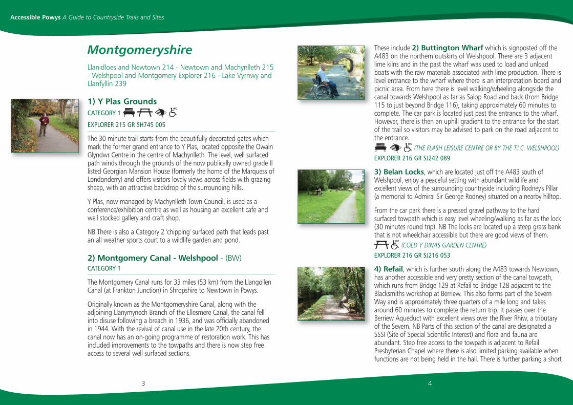
These include 2) Buttington Wharf which is signposted off theA483 on the northern outskirts of Welshpool. There are 3 adjacentlime kilns and in the past the wharf was used to load and unloadboats with the raw materials associated with lime production. There islevel entrance to the wharf where there is an interpretation board andpicnic area. From here there is level walking/wheeling alongside thecanal towards Welshpool as far as Salop Road and back (from Bridge115 to just beyond Bridge 116), taking approximately 60 minutes tocomplete. The car park is located just past the entrance to the wharf.However, there is then an uphill gradient to the entrance for the startof the trail so visitors may be advised to park on the road adjacent tothe entrance.
(THE FLASH LEISURE CENTRE OR BY THE T.I.C. WELSHPOOL)EXPLORER 216 GR SJ242 089
3) Belan Locks, which are located just off the A483 south ofWelshpool, enjoy a peaceful setting with abundant wildlife andexcellent views of the surrounding countryside including Rodney's Pillar(a memorial to Admiral Sir George Rodney) situated on a nearby hilltop.
From the car park there is a pressed gravel pathway to the hardsurfaced towpath which is easy level wheeling/walking as far as the lock(30 minutes round trip). NB The locks are located up a steep grass bankthat is not wheelchair accessible but there are good views of them.
(COED Y DINAS GARDEN CENTRE)EXPLORER 216 GR SJ216 053
4) Refail, which is further south along the A483 towards Newtown,has another accessible and very pretty section of the canal towpath,which runs from Bridge 129 at Refail to Bridge 128 adjacent to theBlacksmiths workshop at Berriew. This also forms part of the SevernWay and is approximately three quarters of a mile long and takesaround 60 minutes to complete the return trip. It passes over theBerriew Aqueduct with excellent views over the River Rhiw, a tributaryof the Severn. NB Parts of this section of the canal are designated aSSSI (Site of Special Scientific Interest) and flora and fauna areabundant. Step free access to the towpath is adjacent to RefailPresbyterian Chapel where there is also limited parking available whenfunctions are not being held in the hall. There is further parking a short
4
MontgomeryshireLlanidloes and Newtown 214 - Newtown and Machynlleth 215- Welshpool and Montgomery Explorer 216 - Lake Vyrnwy andLlanfyllin 239
1) Y Plas GroundsCATEGORY 1
EXPLORER 215 GR SH745 005
The 30 minute trail starts from the beautifully decorated gates whichmark the former grand entrance to Y Plas, located opposite the OwainGlyndwr Centre in the centre of Machynlleth. The level, well surfacedpath winds through the grounds of the now publically owned grade IIlisted Georgian Mansion House (formerly the home of the Marquess ofLondonderry) and offers visitors lovely views across fields with grazingsheep, with an attractive backdrop of the surrounding hills.
Y Plas, now managed by Machynlleth Town Council, is used as aconference/exhibition centre as well as housing an excellent cafe andwell stocked gallery and craft shop.
NB There is also a Category 2 'chipping' surfaced path that leads pastan all weather sports court to a wildlife garden and pond.
2) Montgomery Canal - Welshpool - (BW)CATEGORY 1
The Montgomery Canal runs for 33 miles (53 km) from the LlangollenCanal (at Frankton Junction) in Shropshire to Newtown in Powys.
Originally known as the Montgomeryshire Canal, along with theadjoining Llanymynech Branch of the Ellesmere Canal, the canal fellinto disuse following a breach in 1936, and was officially abandonedin 1944. With the revival of canal use in the late 20th century, thecanal now has an on-going programme of restoration work. This hasincluded improvements to the towpaths and there is now step freeaccess to several well surfaced sections.
3
Accessible Powys A Guide to Countryside Trails and Sites

The well surfaced, gently inclined pathway up to the castle from thecar park has stunning views over the town below. Access to the castleremains is across two level wooden boarded bridges giving excellentviews of the castle's deeply ditched defences. There is good accessaround most of the remains and to some of the information boards.The spectacular views over the surrounding countryside from thecastle's elevated position make this an amazing place to visit.
NB The grass path down to the area around the base of the castlewalls and the information board overlooking the site of the civil warbattle is challenging and too steeply inclined for wheelchair access.
7) Newtown Dolerw ParkCATEGORY 2 (BACK LANE CAR PARK& GRAVEL LANE CAR PARK)
EXPLORER 215 GR SO106 916
Newtown (Y Drenewydd) is the largest town in the county of Powys. Itlies on the banks of the River Severn and is best known as thebirthplace of Robert Owen, the Social Reformer, in 1771. There is anetwork of hard surfaced paths within Dolerw Park and alongside theriver, including a section of the long distance Severn Way whichpasses through the town.
Starting the trail from Back Lane Car Park is a good idea as this iswhere the cafe is located. The Path alongside the river towards theNature Reserve from the Dolerw Bridge divides offering visitors’ twoaccessible options.
The first follows a levee where there are benches (this is quite highwith no hand rail). The path curves around the car park, across aroad, down beside a public house/hotel and around a beautiful ruinedChurch. The path is hard and level surfaced as far as Gravel Car Park,however beyond this point the surface deteriorates so retracing yourroute back to the Dolerw Bridge is the best option. The second routefollows a lower riverside path, which, although it has less seating doeshave lovely sights and sounds.
65
Accessible Powys A Guide to Countryside Trails and Sites
distance away by the old motor works, opposite Glansevern HallGardens and adjacent to the main A483.
(BERRIEW RECREATION GROUND)EXPLORER 216 GR SJ192 002
5) Lake Vyrnwy Nature Reserve Sculpture TrailCATEGORY 2 (RSPB) (AT VISITOR CENTRE)
EXPLORER 239 GR SJO20 191
Lake Vyrnwy Nature Reserve is set in a beautiful part of Mid Wales, inthe heart of the Berwyn Mountains where Powys meets North EastWales. Lake Vyrnwy was created in 1888 when work on a dam tosupply water to Liverpool was finally completed. The old village ofLlanwddyn disappeared under the waters but when the level dropsduring dry summers, you can see the ruins of the buildings. Thereserve is managed by the RSPB and there is plenty to see and doincluding the RSPB shop and information centre, an audio visualtheatre, several gift and craft shops and tearooms.
At the bottom of the dam is a (45 minute) circular sculpture trail withgood hard-surfaced paths and riverside views. For step free accessfrom the Visitor Centre, cross the dam, turn right and take the nextright. There is a small car park at the end of this lane (blue badgeholders only).
6) Montgomery CastleCATEGORY 2 (CADW) (ONLY ACCESSIBLE TOILET IN MONTGOMERYIS LOCATED IN THE CASTLE TEAROOMS AND IS FOR CUSTOMERS USE ONLY)
EXPLORER 216 GR SO221 965
The town of Montgomery in Powys is dominated by the remains ofMontgomery Castle that stands on the hill behind the town. Thepresent castle was started in 1223 and replaced an earlier 'motte andbailey' castle called Hen Domen sited one mile away to the north west.This new site on a rocky outcrop proved an excellent choice as thecastle was never taken by force throughout the town's turbulenthistory and it remained an English stronghold in this area of theMarches until it was finally demolished in 1649.
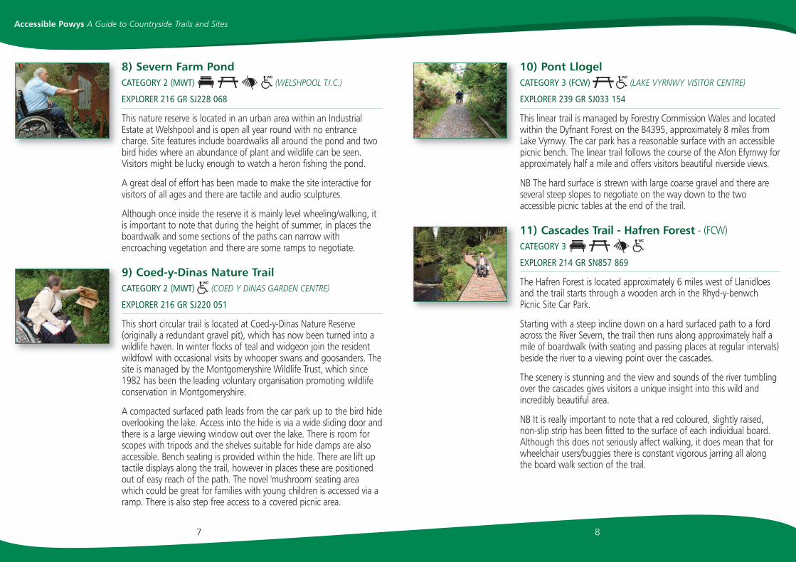
10) Pont LlogelCATEGORY 3 (FCW) (LAKE VYRNWY VISITOR CENTRE)
EXPLORER 239 GR SJ033 154
This linear trail is managed by Forestry Commission Wales and locatedwithin the Dyfnant Forest on the B4395, approximately 8 miles fromLake Vyrnwy. The car park has a reasonable surface with an accessiblepicnic bench. The linear trail follows the course of the Afon Efyrnwy forapproximately half a mile and offers visitors beautiful riverside views.
NB The hard surface is strewn with large coarse gravel and there areseveral steep slopes to negotiate on the way down to the twoaccessible picnic tables at the end of the trail.
11) Cascades Trail - Hafren Forest - (FCW)CATEGORY 3
EXPLORER 214 GR SN857 869
The Hafren Forest is located approximately 6 miles west of Llanidloesand the trail starts through a wooden arch in the Rhyd-y-benwchPicnic Site Car Park.
Starting with a steep incline down on a hard surfaced path to a fordacross the River Severn, the trail then runs along approximately half amile of boardwalk (with seating and passing places at regular intervals)beside the river to a viewing point over the cascades.
The scenery is stunning and the view and sounds of the river tumblingover the cascades gives visitors a unique insight into this wild andincredibly beautiful area.
NB It is really important to note that a red coloured, slightly raised,non-slip strip has been fitted to the surface of each individual board.Although this does not seriously affect walking, it does mean that forwheelchair users/buggies there is constant vigorous jarring all alongthe board walk section of the trail.
8
8) Severn Farm PondCATEGORY 2 (MWT) (WELSHPOOL T.I.C.)
EXPLORER 216 GR SJ228 068
This nature reserve is located in an urban area within an IndustrialEstate at Welshpool and is open all year round with no entrancecharge. Site features include boardwalks all around the pond and twobird hides where an abundance of plant and wildlife can be seen.Visitors might be lucky enough to watch a heron fishing the pond.
A great deal of effort has been made to make the site interactive forvisitors of all ages and there are tactile and audio sculptures.
Although once inside the reserve it is mainly level wheeling/walking, itis important to note that during the height of summer, in places theboardwalk and some sections of the paths can narrow withencroaching vegetation and there are some ramps to negotiate.
9) Coed-y-Dinas Nature TrailCATEGORY 2 (MWT) (COED Y DINAS GARDEN CENTRE)
EXPLORER 216 GR SJ220 051
This short circular trail is located at Coed-y-Dinas Nature Reserve(originally a redundant gravel pit), which has now been turned into awildlife haven. In winter flocks of teal and widgeon join the residentwildfowl with occasional visits by whooper swans and goosanders. Thesite is managed by the Montgomeryshire Wildlife Trust, which since1982 has been the leading voluntary organisation promoting wildlifeconservation in Montgomeryshire.
A compacted surfaced path leads from the car park up to the bird hideoverlooking the lake. Access into the hide is via a wide sliding door andthere is a large viewing window out over the lake. There is room forscopes with tripods and the shelves suitable for hide clamps are alsoaccessible. Bench seating is provided within the hide. There are lift uptactile displays along the trail, however in places these are positionedout of easy reach of the path. The novel 'mushroom' seating areawhich could be great for families with young children is accessed via aramp. There is also step free access to a covered picnic area.
7
Accessible Powys A Guide to Countryside Trails and Sites
14) Elan Valley Trail (EVT) - Garreg Ddu ReservoirCATEGORY 1 (AT VISITOR CENTRE)
EXPLORER 200 GR SN928 646
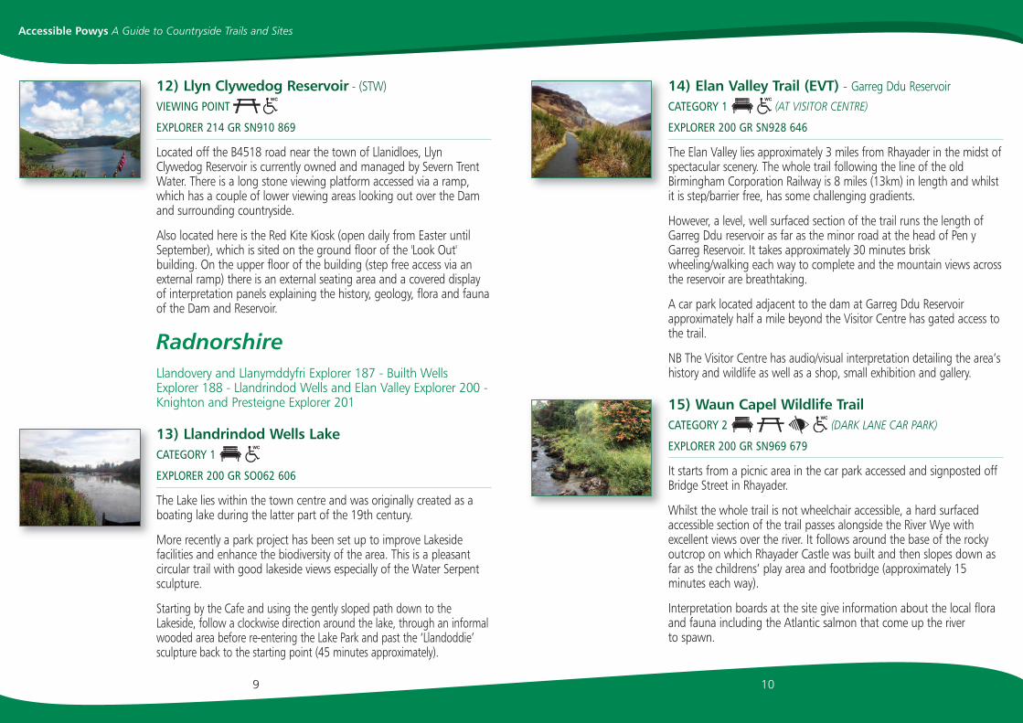
The Elan Valley lies approximately 3 miles from Rhayader in the midst ofspectacular scenery. The whole trail following the line of the oldBirmingham Corporation Railway is 8 miles (13km) in length and whilstit is step/barrier free, has some challenging gradients.
However, a level, well surfaced section of the trail runs the length ofGarreg Ddu reservoir as far as the minor road at the head of Pen yGarreg Reservoir. It takes approximately 30 minutes briskwheeling/walking each way to complete and the mountain views acrossthe reservoir are breathtaking.
A car park located adjacent to the dam at Garreg Ddu Reservoirapproximately half a mile beyond the Visitor Centre has gated access tothe trail.
NB The Visitor Centre has audio/visual interpretation detailing the area’shistory and wildlife as well as a shop, small exhibition and gallery.
15) Waun Capel Wildlife TrailCATEGORY 2 (DARK LANE CAR PARK)
EXPLORER 200 GR SN969 679
It starts from a picnic area in the car park accessed and signposted offBridge Street in Rhayader.
Whilst the whole trail is not wheelchair accessible, a hard surfacedaccessible section of the trail passes alongside the River Wye withexcellent views over the river. It follows around the base of the rockyoutcrop on which Rhayader Castle was built and then slopes down asfar as the childrens’ play area and footbridge (approximately 15minutes each way).
Interpretation boards at the site give information about the local floraand fauna including the Atlantic salmon that come up the river to spawn.
10
12) Llyn Clywedog Reservoir - (STW)VIEWING POINT
EXPLORER 214 GR SN910 869
Located off the B4518 road near the town of Llanidloes, LlynClywedog Reservoir is currently owned and managed by Severn TrentWater. There is a long stone viewing platform accessed via a ramp,which has a couple of lower viewing areas looking out over the Damand surrounding countryside.
Also located here is the Red Kite Kiosk (open daily from Easter untilSeptember), which is sited on the ground floor of the 'Look Out'building. On the upper floor of the building (step free access via anexternal ramp) there is an external seating area and a covered displayof interpretation panels explaining the history, geology, flora and faunaof the Dam and Reservoir.
Radnorshire Llandovery and Llanymddyfri Explorer 187 - Builth WellsExplorer 188 - Llandrindod Wells and Elan Valley Explorer 200 -Knighton and Presteigne Explorer 201
13) Llandrindod Wells LakeCATEGORY 1
EXPLORER 200 GR SO062 606
The Lake lies within the town centre and was originally created as aboating lake during the latter part of the 19th century.
More recently a park project has been set up to improve Lakesidefacilities and enhance the biodiversity of the area. This is a pleasantcircular trail with good lakeside views especially of the Water Serpentsculpture.
Starting by the Cafe and using the gently sloped path down to theLakeside, follow a clockwise direction around the lake, through an informalwooded area before re-entering the Lake Park and past the ‘Llandoddie’sculpture back to the starting point (45 minutes approximately).
9
Accessible Powys A Guide to Countryside Trails and Sites

18) Withybeds and Wentes Meadow Nature Reserve (RWT)CATEGORY 2 (HEREFORD STREET, PRESTEIGNE)
EXPLORER 201 GR SO309 650
The site is located on the edge of Presteigne and alongside the RiverLugg. Both the Withybeds and this section of the river have beendesignated SSSI (Site of Special Scientific Interest). It is a flora andfauna rich habitat including many species of birds,dragonflies/damselflies and yellow necked mice.
The boardwalk takes 30 minutes to complete and is of a good widthand well defined. This is a pleasant site with plenty of interest andexcellent views over the river especially from the only bench on site.
NB On the research visit, the site entrance gate and the path to theboardwalk had encroached vegetation issues and the tapping rail wasnot well defined. Therefore, although fairly level throughout, it wasgraded a Level 2.
19) Rock ParkCATEGORY 3 (LLANDRINDOD WELLS RAILWAY STATION)
EXPLORER 200 GR SO055 609
This park is a community space within the town of Llandrindod Wells.It was established in the nineteenth century as a recreational areawhen the town drew in many visitors to 'take the waters' from itsnatural springs. The park was popular and well used for many years,however from the middle of the twentieth century it gradually fell intodecline. In more recent years combined projects with Powys CountyCouncil and the Friends of the Rock Park Trust have seen on-goingimprovement work to restore the park to its former glory.
Access to the parking area by the Heritage Centre is down a steeproad. However, this car park has a sloping surface and no designatedspaces. There are spaces adjacent to the Bowling Club approximately50 metres further along the track, which on non-match days maybemore suitable for visitors with easy access needs.The park has lovelystreams and wooded areas with some good accessible paths and
12
16) Pwll Bo (FCW)
CATEGORY 2 (LLANWRTYD WELLS BY BRIDGE/COEDTRAWLLMFOREST VISITOR CENTRE)
EXPLORER 187 GR SN856 507
Located near Llanwrtyd Wells, this trail is set within mature coniferouswoodland managed by the Forestry Commission. Starting from the carpark it has open views of the River Irfon and the first section is fairly leveland relatively easy walking/wheeling.
Beyond this point the trail goes up a steep incline and then drops sharplydown to a seat overlooking the river, then leaving the riverside takes asharp turn to the right from which point it is only accessible for peoplewith good walking ability. This very attractive linear trail takes approximately50 minutes to complete and the sounds of the river, the wind in the trees,trickling streams and woodland birds are very evident all along the route.
NB In places the surface is uneven with exposed slate or covered with softpine needles.
17) Offa’s Dyke Path - KnightonCATEGORY 2
EXPLORER 201 GR SO285 726
Offa, King of Mercia (757 - 796 AD) commissioned the Dyke, a massivelinear earthwork on the western edge of his Kingdom (still roughly theWelsh/English boundary) as a defence against attacks from Wales. Offa’sDyke Visitor Centre in Knighton, which lies approximately midway along theDyke, contains information, a shop and interesting displays/exhibits. One of15 long distance national trails, Offa’s Dyke Path is 177 miles long and linksthe Severn estuary near Chepstow with the North Sea at Prestatyn.
Access down to a short section of the Path from the centre is via a flightof steps and although there is a signed grassed alternative route, this issteep, uneven and would be slippery in wet weather.
Alternative step free access is through a gate off nearby Crabtree Walk(includes a small parking area) and another gate leads to an accessible linearsection of the Shropshire Hills Path with beautiful scenic riverside views.
11
Accessible Powys A Guide to Countryside Trails and Sites

The Nature Discovery Centre (open during school holidays and someweekends) offers a programme of countryside activities. When it isshut visitors can still see inside the Byre, part of the traditional WelshLonghouse, which has information about the area and its wildlife aswell as some traditional farming tools.
There are trails throughout the reserve but due to the nature of thiswild area even those indicated as easier access are not wheelchairaccessible or suitable for visitors with limited mobility. However, thebreathtaking scenery along the drive through the reserve up to thefarm makes this site well worth a visit.
There is wheelchair access via a ramp (with assistance) to the Otter hidelocated by a stream approximately a quarter of a mile before reaching thefarm. The hide has foldable seating to enable space in front of a lowerviewing window. There is also space for one car to park near the hide.
22) Gigrin Farm – Red Kite Feeding Centre
EXPLORER 200 GR SN980 677
This privately run site is located near Rhayader in spectacularcountryside and is home to the largest and most diverse concentrationof birds of prey in Southern Britain. The diligence involved in theconservation work of red kites in this area has made this a story ofoutstanding success. To watch the sky fill with the sight and sound ofhundreds of pairs of these amazing creatures performing an aerialballet is a wondrous experience.
The feeding centre is on a working hill farm and as such has someuneven ground and natural slopes. However, to avoid traversing thefarm track down to the viewing area, blue badge holders can ask topark adjacent to the ramped entrance to the accessible hides.
There is excellent vision of the feeding display (lasting approximatelyone and a half hours) through low observation windows in thededicated area for people with more limited mobility.
The centre's information building which houses video displays andinterpretation panels is on two levels with an internal step but there is
14
bridges and is well worth visiting. However, the natural topography ofthe landscape means that some of the paths are extremely steep. Amap is located by the bridge on the approach road that highlightsprominent features within the Park (e.g. Chalybeate Spring) howeverplease note this does not give any indication of easier access routes.New visitors may need to proceed with caution as it is extremely easyto end up on a path with very challenging gradients.
20) Cors-y-Llyn Nature Reserve (CCW)CATEGORY 3 (BUILTH WELLS BY THE STRAND CAR PARK)
EXPLORER 200 GR SO016 556
This site is located approximately 1.5 miles from Newbridge-on-Wye inMid Wales. It has been designated a Site of Special Scientific Interestbecause of its rare habitat of herb rich meadowland and acid mire,which is rich in unusual flora and fauna.The entrance to the site is via acountry lane off the A470 to Builth Wells and through a gated farmroad. A 500 metre wheelchair accessible linear route has been createdto run from the car park through meadowland (over grass mesh) pastopen water and then via an accessible boardwalk through parts of themire culminating in seating at a viewing point.
Care needs to be taken to keep to the boardwalk which has passingplaces as the surrounding mire is deep in places. NB There is a tappingrail on either side of the board walk.
Visitors of all abilities are offered a unique chance to explore a wildand extraordinary part of the Welsh landscape.
21) Gilfach Farm - Nature Reserve (RWT)
EXPLORER 200 GR SN965 717
This site is the flagship nature reserve of Radnorshire Wildlife Trust andis situated near the confluence of the Marteg River with the River Wye,2 miles north of Rhayader in the Cambrian Mountains of Mid Wales. Itcovers 410 acres and encompasses a wide variety of habitats includingrocky outcrops, traditionally managed hay meadows, woodlands andriver valleys.
13
Accessible Powys A Guide to Countryside Trails and Sites

It is a wooded steeply sloping site following the course of the RiverEnig. However, a 500 metre level linear trail, down to a woodland seatand interpretation board, has been created to enable visitors of allabilities to enjoy the woodland.
The site is designated a Site of Special Scientific Interest and noted forits diverse flora and fauna and the trail, which in spring and summeris lined with a variety of rare wild flowers. The path takesapproximately 45 minutes to complete.
It is important to note that the waterfall and Witches Pool alsosituated within the reserve can only be reached by steep uneven pathsthat are only suitable for visitors with excellent ambulant ability.
25) Talybont ReservoirCATEGORY 1 (WW/FCW) (NEAREST FULLY ACCESSIBLE TOILET ISBRECON CANAL BASIN)
EXPLORER OL13 GR SO103 205
This category 1 trail around part of the Reservoir at Talybont-on-Usktakes approximately 45 minutes to complete and is level easywheeling/walking. It offers visitors stunning views of the surroundinglandscape and the large stretch of water, which is home to a widevariety of wildfowl and migratory birds.
It is possible to park on a minor road adjacent to the Dam andwalk/wheel along a road (with several passing places) over the Dam.There are excellent views to both sides of this road and an interpretationboard giving details of the pumping station's supply of water to the area.
On the far side of the Dam, turn right on to a track that passesalongside the reservoir and woodland. It is level and hard surfaced forapproximately a quarter of a mile to a vehicle turning point. NB Fromhere the track surface deteriorates and goes uphill so most visitorswith easy access needs will need to turn and retrace the route.
1615
Accessible Powys A Guide to Countryside Trails and Sites
step free access to both areas on the ground floor through separateentrances. NB The trail at the farm (mentioned in its promotionalliterature) is not wheelchair accessible.
BrecknockshireBrecon Beacons National Park (Western area) OL 12 BreconBeacons National Park (Eastern area) OL 13 - Builth WellsExplorer 188
23) Monmouthshire and Brecon Canal - BreconCATEGORY 1 (BW) (LOCATED WITHIN THE THEATRE)
EXPLORER OL 12 GR SO046 281
A two mile linear trail starts from the Canal Basin in Brecon and followsthe canal as far as Brynich Lock and the Aqueduct. On the way visitorspass interpretation boards, community art projects and the scenery isbeautiful especially the views over the River Taff to the hills beyond.
The start of the trail is narrow and uneven in places but soon broadensout into a wide hard surfaced cycle path. Apart from the ramp at theend of the trail leading back up on to the wharf, there are no realinclines and the trail is level all the way. For visitors with a hearingimpairment it is important to note this is a busy cycle route and whilstthere are signs requesting that priority is given to pedestrians, manycyclists speed through ringing their bells as the only warning.
NB This is definitely a fair weather walk, as during or after prolongedrain there are deep puddles right across the path all along the route.
24) Pwll-y-wrachCATEGORY 1 (BWT) (TALGARTH SQUARE)
EXPLORER OL13 GR SO163 327
Pwll-y-wrach is located approximately one mile south east of the town ofTalgarth within the foothills of the Black Mountains. The trail can beaccessed by leaving the town square, passing over the bridge and takingthe first left and then keeping left for approximately one mile. The smallparking area for the trail is on the right hand side of the road.

28) Craig-y-Nos Country ParkCATEGORY 2 (BBNPA)
EXPLORER OL12 GR SN840 155
Craig-y-nos Country Park is situated in the upper Tawe Valley to thesouth east of Brecon and within the Brecon Beacons National Park.Once inside the walled entrance below the car park, there is a choiceof a short level circular trail around the fish pond or a longerundulating circular trail around the wider estate.
The longer trail which includes the Far Lake has clear signageindicating the easier access route through a rhododendron arch backto the start point. Bounded by the Afon Tawe and containing a formerfishpond and the Far Lake, water is a dominant feature of the park.There is seating at regular intervals and a wheelchair accessible picnicbench invitingly sited just over the bridge on the edge of the river.
General accessibility is good, however, please note for the longer trail,visitors with visual impairments and wheelchair users may requireassistance, as some of the path surfaces are not clearly defined andare uneven in places.
29) Brecon PromenadeCATEGORY 3 (UPPER MEADOW CAR PARKSPORTS GROUND)
EXPLORER OL12 GR SO042 286
This linear trail is located in Brecon alongside the River Usk and haslovely river views. From the town end, access is over a very steep rampadjacent to a small car park and then along a pleasant, tree lined,level section past the weir. The trail then goes up and down a longincline towards the cafe and boat hire before levelling out again as faras the sports field, where the hard surface ends and it becomes grass.
Starting the trail from the car park adjacent to the boathouse offerslevel access to the trail, however there is then the steep incline tonegotiate before reaching the weir so most manual wheelchair userswill require assistance in either direction.
18
26) The GroeCATEGORY 1
EXPLORER 188 GR SO041 511
This lovely riverside park, located in the town of Builth Wells, was usedas rough grazing in the 19th century and the river still marks theboundary between the old counties of Brecknockshire and Radnorshire.
Starting from the car park, an easy, hard surfaced trail runs alongsidethe River Wye and through an avenue of trees (known locally asAbram's Folly) to the confluence where the River Wye and the RiverIrfon meet.
This level, linear option takes approximately 30 minutes to completeand offers excellent views of the surrounding countryside and the sixarched bridge (built in 1775).
NB It is also possible to continue and complete a circular route whichtakes in part of the town.
27) Talybont-on-Usk Canal TowpathCATEGORY 2 (BW) (NEAREST FULLY ACCESSIBLETOILET IS BRECON CANAL BASIN)
EXPLORER OL13 GR SO112 227
For most of its 35-mile length the Monmouthshire and Brecon canal(originally built as a means to transport coal and iron) runs throughthe Brecon Beacons National Park with beautiful views of thesurrounding countryside. This accessible section of canal towpathlocated within Talybont on Usk is on level good surfaced paths, whichstretch for a short way in either direction from the Lift Bridge locatedopposite the village stores/cafe. There is plenty of seating along theroute and also some interpretation signage about the area.
NB Access up to the canal is either via an inclined zigzagged pathopposite the stores or up an inclined minor road from a small car park.
17
Accessible Powys A Guide to Countryside Trails and Sites

20
30) Epynt WayCATEGORY 3 (DE)
EXPLORER 188 GR SN993 437
This trail is located off the B4519 Brecon to Garth road in an areaknown as Mynydd Epynt 'mountain (crossed by a) horse-path', whichsince 1939 has been the MOD Sennybridge Training Area. The trailstarts next to the unmanned Epynt Visitor Centre and the sectiondesignated as easier access runs up an incline for approximately half amile to a viewing point over this wild rugged mountain moorlandlandscape.
The accessible section of the trail is inclined for the entire route andmost manual wheelchair users would need the assistance of a veryfit/able assistant to reach the viewing point. Starting from the car park,assistance is also needed to get through the gate at the side of thecattle grid leading to the start of the trail.
There is seating at regular intervals along this section of the trail,however much of this is now accessed across very rough grass andwheelchair users and people with limited ambulant ability might havedifficulty reaching them.
There are interpretation panels at several points and on our researchers’visit a wealth of typical high moorland birds could be seen.
Please note this is a remote area with rapidly changing weatherconditions and waterproof clothing and stout footwear are advisable.
31) Hay-on-Wye Riverside TrailCATEGORY 3 (ADJACENT TO T.I.C. IN TOWN)
EXPLORER OL13 GR SO230 428
As the name indicates this linear trail is located alongside the river inHay-on-Wye and follows a section of the cycle track 'Lon Las Cymru 42'.
It is some distance from the designated parking in the Tourist InformationCentre car park to the trail and wheeling from there to the trail access pointscould be challenging due to the steep/narrow pavements. Alternatively thereis limited parking in a lay-by on the far side of Hay Bridge.
19
Accessible Powys A Guide to Countryside Trails and Sites
The access point from the bridge is very steeply sloped and mostmanual wheelchair users will require assistance from a very fit/ablecompanion on descent and ascent. The alternative path down to thetrack located off Gypsy Castle Lane by the Church, has an unevensurface and is not wheelchair accessible.
The trail is located on part of a former railway track and havingnegotiated the access points is level wheeling, with the accessiblesection taking approximately 50 minutes to complete.
In high summer, tree foliage blocks much of the river view but there isa good viewing point over the river from under the bridge at the startof the trail. Also encroachment of tall nettles and other vegetation caneffect the length of the path's accessibility.
32) Brecon National Park Mountain Visitor Centre(BBNPA)
EXPLORER OL12 GR SN977 262
The Brecon National Park Mountain Visitor Centre is located at Libanusapproximately 6 miles from Brecon. It is signposted off the main A470and accessed up a steep lane. As well as being an information point,it contains an interpretation area, a video room, an external viewingbalcony with excellent views over the surrounding countryside and acafe. Special events and family craft sessions are held throughout theyear and details are available on the website.
The centre is set on a large area of common but please note due tothe topography of the landscape access to this is restricted for peoplewith limited ambulant ability and wheelchair users. Our self propellingmanual wheelchair user researcher was able (with assistance) to wheelalong the entrance road a short way and along an uneven ruttedtrack across the common to a point with excellent views. However,more of the common may be accessible for visitors who have theirown 'all-terrain' powered scooters as the tracks are not gated.
NB The National Park Authority produces a comprehensive EasierAccess Guide which is available in a physical format from the centre orto download from their website in pdf.

Useful websites: www.powys.gov.uk
www.disabledholidayinfo.org.uk
www.brecknockaccess.org.uk
www.brecknockwildlifetrust.org.uk
www.breconbeacons.org
cadw.wales.gov.uk
www.ccw.gov.uk
www.elanvalley.org.uk
www.epyntway.org
www.forestry.gov.uk
www.gigrin.co.uk
www.montwt.co.uk
www.plasmachynlleth.co.uk
www.rspb.org.uk
www.rwtwales.org
www.stwater.co.uk
www.waterscape.com
wales.gov.uk
Notes:
22
Useful Contacts
Powys County Council GwaliaGwalia, Ithon Road, Llandrindod Wells, Powys,LD1 6AA. Tel 0845 602 7030
Disabled Holiday Information(reg charity no.1119972), PO Box 186,Oswestry, Shropshire, SY10 1AF.
Brecknock Access GroupNew Wing, Brecon War Memorial Hospital,Cerrigcochion Road, Brecon Powys, LD3 7NS.Tel 01874 611401 (answerphone only)
Brecknock Wildlife Trust (BWT)Lion House, Bethel Square, Brecon, Powys, LD3 7AY.Tel 01874 625708
Brecon Beacons National ParkAuthority (BBNPA)Plas y Ffynnon, Cambrian Way, Brecon, Powys,LD3 7HP. 01874 624437 or 01873 830328
British Waterways North Wales &Borders (BW)Navigation House, Navigation Road, Northwich.Cheshire, CW8 1BH. Tel 01606 723800
Cadw (CADW)Welsh Government, Plas Carew, Unit 5/7 CefnCoed, Parc Nantgarw, Cardiff, CF15 7QQ. Tel 01443 336000
Countryside Council For Wales(CCW)Maes y Ffynnon, Penrhosgarnedd, Bangor,Gwynedd, LL57 2DW. Tel 0845 130 6229
Defence Estates (DE)The Barracks, Brecon LD3 7EA . Tel 01874 613887
Elan Valley Visitor CentreElan Estate Office, Elan Village, Rhayader, Powys,LD6 5HP. Tel 01597 810449
Forestry Commission Wales (FCW)Welsh Government, Rhodfa Padarn, LlanbadarnFawr, Aberystwyth, Ceredigion, SY23 3UR. Tel 0300 068 0300
Gigrin FarmSouth Street, Rhayader, Powys, LD6 5BL. Tel 01597 810243
Radnorshire Wildlife Trust (RWT)Warwick House, High Street, Llandrindod Wells,Powys, LD1 6AG. Tel 01597 823298
RSPB Lake Vyrnwy Visitor CentreLlanwddyn, Welshpool, Powys, SY10 0ND. Tel 01691 870278
The Montgomeryshire WildlifeTrust (MWT)42 Broad Street, Welshpool, Powys, SY21 7RR.Tel 01938 555654
Y PlasMachynlleth, Aberystwyth Road, Powys, SY20 8ER. Tel 01654 702571
21
Accessible Powys A Guide to Countryside Trails and Sites

2977
1 Sh
rops
hire
Cou
ncil
Des
ign
& P
rint
©M
ar 2
012
Disabled Holiday Information(Reg charity no.1119972), PO Box 186, Oswestry, Shropshire SY10 1AF.
© March 2012
The research and development of this guide has been carried out by:
PLEASE NOTE - If you can read this, but know someone who can’t,please contact us via e-mail or letter and we will try to provide this
information in a more suitable format.
The production of the guide has been funded by:
Cover image: Montgomery Castle
BE SAFE - PLAN AHEAD AND FOLLOW ANYSIGNS. LEAVE GATES AND PROPERTY AS YOUFIND THEM. PROTECT PLANTS AND ANIMALS,AND TAKE YOUR LITTER HOME. KEEP DOGS
UNDER CLOSE CONTROL.