A14 Cambridge to Huntingdon improvement scheme ... Cambridge to Huntingdon improvement scheme ....
39
A14 Cambridge to Huntingdon improvement scheme Environmental Statement Appendices Appendix 12.1: Geology and soils: land contamination - additional information Date: December 2014 6.3
Transcript of A14 Cambridge to Huntingdon improvement scheme ... Cambridge to Huntingdon improvement scheme ....
A14 Cambridge to Huntingdon improvement scheme
Environmental Statement
Appendices
Appendix 12.1: Geology and soils: land contamination - additional information
Date: December 2014
6.3

Page left intentionally blank
A14 Cambridge to Huntingdon improvement scheme Environmental Statement Appendices
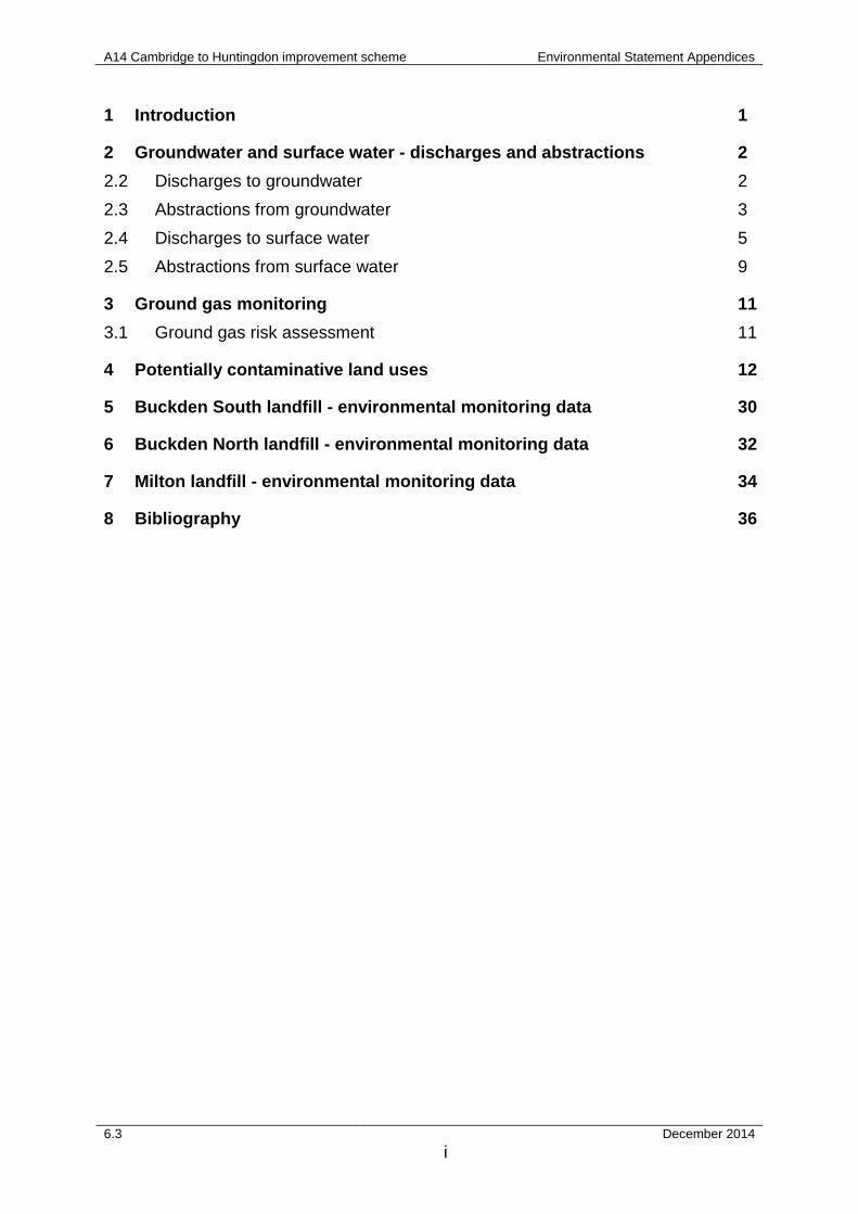
1 Introduction 1
2 Groundwater and surface water - discharges and abstractions 2
2.2 Discharges to groundwater 2
2.3 Abstractions from groundwater 3
2.4 Discharges to surface water 5
2.5 Abstractions from surface water 9
3 Ground gas monitoring 11
3.1 Ground gas risk assessment 11
4 Potentially contaminative land uses 12
5 Buckden South landfill - environmental monitoring data 30
6 Buckden North landfill - environmental monitoring data 32
7 Milton landfill - environmental monitoring data 34
8 Bibliography 36
6.3 December 2014 i
A14 Cambridge to Huntingdon improvement scheme Environmental Statement Appendices
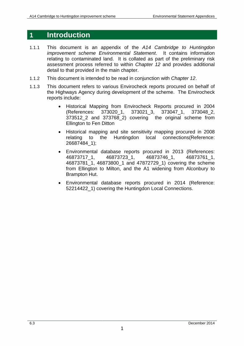
1 Introduction 1.1.1 This document is an appendix of the A14 Cambridge to Huntingdon
improvement scheme Environmental Statement. It contains information relating to contaminated land. It is collated as part of the preliminary risk assessment process referred to within Chapter 12 and provides additional detail to that provided in the main chapter.
1.1.2 This document is intended to be read in conjunction with Chapter 12. 1.1.3 This document refers to various Envirocheck reports procured on behalf of
the Highways Agency during development of the scheme. The Envirocheck reports include:
• Historical Mapping from Envirocheck Reports procured in 2004 (References: 373020_1, 373021_3, 373047_1, 373048_2, 373512_2 and 373768_2) covering the original scheme from Ellington to Fen Ditton
• Historical mapping and site sensitivity mapping procured in 2008 relating to the Huntingdon local connections(Reference: 26687484_1);
• Environmental database reports procured in 2013 (References: 46873717_1, 46873723_1, 46873746_1, 46873761_1, 46873781_1, 46873800_1 and 47872729_1) covering the scheme from Ellington to Milton, and the A1 widening from Alconbury to Brampton Hut.
• Environmental database reports procured in 2014 (Reference: 52214422_1) covering the Huntingdon Local Connections.
6.3 December 2014 1
A14 Cambridge to Huntingdon improvement scheme Environmental Statement Appendices
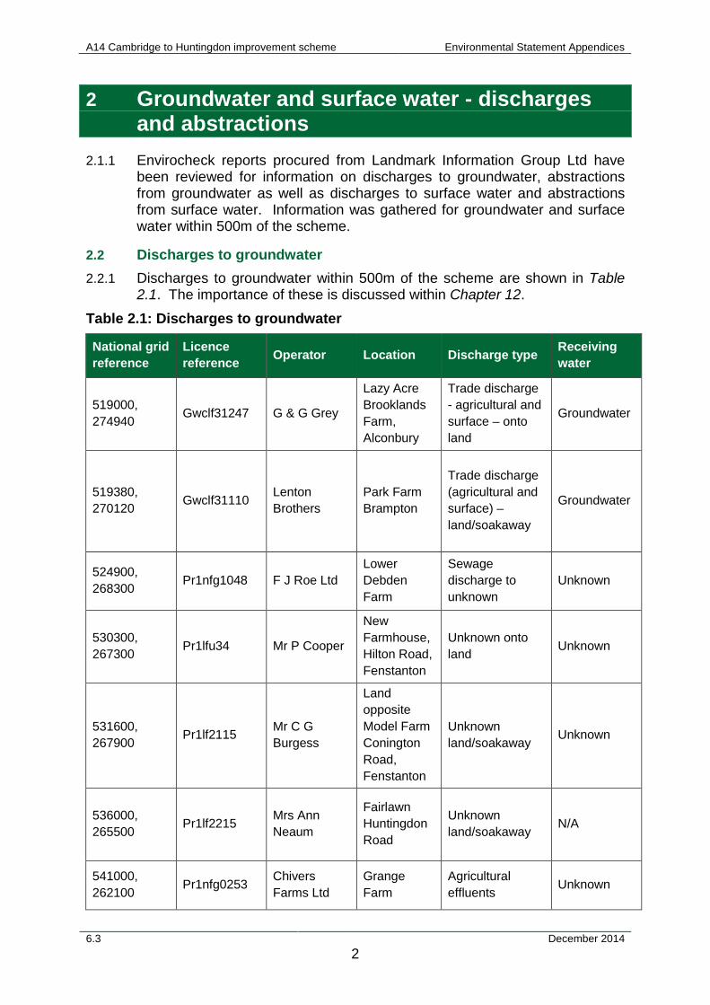
2 Groundwater and surface water - discharges and abstractions
2.1.1 Envirocheck reports procured from Landmark Information Group Ltd have been reviewed for information on discharges to groundwater, abstractions from groundwater as well as discharges to surface water and abstractions from surface water. Information was gathered for groundwater and surface water within 500m of the scheme.
2.2 Discharges to groundwater 2.2.1 Discharges to groundwater within 500m of the scheme are shown in Table
2.1. The importance of these is discussed within Chapter 12.
Table 2.1: Discharges to groundwater
National grid reference
Licence reference Operator Location Discharge type Receiving
water
519000, 274940 Gwclf31247 G & G Grey
Lazy Acre Brooklands Farm, Alconbury
Trade discharge - agricultural and surface – onto land
Groundwater
519380, 270120 Gwclf31110 Lenton
Brothers Park Farm Brampton
Trade discharge (agricultural and surface) – land/soakaway
Groundwater
524900, 268300 Pr1nfg1048 F J Roe Ltd
Lower Debden Farm
Sewage discharge to unknown
Unknown
530300, 267300 Pr1lfu34 Mr P Cooper
New Farmhouse, Hilton Road, Fenstanton
Unknown onto land Unknown
531600, 267900 Pr1lf2115 Mr C G
Burgess
Land opposite Model Farm Conington Road, Fenstanton
Unknown land/soakaway Unknown
536000, 265500 Pr1lf2215 Mrs Ann
Neaum
Fairlawn Huntingdon Road
Unknown land/soakaway N/A
541000, 262100 Pr1nfg0253 Chivers
Farms Ltd Grange Farm
Agricultural effluents Unknown
6.3 December 2014 2
A14 Cambridge to Huntingdon improvement scheme Environmental Statement Appendices
National grid reference
Licence reference Operator Location Discharge type Receiving
water
543500, 261900 Gwclf30521
National Institute Of Agricultural Botany
Huntingdon Road, Cambridge
Trade discharge (agricultural and surface) to land/soakaway
Groundwater
523300, 272400 Pr1lfu293 Mr M G
Stephenson
No 9 Stukeley Road
Discharge to land - unknown origin
N/A
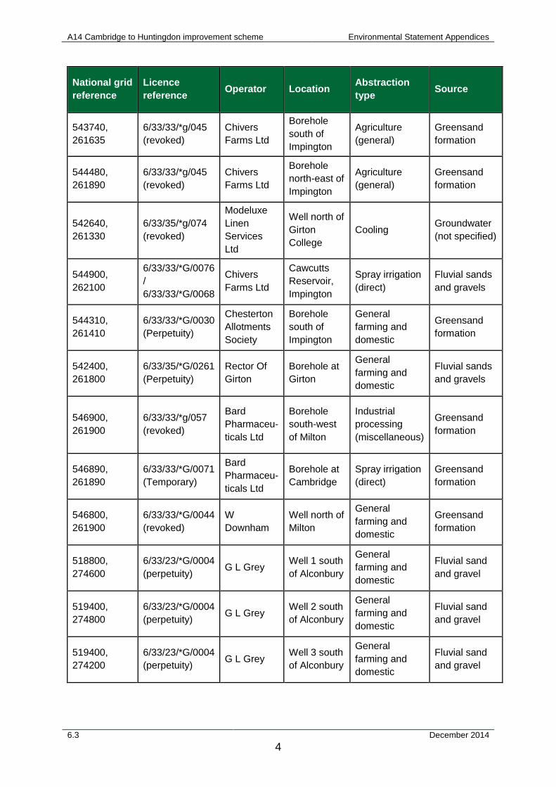
2.3 Abstractions from groundwater 2.3.1 Abstractions from groundwater within 500m of the scheme are shown in
Table 2.2. The importance of these is discussed within Chapter 12. Table 2.2: Abstractions from groundwater
National grid reference
Licence reference Operator Location Abstraction
type Source
519700, 272000
6/33/25/*g/011 / 6/33/25/*G/0014
G.B. Sewell and Partners
East of Brampton Hut
Spray irrigation Fluvial sand and gravel
519850, 270100 6/33/22/*G/0010 Lenton Bros
Ltd
Gravel pit south-west of Brampton
Spray irrigation Fluvial sand and gravel
521200, 268300
6/33/22/*g/049 (revoked) P W Mann
Gravel pit north-east of Buckden
Spray irrigation Fluvial sand and gravel
539150, 263410
6/33/35/*G/0067 (perpetuity)
Welney Farms Ltd
Well north of Dry Drayton
General farming and domestic
Groundwater (not specified)
538505, 263495
6/33/35/*g/203 (revoked)
Cambridge-shire Hotel Ltd
Borehole north of Dry Drayton
Spray irrigation
Groundwater from catchment pit (not specified)
540800, 261800
6/33/35/*g/028 (revoked)
Cambridge University Farm
Borehole, Wells Field
Agriculture (General)
Groundwater (not specified)
542000, 261000
6/33/35/*g/028 (revoked)
Cambridge University Farm
Borehole , Howe Farm
Agriculture (general)
Groundwater (not specified)
6.3 December 2014 3
A14 Cambridge to Huntingdon improvement scheme Environmental Statement Appendices
National grid reference
Licence reference Operator Location Abstraction
type Source
543740, 261635
6/33/33/*g/045 (revoked)
Chivers Farms Ltd
Borehole south of Impington
Agriculture (general)
Greensand formation
544480, 261890
6/33/33/*g/045 (revoked)
Chivers Farms Ltd
Borehole north-east of Impington
Agriculture (general)
Greensand formation
542640, 261330
6/33/35/*g/074 (revoked)
Modeluxe Linen Services Ltd
Well north of Girton College
Cooling Groundwater (not specified)
544900, 262100
6/33/33/*G/0076 / 6/33/33/*G/0068
Chivers Farms Ltd
Cawcutts Reservoir, Impington
Spray irrigation (direct)
Fluvial sands and gravels
544310, 261410
6/33/33/*G/0030 (Perpetuity)
Chesterton Allotments Society
Borehole south of Impington
General farming and domestic
Greensand formation
542400, 261800
6/33/35/*G/0261 (Perpetuity)
Rector Of Girton
Borehole at Girton
General farming and domestic
Fluvial sands and gravels
546900, 261900
6/33/33/*g/057 (revoked)
Bard Pharmaceu-ticals Ltd
Borehole south-west of Milton
Industrial processing (miscellaneous)
Greensand formation
546890, 261890
6/33/33/*G/0071 (Temporary)
Bard Pharmaceu-ticals Ltd
Borehole at Cambridge
Spray irrigation (direct)
Greensand formation
546800, 261900
6/33/33/*G/0044 (revoked)
W Downham
Well north of Milton
General farming and domestic
Greensand formation
518800, 274600
6/33/23/*G/0004 (perpetuity) G L Grey Well 1 south
of Alconbury
General farming and domestic
Fluvial sand and gravel
519400, 274800
6/33/23/*G/0004 (perpetuity) G L Grey Well 2 south
of Alconbury
General farming and domestic
Fluvial sand and gravel
519400, 274200
6/33/23/*G/0004 (perpetuity) G L Grey Well 3 south
of Alconbury
General farming and domestic
Fluvial sand and gravel
6.3 December 2014 4
A14 Cambridge to Huntingdon improvement scheme Environmental Statement Appendices
National grid reference
Licence reference Operator Location Abstraction
type Source
519200, 272600
6/33/23/*G/0004 (perpetuity) G L Grey Well 4 south
of Alconbury
General farming and domestic
Fluvial sand and gravel
519700, 272000
6/33/25/*g/011 / 6/33/25/*G/0014
G.B. Sewell + Partners
East of Brampton Hut
Spray irrigation Fluvial sand and gravel
523405, 272195
6/33/26/*g/021 (revoked)
Silent Channel Products Ltd
Borehole at Huntingdon Cooling Fluvial sand
and gravel
523200, 271500
6/33/22/**/027 (revoked)
Anglian Water Services Ltd
Borehole at Huntingdon
Potable public water supply Greensand
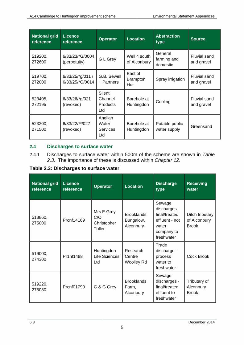
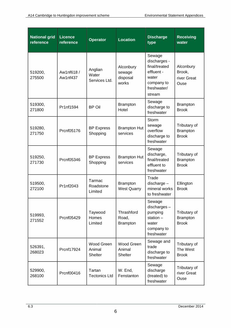
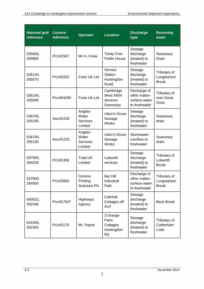
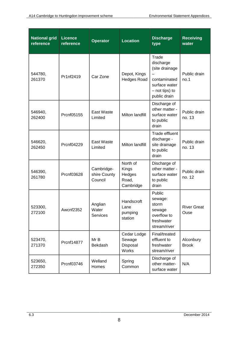
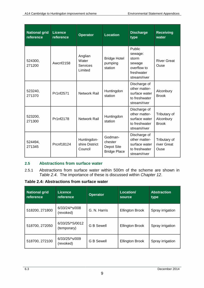
2.4 Discharges to surface water 2.4.1 Discharges to surface water within 500m of the scheme are shown in Table
2.3. The importance of these is discussed within Chapter 12. Table 2.3: Discharges to surface water
National grid reference
Licence reference Operator Location Discharge
type Receiving water
518860, 275000 Prcnf14169
Mrs E Grey C/O Christopher Toller
Brooklands Bungalow, Alconbury
Sewage discharges - final/treated effluent - not water company to freshwater
Ditch tributary of Alconbury Brook
519000, 274300 Pr1nf1488
Huntingdon Life Sciences Ltd
Research Centre Woolley Rd
Trade discharge - process water to freshwater
Cock Brook
519220, 275080 Prcnf01790 G & G Grey
Brooklands Farm, Alconbury
Sewage discharges - final/treated effluent to freshwater
Tributary of Alconbury Brook
6.3 December 2014 5
A14 Cambridge to Huntingdon improvement scheme Environmental Statement Appendices
National grid reference
Licence reference Operator Location Discharge
type Receiving water
519200, 275500
Aw1nf618 / Aw1nf437
Anglian Water Services Ltd.
Alconbury sewage disposal works
Sewage discharges - final/treated effluent - water company to freshwater/ stream
Alconbury Brook, river Great Ouse
519300, 271800 Pr1nf1594 BP Oil Brampton
Hotel
Sewage discharge to freshwater
Brampton Brook
519280, 271750 Prcnf05176 BP Express
Shopping Brampton Hut services
Storm sewage overflow discharge to freshwater
Tributary of Brampton Brook
519250, 271730 Prcnf05346 BP Express
Shopping Brampton Hut services
Sewage discharge, final/treated effluent to freshwater
Tributary of Brampton Brook
519500, 272100 Pr1nf2043
Tarmac Roadstone Limited
Brampton West Quarry
Trade discharge – mineral works to freshwater
Ellington Brook
519993, 271552 Prcnf05429
Taywood Homes Limited
Thrashford Road, Brampton
Sewage discharges – pumping station – water company to freshwater
Tributary of Brampton Brook
526391, 268023 Prcnf17924
Wood Green Animal Shelter
Wood Green Animal Shelter
Sewage and trade discharge to freshwater
Tributary of The West Brook
529900, 268100 Prcnf00416 Tartan
Tectonics Ltd W. End, Fenstanton
Sewage discharge (treated) to freshwater
Tributary of river Great Ouse
6.3 December 2014 6
A14 Cambridge to Huntingdon improvement scheme Environmental Statement Appendices
National grid reference
Licence reference Operator Location Discharge
type Receiving water
535600, 265800 Pr1nf1597 Mr H J Hole Trinity Foot
Public House
Sewage discharge (treated) to freshwater
Swavesey Drain
536140, 265570 Pr1nf2202 Forte UK Ltd.
Service Station Huntingdon Road
Sewage discharge (treated) to freshwater
Tributary of Longstanton Brook
536140, 265590 Prcnf04290 Forte UK Ltd.
Cambridge West A604 services Swavesey
Discharge of other matter-surface water to freshwater
Tributary of river Great Ouse
536700, 265190 Ascnf1232
Anglian Water Services Limited
Utton’s Drove Sewage Works
Sewage discharge (treated) to freshwater
Swavesey drain
536700, 265190 Ascnf1232
Anglian Water Services Limited
Utton’s Drove Sewage Works
Stormwater overflow to freshwater
Swavesey drain
537900, 264200 Pr1nf1306 Total UK
Limited Lolworth services
Sewage discharge (treated) to freshwater
Tributary of Lolworth Brook
537800, 264000 Pr1nf2800
Domino Printing Sciences Plc
Bar Hill Industrial Park
Discharge of other matter-surface water to freshwater
Tributary of Longstanton Brook
540522, 262166 Prcnf17547 Highways
Agency
Catchall Cottages off A14
Sewage discharge (treated) to freshwater
Beck Brook
541050, 261920 Pr1nf2175 Mr. Payne
3 Grange Farm Cottages Huntingdon Rd
Sewage discharge (treated) to freshwater
Tributary of Cottenham Lode
6.3 December 2014 7
A14 Cambridge to Huntingdon improvement scheme Environmental Statement Appendices
National grid reference
Licence reference Operator Location Discharge
type Receiving water
544780, 261370 Pr1nf2419 Car Zone Depot, Kings
Hedges Road
Trade discharge (site drainage – contaminated surface water – not tips) to public drain
Public drain no.1
546940, 262400 Prcnf05155 East Waste
Limited Milton landfill
Discharge of other matter - surface water to public drain
Public drain no. 13
546620, 262450 Prcnf04229 East Waste
Limited Milton landfill
Trade effluent discharge - site drainage to public drain
Public drain no. 13
546390, 261780 Prcnf03628
Cambridge-shire County Council
North of Kings Hedges Road, Cambridge
Discharge of other matter - surface water to public drain
Public drain no. 12
523300, 272100 Awcnf2352
Anglian Water Services
Handscroft Lane pumping station
Public sewage: storm sewage overflow to freshwater stream/river
River Great Ouse
523470, 271370 Prcnf14877 Mr B
Bekdash
Cedar Lodge Sewage Disposal Works
Final/treated effluent to freshwater stream/river
Alconbury Brook
523650, 272350 Prcnf03746 Welland
Homes Spring Common
Discharge of other matter-surface water
N/A
6.3 December 2014 8
A14 Cambridge to Huntingdon improvement scheme Environmental Statement Appendices
National grid reference
Licence reference Operator Location Discharge
type Receiving water
524300, 271200 Awcnf2158
Anglian Water Services Limited
Bridge Hotel pumping station
Public sewage: storm sewage overflow to freshwater stream/river
River Great Ouse
523240, 271370 Pr1nf2571 Network Rail Huntingdon
station
Discharge of other matter-surface water to freshwater stream/river
Alconbury Brook
523200, 271300 Pr1nf2178 Network Rail Huntingdon
station
Discharge of other matter-surface water to freshwater stream/river
Tributary of Alconbury Brook
524494, 271345 Prcnf18124
Huntingdon-shire District Council
Godman-chester Depot Site Bridge Place
Discharge of other matter-surface water to freshwater stream/river
Tributary of river Great Ouse
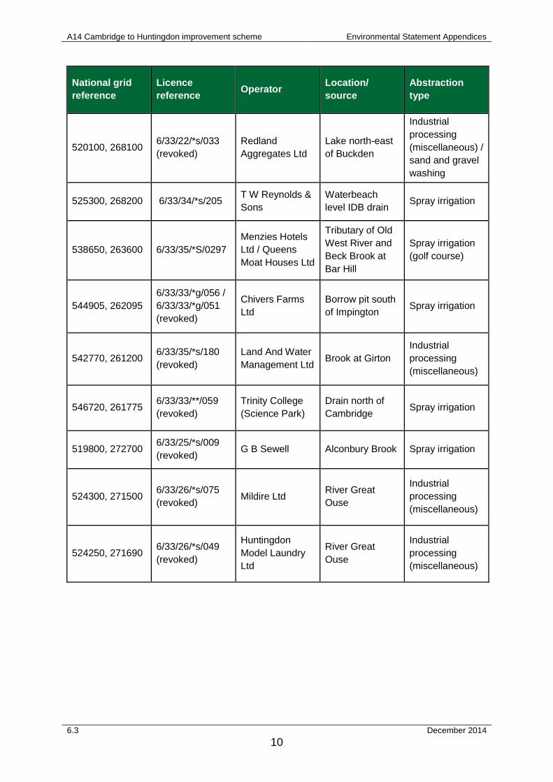
2.5 Abstractions from surface water 2.5.1 Abstractions from surface water within 500m of the scheme are shown in
Table 2.4. The importance of these is discussed within Chapter 12. Table 2.4: Abstractions from surface water
National grid reference
Licence reference Operator Location/
source Abstraction type
518200, 271800 6/33/24/*s/008 (revoked) G. N. Harris Ellington Brook Spray irrigation
518700, 272050 6/33/25/*S/0012 (temporary) G B Sewell Ellington Brook Spray irrigation
518700, 272100 6/33/25/*s/009 (revoked) G B Sewell Ellington Brook Spray irrigation
6.3 December 2014 9
A14 Cambridge to Huntingdon improvement scheme Environmental Statement Appendices
National grid reference
Licence reference Operator Location/
source Abstraction type
520100, 268100 6/33/22/*s/033 (revoked)
Redland Aggregates Ltd
Lake north-east of Buckden
Industrial processing (miscellaneous) / sand and gravel washing
525300, 268200 6/33/34/*s/205 T W Reynolds & Sons
Waterbeach level IDB drain Spray irrigation
538650, 263600 6/33/35/*S/0297 Menzies Hotels Ltd / Queens Moat Houses Ltd
Tributary of Old West River and Beck Brook at Bar Hill
Spray irrigation (golf course)
544905, 262095 6/33/33/*g/056 / 6/33/33/*g/051 (revoked)
Chivers Farms Ltd
Borrow pit south of Impington Spray irrigation
542770, 261200 6/33/35/*s/180 (revoked)
Land And Water Management Ltd Brook at Girton
Industrial processing (miscellaneous)
546720, 261775 6/33/33/**/059 (revoked)
Trinity College (Science Park)
Drain north of Cambridge Spray irrigation
519800, 272700 6/33/25/*s/009 (revoked) G B Sewell Alconbury Brook Spray irrigation
524300, 271500 6/33/26/*s/075 (revoked) Mildire Ltd River Great
Ouse
Industrial processing (miscellaneous)
524250, 271690 6/33/26/*s/049 (revoked)
Huntingdon Model Laundry Ltd
River Great Ouse
Industrial processing (miscellaneous)
6.3 December 2014 10
A14 Cambridge to Huntingdon improvement scheme Environmental Statement Appendices
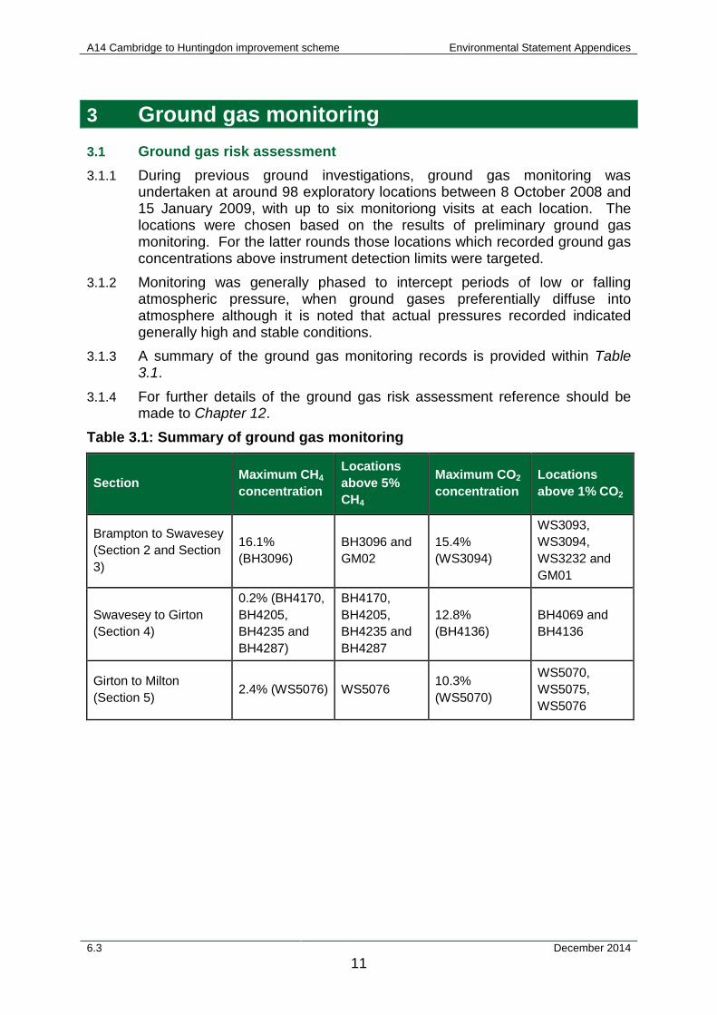
3 Ground gas monitoring 3.1 Ground gas risk assessment 3.1.1 During previous ground investigations, ground gas monitoring was
undertaken at around 98 exploratory locations between 8 October 2008 and 15 January 2009, with up to six monitoriong visits at each location. The locations were chosen based on the results of preliminary ground gas monitoring. For the latter rounds those locations which recorded ground gas concentrations above instrument detection limits were targeted.
3.1.2 Monitoring was generally phased to intercept periods of low or falling atmospheric pressure, when ground gases preferentially diffuse into atmosphere although it is noted that actual pressures recorded indicated generally high and stable conditions.
3.1.3 A summary of the ground gas monitoring records is provided within Table 3.1.
3.1.4 For further details of the ground gas risk assessment reference should be made to Chapter 12.
Table 3.1: Summary of ground gas monitoring
Section Maximum CH4 concentration
Locations above 5% CH4
Maximum CO2 concentration
Locations above 1% CO2
Brampton to Swavesey (Section 2 and Section 3)
16.1% (BH3096)
BH3096 and GM02
15.4% (WS3094)
WS3093, WS3094, WS3232 and GM01
Swavesey to Girton (Section 4)
0.2% (BH4170, BH4205, BH4235 and BH4287)
BH4170, BH4205, BH4235 and BH4287
12.8% (BH4136)
BH4069 and BH4136
Girton to Milton (Section 5) 2.4% (WS5076) WS5076 10.3%
(WS5070)
WS5070, WS5075, WS5076
6.3 December 2014 11
A14 Cambridge to Huntingdon improvement scheme Environmental Statement Appendices
4 Potentially contaminative land uses 4.1.1 The potential for land contamination needs to be assessed both in the
context of the impacts that contaminated land could have on the scheme, and the impacts of the scheme on existing land contamination. This section summarises the areas of land within the study area which have been identified as having the potential to be impacted by current or historical land use and thus the focus of further assessment.
4.1.2 Table 4.1 provides a summary of the potentially contaminative land uses identified in the study area. The extent of the study area and the locations of the potentially contaminative land uses identified are shown on Figure 12.1. Table 4.1 provides approximate distances from the scheme, site observations and comments, geology and details of the previous intrusive investigation and chemical sampling. The 'exceedances' identified include soil, leachate and groundwater are based on human health and controlled waters risk assessments undertaken as part of previous versions of the scheme. Chapter 12 contains further information of the assessments undertaken.
6.3 December 2014 12
A14 Cambridge to Huntingdon improvement scheme Environmental Statement Appendices
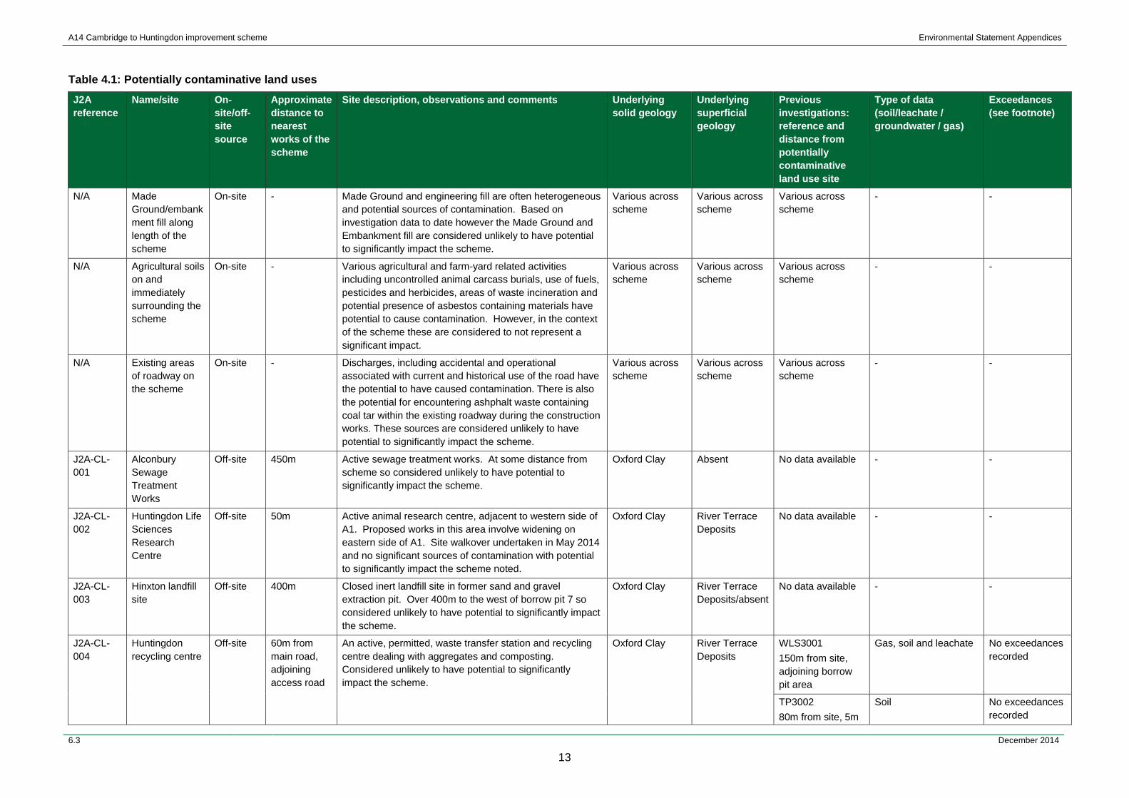
Table 4.1: Potentially contaminative land uses
J2A reference
Name/site On-site/off-site source
Approximate distance to nearest works of the scheme
Site description, observations and comments Underlying solid geology
Underlying superficial geology
Previous investigations: reference and distance from potentially contaminative land use site
Type of data (soil/leachate / groundwater / gas)
Exceedances (see footnote)
N/A Made Ground/embankment fill along length of the scheme
On-site - Made Ground and engineering fill are often heterogeneous and potential sources of contamination. Based on investigation data to date however the Made Ground and Embankment fill are considered unlikely to have potential to significantly impact the scheme.
Various across scheme
Various across scheme
Various across scheme
- -
N/A Agricultural soils on and immediately surrounding the scheme
On-site - Various agricultural and farm-yard related activities including uncontrolled animal carcass burials, use of fuels, pesticides and herbicides, areas of waste incineration and potential presence of asbestos containing materials have potential to cause contamination. However, in the context of the scheme these are considered to not represent a significant impact.
Various across scheme
Various across scheme
Various across scheme
- -
N/A Existing areas of roadway on the scheme
On-site - Discharges, including accidental and operational associated with current and historical use of the road have the potential to have caused contamination. There is also the potential for encountering ashphalt waste containing coal tar within the existing roadway during the construction works. These sources are considered unlikely to have potential to significantly impact the scheme.
Various across scheme
Various across scheme
Various across scheme
- -
J2A-CL-001
Alconbury Sewage Treatment Works
Off-site 450m Active sewage treatment works. At some distance from scheme so considered unlikely to have potential to significantly impact the scheme.
Oxford Clay Absent No data available - -
J2A-CL-002
Huntingdon Life Sciences Research Centre
Off-site 50m Active animal research centre, adjacent to western side of A1. Proposed works in this area involve widening on eastern side of A1. Site walkover undertaken in May 2014 and no significant sources of contamination with potential to significantly impact the scheme noted.
Oxford Clay River Terrace Deposits
No data available - -
J2A-CL-003
Hinxton landfill site
Off-site 400m Closed inert landfill site in former sand and gravel extraction pit. Over 400m to the west of borrow pit 7 so considered unlikely to have potential to significantly impact the scheme.
Oxford Clay River Terrace Deposits/absent
No data available - -
J2A-CL-004
Huntingdon recycling centre
Off-site 60m from main road, adjoining access road
An active, permitted, waste transfer station and recycling centre dealing with aggregates and composting. Considered unlikely to have potential to significantly impact the scheme.
Oxford Clay River Terrace Deposits
WLS3001 150m from site, adjoining borrow pit area
Gas, soil and leachate No exceedances recorded
TP3002 80m from site, 5m
Soil No exceedances recorded
6.3 December 2014
13
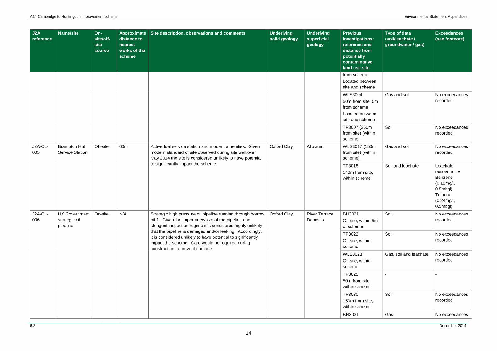
A14 Cambridge to Huntingdon improvement scheme Environmental Statement Appendices
J2A reference
Name/site On-site/off-site source
Approximate distance to nearest works of the scheme
Site description, observations and comments Underlying solid geology
Underlying superficial geology
Previous investigations: reference and distance from potentially contaminative land use site
Type of data (soil/leachate / groundwater / gas)
Exceedances (see footnote)
from scheme Located between site and scheme
WLS3004 50m from site, 5m from scheme Located between site and scheme
Gas and soil No exceedances recorded
TP3007 (250m from site) (within scheme)
Soil No exceedances recorded
J2A-CL-005
Brampton Hut Service Station
Off-site 60m Active fuel service station and modern amenities. Given modern standard of site observed during site walkover May 2014 the site is considered unlikely to have potential to significantly impact the scheme.
Oxford Clay Alluvium WLS3017 (150m from site) (within scheme)
Gas and soil No exceedances recorded
TP3018 140m from site, within scheme
Soil and leachate Leachate exceedances: Benzene (0.12mg/l, 0.5mbgl) Toluene (0.24mg/l, 0.5mbgl)
J2A-CL-006
UK Government strategic oil pipeline
On-site N/A Strategic high pressure oil pipeline running through borrow pit 1. Given the importance/size of the pipeline and stringent inspection regime it is considered highly unlikely that the pipeline is damaged and/or leaking. Accordingly, it is considered unlikely to have potential to significantly impact the scheme. Care would be required during construction to prevent damage.
Oxford Clay River Terrace Deposits
BH3021 On site, within 5m of scheme
Soil No exceedances recorded
TP3022 On site, within scheme
Soil No exceedances recorded
WLS3023 On site, within scheme
Gas, soil and leachate No exceedances recorded
TP3025 50m from site, within scheme
- -
TP3030 150m from site, within scheme
Soil No exceedances recorded
BH3031 Gas No exceedances
6.3 December 2014
14
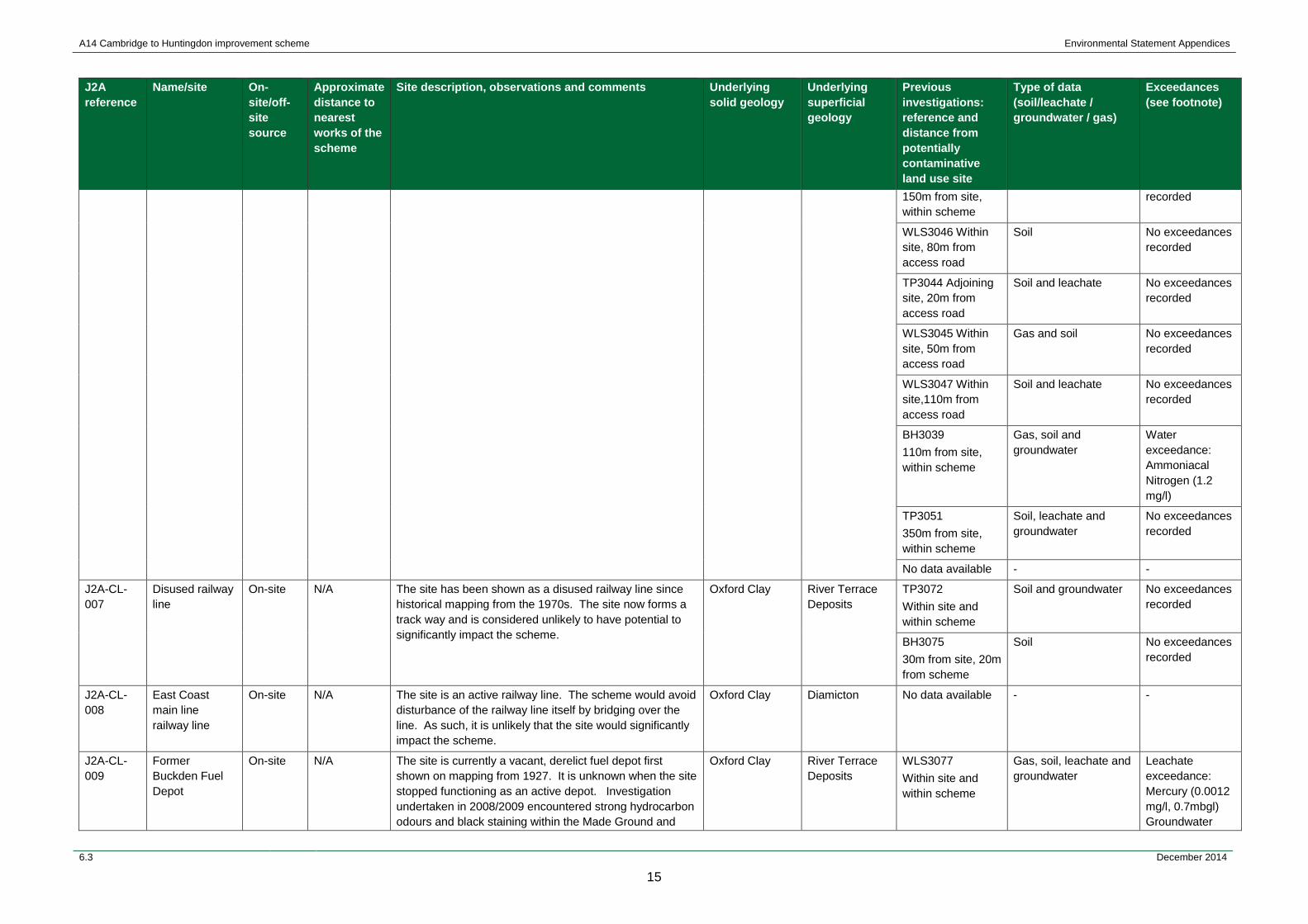
A14 Cambridge to Huntingdon improvement scheme Environmental Statement Appendices
J2A reference
Name/site On-site/off-site source
Approximate distance to nearest works of the scheme
Site description, observations and comments Underlying solid geology
Underlying superficial geology
Previous investigations: reference and distance from potentially contaminative land use site
Type of data (soil/leachate / groundwater / gas)
Exceedances (see footnote)
150m from site, within scheme
recorded
WLS3046 Within site, 80m from access road
Soil No exceedances recorded
TP3044 Adjoining site, 20m from access road
Soil and leachate No exceedances recorded
WLS3045 Within site, 50m from access road
Gas and soil No exceedances recorded
WLS3047 Within site,110m from access road
Soil and leachate No exceedances recorded
BH3039 110m from site, within scheme
Gas, soil and groundwater
Water exceedance: Ammoniacal Nitrogen (1.2 mg/l)
TP3051 350m from site, within scheme
Soil, leachate and groundwater
No exceedances recorded
No data available - -
J2A-CL-007
Disused railway line
On-site N/A The site has been shown as a disused railway line since historical mapping from the 1970s. The site now forms a track way and is considered unlikely to have potential to significantly impact the scheme.
Oxford Clay River Terrace Deposits
TP3072 Within site and within scheme
Soil and groundwater No exceedances recorded
BH3075 30m from site, 20m from scheme
Soil No exceedances recorded
J2A-CL-008
East Coast main line railway line
On-site N/A The site is an active railway line. The scheme would avoid disturbance of the railway line itself by bridging over the line. As such, it is unlikely that the site would significantly impact the scheme.
Oxford Clay Diamicton No data available - -
J2A-CL-009
Former Buckden Fuel Depot
On-site N/A The site is currently a vacant, derelict fuel depot first shown on mapping from 1927. It is unknown when the site stopped functioning as an active depot. Investigation undertaken in 2008/2009 encountered strong hydrocarbon odours and black staining within the Made Ground and
Oxford Clay River Terrace Deposits
WLS3077 Within site and within scheme
Gas, soil, leachate and groundwater
Leachate exceedance: Mercury (0.0012 mg/l, 0.7mbgl) Groundwater
6.3 December 2014
15
A14 Cambridge to Huntingdon improvement scheme Environmental Statement Appendices
J2A reference
Name/site On-site/off-site source
Approximate distance to nearest works of the scheme
Site description, observations and comments Underlying solid geology
Underlying superficial geology
Previous investigations: reference and distance from potentially contaminative land use site
Type of data (soil/leachate / groundwater / gas)
Exceedances (see footnote)
elevated TPH/PAH within soil samples. Levels were below levels representing risk to human health. According to the Remediation Implementation and Verification Plan, Former Buckden Fuel Depot (Arcadis, 2014) the site was used as a fuel depot, with gas oil, diesel, kerosene and petrol reported stored at the site in underground and above ground storage tanks. Decommissioning works were undertaken on the site in 2005 and included removal of above ground storage tanks and underground storage tanks. When the underground tanks were removed, the supporting concrete cradles were left in place, and the excavation backfilled. Investigation in 2012 and 2013 indicated that there was light non aqueous phase liquid (LNAPL) comprising degraded kerosene and degraded diesel on the shallow groundwater at the site, and the extent of LNAPL contamination was delineated using Laser Induced Fluorescence techniques. A risk assessment agreed with the Environment Agency concluded that the risks to human health and the environment from the contamination present at the site were not significant; however the Environment Agency expressed a preference that LNAPL should be recovered from the site as far as practicable. The proposed voluntary remediation at the site is to meet this request. The proposed remedial works are programmed to be completed in 2014. The objective of the proposed works is the removal, recovery or treatment of LNAPL to minimise the potential for dissolution of petroleum hydrocarbons to groundwater. Soils will be excavated to a depth of up to 4.5m below ground level with a total estimated excavation volume of 1336m3. Excavated soils will be screened, segregated and treated as necessary in order to achieve the remediation criteria. Measures are proposed to ensure excavation stability and groundwater ingress, and may include the use of temporary sheet piling and battered slopes. The main soil treatment method proposed is the use of bio-piles, with suitable treated and screened soil re-used within the scheme for backfill. Backfilling is to be carried out in accordance with the highway specification clause 612 of Manual of Contract Documents for Highway Works, Volume 1, Series 600: Earthworks(Highways Agency et al., 2009).
exceedance: Ammoniacal nitrogen (1.3mg/l)
WLS3079 Within site and within scheme
Gas, soil, leachate and groundwater
Leachate exceedance: Lead (0.028 mg/l, 0.5 mbgl) Mercury (0.0011 mg/l, 0.5 mg/l) Groundwater exceedance: Ammoniacal nitrogen (3.2 mbgl)
6.3 December 2014
16
A14 Cambridge to Huntingdon improvement scheme Environmental Statement Appendices
J2A reference
Name/site On-site/off-site source
Approximate distance to nearest works of the scheme
Site description, observations and comments Underlying solid geology
Underlying superficial geology
Previous investigations: reference and distance from potentially contaminative land use site
Type of data (soil/leachate / groundwater / gas)
Exceedances (see footnote)
Soils identified through the screening process to satisfy the remediation criteria will be segregated and stockpiled for re-use on site, and the current site levels will be restored. On completion of the excavation works it is anticipated that any shoring used to support the excavation will be removed, subject to detailed design. However the remediation plan for the adjacent land suggests that a low permeability barrier may be left in situ to protect the Goff petroleum site from further migration of residual dissolved contamination.
J2A-CL-010
Buckden Works (Landsman's Portaloo)
Off-site 10m Active portaloo hire company. Site walkover identified various tanks for wash-water and domestic sewage although no significant contamination sources identified. While the scheme crosses slightly on the eastern portion of the site, it is considered unlikely to have potential to significantly impact the scheme.
Oxford Clay River Terrace Deposits
WLS3081 50m from site, within scheme
Soil No exceedances recorded
TP3083 110m from site, within scheme
Soil and groundwater No exceedances recorded
J2A-CL-011
Buckden Waste Transfer Station
Off-site 50m Active licensed waste transfer site, operated by Anti-Waste Limited dealing with a range of wastes including batteries, paints/varnishes/lacquers, engine oils, lighting lamps/tubes, tyres, metal turnings/swarf/dust/powder, photocopiers, tar, pitch, bitumen and asphalts. Given the site is a licensed transfer station rather than waste disposal site it is considered unlikely to have potential to significantly impact the scheme. Located on site of former railway station and sidings.
Oxford Clay River Terrace Deposits
TP3074 50m from site, 20m from scheme
Soil No exceedances recorded
J2A-CL-012
Buckden South Landfill
Off-site 10m Previous revisions of the scheme investigated the possibility of the route passing through Buckden South and North landfills. Buckden South is a closed landfill site, previously operated by Refuse Disposal Ltd. It is understood however that FCC Environment Ltd. undertake on-going environmental monitoring of the site. The current scheme passes within approximately 10-15m of the southern boundary of Buckden South landfill at its closest point. The Buckden South landfill site is understood to have been operational since the 1930s and covers an area of approximately 40 hectares. The last waste was accepted in 1994. Prior to its use as landfill, the site had been utilised for gravel extraction, and the site was being worked by Inns
Oxford Clay River Terrace Deposits
WLS3086 Less than 10m from site, 20m from scheme Located between site and scheme
Gas, soil and leachate No exceedances recorded
BH3087 110m from site, within scheme
Gas and soil No exceedances recorded
WLS3089 70m from site, within scheme
Gas and soil No exceedances recorded
WLS3090 Less than 10m
Gas and soil No exceedances recorded
6.3 December 2014
17
A14 Cambridge to Huntingdon improvement scheme Environmental Statement Appendices
J2A reference
Name/site On-site/off-site source
Approximate distance to nearest works of the scheme
Site description, observations and comments Underlying solid geology
Underlying superficial geology
Previous investigations: reference and distance from potentially contaminative land use site
Type of data (soil/leachate / groundwater / gas)
Exceedances (see footnote)
and Company in 1947 when planning permission was granted to continue the sand and gravel extraction. The sand and gravel was excavated to a depth of between 3m and 5.5m below existing ground level. Stiff Oxford Clay underlies the gravels to a depth of approximately 23m below ground level. The landfill accepted a range of household, commercial/industrial and liquid/sludge waste and there is evidence that asbestos waste, animal carcasses and clinical wastes were also accepted. Up to 20m thickness of waste is understood to be present in a domed landform with at least a 1m clay capping. Landfill gas generated at both the Buckden South and Buckden North is collected and pumped to a pair of gas turbines which generate electricity for use in the local grid. The landfill is understood to be constructed in cells using site won Oxford Clay. Leachate from the landfill is treated via dedicated plant to the east of the site. The available existing information indicates that leachate has previously possibly escaped from the southern boundary and the Costain 2008/2009 investigation encountered elevated ammoniacal nitrogen and arsenic within groundwater. Ammoniacal nitrogen is a common component of landfill leachate. Environmental monitoring results for the period September 2009 to July 2014 were received from FCC Environmental Ltd. for 9 combined gas and groundwater monitoring boreholes around the perimeter of Buckden South landfill (BH1, BH2, BH6, BH8, BH9, BH10 and BH11). The results of the monitoring were reviewed and a summary of the pertinent gas and groundwater quality information is provided within Table 5.1 of this appendix. Review of this gas and groundwater monitoring data has indicated that landfill gas is not present in the perimeter monitoring wells pertinent to the scheme at concentrations likely to be significant to the scheme. There is some evidence of low levels of leachate derived pollutants present in the groundwater, but the concentrations are not considered significant to the scheme.
from site, within scheme
WLS3092 30m from site, within scheme
Gas and soil No exceedances recorded
WLS3093 Less than 10m from site, 20m from scheme
Gas, soil and groundwater
Groundwater exceedance: Ammoniacal Nitrogen (14 mg/l)
WLS3094 30m from site, within scheme
Gas and soil No exceedances recorded
WLS3095 Less than 10m from site, 10m from scheme
Soil and leachate No exceedances recorded
BH3241 50m from site, within scheme
Soil No exceedances recorded
BH3096 110m from site, 20m from scheme
Soil and groundwater Groundwater exceedances: Ammoniacal nitrogen (14 mg/l) Arsenic (0.059 mg/l)
J2A-CL-013
Buckden North Landfill
Off-site 200m The scheme includes re-alignment works on Buckden Road which is adjacent to the western boundary of
Oxford Clay River Terrace Deposits
Covered by J2A-CL-012 between
- -
6.3 December 2014
18
A14 Cambridge to Huntingdon improvement scheme Environmental Statement Appendices
J2A reference
Name/site On-site/off-site source
Approximate distance to nearest works of the scheme
Site description, observations and comments Underlying solid geology
Underlying superficial geology
Previous investigations: reference and distance from potentially contaminative land use site
Type of data (soil/leachate / groundwater / gas)
Exceedances (see footnote)
Buckden North landfill. A borrow pit (borrow pit 2) would be located west of Buckden Road, approximately 150m away from the western boundary of Buckden North landfill at its closest location. The scheme does not extend within the boundary of the landfill. Buckden North landfill, owned and operated by FCC Environment Ltd., is a permitted, operational landfill although some areas have been filled and restored. Cells 1 to 3 in the south-western-most portion of the landfill i.e. that which is in proximity to the scheme, is understood to have been filled using inert waste only to minimise risks to nearby residential homes. Cells 4 to 6, which are also along the western boundary of the landfill, have also been filled and restored although the waste deposited potentially included household, industrial, liquids, contaminated soils, construction waste and clinical waste. The landfill is understood to have constructed on a full containment principle with a continuous basal and upper impermeable liner. A review of gas and groundwater monitoring data provided by the operator has indicated that landfill gas and leachate are not present in the perimeter monitoring wells pertinent to the scheme at concentrations likely to be significant to the scheme.
site and scheme
J2A-CL-014
Buckden Leachate Treatment Plant
Off-site 550m Active leachate treatment plant for Buckden South and Buckden North Landfill. Given the distance it is considered unlikely that the site would significantly impact the scheme.
Oxford Clay River Terrace Deposits
Covered by J2A-CL-012 between site and scheme.
- -
J2A-CL-015
Lintons Farm On-site N/A Farm built prior to first available mapping from 1890, the farm is due to be demolished as part of the scheme. A fuel tank was observed during a site walkover and a 'mild' organic odour was noted at 0.1m and 0.7m. 1,3,5-trimethylbenzene (a constituent of fuel) exceeded its surrogate screening value in this location. This surrogate screen is considered to be conservative. Therefore, although this sample marginally exceeds the benzene screening criteria, it is not thought to pose a risk to human health. The site is considered unlikely to have potential to significantly impact the scheme.
Oxford Clay River Terrace Deposits
WLS3178 Within site,15m from scheme
Gas, soil and groundwater
Groundwater exceedances: 1,3,5-Trimethylbenzene (1.4 ug/l) Sulphate (450 mg/l)
TP3179 30m from site, within scheme
Soil and leachate Leachate exceedance: Zinc (1.1 mg/l, 0.5 mbgl)
J2A-CL-016
Woolpack Farm Landfill
Off-site 50m Closed landfill site, operational since 1996 and understood to have closed in 2000. Recorded as an ‘inert’ landfill
Oxford Clay River Terrace Deposits
TP3185 450m from site,
Groundwater No exceedances recorded
6.3 December 2014
19
A14 Cambridge to Huntingdon improvement scheme Environmental Statement Appendices
J2A reference
Name/site On-site/off-site source
Approximate distance to nearest works of the scheme
Site description, observations and comments Underlying solid geology
Underlying superficial geology
Previous investigations: reference and distance from potentially contaminative land use site
Type of data (soil/leachate / groundwater / gas)
Exceedances (see footnote)
though no specific details regarding the waste streams accepted at the site are available. Given the distance to the scheme and the proposed works in the area, the site is considered unlikely to have potential to significantly impact the site.
within scheme
J2A-CL-017
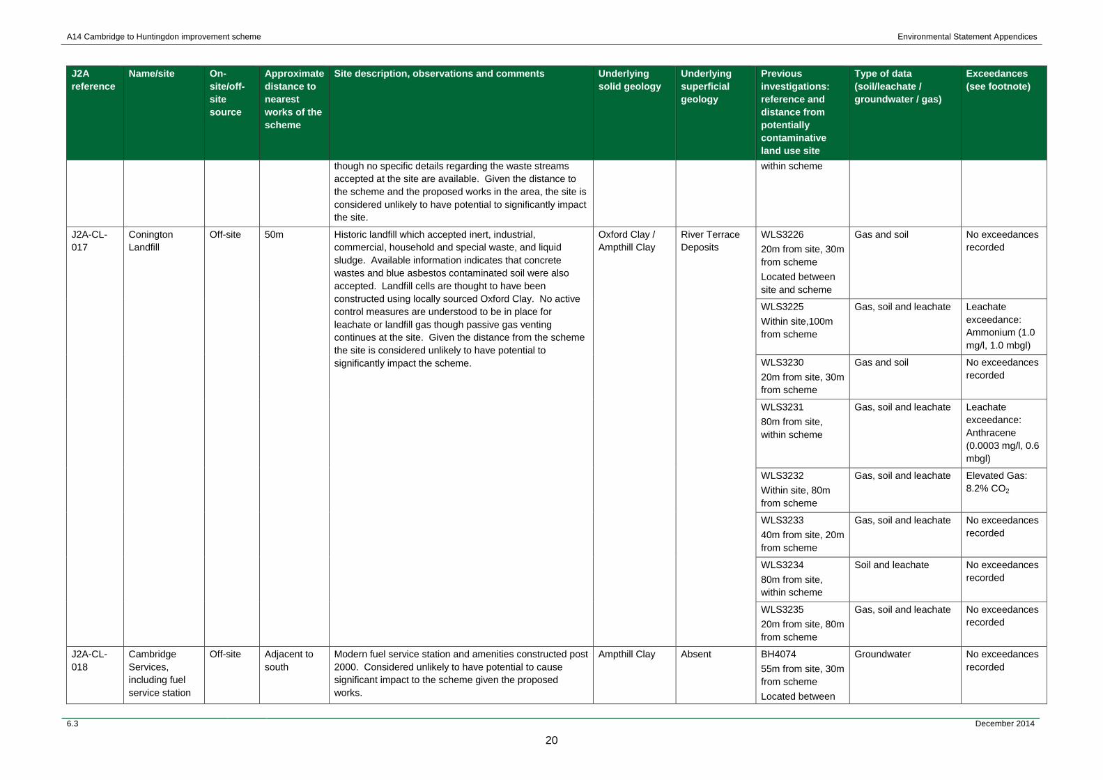
Conington Landfill
Off-site 50m Historic landfill which accepted inert, industrial, commercial, household and special waste, and liquid sludge. Available information indicates that concrete wastes and blue asbestos contaminated soil were also accepted. Landfill cells are thought to have been constructed using locally sourced Oxford Clay. No active control measures are understood to be in place for leachate or landfill gas though passive gas venting continues at the site. Given the distance from the scheme the site is considered unlikely to have potential to significantly impact the scheme.
Oxford Clay / Ampthill Clay
River Terrace Deposits
WLS3226 20m from site, 30m from scheme Located between site and scheme
Gas and soil No exceedances recorded
WLS3225 Within site,100m from scheme
Gas, soil and leachate Leachate exceedance: Ammonium (1.0 mg/l, 1.0 mbgl)
WLS3230 20m from site, 30m from scheme
Gas and soil No exceedances recorded
WLS3231 80m from site, within scheme
Gas, soil and leachate Leachate exceedance: Anthracene (0.0003 mg/l, 0.6 mbgl)
WLS3232 Within site, 80m from scheme
Gas, soil and leachate Elevated Gas: 8.2% CO2
WLS3233 40m from site, 20m from scheme
Gas, soil and leachate No exceedances recorded
WLS3234 80m from site, within scheme
Soil and leachate No exceedances recorded
WLS3235 20m from site, 80m from scheme
Gas, soil and leachate No exceedances recorded
J2A-CL-018
Cambridge Services, including fuel service station
Off-site Adjacent to south
Modern fuel service station and amenities constructed post 2000. Considered unlikely to have potential to cause significant impact to the scheme given the proposed works.
Ampthill Clay Absent BH4074 55m from site, 30m from scheme Located between
Groundwater No exceedances recorded
6.3 December 2014
20

A14 Cambridge to Huntingdon improvement scheme Environmental Statement Appendices
J2A reference
Name/site On-site/off-site source
Approximate distance to nearest works of the scheme
Site description, observations and comments Underlying solid geology
Underlying superficial geology
Previous investigations: reference and distance from potentially contaminative land use site
Type of data (soil/leachate / groundwater / gas)
Exceedances (see footnote)
and substation site and scheme
WLS4079 100m from site, 60m from scheme
Gas and soil No exceedances recorded
J2A-CL-019
Buckingway Business Park (commercial and light industrial)
Off-site Adjacent to north
Modern business park and commercial / light industrial estate. Considered unlikely to have potential to cause significant impact to the scheme.
Ampthill Clay Absent WLS4069 Within site,130m from scheme
Gas and soil No exceedances recorded
WLS4070 20m from site, within scheme
Soil No exceedances recorded
J2A-CL-020
Former fuel service station
Off-site Adjacent to north
Former fuel service station (constructed early 1980s), currently used as vehicular maintenance garage/MOT Test Centre and car wash. The site has potential to impact the scheme although previous investigation has indicated it is unlikely to significantly impact the scheme.
Ampthill Clay Absent TP4076 100m from site, within scheme
Soil and leachate No exceedances recorded
WLS4078 20m from site, within scheme
Gas, soil and groundwater
Groundwater exceedance: Sulphate (2300 mg/l) Nickel (0.04 mg/l)
WLS4077 20m from site, within scheme
Gas and soil No exceedances recorded
J2A-CL-021
Uttons Drove Sewage Works
Off-site 50m Active sewage treatment works. At some distance from scheme so considered unlikely to have potential to significantly impact the scheme.
Ampthill Clay Absent WLS4085 120m from site, within scheme
Gas and soil No exceedances recorded
WLS4086 120m from site, within scheme
Gas, soil and groundwater
Groundwater exceedance: Sulphate (440 mg/l)
WLS4087 120m from site, within scheme
Gas and soil No exceedances recorded
J2A-CL-022
Bar Hill Fuel Service Station (Total)
Off-site Adjacent to south
Fuel service station and amenities, which was constructed in the early 1980s, modern appearance suggests re-development at later date. Considered unlikely to have potential to cause significant impact to the scheme.
Kimmeridge Clay/Woburn Sands
Absent WLS4108 Within site, 100m from scheme
Gas, soil and leachate No exceedances recorded
WLS4106 10m from site,
Gas, soil and groundwater
Groundwater exceedances: Boron (1.1 mg/l)
6.3 December 2014
21
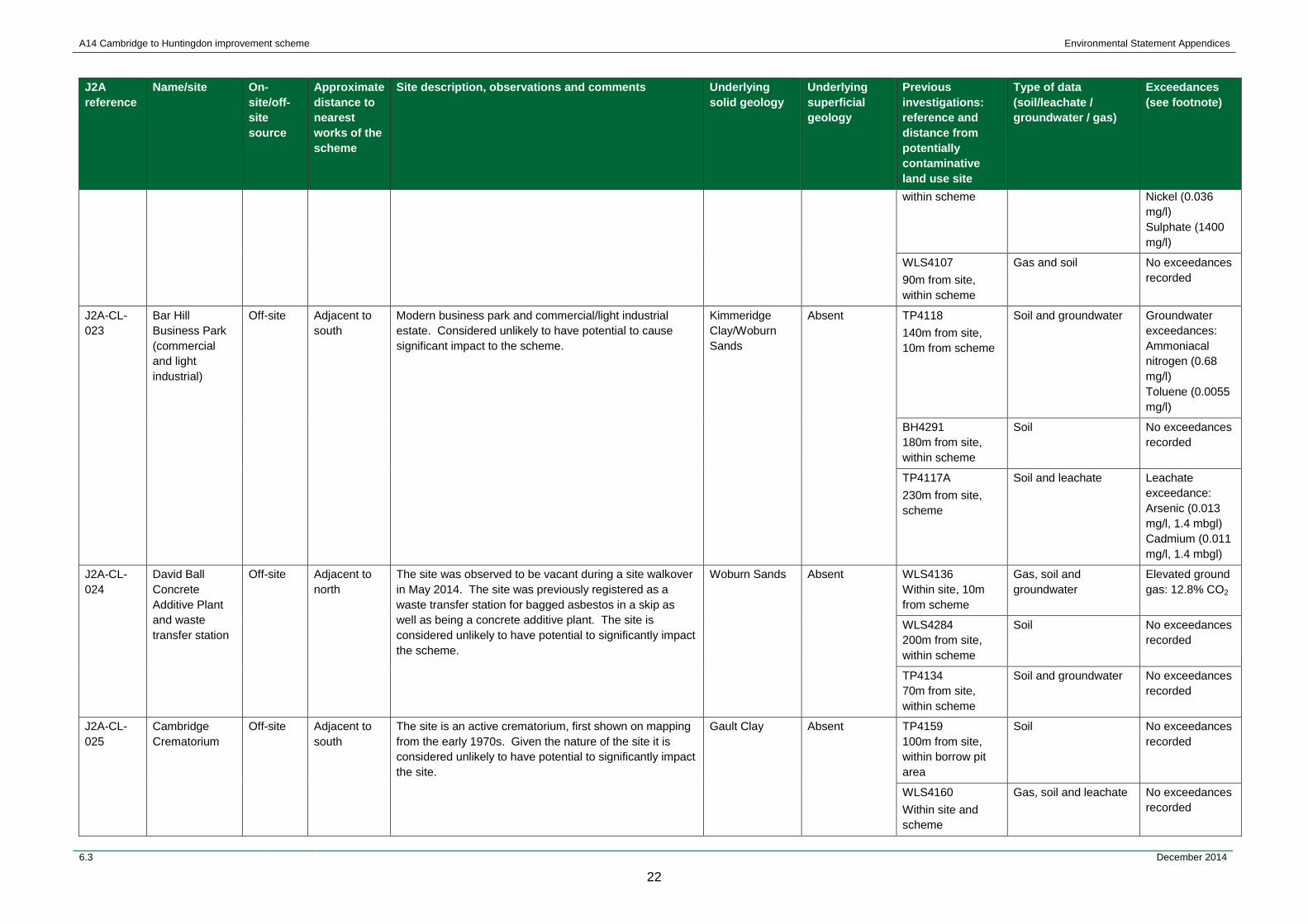
A14 Cambridge to Huntingdon improvement scheme Environmental Statement Appendices
J2A reference
Name/site On-site/off-site source
Approximate distance to nearest works of the scheme
Site description, observations and comments Underlying solid geology
Underlying superficial geology
Previous investigations: reference and distance from potentially contaminative land use site
Type of data (soil/leachate / groundwater / gas)
Exceedances (see footnote)
within scheme Nickel (0.036 mg/l) Sulphate (1400 mg/l)
WLS4107 90m from site, within scheme
Gas and soil No exceedances recorded
J2A-CL-023
Bar Hill Business Park (commercial and light industrial)
Off-site Adjacent to south
Modern business park and commercial/light industrial estate. Considered unlikely to have potential to cause significant impact to the scheme.
Kimmeridge Clay/Woburn Sands
Absent TP4118 140m from site, 10m from scheme
Soil and groundwater Groundwater exceedances: Ammoniacal nitrogen (0.68 mg/l) Toluene (0.0055 mg/l)
BH4291 180m from site, within scheme
Soil No exceedances recorded
TP4117A 230m from site, scheme
Soil and leachate Leachate exceedance: Arsenic (0.013 mg/l, 1.4 mbgl) Cadmium (0.011 mg/l, 1.4 mbgl)
J2A-CL-024
David Ball Concrete Additive Plant and waste transfer station
Off-site Adjacent to north
The site was observed to be vacant during a site walkover in May 2014. The site was previously registered as a waste transfer station for bagged asbestos in a skip as well as being a concrete additive plant. The site is considered unlikely to have potential to significantly impact the scheme.
Woburn Sands Absent WLS4136 Within site, 10m from scheme
Gas, soil and groundwater
Elevated ground gas: 12.8% CO2
WLS4284 200m from site, within scheme
Soil No exceedances recorded
TP4134 70m from site, within scheme
Soil and groundwater No exceedances recorded
J2A-CL-025
Cambridge Crematorium
Off-site Adjacent to south
The site is an active crematorium, first shown on mapping from the early 1970s. Given the nature of the site it is considered unlikely to have potential to significantly impact the site.
Gault Clay Absent TP4159 100m from site, within borrow pit area
Soil No exceedances recorded
WLS4160 Within site and scheme
Gas, soil and leachate No exceedances recorded
6.3 December 2014
22
A14 Cambridge to Huntingdon improvement scheme Environmental Statement Appendices
J2A reference
Name/site On-site/off-site source
Approximate distance to nearest works of the scheme
Site description, observations and comments Underlying solid geology
Underlying superficial geology
Previous investigations: reference and distance from potentially contaminative land use site
Type of data (soil/leachate / groundwater / gas)
Exceedances (see footnote)
WLS4162 Within site and scheme
Gas, soil, leachate and groundwater
Groundwater exceedances: Ammoniacal nitrogen (0.88 mg/l) Nickel (0.053 mg/l) Sulphate (460 mg/l)
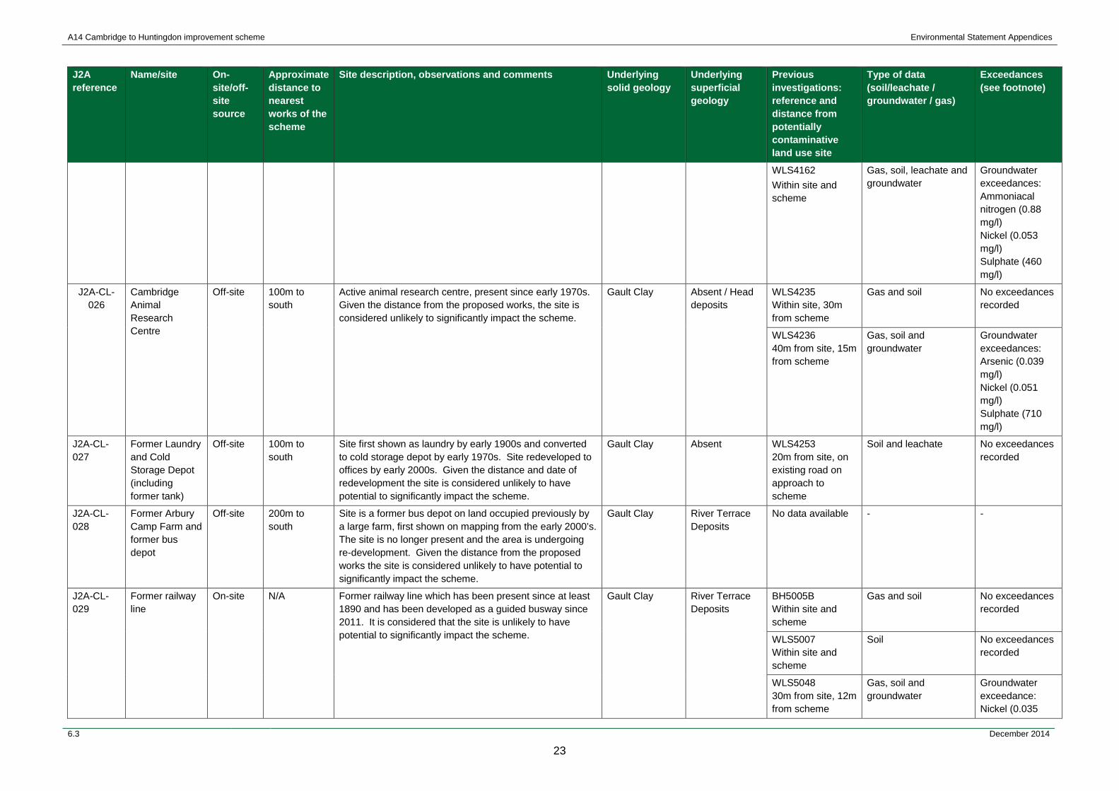
J2A-CL-026
Cambridge Animal Research Centre
Off-site 100m to south
Active animal research centre, present since early 1970s. Given the distance from the proposed works, the site is considered unlikely to significantly impact the scheme.
Gault Clay Absent / Head deposits
WLS4235 Within site, 30m from scheme
Gas and soil No exceedances recorded
WLS4236 40m from site, 15m from scheme
Gas, soil and groundwater
Groundwater exceedances: Arsenic (0.039 mg/l) Nickel (0.051 mg/l) Sulphate (710 mg/l)
J2A-CL-027
Former Laundry and Cold Storage Depot (including former tank)
Off-site 100m to south
Site first shown as laundry by early 1900s and converted to cold storage depot by early 1970s. Site redeveloped to offices by early 2000s. Given the distance and date of redevelopment the site is considered unlikely to have potential to significantly impact the scheme.
Gault Clay Absent WLS4253 20m from site, on existing road on approach to scheme
Soil and leachate No exceedances recorded
J2A-CL-028
Former Arbury Camp Farm and former bus depot
Off-site 200m to south
Site is a former bus depot on land occupied previously by a large farm, first shown on mapping from the early 2000’s. The site is no longer present and the area is undergoing re-development. Given the distance from the proposed works the site is considered unlikely to have potential to significantly impact the scheme.
Gault Clay River Terrace Deposits
No data available - -
J2A-CL-029
Former railway line
On-site N/A Former railway line which has been present since at least 1890 and has been developed as a guided busway since 2011. It is considered that the site is unlikely to have potential to significantly impact the scheme.
Gault Clay River Terrace Deposits
BH5005B Within site and scheme
Gas and soil No exceedances recorded
WLS5007 Within site and scheme
Soil No exceedances recorded
WLS5048 30m from site, 12m from scheme
Gas, soil and groundwater
Groundwater exceedance: Nickel (0.035
6.3 December 2014
23

A14 Cambridge to Huntingdon improvement scheme Environmental Statement Appendices
J2A reference
Name/site On-site/off-site source
Approximate distance to nearest works of the scheme
Site description, observations and comments Underlying solid geology
Underlying superficial geology
Previous investigations: reference and distance from potentially contaminative land use site
Type of data (soil/leachate / groundwater / gas)
Exceedances (see footnote)
mg/l)
WLS5049 Less than 5m from site, 20m from scheme
Gas and soil No exceedances recorded
J2A-CL-030
Former railway sidings and military depot
On-site N/A The site comprised a WWII military depot with railway approach and sidings. The depot was used for the storage, preparation and repair of American military vehicles, including armoured cars, amphibious landing craft and tanks, in the build up to D-Day in 1944. The depot was abandoned after WWII and the existing buildings were gradually demolished.The land was left derelict until 1970 when Cambridge Science Park was built on its southern side. In the late 1970s the A14 was built across the former depot (on the site) and the land to the north remained disused or was developed as Milton Landfill.These military land uses are not considered to have potential to significantly impact the scheme.
Gault Clay River Terrace Deposits
WLS5070 Within site and scheme
Gas and soil Elevated Ground Gas: 10.3% CO2
WLS5020 Within site and adjacent to scheme
Soil No exceedances recorded
WLS5072 Within site, 20m from scheme
Soil and leachate No exceedances recorded
TP5058 Within site and scheme
Soil No exceedances recorded
WLS5073 Within site, less than 10m from scheme
Soil No exceedances recorded
WLS5023 Within site and scheme
Soil No exceedances recorded
WLS5060 Within site and scheme
Soil and leachate Leachate exceedance: Sulphate (310 mg/l, 0.5 mbgl)
WLS5061 Within site and adjacent to scheme
Gas and soil No exceedances recorded
J2A-CL-031
Travellers site Off-site 50m to north Little information known about site although it is understood to have been recently refurbished. Given the relative elevation of the site, located at the foot of an embankment and distance from the scheme, it is considered that the site would not significantly impact the scheme.
Gault Clay River Terrace Deposits
BH5014B 30m from site, adjoining scheme
Soil No exceedances recorded
WLS5051 50m from site, less than 10m from
Gas, soil, leachate and groundwater
Leachate exceedances: Lead (0.15 mg/l,
6.3 December 2014
24
A14 Cambridge to Huntingdon improvement scheme Environmental Statement Appendices
J2A reference
Name/site On-site/off-site source
Approximate distance to nearest works of the scheme
Site description, observations and comments Underlying solid geology
Underlying superficial geology
Previous investigations: reference and distance from potentially contaminative land use site
Type of data (soil/leachate / groundwater / gas)
Exceedances (see footnote)
scheme 0.4 mbgl) Zinc (0.29 mg/l, 0.4 mbgl) Groundwater exceedances: Sulphate (330 mg/l) Selenium (0.34 mg/l)
BH5015 50m from site, less than 10m from scheme
Soil No exceedances recorded
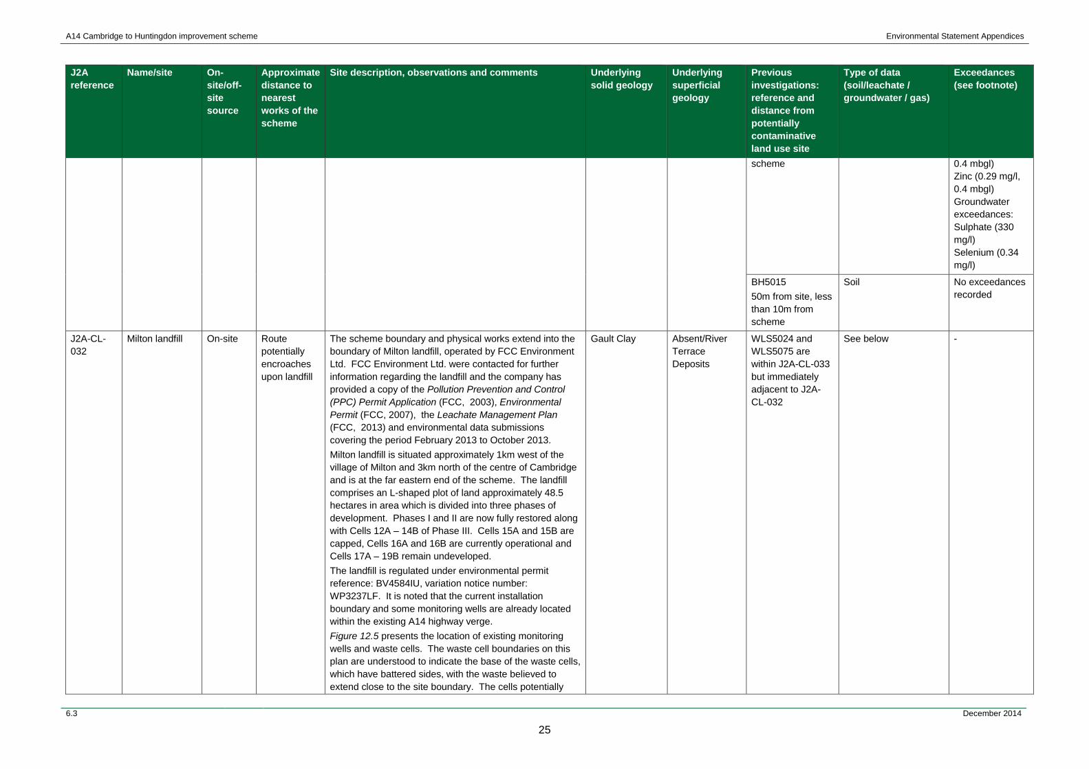
J2A-CL-032
Milton landfill On-site Route potentially encroaches upon landfill
The scheme boundary and physical works extend into the boundary of Milton landfill, operated by FCC Environment Ltd. FCC Environment Ltd. were contacted for further information regarding the landfill and the company has provided a copy of the Pollution Prevention and Control (PPC) Permit Application (FCC, 2003), Environmental Permit (FCC, 2007), the Leachate Management Plan (FCC, 2013) and environmental data submissions covering the period February 2013 to October 2013. Milton landfill is situated approximately 1km west of the village of Milton and 3km north of the centre of Cambridge and is at the far eastern end of the scheme. The landfill comprises an L-shaped plot of land approximately 48.5 hectares in area which is divided into three phases of development. Phases I and II are now fully restored along with Cells 12A – 14B of Phase III. Cells 15A and 15B are capped, Cells 16A and 16B are currently operational and Cells 17A – 19B remain undeveloped. The landfill is regulated under environmental permit reference: BV4584IU, variation notice number: WP3237LF. It is noted that the current installation boundary and some monitoring wells are already located within the existing A14 highway verge. Figure 12.5 presents the location of existing monitoring wells and waste cells. The waste cell boundaries on this plan are understood to indicate the base of the waste cells, which have battered sides, with the waste believed to extend close to the site boundary. The cells potentially
Gault Clay Absent/River Terrace Deposits
WLS5024 and WLS5075 are within J2A-CL-033 but immediately adjacent to J2A-CL-032
See below -
6.3 December 2014
25
A14 Cambridge to Huntingdon improvement scheme Environmental Statement Appendices
J2A reference
Name/site On-site/off-site source
Approximate distance to nearest works of the scheme
Site description, observations and comments Underlying solid geology
Underlying superficial geology
Previous investigations: reference and distance from potentially contaminative land use site
Type of data (soil/leachate / groundwater / gas)
Exceedances (see footnote)
affected by the scheme include Phase I, located along the boundary with the A10 where there is a proposed slip road widening and Cell 1 and Cells 9-10 of Phase II. Developed within a number of disused clay pits excavated during the 1970’s, the site has received waste since the 1980’s. Phase III however, was developed within arable land. The site is located on Gault Clay, which is overlain by River Terrace Deposits although these have been extracted over much of the landfill. The capping system emplaced/proposed across the site comprises 1m thick site derived clay overlain by subsoil. Geological data suggests that locally, the thickness of the Gault Clay ranges from 10.2 – 18.7m and is underlain by the Cretaceous age Woburn Sand Formation (a principal aquifer). Both hazardous and non-hazardous waste was accepted at Milton, up to 15 July 2004, and only non-hazardous thereafter. Phase I received waste from 1980 to 1990, and Phase II is recorded as having received waste from 1990-91. Since 1991 the cell construction has been subject to CQA procedures. Phase I and Phase II, Cells 1 – 5A were not constructed on the basis of engineered containment, but are reported to be hydraulically contained. The cells of these phases are purported to be naturally contained by a basal geological barrier comprised of in-situ Gault Clay. In 1996, a clay sidewall liner was installed retrospectively along the northern, eastern and southern perimeter of Phase I and was keyed into the perimeter clay bunds of Phase II and Phase III. The thickness of the clay sidewall is 1m where it is adjacent to the Gault Clay and is 3m where it lies against the River Terrace Gravel deposits. This remedial action was necessary due to the need to control leachate levels in Phase I. Construction Quality Assurance (CQA) information provided by FCC Environment Ltd. indicates that to the east of the engineered clay liner there is inert fill present overlying the Gault Clay rather than waste. Site walkovers of the southern and eastern boundaries of the landfill were undertaken in both May and August 2014, with FCC Environment Ltd. and the Environment Agency.
6.3 December 2014
26
A14 Cambridge to Huntingdon improvement scheme Environmental Statement Appendices
J2A reference
Name/site On-site/off-site source
Approximate distance to nearest works of the scheme
Site description, observations and comments Underlying solid geology
Underlying superficial geology
Previous investigations: reference and distance from potentially contaminative land use site
Type of data (soil/leachate / groundwater / gas)
Exceedances (see footnote)
The walkovers confirmed that a number of monitoring wells (BH5 to BH14 and BHW1) are present along the boundary of the landfill which are likely to be destroyed or potentially impacted by the scheme. The walkover did not confirm the extent of the waste although the observed surface topography appeared to suggest that the extent of waste as shown on Figure 12.5 was likely. Consultation with the Environment Agency and FCC Environment Ltd. resulted in agreement in principle (from the Environment Agency) to the positioning of boreholes to replace existing monitoring boreholes which would be destroyed by the scheme. These boreholes would be excavated under an agreed Construction Quality Assurance (CQA) process with a view to creation of new perimeter monitoring boreholes outside the waste mass. The proposed borehole locations are presented on Figure 12.5.
J2A-CL-033
Former military camp
On-site N/A Histon Army Camp, within the footprint of the physical works, was established along Milton Road in 1944 for the United States Army. It housed a variety of United States Army troops in the build-up to D-Day, including units of the medical, quartermaster, engineer and ordnance base depot companies.Troops were housed in a series of Nissen Huts and it is likely that some storage of small arms ammunition would have occurred at the camp.After the United States Army troops left the camp was used for temporary accommodation after WWII. It has since been demolished and most of the former camp has been extensively redeveloped with the construction of the A14, Milton Roundabout and Milton Landfill.The site is not considered to have potential to significantly impact the scheme.
Gault Clay Absent/River Terrace Deposits
WLS5024 Within site, less than 10m from scheme
Soil No exceedances recorded
WLS5059 (within site and scheme)
Gas, soil and leachate Leachate exceedance: Sulphate (790 mg/l, 1.3 mbgl)
WLS5062A (within site and scheme)
Gas and soil No exceedances recorded
WLS5075 (within site and scheme)
Gas, soil and leachate Elevated Ground Gas: CO2 (8.1%) Leachate exceedance: Sulphate (290 mg/l, 0.7 mbgl)
WLS5076 (within site and scheme)
Gas, soil and leachate Elevated Ground Gas: Leachate exceedance: Sulphate (280 mg/l, 1.8 mbgl)
6.3 December 2014
27
A14 Cambridge to Huntingdon improvement scheme Environmental Statement Appendices
J2A reference
Name/site On-site/off-site source
Approximate distance to nearest works of the scheme
Site description, observations and comments Underlying solid geology
Underlying superficial geology
Previous investigations: reference and distance from potentially contaminative land use site
Type of data (soil/leachate / groundwater / gas)
Exceedances (see footnote)
J2A-CL-034
Cambridge Sewage Works
Off-site 200m The site has been a sewage works since the early 1900s although was extended toward Milton Junction and converted to a more modern facility in the 1970s. Given the distance the site is considered unlikely to have potential to significantly impact the scheme.
Gault Clay River Terrace Deposits
WLS5033 (within site) (40m from existing road)
Soil and leachate Leachate exceedances: Ammoniacal nitrogen (15 mg/l, 2.2 mbgl) Nickel (0.02 mg/l, 2.2 mbgl)
J2A-CL-035
Former gas works/gas distribution depot
Off-site 50m The site is marked as a gas works from the earliest available mapping in the 1880s and has expanded by the 1920s to include two gas holders. By the 1980s the site is shown as a gas distribution depot and at the time of the J2A site walkover in May 2014 was found to be vacant derelict land advertised for re-development. Given the distance from the site and position adjacent to a watercourse which is likely fed by the underlying Alluvium and River Terrace Deposits, the site is not considered to have potential to significantly impact the scheme.
Oxford Clay Alluvium No data available - -
J2A-CL-036
Former bus depot
Off-site Adjacent to south
The site was first marked as a bus and coach depot from mapping in the early 1970s and is still present in the 1980s after which there is a gap in available mapping. The site was observed during a site walkover in May 2014 to have been re-developed as a modern housing estate. Given this, the site is considered unlikely to have potential to significantly impact the scheme.
Oxford Clay Alluvium No data available - -
J2A-CL-037
Approximate area of infilled ground
On-site N/A Archaeological investigation was undertaken in 2006 at Mill Common. The scheme passes through the south-eastern corner of Mill Common where there is evidence of infilled quarry. Only one hand pit was extended in this area to a depth of 1.1m bgl. The Cambridgeshire County Council Archaeological Field Unit report (Mortimer, 2006) notes: “This series of fills represents a small sample of the many layers of infilling within the larger quarry area consisting of a mix of silty sands, sandy clays and clay silts with varying quantities of domestic refuse intermixed.” An area of quarrying such as this so close to the built up area of Huntingdon would have become a general rubbish tip. The site is not considered likely to have potential to significantly impact the scheme but will be further investigated during forthcoming ground investigation.
Oxford Clay River Terrace Deposits
No data available - -
6.3 December 2014
28
A14 Cambridge to Huntingdon improvement scheme Environmental Statement Appendices
J2A reference
Name/site On-site/off-site source
Approximate distance to nearest works of the scheme
Site description, observations and comments Underlying solid geology
Underlying superficial geology
Previous investigations: reference and distance from potentially contaminative land use site
Type of data (soil/leachate / groundwater / gas)
Exceedances (see footnote)
J2A-CL-038
Commercial/industrial estate
Off-site Adjacent to north
This area is shown as having a commercial/industrial land use since first available mapping in the 1880s with various coal yards, iron and brass works shown throughout the early to mid-20th century (Mortimer, 2006). However, the site is currently undergoing development as the Ermine Street link road. Given the current earthworks and the limited nature of the proposed works for the scheme in the area, the area is considered to be unlikely to have potential to significantly impact the scheme.
Oxford Clay River Terrace Deposits
No data available - -
J2A-CL-039
Railway land/sidings and vehicle maintenance garage
Off-site Adjacent to west
Area shown as having various uses associated with railway sidings since first available mapping from 1880s including coal and storage yards. Area converted to car park in early 1980s including vehicle maintenance garage by early 1990s. Given the limited nature of the proposed works in the area and the underlying geology (unproductive Oxford Clay) the site is considered unlikely to have potential to significantly impact the scheme.
Oxford Clay Absent No data available - -
J2A-CL-040
Railway land/sidings and former brick and tile works
Off-site Adjacent to north
Area shown as brick and tile works adjacent to railway line on first available mapping from 1880s and shown to have various light industrial uses as railway sidings through 20th century. Given the limited nature of the proposed works in the area and the underlying geology (unproductive Oxford Clay) the site is considered to be unlikely to have potential to significantly impact the scheme.
Oxford Clay Absent No data available - -
J2A-CL-041
Hinchingbrooke Hospital
Off-site 140m Hospital first shown in 1970s and shown to have expanded by 1980s. Given the distance from the scheme the site is considered unlikely to significantly impact the scheme.
Oxford Clay Diamicton No data available - -
Note: Where potentially contaminative land uses are identified as being not significant, this is a result of either the distance of the land use from the scheme, the small magnitude of the potential source, or the low contaminative potential of the land use.
6.3 December 2014
29
A14 Cambridge to Huntingdon improvement scheme Environmental Statement Appendices
5 Buckden South landfill - environmental monitoring data
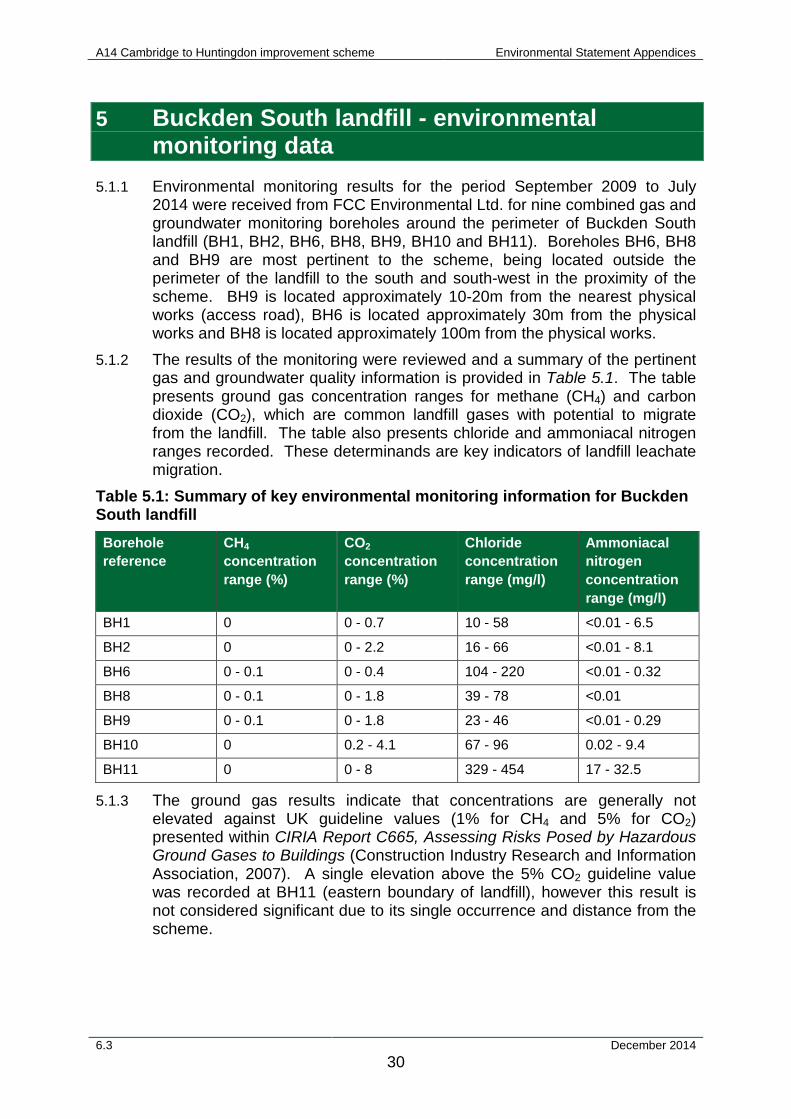
5.1.1 Environmental monitoring results for the period September 2009 to July 2014 were received from FCC Environmental Ltd. for nine combined gas and groundwater monitoring boreholes around the perimeter of Buckden South landfill (BH1, BH2, BH6, BH8, BH9, BH10 and BH11). Boreholes BH6, BH8 and BH9 are most pertinent to the scheme, being located outside the perimeter of the landfill to the south and south-west in the proximity of the scheme. BH9 is located approximately 10-20m from the nearest physical works (access road), BH6 is located approximately 30m from the physical works and BH8 is located approximately 100m from the physical works.
5.1.2 The results of the monitoring were reviewed and a summary of the pertinent gas and groundwater quality information is provided in Table 5.1. The table presents ground gas concentration ranges for methane (CH4) and carbon dioxide (CO2), which are common landfill gases with potential to migrate from the landfill. The table also presents chloride and ammoniacal nitrogen ranges recorded. These determinands are key indicators of landfill leachate migration.
Table 5.1: Summary of key environmental monitoring information for Buckden South landfill Borehole reference
CH4
concentration range (%)
CO2
concentration range (%)
Chloride concentration range (mg/l)
Ammoniacal nitrogen concentration range (mg/l)
BH1 0 0 - 0.7 10 - 58 <0.01 - 6.5
BH2 0 0 - 2.2 16 - 66 <0.01 - 8.1
BH6 0 - 0.1 0 - 0.4 104 - 220 <0.01 - 0.32
BH8 0 - 0.1 0 - 1.8 39 - 78 <0.01
BH9 0 - 0.1 0 - 1.8 23 - 46 <0.01 - 0.29
BH10 0 0.2 - 4.1 67 - 96 0.02 - 9.4
BH11 0 0 - 8 329 - 454 17 - 32.5
5.1.3 The ground gas results indicate that concentrations are generally not elevated against UK guideline values (1% for CH4 and 5% for CO2) presented within CIRIA Report C665, Assessing Risks Posed by Hazardous Ground Gases to Buildings (Construction Industry Research and Information Association, 2007). A single elevation above the 5% CO2 guideline value was recorded at BH11 (eastern boundary of landfill), however this result is not considered significant due to its single occurrence and distance from the scheme.
6.3 December 2014 30
A14 Cambridge to Huntingdon improvement scheme Environmental Statement Appendices
5.1.4 Chloride concentrations are generally low in comparison with typical landfill leachate values. With the exception of BH11, chloride concentrations are all below the UK Drinking Water Standard and the Environmental Quality Standard for Freshwater (Environment Agency, 2014), which both state 250mg/l. The concentrations at BH11 potentially indicate some leachate migration although this monitoring borehole is over 200m from the scheme and accordingly the concentrations at this location are not considered significant.
5.1.5 Whilst many of the boreholes display ammoniacal nitrogen concentrations above the 0.6mg/l ‘good’ standard for freshwater lakes under the Water Framework Directive, it is noted that this guideline value is for the waterbody itself, not groundwater before the point of discharge, and accordingly is conservative. In addition the highest concentrations are recorded at BH11, which are located away from the scheme. The concentrations are not considered significant.
6.3 December 2014 31
A14 Cambridge to Huntingdon improvement scheme Environmental Statement Appendices
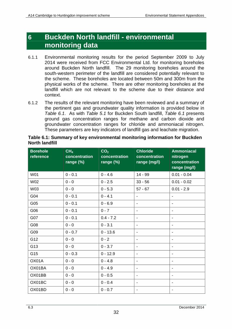
6 Buckden North landfill - environmental monitoring data
6.1.1 Environmental monitoring results for the period September 2009 to July 2014 were received from FCC Environmental Ltd. for monitoring boreholes around Buckden North landfill. The 29 monitoring boreholes around the south-western perimeter of the landfill are considered potentially relevant to the scheme. These boreholes are located between 50m and 300m from the physical works of the scheme. There are other monitoring boreholes at the landfill which are not relevant to the scheme due to their distance and context.
6.1.2 The results of the relevant monitoring have been reviewed and a summary of the pertinent gas and groundwater quality information is provided below in Table 6.1. As with Table 5.1 for Buckden South landfill, Table 6.1 presents ground gas concentration ranges for methane and carbon dioxide and groundwater concentration ranges for chloride and ammoniacal nitrogen. These parameters are key indicators of landfill gas and leachate migration.
Table 6.1: Summary of key environmental monitoring information for Buckden North landfill Borehole reference
CH4
concentration range (%)
CO2
concentration range (%)
Chloride concentration range (mg/l)
Ammoniacal nitrogen concentration range (mg/l)
W01 0 - 0.1 0 - 4.6 14 - 99 0.01 - 0.04
W02 0 - 0 0 - 2.5 33 - 56 0.01 - 0.02
W03 0 - 0 0 - 5.3 57 - 67 0.01 - 2.9
G04 0 - 0.1 0 - 4.1 - -
G05 0 - 0.1 0 - 6.9 - -
G06 0 - 0.1 0 - 7 - -
G07 0 - 0.1 0.4 - 7.2 - -
G08 0 - 0 0 - 3.1 - -
G09 0 - 0.7 0 - 13.6 - -
G12 0 - 0 0 - 2 - -
G13 0 - 0 0 - 3.7 - -
G15 0 - 0.3 0 - 12.9 - -
OX01A 0 - 0 0 - 4.8 - -
OX01BA 0 - 0 0 - 4.9 - -
OX01BB 0 - 0 0 - 0.5 - -
OX01BC 0 - 0 0 - 0.4 - -
OX01BD 0 - 0 0 - 0.7 - -
6.3 December 2014 32
A14 Cambridge to Huntingdon improvement scheme Environmental Statement Appendices
Borehole reference
CH4
concentration range (%)
CO2
concentration range (%)
Chloride concentration range (mg/l)
Ammoniacal nitrogen concentration range (mg/l)
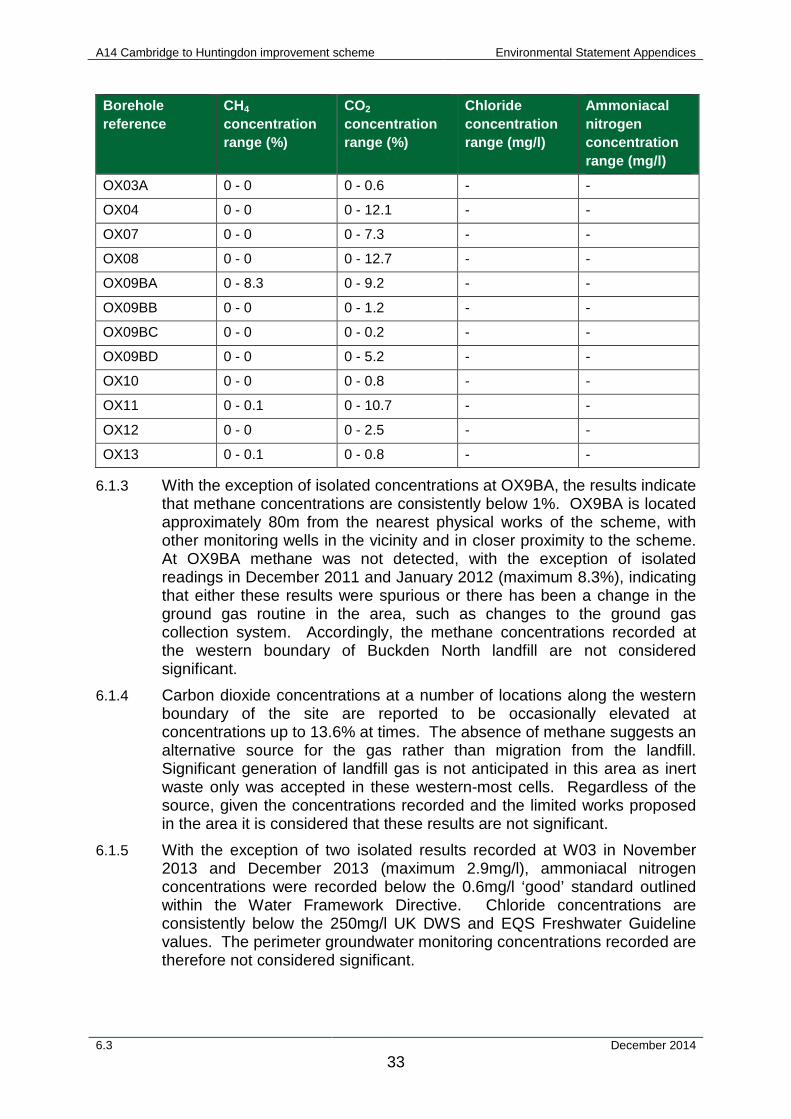
OX03A 0 - 0 0 - 0.6 - -
OX04 0 - 0 0 - 12.1 - -
OX07 0 - 0 0 - 7.3 - -
OX08 0 - 0 0 - 12.7 - -
OX09BA 0 - 8.3 0 - 9.2 - -
OX09BB 0 - 0 0 - 1.2 - -
OX09BC 0 - 0 0 - 0.2 - -
OX09BD 0 - 0 0 - 5.2 - -
OX10 0 - 0 0 - 0.8 - -
OX11 0 - 0.1 0 - 10.7 - -
OX12 0 - 0 0 - 2.5 - -
OX13 0 - 0.1 0 - 0.8 - -
6.1.3 With the exception of isolated concentrations at OX9BA, the results indicate that methane concentrations are consistently below 1%. OX9BA is located approximately 80m from the nearest physical works of the scheme, with other monitoring wells in the vicinity and in closer proximity to the scheme. At OX9BA methane was not detected, with the exception of isolated readings in December 2011 and January 2012 (maximum 8.3%), indicating that either these results were spurious or there has been a change in the ground gas routine in the area, such as changes to the ground gas collection system. Accordingly, the methane concentrations recorded at the western boundary of Buckden North landfill are not considered significant.
6.1.4 Carbon dioxide concentrations at a number of locations along the western boundary of the site are reported to be occasionally elevated at concentrations up to 13.6% at times. The absence of methane suggests an alternative source for the gas rather than migration from the landfill. Significant generation of landfill gas is not anticipated in this area as inert waste only was accepted in these western-most cells. Regardless of the source, given the concentrations recorded and the limited works proposed in the area it is considered that these results are not significant.
6.1.5 With the exception of two isolated results recorded at W03 in November 2013 and December 2013 (maximum 2.9mg/l), ammoniacal nitrogen concentrations were recorded below the 0.6mg/l ‘good’ standard outlined within the Water Framework Directive. Chloride concentrations are consistently below the 250mg/l UK DWS and EQS Freshwater Guideline values. The perimeter groundwater monitoring concentrations recorded are therefore not considered significant.
6.3 December 2014 33
A14 Cambridge to Huntingdon improvement scheme Environmental Statement Appendices
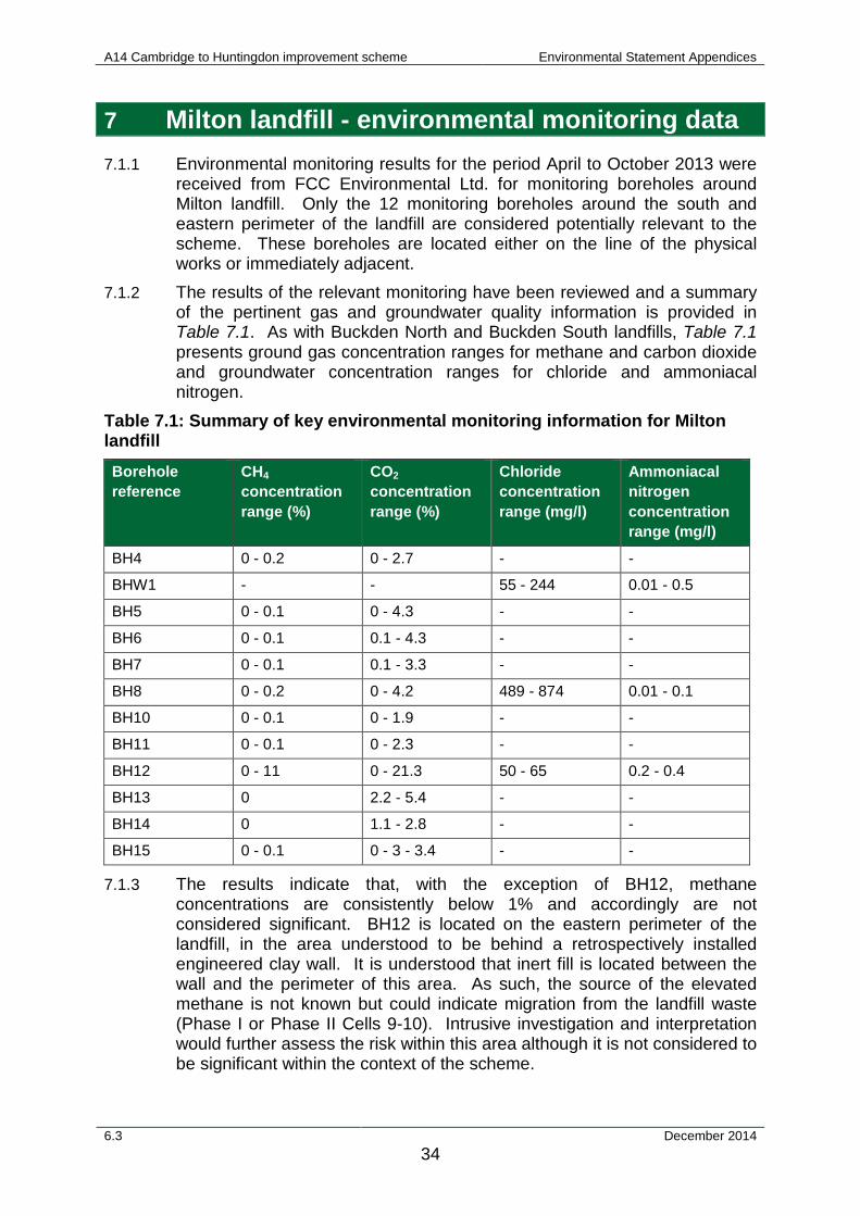
7 Milton landfill - environmental monitoring data 7.1.1 Environmental monitoring results for the period April to October 2013 were
received from FCC Environmental Ltd. for monitoring boreholes around Milton landfill. Only the 12 monitoring boreholes around the south and eastern perimeter of the landfill are considered potentially relevant to the scheme. These boreholes are located either on the line of the physical works or immediately adjacent.
7.1.2 The results of the relevant monitoring have been reviewed and a summary of the pertinent gas and groundwater quality information is provided in Table 7.1. As with Buckden North and Buckden South landfills, Table 7.1 presents ground gas concentration ranges for methane and carbon dioxide and groundwater concentration ranges for chloride and ammoniacal nitrogen.
Table 7.1: Summary of key environmental monitoring information for Milton landfill Borehole reference
CH4
concentration range (%)
CO2
concentration range (%)
Chloride concentration range (mg/l)
Ammoniacal nitrogen concentration range (mg/l)
BH4 0 - 0.2 0 - 2.7 - -
BHW1 - - 55 - 244 0.01 - 0.5
BH5 0 - 0.1 0 - 4.3 - -
BH6 0 - 0.1 0.1 - 4.3 - -
BH7 0 - 0.1 0.1 - 3.3 - -
BH8 0 - 0.2 0 - 4.2 489 - 874 0.01 - 0.1
BH10 0 - 0.1 0 - 1.9 - -
BH11 0 - 0.1 0 - 2.3 - -
BH12 0 - 11 0 - 21.3 50 - 65 0.2 - 0.4
BH13 0 2.2 - 5.4 - -
BH14 0 1.1 - 2.8 - -
BH15 0 - 0.1 0 - 3 - 3.4 - -
7.1.3 The results indicate that, with the exception of BH12, methane concentrations are consistently below 1% and accordingly are not considered significant. BH12 is located on the eastern perimeter of the landfill, in the area understood to be behind a retrospectively installed engineered clay wall. It is understood that inert fill is located between the wall and the perimeter of this area. As such, the source of the elevated methane is not known but could indicate migration from the landfill waste (Phase I or Phase II Cells 9-10). Intrusive investigation and interpretation would further assess the risk within this area although it is not considered to be significant within the context of the scheme.
6.3 December 2014 34
A14 Cambridge to Huntingdon improvement scheme Environmental Statement Appendices
7.1.4 Carbon dioxide concentrations are elevated at a number of locations although with the exception of BH12, concentrations are not above 5% and accordingly are not considered significant. As discussed above, the intrusive investigation and interpretation would further assess the risk within this area. It is not considered to be significant within the context of the scheme.
7.1.5 Ammoniacal nitrogen concentrations are all below 0.6mg/l ‘good’ standard outlined within the WFD. Chloride concentrations are below the 250mg/l UK DWS and EQS Freshwater guideline values (summarised and referenced on the Environment Agency chemical standards database at (Environment Agency, 2014) at BHW1 and BH12 although are elevated at BH8. The source of the elevated concentrations at BH8 is not known although could indicate migration from the landfill. The intrusive investigation and interpretation would further assess the risk within this area. It is not considered to be significant within the context of the scheme.
6.3 December 2014 35
A14 Cambridge to Huntingdon improvement scheme Environmental Statement Appendices
8 Bibliography Arcadis (2014). Remediation Implementation and Verification Plan, Former Buckden Fuel Depot.
Construction Industry Research and Information Association (CIRIA) (2007). C665 Assessing Risks Posed by Hazardous Ground Gases to Buildings.
Environment Agency (2014). Chemical Standards Database. http://evidence.environment-agency.gov.uk/ChemicalStandards.
FCC Environment Ltd (2003). Pollution Prevention and Control Permit Application. Milton Landfill Site.
FCC Environment Ltd (2007). Environmental Permit. Milton Landfill Site.
FCC Environment Ltd (2007). Environmental Permit. Milton Landfill Site.
FCC Environment Ltd (2013). Leachate Management Plan. Milton Landfill Site.
Highways Agency et al. (2009). Specification for Highways Works: Series 600: Earthworks.
Mortimer, R. (2006) Mill Common, Huntingdon, Cambridgeshire: Trench Evaluation and Community Archaeology Project. Cambridgeshire Archaeology Archaeological Field Unit.
6.3 December 2014 36