A VISION FOR TWINWOODS€¦ · A VISION FOR TWINWOODS. ... The majority of the site sits on a...
66
June 2016 Marcol | Bedfordia Barton Willmore | DLP Part 2: Vision Document A VISION FOR TWINWOODS
Transcript of A VISION FOR TWINWOODS€¦ · A VISION FOR TWINWOODS. ... The majority of the site sits on a...
June 2016
Marcol | BedfordiaBarton Willmore | DLP
Part 2: Vision Document
A VISION FORTWINWOODS

All plans are reproduced from the Ordnance Survey Map with the permission of the Controller of HMSO. Crown copyright Reserved. Licence
No. AR152684.
Barton Willmore LLP
7 Soho SquareLondon
W1D 3QB
t: 0207 446 6888f: 0207 446 6889
www.bartonwillmore.co.uk
Desk Top Publishing and Graphic Design by Barton Willmore Graphic Design
This artwork was printed on paper using fibre sourced from sustainable plantation wood from suppliers who practice sustainable management
of forests in line with strict international standards. Pulp used in its manufacture is also Elemental Chlorine Free (ECF).
CopyrightThe contents of this document must not be copied or reproduced in whole
or in part without the written consent of Barton Willmore.
Issue date 29/06/2016
Document status Final
Revision E
Author MS/DF/LA
Checked by LA/MS
Authorised by LA/SR

Contents
Introduction
Considerations
Vision
Why Twinwoods?
A Locally Led Vision
Development Principles
The Framework Plan
Land Use
Indicative Phasing
Appendix
Landscape Infrastructure
Movement and Connections
Typology & Density
The Audit
1
6
15
15
18
19
27
30
32
41
42 44
48
49
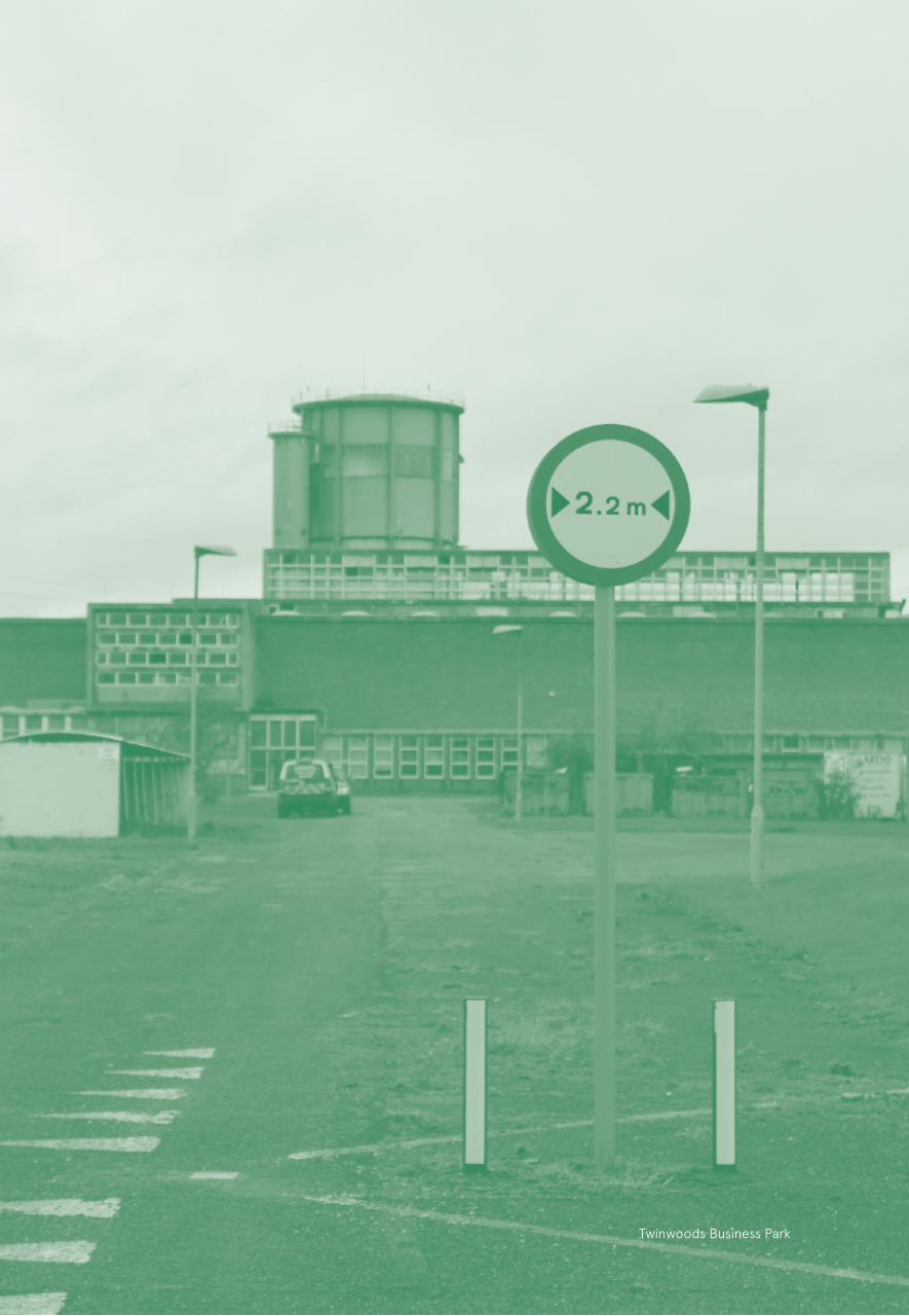
Twinwoods Business Park
1
Introduction
This part of the submission document sets out our vision for the site, the principles of development and the benefits of developing at this location. It demonstrates the masterplan and design considerations in response to a broad range of technical work and sets out the community, environmental and sustainable movement infrastructure requirements. Finally, it sets out information on the development proposals as they have evolved at this stage including the extent, form and content of the settlement and indication of phasing.
THE OPPORTUNITY
Twinwoods has capacity to deliver up to 6,000 new homes,new employment opportunities and a mixture of supporting uses including commercial development, workshops, retail, primary, secondary and nursery schools, medical facilities and leisure, as a best practice benchmark for the planning and design of a new community. Twinwoods is being planned to provide a full range of facilities and infrastructure to support a large scale community.
WHY TWINWOODS?
Twinwoods is a sustainably located, unconstrained and deliverable location for new development that offers a broad range of benefits:
• The land required to deliver the proposed new settlement and proposed bypass is available and in the control of two parties only;
• A significant proportion of the site is classified as previously developed land, or brownfield land which is visually invasive;
• The site is largely unconstrained and in line with development plan requirements and can be delivered;
• Up to 6,000 new homes to meet emerging housing needs, plus new employment opportunities, including a mixture of supporting uses and community facilities, Twinwoods provides the opportunity to create a stand-alone, self-sustaining settlement and would deliver growth in the plan period and beyond;
• Opportunity to create a ‘Rural Service Centre’ that can enhance facilities for existing local communities;
• Twinwoods will allow for the delivery of new employment (up to 2,000 jobs) and the provision of environmental and community infrastructure;
• Twinwoods is located centrally within Bedford Borough Council geographical boundary and can contribute to meeting the emerging housing needs of the Borough;
• The A6 north of Milton Ernest is single carriageway and is at capacity, thereby restricting opportunities for future development to the North of Milton Ernest;
• Development of Twinwoods would provide for the realignment of the A6 which would provide a bypass to Milton Ernest and Bletsoe and improve network capacity;
• Close proximity to the A6 will allow access to strategic destinations including Bedford to the south and Wellingborough, Kettering and Rushden, amongst others, to the north;
• The location of the site will allow access to existing bus services with easy connections to Bedford and other destinations including Kettering;
• Established walking and cycling networks already connect Twinwoods with Bedford, surrounding villages and the wider countryside. The development would significantly enhance and improve this network, in particular with hard surfaced links to Bedford;
• A unique opportunity to repair the ‘skyline’ of the Twinwoods Business Park through sensitive design and create an attractive built form;
• The best of town and country living with excellent access to the facilities of Bedford and the open countryside.
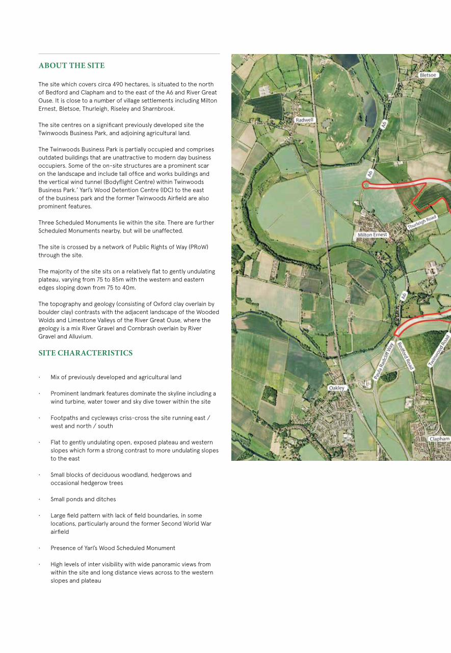
ABOUT THE SITE
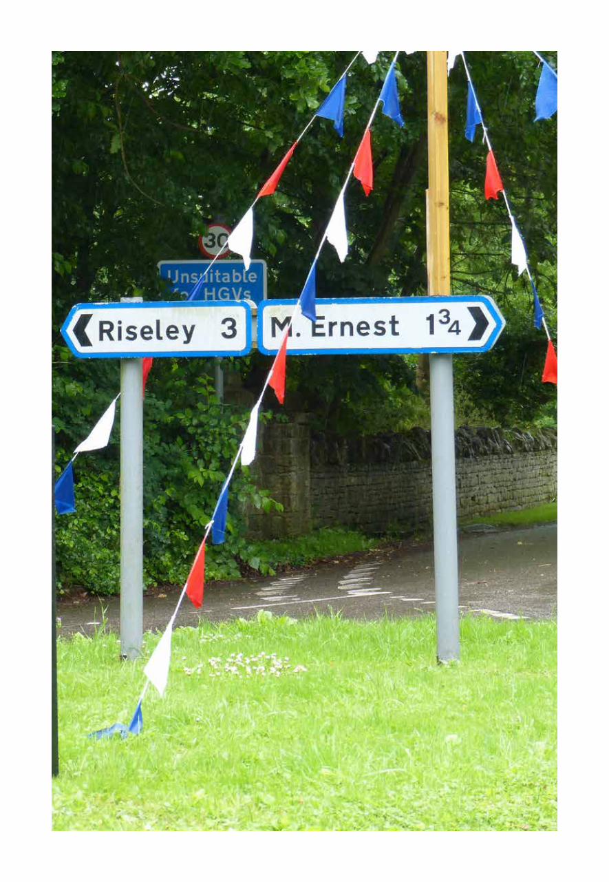
The site which covers circa 490 hectares, is situated to the north of Bedford and Clapham and to the east of the A6 and River Great Ouse. It is close to a number of village settlements including Milton Ernest, Bletsoe, Thurleigh, Riseley and Sharnbrook.
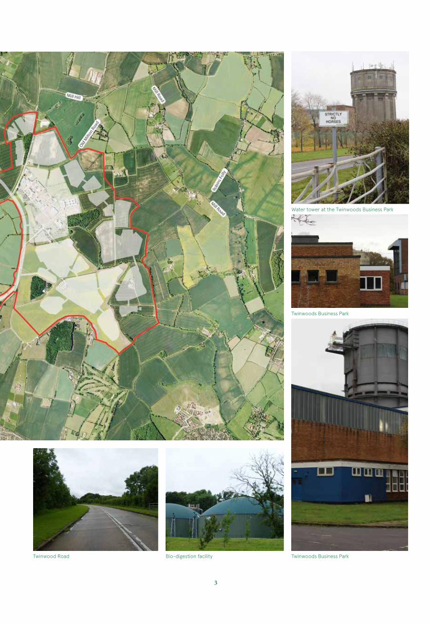
The site centres on a significant previously developed site the Twinwoods Business Park, and adjoining agricultural land.
The Twinwoods Business Park is partially occupied and comprises outdated buildings that are unattractive to modern day business occupiers. Some of the on-site structures are a prominent scar on the landscape and include tall office and works buildings and the vertical wind tunnel (Bodyflight Centre) within Twinwoods Business Park.’ Yarl’s Wood Detention Centre (IDC) to the east of the business park and the former Twinwoods Airfield are also prominent features.
Three Scheduled Monuments lie within the site. There are further Scheduled Monuments nearby, but will be unaffected.
The site is crossed by a network of Public Rights of Way (PRoW) through the site.
The majority of the site sits on a relatively flat to gently undulating plateau, varying from 75 to 85m with the western and eastern edges sloping down from 75 to 40m.
The topography and geology (consisting of Oxford clay overlain by boulder clay) contrasts with the adjacent landscape of the Wooded Wolds and Limestone Valleys of the River Great Ouse, where the geology is a mix River Gravel and Cornbrash overlain by River Gravel and Alluvium.
SITE CHARACTERISTICS
• Mix of previously developed and agricultural land
• Prominent landmark features dominate the skyline including a wind turbine, water tower and sky dive tower within the site
• Footpaths and cycleways criss-cross the site running east / west and north / south
• Flat to gently undulating open, exposed plateau and western slopes which form a strong contrast to more undulating slopes to the east
• Small blocks of deciduous woodland, hedgerows and occasional hedgerow trees
• Small ponds and ditches
• Large field pattern with lack of field boundaries, in some locations, particularly around the former Second World War airfield
• Presence of Yarl’s Wood Scheduled Monument
• High levels of inter visibility with wide panoramic views from within the site and long distance views across to the western slopes and plateau
3
Water tower at the Twinwoods Business Park
Twinwoods Business Park
Twinwood Road Bio-digestion facility Twinwoods Business Park
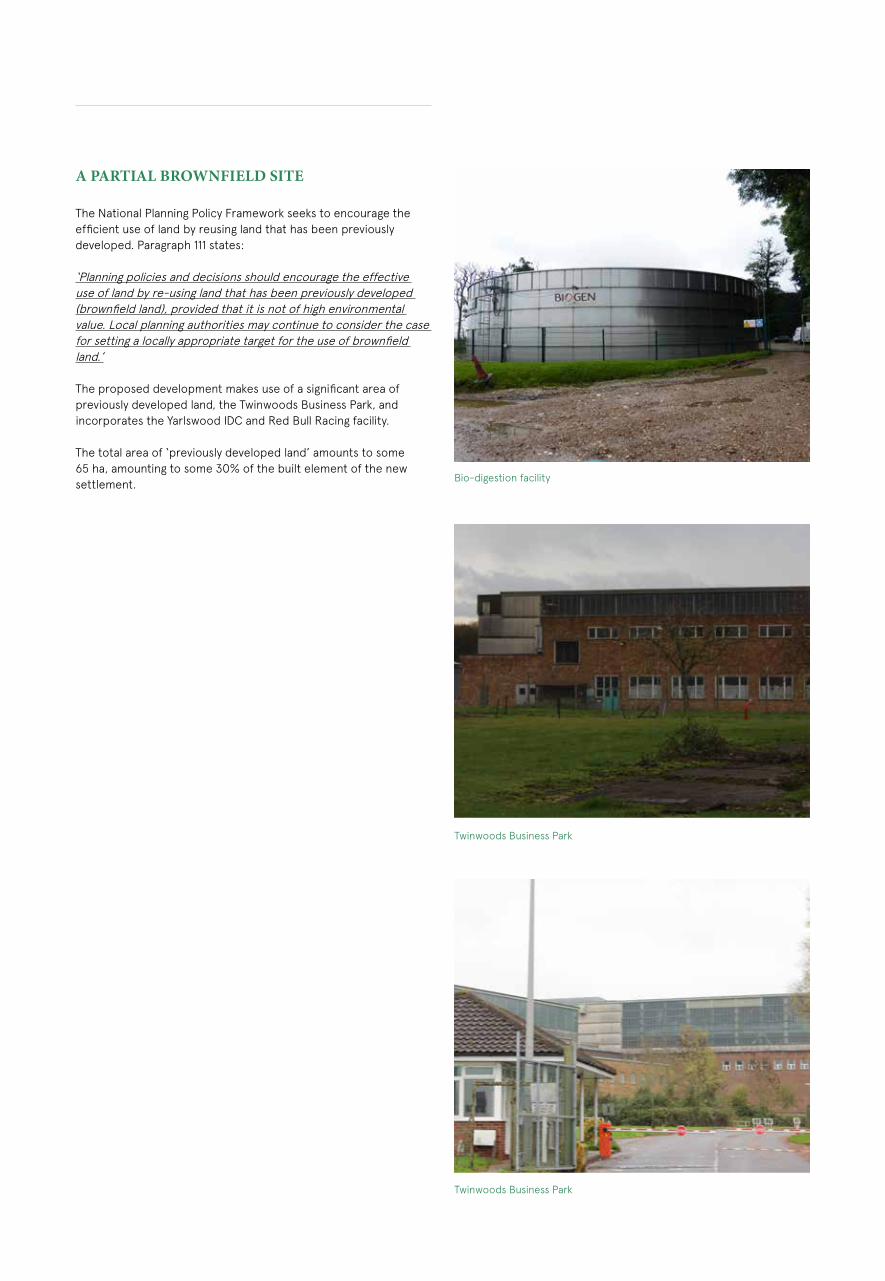
A PARTIAL BROWNFIELD SITE
The National Planning Policy Framework seeks to encourage the efficient use of land by reusing land that has been previously developed. Paragraph 111 states:
‘Planning policies and decisions should encourage the effective use of land by re-using land that has been previously developed (brownfield land), provided that it is not of high environmental value. Local planning authorities may continue to consider the case for setting a locally appropriate target for the use of brownfield land.’
The proposed development makes use of a significant area of previously developed land, the Twinwoods Business Park, and incorporates the Yarlswood IDC and Red Bull Racing facility.
The total area of ‘previously developed land’ amounts to some 65 ha, amounting to some 30% of the built element of the new settlement.
Twinwoods Business Park
Bio-digestion facility
Twinwoods Business Park

5Previously Developed Land
Proximity of the Sharnbrook Turn Roundabout

Site Boundary
Other Land within client’s ownership
Contours/Spot Heights (Meters AOD)
Public Rights of Way
Cycle Route (Policy AD39)
Listed Building
Scheduled Monument
Ancient Woodland
Local Nature Reserve (LNR)
County Wildlife Site (WCS)
Roadside Nature Reserve (RNR)
Conservation Area
Existing Pond
Running Water
Dry Ditch
Broad-leaved Semi-nat Woodland
Broad-leaved Plantation Woodland
Hedgerow
Individual Tree
Flood Zone
Country Park
Detention Centre
Museum
Water Tower
A6/ Bedford Road
Thurleigh Road
Existing Sewage Treatment Works
110m
Areas with Topography Steeper Than 1:12 (Refer to note 6)
Gas Main Intermediate Pressure
Foul Sewer (Anglian Water)
Foul Sewer (Private)
Existing Foul Water Pumping Station
Surface Sewer
Water Main
BT Duct/Aerial
Western Power Distribution (HV Cable/OH Line)
Western Power Distribution (LV Cable/OH Line)
UK Power Networks Electricity Cable/Overhead Line
UK Power Networks Secondary Sub Station
Telecom Antenna
Wind Turbine
S S/SP S/S
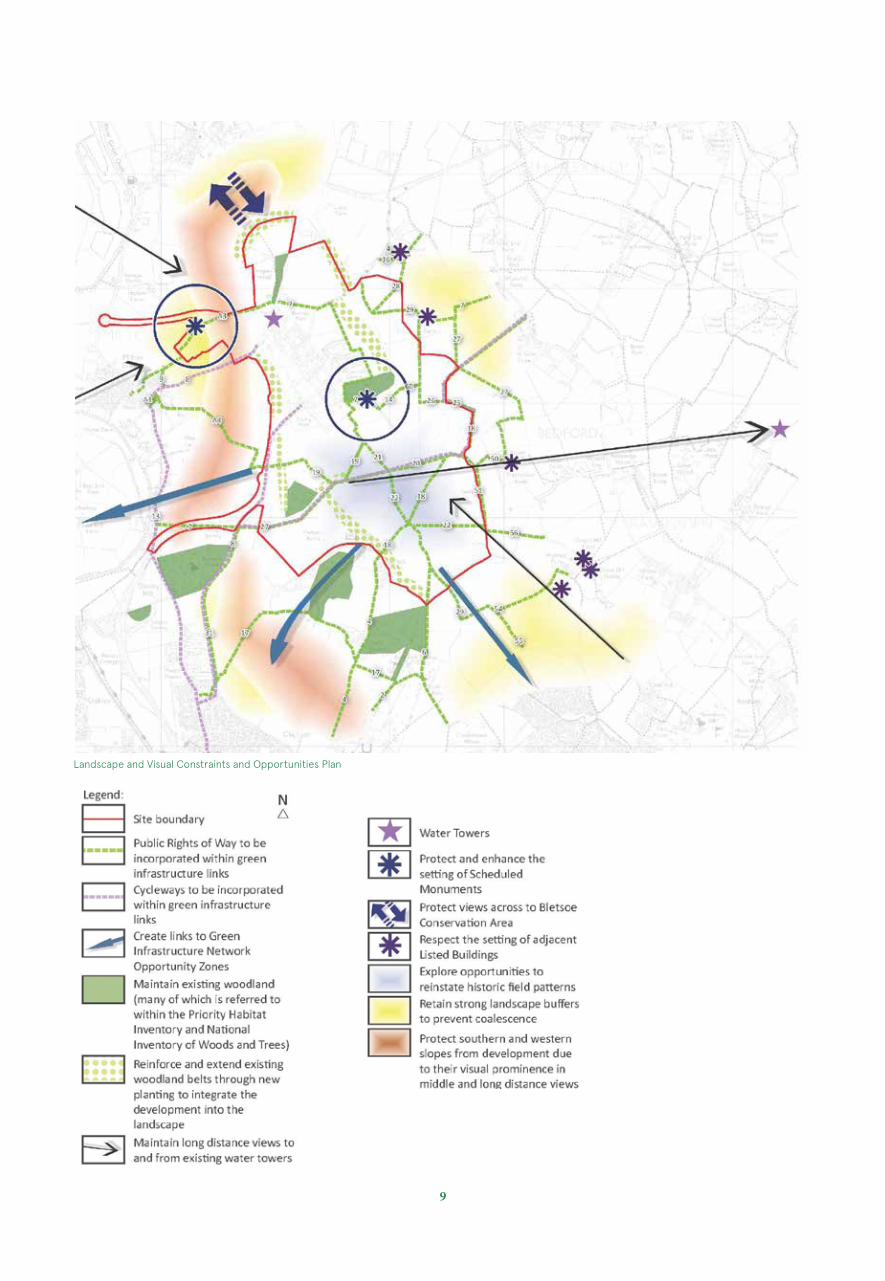
Considerations
The land required to deliver the proposed new settlement and bypass is in the control of two landowners/promoters only, and is available and deliverable.
A number of technical assessments have been undertaken identifying constraints and opportunities, and these conclude there is relatively little to constrain development (see right). The site is well screened by existing tree stands and woodland and although development will alter the character of the land, sensitive design will allow development to sit well within its setting and provide for mitigation.
In terms of its landscape and heritage, the site offers a number of opportunities for enhancement to create a unique sense of place. Existing features such as mature woodland and hedgerows, waterbodies and ditches, historic remains and built features will all be integrated in a way that adds value to the development.
The network of public rights of way and cycleways can be fully retained and integrated to provide connections within the development, Bedford and other settlements and to the wider countryside.
Coalescence of settlements can be avoided through the provision of wide landscape buffers to create physical and visual separation. This will also assist in mitigation, and keep the continued use of the surrounding land for agriculture.
The plan (right) summarises the key considerations and the following pages describe these in more detail.
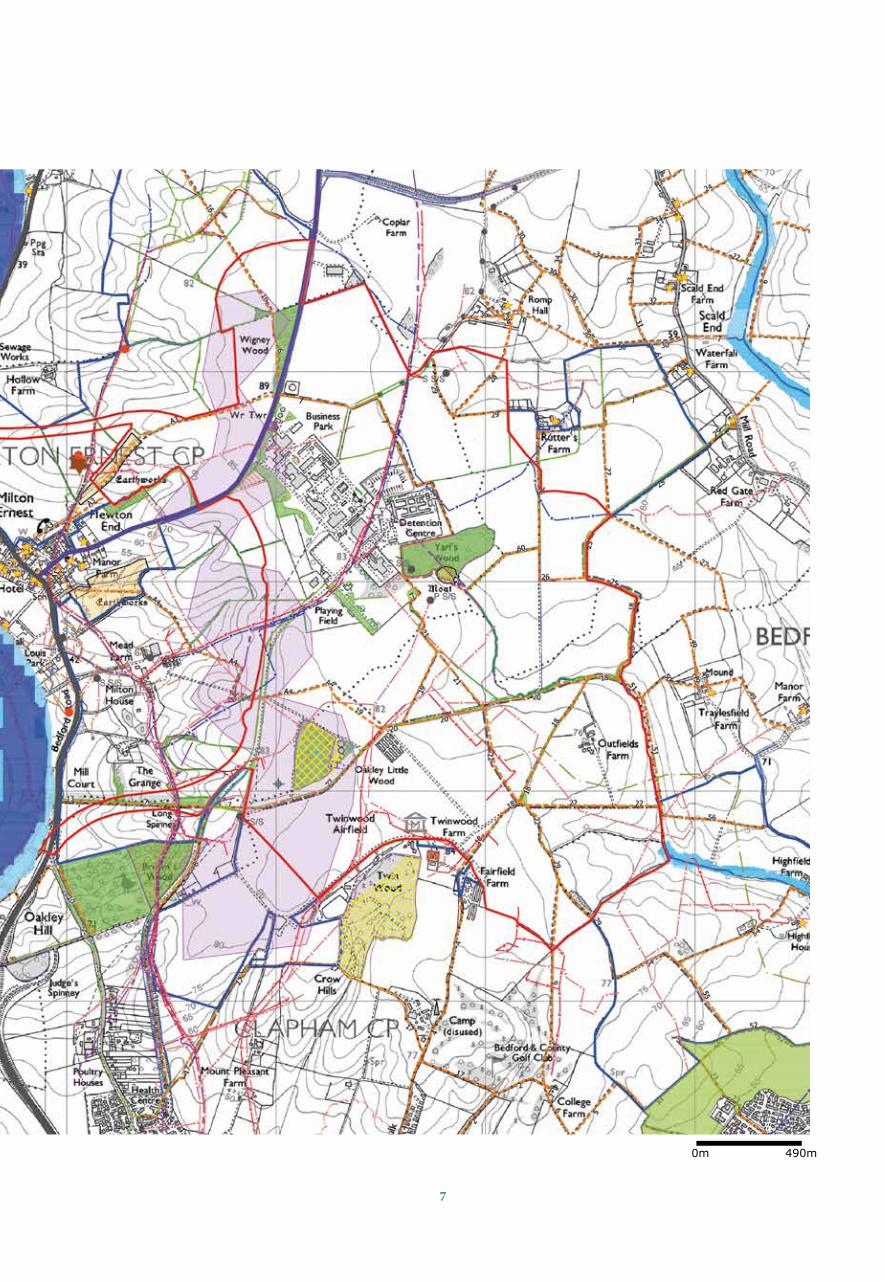
7
0m 490m
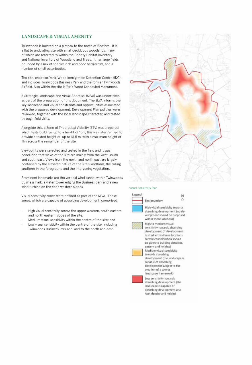
LANDSCAPE & VISUAL AMENITY
Twinwoods is located on a plateau to the north of Bedford. It is a flat to undulating site with small deciduous woodlands, many of which are referred to within the Priority Habitat Inventory and National Inventory of Woodland and Trees. It has large fields bounded by a mix of species rich and poor hedgerows, and a number of small waterbodies.
The site, encircles Yarl’s Wood Immigration Detention Centre (IDC), and includes Twinwoods Business Park and the former Twinwoods Airfield. Also within the site is Yarl’s Wood Scheduled Monument.
A Strategic Landscape and Visual Appraisal (SLVA) was undertaken as part of the preparation of this document. The SLVA informs the key landscape and visual constraints and opportunities associated with the proposed development. Development Plan policies were reviewed, together with the local landscape character, and tested through field visits.
Alongside this, a Zone of Theoretical Visibility (ZTV) was prepared which tests buildings up to a height of 15m, this was later refined to provide a tested height of up to 16.5 m, with a maximum height of 11m across the remainder of the site.
Viewpoints were selected and tested in the field and it was concluded that views of the site are mainly from the west, south and south east. Views from the north and north east are largely contained by the elevated nature of the site’s landform, the rolling landform in the foreground and the intervening vegetation.
Prominent landmarks are the vertical wind tunnel within Twinwoods Business Park, a water tower edging the Business park and a new wind turbine on the site’s western slopes.
Visual sensitivity zones were defined as part of the SLVA. These zones, which are capable of absorbing development, comprised:
• High visual sensitivity across the upper western, south eastern and north eastern slopes of the site;
• Medium visual sensitivity within the centre of the site; and • Low visual sensitivity within the centre of the site, including
Twinwoods Business Park and land to the north and east.
Visual Sensitivity Plan
9
Landscape and Visual Constraints and Opportunities Plan

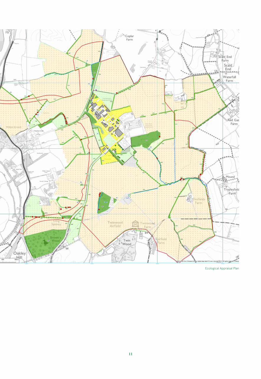
ECOLOGY
The site comprises a significant area of previously developed land, and large arable fields with little intrinsic ecological value. There is an extensive network of native species hedgerows and field margins and patches of woodland, including Yarl’s Wood CWS, Little Oakley Wood CWS and Wigney Wood.
Two roadside nature areas supporting neutral and calcareous grassland flora are present on Twinwoods Road and Thurleigh Road.
The woodlands support a ground flora including bluebell, wood anemone and dog’s mercury, and some of the hedgerows also contain remnant woodland ground flora.
There are several ponds present, although most are not in particularly good condition. There is also a network of field drains, most of which only hold water periodically, and one watercourse which flows from the approximate centre of the site to the south-west.
The hedgerows vary in condition and height from species-poor defunct hedgerows to managed hedgerows to species-rich less intensively managed hedges of between 2-4m in height.The hedgerows, field margins and woodlands have potential to support a range of species including bats, breeding birds, reptiles, amphibians and invertebrates, and Badgers are also present.
The Masterplan design process has fully taken into account existing features of ecological interest, especially woodlands, hedgerows and the watercourse, and seeks to retain habitat connectivity across and around the site and to strengthen existing woodland with new planting.
The open spaces within and around the development provide good opportunities for habitat creation to benefit a range of species and to provide alternative habitat for any species displaced by the development. Opportunities also exist to provide habitats currently absent or minimally represented in the existing landscape such as open waterbodies and meadow grassland. The detail of the proposed habitat creation and enhancements will be informed by species-specific surveys to be carried out at a later stage in the application process.
11
Ecological Appraisal Plan
WATER QUALITY AND DRAINAGE Anglian Water (AW) are responsible for water supply infrastructure in the area.
There is no single statutory undertaker for surface water drainage. Sewers and onsite systems are typically adopted by Anglian Water, whilst watercourses and SuDS features can be either adopted by the Internal Drainage Board (IDB) or Lead Local Flood Authority (LLFA) or maintained privately under a management company.
The existing site is drained through a network of small watercourses across the site. Given its geology it is anticipated that discharge of surface water runoff will not be possible through infiltration, as the site is largely situated on mudstone which has poor percolation rates. As such it is proposed that existing runoff rates and discharge points are maintained as part of the proposed development. The surface water drainage strategy will retain the existing watercourses across the site and attenuate flows from hardstanding areas using a wide range of SuDS systems, including shallow swales, attenuation basins, permeable paved areas etc.
GAS
Gas supply is National Grid (NG). National Grid have advised that the existing infrastructure will require reinforcement.
ELECTRICITY
Electricity is supplied to the site by UK Power Networks (UKPN).UKPN have estimated that a new 20km 132kV underground feed may be required to augment this at some future point. HIGHWAYS
The A6 runs to the west of the site and is the main route linking Bedford with Rushden, Wellingborough, the A45, Kettering and the A14 to the north.
In the vicinity of Milton Ernest the A6 is a single carriageway road. Subject to a 50mph speed limit on the southern approach to Milton Ernest, 30mph within Milton Ernest itself and 60mph to the north of Milton Ernest.
The A6 is largely rural in character, with the exception of the stretch that runs through Milton Ernest, which is urbanised and has lighting columns, footways and a pedestrian crossing, and to the south of Milton Ernest widens to form the Clapham Bypass.
To the north of Milton Ernest the A6 continues as a single carriageway road with the exception of a short length of dual carriageway on its approach to the A45 at Higham Ferrers. Two miles north of Milton Ernest the A6 connects with Thurleigh Road and Mill Road at Sharnbrook Turn.
Twinwoods Business Park is accessed via a T-junction on Thurleigh Road, a single carriageway road running from Milton Ernest on to Sharnbrook Turn. Thurleigh Road has a 60 mph speed limit, which becomes restricted to 30mph upon entering Milton Ernest, with traffic calming to support the 30mph speed limit.
There is also a private road access to Twinwoods Business Park from Clapham to the south but this is little used.
To the north of Twinwoods Business Park, Thurleigh Road has side road T-junctions with Milton Lane and Coplowe Lane and Riseley Road. There is also a staggered crossroads junction with The Avenue which also leads into Bletsoe and has weight restrictions. Just prior to Sharnbrook Turn there is a minor crossroads at Bourne End Lane.
Old Milton Road is a minor rural lane leading from Milton Lane to serve farms on the north side of the Twinwoods site.
Mill Road (which becomes Thurleigh Road ) traverses roughly north to south to the east of Twinwoods leading to a staggered cross-roads with the B660 at Ravensden. The B660 runs in an approximate northeast to southwest direction leading to north Bedford.
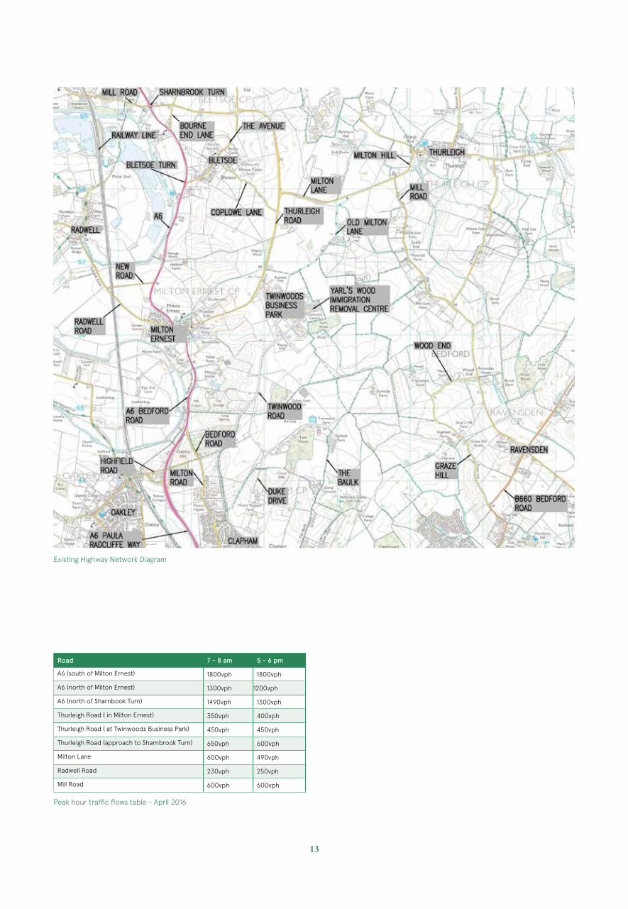
Typical peak hour traffic flows on the local road network are shown in the table below. Traffic counts have shown that the local network peak hours are 7-8am and 5-6pm
These figures indicate that the single carriageway stretch of the A6 south of Milton Ernest is operating at design capacity but is still within practical capacity for a road of this type. North of Milton Ernest, the A6 has spare link capacity and in relation to the Sharnbrook Turn roundabout this is approaching capacity during the morning peak period from the northern approach only.
The northern section of the Bedford Western by-pass, the Great Ouse Way, has recently been completed and offers an attractive route for traffic to and from the west side of Bedford and for traffic accessing the A421. This road has been designed to relief to congestion along the urban section of the A6.
The rest of the local road network has substantial spare link capacity.
The extent of the land owned by the landowners/promoters provides a range of opportunities to improve the capacity and operation of the local road network, primarily through the provision of a new road which would not only serve as the access to Twinwoods, but also provide a bypass for Milton Ernest and Bletsoe villages.
The new alignment of the A6 would provide adequate capacity for A6 north-south though traffic as well as the Twinwoods traffic. This corridor improvement would be supplemented by the new road link to the A6 to the north of Milton Ernest, which would also remove east-west traffic from the village. Thus there is a significant opportunity to remove the large majority of traffic from Milton Ernest without detriment to other villages such as Bletsoe and Thurleigh. There is also significant scope for improvements at other local pinch points on the highway network through junction improvements notably at Sharnbrook Turn and in Ravensden village.
13
Road 7 - 8 am 5 - 6 pm
A6 (south of Milton Ernest) 1800vph 1800vph
A6 (north of Milton Ernest) 1300vph 1200vph
A6 (north of Sharnbook Turn) 1490vph 1300vph
Thurleigh Road ( in Milton Ernest) 350vph 400vph
Thurleigh Road ( at Twinwoods Business Park) 450vph 450vph
Thurleigh Road (approach to Sharnbrook Turn) 650vph 600vph
Milton Lane 600vph 490vph
Radwell Road 230vph 250vph
Mill Road 600vph 600vph
Existing Highway Network Diagram
Peak hour traffic flows table - April 2016

Artist’s Impression of Local Neighborhood
15
The VisionWHY TWINWOODS?
Locating development at Twinwoods provides a number of strategic benefits, from accommodating development pressures to providing additional services to the rural area and local environmental improvements.
The site is a sustainable choice for development as it is centrally located and provides a real opportunity to develop a part brownfield site with good public transport and walking and cycling links to a network of settlements, including Bedford and the larger villages of Sharnbrook and Clapham. Twinwoods will provide real benefits to the surrounding communities through the provision of additional facilities absent in surrounding villages.
1. A deliverable site. The land required to deliver the proposed new settlement and proposed bypass is available and in the control of two parties only. Bedfordia and Marcol have a proven track record in delivering quality sustainable mixed use developments.
2. A part previously developed brownfield site. Provides beneficial reuse of a challenging, visually prominent, previously developed site, in full accordance with Planning Policy as expressed in the National Planning Policy Framework. A significant proportion, 65ha of the site is classified as previously developed land.
3. An Unconstrained Site. The majority of the site is flat to gently undulating arable land with only small blocks of deciduous woodland, hedgerows and occasional hedgerow trees with little ecological importance.
The following diagrams explore some of the overarching benefits of locating a new community at Twinwoods.
4. Size Matters: Facilities. Twinwoods provides an opportunity to create a self-sustaining settlement. A development of 6,000 homes, and up to an additional 2,000 jobs, triggers a full range of facilities to meet the needs of its residents in surrounding areas. Among other facilities, the new settlement would include a secondary school, four new primary schools, food and other retail, comprehensive health provision/ medical centre, bars, cafés and restaurants, community space, parkland, and sports facilities.
5. Providing facilities for existing rural communities. Opportunity to create a Rural Service Centre that can support existing local communities, where access to facilities may be weak. Including Bletsoe, Milton Ernest, Radwell, Riseley, Thurleigh, Oakley and Clapham.
6. Opportunity to create a comprehensively planned settlement. With all the supporting uses planned in from the outset.
7. Building upon existing business. Twinwoods provides the opportunity to build upon the existing business community to create circa 2,000 jobs. The existing business park is based on a former MOD site that is currently part vacant and outdated for modern business needs. Comprehensive masterplanning provides the opportunity to create new purpose built employment space that is fit for purpose.
8. Twinwoods is located centrally in Bedford Borough and can readily meet emerging housing needs.
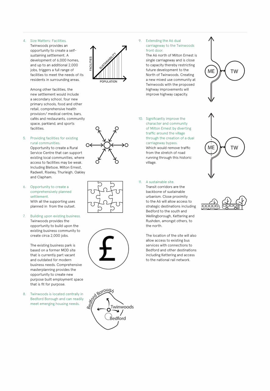
9. Extending the A6 dual carriageway to the Twinwoods front door. The A6 north of Milton Ernest is single carriageway and is close to capacity thereby restricting future development to the North of Twinwoods. Creating a new mixed use community at Twinwoods with the proposed highway improvements will improve highway capacity.
10. Significantly improve the character and community of Milton Ernest by diverting traffic around the village through the creation of a dual carriageway bypass. Which would remove traffic from the stretch of road running through this historic village.
11. A sustainable site. Transit corridors are the backbone of sustainable urbanism. Close proximity to the A6 will allow access to strategic destinations including Bedford to the south and Wellingborough, Kettering and Rushden, amongst others, to the north. The location of the site will also allow access to existing bus services with connections to Bedford and other destinations including Kettering and access to the national rail network.

17
12. A sustainable site: walking and cycling ready. Walking and cycling provides a range of benefits from reducing congestion to improving general health and saving money. The existing high quality and comprehensive walking and cycling network already connects Twinwoods site with Bedford, surrounding villages and the wider countryside. The existing network will be enhanced and improved to include a hard surfaced cycle and pedestrian route to Bedford. Twinwoods is a walking and cycling network ready site allowing the creation of a development that reduces reliance on the private car.
13. A sustainable site: reducing the need to travel by car. By creating a mixed use settlement that includes employment space, the need for external trips onto the strategic road network is reduced.
14. Repairing the skyline. Existing buildings within Twinwoods Business Park dominate the skyline. Comprehensive planning of the site provides the opportunity to repair the skyline through more sensitive design and a strategic planting strategy.
15. Best of Both. The site is close to Bedford, thereby allowing easy access to a main urban area and its amenities, but is situated within rural surrounds. It therefore allows residents the benefits of town and country.
A Locally Led VisionA LOCALLY LED VISION
The vision for Twinwoods is to create a self-sustaining new settlement comprising up to 6000 homes on the under-used previously developed land at Twinwoods and surrounding land which could meet a large share of the Borough’s long term housing needs and provide a range of community benefits. Above all, it is a vision that must be locally led.
INVOLVING THE COMMUNITY
The owners/promoters are committed to harnessing the energy and resourcefulness of local stakeholders and incorporating their ideas and ambitions. We strongly believe that by fully involving the local community at every stage we can deliver an exemplar new settlement at Twinwoods. We are committed to meaningful consultation with the local community and will continue to demonstrate a responsible and transparent approach in all our community engagement activity. Tried and tested processes will allow for the identification of issues and problems at an early stage, as well as providing the mechanisms to respond positively to local initiatives.
We will incorporate a variety of innovative techniques to ensure we provide the maximum opportunity for all stakeholders to help shape the proposals. We will pay particular attention to making sure our engagement strategy fully involves young people, the elderly and hard to reach groups.
A new settlement at Twinwoods should, if consulted upon, and designed properly, help meet the needs of existing and future residents.
Engagement with elected members, parish councils, our tenants and immediate neighbours has provided the cornerstone of our approach to date. We’ve heard directly from stakeholders about their concerns and particularly:
• Over-development in villages such as Clapham • Traffic problems• Better links for pedestrians and cyclists • Potential coalescence in Milton Ernest• Future affordability of homes for their children• The type of housing• Pressure on GP surgeries, closure of hospital services• School capacity• Landscape• Recreational space• Flooding and drainage• Retail offer• Employment opportunities and what happens to existing
businesses
The latest indicative masterplan has not only been informed by technical assessments undertaken by the professional team but has also evolved following early discussions with local stakeholders. Investing in new infrastructure in particular is one way that can help address exiting issues for the local community.
• A new By-pass for Milton Ernest and Bletsoe• Safeguarding land for agricultural uses and parkland to prevent
coalescence • The retention of habitat and an extensive planting of new
habitat• A neighbourhood centre, incorporating new shops and health
facilities• A range of housing including starter homes and custom/self-
build plots• Potential for early delivery of 250 homes• 4 new primary schools and a new secondary school• Modern employment space for SMEs • Enhancement of pedestrian and cycle links
These are just some examples of how the indicative masterplan has evolved through early engagement with stakeholders.
At the next stages, we propose to consult on and produce a site specific involvement strategy in collaboration with local parish councils which will include design workshops that will allow local people to genuinely shape the proposed development from the concept stage through to detailed design.
Further detailed work and consultation will be undertaken to develop the mix of uses for the site that can deliver as many of the community’s needs as possible. As part of our technical work, we will also aim to meet with as many of the relevant organisations as we can and will continue to do this as we work on the details of the development proposals.
LOCAL DECISION MAKING
Creating a successful new settlement must extend public engagement beyond consultation and comment into areas of decision making on design and management. At an early stage consideration will be given to the future ownership and management models for Twinwoods.
In creating, designing and implementing a new settlement, we will strive to go beyond creating a place where people will live, work, enjoy and interact. We want to encourage the community to take a degree of control and decisions which have a significant effect on the look of the place and the way it functions. In this way a dynamic self-supporting community will be created.
19
Development Principles
The following sequence of diagrams show the key principles for the development of Twinwoods. The principles have been developed in response to baseline analysis and established good practice.
For further, detailed information, please see the appendix of this report.
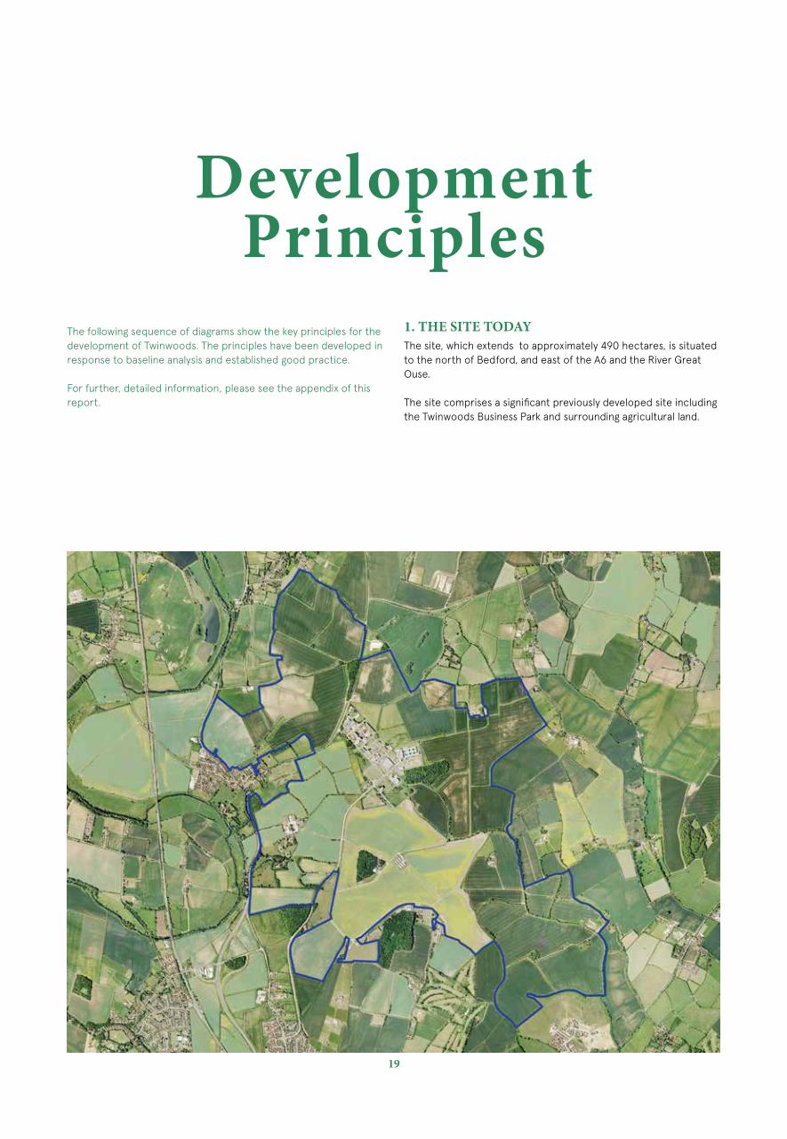
1. THE SITE TODAY The site, which extends to approximately 490 hectares, is situated to the north of Bedford, and east of the A6 and the River Great Ouse.
The site comprises a significant previously developed site including the Twinwoods Business Park and surrounding agricultural land.

2. ESTABLISH A CORE DEVELOPMENT AREA
Locate the developable core of Twinwoods in an area of low to medium landscape sensitivity and also serves to mitigate the potential for coalescence with the surrounding settlements, principally Bletsoe, Milton Ernest, Clapham and Bedford.
The provision of a settlement buffer creates the opportunity for a separate, self-sufficient, settlement at Twinwoods with strong connections to existing surrounding communities.
3. COMPLETE VISUAL SECLUSION TO MITIGATE EXTERNAL VIEWS
The creation of structural perimeter tree planting serves to mitigate strategic and local views from surrounding settlements and Public Rights of Way.
The visual seclusion the perimeter tree belt offers helps to create a separate yet connected settlement with its own distinct identity.

21
4. DESIGNATE SAFE GUARDED OPEN SPACE BUFFERS AND RETAINED FARMLAND TO LOCAL SETTLEMENT AND FARMS TO GUARD AGAINST FUTURE COALESCENCE
5. MAINTAIN AND ENHANCE EXISTING NATURAL FEATURES
Retain and enhance natural features including hedgerows, trees and water bodies for the benefit of flora and fauna. The retention of trees and hedgerows provides mature planting with aesthetic value that helps to mitigate the visual impact of future development.
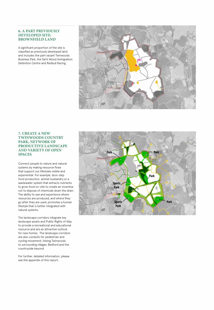
6. A PART PREVIOUSLY DEVELOPED SITE: BROWNFIELD LAND
A significant proportion of the site is classified as previously developed land and includes the part vacant Twinwoods Business Park, the Yarl’s Wood Immigration Detention Centre and Redbull Racing.
7. CREATE A NEW TWINWOODS COUNTRY PARK, NETWORK OF PRODUCTIVE LANDSCAPE AND VARIETY OF OPEN SPACES
Connect people to nature and natural systems by making resource flows that support our lifestyles visible and experiential. For example, door step food production, animal husbandry or a wastewater system that extracts nutrients to grow food on-site to create an incentive not to dispose of chemicals down the drain. The ability to see and experience where resources are produced, and where they go after they are used, promotes a human lifestyle that is better integrated with natural systems.
The landscape corridors integrate key landscape assets and Public Rights of Way to provide a recreational and educational resource and are an attractive outlook for new homes. The landscape corridors are also conduits for pedestrian and cycling movement, linking Twinwoods to surrounding villages, Bedford and the countryside beyond.
For further, detailed information, please see the appendix of this report.

23
8. REFLECT THE LOCAL SETTLEMENT PATTERN OF VILLAGES, HAMLETS AND ENDS
Twinwoods is comprised of a hierarchy of settlement types drawn upon from the local settlement pattern character of villages, hamlets and ‘village ends’. The reflection of this character will serve to create a new community that is distinct to the local area and offers a broad range of variety and interest.
9. CREATE A BROAD RANGE OF MIXED-USES
Create a sustainable hierarchy of walkable village and neighbourhood centres.
Twinwoods will be a self-sustaining community of up to approximately 15,000 people. A population of this order is enough to trigger a full range of facilities including health, shopping, employment, leisure and education on-site, to support daily life and provide a well-rounded settlement.
Non-residential uses are likely be focused at the mixed-use centre ( ) where facilities are most accessible to all by foot. The village centre is a community and employment cluster that includes a secondary school ( ) and primary school ( ) and nursery/ early years facilities to encourage vitality throughout all times of the day and which enhances long term economic viability.
Smaller neighbourhood centres/greens ( ) contain primary schools and a small amount of employment, retail and community uses.

11. CREATE A DUAL CARRIAGEWAY BYPASS OF THE A6 TO SERVE THE TWINWOODSAND REMOVE TRAFFIC FROM MILTON ERNEST
The extension of the dual carriageway section of the A6 northwards as far as Thurleigh Road would provide the road capacity needed to link Twinwoodswith the employment, retail, education, leisure and other facilities within and beyond the Bedford area, and a bypass to Milton Ernest and Bletsoe and will facilitate easier movement for all traffic whilst further removing through traffic from Milton Ernest.
In addition to the provision of new roads, traffic calming and deterrence measures on the approaches to Milton Ernest and other villages will be the catalyst for a much improved and safer street environment.
For further, detailed information, please see the appendix of this report.
10. CREATE COMMUNITY FACILITIES INCLUDING
• High Street Retail• Offices / Workshops / Enterprise
Centre• 1 Academy - Secondary School• 4 Primary Schools• Nurseries / Crèche• Medical Centre• Dentist• Food Store• Post office, Vets, Public House/
Restaurant, Place of Worship, Country Hotel, Elderly accommodation, Gym & Fitness Provision
• Country Park• Country Park Visitor Centre/Pub• Country Park Parking• Community Centre
Wider network connecting with Sharnbrook Turn Roundabout
25
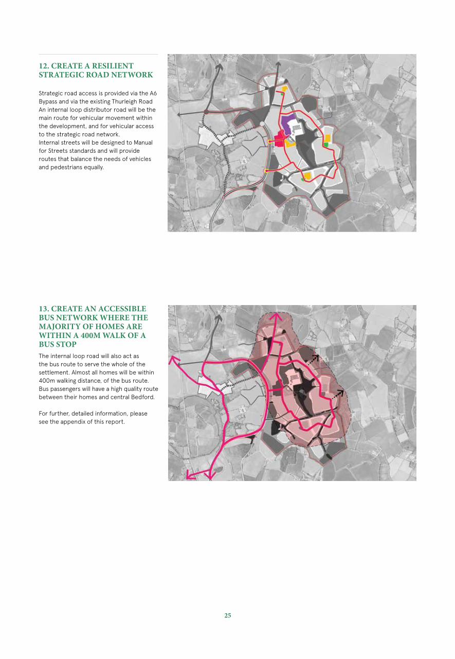
13. CREATE AN ACCESSIBLE BUS NETWORK WHERE THE MAJORITY OF HOMES ARE WITHIN A 400M WALK OF A BUS STOPThe internal loop road will also act as the bus route to serve the whole of the settlement. Almost all homes will be within 400m walking distance, of the bus route. Bus passengers will have a high quality route between their homes and central Bedford.
For further, detailed information, please see the appendix of this report.
12. CREATE A RESILIENT STRATEGIC ROAD NETWORK
Strategic road access is provided via the A6 Bypass and via the existing Thurleigh RoadAn internal loop distributor road will be the main route for vehicular movement within the development, and for vehicular access to the strategic road network.Internal streets will be designed to Manual for Streets standards and will provide routes that balance the needs of vehicles and pedestrians equally.
Wider network connecting with Sharnbrook Turn Roundabout

14. RETAIN, ENHANCE & EXPAND PUBLIC RIGHTS OF WAYTwinwoods will retain, incorporate and enhance the existing network of Public Rights of Way which pass through and within the Twinwoods area. This will improve both accessibility within the settlement and with neighbouring communities around Twinwoods. These routes will be enhanced in some places and complemented by the provision of new routes within the fabric of the residential areas, most notably with the provision of a 10km looped leisure route.
For further, detailed information, please see the appendix of this report.
15. RETAIN, ENHANCE & EXPAND CYCLE WAYS
New routes will form cycle linkages through Twinwoods and beyond to link up with other communities, and to other existing cycle routes including the internal 10km leisure route and a hard surfaced cycle route which will join Twinwoods to Bedford.
The cycle infrastructure will also connect up with three existing cycle routes on the north side of Bedford.
For further, detailed information, please see the appendix of this report.
16. CREATE A 10KM LEISURE ROUTE
A circular leisure route will be a 10km pedestrian and cycle friendly leisure route around the site’s periphery allowing an outlook to the surrounding countryside that connects landscape corridors, existing and proposed pedestrian footpaths, cycle paths and local parks.
For further, detailed information, please see the appendix of this report.

27
Twinwoods will offer town and country living as a new residential led, mixed-use community.
The proximity to Bedford provides good access to local employment, retail and entertainment. This is balanced by easy access to the tranquillity of the countryside, offering a wealth of recreational and leisure opportunities.
Using a substantial previously developed site, Twinwoods could deliver up to 6,000 new homes and new employment opportunities, retail, provisional schools, medical facilities and community infrastructure, as a best practice benchmark for the planning and design of a new community.
Twinwoods would provide a full range of necessary facilities and infrastructure necessary to support a new community.
TWINWOODS DESIGN PRINCIPLES
Twinwoods is based on best practice design and planning principles. Emerging Guiding principles for the creation of a new settlement:
• Strong vision, leadership and community engagement
• Mixed-tenure homes and housing types that give genuine housing choice.
• Access to employment opportunities on site within easy commuting distance
• Well designed housing areas integrated within an extensive landscape setting
• Enhancement of the natural environment, providing a comprehensive green infrastructure network and net biodiversity gains
• Strong cultural, recreational and shopping facilities in walkable, vibrant and sociable neighbourhoods
• Integrated and accessible transport systems, with walking, cycling and public transport designed to be the most attractive forms of local transport
The Framework Plan

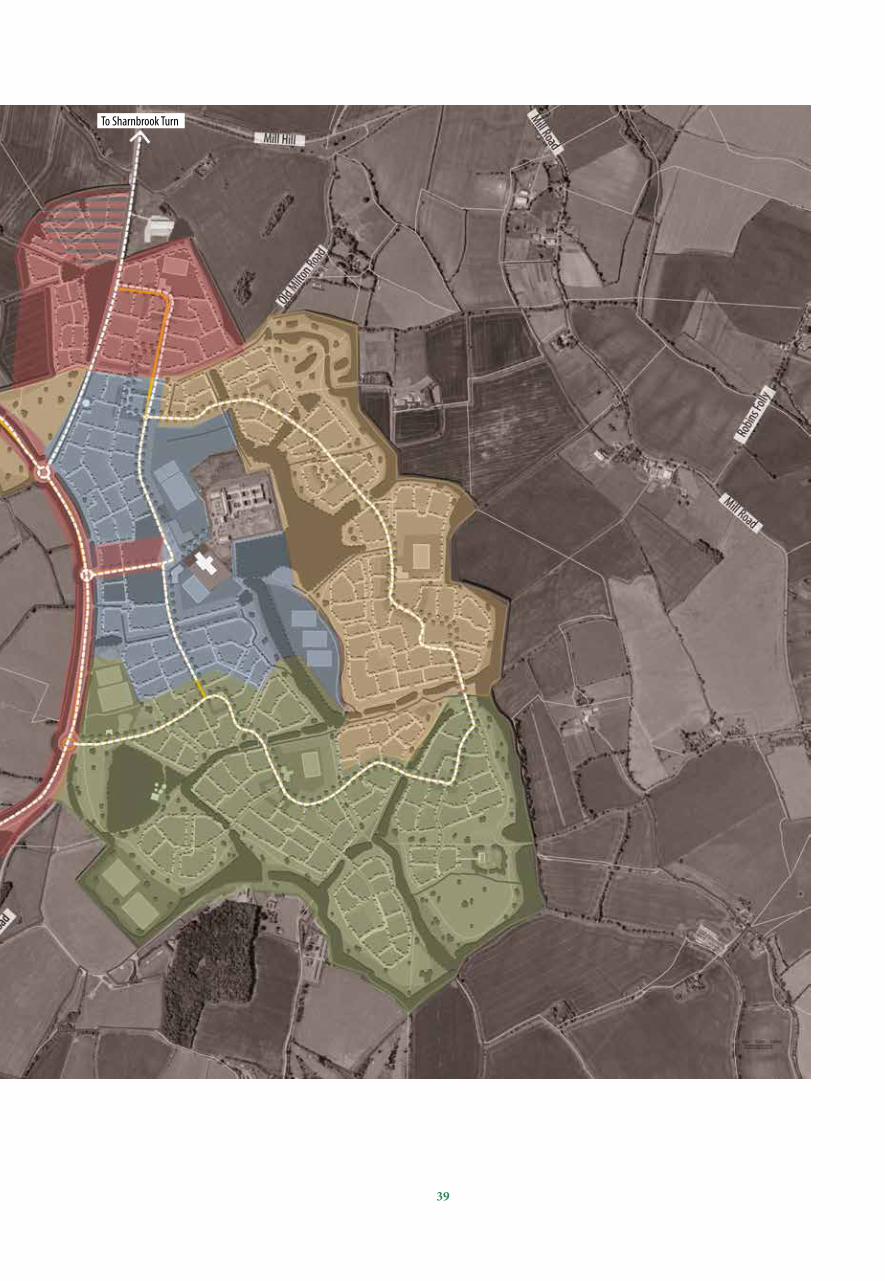
THE FRAMEWORK PLAN
Site boundary
Other land in clients ownership
Residential led mixed-use
Mixed-use & employment
1. Gateway square/mixed-use centre with secondary school &
primary school
2. Country park
3. Neighbourhood green
4. Local centre & primary school
5. Hard paved cycle route to North Bedford
6. 10 km circular leisure route
7. Footpath connections
8. SuDS network
9. New access junction to proposed Milton Ernest Bypass
10. Primary loop road with segregated cycle path
11. Woodland buffer
12. Green links / ecological corridor
13. Shared surfaces within the residential blocks
14. Country spa retreat
15. Existing woodland
16. Proposed woodland
17. Formal playing pitches
18. Twinwoods Museum
19. Red Bull testing facility
20. Yarl’s Wood Immigration Centre
THE NUMBERS:
• Up to 6,000 homes at an average of 32-36dph• Creation of up to circa 2,000 jobs
MIXED USES COULD INCLUDE:
• High Street Retail• Offices / Workshops / Enterprise Centre• 1 Academy - Secondary School• 4 Primary Schools• Nursery School / Crèche• Medical Centre• Dentist• Food Store• Post office, Vets, Public House/Restaurant, Place of
Worship, Country Hotel, Elderly Accommodation, Gym & Fitness provision
• Country Park• Country Park Visitor Centre/Pub• Country Park Parking• Community Centre
Development Framework. NTS.
09
09
16

29
THE GUIDING VISION FOR THE FRAMEWORK PLAN:
The Framework Plan provides an illustration of the design concept for Twinwoods which incorporates the best of both worlds, town and country living as a new residential led, mixed-use community of up to 6,000 homes and 2,000 jobs.
The proximity to Bedford Town Centre and employment areas provides easy access to local employment, retail and entertainment. This is balanced by unsurpassed access to the tranquillity of the countryside offering a wealth of recreational and leisure opportunities.
01
02
02
02
03
03
03
03
03
03
0403
04
04
07
07
07
07
05
06
06
06
06
06
08
08
0808
08
10
10
10
10
10
11
11
11
11
11
11
12
12
12
12
08
12
12
13
13
13
13
15
15
15
16
16
14
16
20
19
1817
17
17
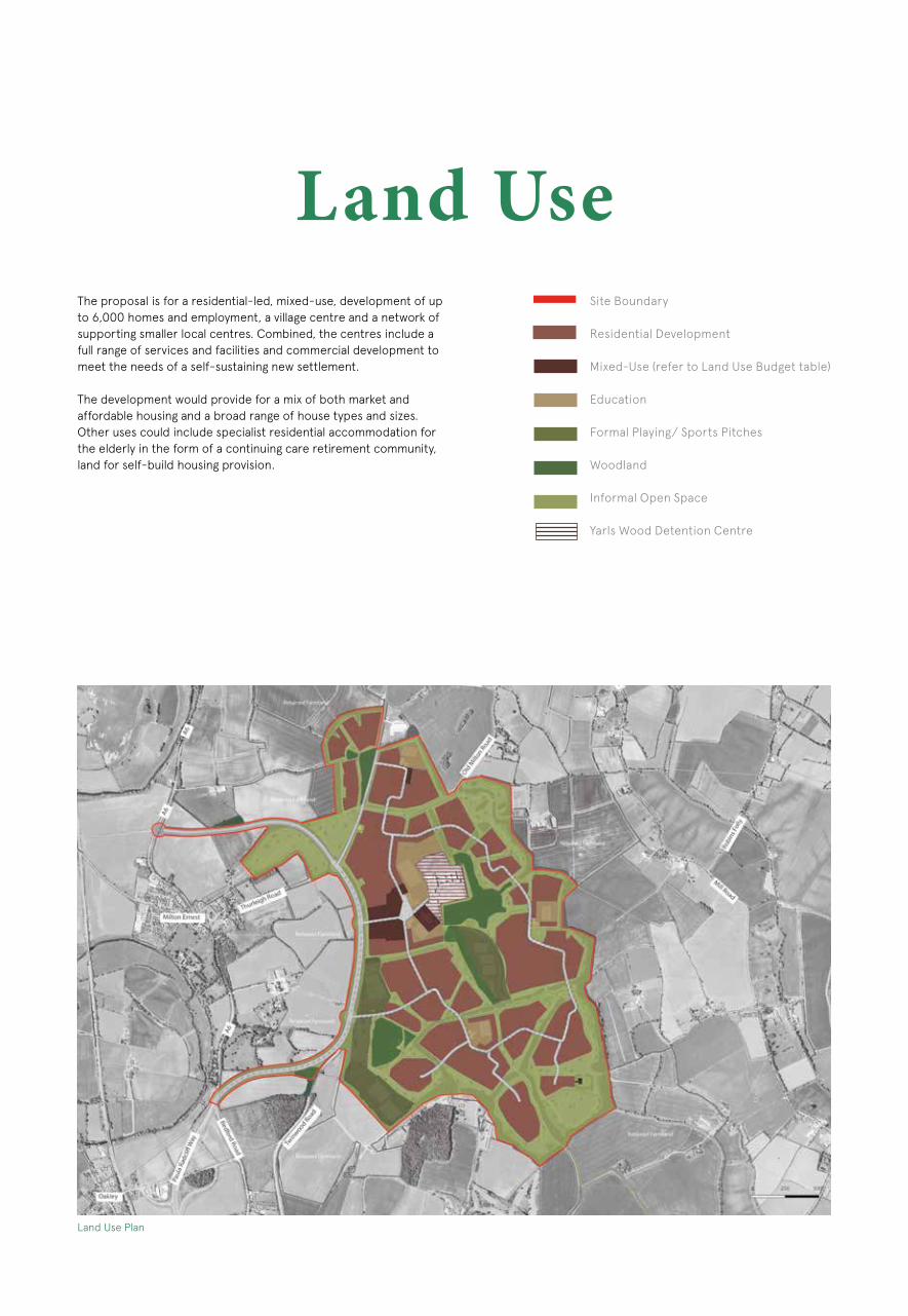
Land Use The proposal is for a residential-led, mixed-use, development of up to 6,000 homes and employment, a village centre and a network of supporting smaller local centres. Combined, the centres include a full range of services and facilities and commercial development to meet the needs of a self-sustaining new settlement.
The development would provide for a mix of both market and affordable housing and a broad range of house types and sizes. Other uses could include specialist residential accommodation for the elderly in the form of a continuing care retirement community, land for self-build housing provision.
Site Boundary
Residential Development
Mixed-Use (refer to Land Use Budget table)
Education
Formal Playing/ Sports Pitches
Woodland
Informal Open Space
Yarls Wood Detention Centre
Land Use Plan

31
SUPPORTING, NON-RESIDENTIAL, INCLUDE:• Up to four 3FE Primary Schools • A Secondary School• High Street Retail• Nursery School / Crèche• Offices / Workshops / Enterprise Centre• Medical Centre / Dentist• Food Store• Post Office, Vets, Public House/Restaurant, Place of Worship,
Country Hotel, Elderly Accommodation, Gym & Fitness provision
• Country Park• Country Park Visitor Centre/Pub• Country Park Parking• Community Centre • Formal and Informal Open Space
Land Use (Provisional) Area (Ha) Number
Residential including mix of types and tenures (market, self-build, affordable, starter and housing for the elderly)
165 Up to 6,000 homes
Mixed Uses including retail, b1, community, employment 21
(Approx. 2,000 jobs to be created)
Education - Secondary School x 1 10
Education - Primary Schools x4 11.2 (2.8 Ha each)
Main road & cycle infrastructure 12
Informal Open Space including SUDS, urban agriculture, play & buffers
229
Formal Playing Pitches 16
Woodland 25
TOTAL SITE AREA Circa 490

Indicative PhasingAPPROACH TO INDICATIVE PHASING The following diagrams illustrate a delivery sequence for 6,000 homes, employment space and ancillary and supporting facilities at Twinwoods, based upon the strategic masterplan.
Considering the size of the development area, a number of phases will be required to complete the development. The overarching phasing strategy is to allow development areas to come forward in a logical sequence in order to provide a natural growth pattern where one neighbourhood naturally extends into the next.
The principle for phasing should be one of completing streets and neighbourhoods so that new residents will have the benefit of moving into a completed part of the development and do not feel they live within a construction site.
The various areas of the development will be completed with access solutions, surrounding landscape, technical infrastructure, flood alleviation and open space requirements to ensure minimal disruption to the previously completed neighbourhoods.
The indicative development programme illustrates six years in each phase with four phases. The approximate build out time is twenty four years.
The phasing takes into account high level contextual, access, social, technical and economic factors. More detailed phasing plans will come forward with subsequent stages.
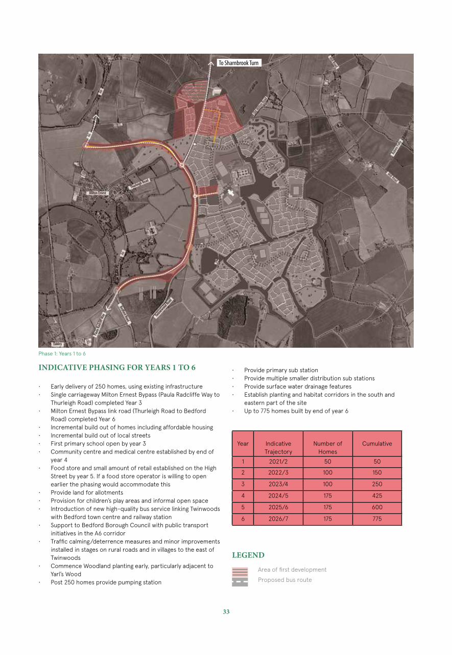
33
INDICATIVE PHASING FOR YEARS 1 TO 6
• Early delivery of 250 homes, using existing infrastructure• Single carriageway Milton Ernest Bypass (Paula Radcliffe Way to
Thurleigh Road) completed Year 3• Milton Ernest Bypass link road (Thurleigh Road to Bedford
Road) completed Year 6• Incremental build out of homes including affordable housing• Incremental build out of local streets• First primary school open by year 3• Community centre and medical centre established by end of
year 4• Food store and small amount of retail established on the High
Street by year 5. If a food store operator is willing to open earlier the phasing would accommodate this
• Provide land for allotments• Provision for children’s play areas and informal open space• Introduction of new high-quality bus service linking Twinwoods
with Bedford town centre and railway station• Support to Bedford Borough Council with public transport
initiatives in the A6 corridor• Traffic calming/deterrence measures and minor improvements
installed in stages on rural roads and in villages to the east of Twinwoods
• Commence Woodland planting early, particularly adjacent to Yarl’s Wood
• Post 250 homes provide pumping station
Area of first development
Proposed bus route
LEGEND
Phase 1: Years 1 to 6
• Provide primary sub station• Provide multiple smaller distribution sub stations• Provide surface water drainage features• Establish planting and habitat corridors in the south and
eastern part of the site• Up to 775 homes built by end of year 6
Year Indicative Trajectory
Number of Homes
Cumulative
1 2021/2 50 50
2 2022/3 100 150
3 2023/4 100 250
4 2024/5 175 425
5 2025/6 175 600
6 2026/7 175 775
To Sharnbrook Turn
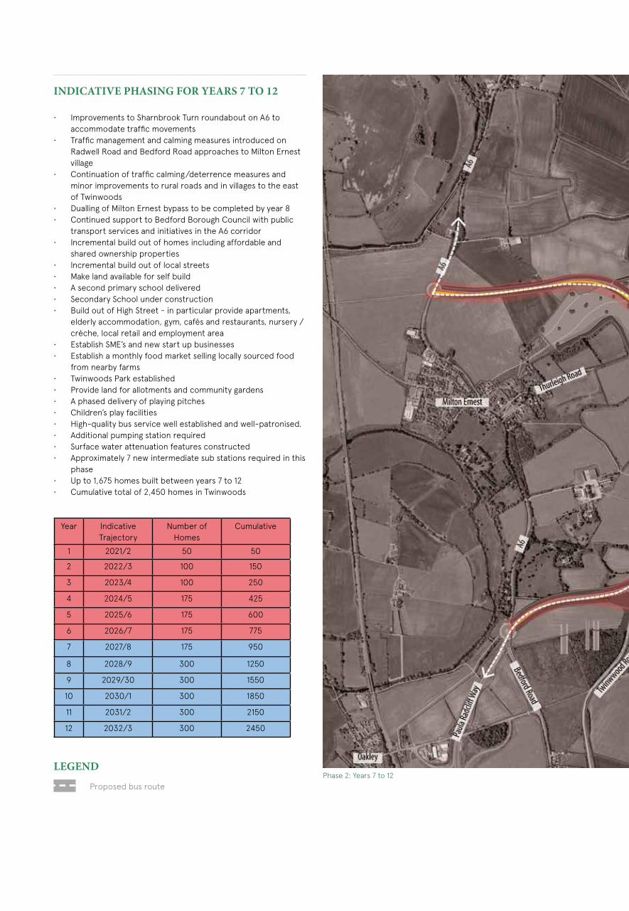
INDICATIVE PHASING FOR YEARS 7 TO 12
• Improvements to Sharnbrook Turn roundabout on A6 to accommodate traffic movements
• Traffic management and calming measures introduced on Radwell Road and Bedford Road approaches to Milton Ernest village
• Continuation of traffic calming/deterrence measures and minor improvements to rural roads and in villages to the east of Twinwoods
• Dualling of Milton Ernest bypass to be completed by year 8• Continued support to Bedford Borough Council with public
transport services and initiatives in the A6 corridor• Incremental build out of homes including affordable and
shared ownership properties• Incremental build out of local streets• Make land available for self build• A second primary school delivered• Secondary School under construction • Build out of High Street - in particular provide apartments,
elderly accommodation, gym, cafés and restaurants, nursery / crèche, local retail and employment area
• Establish SME’s and new start up businesses• Establish a monthly food market selling locally sourced food
from nearby farms• Twinwoods Park established• Provide land for allotments and community gardens• A phased delivery of playing pitches• Children’s play facilities• High-quality bus service well established and well-patronised. • Additional pumping station required• Surface water attenuation features constructed• Approximately 7 new intermediate sub stations required in this
phase• Up to 1,675 homes built between years 7 to 12• Cumulative total of 2,450 homes in Twinwoods
Proposed bus route
LEGENDPhase 2: Years 7 to 12
Year Indicative Trajectory
Number of Homes
Cumulative
1 2021/2 50 50
2 2022/3 100 150
3 2023/4 100 250
4 2024/5 175 425
5 2025/6 175 600
6 2026/7 175 775
7 2027/8 175 950
8 2028/9 300 1250
9 2029/30 300 1550
10 2030/1 300 1850
11 2031/2 300 2150
12 2032/3 300 2450
35
To Sharnbrook Turn

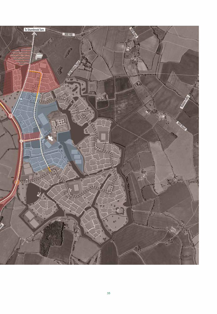
INDICATIVE PHASING FOR YEARS 13 TO 18
• Incremental build out of homes including affordable and shared ownership properties
• Incremental build out of local streets• High Street retail, employment and mixed use residential
completed• A third Primary School delivered• Local retail provided adjacent to Primary School in local centre• Country Park Spa Hotel• Further phases of the Twinwoods Park delivered• Provide land for allotments and community gardens• A phased delivery of playing pitches• Provision of children’s play facilities• Additional pumping station• Surface water attenuation features• 7 intermediate sub stations required• Up to 1975 homes built between years 13 to18• Cumulative total of 4,425 homes in Twinwoods
Proposed bus route
LEGEND
Phase 3: Years 13 to 18
Year Indicative Trajectory
Number of Homes
Cumulative
1 2021/2 50 50
2 2022/3 100 150
3 2023/4 100 250
4 2024/5 175 425
5 2025/6 175 600
6 2026/7 175 775
7 2027/8 175 950
8 2028/9 300 1250
9 2029/30 300 1550
10 2030/1 300 1850
11 2031/2 300 2150
12 2032/3 300 2450
13 2033/4 300 2750
14 2034/5 300 3050
15 2035/6 325 3375
16 2036/7 350 3725
17 2037/8 350 4075
18 2038/9 350 4425

37
To Sharnbrook Turn
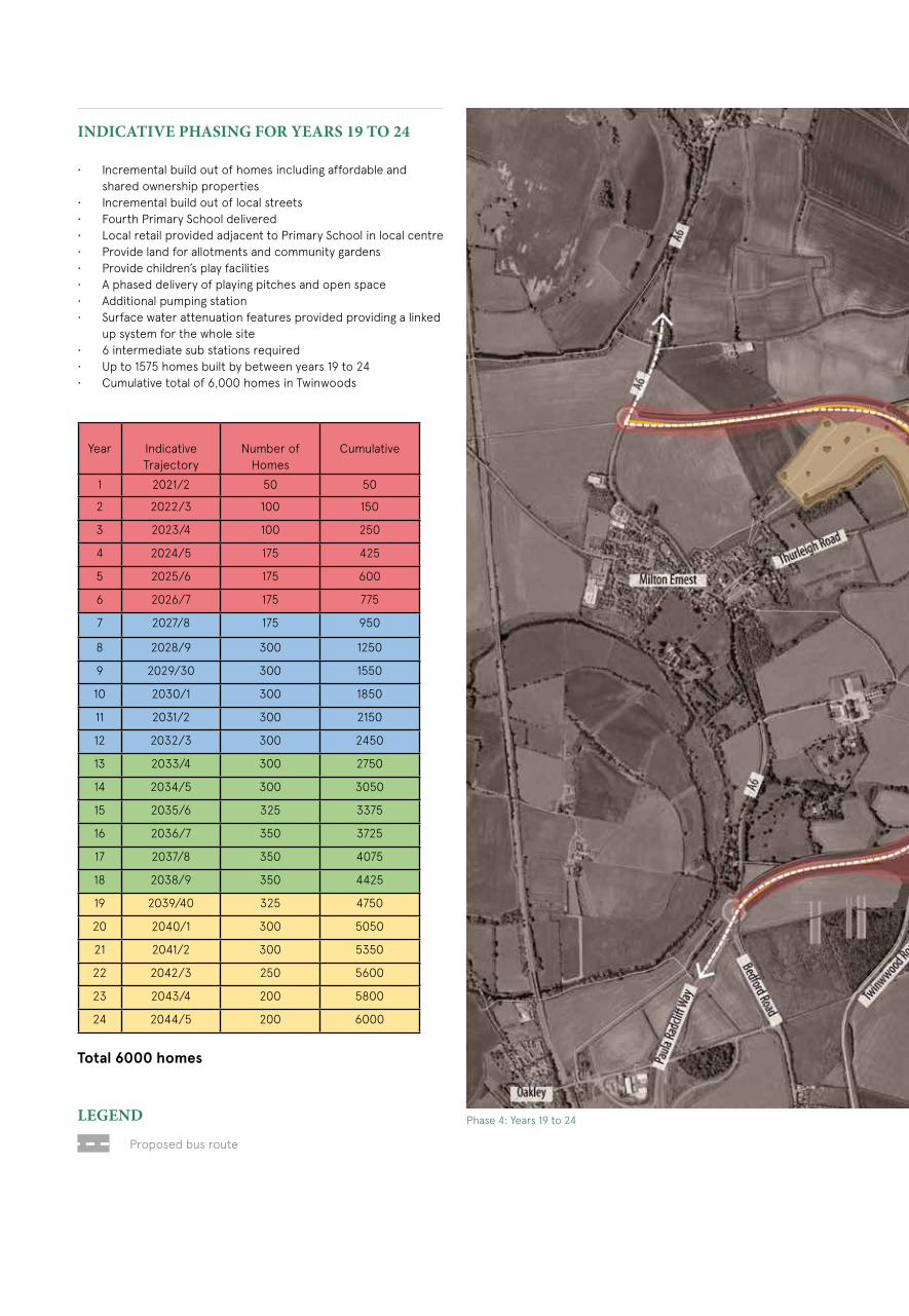
INDICATIVE PHASING FOR YEARS 19 TO 24
• Incremental build out of homes including affordable and shared ownership properties
• Incremental build out of local streets• Fourth Primary School delivered• Local retail provided adjacent to Primary School in local centre• Provide land for allotments and community gardens• Provide children’s play facilities• A phased delivery of playing pitches and open space• Additional pumping station• Surface water attenuation features provided providing a linked
up system for the whole site• 6 intermediate sub stations required• Up to 1575 homes built by between years 19 to 24• Cumulative total of 6,000 homes in Twinwoods
Proposed bus route
LEGEND Phase 4: Years 19 to 24
Year Indicative Trajectory
Number of Homes
Cumulative
1 2021/2 50 50
2 2022/3 100 150
3 2023/4 100 250
4 2024/5 175 425
5 2025/6 175 600
6 2026/7 175 775
7 2027/8 175 950
8 2028/9 300 1250
9 2029/30 300 1550
10 2030/1 300 1850
11 2031/2 300 2150
12 2032/3 300 2450
13 2033/4 300 2750
14 2034/5 300 3050
15 2035/6 325 3375
16 2036/7 350 3725
17 2037/8 350 4075
18 2038/9 350 4425
19 2039/40 325 4750
20 2040/1 300 5050
21 2041/2 300 5350
22 2042/3 250 5600
23 2043/4 200 5800
24 2044/5 200 6000
Total 6000 homes
39
To Sharnbrook Turn

Twinwoods Business Park

41
Appendix

Landscape Infrastructure
SITE SPECIFIC ABILITY TO ACCOMMODATE DEVELOPMENT
Informed by the SLVA, a draft framework plan was prepared and tested again in terms of visibility. Two variations in building heights were tested; 16.5m and 11.5m. The revised ZTV demonstrated that the extent of the site’s visibility compared to the earlier model had reduced, particularly to the south west, south and east.
Based on the findings of the SLVA and the revised ZTV it is considered that the development:
1. would respect the visual sensitivity of the western slopes, and2. could be accommodated in areas of land assessed as of high
to medium, medium and low visual sensitivity.
The development would be set within a strong landscape and biodiversity framework which, through sensitive design, is sympathetic to landscape character and townscape morphology, and integrates into the surrounding landscape. The following recommendations should be taken into account in any development on site:
• Incorporate development within a robust landscape framework, which retains and extends existing woodland and hedgerows into the centre of the development.
• Incorporate buffer zones that safeguard biodiversity around existing vegetation.
• Ensure substantial areas of open space are created within the site, supporting not just leisure opportunities, but also landscape amenity and biodiversity.
• Create a gradient of the built form from the edge of the development towards the core, with looser densities and lower building heights, to reflect the transition between the open countryside and the built environment of the new community.
• Consider a slight variation in building heights in the fringes of the development to echo other structures in the landscape and aid legibility of neighbourhood elements within the new community.
• Maintain strong vistas across the site to surrounding landmark features.
• Avoid visual scarring of the ridgeline, the loss/severance of vegetation and impacts on biodiversity and heritage assets that could be caused by the creation of the proposed A6 link road.
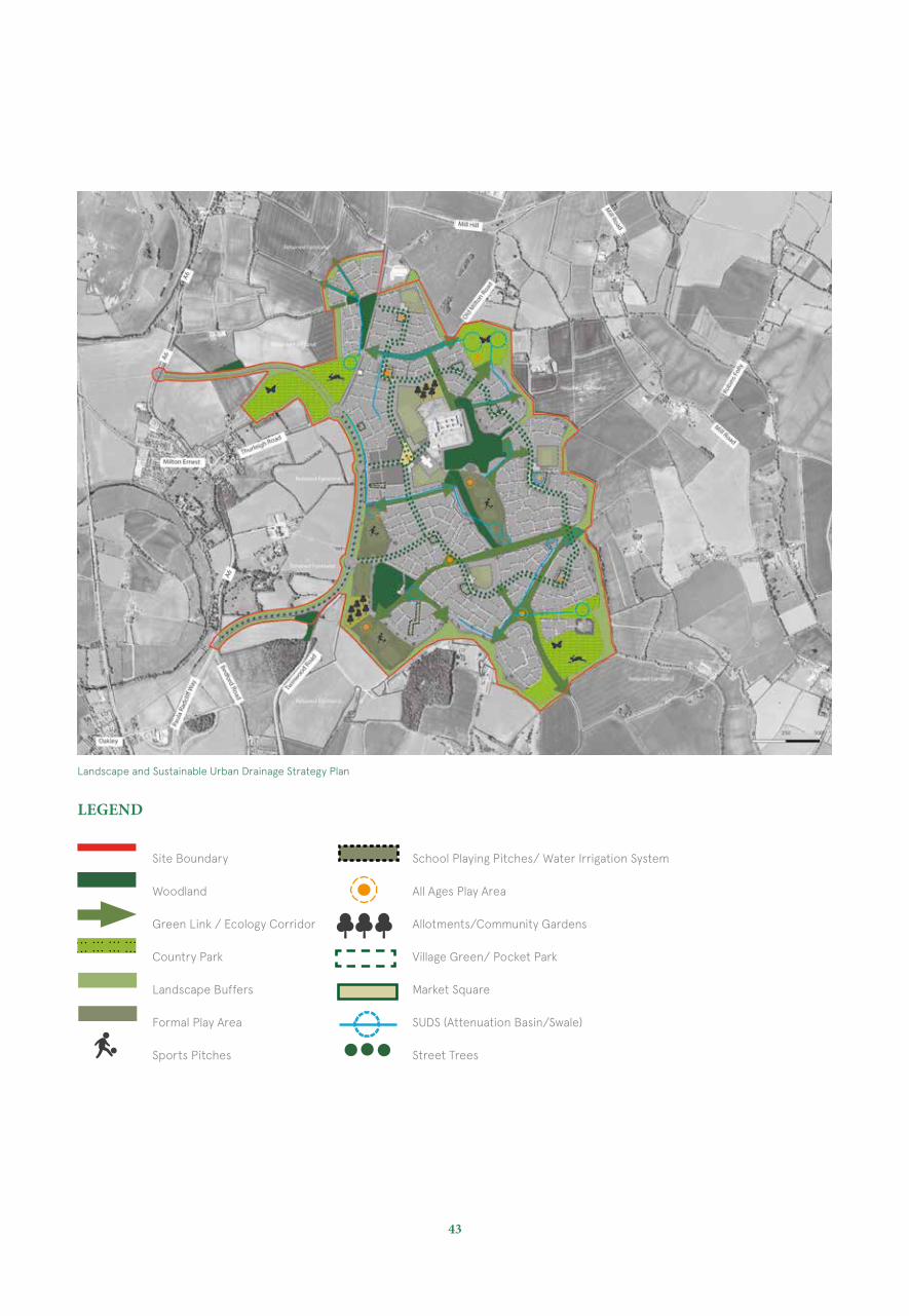
SUSTAINABLE URBAN DRAINAGE
Sustainable surface water management measures can help create a more balanced and natural ecology in our new settlements. Embracing the principles of Sustainable Urban Drainage which can open a gateway towards a much more far-reaching and transformational urban landscape in the future.Our approach to Sustainable Urban Drainage (SuDS) is that of integrating the green and blue - making our landscape more resilient and adaptive to address future changes in climate, landuse and water management.
It is proposed to link a series of attenuation basins and shallow swale systems throughout the entire development to form the main basis for the sustainable surface water drainage features. It is proposed to link up attenuation areas and SuDS features with proposed play areas and open space amenities to further enhance the landscape opportunities and overall biodiversity enhancements throughout the development.
As well as the above the site will promote the use of green roofs, water recycling facilities (grey water recycling) with permeable paved driveways and private parking areas within the built development areas and rainwater butts within private gardens.
It is proposed to promote water irrigation systems within the proposed school playing fields as an additional sustainable feature.
43
Landscape and Sustainable Urban Drainage Strategy Plan
Site Boundary
Woodland
Green Link / Ecology Corridor
Country Park
Landscape Buffers
Formal Play Area
Sports Pitches
LEGEND
School Playing Pitches/ Water Irrigation System
All Ages Play Area
Allotments/Community Gardens
Village Green/ Pocket Park
Market Square
SUDS (Attenuation Basin/Swale)
Street Trees
Movement & Connections
SUSTAINABLE TRANSPORT
Twinwoods will be a community that offers sustainable forms of transport as alternatives to car use. As well as having pedestrian and cycleways that offer a high level of accessibility a high quality bus service will be provided. It is intended that these sustainable transport provisions will be supplemented by a range of Travel Plan measures and incentives so that the vehicular traffic is kept at as low a level as possible. A comprehensive and integrated package of transport measures which include new and improved connections to the strategic highway network.
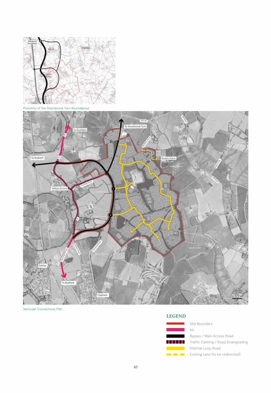
VEHICULAR CONNECTIONS
The strategic highway improvements have been evolved so that they provide movement links of an appropriate standard and capacity between the settlement and the strategic road network, so that they avoid and minimise traffic impacts on adjacent communities and also so that they can facilitate a high quality public transport links.
The existing dual carriageway section of the A6 (Paula Radcliffe Way) will be extended to the core of the Twinwoods development around and to the east of Milton Ernest through land owned by the landowners/promoters and forming a bypass for Milton Ernest and Bletsoe.
The bypass will initially comprise of a single carriageway which will be dualled in due course to accommodate the growth of the settlement
The second element of the strategy is the upgrading of the existing single carriageway Thurleigh Road route between the site and Sharnbrook Turn.
The third component of the strategy is a new east-west single carriageway link between the core of the settlement and a point on the A6 to the north of Milton Ernest. This link will serve to provide a new east-west link for future traffic thereby removing through-traffic in Milton Ernest.
This east-west link road will also assist the distribution of north-south through traffic on the existing A6 (north of Milton Ernest) and Thurleigh Road to the Sharnbrook Turn.
In addition to these network proposals it is envisaged that complementary traffic restraint measures including traffic calming will be introduced in the villages of Milton Ernest, Bletsoe, Thurleigh and other villages as deemed necessary to deter and reduce through- traffic and thereby enhance the environment within these communities.
These core strategic elements of the highways proposals will be integrated with and complementary to the internal highway layout within Twinwoods. The internal road network will be accessed via three new main road junctions and will operate efficiently and safely as well as providing the road network needed for Twinwoods bus services.
Within the settlement there will be a hierarchy of routes the main elements of which will be:-
• Main streets comprising the access links and the loop road which will also serve as the bus route
• Access roads which will link residential roads linking to the main streets
• Minor Roads such as streets, lanes and mews• Pedestrian and cycle paths• This hierarchical approach will be based upon the ‘Manual for
Streets’ and accords with best practice.
45
Site Boundary
A6
Bypass / Main Access Road
Traffic Calming / Road Downgrading
Internal Loop Road
Existing Lane (to be redirected)
Vehicular Connections Plan
Proximity of the Sharnbrook Turn Roundabout
LEGEND
PUBLIC TRANSPORT
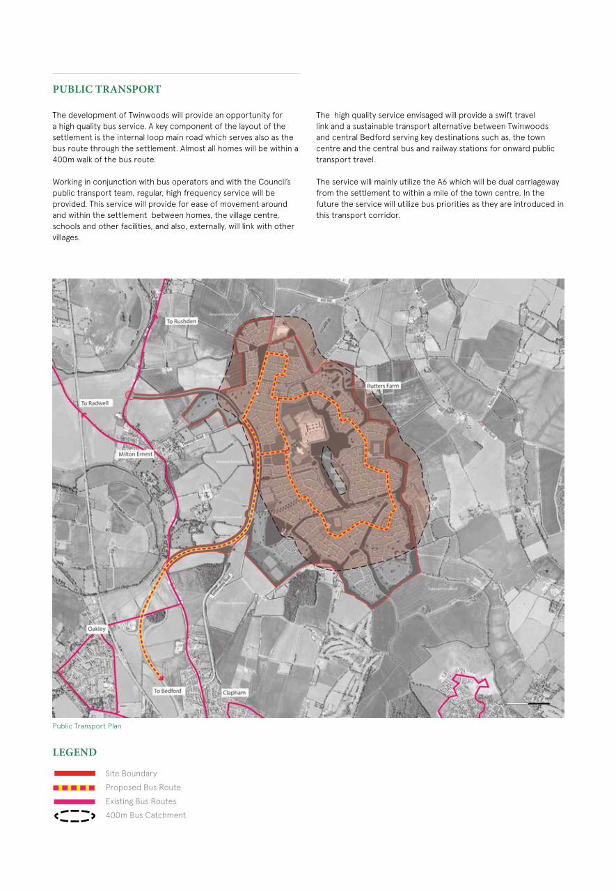
The development of Twinwoods will provide an opportunity for a high quality bus service. A key component of the layout of the settlement is the internal loop main road which serves also as the bus route through the settlement. Almost all homes will be within a 400m walk of the bus route.
Working in conjunction with bus operators and with the Council’s public transport team, regular, high frequency service will be provided. This service will provide for ease of movement around and within the settlement between homes, the village centre, schools and other facilities, and also, externally, will link with other villages.
Site Boundary
Proposed Bus Route
Existing Bus Routes
400m Bus Catchment
Public Transport Plan
The high quality service envisaged will provide a swift travel link and a sustainable transport alternative between Twinwoods and central Bedford serving key destinations such as, the town centre and the central bus and railway stations for onward public transport travel.
The service will mainly utilize the A6 which will be dual carriageway from the settlement to within a mile of the town centre. In the future the service will utilize bus priorities as they are introduced in this transport corridor.
LEGEND
47
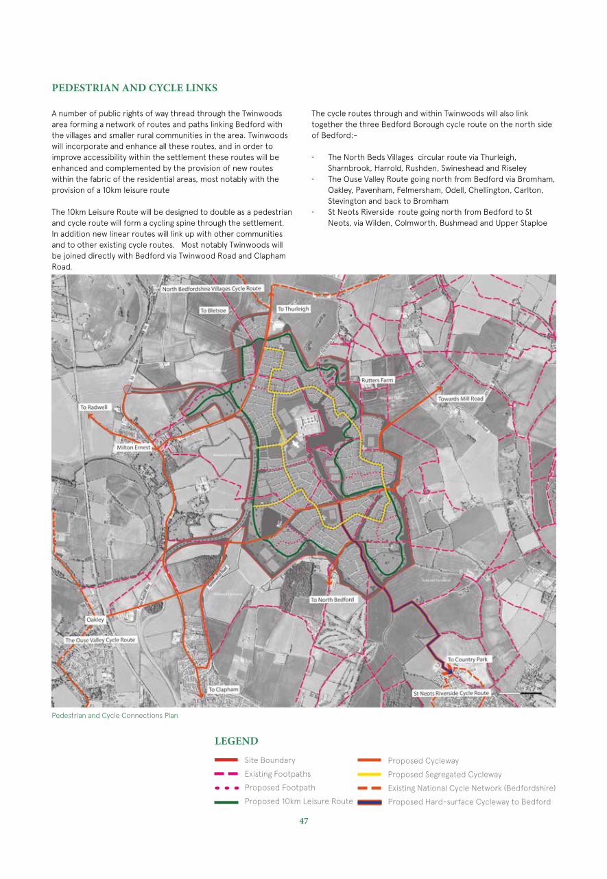
PEDESTRIAN AND CYCLE LINKS
A number of public rights of way thread through the Twinwoods area forming a network of routes and paths linking Bedford with the villages and smaller rural communities in the area. Twinwoods will incorporate and enhance all these routes, and in order to improve accessibility within the settlement these routes will be enhanced and complemented by the provision of new routes within the fabric of the residential areas, most notably with the provision of a 10km leisure route
The 10km Leisure Route will be designed to double as a pedestrian and cycle route will form a cycling spine through the settlement. In addition new linear routes will link up with other communities and to other existing cycle routes. Most notably Twinwoods will be joined directly with Bedford via Twinwood Road and Clapham Road.
Pedestrian and Cycle Connections Plan
The cycle routes through and within Twinwoods will also link together the three Bedford Borough cycle route on the north side of Bedford:-
• The North Beds Villages circular route via Thurleigh, Sharnbrook, Harrold, Rushden, Swineshead and Riseley
• The Ouse Valley Route going north from Bedford via Bromham, Oakley, Pavenham, Felmersham, Odell, Chellington, Carlton, Stevington and back to Bromham
• St Neots Riverside route going north from Bedford to St Neots, via Wilden, Colmworth, Bushmead and Upper Staploe
LEGEND
Site Boundary
Existing Footpaths
Proposed Footpath
Proposed 10km Leisure Route
Proposed Cycleway
Proposed Segregated Cycleway
Existing National Cycle Network (Bedfordshire)
Proposed Hard-surface Cycleway to Bedford
Typology & Density
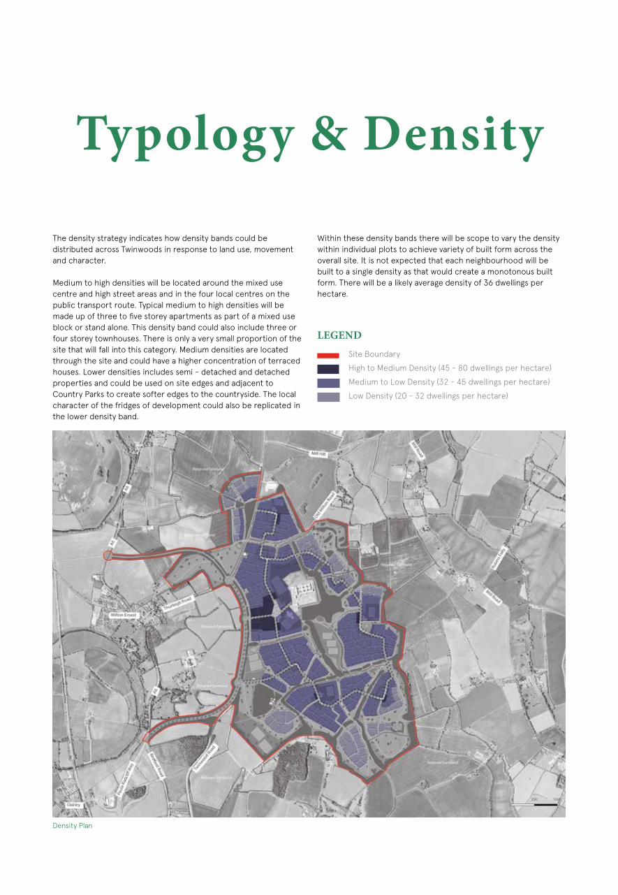
The density strategy indicates how density bands could be distributed across Twinwoods in response to land use, movement and character.
Medium to high densities will be located around the mixed use centre and high street areas and in the four local centres on the public transport route. Typical medium to high densities will be made up of three to five storey apartments as part of a mixed use block or stand alone. This density band could also include three or four storey townhouses. There is only a very small proportion of the site that will fall into this category. Medium densities are located through the site and could have a higher concentration of terraced houses. Lower densities includes semi - detached and detached properties and could be used on site edges and adjacent to Country Parks to create softer edges to the countryside. The local character of the fridges of development could also be replicated in the lower density band.
Within these density bands there will be scope to vary the density within individual plots to achieve variety of built form across the overall site. It is not expected that each neighbourhood will be built to a single density as that would create a monotonous built form. There will be a likely average density of 36 dwellings per hectare.
LEGENDSite Boundary
High to Medium Density (45 - 80 dwellings per hectare)
Medium to Low Density (32 - 45 dwellings per hectare)
Low Density (20 - 32 dwellings per hectare)
Density Plan

49
The Audit
INTRODUCTION
The Audit is a comprehensive analysis of the Twinwoods site and the wider area, encompassing assessment of access to local facilities, landscape and open space, and connectivity.
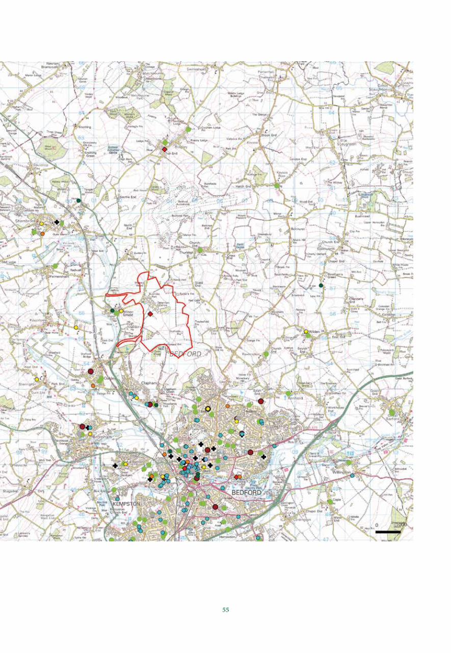
CONSTELLATION OF LOCAL SETTLEMENTS
Twinwoods is situated within a network of villages mutually dependent on one another and Bedford for facilities and employment.
The network of villages in which Twinwoods is situated are categorised within the development plan and the emerging Local Plan according to their size and function. The network includes Thurleigh, Bletsoe, Radwell, Milton Ernest, Riseley, Ravensden, Sharnbrook and Clapham.
THE TWINWOODS, WHEN BUILT, WOULD PROVIDE THE WIDE RANGE OF FACILITIES EXPECTED OF A RURAL SERVICE CENTRE. THE PROPOSED LEVEL AND MIX OF SERVICE PROVISION WOULD ALSO SERVE TO SUPPORT OTHER LOCAL COMMUNITIES WHERE ACCESS TO FACILITIES MAY BE WEAK. THIS APPROACH WOULD ALSO SERVE TO REDUCE THE NEED TO TRAVEL AND WOULD MAKE TWINWOODS A SUSTAINABLE AND ATTRACTIVE PLACE TO BOTH LIVE AND WORK.
A study of surrounding villages has been undertaken to assess the level of facilities, including employment, provided by each village.
Twinwoods Constellation
Villages included in the audit overleaf /NTS
Clapham
Oakley
Milton Ernest
ThurleighBletsoeRadwell
Ravensden
Riseley
Sharnbrook
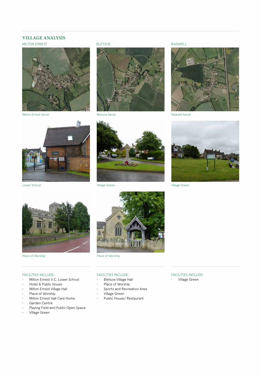
VILLAGE ANALYSISMILTON ERNEST BLETSOE RADWELL
FACILITIES INCLUDE:• Milton Ernest V.C. Lower School• Hotel & Public House• Milton Ernest Village Hall• Place of Worship• Milton Ernest Hall Care Home• Garden Centre• Playing Field and Public Open Space• Village Green
FACILITIES INCLUDE:• Bletsoe Village Hall• Place of Worship• Sports and Recreation Area• Village Green• Public House/ Restaurant
FACILITIES INCLUDE:• Village Green
Milton Ernest Aerial Bletsoe Aerial Radwell Aerial
Lower School Village Green Village Green
Place of Worship Place of Worship
51
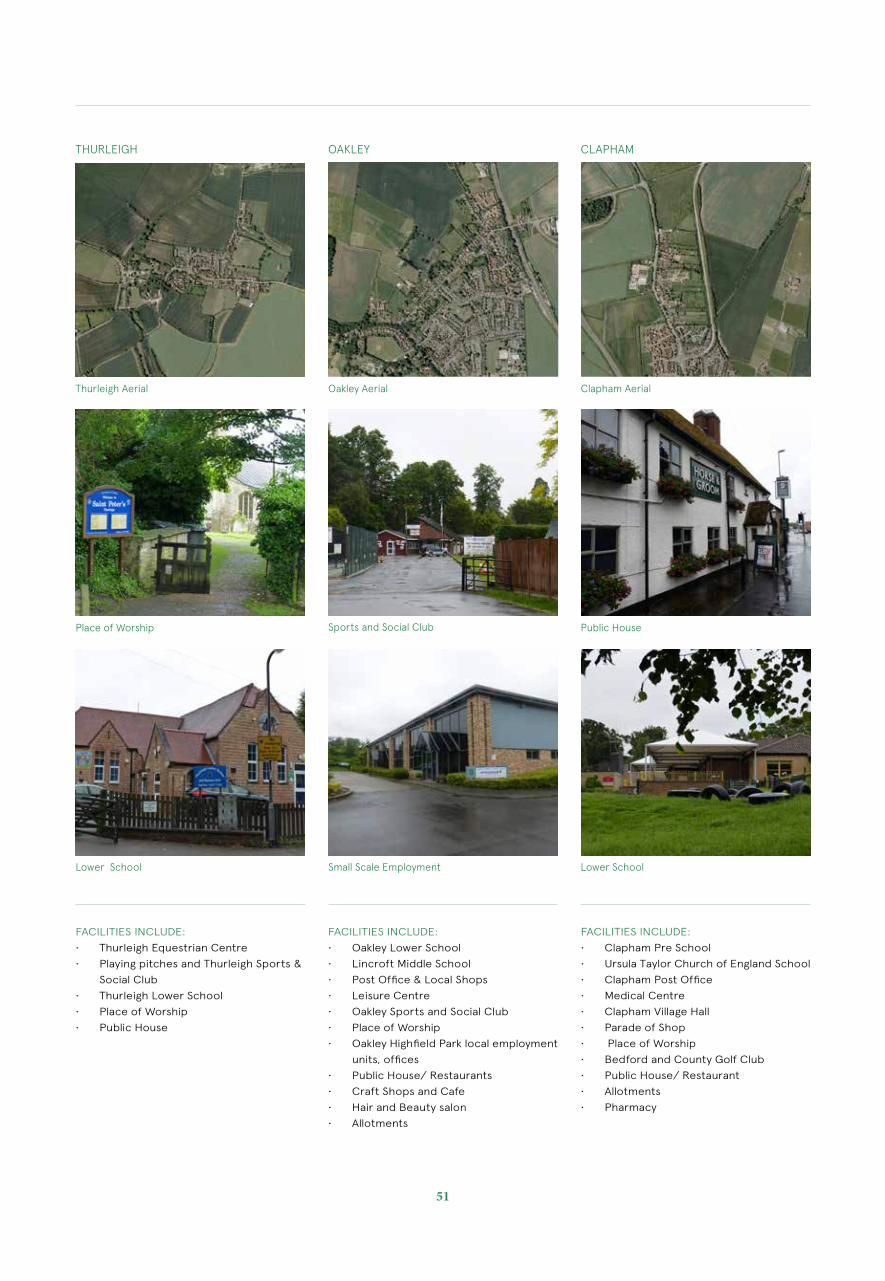
THURLEIGH OAKLEY CLAPHAM
FACILITIES INCLUDE:
• Thurleigh Equestrian Centre
• Playing pitches and Thurleigh Sports &
Social Club
• Thurleigh Lower School
• Place of Worship
• Public House
FACILITIES INCLUDE:
• Oakley Lower School
• Lincroft Middle School
• Post Office & Local Shops
• Leisure Centre
• Oakley Sports and Social Club
• Place of Worship
• Oakley Highfield Park local employment
units, offices
• Public House/ Restaurants
• Craft Shops and Cafe
• Hair and Beauty salon
• Allotments
FACILITIES INCLUDE:
• Clapham Pre School
• Ursula Taylor Church of England School
• Clapham Post Office
• Medical Centre
• Clapham Village Hall
• Parade of Shop
• Place of Worship
• Bedford and County Golf Club
• Public House/ Restaurant
• Allotments
• Pharmacy
Thurleigh Aerial Oakley Aerial Clapham Aerial
Place of Worship Sports and Social Club
Lower School Small Scale Employment
Public House
Lower School
53
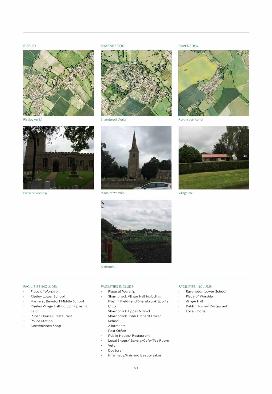
RISELEY SHARNBROOK RAVENSDEN
FACILITIES INCLUDE:
• Place of Worship
• Riseley Lower School
• Margaret Beaufort Middle School
• Riseley Village Hall including playing
field
• Public House/ Restaurant
• Police Station
• Convenience Shop
FACILITIES INCLUDE:
• Place of Worship
• Sharnbrook Village Hall including
Playing Fields and Sharnbrook Sports
Club
• Sharnbrook Upper School
• Sharnbrook John Gibbard Lower
School
• Allotments
• Post Office
• Public House/ Restaurant
• Local Shops/ Bakery/Cafe/Tea Room
• Vets
• Doctors
• Pharmacy/Hair and Beauty salon
FACILITIES INCLUDE:
• Ravensden Lower School
• Place of Worship
• Village Hall
• Public House/ Restaurant
• Local Shops
Riseley Aerial Sharnbrook Aerial Ravensden Aerial
Place of worship Place of worship Village hall
Allotments

SUMMARY
Twinwoods is situated within a network of villages mutually dependent on one another and surrounding towns, notably Bedford, for facilities and employment.
Most villages have some facilities and rely on each other for missing needs.
A residential led mixed-use new settlement at Twinwoods could provide a range of facilities missing in local villages. This would serve to help relieve pressure on the local and strategic road network, particularly the A6 in the vicinity of Milton Ernest.
SELECTING SUSTAINABLE SITES
Access to local facilities is fundamental to the concept of locating sustainable development. New development needs the full range of social, retail, educational, health, transport and recreational facilities to allow people, especially those of limited means or mobility, to go about their daily lives without over reliance on a private car.
BUILDING FOR LIFE CRITERIABuilding for Life is the Government endorsed, industry standard tool to assess and compare the quality of developments. It is led by the Design Council CABE, Home Builders Federation and Design for Homes. Whilst Building for Life is usually awarded to completed schemes, the site selection criteria has been applied to Twinwoods to demonstrate the inherent sustainability of the site’s location for future development. Building for Life asks:
1) Does the development provide (or is it close to) community facilities, such as shops, schools, workplaces, parks, play areas, pubs or cafes?2) Are there enough facilities and services in the local area to support the development? If not, what is needed?
The facilities audit, using an assessment methodology established by Shaping Neighbourhoods, diagrams over the following pages demonstrates that Twinwoods is a sustainable site location and fully meets the Building for Life criteria through existing local facilities and the potential to provide new facilities on-site as part of a new residential-led, mixed-use, community.
L E G E N D
Site Boundary
Schools
Post Office
Hospital
GP/ Health Clinic
Banks
Supermarket
Library
Emergency Services
Hotel
Leisure Centre
Community Hall/ Centre
Existing Facilities Analysis Plan
55
Existing Facilities Analysis Plan
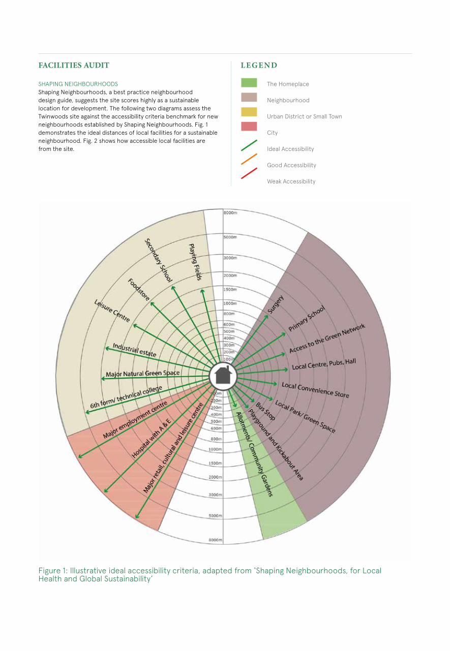
FACILITIES AUDIT
SHAPING NEIGHBOURHOODSShaping Neighbourhoods, a best practice neighbourhood design guide, suggests the site scores highly as a sustainable location for development. The following two diagrams assess the Twinwoods site against the accessibility criteria benchmark for new neighbourhoods established by Shaping Neighbourhoods. Fig. 1 demonstrates the ideal distances of local facilities for a sustainable neighbourhood. Fig. 2 shows how accessible local facilities are from the site.
L E G E N D
The Homeplace
Neighbourhood
Urban District or Small Town
City
Ideal Accessibility
Good Accessibility
Weak Accessibility
Figure 1: Illustrative ideal accessibility criteria, adapted from ‘Shaping Neighbourhoods, for Local Health and Global Sustainability’
57
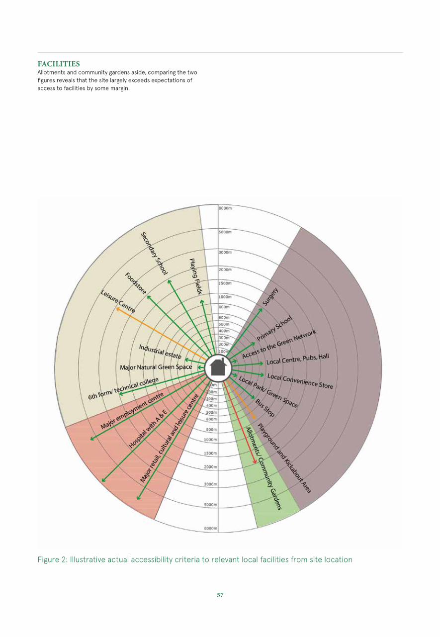
FACILITIESAllotments and community gardens aside, comparing the two figures reveals that the site largely exceeds expectations of access to facilities by some margin.
Figure 2: Illustrative actual accessibility criteria to relevant local facilities from site location
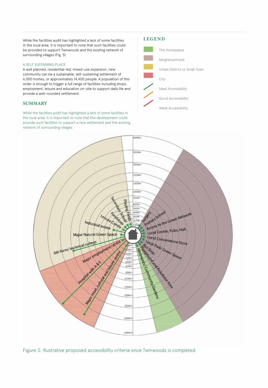
While the facilities audit has highlighted a lack of some facilities in the local area, it is important to note that such facilities could be provided to support Twinwoods and the existing network of surrounding villages (Fig. 3).
A SELF SUSTAINING PLACEA well planned, residential-led, mixed-use expansion, new community can be a sustainable, self-sustaining settlement of 6,000 homes, or approximately 14,400 people. A population of this order is enough to trigger a full range of facilities including shops, employment, leisure and education on-site to support daily life and provide a well-rounded settlement.
SUMMARY
While the facilities audit has highlighted a lack of some facilities in the local area, it is important to note that the development could provide such facilities to support a new settlement and the existing network of surrounding villages.
L E G E N D
The Homeplace
Neighbourhood
Urban District or Small Town
City
Ideal Accessibility
Good Accessibility
Weak Accessibility
Figure 3: Illustrative proposed accessibility criteria once Twinwoods is completed

59
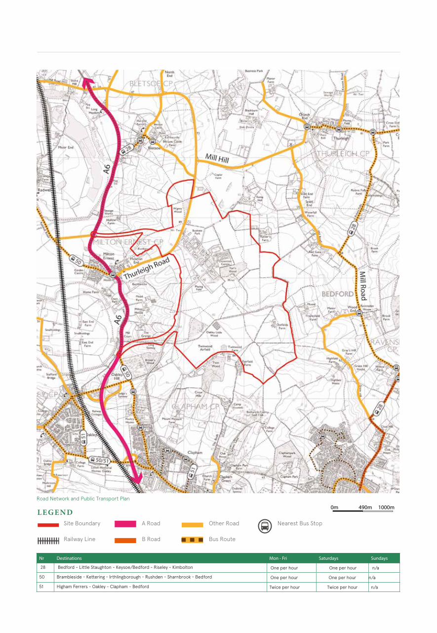
CONNECTIVITY AUDITROAD NETWORKThe site is well connected to the strategic road network. The A6 passes close to the west side of the site providing access to strategic destinations including Bedford to the south and beyond and to the north to Wellingborough, Kettering and the A45 and A14 routes. Thurleigh Road traverses the northern portion of the site providing access to the countryside and villages to the east including the village of Thurleigh.
PUBLIC TRANSPORTThere is a no 50 service along the A6, providing an hourly bus service into Bedford and other destinations including Rushden / Kettering.
Other bus services are located to the east and south of the site and provide frequent services to Bedford Higham Ferrers and Kimbolton.
The combination of existing services means that there is a reasonably good service of four routes near to the site every hour.
Strategic Connections Diagram
0m 1000m490m
Road Network and Public Transport Plan
Nr Destinations Mon - Fri Saturdays Sundays
28 Bedford - Little Staughton - Keysoe/Bedford - Riseley - Kimbolton One per hour One per hour n/a
50 Brambleside - Kettering - Irthlingborough - Rushden - Sharnbrook - Bedford One per hour One per hour n/a
51 Higham Ferrers - Oakley - Clapham - Bedford Twice per hour Twice per hour n/a
L E G E N DSite Boundary
Railway Line
A Road
B Road
Other Road
Bus Route
Nearest Bus Stop
61
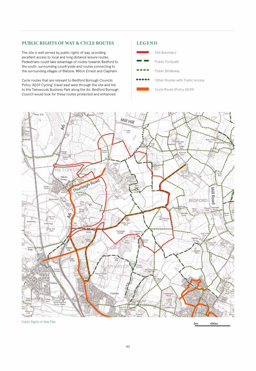
PUBLIC RIGHTS OF WAY & CYCLE ROUTES
The site is well served by public rights of way, providing excellent access to local and long distance leisure routes. Pedestrians could take advantage of routes towards Bedford to the south, surrounding countryside and routes connecting to the surrounding villages of Bletsoe, Milton Ernest and Clapham.
Cycle routes that are relevant to Bedford Borough Councils Policy ‘AD39 Cycling’ travel east west through the site and link to the Twinwoods Business Park along the A6. Bedford Borough Council would look for these routes protected and enhanced.
0m 490mPublic Rights of Way Plan
Site Boundary
Public Footpath
Public Bridleway
Other Routes with Public Access
Cycle Route (Policy AD39)
L E G E N D