A Multi-Scalar Approach to Theorizing Socio-Ecological Dynamics of Urban Residential...
21
Cities and the Environment (CATE) | Issue 1 Volume 4 Article 6 7-29-2011 A Multi-Scalar Approach to Theorizing Socio- Ecological Dynamics of Urban Residential Landscapes Rinku Roy Chowdhury Indiana University, Bloomington, [email protected] Kelli Larson Arizona State University, [email protected] Morgan Grove USDA Forest Service, [email protected] Colin Polsky Clark University, [email protected] Elizabeth Cook Arizona State University, [email protected] See next page for additional authors This Article is brought to you for free and open access by the Department of Biology at Digital Commons at Loyola Marymount University and Loyola Law School. It has been accepted for inclusion in Cities and the Environment (CATE) by an authorized administrator of Digital Commons at Loyola Marymount University and Loyola Law School. For more information, please contact [email protected]. Recommended Citation Roy Chowdhury, Rinku; Larson, Kelli; Grove, Morgan; Polsky, Colin; Cook, Elizabeth; Onsted, Jeffrey; and Ogden, Laura (2011) "A Multi-Scalar Approach to Theorizing Socio-Ecological Dynamics of Urban Residential Landscapes," Cities and the Environment (CATE): Vol. 4: Iss. 1, Article 6. Available at: http://digitalcommons.lmu.edu/cate/vol4/iss1/6
Transcript of A Multi-Scalar Approach to Theorizing Socio-Ecological Dynamics of Urban Residential...

Cities and the Environment (CATE)
| Issue 1Volume 4 Article 6
7-29-2011
A Multi-Scalar Approach to Theorizing Socio-Ecological Dynamics of Urban ResidentialLandscapesRinku Roy ChowdhuryIndiana University, Bloomington, [email protected]
Kelli LarsonArizona State University, [email protected]
Morgan GroveUSDA Forest Service, [email protected]
Colin PolskyClark University, [email protected]
Elizabeth CookArizona State University, [email protected]
See next page for additional authors
This Article is brought to you for free and open access by the Department of Biology at Digital Commons at Loyola Marymount University and LoyolaLaw School. It has been accepted for inclusion in Cities and the Environment (CATE) by an authorized administrator of Digital Commons at LoyolaMarymount University and Loyola Law School. For more information, please contact [email protected].
Recommended CitationRoy Chowdhury, Rinku; Larson, Kelli; Grove, Morgan; Polsky, Colin; Cook, Elizabeth; Onsted, Jeffrey; and Ogden, Laura (2011) "AMulti-Scalar Approach to Theorizing Socio-Ecological Dynamics of Urban Residential Landscapes," Cities and the Environment(CATE): Vol. 4: Iss. 1, Article 6.Available at: http://digitalcommons.lmu.edu/cate/vol4/iss1/6
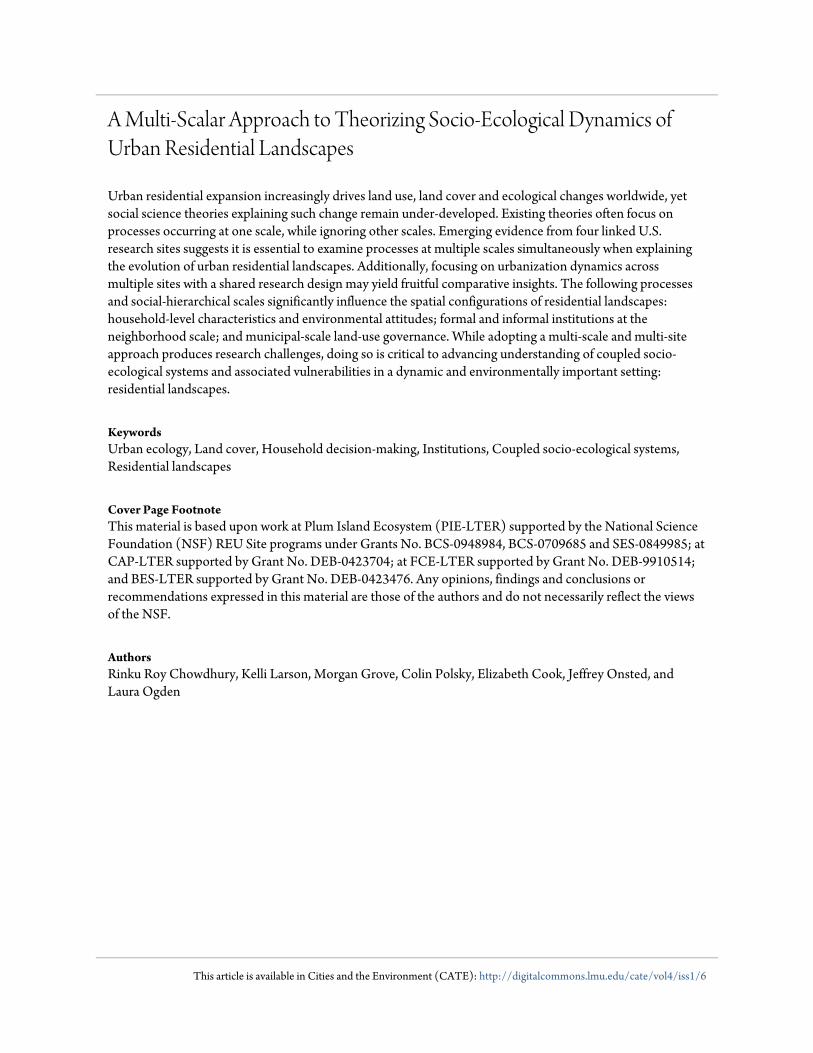
A Multi-Scalar Approach to Theorizing Socio-Ecological Dynamics ofUrban Residential Landscapes
Urban residential expansion increasingly drives land use, land cover and ecological changes worldwide, yetsocial science theories explaining such change remain under-developed. Existing theories often focus onprocesses occurring at one scale, while ignoring other scales. Emerging evidence from four linked U.S.research sites suggests it is essential to examine processes at multiple scales simultaneously when explainingthe evolution of urban residential landscapes. Additionally, focusing on urbanization dynamics acrossmultiple sites with a shared research design may yield fruitful comparative insights. The following processesand social-hierarchical scales significantly influence the spatial configurations of residential landscapes:household-level characteristics and environmental attitudes; formal and informal institutions at theneighborhood scale; and municipal-scale land-use governance. While adopting a multi-scale and multi-siteapproach produces research challenges, doing so is critical to advancing understanding of coupled socio-ecological systems and associated vulnerabilities in a dynamic and environmentally important setting:residential landscapes.
KeywordsUrban ecology, Land cover, Household decision-making, Institutions, Coupled socio-ecological systems,Residential landscapes
Cover Page FootnoteThis material is based upon work at Plum Island Ecosystem (PIE-LTER) supported by the National ScienceFoundation (NSF) REU Site programs under Grants No. BCS-0948984, BCS-0709685 and SES-0849985; atCAP-LTER supported by Grant No. DEB-0423704; at FCE-LTER supported by Grant No. DEB-9910514;and BES-LTER supported by Grant No. DEB-0423476. Any opinions, findings and conclusions orrecommendations expressed in this material are those of the authors and do not necessarily reflect the viewsof the NSF.
AuthorsRinku Roy Chowdhury, Kelli Larson, Morgan Grove, Colin Polsky, Elizabeth Cook, Jeffrey Onsted, andLaura Ogden
This article is available in Cities and the Environment (CATE): http://digitalcommons.lmu.edu/cate/vol4/iss1/6
I. INTRODUCTION
Social structures, local decisions and ecological factors interact in complex ways to shape urban
environments at multiple scales. Developing urban areas worldwide reflect state, private,
communal and other property ownership structures, however, in the United States, urban and
suburban landscapes are dominated by private land ownership and residential land use.
Understanding these landscapes depends on adequately integrating their multi-scalar, socio-
ecological dynamics, but past studies have generally focused on individual scales of analysis
(e.g., social neighborhoods, municipal governance), or on either social or environmental aspects.
A deeper, integrated understanding is especially critical given the spatial pervasiveness of
residential landscapes. Lawns are now a dominant “crop” covering over 16 million hectares,
exceeding corn as the most extensive irrigated crop in the US (Milesi et al. 2005). The rapid
expansion of residential land covers is driven by complex interactions among socioeconomic,
political and environmental factors. Within the US, losses of agricultural and forested land to
urban and suburban use are among the greatest sources of anthropogenic landscape change in the
20th
century, a concern intensified by the large ecological footprints of urban areas as they
mobilize resource, commodity and material flows affecting agricultural, forested and other
nonurban landscapes (Munroe et al. 2005). Since World War II, urban land expansion outpaced
population growth in many US cities (Otto et al. 2002). These trends accelerated in the past
twenty-five years: urban areas expanded by 34% between 1982 and 1997, extending over 1.4
million sq. km. and housing over 80% of the US population (Brown et al. 2005). According to
the 2000 census, suburban growth surpassed growth in cities regardless of city-specific
population or economic trajectories (Katz and Lang 2003). While expanding residential spaces
are embedded with personal and social value (e.g., recreational, aesthetic and property values),
they also affect ecological structure (e.g., habitat fragmentation) and function (e.g., nutrient
flows), creating a “self-imposed burden and hazard” (Robbins 2007, p. xx; Fissore et al. 2011).
These dynamic, multi-scalar social spaces and their deep ecological impacts spur the need for
theories and methods to deepen our social-ecological understanding of (sub)urban landscapes.
This paper presents a multi-scalar approach to the study of residential landscapes,
grounding theories of urban and residential land use within a set of illustrative vignettes from
four long-term socio-ecological research projects. In particular, we synthesize distinct mid-level
theories, i.e., theories grounded within empirical research (supported by evidence derived from
direct observation or experience, and subject to either quantitative or qualitative analysis), as
opposed to a higher level of abstraction (Merton 1968; Wallace 1969). This enables us to anchor
our approach in actual historical and contemporary processes of residential land management in
the study locations we draw from. We examine mid-level theories that explain environmental
decisions at varying spatial scales, ranging from individual behavior to broader forces at
neighborhood, city and state scales. Our synthesis is built upon an examination of theoretical
approaches, empirical findings and knowledge gaps from four Long Term Ecological Research
(LTER) sites, each of which examines the social-ecological dynamics of residential landscapes.
The multi-scalar approach is motivated by theoretical concerns. A primary theoretical
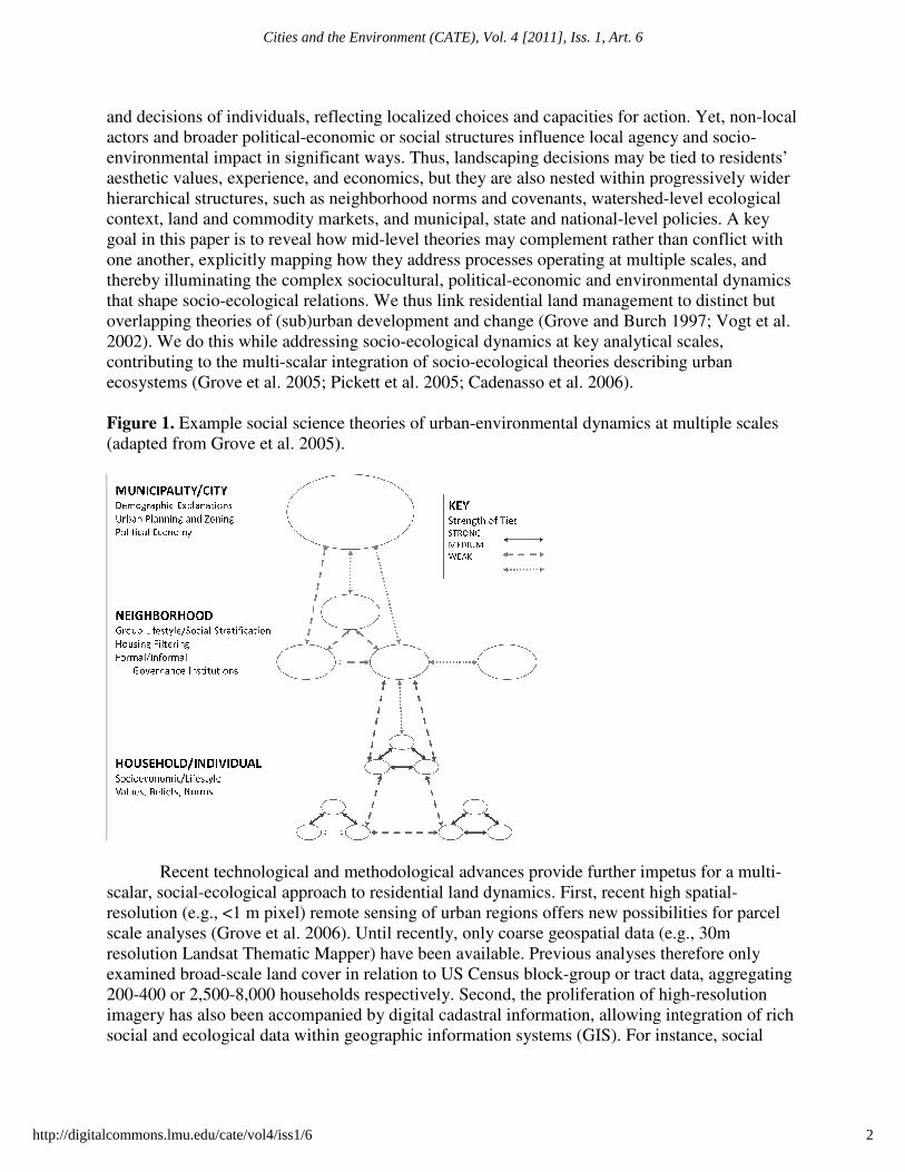
rationale lies in diverse, contradicting or complementary mid-level social science theories
relevant to residential land management (Figure 1) that address various aspects of structure or
agency. Land management is ultimately a local expression of the desires, constraints, abilities
1
Roy Chowdhury et al.: Socio-ecological dynamics of urban residential landscapes
Produced by The Berkeley Electronic Press, 2011
and decisions of individuals, reflecting local
actors and broader political-economic or social
environmental impact in significant ways
aesthetic values, experience, and economics, but
hierarchical structures, such as neighborhood norms and covenants, watershed
context, land and commodity markets, and municipal, state and national
goal in this paper is to reveal how mid
one another, explicitly mapping how
thereby illuminating the complex
that shape socio-ecological relations
overlapping theories of (sub)urban development and
2002). We do this while addressing socio
contributing to the multi-scalar integration of
ecosystems (Grove et al. 2005; Pickett
Figure 1. Example social science theories
(adapted from Grove et al. 2005).
Recent technological and methodological advances
scalar, social-ecological approach to residential land dynamics.
resolution (e.g., <1 m pixel) remote sensing
scale analyses (Grove et al. 2006). Until recently, only coarse geospatial data
resolution Landsat Thematic Mapper)
examined broad-scale land cover in relation to US Census
200-400 or 2,500-8,000 households respectively.
imagery has also been accompanied by digital cadastral
social and ecological data within geographic information systems (GIS)
, reflecting localized choices and capacities for action
economic or social structures influence local agency
in significant ways. Thus, landscaping decisions may be tied to residents’
and economics, but they are also nested within progressi
neighborhood norms and covenants, watershed-level ecological
context, land and commodity markets, and municipal, state and national-level policies. A key
is to reveal how mid-level theories may complement rather than conflict with
how they address processes operating at multiple scales
thereby illuminating the complex sociocultural, political-economic and environmental
relations. We thus link residential land management
overlapping theories of (sub)urban development and change (Grove and Burch 1997;
. We do this while addressing socio-ecological dynamics at key analytical scales
integration of socio-ecological theories describing urban
2005; Pickett et al. 2005; Cadenasso et al. 2006).
Example social science theories of urban-environmental dynamics at multiple scales
2005).
ecent technological and methodological advances provide further impetus for a multi
ecological approach to residential land dynamics. First, recent high
remote sensing of urban regions offers new possibilities for parcel
2006). Until recently, only coarse geospatial data (e.g., 30m
resolution Landsat Thematic Mapper) have been available. Previous analyses therefore only
land cover in relation to US Census block-group or tract data, aggregating
8,000 households respectively. Second, the proliferation of high
has also been accompanied by digital cadastral information, allowing integration of rich
within geographic information systems (GIS). For instance, social
and capacities for action. Yet, non-local
local agency and socio-
. Thus, landscaping decisions may be tied to residents’
progressively wider
level ecological
level policies. A key
complement rather than conflict with
processes operating at multiple scales, and
environmental dynamics
residential land management to distinct but
change (Grove and Burch 1997; Vogt et al.
ecological dynamics at key analytical scales,
theories describing urban
environmental dynamics at multiple scales
impetus for a multi-
high spatial-
offers new possibilities for parcel
(e.g., 30m
have been available. Previous analyses therefore only
ract data, aggregating
, the proliferation of high-resolution
ng integration of rich
. For instance, social
2
Cities and the Environment (CATE), Vol. 4 [2011], Iss. 1, Art. 6
http://digitalcommons.lmu.edu/cate/vol4/iss1/6
surveys of residents’ landscaping practices can now be linked to ecological information at the
parcel scale. Integration at multiple spatial scales, from the detailed parcel to broader
neighborhoods and regions, thus enable novel analytical and theoretical advances.
The following sections describe an approach to the study of residential landscapes
illustrated in a set of research vignettes emerging from four diverse LTER sites: the Baltimore
Ecosystem Study (BES), Central Arizona-Phoenix (CAP), Florida-Coastal Everglades (FCE),
and Plum Island Ecosystem (PIE; Table 1). Suburbanization is well underway in each site
(Figure 2), but is tied to varying regional contexts and socio-environmental drivers, which help
shape land cover choices and outcomes in residential parcels. Figure 3 depicts just four examples
of landscapes in these four sites, though it should be noted that there is great diversity of yard
forms, management and vegetative cover within any individual site. Drawing from these
complementary long-term socio-ecological research projects, we derive a research framework
with two overarching goals: (1) to understand the complex, multi-scalar drivers and feedbacks of
residential landscapes, including lawns and “lawn people” (Robbins 2007), and (2) to develop
spatially explicit theories of these patterns and processes. In doing so, we approach urbanization
as an integrated social-ecological process constituted by social, political, economic, ecological
and climate interactions. Ultimately, this work reflects a commitment to trans-disciplinary
environmental science and LTER research priorities targeting land- and water-use dynamics
(Collins et al. 2007; Fissore et al. 2011).
Table 1. Socio-ecological research at four LTER sites
The Baltimore Ecosystem Study (BES) LTER (http://www.beslter.org/)
The BES-LTER site spans the Baltimore Metropolitan Statistical Areas (MSA), including Baltimore City and
several surrounding counties. Originally an agricultural port on the Chesapeake Bay, Baltimore’s population
expanded significantly between 1900 and 1960 due to immigration and industrialization, and has declined since
1960 due to declining immigration and manufacturing jobs, and a transition to a service economy. Far-reaching
land-use and zoning regulations, including the Urban-Rural Delineated Line, constrain urban growth of Baltimore
City. The Baltimore MSA straddles the Piedmont and Coastal Zone geologic regions and has easily delineated
watersheds studied in BES research. Because of land-water connections to the Bay, a policy goal to increase urban
tree canopy from 20% to 40% over 30 years has been implemented in Baltimore City, where most land available
for increasing vegetation lies in private, residential areas. Understanding social and ecological motivations,
capacities, and pathways for land management on private parcels is an important BES science and policy issue.
The Central Arizona-Phoenix (CAP) LTER (http://caplter.asu.edu/)
The CAP-LTER site encompasses the City of Phoenix, more than 20 municipalities, and nearly 4 million residents.
Phoenix is situated in the Sonoran Desert with only ~190 mm/year of rainfall, yet water use has enabled its rapid
growth. Severe groundwater overdraft led to the 1980 Groundwater Management Act, but high water use persists,
partly a result of weak municipal regulations. While the Phoenix region continues to be promoted as a lush oasis,
land use changes and recent drought have led to water scarcity and residential landscaping alternatives, such as
rock-based yards with drought tolerant plants. Focused primarily on household and neighborhood scales, CAP
integrates social and ecological methods to examine the human drivers of urban-ecological structure, land-
management practices, and associated ecosystem functions and services.
3
Roy Chowdhury et al.: Socio-ecological dynamics of urban residential landscapes
Produced by The Berkeley Electronic Press, 2011
Table 1, Continued.
The Florida-Coastal Everglades (FCE)
The FCE-LTER study site in the greater Everglades watershed
rural towns, agriculture, and the greater Miami urban corridor. Seven and one half million people including in
migrants, Spanish speakers, and elderly and seasonal residents live in the region.
conversion have profoundly altered the natural system, and agricultur
residential and exurban developments fragment
ecological impacts of land conversion are of particular concern
national parks and reserves (Everglades, Big Cypress and Biscayne)
ethnographic analyses to uncover how zoning, socio
impact land-use and land-cover at household to regional scales.
The Plum Island Ecosystem (PIE) LTER
The PIE-LTER project includes 26 Massachusetts towns intersecting the
the Plum Island Sound estuary. The area receives ~1200 mm/year of precipitation, and river flow is greatest during
spring snowmelt and low in summer and fall when evapotranspiration, sewage and municipal water withdrawals
exceed rainfall and river flow. Overall water quality and fisheries p
reaches frequently experience eutrophic conditions during summer
for centuries, while land use change and
recent decades. Population and associated sprawling land
some residents to outlying areas; high-income residents who develop coastal areas for seasonal recreation; and
fragmented decision-making where one town’s decisions directly affect development pressures and outcomes in
neighboring towns.
Figure 2. Geographic context and urbanicity of the
Coastal Everglades (FCE) LTER (http://fce.lternet.edu/)
LTER study site in the greater Everglades watershed spans a mosaic of land uses, including wetlands,
greater Miami urban corridor. Seven and one half million people including in
elderly and seasonal residents live in the region. Wetland drainage
conversion have profoundly altered the natural system, and agricultural and undeveloped lands are being lost as
exurban developments fragment the landscape. Aside from the socio-economic consequences, the
ecological impacts of land conversion are of particular concern – as these lands buffer urban Miami
and reserves (Everglades, Big Cypress and Biscayne). FCE scholars combine geospatial and
ethnographic analyses to uncover how zoning, socio-demographics, and climate events (hurricanes and sea
cover at household to regional scales.
LTER (http://ecosystems.mbl.edu/PIE/)
26 Massachusetts towns intersecting the Ipswich and Parker River
area receives ~1200 mm/year of precipitation, and river flow is greatest during
spring snowmelt and low in summer and fall when evapotranspiration, sewage and municipal water withdrawals
exceed rainfall and river flow. Overall water quality and fisheries production is high, but the estuary’s upper
frequently experience eutrophic conditions during summer. The estuary has been economically productive
for centuries, while land use change and human population (~500,000 in 2000) have increased dramatically in
opulation and associated sprawling land-use changes are driven by: high home prices forcing
income residents who develop coastal areas for seasonal recreation; and
making where one town’s decisions directly affect development pressures and outcomes in
. Geographic context and urbanicity of the four LTER sites
including wetlands,
greater Miami urban corridor. Seven and one half million people including in-
etland drainage and land
s are being lost as
economic consequences, the
as these lands buffer urban Miami-Dade and three
FCE scholars combine geospatial and
and climate events (hurricanes and sea-level rise)
Ipswich and Parker River watersheds, and
area receives ~1200 mm/year of precipitation, and river flow is greatest during
spring snowmelt and low in summer and fall when evapotranspiration, sewage and municipal water withdrawals
is high, but the estuary’s upper
. The estuary has been economically productive
dramatically in
driven by: high home prices forcing
income residents who develop coastal areas for seasonal recreation; and
making where one town’s decisions directly affect development pressures and outcomes in
4
Cities and the Environment (CATE), Vol. 4 [2011], Iss. 1, Art. 6
http://digitalcommons.lmu.edu/cate/vol4/iss1/6

Figure 3. Examples of residential landscapes in the
II. APPROACHING MULTI-SCALAR RESIDENTIAL ECOLOGIES
In this section, we present theories, empirical findings, and methodological approaches to
residential landscapes research conducted at three fundamental social
individual/household decisions, neighborhood
institutions. We draw from distinct
explanations, social stratification, lifestyle
ownership and tenure rules), to describe
suburban form.
What socioeconomic and cultural factors explain residential land choices at the
individual/household parcel scale
Individual households, the fundamental local
particular ways for a variety of reasons, affecting ecosystem structure and function (Baker
2007). For instance, residential lawn fertilization rates
account for the majority of total household nitr
metropolitan area in Minnesota, USA
. Examples of residential landscapes in the four LTER study regions.
SCALAR RESIDENTIAL ECOLOGIES
section, we present theories, empirical findings, and methodological approaches to
residential landscapes research conducted at three fundamental social-organizational scales:
individual/household decisions, neighborhood-level processes, and regional-scal
distinct theoretical domains and approaches including: demographic
, social stratification, lifestyle-based characteristics, and property regimes
describe the diverse scalar processes influencing urban and
What socioeconomic and cultural factors explain residential land choices at the
scale?
he fundamental local-scale residential land managers, main
particular ways for a variety of reasons, affecting ecosystem structure and function (Baker
2007). For instance, residential lawn fertilization rates, when combined with household diets,
account for the majority of total household nitrogen fluxes in the Minneapolis-St. Paul
metropolitan area in Minnesota, USA (Fissore et al. 2011). Household fertilization rates
section, we present theories, empirical findings, and methodological approaches to
organizational scales:
scale policy
including: demographic
characteristics, and property regimes (e.g. land
e scalar processes influencing urban and
What socioeconomic and cultural factors explain residential land choices at the
maintain yards in
particular ways for a variety of reasons, affecting ecosystem structure and function (Baker et al.
, when combined with household diets,
St. Paul
(Fissore et al. 2011). Household fertilization rates also
5
Roy Chowdhury et al.: Socio-ecological dynamics of urban residential landscapes
Produced by The Berkeley Electronic Press, 2011

determine watershed nutrient budgets (Law et al. 2004). These land management practices and
ecological outcomes are fundamentally linked to households’ socioeconomic and biophysical
characteristics. Understanding household-scale decision drivers is thus critical to grounded
theories of residential landscapes and socio-ecological dynamics.
Theorizing environmental behavior: Agency and attitudinal factors
Household land management takes place in both public front yards and private backyards, with
distinct behavioral drivers in social vs. personal spheres (Stern 2000). In the Phoenix region,
CAP-LTER research reveals that landscape preferences in front and backyards are explained by
distinct factors: backyard preferences align closely with actual landscaping, and are not linked
to household income, whereas household income and house age best explain front yard
preferences and landscapes (Larsen and Harlan 2006). A prominent theory of environmental
behavior, the Value-Belief-Norm model, posits that individual environmental behavior is
influenced by value-based cognitive judgments, or “attitudinal” factors, including: values
aligning with individualistic or altruistic orientations and conservative or change-oriented
inclinations; beliefs ascribing responsibility and outcomes to particular actors and actions; and
norms defining the social expectations for desirable behaviors and people’s inclinations to meet
them (Stern 2000). Based on people’s varying views and priorities, self-transcending altruistic
values combined with biocentric orientations may encourage pro-ecological behaviors (Stern et
al. 1999), such as reduced pesticide use in yards. On the other hand, conservative values, beliefs
in benign or positive outcomes, and long-standing norms could underpin the traditional
American lawn (Jenkins 1994; Steinberg 2007).
The empirical evidence for value-based hypotheses is mixed. A CAP survey of residents
in one neighborhood found that while anthropocentric values (emphasizing the rights of people
to use and control nature) significantly influenced preferences for ‘mesic’ or water-intensive
lawns, biocentric orientations (stressing the rights and protection of nature) did not affect land-
cover preferences for drought-tolerant, ‘xeric’ landscapes with rock groundcover or other yard
choices (Yabiku et al. 2008). However, a more recent study in diverse Phoenix neighborhoods
indicated that biocentric value orientations led to watering of grassy landscapes as people
construct ‘nature’ in their yards (Larson et al. 2008; Larson et al. 2010), while residents chose
xeric landscapes if they prioritized ecologically practical (low-impact and low-maintenance)
yards. However, landscaping decisions were influenced less by individual’s values than by the
historical context of neighborhoods. For instance, intensified pesticide use prevailed in newer,
xeric yards compared to lawns in older areas. These findings suggest the need to consider a
variety of agency-based and other (e.g., historical) factors as drivers of residential land
management.
While Larsen and Harlan (2006) found that environmental concerns did not influence
land-cover choices in some Phoenix neighborhoods, other (non-LTER) studies have shown that
environmental concerns (Robbins et al. 2001) and activism (Templeton et al. 1999) are
associated with increased pesticide usage. Varying explanations have been proposed for such
disconnects. Some scholars ascribe the prevalence of lawns to residents’ desire to be surrounded
by ‘nature’ in their homes (Templeton et al. 1999; Larson et al. 2009a). On the other hand,
Robbins (2007) and colleagues (2001) explain that residents consume the ideal of the lawn (and
6
Cities and the Environment (CATE), Vol. 4 [2011], Iss. 1, Art. 6
http://digitalcommons.lmu.edu/cate/vol4/iss1/6

the products needed to sustain it) as a result of neighborhood social pressure and broader
institutional and political-economic forces (addressed in following sections). Yet more research
is needed on how behavioral and normative beliefs, in addition to values, alter landscaping
decisions relative to other factors.
Social stratification and lifestyle groups
Beyond attitudinal factors, some mid-level theories of residential landscapes have invoked an
“ecology of prestige” (Grove et al. 2006, Troy et al. 2007), noting that land management is
centrally determined by the socioeconomic characteristics of households. For instance, BES-
LTER surveys indicate that differential yard expenditures by Baltimore residents are linked to
their income, age and household size (Grove et al. 2006, Zhou et al. 2009), although both yard
expenditures and greenness also varied with housing age. Unobserved variables not related to
lawn expenditure, such as irrigation methods, labor inputs, or community greening efforts, may
significantly influence lawn greenness as well. Such measurement challenges complicate the
socio-ecological analysis of residential landscapes.
CAP-LTER research also reveals the salience of residents’ socioeconomic characteristics
in the Phoenix area. Higher-income residents prefer desert-style xeric options over mesic lawns
(Larsen and Harlan 2006). As well, the gendered division of household labor significantly shapes
landscape preferences; women’s roles in house and childcare were linked to their dislike of xeric
yards, perceived to increase the likelihood of injuries to children (Yabiku et al. 2008; Larson et
al. 2009a). Furthermore, socialization processes and the tenure of residency influences landscape
choices (Martin 2008); recent empirical evidence suggests that long-time Phoenicians strongly
prefer the mesic lawns to which they have become accustomed (Larson et al. 2009a), while
newcomers prefer more desert-like, xeric landscaping (Martin et al. 2003; Yabiku et al. 2008).
While household characteristics clearly drive land management decisions, material
aspects of the parcels and dwellings also influence landscape choices. For instance, housing age
affects landscaping in Phoenix, where historic neighborhoods often contain lush grassy
landscapes while new developments increasingly include xeric front yards (Larsen and Harlan
2006). In Baltimore, residential grass and tree cover increase non-linearly with housing age,
with a peak at 40-50 years (Grove et al. 2006, Troy et al. 2007, Boone et al. 2009a). Spatial and
economic aspects of parcels are also fundamental. For instance, house-to-lot size ratios, setback
and frontage are linked to the possible extent of lawns and impervious surface on individual
properties (Robbins and Birkenholtz 2003; Stone 2004), while housing values are linked to
residential fertilizer applications (Zhou et al. 2008).
In sum, attitudinal factors, household demographics, and parcel characteristics combine
in complex ways to produce residential landscapes at the local scale through value-based
judgments, social lifestyle preferences, and structural urban characteristics. Since outcomes at
these disaggregate scales are partly a function of broader-scale processes, it is essential to
consider neighborhood and larger-scale dynamics in a multi-scalar approach to residential
landscapes research.
7
Roy Chowdhury et al.: Socio-ecological dynamics of urban residential landscapes
Produced by The Berkeley Electronic Press, 2011

How do social/structural forces at the neighborhood scale mediate residential land
management, use and cover patterns?
Individual and household land management is strongly affected by shared social characteristics
at the neighborhood level. Key aspects of neighborhood social dynamics critical to the evolution
of residential landscapes include formal and informal neighborhood governance, social
stratification or group lifestyle characteristics, and processes of neighborhood-scale housing
transitions or filtering.
Formal and informal neighborhood institutions
Neighborhoods are governed in multiple ways, ranging from formal institutional rules in
privately governed communities, to informal social mores among neighbors. Formal
neighborhood governance institutions include covenants, codes, and restrictions (CCRs)
associated with residential community associations (RCAs) and homeowner associations. New
residential developments are witnessing a resurgence of private covenants, historically the means
of land zoning in the US before the advent of municipal zoning in the early 20th
century (Deng
2003). CCRs often control visible front yards rather than backyards in Phoenix (Larsen and
Harlan 2006), and help explain the divergence between residents’ stated yard preferences and
actual yard management (Martin et al. 2003; Larson et al. 2008). Even neighborhoods lacking
RCAs often mobilize voluntary neighborhood associations to enforce municipal ordinances.
In addition to formal institutions, informal social norms define what is acceptable in
yards, and residents commonly cite neighbors in connection with their yard maintenance
strategies (Nielson and Smith 2005). Scholars have connected such norms to the economic
imperatives of the lawn-chemical industry (Robbins and Sharp 2003a), producing a “moral
economy of the lawn” and a “collective culture of redistributive obligation” in which community
is constructed and reinforced through collective monoculture practices (Robbins and Sharp
2003b). Not surprisingly, resistance to neighborhood lawn care regimes also occurs (Robbins and
Sharpe 2003b), or may simply take the form of disinvestment or passive yard management.
Odland (1982) and Massey and Denton (1993) highlight, respectively, how disinvestment can
expand through spatial lag effects, and how the lack of maintenance of residential properties can
lower neighbor’s incentives as well.
Neighborhood norms are subject to social stratification and group lifestyle effects. When
town elites organize to shape local development, resulting outcomes tend to cater to elite
interests (Logan and Molotch 1987). Thus, urban spatial segregation related to lifestyle group
clustering in neighborhoods may produce distinct landscape patterns. Such outcomes are of great
interest in environmental justice, a field that has long focused on the distribution of
environmental risks such as atmospheric pollution, but is moving to critically (re)evaluate the
social allocation of environmental amenities, such as urban tree canopy cover. For instance,
urban vegetative patterns correlate strongly with varying levels of investment in green
infrastructure, in turn linked to relative power and wealth differences in neighborhoods (Heynen
et al. 2006). Political ecological approaches trace how the social production of urban ecology
leads to an uneven distribution of amenities such as green space, or vulnerabilities to changes
such as drought and water policy (Swyngedouw 2002; Desfor and Keil 2005). Prevailing models
8
Cities and the Environment (CATE), Vol. 4 [2011], Iss. 1, Art. 6
http://digitalcommons.lmu.edu/cate/vol4/iss1/6

of capitalist development embed urban areas in local-global networks, commodifying nature in
cities for consumption and exchange (Robbins et al. 2001). For instance, the privatization of
environmental management, specifically urban forestry, has intensified residential canopy cover
inequities in Milwaukee (Heynen et al. 2006).
Neighborhood turnover, social and spatial mobility
Alongside wealth disparities, broader differences in group identities and social status may
represent various lifestyle niches (Jenkins 1994) and influence neighborhood landscape
dynamics. Commensurate with stratification and lifestyle group affinity theories, the “ecology of
prestige” effect in Baltimore relates higher social status with higher neighborhood biodiversity
and vegetation cover (Grove et al. 2006; Troy et al. 2007). Yet, long-term land use legacies
complicate such socio-ecological relations. For instance, Baltimore neighborhoods with high
proportions of African Americans show lower expenditure on planting and yard maintenance,
but higher tree densities, possibly explained by past tree plantings or processes of “natural”
succession on vacant lots, or both (Grove et al. 2005, Troy et al. 2007). In Phoenix, present-day
canals based on the ancient Hohokam agricultural irrigation system continue to deliver water to
flood irrigation systems in older residential neighborhoods. Finally, past decisions, such as the
promotion of Phoenix as an “oasis” in which “the desert is a myth”, can create cultural legacies
wherein long-time residents of historic neighborhoods prefer the mesic landscapes to which they
have become accustomed (Larson et al. 2009a). These cases exemplify the importance of long-
term legacies in continuing to shape contemporary residential landscapes.
Social mobility, the ability of individuals and groups to increase their social status, has
been linked to neighborhood turnover over time. For instance, the housing filtering model
suggests that neighborhoods of aging (Muth 1969) or smaller (Bond and Coulson 1989) housing
structures “filter down” to lower income residents as households of increasing/higher wealth
move to suburbs with newer construction, larger lots or better public services. BES-LTER
research illustrates lifestyle theory, social stratification and housing filtering in Baltimore, where
homes are more likely to have more extensive areas of vegetative (lawns, shrubs or tree) cover if
they are located in neighborhoods with considerable public green space (Grove et al. 2005,
Boone et al. 2009b). Consistent with social stratification and housing filtering theory, high-
density neighborhoods with smaller lots, more impervious surfaces and less plantable area are
typically located in older, central urban regions that are more densely settled, with larger
minority populations and lower incomes (Troy et al. 2007).
Social mobility not only drives neighborhood transitions, it is critical in short-term
responses to stress, and to long-term social resilience. Theoretical approaches in political ecology
and vulnerability research reveal how social contexts mediate community responses and coping
capacities in the face of environmental change (Blaikie et al. 1994; Eakin and Luers 2006).
These insights are particularly germane in south Florida, where urban households and land
parcels exposed to periodic shocks from extreme weather events such as hurricanes, vary in their
capacities to recover, in part due to uneven social and power relations. Accordingly, FCE-LTER
research is investigating how residents in neighborhoods of varying economic marginalization
respond to hurricanes, evaluating social-ecological resilience to extreme events or sudden,
“pulsed” changes. The recent real estate collapse is another example of a pulse event or system
9
Roy Chowdhury et al.: Socio-ecological dynamics of urban residential landscapes
Produced by The Berkeley Electronic Press, 2011
“shock” that is more anthropogenic in flavor, also being explored. Initial analyses indicate that
residents’ spatial mobility (their ability to relocate) and their residential land use/cover outcomes
depend upon access to top-tier home insurance policies (Peacock and Girard 1997), in turn
conditioned by neighborhood racial and economic characteristics. These examples illustrate how
spatial mobility is inextricably linked with social mobility.
In summary, neighborhood-scale processes influencing urban landscapes range from
formal governance institutions and codes to informal social norms, and regionally differentiated
processes of urban social and spatial mobility. Such processes not only affect residential land
management at the household scale, but also the viability of neighborhood survival and
resilience in the event of sudden pulse disturbances or system “shocks”, whether
political/economic or ecological. Both household and neighborhood scale dynamics are
fundamentally affected by regional policies, development dynamics, and municipal governance
institutions.
What are the implications of regional development and institutions, including municipal
and state-level governance, for residential land management?
Development and land management in parcels and neighborhoods unfold within regional
political, economic and ecological contexts. Thus, vegetative change at local scales is linked to
regional development and municipal or state-level policy and governance.
Regional urban development and density theories
The determinants of urban development and density have been analyzed in urban economics,
geography and planning (e.g. Muth 1969; Mills 1979; Alperovich 1982). At the regional scale,
urban development has been linked to “pull” factors such as employment and amenities, and
“push” factors such as crime and expensive land. Existing building densities and residential
management emerge from these processes over multiple time scales; for instance, many city
centers developed from the clustering of industrial-transportation infrastructure and differential
diffusion processes (e.g., Geyer and Kontuly 1993; Antrop 2004). Construction shifted towards
the suburbs as reduced transportation costs and communication technologies released businesses
from their dependency on city centers. These factors have driven a widespread decentralization
of urban populations and suburban expansion, although new evidence suggests the growth of
suburban regions and populations may be declining in several US cities (Mieszkowski and Mills
1993; Henrie and Plane 2006).
Land use planning and zoning institutions
Strategies to manage suburban sprawl and land fragmentation at larger scales include land use
planning, zoning ordinances and open space preservation policies (Karasov 1997; Razin 1998;
Croissant and Munroe 2002). Zoning regulations are strongly linked to the patterns of residential
development, with implications for landscape change (Munroe et al. 2005; McConnell et al.
2006). For instance, larger minimum lot size zoning has been linked to higher landscape
fragmentation in Maryland (Irwin and Bockstael 2007) and lower land use diversity in Indiana
(Munroe et al. 2005). Levia (1998) found that lot size, distances to town centers, and
10
Cities and the Environment (CATE), Vol. 4 [2011], Iss. 1, Art. 6
http://digitalcommons.lmu.edu/cate/vol4/iss1/6
transportation networks significantly drove farmland conversion to residential development in
Massachusetts. While zoning policies can reduce land fragmentation and sprawl, they may also
prevent investments in environmental amenities. For example, municipal ordinances in
Milwaukee prevent the public establishment of urban forest in low-income, private residential
lots where owners may be financially unable to realize such environmental stewardship (Heynen
et al. 2006).
Inconsistent zoning may produce spatial externalities wherein land uses are displaced or
“spill over” to adjacent regions in the face of zoning discontinuities (Carruthers 2003).
Additionally, municipal zoning often reflects feedbacks from social and ecological changes, and
broader-scale state-level mandates. Thus, zoning can be an endogenous response to the realities
of land markets (Wallace 1988) and environmental risks, such as hurricanes in Florida. Such
factors motivate state-level growth management planning mandates (e.g., the Florida Growth
Management Act 1985), and inform zoning policies in vulnerable regions (Deyle et al. 2008).
The politically negotiated and transient nature of zoning is frequently reflected in local
histories of zoning variances and exemptions, which can alter the relationship between formal
zoning codes and observed land use/cover (Libby 1994; Cordes 2002; Duke and Lynch 2006).
FCE-LTER research in rapidly urbanizing Miami-Dade County is analyzing archival land use
and zoning data to test the hypothesis that zoning changes are more likely to occur in land
parcels whose market valuation diverges significantly from their current land use. Such a
divergence between land use and market valuation can trigger land cover changes and
environmental impacts through landscape fragmentation, increased water demand, and changes
in wildlife habitat availability. Initial analyses suggest (1) requests for exemptions and changes
to parcel zoning exhibit significant spatial clustering, and (2) property damage associated with
sudden events such as hurricanes can drastically lower assessed home values, and then trigger
rapid transformations in area demographics, land use and land cover. Both types of phenomena
through time may be linked to changes in zoning.
Broad-scale resource use restrictions and conservation initiatives
Residential land management is also affected by municipal and/or state conservation initiatives
and resource (e.g., water) use restrictions. PIE-LTER research examines how town zoning, land-
use boards and state water-use regulatory structures affect suburbanization and homeowner lawn
care and water management in central and eastern Massachusetts (Hill and Polsky 2005, 2007;
Guha 2009; Polsky et al. 2009). State development policies (e.g., 1994 Smart Growth Zoning
and Housing Production Act; 2000 Community Preservation Act) shape residential patterns by
encouraging high-density growth. Massachusetts’ Regional Planning Commissions lack binding
authority, but influence resource management policies by assisting towns with “open space”
funding applications by providing maps, models and predictions of land and resource use. State
water management legislation, including the 1963 Wetlands Protection Act and 2004 Water
Policy, target both demand- and supply-side water management with per capita daily residential
consumption limits. The net effect of such legislation has been a more restrictive regulatory
environment in Massachusetts than in arid regions such as Phoenix, where no watering
restrictions have been imposed despite a long-term drought (Larson et al. 2009b).
11
Roy Chowdhury et al.: Socio-ecological dynamics of urban residential landscapes
Produced by The Berkeley Electronic Press, 2011
Scalar disconnects in governance are apparent between state-level structures and town
level implementation. PIE-LTER interviews reveal that even though town land-use planners and
state-level water managers are aware of potential synergies, many report being institutionally
unable (i.e., under-staffed) to capitalize on them. For example, survey results indicate that the
two sets of decision makers agree about the drivers (e.g., residential lawn care behaviors) of local
water stress, suggesting the opportunity for pursuing integrated land and water policy actions.
Interestingly, however, these two communities diverge on which policy solutions they support.
Compared to land-use planners, water managers are more supportive of policies to find and
purchase new water sources, and less supportive of policies to restrict residential outdoor water
consumption (Guha 2009). Conflicting views about governance, also exemplified in a Phoenix
study of policy professionals, residents and academics (Larson et al. 2009c), may constrain the
ability of towns to enact adaptations for expected future water challenges (Hill and Polsky 2005,
2007; Polsky et al. 2009).
In sum, town, municipal and state regulatory structures respond to processes and
predictions of urban growth, and impose resource use restrictions that shape residential
landscape management at the neighborhood and household scale. Regional-scale policies are in
turn influenced by national and broader-scale dynamics and institutions, including market
fluctuations, federal policies, and the global economy. For instance, Miami residential land value
and use are linked to regional and international land markets, while national disaster insurance
markets influence the ability of neighborhoods, with varying policy coverage, to recover from
hurricanes. Such dynamics are difficult to quantify, yet important to land cover and management
dynamics. While tracing the impacts of such broader processes is outside the current scope of
this article, it is critical to recognize and evaluate how these forces may manifest at the various
scales and influence local land management.
III. CONCLUSION: COMPARATIVE INSIGHTS, EMERGENT CHALLENGES,
FUTURE DIRECTIONS
The theoretical insights and quantitative and qualitative evidence we have presented illustrate
multi-scalar processes of decision-making and landscape change in urban socio-ecological
systems. At the scale of individual residential parcels, land management decisions are linked to
residents’ attitudes and values, socio-economic and lifestyle factors and constraints, and parcel
biophysical characteristics. Household residential actions are further shaped by diverse formal
and informal institutions at the neighborhood-scale and processes of socio-spatial mobility—
respectively, the ability of individuals and households to increase their socio-economic status or
relocate to neighborhoods perceived as reflecting such status—among neighborhoods.
Household and neighborhood vegetation structure are in turn affected by municipal and state
regulatory structures, including land use zoning and water use restrictions.
Rather than exhaustively document site-specific research on residential landscapes to
illustrate the above scalar dynamics, the vignettes presented here illustrate a common set of
research approaches to deal explicitly with multi-scalar processes affecting residential land use.
The vignettes also reveal a set of theoretical insights as well as challenges emerging from:
political-ecological contexts (e.g., neighborhood marginalization and hurricane recovery in south
Florida); the importance of cultural attitudes and historical legacies (e.g., in explaining
12
Cities and the Environment (CATE), Vol. 4 [2011], Iss. 1, Art. 6
http://digitalcommons.lmu.edu/cate/vol4/iss1/6
yardscaping outcomes in Phoenix); prevalence of nonlinear dynamics (e.g., between housing age
and land cover outcomes in Baltimore); and scalar disconnects (e.g., between state vs. town-level
governance in the Boston area). Each of these vignettes, and residential landscapes in general,
also illustrate difficult challenges in determining causality. While cross-sectional data collected
in short time-frames (two-three years) may point towards associations among diverse social and
ecological variables, the analysis of cause-effect relations requires investment in long-term data
collection, as also advocated by leading researchers of socio-ecological change (e.g., Yarnal et
al. 2009; Redman and Foster 2008). Furthermore, cause-effect or endogeneity relations between
local social and ecological characteristics may vary across social groups and/or spatial and
temporal scales. Such considerations require time-series and multi-scalar data and analyses.
Addressing these challenges is essential to developing mid-level theories of residential
landscapes and bridging individualistic theories of environmentally relevant behavior with
structural theories of human-environment interactions. Residential landscapes can be a site of
constant tension between managers’ desires and actions and broader structural-institutional
forces (Robbins 2007). Thus, assessing the discrepancies between residents’ preferences,
abilities, management practices and land use/cover can contribute to a better understanding of
realized urban residential form and ecological patterns; past legacies and time-lags; supra-local
constraints/forces, or natural succession processes; and the relative importance of each driving
process within and across diverse scales. Approaching this understanding across multiple sites
within an explicitly multi-scalar organizational framework stands to contribute valuable insights
to advancing socio-ecological theories of urban landscape change under diverse biophysical,
social and scalar contexts.
LITERATURE CITED
Alperovich, G. 1982. Density gradients and the identification of the central business district.
Urban Studies 19:8.
Antrop, M. 2004. Landscape change and the urbanization process in Europe. Landscape and
Urban Planning 67:9-26.
Baker L., A. Brazel, L. Byrne, A. Felson, J.M. Grove, H. Hill, K.C. Nelson, J. Walker and V.
Shandas. 2007. Symposium: Effects of human choices on characteristics of urban
ecosystems. Bull Ecol Soc Am 88(4):404–9.
Blaikie, P., T. Cannon and B. Wisner. 1994. At risk, Natural hazards, people’s vulnerability and
disasters. London: Routledge.
Bond, E.W. and N.E. Coulson. 1989. Externalities, filtering and neighborhood change. Journal of
Urban Economics 26(2):231-249.
Boone, C., M.L. Cadenasso and J.M. Grove. 2009a. Landscape, vegetation characteristics, and
group identity in an urban and suburban watershed: Why the 60s matter. Urban Ecosystems
13(3):255-271.
13
Roy Chowdhury et al.: Socio-ecological dynamics of urban residential landscapes
Produced by The Berkeley Electronic Press, 2011

Boone, C.G., G.B. Buckley, J.M. Grove and C. Sister. 2009b. Parks and people: An
environmental justice inquiry in Baltimore, Maryland. Annals of the Association of
American Geographers 99(4):1-21.
Brown D.G., K.M. Johnson, T.R. Loveland and D.M. Theobald. 2005. Rural land-use trends in
the coterminous United States, 1950-2000. Ecol Appl 15:1851–63.
Cadenasso, M.L., S.T.A. Pickett and J.M. Grove. 2006. Dimensions of ecosystem complexity:
Heterogeneity, connectivity, and history. Ecological Complexity 3(1):1-12.
Carruthers, J.I. 2003. Growth at the fringe: The influence of political fragmentation in United
States metropolitan areas. Papers in Regional Science 82(4):475-499.
Collins, S., S.M. Swinton, C.W. Anderson, B.J. Benson, J. Brunt, T.L. Gragson, N.B. Grimm,
J.M. Grove, D. Henshaw, A.K. Knapp, G. Kofinas, J. J. Magnuson, W. McDowell, J.
Melack, J.C. Moore, L. Ogden, L. Porter, J. Reichman, G.P. Robertson, M.D. Smith, J.
Vande Castle and A.C. Whitmer. 2007. Integrated Science for Society and the Environment:
A strategic research initiative, p. 35. Albuquerque, NM: LTER Network Office.
Cordes, M. 2002. Agricultural zoning: Impacts and future directions. Protecting farmland at the
fringe: Do regulations work? Columbus, OH: OSU Swank Program in Rural-Urban Policy.
Croissant, C. and D. Munroe. 2002. Zoning and fragmentation of agricultural and forest land use
on residential parcels in Monroe county, Indiana. Geography Research Forum 22:91–109.
Deng, F.F. 2003. The rebound of private zoning: Property rights and local governance in urban
land use. Environment and Planning A 35:133-149.
Deyle, R.E., T.S. Chapin and E.J. Baker. 2008. The proof of the planning is in the platting: An
evaluation of Florida’s hurricane exposure mitigation planning mandate. Journal of the
American Planning Association 74(3):349-370.
Duke, J. and L. Lynch. 2006. Farmland retention techniques: Property rights implications and
comparative evaluation. Land Economics 82(2): 189–213.
Eakin, H. and A.L. Luers. 2006. Assessing the vulnerability of social-environmental systems.
Annu. Rev.Environ Resourc 31:365-394.
Fissore, C., L.A. Baker, S.E. Hobbie, J.Y. King, J.P. Mcfadden, K.C. Nelson and I. Jakobsdottir.
2011. Carbon, nitrogen, and phosphorus fluxes in household ecosystems in the Minneapolis-
Saint Paul, Minnesota, urban region. Ecological Applications 21(3):619-639.
Florida Growth Management Act. 1985. 1985 Fla. Laws chapter 55.
Geyer, H.S. and T.M. Kontuly. 1993. A theoretical foundation for the concept of differential
urbanization. Int. Reg. Sci. Rev. 15:157-177.
14
Cities and the Environment (CATE), Vol. 4 [2011], Iss. 1, Art. 6
http://digitalcommons.lmu.edu/cate/vol4/iss1/6
Grove, J.M. and W.R. Burch Jr. 1997. A social ecology approach and applications of urban
ecosystem and landscape analyses: A case study of Baltimore, Maryland. Urban Ecosystems
1(4):259-275.
Grove, J.M., W.R. Burch and S.T.A. Pickett. 2005. Social mosaics and urban forestry in
Baltimore, Maryland. In Communities and forests: Where people meet the land, R.G. Lee and
D.R. Field (eds.), pp. 248-273. Corvalis: Oregon State Univ. Press.
Grove, J.M., A.R. Troy, J.P.M. O'Neil-Dunne, W.R. Burch, M.L. Cadenasso and S.T.A. Pickett.
2006. Characterization of households and its implications for the vegetation of urban
ecosystems. Ecosystems 9(4):578-597.
Guha, A. 2009. Adapting to suburbanization-induced water stress in Eastern Massachusetts:
Opportunities and constraints for integrated land-use and water resource management.
Unpublished Master of Arts Thesis, Graduate School of Geography, Clark University,
Worcester, MA.
Henrie, C.J. and D.A. Plane. 2006. Decentralization of the nation's Main Street: New coastal-
proximity-based portrayals of population distribution in the United States. Professional
Geographer 58(4):448-459.
Heynen, N., H.A. Perkins and P. Roy. 2006. The political ecology of uneven urban green space:
The impact of political economy on race and ethnicity in producing environmental inequality
in Milwaukee. Urban Affairs Review 42(1):3-25.
Hill, T. and C. Polsky. 2005. Suburbanization and adaptation to the effects of suburban drought
in rainy Central Massachusetts. Geographical Bulletin 47(2):85-100.
Hill, T. and C. Polsky. 2007. Development and drought in suburbia: A mixed methods rapid
assessment of vulnerability to drought in rainy Massachusetts. Environmental Hazards:
Human and Policy Dimensions 7:291-301.
Irwin, E.G. and N.E. Bockstael. 2007. The evolution of urban sprawl: Evidence of spatial
heterogeneity and increasing land fragmentation. Proceedings of the National Academy of
Sciences of the USA 104(52):20672-20677.
Jenkins, V.S. 1994. The lawn: A history of an American obsession. Washington DC: Smithsonian
Institution Press.
Karasov, D. 1997. Politics at the scale of nature. In Placing nature: Culture and landscape
ecology, J.I. Nassauer (ed.), pp 123-138. Washington DC: Island Press.
Katz, B. and R.E. Lang, eds. 2003. Redefining cities and suburbs: Evidence from census 2000.
Volume I. Washington DC: Brookings Institution Press.
15
Roy Chowdhury et al.: Socio-ecological dynamics of urban residential landscapes
Produced by The Berkeley Electronic Press, 2011

Larsen, L. and S.L. Harlan. 2006. Desert dreamscapes: Residential landscape preference and
behavior. Landscape and Urban Planning 78(1-2):85-100.
Larson, K.L., E.M. Cook, S.J. Hall, B. Funke, C.A. Strawhacker and V.K. Turner. 2008. Social-
ecological dynamics of residential landscapes: Human drivers of management practices and
ecological structure in an urban ecosystem context. Final Report from an Interdisciplinary
Graduate Workshop, Fall 2008. Global Institute of Sustainability, Arizona State University.
Larson, K.L., D. Casagrande, S. Harlan and S. Yabiku. 2009a. Residents’ yard choices and
rationales in a desert city: Social priorities, ecological impacts, and decision tradeoffs.
Environmental Management 44(5):921-937.
Larson, K.L., A. Gustafson and P. Hirt. 2009b. Insatiable thirst and a finite supply: Assessing
municipal water conservation policy in greater Phoenix, Arizona, 1980-2007. Journal of
Policy History 21(2):107-137.
Larson, K.L., D. White, P. Gober, S. Harlan and A. Wutich. 2009c. Divergent perspectives on
water resource sustainability in a public-policy-science context. Environmental Science and
Policy 12:2012-2023.
Larson, K.L., E.M. Cook, C.A. Strawhacker and S.J. Hall. 2010. The influence of diverse values,
ecological structure, and geographic context on residents' multi-faceted landscaping
decisions. Human Ecology 38(6):747-761.
Law, N.L., L.E. Band and J.M. Grove. 2004. Nutrient input from residential lawncare practices
in suburban watersheds in Baltimore County, MD. Journal of Environmental Planning and
Management 47:737-755.
Levia, D.F. 1998. Farmland conversion and residential development in North Central
Massachusetts. Land Degradation and Development 9(2):123-130.
Libby, L.W. 1994. Conflict on the commons: Natural resource entitlements, the public interest,
and agricultural economics. American Journal of Agricultural Economics 76(5): 997–1009.
Logan, J. and H.L. Molotch. 1987. Urban fortunes: The political economy of place.
Berkeley, CA: Univ. of California Press.
McConnell, V., M. Walls and E. Kopits. 2006. Zoning, TDRs and the density of development.
Journal of Urban Economics 59(3):440-457.
Martin, C. 2008. Landscape sustainability in a Sonoran desert city. Cities and the Environment
1(2):1-16.
Martin, C., K.A. Peterson and L.B. Stabler. 2003. Residential landscaping in Phoenix, Arizona,
USA: Practices and preferences relative to covenants, codes and restrictions. Journal of
Arboriculture 29(1):9-17.
16
Cities and the Environment (CATE), Vol. 4 [2011], Iss. 1, Art. 6
http://digitalcommons.lmu.edu/cate/vol4/iss1/6
Massey, D. and N. Denton. 1993. American apartheid: Segregation and the making of the
underclass. Cambridge, MA: Harvard Univ. Press.
Merton, R.K. 1968. Social theory and social structure. New York: The Free Press.
Mieszkowski, P. and E.S. Mills. 1993. The causes of metropolitan suburbanization. The Journal
of Economic Perspectives 7(3):135-147.
Milesi, C., S.W. Running, C.D. Elvidge, J.B. Dietz, B.T. Tuttle and R.R. Nemani. 2005.
Mapping and modeling the biogeochemical cycling of turf grasses in the United States.
Environmental Management 36(3):426-438.
Mills, E.S. 1979. Economic analysis of urban land-use controls. In Current issues in urban
economics, P. Mieszkowski and M. Straszheim (eds.), pp 511-541. Baltimore: Johns Hopkins
Univ. Press.
Munroe, D.K., C. Croissant and A.M. York. 2005. Land use policy and landscape fragmentation
in an urbanizing region: Assessing the impact of zoning. Applied Geography 25:121-141.
Muth, R.F. 1969. Cities and housing: The spatial pattern of urban residential land use. Chicago:
Univ. Chicago Press.
Nielson, L. and C.L. Smith. 2005. Influences on residential yard care and water quality: Tualatin
watershed, Oregon. Journal of the American Water Resources Association 41(1):93-106.
Odland, J. 1982. A statistical model for the development of spatial patterns: Applications to the
spread of housing deterioration. Geographical Analysis 14:326–39.
Otto, B., K. Ransel, J. Todd, D. Lovaas, H. Stutzman and J. Bailey. 2002. Paving our way to
water shortages: How sprawl aggravates the effects of drought. American Rivers, the
Natural Resources Defense Council and Smart Growth America. Online:
http://www.americanrivers.org/index.php?module=HyperContent&func=display&cid=1010.
Peacock, W.G. and C. Girard. 1997. Ethnic and racial inequalities in hurricane damage and
insurance settlements. In Hurricane Andrew: Ethnicity, gender and the sociology of
disasters. W.G. Peacock, B.H. Morrow and H. Gladwin (eds.), pp. 171-190. London:
Routledge.
Pickett, S.T.A., M.L. Cadenasso and J.M. Grove. 2005. Biocomplexity in coupled human-natural
systems: A multi-dimensional framework. Ecosystems 8:1-8.
Polsky, C., S. Assefa, K. Del Vecchio, T. Hill, L. Merner, I. Tercero and G. Pontius. 2009. The
mounting risk of drought in a humid landscape: Structure and agency in suburbanizing
Massachusetts. In Sustainable communities on a sustainable planet: The human-environment
regional observatory project, B. Yarnal, C. Polsky and J. O'Brien (eds.), pp.229-250. New
York: Cambridge University Press.
17
Roy Chowdhury et al.: Socio-ecological dynamics of urban residential landscapes
Produced by The Berkeley Electronic Press, 2011
Razin, E. 1998. Policies to control urban sprawl: Planning regulations or changes in the ‘rules of
the game’? Urban Studies 35(2):321-340.
Redman, C. and D.R. Foster (Eds). 2008. Agrarian Landscapes in Transition: Comparisons of
Long�Term Ecological & Cultural Change. Oxford University Press.
Robbins, P. 2007. Lawn people: How grasses, weeds and chemicals make us who we are.
Philadelphia, PA: Temple University Press.
Robbins, P., A. Polderman and T. Birkenholtz. 2001. An ecology of the city. Cities 18(6):369–
80.
Robbins, P. and T. Birkenholtz. 2003. Turfgrass revolution: Measuring the expansion of the
American lawn. Land Use Policy 20:181-194.
Robbins, P. and J.T. Sharp. 2003a. The lawn-chemical economy and its discontents. Antipode
35(5):955-979.
Robbins, P. and J.T. Sharp. 2003b. Producing and consuming chemicals: The moral economy of
the American lawn. Economic Geographer 79(4):425-451.
Steinberg, T. 2007. American green: The obsessive quest for the perfect lawn. New York: W.W.
Norton and Co.
Stern, P. 2000. Toward a coherent theory of environmentally significant behavior. Journal of
Social Issues 56(3):407-424.
Stern, P.C., T. Dietz, T. Abel, G.A. Guagnano and L. Kalof. 1999. A value-belief-norm theory of
support for social movements: The case of environmentalism. Human Ecology Review
6(2):81-98.
Stone Jr., B. 2004. Paving over paradise: How land use regulations promote residential
imperviousness. Landscape & Urban Planning 69:101-113.
Swyngedouw, E. 2002. Urban water: A political-ecology perspective. Built Environment
28(2):124-137.
Templeton, S.R., S. J. Yoo and D. Zilberman. 1999. An economic analysis of yard care and
synthetic chemical use: The case of San Francisco. Environmental & Resource Economics
14(3):385-397.
Troy, A.R., J.M. Grove, J.P.M. O’Neil-Dunne, S.T.A. Pickett and M.L. Cadenasso. 2007.
Predicting patterns of vegetation and opportunities for greening on private urban lands.
Environmental Management 40:394-412.
18
Cities and the Environment (CATE), Vol. 4 [2011], Iss. 1, Art. 6
http://digitalcommons.lmu.edu/cate/vol4/iss1/6
Vogt, K.A., J.M. Grove, H. Asbjornsen, K. Maxwell, D.J. Vogt, R. Sigurdardottir and M. Dove.
2002. Linking ecological and social scales for natural resource management. In Integrating
landscape ecology into natural resource management, J. Liu and W.W. Taylor (eds.), pp
143-175. Cambridge: Cambridge Univ. Press.
Wallace, N.E. 1988. The market effects of zoning undeveloped land: Does zoning follow the
market. Journal of Urban Economics 23(3):307–326
Wallace, W.L. 1969. Sociological Theory. p. 296. Chicago: Aldine Publishing Company.
Yabiku S., D.G. Casagrande and E. Farley-Metzger. 2008. Preferences for landscape choice in a
Southwestern desert city. Environment and Behavior 40(3):382-400.
Yarnal, B., C. Polsky and J.O’Brien (Eds.). 2009. Sustainable communities on a sustainable
planet: The human-environment regional observatory project. Cambridge University Press,
Cambridge, England.
Zhou, W., A.R. Troy and J.M. Grove. 2008. Modeling residential lawn fertilization practices:
Integrating high resolution remote sensing with socioeconomic data. Environmental
Management 41:742-752.
Zhou, W., J.M. Grove, A.R. Troy and J.C. Jenkins. 2009. Can money buy green? Demographic
and socioeconomic predictors of lawncare expenditures and lawn greenness in urban
residential areas. Society & Natural Resources 22:744-760.
19
Roy Chowdhury et al.: Socio-ecological dynamics of urban residential landscapes
Produced by The Berkeley Electronic Press, 2011