5.4 Bourne End and Wooburn - Wycombe · 5.4 Bourne End and Wooburn 5.4.1 Bourne End and Wooburn lie...
15
Wycombe District Local Plan Local Plan – Regulation 19 Version October 2017 259 5.4 Bourne End and Wooburn 5.4.1 Bourne End and Wooburn lie at the south east end of the River Wye as it joins the Thames. Bourne End has a bustling village centre with good local amenities and there are significant areas for local business making it an important local centre for jobs. The proximity of the Thames is an attraction but also raises concerns about flood risk, as does the River Wye. The area is surrounded by the Green Belt but not Area of Outstanding Natural Beauty, but the landscape is also important, particularly the hillsides overlooking the valley that provide an important setting to the villages. There are traffic congestion issues through the village and at Cookham Bridge. 5.4.2 The Sustainable Communities Strategy seeks to ensure that the Wye Valley including Bourne End and Wooburn retains its character and reputation as an attractive, vibrant and accessible place and that through careful stewardship the River Thames continues to attract many visitors. 5.4.3 Bourne End and Wooburn Parish Council has applied to be designated as a Neighbourhood Area. Any neighbourhood plan has to be in conformity with the Development Plan. 5.4.4 Neighbourhood Plans can allocate sites. However, two sites are allocated in this Local Plan. This is because they are strategic in nature. The sites BE1 (Slate Meadow) and BE2 (Hollands Farm) make an important contribution to the District’s housing supply. They also contribute to providing key open space and educational requirements for the wider area. Slate Meadow was designated as a Reserve sites in the Core Strategy The allocation of Hollands Farm results in a change to the Green Belt boundary - changes to the Green Belt can only be made through the Local Plan process, not through Neighbourhood Plans.
Transcript of 5.4 Bourne End and Wooburn - Wycombe · 5.4 Bourne End and Wooburn 5.4.1 Bourne End and Wooburn lie...
Wycombe District Local Plan Local Plan – Regulation 19 Version October 2017
259
5.4 Bourne End and Wooburn
5.4.1 Bourne End and Wooburn lie at the south east end of the River Wye as it
joins the Thames. Bourne End has a bustling village centre with good local
amenities and there are significant areas for local business making it an
important local centre for jobs. The proximity of the Thames is an attraction
but also raises concerns about flood risk, as does the River Wye. The area is
surrounded by the Green Belt but not Area of Outstanding Natural Beauty,
but the landscape is also important, particularly the hillsides overlooking the
valley that provide an important setting to the villages. There are traffic
congestion issues through the village and at Cookham Bridge.
5.4.2 The Sustainable Communities Strategy seeks to ensure that the Wye Valley
including Bourne End and Wooburn retains its character and reputation as
an attractive, vibrant and accessible place and that through careful
stewardship the River Thames continues to attract many visitors.
5.4.3 Bourne End and Wooburn Parish Council has applied to be designated as a
Neighbourhood Area. Any neighbourhood plan has to be in conformity with
the Development Plan.
5.4.4 Neighbourhood Plans can allocate sites. However, two sites are allocated in
this Local Plan. This is because they are strategic in nature.
The sites BE1 (Slate Meadow) and BE2 (Hollands Farm) make an
important contribution to the District’s housing supply. They also
contribute to providing key open space and educational requirements for
the wider area.
Slate Meadow was designated as a Reserve sites in the Core Strategy
The allocation of Hollands Farm results in a change to the Green Belt
boundary - changes to the Green Belt can only be made through the
Local Plan process, not through Neighbourhood Plans.
Wycombe District Local Plan Local Plan – Regulation 19 Version October 2017
260
PRINCIPLES FOR BOURNE END AND WOOBURN
To meet the district-wide Strategic Objectives, the Council will shape
development in Bourne End and Wooburn to:
1. Cherish the Chilterns
a) Make the most of the areas Thames-side setting and encourage access
to it;
b) Protect the hillside setting of the Wye Valley.
2. Strengthen the Sense of Place
a) Protect the area from flooding, both from the Thames and the Wye;
b) Support the Parish Council in the development of proposals in the
Neighbourhood Plan.
3. Foster economic growth
a) Safeguard business areas to provide the local employment base to
support growth.
4. Improve strategic connectivity
a) Provide a strategic walking and cycling route to High Wycombe along
the former railway line whilst investigating the case for the railway to be
re-opened.
5. Facilitate local infrastructure
a) Provide additional school places and other community facilities;
b) Work with the Clinical Commissioning Group to ensure demands from
new development are met through improved and expanded GP led
healthcare facilities in the area, ideally in a new conveniently located
premises;
c) Provide an “eastern link road” connecting Cores End Road/Town Lane
to Ferry Lane and Cookham Bridge to reduce the traffic impact on
existing roads;
Wycombe District Local Plan Local Plan – Regulation 19 Version October 2017
261
d) Explore improvements to Cookham Bridge that do not result in
additional through traffic through the villages.
6. Deliver housing
a) Provide new housing and affordable housing including through the
release of a strategic site from the Green Belt and development of the
reserve site.
7. Champion town centres
a) Maintain and improve the vitality and viability of Bourne End and
Wooburn village centre.
8. Mitigate Climate Change
a) Ensure issues of flooding are fully mitigated in any proposals.
Wycombe District Local Plan Local Plan – Regulation 19 Version October 2017
262
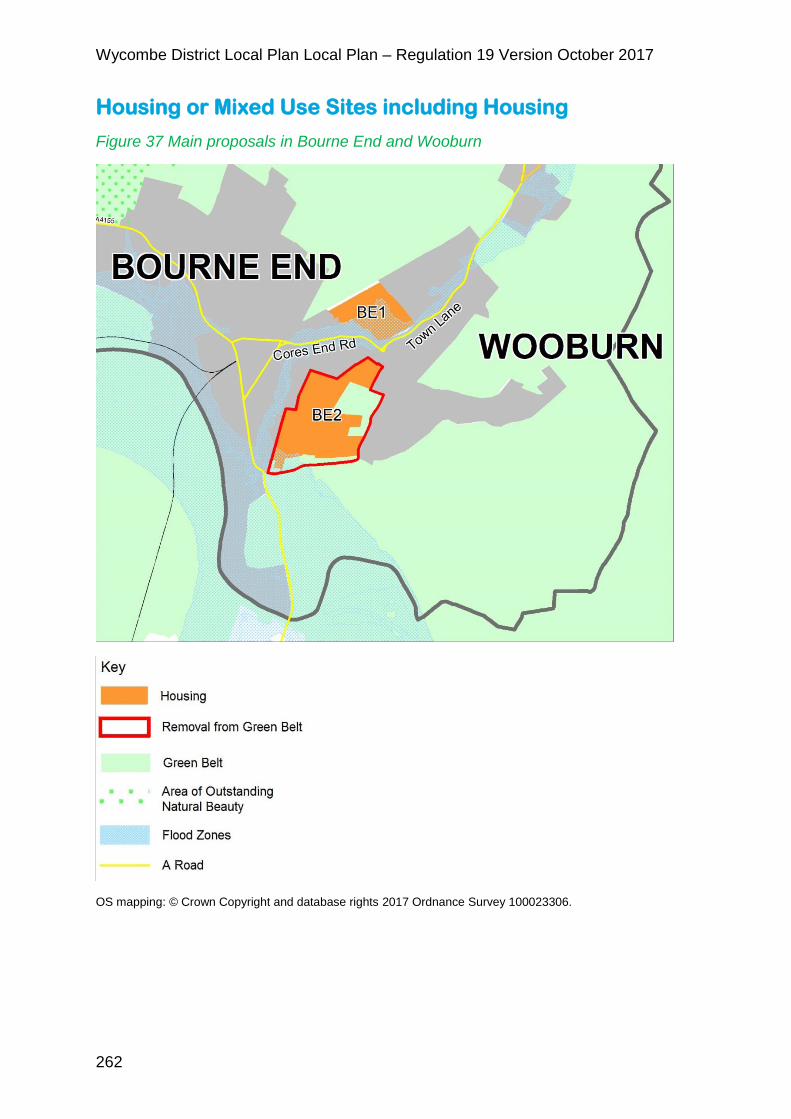
Housing or Mixed Use Sites including Housing
Figure 37 Main proposals in Bourne End and Wooburn
OS mapping: © Crown Copyright and database rights 2017 Ordnance Survey 100023306.

Wycombe District Local Plan Local Plan – Regulation 19 Version October 2017
263
5.4.5 The following sites are identified for housing or housing led mixed use
development. Site specific policies are included for these sites below.
Table 18 Sites identified for housing or housing-led mixed use development in the Bourne End and Wooburn area
Policy reference
Site Area (hectares)
Indicative dwelling numbers (617)
BE1 Slate Meadow, Bourne End and Wooburn
10.26 150
BE2 Hollands Farm, Bourne End and Wooburn
23.74 467
5.4.6 The following sites are also identified for housing or housing led mixed use
development and are shown on the policies map.
Table 19 Additional sites identified for housing in the Bourne End and Wooburn area
Site Area (hectares) Indicative dwelling numbers
Windrush House, Bourne End/Wooburn
0.15 8
BE1 – Slate Meadow
5.4.7 Slate Meadow is a 10 ha site located in Bourne End and Wooburn, the site
comprises three parcels of land between the A4094 and the former High
Wycombe to Bourne End railway, part of the site is a village green which
needs to be retained.
POLICY BE1 – SLATE MEADOW, BOURNE END AND WOOBURN
The site as shown on the Policies Map is allocated for residential development.
Development of the site will be required to:
1. Place making
a) Retain an undeveloped area between developed areas of Bourne End
Wycombe District Local Plan Local Plan – Regulation 19 Version October 2017
264
and Wooburn;
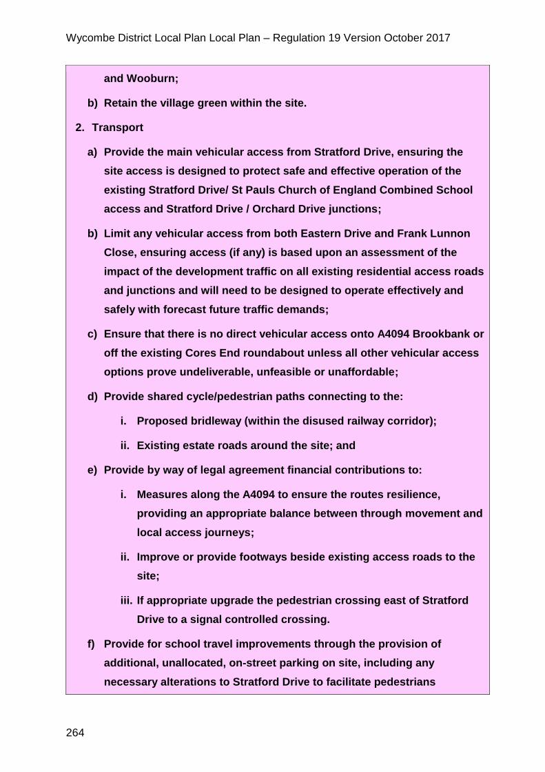
b) Retain the village green within the site.
2. Transport
a) Provide the main vehicular access from Stratford Drive, ensuring the
site access is designed to protect safe and effective operation of the
existing Stratford Drive/ St Pauls Church of England Combined School
access and Stratford Drive / Orchard Drive junctions;
b) Limit any vehicular access from both Eastern Drive and Frank Lunnon
Close, ensuring access (if any) is based upon an assessment of the
impact of the development traffic on all existing residential access roads
and junctions and will need to be designed to operate effectively and
safely with forecast future traffic demands;
c) Ensure that there is no direct vehicular access onto A4094 Brookbank or
off the existing Cores End roundabout unless all other vehicular access
options prove undeliverable, unfeasible or unaffordable;
d) Provide shared cycle/pedestrian paths connecting to the:
i. Proposed bridleway (within the disused railway corridor);
ii. Existing estate roads around the site; and
e) Provide by way of legal agreement financial contributions to:
i. Measures along the A4094 to ensure the routes resilience,
providing an appropriate balance between through movement and
local access journeys;
ii. Improve or provide footways beside existing access roads to the
site;
iii. If appropriate upgrade the pedestrian crossing east of Stratford
Drive to a signal controlled crossing.
f) Provide for school travel improvements through the provision of
additional, unallocated, on-street parking on site, including any
necessary alterations to Stratford Drive to facilitate pedestrians
Wycombe District Local Plan Local Plan – Regulation 19 Version October 2017
265
crossing from the development to the school and back.
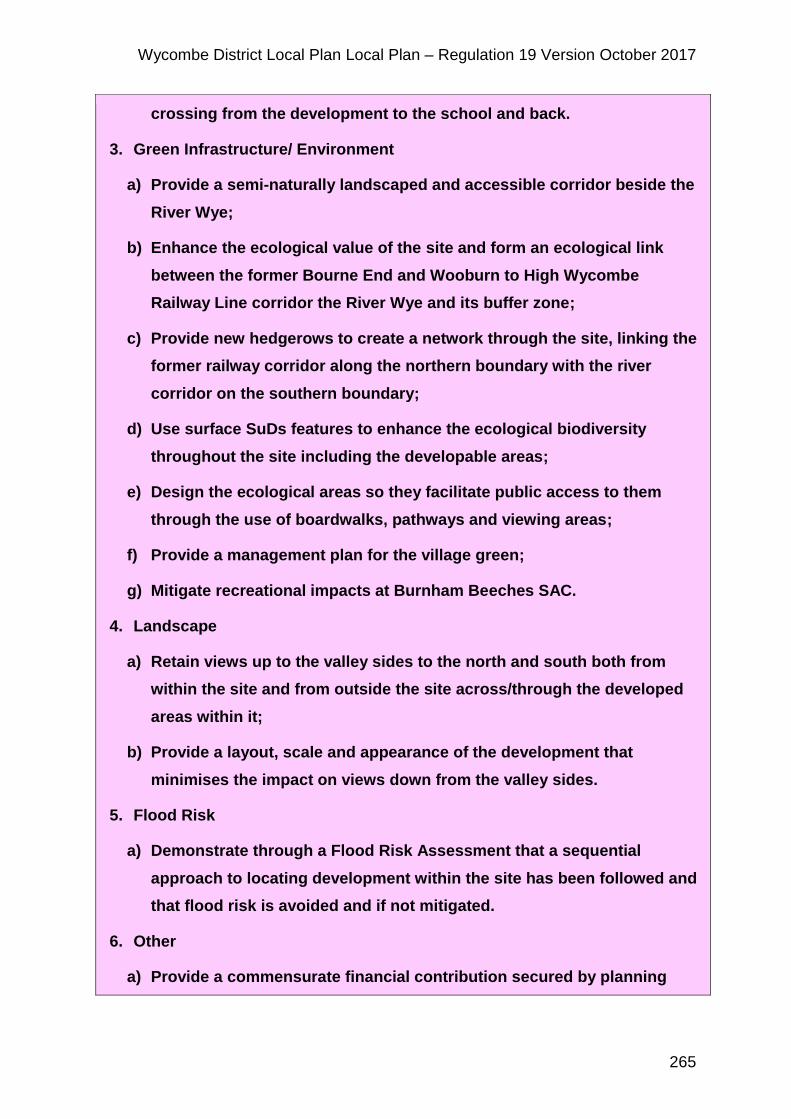
3. Green Infrastructure/ Environment
a) Provide a semi-naturally landscaped and accessible corridor beside the
River Wye;
b) Enhance the ecological value of the site and form an ecological link
between the former Bourne End and Wooburn to High Wycombe
Railway Line corridor the River Wye and its buffer zone;
c) Provide new hedgerows to create a network through the site, linking the
former railway corridor along the northern boundary with the river
corridor on the southern boundary;
d) Use surface SuDs features to enhance the ecological biodiversity
throughout the site including the developable areas;
e) Design the ecological areas so they facilitate public access to them
through the use of boardwalks, pathways and viewing areas;
f) Provide a management plan for the village green;
g) Mitigate recreational impacts at Burnham Beeches SAC.
4. Landscape
a) Retain views up to the valley sides to the north and south both from
within the site and from outside the site across/through the developed
areas within it;
b) Provide a layout, scale and appearance of the development that
minimises the impact on views down from the valley sides.
5. Flood Risk
a) Demonstrate through a Flood Risk Assessment that a sequential
approach to locating development within the site has been followed and
that flood risk is avoided and if not mitigated.
6. Other
a) Provide a commensurate financial contribution secured by planning

Wycombe District Local Plan Local Plan – Regulation 19 Version October 2017
266
obligation for primary education provision to meet the need for primary
school places from the development.
Figure 38 Slate Meadow - illustrative layout
5.4.8 The indicative capacity of the site is 150
5.4.9 Access to the site needs to be created in a way that does not have a
negative impact on the surrounding residential areas and does not
Wycombe District Local Plan Local Plan – Regulation 19 Version October 2017
267
compromise the flow of traffic on the A4094. Development proposals need to
ensure that the site integrates well with the surrounding road network and
makes appropriate improvements to the roads, junctions, crossings affected
by the increased traffic generation resulting from the development as well
ensuring that alternative modes of transport are also supported. In addition,
there will need to be pedestrian and cycle links to the surrounding area.
5.4.10 Development offers the opportunity to improve and enhance existing green
infrastructure and ecological features on and adjacent to the allocated site,
particularly the River Wye and the former railway line. Management
proposals that improve the ecological value of these areas and improve
access and use of the village green will be taken into consideration when
assessing the impact of the proposal upon the open space contribution of
the site to the local area.
5.4.11 In line with the Habitats Regulations Assessment Screening Report
findings121 and Natural England’s advice in order to minimise recreational
impacts on Burnham Beeches Special Area of Conservation, open space for
informal recreational purposes needs to be provided in addition to the
requirements of DM16. It is possible that this could be provided on site, but a
strategic preference would be in the form of S106 contribution to be directed
to the development of the Little Marlow Lakes Country Park, improving
access to the park by sustainable travel modes as well as improvement to
the park itself. This is in addition to the requirements of DM16.
5.4.12 The management plan for the Village Green (adjacent to the site) will
address how to balance its ecological diversity with the impact of dog
walking and informal recreation. If it is proposed that the village green plays
a part in the open space provision for the development, a financial
contribution for its ongoing maintenance will also be required as part of the
management plan.
121 Habitats Regulations Screening Report of the Wycombe District Local Plan (September 2017, Wycombe District Council)
Wycombe District Local Plan Local Plan – Regulation 19 Version October 2017
268
5.4.13 Proposals for this site need to address views to the hillside immediate to the
north and as well leaving an undeveloped break between Bourne End and
Wooburn.
5.4.14 Part of the site is in fluvial flood risk zone 2 and 3 and has surface and
groundwater flood risk areas. Development proposals will need to be
supported by a site specific flood risk assessment which demonstrates that a
sequential approach to locating development within the site has been
followed, ensuring vulnerable uses are not located in inappropriate locations,
and that flood risk from all sources is mitigated, through the implementation
and continuous management of suitable Sustainable Drainage Systems.
Applicants should refer to the SFRA level 1 and 2122.
5.4.15 The County Council provides primary education, and it is appropriate that
this site contributes to that provision. A new school is to be provided at
Hollands Farm. The County will direct the funds to the most appropriate
location depending on the timing of the development.
BE2 – Hollands Farm
5.4.16 The site is located towards the south of Bourne End between Hawks Hill and
Wessex Road. It is a 23.7 hectare greenfield site.
POLICY BE2 – HOLLANDS FARM , BOURNE END AND WOOBURN
The site as shown on the Policies Map is allocated for residential-led mixed
use.
Development of the site is required to :
1. Placemaking
a) Adopt a landscape-led positive approach to design and layout to limit
its impact on the landscape;
b) Not have an adverse impact on the setting of Hedsor Road and
122 Strategic Flood Risk Assessment (SFRA) Level 1 Update (November 2014, Jacobs) and Level 2 Strategic Flood Risk Assessment (September 2017, Jacobs)
Wycombe District Local Plan Local Plan – Regulation 19 Version October 2017
269
Riversdale Bourne End and Wooburn Conservation Area;
c) Maintain a sense of separation between Harvest Hill and the new
development site;
d) Ensure satisfactory relationship to the industrial buildings at Millboard
Road Employment Area on the western boundary.
2. Transport
a) Provide a link road through the site linking to the Cores End Road
roundabout and Ferry Lane;
b) Provide a redirected bus service and enhanced provision through the
site;
c) Provide contributions to off-site highway improvements as required by
the Highway Authority;
d) Provide and enhance footpath and cycle links to the village centre.
3. Green Infrastructure/ Environment
a) Provide on-site high quality open space;
b) Provide S106 contributions to mitigate recreational impacts at Burnham
Beeches SAC;
c) Maintain north south connectivity for Public Rights of Way through the
site;
d) Protect and enhance the biodiversity and green infrastructure value of
the former orchard in accordance with Policy DM34, providing public
access and ongoing management as part of the overall development.
Buildings within this area will not be acceptable;
e) Avoid areas of fluvial flood risk where possible;
f) Provide appropriate SuDS across the site.
4. Other
a) Provision of a 1 form entry primary school.
Wycombe District Local Plan Local Plan – Regulation 19 Version October 2017
270
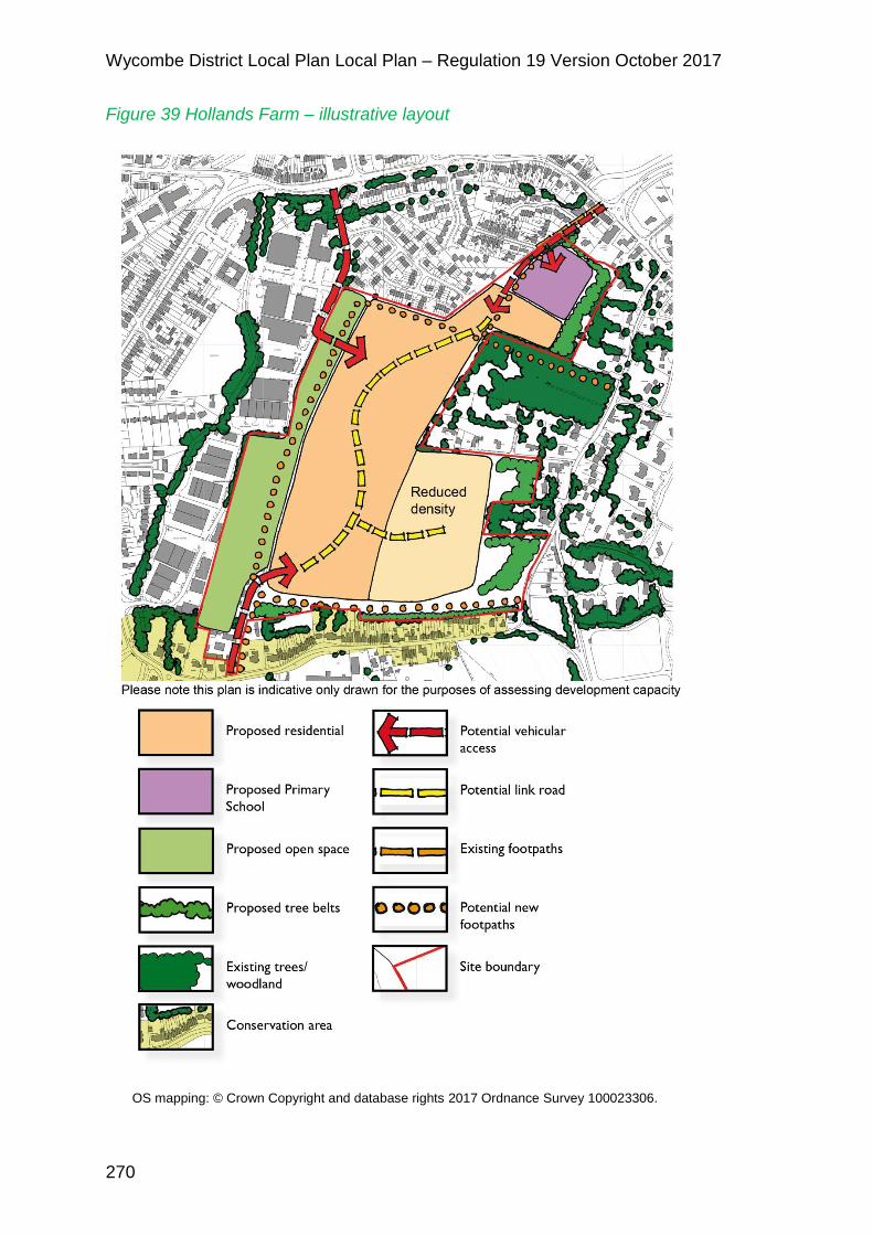
Figure 39 Hollands Farm – illustrative layout
OS mapping: © Crown Copyright and database rights 2017 Ordnance Survey 100023306.
Wycombe District Local Plan Local Plan – Regulation 19 Version October 2017
271
5.4.17 The indicative capacity of the site is 467 homes
5.4.18 The site is proposed to be taken out of the Green Belt and allocated for
residential purposes. The Green Belt Part 2 report123 has reviewed this site
and indicates that exceptional circumstances exist in this case for removing
the site from the Green Belt.
5.4.19 There are a number of issues and constraints that will need to be carefully
taken into account in the development of this site. These include the
proximity of the Hedsor Road and Riversdale Conservation Area, nearby
heritage assets124, an area of fluvial flood risk in the south west corner of the
site, and some surface and groundwater flood risk. Any development will
need to be carefully integrated with and connected to the village and the
traffic impact arising from the development addressed. A development brief
will be prepared for the site to address these issues in more detail.
5.4.20 A buffer should be provided between the development and the Harvest Hill
area to minimise the impact on the area and maintain a degree of
separation. This could be achieved for example through structural planting
and landscaping or open space such as a village green. The former orchard
referred to in point 3 d) of the policy comprises approximately 2.2 ha sited
between the dwellings known as Fairholme and Mendip, at Hawks Hill. It will
contribute to this buffer.
5.4.21 In relation to traffic generation the Council has assessed the impact of
increased traffic resulting from this site125 and identified that provision of a
link road through the site between the Cores End Roundabout and Ferry
Lane will benefit existing roads in the Bourne End area. This would also
relieve the narrow Cores End Road into the village centre as well as
distribute traffic from the development.
5.4.22 It is important that development of this scale is well served by public
transport. There is scope, particularly with the link road to divert existing bus
123 Green Belt Part Two Assessment (September 2017, Wycombe District Council) 124 Hedsor Road and Riversdale draft Conservation Area Appraisal (September 2017, Wycombe District Council) 125 Wycombe Local Plan Sites Traffic Modelling (June 2017, Jacobs)
Wycombe District Local Plan Local Plan – Regulation 19 Version October 2017
272
services through the site to serve the development. The road is to be
designed to accommodate buses, to provide future flexibility.
5.4.23 Flood risk issues should be fully addressed in any development proposals,
including the potential for fluvial, surface water and groundwater flooding.
Applicants should refer to the SFRA level 1 and 2126. Assessments will be
required and appropriate mitigation measures identified and implemented.
5.4.24 The Infrastructure Delivery Plan has identified that developments in Bourne
End result in the need for an additional single form of entry primary school.
Due to its size it is more suitable that this is provided on the Hollands Farm
site. Contributions from other developments will need to contribute towards
the delivery of the school on a proportionate basis.
5.4.25 In line with the Habitats Regulations Assessment Screening Report
findings127 and Natural England’s advice in order to minimise recreational
impacts on Burnham Beeches Special Area of Conservation, an S106
contribution will be directed to the development of the Little Marlow Lakes
Country Park, improving access to the park by sustainable travel modes as
well as improvement to the park itself. This is in addition to the requirements
of DM16.
126 Strategic Flood Risk Assessment (SFRA) Level 1 Update (November 2014, Jacobs) and Level 2 Strategic Flood Risk Assessment (September 2017, Jacobs) 127 Habitats Regulations Screening Report of the Wycombe District Local Plan (September 2017, Wycombe District Council)
Wycombe District Local Plan Local Plan – Regulation 19 Version October 2017
273
Other development
BE3 – Health Facilities in Bourne End and Wooburn
5.4.26 In assessing the infrastructure requirements for proposed development in
Bourne End and Wooburn, the Infrastructure Delivery Plan has identified
increased demand on primary health care.
POLICY BE3 – HEALTH FACILITIES IN BOURNE END AND WOOBURN
1. Proposals put forward by the local Clinical Commissioning Group or other
promoters for a new health centre in Bourne End and Wooburn will be
supported subject to transport assessment, parking arrangements and
other relevant planning considerations being satisfactory.
5.4.27 The Chiltern Clinical Commissioning Group has submitted practice plans to
NHS England to develop a new build surgery to house both Hawthornden
and Pound House practices, including their branch surgeries in a modern,
state of the art building with sufficient capacity to absorb expected population
growth.
5.4.28 A new health centre could be facilitated on the housing allocations at Slate
Meadow (BE1) or Land at Hollands Farm (BE2) subject to agreement with
landowners. Existing employment sites in Bourne End may also be a
suitable location. Any proposals must be accompanied by a comprehensive
transport assessment and ensure that adequate parking is also provided.
Sustainable travel modes should also be well catered for.