5.16 LIGHT EMISSIONS - Airport Sites
30
PORT COLUMBUS INTERNATIONAL AIRPORT ENVIRONMENTAL IMPACT STATEMENT FINAL Landrum & Brown Chapter Five – Environmental Consequences March 2009 Page 5.16-1 5.16 LIGHT EMISSIONS Airports have high-intensity lights to illuminate runways, taxiways, and gate areas, and to supply visual approach navigational aids, which are critical to the safe operation of an airport. This section presents the analysis of the impact of airport-related light emissions upon the residential areas surrounding Port Columbus International Airport (CMH or Airport) resulting from the project alternatives under consideration in this Environmental Impact Statement (EIS). 1 5.16.1 REGULATORY SETTING Only in unusual circumstances (e.g., when high-intensity strobe lights would shine directly into people's homes) would the impact of light emissions be considered sufficient to warrant special study and a more detailed examination of alternatives in an EIS. Light emissions are assessed to the “extent to which any lighting associated with an action will create an annoyance among people in the vicinity or interfere with their normal activities”. Airport facilities at CMH are illuminated by various types of lighting emanating from any of the following sources: Airfield lighting on runways, runway thresholds, taxiways, and ramps (runway lighting); Visual approach aids; Obstruction lights; Terminal and facilities lighting; and Roadway and parking lot lighting. Generally, lights located at the runway thresholds and in the approach area pose the greatest concern for potential impact. Therefore, the following light systems were evaluated: Approach lighting system; Visual glideslope indicators; Runway end lights; In-runway lighting; Runway edge lights; and Taxiway edge lights. 1 The light emissions analysis considered only airfield lighting, which would not include light emissions from restaurants, commercial office buildings, etc.
Transcript of 5.16 LIGHT EMISSIONS - Airport Sites

PORT COLUMBUS INTERNATIONAL AIRPORT ENVIRONMENTAL IMPACT STATEMENT FINAL
Landrum & Brown Chapter Five – Environmental Consequences March 2009 Page 5.16-1
5.16 LIGHT EMISSIONS Airports have high-intensity lights to illuminate runways, taxiways, and gate areas, and to supply visual approach navigational aids, which are critical to the safe operation of an airport. This section presents the analysis of the impact of airport-related light emissions upon the residential areas surrounding Port Columbus International Airport (CMH or Airport) resulting from the project alternatives under consideration in this Environmental Impact Statement (EIS).1 5.16.1 REGULATORY SETTING Only in unusual circumstances (e.g., when high-intensity strobe lights would shine directly into people's homes) would the impact of light emissions be considered sufficient to warrant special study and a more detailed examination of alternatives in an EIS. Light emissions are assessed to the “extent to which any lighting associated with an action will create an annoyance among people in the vicinity or interfere with their normal activities”. Airport facilities at CMH are illuminated by various types of lighting emanating from any of the following sources:
Airfield lighting on runways, runway thresholds, taxiways, and ramps (runway lighting);
Visual approach aids;
Obstruction lights;
Terminal and facilities lighting; and
Roadway and parking lot lighting.
Generally, lights located at the runway thresholds and in the approach area pose the greatest concern for potential impact. Therefore, the following light systems were evaluated:
Approach lighting system;
Visual glideslope indicators;
Runway end lights;
In-runway lighting;
Runway edge lights; and
Taxiway edge lights.
1 The light emissions analysis considered only airfield lighting, which would not include light
emissions from restaurants, commercial office buildings, etc.

PORT COLUMBUS INTERNATIONAL AIRPORT ENVIRONMENTAL IMPACT STATEMENT FINAL
Landrum & Brown Chapter Five – Environmental Consequences March 2009 Page 5.16-2
The following information is provided in the assessment for each lighting system:
Location of existing and future runway threshold lights, and approach light systems;
Descriptions of each airfield lighting system as to its purpose, intensity, color, flashing sequence, and beam angle; and
Assessment of the extent of annoyance caused by the CMH airfield lighting systems.
5.16.2 EXISTING CONDITIONS: 2006
This section describes conditions at the Airport as they existed during the preparation of this environmental document. The following paragraphs discuss the existing lighting systems in use at CMH. A summary of the existing lighting systems is presented in Table 5.16-1.
Approach Lighting Systems (ALS)
Approach lighting systems (ALS) provide the basic means to transition from instrument flight to visual flight for landing. It is a configuration of steady-burning sequenced flashing signal lights that appear to the pilot as a ball of light traveling toward the runway at high speed (twice a second). Operational requirements dictate the type and configuration of the approach light system for a particular runway.
All four runway ends include a Medium-intensity Approach Lighting System with Runway Alignment Indicator Lights (MALSR). This system uses medium-intensity lights to guide a pilot to the runway centerline as a flight progresses through the transition from instrument flight to visual flight during landing. The MALSR lighting system provides early runway lineup and lead-in guidance, runway end identification, and to a degree, roll guidance. The lights are helpful during some periods of restricted visibility. The MALSR system is beneficial where extraneous lighting prevents the pilot from lining up with the runway centerline or where the surrounding terrain is devoid of lighting and does not provide the cues necessary for proper aircraft attitude control.2 A diagram of a typical MALSR lighting system is shown in Exhibit 5.16-1, MALSR Lighting System.
2 Spence, C.F. (Ed). 2006. AIM/FAR Aeronautical Information Manual/Federal Aviation Regulations.
McGraw Hill: New York.
PORT COLUMBUS INTERNATIONAL AIRPORT ENVIRONMENTAL IMPACT STATEMENT FINAL
Landrum & Brown Chapter Five – Environmental Consequences March 2009 Page 5.16-3
Table 5.16-1 EXISTING AIRFIELD LIGHTING SYSTEMS Port Columbus International Airport
Runway End LIGHTING SYSTEM
10R 28L 10L 28R
Approach Lighting System MALSR MALSR MALSR MALSR
Visual Glideslope Indicators PAPI none PAPI PAPI
Runway End Identifier Lights none none none none
In-Runway Lighting none none none none
Runway Edge Lights HIRL HIRL HIRL HIRL
Notes: MALSR - Medium-intensity Approach Lighting System with Runway Alignment Indicator Lights
PAPI - Precision Approach Path Indicator
HIRL - High Intensity Runway Lights Source: AirNav website, accessed on August 16, 2007. http://www.airnav.com/airport/KCMH.
The runway threshold lights start 200 feet from the landing threshold and extend at 200-foot intervals into the approach area at a distance of 2,400 to 3,000 feet for precision instrument runways and 1,400 to 1,500 feet for non-precision instrument runways. There are generally seven light bars with five steady-burning lights for each bar. At the light bar 1,000 feet from the runway threshold, there are two additional bars (one on each side of the centerline bar) each with five steady-burning lights.3
Runway threshold lights consist of a line of green lights located perpendicular to the extended runway centerline not more than two feet or less than 100 feet from the designated threshold of the runway.
The lights of the MALSR lighting system are medium-intensity lights with intensity control provided. The lights are white and steady-burning, with green lights closest to the runway threshold. The MALSR lighting system does not use flashing lights. The lights are mounted on poles and aimed with their beam axis parallel to the runway centerline and intercepting an assumed 3-degree slope at a horizontal distance of 1,600 feet in advance of the light.
A MALSR lighting system is installed on Runway ends 10L, 10R, 28L, and 28R at CMH. The MALSR starts at the landing threshold and extends into the approach area a distance of 2,000 to 2,300 feet, depending on the runway end. Table 5.16-2 shows the nearest homes to each of the MALSR light bars.
3 FAA AC 150/5340-30B, Design and Installation Details for Airport Visual Aids, August 1, 2006.

PORT COLUMBUS INTERNATIONAL AIRPORT ENVIRONMENTAL IMPACT STATEMENT FINAL
Landrum & Brown Chapter Five – Environmental Consequences March 2009 Page 5.16-4
Table 5.16-2 DISTANCES FROM MALSR LIGHTS TO NEAREST HOMES BY RUNWAY END – EXISTING CONDITIONS Port Columbus International Airport
Runway Distance to
Nearest Home (in feet)
10R 1,400
28L 2,600
10L 1,300
28R 2,500
Source: Landrum & Brown, 2007.
Visual Glideslope Indicator: The Visual Glideslope Indicator is a system of lights arranged to provide visual descent guidance information during the approach to a runway.4 One such system, a Precision Approach Path Indicator (PAPI), provides a specific light pattern when the aircraft is on the desired descent path to the touchdown point. A diagram of a PAPI lighting system is shown in Exhibit 5.16-2, PAPI Lighting System.
The PAPI system includes four identical light units normally placed 50 feet from the left side of the runway providing visual approach slope information. The PAPI is a single horizontal bar with four sharp transition lamps installed on the left side of the runway. The system is located perpendicular to the runway centerline, at a distance from the threshold that provides the proper threshold crossing height and obstacle clearance.
Each lamp projects a split beam of light. The upper segment is white, and the lower segment is red. The transition from white to red, or vice versa, occurs within a vertical angle of five minutes of arc at the beam center and results in a well-defined corridor of light consisting of white (top) and red (bottom) beams. These systems have an effective visual range of about five miles during the day and up to 20 miles at night.
The PAPI lights are high-intensity lights that are red and white and are not sequenced flashing lights. The lights are installed on poles and the light beam is positioned to project 20 feet above the most critical obstruction in the area. At CMH, PAPI lights are installed at the ends of Runways 10L, 10R, and 28R. There is no PAPI at Runway End 28L.
4 FAA AC 150/5345-52, Generic Visual Glideslope Indicators (GVGI), 9/5/2007.

Port ColumbusInternational Airport
Environmental Impact Study
5.16-1
Exhibit:7/29/08P:\CMH\GIS_EIS_P150\GRAPHICS\ADMIN_DRAFT_EIS_Document\Working\5.16-1_MALSR.CDR
MALSR Lighting SystemFINAL
Green Lights
Flashing White
Lights
White Lights
Lights
Runway Landing Threshold

THIS PAGE INTENTIONALLY LEFT BLANK

Port ColumbusInternational Airport
Environmental Impact Study
5.16-2
Exhibit:7/29/08P:\CMH\GIS_EIS_P150\GRAPHICS\ADMIN_DRAFT_EIS_Document\Working\5.16-2_PAPI.CDR
FINAL
PAPI Lighting System

THIS PAGE INTENTIONALLY LEFT BLANK
PORT COLUMBUS INTERNATIONAL AIRPORT ENVIRONMENTAL IMPACT STATEMENT FINAL
Landrum & Brown Chapter Five – Environmental Consequences March 2009 Page 5.16-9
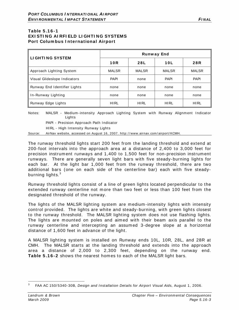
Table 5.16-3 shows the nearest home to each of the PAPI lighting systems. The lights are projected at such a steep upward angle that the light beam is above all surrounding buildings. Residences beyond each of these runway ends would not be impacted by the light emissions from the PAPI lighting systems at CMH.
Exhibits 5.16-3 through 5.16-6 show the lighting equipment installed at each of the four runway ends at CMH.
Table 5.16-3 DISTANCES FROM PAPI TO NEAREST HOMES BY RUNWAY END – EXISTING CONDITIONS Port Columbus International Airport
Runway Distance to
Nearest Home (in feet)
10R 2,800
28L n/a
10L 2,300
28R 2,300
Source: Landrum & Brown, 2007.
Runway Edge Light Systems
HIRL are used to outline the edges of a runway during periods of darkness and low visibility weather conditions. They are used on runways having precision Instrument Flight Rules (IFR) approach procedures and for runways utilizing Runway Visual Range (RVR). The lights are located approximately 200 feet apart with a maximum height of 24 inches above the pavement elevation.
The light emitted from HIRLs is white, except that yellow light is substituted for white light on the last 2,000 feet of an instrument runway, or one-half the runway length, whichever is less. The yellow lights indicate the caution zone for landing. The lights in the caution zone emit yellow light in the direction facing the instrument approach threshold and white light in the opposite direction.
The lights marking the ends of the runway emit red light toward the runway to indicate the end of the runway to a departing aircraft and emit green outward from the runway end to indicate the threshold to landing aircraft.5 HIRLs do not use sequenced flashing lights. The yellow and green lights are directed facing the instrument approach threshold. The white and red lights are directed toward the runway.
5 FAA AC 150/5340-30B, Design and Installation Details for Airport Visual Aids, August 1, 2006.

PORT COLUMBUS INTERNATIONAL AIRPORT ENVIRONMENTAL IMPACT STATEMENT FINAL
Landrum & Brown Chapter Five – Environmental Consequences March 2009 Page 5.16-10
Other Airport Lighting
A rotating beacon identifies the location of the Airport at night and is identified by projecting a green and white beam of light 180 degrees apart.
Obstructions in the vicinity of the Airport are also marked or lighted to warn pilots of their presence. These obstructions may be identified by a steady-red, flashing-red, or white strobe light. These obstructions are identified for pilots on approach and sectional Visual Flight Rules (VFR) charts and on the official Airport Obstruction Chart, published by the National Oceanic and Atmospheric Administration (NOAA).
Other lighting exists along the taxiways and ramps for low visibility purposes and to assist aircraft movement on the airfield, such as hold position lights, stop bar lights, and runway and taxiway signage. Each of these additional light systems is located within the Airport complex and represent no impact upon neighboring communities.
5.16.3 FUTURE CONDITIONS: 2012
The following section describes the conditions that would result from the lighting required by each of the proposed runway alternatives during the first full year in which the proposed relocated runway is anticipated to be operational. While the same types of lighting systems described for the existing conditions are expected to be used for each of the proposed runway alternatives, the location of lighting equipment in relation to homes will change due to the proposed relocation of Runway 10R/28L.
Alternative A: No Action
Under this Alternative, Runway 10R/28L would remain in its current location and therefore no changes to the existing lighting equipment or locations would occur.
Alternative C2a: Relocate Runway 10R/28L 800 Feet to the South – Noise Abatement Scenario A
Alternative C2a includes the relocation of Runway 10R/28L 800 feet to the south. The relocated runway would include MALSR and PAPI lighting on both ends. These lights would move 800 feet south of the current location. In addition, the relocated runway would include a CAT-II approach to Runway 10R, which would increase the number of light stands in the MALSR system from 8 to 15. The MALSR lights would not extend farther west than they currently do today; however, the lights would be spaced closer together. Exhibit 5.16-7, Runway 10X (Alternative C2) MALSR and PAPI Locations, and Exhibit 5.16-8, Runway 28X (Alternative C2) MALSR Location, show the location of the proposed lighting equipment for Alternative C2a. Table 5.16-4 and Table 5.16-5 show the distances from the MALSR and PAPI equipment to the nearest homes under this alternative.

"
"""""" """ """ "
""
""""
""""""""""""""""""""""""
"""""""""""""""
""""""
"""
" """"""""
" ""
"
"
""
"
" ""
"
"
"
MifflinTownship
10R
JOHNSTOWN RDOLE COUNTRY LN
STEL
ZER
RD
BRIDGEWAY AV
MARILYN PARK LN
STER
LING
AV
LONE SPRUCE RD
SEVENTEENTH AV
DRAKE RD
OLE COUNTRY LN
PAPI
1/20/2009 Prepared by Landrum & BrownFilename: P:\CMH\GIS_EIS_P150\MXD\EXHIBITS\EIS\5.16-3_Runway End 10L Lighting Equipment.mxd
FINALEnvironmental Impact StatementPort Columbus International Airport
Exhibit:5.16-3Runway End 10L Lighting Equipment
Legend
±0 600
'
MALSR
10L
Close
st res
idenc
e is 1
,300'
Closest residence is 2,300'
'
Airport Property BoundaryResidenceSteady White LightSequenced Flashing Light

THIS PAGE INTENTIONALLY LEFT BLANK

"
""""""" """
"""""""""""""""""""""""""
"""""""""""""
"""""""""""""""""
""""""""""""""""""
"""
"""
"""
"""
"""""""""""""""""""""""
""""""""""""""""""""""
""""""""
"""""""""""""""" ""
""""""""""""""""""""
""
"""""""""
"""""""""""""""""""
"""""""" ""
"""
""""""""""""""""""""""""" """" "
"""
"""""""""
"""
""""""
""""""""""""""""
""""""
""""""
"""""
"""""""
""""""""""""""""""""""""""""
"""""
""""""""""""""""""""""""""""""""
""
"""
"
"
""
"
""
""
""""
"" """
""""
"""
""
" """"" """"""""""""" "
""" "" ""
""""
"
"
""
""""""
"""
"""""""""
""
""""""" "" "" "
"""""""
""""""""
" "
"
"
"
""""
"
CENTER ST
FIFTH AV
SOUTH ST
NORTH ST
ELEVENTH AV
SEVENTH AV
TENT
H ST
STEL
ZER
RD
SIXTH AV
TWELFTH AV
KRUM
M AV
STERLING LN
THIRTEENTH AVOS
BORN
AV
THIRTEENTH ST
FIFTH
ST
FIRST
ST
JAMES RD
SIXTH
ST
NINT
H ST
EIGHT
H ST
SECO
ND S
T
SEVE
NTH
ST
SEVENTH AV
FIFTH AV
PAPI
1/20/2009 Prepared by Landrum & BrownFilename: P:\CMH\GIS_EIS_P150\MXD\EXHIBITS\EIS\5.16-4_Runway End 10R Lighting Equipment.mxd
FINALEnvironmental Impact StatementPort Columbus International Airport
Exhibit:5.16-4Runway End 10R Lighting Equipment
Legend
±0 600
'
MALSR
10R
Closest residence is 2,800'
Close
st res
idenc
e is 1
,400'
'
Airport Property BoundaryResidenceSteady White LightSequenced Flashing Light
StelzerCemetery

THIS PAGE INTENTIONALLY LEFT BLANK

"
"""""
""
"
"""
""
"
"
"
"
"
""""
"
"""""
"
"""""
"""
""""""
"
""
"
"
"
""
""""""""
"""""
"""
""""
""
""
""
"""""""""""" """
"""
"""""
""""
" ""
" "" "
" " """ " ""
"
" """ ""
"
"
"""
"""""""""
""
"""""
"""
"
""""
""
"""
"""
"
"
"
"
"""
"""
"" "
"
"
"
"
"
""
" "
"
"
" "
""
""
" "
""
"" "
JAMES RD
MORRISON RDPRICE RD
ROCKY FORK DR S
SAWYER RD
HEMSTON DR
ARBORS CIR
WATERBURY BLVD
OBERLIN CT N HEMSTON CT
PRICE RD
JAME
S RD
SAWYER RD
PAPI
1/20/2009 Prepared by Landrum & BrownFilename: P:\CMH\GIS_EIS_P150\MXD\EXHIBITS\EIS\5.16-5_Runway End 28R Lighting Equipment.mxd
FINALEnvironmental Impact StatementPort Columbus International Airport
Exhibit:5.16-5Runway End 28R Lighting Equipment
Legend
±0 600
'MALSR
28R
'
Closest residence is 2,300'
Closest re
sidence
is 2,500'
Airport Property BoundaryResidenceSteady White LightSequenced Flashing Light
PetCemetery

THIS PAGE INTENTIONALLY LEFT BLANK

"
"
" "
"
"
""
"""
" ""
" "
""
""
"
" " "
"""
"
"
"
""""
"
"
FIFTH
AV
MORRISON RD
LEAVITT SERVICE RD
HAMI
LTON
RD
CLAY
CRAF
T RD
BRICKLAWN AV
WESTBOURNE AV
WINDING WOODS BL
WILDBERRY LN
WELLINGTON WOODS BL
PALM SPRINGS DR
WELLINGTON WILLOWS WAY
BEVERLY HILLS DRWOOD
CLIFF
DR
OLD MORRISON RD
SANTA MONICA DR
WINDCHIME WAY
SANTA ROSA
CARD
INAL
PARK
DR SANTA CLARA
MORR
ISON
RD
1/20/2009 Prepared by Landrum & BrownFilename: P:\CMH\GIS_EIS_P150\MXD\EXHIBITS\EIS\5.16-6_Runway End 28L Lighting Equipment.mxd
FINALEnvironmental Impact StatementPort Columbus International Airport
Exhibit:5.16-6Runway End 28L Lighting Equipment
Legend
±0 600
'
MALSR28
L
Closest residence is 2,600'
'
Airport Property BoundaryResidenceSteady White LightSequenced Flashing Light

THIS PAGE INTENTIONALLY LEFT BLANK

"
""""""" """
"""""""""""""""""""""""""
"""""""""""""
"""""""""""""""""
""""""""""""""""""
"""
"""
"""
"""
"""""""""""""""""""""""
""""""""""""""""""""""
""""""""
"""""""""""""""" ""
""""""""""""""""""""
""
"""""""""
"""""""""""""""""""
"""""""" ""
"""
""""""""""""""""""""""""" """" "
"""
"""""""""
"""
""""""
""""""""""""""""
""""""
""""""
"""""
"""""""
""""""""""""""""""""""""""""
"""""
""""""""""""""""""""""""""""""""
""
"""
"
"
""
"
""
""
""""
"" """
""""
"""
""
" """"" """"""""""""" "
""" "" ""
""""
"
"
""
""""""
"""
"""""""""
""
""""" "" "" "" "
"""""""
""""""""
" "
"
"
"
""""
"
CENTER ST
FIFTH AV
SOUTH ST
NORTH ST
ELEVENTH AV
TENT
H ST
SEVENTH AV
STEL
ZER
RD
SIXTH AV
KRUM
M AV
OSBO
RN AV
TWELFTH AV
STERLING LN
THIRTEENTH AV
FIFTH
ST
THIRTEENTH ST
FIRST
ST
JAMES RD
SIXTH
ST
NINT
H ST
EIGHT
H ST
SECO
ND S
T
SEVE
NTH
ST
FIFTH AV
SEVENTH AV
FIFTH AV
PAPI
1/21/2009 Prepared by Landrum & BrownFilename: P:\CMH\GIS_EIS_P150\MXD\EXHIBITS\EIS\5.16-7_Runway 10X (Alternative C2) MALSR and PAPI Locations.mxd
FINALEnvironmental Impact StatementPort Columbus International Airport
Exhibit:5.16-7
Runway 10X (Alternative C2)MALSR and PAPI Locations
Legend
±0 600
'
MALSR
10X
Closest residence is 2,000'
Close
st res
idenc
eis
700'
'
Airport Property BoundaryResidenceSteady White LightSequenced Flashing Light
Relocate Runway10R/28L 800 feet South
StelzerCemetery

THIS PAGE INTENTIONALLY LEFT BLANK
""
""
"
"
"" "
"
"
"
"
"
" "
"
"
""
"""
" ""
" "
""
""
"
" " "
"""
"
"
"
""""
"
"
"
"
FIFTH AV
MORRISON RD
HAMI
LTON
RD
WOOD
CLIFF
DR
SAN GABRIEL DR
CLAY
CRAF
T RD
BEVERLY HILLS DR
WINDING WOODS BL
WILDBERRY LN
BRICKLAWN AV
WELLINGTON WOODS BL
PALM SPRINGS DR
WELLINGTON WILLOWS WAY
SANTA MONICA DR
CARD
INAL
PARK
DR
LEAVITT SERVICE RD
WINDCHIME WAY
SANTA ROSA
SANTA CLARA
HAMILTON RD
1/20/2009 Prepared by Landrum & BrownFilename: P:\CMH\GIS_EIS_P150\MXD\EXHIBITS\EIS\Runway 28X (Alternative C2) MALSR Location.mxd
FINALEnvironmental Impact StatementPort Columbus International Airport
Exhibit:5.16-8Runway 28X (Alternative C2)
MALSR Location
Legend
±0 600
'
MALSR
Closest residence is 2,000'
'
Airport Property BoundaryResidenceSteady White LightSequenced Flashing Light
28X
Relocate Runway10R/28L 800 feet South

THIS PAGE INTENTIONALLY LEFT BLANK
PORT COLUMBUS INTERNATIONAL AIRPORT ENVIRONMENTAL IMPACT STATEMENT FINAL
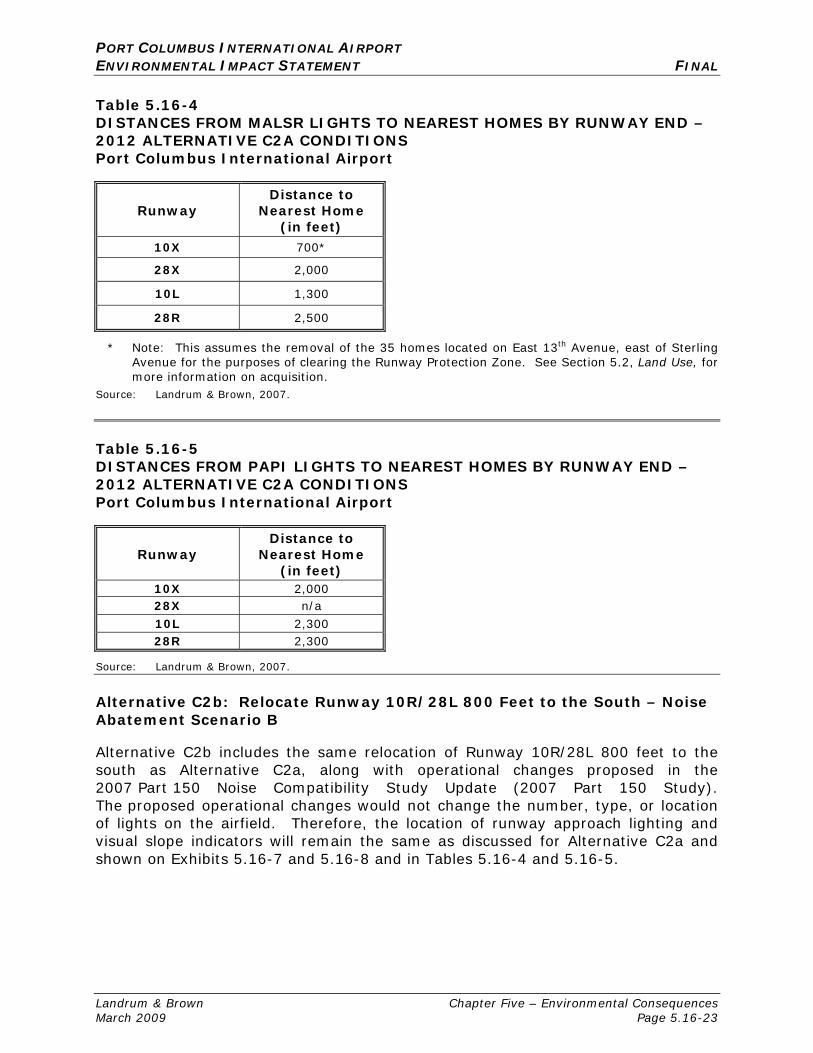
Landrum & Brown Chapter Five – Environmental Consequences March 2009 Page 5.16-23
Table 5.16-4 DISTANCES FROM MALSR LIGHTS TO NEAREST HOMES BY RUNWAY END – 2012 ALTERNATIVE C2A CONDITIONS Port Columbus International Airport
Runway Distance to
Nearest Home (in feet)
10X 700*
28X 2,000
10L 1,300
28R 2,500
* Note: This assumes the removal of the 35 homes located on East 13th Avenue, east of Sterling Avenue for the purposes of clearing the Runway Protection Zone. See Section 5.2, Land Use, for more information on acquisition.
Source: Landrum & Brown, 2007.
Table 5.16-5 DISTANCES FROM PAPI LIGHTS TO NEAREST HOMES BY RUNWAY END – 2012 ALTERNATIVE C2A CONDITIONS Port Columbus International Airport
Runway Distance to
Nearest Home (in feet)
10X 2,000 28X n/a 10L 2,300 28R 2,300
Source: Landrum & Brown, 2007.
Alternative C2b: Relocate Runway 10R/28L 800 Feet to the South – Noise Abatement Scenario B
Alternative C2b includes the same relocation of Runway 10R/28L 800 feet to the south as Alternative C2a, along with operational changes proposed in the 2007 Part 150 Noise Compatibility Study Update (2007 Part 150 Study). The proposed operational changes would not change the number, type, or location of lights on the airfield. Therefore, the location of runway approach lighting and visual slope indicators will remain the same as discussed for Alternative C2a and shown on Exhibits 5.16-7 and 5.16-8 and in Tables 5.16-4 and 5.16-5.
PORT COLUMBUS INTERNATIONAL AIRPORT ENVIRONMENTAL IMPACT STATEMENT FINAL
Landrum & Brown Chapter Five – Environmental Consequences March 2009 Page 5.16-24
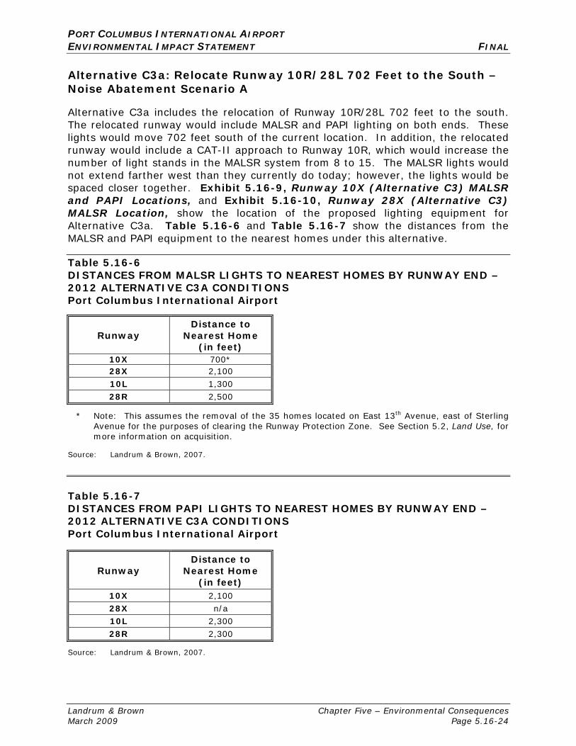
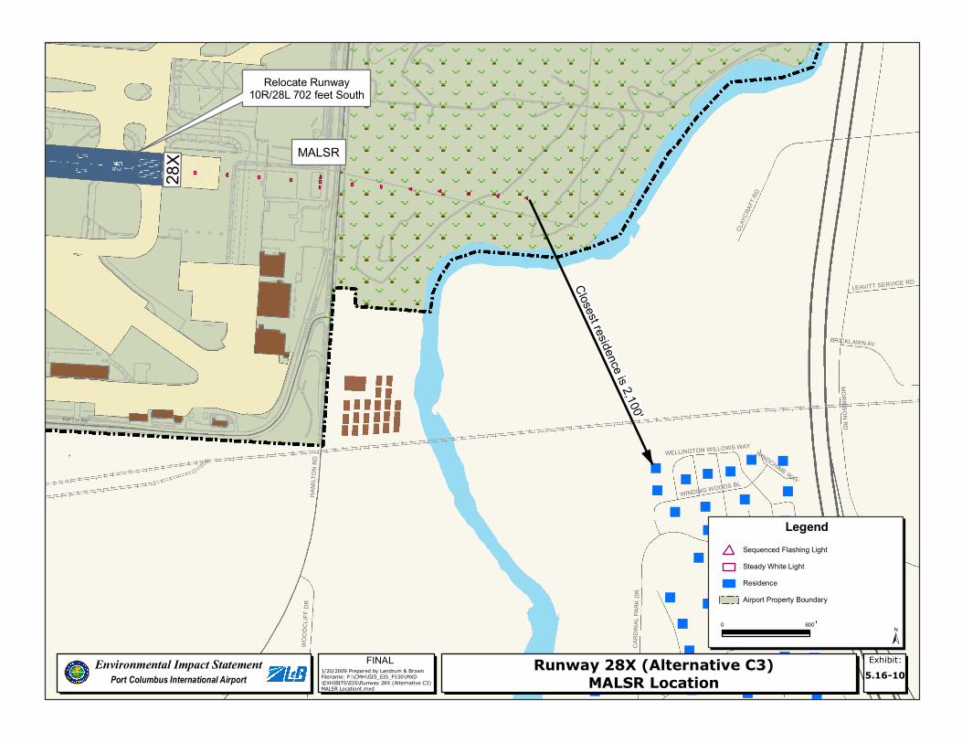
Alternative C3a: Relocate Runway 10R/28L 702 Feet to the South – Noise Abatement Scenario A
Alternative C3a includes the relocation of Runway 10R/28L 702 feet to the south. The relocated runway would include MALSR and PAPI lighting on both ends. These lights would move 702 feet south of the current location. In addition, the relocated runway would include a CAT-II approach to Runway 10R, which would increase the number of light stands in the MALSR system from 8 to 15. The MALSR lights would not extend farther west than they currently do today; however, the lights would be spaced closer together. Exhibit 5.16-9, Runway 10X (Alternative C3) MALSR and PAPI Locations, and Exhibit 5.16-10, Runway 28X (Alternative C3) MALSR Location, show the location of the proposed lighting equipment for Alternative C3a. Table 5.16-6 and Table 5.16-7 show the distances from the MALSR and PAPI equipment to the nearest homes under this alternative.
Table 5.16-6 DISTANCES FROM MALSR LIGHTS TO NEAREST HOMES BY RUNWAY END – 2012 ALTERNATIVE C3A CONDITIONS Port Columbus International Airport
Runway Distance to
Nearest Home (in feet)
10X 700* 28X 2,100 10L 1,300 28R 2,500
* Note: This assumes the removal of the 35 homes located on East 13th Avenue, east of Sterling Avenue for the purposes of clearing the Runway Protection Zone. See Section 5.2, Land Use, for more information on acquisition.
Source: Landrum & Brown, 2007.
Table 5.16-7 DISTANCES FROM PAPI LIGHTS TO NEAREST HOMES BY RUNWAY END – 2012 ALTERNATIVE C3A CONDITIONS Port Columbus International Airport
Runway Distance to
Nearest Home (in feet)
10X 2,100 28X n/a 10L 2,300 28R 2,300
Source: Landrum & Brown, 2007.

"
""""""" """
"""""""""""""""""""""""""
"""""""""""""
"""""""""""""""""
""""""""""""""""""
"""
"""
"""
"""
"""""""""""""""""""""""
""""""""""""""""""""""
""""""""
"""""""""""""""" ""
""""""""""""""""""""
""
"""""""""
"""""""""""""""""""
"""""""" ""
"""
""""""""""""""""""""""""" """" "
"""
"""""""""
"""
""""""
""""""""""""""""
""""""
""""""
"""""
"""""""
""""""""""""""""""""""""""""
"""""
""""""""""""""""""""""""""""""""
""
"""
"
"
""
"
""
""
""""
"" """
""""
"""
""
" """"" """"""""""""" "
""" "" ""
""""
"
"
""
""""""
"""
"""""""""
""
""""" "" "" "" "
"""""""
""""""""
" "
"
"
"
""""
"
CENTER ST
FIFTH AV
SOUTH ST
NORTH ST
ELEVENTH AV
TENT
H ST
SEVENTH AV
STEL
ZER
RD
SIXTH AV
KRUM
M AV
OSBO
RN AV
TWELFTH AV
STERLING LN
THIRTEENTH AV
FIFTH
ST
THIRTEENTH ST
FIRST
ST
JAMES RD
SIXTH
ST
NINT
H ST
EIGHT
H ST
SECO
ND S
T
SEVE
NTH
ST
FIFTH AV
SEVENTH AV
FIFTH AV
PAPI
7/29/2008 Prepared by Landrum & BrownFilename: P:\CMH\GIS_EIS_P150\MXD\EXHIBITS\EIS\Runway 10X (Alternative C3) MALSR and PAPI Locations.mxd
FINALEnvironmental Impact StatementPort Columbus International Airport
Exhibit:5.16-9
Runway 10X (Alternative C3)MALSR and PAPI Locations
Legend
±0 600
'
MALSR
10X
Closest residence is 2,100'
Close
st res
idenc
eis
700'
'
Airport Property BoundaryResidenceSteady White LightSequenced Flashing Light
Relocate Runway10R/28L 702 feet South
StelzerCemetery

THIS PAGE INTENTIONALLY LEFT BLANK
""
"
"
"
"" "
"
"
"
"
" "
"
"
""
"""
" ""
" "
""
""
"
" " "
"""
"
"
"
""""
"
"
"
"
FIFTH AV
MORRISON RD
HAMI
LTON
RD
WOOD
CLIFF
DR
SAN GABRIEL DR
CLAY
CRAF
T RD
BEVERLY HILLS DR
WINDING WOODS BL
BRICKLAWN AV
WELLINGTON WOODS BL
PALM SPRINGS DR
WELLINGTON WILLOWS WAY
CARD
INAL
PARK
DR
LEAVITT SERVICE RD
WINDCHIME WAY
SANTA ROSA
SANTA CLARA
HAMILTON RD
1/20/2009 Prepared by Landrum & BrownFilename: P:\CMH\GIS_EIS_P150\MXD\EXHIBITS\EIS\Runway 28X (Alternative C3) MALSR Locationt.mxd
FINALEnvironmental Impact StatementPort Columbus International Airport
Exhibit:5.16-10Runway 28X (Alternative C3)
MALSR Location
Legend
±0 600
'
MALSR
Closest residence is 2,100'
'
Airport Property BoundaryResidenceSteady White LightSequenced Flashing Light
28X
Relocate Runway10R/28L 702 feet South

THIS PAGE INTENTIONALLY LEFT BLANK

PORT COLUMBUS INTERNATIONAL AIRPORT ENVIRONMENTAL IMPACT STATEMENT FINAL
Landrum & Brown Chapter Five – Environmental Consequences March 2009 Page 5.16-29
Alternative C3b: 2012 Relocate Runway 10R/28L 702 Feet to the South – Noise Abatement Scenario B (Sponsor’s Proposed Project)
Alternative C3b includes the same relocation of Runway 10R/28L 702 feet to the south as Alternative C3a, along with operational changes proposed in the 2007 Part 150 Study. The proposed operational changes would not change the number, type, or location of lights on the airfield. Therefore, the location of runway approach lighting and visual slope indicators will remain the same as discussed for Alternative C3a and shown on Exhibit 5.16-9 and Exhibit 5.16-10 and in Table 5.16-6 and Table 5.16-7.
5.16.4 FUTURE CONDITIONS: 2018
Alternatives C2a, C2b, C3a, and C3b assume that by 2018, Phase 1 of the proposed passenger terminal will be constructed and in operation. However, any new lighting associated with the proposed passenger terminal would be located in the middle of Airport property and therefore would not affect any residences. No additional changes to the airfield lighting are anticipated to occur between 2012 and 2018. Therefore, the conditions and potential impacts described for the 2012 Alternatives would remain the same for each of the 2018 Alternatives.
5.16.5 VISUAL IMPACTS
According to FAA Order 1050.1E, “Visual or aesthetic impacts are inherently more difficult to define because of the subjectivity involved”. Analysis of visual impacts refers to “…the extent that the development contrasts with the existing environment…”6 Because the location of the proposed development would occur entirely on Airport property, surrounded by existing commercial and industrial development, no adverse visual or aesthetic impacts are anticipated.
6 FAA Order 1050.1E: Environmental Impacts: Policies and Procedures, Appendix A, paragraph
12.2b. .

PORT COLUMBUS INTERNATIONAL AIRPORT ENVIRONMENTAL IMPACT STATEMENT FINAL
Landrum & Brown Chapter Five – Environmental Consequences March 2009 Page 5.16-30
THIS PAGE INTENTIONALLY LEFT BLANK