42285-013: Integrated Urban Environmental Management in ... · PDF file3.1.2 SWOT Analysis 8...
25
Integrated Urban Environmental Management in the Tonle Sap Basin Ministry of Public Works and Transport, Phnom Penh, Cambodia Urban Development Strategy Pursat 1 June 2014 Prepared with support from an ADB technical assistance (ADB TA 7986-CAM) 1 Approved on 31 July 2014 by Pursat Provincial Governor (MPWT Letter No. 008 PMU/ MPWT/ IUEMTB/ 14/ 30 July 2014)
Transcript of 42285-013: Integrated Urban Environmental Management in ... · PDF file3.1.2 SWOT Analysis 8...

Integrated Urban Environmental Management in the Tonle Sap Basin Ministry of Public Works and Transport, Phnom Penh, Cambodia
Urban Development Strategy Pursat
1
June 2014 Prepared with support from an ADB technical assistance (ADB TA 7986-CAM)
1 Approved on 31 July 2014 by Pursat Provincial Governor (MPWT Letter No. 008 PMU/ MPWT/ IUEMTB/ 14/ 30 July 2014)

Integrated Urban Environmental Management in the Tonle Sap Basin Urban Development Strategy Pursat, June 2014
i
Contents
1 Introduction 1 1.1 Background 1 1.2 Development Strategy Objectives 1 1.3 Components of the Strategy 2
2 Development Context 3 2.1 Regional and National Context 3
2.1.1 GMS 3 2.1.2 National Planning 3 2.1.3 Urban Planning 4 2.1.4 Transport Networks 4 2.1.5 Tonle Sap Protected Area 4
2.2 Population Growth and Urban Expansion 5 2.2.1 Current Population 5 2.2.2 Population Projections 6 2.2.3 Urban Development 6
3 Development Issues and Needs 8 3.1 Consultations 8
3.1.1 The Vision 8 3.1.2 SWOT Analysis 8 3.1.3 Other Consultations 9
3.2 Summary of Development Considerations 9 3.2.1 Environmental, Geographic and other Constraints 10
3.3 Role of the Strategy 12
4 Development Concepts 13 4.1 Growth Scenario 13 4.2 Development Targets 13 4.3 Directions for Growth 13 4.4 Development Framework 14
4.4.1 Development Principles and Rationale 14 4.4.2 Sustainable Development 14
4.5 Priority Actions 15
5 Phased Development Strategy 17 5.1 General 17 5.2 Development Strategy Phase 1 – 2014 to 2020 17
5.2.1 Components of Phase 1 18 5.3 Development Strategy Phase 2 – 2021 to 2025 18
5.3.1 Components of Phase 2 18 5.4 Development Strategy Phase 3 – 2026 to 2030 19
5.4.1 Components of Phase 3 19

Integrated Urban Environmental Management in the Tonle Sap Basin Urban Development Strategy Pursat, June 2014
ii
Abbreviations ADB Asian Development Bank CARM Cambodia Resident Mission (ADB) DPWT Department of Public Works and Transport (in provinces) EC European Commission EDF European Development Fund EIB European Investment Bank EU European Union GDP Gross Domestic Product GEF Global Environment Facility GIZ Deutsche Gesellschaft für Internationale Zusammenarbeit IDA International Development Association IFC International Finance Corporation (of the World Bank Group) JICA Japan International Cooperation Agency MCA Multi-Criteria Analysis MDGs Millennium Development Goals MEF Ministry of Economy and Finance MIME Ministry of Industry, Mines and Energy MLMUPC Ministry of Land Management, Urban Planning and Construction MOE Ministry of the Environment MOWRAM Ministry of Water Resources and Meteorology MPWT Ministry of Public Works and Transport NAPA National Adaptation Plan of Action to Climate Change NGO Non Governmental Organisation PDWRAM Provincial Department for Water Resources and Meteorology PPCR Pilot Program for Climate Resilience SOE State-Owned Enterprise TA Technical Assistance TSA Tonle Sap Authority UNDP United Nations Development Programme WB World Bank Group

Integrated Urban Environmental Management in the Tonle Sap Basin Urban Development Strategy Pursat, June 2014
iii
Consultant Team
Richard Mabbitt Urban Development Specialist/Team Leader
Bruce Pollock Municipal Engineer And Procurement Specialist
Lyndsay Chapple Solid Waste Management Specialist
Joji Reyes Economist/Municipal Finance Specialist
Maria Cleto Social Development and Resettlement Specialist
Kerry Blanch Institutional Development Specialist
Delfa Uy Environment Specialist
Phai Sok Heng Civil Engineer/Deputy Team Leader
Hak You Urban Development Specialist
Sour Sethy Solid Waste Management Specialist
Mao Dor Finance Specialist
Hem Socheth Economist/Accountant
Kol Prapey Social And Community Development Specialist
Mel Sophanna Resettlement Specialist
May Simorn Environment Specialist
Mak Sithirith Institutional Specialist
Disclaimer The views expressed in this report are those of the authors and do not necessarily reflect the views and policies of ADB or its Board of Governors, the governments they represent, or the Government of Cambodia. ADB or any of the above parties does not guarantee the accuracy of the data included in this publication and accepts no responsibility for any consequence of their use.

Integrated Urban Environmental Management in the Tonle Sap Basin Urban Development Strategy Pursat, June 2014
iv
Location of Pursat in the Tonle Sap Basin
Tonle Sap
0 10 20 Km
N Serei Saophoan
Siem Reap
Battambang
Stueng Saen
Kampong Chhnang
Pursat
Stoung
Chi Kraeng
Kralanh
Mongkol Borei
Banan
Moung Ruessei
Kandieng
Krakor
Baribour
Preah Netr Preah
Thmar Koul
Road No.5
Road No.6
Railway

Integrated Urban Environmental Management in the Tonle Sap Basin Urban Development Strategy Pursat, June 2014
1
1 Introduction
1.1 Background
1 Pursat is located about 174km north of Phnom Penh on National Road No.5. It is situated about 20km from the western edge of the Tonle Sap lake, on the banks of the Stueng Pursat river.
2 National Road No.5 is part of the GMS Southern Economic Corridor and the town is well placed to benefit from the economic growth that this, and its proximity to Phnom Penh, will generate. The town’s expansion needs to be planned and well-managed, and this should be done within the context of its surrounding area, or hinterland. Experience has shown that a suitable planning area for a medium-sized town is an area 20km x 20km. On this basis a strategy area was discussed and agreed with municipal and provincial stakeholders on 29
th August 2013 and this is shown in Figure
1.1 below.
3 National spatial planning policy2 sets the procedure for urban master plan preparation and
approval. However, there is no provision for plans between municipal level and provincial level. It is recommended that the Policy is amended to include strategic plans of this type.
Figure 1.1 Proposed Strategy Area
1.2 Development Strategy Objectives
4 The Strategy is intended to be a guiding tool in the management of Pursat’s future growth. By facilitating more efficient development and infrastructure investment it will thereby assist in the establishment of Pursat as a key provincial centre.
2 National Policy on Spatial Planning, Council of Ministers, April 2011
Urban area
Pursat
Municipality
Krakor
District
Proposed area
for outline development
strategy
Kandieng
District
Bakan
District
20 Km
Integrated Urban Environmental Management in the Tonle Sap Basin Urban Development Strategy Pursat, June 2014
2
5 More specifically the strategy aims are:
To establish development targets and an overall goal for Pursat’s development To identify the principal opportunities for town growth, including main areas for expansion To identify the major constraints to expansion To define key urban infrastructure requirements To stimulate strategic thinking in urban planning and management
1.3 Components of the Strategy
6 The strategy’s key components are:
Regional and national context Development issues and needs assessment Vision and SWOT analysis Concept for growth Phased development strategy
Integrated Urban Environmental Management in the Tonle Sap Basin Urban Development Strategy Pursat, June 2014
3
2 Development Context
2.1 Regional and National Context
2.1.1 GMS
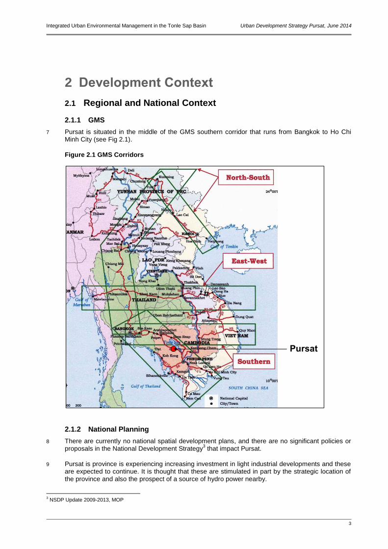
7 Pursat is situated in the middle of the GMS southern corridor that runs from Bangkok to Ho Chi Minh City (see Fig 2.1).
Figure 2.1 GMS Corridors
2.1.2 National Planning
8 There are currently no national spatial development plans, and there are no significant policies or proposals in the National Development Strategy
3 that impact Pursat.
9 Pursat is province is experiencing increasing investment in light industrial developments and these are expected to continue. It is thought that these are stimulated in part by the strategic location of the province and also the prospect of a source of hydro power nearby.
3 NSDP Update 2009-2013, MOP
Pursat

Integrated Urban Environmental Management in the Tonle Sap Basin Urban Development Strategy Pursat, June 2014
4
10 Initial work on the Tonle Sap Urban Areas Development Framework (TSUADF)4 shows that the
town is in a key location for growth based on the economic corridor, upgraded and new transport routes, and tourism (see Figure 2.2).
Figure 2.2 Strategic Analysis from TSUADF
2.1.3 Urban Planning
11 There is no master pan for Pursat. Planning the town growth is done in an ad-hoc manner with no overall guiding principles.
2.1.4 Transport Networks
12 As mentioned above, Pursat is located on National Road No.5, a main arterial route from Phnom Penh to the Thai border at Poipet. The town is situated just over halfway from Phnom Penh to Battambang.
13 The railway line from Phnom Penh to Poipet is currently being rehabilitated and services are expected to resume on the line from possibly as early as 2014. The railway passes directly through the town and it is expected that the town will become a key transport interchange for both passengers and freight.
2.1.5 Tonle Sap Protected Area
14 A Tonle Sap Basin Strategy was developed under the ADB’s TA Tonle Sap Environmental Management Project. One output from this was the designation of the Tonle Sap Biosphere
4 TSUADF is part of the work of this ADB PPTA - 7986 CAM
Tonle Sap
Serei Saophoan
Siem Reap
Battambang
Stueng Saen
Kampong
Chhnang
Pursat
0 10 20 Km
N
National Roads
GMS Southern Corridor
Railway
Tourism
Industry
Flood plain

Integrated Urban Environmental Management in the Tonle Sap Basin Urban Development Strategy Pursat, June 2014
5
Reserve and the establishment of the Tonle Sap Biosphere Reserve Secretariat. The establishment of the Tonle Sap Authority (TSA) has since superseded this. The TSA has designated three zones for different degrees of protection (see Figure 2.3). These are as follows:
Zone 1: Generally residential area and traditional paddy fields with rain-fed farming Zone 2: Cultivated area with dry season rice that is inundated in the wet season Zone 3: Area of flooded forests, natural lakes and muddy areas (fully protected)
Figure 2.3 TSA Zones
15 From Figure 2.3 it can be seen that Zone 1 includes all areas east of Road No.5. This means that
about one third of the urban area of Pursat is within Zone 1. The boundary of Zone 2 also passes close to Pursat and it follows the western edge of the watercourse.
2.2 Population Growth and Urban Expansion
2.2.1 Current Population
16 In 2011 the estimated population of the municipality was 68,924, but as shown in Figure 1.1, the municipality is much bigger than the urban area. The urban area also extends slightly beyond the municipal boundary into Kandieng district. The population of the contiguous urban area is estimated at 49,044 (see Table 2.1).
17 The total population residing in the strategy area in 2011 was about 101,000. As this is the immediate hinterland of the town it is reasonable to assume that the town functions as the day to day service centre for this population.
Tonle Sap
Serei Saophoan
Siem Reap
Battambang
Stueng Saen
Kampong Chhnang
Pursat
0 10 20 Km
N
Zone 3
Zone 2
Zone 1

Integrated Urban Environmental Management in the Tonle Sap Basin Urban Development Strategy Pursat, June 2014
6
Table 2.1 Population of Pursat
Area No. Households Total Population
Male Female
Pursat Municipality 14,462 68,924 39,783 29,141
Urban area 10,676 49,044 29,456 24,376
Strategy area 21,295 101,630 48,224 53,406
Source: Provincial database 2011
2.2.2 Population Projections
18 The population projections described here use a combination of the NIS predictions of growth rates for provinces and a national rate for urban areas to 2030. The NIS projected urban population growth is about two percentage points above the predicted provincial growth rates. It is likely that a large proportion of this urban growth will be in Phnom Penh and the other larger towns due to rural-urban migration. For the smaller towns such as Pursat a lower urban growth rate is probable, i.e. somewhere between the provincial and urban rates. A rate of one percentage point above the provincial growth rates has therefore been adopted as a 'medium growth' scenario. Higher and lower scenarios have also been calculated for comparison.
19 For the purposes of the strategy it has been assumed that all population within the strategy area will reflect the same growth rate as the urban area. The results of the population projections are summarised in Table 2.2.
20 The projections show that under the medium growth scenario by 2030 there will be an additional 60,000 people living in the strategy area.
Table 2.2 Population Projections Pursat Urban Area and Strategy Area
2011 Growth Rate
%
2015 Growth Rate
%
2020 Growth Rate
%
2025 Growth Rate
%
2030
Medium Growth Scenario 2.34 2.49 2.49 2.47
Urban area 49,044 53,800 60,900 68,900 77,900
Strategy area 101,630 111,500 126,100 142,700 161,300
High Growth Scenario 2.84 2.99 2.99 2.97
Urban area 49,044 54,900 63,700 73,900 85,600
Strategy area 101,630 113,700 131,800 152,800 176,900
Low Growth Scenario 1.84 2.49 2.49 2.47
Urban area 49,044 52,800 59,800 67,700 76,500
Strategy area 101,630 109,400 123,800 140,100 158,300
Source: Consultant estimates based on NIS projections5
2.2.3 Urban Development
21 Recent expansion in Pursat urban area has been mostly along National Road No.5 to the north and south of the town. This pattern of development largely reflects the availability of access and utilities. There is a clear need therefore to expand the secondary road network in the town in order to promote more even and organised growth.
22 Within the existing urban area the developed land (i.e. land occupied by residential, commercial, and other facilities) amounts to a total of approximately 12.3 Km
2. Based on the current population
5 NIS National Population Projections 2008-2050 (digital data provided by NIS)

Integrated Urban Environmental Management in the Tonle Sap Basin Urban Development Strategy Pursat, June 2014
7
of around 49,000 this represents a gross development density of about 3,900 persons per Km2. By
comparison the gross density in Kampong Chhnang was found to be around 3,500 persons per Km
2. For consistency the lower density is proposed for calculating development areas required. At
this density the additional population of 60,000 will require an area of 17.1Km2. Although residential
and commercial densities may increase in future, through high-rise developments, improved urban planning should also result in greater provision of community facilities and small-scale open spaces. It seems reasonable to assume therefore that the overall density at 2030 will not be very different from that today.

Integrated Urban Environmental Management in the Tonle Sap Basin Urban Development Strategy Pursat, June 2014
8
3 Development Issues and Needs
3.1 Consultations
23 A number of consultations have been held with stakeholders including municipal, provincial and central government, civil society and other agencies involved in development. These culminated in a strategy meeting in Pursat on 29th August 2013. The findings of that meeting and other consultations are set out below.
3.1.1 The Vision
24 At the meeting on 29th August a vision for the future of Pursat was agreed. This is as follows:
A regional centre and transport hub for commerce, industry, and tourism, developed in a sustainable way keeping development and protection of natural resources in balance, and providing a healthy environment for its citizens
3.1.2 SWOT Analysis
25 The meeting on 29th August also undertook a an analysis of the town’s strengths, weaknesses,
opportunities and threats (SWOT). The results are shown in Figure 3.1 below.
Figure 3.1 SWOT Analysis for Pursat
STRENGTHS
On National Road No.5 at junction with No.55 Half way from Phnom Penh to Thai border Attractive for commercial/industrial investment
in the vicinity Hydro project – cheap electricity Land availability Railway - interchange Agricultural potential – hub for processing
WEAKNESSES
Power constraints Infrastructure not complete Far from port Weak investor interest No clear urban planning Low capacity in urban services operation and
management
OPPORTUNITIES
Tourism potential based on marble carving
and natural surroundings Railway rehabilitation Riverfront development Natural conservation areas Bird habitat Tonle Sap as an attraction Waterfalls not yet developed Decentralisation of financial control
THREATS
Shortage of human resources and inadequate
education facilities to support professional development
Continued unplanned development Environmental damage will affect natural
resource attractions Other towns attract investment Electricity remains too expensive Limited financial resources

Integrated Urban Environmental Management in the Tonle Sap Basin Urban Development Strategy Pursat, June 2014
9
3.1.3 Other Consultations
26 A summary of issues raised in various consultations with stakeholders are summarised in Table 3.1.
Table 3.1 Issues Raised in Discussions with Pursat Stakeholders
Subject Points Raised
Environment Flooding occurs in town centre - from storm water, not back-up from Tonle Sap
Urban Planning Municipal governor would like to see town grow in all directions. The governor would like to see bypass roads to north and south creating a ring road
and Dyke around the city. The governor sees town growth based on industry rather than tourism. There is more land available for growth to the east of the town than to the west. Road 55 to Sihanoukville to be upgraded
Infrastructure Drainage/sewerage system needs rehabilitation and extension An old wastewater pond system is no longer functioning Two companies involved in solid waste collection as a new company won market tender
this year One of the companies owns the dumpsite Dumpsite needs improved management and extension Govt prepared to purchase the site if necessary Some riverbank work needed on southern side of town Insufficient town drainage system
Lack of waste water treatment plant
Surface paved road within the municipality is consisting of only 16.38%
Administration/ Public Awareness
Some boundary issues as northern part of urban area is in adjacent district, not municipality
Insufficient budget for town development Roads and drains blocked by encroachments and utilities Poor level of public awareness of urban environmental issues Poor driving standards
3.2 Summary of Development Considerations
27 The river is a major feature of the town, including an artificial island in the shape of a large ship, and a barrage across the river. However the river frontage has not been fully exploited as an attraction.
28 A ‘by-pass’ road is proposed to the south of the urban area linking the eastern and western sections of Road No.5. This will have the benefit of taking through-traffic out of the town centre. A bridge has already been constructed over the river but the alignment of existing roads does not provide an effective through route at the moment. The road involves two crossing points with the railway. In future these are likely to overpasses as crossings.
29 Pursat province has been earmarked by Government as having significant tourism potential and ‘untouched resources which have not yet been transformed into tourism products’.
6 The potential
attractions are associated with the natural environments of the Tonle Sap, and the mountains to the south. The town is better situated than Kampong Chhnang to act as a transit point as it is approximately half way between Phnom Penh and Battambang.
6 Tourism Development Strategic Plan 2012-2020, Government of Cambodia, July 2012

Integrated Urban Environmental Management in the Tonle Sap Basin Urban Development Strategy Pursat, June 2014
10
30 Located within the GMS Southern Economic Corridor, the town can expect continued economic development and expansion. There are already several rice mills in the town and several industries have recently located in the adjacent district (Krokor) to the east of the municipality. In recent years expansion of the urban area has been mostly to the east and this is where future growth is expected. The new municipal office has been constructed about 3km east of the town.
31 There is no existing Master Plan for Pursat, nor any under preparation.
3.2.1 Environmental, Geographic and other Constraints
32 There are a number of constraints that will have to be taken into account when developing the strategy for Pursat. Some of the key constraints are described below and shown in Figure 3.2.
33 As mentioned above, most of the town in within TSA Zone 1. Whilst this does not significantly restrict development, it does mean that the types of land use in this area should be given careful consideration. For instance there should be no heavy industries, and major developments should be kept away from the Pursat River, a tributary of the Tonle Sap. Areas to the north of the town are low-lying and liable to flood. These are not suitable areas for major residential or other developments.
34 The rehabilitated railway line will be a physical barrier. In the long-term all major road crossing should be grade separated.
35 The municipality is striving to improve its environment and submitted an entry for the National Clean City Award. This award considers environmental management, city cleanliness, waste management, levels of public awareness, health safety, and tourism facilities. The municipality was unsuccessful in its first application and will be keen to re-apply in the competition period.

Integrated Urban Environmental Management in the Tonle Sap Basin Urban Development Strategy Pursat, June 2014
11
Figure 3.2 Constraints to Development

Integrated Urban Environmental Management in the Tonle Sap Basin Urban Development Strategy Pursat, June 2014
12
3.3 Role of the Strategy
36 The proposed strategy is a framework for addressing the issues and opportunities outlined above. It is not a detailed prescriptive plan, but an outline providing an overview within which the detailed planning can take place.
37 Building on the issues and opportunities identified above, the potential role of the strategy is summarised in Table 3.2 below.
Table 3.2 Potential Strategy Responses to Issues, Needs and Opportunities
Issues and Needs Potential Strategy Responses
Land Use
Lack of approved master plan to guide development resulting in inappropriate developments, and inefficient urban expansion
Existing land use patterns result in conflicting, incompatible activities on adjacent sites causing nuisance and environmental impacts
Development control has not protected areas requiring conservation
Uncontrolled development has interfered with existing utilities such as drains
The strategy will be the starting point for review of the master plan and will identify key growth areas
Definition of areas for urban development and areas to be protected
Identify key agriculture land to be protected from encroachment by urban expansion
Identify areas for industrial developments away from residential areas
Roads and Transportation
Currently all through traffic passes through the town centre resulting in traffic congestion and adverse environmental impacts
Commercial traffic is due to increase, particularly with new industries locating near the town and the development of the GMS corridor
Few secondary access roads linking primary routes
Rehabilitation of railway will require integration of other transport facilities
By-pass route(s) to take long-distance traffic around the town
Plan for effective traffic management of increased volumes due to GMS corridor
Improve existing road network and add more secondary road linkages
Integrated plans for rail-road interchanges at town centre passenger station and edge of town freight station
Natural Resources
Natural resources in and adjacent to the town have not been well managed or protected
Insufficient attention has been paid to environmental issues and climate change
Existing open green spaces are underutilised for public access
Designate no-build areas that are susceptible to climate change impacts
Use strategy to increase public awareness of environment issues
Identify green areas for public access and eco-tourism
Urban Management
Urban planning is not integrated with infrastructure planning and provision
Low level of public awareness of urban management issues and procedures
Low levels of community participation in planning decisions and strategies
Use strategy to guide future infrastructure planning and investment
Use strategy to develop participatory approach in urban planning
Engage communities as partners in local improvements

Integrated Urban Environmental Management in the Tonle Sap Basin Urban Development Strategy Pursat, June 2014
13
4 Development Concepts
4.1 Growth Scenario
38 The proposed strategy is for development of Pursat up to 2030. It is divided into three phases. The first is from 2014 to 2020 and therefore more or less approximately concurrent with the ADB implementation project. The second and third phases civer the subsequent 10 years.
39 The strategy is based on the population projections and the resulting estimates of land areas required as presented in Chapter 2. However, development plans need to allow for some flexibility to adapt to changing circumstances, and all expansion areas may not be developed to the same densities as assumed. The development areas are therefore greater than necessarily required during that period.
4.2 Development Targets
40 The vision for the city is described in Chapter 3. Achieving the vision will happen in stages. Suggested targets for each stage are shown in Table 4.1.
Table 4.1 Targets for Phases of the Pursat Development Strategy
Phase 1: 2015-2020 - Improved Urban Environment
Pursat is well planned and well managed Pursat is well known as a transport hub and interchange Pursat is the major market for agriculture products and a centre for agricultural
processing
Pursat achieves Clean City Award
Phase 2: 2020-2025 – Attractive City and Commercial/Industrial Centre
Greater Pursat is a self governing city No residents living in poverty or without full urban services Centre for light industry
Pursat established as a city being developed sustainably
Phase 3: 2025-2030 - Regional Commercial and Cultural Centre
A major centre in Mekong region for commerce, industry, tourism, and other
services
4.3 Directions for Growth
41 As mentioned above, recent development in Pursat has tended to extend along the Pursat River and along Road No.5. This has resulted in rather elongated developments, which are not an efficient urban form. Future development should be encouraged to consolidate around the texisting urban centre through provision of additional secondary roads.
42 Expansion of the town should be primarily to the south of Road No.5 as the land north of the town is low-lying and more liable to flood.

Integrated Urban Environmental Management in the Tonle Sap Basin Urban Development Strategy Pursat, June 2014
14
43 Alignment for the proposed by-pass is not yet determined but is expected to be to the south of the town. This will also pull development in that direction. Development along the by-pass should include a frontage road so that access to and from the commercial and other activities does not interfere with the free flow of the traffic along a national road.
44 The area around the railway station will need a detailed plan in order to manage traffic. A separate road-rail interchange is proposed for freight traffic to the west of the town where the railway runs alongside Road No.5.
4.4 Development Framework
4.4.1 Development Principles and Rationale
45 The framework for the strategy area will be determined by a network of primary and secondary road infrastructure. With the addition of the proposed bypass to the south of the town Pursat will have a reasonable primary road network. This needs to be supplemented by an improved secondary network. The terrain in and around Pursat is relatively flat, with rivers, streams and low-lying land the only major constraints. This will allow for future the urban form to follow a regular shape.
46 The rationale for the proposed framework is based on the following (see Figure 4.1):
Urban growth primarily south of National Road No.5 Controlled development along the proposed by-pass Public green open space established near municipal offices as part of a future civic centre Road-railway interchange and high-tech industrial zone on the western side of the town Central riverside area planned as linear recreation zone
4.4.2 Sustainable Development
47 The urban strategy should be developed with the issues of sustainability and climate change impact as key parameters. The strategy will contribute in various ways to addressing the impacts of climate change or in mitigating additional impacts. In particular the strategy will aim to facilitate and encourage initiatives that tackle these issues and enhance preparedness. These include:
Restrictions on development in flood-prone areas Planned development to maximise efficiency of utilities Minimisation of impacts on ecologically sensitive areas Encouragement of climate-resilient infrastructure
Institutional Support
48 The development framework deals primarily with physical infrastructure and spatial planning. An important component for its success however will be institutional support. A programme of capacity building and awareness raising should run parallel with the implementation of the urban strategy. This should include:
Capacity building in urban planning and management Strengthening and extension of urban services delivery mechanisms Improved revenue collection and identification of new revenue opportunities Increased public participation in spatial and infrastructure planning Raising public awareness of urban environmental issues and climate change

Integrated Urban Environmental Management in the Tonle Sap Basin Urban Development Strategy Pursat, June 2014
15
Figure 4.1 Outline Development Concept for Pursat
4.5 Priority Actions
49 Chapter 5 sets out the phased development strategy over 16 years. In the short term there are a number of issues that should be addressed and given priority. The issues and suggested actions are summarised in Table 4.2.
Table 4.2 Priority Issues and Suggested Actions - Pursat
Issues Description Suggested Actions
Mapping There is no comprehensive small scale mapping of the urban area and surroundings of Kampong Chhnang. Detailed topographical mapping is essential for the purposes of the planning and design of urban growth and in particular the design of infrastructure.
Preparation of digital contour maps (contour intervals at 0.5m) of the urban area of Pursat and surrounding area – approximately 80Km
2
Map output at 1:5000 scale
Satellite Imagery
The Government is currently using poor quality aerial photography from 2005. There
Acquisition of high-resolution satellite imagery (e.g. Quickbird) for the urban

Integrated Urban Environmental Management in the Tonle Sap Basin Urban Development Strategy Pursat, June 2014
16
Issues Description Suggested Actions
is no high-resolution satellite imagery available for Pursat and surrounding area. Detailed satellite images are a crucial tool in the planning of urban areas and infrastructure.
area of Pursat and immediate surroundings
TSA Zoning The boundary of TSA Zone 1 follows National Road No.5 so includes only about one third of the urban area.
Review of the boundary of Zone 1 in relation to urban areas.
River frontage The part of the town fronting the river in Pursat has the potential to be an attractive urban space to be enjoyed by residents. The potential is currently not realised and there is a danger that the opportunities could be lost if development is allowed to extend along the banks.
Preparation of detailed local plan for the riverbanks. Identification of areas to be protected from development.
Green Infrastructure and cultural heritage
As towns and cities grow it is common that green spaces and other attractive assets such as historic buildings are lost. There is an opportunity to retain these important features if action is taken soon.
Mapping and inventory of green infrastructure and cultural heritage including river banks, open spaces, historic buildings, water bodies.
Railway station
The proposed rehabilitation of the railway will have implications for the town. In particular it will be important to plan the areas around the existing railway station and look at options for an alternative location for a freight traffic interchange.
Preparation of detailed local plan of the area around the railway station.
Review and planning of future road-rail interchange for freight.

Integrated Urban Environmental Management in the Tonle Sap Basin Urban Development Strategy Pursat, June 2014
17
5 Phased Development Strategy
5.1 General
50 The strategy has been divided into three phases. The first phase is 6 years, parallel with the implementation of the ADB project. Second and third phases are both 5 years.
5.2 Development Strategy Phase 1 – 2014 to 2020
51 The key features of Phase 1 are consolidation of urban development to the east of the town, construction of the by-pass, rehabilitation of the railway station, and creation of a civic centre and urban park in the location of the municipal offices.
Figure 5.1 Development Strategy Phase 1, 2014 – 2020

Integrated Urban Environmental Management in the Tonle Sap Basin Urban Development Strategy Pursat, June 2014
18
5.2.1 Components of Phase 1
Urban Development Extend existing urban area through improvements in infrastructure, and better planning and
development control Facilitate urban growth in expansion areas by extending existing infrastructure Plan and upgrade area around central railway station
Road Network and Transportation
Railway line operational Central railway station rehabilitated By-pass road to south of town Establish bus stations at junctions of by-pass and Road No.5 Secondary road connections
Environmental Infrastructure
Drainage improvements in town centre Plan and develop river frontage as recreation area Designate public green space as part of civic centre Improved solid waste collection and disposal facilities
5.3 Development Strategy Phase 2 – 2021 to 2025
52 The components of Phase 2 include further urban expansion to the east and west, additional secondary roads, urban parks in the central southern part of the town, and the establishment of a high-tech industrial zone on the western edge of the strategy area.
5.3.1 Components of Phase 2
Urban Development
Controlled development along northern side of by-pass, with frontage roads Plan and develop civic centre area around municipal offices Identify zone for high-tech industry to west of town along Road No.5
Road Network and Transport Road-rail interchange west of town where by-pass meets Road No.5 Complete secondary road network
Environmental Infrastructure
Urban parks to east and west of Pursat River in central area
53

Integrated Urban Environmental Management in the Tonle Sap Basin Urban Development Strategy Pursat, June 2014
19
Figure 5.2 Development Strategy Phase 2, 2021 – 2025
5.4 Development Strategy Phase 3 – 2026 to 2030
54 The main components of Phase 3 will be additional urban expansion within the by-pass and extension of the central urban parkland.
5.4.1 Components of Phase 3
Urban Development Further controlled development along southern side of by-pass, with frontage roads
Environmental Infrastructure
Extension of urban parks to east and west of Pursat River

Integrated Urban Environmental Management in the Tonle Sap Basin Urban Development Strategy Pursat, June 2014
20
Figure 5.3 Development Strategy Phase 3, 2026 – 2030