42285-013: Integrated Urban Environmental Management in the ...
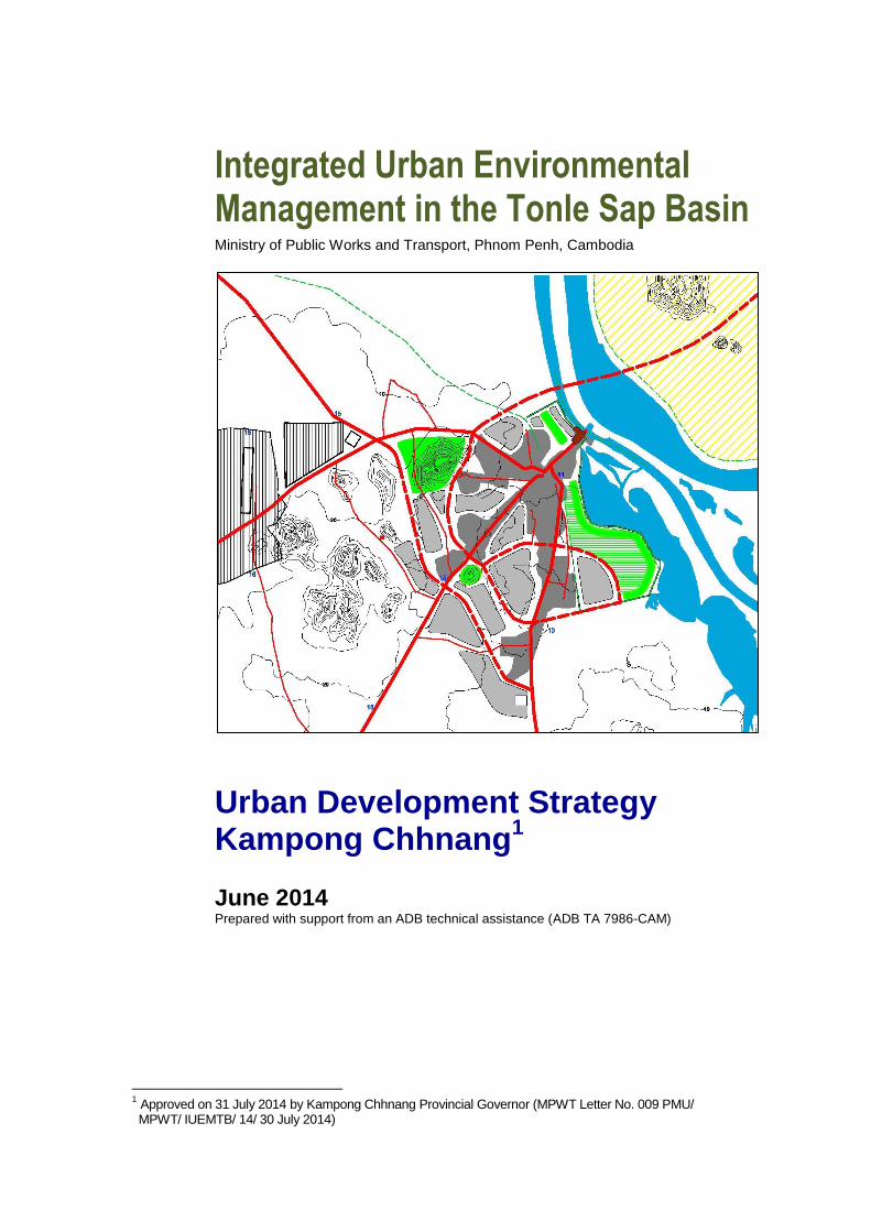
Integrated Urban Environmental Management in the Tonle Sap Basin
Ministry of Public Works and Transport, Phnom Penh, Cambodia
Urban Development Strategy Kampong Chhnang
1
June 2014 Prepared with support from an ADB technical assistance (ADB TA 7986-CAM)
1 Approved on 31 July 2014 by Kampong Chhnang Provincial Governor (MPWT Letter No. 009 PMU/ MPWT/ IUEMTB/ 14/ 30 July 2014)

Integrated Urban Environmental Management in the Tonle Sap Basin Urban Development Strategy K. Chhnang, June 2014
i
Contents
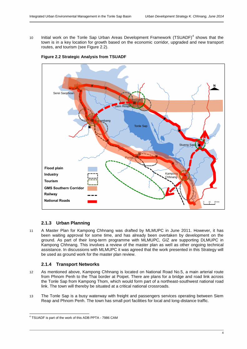
1 Introduction 1 1.1 Background 1 1.2 Development Strategy Objectives 2 1.3 Components of the Strategy 2
2 Development Context 3 2.1 Regional and National Context 3
2.1.1 GMS 3 2.1.2 National Planning 3 2.1.3 Urban Planning 4 2.1.4 Transport Networks 4 2.1.5 Tonle Sap Protected Area 5
2.2 Population Growth and Urban Expansion 6 2.2.1 Current Population 6 2.2.2 Population Projections 6 2.2.3 Urban Development 7
3 Development Issues and Needs 8 3.1 Consultations 8
3.1.1 The Vision 8 3.1.2 SWOT Analysis 8 3.1.3 Other Consultations 9
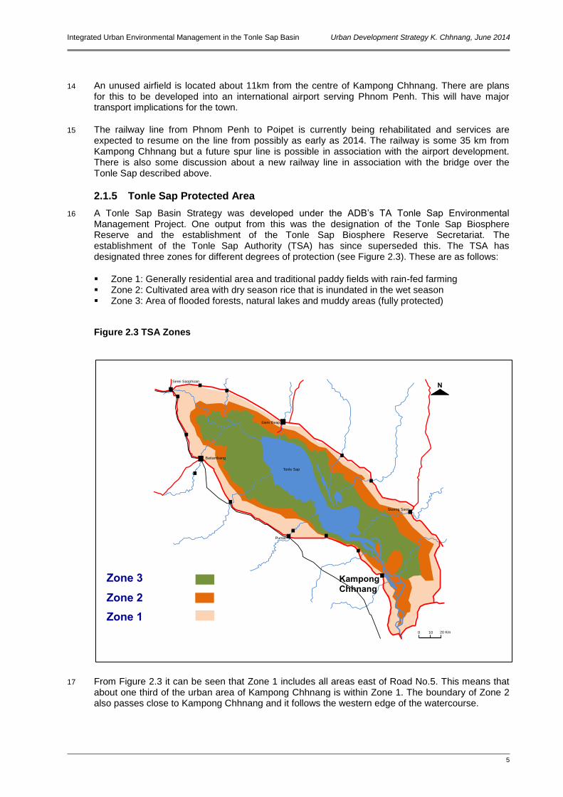
3.2 Summary of Development Considerations 9 3.2.1 Environmental, Geographic and other Constraints 10
3.3 Role of the Strategy 11
4 Development Concepts 13 4.1 Growth Scenario 13 4.2 Development Targets 13 4.3 Directions for Growth 13 4.4 Development Framework 14
4.4.1 Development Principles and Rationale 14 4.4.2 Sustainable Development 14 4.4.3 Institutional Support 14
4.5 Priority Actions 15
5 Phased Development Strategy 17 5.1 General 17 5.2 Development Strategy Phase 1 – 2014 to 2020 17
5.2.1 Components of Phase 1 18 5.3 Development Strategy Phase 2 – 2021 to 2025 18
5.3.1 Components of Phase 2 18 5.4 Development Strategy Phase 3 – 2026 to 2030 19
5.4.1 Components of Phase 3 19
Integrated Urban Environmental Management in the Tonle Sap Basin Urban Development Strategy K. Chhnang, June 2014
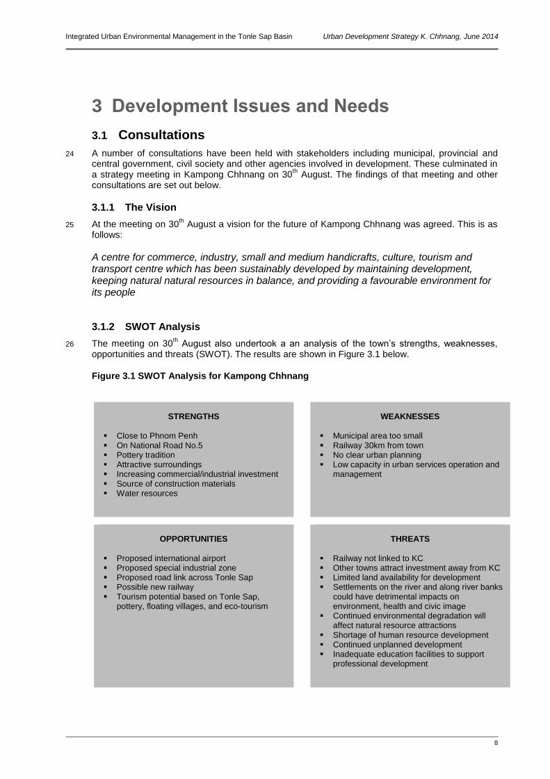
ii
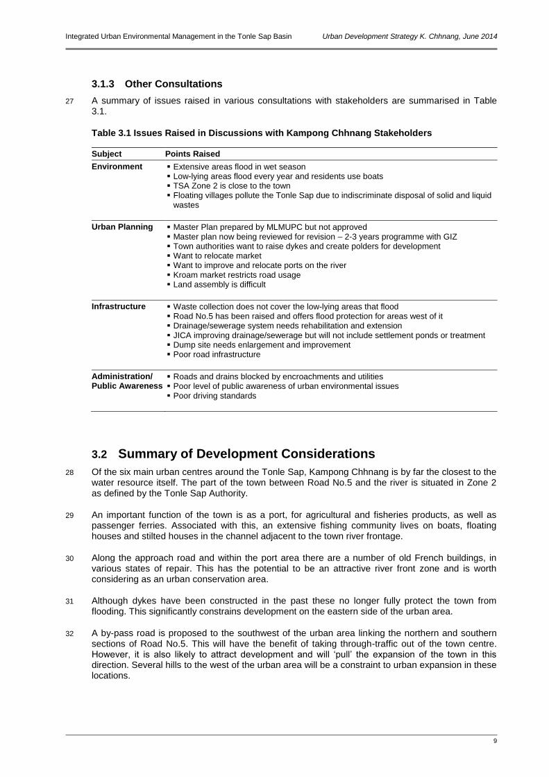
Abbreviations ADB Asian Development Bank CARM Cambodia Resident Mission (ADB) DPWT Department of Public Works and Transport (in provinces) EC European Commission EDF European Development Fund EIB European Investment Bank EU European Union GDP Gross Domestic Product GEF Global Environment Facility GIZ Deutsche Gesellschaft für Internationale Zusammenarbeit IDA International Development Association IFC International Finance Corporation (of the World Bank Group) JICA Japan International Cooperation Agency MCA Multi-Criteria Analysis MDGs Millennium Development Goals MEF Ministry of Economy and Finance MIME Ministry of Industry, Mines and Energy MLMUPC Ministry of Land Management, Urban Planning and Construction MOE Ministry of the Environment MOWRAM Ministry of Water Resources and Meteorology MPWT Ministry of Public Works and Transport NAPA National Adaptation Plan of Action to Climate Change NGO Non Governmental Organisation PDWRAM Provincial Department for Water Resources and Meteorology PPCR Pilot Program for Climate Resilience SOE State-Owned Enterprise TA Technical Assistance TSA Tonle Sap Authority UNDP United Nations Development Programme WB World Bank Group
Integrated Urban Environmental Management in the Tonle Sap Basin Urban Development Strategy K. Chhnang, June 2014
iii
Consultant Team
Richard Mabbitt Urban Development Specialist/Team Leader
Bruce Pollock Municipal Engineer And Procurement Specialist
Lyndsay Chapple Solid Waste Management Specialist
Joji Reyes Economist/Municipal Finance Specialist
Maria Cleto Social Development and Resettlement Specialist
Kerry Blanch Institutional Development Specialist
Delfa Uy Environment Specialist
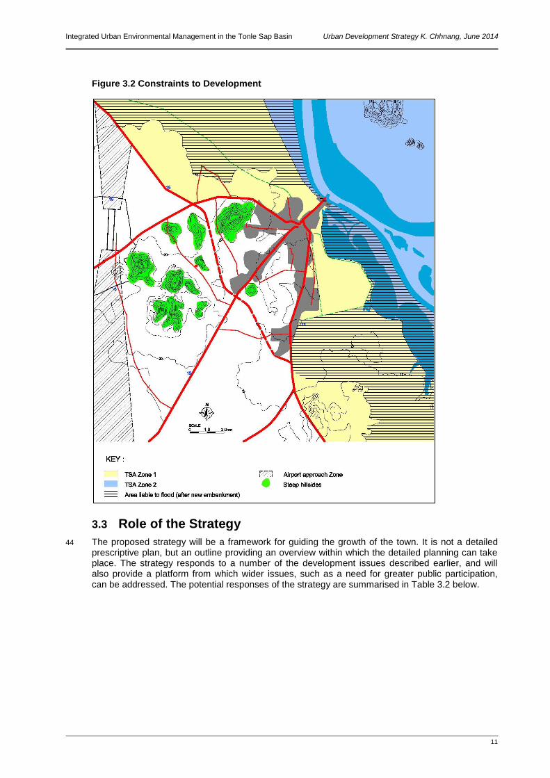
Phai Sok Heng Civil Engineer/Deputy Team Leader
Hak You Urban Development Specialist
Sour Sethy Solid Waste Management Specialist
Mao Dor Finance Specialist
Hem Socheth Economist/Accountant
Kol Prapey Social And Community Development Specialist
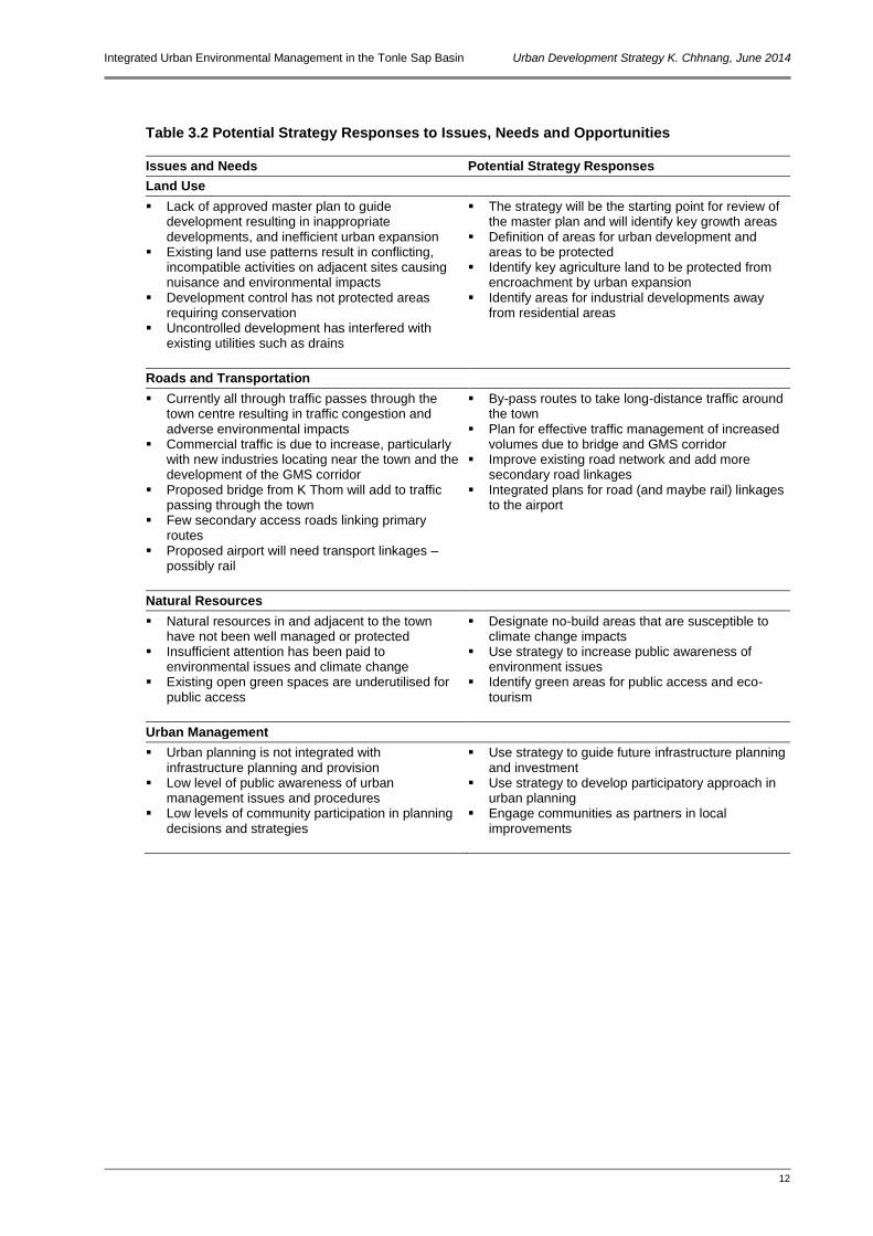
Mel Sophanna Resettlement Specialist
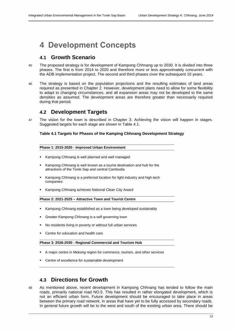
May Simorn Environment Specialist
Mak Sithirith Institutional Specialist
Disclaimer
The views expressed in this report are those of the authors and do not necessarily reflect the views and policies of ADB or its Board of Governors, the governments they represent, or the Government of Cambodia. ADB or any of the above parties does not guarantee the accuracy of the data included in this publication and accepts no responsibility for any consequence of their use.

Integrated Urban Environmental Management in the Tonle Sap Basin Urban Development Strategy K. Chhnang, June 2014
iv
Location of Kampong Chhnang in the Tonle Sap Basin
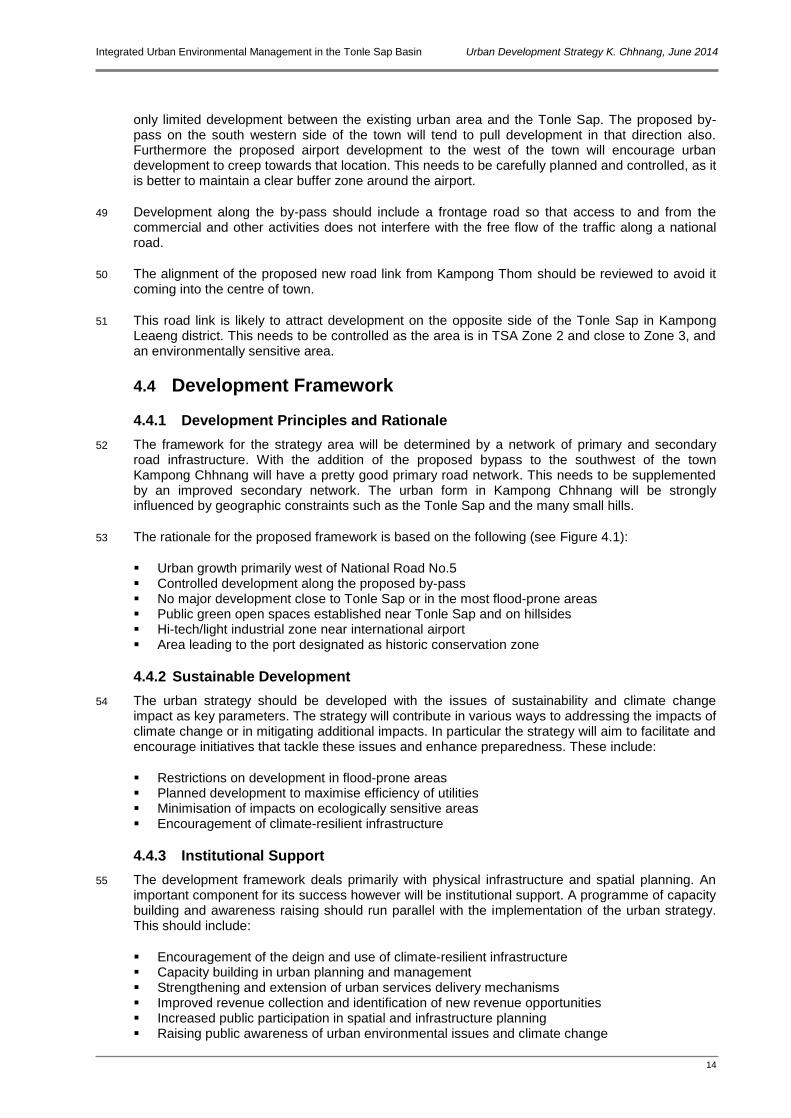
Tonle Sap
0 10 20 Km
N Serei Saophoan
Siem Reap
Battambang
Stueng Saen
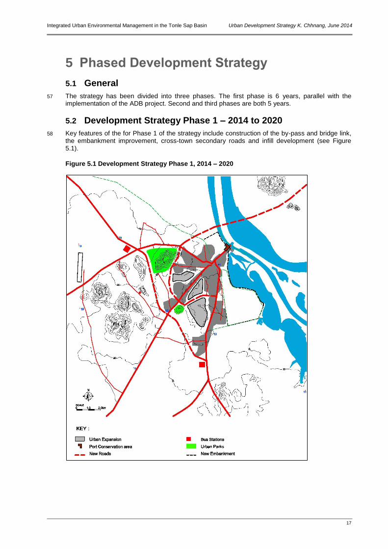
Kampong Chhnang
Pursat
Stoung
Chi Kraeng
Kralanh
Mongkol Borei
Banan
Moung Ruessei
Kandieng
Krakor
Baribour
Preah Netr Preah
Thmar Koul
Road No.5
Road No.6
Railway
Integrated Urban Environmental Management in the Tonle Sap Basin Urban Development Strategy K. Chhnang, June 2014
1
1 Introduction
1.1 Background
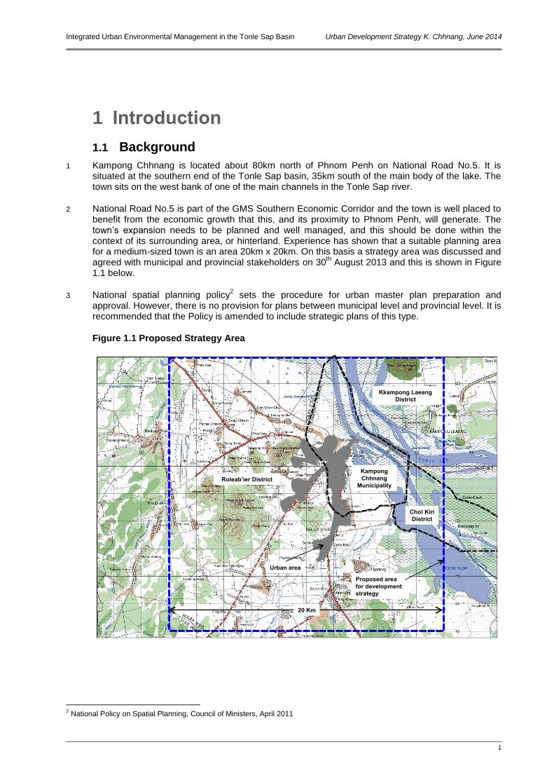
1 Kampong Chhnang is located about 80km north of Phnom Penh on National Road No.5. It is situated at the southern end of the Tonle Sap basin, 35km south of the main body of the lake. The town sits on the west bank of one of the main channels in the Tonle Sap river.
2 National Road No.5 is part of the GMS Southern Economic Corridor and the town is well placed to benefit from the economic growth that this, and its proximity to Phnom Penh, will generate. The town’s expansion needs to be planned and well managed, and this should be done within the context of its surrounding area, or hinterland. Experience has shown that a suitable planning area for a medium-sized town is an area 20km x 20km. On this basis a strategy area was discussed and agreed with municipal and provincial stakeholders on 30
th August 2013 and this is shown in Figure
1.1 below.
3 National spatial planning policy2 sets the procedure for urban master plan preparation and
approval. However, there is no provision for plans between municipal level and provincial level. It is recommended that the Policy is amended to include strategic plans of this type.
Figure 1.1 Proposed Strategy Area
2 National Policy on Spatial Planning, Council of Ministers, April 2011
Urban area
Kampong
Chhnang
Municipality
Kkampong Laeang
District
Chol Kiri
District
Roleab’ier District
Proposed area
for development
strategy
20 Km
Integrated Urban Environmental Management in the Tonle Sap Basin Urban Development Strategy K. Chhnang, June 2014
2
1.2 Development Strategy Objectives
4 The Strategy is intended to be a guiding tool in the management of Kampong Chhnang’s future growth. By facilitating more efficient development and infrastructure investment it will thereby assist in the establishment of Kampong Chhnang as a key provincial centre.
5 More specifically the strategy aims are:
To establish development targets and an overall goal for Kampong Chhnang’s development To identify the principal opportunities for town growth, including main areas for expansion To identify the major constraints to expansion To define key urban infrastructure requirements To stimulate strategic thinking in urban planning and management
1.3 Components of the Strategy
6 The strategy’s key components are:
Regional and national context Development issues and needs assessment Vision and SWOT analysis Concept for growth Phased development strategy
Integrated Urban Environmental Management in the Tonle Sap Basin Urban Development Strategy K. Chhnang, June 2014
3
2 Development Context
2.1 Regional and National Context
2.1.1 GMS
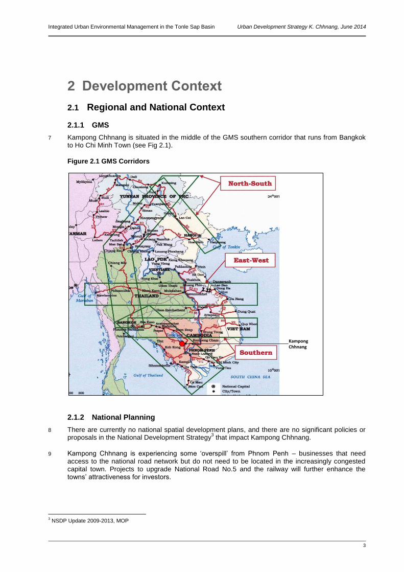
7 Kampong Chhnang is situated in the middle of the GMS southern corridor that runs from Bangkok to Ho Chi Minh Town (see Fig 2.1).
Figure 2.1 GMS Corridors
2.1.2 National Planning
8 There are currently no national spatial development plans, and there are no significant policies or proposals in the National Development Strategy
3 that impact Kampong Chhnang.
9 Kampong Chhnang is experiencing some ‘overspill’ from Phnom Penh – businesses that need access to the national road network but do not need to be located in the increasingly congested capital town. Projects to upgrade National Road No.5 and the railway will further enhance the towns’ attractiveness for investors.
3 NSDP Update 2009-2013, MOP
KampongChhnang
Integrated Urban Environmental Management in the Tonle Sap Basin Urban Development Strategy K. Chhnang, June 2014
4
10 Initial work on the Tonle Sap Urban Areas Development Framework (TSUADF)4 shows that the
town is in a key location for growth based on the economic corridor, upgraded and new transport routes, and tourism (see Figure 2.2).
Figure 2.2 Strategic Analysis from TSUADF
2.1.3 Urban Planning
11 A Master Plan for Kampong Chhnang was drafted by MLMUPC in June 2011. However, it has been waiting approval for some time, and has already been overtaken by development on the ground. As part of their long-term programme with MLMUPC, GIZ are supporting DLMUPC in Kampong Chhnang. This involves a review of the master plan as well as other ongoing technical assistance. In discussions with MLMUPC it was agreed that the work presented in this Strategy will be used as ground work for the master plan review.
2.1.4 Transport Networks
12 As mentioned above, Kampong Chhnang is located on National Road No.5, a main arterial route from Phnom Penh to the Thai border at Poipet. There are plans for a bridge and road link across the Tonle Sap from Kampong Thom, which would form part of a northeast-southwest national road link. The town will thereby be situated at a critical national crossroads.
13 The Tonle Sap is a busy waterway with freight and passengers services operating between Siem Reap and Phnom Penh. The town has small port facilities for local and long-distance traffic.
4 TSUADF is part of the work of this ADB PPTA - 7986 CAM
Tonle Sap
Serei Saophoan
Siem Reap
Battambang
Stueng Saen
Kampong
Chhnang
Pursat
0 10 20 Km
N
National Roads
GMS Southern Corridor
Railway
Tourism
Industry
Flood plain
Integrated Urban Environmental Management in the Tonle Sap Basin Urban Development Strategy K. Chhnang, June 2014
5
14 An unused airfield is located about 11km from the centre of Kampong Chhnang. There are plans for this to be developed into an international airport serving Phnom Penh. This will have major transport implications for the town.
15 The railway line from Phnom Penh to Poipet is currently being rehabilitated and services are expected to resume on the line from possibly as early as 2014. The railway is some 35 km from Kampong Chhnang but a future spur line is possible in association with the airport development. There is also some discussion about a new railway line in association with the bridge over the Tonle Sap described above.
2.1.5 Tonle Sap Protected Area
16 A Tonle Sap Basin Strategy was developed under the ADB’s TA Tonle Sap Environmental Management Project. One output from this was the designation of the Tonle Sap Biosphere Reserve and the establishment of the Tonle Sap Biosphere Reserve Secretariat. The establishment of the Tonle Sap Authority (TSA) has since superseded this. The TSA has designated three zones for different degrees of protection (see Figure 2.3). These are as follows:
Zone 1: Generally residential area and traditional paddy fields with rain-fed farming Zone 2: Cultivated area with dry season rice that is inundated in the wet season Zone 3: Area of flooded forests, natural lakes and muddy areas (fully protected)
Figure 2.3 TSA Zones
17 From Figure 2.3 it can be seen that Zone 1 includes all areas east of Road No.5. This means that
about one third of the urban area of Kampong Chhnang is within Zone 1. The boundary of Zone 2 also passes close to Kampong Chhnang and it follows the western edge of the watercourse.
Tonle Sap
Serei Saophoan
Siem Reap
Battambang
Stueng Saen
Kampong Chhnang
Pursat
0 10 20 Km
N
Zone 3
Zone 2
Zone 1
Integrated Urban Environmental Management in the Tonle Sap Basin Urban Development Strategy K. Chhnang, June 2014
6
2.2 Population Growth and Urban Expansion
2.2.1 Current Population
18 In 2011 the estimated population of the municipality was 40,360, but as shown in Figure 1.1, the urban area extends beyond the municipal boundary. The population of the contiguous urban area is estimated at 56,829 (see Table 2.1).
19 The total population residing in the strategy area in 2011 was just under 119,000. As this is the immediate hinterland of the town it is reasonable to assume that the town functions as the day to day service centre for this population.
Table 2.1 Population of Kampong Chhnang
Area No. Households Total Population
Male Female
Kampong Chhnang Municipality 7,928 40,360 19,553 20,807
Urban area 11,705 56,829 27,259 29,570
Strategy area 25,571 118,835 56,756 62,079
Source: Provincial database 2011
2.2.2 Population Projections
20 The population projections described here use a combination of the NIS predictions of growth rates for provinces and a national rate for urban areas to 2030. The NIS projected urban population growth is about two percentage points above the predicted provincial growth rates. It is likely that a large proportion of this urban growth will be in Phnom Penh and the other larger towns due to rural-urban migration. For the smaller towns such as Kampong Chhnang a lower urban growth rate is probable, i.e. somewhere between the provincial and urban rates. A rate of one percentage point above the provincial growth rates has therefore been adopted as a 'medium growth' scenario. Higher and lower scenarios have also been calculated for comparison.
21 For the purposes of the strategy it has been assumed that all population within the strategy area will reflect the same growth rate as the urban area. The results of the population projections are summarised in Table 2.2. The projections show that under the medium growth scenario by 2030 there will be an additional 50,000 people living in the strategy area.
Table 2.2 Population Projections Kampong Chhnang Urban Area and Strategy Area
2011 Growth Rate %
2015 Growth Rate %
2020 Growth Rate %
2025 Growth Rate %
2030
Medium Growth Scenario 2.24 2.04 1.77 1.50
Urban area 56,829 62,100 68,700 75,000 80,800
Strategy area 118,835 129,900 143,800 157,000 169,200
High Growth Scenario 2.74 2.54 2.27 2.00
Urban area 56,829 63,400 71,900 80,500 88,900
Strategy area 118,835 132,500 150,300 168,200 185,800
Low Growth Scenario 1.74 1.54 1.27 1.00
Urban area 56,829 60,900 65,800 70,100 73,700
Strategy area 118,835 127,400 137,600 146,600 154,100
Source: Consultant estimates based on NIS projections5
5 NIS National Population Projections 2008-2050 (digital data provided by NIS)
Integrated Urban Environmental Management in the Tonle Sap Basin Urban Development Strategy K. Chhnang, June 2014
7
2.2.3 Urban Development
22 Recent expansion in Kampong Chnang urban area has been mostly along National Road No.5 to the north and south of the town. This pattern of development largely reflects the availability of access and utilities. There is a clear need therefore to expand the secondary road network in the town in order to promote more even and organised growth.
23 Within the existing urban area the developed land (i.e. land occupied by residential, commercial, and other facilities) amounts to a total of approximately 16.5 Km
2. Based on the current population
of around 57,000 this represents a gross development density of around 3,500 persons per Km2. At
the same density the additional population of 50,000 will require an area of approximately 14.3 Km
2. Although residential and commercial densities may increase in future, through high-rise
developments, improved urban planning should also result in greater provision of community facilities and small-scale open spaces. It seems reasonable to assume therefore that the overall density at 2030 will not be very different from that today.
Integrated Urban Environmental Management in the Tonle Sap Basin Urban Development Strategy K. Chhnang, June 2014
8
3 Development Issues and Needs
3.1 Consultations
24 A number of consultations have been held with stakeholders including municipal, provincial and central government, civil society and other agencies involved in development. These culminated in a strategy meeting in Kampong Chhnang on 30
th August. The findings of that meeting and other
consultations are set out below.
3.1.1 The Vision
25 At the meeting on 30th August a vision for the future of Kampong Chhnang was agreed. This is as
follows:
A centre for commerce, industry, small and medium handicrafts, culture, tourism and transport centre which has been sustainably developed by maintaining development, keeping natural natural resources in balance, and providing a favourable environment for its people
3.1.2 SWOT Analysis
26 The meeting on 30th August also undertook a an analysis of the town’s strengths, weaknesses,
opportunities and threats (SWOT). The results are shown in Figure 3.1 below.
Figure 3.1 SWOT Analysis for Kampong Chhnang
STRENGTHS
Close to Phnom Penh On National Road No.5 Pottery tradition Attractive surroundings Increasing commercial/industrial investment Source of construction materials Water resources
WEAKNESSES
Municipal area too small Railway 30km from town No clear urban planning Low capacity in urban services operation and
management
OPPORTUNITIES
Proposed international airport Proposed special industrial zone Proposed road link across Tonle Sap Possible new railway Tourism potential based on Tonle Sap,
pottery, floating villages, and eco-tourism
THREATS
Railway not linked to KC Other towns attract investment away from KC Limited land availability for development Settlements on the river and along river banks
could have detrimental impacts on environment, health and civic image
Continued environmental degradation will affect natural resource attractions
Shortage of human resource development Continued unplanned development Inadequate education facilities to support
professional development
Integrated Urban Environmental Management in the Tonle Sap Basin Urban Development Strategy K. Chhnang, June 2014
9
3.1.3 Other Consultations
27 A summary of issues raised in various consultations with stakeholders are summarised in Table 3.1.
Table 3.1 Issues Raised in Discussions with Kampong Chhnang Stakeholders
Subject Points Raised
Environment Extensive areas flood in wet season Low-lying areas flood every year and residents use boats TSA Zone 2 is close to the town Floating villages pollute the Tonle Sap due to indiscriminate disposal of solid and liquid
wastes
Urban Planning Master Plan prepared by MLMUPC but not approved Master plan now being reviewed for revision – 2-3 years programme with GIZ Town authorities want to raise dykes and create polders for development Want to relocate market Want to improve and relocate ports on the river Kroam market restricts road usage Land assembly is difficult
Infrastructure Waste collection does not cover the low-lying areas that flood Road No.5 has been raised and offers flood protection for areas west of it Drainage/sewerage system needs rehabilitation and extension JICA improving drainage/sewerage but will not include settlement ponds or treatment Dump site needs enlargement and improvement Poor road infrastructure
Administration/ Public Awareness
Roads and drains blocked by encroachments and utilities Poor level of public awareness of urban environmental issues Poor driving standards
3.2 Summary of Development Considerations
28 Of the six main urban centres around the Tonle Sap, Kampong Chhnang is by far the closest to the water resource itself. The part of the town between Road No.5 and the river is situated in Zone 2 as defined by the Tonle Sap Authority.
29 An important function of the town is as a port, for agricultural and fisheries products, as well as passenger ferries. Associated with this, an extensive fishing community lives on boats, floating houses and stilted houses in the channel adjacent to the town river frontage.
30 Along the approach road and within the port area there are a number of old French buildings, in various states of repair. This has the potential to be an attractive river front zone and is worth considering as an urban conservation area.
31 Although dykes have been constructed in the past these no longer fully protect the town from flooding. This significantly constrains development on the eastern side of the urban area.
32 A by-pass road is proposed to the southwest of the urban area linking the northern and southern sections of Road No.5. This will have the benefit of taking through-traffic out of the town centre. However, it is also likely to attract development and will ‘pull’ the expansion of the town in this direction. Several hills to the west of the urban area will be a constraint to urban expansion in these locations.

Integrated Urban Environmental Management in the Tonle Sap Basin Urban Development Strategy K. Chhnang, June 2014
10
33 Approximately 11km west of the town centre is an airport on which construction was started during the Khmer Rouge era but never finished. The Government has announced that this will be developed into an international airport by 2025.
34 Kampong Chhnang province has been earmarked by Government as having significant tourism potential and ‘..untouched resources which have not yet been transformed into tourism products’.
6
The report highlights the traditional crafts, natural environments and the fishing villages as potential attractions. The province itself has identified opportunities including the town’s pottery craft, the river frontage, and eco-tourism to the west and across the Tonle Sap. The combination of the port area, with its old buildings, and the fishing villages could be a significant attraction. Although the town is well located on a strategic road, it is probably too close to Phnom Penh to operate effectively as a transit stop.
35 Located within the GMS Southern Economic Corridor, the town can expect continued economic development and expansion. Several industries (such as garment drinks manufacturers) have recently located to the south of the municipality.
36 A proposal for a bridge and road link with Kampong Thom across the Tonle Sap River is currently under feasibility study (It is understood that a Chinese company is studying this in cooperation with MPWT). The alignment of this has not been finalised.
37 The municipality is striving to improve its environment and has submitted an entry for the National Clean City Award. This award considers environmental management, city cleanliness, waste management, levels of public awareness, health safety, and tourism facilities.
3.2.1 Environmental, Geographic and other Constraints
38 There are a number of constraints that will have to be taken into account when developing the strategy for Kampong Chhnang. Some of the key constraints are described below and shown in Figure 3.2.
39 As mentioned above, the eastern part of the town in within TSA Zone 1. Whilst this does not significantly restrict development, it does mean that the types of land use in this area should be given careful consideration. For instance there should be no heavy industries, and major developments should be kept away from the edge of the Tonle Sap.
40 TSA Zone 2 is adjacent to the town and this should preclude any major developments in that area.
41 Extensive areas of land lying between Road No.5 and the Tonle Sap are low-lying and liable to flood. These are not suitable areas for major residential or other developments. Whilst the ADB project is proposing to improve the embankment to protect the area immediately adjacent to the town from flooding, only moderate amounts of development should be considered in these environmentally sensitive areas close to the Tonle Sap.
42 To the south and west of the urban area a number of steep-sided hills are constraints to urban expansion. Although the lower slopes could provide locations for upmarket residential areas, the hills should remain largely undeveloped in order to create natural breaks in the urban form of the future town.
43 The proposed development of the international airport to the west of the town will require constraints over development within the flight paths.
6 Tourism Development Strategic Plan 2012-2020, Government of Cambodia, July 2012
Integrated Urban Environmental Management in the Tonle Sap Basin Urban Development Strategy K. Chhnang, June 2014
11
Figure 3.2 Constraints to Development
3.3 Role of the Strategy
44 The proposed strategy will be a framework for guiding the growth of the town. It is not a detailed prescriptive plan, but an outline providing an overview within which the detailed planning can take place. The strategy responds to a number of the development issues described earlier, and will also provide a platform from which wider issues, such as a need for greater public participation, can be addressed. The potential responses of the strategy are summarised in Table 3.2 below.
Integrated Urban Environmental Management in the Tonle Sap Basin Urban Development Strategy K. Chhnang, June 2014
12
Table 3.2 Potential Strategy Responses to Issues, Needs and Opportunities
Issues and Needs Potential Strategy Responses
Land Use
Lack of approved master plan to guide development resulting in inappropriate developments, and inefficient urban expansion
Existing land use patterns result in conflicting, incompatible activities on adjacent sites causing nuisance and environmental impacts
Development control has not protected areas requiring conservation
Uncontrolled development has interfered with existing utilities such as drains
The strategy will be the starting point for review of the master plan and will identify key growth areas
Definition of areas for urban development and areas to be protected
Identify key agriculture land to be protected from encroachment by urban expansion
Identify areas for industrial developments away from residential areas
Roads and Transportation
Currently all through traffic passes through the town centre resulting in traffic congestion and adverse environmental impacts
Commercial traffic is due to increase, particularly with new industries locating near the town and the development of the GMS corridor
Proposed bridge from K Thom will add to traffic passing through the town
Few secondary access roads linking primary routes
Proposed airport will need transport linkages – possibly rail
By-pass routes to take long-distance traffic around the town
Plan for effective traffic management of increased volumes due to bridge and GMS corridor
Improve existing road network and add more secondary road linkages
Integrated plans for road (and maybe rail) linkages to the airport
Natural Resources
Natural resources in and adjacent to the town have not been well managed or protected
Insufficient attention has been paid to environmental issues and climate change
Existing open green spaces are underutilised for public access
Designate no-build areas that are susceptible to climate change impacts
Use strategy to increase public awareness of environment issues
Identify green areas for public access and eco-tourism
Urban Management
Urban planning is not integrated with infrastructure planning and provision
Low level of public awareness of urban management issues and procedures
Low levels of community participation in planning decisions and strategies
Use strategy to guide future infrastructure planning and investment
Use strategy to develop participatory approach in urban planning
Engage communities as partners in local improvements
Integrated Urban Environmental Management in the Tonle Sap Basin Urban Development Strategy K. Chhnang, June 2014
13
4 Development Concepts
4.1 Growth Scenario
45 The proposed strategy is for development of Kampong Chhnang up to 2030. It is divided into three phases. The first is from 2014 to 2020 and therefore more or less approximately concurrent with the ADB implementation project. The second and third phases civer the subsequent 10 years.
46 The strategy is based on the population projections and the resulting estimates of land areas required as presented in Chapter 2. However, development plans need to allow for some flexibility to adapt to changing circumstances, and all expansion areas may not be developed to the same densities as assumed. The development areas are therefore greater than necessarily required during that period.
4.2 Development Targets
47 The vision for the town is described in Chapter 3. Achieving the vision will happen in stages. Suggested targets for each stage are shown in Table 4.1.
Table 4.1 Targets for Phases of the Kamping Chhnang Development Strategy
Phase 1: 2015-2020 - Improved Urban Environment
Kampong Chhnang is well planned and well managed Kampong Chhnang is well known as a tourist destination and hub for the
attractions of the Tonle Sap and central Cambodia Kampong Chhnang is a preferred location for light industry and high-tech
companies
Kampong Chhnang achieves National Clean City Award
Phase 2: 2021-2025 – Attractive Town and Tourist Centre
Kampong Chhnang established as a town being developed sustainably
Greater Kampong Chhnang is a self governing town No residents living in poverty or without full urban services Centre for education and health care
Phase 3: 2026-2030 - Regional Commercial and Tourism Hub
A major centre in Mekong region for commerce, tourism, and other services Centre of excellence for sustainable development
4.3 Directions for Growth
48 As mentioned above, recent development in Kampong Chhnang has tended to follow the main roads, primarily national road NO.5. This has resulted in rather elongated development, which is not an efficient urban form. Future development should be encouraged to take place in areas between the primary road network, in areas that have yet to be fully accessed by secondary roads. In general future growth will be to the west and south of the existing urban area. There should be
Integrated Urban Environmental Management in the Tonle Sap Basin Urban Development Strategy K. Chhnang, June 2014
14
only limited development between the existing urban area and the Tonle Sap. The proposed by-pass on the south western side of the town will tend to pull development in that direction also. Furthermore the proposed airport development to the west of the town will encourage urban development to creep towards that location. This needs to be carefully planned and controlled, as it is better to maintain a clear buffer zone around the airport.
49 Development along the by-pass should include a frontage road so that access to and from the commercial and other activities does not interfere with the free flow of the traffic along a national road.
50 The alignment of the proposed new road link from Kampong Thom should be reviewed to avoid it coming into the centre of town.
51 This road link is likely to attract development on the opposite side of the Tonle Sap in Kampong Leaeng district. This needs to be controlled as the area is in TSA Zone 2 and close to Zone 3, and an environmentally sensitive area.
4.4 Development Framework
4.4.1 Development Principles and Rationale
52 The framework for the strategy area will be determined by a network of primary and secondary road infrastructure. With the addition of the proposed bypass to the southwest of the town Kampong Chhnang will have a pretty good primary road network. This needs to be supplemented by an improved secondary network. The urban form in Kampong Chhnang will be strongly influenced by geographic constraints such as the Tonle Sap and the many small hills.
53 The rationale for the proposed framework is based on the following (see Figure 4.1):
Urban growth primarily west of National Road No.5 Controlled development along the proposed by-pass No major development close to Tonle Sap or in the most flood-prone areas Public green open spaces established near Tonle Sap and on hillsides Hi-tech/light industrial zone near international airport Area leading to the port designated as historic conservation zone
4.4.2 Sustainable Development
54 The urban strategy should be developed with the issues of sustainability and climate change impact as key parameters. The strategy will contribute in various ways to addressing the impacts of climate change or in mitigating additional impacts. In particular the strategy will aim to facilitate and encourage initiatives that tackle these issues and enhance preparedness. These include:
Restrictions on development in flood-prone areas Planned development to maximise efficiency of utilities Minimisation of impacts on ecologically sensitive areas Encouragement of climate-resilient infrastructure
4.4.3 Institutional Support
55 The development framework deals primarily with physical infrastructure and spatial planning. An important component for its success however will be institutional support. A programme of capacity building and awareness raising should run parallel with the implementation of the urban strategy. This should include:
Encouragement of the deign and use of climate-resilient infrastructure Capacity building in urban planning and management Strengthening and extension of urban services delivery mechanisms Improved revenue collection and identification of new revenue opportunities Increased public participation in spatial and infrastructure planning Raising public awareness of urban environmental issues and climate change
Integrated Urban Environmental Management in the Tonle Sap Basin Urban Development Strategy K. Chhnang, June 2014
15
Figure 4.1 Outline Development Concept for Kampong Chhnang
4.5 Priority Actions
56 Chapter 5 sets out the phased development strategy over 16 years. In the short term there are a number of issues that should be addressed and given priority. The issues and suggested actions are summarised in Table 4.2.
Integrated Urban Environmental Management in the Tonle Sap Basin Urban Development Strategy K. Chhnang, June 2014
16
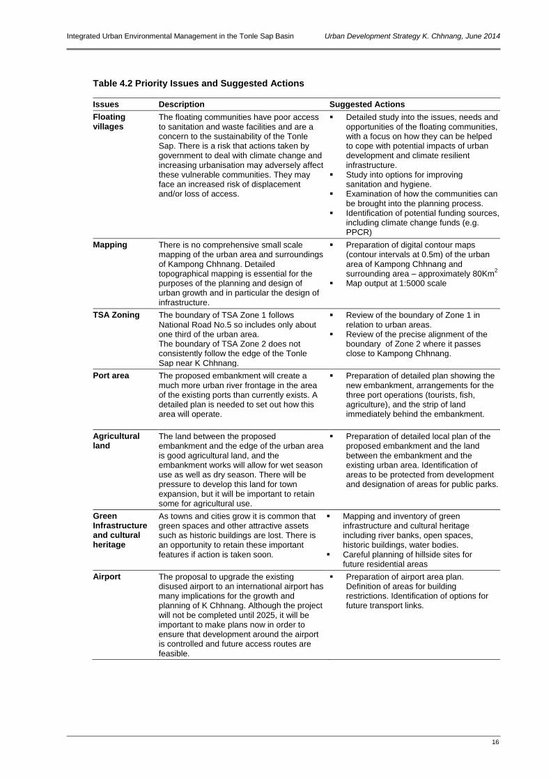
Table 4.2 Priority Issues and Suggested Actions
Issues Description Suggested Actions
Floating villages
The floating communities have poor access to sanitation and waste facilities and are a concern to the sustainability of the Tonle Sap. There is a risk that actions taken by government to deal with climate change and increasing urbanisation may adversely affect these vulnerable communities. They may face an increased risk of displacement and/or loss of access.
Detailed study into the issues, needs and opportunities of the floating communities, with a focus on how they can be helped to cope with potential impacts of urban development and climate resilient infrastructure.
Study into options for improving sanitation and hygiene.
Examination of how the communities can be brought into the planning process.
Identification of potential funding sources, including climate change funds (e.g. PPCR)
Mapping There is no comprehensive small scale mapping of the urban area and surroundings of Kampong Chhnang. Detailed topographical mapping is essential for the purposes of the planning and design of urban growth and in particular the design of infrastructure.
Preparation of digital contour maps (contour intervals at 0.5m) of the urban area of Kampong Chhnang and surrounding area – approximately 80Km
2
Map output at 1:5000 scale
TSA Zoning The boundary of TSA Zone 1 follows National Road No.5 so includes only about one third of the urban area. The boundary of TSA Zone 2 does not consistently follow the edge of the Tonle Sap near K Chhnang.
Review of the boundary of Zone 1 in relation to urban areas.
Review of the precise alignment of the boundary of Zone 2 where it passes close to Kampong Chhnang.
Port area The proposed embankment will create a much more urban river frontage in the area of the existing ports than currently exists. A detailed plan is needed to set out how this area will operate.
Preparation of detailed plan showing the new embankment, arrangements for the three port operations (tourists, fish, agriculture), and the strip of land immediately behind the embankment.
Agricultural land
The land between the proposed embankment and the edge of the urban area is good agricultural land, and the embankment works will allow for wet season use as well as dry season. There will be pressure to develop this land for town expansion, but it will be important to retain some for agricultural use.
Preparation of detailed local plan of the proposed embankment and the land between the embankment and the existing urban area. Identification of areas to be protected from development and designation of areas for public parks.
Green Infrastructure and cultural heritage
As towns and cities grow it is common that green spaces and other attractive assets such as historic buildings are lost. There is an opportunity to retain these important features if action is taken soon.
Mapping and inventory of green infrastructure and cultural heritage including river banks, open spaces, historic buildings, water bodies.
Careful planning of hillside sites for future residential areas
Airport The proposal to upgrade the existing disused airport to an international airport has many implications for the growth and planning of K Chhnang. Although the project will not be completed until 2025, it will be important to make plans now in order to ensure that development around the airport is controlled and future access routes are feasible.
Preparation of airport area plan. Definition of areas for building restrictions. Identification of options for future transport links.
Integrated Urban Environmental Management in the Tonle Sap Basin Urban Development Strategy K. Chhnang, June 2014
17
5 Phased Development Strategy
5.1 General
57 The strategy has been divided into three phases. The first phase is 6 years, parallel with the implementation of the ADB project. Second and third phases are both 5 years.
5.2 Development Strategy Phase 1 – 2014 to 2020
58 Key features of the for Phase 1 of the strategy include construction of the by-pass and bridge link, the embankment improvement, cross-town secondary roads and infill development (see Figure 5.1).
Figure 5.1 Development Strategy Phase 1, 2014 – 2020
Integrated Urban Environmental Management in the Tonle Sap Basin Urban Development Strategy K. Chhnang, June 2014
18
5.2.1 Components of Phase 1
Urban Development Consolidate existing urban area through infill developments, improvements in infrastructure,
and better planning and development control Facilitate urban growth in expansion areas by extending existing infrastructure Identify zone for general industry to south of town along Road No.5 Establish area leading to the port as conservation zone
Road Network and Transport
By-pass road linking National Road No.5 to north and south of the town Bridge and road link with Kampong Thom Establish bus stations at junctions of by-pass and Road No.5 Secondary road connections
Environmental Infrastructure Construction of flood embankment Establish urban parks Establish improved solid waste collection and disposal facilities
5.3 Development Strategy Phase 2 – 2021 to 2025
59 Key features of Phase 2 of the strategy include development behind the embankment, urban development along the by-pass, and construction of the international airport (see Figure 5.2).
5.3.1 Components of Phase 2
Urban Development Limited planned development including new roads in areas protected by new embankment Extension of ‘urban’ river frontage along new embankment north of existing port area Controlled development along northern side of by-pass, with frontage roads
Road Network and Transport
Relocate ports on river frontage Complete secondary road network Construction of international airport Improve transport linkages to airport
Environmental Infrastructure
Create urban park behind embankment Kampong Leaeng developed as eco-tourism zone Establish wastewater treatment systems

Integrated Urban Environmental Management in the Tonle Sap Basin Urban Development Strategy K. Chhnang, June 2014
19
Figure 5.2 Development Strategy Phase 2, 2021 – 2025
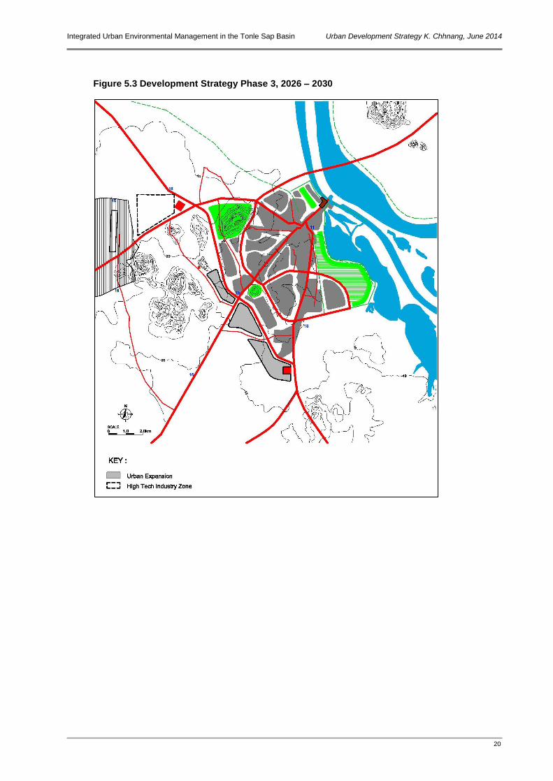
5.4 Development Strategy Phase 3 – 2026 to 2030
5.4.1 Components of Phase 3
Urban Development Controlled development along southern side of by-pass, with frontage roads Establish high tech/light industrial zone near airport
Road Network and Transport
Rapid-transit rail link to airport?
Integrated Urban Environmental Management in the Tonle Sap Basin Urban Development Strategy K. Chhnang, June 2014
20
Figure 5.3 Development Strategy Phase 3, 2026 – 2030