4.13 ENVIRONMENTAL AND SOCIAL CONSIDERATION 4.13.1...
42
The Study on Integrated Transport Master Plan for JABODETABEK (Phase II) Final Report, Volume 2: Pre-Feasibility Studies Chapter 4 Serpong Line Double Tracking, Access Improvement & Integrated Land Development 4-78 4.13 ENVIRONMENTAL AND SOCIAL CONSIDERATION 4.13.1 Examination of AMDAL Requirement (1) Criteria for AMDAL Requirement The project consists of four components: Serpong line double tracking, Serpong line short cut, Improvement of railway facilities of western line and Access road and station square development, as shown in Table 4.13.1. Serpong line double tracking project will not require AMDAL according to national criteria, which will be adopted for the project site lying across the provincial boundary. The reason is that the length of planned railroad is shorter than 25 km, which is a national criterion, and the scale of new stations is smaller than Class I. National and DKI’s criteria for AMDAL requirement are compared in Tables 4.13.2 and 4.13.3. DKI’s criteria are lower than the national’s in order to fulfill the requirement of AMDAL. National criteria are adopted for all projects whose sites bestride the boundary between DKI and an adjacent province, while DKI’s criteria are adopted only for projects whose sites are within DKI. It causes an unreasonable result, that is, in the case that the project site bestrides the boundary between DKI and an adjacent province, and the scale of whole project does not fulfill the national criteria although the scale only within DKI fulfill DKI’s criteria, the project could be exempted from AMDAL. This contradiction happened in the case of Serpong line double tracking. In order to solve this problem, the project, whose site bestrides provinces, should be judged by not only national criteria in totality but also the criteria of each province for each project site included. Serpong line shortcut project will not require AMDAL according to DKI’s criteria because the length of planned railroad is shorter than 5 km, which is DKI’s criterion. The construction of new stations, which is planned in Improvement of railway facilities of western line, will require AMDAL according to DKI’s standard. Road widening, which is planned in access road and station square development project, will require AMDAL on the basis of both DKI’s and national criterion. Accordingly, two of four components would not require AMDAL, in the case that each of them is independently judged by the criteria to be adopted. However, they are related to each other so closely as a whole project that environmental impacts will be accumulated by the implementation of four components. Therefore, it is highly recommended to conduct the integrated EIA on the four components and to analyze the accumulated impacts. The integrated evaluation contributes to illuminating potential issues, which might be overlooked by analyzing fragmentary impacts.
Transcript of 4.13 ENVIRONMENTAL AND SOCIAL CONSIDERATION 4.13.1...
The Study on Integrated Transport Master Plan for JABODETABEK (Phase II) Final Report, Volume 2: Pre-Feasibility Studies Chapter 4 Serpong Line Double Tracking, Access Improvement & Integrated Land Development
4-78
4.13 ENVIRONMENTAL AND SOCIAL CONSIDERATION
4.13.1 Examination of AMDAL Requirement
(1) Criteria for AMDAL Requirement
The project consists of four components: Serpong line double tracking, Serpong line short cut,
Improvement of railway facilities of western line and Access road and station square
development, as shown in Table 4.13.1. Serpong line double tracking project will not require
AMDAL according to national criteria, which will be adopted for the project site lying across
the provincial boundary. The reason is that the length of planned railroad is shorter than 25
km, which is a national criterion, and the scale of new stations is smaller than Class I.
National and DKI’s criteria for AMDAL requirement are compared in Tables 4.13.2 and 4.13.3.
DKI’s criteria are lower than the national’s in order to fulfill the requirement of AMDAL.
National criteria are adopted for all projects whose sites bestride the boundary between DKI
and an adjacent province, while DKI’s criteria are adopted only for projects whose sites are
within DKI. It causes an unreasonable result, that is, in the case that the project site bestrides
the boundary between DKI and an adjacent province, and the scale of whole project does not
fulfill the national criteria although the scale only within DKI fulfill DKI’s criteria, the project
could be exempted from AMDAL. This contradiction happened in the case of Serpong line
double tracking. In order to solve this problem, the project, whose site bestrides provinces,
should be judged by not only national criteria in totality but also the criteria of each province
for each project site included.
Serpong line shortcut project will not require AMDAL according to DKI’s criteria because the
length of planned railroad is shorter than 5 km, which is DKI’s criterion. The construction of
new stations, which is planned in Improvement of railway facilities of western line, will require
AMDAL according to DKI’s standard. Road widening, which is planned in access road and
station square development project, will require AMDAL on the basis of both DKI’s and
national criterion. Accordingly, two of four components would not require AMDAL, in the
case that each of them is independently judged by the criteria to be adopted. However, they
are related to each other so closely as a whole project that environmental impacts will be
accumulated by the implementation of four components.
Therefore, it is highly recommended to conduct the integrated EIA on the four components and
to analyze the accumulated impacts. The integrated evaluation contributes to illuminating
potential issues, which might be overlooked by analyzing fragmentary impacts.

The Study on Integrated Transport Master Plan for JABODETABEK (Phase II) Final Report, Volume 2: Pre-Feasibility Studies
Chapter 4 Serpong Line Double Tracking, Access Improvement & Integrated Land Development
4-79
Table 4.13.1 Project Proponent and Scale of Each Project Component
Proponent Project Component (Underlined work may require AMDAL according to DKI’s criteria)
(1) Serpong Line Double Tracking (Serpong – Tanah Abang: 23.3 km)
- Double-tracking (DKI: 12.1km, Kb. Tangerang: 11.2km) - Electrical, signaling and communication system installation - Improvement of existing station facilities - Construction of new stations (Class II and smaller)
(2) Serpong Line Short Cut (Palmerah – Karet: 1.7 km)
- Embankment works of Double-tracking
DGLC
(3) Improvement of Railway Facilities of Western Line (Karet – Manggarai: 4.3 km)
- Improvement of signaling and telecommunication facilities - Improvement of existing station facilities - Construction of new stations (Class II and smaller)
DGLC and DKI, Kb.
Tangerang
(4) Access Road and Station Square Development - Road widening (1st stage: 17km, 2nd stage: 3.7km) - Construction of new road (1st stage: 0km, 2nd stage: 4.0km) - Construction of station square (1st stage: 1,300sqm, 2nd stage:
5,600sqm)
Table 4.13.2 National and DKI’s Criteria for AMDAL Requirement (Railway related projects)
Project Type DKI National
Construction of Train Railroad Length : 5 km Length : 25 km
Construction of Train Station Class I, II* Large, Class I*
* PT. KA divides a station class into four: Large class, Class I, II and III by type of station facilities to be installed. Large class station is as large a terminal as Kota/Gambir and Class II station is as major a station as Sudirman, Serpong and Rawabuntu planned stations.
Table 4.13.3 National and DKI’s Criteria for AMDAL Requirement (Road Construction)
Project Type DKI National* Construction of New Road
with Land Acquisition Length** : 1 km or Extent Area*** : 1 ha
Improvement of Existing Road WITH Land Acquisition
Length : 4 km or Extent Area : 2.5 ha
Improvement of Existing Road WITHOUT Land Acquisition****
Length : 4 km or Extent Area : 3 ha
Length : 5 km or Extent Area : 5 ha (for Big city/Metropolitan)
* Banten province employs national criteria. ** “Length” means the total length of new road construction and existing road improvement. *** “Extent area” means road area constructed by new road construction and existing road improvement. **** “Improvement of Existing Road WITHOUT Land Acquisition” means existing road improvement in right-of-way and “Improvement” excludes regular road maintenance.

The Study on Integrated Transport Master Plan for JABODETABEK (Phase II) Final Report, Volume 2: Pre-Feasibility Studies Chapter 4 Serpong Line Double Tracking, Access Improvement & Integrated Land Development
4-80
(2) Project Proponent and Relevant Agencies
DGLC and Local governments should cooperate closely with the EIA secretariat, MLH, to
conduct an integrated EIA. A concrete proposal is to organize the project management unit,
which will work as the project proponent to follow the AMDAL procedure. It is also
recommended that MLH invite representatives from BPLHD of DKI, Kb. Tangerang and
Banten Province to AMDAL evaluation committee because the project will affect a broad area
surrounding the project site.
Table 4.13.4 Project Proponent Proposed and Relevant Agencies
Proponent Relevant Agencies Tasks assigned PT KA Operator
Responsible local government agencies
Road Widening (Dinas PU) Implementation of land acquisition (Land acquisition Committee)
Private Developer Possible investor/builder of station building and station square
Project Management Unit (DGLC & DKI, Kb. Tangerang)
MLH EIA Secretariat
(3) Other Stakeholders
In addition to the project proponent and relevant agencies, stakeholders of the project are
preliminarily identified as shown in Table 4.13.5.
Table 4.13.5 Preliminary Identification of Stakeholders
Categories Features of the People/Group Beneficiaries - Railway users (both existing and potential ones)
- Railway operators (PT. KA) Negatively Affected Groups - Other public transport operators competing with the railway
- Individuals/households/business enterprises/public facilities who have to give up a part of their property (land, building) but no need to resettle.
- Individuals/households/business enterprises/public facilities who have to give up all of their property and resettle
- Users of public facilities mentioned above - Illegal occupants on the project site such as squatters living in the
right-of-way of the railway and street vendors - People living near the railway track
Implementing agencies - Project Proponent & relevant agencies (see Table 4.13.4) Funding agencies - Unknown yet
Local & Community leaders Following leaders in the project area and its surrounding areas - Head of Kecamatan - Head of Kelrahan / Desa - Head of RT & RW - Leaders of various community groups
Potential Opponents - Social Groups/NGOs which concern environmental issues - Social Groups/NGOs which concern interests of the negatively affected
groups mentioned above Supporting Groups - Private developers
- People who have intention to possess or rent house to settle in outer areas of DKI Jakarta

The Study on Integrated Transport Master Plan for JABODETABEK (Phase II) Final Report, Volume 2: Pre-Feasibility Studies
Chapter 4 Serpong Line Double Tracking, Access Improvement & Integrated Land Development
4-81
(4) Scoping of Natural Environment
The four project components are different in terms of natural environmental impacts. The
possible impacts are described for each component in Table 4.13.6 and natural environmental
issues are scoped as shown in Table 4.13.7.
Table 4.13.6 Possible Impacts of each Project Component
Project component Possible Impacts Description Serpong Line Double Tracking (Serpong – Tanah Abang: 23.3 km)
More impact of noise and vibration would be caused along the project site.
Serpong Line Short Cut (Palmerah – Karet: 1.7 km)
Serious impacts of noise and vibration would be caused along the project site since the project site will be located partly in Kampung where residents are not used to noise and vibration.
Improvement of Railway Facilities of Western Line (Karet – Manggarai: 4.3 km)
More impact of noise and vibration would be caused along the project site due to more frequent operation of railway.
Access Road and Station Square Development
The project would increase traffic demand on connecting roads’ adjacent area to the upgraded stations. It would cause air pollution, noise and vibration.
Table 4.13.7 Possible Impacts on Natural Environment
Possible impact Construction stage Operational stage
(1) Air Quality B C (2) Water Quality B B (3) Noise & Vibration A A (4) Topography & Geology B B (5) Hydrology - B
Natural Environment
(6) Wastes B B A: Serious impact expected, B: Impact expected, C: Unknown, -: No/Negligible Impact expected
(5) Scoping of Social Environment
Social impacts of the project will slightly differ from each project component. Following is a
brief review of key aspects.
1) Serpong Line Double Tracking
In most parts of the line, present right-of-way is sufficient for double tracking. However,
there are many people living in the right-of-way. Especially between Palmerah and Tanah
Abang, many small houses, possibly about 100, line up on both sides of track. Some of them
are two-storied. Between Limo and Kebayoran Lama, there are also small huts scattered
along the track but not so many. Although they are compelled to move out, appropriate
compensatory measures are necessary for them because they are most vulnerable people in
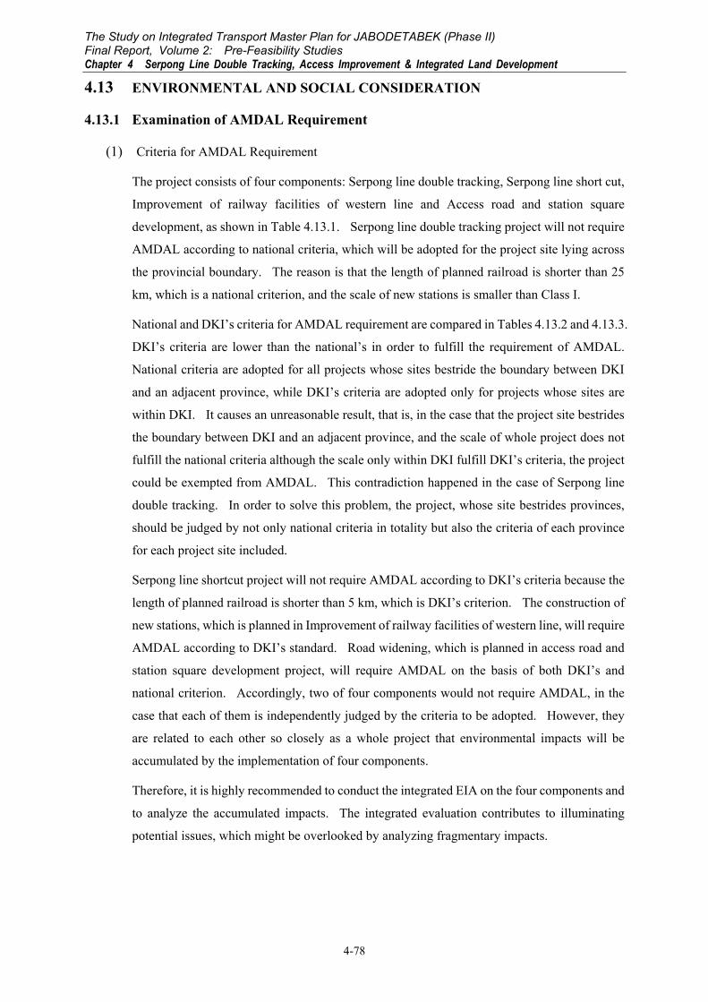
society (Figure 4.13.1).
The Study on Integrated Transport Master Plan for JABODETABEK (Phase II) Final Report, Volume 2: Pre-Feasibility Studies Chapter 4 Serpong Line Double Tracking, Access Improvement & Integrated Land Development
4-82
Figure 4.13.1 Squatters’ Houses in the Right-Of-Way of Railway
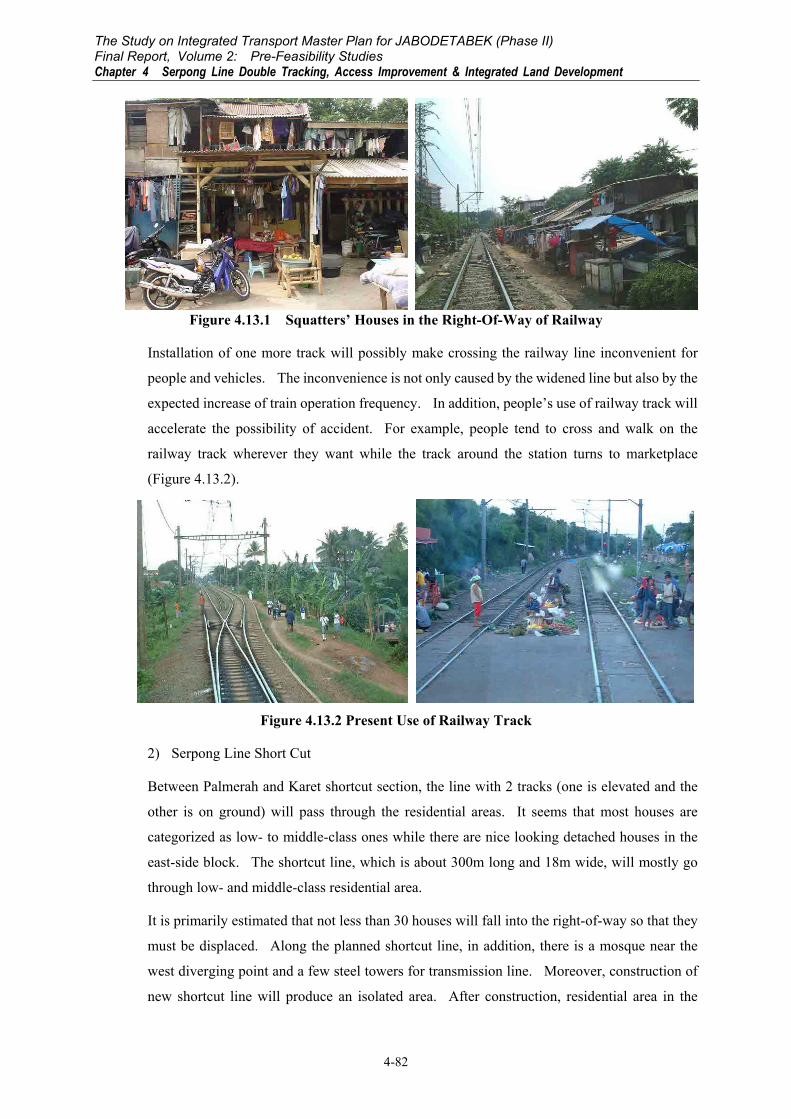
Installation of one more track will possibly make crossing the railway line inconvenient for
people and vehicles. The inconvenience is not only caused by the widened line but also by the
expected increase of train operation frequency. In addition, people’s use of railway track will
accelerate the possibility of accident. For example, people tend to cross and walk on the
railway track wherever they want while the track around the station turns to marketplace
(Figure 4.13.2).
Figure 4.13.2 Present Use of Railway Track
2) Serpong Line Short Cut
Between Palmerah and Karet shortcut section, the line with 2 tracks (one is elevated and the
other is on ground) will pass through the residential areas. It seems that most houses are
categorized as low- to middle-class ones while there are nice looking detached houses in the
east-side block. The shortcut line, which is about 300m long and 18m wide, will mostly go
through low- and middle-class residential area.
It is primarily estimated that not less than 30 houses will fall into the right-of-way so that they
must be displaced. Along the planned shortcut line, in addition, there is a mosque near the
west diverging point and a few steel towers for transmission line. Moreover, construction of
new shortcut line will produce an isolated area. After construction, residential area in the

The Study on Integrated Transport Master Plan for JABODETABEK (Phase II) Final Report, Volume 2: Pre-Feasibility Studies
Chapter 4 Serpong Line Double Tracking, Access Improvement & Integrated Land Development
4-83
north side of the line is enclosed by river on east, main Serpong line on west and shortcut line
on south. Approximately, not less than 50 houses are located in this area at present.
In conclusion, it is apparent that involuntary resettlement followed by land acquisition and split
community will significantly influence on the socio-economic activities of people. In
addition, it should be noted that emergence of such big structure right in the middle of the
community will not be an easy situation for people to adjust.
Figure 4.13.3 Panorama of the Shortcut Section
Figure 4.13.4 Overview of the Shortcut Section
3) Improvement of Railway Facilities of Western Line
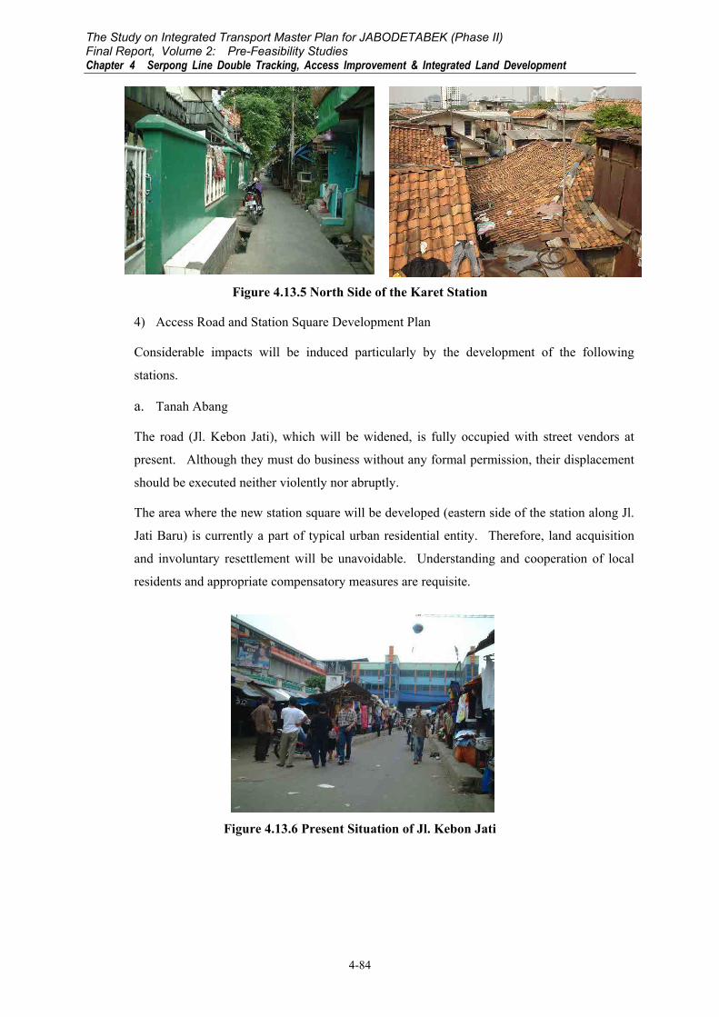
Significant social impact will be caused by improvement of Karet station. Although its
number is not so many, about 20 houses located in the north side of the station should be
completely removed. According to an existing planning map of railway, these houses are
built within its right-of-way. However, they appear to have been a part of neighboring
community for many years (Figure 4.13.5). Their land status should be clarified while
compensatory measures for their involuntary resettlement should be taken appropriately.
RIVER
Jl. Penjernihan
Jl. KH. Mas Mansyur
Karet Station
Tanah Abang
Collective houses(High-rise building)
Railway track
Tanah Abang
MosqueLow &middle-class
residentialarea
Shortcut line
Uppermiddle &
high classresidential
area
Residential area(land acquisition isnecessary)
The Study on Integrated Transport Master Plan for JABODETABEK (Phase II) Final Report, Volume 2: Pre-Feasibility Studies Chapter 4 Serpong Line Double Tracking, Access Improvement & Integrated Land Development
4-84
Figure 4.13.5 North Side of the Karet Station
4) Access Road and Station Square Development Plan
Considerable impacts will be induced particularly by the development of the following
stations.
a. Tanah Abang
The road (Jl. Kebon Jati), which will be widened, is fully occupied with street vendors at
present. Although they must do business without any formal permission, their displacement
should be executed neither violently nor abruptly.
The area where the new station square will be developed (eastern side of the station along Jl.
Jati Baru) is currently a part of typical urban residential entity. Therefore, land acquisition
and involuntary resettlement will be unavoidable. Understanding and cooperation of local
residents and appropriate compensatory measures are requisite.
Figure 4.13.6 Present Situation of Jl. Kebon Jati
The Study on Integrated Transport Master Plan for JABODETABEK (Phase II) Final Report, Volume 2: Pre-Feasibility Studies
Chapter 4 Serpong Line Double Tracking, Access Improvement & Integrated Land Development
4-85
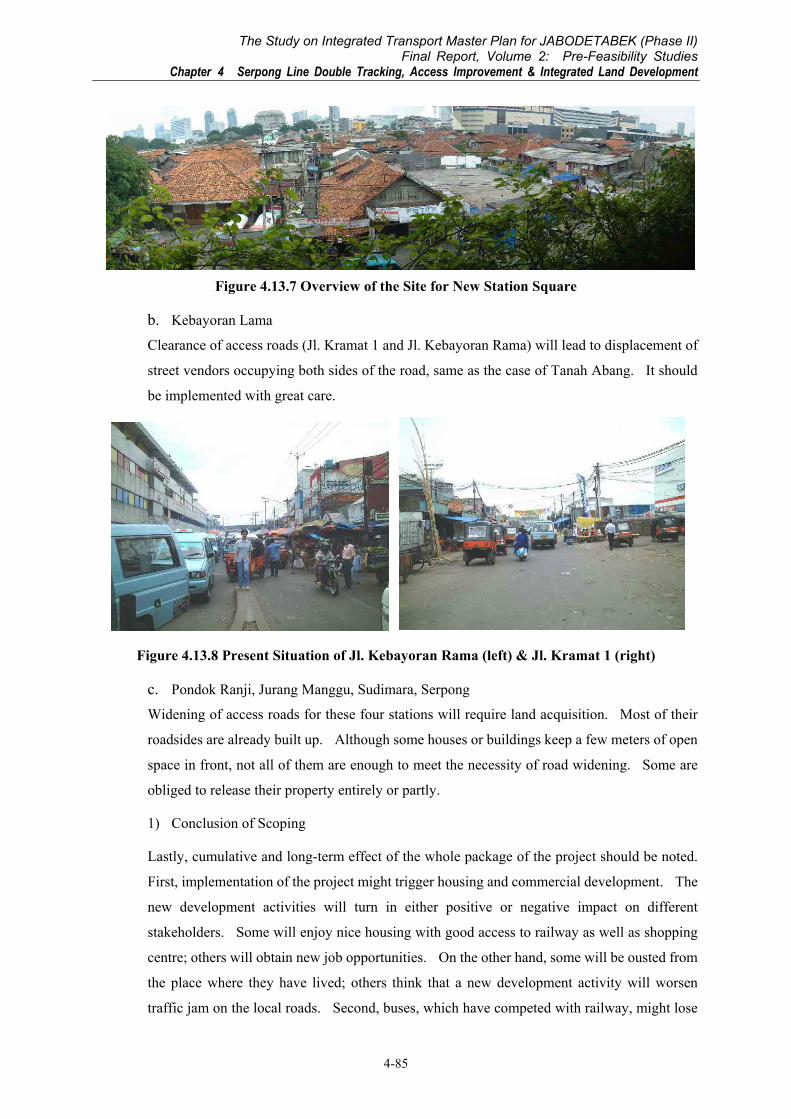
Figure 4.13.7 Overview of the Site for New Station Square
b. Kebayoran Lama
Clearance of access roads (Jl. Kramat 1 and Jl. Kebayoran Rama) will lead to displacement of
street vendors occupying both sides of the road, same as the case of Tanah Abang. It should
be implemented with great care.
Figure 4.13.8 Present Situation of Jl. Kebayoran Rama (left) & Jl. Kramat 1 (right)
c. Pondok Ranji, Jurang Manggu, Sudimara, Serpong
Widening of access roads for these four stations will require land acquisition. Most of their
roadsides are already built up. Although some houses or buildings keep a few meters of open
space in front, not all of them are enough to meet the necessity of road widening. Some are
obliged to release their property entirely or partly.
1) Conclusion of Scoping
Lastly, cumulative and long-term effect of the whole package of the project should be noted.
First, implementation of the project might trigger housing and commercial development. The
new development activities will turn in either positive or negative impact on different
stakeholders. Some will enjoy nice housing with good access to railway as well as shopping
centre; others will obtain new job opportunities. On the other hand, some will be ousted from
the place where they have lived; others think that a new development activity will worsen
traffic jam on the local roads. Second, buses, which have competed with railway, might lose

The Study on Integrated Transport Master Plan for JABODETABEK (Phase II) Final Report, Volume 2: Pre-Feasibility Studies Chapter 4 Serpong Line Double Tracking, Access Improvement & Integrated Land Development
4-86
patronage because of improvement of railway service. However, above-mentioned housing
development might create new travel demand between housing complex and railway station
for bus operators.
In conclusion, influence of the project over the social environment will be significant.
Possible impacts and degree of their seriousness are summarized in Table 4.13.8.
Table 4.13.8 Possible Impacts on Social Environment
Possible impact Construction stage
Operational Stage
(1) Land acquisition & Involuntary resettlement
A A
(2) Split community A/B A (3) Socio-economic activities A/B A (4) Traffic activities A A (5) Land use C B
Social Environment
(6) Cultural property C C A: Serious impact expected, B: Impact expected, C: Unknown, -: No/Negligible Impact expected
4.13.2 Preliminary Examination of EIA Methodologies
It is highly recommended to conduct a full-blown AMDAL for the whole project, which
consists of four components on the condition that they will start their construction works within
three years because basically the completion of AMDAL procedure is legally valid for three
years.
(1) Natural Environment
Methodology of natural environmental impact assessment in AMDAL is proposed as shown in
Table 4.13.9.
(2) Social Environment
Methodology of social impact assessment in EIA is proposed in Table 4.13.10.

4-87
Table 4.13.9 Methodologies on Natural Environment
Issue Preliminary Forecasted Impact Methodology of Data Collection/Analysis Methodology of Impact Forecasting
Methodology of Evaluation of Forecasted
Impact
(1) Air Quality
Construction stage: Construction machine would emit air pollutants and earthwork would cause particulates. Operational stage: Improved Serpong Line would increase the capacity of its transportation. Therefore, it is expected to reduce traffic volume of the competitive roads along the alignment and it may increase traffic demand on connecting roads to the stations.
If continuous monitoring data measured (BPLHD, etc.) at a monitoring station near to project site (Secondary data) are available, they would be most reliable for long-term evaluation. However, air quality survey (Primary data) should be implemented since monitoring station locates away from project site and the monitoring data might not describe its own characteristics. Therefore, long-term trend should be analyzed by continuous monitoring data and the analyzed trend would be converted to the project site properly by comparing on-site survey data with the continuous monitoring data in the survey periods. The survey points should be located at environment-sensitive area/sites, namely housing area, hospitals and schools adjacent to the project site, which should be identified on a map.
For forecasting the impact, a simpler method than Gausian model, commonly adopted in EIA, would be appropriate. It estimates by increasing or reducing the surveyed concentration by total emission change from pre-construction to construction/operational stage. For the calculation of the total emission amount, the machines’ emission factors and their working hours in construction stage, vehicles’ emission factors and traffic volumes in operational stage should be estimated.
The forecasted concentration should be evaluated with the standard.
(2) Water Quality
Construction stage: Construction/Improvement work of bridges would worsen especially turbidity.
Regular monitoring data on water quality are available in major rivers. If the rivers crossing the project sites are monitored and the sampling points are near to crossing points, monitored data should be collected and analyzed. And for the other rivers, on-site survey should be conducted.
Since the impact would be limited in construction stage, the impact would be forecasted in empirical method by considering construction activity at the crossing points.
The forecasted concentration should be evaluated with the standard.
4-88
4-88
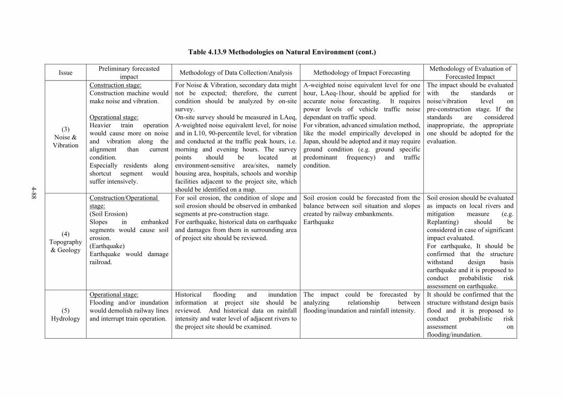
Table 4.13.9 Methodologies on Natural Environment (cont.)
Issue Preliminary forecasted impact Methodology of Data Collection/Analysis Methodology of Impact Forecasting Methodology of Evaluation of
Forecasted Impact
(3) Noise & Vibration
Construction stage: Construction machine would make noise and vibration. Operational stage: Heavier train operation would cause more on noise and vibration along the alignment than current condition. Especially residents along shortcut segment would suffer intensively.
For Noise & Vibration, secondary data might not be expected; therefore, the current condition should be analyzed by on-site survey. On-site survey should be measured in LAeq, A-weighted noise equivalent level, for noise and in L10, 90-percentile level, for vibration and conducted at the traffic peak hours, i.e. morning and evening hours. The survey points should be located at environment-sensitive area/sites, namely housing area, hospitals, schools and worship facilities adjacent to the project site, which should be identified on a map.
A-weighted noise equivalent level for one hour, LAeq-1hour, should be applied for accurate noise forecasting. It requires power levels of vehicle traffic noise dependant on traffic speed. For vibration, advanced simulation method, like the model empirically developed in Japan, should be adopted and it may require ground condition (e.g. ground specific predominant frequency) and traffic condition.
The impact should be evaluated with the standards or noise/vibration level on pre-construction stage. If the standards are considered inappropriate, the appropriate one should be adopted for the evaluation.
(4) Topography & Geology
Construction/Operational stage: (Soil Erosion) Slopes in embanked segments would cause soil erosion. (Earthquake) Earthquake would damage railroad.
For soil erosion, the condition of slope and soil erosion should be observed in embanked segments at pre-construction stage. For earthquake, historical data on earthquake and damages from them in surrounding area of project site should be reviewed.
Soil erosion could be forecasted from the balance between soil situation and slopes created by railway embankments. Earthquake
Soil erosion should be evaluated as impacts on local rivers and mitigation measure (e.g. Replanting) should be considered in case of significant impact evaluated. For earthquake, It should be confirmed that the structure withstand design basis earthquake and it is proposed to conduct probabilistic risk assessment on earthquake.
(5) Hydrology
Operational stage: Flooding and/or inundation would demolish railway lines and interrupt train operation.
Historical flooding and inundation information at project site should be reviewed. And historical data on rainfall intensity and water level of adjacent rivers to the project site should be examined.
The impact could be forecasted by analyzing relationship between flooding/inundation and rainfall intensity.
It should be confirmed that the structure withstand design basis flood and it is proposed to conduct probabilistic risk assessment on flooding/inundation.

4-89
Table 4.13.9 Methodologies on Natural Environment (cont.)
Issue Preliminary forecasted impact Methodology of Data Collection/Analysis Methodology of Impact Forecasting Methodology of Evaluation of
Forecasted Impact
(6) Wastes
Construction stage: Construction wastes, especially soil and domestic wastes of workers, would be generated. Operational stage: More passengers would discharge more domestic wastes at the stations.
The condition of wastes disposal at pre-construction stage should be examined. Amount of domestic wastes should be examined in adjacent area to the project site.Total amount of domestic wastes in adjacent area to the project site should be examined. To determine emission factor of domestic wastes, an amount of domestic wastes and the number of passengers should be surveyed at existing stations.
The amount of the construction wastes in construction stage could be forecasted empirically by type and scale of the construction. The amount of the domestic wastes in construction stage could be estimated from the number of man-months required in the construction plan. And in operational stage, the number could be forecasted from the surveyed emission factors and the number of passengers estimated at each station.
The impact of the construction wastes should be evaluated by the capacity of disposal site for them. The impact of the domestic wastes should be evaluated by comparing the additional amount due to the project to the amount in pre-construction stage.

4-90
4-90
Table 4.13.10 Methodologies on Social Environment (1/5)
Issue
Preliminary forecasted
impact
Methodology of Data Collection/Analysis * Required Data & Information * Method of Data Collection & Source of Data
Methodology of * Impact Forecasting * Evaluation of Forecasted Impact
(1) Land acquisition & Involuntary resettlement
(For those who live or do their business in the
areas which need to be
acquired for the project and within the
right-of-way)
1) It will weaken socio-economic situation of households which lost a part or whole of their property (e.g. loss of business and/or living basis, deteriorated condition of house/commercial building)
2) People will have difficulty to adjust to the new settlement place (e.g. conflict with other residents, difficulty to get job)
3) Removal of some social facilities will cause inconvenience to their users
Required data & information • Data & information of land acquisition area:
- Population, number of households, characteristics of households (housing & land status, living conditions, occupation, income, etc.)
- Land use pattern & inventory of existing infrastructure (property/land right status, location & area of houses, local road, social facilities, agricultural field, commercial & business facilities)
- Socio-cultural characteristics of community (community history & profile, ethnic & geographical origin, custom & tradition, socio-cultural group & its activities, mutual help, communal property & facilities)
• Data & information of people living within the right-of-way - Population, number of households, characteristics of households
(housing, living conditions, occupation, income, etc.) - Characteristics of squatters’ community (history, ethnic &
geographical origin, mutual help, relationship with outside community and PT KA)
Method & Source (Primary data & information) • Household interview (sample HHs, using questionnaire) • Key informant interview (RT/RW leader, leader of various social
groups, local government officials) • Direct observation (Secondary data & information) • Relevant maps & statistics obtained from:
- Local government (e.g. Camat, Lurah) - Local office of National Land Agency (BPN) - Local office of National Statistics Agency (BPS), and - Other relevant government agencies (e.g. Dinas Tata Kota)
(Impact forecasting) Required data & information • Opinion & perception from project affected
people (PAP) and other relevant stakeholders • Experience of similar projects Method & Source • Household interview (sample HHs, using
questionnaire) • Key informant interview ((RT/RW leader, leader
of various social groups, local government officials, local NGOs, intellectuals, experts)
• Group discussion (by different stakeholders) • Project document & research paper of similar
projects (Evaluation of forecasted impact) Required data & information • Number of PAP, households • Project affected area (m2) • Degree/seriousness of impact • Period of impact continued Method & Source • Empirical knowledge of expert • Analysis of obtained data & information • Project document & research paper of similar
projects

4-91
Table 4.13.10 Methodologies on Social Environment (2/5)
Issue
Preliminary forecasted
impact
Methodology of Data Collection/Analysis * Required Data & Information * Method of Data Collection & Source of Data
Methodology of * Impact Forecasting * Evaluation of Forecasted Impact
(2) Split community
1) New shortcut will cut traditional lines of travel or communication of people in the community
2) Isolated part of the community will emerge as a result of shortcut railway construction so that the community ties will be deteriorated.
(3) Socio-economic
activities
(Those who live or do business in the surrounding
area of the project)
1) Split community as well as change of land use pattern will affect economic activities of local people and most possibly enervate them.
2) Split community as well as change of land use pattern will weaken community ties & relationships.
3) Widened railway will make it more difficult for the local people to access social service facilities located at opposite side of the road.
Required data & information • Data & information of surrounding area of the project
- Population, number of households, characteristics of households (housing & living conditions, occupation, income, etc.)
- Land use pattern & Inventory of existing infrastructure (location & area of houses, local road, social facilities, agricultural field, commercial & business facilities)
- Socio-cultural characteristics of community (community history & profile, ethnic & geographical origin, custom & tradition, socio-cultural group & its activities, mutual help, communal property & facilities)
Method & Source (Primary data& information) • Household interview (sample HHs, using questionnaire) • Key informant interview (RT/RW leaders, leaders of various
social groups, local government officials, staff of social facilities such as school, hospital, farmers, market traders)
• Direct observation (Secondary data & information) Relevant maps & statistics obtained from:
- Local government (e.g. Camat, Lurah) - Local office of National Statistics Agency (BPS), and - Other relevant government agencies (e.g. Dinas Tata Kota)
(Impact forecasting) Required data & information • Opinion & perception from project affected
people (PAP) and other relevant stakeholders • Data & information obtained in (5) • Experience of similar projects Method & Source • Household interview (sample HHs, using
questionnaire) • Key informant interview ((RT/RW leader, leader
of various social groups, local government officials, local NGOs, intellectuals, experts)
• Group discussion (by different stakeholders) • Project document & research paper of similar
projects (Evaluation of forecasted impact) Required data & information • Number of PAP • Project affected area (m2) • Degree/seriousness of impact • Period of impact continued Method & Source • Empirical knowledge of expert • Analysis of obtained data & information • Project document & research paper of similar
projects
4-92
4-92
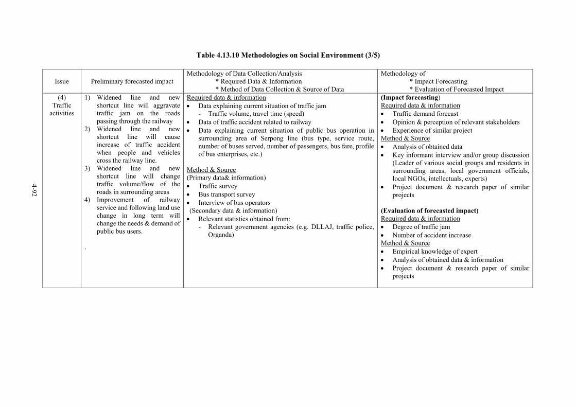
Table 4.13.10 Methodologies on Social Environment (3/5)
Issue
Preliminary forecasted impact
Methodology of Data Collection/Analysis * Required Data & Information * Method of Data Collection & Source of Data
Methodology of * Impact Forecasting * Evaluation of Forecasted Impact
(4) Traffic
activities
1) Widened line and new shortcut line will aggravate traffic jam on the roads passing through the railway
2) Widened line and new shortcut line will cause increase of traffic accident when people and vehicles cross the railway line.
3) Widened line and new shortcut line will change traffic volume/flow of the roads in surrounding areas
4) Improvement of railway service and following land use change in long term will change the needs & demand of public bus users.
.
Required data & information • Data explaining current situation of traffic jam
- Traffic volume, travel time (speed) • Data of traffic accident related to railway • Data explaining current situation of public bus operation in
surrounding area of Serpong line (bus type, service route, number of buses served, number of passengers, bus fare, profile of bus enterprises, etc.)
Method & Source (Primary data& information) • Traffic survey • Bus transport survey • Interview of bus operators (Secondary data & information) • Relevant statistics obtained from:
- Relevant government agencies (e.g. DLLAJ, traffic police, Organda)
(Impact forecasting) Required data & information • Traffic demand forecast • Opinion & perception of relevant stakeholders • Experience of similar project Method & Source • Analysis of obtained data • Key informant interview and/or group discussion
(Leader of various social groups and residents in surrounding areas, local government officials, local NGOs, intellectuals, experts)
• Project document & research paper of similar projects
(Evaluation of forecasted impact) Required data & information • Degree of traffic jam • Number of accident increase Method & Source • Empirical knowledge of expert • Analysis of obtained data & information • Project document & research paper of similar
projects

4-93
Table 4.13.10 Methodologies on Social Environment (4/5)
Issue
Preliminary forecasted impact
Methodology of Data Collection/Analysis * Required Data & Information * Method of Data Collection & Source of Data
Methodology of * Impact Forecasting * Evaluation of Forecasted Impact
(5) Land use
1) Housing and commercial development will be encouraged so that it will impact on socio-economic activities of people (e.g. hike of land price, decline of local industry)
Required data & information • Data & information of development plan
- Housing development, commercial & business development
- Regional Spatial Structure Plan (RTRW) of local government
Method & Source • Relevant maps & planning document obtained from:
- Private developers - Housing Agency (Perumnas) - Relevant local government agencies (e.g. Bapeda,
Dinas Tata Kota, Dinas PU)
(Impact forecasting) Required data & information • Opinion & perception from relevant stakeholders • Data & information obtained in (2)-(3) • Experience of similar projects Method & Source • Key informant interview (private developers, local government
officials, intellectuals, experts) • Project document & research paper of similar projects (Evaluation of forecasted impact) Required data & information • Degree/seriousness of impact Method & Source • Empirical knowledge of expert • Analysis of obtained data & information • Project document & research paper of similar projects

4-94
4-94
Table 4.13.10 Methodologies on Social Environment (5/5)
Issue
Preliminary forecasted impact
Methodology of Data Collection/Analysis * Required Data & Information * Method of Data Collection & Source of Data
Methodology of * Impact Forecasting * Evaluation of Forecasted Impact
(6) Cultural property
1) Cultural property located in/along the project area will be damaged.
Required data & information • Location, area, and the profile of cultural property
in/along the project area Method & Source (Primary data & information) • Direct observation • Key informant interview (relevant government
officials, community leaders, traditional users of the property)
(Secondary data & information) • Relevant maps and document obtained from:
- Information office at the cultural property, and - Other relevant government agencies
(Impact forecasting) Required data & information • Opinion & perception from relevant stakeholders • Experience of similar projects Method & Source • Key informant interview (government officials, intellectuals,
experts) • Project document & research paper of similar projects (Evaluation of forecasted impact) • Project affected area (m2) • Degree/seriousness of impact Method & Source • Empirical knowledge of expert • Analysis of obtained data & information • Project document & research paper of similar projects

The Study on Integrated Transportation Master Plan for JABODETABEK (Phase II) Final Report, Volume 2: Pre-Feasibility Studies
Chapter 4 Serpong Line Double Tracking, Access Improvement & Integrated Land Development
4-95
4.13.3 Recommendations on Environmental Impact Assessment for F/S
1) The project proponent should review several alternatives, analyze their impacts comparatively
and explain the results in the evaluation committee to achieve the accountability for the project.
And the evaluation committee should weigh the potential environmental impacts against the
project costs.
2) The project proponent and AMDAL secretariat should ensure fairness and transparency in
AMDAL procedure.
3) With regard to the Serpong line double tracking, the following three points should be
confirmed:
• It is necessary to check that the present right-of-way or the reserved land for railway by the
government is large enough for double tracking, for 2 additional passing tracks at the station
of Kebayoran Lama, Pondok Betung, Pondok Ranji, Jurang Manggu, and Sudimara, and for
the Depot in Serpong station.
• It is necessary to check that whole right-of-way or the reserved land is completely under the
ownership of the government and there is no conflict or overlap with other stakeholders
• The area where the access road to the housing block is built on the right-of-way should be
identified. One such case was found between Kebayoran Lama and Pondok Betung during
scoping. Since the loss of such access road will negatively influence on community,
provision of alternative road should be taken into consideration.
4) Since the project requires land acquisition and involuntary resettlement, Land Acquisition and
Resettlement Plan (LARAP) needs to be formulated in F/S stage. With reference to the area
for the shortcut line and behind Karet station, especially, land status should be clarified as soon
as possible. In addition, some special measures should be considered for illegal occupants,
such as squatters within the right-of-way and street vendors, to mitigate their loss.
5) Overall scheduling of the project and phasing of each component should be decided
thoughtfully. Such situation should be avoided that stagnation of some project component
due to difficult environmental problems would delay other components so that benefit of the
project as a whole would seriously decline.
6) Preparation of environmental management, mitigation and monitoring plan is more important.
It should include, for instance, how to stop careless walking or crossing over the line by people,
and how to deal with complaint from people living near shortcut line.

The Study on Integrated Transportation Master Plan for JABODETABEK (Phase II) Final Report, Volume 2: Pre-Feasibility Studies Chapter 4 Serpong Line Double Tracking, Access Improvement & Integrated Land Development
4-96
4.14 IMPLEMENTATION PROGRAM
4.14.1 Cost Estimates
The Project consists of three packages as follows:
• Serpong Line Double Tracking
• Access Improvement, and
• Integrated Land Development
Total investment cost of the project amounts to Rp. 4,312.4 billion during the period from 2004 to
2020, of which the cost for Serpong Line Double Tracking, Access Improvement and Integrated
Land Development is Rp. 3,248 billion, Rp. 966 billion and Rp. 98.4 billion, respectively as shown
in Table 4.14.1. The cost of Serpong Line Double Tacking accounts for 75% of the total. The
implementation schedule is shown in Figure 4.14.1.
Table 4.14.1 Investment Cost of Project
Unit: Rp. million Short and
Intermediate term(2006~2010)
Long term (2011~2020) Total
Serpong Line Double Tracking 3,248,000 3,248,000Access Improvement 655,000 311,000 966,000Integrated Land Development 19,500 78,900 98,400Total 3,922,500 389,900 4,312,400
Source: SITRAMP
Short term (2008~2007)
Intermediate term (2008~2010)
Long term (2011~2020)
Serpong Line Double Tracking
Access Improvement
Integrated Land Development
Figure 4.14.1 Implementation Schedule of Project
4.14.2 Economic Analysis
(1) Assumptions
1) General
An economic analysis is carried out to examine the efficiency of the implementation of the Project:
Serpong Line Double Tracking, Access Improvement and Integrated Land Development in the
lump.

The Study on Integrated Transportation Master Plan for JABODETABEK (Phase II) Final Report, Volume 2: Pre-Feasibility Studies
Chapter 4 Serpong Line Double Tracking, Access Improvement & Integrated Land Development
4-97
In the Cost-Benefit Analysis, two scenarios, "With Project" and "Without Project" scenarios, are
assumed in order to distinguish and compare the benefits and the costs accompanied by the
implementation of the proposed project. The SITRAMP Master Plan is regarded as "With Project
Case," while "Without Project Case" scenario is formulated under the assumption that three
projects: Serpong Line Improvement, Access Improvement and Integrated Land Development
Project will not be implemented and deleted from the SITRAMP Master Plan.
The followings are also the assumptions for general conditions in the economic evaluation.
• Project Life: 20 years after the target year of the Master Plan, namely from the year 2004 to
2040.
• Life Period: Life period of facility is estimated as the following years based on physical life
period of the facility.
Civil Works, Structure and Building: 40 years
Signal and telecommunication facility: 20 years
Rolling stock: 25 years
• Replacement cost of facility and rolling stock is estimated based on the life period. The
residual value is calculated as a negative cost in the last year of the evaluation period.
Depreciation of land is not considered.
• The cost such as land, civil works, track works, electric facilities and rolling stock, which
was previously invested for existing system of the Serpong Line, is considered to be a sunk
cost and is not identified as the cost of the project in economic analysis.
• Financial and Economic Cost: Financial costs are converted into economic cost using the
conversion factor at 0.80 and 0.85 for foreign currency portion and local currency portion,
respectively.
• Discount Rate: A discount rate of 12% is used.
• Foreign Exchange Rate: For the purpose of pre-feasibility study of the SITRAMP the
foreign exchange rate is fixed at the following rate as of October 2003 and shadow exchange
rate is not considered.
• US Dollar 1.00 is equivalent to Rp. 8,500 and Japanese Yen 109.08
• Inflation: Inflation is not taken into account both in benefit and cost estimates during the
evaluation period.
The Study on Integrated Transportation Master Plan for JABODETABEK (Phase II) Final Report, Volume 2: Pre-Feasibility Studies Chapter 4 Serpong Line Double Tracking, Access Improvement & Integrated Land Development
4-98
2) Benefit
Railway improvement generates direct and indirect benefits to the traffic in Jabodetabek as well as
railway passengers. Among those benefits the major direct benefits due to the implementation of
Serpong Line Double Tracking, Access Improvement and Integrated Land Development are
identified as follows and quantified as benefits:
• Cost savings in the Vehicle Operation Cost and the Passenger Traveling Time Cost, and
• Avoided cost of the operation cost of the Serpong Line which was originally required to
meet the demand of the traffic increase of the Serpong Line during the evaluation period
without project case but is not required when the project is implemented.
a. Cost savings
The cost savings was estimated based on the results of traffic demand forecast, unit VOC and
average time value of passenger.
• Traffic demand:
Traffic demand "With Project Case" was compared with that of "Without Project Case" in
the Jabodetabek region.
• Vehicle Operation Cost (VOC):
Unit vehicle operating cost is estimated by the representative vehicles and operating speed.
Unit VOC by type of vehicles and vehicle speed as well as the assumptions for the VOC
estimates are referred to Appendix of “Technical Report 10 Master Plan Evaluation” of the
SITRAMP.
• Travel Time Cost estimate:
Hourly travel time value of passengers is estimated by three income groups based on the
results of the Home Visit Survey of the SITRAMP conducted in 2002. Regarding the
estimation of the future value of traveling time, it is assumed that income level will increase
proportionally to the growth of the GRDP per capita estimated in the socio-economic
framework of SITRAMP. Table 4.14.2 presents the time value of passenger of three
categories.

The Study on Integrated Transportation Master Plan for JABODETABEK (Phase II) Final Report, Volume 2: Pre-Feasibility Studies
Chapter 4 Serpong Line Double Tracking, Access Improvement & Integrated Land Development
4-99
Table 4.14.2 Average Time Value of Passenger
Low (Rp. per hour)
Middle (Rp. per hour)
High (Rp. per hour)
Average Time Value of Passenger
(Rp. per hour) 2002 1,270 (48%) 3,110 (45%) 9,930 (7%) 2,710 2007 1,290 (35%) 3,390 (55%) 9,960 (10%) 3,290 2010 1,300 (27%) 3,720 (61%) 10,700 (12%) 3,880 2020 1,510 (7%) 4,410 (56%) 10,590 (37%) 6,510 Note: 1) Income group Low less than Rp. 999,999
Middle Rp. 1,000,000 – Rp. 3,999,999 High Rp. 4,000,000 – above
2) Annual working hour is estimated at 1,980 hours (38 hours x 52.1 weeks) 3) Indirect cost at 10% is included in time value estimates.
Source: SITRAMP Home Visit Survey
b. Avoided Cost
The avoided cost of the operation cost of the Serpong Line without Project, which includes
additional procurement cost of rolling stock and operation and maintenance cost, is the benefits of
the Project. It is estimated based on the existing system and the capacity of the Serpong line as
well as the increase of the passenger demands in the future.
Table 4.14.3 Avoided Cost
Cost for Rolling Stock (2006~2020) Rp. 467.7 billion Annual Operation and Maintenance Cost Rp. 32 billion per year
(2) Economic evaluation
1) Evaluation index
Table 4.14.4 shows the cost of the project during the evaluation period from 2004 to 2040 in terms
of financial prices of October 2003, converted to the economic prices and discounted to the
present value at 12%. The life period, replacement cost and residual value of the facility and
rolling stock are taken into account in the estimation. The total cost (investment cost and OM
cost) of the project consisting of Serpong Line Double Tracking, Access Improvement and
Integrated Land Development which converted in economic prices is Rp. 2,348 billion in terms of
the present value discounted by 12% during the evaluation period from 2004 to 2040.
Table 4.14.4 Cost of Serpong Line Double Tracking, Access Improvement and Integrated Land Development in Economic Analysis (2004~2040)
Unit: Rp. billion Project Cost during Evaluation Period (2004~2040)
In Financial Prices, October 2003
In Economic Prices Present value discounted by 12%
Investment cost 4,716 3,742OM cost 2,444 2,078Total 7,160 5,820
2,348

The Study on Integrated Transportation Master Plan for JABODETABEK (Phase II) Final Report, Volume 2: Pre-Feasibility Studies Chapter 4 Serpong Line Double Tracking, Access Improvement & Integrated Land Development
4-100
Meanwhile, savings in the Vehicle Operating Cost (VOC) and the Passenger Traveling Time Cost
(TTC) is estimated at Rp. 3,999 billion in discount price during the same period. Avoided cost is
valued at Rp. 342 billion in discounted price.
Consequently, the Net Present Value (NPV) discounted by 12% is estimated at Rp. 1,993 billion as
shown in Table 4.14.5. The Economic Internal Rate of Return (EIRR) is 18.9%, which is
sufficiently high to show the economic viability of the implementation of the project.
Table 4.14.5 Evaluation Index of Economic Analysis
Present Value discounted by 12 (Rp. billion) Costs Benefits Net Present
Value Cost savings
in VOC and TTC
Avoided cost of Serpong
Line Operation
Total Benefits
EIRR (%)
2,348 3,999 342 4,341 1,993 18.9%
2) Sensitivity
The effect of variations in the costs and the benefits on the EIRR is examined, when the cost
increase by 20% and the benefits decrease by 20%, simultaneously. Switching value, which is
one of the tools for assessing risks for the project analysis, is also calculated. Table 4.14.6
examines the sensitivity of the EIRR of the project.
Table 4.14.6 Sensitivity of EIRR
Cost Benefit NPV discounted by 12%
(Rp. billion)
EIRR
Base Case 1,993 18.9%
20% Increase - 1,524 16.7% - 20% Decrease 1,194 16.5%
20% Increase 20% Decrease 724 14.4% 85% Increase
(Switching value *1) of cost increase)
- 0 12.0%
- 50% Increase
(Switching value of benefit decrease)
0 12.0%
Note 1): The switching value of a variable is the value at which the NPV becomes zero or the EIRR equals the discount rate.
The indices of sensitivity analysis reveal the followings:
• The EIRR of the project is 14.4%, which is still higher than the discount rate when the cost
increases by 20% and the benefit decreases by 20%, simultaneously.
The Study on Integrated Transportation Master Plan for JABODETABEK (Phase II) Final Report, Volume 2: Pre-Feasibility Studies
Chapter 4 Serpong Line Double Tracking, Access Improvement & Integrated Land Development
4-101
• Switching value shows that increase in cost by 85% makes the NPV zero and decrease in
benefit by 50% makes the NPV zero. It means that the risk due to the cost increase is lower
than that due to the decrease of benefit.
3) Evaluation
The EIRR of the project was estimated at 18.9 % in Base Case, which reveals the efficiency of the
project implementation. As examined in the sensitivity analysis, the risk of change in the cost and
the benefit is rather small.
Besides the cost savings of the VOC and the TTC and avoided operation cost, the passengers of
Serpong Line enjoy the direct benefits such as traveling safely, punctually and conveniently due to
the improvement of railway operation. In economic analysis, however, it is impossible to make
an estimate of those benefits in monetary terms.
The reduction of CO2 emission is also considered an important benefit to global environment.
The reduction in CO2 emission is estimated to amount to 360 thousand ton in 2020 with Project
compared with the scenario without Project. The economic value of CO2 reduction is currently
assessed at US$ 5~20 (Rp. 43,000~Rp. 170,000) per ton of CO2 reduction. Adopting the value of
US$ 10 per ton, the reduction of CO2 in 2020 is converted Rp. 30 billion.
Furthermore, the indirect benefits such as increase in land value along the Serpong Line due to
increase of accessibility are also important benefits of the project. Actually, some developers are
interested in the integrated development of the housing and commercial area with the Serpong
Line.
4.14.3 Financial Analysis
(1) Current system of cost-sharing of Jabotabek Railway
PERUMKA was a public corporation to operate the Indonesian Railway with 100% of the equity
owned by the Government since 1991. In 1999 PERUMKA was transferred to PT. KAI and
converted to PT. KA. Ownership of main infrastructure and facility such as track, structures,
signaling and telecommunications belongs to the government. Rolling stock and other equipment
are owned by PT. KA. When PT. KA was established, the cost-sharing system between the
Government and the operating entity was changed to a specific system, which is described below.
The tariff of economy class train is subjected to the regulation by the Government and for the
contribution of the railway transportation to the people’s welfare the tariff has been determined to
lower level. Until 1999 the Government subsidized the deficits of PERUMKA. After the
establishment of PT. KAI, a new scheme of cost sharing was regulated. The principle of the cost
burden is as follows:

The Study on Integrated Transportation Master Plan for JABODETABEK (Phase II) Final Report, Volume 2: Pre-Feasibility Studies Chapter 4 Serpong Line Double Tracking, Access Improvement & Integrated Land Development
4-102
• Basic infrastructure facilities, such as civil and track works, electrical and signaling works
are invested by the Government.
• As maintenance work of the infrastructure owned by the government is provided by PT. KA,
the maintenance cost is paid to PT. KA by the government as Infrastructure Maintenance
and Operation (IMO).
• PT. KA is required to pay annually the user charges of infrastructure facilities to the
Government (Track Access Charge: TAC). TAC is calculated based on the depreciation
cost of the infrastructure facility and the OM cost.
• The government subsidizes the Public Service Obligation (PSO) to PT. KA to compensate
the deficit due to the low level of passenger tariff for economy class.
• Consequently the NET receivable of PT. KA is: PSO + IMO – TAC
Despite the principle described above, actually those allocations are not sufficiently realized to
cover the estimated amount due to the shortage of funds of the government as well as PT. KA.
(2) Passenger Tariff of Jabotabek Railway
Figure 4.14.2 presents the current passenger tariff of Jabotabek Railway. The tariff of economy
class of the Serpong Line is low at Rp. 1,000 within the Zone 2 between Serpong and Kebayoran.
Tariff between Zone 1 and Zone 2, for example from Serpong to Manggarai, is also low at Rp.
1,500. On the other hand, the tariff of the executive trains comparatively high at Rp. 6,000 from
JKT Kota to Serpong. The share of the passenger for the executive train is around 6% in term
of the passenger-km of the Jabotabek railway, while in term of the operating revenue it increases
to 28% of the total passenger revenue in 2002.

The Study on Integrated Transportation Master Plan for JABODETABEK (Phase II) Final Report, Volume 2: Pre-Feasibility Studies
Chapter 4 Serpong Line Double Tracking, Access Improvement & Integrated Land Development
4-103
JKT Kota Kp. Bandan Tj. Priok
Tangerang Duri
Gambir Pasar Senen
Serpong Kebayoran T. Abang
Manggarai JatinegaraBakasi
Pasar Minggu
Legend: Zone 1 DepokZone 2Zone 3 BojonggedeZone 4
Bogor
ECONOMY TRAIN FAIR EXECUTIVE TRAIN FAIRWithin zone: Rp.1,000 JKT Kota - Depok Rp.6,000Zone 1 JKT Kota - Bojonggede Rp.7,500
Rp.1,500 Zone 2 JKT Kota - Bogor Rp.8,000Rp.1,500 Rp.2,000 Zone 3 JKT Kota - Bekasi Rp.6,000Rp.2,000 Rp.2,500 Rp.1,500 Zone 4 JKT Kota - Serpong Rp.6,000
Source: PT. KA
Figure 4.14.2 Current Passenger Tariff of Jabotabek Railway
(3) Profitability of Serpong Line Double Tracking
In financial analysis, the financial viability of Serpong Line Double Tracking is evaluated.
Cash-flow analysis is employed in order to reveal the profitability of the project. In cash-flow
analysis, the FIRR of the alternatives are estimated in order to examine whether the passenger tariff
revenue will recover the cost of the project. The following assumptions are used in the analysis:
• Evaluation period is assumed to be 20 years (2004 to 2040) after the target year of the
Master Plan considering the life period of main facility.
• The passenger revenue from “get-on passenger” on the stations between Serpong and
Mampang is regarded as the revenue of the project. Distance portion revenue is calculated
by passenger-km of those passengers between Serpong and Mampang.
• Number of passengers and passenger-km provided by the demand forecast is used to
estimate the revenue until 2020, and the growth of passengers after 2020 is assumed to be
2.7% per year adopting the average growth rate during 2010 and 2020.
• Free riders and special tariff system such as for executive train is not taken into account in
the analysis.
• Additional investment cost for rolling stock due to the increase in number of passengers is
allocated when it is necessary.
The Study on Integrated Transportation Master Plan for JABODETABEK (Phase II) Final Report, Volume 2: Pre-Feasibility Studies Chapter 4 Serpong Line Double Tracking, Access Improvement & Integrated Land Development
4-104
• Replacement cost of rolling stock and signaling and electric facility is estimated based on
the depreciation period.
• The depreciation cost or payment of the TAC for the existing system is not taken into
account in the analysis.
• Prices: Constant price in 2003 is used. Inflation is not taken into account both in revenue
and cost estimates during the evaluation period to calculate the FIRR.
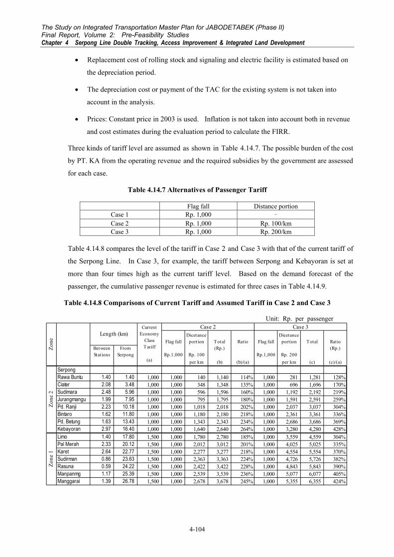
Three kinds of tariff level are assumed as shown in Table 4.14.7. The possible burden of the cost
by PT. KA from the operating revenue and the required subsidies by the government are assessed
for each case.
Table 4.14.7 Alternatives of Passenger Tariff
Flag fall Distance portion Case 1 Rp. 1,000 - Case 2 Rp. 1,000 Rp. 100/km Case 3 Rp. 1,000 Rp. 200/km
Table 4.14.8 compares the level of the tariff in Case 2 and Case 3 with that of the current tariff of
the Serpong Line. In Case 3, for example, the tariff between Serpong and Kebayoran is set at
more than four times high as the current tariff level. Based on the demand forecast of the
passenger, the cumulative passenger revenue is estimated for three cases in Table 4.14.9.
Table 4.14.8 Comparisons of Current Tariff and Assumed Tariff in Case 2 and Case 3
Unit: Rp. per passenger
Flag fallDicetance
portion Total Ratio Flag fallDicetance
portion Total RatioBetweenStations
FromSerpong Rp.1,000 Rp. 100
(Rp.)Rp.1,000 Rp. 200
(Rp.)
per km (b) (b)/(a) per km (c) (c)/(a)
SerpongRawa Buntu 1.40 1.40 1,000 1,000 140 1,140 114% 1,000 281 1,281 128%Ciater 2.08 3.48 1,000 1,000 348 1,348 135% 1,000 696 1,696 170%Sudimara 2.48 5.96 1,000 1,000 596 1,596 160% 1,000 1,192 2,192 219%Jurangmangu 1.99 7.95 1,000 1,000 795 1,795 180% 1,000 1,591 2,591 259%Pd. Ranji 2.23 10.18 1,000 1,000 1,018 2,018 202% 1,000 2,037 3,037 304%Bintaro 1.62 11.80 1,000 1,000 1,180 2,180 218% 1,000 2,361 3,361 336%Pd. Betung 1.63 13.43 1,000 1,000 1,343 2,343 234% 1,000 2,686 3,686 369%Kebayoran 2.97 16.40 1,000 1,000 1,640 2,640 264% 1,000 3,280 4,280 428%Limo 1.40 17.80 1,500 1,000 1,780 2,780 185% 1,000 3,559 4,559 304%Pal Merah 2.33 20.12 1,500 1,000 2,012 3,012 201% 1,000 4,025 5,025 335%Karet 2.64 22.77 1,500 1,000 2,277 3,277 218% 1,000 4,554 5,554 370%Sudirman 0.86 23.63 1,500 1,000 2,363 3,363 224% 1,000 4,726 5,726 382%Rasuna 0.59 24.22 1,500 1,000 2,422 3,422 228% 1,000 4,843 5,843 390%Manpanmg 1.17 25.39 1,500 1,000 2,539 3,539 236% 1,000 5,077 6,077 405%Manggarai 1.39 26.78 1,500 1,000 2,678 3,678 245% 1,000 5,355 6,355 424%
Zone
2Zo
ne 1
Zone
Length (km)Current
EconomyClassTariff
(a)
Case 3Case 2

The Study on Integrated Transportation Master Plan for JABODETABEK (Phase II) Final Report, Volume 2: Pre-Feasibility Studies
Chapter 4 Serpong Line Double Tracking, Access Improvement & Integrated Land Development
4-105
Table 4.14.9 Passenger Revenue Estimate for Three Cases Unit: Rp. billion
Tariff System Short and intermediate-term
period
Long-term period Total
~2010 2011~2020 Case 1 80 930 1,010 Case 2 213 2,422 2,634 Case 3 346 3,913 4,258
Regarding the cost for the Serpong Line Improvement it is mainly classified into five items as
follows:
• Land procurement and compensation cost;
• Cost for basic infrastructure development such as civil works, bridge works, track works,
stabling yard and electric facilities;
• Construction cost for station building and station plaza;
• Procurement cost of rolling stock; and
• Operation and maintenance cost.
An affordable cost-sharing of those cost items between the Government and PT. KA is
considered in the analysis based on the tariff levels assumed. When the management of the
railway business with self-sufficiency from the passenger revenue is required of PT. KA, the
results of FIRR analysis reveal the following (refer to Table 4.14.10):
• In Case 1, the revenue enables PT. KA to shoulder 10 ~ 20% of rolling stock cost and OM
cost (FIRR: 15.4% and 8.0% with the burden of 10% and 20% of rolling stock cost and
OM cost, respectively);
• In Case 2, the FIRR is 10.0% when PT. KA bears the cost of rolling stock and OM. The
FIRR is not sufficiently high for the operation of private business; and
• In Case 3, it is expected that PT. KA will make sufficient profits even with the cost burden
of rolling stock and OM (FIRR: 19.3%) and be able to shoulder the cost for station
building and station plaza (FIRR: 16.8%) under the assumptions.
PT. KA will be unable to manage self-sufficiently when it is required to fulfill the burden of the
investment cost as well as the OM cost of the Serpong Line Double Tracking as currently
regulated in the TAC payment system, even if the tariff increase could be realized to the level of
Case 3. The FIRR is 8.5%, which is still a lower level for the private business. It would be
rational that basic infrastructure facilities, such as civil and track works, electrical and signaling
works are invested by the Government and the costs for procurement of rolling stock and

The Study on Integrated Transportation Master Plan for JABODETABEK (Phase II) Final Report, Volume 2: Pre-Feasibility Studies Chapter 4 Serpong Line Double Tracking, Access Improvement & Integrated Land Development
4-106
operation and maintenance are shouldered through operating revenues from passenger and
commodity transportation by PT. KA. It is crucial to distinguish the cost responsible for PT.
KA to share from the government budget in order to transfer PT. KA to privatized management
in the future.
At the same time the increase in passenger tariff is inevitable for a financially sound operation of
Jabotabek Railway. Annual cost and revenue flow of the Serpong Line Double Tracking is
compared between Case 1 and Case3 in Figure 4.14.3 and Figure 4.14.4, respectively.

The Study on Integrated Transportation Master Plan for JABODETABEK (Phase II) Final Report, Volume 2: Pre-Feasibility Studies
Chapter 4 Serpong Line Double Tracking, Access Improvement & Integrated Land Development
4-107
Table 4.14.10 Profitability of Serpong Line Double Tracking for PT. KA
Tariff Land Procurement xConstruction< 1 > Civil Works x x< 2 > Bridge Works x x< 3 > Track Works x x< 4 > Electric Facilities x x< 5 > Station Building and Station Plaza x x x< 6 > Construction of Stabling Yard x x< 7 > Rolling Stock *1) x x xOM x x x x
See below - - -
*1) 10% of Rolling stock cost 15.4%
20% of Rolling stock cost 8.0%
TariffLand Procurement xConstruction< 1 > Civil Works x x< 2 > Bridge Works x x< 3 > Track Works x x< 4 > Electric Facilities x x< 5 > Station Building and Station Plaza x x x< 6 > Construction of Stabling Yard x x< 7 > Rolling Stock x x x xOM x x x x
10.0% 8.6% 3.6% 3.2%
TariffLand Procurement xConstruction< 1 > Civil Works x x< 2 > Bridge Works x x< 3 > Track Works x x< 4 > Electric Facilities x x< 5 > Station Building and Station Plaza x x x< 6 > Construction of Stabling Yard x x< 7 > Rolling Stock x x x xOM x x x x
19.3% 16.8% 9.1% 8.5%FIRR
Flag fall: Rp.1,000, Distance portion: Rp.200/km (CASE 3)
Cos
t Bur
den
by P
T. K
A
Flag fall: Rp.1,000, Distance portion: 0 (CASE 1)
Cos
t Bur
den
by P
T. K
A
Flag fall: Rp.1,000, Distance portion: Rp.100/km (CASE 2)
Cost
Bur
den
by P
T. K
A
FIRR
FIRR

The Study on Integrated Transportation Master Plan for JABODETABEK (Phase II) Final Report, Volume 2: Pre-Feasibility Studies Chapter 4 Serpong Line Double Tracking, Access Improvement & Integrated Land Development
4-108
Figure 4.14.3 Cost and Revenue of Serpong Line Double Tracking (Case 1)
Figure 4.14.4 Cost and Revenue of Serpong Line Double Tracking (Case 3) Note: Negative cost for the procurement of rolling stock in 2040 is the residual value of rolling stock.
4.14.4 Roles of Related Stakeholders
Many stakeholders are related to the Serpong Line Double Tracking, Access Improvement and
Integrated Land Development Project (referred to as the Project). Those and the connection can
be summarized as follows:
-1,000
-500
0
500
1,000
1,500
2,000
2006
2008
2010
2012
2014
2016
2018
2020
2022
2024
2026
2028
2030
2032
2034
2036
2038
2040
Rp. b
illion
Investment Cost Procurement Cost of Rolling Stock OM Cost Passenger Revenue
-1,000
-500
0
500
1,000
1,500
2,000
2006
2008
2010
2012
2014
2016
2018
2020
2022
2024
2026
2028
2030
2032
2034
2036
2038
2040
Rp. b
illion
Investment Cost Procurement Cost of Rolling Stock OM Cost Passenger Revenue

The Study on Integrated Transportation Master Plan for JABODETABEK (Phase II) Final Report, Volume 2: Pre-Feasibility Studies
Chapter 4 Serpong Line Double Tracking, Access Improvement & Integrated Land Development
4-109
Table 4.14.11Related Stakeholders and Connection
Stakeholders Major Relationship Remarks
Ministry of Communications Administration of development plan and securing budget
Administrator
PTKA Management of railway operation Including fringe business
Local Government Administration of local plan
Real-estate Developers Implementation of housing development and furnishing qualified living environment
Bintaro Jaya and BSD
Feeder-service Operators Securing accessibility to railway stations
Mainly by public transportation
Railway Patronage Fare payers On foot, by public transportation, and by Park and ride
Illegal Squatters Social concern
Property Owners within R/W of the Project
Having property right
The following are the roles and undertaking by the stakeholders toward successful
implementation of the Project.
(1) Ministry of Communications
The most single important issue for the Ministry of Communications is how to set up a basic
condition for PT. KA to manage railway as a private company. In other words, PT. KA has
been required to establish self-sufficient railway operation body in order to keep the balance
between operating cost and revenue. In this context, the study proposed the separation of
responsibility between capital investment and operation management. This is only a way to
accomplish promising privatization of PT. KA and this will be achieved through the strong
support of the Ministry of Communications.
(2) PT. KA
Many international ODA implementation bodies including the World Bank and others have
expressed issues and preconditions related to privatization of PT. KA. PT. KA has to sincerely
take action according to the recommendation step by step. In addition, it is also important to
hear various opinions from the related persons and agencies concerned.
(3) Local Government
There are two major issues on the local government. One is to support integrated land
development with railway facility improvement to form preferable and well-established
urbanization. Two is to cooperate with construction of railway station squares and access roads
to the stations from a viewpoint of planning and cost demarcation with PT. KA. These are
inevitable to accommodate railway passengers and this will, without doubt, increase land

The Study on Integrated Transportation Master Plan for JABODETABEK (Phase II) Final Report, Volume 2: Pre-Feasibility Studies Chapter 4 Serpong Line Double Tracking, Access Improvement & Integrated Land Development
4-110
development potential near the railway stations. In addition, this will induce future preferable
and wealthy urbanization
(4) Real-estate Developers
Bintaro Jaya and BSD are the two large real-estate developers along the Serpong Line. They
have some ideas to increase convenience of living for residents, who have been commuting to
CBD of Jakarta. Such are construction of complex terminal facilities to accommodate the
residents and railway patronage. The railway development project is expected to contribute to
the improvement of commuting activities of residents. Cooperation between the real-estate
developers and PTKA will bring about mutual advantage.
(5) Feeder Service Operators
Feeder service has an important role for railway transportation. Many operators have to
participate in railway station square development and improvement of access roads from a
viewpoint of feeder service business. They are also seeking a business chance to furnish
qualified services to the customers. Their opinion will be valuable to improve the existing
situations.
(6) Railway Patronage
It is inevitable for railway customers to approve of necessary tariff-raising to meet good, safe and
convenient railway services. In this context, it is required for the railway patronage to judge the
pertinent level of tariff and to claim the necessary requests to PT. KA, related agencies and
bodies concerned.
(7) Illegal Squatters
This subject will be discussed from a viewpoint of social aspect. In this context, the third
party’s participation is required to help their self-support.
(8) Property Owners
Land acquisition is usually realized through payment of compensation for a value equivalent to
property loss. However, this has been a problem on public works for a long time. Good
coordination among related people and agencies is required from a viewpoint of not only
assessment of the value of property but also self-support of their lives after the relocation.

The Study on Integrated Transportation Master Plan for JABODETABEK (Phase II) Final Report, Volume 2: Pre-Feasibility Studies
Chapter 4 Serpong Line Double Tracking, Access Improvement & Integrated Land Development
4-111
4.15 INTEGRATION OF TRANSPORTATION SYSTEM WITH LAND USE
THROUGH GUIDANCE OF URBAN PLANNING
4.15.1 Integration with Housing Developments in Suburban Area
(1) Bintaro Jaya and Bumi Serpong Damai
Along the Serpong line large-scale housing complexes have been developed by the private sector.
The major real estate developments include Bumi Serpong Damai (BSD) and Bintaro Jaya as
shown in Figure 4.15.1.
BSD plans to develop 6,000 hectares of land for residential area as well as commercial and
business district. To date 4,500 hectares and 1,400 hectares of land have been acquired and
developed, respectively. A 280-hectare high-tech industrial area will also be developed and will
provide 40,000 job opportunities. Currently 80,000 residents have moved in BSD and as many
as 600,000 persons are expected in the final stage of the development at around the year 2020.
On the other hand, Bintaro Jaya has developed 750 hectares of land out of the planned
2,400-hectare area. At present 18,000 households stay in the residential area and most of head
of households are managers working in Jakarta CBD.
This planned urban development will lead to increase of population and activities in the areas,
and the total trips generated in the areas would increase around five times compared to travel
demand in 2020. Consequently the transportation network capacity expansion is required on
this corridor.
Figure 4.15.1 On-Going Large-scale Housing Development along the Serpong Line

The Study on Integrated Transportation Master Plan for JABODETABEK (Phase II) Final Report, Volume 2: Pre-Feasibility Studies Chapter 4 Serpong Line Double Tracking, Access Improvement & Integrated Land Development
4-112
At present shuttle bus services from BSD to Jakarta CBD are operated with five air-conditioned
buses at Rp. 6000 per ride. Although it takes time to reach the CBD in Jakarta because of traffic
congestion on the roads, the bus services are popular among the residents in BSD. The
passengers prefer to take the bus because they dislike driving a car in the traffic congestion and
getting stressed. PT. KA also got started the executive train services from Sudimara and
Serpong to Sudirman utilizing the new PT. INKA air-conditioned electric train cars. This
service has also become popular among the residents because of reduction in travel time
compared to private passenger cars. It takes 30 to 40 minutes from origin stations to Sudirman
station in the CBD, whereas it takes usually more than two hours by private passenger cars.
Both shuttle buses and executive trains are attractive to the residents and almost fully occupied
every morning. This implies that if railway services were improved people could shift from
private passenger cars to railway transportation.
Since Bitaro Jaya and BSD suffer from chronic traffic congestion every morning and afternoon,
both are concerned with how to improve accessibility of the residents. Therefore, both BSD and
Bintaro Jaya show interest to integrate their housing complexes with the railway system. BSD
plans to improve the existing Rawa Buntu railway station as an integrated transportation terminal
whereas Bintaro Jaya considers to develop a new station as its gateway at Jarang Manggu, where
a sub-station is located at present.
Integration between land use and transportation system development is essential for efficiency of
railway transportation system development. The concept of Transit-Oriented Development
(TOD) should be taken into consideration for railway system development.
Both BSD as well as Bintaro Jaya, however, do not intend to develop the surrounding area of the
railway station in such a way due to low level of passenger demand. This is probably due to the
historical perception of people that railway is a mode of transportation for relatively poor people.
If real estate developers are aware of potential of land near railway station for business
opportunity after the level of railway service is improved, they might want to modify the land use
plan and higher floor area could be allocated to the areas within 10-minute walking distance or
about 600-meter radius from the stations. In such a case, developers should discuss with local
government about changes of the land use plan with land zoning, which specifies floor-area ratio
and the building-to-land ratio by area.
(2) Housing Development by Perumnas in Parung Panjang
Although Parung Panjang is not included in the Study area of this pre-feasibility study, housing
development by Perumnas can be regarded as one way for integrated land development.
Perumnas, a public agency providing low cost housing for the poor, has purchased 800 hectares

The Study on Integrated Transportation Master Plan for JABODETABEK (Phase II) Final Report, Volume 2: Pre-Feasibility Studies
Chapter 4 Serpong Line Double Tracking, Access Improvement & Integrated Land Development
4-113
of land in Parung Panjang because it was informed that the railway service would be improved in
near future. However, since the railway service has not yet been improved significantly, the
housing units have not been sold well. Along the Bogor railway line, at higher level of
railway service, housing complexes have been emerging in close proximity to railway stations
such as Bojong Gede because of good accessibility to Jakarta by railway. The Bojong Gede
station is located 30 km south to Jakarta and the distance to Parung Panjang is almost identical
with Bojong Gede, so that it implies that housing development could be accelerated if level of the
railway service were improved on the Serpong line. Since the area has already been purchased
by Perumnas, integrated land development can be achieved in cooperation with PT. KA as
depicted in Figure 4.15.2. To materialize the Transit-Oriented Development (TOD), the roles
of Perumnas should be expanded and it should take responsibility not merely in low-cost housing
developments but also in business/commercial and public facility development in the surrounding
areas of railway stations.
Source: The Study on Land Provision for Housing Development and Settlements Development Through Kasiba and Land Consolidation in Jakarta Metropolitan Area, JICA, January 2000
Figure 4.15.2 Land Development Plan in Parung Panjang
4.15.2 High Intensity Land Development in Urban Area
In order to promote railway transportation use, not merely integrated urban development in
suburban area but also high intensity land development in urban area should be enhanced. The
surrounding areas of interchange stations will attract a considerable number of railway
The Study on Integrated Transportation Master Plan for JABODETABEK (Phase II) Final Report, Volume 2: Pre-Feasibility Studies Chapter 4 Serpong Line Double Tracking, Access Improvement & Integrated Land Development
4-114
passengers owing to better accessibility from various places. When considering the integration
of public transportation system and land use development, the following two factors should be
realized to maximize the development impact in the catchment areas:
• Stations have to be developed to not only sufficiently accommodate trains and passengers
but also ensure the most suitable access to them, and
• The catchment areas have to be developed in a dense and orderly manner with good access
to the stations.
Both of the factors should be well integrated under the concept of transport node development by
way of:
a. Provision of Convenient Access
A transport node intends to enhance accessibility by means of a combination of transport
facilities, such as a bus terminal, bus bay, other railway stations, station plaza, parking area, and
an exclusive pedestrian pass. These combinations result in a shorter access time as well as access
distance.
b. Integration of Adjoining Area
In an urbanized area, the construction of a transport node is required to integrate adjoining
buildings and land uses. The construction itself is considered as an urban renewal project and it
has therefore to pursue more efficient and sophisticated spatial management.
c. Stimulation of Urban Development
In an underdeveloped area, a well-designed transport node can stimulate urban development
significantly. It needs a clear land use zoning system ahead of time.
Integrated urban renewal and transport node development is very important for railway system
development. The following discusses specific development opportunities and constraints,
namely, the relationship between density and accessibility of the catchment areas.
Experience elsewhere in the world shows that the extent of catchment areas can vary according to
the distances that railway users are willing to walk. In the U.K. and Japan, the walking limit is
considered to be 15 minutes to a station (10 minutes to a bus stop), which converts into a distance
of about 800 – 1,000 meters. In contrast, in Southeast Asian countries, where the climate is less
friendly, the walking limit is considered to be about 500-600 meters. With the creation of a
comfortable walking environment, such as in Singapore, the limit can be extended.
It is logically considered that the immediate environs of the stations will become high density
(walking distance: some 200 meters) while medium density is reasonable for the remaining part

The Study on Integrated Transportation Master Plan for JABODETABEK (Phase II) Final Report, Volume 2: Pre-Feasibility Studies
Chapter 4 Serpong Line Double Tracking, Access Improvement & Integrated Land Development
4-115
of the walking limit. Beyond the walking limit, the existing low-density hinterland might
remain. (Refer to Figure 4.15.3)
Even in the middle density areas, medium- to high-rise buildings are favorable in order to provide
sufficient access roads/paths and open space. In this sense, existing urban kampungs are
problematic, due to the limited uncovered space. It is necessary to redevelop these areas. (Refer
to Figure 4.15.4)
HighDensity
MediumDensity
LowDensityRailway
Station
200m
300-400m
MediumDensity
LowDensity
Figure 4.15.3 Conceptual Density Arrangement Around A Railway Station
Figure 4.15.4 Development Concept for Railway Catchment Area

The Study on Integrated Transportation Master Plan for JABODETABEK (Phase II) Final Report, Volume 2: Pre-Feasibility Studies Chapter 4 Serpong Line Double Tracking, Access Improvement & Integrated Land Development
4-116
On the Serpong line and the Western line, the Stations Kebayoran Lama, Tanah Abang,
Sudirman and Rasuna Said show significant potential to attract passengers as shown in Figure
4.15.5.
Planning issues for each station in urban area is listed in Table 4.15.1. In urbanized areas
railway station and station square development could be implemented under private sector
initiative by providing development rights. On the other hand, access road development and
high intensity urban development of the surrounding area might be executed under urban
redevelopment scheme, in which land tenure will be exchanged vertically with floor-area in
high-rise buildings.
Table 4.15.1 Planning Issues at Railway Stations in Urban Area
Railway Station Planning Issues Sudirman - Development transfer facility between busway
- Provision of bus-bays for feeder bus services to surrounding districts (See Figure 4.12.5)
Rasuna Said - Development of new railway station - Provision of transfer facility to busway - Office building development integrated with station square (See Figure 4.12.6)
Manggarai - Urban redevelopment of the surrounding area - Development of accommodation and facility to support long-distance travelers from outside of the region - Promotion of business and commercial facilities - Improvement of access roads to the station - Strengthening of bus terminal facility
Tanah Abang - Urban redevelopment of the surrounding area - Promotion of business and commercial facilities - Improvement of access roads to the station by road widening - Station square development to accommodate feeder bus services and parking for cars and motorcycles

The Study on Integrated Transportation Master Plan for JABODETABEK (Phase II) Final Report, Volume 2: Pre-Feasibility Studies
Chapter 4 Serpong Line Double Tracking, Access Improvement & Integrated Land Development
4-117
Figure 4.15.5 Number of Boarding/Alighting/Transferring Railway Passengers and Potential TOD Area
An ultimate way to integrate urban development with railway system is combining railway
stations with commercial/office buildings. An example is drawn at Kerinch LRT station where
the commercial building was built combining with an LRT station facility as shown in Figure
4.15.6. A station square was also developed in front of the station for easier transfer to feeder
buses.
Figure 4.15.6 Integrated Railway Station with Commercial Building at Station Kerinch of Putra LRT Line in Kuala Lumpur

The Study on Integrated Transportation Master Plan for JABODETABEK (Phase II) Final Report, Volume 2: Pre-Feasibility Studies Chapter 4 Serpong Line Double Tracking, Access Improvement & Integrated Land Development
4-118
4.16 IMPLEMENTATION MECHANISM FOR THE SERPONG LINE
IMPROVEMENT PROJECT
It is well known that transportation system brings about considerable economic benefits but
transportation operators cannot fully benefit from the improvement of the transportation service.
The way to internalize the benefits of railway transportation system development is for a railway
company to engage in real estate business along the railway corridor in suburban area and the
surrounding area of railway stations in urban areas.
In suburban area, the railway company first purchases the land along the railway line and develops
them as residential lands prior to improvement of the railway system. The land value would
increase after the service level of the railway line is improved. Then the railway company could
gain the benefit from a rise of land value in market from its investment. At the same time,
residential land development will bring about additional patronage for railway services.
In urbanized area, on the other hand, if the surrounding area of stations is currently under-utilized
with low buildings, redevelopment of the area into high-intensity land use under the urban
renewal scheme is required.
1) Public-Private Partnership (PPP)
PT. KA, however, does not have personnel with sufficient knowledge in real estate business. It is
not proposed at the moment that PT. KA venture into such new business. Instead, it is
recommended that PT. KA cooperate with real estate developers such as Bintaro Jaya and Bumi
Serpong Damai (BSD) for financial support for access road development, railway station square
development and railway station facility development because the developers and their customers
would enjoy improved railway services. In general, a local government should develop a
detailed land use plan for the districts including railway station. The government should
establish a regulation on the responsibility of private sector for railway-related facility
developments; that is, what private sector should contribute for railway system development and
what they can get from the development. Local government could also develop access roads,
station squares, and even provide land for railway station development by applying land
readjustment scheme.
2) Cooperation among Public Corporations
As mentioned above, Perumnas has purchased 800 hectares of the land for residential development
for mainly low-income households to the south of the Parung Panjang Station on the Serpong Line.
Due to the delay of railway service improvement, housing development has not yet been
progressed as scheduled.

The Study on Integrated Transportation Master Plan for JABODETABEK (Phase II) Final Report, Volume 2: Pre-Feasibility Studies
Chapter 4 Serpong Line Double Tracking, Access Improvement & Integrated Land Development
4-119
If the function of Perumnas were expanded to urban development, which can deal with not merely
housing development for low-income households but also commercial facility and good quality
housing for the middle class, then Perumnas could develop high-rise buildings in the surrounding
areas of the railway station in accordance with TOD concept.
In principle, a railway system development contributes provision of land and housing in distant
areas by reducing travel time and travel cost. At present the poor cannot reside in suburban
areas due to relatively expensive travel costs and long travel time. If affordable means of
transportation were provided, then the urban poor could locate themselves in a bit more spacious
housing in suburban areas at affordable costs and they could commute to the CBD in Jakarta.
Therefore, housing development at Parung Panjang coupled with railway system development
could be a model case to improve the quality of life of the urban poor.
Finally, in this pre-feasibility study, the Serpong line has been studied as a model case but the
concept of transit-oriented development is applicable for the other lines of the Jabotabek railway
including the Bekasi line and the Tangerang line.
Furthermore, for making high-intensity urban development effective in the surrounding area of
the railway stations, it requires spatial planning including density control for not merely suburban
areas but also urbanized areas of the whole Jabodetabek region; otherwise, incentive for
developments would be reduced and other areas could be developed with higher priority. In this
regard, strict urban development control and land use zoning is prerequisite for effective land use
as a whole.