4.0 ENVIRONMENTAL IMPACT ANALYSIS - slc.ca.gov · 04.09.2018 · 5 Flores Canyon (LFC) as part of...
334
4.0 ENVIRONMENTAL IMPACT ANALYSIS INTRODUCTION TO ENVIRONMENTAL ANALYSIS 1 Section 4 of this Environmental Impact Report (EIR) examines the potential 2 environmental impacts of the proposed Revised PRC 421 Recommissioning Project 3 (Project) identified by the California State Lands Commission (CSLC) as Lead Agency 4 under the California Environmental Quality Act (CEQA). This Section includes analyses 5 of environmental issue areas listed below: 6 4.1 - Geological Resources; 7 4.2 - Safety; 8 4.3 - Hazardous Materials; 9 4.4 - Air Quality and Greenhouse Gases; 10 4.5 - Hydrology, Water Resources, and Water Quality; 11 4.6 - Marine Biological Resources; 12 4.7 - Terrestrial Biological Resources; 13 4.8 - Land Use, Planning, and Recreation; 14 4.9 - Public Services; 15 4.10 - Transportation and Circulation; 16 4.11 - Noise; 17 4.12 - Aesthetic/Visual Resources; 18 4.13 - Cultural, Historical, and Paleontological Resources; 19 4.14 - Energy and Mineral Resources; and 20 4.15 - Socioeconomics and Environmental Justice. 21 Each environmental issue area analyzed in this EIR provides background information 22 and describes the environmental setting (baseline conditions) to help the reader 23 understand the conditions that exist currently, prior to Project implementation, and the 24 relationship between those existing conditions and potential Project-related impacts. In 25 addition, each section describes the approach to analysis that results in a determination 26 whether an impact is “significant” or “less than significant.” Finally, individual sections 27 recommend mitigation measures (MMs) to reduce significant impacts. Throughout 28 Section 4, both impacts and the corresponding MMs are identified by a bold letter- 29 number designation (e.g., Impact TBIO-1 and MM TBIO-1a). 30 Based on an initial review and analysis, it is likely that the Project would have a less 31 than significant impact, or no impact, on the environmental issue areas identified below. 32 The primary reasons for these determinations are as follows: 33 November 2014 4-1 Revised PRC 421 Recommissioning Project Final EIR
Transcript of 4.0 ENVIRONMENTAL IMPACT ANALYSIS - slc.ca.gov · 04.09.2018 · 5 Flores Canyon (LFC) as part of...
4.0 ENVIRONMENTAL IMPACT ANALYSIS
INTRODUCTION TO ENVIRONMENTAL ANALYSIS 1
Section 4 of this Environmental Impact Report (EIR) examines the potential 2 environmental impacts of the proposed Revised PRC 421 Recommissioning Project 3 (Project) identified by the California State Lands Commission (CSLC) as Lead Agency 4 under the California Environmental Quality Act (CEQA). This Section includes analyses 5 of environmental issue areas listed below: 6
4.1 - Geological Resources; 7 4.2 - Safety; 8 4.3 - Hazardous Materials; 9 4.4 - Air Quality and Greenhouse Gases; 10 4.5 - Hydrology, Water Resources, and Water Quality; 11 4.6 - Marine Biological Resources; 12 4.7 - Terrestrial Biological Resources; 13 4.8 - Land Use, Planning, and Recreation; 14 4.9 - Public Services; 15 4.10 - Transportation and Circulation; 16 4.11 - Noise; 17 4.12 - Aesthetic/Visual Resources; 18 4.13 - Cultural, Historical, and Paleontological Resources; 19 4.14 - Energy and Mineral Resources; and 20 4.15 - Socioeconomics and Environmental Justice. 21
Each environmental issue area analyzed in this EIR provides background information 22 and describes the environmental setting (baseline conditions) to help the reader 23 understand the conditions that exist currently, prior to Project implementation, and the 24 relationship between those existing conditions and potential Project-related impacts. In 25 addition, each section describes the approach to analysis that results in a determination 26 whether an impact is “significant” or “less than significant.” Finally, individual sections 27 recommend mitigation measures (MMs) to reduce significant impacts. Throughout 28 Section 4, both impacts and the corresponding MMs are identified by a bold letter-29 number designation (e.g., Impact TBIO-1 and MM TBIO-1a). 30
Based on an initial review and analysis, it is likely that the Project would have a less 31 than significant impact, or no impact, on the environmental issue areas identified below. 32 The primary reasons for these determinations are as follows: 33
November 2014 4-1 Revised PRC 421 Recommissioning Project Final EIR

4.0 Environmental Analysis
· Agricultural Resources. Activities for Recommissioning PRC 421 are located on1 sand, shale bedrock and artificial fill and therefore would not impact soils used for2 agricultural purposes. The Line 96 Modification Project EIR (Santa Barbara3 County 2011) fully analyzed agricultural resources along the pipeline route to Las4 Flores Canyon (LFC) as part of the construction and operation of the new5 pipeline and is incorporated by reference in Section 4.8, Land Use, Planning and6 Recreation of this EIR.7
· Population and Housing. The Project would not require a change in the number8 of employees and would require only short-term construction activity for removal9 of Pier 421-1 infrastructure and repair and upgrade of existing facilities at Pier10 421-2. The Project would neither induce substantial population growth in the area11 nor displace any people or housing units.12
· Utilities and Service Systems. The Project would not result in additional demand13 for water, wastewater treatment, or solid waste disposal services in excess of14 current capacities.15
ASSESSMENT METHODOLOGY 16
Environmental Baseline 17
The analysis of each issue area begins with an examination of the existing physical 18 setting or baseline conditions as determined pursuant to section 15125, subdivision (a) 19 of the State CEQA Guidelines that may be affected by the Project. The effects of the 20 Project are defined as changes to the environmental setting that are attributable to 21 Project components or operation. 22
The baseline conditions for the Project include operation of the Line 96 pipeline, which 23 connects the Ellwood Onshore Facility (EOF) to the Plains All American Pipeline, L.P. 24 (PAAPLP) Coastal Pipeline west of LFC. This EIR relies upon, updates, and under the 25 guidance provided in State CEQA Guidelines section 15150 hereby incorporates by 26 reference the findings of the Line 96 Modification Project EIR (Santa Barbara County 27 2011) regarding potential impacts and MMs associated with use of that pipeline. 28
Significance Criteria 29
Significance criteria are identified for each environmental issue area; these criteria 30 serve as benchmarks for determining if a component action will result in a significant 31 adverse environmental impact when evaluated against the baseline. According to State 32 CEQA Guidelines section 15382, a significant effect on the environment means “a 33 substantial, or potentially substantial, adverse change in any of the physical conditions 34 within the area affected by the project….” 35
Revised PRC 421 Recommissioning Project 4-2 November 2014 Final EIR

4.0 Environmental Analysis
Impact Analysis 1
Impacts are classified as according to one of the following five categories: 2
· Significant and Unavoidable – significant adverse impact that remains3 significant after mitigation;4
· Less than Significant with Mitigation – significant adverse impact that can be5 eliminated or reduced below an issue area’s significance criteria;6
· Less than Significant – adverse impact that does not meet or exceed an issue7 area’s significance criteria;8
· Beneficial – beneficial impact; or9
· No Impact – the Project would not result in any impact to the resource area10 considered.11
A determination will be made, based on the analysis of any impact within each affected 12 environmental issue area and compliance with any recommended MM, of the level of 13 impact remaining in comparison to pertinent significance criteria. If the impact remains 14 significant, at or above the significance criteria, it is deemed to be “significant and 15 unavoidable.” If a significant adverse impact could be reduced to a less than significant 16 level with application of identified mitigation, then it is “less than significant with 17 mitigation.” If an action creates an adverse impact above the baseline condition, but 18 such impact does not meet or exceed the pertinent significance criteria, it is determined 19 to be “less than significant.” An action that provides an improvement to an 20 environmental issue area in comparison to baseline conditions is recognized as a 21 “beneficial” impact. 22
Formulation of Mitigation Measures and Mitigation Monitoring Program 23
When significant impacts are identified, feasible MMs are formulated to eliminate or 24 reduce the severity of impacts and focus on the protection of sensitive resources. The 25 effectiveness of a MM is subsequently determined by evaluating the impact remaining 26 after its application. Impacts which still meet or exceed the impact significance criteria 27 after mitigation are considered residual impacts that remain significant. Implementation 28 of more than one MM may be needed to reduce an impact below a level of significance. 29 The MMs recommended in this document are identified in the impact sections and 30 presented in a Mitigation Monitoring Program (MMP), provided in Section 7. 31
If any MMs are ultimately incorporated as part of a project’s design, they are no longer 32 considered MMs under CEQA. If they eliminate or reduce a potentially significant impact 33 to a level below the significance criteria, they eliminate the potential for that significant 34 impact since the "measure" is now a component of the action. Such measures 35 incorporated into the project design have the same status as any “applicant proposed 36
November 2014 4-3 Revised PRC 421 Recommissioning Project Final EIR
4.0 Environmental Analysis
measures.” The CSLC’s standard practice is to include all measures to eliminate or 1 reduce the environmental impacts of a proposed project, whether applicant-proposed or 2 recommended mitigation, in the MMP. 3
Timing of Project Elements 4
This EIR addresses the impacts of both recommissioning of Pier 421-2, including 5 construction and operation, as well as abandonment of Pier 421-1. Because Venoco 6 proposes submittal of applications for abandonment of Pier 421-1 after production has 7 commenced at Pier 421-2, the CSLC staff anticipates that actual abandonment of Pier 8 421-1 will trail construction and initiation of production at Pier 421-2 by approximately 1 9 year. The impact analysis reflects this assumption. 10
Cumulative Impacts Analysis 11
Each issue area in Section 4 presents the cumulative impact scenario, the focus of 12 which is to identify the potential impacts of the Project that might not be significant when 13 considered alone, but that might contribute to a significant impact when viewed in 14 conjunction with the other projects. 15
Impacts of Alternatives 16
Section 5 describes the alternatives to the Project and includes the impact analysis for 17 each alternative scenario being considered to the Project. A summary of collective 18 impacts of each alternative in comparison with the impacts of the Project is included 19 within the Executive Summary and Section 6.4. 20
FEDERAL AND STATE REGULATIONS 21
Each of the issue areas is considered in terms of the Federal, State, regional, and local 22 laws, regulations, and policies that apply to the issue area. Federal and State laws, 23 regulations and policies, including a summary of each, are provided below in 24 Table 4.0-1, organized by issues area. Applicable regional and local laws, regulations, 25 and policies are summarized in each of the sections. 26
Revised PRC 421 Recommissioning Project 4-4 November 2014 Final EIR

4.0 Environmental Analysis
Table 4.0-1 Major U.S. and State Laws, Regulations, and Policies Potentially Applicable to the Project 4.0 MULTIPLE ENVIRONMENTAL ISSUES U.S. Coastal Zone
Management Act (CZMA) (42 USC 4321 et seq.)
The CZMA recognizes a national interest in coastal zone resources and in the importance of balancing competing uses of those resources, giving full consideration to aesthetic, cultural and historic, ecological, recreational, and other values as well as the needs for compatible economic development. Pursuant to the CZMA, coastal states develop and implement comprehensive coastal management programs (CMPs) that describe uses subject to the CMP, authorities and enforceable policies, and coastal zone boundaries, among other elements. The CZMA also gives state coastal management agencies regulatory control (“federal consistency” review authority) over federal activities and federally licensed, permitted or assisted activities, if the activity affects coastal resources; such activities include military projects at coastal locations and outer continental shelf oil and gas leasing, exploration and development. The California Coastal Commission (CCC) and San Francisco Bay Conservation and Development Commission (BCDC) coordinate California’s federally approved CMPs and federal consistency reviews within their respective jurisdictions.
CA California Environmental Quality Act (CEQA) (Pub. Resources Code, § 21000 et seq.)
CEQA requires state and local agencies to identify the significant environmental impacts of their actions and to avoid or mitigate those impacts, if feasible. A public agency must comply with CEQA when it undertakes an activity defined by CEQA as a "project" that must receive some discretionary approval (i.e., the agency has the authority to deny the requested permit or approval) which may cause either a direct physical change in the environment or a reasonably foreseeable indirect change in the environment.
CA California State Lands Commission (CSLC) Public Trust Doctrine
All tidelands and submerged lands, granted or ungranted, as well as navigable lakes and waterways, are subject to the protections of the Common Law Public Trust. The CSLC has jurisdiction and management authority over all ungranted tidelands, submerged lands, and the beds of navigable lakes and waterways, as well as certain residual and review authority for tidelands and submerged lands legislatively granted in trust to local jurisdictions (Pub. Resources Code, §§ 6301, 6306). As general background, the State of California acquired sovereign ownership of all tidelands and submerged lands and beds of navigable lakes and waterways upon its admission to the U.S. in 1850. The State holds these lands for the benefit of all people of the State for statewide Public Trust purposes, which include but are not limited to waterborne commerce, navigation, fisheries, water-related recreation, habitat preservation and open space. On tidal waterways, the State's sovereign fee ownership extends landward to the mean high tide line, except for areas of fill or artificial accretion. The CSLC’s jurisdiction also includes a 3-nautical-mile-wide section of tidal and submerged land adjacent to the coast and offshore islands, including bays, estuaries, and lagoons; the waters and underlying beds of more than 120 rivers, lakes, streams, and sloughs; and 1.3 million acres of “school lands" granted to the State by the Federal government to support public education. The CSLC also has leasing jurisdiction, subject to certain conditions, over mineral extraction from State property owned and managed by other State agencies (Pub. Resources Code, § 68910, subd. (b)), and is responsible for implementing a variety of State regulations for activities affecting these State Trust Lands, including implementing CEQA.
November 2014 4-5 Revised PRC 421 Recommissioning Project Final EIR

4.0 Environmental Analysis
Table 4.0-1 Major U.S. and State Laws, Regulations, and Policies Potentially Applicable to the Project (continued) CA California Coastal Act
(Coastal Act) of 1976 (Pub. Resources Code, § 30000 et seq.)
CCC Federal Consistency Program
Pursuant to the Coastal Act, the CCC, in partnership with coastal cities and counties, plans and regulates the use of land and water in the coastal zone. The Coastal Act includes specific policies (see Chapter 3) that address issues such as shoreline public access and recreation, lower cost visitor accommodations, terrestrial and marine habitat protection, visual resources, landform alteration, agricultural lands, commercial fisheries, industrial uses, water quality, offshore oil and gas development, transportation, development design, power plants, ports, and public works. Development activities in the coastal zone generally require a coastal permit from either the CCC or the local government: (1) the CCC retains jurisdiction over the immediate shoreline areas below the mean high tide line and offshore areas to the 3 nautical mile State water limit; and (2) following certification of county- and municipality-developed Local Coastal Programs, the CCC has delegated permit authority to many local governments for the portions of their jurisdictions within the coastal zone. The CCC also implements the CZMA as it applies to federal activities (e.g., development projects, permits, and licenses) in the coastal zone by reviewing specified federal actions for consistency with the enforceable policies of Chapter 3 of the Coastal Act.
4.1 GEOLOGICAL RESOURCES U.S. The International
Building Code (IBC) The IBC sets design standards to accommodate a “maximum considered earthquake” or MCE, based on a project’s regional location, site characteristics, and other factors.
CA California Building Code (CBC) (Cal. Code Regs., tit. 23)
The State of California provides a minimum standard for building design through the CBC, which is based on the IBC, but has been modified for conditions unique to California. The CBC is selectively adopted by local jurisdictions, based on local conditions. Relevant CBC sections include the following: Chapter 16 contains specific requirements for seismic safety; Chapter 18 regulates excavation, foundations, and retaining walls; Chapter 33 contains specific requirements pertaining to site demolition, excavation, and construction to protect people and property from hazards associated with excavation cave-ins and falling debris or construction materials; Chapter 70 regulates grading activities, including drainage and erosion control; and Construction activities are subject to occupational safety standards for excavation, shoring, and trenching, as specified in CBC section A33 and California Division of Occupational Safety and Health regulations (Cal. Code Regs., tit. 8).
CA Alquist-Priolo Earth-quake Fault Zoning Act (Pub. Resources Code, §§ 2621-2630)
This Act requires that "sufficiently active" and "well-defined" earthquake fault zones be delineated by the State Geologist. The criteria most commonly used to estimate fault activity in California are described in this act, which addresses only surface fault-rupture hazards. Legislative guidelines to determine fault activity status are based on the age of the youngest geologic unit offset by the fault. This legislation prohibits the construction of buildings used for human occupancy on active and potentially active surface faults. However, only those potentially active faults that have a relatively high potential for ground rupture are identified as fault zones. Therefore, not all potentially active faults are zoned under the Alquist-Priolo Earthquake Fault Zone, as designated by the State of California.
CA California Seismic Hazards Mapping Act (Pub. Resources Code, § 2690 and following as Division 2, Chapter 7.8)
These regulations were promulgated for the purpose of promoting public safety by protecting against the effects of strong ground shaking, liquefaction, landslides, other ground failures, or other hazards caused by earthquakes. Special Publication 117, Guidelines for Evaluating and Mitigating Seismic Hazards in California (California Division of Mines and Geology [CDMG] 1997), constitutes the guidelines for evaluating seismic hazards other than surface fault-rupture, and for recommending MMs as required by Public Resources Code section 2695, subdivision (a). To date the California Geological Survey (CGS) has not zoned offshore California under the Seismic Hazard Mapping Act.
Revised PRC 421 Recommissioning Project 4-6 November 2014 Final EIR

4.0 Environmental Analysis
Table 4.0-1 Major U.S. and State Laws, Regulations, and Policies Potentially Applicable to the Project (continued) CA Public Resources
Code, Division 6, Parts 1 and 2
The CSLC issues and administers oil and gas leases covering tide and submerged lands in accordance with Division 6, Parts 1 and 2 of the Public Resources Code and Title 2 of the California Code of Regulations. Relevant provisions of the Public Resources Code include the following: section 6829 includes provisions for specifying methods of operation and standard requirements for conducting operations properly; the prevention of waste, the protection of the safety and health of the workers; and the liability of the lessee for personal injuries and property damage; section 6829.2 includes provisions for the possible arresting or amelioration of land subsidence; and sections 6873.2 and 6873.5 include provisions for carrying out the requirements of CEQA.
CA California Code of Regulations, Title 2
The CSLC issues and administers oil and gas leases covering tide and submerged lands in accordance with Division 6, Parts 1 and 2 of the Public Resources Code and Title 2 of the California Code of Regulations. Relevant provisions of the California Code of Regulations include the following. Article 3.2 pertains to oil and gas drilling regulations. Article 3.3 pertains to oil and gas production operations on tide and submerged lands under the jurisdiction of CSLC, and is applicable to operations conducted from mobile rigs, fixed offshore structures and upland locations serving these leases. Provisions in this article include administrative prevention and elimination of any contamination or pollution of the ocean and tidelands, prevention of waste, for the protection of human health, regulations on wellhead equipment, subsurface safety valves, surface safety valves, remedial and well maintenance work, supervision and training, anomalous casing annulus pressure, subsurface injection, conversion of a well to fluid injection (requires prior approval of CSLC), waste disposal, pressure relief valves, personal protective equipment, and pipeline inspections. Article 3.4 pertains to oil and gas drilling and production to operations on State oil and gas leases located on State tide and submerged lands under the jurisdiction of the CSLC, and is applicable to operations conducted from mobile rigs, fixed offshore structures and upland locations serving these leases. The article includes provisions for administration, prohibitions of pollution and contamination, suspension of operations and corrective action, disposal of drill cuttings and drilling muds, oil spill contingency plan requirements, pollution control and removal equipment, critical operations and curtailment plans, and pollution reports to the USCG and State OES. Article 3.5, which pertains to disposal of royalty oil, gas, or other hydrocarbons, sets forth the procedures whereby the CSLC may enter into agreements for the disposition and sale of oil, gas, or other hydrocarbons. Article 3.6 (Cal. Code Regs., tit. 2, §§ 2170-2175) includes (1) requirements for operators to prepare an operations manual describing equipment and procedures which the operator employs or will employ to protect public health and safety and the environment, and (2) provisions for development and maintenance of emergency response plans that include natural disaster response planning.
CA Coastal Act Chapter 3 Policies (see also under Multiple Environmental Issues)
With respect to geological resources, Coastal Act section 30253 requires, in part, that: New development shall: (a) Minimize risks to life and property in areas of high geologic, flood, and fire hazard; and (b) Assure stability and structural integrity, and neither create nor contribute significantly to erosion, geologic instability, or destruction of the site or surrounding area or in any way require the construction of protective devices that would substantially alter natural landforms along bluffs and cliffs. Section 30243 also states in part that the long-term productivity of soils and timberlands shall be protected.
November 2014 4-7 Revised PRC 421 Recommissioning Project Final EIR
4.0 Environmental Analysis
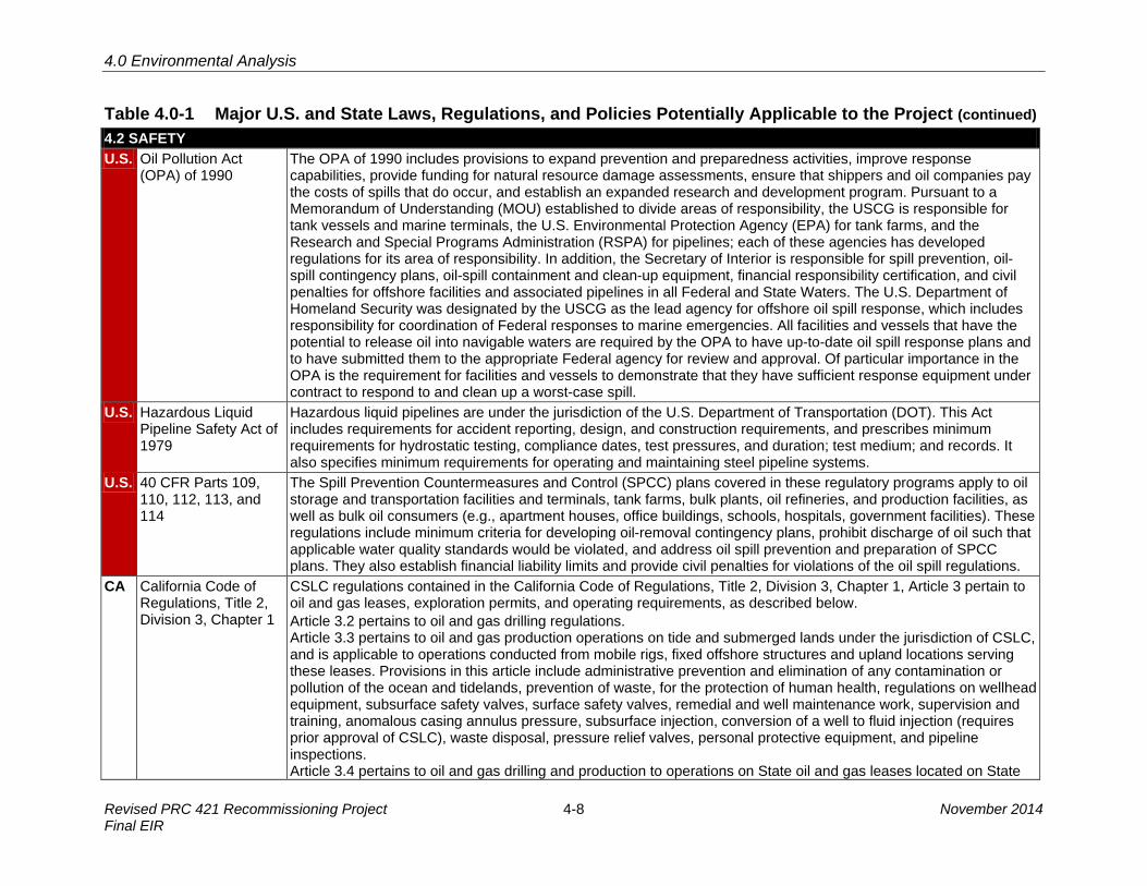
Table 4.0-1 Major U.S. and State Laws, Regulations, and Policies Potentially Applicable to the Project (continued) 4.2 SAFETY U.S. Oil Pollution Act
(OPA) of 1990 The OPA of 1990 includes provisions to expand prevention and preparedness activities, improve response capabilities, provide funding for natural resource damage assessments, ensure that shippers and oil companies pay the costs of spills that do occur, and establish an expanded research and development program. Pursuant to a Memorandum of Understanding (MOU) established to divide areas of responsibility, the USCG is responsible for tank vessels and marine terminals, the U.S. Environmental Protection Agency (EPA) for tank farms, and the Research and Special Programs Administration (RSPA) for pipelines; each of these agencies has developed regulations for its area of responsibility. In addition, the Secretary of Interior is responsible for spill prevention, oil-spill contingency plans, oil-spill containment and clean-up equipment, financial responsibility certification, and civil penalties for offshore facilities and associated pipelines in all Federal and State Waters. The U.S. Department of Homeland Security was designated by the USCG as the lead agency for offshore oil spill response, which includes responsibility for coordination of Federal responses to marine emergencies. All facilities and vessels that have the potential to release oil into navigable waters are required by the OPA to have up-to-date oil spill response plans and to have submitted them to the appropriate Federal agency for review and approval. Of particular importance in the OPA is the requirement for facilities and vessels to demonstrate that they have sufficient response equipment under contract to respond to and clean up a worst-case spill.
U.S. Hazardous Liquid Pipeline Safety Act of 1979
Hazardous liquid pipelines are under the jurisdiction of the U.S. Department of Transportation (DOT). This Act includes requirements for accident reporting, design, and construction requirements, and prescribes minimum requirements for hydrostatic testing, compliance dates, test pressures, and duration; test medium; and records. It also specifies minimum requirements for operating and maintaining steel pipeline systems.
U.S. 40 CFR Parts 109, 110, 112, 113, and 114
The Spill Prevention Countermeasures and Control (SPCC) plans covered in these regulatory programs apply to oil storage and transportation facilities and terminals, tank farms, bulk plants, oil refineries, and production facilities, as well as bulk oil consumers (e.g., apartment houses, office buildings, schools, hospitals, government facilities). These regulations include minimum criteria for developing oil-removal contingency plans, prohibit discharge of oil such that applicable water quality standards would be violated, and address oil spill prevention and preparation of SPCC plans. They also establish financial liability limits and provide civil penalties for violations of the oil spill regulations.
CA California Code of Regulations, Title 2, Division 3, Chapter 1
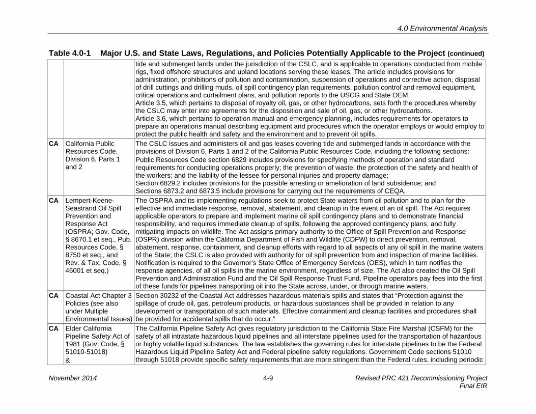
CSLC regulations contained in the California Code of Regulations, Title 2, Division 3, Chapter 1, Article 3 pertain to oil and gas leases, exploration permits, and operating requirements, as described below. Article 3.2 pertains to oil and gas drilling regulations. Article 3.3 pertains to oil and gas production operations on tide and submerged lands under the jurisdiction of CSLC, and is applicable to operations conducted from mobile rigs, fixed offshore structures and upland locations serving these leases. Provisions in this article include administrative prevention and elimination of any contamination or pollution of the ocean and tidelands, prevention of waste, for the protection of human health, regulations on wellhead equipment, subsurface safety valves, surface safety valves, remedial and well maintenance work, supervision and training, anomalous casing annulus pressure, subsurface injection, conversion of a well to fluid injection (requires prior approval of CSLC), waste disposal, pressure relief valves, personal protective equipment, and pipeline inspections. Article 3.4 pertains to oil and gas drilling and production to operations on State oil and gas leases located on State
Revised PRC 421 Recommissioning Project 4-8 November 2014 Final EIR
4.0 Environmental Analysis
Table 4.0-1 Major U.S. and State Laws, Regulations, and Policies Potentially Applicable to the Project (continued) tide and submerged lands under the jurisdiction of the CSLC, and is applicable to operations conducted from mobile rigs, fixed offshore structures and upland locations serving these leases. The article includes provisions for administration, prohibitions of pollution and contamination, suspension of operations and corrective action, disposal of drill cuttings and drilling muds, oil spill contingency plan requirements, pollution control and removal equipment, critical operations and curtailment plans, and pollution reports to the USCG and State OEM. Article 3.5, which pertains to disposal of royalty oil, gas, or other hydrocarbons, sets forth the procedures whereby the CSLC may enter into agreements for the disposition and sale of oil, gas, or other hydrocarbons. Article 3.6, which pertains to operation manual and emergency planning, includes requirements for operators to prepare an operations manual describing equipment and procedures which the operator employs or would employ to protect the public health and safety and the environment and to prevent oil spills.
CA California Public Resources Code, Division 6, Parts 1 and 2
The CSLC issues and administers oil and gas leases covering tide and submerged lands in accordance with the provisions of Division 6, Parts 1 and 2 of the California Public Resources Code, including the following sections: Public Resources Code section 6829 includes provisions for specifying methods of operation and standard requirements for conducting operations properly; the prevention of waste, the protection of the safety and health of the workers; and the liability of the lessee for personal injuries and property damage; Section 6829.2 includes provisions for the possible arresting or amelioration of land subsidence; and Sections 6873.2 and 6873.5 include provisions for carrying out the requirements of CEQA.
CA Lempert-Keene-Seastrand Oil Spill Prevention and Response Act (OSPRA; Gov. Code, § 8670.1 et seq., Pub.Resources Code, § 8750 et seq., and Rev. & Tax. Code, § 46001 et seq.)
The OSPRA and its implementing regulations seek to protect State waters from oil pollution and to plan for the effective and immediate response, removal, abatement, and cleanup in the event of an oil spill. The Act requires applicable operators to prepare and implement marine oil spill contingency plans and to demonstrate financial responsibility, and requires immediate cleanup of spills, following the approved contingency plans, and fully mitigating impacts on wildlife. The Act assigns primary authority to the Office of Spill Prevention and Response (OSPR) division within the California Department of Fish and Wildlife (CDFW) to direct prevention, removal, abatement, response, containment, and cleanup efforts with regard to all aspects of any oil spill in the marine waters of the State; the CSLC is also provided with authority for oil spill prevention from and inspection of marine facilities. Notification is required to the Governor’s State Office of Emergency Services (OES), which in turn notifies the response agencies, of all oil spills in the marine environment, regardless of size. The Act also created the Oil Spill Prevention and Administration Fund and the Oil Spill Response Trust Fund. Pipeline operators pay fees into the first of these funds for pipelines transporting oil into the State across, under, or through marine waters.
CA Coastal Act Chapter 3 Policies (see also under Multiple Environmental Issues)
Section 30232 of the Coastal Act addresses hazardous materials spills and states that “Protection against the spillage of crude oil, gas, petroleum products, or hazardous substances shall be provided in relation to any development or transportation of such materials. Effective containment and cleanup facilities and procedures shall be provided for accidental spills that do occur.”
CA Elder California Pipeline Safety Act of 1981 (Gov. Code, § 51010-51018) &
The California Pipeline Safety Act gives regulatory jurisdiction to the California State Fire Marshal (CSFM) for the safety of all intrastate hazardous liquid pipelines and all interstate pipelines used for the transportation of hazardous or highly volatile liquid substances. The law establishes the governing rules for interstate pipelines to be the Federal Hazardous Liquid Pipeline Safety Act and Federal pipeline safety regulations. Government Code sections 51010 through 51018 provide specific safety requirements that are more stringent than the Federal rules, including periodic
November 2014 4-9 Revised PRC 421 Recommissioning Project Final EIR

4.0 Environmental Analysis
Table 4.0-1 Major U.S. and State Laws, Regulations, and Policies Potentially Applicable to the Project (continued) California Code of Regulations, Title 19, Public Safety
hydrostatic testing of pipelines, pipeline leak detection, and a requirement that all leaks be reported. Under California Code of Regulations, Title 19, Public Safety, the CSFM develops regulations relating to fire and life safety. These regulations have been prepared and adopted to establish minimum standards for the prevention of fire and for protection of life and property against fire, explosion, and panic. The CSFM also adopts and administers the regulations and standards considered necessary under the California Health and Safety Code to protect life and property, including California Health and Safety Code sections 13160 (Portable Fire Extinguishers) and 13195 (Automatic Fire Extinguishers Systems).
CA Oil Pipeline Environmental Responsibility Act (Assembly Bill [AB] 1868)
This Act requires every pipeline corporation qualifying as a public utility and transporting crude oil in a public utility oil pipeline system to be held strictly liable for any damages incurred by “any injured party which arise out of, or caused by, the discharge or leaking of crude oil or any fraction thereof....” The law applies only to public utility pipelines for which construction would be completed after January 1, 1996, or that part of an existing utility pipeline that is being relocated after the above date and is more than 3 miles in length.
4.3 HAZARDOUS MATERIALS U.S. Resource
Conservation and Recovery Act (RCRA) (42 USC 6901 et seq.)
The RCRA authorizes the U.S. EPA to control hazardous waste from “cradle-to-grave,” which encompasses its generation, transportation, treatment, storage, and disposal. RCRA’s Federal Hazardous and Solid Waste Amendments from 1984 include waste minimization and phasing out land disposal of hazardous waste as well as corrective action for releases. The Department of Toxic Substances Control is the lead State agency for corrective action associated with RCRA facility investigations and remediation.
U.S. California Toxics Rule (40 CFR 131)
In 2000, the U.S. EPA promulgated numeric water quality criteria for priority toxic pollutants and other water quality standards provisions to be applied to waters in the State of California. U.S. EPA promulgated this rule based on the Administrator's determination that the numeric criteria are necessary in the State of California to protect human health and the environment. (Under CWA section 303(c)(2)(B), the U.S. EPA requires states to adopt numeric water quality criteria for priority toxic pollutants for which the U.S. EPA has issued criteria guidance, and the presence or discharge of which could reasonably be expected to interfere with maintaining designated uses.) These criteria have been adopted by the State; together with State-adopted designated uses, they satisfy CWA requirements for the establishment of water quality standards for California inland surface waters, enclosed bays, and estuaries.
U.S. National Oil and Hazardous Substances Pollution Contingency Plan (NCP) (40 CFR 300)
Authorized under the Comprehensive Environmental Response, Compensation, and Liability Act of 1980 (CERCLA), 42 USC 9605, as amended by the Superfund Amendments and Reauthorization Act of 1986 (SARA), Pub. L. 99 through 499; and by CWA section 311(d), as amended by the Oil Pollution Act of 1990 (OPA), Pub. L. 101 through 380. The NCP outlines requirements for responding to both oil spills and releases of hazardous substances. It specifies compliance, but does not require the preparation of a written plan. It also provides a comprehensive system for reporting, spill containment, and cleanup. The USCG and the U.S. EPA co-chair the National Response Team. In accordance with 40 CFR 300.175, the USCG has responsibility for oversight of regional response for oil spills in “coastal zones,” as described in 40 CFR 300.120.
U.S. Toxic Substances Control Act (TSCA) (15 USC 2601–2692)
The TSCA authorizes the U.S. EPA to require reporting, record-keeping, testing requirements, and restrictions related to chemical substances and/or mixtures. It also addresses production, importation, use, and disposal of specific chemicals, such as polychlorinated biphenyls (PCBs), asbestos-containing materials, lead-based paint, and petroleum.
Revised PRC 421 Recommissioning Project 4-10 November 2014 Final EIR

4.0 Environmental Analysis
Table 4.0-1 Major U.S. and State Laws, Regulations, and Policies Potentially Applicable to the Project (continued) CA NPDES Storm Water
Permits Associated with Construction and Industrial Activities
The Central Coast RWQCB oversees on-site treatment of “California Designated, Non-Hazardous Waste” and enforces water quality thresholds and standards set forth in the Basin Plan. Venoco would be required to obtain a General Construction Activities Storm Water Permit under the NPDES program, and develop and implement a Storm Water Pollution Prevention Plan (SWPPP) that includes best management practices (BMPs) to control erosion, siltation, turbidity, and other contaminants associated with construction activities. The SWPPP would include BMPs to control or prevent the release of non-storm water discharges, such as crude oil, in storm water runoff. Additional information is provided in Section 4.5, Hydrology, Water Resources, and Water Quality.
CA Other California Health and Safety Code Regulations, Titles 22 and 26: regulates the management of hazardous materials - See above under Section 4.2, Safety Lempert-Keene-Seastrand Oil Spill Prevention and Response Act – See above under Section 4.2, Safety. Coastal Act section 30232 – See above under Section 4.2, Safety. California Seismic Hazards Mapping Act and Seismic Hazards Mapping – See above under Section 4.1, Geological Resources. Hazardous Waste Control Act (Cal. Code Regs., tit. 26) defines requirements for proper management of hazardous materials. Porter-Cologne Water Quality Control Act – See under Section 4.5, Hydrology, Water Resources, and Water Quality.
4.4 AIR QUALITY AND GREENHOUSE GASES U.S. Federal Clean Air Act
(FCAA) (42 USC 7401 et seq.)
The FCAA requires the U.S. EPA to identify National Ambient Air Quality Standards (NAAQS) to protect public health and welfare. National standards are established for ozone (O3), carbon monoxide (CO), nitrogen dioxide (NO2), sulfur dioxide (SO2), particulate matter (PM10 and PM2.5), and lead (Pb). In 2007, the U.S. Supreme Court ruled that carbon dioxide (CO2) is an air pollutant as defined under the FCAA, and that the U.S. EPA has authority to regulate GHG emissions. Pursuant to the 1990 FCAA Amendments, U.S. EPA classifies air basins (or portions thereof) as in “attainment” or “nonattainment” for each criteria air pollutant, based on whether or not the NAAQS are achieved. The classification is determined by comparing monitoring data with State and Federal standards. An area is classified as in “attainment” for a pollutant if the pollutant concentration is lower than the standard. An area is classified as in “nonattainment” for a pollutant if the pollutant concentration exceeds the standard. An area is designated “unclassified” for a pollutant if there are not enough data available for comparisons.
CA California Clean Air Act of 1988 (CCAA) (AB 2595)
The CCAA requires all air districts in the State to endeavor to achieve and maintain State ambient air quality standards for O3, CO, SO2, NO2, and PM; attainment plans for areas that did not demonstrate attainment of State standards until after 1997 must specify emission reduction strategies and meet milestones to implement emission controls and achieve more healthful air quality. California's ambient air standards are generally stricter than national standards for the same pollutants; the State has also established standards for sulfates, hydrogen sulfide (H2S), vinyl chloride, and visibility-reducing particles. CARB sets air quality standards for the State at levels to protect public health and welfare with an adequate margin of safety. The CAAQS describe adverse conditions; that is, pollution levels must be below these standards before a basin can attain the standard. Air quality is considered in “attainment” if pollutant levels are continuously below or equal to the standards and violate the standards no more than once each year. The 1992 CCAA Amendments divide O3 nonattainment areas into four categories of pollutant levels (moderate, serious, severe, and extreme) to which progressively more stringent requirements apply.
November 2014 4-11 Revised PRC 421 Recommissioning Project Final EIR

4.0 Environmental Analysis
Table 4.0-1 Major U.S. and State Laws, Regulations, and Policies Potentially Applicable to the Project (continued) CA California Global
Warming Solutions Act of 2006 (AB 32)
Under AB 32, CARB is responsible for monitoring and reducing GHG emissions in the State and for establishing a statewide GHG emissions cap for 2020 that is based on 1990 emissions levels. CARB (2009) has adopted the AB 32 Climate Change Scoping Plan (Scoping Plan), which contains the main strategies for California to implement to reduce CO2 equivalent (CO2e) emissions by 169 million metric tons (MMT) from the State’s projected 2020 emissions level of 596 MMT CO2e under a business-as-usual scenario. The Scoping Plan breaks down the amount of GHG emissions reductions the CARB recommends for each emissions sector of the State’s GHG inventory, but does not directly discuss GHG emissions generated by construction activities.
CA Coastal Act Chapter 3 Policies (see also under Multiple Environmental Issues)
Coastal Act section 30253, subdivision (c) requires that new development shall Be consistent with requirements imposed by an air pollution control district or the State Air Resources Board as to each particular development.
CA Other Pursuant to SB 97, the State Office of Planning and Research prepared guidelines for the feasible mitigation of GHG emissions or the effects of GHG emissions, which were adopted by the Natural Resources Agency in 2009 and became effective in March 2010. These amendments to the State CEQA Guidelines establish a framework to address global climate change impacts in the CEQA process, and include revisions to the CEQA Environmental Checklist Form (Appendix G of the Guidelines) and the Energy Conservation Appendix (Appendix F of the Guidelines). A new section was also added to the State CEQA Guidelines (§ 15064.4) that provides an approach to assessing impacts from GHGs. SB 375 (effective January 1, 2009) requires CARB to develop regional reduction targets for GHG emissions, and prompted the creation of regional land use and transportation plans to reduce emissions from passenger vehicle use throughout the State. The targets apply to the regions covered by California’s 18 metropolitan planning organizations (MPOs). The 18 MPOs are required to develop regional land use and transportation plans and demonstrate an ability to attain the proposed reduction targets by 2020 and 2035. Executive Order S-01-07 set forth a low carbon fuel standard for California; the carbon intensity of California’s transportation fuels is to be reduced by at least 10 percent by 2020. Executive Order S-3-05 established statewide GHG emission targets of reducing emissions to 2000 levels by 2010, to 1990 levels by 2020, and to 80 percent below the 1990 level by 2050. Under California’s Diesel Fuel Regulations, diesel fuel used in motor vehicles, except harbor craft, has been limited to 500 parts per million (ppm) sulfur since 1993. The sulfur limit was reduced to 15 ppm beginning September 1, 2006, and harbor craft were included starting in 2009. CARB’s Heavy Duty Diesel Truck Idling Rule (Cal. Code Regs., tit. 13, § 2485) prohibits heavy-duty diesel trucks from idling for longer than 5 minutes at a time. Truck idling for longer than 5 minutes while queuing is allowed, however, provided the queue is located beyond 100 feet (30 meters) from any homes or schools. The Statewide Portable Equipment Registration Program (PERP) establishes a uniform program to regulate portable engines/engine-driven equipment units. Once registered in the PERP, engines and equipment units may operate throughout California without the need to obtain individual permits from local air districts.
Revised PRC 421 Recommissioning Project 4-12 November 2014 Final EIR

4.0 Environmental Analysis
Table 4.0-1 Major U.S. and State Laws, Regulations, and Policies Potentially Applicable to the Project (continued) 4.5 HYDROLOGY, WATER RESOURCES, AND WATER QUALITY U.S. Clean Water Act
(CWA) (33 USC 1251 et seq.)
The CWA is a comprehensive piece of legislation that generally includes reference to the Federal Water Pollution Control Act of 1972, and its substantial supplementation by the CWA of 1977. Both Acts were subsequently amended in 1981, 1987, and 1993. Overall, the CWA seeks to protect the nation’s water from pollution by setting water quality standards for surface water and by limiting the discharge of effluents into waters of the U.S. These water quality standards are promulgated by the U.S. EPA and enforced in California by the SWRCB and nine Regional Water Quality Control Boards (RWQCBs). The CWA also provides for development of municipal and industrial wastewater treatment standards and a permitting system to control wastewater discharges to surface waters. Under CWA section 404, the USACE has primary Federal responsibility for administering regulations that concern waters of the U.S. wetlands, which are defined as those areas that are inundated or saturated by surface or groundwater at a frequency and duration that are sufficient to support, and that under normal circumstances do support, a prevalence of vegetation typically adapted for life in saturated soil conditions.
U.S. National Pollutant Discharge Elimination System (NPDES)
The CWA also established the basic structure for regulating discharges of pollutants into the waters of the U.S. through the NPDES, which specifies minimum standards for the quality of discharged waters. It required states to establish standards specific to water bodies and designate the types of pollutants to be regulated, including total suspended solids and oil. Under NPDES, all point sources that discharge directly into waterways are required to obtain a permit regulating their discharge. NPDES permits fall under the jurisdiction of the SWRCB or RWQCBs when the discharge occurs within the 3 nautical mile territorial limit.
U.S. Marine Protection, Research, and Sanctuary Act
In 1972, this Act established the National Marine Sanctuary Program, which is administered by the National Oceanic and Atmospheric Administration (NOAA). Channel Islands National Marine Sanctuary (CINMS) is located within the Project study area. The primary goal of establishing and maintaining National Marine Sanctuaries is the protection of the natural and cultural resources contained within their boundaries. Designated in 1980, the CINMS surrounds the four northern Channel Islands out to a distance of six nm. Sanctuary regulations prohibit exploring for, developing, and producing hydrocarbons within the CINMS, except pursuant to leases executed prior to March 30, 1981, and except the laying of pipeline, provided specified oil spill contingency equipment is available at the site of such operations. In 2003, regulations went into effect that restrict fishing and other extractive uses in 10 marine reserves and two conservation areas within the CINMS (CDFW 2001, CINMS 2001, and CDFW 2002).
U.S. Rivers and Harbors Act (33 USC 401)
This Act governs specified activities in “navigable waters” (waters subject to the ebb and flow of the tide or that are presently used, have been used in the past, or may be susceptible for use to transport interstate or foreign commerce). Specifically, it limits the construction of structures and the discharge of fill into navigable waters of the U.S. Under section 10 of the Rivers and Harbors Act, the building of any wharf, pier, jetty, or other structure is prohibited without Congressional approval, and excavation or fill within navigable waters requires approval from the USACE.
U.S. Other Oil Pollution Act – See above under Section 4.2, Safety. The Marine Plastic Pollution Research and Control Act prohibits the discharge of plastic, garbage, and floating wood scraps within 3 nm of land. Beyond 3 nm, garbage must be ground to less than one inch, but discharge of plastic and floating wood scraps is still restricted. This Act requires manned offshore platforms, drilling rigs, and support vessels operating under a Federal oil and gas lease to develop waste management plans.
November 2014 4-13 Revised PRC 421 Recommissioning Project Final EIR

4.0 Environmental Analysis
Table 4.0-1 Major U.S. and State Laws, Regulations, and Policies Potentially Applicable to the Project (continued) CA Porter-Cologne Water
Quality Control Act (Cal. Water Code, § 13000 et seq.) (Porter-Cologne)
Porter-Cologne is the principal law governing water quality in California. The Act established the SWRCB and nine RWQCBs who have primary responsibility for protecting State water quality and the beneficial uses of State waters. Porter-Cologne also implements many provisions of the Federal CWA, such as the National Pollutant Discharge Elimination System (NPDES) permitting program. Pursuant to the CWA § 401, applicants for a Federal license or permit for activities that may result in any discharge to waters of the U. S. must seek a Water Quality Certification (Certification) from the State in which the discharge originates. Such Certification is based on a finding that the discharge will meet water quality standards and other appropriate requirements of State law. In California, RWQCBs issue or deny certification for discharges within their jurisdiction. The SWRCB has this responsibility where projects or activities affect waters in more than one RWQCB’s jurisdiction. If the SWRCB or a RWQCB imposes a condition on its Certification, those conditions must be included in the Federal permit or license. Statewide Water Quality Control Plans include: individual RWQCB Basin Plans; the California Ocean Plan; the San Francisco Bay/Sacramento-San Joaquin Delta Estuary Water Quality Control Plan (Bay-Delta Plan); the Water Quality Control Plan for Enclosed Bays and Estuaries of California; and the Water Quality Control Plan for Control of Temperature in the Coastal and Interstate Waters and Enclosed Bays and Estuaries of California (Thermal Plan). These Plans contain enforceable standards for the various waters they address. For example: Basin Plan. Porter-Cologne (§ 13240) requires each RWQCB to formulate and adopt a Basin Plan for all areas within the Region. Each RWQCB must establish water quality objectives to ensure the reasonable protection of beneficial uses and a program of implementation for achieving water quality objectives within the basin plans. 40 CFR 131 requires each State to adopt water quality standards by designating water uses to be protected and adopting water quality criteria that protect the designated uses. In California, the beneficial uses and water quality objectives are the State’s water quality standards. The California Ocean Plan establishes water quality objectives for California's ocean waters and provides the basis for regulation of wastes discharged into the State's ocean and coastal waters. For example, the Ocean Plan incorporates the State water quality standards that apply to all NPDES permits for discharges to ocean waters.
CA Other California Water Code sections
Section 13142.5 of the California Water Code provides marine water quality policies stating that wastewater discharges shall be treated to protect present and future beneficial uses, and, where feasible, to restore past beneficial uses of the receiving waters. The highest priority is given to improving or eliminating discharges that adversely affect wetlands, estuaries, and other biologically sensitive sites; areas important for water contact sports; areas that produce shellfish for human consumption; and ocean areas subject to massive waste discharge. Section 13170.2 of the California Water Code directs the SWRCB to formulate and adopt a water quality control plan for the ocean waters of California. The SWRCB first adopted this plan, known as the California Ocean Plan, in 1972. The California Water Code also requires a review of the plan at least every three years to ensure that current standards are adequate and are not allowing degradation to indigenous marine species or posing a threat to human health. The amendments to the Ocean Plan are reviewed and approved by the U.S. EPA under the CWA. The Ocean Plan establishes water quality objectives for California’s ocean waters and provides the basis for regulation of wastes discharged into the State’s coastal waters. The plan applies to point and non-point sources. In addition, the Ocean Plan identifies applicable beneficial uses of marine waters and sets narrative and numerical water quality objectives to protect beneficial uses.
Revised PRC 421 Recommissioning Project 4-14 November 2014 Final EIR

4.0 Environmental Analysis
Table 4.0-1 Major U.S. and State Laws, Regulations, and Policies Potentially Applicable to the Project (continued) CA Coastal Act Chapter 3
Policies (see also under Multiple Environmental Issues)
Section 30231 states The biological productivity and the quality of coastal waters, streams, wetlands, estuaries, and lakes appropriate to maintain optimum populations of marine organisms and for the protection of human health shall be maintained and, where feasible, restored through, among other means, minimizing adverse effects of waste water discharges and entrainment, controlling runoff, preventing depletion of ground water supplies and substantial interference with surface water flow, encouraging waste water reclamation, maintaining natural vegetation buffer areas that protect riparian habitats, and minimizing alteration of natural streams. See also: Section 30233 (Diking, filling or dredging; continued movement of sediment and nutrients); and Section 30235 (Construction altering natural shoreline), which states in part …Existing marine structures causing water stagnation contributing to pollution problems and fish kills should be phased out or upgraded where feasible.
4.6 MARINE BIOLOGICAL RESOURCES & 4.7 TERRESTRIAL BIOLOGICAL RESOURCES U.S. Endangered Species
Act (ESA) (7 USC 136, 16 USC 1531 et seq.)
The ESA, which is administered in California by the U.S. Fish and Wildlife Service (USFWS) and National Marine Fisheries Service (NMFS), provides protection to species listed as threatened or endangered, or proposed for listing as threatened or endangered. Section 9 prohibits the “take” of any member of a listed species. · Take is defined as “...to harass, harm, pursue, hunt, shoot, wound, kill, trap, capture, or collect, or to attempt to
engage in any such conduct.”· Harass is “an intentional or negligent act or omission that creates the likelihood of injury to a listed species by
annoying it to such an extent as to significantly disrupt normal behavior patterns that include, but are not limited to,breeding, feeding, or sheltering.”
· Harm is defined as “...significant habitat modification or degradation that results in death or injury to listed speciesby significantly impairing behavioral patterns such as breeding, feeding, or sheltering.”
When applicants are proposing projects with a Federal nexus that “may affect” a federally listed or proposed species, the Federal agency is required to consult with the USFWS or NMFS, as appropriate, under Section 7, which provides that each Federal agency must ensure that any actions authorized, funded, or carried out by the agency are not likely to jeopardize the continued existence of any endangered or threatened species or result in the destruction or adverse modification of areas determined to be critical habitat.
U.S. Magnuson-Stevens Fishery Conservation and Management Act (MSA) (16 USC 1801 et seq.)
The MSA is the primary law governing marine fisheries management in U.S. Federal waters. The MSA was first enacted in 1976 and amended in 1996. Amendments to the 1996 MSA require the identification of Essential Fish Habitat (EFH) for federally managed species and the implementation of measures to conserve and enhance this habitat. Any project requiring Federal authorization, such as a USACE permit, is required to complete and submit an EFH Assessment with the application and either show that no significant impacts to the essential habitat of managed species are expected or identify mitigations to reduce those impacts. Under the MSA, Congress defined EFH as “those waters and substrate necessary to fish for spawning, breeding, feeding, or growth to maturity” (16 USC 1802(10)). The EFH provisions of the MSA offer resource managers a means to heighten consideration of fish habitat in resource management. Pursuant to section 305(b)(2), Federal agencies shall consult with the NMFS regarding any action they authorize, fund, or undertake that might adversely affect EFH.
U.S. Marine Mammal Protection Act
The MMPA is designed to protect and conserve marine mammals and their habitats. It prohibits takes of all marine mammals in the U.S. (including territorial seas) with few exceptions. The NMFS may issue a take permit under
November 2014 4-15 Revised PRC 421 Recommissioning Project Final EIR

4.0 Environmental Analysis
Table 4.0-1 Major U.S. and State Laws, Regulations, and Policies Potentially Applicable to the Project (continued) (MMPA) (16 USC 1361 et seq.)
section 104 if the activities are consistent with the purposes of the MMPA and applicable regulations at 50 CFR, Part 216. The NMFS must also find that the manner of taking is “humane” as defined in the MMPA. If lethal taking of a marine mammal is requested, the applicant must demonstrate that using a non-lethal method is not feasible.
U.S. Migratory Bird Treaty Act (MBTA) and Executive Order 13186
The MBTA governs the taking, killing, possession, transportation, and importation of migratory birds, their eggs, parts and nest, and requires harvests to be limited to levels that prevent overuse. Further, the MBTA prohibits the take, possession, import, export, transport, selling, purchase, barter, or offering for sale, purchase, or barter, of any migratory bird, their eggs, parts, and nests, except as authorized under a valid permit (50 CFR 21.11).
U.S. Fish and Wildlife Coordination Act of 1958
The Fish and Wildlife Coordination Act requires that whenever a body of water is proposed to be controlled or modified, the lead agency must consult the State and Federal agencies responsible for fish and wildlife management (e.g., USFWS, CDFW, and NOAA). This Act allows for recommendations addressing adverse impacts associated with a proposed project, and for mitigating or compensating for impacts on fish and wildlife.
U.S. Protection of Wetlands (Executive Order 11990)
Under this EO each Federal agency must provide leadership and take action to minimize the destruction, loss or degradation of wetlands, and to preserve and enhance the natural and beneficial values of wetlands. Each agency, to the extent permitted by law, must avoid undertaking or providing assistance for new construction located in wetlands unless the head of the agency finds: there is no practical alternative to such construction; the proposed action includes all practical measures to minimize harm to wetlands that may result from such use. In making this finding the head of the agency may take into account economic, environmental and other pertinent factors (Section 2(a)). Each agency must also provide opportunity for early public review of any plans or proposals for new construction in wetlands (Section 2(b)).
U.S. Invasive Species (Executive Order 13112)
This EO addresses the prevention of the introduction of invasive species and provides for their control and minimization of the economic, ecological, and human health impacts the invasive species causes. The EO establishes the Invasive Species Council, which is responsible for the preparation and issuance of the National Invasive Species Management Plan, which details and recommends performance-oriented goals and objectives and specific measures of success for Federal Agencies.
CA California Endangered Species Act (CESA) (Fish & G. Code, § 2050 et seq.)
The CESA provides for the protection of rare, threatened, and endangered plants and animals, as recognized by the CDFW, and prohibits the taking of such species without its authorization. Furthermore, the CESA provides protection for those species that are designated as candidates for threatened or endangered listings. Under the CESA, the CDFW has the responsibility for maintaining a list of threatened species and endangered species (Fish & G. Code, § 2070). The CDFW also maintains a list of candidate species, which are species that the CDFW has formally noticed as under review for addition to the threatened or endangered species lists. The CDFW also maintains lists of Species of Special Concern that serve as watch lists. Pursuant to the requirements of the CESA, an agency reviewing a proposed project within its jurisdiction must determine whether any State-listed endangered or threatened species may be present in the project site and determine whether the project will have a potentially significant impact on such species. In addition, the CDFW encourages informal consultation on any proposed project that may affect a candidate species. The CESA also requires a permit to take a State-listed species through incidental or otherwise lawful activities (§ 2081, subd. (b)).
Revised PRC 421 Recommissioning Project 4-16 November 2014 Final EIR
4.0 Environmental Analysis
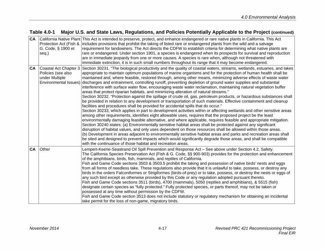
Table 4.0-1 Major U.S. and State Laws, Regulations, and Policies Potentially Applicable to the Project (continued) CA California Native Plant
Protection Act (Fish & G. Code, § 1900 et seq.)
This Act is intended to preserve, protect, and enhance endangered or rare native plants in California. This Act includes provisions that prohibit the taking of listed rare or endangered plants from the wild and a salvage requirement for landowners. The Act directs the CDFW to establish criteria for determining what native plants are rare or endangered. Under section 1901, a species is endangered when its prospects for survival and reproduction are in immediate jeopardy from one or more causes. A species is rare when, although not threatened with immediate extinction, it is in such small numbers throughout its range that it may become endangered.
CA Coastal Act Chapter 3 Policies (see also under Multiple Environmental Issues)
Section 30231. “The biological productivity and the quality of coastal waters, streams, wetlands, estuaries, and lakes appropriate to maintain optimum populations of marine organisms and for the protection of human health shall be maintained and, where feasible, restored through, among other means, minimizing adverse effects of waste water discharges and entrainment, controlling runoff, preventing depletion of ground water supplies and substantial interference with surface water flow, encouraging waste water reclamation, maintaining natural vegetation buffer areas that protect riparian habitats, and minimizing alteration of natural streams.” Section 30232. “Protection against the spillage of crude oil, gas, petroleum products, or hazardous substances shall be provided in relation to any development or transportation of such materials. Effective containment and cleanup facilities and procedures shall be provided for accidental spills that do occur.” Section 30233, which applies in part to development activities within or affecting wetlands and other sensitive areas among other requirements, identifies eight allowable uses, requires that the proposed project be the least environmentally damaging feasible alternative, and where applicable, requires feasible and appropriate mitigation. Section 30240 states: (a) Environmentally sensitive habitat areas shall be protected against any significant disruption of habitat values, and only uses dependent on those resources shall be allowed within those areas. (b) Development in areas adjacent to environmentally sensitive habitat areas and parks and recreation areas shall be sited and designed to prevent impacts which would significantly degrade those areas, and shall be compatible with the continuance of those habitat and recreation areas.
CA Other Lempert-Keene-Seastrand Oil Spill Prevention and Response Act – See above under Section 4.2, Safety. The California Species Preservation Act (Fish & G. Code, §§ 900-903) provides for the protection and enhancement of the amphibians, birds, fish, mammals, and reptiles of California. Fish and Game Code sections 3503 & 3503.5 prohibit the taking and possession of native birds’ nests and eggs from all forms of needless take. These regulations also provide that it is unlawful to take, possess, or destroy any birds in the orders Falconiformes or Strigiformes (birds-of-prey) or to take, possess, or destroy the nests or eggs of any such bird except as otherwise provided by this Code or any regulation adopted pursuant thereto. Fish and Game Code sections 3511 (birds), 4700 (mammals), 5050 (reptiles and amphibians), & 5515 (fish) designate certain species as “fully protected.” Fully protected species, or parts thereof, may not be taken or possessed at any time without permission by the CDFW. Fish and Game Code section 3513 does not include statutory or regulatory mechanism for obtaining an incidental take permit for the loss of non-game, migratory birds.
November 2014 4-17 Revised PRC 421 Recommissioning Project Final EIR

4.0 Environmental Analysis
Table 4.0-1 Major U.S. and State Laws, Regulations, and Policies Potentially Applicable to the Project (continued) 4.8 LAND USE, PLANNING, AND RECREATION See above under Multiple Environmental Issues for laws, regulations, and policies related to land use and planning. CA Coastal Act Chapter 3
Policies (see also under Multiple Environmental Issues)
Section 30220. Coastal areas suited for water-oriented recreational activities that cannot readily be provided at inland water areas shall be protected for such uses. Section 30221. Oceanfront land suitable for recreational use shall be protected for recreational use and development unless present and foreseeable future demand for public or commercial recreational activities that could be accommodated on the property is already adequately provided for in the area. Section 30222. The use of private lands suitable for visitor-serving commercial recreational facilities designed to enhance public opportunities for coastal recreation shall have priority over private residential, general industrial, or general commercial development, but not over agriculture or coastal-dependent industry. Section 30223. Upland areas necessary to support coastal recreational uses shall be reserved for such uses, where feasible. Section 30224. Increased recreational boating use of coastal waters shall be encouraged, in accordance with this division, by developing dry storage areas, increasing public launching facilities, providing additional berthing space in existing harbors, limiting non-water-dependent land uses that congest access corridors and preclude boating support facilities, providing harbors of refuge, and by providing for new boating facilities in natural harbors, new protected water areas, and in areas dredged from dry land.
4.9 PUBLIC SERVICES U.S. Code of Federal
Regulations, Title 29 · Under 29 CFR 1910.38, whenever an Occupational Safety and Health Administration (OSHA) standard requires
one, an employer must have an Emergency Action Plan that must be in writing, kept in the workplace, andavailable to employees for review. An employer with 10 or fewer employees may communicate the plan orally toemployees. Minimum elements of an emergency action plan are:o Procedures for reporting a fire or other emergency;o Procedures for emergency evacuation, including type of evacuation and exit route assignments;o Procedures to be followed by employees who remain to operate critical plant operations before they evacuate;o Procedures to account for all employees after evacuation;o Procedures to be followed by employees performing rescue or medical duties; ando The name or job title of every employee who may be contacted by employees who need more information
about the plan or an explanation of their duties under the plan.· Under 29 CFR 1910.39, an employer must have a Fire Prevention Plan (FPP). A FPP must be in writing, be kept
in the workplace, and be made available to employees for review; an employer with 10 or fewer employees maycommunicate the plan orally to employees. Minimum elements of a FPP are:o A list of all major fire hazards, proper hazardous material handling and storage procedures, potential ignition
sources and their control, and the type of fire protection equipment necessary to control each major hazard;o Procedures to control accumulations of flammable and combustible waste materials;o Procedures for regular maintenance of safeguards installed on heat-producing equipment to prevent the
accidental ignition of combustible materials;
Revised PRC 421 Recommissioning Project 4-18 November 2014 Final EIR

4.0 Environmental Analysis
Table 4.0-1 Major U.S. and State Laws, Regulations, and Policies Potentially Applicable to the Project (continued) o The name or job title of employees responsible for maintaining equipment to prevent or control sources of
ignition or fires; ando The name or job title of employees responsible for the control of fuel source hazards.o An employer must inform employees upon initial assignment to a job of the fire hazards to which they are
exposed and must also review with each employee those parts of the FPP necessary for self-protection.Under 29 CFR 1910.155, Subpart L, Fire Protection, employers are required to place and keep in proper working order fire safety equipment within facilities.
CA Other See above under Section 4.2, Safety. 4.10 TRANSPORTATION AND CIRCULATION CA Caltrans Caltrans is responsible for the design, construction, maintenance, and operation of the California State Highway
System and the portion of the Interstate Highway System within State boundaries. Chapter 2, Article 3 of the Vehicle Code defines the powers and duties of the California Highway Patrol, which has enforcement responsibilities for the vehicle operation and highway use in the State.
4.11 NOISE U.S. Noise Control Act (42
USC 4910) The Noise Control Act required the U.S. EPA to establish noise emission criteria, as well as noise testing methods (40 CFR Chapter 1, Subpart Q). These criteria generally apply to interstate rail carriers and to some types of construction and transportation equipment. The U.S. EPA published a guideline (U.S. EPA 1974) containing recommendations for acceptable noise level limits affecting residential land use of 55 dBA Ldn for outdoors and 45 dBA Ldn for indoors.
U.S. Department of Housing and Urban Development Environmental Standards (24 CFR Part 51)
The Department of Housing and Urban Development Environmental Standards forth the following exterior noise standards for new home construction (for interior noise levels, a goal of 45 dBA is set forth and attenuation requirements are geared to achieve that goal): 65 Ldn or less – Acceptable 65 Ldn and < 75 Ldn – Normally unacceptable, appropriate sound attenuation measures must be provided > 75 Ldn – Unacceptable
U.S. NTIS 550\9-74-004, 1974
In response to a Federal mandate, the U.S. EPA provided guidance in NTIS 550\9-74-004, 1974 (“Information on Levels of Environmental Noise Requisite to Protect Health and Welfare with an Adequate Margin of Safety”), commonly referenced as the “Levels Document” that establishes an Ldn of 55 dBA as the requisite level, with an adequate margin of safety, for areas of outdoor uses including residences and recreation areas. The U.S. EPA recommendations contain a factor of safety and do not consider technical or economic feasibility (i.e., the document identifies safe levels of environmental noise exposure without consideration for achieving these levels or other potentially relevant considerations), and therefore should not be construed as standards or regulations.
CA California Administrative Code, Title 4
The California Administrative Code, Title 4, which applies to airports operating under permit from the Caltrans Division of Aeronautics, defines a noise-impacted zone as any residential or other noise-sensitive use with CNEL 65 and above. The California Administrative Code, Title 2, establishes CNEL 45 as the maximum allowable indoor noise level resulting from exterior noise sources for multi-family residences.
November 2014 4-19 Revised PRC 421 Recommissioning Project Final EIR

4.0 Environmental Analysis
Table 4.0-1 Major U.S. and State Laws, Regulations, and Policies Potentially Applicable to the Project (continued) CA Land Use
Compatibility Guidelines from the now defunct California Office of Noise Control
State regulations for limiting population exposure to physically and/or psychologically significant noise levels include established guidelines and ordinances for roadway and aviation noise under Caltrans as well as the now defunct California Office of Noise Control. The California Office of Noise Control land use compatibility guidelines provided the following: An exterior noise level of 60 to 65 dBA Community Noise Equivalent Level (CNEL) is considered "normally acceptable" for residences. A noise level of 70 dBA CNEL is considered to be "conditionally acceptable" (i.e., the upper limit of "normally acceptable" noise levels for sensitive uses such as schools, libraries, hospitals, nursing homes, churches, parks, offices, and commercial/professional businesses). A noise level of greater than 75 dBA CNEL is considered "clearly unacceptable" for residences.
4.12 AESTHETICS/VISUAL RESOURCES CA Coastal Act Chapter 3
Policies (see also under Multiple Environmental Issues)
The Coastal Act is concerned with protecting the public viewshed, including views from public areas, such as roads, beaches, coastal trails, and access ways. Section 30251 states: Permitted development shall be sited and designed to protect views to and along the ocean and scenic coastal areas, to minimize the alteration of natural landforms, to be visually compatible with the character of the surrounding area, and, where feasible, to restore and enhance visual quality in visually degraded areas.
4.13 CULTURAL, HISTORICAL, AND PALEONTOLOGICAL RESOURCES U.S. Archaeological and
Historic Preservation Act (AHPA)
The AHPA provides for the preservation of historical and archaeological data that might be irreparably lost or destroyed as a result of (1) flooding, the building of access roads, the erection of workmen’s communities, the relocation of railroads and highways, and other alterations of terrain caused by the construction of a dam by an agency of the U.S. or by any private person or corporation holding a license issued by any such agency; or (2) any alteration of the terrain caused as a result of a Federal construction project or federally licensed project, activity, or program. This Act requires Federal agencies to notify the Secretary of the Interior when they find that any federally permitted activity or program may cause irreparable loss or destruction of significant scientific, prehistoric, historical, or archaeological data. The AHPA built upon the national policy, set out in the Historic Sites Act of 1935, "...to provide for the preservation of historic American sites, buildings, objects, and antiquities of national significance...."
U.S. Archaeological Resources Protection Act (ARPA)
The ARPA states that archaeological resources on public or Indian lands are an accessible and irreplaceable part of the nation’s heritage and: Establishes protection for archaeological resources to prevent loss and destruction due to uncontrolled excavations and pillaging; Encourages increased cooperation and exchange of information between government authorities, the professional archaeological community, and private individuals having collections of archaeological resources prior to the enactment of this Act; Establishes permit procedures to permit excavation or removal of archaeological resources (and associated activities) located on public or Indian land; and Defines excavation, removal, damage, or other alteration or defacing of archaeological resources as a “prohibited act” and provides for criminal and monetary rewards to be paid to individuals furnishing information leading to the
Revised PRC 421 Recommissioning Project 4-20 November 2014 Final EIR

4.0 Environmental Analysis
Table 4.0-1 Major U.S. and State Laws, Regulations, and Policies Potentially Applicable to the Project (continued) finding of a civil violation or conviction of a criminal violator. ARPA has both enforcement and permitting components. The enforcement provision provides for the imposition of both criminal and civil penalties against violators of the Act. The ARPA's permitting component allows for recovery of certain artifacts consistent with the standards and requirements of the NPS's Federal Archeology Program.
U.S. National Historic Preservation Act (NHPA) (16 USC 470 et seq.)
This applies only to Federal undertakings. Archaeological resources are protected through the NHPA, as amended, and its implementing regulation, Protection of Historic Properties (36 CFR 800), the AHPA, and the ARPA. This Act presents a general policy of supporting and encouraging the preservation of prehistoric and historic resources for present and future generations by directing Federal agencies to assume responsibility for considering the historic resources in their activities. The State implements the NHPA through its statewide comprehensive cultural resource surveys and preservation programs coordinated by the California Office of Historic Preservation (OHP) in the State Department of Parks and Recreation, which also advises Federal agencies regarding potential effects on historic properties. The OHP also maintains the California Historic Resources Inventory. The State Historic Preservation Officer (SHPO) is an appointed official who implements historic preservation programs within the State’s jurisdictions. Under the NHPA, historic properties include “any prehistoric or historic district, site, building, structure, or object included in, or eligible for inclusion in, the National Register of Historic Places” (16 U.S.C. 470w [5]).
U.S. Omnibus Public Land Management Act of 2009 - Public Law 111-11 (123 Stat. 991)
Public Law 111-011 at title VI, subtitle D lays out statutory requirements for Paleontological Resources Preservation (PRP). PRP provides definitions but requires the definition of some terms, and uses other terms and concepts that need further definition or details to clarify intent or enforcement. PRP identifies management requirements, collection requirements, curation requirements, need for both criminal and civil penalties, rewards and forfeiture, and the need for confidentiality of some significant resource locations. PRP at section 6310 also states that "As soon as practical after the date of enactment of this Act, the Secretary shall issue such regulations as are appropriate to carry out this subtitle, providing opportunities for public notice and comment."
CA California Environmental Quality Act (CEQA) (see Multiple Environmental Issues)
As the CEQA lead agency, the CSLC is responsible for complying with all provisions of the CEQA and State CEQA Guidelines that relate to “historical resources.” A historical resource includes: (1) a resource listed in, or eligible for listing in, the California Register of Historic Resources (CRHR); (2) a resource included in a local register of historical or identified as significant in an historical resource surveys; and (3) any resource that a lead agency determines to be historically significant for the purposes of CEQA, when supported by substantial evidence in light of the whole record. The CRHR was created to identify resources deemed worthy of preservation on a State level and was modeled closely after the National Register. The criteria, which are nearly identical to those of the National Register but focus on resources of statewide significance (see State CEQA Guidelines § 15064.5, subdivision (a)(3)), are defined as any resource that meets any of the following criteria: (1) Is associated with events that have made a significant contribution to the broad patterns of California’s history and cultural heritage; (2) Is associated with lives of persons important in our past; (3) Embodies the distinctive characteristics of a type, period, region, or method of construction, or represents the work of an important creative individual, or possesses high artistic values; or (4) Has yielded, or may be likely to yield, information important in prehistory or history. Properties listed, or formally designated as eligible for listing, on the National Register are automatically listed on the CRHR, as are certain State Landmarks and Points of Interest. A lead agency is not precluded from determining that the resource may be an historical resource as defined in Public Resources Code sections 5020.1, subdivision (j), or 5024.1 (State
November 2014 4-21 Revised PRC 421 Recommissioning Project Final EIR

4.0 Environmental Analysis
Table 4.0-1 Major U.S. and State Laws, Regulations, and Policies Potentially Applicable to the Project (continued) CEQA Guidelines § 15064.5, subdivision (a)(4)).
CA Coastal Act Chapter 3 Policies (see also under Multiple Environmental Issues)
Coastal Act Section 30244 states: Where development would adversely impact archaeological or paleontological resources as identified by the State Historic Preservation Officer, reasonable mitigation measures shall be required. (See also Coastal Act, under Multiple Environmental Issues)
CA California Public Resources Code section 5097.5
Section 5097.5 of the California Public Resources Code prohibits excavation or removal of any “vertebrate paleontological site or historical feature, situated on public lands, except with the express permission of the public agency having jurisdiction over such lands.” Penal Code section 623 spells out regulations for the protection of caves, including their natural, cultural, and paleontological contents. It specifies that no “material” (including all or any part of any paleontological item) will be removed from any natural geologically formed cavity or cave.
CA Health and Safety Code section 7050.5
This code states that if human remains are exposed during construction, no further disturbance shall occur until the County Coroner has made the necessary findings as to origin and disposition pursuant to Public Resources Code section 5097.998. The Coroner has 24 hours to notify the Native American Heritage Commission (NAHC) if the remains are determined to be of Native American descent. The NAHC will contact most likely descendants, who may recommend how to proceed.
4.14 ENERGY AND MINERAL RESOURCES U.S. CFR, Titles 10, 18,
and 30 10 CFR addresses energy consumption and the establishment of the Department of Energy. 18 CFR addresses the Federal Energy Regulatory Commission (FERC). 30 CFR establishes the Bureau of Ocean Energy Management (BOEM, formerly the MMS), which manages energy resources in the Federal OCS.
CA Surface Mining and Reclamation Act (SMARA) (Pub. Resources Code, §§ 2710-2796).
The California Department of Conservation is the primary agency with regard to mineral resource protection. The Department is charged with conserving earth resources (Pub. Resources Code, §§ 600-690) and has five program divisions: California Geological Survey; Division of Oil, Gas, and Geothermal Resources; Division of Land Resource Protection; State Mining and Geology Board (SMGB); and Office of Mine Reclamation. The SMGB develops policy direction regarding the development and conservation of mineral resources and reclamation of mined lands. In accordance with SMARA, the California Geological Survey classifies the regional significance of mineral resources and assists in the designation of lands containing significant aggregate resources. Mineral Resource Zones (MRZs) have been designated to indicate the significance of mineral deposits. The MRZ categories are: MRZ-1: Areas where adequate information indicates that no significant mineral deposits are present or where it is judged that little likelihood exists for their presence. MRZ-2: Areas where adequate information indicates significant mineral deposits are present, or where it is judged that a high likelihood exists for their presence. MRZ-3: Areas containing mineral deposits the significance of which cannot be evaluated from available data. MRZ-4: Areas where available information is inadequate for assignment to any other MRZ.
CA Coastal Act Chapter 3 Policies (see also under Multiple
Section 30254 states: New or expanded public works facilities shall be designed and limited to accommodate needs generated by development or uses permitted consistent with the provisions of this division; provided, however, that it is the intent of the Legislature that State Highway Route 1 in rural areas of the coastal zone remain a scenic two-lane
Revised PRC 421 Recommissioning Project 4-22 November 2014 Final EIR

4.0 Environmental Analysis
Table 4.0-1 Major U.S. and State Laws, Regulations, and Policies Potentially Applicable to the Project (continued) Environmental Issues) road. Special districts shall not be formed or expanded except where assessment for, and provision of, the service
would not induce new development inconsistent with this division. Where existing or planned public works facilities can accommodate only a limited amount of new development, services to coastal-dependent land use, essential public services and basic industries vital to the economic health of the region, state, or nation, public recreation, commercial recreation, and visitor-serving land uses shall not be precluded by other development. Section 30254.5 states in part: Notwithstanding any other provision of law, the commission may not impose any term or condition on the development of any sewage treatment plant which is applicable to any future development that the commission finds can be accommodated by that plant consistent with this division….
CA Other Public Resources Code section 6801 (Oil and Gas and Mineral Leases) Warren-Alquist Act, adopted in 1974 to encourage conservation of non-renewable energy resources.
4.15 SOCIOECONOMICS AND ENVIRONMENTAL JUSTICE U.S. Executive Order
12898 On February 11, 1994, President Clinton issued an “Executive Order on Federal Actions to Address Environmental Justice in Minority Populations and Low-Income Populations” (Executive Order 12898). This Executive Order was designed to focus attention on environmental and human health conditions in areas of high minority populations and low-income communities, and promote non-discrimination in programs and projects substantially affecting human health and the environment (White House 1994). The Executive Order requires Federal agencies (as well as State agencies receiving Federal funds) to identify and address any disproportionately high and adverse human health or environmental effects of their programs, policies, and activities on minority and/or low-income populations.
CA CSLC The CSLC has developed and adopted an Environmental Justice Policy to ensure equity and fairness in its own processes and procedures. The CSLC adopted and amended the Environmental Justice Policy on October 1, 2002, to ensure consideration of environmental justice as part of CSLC processes, decisions, and programs. The policy stresses equitable treatment of all members of the public and commits to consider environmental justice in its processes, decision-making, and regulatory affairs. It is implemented, in part, through identification of, and communication with, relevant populations that could be adversely and disproportionately affected by CSLC projects or programs, and by ensuring that a range of reasonable alternatives is identified that would minimize or eliminate environmental issues affecting such populations. This discussion is provided in this document consistent with and in furtherance of the CSLC’s Environmental Justice Policy. The staff of the CSLC is required to report back to the Commission on how environmental justice is integrated into its programs, processes, and activities (CSLC 2002).
Abbreviations used in this table include (see also List of Abbreviations and Acronyms following the Table of Contents): AB = Assembly Bill; Caltrans = California Dept. of Transportation; CARB = California Air Resources Board; CCC = California Coastal Commission; CDFW = California Dept. of Fish and Wildlife; CDP = Coastal Development Permit; CEQA = California Environmental Quality Act; CFR = Code of Federal Regulations; CSLC = California State Lands Commission; CWA = Clean Water Act; CZMA = Coastal Zone Management Act; LCP = Local Coastal Program; MPA = Marine Protected Area; NMFS = National Marine Fisheries Service; NPS = National Park Service; RWQCB = Regional Water Quality Control Board; SB = Senate Bill; SWRCB = State Water Resources Control Board; USACE = U.S. Army Corps of Engineers; USC = U.S. Code; USCG = U.S. Coast Guard; U.S. EPA = U.S. Environmental Protection Agency; USFWS = U.S. Fish and Wildlife Service.
November 2014 4-23 Revised PRC 421 Recommissioning Project Final EIR

4.0 Environmental Analysis
This page intentionally left blank.
Revised PRC 421 Recommissioning Project 4-24 November 2014 Final EIR

4.1 Geological Resources
4.1 GEOLOGICAL RESOURCES 1
This section of the Environmental Impact Report (EIR) discusses potential geological 2 issues that may be associated with the Project. Specifically, this section focuses on the 3 potential for structural instability of Project facilities given impacts on the Project from 4 (1) seismic hazards including earthquakes, faulting, surface rupture, ground shaking, 5 liquefaction, subsidence, and tsunamis, and (2) coastal processes including erosion, 6 scour, coastal bluff instability and landslides. In addition, this section includes a 7 summary of the existing geologic condition of the reservoir from which the State Oil and 8 Gas Lease PRC 421 (PRC 421) wells have historically extracted oil. The information 9 presented below outlines the environmental setting, regulatory setting, significance 10 criteria, the potential for impacts to the facilities from various geological events, and the 11 significance of these impacts. This section also presents projects identified in the 12 cumulative impacts analysis. 13
This analysis is based on a review of publicly available information on the soils, 14 stratigraphy, and geologic structures present in the study area vicinity. It does not 15 include design-level engineering geology or geotechnical investigations, subsurface 16 explorations, or any laboratory testing of any media, as these analyses are not required 17 by the California Environmental Quality Act (CEQA). This document incorporates by 18 reference the conclusions of the Line 96 Modification Project EIR (Santa Barbara 19 County 2011) regarding geological resources associated with operation of the Line 96 20 pipeline to the Plains All American Pipeline, L.P. (PAAPLP) Coastal Pipeline west of Las 21 Flores Canyon (LFC), and summarizes these where appropriate. 22
4.1.1 Environmental Setting 23
Study Area Location and Description 24
The primary Project study area comprises the immediate onshore and near-shore areas 25 of the Ellwood coast that would be subject to direct impacts from geologic and structural 26 hazards as a result of Project implementation. This area includes existing PRC 421 27 facilities, the access road, and the pipeline route along the access road, coastal bluff, 28 golf course easement, and tie-in at the Ellwood Onshore Facility (EOF). The secondary 29 Project study area includes the Gaviota Coast and is only discussed in environmental 30 issue areas where the potential exists for impacts that are different from those identified 31 in the certified Line 96 Modification Project EIR (refer to Section 4.1.4 below). In 32 addition, the environmental setting includes the current pressure regime of the 33 Vaqueros Reservoir, located in the Ellwood Oil Field, and a discussion of other wells 34 that historically produced from the same reservoir. Figure 4.1-1 shows a schematic 35 diagram of the Ellwood Oil Field in relation to other oil fields located along the coast in 36 the Project vicinity. 37
November 2014 4-25 Revised PRC 421 Recommissioning Project Final EIR

4.1 Geological Resources
FIGURE 4.1-1. MAJOR OIL AND GAS FIELDS OF THE SANTA BARBARA CHANNEL
Source: From Venoco, Inc., presentation titled “Revitalizing South Ellwood Field, Offshore California” (West Coast Petroleum Technology Transfer Conference [PTTC] 2001).
Physiography 1
The PRC 421 piers are located beneath a coastal bluff that rises approximately 80 feet 2 above mean sea level (msl). The existing access road intersects the bluff at its base 3 (i.e., below 20 feet above msl) to the northwest of the piers near the EOF, and traverses 4 the bluff nearly 20 feet above msl in the direction of the piers to the southeast. To the 5 northeast, a north-south trending canyon is incised into the bluff where Bell Canyon 6 Creek discharges into the ocean. Another small east-west trending gully exists along 7 the bluff above the access road and piers. Accumulations of beach sand deposits exist 8 at the base of the bluff in the surf zone (U.S. Geological Service [USGS] 1995). 9
The local physiography consists of a wave-cut platform with an associated sea cliff. The 10 cliff marks the locations of older marine terraces which have been uplifted, and the 11 beach marks the modern wave-cut platform. Bell Canyon Creek and the other incision 12 along the sea cliff mark the locations of eroded gullies and/or fault scarps. 13
Revised PRC 421 Recommissioning Project 4-26 November 2014 Final EIR

4.1 Geological Resources
Stratigraphy 1
The geologic strata exposed onshore in the Project vicinity include (Gurrola 2004) 2 (Figure 4.1-2): 3
· Quaternary Beach Sand (Qs)–unconsolidated marine and wind transported4 beach sand. This unit is exposed along the beach in the surf zone.5
· Quaternary Alluvium (Qa)–undifferentiated alluvial, stream channel, and6 floodplain deposits composed of silty sands to sandy gravels. This unit is7 exposed along Bell Canyon Creek and an unnamed incision near the golf course.8
· Quaternary Marine Terrace Deposits (Qt and Qt3a)–marine terrace deposits9 composed of medial to near-shore marine sands and wind transported silts.10 Based on Gurrola’s mapping, there is a sequence of marine terrace deposits.11 There are also several ancient shorelines, as depicted in Figure 4.1-2 (shown as12 blue lines), that trend generally east-west across the Project study area. The13 typical thickness of these deposits is less than 100 feet (City of Goleta 2003).14
· Tertiary Monterey Formation (Tm)–undifferentiated diatomaceous, calcareous, and15 silicious shale with minor sandstone and volcanic ash deposits. This unit is16 exposed along the coastal bluff beneath units Qt and Qt3a. The formation17 averages approximately 1,000 feet in thickness, and is impregnated with tar.18 Where exposed, Monterey Formation is usually white and stained with limonite,19 and the weaker portions are easily eroded by both marine and non-marine20 processes including wave action, wind erosion and erosion due to rainfall (City of21 Goleta 2003). The stratigraphy of the offshore area along the continental shelf22 generally consists of shale deposits overlying the Monterey Formation (PTTC23 2001). 24
In addition to the units exposed at the surface, another unit, the Tertiary Vaqueros 25 Formation (Tvq), exists in the subsurface beneath the study area. This unit consists of 26 sandstone with siltstone and shale interbeds and is located approximately 3,000 feet 27 below the ground surface (City of Goleta 2003). 28
A combination of organic-rich rocks (i.e., containing oil and gas), such as those formed 29 in a marine environment, combined with folds and faults, allows for oil and gas to 30 become trapped in the subsurface. Within the Vaqueros Formation, an oil and gas 31 reservoir exists which has been folded and faulted. The Vaqueros is folded into two 32 anticlines. The oil and gas rises to and accumulates at the top of the axes (the top of the 33 center of the folds) of the anticlines. One of the axes of the anticlines (to the southeast – 34 referred to as the eastern high) is higher than the other (the western high), and this 35 corresponds to the location of the PRC 421 wells. 36
November 2014 4-27 Revised PRC 421 Recommissioning Project Final EIR

★★
PROJECTLOCATION
EXPLANATIONAGE
Qua
tern
ary
Hol
ocen
eM
ioce
ne
Terti
ary
Qa
Qs
Qt3a
Qe
Tm
unconformity
Source: Gurrola 2004.
Geologic Contact, location approximate, concealed or inferred
Faullt, location approximate where dashed, location concealed (blind) or inferred where dotted, bal and bar on downthrown side, tic indicates dip of fault
Anticline, location approximate where dashed, inferred where dotted; plunge direction indicated
Syncline, location approximate where dashed, inferred where dotted; plunge direction indicated
Marine terrace shoreline or strandline, location approximate
Strike and dip of inclined beds
Radiocarbon sample site
Beach Sand – Unconsolidated marine and aeolian beach sand.
Alluvium – Undifferentiated alluvial, stream channel, and floodplain deposits composed of silty sands to sandy gravels.
Estuarine Deposits – Commonly estuarine silts and clays with sand interbeds and lenses.
Marine Terrace Deposits – Second marine terrace associated with oxygen isotope substage 5a; Qt denotes deposit of unknown age; medial to nearshore marine sands with aeolian silts.
Monterey Formation – Undifferentiated diatomaceous, calcareous, and silicious shale with minor sandstone and volcanic ash deposits
FIGURE4.1-2
0 1,800
SCALE IN FEET
N
Geology in the Project Area
4-

4.1 Geological Resources
Structure 1
The Project is located in a tectonically active area. Folds consisting of anticlines 2 (concave down), and synclines (concave up) whose axes trend east-west are shown in 3 Figure 4.1-2 as green dashed lines. Thrust faults (i.e., reverse faults) also trend east-4 west in the area, and the main faults consist of the More Ranch Fault Zone, Coal Oil 5 Point Fault, and Lavigia Fault (not exposed at the surface in the study area). The folding 6 and faulting in the study area are characteristic of compressional forces caused by 7 tectonic plates moving toward one another (Gurrola 2004). 8
A study was conducted on the More Ranch faults located just southeast of the Project 9 site, where one of the segments is exposed in the sea cliff at Ellwood Beach. The study 10 results show that the fault deforms the first emergent marine terrace, and is expressed 11 at the surface as a north-facing fold scarp approximately 5 meters high. Additionally, the 12 sea cliff exposure reveals the fault as a south-dipping reverse fault that offsets the 13 Miocene Monterey Formation and wave-cut platform. A channel fill whose upstream 14 reach is Devereux Creek is also exposed along the fold scarp in the sea cliff, and has 15 been truncated by coastal erosion (Keller and Gurrola 2000). 16
Soils and Soil-Related Hazards 17
Surface soils in the Project area are generally found at the top of the coastal bluff, and 18 were formed in alluvium derived from sedimentary rock. The soils are generally fine 19 sandy loams over dense, very low permeable clay subsoil. The depth to the clay subsoil 20 is approximately 30 inches. Below the bluff, no soils are formed due to active coastal 21 processes. 22
The soils in the Project vicinity consist of Goleta Loam with 0 to 2 percent slopes 23 (exposed at EOF and Bell Canyon Creek), Milpitas-Positas Fine Sandy Loams with 9 to 24 15 percent slopes and 30 to 50 percent slopes, eroded (exposed at EOF and Sandpiper 25 Golf Course), and Diablo Clay with 2 to 9 percent slopes and 9 to 15 percent slopes 26 (exposed southeast of the golf course). The Diablo series soils are well-drained, formed 27 in soft shale and mudstone, with slight to moderate erosion hazards. Goleta Loam is 28 formed on broad floodplains and the hazard of erosion is slight. Milpitas series soils 29 consist of moderately well-drained soils on terraces formed in mixed alluvial deposits, 30 runoff is rapid, and the erosion hazard potential is high (U.S. Department of Agriculture 31 [USDA] 1981). According to a map of compressible soils, none of the soils within the 32 Project study area are compressible (City of Goleta 2006a). However, the City of Goleta 33 (2003) indicated that some of the soil types present at the Project area (Diablo and 34 Milpitas) could have high expansion potential whereas Santa Barbara County has 35 classified the Project study area as having a low to moderate potential of having 36 problems associated with expansive soils (Moore and Taber 1979). Both of these 37 classifications are based on the fact that smectites (a clay mineral group) are present in 38
November 2014 4-29 Revised PRC 421 Recommissioning Project Final EIR

4.1 Geological Resources
the study area soils. The origin, type, and stability of fill soils used to construct the 1 Project access road along the toe of the bluff are unknown. 2
The presence of expansive soils does not by itself constitute a geologic hazard. The 3 hazard arises when clay minerals with expansive potential exist in an environment 4 where they are constantly subjected to periods of wetness and periods of dryness. 5 Buildings and structures developed in these areas can then be damaged due to 6 shrinking and swelling of the clay minerals in the soil beneath the foundations. 7
The study area includes both onshore and surf zone areas. The structures located in 8 the surf zone (i.e., piers and causeways) are in a constant state of saturation; therefore, 9 the risk of damage to the foundations of the piers and causeways caused by expansive 10 soils is minimal, as these soils would not be expected to undergo wetting and drying 11 periods. The onshore areas of the Project located above the high water line could 12 undergo wetting and drying periods, and could include expansive soils. 13
Natural Oil Seeps 14
Prolific natural marine hydrocarbon seepage in the Project vicinity occurs offshore in the 15 Santa Barbara Channel (Figure 4.1-3) (University of California Santa Barbara [UCSB] 16 2006; Quigley et al. 1999a; Hornafius et al. 1999). Natural oil and gas have been 17 released from submarine seeps in the Channel for thousands of years. The seeps emit 18 both liquid and gaseous hydrocarbon phases, with gas predominating. The most active 19 gas seeps form visible boils where they intersect the sea surface. Based on the 20 mapping of the seep locations and comparison with other data, the oil and gas are 21 thought to migrate upward through the overlying cap rock (Sisquoc Formation) along 22 fractures on the axis of the South Ellwood anticline and the Coal Oil Point fold complex. 23 The seep locations follow linear trends that mirror the axes of the folds, suggesting that 24 the release of oil and gas along seeps in the Channel is controlled by geologic structure 25 (Bartsch et al. 1999). Seepage is most intense at submarine fault conduits and at 26 structural closures along anticline axes (Quigley et al. 1999a; Hornafius et al. 1999). 27
Evidence of the natural oil seeps can be directly observed on the beach at the study 28 area. Black tar ball deposits exist and are mixed in with the sand on the beach. Because 29 the natural oil seeps originate offshore, the source of the seeps is not the Vaqueros 30 Formation, the reservoir for the PRC 421 wells. This conclusion is supported by multiple 31 lines of study including seep location, seep discharge, variations of seep emissions 32 through time, and by geochemical analyses performed on oil samples from offshore 33 platforms and beach tar balls. Based on the laboratory analysis, the beach tar ball 34 geochemistry is most similar to oil samples collected from Platform Holly, which 35 produces from the Monterey Formation (Lorenson et al. 2004). Therefore, the tar balls 36 are considered to originate offshore, from where they travel onshore via wave action 37 and other coastal processes. 38
Revised PRC 421 Recommissioning Project 4-30 November 2014 Final EIR

Goleta Pier
UCSB
Ellwood Pier
Three Mile Limit
Field Boundary
PlatformHolly
SeepTents
South Ellwood Seeps
La Goleta Seeps
Isla VistaSeeps
Coal Oil PointSeeps
PRC 208
PRC 3120
PRC 3242
PRC 421
Goleta Slough
DevereuxSlough
S a n t a B a r b a r a
C h a n n e l
PACIFIC OCEAN
Seep Volume
0-10 MCFGPD/Acre
10-20 MCFGPD/Acre
20-30 MCFGPD/Acre
Source: CSLC.
LEGEND
0 1 2
APPROXIMATE SCALE IN MILES
N
PROJECTLOCATION
★

4.1 Geological Resources
Faulting and Seismicity 1
Regional Seismicity 2
The Santa Barbara/Goleta area is located in the Western Transverse Ranges, which is 3 a seismically active region of Southern California. The North Branch of the More Ranch 4 Fault trends roughly east-west to northwest-southeast less than 0.25 mile south of the 5 Project study area (Gurrola 2004). The Santa Barbara County General Plan Safety 6 Element classifies the More Ranch Fault Zone as active, which the California Geological 7 Survey (CGS), formerly the California Division of Mines and Geology (CDMG), defines 8 as those along which movement has occurred within the last 11,000 years. Potentially 9 active faults have displayed evidence of movement during the past 1.6 million years. 10 Inactive faults demonstrate no evidence of movement in the same timeframe (CDMG 11 1994). However, the More Ranch Fault Zone has not been zoned as active by the State 12 of California (Jennings 1994; CDMG 1999), or through the creation of an Alquist-Priolo 13 special studies zone (City of Goleta 2003). The North Branch of the More Ranch Fault 14 has deformed a 45,000-year old marine terrace deposit, and is therefore considered 15 potentially active (Gurrola 2004). 16
The reverse Lavigia Fault is located beneath the Project area, but is buried in the 17 Project vicinity. This fault is believed to act as a trap for oil and gas in the Vaqueros 18 Reservoir at depth and is classified as potentially active (Keller and Gurrola 2000). 19
Ground motion in the Project vicinity is generally the result of sudden movements of 20 large blocks of the earth’s crust along active faults, which result in an earthquake. 21 Southern California is recognized as one of the most seismically active areas in the U.S. 22 having been subjected to over 50 major earthquakes of magnitude 6 or greater since 23 1796. Earthquakes of magnitude 7.8 or greater occur at the rate of about two or three 24 per 1,000 years, corresponding to a 6 to 9 percent probability in 30 years. 25
The Santa Barbara/Goleta area has experienced numerous seismic events over the last 26 two centuries, including a few historic large-scale (magnitude greater than 6.0) events, 27 such as the 1812 earthquake, which had a probable Richter magnitude of 7.1 28 (Toppozada et al. 1981) and likely occurred either offshore, on the San Cayetano Fault 29 to the east (Dolan and Rockwell 2001), or on the Santa Ynez River Fault to the 30 northwest (Santa Barbara County 2004; UCSB 2004; Sylvester and Darrow 1979). 31 Other destructive earthquakes struck the Santa Barbara/Goleta area in 1857 (San 32 Andreas Fault, magnitude 8.4), in 1925 (Santa Barbara vicinity, possibly the More 33 Ranch or Mesa Fault, magnitude 6.3), in 1927 (offshore Point Arguello, magnitude 7.3), 34 and in 1978 (offshore North Channel Fault, magnitude 5.9). A magnitude 4.4 35 earthquake was centered near the Project site in Isla Vista in 2004 (USGS 2004). 36
Movement along active and potentially active faults, either onshore or offshore near the 37 Project area, including the San Andreas Fault, Santa Ynez/Santa Ynez River Fault 38
Revised PRC 421 Recommissioning Project 4-32 November 2014 Final EIR

4.1 Geological Resources
Zone, More Ranch Fault Zone, Lavigia Fault, and several others could induce seismic 1 shaking. The Project location is classified as an area where shaking from earthquakes 2 will occur 1 to 2 times per century, and those events will exceed 20 percent of the force 3 of gravity. At this level, significant damage to older buildings is expected to result 4 (Southern California Earthquake Center [SCEC] 1995). 5
Additional geologic hazards associated with seismicity include surface rupture, 6 liquefaction, subsidence, and tsunamis. These hazards which also have the potential to 7 affect the Project are described in detail below. 8
Surface Rupture and Other Types of Seismic Ground Failure 9
Surface ruptures comprise the displacement and cracking of the ground surface along a 10 fault trace. Surface ruptures are visible instances of horizontal or vertical displacement, 11 or a combination of the two, typically confined to a narrow zone along the fault. 12 Developments near the More Ranch faults, which would include the Project, would have 13 the most significant potential to be affected by surface rupture (City of Goleta 2003). 14
Differential settlement is a process whereby soils settle non-uniformly, potentially 15 resulting in stress and damage to pipelines or other overlying structures. Such 16 movement can occur in the absence of seismically induced ground failure, due to 17 improper grading and soil compaction or discontinuity of naturally occurring soils; 18 however, strong ground shaking often greatly exacerbates soil conditions already prone 19 to differential settlement, resulting in distress to overlying structures. Elongated 20 structures, such as pipelines, are especially prone to damage as a result of differential 21 settlement. 22
Lateral spreading is a type of seismically induced ground failure that occurs when 23 cracks and fissures form on an unsupported slope, resulting in lateral propagation and 24 failure of slope material in a downslope direction. This type of failure is common in 25 unconsolidated river or stream bank deposits, where lateral stream scour creates 26 oversteepened banks in unconsolidated silts and sands. 27
Liquefaction 28
Liquefaction is a form of earthquake-induced ground failure that occurs primarily in 29 relatively shallow, loose, granular, water-saturated soils. Liquefaction is defined as the 30 transformation of a granular material from a solid state into a liquefied state as a 31 consequence of increased pore pressure, which results in the loss of grain-to-grain 32 contact. Unconsolidated silts, sands, and silty sands are most susceptible to 33 liquefaction. While almost any saturated granular soil can develop increased pore water 34 pressures when shaken, these excess pore water pressures can lead to liquefaction if 35 the intensity and duration of earthquake shaking are great enough. During recent large 36 earthquakes where liquefaction occurred, structures that appeared to be most 37
November 2014 4-33 Revised PRC 421 Recommissioning Project Final EIR

4.1 Geological Resources
vulnerable to liquefaction included buildings with shallow foundations, railways, buried 1 structures, retaining walls, port structures, utility poles, and towers. 2
Santa Barbara County identifies the Project study area as having moderate liquefaction 3 hazard (Moore and Taber 1979). According to the City of Goleta, there is no historical 4 evidence of structures being damaged by liquefaction in the city or adjacent 5 unincorporated portions of Santa Barbara County (City of Goleta 2003). However, areas 6 of beach sand could have a high liquefaction potential, due to unconsolidated sand 7 layers below the water table at shallow depths. During ground shaking, loose saturated 8 soils and beach sands can undergo liquefaction, and differential settlement of buildings 9 and structures can occur. In addition, as noted above, the types of soils used in 10 construction of the Project access road are unknown. Portions of this access road 11 appear to be saturated due to inflow from springs in the bluff which may increase the 12 potential for liquefaction of these fill soils of unknown origin. 13
Subsidence 14
Subsidence is a type of ground failure, defined as settlement or compression of 15 subsurface soils following the loss of interstitial materials such as water or gas. 16 Subsidence can also result from wetting of collapsible soils, typically loose deposits of 17 silt or sand. Subsidence can occur over a broad region or in localized areas, and can 18 occur gradually over time or as a sudden collapse. The loss of interstitial material can 19 result from shaking of the soil mass during an earthquake, or it can result from other 20 non-seismic factors such as the extraction of oil and gas reserves. Because the 21 Vaqueros Reservoir is thought to naturally repressurize due to influx of groundwater into 22 the reservoir rock, subsidence is not expected to occur in the study area as a result of 23 the Project. 24
Tsunamis 25
Tsunamis are large ocean waves generated by large-scale, short duration submarine 26 earthquakes, volcanic activity, and submarine landslides. A seismic event on any 27 moderate offshore fault could result in a tsunami in the Project vicinity. A major 28 earthquake that occurred off the coast of Point Arguello in 1927 initiated a tsunami, 29 which was recorded on tsunami gages as far away as Hawaii and reached heights of 6 30 feet above msl along the coast. Another historical tsunami may have resulted from an 31 1812 earthquake that was generated along a fault in the Santa Barbara Channel (Keller 32 and Gurrola 2000). Tsunamis affecting the Project area can also be generated by 33 distant earthquakes, such as the one that occurred in March 2011 in Japan. A 34 significant tsunami in the area could affect areas as high as 40 feet above msl; areas 35 most susceptible to the effects of a tsunami would be along the oceanfront (Santa 36 Barbara County 2001). 37
Revised PRC 421 Recommissioning Project 4-34 November 2014 Final EIR
4.1 Geological Resources
The stream discharge area of Bell Canyon Creek and the beach area to the southeast 1 of the Project site are designated as potential tsunami runup areas. The runup area was 2 calculated by the University of Southern California using a tsunami model and potential 3 earthquake sources. The calculated runup area of Bell Canyon Creek includes the area 4 occupied by the EOF (City of Goleta 2006a). 5
Coastal Process Hazards 6
Erosion and Scour 7
Erosion of exposed soils and rocks along the coastal bluff, and in gullies and creeks, 8 naturally occurs as a result of physical weathering and ongoing coastal processes. 9 Active erosion caused by water and wind action is evident along the sea cliff where 10 outcrops expose old filled channels and fault planes (Keller and Gurrola 2000). Scour 11 can be considered an aggressive form of water erosion where soil or sediment particles 12 are removed from gullies, creeks, and the sea cliff exposed to wave action. Erosion and 13 scour, while ongoing and naturally occurring in a beach environment, can be affected by 14 human-induced changes including changes to topography, addition of structures, roads, 15 and artificial fill, or other disturbances to the existing natural setting. In areas of 16 increased erosion, deeper incision of gullies and creeks can occur, which causes 17 accumulation of sediments downstream where slopes are less steep and sediments can 18 settle out of the water column. In areas of increased scour, a net increase in removal of 19 mass including soil, sediment (beach sand), and bedrock can occur. 20
The Project is located within the active wave-cut platform along the coast of the Pacific 21 Ocean. Historical wave-cut platforms and ancient shorelines exist at the top of the 22 coastal bluff, and are marked by emergent marine terraces. The terrace deposits record 23 a geologic history of ongoing coastal erosion processes that have created the sequence 24 of marine terraces. Accumulation and removal of soil (or beach sand) are transient 25 features, and in a wave-cut platform environment, there is an overall net removal of soil, 26 rock, and beach sand. This area has been continually eroded and scoured through time 27 as waves have cut into the existing soil and rock to form the wave-cut platform and 28 coastal bluff. This continual cutting into the sea cliff by waves will continue to erode the 29 coastal bluff over time. This process would be expected to continue for the foreseeable 30 future (on the order of thousands of years). 31
The southwest-facing shoreline of the beach in the Project area is subject to direct wave 32 energy which causes off-shore migration of sediments. Sediment removal is greatest in 33 the winter when wave action increases in response to tidal variation (see Section 4.5, 34 Hydrology, Water Resources and Water Quality). Beach width ranges from 35 meters to 35 90 meters and is subject to seasonal variation and long-term weather patterns including 36 El Niño and the Pacific Decadal Oscillation. A 65-year study of beach width (1938–37 2003) in the Project area found that beach width was the lowest during 1983 and 1998, 38
November 2014 4-35 Revised PRC 421 Recommissioning Project Final EIR

4.1 Geological Resources
following El Niño events (Revell and Griggs 2003). The maximum beach width was 1 observed in 2001 and 2003. The seasonal change in beach width also exposes the pier 2 structures and tops of the caissons to greater level of wave action during winter months. 3
As mentioned previously, the soils in the Project vicinity are classified as having 4 moderate to high erosion potentials. Because these soils are formed on the terraces at 5 the top of the bluff and along Bell Canyon Creek, there is a potential for these soils to 6 erode. Erosion of the terrace soils could result in downstream sedimentation at the 7 mouth of Bell Canyon on the beach. Any eroded soil or sediment particles from the 8 discharge area at Bell Canyon Creek are likely transported away by wave action and 9 scour processes. 10
As noted in Section 2.1.1, Project History, Venoco made several repairs to PRC 421 11 structures in 2001, including to the existing access road between the two PRC 421 piers 12 which was severely eroded. During the initial repair project, approximately 200 tons of 13 rip-rap rock was placed within the gaps of the existing beachside mixed timber and rock 14 revetment to allow for vehicle access to the piers. This repair included only 15 reinforcement of the existing revetment, and did not include seaward encroachment. 16 The access road also was graded, compacted, and topped with at least 3 inches of road 17 base gravel. Float rock was installed beneath the road base in areas where poor 18 subsurface drainage had been observed. 19
In 2004, additional repair was needed when a large section of the original outer caisson 20 wall of Pier 421-1 sheared off during a storm. According to the 2006 Mitigated Negative 21 Declaration (MND), the damage resulted from increased wave action on the structure 22 (City of Goleta 2006b). 23
In September 2010, CSLC inspectors noted that significant new damage to Pier 421-2 24 had occurred during the previous year and the lower portion of the original caisson wall 25 at the southwest corner was fully exposed to storms and ocean waves. Emergency 26 permits for repair of the caisson wall were issued by the City of Goleta (10-120-EMP), 27 California Coastal Commission (CCC) (E-10-013-G), and U.S. Army Corps of Engineers 28 (USACE) (2010-959-JWM), and repairs were completed in July 2011. 29
Coastal Bluff Instability and Landslides 30
Because the Project study area includes a coastal bluff, the potential exists for slope 31 failure and landslides to impact the Project. The stability of slopes is affected by a 32 number of factors including gravity, rock and soil type, amount of water present, and 33 amount of vegetation present. The Santa Barbara County Seismic and Safety Element 34 and the City of Goleta General Plan/ Coastal Land Use Plan (GP/CLUP) Safety Element 35 have classified the Project area as having a high potential for slope instability (Moore 36 and Taber 1979; City of Goleta 2006). 37
Revised PRC 421 Recommissioning Project 4-36 November 2014 Final EIR

4.1 Geological Resources
Failure of the bank below the access road during the winter of 2000/2001 occurred in 1 areas where previously buried pipelines were exposed beneath the access road. During 2 the road repair project, some of the pipelines were removed and the bank failure areas 3 were back-filled. In addition, a French drain and wooden dam were installed to divert 4 water flow around the perimeter of the Pier 421-2 approach area and to relieve 5 hydraulic pressure on the access road. The diverted water is directed onto the beach. 6
Previous measures to prevent slope undercutting and destabilization included 7 placement of a 12-foot-wide limit to the access road repairs, minimizing cut and fill 8 volumes during access road repairs, and best management practices (BMPs) designed 9 to prevent additional soil erosion during the road repair activities. It appears that the 10 temporary vibrations generated during pile driving in 2001 did not result in further 11 destabilization of the road or slope. 12
During the well repair projects in 2001 and 2004, issues with a broken sprinkler head 13 and a damaged water line occurred in association with the golf course at the top of the 14 sea cliff. These issues caused saturation of soil in some areas of the slope and access 15 road. Saturation of the soil in the slope can contribute to slope failure and landslides. 16
4.1.2 Regulatory Setting 17
Many Federal and State laws and regulations govern security of oil and gas production 18 and transport facilities, and emergency response/contingency planning. These laws 19 address, among other things, design and construction standards, operational standards, 20 and spill prevention and cleanup. The primary Federal and State laws, regulations, and 21 policies that pertain to the Project are summarized in Table 4.0-1, while local laws, 22 regulations, and policies are summarized below. 23
Local 24
City of Goleta General Plan, Coastal Land Use Plan, and Ordinances 25
Development in the city is subject to and must conform with the city’s GP/CLUP and 26 unified zoning code, both of which include regulations applicable to inland and coastal 27 areas, and Venoco would need to obtain all applicable permits with the City for 28 construction of Project components. Because the City’s GP/CLUP has not yet been 29 certified by the CCC, Venoco would also need to obtain a Coastal Development Permit 30 (CDP) from the CCC. 31
Santa Barbara County Fire Department (SBCFD) 32
The SBCFD is the Certified Unified Program Agency (CUPA), a consolidation of six 33 state environmental regulatory programs under one authority, responsible for 34 administering state environmental programs in Santa Barbara County. The SBCFD Fire 35
November 2014 4-37 Revised PRC 421 Recommissioning Project Final EIR

4.1 Geological Resources
Prevention Division (FPD) Site Mitigation Unit coordinates with the Regional Water 1 Quality Control Board (RWQCB) for sites involving both groundwater and solvent 2 contamination and provides regulatory oversight for the assessment and remediation of 3 all unauthorized material releases other than petroleum releases from underground 4 storage tanks and crude oil releases. 5
System Safety and Reliability Review Committee (SSRRC) and Safety Inspection, 6 Maintenance and Quality Assurance Plan (SIMQAP) 7
The Santa Barbara County Board of Supervisors originally established the SSRRC—a 8 committee of County departments plus the Santa Barbara County Air Pollution Control 9 District (APCD)—in 1985 to identify and require correction of possible design and 10 operational hazards for oil and gas projects prior to construction and startup of the 11 project and for project modifications. The goal of the SSRRC is to substantially reduce 12 the risks of project-related hazards that may result in loss of life and injury and damage 13 to property and the natural environment. The SSRRC has delegated authority to review 14 the technical design of facilities, as well as to review and approve the SIMQAP. The 15 purpose and scope of the SIMQAP is to identify procedures that will be used during the 16 operation of a facility and to insure that all equipment will function as designed. The 17 SIMQAP identifies items to be inspected, maintained or tested, defines the procedure 18 for such inspection, maintenance, or testing, and establishes the frequency of 19 inspection, maintenance or testing. SIMQAP audits are conducted on facilities to ensure 20 compliance, and are conducted annually at the EOF. For some projects, the City of 21 Goleta contracts with the County Energy Division for energy related planning services, 22 which includes SSRRC project review; however, the County Energy Division is not 23 currently providing energy planning services for the PRC 421 Project. 24
4.1.3 Significance Criteria 25
Impacts are considered significant if any of the following conditions apply: 26
· Ground motion due to a seismic event that could include surface rupture, 27 liquefaction, subsidence, landslides or tsunami and damage to structural 28 components; 29
· Substantial soil erosion or the loss of topsoil; 30
· Unstable soils which result from Project implementation and cause landslide, slope 31 failure, lateral spreading, subsidence, liquefaction or collapse; 32
· Damage of structural components as a result of soil expansion; 33
· Soil settling that could substantially damage structural components of the wells; 34
· Deterioration of structural components of PRC 421 due to corrosion, weathering, 35 fatigue, or erosion that could reduce structural stability; 36
Revised PRC 421 Recommissioning Project 4-38 November 2014 Final EIR

4.1 Geological Resources
· Damage to petroleum pipelines and/or valves along the pipelines from any of the 1 above conditions that could release crude oil into the environment; or 2
· Erosion-induced siltation of nearby waterways as a result of ground disturbing 3 activities. 4
4.1.4 Impact Analysis and Mitigation 5
The Project was evaluated to identify potential geologic hazards that could result in 6 impacts to people or structures over the Project’s production horizon. A qualitative 7 evaluation of potential Project impacts was conducted based on the site-specific 8 information described in Section 4.1.1, Environmental Setting. 9
Project-related geologic impacts would be confined primarily to the Project study area 10 and would be associated with seismic hazards; seismically induced hazards including 11 earthquakes, ground shaking, slope failure and landslides, and tsunamis; and coastal-12 process-related hazards including erosion and coastal bluff instability. Potential geologic 13 impacts associated with the Line 96 pipeline (e.g., seismically related potential for 14 pipeline rupture) within the secondary study area were fully addressed and considered 15 as part of the certified Line 96 Modification Project EIR (Santa Barbara County 2011) 16 and are incorporated by reference. 17
As Pier 421-1 would be decommissioned upon operation of the Project and all related 18 infrastructure would be removed, it would be exposed to potential geologic impacts only 19 during the initial operating phases of Pier 421-1 (e.g., 1 year) and potential impacts are 20 considered in this context. In general, given the limited time that Pier 421-1 would 21 remain in place and the lack of any active oil production activity at this pier and caisson, 22 geologic impacts would be less than significant. Project implementation is not 23 anticipated to result in substantial soil erosion or loss of topsoil when compared to the 24 overriding coastal processes of the Pacific Ocean. Removal of Pier 421-1 would result 25 in some additional sand being exposed to wave action, but this would represent 26 resumption of a natural condition. 27
Table 4.1-1, located at the end of Section 4.1.4, provides a summary of impacts 28 associated with geological resources impacts and recommended mitigation measures 29 (MMs) to address these impacts. 30
Impact GEO-1: Seismic and Seismically Induced Hazards 31 Seismic activity along the More Ranch Fault Zone or other regional faults could 32 produce fault rupture, seismic ground shaking, liquefaction, or other seismically 33 induced ground failure that could expose Pier 421-2 facilities, including the pier, 34 caisson and pipeline, to damage during the Project life; Pier 421-1 would be 35 exposed to seismic hazards for approximately 1 year before decommissioning is 36 completed (Less than Significant with Mitigation). 37
November 2014 4-39 Revised PRC 421 Recommissioning Project Final EIR

4.1 Geological Resources
Impact Discussion 1
The Project is located in an area that is subject to seismic and seismically induced 2 hazards, such as earthquakes, surface rupture, ground shaking, slope failure and 3 landslides, liquefaction, subsidence, and large wave events. If movement were to occur 4 along the active North Branch More Ranch Fault, people or structures in the study area 5 could be exposed to seismic hazards. Given the study area’s proximity to this fault 6 segment (less than 0.25 mile away), the potential exists for surface rupture, ground 7 shaking, slope failure and landslides to impact the Project site. Any one of these 8 hazards or a combination of these hazards could occur during the life of the Project, and 9 can neither be accurately predicted nor avoided in the Santa Barbara/Goleta region. 10
Because the Project is also located along the coast, movement along an offshore fault 11 in the Santa Barbara Channel or in more distant faults could result in a large wave event 12 at the study area. Santa Barbara County has indicated that the wave height in the area 13 could reach as high as 40 feet, which could overtop the piers and access road and 14 potentially compromise the structural integrity of the Pier 421-1 or 421-2 caissons (see 15 also, Section 4.2, Safety; Impacts S-2 and S-3). 16
Pier 421-1 would remain in place for an estimated further 1 year after commencement 17 of production at Pier 421-2. During this period, this pier and caissons could be exposed 18 to damage from seismic events, including both earthshaking and tsunamis. Although the 19 seaward caisson face at Pier 421-1 was upgraded in 2001, potential exists for damage 20 to the pier during this interim 1 year. Such impacts would be considered less than 21 significant as the pier is proposed for removal and active oil production equipment and 22 facilities would not be exposed to damage. Full removal of Pier 421-1 would eliminate 23 seismic impacts to this facility. 24
Based on the engineering design information for existing Pier 421-2 infrastructure, the 25 Project design may be inadequate to sustain the effects of seismic loading, which could 26 result in damage to structural components during a seismic event. While the Project 27 includes major upgrades to the caissons at Pier 412-2, including drilling pilings and 28 installation of sheet piles walls on all sides, some existing structures at Pier 421-2 that 29 would be recommissioned as part of this Project were constructed in 1928. Repairs to 30 portions of the structures in the surf zone were conducted in 2001 and 2011; these 31 included installation of a seaward-facing sheet pile walls at the caissons at Piers 421-1 32 and 421-2, replacing decking and pilings at both piers and placing rock revetment at 33 gaps in the aging timber bulkhead seawall. The design of these repairs and the Project 34 include an assumption that subsurface conditions for the repair were accurately 35 characterized by one soil boring that was completed approximately 80 feet north of the 36 structure in the access road as part of the 2001 repair project. 37
Revised PRC 421 Recommissioning Project 4-40 November 2014 Final EIR

4.1 Geological Resources
Based on a review of engineering plans associated with those repairs and the current 1 Project, it does not appear that the previous engineering designs or current Project 2 specification included analysis of seismic loading. Although Pier 421-2 would be greatly 3 strengthened by proposed caisson improvements, the Project infrastructure would be at 4 risk of being damaged in a seismic event. A seismic event could also damage sections 5 of the pipeline connecting Pier 421-2 to Line 96 as well as Line 96 itself. Therefore, 6 impacts to Project facilities resulting from seismicity or seismically induced hazards are 7 considered to be less than significant with mitigation. 8
Mitigation Measures 9
In addition to the MMs described below, MM GEO-4c Seismic Inspection from the Line 10 96 Modification Project EIR (described in Appendix H) would ensure protection of the 11 Line 96 pipeline from seismic events during Project operation. 12
MM GEO-1a. Include Seismic Loading Evaluation. Venoco shall have the caisson 13 at Pier 421-2 evaluated to ensure its ability to withstand effects of dynamic 14 earth pressures, seismic overturning and base shear, and to support Project 15 facilities through the production life of the facility. Results of the evaluation, 16 together with any redesign plans determined to be necessary to ensure the 17 ability of the caisson to withstand effects of dynamic earth pressures, seismic 18 overturning and base sheer, and to support Project facilities through the 19 production life shall be reviewed and certified by a professional engineer and 20 submitted to California State Lands Commission staff for approval. Prior to 21 recommencement of production, and subject to receipt of all necessary 22 approvals and permits to undertake the work, Venoco shall construct the 23 necessary improvements to meet the criteria of this mitigation measure. 24
MM GEO-1b. Field-Verify Subsurface Condition Assumptions. Venoco shall 25 establish a procedure to field-verify that the subsurface conditions used in the 26 design of the past repairs and proposed improvements at the 421-2 caisson 27 are representative of actual conditions to be encountered. The procedure 28 established by Venoco for field-verification shall be submitted to California 29 State Lands Commission (CSLC) staff for approval prior to implementation. If 30 the field conditions encountered require a design modification of past repairs 31 and proposed improvements, then the revised design plans shall be reviewed 32 and certified by a registered professional civil/structural engineer, and shall be 33 submitted to the CSLC staff for approval. Prior to recommencement of 34 production, and subject to receipt of all necessary approvals and permits to 35 undertake the work, Venoco shall construct the necessary improvements to 36 meet the criteria of this mitigation measure. 37
MM GEO-1c. Seismic Inspection. Venoco shall inspect the structures, including 38 Pier 421-2, pipeline, and associated infrastructure following any seismic event 39 in the region (for these purposes defined as Santa Barbara County and 40 offshore waters of the Santa Barbara Channel and Channel Islands) that 41 exceeds a Richter magnitude of 4.0 (see also Appendix H, MM GEO-4c 42
November 2014 4-41 Revised PRC 421 Recommissioning Project Final EIR

4.1 Geological Resources
Seismic Inspection). Venoco shall report the findings of such inspection to the 1 California State Lands Commission staff and City of Goleta staff. Venoco shall 2 not reinstate operations of the pipeline within the City of Goleta until authorized 3 by the City of Goleta. 4
MM GEO-1d. Tsunami Preparedness. In the event that a tsunami warning is 5 issued for an area that includes PRC 421, Venoco shall cease production 6 activities at PRC 421 as quickly as possible within the constraints of operations 7 and safety. When the tsunami warning is lifted, Venoco shall conduct a 8 thorough inspection of Pier 421-2, pipeline, and associated infrastructure 9 before resuming production. Venoco shall report the findings of such 10 inspections to the California State Lands Commission and City of Goleta staffs. 11
Rationale for Mitigation 12
Based on the local geologic environment, which includes seismic and seismically 13 induced hazards, Pier 421-2 should be designed to account for seismic loading. 14 Because the structural components of Pier 421-2 are located in the surf zone, the 15 potential for a large wave event also exists; therefore, wave loading would also be 16 included in the design (see Section 4.2, Safety; MM S-2a). Seismic inspections and any 17 necessary improvements would test the effectiveness of the design and ensure that the 18 design is adequate for the Project life. 19
Evaluation of subsurface conditions is necessary to ensure that previous assumptions 20 are sufficient since the design must rely on existing subsurface conditions in the vicinity 21 of the structures. Regular inspections of Project facilities, such as the pipeline from Pier 22 421-2 to the tie-in at the EOF after seismic events, would permit timely repairs. 23 Cessation of operation during tsunami threat warnings would avoid or minimize potential 24 for spills during a large wave event. 25
Implementation of MMs GEO-1a through GEO-1d would reduce impacts associated 26 with damage from seismicity and tsunamis to Project facilities to less than significant. 27 See also Section 4.2, Safety, for a discussion of accidental release of oil. 28
Impact GEO-2: Landslide and Slope Failure 29
The Project would be located on a geologic unit or soil that is unstable, which 30 could create potentially significant damage to the project access road and 31 pipeline from a landslide or slope failure (Less than Significant with Mitigation). 32
Impact Discussion 33
The Project is located within an active wave-cut platform beneath a coastal bluff. All 34 components of the Project (e.g., access road, coastal cliff, Pier 421-2) are located on 35 soil units or fill that overlie the Monterey Formation. The Monterey Formation is visibly 36 eroded and weathered on the face of the cliff where it is exposed to wave action and 37
Revised PRC 421 Recommissioning Project 4-42 November 2014 Final EIR
4.1 Geological Resources
other physical and chemical weathering processes. The Monterey Formation and the 1 soils that overlie it in this area are considered to be geologically unstable, and have the 2 potential for slope failure or landslide. The potential instability of the coastal bluff 3 increases when saturated with water, which may occur due to the presence of several 4 springs along the bluff face. Saturation has also occurred from past sprinkler leaks from 5 the Sandpiper Golf Course that reached the bluff. The existing rock revetment reduces, 6 but does not eliminate, the potential for slope failure. The pipeline that is buried beneath 7 the access road is partially protected from wave-caused erosion by the existing rock 8 revetment, if the revetment is properly maintained (see Impact S-2). However, if the 9 coastal bluff experiences slope failure, the pipeline in the access road may be 10 damaged. Although the Project includes measures to ensure the integrity of this section 11 of pipe (including hydrotesting, internal plastic coating, and enhanced cathodic 12 protection), the pipeline may still be damaged or broken during slope failure or 13 landslide. Further, the Line 96 pipeline from the EOF to the connection with the 14 PAAPLP Coastal Pipeline traverses several steep hillsides, including those underlain by 15 the highly unstable Rincon Shale Formation. 16
Therefore, the impact to the Project area that could result from unstable soils or rocks is 17 considered less than significant with mitigation. A detailed geologic impacts evaluation 18 for the Line 96 pipeline, with MMs to reduce the risk of failure related to unstable slopes, 19 was conducted as part of the Line 96 Modification Project EIR (Santa Barbara County 20 2011) and is incorporated by reference (refer to Appendix H). 21
Mitigation Measures 22
MM GEO-2a. Monitor Coastal Bluff and Access Road. Venoco shall monitor the 23 coastal bluff and access road weekly for signs of water saturation, including 24 during and/or heavy rains, or after a sprinkler line leak from the Sandpiper Golf 25 Course. If saturation is apparent, the source of the water infiltration shall be 26 evaluated and, diverted (if possible) or removed. Venoco shall provide written 27 weekly statements regarding bluff and access road stability and saturation 28 conditions to the City of Goleta. If saturation is apparent, Venoco shall 29 immediately report such finding to the City of Goleta. Within 24 hours of such a 30 finding, Venoco shall identify the source of water infiltration and shall divert or 31 remove the water source within 24 hours, and shall provide a written report 32 with photo documentation to the City within one week of the action. If native 33 habitats could be impacted as a result of related activities, Venoco shall 34 coordinate the activities with the Project Biologist and implement MM TBIO-1b 35 Project Biological Monitors and MM TBIO-1c Restoration Plan/Restoration. 36
MM GEO-2b. Maintain Existing Seawall and Rock Revetment. Venoco shall 37 inspect the existing seawall and rock revetment weekly for signs of erosion or 38 need for repairs. If eroded areas are observed, these shall immediately be filled 39 in, and any areas in need of repair or addition of rip-rap shall be repaired 40 consistent with applicable permit requirements. Venoco shall provide written 41 weekly reports regarding existing seawall and rock revetment stability to the 42
November 2014 4-43 Revised PRC 421 Recommissioning Project Final EIR

4.1 Geological Resources
City of Goleta. If erosion is observed, Venoco shall immediately report such 1 finding to the City of Goleta. Within 24 hours of such a finding, Venoco shall 2 repair the erosion and shall provide a written report with photo documentation 3 to the City within one week of the action. Venoco shall coordinate the activities 4 with the Project Biologist and implement MM TBIO-1b Project Biological 5 Monitors and MM TBIO-1c Restoration Plan/Restoration. 6
MM GEO-2c. Inspect and Repair Access Road and Pipeline after Landslide 7 Events. Venoco shall monitor the access road and pipeline after bluff failure or 8 landslide events and shall repair any damaged areas or add rip-rap consistent 9 with applicable permit requirements. In addition to clearing the road of debris, 10 Venoco shall test or inspect the pipeline immediately after any major slope 11 failure to determine if pipeline damage has occurred and shall implement 12 repairs to this infrastructure. If damage is observed, Venoco shall immediately 13 report such finding to the City of Goleta. Within 24 hours of such a finding, 14 Venoco shall repair the erosion and shall provide a written report with photo 15 documentation to the City within one week of the action. Venoco shall 16 coordinate the activities with the Project Biologist and implement MM TBIO-1b 17 Project Biological Monitors and MM TBIO-1c Restoration Plan/Restoration. 18
Rationale for Mitigation 19
Because water-saturated soils have been observed along the coastal bluff in the past, 20 and because saturation could cause the slope to fail, routine monitoring for water 21 saturated soils is necessary to mitigate the risks associated with a potential slope 22 failures or landslides. The seawall and revetment must also be maintained since these 23 structures provide added stability to the base of the bluff, which reduces the potential for 24 slope failure. Although the potential for major bluff failures to occur over the Project life 25 is unknown, in the event of such a failure, inspection and any required repair of the road 26 and pipeline would be necessary to prevent potential releases of oil. Implementation of 27 MMs GEO-2a through GEO-2c would reduce this impact to less than significant. 28
Impact GEO-3: Soil Settlement and Liquefaction 29 The recommissioning of PRC 421 could potentially expose Project facilities such 30 as the caisson and proposed pipeline to soil settlement or liquefaction that could 31 damage these facilities, particularly the pipeline (Less than Significant with 32 Mitigation). 33
Impact Discussion 34
Soils beneath the structural components of the caissons and wells at PRC 421 are 35 composed of beach sands on the active wave-cut platform, which are underlain by 36 Monterey Formation bedrock. Because the structural design did not include placing 37 foundations of any portions of the structures in the beach sand, settlement of the beach 38
Revised PRC 421 Recommissioning Project 4-44 November 2014 Final EIR

4.1 Geological Resources
sand beneath the structure would not be anticipated to result in settlement problems 1 beneath the pier. 2
Other portions of the Project, including the access road, seawall, and revetment, may 3 have been constructed on beach sand and may consist of fill soils of unknown origin. 4 The subsurface conditions of the beach sand, including potential for saturated 5 unconsolidated sands are not known. One soil boring was drilled through the access 6 road during the caisson wall repair for Pier 421-1 in 2004. However, the subsurface 7 conditions were not logged for the first 20 feet below the surface of the road. Therefore, 8 the potential for settlement and liquefaction of these soils must be assumed until 9 evaluated. If settlement or liquefaction of the fill or soils beneath the access road were 10 to occur, the pipeline in the access road could be damaged and an oil spill could 11 potentially occur. Impacts related to settlement beneath these structural components 12 are considered less than significant with mitigation. 13
Mitigation Measures 14
MM GEO-3. Perform Subsurface Evaluation. An evaluation of soils within and 15 beneath the Pier 421-2 caisson, seawall, revetment, and access road shall be 16 performed to ascertain if the soil is fit for purpose. The evaluation shall be 17 performed by a California-registered Geotechnical Engineer, and shall propose 18 maintenance and repair procedures as needed to ensure these areas remain fit 19 for purpose for the life of the Project. The conclusions and recommendations 20 shall be incorporated into Project engineering design components, as 21 applicable, and submitted to the California State Lands Commission, City of 22 Goleta, and California Coastal Commission staffs for review and approval prior 23 to issuance of permits for construction clearance. 24
Rationale for Mitigation 25
Because the previous subsurface evaluation did not assess the conditions within the 26 upper 20 feet of the ground surface, a subsurface evaluation is needed to address the 27 potential for settlement and/or liquefaction. The findings would be incorporated into the 28 engineering design to improve the ability of the Project infrastructure to withstand 29 expected localized conditions. If MM GEO-3 is implemented, the potential for damage to 30 Project infrastructure would be reduced to less than significant. 31
Impact GEO-4: Corrosion, Weathering, and Erosion 32 Corrosion, weathering, fatigue, or erosion could cause deterioration of structural 33 components of PRC 421 (Less than Significant with Mitigation). 34
Impact Discussion 35
The Project is located in a naturally corrosive and erosive environment. Weathering of 36 soils, rocks, and structures is active where there is constant action by wind and waves. 37
November 2014 4-45 Revised PRC 421 Recommissioning Project Final EIR

4.1 Geological Resources
Previous deterioration of the existing structures has been documented, and resulted in 1 emergency repairs in 2001, 2004, and 2011. During those repairs, corrosion of 2 structural components was noted. The Project design plans indicate that corrosion 3 protection will be included as part of the upgrades to the existing structural components, 4 including the steel piles and exposed metal. However, the design plans do not include 5 the corrosion protection specifications. Based on the record of emergency repairs, 6 corrosion-related impacts to Project structures require mitigation and would be less than 7 significant with mitigation. 8
Because the geologic environment is highly conducive to physical weathering, the potential 9 exists for impacts associated with weathering of the caisson wall to occur. Further, pipeline 10 and valves associated with the Project may be exposed to cyclic and continual wave action 11 in the surf zone and could experience fatigue as a result (see Impact S-2). 12
With regard to erosion, the Project design plans indicate that the sheet piles will be 13 founded four inches into the underlying bedrock (Monterey Formation). Based on the 14 continual erosion that occurs at the wave-cut platform on which Pier 421-2 is located, 15 there is a potential for the sheet pile foundations to be eroded at the base. 16
Issues Related to Sea Level Rise 17
Sea levels have risen between 4 and 10 inches during the past century and are projected 18 to be affected by climate change in the future. Global average sea level rose at an 19 average rate of 0.07 inch per year from 1961 through 2003 and at an average rate of 20 about 0.12 inch per year from 1993 to 2003 (Intergovernmental Panel on Climate Change 21 [IPCC] 2007). Whether this faster rate for 1993 to 2003 reflects decadal variation or an 22 increase in the longer-term trend is unclear. The IPCC (2007) predicts that sea level rise 23 for the next century could range between 0.59 and 1.94 feet. However, a range of 24 projections exists for sea level rise and sea level rise could be much greater depending 25 on the rate and extent of polar ice sheet melting. Ice-sheet disintegration is a complex 26 phenomenon and still involves many uncertainties which are reflected in the lack of 27 published literature regarding the issue. Because of this lack of consensus, sea level 28 estimates do not include the full effects of changes in ice sheet flow. For example, 29 complete melting of the Greenland ice sheet could contribute approximately 23 additional 30 feet to average global sea level rise (IPCC 2007). 31
The National Research Council (2012) has also projected sea-level rise for California, 32 Oregon, and Washington, taking into account both global and regional factors. For the 33 California coast south of Cape Mendocino, the NRC projects that, relative to 2000, sea 34 level will rise 2 to 12 inches (4 to 30 centimeters [cm]) by 2030, 5 to 24 inches (12 to 61 35 cm) by 2050, and 17 to 66 inches (42 to 167 cm) by 2100. These projections are close 36 to global sea-level rise projections. However, for the Washington, Oregon, and 37 California coasts north of Cape Mendocino, sea level is projected to change between -2 38
Revised PRC 421 Recommissioning Project 4-46 November 2014 Final EIR

4.1 Geological Resources
inches (–4 cm, sea-level fall) and +9 inches (23 cm) by 2030, –1 inch (-3 cm) and +19 1 inches (48 cm) by 2050, and 4 to 56 inches (10 to 143 cm) by 2100. 2
Higher water levels result in greater wave energy reaching higher on the shoreline and 3 directly onto the face of cliffs. According to the best available models, a 4.6-foot 4 increase in sea level by 2100 would cause the coastline of Santa Barbara County to 5 recede by an average of 178 feet (California Climate Change Center 2009). Sea level 6 rise of these higher magnitudes could potentially affect the Project because the loss of 7 beaches would likely result in greater wave force on Pier 421-2, resulting in increased 8 weathering and corrosion. If sea level rise and resultant beach erosion were to occur at 9 much greater rates than currently forecast, Venoco could potentially request 10 construction of seawalls, groins, or beach nourishment projects to protect PRC 421 11 infrastructure and other coastal oil infrastructure such as the EOF. Coastal protection 12 structures are documented to often have adverse effects on beaches and sand supply, 13 whereas beach nourishment projects can be expensive and require repeat applications 14 of sand (Titus 1991). However, due to the limited Project lifetime, such protective 15 structures are highly unlikely to be needed or requested. 16
Mitigation Measures 17
MM GEO-4a. Corrosion Protection Design Specifications. The corrosion 18 protection design specifications shall be included on the design drawings. 19 Once included, the revised design plans shall be reviewed and certified by a 20 registered corrosion engineer or qualified mechanical or electrical engineer, 21 and submitted to the California State Lands Commission staff for approval. 22 Prior to commencement of production, and subject to receipt of all necessary 23 approvals and permits to undertake the work, Venoco shall construct all 24 corrosion protection improvements specified in the approved plans. If corrosion 25 protection is required for the Project, with the exception of the caisson walls 26 which are just beyond the City limits, all design plans shall be submitted to the 27 City of Goleta for review and approval. 28
MM GEO-4b. Check Overall Structural Stability against Wind and Wave Action. 29 The Project design shall include evaluation of cyclic wind and wave action on 30 structural components. Once included, revised design plans shall be reviewed 31 and certified by a professional civil/structural engineer then submitted to the 32 California State Lands Commission staff for approval. These revised design 33 plans shall identify any additional construction required as part of the Project. 34 Prior to commencement of production, and subject to receipt of all necessary 35 approvals and permits to undertake the work, Venoco shall construct all 36 structural improvements specified in the approved plans. Venoco shall submit 37 the design plans to the City of Goleta, for review and approval for any part of 38 the Project within City limits. 39
MM GEO-4c. Evaluate Embedment of Concrete Panels and Lean Concrete 40 Backfill. Venoco shall include in the Project design an evaluation of the 41 potential depth of scour and erosion during the lifetime of the Project within the 42
November 2014 4-47 Revised PRC 421 Recommissioning Project Final EIR
4.1 Geological Resources
Monterey Formation in the area of Pier 421-2. Venoco shall ensure that the 1 concrete shoring panels and lean concrete backfill shall be embedded into the 2 Monterey Formation to a depth greater than the maximum potential scour 3 depth. Venoco shall submit all plans to the City of Goleta for work within City 4 limits and California State Lands Commission staffs. 5
MM GEO-4d. Inspect Structures During and/or After Storm Events. Venoco shall 6 conduct inspections of the structural components including the pier, caisson, 7 causeway, seawall and revetment during and after major storm events. Venoco 8 shall immediately report inspection results to the California State Lands 9 Commission and the City of Goleta staffs and conduct repairs accordingly and 10 per agency authorization. 11
Rationale for Mitigation 12
The Project would be located in an environment that could cause deterioration of 13 structural components if the components are not appropriately designed. Therefore, 14 incorporating these hazards into the structural design should anticipate and prevent 15 potential deterioration. Additionally, once construction is complete, routine inspections 16 of Project facilities conducted during and after major storm events would ensure that the 17 structural components have not deteriorated and provide opportunities for repairs to be 18 conducted immediately following the detection of any deterioration. With implementation 19 of MMs GEO-4a through GEO-4d, impacts are anticipated to be less than significant. 20
Impact GEO-5: Erosion-Induced Siltation 21 Erosion-induced siltation could occur during ground disturbing activities (Less 22 than Significant). 23
Impact Discussion 24
Erosion-induced siltation may occur along nearby waterways from ground-disturbing 25 activities during Project construction, such as trenching for electrical cable installation, 26 and during the decommissioning and removal of Pier 421-1. In compliance with the 27 Clean Water Act (CWA) Section 402, Venoco would obtain a National Pollutant 28 Discharge Elimination System (NPDES) storm water discharge permit and develop a 29 Storm Water Pollution Prevention Plan (SWPPP) prior to Project construction; separate 30 permits would be required for the future decommissioning and removal of PRC 421 31 infrastructure. The SWPPP includes erosion and sedimentation control measures and 32 monitoring specific to the activities being performed at the construction site. Based on 33 implementation of these measures, impacts related to erosion-induced siltation during 34 construction activities would be less than significant. 35
Mitigation Measures 36
None required. 37
Revised PRC 421 Recommissioning Project 4-48 November 2014 Final EIR

4.1 Geological Resources
Table 4.1-1. Summary of Geological Resources Impacts and Mitigation Measures Impact Mitigation Measures
GEO-1: Seismic and Seismically Induced Hazards
GEO-1a. Include Seismic Loading Evaluation. GEO-1b. Field-Verify Subsurface Condition Assumptions. GEO-1c. Seismic Inspection. GEO-1d. Tsunami Preparedness.
GEO-2: Landslides and Slope Failure
GEO-2a. Monitor Coastal Bluff and Access Road. GEO-2b. Maintain Existing Seawall and Rock Revetment. GEO-2c. Inspect and Repair Access Road and Pipeline after Landslide Events.
GEO-3: Soil Settlement and Liquefaction
GEO-3. Perform Subsurface Evaluation.
GEO-4: Corrosion, Weathering, and Erosion
GEO-4a. Corrosion Protection Design Specifications. GEO-4b. Check Overall Structural Stability Against Wind and Wave Action. GEO-4c. Evaluate Embedment of Concrete Panels and Lean Concrete Backfill. GEO-4d. Inspect Structures During and/or After Storm Events.
GEO-5: Erosion-Induced Siltation
None Required.
4.1.5 Cumulative Impacts Analysis 1
With regard to geologic hazards, Project implementation is not anticipated to add to the 2 cumulative impacts of other projects in the area. Because geologic hazards such as 3 seismicity and seismically induced hazards exist in the region that includes the study 4 area, implementation of the Project and other projects would not increase the likelihood 5 of such events. 6
Structural development of individual projects is subject to California Building Code 7 requirements and would be completed in accordance with recommendations by a 8 licensed civil/structural engineer and the City of Goleta Planning and Environmental 9 Review Department or its designee. Therefore, impacts associated with projects in the 10 Project vicinity would generally be site-specific and less than significant. Impacts to 11 human health associated with oil spills are addressed in Section 4.3, Hazardous 12 Materials. Therefore, cumulative impacts with regard to geological resources are 13 expected to be less than significant. 14
November 2014 4-49 Revised PRC 421 Recommissioning Project Final EIR

4.1 Geological Resources
This page intentionally left blank.
Revised PRC 421 Recommissioning Project 4-50 November 2014 Final EIR

4.2 Safety
4.2 SAFETY 1
This section addresses potential upset conditions during Project construction and 2 operation that could result in release of oil or hazardous materials, fire, explosion or 3 other conditions that could be hazardous to the public and environment. Detailed 4 analyses of impacts of upset conditions on specific resources are addressed in their 5 respective sections (e.g., Section 4.6, Marine Biological Resources). Potential safety 6 effects of the Project are based on a change from existing conditions. Significance 7 criteria are used to assess the significance of the impacts, and whether mitigation 8 measures (MMs) can be applied to reduce the level of significance. 9
Assembly of information presented in this section involved a review of PRC 421 10 production facilities by licensed structural and petroleum facility engineers to address 11 the adequacy and ability of these facilities to operate safely throughout the life of the 12 Project. The assessment of the physical integrity of primary existing and proposed 13 facility components serves as the basis for analyzing the potential hazards of resuming 14 production from State Oil and Gas Lease PRC 421 (PRC 421). The engineering 15 assessments incorporate existing conditions and facility improvements implemented by 16 Venoco since 1997 and further improvements proposed as part of this Project. The 17 facility engineering assessment is provided as a technical report in Appendix C. 18
This section relies upon information contained in the South Ellwood Field Emergency 19 Action Plan (EAP), the California Department of Fish and Wildlife (CDFW) Office of Spill 20 Prevention and Response (OSPR) Area Contingency Plan for Region 4, Los 21 Angeles/Long Beach, and Venoco’s EAP and Fire Prevention and Preparedness Plan. 22 This document incorporates by reference the conclusions of the Line 96 Modification 23 Project Environmental Impact Report (EIR) (Santa Barbara County 2011) regarding 24 impacts to safety associated with operation of the Line 96 pipeline extension to the 25 Plains All American Pipeline, L.P. (PAAPLP) Coastal Pipeline west of Las Flores 26 Canyon (LFC), and summarizes these where appropriate. Where this document relies 27 upon MMs contained in the Line 96 Modification Project EIR to address Project impacts, 28 these are summarized to allow report reviewers to understand their relationship to the 29 Project. 30
4.2.1 Environmental Setting 31
Study Area Location and Description 32
The primary Project study area comprises the immediate onshore and near-shore areas 33 of the Ellwood coast that would be subject to direct impacts from safety hazards as a 34 result of Project implementation. This area includes existing PRC 421 facilities, access 35 road, and the pipeline route along the access road, coastal bluff, golf course easement, 36 and tie-in at the existing Ellwood Onshore Facility (EOF), as well as areas up and down 37 coast that may be subject to the effects of an oil spill, a 2-mile reach of coast that 38
November 2014 4-51 Revised PRC 421 Recommissioning Project Final EIR

4.2 Safety
extends roughly from Coal Oil Point west to the Tecolote Creek estuary. The secondary 1 Project study area includes the Gaviota Coast and is only discussed in environmental 2 issue areas where potential exists for impacts that are different from those identified in 3 the certified Line 96 Modification Project EIR. 4
Existing Conditions 5
The Project would use a number of existing facilities integral to historic PRC 421 6 operations and involve upgrades to some of these facilities, new construction, and use 7 of, but not substantial alteration to components of the EOF (Figure 4.2-1). Most of the 8 existing facilities at PRC 421 were originally constructed in the late 1920s or early 9 1930s. As a result, the age of these facilities and their ability to support continued oil 10 and gas production safely has been a focus of agency attention and public concern 11 regarding the safety and potential impacts of recommissioning PRC 421 (see comments 12 on the Notice of Preparation [NOP] in Appendix B). 13
Project piers and caissons were subject to structural engineering review in 2000 14 (Thomas and Beers 2000). That report assessed the condition of the existing caissons 15 and noted that construction plans were unavailable to fully identify construction 16 characteristics and provide support for detailed structural engineering review. The report 17 also disclosed that corrosion had collapsed the upper reaches of the seaward-facing 18 portions of both caisson walls in the early 1980s and that both seaward-facing walls had 19 been subject to major repairs completed in approximately 1985. The report concluded 20 although it was “impossible to know for certain if the caisson islands have adequate 21 structural integrity” that the caissons have survived 50 years of inclement weather and 22 that the repairs completed in 1985 appear to be in good condition and that it appeared 23 likely that sound engineering and design had been used in these caissons along with 24 “robust” construction. As discussed below, four years after completing this assessment, 25 major portions of the previously repaired seaward-facing wall on Pier 421-1 collapsed 26 during a severe weather event. 27
Since Venoco’s acquisition of the lease, both PRC 421 and some Ellwood area facilities 28 have undergone rigorous inspection and review by regulatory agencies, and Venoco 29 has implemented a series of upgrades and improvements. These improvements have 30 been designed to repair degraded or failing facility components and to correct potential 31 safety deficiencies. In particular, major improvements were performed on the Project 32 piers in 2004 and 2011 incorporating the detailed engineering recommendations of the 33 Thomas and Beers report. 34
Revised PRC 421 Recommissioning Project 4-52 November 2014 Final EIR

Bell
Cany
on C
reek
Bell
Cany
on C
reek
Bell
Cany
on C
reek
CABLESCABLES
REVETMENT
REVETMENT
SEAWALLSEAWALL
CABLES
SEAWALL
REVETMENT
OIL/WATER/GASOIL/WATER/GASEMULSION PRODUCTIONEMULSION PRODUCTION
TO BE DECOMMISSIONEDTO BE DECOMMISSIONEDAND REMOVEDAND REMOVED
FLOWLINEFLOWLINETRANSFERTRANSFER
PIER 421-1PIER 421-1
PIER 421-2PIER 421-2
ELLWOODONSHOREFACILITY
ELLWOODONSHOREFACILITY
PIER 421-1
PIER 421-2
OIL/WATER/GASEMULSION PRODUCTION
TO BE DECOMMISSIONEDAND REMOVED
FLOWLINETRANSFER
LINE 96LINE 96LINE 96
Project Facilities and Functions [Revised]FIGURE4.2-1
4-
SCALE IN FEET
0 350 700
N

4.2 Safety
The Project would use the EOF for processing of the oil/gas/water emulsion produced at 1 Pier 421-2 as well as support functions (control-room functions, security, and power) 2 and create an additional source of crude oil throughput in the Line 96 pipeline; however, 3 physical change to the EOF would be limited to the installation of the power cable, the 4 connecting pipe and tie-in to the 6-inch pipeline from Platform Holly, the multiphase flow 5 meter, and the process monitoring equipment. This equipment would be used for 6 operations through the life of production. 7
Sensitive Receptors and Populations in the Project Area 8
A variety of land uses exist in the immediate vicinity of the Project site that could be 9 affected by upset conditions including areas of recreational, commercial, and residential 10 development. As a result, a number of populations could be impacted by potential upset 11 conditions, including patrons and employees at the Sandpiper Golf Course and the 12 Bacara Resort and populations living in Ellwood and Santa Barbara Shores 13 neighborhoods along Hollister Avenue east of the site. In addition, users of the local 14 beaches, trails, and ocean could also be impacted. (Refer to the Line 96 Modification 15 Project EIR for additional details on population densities and distances from the 16 approved pipeline route.) Further, the shoreline in the Project vicinity includes sensitive 17 resources and habitats that could be affected by Project activities, including biological, 18 cultural, historic, and archaeological resources (see resource-specific sections for a 19 discussion of impacts from upset conditions). Sensitive sites in the area are identified in 20 the Area Contingency Plan (ACP) for the Los Angeles/Long Beach region (ACP 4). The 21 ACP contains site-specific resources, response considerations (e.g., seasonal factors, 22 access points, and hazards), as well as protective strategies and logistics (CDFW and 23 U.S. Coast Guard [USCG] 2011; accessed January 10, 2014). 24
Historical Activity and Relation to Project 25
As discussed in Section 2.0, Project Description, the Project area has been used for oil 26 and gas production since 1928. Currently, Federal, State, and local lands are used for 27 onshore and offshore oil and gas production. There are 23 existing platforms offshore 28 Southern California (one of which is used for processing only) on the Federal Outer 29 Continental Shelf (OCS) and 20 fields in State tidelands (Bureau of Ocean Energy 30 Management [BOEM)] 2011; CSLC 2010). 31
In addition, within the immediate Project vicinity, the Ellwood Marine Terminal (EMT) 32 discontinued operation in 2012 when the Line 96 pipeline to the west of LFC became 33 available. This facility is proposed to be decommissioned and removed prior to or within 34 180 days of January 1, 2016, as per the lease agreement with University of California, 35 Santa Barbara (UCSB) (see Section 1, Introduction). Additional oil production and 36 processing facilities in the Ellwood area include Platform Holly located approximately 1 37 mile south of the Project site and the EOF, located northwest of the PRC 421 facilities. 38
Revised PRC 421 Recommissioning Project 4-54 November 2014 Final EIR

4.2 Safety
Operational and abandonment practices associated with early oil and gas development 1 were less protective of the environment than modern practices and requirements; 2 consequently, present conditions may have unknown or unquantified oil-related 3 contamination as a result of this earlier development. Further, the adequacy of the 4 abandonment of production wells in the area is also an issue of concern, with at least 21 5 of the 72 wells drilled into the reservoir from offshore piers having potential deficiencies 6 in their abandonment procedures when compared to modern standards (CSLC 2006). 7
As described in Section 2.1.1, Project History, PRC 421 was shut-in in 1994 in response 8 to a leak in the 6-inch line, which delivered oil to the old Line 96 that runs from the EOF 9 to the EMT. Since the facilities were shut-in, additional problems have occurred, 10 including methane and oil leaks at Piers 421-1 and 421-2, as well as the partial collapse 11 of the Pier 421-1 caisson. These issues and activities at PRC 421 relevant to this safety 12 analysis are described below: 13
· 1994 Pipeline Leak – A release of 170 barrels was caused by a leak in the 6-inch 14 line that connected Pier 421-1 to the old Line 96. The pipeline is presently out of 15 service; Venoco proposes to use it as an outer “casing” for the internal liner and 16 the new 3-inch flowline that would be inserted into the 6-inch line. The proposed 17 repair of the damaged portions of this pipeline and removal of 90 degree bends, 18 along with installation of a new leak detection and automated shut-off (on the 19 well) on the existing pipeline would, in part, serve to resolve the conditions that 20 led to the release. 21
· Methane Leak in 2000 and Repairs – As noted previously, detection of the leak 22 during inspection triggered a series of repairs and upgrades to PRC 421 facilities, 23 which included the wellhead, well casings, and installation of surface and 24 subsurface safety valves. Prior to implementing these repairs, both piers were 25 largely reconstructed, the seawall was strengthened by the addition of riprap, and 26 the access road was resurfaced and upgraded. Historic production equipment 27 was removed from the piers. 28
· Pier 421-1 Damage, 2004 – The seaward-facing wall of the caisson at Pier 421-1 29 partially collapsed into the surf during severe winter storms in 2004. In response, 30 Venoco instituted emergency repairs to the caisson wall. 31
· Pier 421-2 Repairs, 2011 – The seaward-facing wall of the caisson at Pier 421-2 32 was also observed to be damaged during routine CSLC staff inspection in 2010. 33 Based on this damage and the potential for leakage of oil from the pier, 34 emergency permits were obtained and repairs similar to those performed on Pier 35 421-1 in 2004 were performed for Pier 421-2 in 2011. The structural integrity of, 36 and any needed improvements to, the caisson at 421-2 is an important concern 37 addressed in this EIR. 38
November 2014 4-55 Revised PRC 421 Recommissioning Project Final EIR

4.2 Safety
According to the South Ellwood Field EAP, none of the Ellwood area oil production 1 facilities, including the PRC 421 facilities (which, other than depressurization activities in 2 2001 to relieve well-head pressure, have been idle since 1994), has had a reportable 3 spill reaching marine waters in 19 years (Venoco 2013). 4
Vaqueros Reservoir Repressurization 5
A number of events and observations indicate that the Vaqueros Reservoir has been 6 repressurizing and continues to repressurize. The repressurization of the Vaqueros 7 Reservoir is a concern because at least 21 offshore wells in the area were not properly 8 plugged and abandoned to current standards in the 1930s, 1940s, and 1950s. These 9 abandonment deficiencies make these wells more likely to leak oil as pressure 10 increases in the reservoir. This section discusses the evidence of repressurization, the 11 potential cause of repressurization, and concerns created by old abandoned wells, in 12 which creates the risk of potential offshore oil releases. 13
Evidence of Repressurization 14
The empirical evidence demonstrates that reservoir pressures have risen, as shown by 15 the controlled release of nearly 17,000 barrels of pure oil from PRC 421-2 in 2001 while 16 undertaking emergency repairs (see Section 2.1.1). More specifically, following the 17 discovery of gas leaks, by the Santa Barbara County Air Pollution Control District 18 (APCD), from PRC 421, Venoco sought to recap the shut-in wells, but could not do so 19 safely without first relieving surface wellhead pressure observed by operating 20 personnel. After receiving authorization from the proper authorities, Venoco installed a 21 temporary pipeline at Well 421-2, which when opened flowed upwards or in excess of 22 17,000 barrels of nearly pure oil over the next 10 months. This free-flow of oil confirmed 23 that repressurization in the Vaqueros Reservoir was substantial and raised concern and 24 the realization that nearby poorly abandoned wells could leak under similar and 25 prolonged elevated reservoir pressures. The gradual increase in bottomhole pressure 26 (reflective of the reservoir pressure) has been displayed in the measurements of fluid 27 rise in Well 421-2 between the years of 1987-2000 (Figure 4.2-2).1 The original 28 reservoir pressure was 1,525 pounds per square inch (psi) at the time development 29 began in the 1930’s, which is equivalent to a pressure gradient of 0.46 psi per foot. 30 Years of oil, gas and water production from the field since that time caused significant 31 reservoir pressure decline (CSLC 2006). In 1987, fluid level measurements in well PRC 32 421-2 estimated the reservoir pressure at that time to be approximately 690 psi. The 33 Vaqueros Formation had for many years, prior to 1987, been subject to reservoir fluid 34 withdrawals by a significant number of wells, both onshore and offshore, which, with the 35
1 An estimate of formation pressure can be made by using the height of the fluid column in a static well and the density of that fluid, by multiplying the column height (in feet) by the pressure gradient derived from the density (in psi per foot).
Revised PRC 421 Recommissioning Project 4-56 November 2014 Final EIR

4.2 Safety
FIGURE 4.2-2. REPRESSURIZATION OF VAQUEROS RESERVOIR, 1987-2000* * This graph represents bottom hole pressures measurements for Well 421-2 and 421-1 from August
1987 through November 2000. The bottomhole pressure readings were determined from measurement instruments that record fluid rise inside the wellbore. A higher fluid level in the wellbore indicates a greater pressure at the bottom of the well at reservoir depth. Since 1987 the graph shows that the bottomhole pressure increased approximately from 690 pounds per square inch (psi) to approximately 1100 psi by 1994, when the well was shut in because of a pipeline leak, to approximately 1350 psi in 2000.
exception of the PRC 421 wells, have since been plugged and abandoned (see 1 Figure 4.2-3). The rate of reservoir fluid withdrawals from these wells over a great 2 period of time exceeded the rate of aquifer influx, which has been and continues to be 3 the source of reservoir pressure. The aquifer only began to replenish the void after 4 production from the formation began to decline during the 1970’s and eventually ceased 5 in 1994. As production ceased, the natural influx into the aquifer slowly re-filled the 6 reservoir thereby increasing the reservoir pressure. Continued and prolonged shut in of 7 production from abandoned wells in the field allowed influx of aquifer water to gradually 8 increase and restore reservoir pressure close to its original pressure. Fluid level 9 measurements since 1987 have shown this to be the case, and by the year 2000, these 10 measurements estimated a reservoir pressure of approximately 1,350 psi. The pressure 11 near the well is a direct reflection of the increase in reservoir pressure in the 12 surrounding formation. The rate of increase in pressure from the year 1987 to 1994 was 13
500
600
700
800
900
1,000
1,100
1,200
1,300
1,400
1,500
1,600
Mar
-86
Mar
-87
Mar
-88
Mar
-89
Mar
-90
Mar
-91
Mar
-92
Mar
-93
Mar
-94
Mar
-95
Mar
-96
Mar
-97
Mar
-98
Mar
-99
Mar
-00
Mar
-01
Mar
-02
psi
PRC 421 Wells: Static BHP at 3,323' VSS, from Fluid Level Data
PRC 421 #1
assumes fluid column
water (0.43psi/ft) PRC 421
#2 assumes fluid column dead oil (0.37psi/ft)
Original reservoir pressure = 1,525 psi (0.46psi/ft).
Hydrostatic would be 1,439 psi
No data after Nov 2000, downhole
valves installed
Wells shut-in
Mar-1994
November 2014 4-57 Revised PRC 421 Recommissioning Project Final EIR

4.2 Safety
55 psi per year. During the time period Well 421-2 was shut in, the pressure continued 1 to increase at a slightly higher rate of climb, approximately 62 psi per year, from 1996 to 2 2000 (see Figure 4.2-2). No fluid measurements were recorded after the 2000 year as 3 the well was equipped with new surface equipment and mechanical shut off valves for 4 safety, which prevented further fluid level measurements. 5
The Commission’s Mineral Resources Management Division staff has evaluated fluid 6 level measurement data from Well 421-2 during the period from August 1987 through 7 October 2000 and believes that pressures have continued to climb above the 1350 psi 8 measurement and will reach a pressure very close to original reservoir pressure. It is 9 important to highlight that during the period that the wells were abandoned, reservoir 10 pressures were low and the sealing effectiveness of the plugs were subject only to 11 these low pressures. This means that the sealing adequacy of the plugs placed in the 12 older abandoned wells, now subject to higher pressure conditions, will be increasingly 13 tested. The risks of leakage cannot be quantified; however, the relative risk can be 14 reduced if the reservoir pressure that has risen over time can be reduced by resuming 15 withdrawals from Well 421-2. 16
If production from Well 421-2 is resumed, oil in the reservoir that has accumulated near 17 this well will be withdrawn and prevented from leaking through nearby, poorly 18 abandoned, wells. While the degree of repressurization of the formation may be 19 speculative, the risk of significant offshore oil leaks, in the absence of the Project, 20 reinforces the findings in the EIR that the Project is an environmentally superior option. 21
Engineers with Venoco and the CSLC identified two possible sources of 22 repressurization: Aquifer influx (natural groundwater movement), or water influx from 23 onshore water injection Well WD-1. 24
Aquifer Influx 25
Substantial evidence exists that supports the basis of aquifer influx (natural groundwater 26 movement) being the source of the original Vaqueros reservoir pressure state, as well 27 as the cause of its present repressurization. First, geologic data from exploratory and 28 developmental drilling showed that oil accumulation lies on the surface of an extensive 29 aquifer. Second, an active water drive was suspected early in the field’s development, 30 as most initial wells flowed and many experienced rapid water encroachment. Finally, 31 evidence of pressure support from aquifer influx, as well as gravity segregation, can be 32 seen in the production performance of Well 421-2 (CSLC 2006). Gravity segregation 33 refers to the tendency of fluids (water and oil in this case) to stratify into different layers 34 because of gravitational forces. In gravity segregation, the heaviest fluid (water) settles 35 near the bottom of the reservoir and the lightest fluid (oil) rises to the top. 36
Well 421-2, after initially flowing at more than 1,000 BOPD, experienced a steep decline 37 from 1930 to 1940. The water flow rate increased steadily during that time; however, 38
Revised PRC 421 Recommissioning Project 4-58 November 2014 Final EIR

4.2 Safety
between the early 1940s to mid-1960s, its oil production rate held steady at 20 to 30 1 BOPD, with about 90 percent water cut. Then the oil rate increased, gradually but 2 steadily, to nearly 60 BOPD in 2000. The increase in production began more than a 3 decade prior to commencement of injection into Well WD-1. The production 4 performance of Well 421-2 appears to be unaffected by the onset of injection in Well 5 WD-1. Instead, the gradual increase in oil rate of Well 421-2 appears to be the result of 6 the well’s position at the crest of the Vaqueros Reservoir, the elimination of competing 7 wells in the field, and the combined effect of both natural aquifer influx and produced 8 water re-injection into the adjacent Well 421-1, which was used for disposing water that 9 was produced with the oil from Well 421-2. By the mid-1960s and extending into the 10 early 1970s, most producing wells in the eastern part of the field were plugged and 11 abandoned due to production levels that were not economically viable. At the same 12 time, injection into the reservoir was initiated for the first time. From the 1930s through 13 the 1960s, most produced water from the Ellwood Oil Field was disposed of in the 14 ocean. Well 421-1 was converted from a producer to an injector in the early 1970s, and 15 the injection of water from this well appears to have increased the oil production rate in 16 Well 421-2 by at least 10 BOPD. Thus, natural aquifer influx and gravity segregation 17 appear to have caused both the repressurization in this portion of the Vaqueros 18 Reservoir and the improvement of the oil production rate from Well 421-2 (CSLC 2006). 19
Injection Well WD-1 20
Injection Well WD-1 disposes of produced water from Platform Holly; it is drilled into a 21 down-structure portion of the Vaqueros Reservoir. The well is located onshore, at the 22 EOF, about 2,500 feet northwest of PRC 421. The well location was chosen because 23 geologic data indicated that the Vaqueros Reservoir in that area selected for water 24 injection is isolated from the oil-bearing part of the reservoir (the Ellwood Oil Field) by 25 an east-west trending, high-angle reverse fault known as the La Vigia fault. Geologic 26 data further suggest that Well WD-1 does not penetrate an area of the Vaqueros 27 Reservoir that would affect the pressure at Well 421-2. Previous drilling showed that the 28 La Vigia Fault acts as a barrier to oil migration. Oil is trapped in the sands on the south 29 side of the fault, while no oil is found to the north of the fault (CSLC 2006). 30
In late 2004, Venoco submitted to the Commission a design for a pressure fall-off test of 31 the onshore water disposal well (WD-1), and a simultaneous build up test in Well 421-2. 32 These tests were designed to detect possible pressure connectivity between the 33 producer and disposal wells. The test was not performed because: 1) the disposal well 34 was needed for continuous service of produced water from Platform Holly; and 2) a 35 pressure build up test in Well 421-2 would require temporary production of the well, for 36 which Venoco had neither the permits nor the approvals to undertake the temporary 37 production. 38
November 2014 4-59 Revised PRC 421 Recommissioning Project Final EIR

4.2 Safety
An examination of cumulative production and injection data for the Ellwood Oil Field 1 also indicates that the volume of water injected into Well WD-1 has been insufficient to 2 cause an increase in pressure throughout the Vaqueros Reservoir, even if the La Vigia 3 did not exist. Cumulative liquid production from the Vaqueros Reservoir is 4 approximately 252 million barrels, which includes 104 million barrels of oil and 148 5 million barrels of water. Cumulative water injection in the field, including injected water 6 into Well WD-1, is only 97 million barrels. This leaves a net void of 155 million barrels of 7 liquid for the Ellwood Oil Field, and if natural gas withdrawals from the reservoir were 8 included in this calculation, the net voidage would be even greater. In a reservoir with 9 no other sources of water or other liquid entering the formation, this can only result in a 10 decrease in reservoir pressure. The presence of the isolating La Vigia fault, coupled 11 with the imbalance of injection to withdrawal volumes, makes Well WD-1 an unlikely 12 premise as the cause of Well 421-2 pressurization (CSLC 2006). 13
Repressurization Monitoring 14
Static reservoir measurements record the reservoir pressure condition of a 15 nonoperational well at the moment the pressure instrument reaches reservoir depth. 16 This is a single measurement and is a record of the reservoir pressure at that point in 17 time. Static measurements are usually taken when it is believed the reservoir pressure 18 at that location has reached a state of equilibrium. These measurements are useful for 19 identifying the pressure state of a reservoir and to determine the level of depletion a 20 reservoir has experienced at different times during its operating life. This single point 21 pressure measurement method is not, however, a method for evaluating a dynamically 22 changing reservoir, which is the condition of the Vaqueros reservoir in the Ellwood 23 Field. The pressure in the Vaqueros Formation has been in a state of flux over the past 24 25 years (see Figure 4.2-2). To evaluate a dynamic and changing pressure environment 25 within a reservoir, it is necessary to record the trend of pressure changes from within 26 wells in the reservoir. It is also necessary that pressure changes are recorded at 27 extreme well conditions. In order to utilize recorded data effectively from a producing 28 well, such as Well 421-2, a pressure increase trend must be developed, beginning at its 29 lowest possible recorded pressure. Reservoir pressure recordings in a dynamic 30 environment are only effectively recorded after a well has produced for a period of time 31 where the reservoir has been significantly depressurized at reservoir depth. 32 Depressurization can only occur through continuous withdrawal of reservoir fluids, until 33 the producing reservoir pressures have reached a constant state. It is not possible to 34 record this information without first producing the well to achieve a constant producing 35 pressure at the bottom of the well. Under the Project, the electric submersible pump 36 (ESP) will allow for producing pressure data and rate data that will be made available to 37 the Commission on a regular basis, allowing for a detailed reservoir analysis of the 38 Vaqueros Formation. 39
Revised PRC 421 Recommissioning Project 4-60 November 2014 Final EIR

4.2 Safety
The Vaqueros pressure cannot be monitored as long as production at PRC 421 is shut-1 in. PRC wells 421-1 and 421-2 are the only remaining wells where measurements can 2 be made. Section 2.4.5 of the Project Description provides a reservoir pressure 3 monitoring program through the life of the Project. Because Venoco has no obligation 4 under its lease to perform pressure testing or pressure monitoring without approval of a 5 Project to return PRC 421 to production, the CSLC does not have any current 6 mechanism by which to collect pressure data in the absence of the Project. 7
Gas leaks at PRC 421 were detected in 2000 from monitoring by the Santa Barbara 8 County APCD. APCD’s testing and monitoring, however, does not provide any 9 information regarding the pressure within the reservoir, only whether there is a presence 10 of volatile organic compounds around the wells, which could signify the presence of a 11 leak. CSLC staff acknowledges the concern about leakage at Well 421-2, but believes 12 that the current absence of leakage at Well 421-2 is not a reliable indicator that the 13 reservoir is not repressurizing for the following reasons: 14
· installation of a subsurface safety valve occurred when Well 421-2 was shut-in15 pursuant to the direction and oversight of Commission and Division of Oil and16 Gas, and Geothermal Resources (DOGGR) staffs; and17
· the risk of a leak from this well has been mitigated by the modern method by18 which the well was closed and the addition of the subsurface safety valve.19
In the event that the APCD detects a leak through its testing at Well 421-2, CSLC staff 20 would be notified. CSLC staff believes the greater environmental risk, as identified in the 21 EIR, is that the older wells abandoned throughout the field, some of which were 22 abandoned many decades ago (see Figures 4.2-3 and 4.2-4), will leak oil and gas as 23 the reservoir repressurizes. 24
Repressurization and Abandoned Wells 25
According to a review conducted by the CSLC’s Mineral Resources Management 26 Division in 2001, at least 21 of the offshore wells drilled into the Vaqueros Reservoir 27 from piers had potential deficiencies in their historic abandonment procedures, which 28 could make them more likely to leak. Figures 4.2-3 and 4.2-4 provide maps of the 29 locations of these wells, which only depict these offshore wells, and do not include 30 approximately 20 wells located at upland locations now within the City of Goleta. All of 31 these wells are currently abandoned, and PRC 421 is the only active lease remaining. 32
The potential concern for most of the wells is the inadequate volume of cement in the 33 casing shoe plugs and/or surface plugs.2 Most wells have shoe plugs less than 100 feet 34
2 A shoe plug consists of a concrete plug at the bottom of a string of open casing. A surface plug is placed from the surface down to a variable depth in the well bore, typically 50 feet in modern operations.
November 2014 4-61 Revised PRC 421 Recommissioning Project Final EIR

Ellwood
FIGURE
0 2,400 4,800
APPROXIMATE SCALE IN FEET
Historic Well Locations in the Project Vicinity*
-
N
LEGEND
Historic Abandoned Oil Wells
Historic Wells Abandoned Under Antiquated Standards
State Lease 421
Note: *Only the wells drilled from the State's property to its offshore leases are shown. Approximately 20 wells located at upland locations within the city of Goleta are not shown.
ArcoOil & Gas Co(State 421)
4.2-
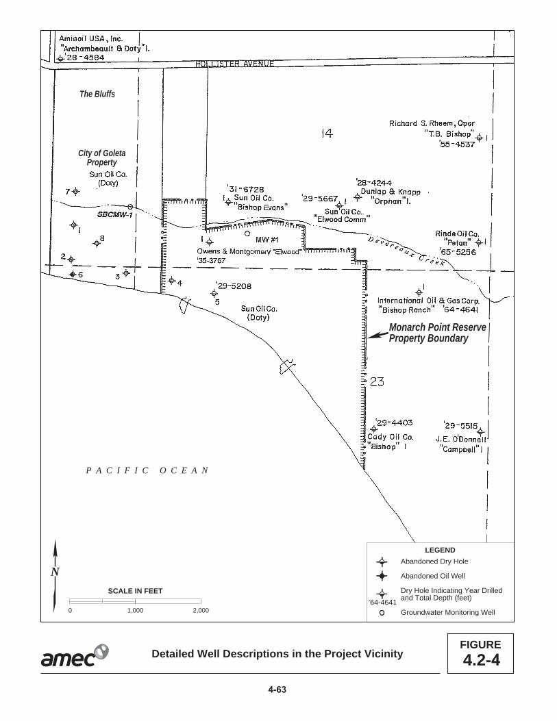
Monarch Point ReserveProperty Boundary
The Bluffs
City of GoletaProperty
P A C I F I C O C E A N
LEGEND
Abandoned Dry Hole
Abandoned Oil Well
Dry Hole Indicating Year Drilledand Total Depth (feet)
Groundwater Monitoring Well’64-4641
SCALE IN FEET
0 1,000 2,000
Detailed Well Descriptions in the Project VicinityFIGURE
N
4.2-

4.2 Safety
long, some wells have shoe plugs of only a few feet, and some have no shoe plug at all. 1 Like the shoe plugs, the surface plugs do not meet current standards and practices. 2 Some wells have no surface plugs; wells with surface plugs average only 30 feet in 3 length. Re-abandoning these wells could present significant problems, since many of 4 them had their inner/production strings cut and recovered, and the well casings were cut 5 off at or below the mud line, making it very difficult to locate the wells and re-entry to an 6 appropriate depth nearly impossible. 7
Summary 8
Pursuant to State CEQA Guidelines section 15144, while an agency cannot foresee the 9 unforeseeable, it must use its best efforts to find out and disclose all that it reasonably 10 can. As such, the CSLC staff is concerned that any build-up of pressure within the 11 Vaqueros Reservoir could potentially cause unintentional oil releases into the coastal 12 environment. The increased pressure in the reservoir could force a leak from historic 13 abandoned wells in offshore areas of the reservoir or possibly lead to additional release 14 of oil from a natural seep. Given current conditions – PRC 421 is shut-in and all other 15 wells that once tapped the reservoir have been abandoned – there is no active well 16 penetrating the reservoir into which pressure-testing equipment can be inserted. 17 Consequently, there is no existing mechanism to conduct pressure testing of the 18 reservoir to determine the extent of possible pressure build-up. The potential impacts of 19 repressurization cannot be adequately determined until the Commission has sufficient 20 data to evaluate. The pressure data that would be collected by the Project are integral 21 to assessing the future risks of pressurization of the formation and the determination of 22 any future risks and responses. Long-term risks and responses to repressurization will 23 be dealt with when the lease is quitclaimed or terminated. 24
Existing Facility Conditions 25
Existing facilities at PRC 421 have undergone structural improvements, repairs, and 26 removal of historic structures. The present conditions of these facilities, as they relate to 27 Project safety, are summarized in Table 4.2-1. 28
Hazards, conditions, or features that have the potential to be the source of a release, 29 fire, or explosion, are also noted. Figure 4.2-5 shows the piers in their existing condition, 30 and Figure 4.2-6 shows the conditions of the existing caisson walls of each pier. 31
Existing Facility Hazards 32
Sands within and possibly beneath both caissons at Piers 421-1 and 421-2 may contain 33 unknown quantities of residual oil and oil-containing materials, although no 34 contamination was discovered during repair work and associated excavation at 35 Pier 421-1 in 2004 or at Pier 421-2 in 2011. In their current condition, portions of either 36
Revised PRC 421 Recommissioning Project 4-64 November 2014 Final EIR

4.2 Safety
Table 4.2-1. Summary of Area Facility Conditions Facility Condition
Used by Project Pier 421-1 (Pier and Caisson)
In 2000, the pier was reinforced, the well casing and wellheads were repaired, and subsurface safety valves were installed. In 2004, a new seaward-facing wall was installed on the caisson. Venoco has developed and is implementing a monitoring plan to identify and respond to leaks from the PRC 421 piers. The pier is fenced and patrolled twice daily by private security.
Pier 421-2 (Pier and Caisson)
In 2000, the pier was reinforced and upgraded and new subsurface safety valves were installed. In 2011, a new seaward-facing caisson wall was built. Venoco has developed and implemented a monitoring plan to identify and respond to leaks. This facility may have similar source and quantity of contaminated material as that found in Pier 421-1. The pier is fenced and patrolled twice daily by private security.
6-inch Pipeline In 1994, 170 barrels of oil were released near the coastal bluffs. The line is currently out of service and is not suitable for modern “pigging” maintenance due to the presence of two 90 degree bends.
Access Road and Seawall
The access road was rebuilt and resurfaced during 2000 repair activity to permit use by heavy construction equipment. The seawall was expanded and reinforced by the addition of new riprap; however, there is a gap in the seawall between Piers 421-1 and 421-2 where a timber bulkhead provides the only protection for the access road. Security patrols along the access road are conducted by Venoco.
EOF The EOF includes multiple redundant monitoring and safety systems with a control room that is staffed 24 hours per day, 7 days per week. Existing safety systems include onsite fire fighting capabilities, and personnel trained to respond to fires and other emergencies. Substantial upgrades to the EOF have been implemented to comply with the 1999 Santa Barbara County APCD Abatement Order and conclusions of the 2000 quantitative risk assessment and Safety audit (Santa Barbara County 2006).
Line 96 Pipeline from the EOF to the PAAPLP Coastal Pipeline
The Line 96 pipeline began operation in 2012. Standard regulatory conditions for pipelines and MMs in certified Line 96 Modification Project EIR (Santa Barbara County 2011) include pressure testing, pigging, and other methods to ensure safe operation consistent with industry and regulatory standards.
Other Area Ellwood Oil Facilities EMT Not a part of Project. Operation was discontinued upon completion of the Line 96
pipeline in 2012; abandonment planning is underway. Old Line 96 that runs from the EOF to the EMT
The old Line 96 that runs from the EOF to the EMT ceased operation in 2012 and will be removed or abandoned in place now that the Line 96 pipeline from the EOF to the PAAPLP Coastal Pipeline is in operation.
Historic Abandoned Oil Wells
There are many offshore oil wells that were drilled into the Vaqueros Reservoir from historic piers that are no long present in the area (see Figure 4.13-1 depicting the historic piers); however, the old wells remain in place and abandoned by historic abandonment practices.
caisson have the potential to deteriorate and release oil and oil-related contaminants, 1 despite the repairs conducted in 2004 and 2011. 2
Hazards and hazardous conditions associated with Project implementation would 3 potentially affect both the EOF and the Line 96 pipeline extension because the quantity 4 of oil and gas processed at the EOF and the total crude oil throughput in the pipeline 5 would increase. The Project would not modify the existing oil and gas processing 6
November 2014 4-65 Revised PRC 421 Recommissioning Project Final EIR

Figure 4.2-2bPier 421-2 (shown under repair as of April 2011)
(Photo: Bruce Reitherman)
Figure 4.2-2aPier 421-1
Existing Conditions of the421 Piers
FIGURE4.2-
4-6

Figure 4.2-3bPier 421-2 Caisson Wall (facing ocean, shown under repair as of April 2011)
(Photo: John Storrer)
Figure 4.2-3aPier 421-1 Caisson Wall (facing ocean)
Existing Conditions of thePier 421 Caissons
FIGURE4.2-
4-6

4.2 Safety
systems at the EOF or increase the quantity of oil processed beyond the processing 1 limits for Platform Holly alone. Therefore, the Project would not generate significant 2 changes in the operation of the EOF. The Line 96 pipeline was evaluated in a certified 3 EIR, which contains proposed MMs that are required to be implemented as part of 4 project construction and operation. 5
A 1999 Abatement Order by the Santa Barbara County Air Pollution Control District 6 (APCD) required a series of audits, improvements, and other actions to address 7 releases of gas containing hydrogen sulfide (H2S) at Ellwood area facilities (Santa 8 Barbara County APCD 1999). Although the Abatement Order notes PRC 421 as being 9 included in the Ellwood facilities (i.e., EOF, EMT, and the old Line 96 pipeline from the 10 EOF to the EMT), there were no specific references to PRC 421 in the Abatement 11 Order; additionally, the oil produced at PRC 421 is light “sweet” crude oil, typically low in 12 H2S. The Abatement Order led to the preparation of a quantitative risk assessment 13 (QRA) of these facilities (Arthur D. Little [ADL] 2000). The conclusions of the QRA are 14 incorporated in this EIR both as background for issues affecting the Project and for use 15 in assessing the risk associated with certain Project alternatives (see Section 5.0 for the 16 alternatives analysis). 17
The Ellwood area oil production facilities have hazards and risks associated with them 18 related to the crude oil produced from Platform Holly, for which crude oil production 19 includes H2S or “sour gas.” Crude oil with little or no sulfur content is referred to as 20 “sweet” crude. Figure 4.2-7 is a simplified diagram presenting existing hazards and risks 21 associated with the Ellwood area oil production facilities that would be affected by the 22 Project. These are the baseline conditions against which Project effects are compared. 23
FIGURE 4.2-7. BASELINE HAZARDS/RISKS FROM ELLWOOD OIL PRODUCTION FACILITIES
Information about hazards and risks was obtained from CSLC (2009), ADL (2000), and 24 Santa Barbara County (2011). Project-related hazards and risks associated with 25 Ellwood facility components are summarized below (see the Line 96 Modification 26 Project EIR for a full discussion of hazards associated with Line 96). Existing hazards 27 associated with operation of Platform Holly are not addressed here as the Project would 28 not require use of those facilities. 29
Revised PRC 421 Recommissioning Project 4-68 November 2014 Final EIR

4.2 Safety
· EOF – The Project would require use of the EOF for separation and processing1 of oil, gas, and water, reinjection of water, control-room and security support, and2 electrical power (from the substation).3
· Line 96 Pipeline from the EOF to the PAAPLP Coastal Pipeline – The Line 964 Modification Project EIR projected a failure rate for the approved pipeline of a5 large spill once every 140 years, and a small spill once every 31 years. These6 rates would not be expected to change substantially with the addition of Project7 oil, and the Project’s use of the pipeline would occur during its first decades of8 operation, when risks of pipeline spills and accidents are at their lowest levels.9
Crude Oil Characteristics 10
Crude oil characteristics can vary significantly by origin and (after exposure to the 11 surface) weathering. At the wellhead, crude oil is typically a mixture of water, 12 hydrocarbons (liquid and gases), and solids. The crude oil produced from PRC 421 is 13 “sweet” crude, referring to its low sulfur content. Table 4.2-2 provides the crude oil 14 properties of oil produced from PRC 421 (Ellwood Field), compared to other crude oils 15 produced from the South Ellwood Field (Platform Holly). 16
Table 4.2-2. Crude Oil Characteristics, PRC 421 and the South Ellwood Field PRC 421 Hollya EOFa
API Gravity 35 22.4 22.4 Sulfur Content, percent by weight <0.6% 4.1% 4.1% H2S Concentration, (parts per million by weight (ppmw) <10a 200 65 a Venoco 2013.
The natural gas content of oil produced at PRC 421 is known to be low, and the gas that 17 is produced would have an H2S content of approximately 10 parts per million (ppm). 18 The low gas content of this oil was confirmed during previous production under 19 emergency permit by Venoco in 2001 when approximately 17,000 barrels of oil 20 produced from 421-2 contained no detectable amounts of gas (Venoco 2007). The 21 Emergency Response Planning Guidelines (ERPG), which are used to develop 22 thresholds for injuries and fatalities, identify 30 ppm of H2S as the level at which nearly 23 all individuals could be exposed for up to one hour without experiencing irreversible or 24 serious health effects (American Industrial Hygiene Association 2006). Therefore, the 25 crude oil produced by the Project would not be a source of acute toxic impacts to 26 human receptors, if released. This distinguishes the characteristics of oil produced from 27 PRC 421 from that currently produced at Platform Holly. 28
Crude oil released into the environment can pose a range of hazards, depending on the 29 specific properties of the crude oil, location, and condition under which it is released, 30 and the sensitivity and physical characteristics of the receiving environment and local 31
November 2014 4-69 Revised PRC 421 Recommissioning Project Final EIR

4.2 Safety
receptors. Crude oil can be toxic to biota, as well as cause physical harm or death to 1 animals following contact with oil. See Section 4.5, Hydrology, Water Quality, and Water 2 Resources, for discussion of effects of oil on water quality, and Section 4.6, Marine 3 Biological Resources, for more discussion about the effects of oil on biota. 4
Rapid response to a crude oil release is critical. Because crude oil contains a mixture of 5 constituents, as the lighter or more volatile fractions dissipate, the remaining material is 6 thicker and tends to be more persistent in the environment if it is not contained and 7 removed at the early stages of a response. Crude oil spilled in the marine environment 8 typically forms an emulsion that incorporates sand and debris as it weathers, which 9 causes it to sink after a period of time and is difficult to recover. This is especially true of 10 oil in the surf zone, which is a high-energy area. 11
Crude oil can ignite, which could result in a crude oil fire. As noted in the EMT Lease 12 Renewal EIR, the likelihood of an explosion related to a crude oil spill and fire related to 13 crude oil produced from Platform Holly is “virtually non-existent;” therefore, the EMT 14 analysis did not conduct further analysis on explosions (CSLC 2009; ADL 2000). 15 However, the Platform Holly crude oil is heavier than PRC 421 crude oil. The PRC 421 16 crude oil (35 API) has higher potential of explosion than Platform Holly crude oil due to 17 the presence of higher light ends. A more recent risk assessment was conducted for the 18 Keystone XL pipeline, which included a wide range of historical analyses of pipeline 19 accidents (U.S. Department of State 2013). That assessment concluded that explosions 20 from newer pipelines carrying single-phase crude oil (as Line 96 does) present an 21 extremely low risk of explosion or fire. 22
Environmental Hazards 23
The Project site is situated in a dynamic environment, with naturally occurring conditions 24 that may affect safety conditions. These are ocean/wind conditions, coastal processes, 25 seismicity, and subsurface pressure in the Ellwood Oil Field. See Section 4.1, Geologic 26 Resources, for a complete discussion of geologic processes that may impact Project 27 safety conditions; specifically erosion, seismicity, tsunamis, and subsurface pressure. 28
Prevailing winds in the coastal region are from the west/northwest during the day, with 29 an average speed of 7 to 12 miles per hour. Evening winds blow from the east, as the 30 air over the Pacific Ocean cools and creates a low pressure zone. Ocean conditions are 31 summarized below, and are described in more detail in the EMT Lease Renewal EIR 32 (CSLC 2009). These data are based on historic conditions in the Project area, and it is 33 uncertain to what degree, if any, these would evolve or change due to the effects of 34 global warming over the Project production horizon. 35
Although located in the relatively sheltered surf zone of the Santa Barbara Channel, the 36 Project site is subject to periodic high winter surf conditions (Table 4.2-3). Heavy winter 37
Revised PRC 421 Recommissioning Project 4-70 November 2014 Final EIR

4.2 Safety
Table 4.2-3. Ocean and Wind Conditions Weather Elements Annual Average Monthly Maximum
Wind > 33 Knots – Percent Frequency 1.3 2.2 Wave Height > 9 feet – Percent Frequency 6.4 10.6 Visibility < 2 nautical miles – Percent Frequency 6.3 8.7 Precipitation (inches) 16.8 5.8 Temperature > 69°F – Percent Frequency 1.7 4.2 Mean Temperature (°F) 58.8 62.8 Temperature < 33 °F – Percent Frequency 0 0.1 Mean Relative Humidity (percent) 82.0 86.0 Overcast or Obscured – Percent Frequency 31.4 50.6 Mean Cloud Cover (8ths) 4.5 5.4 Prevailing Wind Direction NW N/A Sources: USCG 2002; CSLC 2009.
storms can generate wave heights in excess of 10 feet leading to scouring of all or most 1 of the sand from beaches at the Project site and exposing primary Project facilities, 2 such as the caissons, piers, and seawall to battering from heavy surf. When combined 3 with winter high tides, which can reach the toe of the seawall, such high surf conditions 4 may pose a hazard to Project facilities. 5
Security, Prevention, and Response Capabilities for the Ellwood Facilities 6
Venoco has existing security, accident prevention, and response capabilities that 7 address the PRC 421 facilities. Preventive measures, plans, response equipment, and 8 the programs required to implement a response (e.g., health and safety training, drills 9 and exercises, and equipment inspection) contribute to Venoco’s ability to prevent or 10 respond to upset conditions. Most of these measures and programs are governed by 11 agency and industry requirements and standards (see Section 4.2.2, Regulatory 12 Setting), as well as corporate policies, to avoid or reduce harm to the public and the 13 environment. Although these safeguards provide a level of confidence in the safety of 14 operations, and an ability to respond to emergencies, they cannot reduce the potential 15 for accidents or harm to zero. Existing security, prevention, and response capabilities in 16 place that encompass PRC 421 facilities are listed in Table 4.2-4. 17
For releases of oil at the Ellwood facilities, Venoco has response equipment, vessels, 18 personnel, and/or supplies located at the EOF and onboard Platform Holly. As required 19 by various regulations, contingency plan implementation requires personnel training, 20 equipment testing and inspections, and scheduled and unscheduled drills and exercises 21 to maintain readiness. According to records provided of response drills and exercises 22 held for the Ellwood facilities since 1999, 10 drills were held, of which nine were for H2S 23
November 2014 4-71 Revised PRC 421 Recommissioning Project Final EIR

4.2 Safety
Table 4.2-4. Security, Prevention and Response Plans and Capabilities In Place for PRC 421 Facilities
Measure Purpose Controlled Access Each caisson has an 8-foot-high chain link fence that remains locked to
prohibit entry to the equipment on the piers. EOF staff provides security. Security Patrol A private security firm patrols the PRC 421 facility area twice daily. Emergency Action Plan (EAP)
Emergency plan for the South Ellwood facilities provides information and procedures for emergency shutdown, evaluation, and response to emergency conditions at the South Ellwood Field. The plan includes procedures for responding to and managing an oil spill emergency, and contains response checklists, roles and responsibilities of response personnel, inventories and locations of response equipment, supplies, and personnel (Venoco and contracted).
Spill Prevention Countermeasures and Control (SPCC) Plan
Description of systems (equipment, containment, related components) at PRC 421 used to prevent and manage releases of oil.
Fire Prevention and Preparedness Plan, South Ellwood Facilities
Fire prevention and response. This plan specifically addresses the EOF and EMT. PRC 421 facilities are not specifically addressed in this plan.
Mitigations from City of Goleta (2006) MND
Site-specific plans resulting from Pier 421-1 repair and subsequent monitoring for leakage which were completed in early 2007:
· Emergency Response Plan· Prevention and Control Plan· Removal Action Plan
releases or H2S-related drills at the EOF, and one was an unannounced oil spill drill at 1 the EMT, initiated by OSPR. None of the drills specifically addressed PRC 421; 2 however, a response to an event at the PRC 421 facilities would be similar to the 3 response to an event at the EOF facilities or formerly conducted at the EMT (with the 4 exception being the low likelihood for H2S drills due to the low H2S content of PRC 421 5 oil). According to the records provided, some included written evaluations by Santa 6 Barbara County, providing specific recommendations (Venoco 1999-2004). 7
The EAP includes descriptive information of and response procedures for PRC 421 8 (referred to as the “Beachfront Lease”), lists the historical components, and notes that 9 they will be replaced. Similarly, the Spill Prevention Countermeasures and Control 10 (SPCC) Plan would need to be updated as it lists a potential release volume of 900 11 barrels; however, the source of the volume noted was the crude oil storage tank on Pier 12 421-1, which has been removed. On-water containment procedures in the EAP include 13 booming strategies for a release from the piers. 14
The EOF has engineered fire protection systems and procedures (contained in the Fire 15 Prevention and Preparedness Plan) to prevent, detect, and manage a fire. According to 16 the Fire Prevention and Preparedness Plan, Venoco personnel are trained and 17
Revised PRC 421 Recommissioning Project 4-72 November 2014 Final EIR
4.2 Safety
equipped to initiate a response to a fire at the incipient stage3 and to control the site in 1 preparation for the arrival of the SBCFD. In its existing form, the Fire Prevention and 2 Preparedness Plan does not specifically provide procedures or other information for the 3 PRC 421 facilities (Venoco 2003). 4
The Line 96 pipeline includes a number of measures related to response planning and 5 capabilities to address an oil spill. These measures are intended primarily to ensure 6 timely shut down of oil flows through the pipeline should a rupture occur and require 7 capabilities for active response to potential oil spills, particularly those that threaten 8 environmentally sensitive areas (e.g., creeks, shoreline). The specific measures have 9 been set forth in a revised Safety Inspection, Maintenance and Quality Assurance Plan 10 (SIMQAP), Oil Spill Contingency Plan (OSCP), and EAP which were completed and 11 approved prior to commencing operation of the new pipeline in 2012. 12
4.2.2 Regulatory Setting 13
The primary Federal and State laws, regulations, and policies that address security of 14 oil and gas production and transport facilities, emergency response/contingency 15 planning, design and construction standards, operational standards, and spill prevention 16 and cleanup that pertain to the Project, are summarized in Table 4.0-1, while local laws, 17 regulations, and policies are summarized below. 18
Local 19
System Safety and Reliability Review Committee (SSRRC) and Safety Inspection, 20 Maintenance and Quality Assurance Plan (SIMQAP) 21
The Santa Barbara County Board of Supervisors originally established the SSRRC—a 22 committee of County departments plus the Santa Barbara County APCD—in 1985 to 23 identify and require correction of possible design and operational hazards for oil and 24 gas projects prior to construction and startup of the project and for project modifications. 25 The SSRRC has authority to review the technical design of facilities, as well as to 26 review and approve the SIMQAP. The purpose and scope of the SIMQAP is to identify 27 procedures that will be used during the operation of a facility and to insure that all 28 equipment will function as designed. The SIMQAP identifies items to be inspected, 29 maintained or tested, defines the procedure for such inspection, maintenance, or 30 testing, and establishes the frequency of inspection, maintenance or testing. SIMQAP 31 audits are conducted annually at the EOF. The City of Goleta contracts with the County 32 Energy Division for energy related planning services, which includes SSRRC project 33
3 As defined by the Occupational Safety and Health Administration (OSHA) (29 Code of Federal Regulations [CFR] 1910.155[c][26]), an incipient stage fire is in its initial or beginning stage, and can be controlled or extinguished by portable fire extinguishers, class II standpipe or small hose systems without the need for protective clothing or breathing apparatus.
November 2014 4-73 Revised PRC 421 Recommissioning Project Final EIR

4.2 Safety
review; however, the County Energy Division is not currently providing energy planning 1 services for the PRC 421 Project. 2
City of Goleta Safety Element 3
The objective of the City’s Safety Element is to minimize risk associated with the 4 operation of Venoco’s Ellwood area facilities and other oil and gas operations. As part of 5 this objective and its adopted policies, the city has defined unacceptable risk as 6 involving new development as well as modifications to existing development if those 7 modifications increase risk. Several city policies address how to minimize or avoid risk 8 from H2S and pipeline operations and set forth the requirements for preparation of QRA. 9 Pipeline policies address construction, location, operation, and safety, as well as the 10 location of sensitive receptors near pipelines. 11
Santa Barbara County Public Safety Thresholds and Safety Element 12
The county has established thresholds for classifying the significance of public safety 13 impacts, particularly public exposure to acute risks from activities with significant 14 amounts of hazardous materials. The county defines acute risk as being the “chance of 15 fatality or serious injury due to a single, short-term, involuntary exposure to the release 16 of hazardous gas, liquid, or solid, or to a fire or explosion.” The thresholds are designed 17 for use in EIRs as significance criteria. The county’s Safety Element automatically 18 requires some types of facilities, such as sour gas pipelines and processing facilities, to 19 perform a QRA to calculate risk and apply the criteria. These criteria were applied for 20 analyses related to the EOF which handles sour natural gas oil that contains higher 21 concentrations of H2S, which is an acutely hazardous material. Findings from the QRA 22 that was performed for the EOF are discussed where appropriate below (see also 23 Section 4.4, Air Quality and Greenhouse Gases). 24
4.2.3 Significance Criteria 25
A safety impact is considered significant if any of the following apply: 26
· There is a potential for fire, explosion, releases of flammable/toxic materials27 and/or oil, or other accidents resulting from Project operations that could cause28 injury or death to members of the public;29
· Operations would increase the probability or volume of oil spills into the30 environment, and existing or proposed emergency response capabilities are not31 adequate to effectively mitigate Project spills and other accidents; or32
· Project operations are not consistent with Federal, State or local regulations.33 Conformance with regulations does not necessarily mean that there are no34 significant impacts.35
Revised PRC 421 Recommissioning Project 4-74 November 2014 Final EIR
4.2 Safety
4.2.4 Impact Analysis and Mitigation 1
This section evaluates Project construction and operational activities to identify potential 2 impacts and their severity with respect to the stated significance criteria. Activities and 3 conditions that, under upset conditions, could lead to a release of oil or hazardous 4 materials, fire, or explosion were identified based on a review of available materials, site 5 visits, independent engineering and structural analyses, and professional judgment. 6 Impacts were compared against baseline conditions and the significance criteria 7 established in the State CEQA Guidelines and the EMT Lease Renewal EIR (CSLC 8 2009) to determine the severity of the impact. Where relevant, a quantitative estimate of 9 frequency or probability is used. Where applicable, MMs have been developed to avoid 10 or reduce impacts. Baseline conditions for Ellwood area oil facilities were derived from 11 the EMT Lease Renewal EIR and other available reports, which were defined earlier in 12 this section. 13
Construction and operational impacts related to a release of hazardous materials are 14 also discussed in Section 4.3, Hazardous Materials. Best management practices 15 (BMPs) include monitors to direct public access during construction, installation of 16 temporary fencing as needed, removal of equipment or other hazards from the beach 17 and other publicly accessible areas at the end of each day of construction, posting of 18 warning signs, measures to prevent release of fuel during refueling, etc. (see Appendix 19 F). The Line 96 Modification Project EIR proposed mitigations that are incorporated by 20 reference into this document (Appendix H) that reduce the potential for crude oil 21 releases, and therefore the opportunity for crude oil fires. 22
Table 4.2-5, located at the end of Section 4.2.4, provides a summary of safety-related 23 impacts and recommended MMs to address these impacts. 24
Impact S-1: Release of Oil During Cleanup of 6-inch Pipeline 25 Residual oil could be encountered and released during clean-up of the 6-inch 26 pipeline (Less than Significant). 27
Impact Discussion 28
Prior to installation of the internal liner and 3-inch flowline within the 6-inch line that 29 connects Pier 421-2 to the tie-in at the EOF, a release of oil could occur. The 6-inch line 30 was the source of the 1994 leak; therefore, residual oil could be encountered within or 31 surrounding the pipeline during construction. If residual oil is encountered, it could be 32 controlled and removed to prevent further contamination or migration. BMPs would 33 include safety procedures for use of equipment in the presence of hydrocarbons, which 34 would reduce the potential for ignition if vapors are present (see Appendix F). As noted 35 previously, access to the construction area would be controlled to maintain safety and 36
November 2014 4-75 Revised PRC 421 Recommissioning Project Final EIR

4.2 Safety
prevent public contact with construction-generated materials or equipment. Therefore, 1 this impact would be adverse but less than significant. 2
Mitigation Measures 3
None required. 4
Rationale for Mitigation 5
Although no mitigation is required, BMPs, as discussed above, which establish Project 6 construction equipment operation and maintenance procedures, are designed to 7 prevent releases, and would also be protective of the public during the construction 8 process to avoid potential contact with hazardous materials and the introduction of 9 ignition sources. Such measures would include removal of equipment and construction 10 materials from the beach at night, use of tape or orange plastic construction fencing 11 around construction areas and the presence of monitors to direct the public around 12 construction activity (see Appendix F). 13
Impact S-2: Exposure of the Public and Environment to Safety Hazards Due to 14 Collapse of the Pier 421-1 or 421-2 Caisson 15 The Project would prolong the use of the aging caisson on Pier 421-2, which 16 could collapse and lead to the release of hazardous materials and oil from within 17 the caisson or from Project-related pipelines (Less than Significant with 18 Mitigation). 19
Impact Discussion 20
The caisson at Pier 421-1 would remain in place for an estimated 1 year after 21 resumption of production at Pier 421-2. Although the seaward-facing wall of the caisson 22 at Pier 421-1 was repaired in 2004, some potential exists for collapse of this structure 23 during its limited remaining life. Although no active oil production facilities would be 24 located on Pier 421-1, a collapse could release contaminated materials (e.g., sand, 25 concrete) into the surf zone as discussed below for Pier 421-2. Abandonment and 26 decommissioning of Pier 421-1 would eliminate this potential hazard. 27
The proposed well design and layout at Pier 421-2 is shown in Figure 4.2-8. Critical 28 features include the ESP, which would be at a depth of about 2,960 feet below sea 29 level, the subsurface safety valve (SSSV) located above the ESP, the well cellar within 30 the caisson, the wellhead and casing, the surface safety valve (SSV), and the oil 31 discharge line with High and Low pressure sensing switches. This system would pump 32 crude oil emulsion to the surface and deliver it directly to the EOF for processing. Safety 33 features included in this system are the pressure sensing switches for the oil discharge 34 line and the safety valves (SSSV and SSV), which require power to remain open. In the 35
Revised PRC 421 Recommissioning Project 4-76 November 2014 Final EIR

ELECTRICALSUBMERSIBLE PUMPBEACH OCEAN
WELLCELLAR
421-2 WELLHEAD
EXISTINGPIER
HANDRAIL HANDRAIL
EXISTING CAISSONS
EXISTING CAISSONCONTAINMENT WALL
ELEVATION 15' 2 1/2"
ELEVATION 3' 8"
ELEVATION 0' 0"
WELL CELLAR
SEA LEVEL
TOP OF DECK
3" OIL/WATER/GAS
CONDUCTORPOWER AND CONTROL CONDUIT
ELEVATION (-)2960
3 1/8"3000# API
1" CASING DRAIN(DRAINS TO WELL CELLAR)
BEGIN 6"ø HDPE PIPELINE
CONTAINM
ENT CASING
EXISTINGNEW
3000# API3000# ANSI
FIGURE4.2-Cross-Section of Proposed Layout for Pier 421-2
0 7 14
SCALE IN FEET
4-7

4.2 Safety
event that the pressure sensing switches report high or low pressure, or any alarm 1 forces a shutdown of the well, the safety valves will automatically close, which prevents 2 oil from being conveyed to the surface; the safety valves would also shut if there were a 3 loss of power. The well cellar within the caisson has a volume of approximately 213 4 barrels (8,946 gallons). It is believed to have sand and other materials packed around it, 5 but its actual condition and construction are unknown. The well cellar houses the 6 wellhead and casing and, in the event of leakage, would serve as containment within 7 the caisson, with some improvements likely required to permit these facilities to provide 8 complete containment (see MM S-4b below). The wall surrounding the caisson deck is 9 higher than the deck itself and would in its present state impede oil movement, but is 10 not specifically designed as secondary containment. 11
The wellhead was repaired in 2000-2001. Venoco proposes to equip the wellhead with 12 current safety equipment to adhere to design criteria specified in American Petroleum 13 Institute (API) Recommended Practice (RP) 14C, Safety Analysis Function Evaluation 14 (SAFE) of Offshore Petroleum Production Systems, and incorporated in 30 CFR 15 250.168. 16
AMEC engineers conducted an engineering review of the facilities to evaluate the 17 appropriateness and adequacy of the Project with respect to safe operations for the 18 Project duration. The conclusions of that review are: 19
· The Project design uses proven technologies and is consistent with industry20 standards.21
· Installation of an ESP is advantageous because it protects the equipment from22 external forces (wave action) and avoids creating a noise source on the surface.23
· The 3-inch flowline would be equipped with high- and low-pressure switches for24 leak detection which would be important if the 6-inch line casing were25 compromised.26
As discussed above, a preliminary review of the structural integrity of Project caissons 27 and the seawall was conducted by a licensed structural engineer to determine the 28 current structural stability of key Project facilities and to analyze the potential for the 29 facilities to endure two decades of operation (Thomas and Beers 2000). This review 30 was conducted prior to the emergency repairs on Pier 421-2, so improvements to the 31 seaward-facing caisson in 2011 were not taken into account. The review of the 32 structural integrity of Project facilities consisted of: 33
· A visual inspection of all facilities by a licensed structural engineer;34
· A review and analysis of structural diagrams of Project facilities from the 200635 Negative Declaration (ND) and other engineering diagrams and relevant36 documents which address design standards and construction issues for marine37 structures such as seawalls;38
Revised PRC 421 Recommissioning Project 4-78 November 2014 Final EIR

4.2 Safety
· Communication and information exchanges with CSLC engineering staff 1 regarding improvements at the Pier 421-1 and 421-2 caissons; and2
· A review of a previous structural engineering report on the Project piers and3 caissons (Thomas and Beers 2000).4
No as-built plans were provided by Venoco for the seawall and older portions of the 5 caissons and no load calculations are available for the new walls; therefore, the stability 6 of the piers, caissons, and seawall at that 7 time is impossible to fully ascertain. The lack 8 of as-built plans was also referenced in the 9 Thomas and Beers (2000) structural 10 engineering report. 11
Although the structural stability of the 12 caissons was a concern at the time of the 13 engineering report, improvements have 14 since been made and additional 15 improvements will be made as part of the 16 Project. The seaward facing walls, as well as 17 portions of the east and west facing walls, of 18 both caissons have undergone major repairs 19 in 2004 and 2011, and the integrity of these 20 structures has been substantially improved. Additionally, the Project includes repairs to 21 the north wall of the Pier 421-2 caisson, as well as the remaining un-repaired portions of 22 the east and west walls. 23
The aging caisson on Pier 421-2 has been subject to more than 75 years of weathering 24 and corrosion associated with exposure to the surf zone of a marine environment. 25 Visual inspections of these facilities have revealed no major stress lines or cracks, but 26 the sides and rear of the caisson showed signs of wear and stress that would be 27 anticipated under such circumstances. This includes a number of smaller cracks and 28 irregularities, one of which appeared to very slowly seep oily or sulfurous fluid. In 29 addition, no as-built plans for this aging facility are available to assist in determining 30 probable structural stability for the life of Project operation. Further, review of the design 31 previously proposed for Pier 421-2 indicates that earthquake loading appears to not 32 have been considered in the design of this structure. Finally, as noted in the structural 33 engineering report, the seaward-facing walls of the two caissons at PRC 421 have 34 suffered a total of three substantial collapses in the last 25 years (Thomas and Beers 35 2000; CSLC 2010). 36
Although the caisson on Pier 421-2 has degraded, the seaward-facing wall of the 37 structure, as well of portions of the east- and west-facing walls, have been substantially 38 reinforced through repairs conducted in 2011. The Project includes repair of the walls 39
Installation of new caisson walls in 2011 substantially improved the structural integrity of the seaward-facing side of Pier 421-2.
November 2014 4-79 Revised PRC 421 Recommissioning Project Final EIR

4.2 Safety
that were not repaired in 2011. However, the Project description provided by Venoco 1 (Appendix G) does not currently include information about how the design of these 2 repairs accounts for design wave loading conditions including hydrodynamic loading, 3 overturning, and base shear, as well as the maximum credible earthquake according to 4 the current CBC. An engineering analysis of the Project design has not been conducted; 5 however, the analysis conducted for the previous Draft EIR (CSLC 2005) remains 6 generally applicable to the Project and would be supplemented through the 7 implementation of MM S-2a. 8
The extent and quality of repairs made following the caisson’s collapse in the 1980s are 9 not clearly documented as no engineering plans for these repairs are available. Under 10 these circumstances, based on the lack of definitive engineering information, the partial 11 collapse of the aging caisson on Pier 421-1 could occur during its remaining 1 year of 12 existence. Further, Pier 421-2 could also collapse during the life of Project operation, 13 particularly associated with sustained high winter surf, seismic activity, or in a low-14 probability large wave event. The risk of collapse would also be increased incrementally 15 over the project life by sea level rise associated with global climate change. Such a 16 collapse could result in release of unknown quantities of sand contaminated with 17 hydrocarbons into the marine environment from either Pier 421-1 or 421-2, as well as 18 small quantities of oil associated with production at Pier 421-2. This impact would be 19 considered less than significant with mitigation. 20
Mitigation Measures 21
MM S-2a. Design Review/Wave Loading Evaluation. Prior to implementing 22 caisson repairs at Pier 421-2, Venoco shall develop design improvement plans 23 that account for design wave loading conditions including hydrodynamic 24 loading, overturning, and base shear, as well as the maximum credible 25 earthquake according to the current California Building Code; these 26 improvements shall be sufficient to support Project facilities through the 27 production life. The revised design plans shall be reviewed and certified by a 28 professional civil/structural engineer and shall be submitted to the California 29 State Lands Commission staff for approval. Caisson repair shall be performed 30 in accordance with approved design plans prior to recommencement of 31 production at Pier 421-2. 32
MM S-2b. Post Storm Inspection, Monitoring and Cleanup. Venoco shall amend 33 the existing monitoring program to include regular monitoring and inspection of 34 both caissons during the winter storm season. Damage to caissons shall be 35 reported to California State Lands Commission staff and cleanup and removal 36 of any debris immediately initiated (see also MM S-4e). 37
Rationale for Mitigation 38
The existing repaired seaward-facing walls on the caissons of Piers 421-1 and 421-2 39 have improved the integrity of these structures and appear adequate to protect the 40
Revised PRC 421 Recommissioning Project 4-80 November 2014 Final EIR
4.2 Safety
seaward-facing side of these structures from severe winter storm damage; however, 1 data are unavailable to demonstrate the ability of the structures to withstand damage 2 from low-probability, high-magnitude events, such as the maximum probable design 3 waves and earthquakes. For Pier 421-2, MM S-2a would require provision of such data 4 as well as review and approval of the planned reinforcement of the non-seaward-facing 5 walls of this caisson, which have not been subject to any recent improvement. These 6 improvements include construction of walls similar to those built for the seaward-facing 7 walls of the caissons for all non-seaward-facing walls of the caissons to address the 8 potential for failure of these non-seaward-facing walls from both high-magnitude, low-9 frequency events (i.e., design wave events and earthquakes) and from more typical 10 severe winter storms. MM S-2b would improve existing monitoring protocols to ensure 11 regular winter storm season monitoring and response. Full implementation of these 12 measures would reduce Impact S-2 to less than significant. 13
Impact S-3: Exposure of the Public and Environment to Safety Hazards Due to 14 Collapse of or Damage to the Existing Timber Bulkhead or Rip-Rap Seawall 15 The Project would prolong the use of the existing causeway and supporting, 16 aging timber bulkhead and rip-rap seawall, which would be exposed to high 17 winter surf and large wave events over the Project’s life, leading to possible 18 erosion or collapse and the potential for release of hazardous materials and oil 19 from within the causeway or Project-related pipelines (Less than Significant with 20 Mitigation). 21
Impact Discussion 22
The stability of the existing seawall is difficult to assess because as-built plans are also 23 not available for this structure. In addition, based on previous environmental review of 24 past seawall improvements, it is unknown if seawall construction followed standard 25 Santa Barbara County construction practices for such structures (e.g., if the seawall 26 was keyed into bedrock underlying the beach sand to prevent undercutting) (Santa 27 Barbara County 2001). 28
This seawall is faced with generally large 1- to 3-ton boulders consistent with standard 29 seawall construction practices in Santa Barbara County. The use of large 1- to 3-ton 30 boulders should provide adequate protection and prevent remobilization of these rocks 31 during larger storm events; however, several gaps exist in the rip-rap portions of this 32 seawall, and minor areas have been repaired with smaller sized rock that could become 33 remobilized during high surf events. 34
This segment of the wall is partially shielded from some wave action by the caissons 35 and pilings at Piers 421-1 and 421-2; however, some level of existing protection would 36 be lost through the removal of Pier 421-1. For example, an unquantifiable large storm 37 event and associated major wave action could result in total failure of the wall. This is 38
November 2014 4-81 Revised PRC 421 Recommissioning Project Final EIR

4.2 Safety
The existing aging timber bulkhead seawall has been reinforced through much of its length with a rip-rap boulder revetment, although some gaps in this protection exist.
The Project’s existing timber and rock seawall appears generally intact along most of its reach, although the eastern end (outside of critical pipeline areas) has suffered some wave damage.
evidenced by the fact that major unmaintained portions of this historic seawall have 1 suffered collapse and substantial damage over the last decade along other portions of 2 the Ellwood Coast (AMEC 2006). Frequency and intensity of strong wave impact on this 3 bulkhead and seawall could be increased by sea level rise related to climate change; 4 however, the Project’s production life would minimize such effects. Collapse of this 5 segment of the seawall in a high-surf or low-probability, large-wave event could 6 undermine the Project access road and expose the proposed oil, produced water and 7 gas pipeline and power cables to wave action, creating impacts related to the accidental 8 release of oil into the marine and terrestrial environment that would be less than 9 significant with mitigation. 10
Further, visual observations of the seawall at the east end of the Project site, between 11 Piers 421-1 and 421-2, reveal that in this area, the seawall consists of the original 12 timber bulkhead, which has not been reinforced with rip-rap and thus should be 13 considered as marginally stable. 14
Mitigation Measures 15
MM S-3. Design Review by Civil/Structural Engineer. Prior to construction on the 16 Project and subject to receipt of all necessary approvals and permits to 17 undertake the work, Venoco shall complete the following: 18 · Venoco shall retain a licensed civil/structural engineer to review seawall19
design and recommend improvements to the Project seawall to permit it to20 support Project access road, pipelines, and power cables through the21 production life.22
· These potential design improvements, including a maintenance and repair23 plan to ensure fitness for purpose, shall account for anticipated winter surf24 conditions and for a design wave event.25
Revised PRC 421 Recommissioning Project 4-82 November 2014 Final EIR

4.2 Safety
· West of Pier 421-1, improvements to the seawall may include use of1 additional appropriately sized (i.e., 1- to 3-ton boulders) rip-rap if needed to2 fill in small gaps in the wall.3
Between Piers 421-1 and 421-2 and east of 421-2, to the maximum extent feasible, any 4 needed seawall improvements shall consist of minor repairs to and strengthening of the 5 existing timber bulkhead, unless seawall design review indicates that such 6 improvements would be insufficient to protect the pipeline and power cables over the life 7 of the Project. 8
Rationale for Mitigation 9
The existing seawall appears adequate to protect Project facilities over most of its 10 length. However, portions of the seawall may require repair and upgrade to ensure that 11 damage to pipelines and other facilities does not occur during winter surf or a design 12 wave event. However, consistent with the intent of City of Goleta policies to minimize 13 new coastal protection structures, MM S-3 would permit only focused repair of minor 14 gaps in the Project seawall, but not the extension of rip-rap into new areas solely 15 protected by the aging timber bulkhead. These areas would be subject to limited repair 16 and strengthening of the aging bulkhead as needed, through repairs to the existing 17 timber bulkhead. The relatively intact condition of this portion of the timber bulkhead and 18 the fact that it is partially shielded from direct wave action by Pier 421-2, seem to 19 support lesser improvements to this segment. This would be confirmed as part of design 20 review. Repair of the timber seawall would also provide protection for the proposed 21 extension of the 6-inch line from Pier 421-2 to the EOF in the event of partial collapse of 22 this timber bulkhead. If design review determines that additional rip-rap is necessary to 23 protect aging timber bulkhead between Piers 421-1 and 421-2, such improvements 24 would be subject to appropriate permits from the City of Goleta. 25
Full implementation of these measures would reduce Impact S-3 to less than significant. 26
Impact S-4: Potential for Release of Oil or Hazardous Materials from Pier 421-2 27 Project operations could result in the release of oil or hazardous materials from 28 Project facilities, including the 421-2 well and caisson, drilling and separation 29 equipment (Significant and Unavoidable). 30
Impact Discussion 31
Because of Well 421-2’s shoreline location, a release of oil during production into the 32 marine environment or nearby sensitive habitats is a significant concern. The potential 33 for oil to be released and enter the marine environment is a function of the potential 34 frequency of a release over the life of the Project, and the ability of the released volume 35 to exceed or otherwise breach the containment within the pier and caisson. 36
November 2014 4-83 Revised PRC 421 Recommissioning Project Final EIR

4.2 Safety
Spill frequency can be estimated for operations for which there are data to support 1 calculations. Oil spill occurrence rates for offshore oil spills from production platforms 2 are based on years of data collected for activities on the OCS (Anderson and LaBelle 3 2000). However, unlike the well-established statistics for OCS platform and pipeline 4 operations and tank vessel transit operations, past and proposed PRC 421 operations 5 are somewhat anomalous. A spill frequency estimate was not calculated due to: (1) low 6 PRC 421 throughput relative to spill volume data collected for OCS spill occurrence 7 rates,4 and (2) applicability of the OCS data to PRC 421 operations. For this analysis, 8 the release of a worst-case discharge was assumed, regardless of likelihood. A 9 reasonable worst-case discharge of oil from Pier 421-2 would involve an uncontrolled 10 release of oil as follows: 11
· Shutdown of the ESP delayed 5 minutes, assuming a maximum flow rate of12 approximately 0.35 barrel per minute between the wellhead and the separation13 vessel (1.7 barrels);5 or14
· Wellhead drilling and production and well workovers could lead to a failure along15 the casing leading to a blowout, which, if it occurred below the caisson on Pier16 421-2, could release oil into sub-surface areas and eventually the ocean. As17 discussed below, the amount of oil released from such a spill would be roughly18 equivalent to that from a delayed shut down of the ESP (1.7 barrels).19
Based on these assumptions, the maximum spill volume, which is the maximum amount 20 that could spill during peak instantaneous production of 500 barrels of oil per day 21 (BOPD), is estimated to be 1.7 barrels; the potential spill volume based on average 22 production of 150 BOPD would be 0.5 barrels. See Impact S-5 below for the maximum 23 spill volume for the 3-inch flowline. The containment capacity of the well cellar within the 24 caisson is 213 barrels. Because the caisson deck wall is not specifically designed to act 25 as containment, no containment capacity is assumed for the caisson deck. However, 26 the well casing has adequate capacity to contain the entire volume of oil that could be 27 released; no oil is expected to be released to the shore or marine waters. 28
Production at PRC 421 would use a submersible pump. The risk of a blowout would be 29 minimized due to the relatively low pressures of this system (978 pounds per square 30 inch gauge [psig]) when compared to the ability of the safety systems at PRC 421 to 31 control the pressure and the rating of 3,000 psig for the well casing. However, the wells 32 could produce releases at the wellhead due to failures associated with the piping, 33 fittings, or safety valves. A release could also be produced during a workover in the 34 event that operations encounter a gas pocket or pressurized zone during drilling. In 35 addition, sub-surface damage to the well casing and liner could result in accidental 36
4 Spill occurrence rates are a function of historic volumes of oil handled (the “exposure variable”), and address only spills of 1,000 barrels or more.
5 Derived from flow curves provided by Venoco of estimated maximum instantaneous production of 500 BOPD (2013).
Revised PRC 421 Recommissioning Project 4-84 November 2014 Final EIR

4.2 Safety
release of oil. Such damage, while very unlikely, could occur from several sources such 1 as corrosion, aging of the casing, and seismic damage. If such a failure occurred near 2 the surface, and the pump continued to run for five minutes prior to shutdown, a 3 relatively small quantity of oil contained in the casing (estimated 1.7 barrels) could reach 4 the surface. In addition, the slight potential exists under these circumstances that 5 artesian pressure present in Well 421-2 could force the rotors in the ESP to spin, slowly 6 releasing oil into the casing and environment, until repairs were affected. However, only 7 a small proportion of blowouts release significant volumes of oil, and as discussed 8 above, minimal gas production is anticipated to be associated with this Project. 9
Well workovers are also a possible source of blowouts. The Hydrocarbon Leak and 10 Ignition Database (1992) estimates well workovers are performed every 7 years. As 11 such, the potential exists for the Project to require two or more workovers during its 12 productive life. Blowouts have the potential to occur in sub-surface areas hundreds to 13 thousands of feet below the caisson deck. These blowouts would not be contained by 14 the well cellar or caisson deck and would therefore be released directly to the sub-15 surface areas and potentially into the ocean. Blowouts that occur at the wellhead or the 16 caisson deck could be contained by the well cellar and caisson deck; however, larger 17 blowouts could directly affect the ocean. There have been four blowouts from Pacific 18 OCS oil/gas projects since 1992; two of which occurred in the years 2000 and 2004 19 from Platform Gail, which is currently operated by Venoco. Neither resulted in release of 20 significant volumes of oil into the ocean; however, both were due, at least in part, to 21 human error (D. Dusette, Santa Barbara County, pers. comm. 2007). 22
Over the Project life, oil produced from extracted products would range from 85 to 11 23 percent by volume, as the fraction of produced water increases over time. Therefore, 24 the oil portion of the product available for release from Pier 421-2 would decline over 25 the Project life. This analysis uses the maximum volume of oil. 26
The location of the well at the water line and surf zone affects the possible movement 27 and dispersion of any released oil; under most conditions a release would reach shore. 28 Because of the location of the facility at the water line, and the low estimated release 29 volumes, spill simulations were not conducted. Instead, for the purposes of evaluating 30 the potential impacts of released oil from the Project and considering the site’s exposure 31 to winter storm conditions, based on predominant ocean currents (see Sections 4.5, 32 Hydrology, Water Resources, and Water Quality and 4.6, Marine Biological Resources), 33 oil released to marine waters is assumed to be transported approximately 1 mile 34 northwest of the site and 2 miles to the southeast, as shown in Figure 4.2-9. 35
Although there are sensitive locations throughout the Project area, two down coast 36 sensitive sites identified in the ACP would be immediately vulnerable if an oil spill 37 occurred at PRC 421: Bell Canyon Creek (Site 4-640-A) and Devereux Slough estuaries 38
November 2014 4-85 Revised PRC 421 Recommissioning Project Final EIR

DevereuxSlough
PIER 421-1PIER 421-1
PIER 421-2PIER 421-2
ELLWOODONSHOREFACILITY
DevereuxSlough
ELLWOODONSHOREFACILITY
PIER 421-1
PIER 421-2
HOLLLISTER AAVVENNUE HOLLISTER AVENUE
101
TecoloteTecoloteCreek EstuaryCreek Estuary
Devereux SloughDevereux SloughMarshMarsh
Bell CanyonBell CanyonCreek EstuaryCreek Estuary
TecoloteCreek Estuary
Devereux SloughMarsh
Bell CanyonCreek Estuary
PO
TE
NT
IA
L
AF
FE
CT
ED
A
RE
A
ONE MILE
TWO MILES
FIGURE4.2-
Estimated Oil Spill Coverage inProject Area
0 1,650
SCALE IN FEET
N
Note: Oil spill simulations not conducted.
4-8
4.2 Safety
(Site 4-645-A). Excerpts of the ACP entries for these sites are included in Figures 1 4.2-10 and 4.2-11. In addition, rocky intertidal habitat and kelp beds exist within 0.5 mile 2 east of the site and an additional estuary associated with Tecolote Creek exists 0.25 3 mile west of the site. 4
Although predominant currents would generally prevent oil from drifting westward from 5 PRC 421 more than 1 mile, in the event an oil slick drifted farther westward three other 6 sensitive sites identified in the ACP: Naples, Eagle Canyon Creek, and Tecolote Creek, 7 could also experience adverse impacts. Although they are not included in the 2011 ACP 8 as they were designated in 2012, Naples MPA and Campus Point MPA would also be 9 vulnerable to adverse impacts in the event oil reached these sensitive habitats. 10
Venoco maintains a response capability at Ellwood based on discharges estimated for 11 the South Ellwood Field. The worst-case discharge planning volume for this field is 3,000 12 30,811 barrels, and Venoco has response resources capable of handling a 3,000-30,811 13 barrel shoreline clean-up (Venoco 20052014). On-water containment and recovery would 14 be conducted by Clean Seas, an oil spill response organization, and o. Clean Seas has 15 demonstrated its ability to meet the OSPR daily recovery capability standards for the 16 Santa Barbara Channel of 19,531 barrels per day within 12 hours, 35,156 barrels per 17 day within 36 hours, and 66,406 barrels per day within 60 hours. Onshore oil spill 18 response and clean-up would be conducted by Advanced Cleanup Technologies Inc. 19 (ACTI) NRC Environmental Services, a contractor. Both Clean Seas and ACTI NRC 20 Environmental Services maintain equipment lists and certifications as required by State 21 and Federal regulations (Venoco 20052014). The oil spill contingency plan is 22 implemented, in part, by conducting drills to test and improve the response capabilities 23 over time. 24
Oil dispersants are one potential method to respond to in-water oil spills. Depending on 25 the size, location, weather conditions, and type of oil spilled, differing combinations of 26 droplet size, concentration, and rate of application are administered. Once dispersants 27 are applied, dispersed oil laterally spreads while dropping down the water column 28 between 3 and 30 feet. As a result, dispersant use is limited to waters deeper than 30 29 feet to avoid possible sea floor contamination, which would likely limit its utility to 30 respond to spills from Pier 421-2 (see Appendix E for more details on dispersant use). 31
Aside from booming strategies for an on-water release, most procedures contained in 32 the Ellwood emergency plans are not specific to PRC 421. Recent emergency drills 33 have focused on H2S and similar emergencies at the EOF and EMT (Venoco 1999-34 2004). Because Venoco has not been producing from the PRC 421 lease area since 35 1994, the current EAP for South Elwood does not contain any response procedures for 36 response to a release at PRC 421 and thus would need to be updated to address a 37 release associated with recommissioned production. 38
November 2014 4-87 Revised PRC 421 Recommissioning Project Final EIR

Source: Area Contingency Plan October 2005.
SITE DESCRIPTION
Bell Canyon Creek is a moderate sized creek with a well developed lagoon just west of Sandpiper Golf Course; the sand berm which develops during summer is usually relatively low and the lagoon is subject to wash over especially during high tides. The creek flow during winter is usually enough to breach the berm. The beaches to the east and west are of fine- to medium-grained sand, and often have very high volumes of debris (mostly wood and kelp) especially after rains. The Venoco oil facility lies less than 1/4 mile inland.
SEASONAL AND SPECIAL RESOURCE CONCERNS
Whenever the lagoon mouth is open or subject to high tide wash over, wetland biota are at risk.
RESOURCES OF PRIMARY CONCERN
Wetland biota including Tidewater goby and possibly Steelhead trout; plus waterfowl and marsh vegetation.
Waterfowl, seabirds (including Brown pelicans) and various shorebirds.
Sea otters have been known to pass through the area.
CULTURAL, HISTORIC, AND ARCHEOLOGICAL SENSITIVITIES
Cultural, historical, and archeological sites are known to exist in the area; however, the exact locations of these sites must be ascertained by contacting the Native American Heritage Commission at (916) 653-4082, the State Office of Historical Preservation at (916) 653-6624, and/or the Central Coast Archeological Information Center at (805) 893-2474.
Area Contingency Plan Summary:Bell Canyon Creek
FIGURE4.2-
4-8

Source: Area Contingency Plan October 2005.
SITE DESCRIPTION
Devereaux Slough lies just north of Coal Oil Point. This 45-acre slough contains freshwater emergent vegetation, salt marsh, tidal flats and sand dune habitats. The mouth is generally cut off from the ocean by a well developed sand berm except during heavy rainfall. East and west of the slough are extensive medium-grained sand beaches backed by vegetated dunes. Large surf and strong winds are common, especially in winter. The slough is part of the larger Coal Oil Point natural reserve, managed by the University of California at Santa Barbara.
SEASONAL AND SPECIAL RESOURCE CONCERNS
Whenever the slough is open to the ocean, typically only during heavy rainfall, wetlands biota are at risk.
RESOURCES OF PRIMARY CONCERN
Western snowy plovers (all year), California lest terns (April through September), American coot, American wigeon, Black-crowned night heron, Canvasback, Green winged teal (March through July), Mallard, Pintail, and Red-breasted merganser.
Sea otters have been known to pass through the area.California spiny lobster
Tidewater goby (August through November).
Eelgrass, Surfgrass.
CULTURAL, HISTORIC, AND ARCHEOLOGICAL SENSITIVITIES
Cultural, historical, and archeological sites are known to exist in the area; however, the exact locations of these sites must be ascertained by contacting the Native American Heritage Commission at (916) 653-4082, the State Office of Historical Preservation at (916) 653-6624, and/or the Central Coast Archeological Information Center at (805) 893-2474.
Area Contingency Plan Summary:Devereux Slough
FIGURE4.2-
4-8

4.2 Safety
Crude oil is ignitable and can cause a fire. Design features incorporated into the Project 1 include regulatory and industry standards for safety and fire prevention, which reduce 2 the probability of a fire significantly. Coupled with the absence of ignition sources 3 available to ignite released oil, the likelihood of a fire is remote. 4
Impact Summary 5
Because of safeguards designed into the system, there is a low probability for a release 6 of oil from the production process at Pier 421-2 (i.e., loss of power would shut in the 7 valves and would prevent oil from reaching the surface under non-routine conditions). 8 Containment capacity in the well cellar, in the event oil is released, is adequate to 9 contain expected volumes of oil given design capacity and pumping rates. However, the 10 well cellar is an old structure of unknown condition, and its ability to fully contain spills is 11 unknown. Sands and materials enclosed in the caisson could be contaminated by 12 leakage produced by the Project if the cellar is not adequately sealed. As discussed 13 below, the cellar would require improvements to ensure its condition and suitability to 14 prevent additional migration of oil from Pier 421-2. Because the caisson deck wall is not 15 specifically designed as containment, it would also require improvements and no 16 containment capacity is assumed as part of the impact analysis for the caisson deck. 17 Although remote, the potential also exists for a well blowout to occur below the well 18 cellar and caisson, with an associated potential for release into the marine environment. 19 Such a blowout could occur during routine operations due to human error or during the 20 estimated one to two well workovers that may occur over the life of the Project. 21
Venoco currently maintains response capability adequate to respond to the likely spill 22 volumes at PRC 421, although site-specific procedures would need immediate revision 23 and drills to test new procedures and equipment. 24
A release of oil to marine waters would be a significant impact. However, the Project 25 design incorporates safety features that would substantially reduce the potential for a 26 release. The short operating period also contributes to a low potential for release. 27 Further, containment provided by the caisson is adequate to capture maximum spill 28 volumes, should the spill occur on the caisson deck. 29
The public could also face potentially hazardous conditions if leaks of hydrocarbons and 30 sulfur compounds occurred from the sides of the caisson structures, as happened 31 recently from the side of Pier 421-1 and the seaward side of Pier 421-2. MM S-2a 32 requires that the repairs and improvements being made to the caisson walls as part of 33 the Project would meet design standards that would ensure the integrity of this structure 34 during the Project life. These repairs would minimize the risk of direct public exposure to 35 potential leaks, and restricted access to the pier and equipment would limit public 36 exposure to hazardous conditions. However, because of the remote potential for 37 blowouts or other failures to occur, with subsequent release of oil into the marine 38
Revised PRC 421 Recommissioning Project 4-90 November 2014 Final EIR

4.2 Safety
environment; no matter how low the probability, this impact would be significant and 1 unavoidable. 2
Mitigation Measures 3
MM S-4a. Containment. As the primary containment at Pier 421-2, the well cellar 4 shall be tested by Venoco to determine whether it is leaking, and coated with a 5 rubber type liner or other sealant to prevent migration from the cellar walls or 6 bottom to surrounding areas. If the well cellar is leaking, an engineering 7 evaluation shall be performed to determine the best method to achieve 8 containment; which may include replacement with a double wall cellar or retrofit 9 with a membrane coating capable of containing oil and preventing migration. 10 The revised design, which includes these improvements, shall be reviewed and 11 certified by a registered engineer and submitted to the California State Lands 12 Commission staff for approval, and Venoco shall construct all approved 13 improvements prior to recommencing production. 14
MM S-4b. Response Drills and Planning. Venoco shall revise its existing Oil Spill 15 Contingency Plan (OSCP) to include site-specific procedures for response to a 16 release from Pier 421-2, in accordance with applicable State and Federal 17 regulations. The revised OSCP shall be submitted to the City of Goleta, county 18 of Santa Barbara, California Department of Fish and Wildlife Office of Spill 19 Prevention and Response, California Coastal Commission, and California State 20 Lands Commission (CSLC) staffs for review and approval prior to issuance of 21 the Land Use Permit. Venoco shall demonstrate spill response capability by 22 responding to at least two surprise drills each year – one at Pier 421-2 and one 23 along the pipeline route. A tabletop exercise shall be conducted within six 24 months of operation to test and improve upon the revised procedures. The 25 Venoco shall prepare and submit a critique and recommendations of Venoco’s 26 OSCP, regarding Pier 421-2, to CSLC staff and shall demonstrate the 27 effectiveness of Venoco’s oil spill response plan. Any recommended 28 adjustments to the frequency of drills required to improve the effectiveness of 29 the measure, in consideration of all other Ellwood oil spill response drill 30 operations by Venoco, and a timetable for implementation of drill schedules 31 may be considered by CSLC staff. In addition, Venoco shall participate in the 32 Santa Barbara County Area Oil and Gas Industry Emergency Response Plan 33 (P-4 Plan). 34
MM S-4c. Casing Pressure Testing. Prior to initiating active pumping, Venoco shall 35 perform pressure testing on the well casing to ensure that the casing meets 36 required operating specifications. The exact pressure shall be determined by 37 the reviewing agencies. If the casing does not meet required test pressure as 38 reviewed and approved by the California Department of Conservation’s 39 Division of Oil, Gas, and Geothermal Resources (DOGGR), Venoco shall 40 implement casing repairs and improvements subject to review and approval by 41 the DOGGR and California State Lands Commission staffs. 42
MM S-4d. Regular Facility Inspections. As part of its daily facility inspections, 43 Venoco shall check the caisson at Pier 421-2 for signs of oily or sulfurous 44
November 2014 4-91 Revised PRC 421 Recommissioning Project Final EIR

4.2 Safety
leaks. If leaks are detected, Venoco shall report this occurrence to the City of 1 Goleta, Santa Barbara County Office of Emergency Management, California 2 Coastal Commission, and California Department of Fish and Wildlife Office of 3 Spill Prevention and Response, and California State Lands Commission staffs, 4 and in coordination with these agencies, take immediate steps to clean up or 5 repair such leaks and prevent public exposure to any hazards. 6
MM S-4e. Quantitative Risk Assessment (QRA) and Implementation of QRA-7 Recommended Measures. Prior to issuance of land use permits, Venoco shall 8 prepare a QRA to determine long-term risk of upset potential for the PRC 421 9 facilities. The QRA should assume the best estimate for the duration of the 10 project. The QRA shall identify any deficient facilities with potential for creation 11 of hazards associated with production from PRC 421 and processing of 12 oil/gas/water at the Ellwood Onshore Facility and identify any improvements 13 needed to reduce such hazards to acceptable levels. The QRA shall be 14 submitted to the California State Lands Commission, City of Goleta, Santa 15 Barbara County Fire Department Fire Protection Division staffs for review and 16 comment prior to approval. Subsequent to approval, Venoco shall implement 17 any modifications to facilities or processes recommended in the QRA. 18
Rationale for Mitigation 19
The MMs are intended to improve prevention of releases by providing for additional 20 containment and response planning to reduce the potential for spilled oil to be 21 uncontrolled. Facility-specific response drills are intended to refine existing plans and 22 procedures to address operation of PRC 421. The purpose of the QRA is to ensure that 23 all facilities associated with PRC 421 can effectively and safely produce process and 24 transport this resumed production and to assure that any deficiencies are rectified. 25
Residual Impacts 26
Although there is a low probability of an oil release to marine waters, and the application 27 of MMs would further reduce the potential for and effects of released oil on the 28 environment, under the thresholds of significance any release of oil to the marine 29 environment would be considered significant. 30
Impact S-5: Potential for Release of Oil or Hazardous Materials from the Crude Oil 31 Flowline 32 Project operations could result in the release of oil or hazardous materials from 33 the crude oil flowline as oil is transported from Well 421-2 to the tie-in at the EOF 34 (Less than Significant with Mitigation). 35
Impact Discussion 36
Produced oil/gas/water emulsion would be transferred from Pier 421-2 to the tie-in at 37 the EOF via a 3-inch diameter flowline. The 3-inch flow-line would be contained within 38
Revised PRC 421 Recommissioning Project 4-92 November 2014 Final EIR
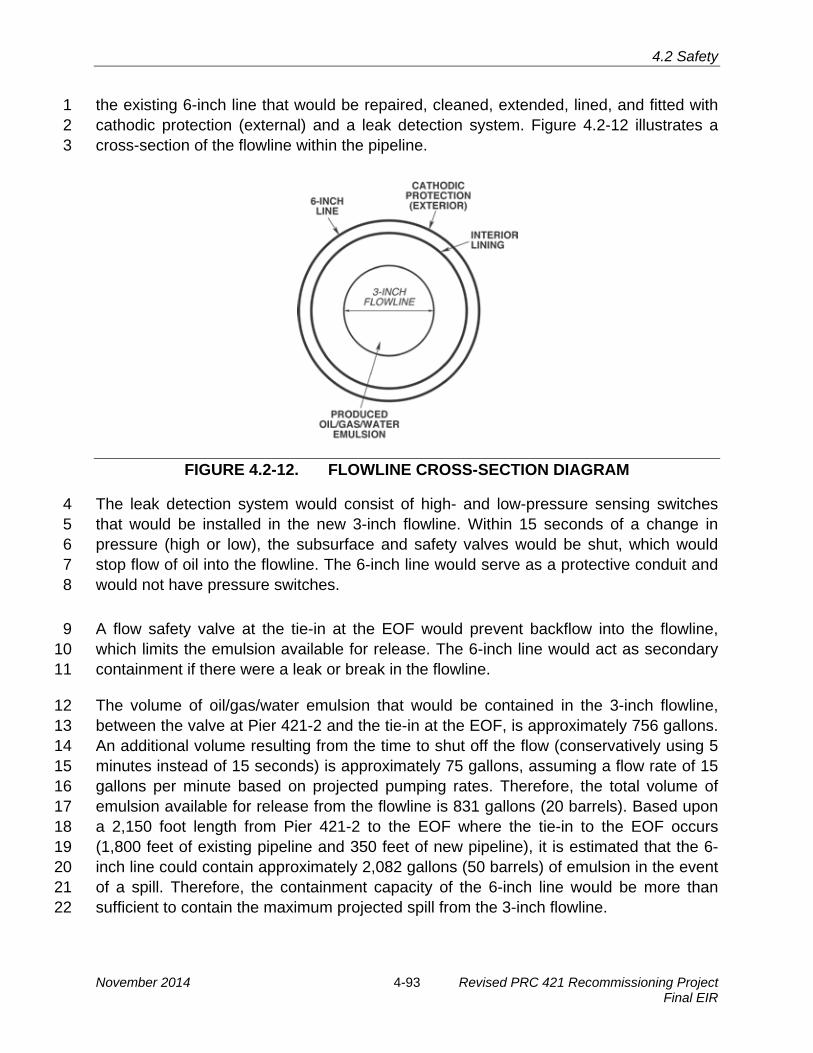
4.2 Safety
the existing 6-inch line that would be repaired, cleaned, extended, lined, and fitted with 1 cathodic protection (external) and a leak detection system. Figure 4.2-12 illustrates a 2 cross-section of the flowline within the pipeline. 3
FIGURE 4.2-12. FLOWLINE CROSS-SECTION DIAGRAM
The leak detection system would consist of high- and low-pressure sensing switches 4 that would be installed in the new 3-inch flowline. Within 15 seconds of a change in 5 pressure (high or low), the subsurface and safety valves would be shut, which would 6 stop flow of oil into the flowline. The 6-inch line would serve as a protective conduit and 7 would not have pressure switches. 8
A flow safety valve at the tie-in at the EOF would prevent backflow into the flowline, 9 which limits the emulsion available for release. The 6-inch line would act as secondary 10 containment if there were a leak or break in the flowline. 11
The volume of oil/gas/water emulsion that would be contained in the 3-inch flowline, 12 between the valve at Pier 421-2 and the tie-in at the EOF, is approximately 756 gallons. 13 An additional volume resulting from the time to shut off the flow (conservatively using 5 14 minutes instead of 15 seconds) is approximately 75 gallons, assuming a flow rate of 15 15 gallons per minute based on projected pumping rates. Therefore, the total volume of 16 emulsion available for release from the flowline is 831 gallons (20 barrels). Based upon 17 a 2,150 foot length from Pier 421-2 to the EOF where the tie-in to the EOF occurs 18 (1,800 feet of existing pipeline and 350 feet of new pipeline), it is estimated that the 6-19 inch line could contain approximately 2,082 gallons (50 barrels) of emulsion in the event 20 of a spill. Therefore, the containment capacity of the 6-inch line would be more than 21 sufficient to contain the maximum projected spill from the 3-inch flowline. 22
November 2014 4-93 Revised PRC 421 Recommissioning Project Final EIR

4.2 Safety
As described above, the design of the 3-inch flowline provides a system of detecting 1 leaks, shutting down flow, and containing released emulsion within the 6-inch line, 2 which would be tested and lined prior to operation. Therefore the likelihood of an 3 uncontained release is low. 4
Although the 6-inch line is located within a road and area known to contain sub-surface 5 oil facilities such as pipelines, there is some potential for accidental damage to occur to 6 this oil line during trenching or other unanticipated future construction activities. A 7 catastrophic break (e.g., from construction equipment) could potentially cause a release 8 of the entire contents of the line, although such damage would be detected by the leak 9 detection system, the well would be automatically shut in, and an alarm would sound at 10 the EOF. Because of the proximity of the pipeline to the surf zone, Bell Canyon Creek, 11 and other nearby sensitive resources, however, a release from the flowline is of 12 particular concern, even though the volume is relatively low and spills to land are 13 typically contained more readily than spills to water. This impact would be less than 14 significant with mitigation. 15
Mitigation Measures 16
MM S-5a. Install Pipeline Warning Markers. Venoco shall modify Project design to 17 include installation of several pipeline markers with reflective warning tape 18 along the 6-inch line to identify the pipeline route and associated excavation 19 hazards. Venoco shall submit the modified Project design to the City of Goleta 20 for review and approval prior to issuance of the Land Use Permit. 21
MM S-5b. Develop Emergency Action Plan (EAP)/Update South Ellwood Field 22 EAP. Venoco shall develop and incorporate into the EAP updated descriptions 23 of the pipeline and flowline, detection systems, emergency shutdown, and 24 response procedures specific to the new system prior to the initiation of 25 operation. Venoco shall update the existing South Ellwood Field EAP to include 26 descriptions of the new flowline interconnection with Platform Holly production 27 within the EOF and other EOF modifications such as the programmable logic 28 controller cabinet, variable speed drive facility, and transformer. Venoco shall 29 submit the EAPs to the City of Goleta and Santa Barbara County Office of 30 Emergency Management for review and approval prior to recommissioning 31 start-up. The City of Goleta and Santa Barbara County Office of Emergency 32 Management shall coordinate updates notice for these revisions shall be 33 provided to the current plan holders within two months of initiating operations of 34 the EAPs with the operator on a regular basis or as conditions change that 35 warrant review of emergency response protocols. 36
MM S-5c. Safety, Inspection, and Maintenance of Oil and Gas Pipelines. 37 Venoco shall prepare a Safety Inspection, Maintenance, and Quality 38 Assurance Program (SIMQAP) or similar mechanism for Project-related 39 pipelines to ensure adequate ongoing inspection, maintenance, and other 40 operating procedures. Any such mechanism shall be subject to approval by the 41 City of Goleta prior to commencement of pipeline operations and provide for 42
Revised PRC 421 Recommissioning Project 4-94 November 2014 Final EIR
4.2 Safety
systematic updates as appropriate. Requirements shall be commensurate with 1 the level and anticipated duration of the risk. The City of Goleta and Venoco 2 would update the SIMQAP or similar mechanism biennially or sooner if 3 conditions change that warrant review of the program. 4
Rationale for Mitigation 5
MMs S-5a would reduce the potential for release by alerting future workers in the area to 6 the pipeline location, while updates to emergency plans and procedures, as required 7 under MM S-5b, would provide responders with better information to manage emergency 8 conditions. Implementation of MM S-5c would ensure pipelines are regularly inspected 9 and maintained, and that such measures are consistent with City requirements. 10
With the implementation of the above measures, Impact S-5 would be reduced to less 11 than significant. 12
Impact S-6: Increased Amount of Oil or Hazardous Materials Potentially Released 13 from Oil Transfer in Line 96 14 Project implementation would increase throughput in the Line 96 pipeline, and 15 therefore increase the amount of oil or hazardous materials potentially released 16 (Significant and Unavoidable). 17
Impact Discussion 18
The Project includes transporting processed oil from the EOF to the PAAPLP Coastal 19 Pipeline via the Line 96 pipeline. This pipeline was analyzed in the Line 96 Modification 20 Project EIR (Santa Barbara County 2011), which is also incorporated by reference. The 21 Project would not require physical modification to Line 96 or changes in its operations. 22 Although risks from oil transportation by pipeline are the lowest of any form of crude oil 23 transportation, pipeline transportation of oil still has the potential to result in impacts 24 through an accidental spill. As the Line 96 pipeline from the EOF along the Gaviota 25 Coast to is equipped with the most modern cathodic protection and internal inspection 26 (“smart pigging”) capabilities, it has a lower failure rate than older pipelines. In addition, 27 eight mainline block valves and check valves were installed along this pipeline to limit 28 the volume of oil spilled in the event of a rupture (refer to Figure 4.2-7). However, a risk 29 of a crude oil release to the environment would exist, including a release from the 30 pipeline into Gaviota Coast drainages and perennial streams, which could also 31 subsequently reach the marine environment. Figure 4.2-13 shows the elevation profile 32 of the Line 96 pipeline, including automatic and manual check valves. 33
The largest drain-down locations (i.e., where the potential exists for largest oil spill) 34 along the pipeline would be located at Llagas Canyon and near the entrance to the 35 ExxonMobil LFC facility at Corral Canyon. Estimated worst-case drain-down volumes in 36
November 2014 4-95 Revised PRC 421 Recommissioning Project Final EIR

4.2 Safety
FIGURE 4.2-13. ELEVATION PROFILE OF LINE 96 PIPELINE Source: Santa Barbara County 2011
the event of a large pipeline rupture range from about 40 barrels at Dos Pueblos 1 Canyon east, to 60 barrels at Bell Canyon, Eagle Canyon, and Dos Pueblos Canyon 2 west, to 194 barrels at Corral Canyon and 237 barrels at Llagas Canyon. However, 3 potential spill volumes would be reduced further as result of additional automatic valves 4 installed around low points are in the onshore Line 96 pipeline located both upstream 5 and downstream. With the automatic valves, spill volumes for Llagas Creek would be 6 reduced to 60 barrels and Corral Canyon would be reduced to 52 barrels (Ellwood 7 Pipeline Company 2011).6 Pipeline safety is affected by several factors, including both 8 the length and the duration of service of the pipeline. Information on historical risks from 9 pipeline operations, including the size and number of spills and the causes of such 10 spills, are available from a number of sources, two of which are noted below. 11
Information on the number and causes of pipeline spills greater than 50 barrels in size is 12 available from the U.S. Department of Transportation/Office of Pipeline Safety 13 (DOT/OPS). These data were obtained for spills from 1968 to 2000 (information from 14
6 The Line 96 Modification Project EIR required MM HM-3 to reduce spill capacity of pipeline. A portion of this potential spill material (approximately 3.61 percent) would be associated with PRC 421, as the pipeline would convey product from both Platform Holly (4,000 barrels per day [bpd]) and PRC 421 (150 bpd).
Revised PRC 421 Recommissioning Project 4-96 November 2014 Final EIR

4.2 Safety
pre-1985 is less reliable in the DOT/OPS data). Information is available from the OPS 1 for crude-oil pipelines, as well as for all liquid pipelines (DOT/OPS 1990). Since 1985, 2 crude oil has comprised 42 to 51 percent of the liquid spilled from pipelines, and 3 petroleum products have made up 47 to 55 percent of the total volume spilled. Pipeline 4 corrosion ranks as the most frequent cause of spills, an estimated 39 percent of all 5 failures since 1985. The number of spills caused by corrosion has remained in the same 6 range since 1985, and there has been no downward trend in the number of spills 7 caused by corrosion since that time. Third-party impacts rank as the second highest 8 cause of pipeline spills, accounting for 30 percent of all failures. 9
The California State Fire Marshal (CSFM) publication, Hazardous Liquid Pipeline Risk 10 Assessment (CSFM 1993), analyzed leak information for the 7,800 miles of liquid 11 pipelines within California for the years 1981 through 1990. The CSFM report presented 12 a set of hazardous liquid pipeline incident rates for all pipelines and uses. A review of 13 the CSFM report shows that the following pipeline design and operation parameters can 14 have a significant effect on pipeline spill rates: 15
· Pipeline age;16 · Pipeline diameter;17 · Pipe specification;18 · Pipe type;19 · Normal operating temperature;20 · Supervisory Control and Data Acquisition (SCADA) leak detection system;21 · Cathodic protection system;22 · Coating type; and23 · Internal inspection.24
The study found that external corrosion was the major cause of pipeline leaks, causing 25 approximately 59 percent of spills, followed by internal corrosion and third-party damage 26 at 20 percent. Operator error and weld failure were also mentioned as minor causes of 27 pipeline failure. Older pipelines and those that operate at higher temperatures had 28 significantly higher spill rates. Crude oil had the highest spill rate primarily due to the 29 transportation of crude oil at elevated temperatures, which increases the rate of external 30 corrosion. This is because faster corrosion rates occur at elevated temperatures when 31 metal comes in contact with soil moisture. 32
To prevent these potential problems, the design of the Line 96 pipeline addresses the 33 issues which most commonly affect the rate of accidental pipeline releases. Venoco 34 subscribes to the Underground Service Alert "one call" system that provides a single 35 toll-free number for contractors and individuals to call prior to digging near the pipeline. 36 Upon notification that a contractor or property owner is intending to dig near the 37 pipeline, the horizontal location of the pipeline would be marked. Marking will be 38 provided within 48 hours of the request. Additionally a warning tape with the pipeline 39
November 2014 4-97 Revised PRC 421 Recommissioning Project Final EIR

4.2 Safety
name is buried approximately 18 inches above the pipeline. The pipeline is new and 1 incorporates all modern safety standards including advanced pipeline coatings, cathodic 2 corrosion protection, emergency flow control and shut-off valves, a new SCADA 3 monitoring system with continuous monitoring provided from the EOF (see Appendix H, 4 HM-3 for detailed description of pipeline safety features). These measures directly 5 address many of the historic causes of pipeline failure raised in past studies, particularly 6 the CSFM study of California pipeline safety. 7
Further, internal inspection, required hydrostatic testing, and frequent pipeline corridor 8 visual inspection by a line rider further reduces the potential for undetected corrosion 9 and third-party damage to the pipeline. Operator training and redundant safety systems 10 decrease the frequency of this already minor source of pipeline leaks. Finally, the 11 pipeline would only transport oil produced at PRC 421 for its productive life (see Section 12 4.2.5 for analysis of cumulative pipeline safety issues). 13
There is a low probability for a release of oil from the production process at Pier 421-2 14 because safeguards designed into the system (i.e., loss of power would shut in the 15 valves) would prevent oil from reaching the surface under non-routine conditions. 16 However, because of the remote potential for blowouts or other failures to occur at Pier 17 421-2 or pipeline failure along the Line 96 pipeline, with subsequent release of oil into 18 the marine environment; no matter how low the probability, this impact would be 19 significant and unavoidable. 20
Mitigation Measures 21
MM HM-3 (Automated Block Valves and an Additional Check Valve on the Proposed 22 Pipeline) from the certified Line 96 Modification Project EIR (Santa Barbara County 23 2011) is incorporated by reference (see Appendix H for details). 24
Rationale for Mitigation 25
Spill volumes for Llagas Creek would be reduced to 60 barrels with an automatic valve 26 and check valve located upstream and downstream, respectively. Spill volumes around 27 Corral Canyon would be reduced to 52 barrels with an automatic valve and check valve 28 located upstream and downstream, respectively. The proposed mainline valve at the 29 EOF would also effectively reduce potential spill volumes into Bell Creek. 30
Residual Impacts 31
After mitigation, this impact would remain significant and unavoidable because there 32 would still be a risk of oil release to the environment. 33
Revised PRC 421 Recommissioning Project 4-98 November 2014 Final EIR

4.2 Safety
Impact S-7: Increased Processing of Oil and Gas at the EOF 1 Project implementation would increase processing of oil and gas at the EOF, and 2 therefore increase potential risks related to safety and potential release of 3 hazardous materials (Significant and Unavoidable). 4
Impact Discussion 5
The Project includes transporting the oil/gas/water emulsion produced at Pier 421-2 to the 6 EOF for processing. The EOF is already equipped with the oil-water separation, 7 treatment, and discharge of produced water systems necessary to treat oil produced from 8 Pier 421-2. Although existing EOF throughput levels would increase, no modifications of 9 existing systems at the EOF would be necessary, beyond the those discussed in Section 10 2.3.4, including control system improvements that would be implemented as part of the 11 Project, a new interconnection with Platform Holly, a programmable logic controller 12 cabinet, variable speed drive package, transformer, and various pressure sensors and 13 gauges. The throughput would increase under the Project by up to 150 BOPD but would 14 remain well below the EOF’s current permitted level of 13,000 BOPD. 15
Figure 4.2-14 shows the changes to baseline hazards and risks posed by the Project. 16 The impacts of these changes as they relate to Pier 421-2 structures and other Project-17 related infrastructure are discussed below. 18
FIGURE 4.2-14. BASELINE AND CHANGES TO HAZARDS/RISKS
November 2014 4-99 Revised PRC 421 Recommissioning Project Final EIR

4.2 Safety
The addition of new equipment on the EOF site, including the programmable logic 1 controller cabinet, variable speed drive facility, and transformer, would introduce 2 potential new safety risks at the EOF (e.g., the transformer may create a fire hazard at a 3 new location in the EOF). These risks would be reduced by updating the South Ellwood 4 Field EAP to address these changes, as required in MM S-5b. 5
As noted previously, a QRA was conducted for the EOF in 2000, resulting in a set of 6 MMs designed to bring EOF operations in compliance with Santa Barbara County 7 Environmental Thresholds for Public Safety (ADL 2000). The analysis evaluated the 8 facility’s operations at permitted (maximum) levels. 9
Prior to mitigation, the study found the main risk to the population was the separation 10 and storage of liquefied petroleum gas (LPG) and natural gas liquids (NGLs). The QRA 11 further concluded that the toxic risk (i.e., from H2S) from the facility would be 12 considered acceptable based on the County’s Environmental Risk Threshold for Public 13 Safety (ADL 2000). Platform Holly was found to produce an acceptable level of risk, in 14 part because no large quantities of flammable gas liquids are stored at the facility. At 15 present capacity (below permitted capacity), the facility’s risk profile is within the 16 County’s and City’s risk thresholds for public safety. 17
The largest vessels at the EOF that contain crude oil are the two crude oil storage 18 tanks, which have a capacity of 2,000 barrels each and the 1,500 barrel heater treaters. 19 Additional vessels with liquid inventory include the 3,000 barrel produced water tank, 20 and the 2,000 barrel reaction and oxidation tanks in the H2S removal unit. A failure of 21 the tank/vessel or a rupture of piping or one of the smaller, connected vessels/systems 22 could cause a release of the contents to the containment/sump system, which could be 23 released to the ocean outfall if appropriate procedures and methods are not followed. 24 The QRA prepared for the EOF estimated the frequency of such a spill at less than one 25 occurrence per million years. The containment at the EOF exceeds the combined 26 capacity of crude oil storage. 27
PRC 421 production would enter three process streams at the EOF: crude oil 28 processing, gas sweetening, and produced-water disposal. 29
· Crude oil processing – Pier 421-2 oil/gas/water emulsion would be commingled30 with crude oil from Platform Holly, and would be processed together at the EOF.31
· Gas sweetening – Because of its low sulfur content, Pier 421-2 gas is not sour;32 however, it would be commingled with production from Platform Holly, then the33 combined PRC 421/Holly gas stream would be processed in the gas sweetening34 system at the EOF.35
Revised PRC 421 Recommissioning Project 4-100 November 2014 Final EIR

4.2 Safety
· Produced-water disposal – Separated water from the commingled crude oil1 would be injected into well WD-1 at the EOF, which is used for disposal of2 Platform Holly’s produced water.3
The addition of projected PRC 421 flow volumes would not cause EOF throughput to 4 approach the limits of its permitted capacity, which is lower than its design capacity. In 5 addition, oil produced from PRC 421 does not have constituents or concentrations of 6 constituents that would fall outside of EOF processing system design basis or capacity. 7 Therefore, PRC 421 production is suitable for handling and processing at the EOF. 8
The EOF includes a total storage capacity of 4,000 barrels, which is not enough storage 9 to accommodate a full day of production from PRC 421 and Platform Holly. Additionally, 10 no other oil storage facilities are available for this production. Therefore, oil produced 11 from PRC 421 would be blended with the Platform Holly oil and continuously 12 transported through Line 96 to the PAAPLP Coastal Pipeline located west of LFC, 13 except for use of the limited storage facilities currently available at the EOF. If, for any 14 reason, the PAAPLP Coastal Pipeline system downstream of the EOF or processing 15 equipment within the EOF were not operating, the Applicant would need to curtail 16 production from Platform Holly and PRC 421 within less than a day. Production from 17 PRC 421 could be shut down within 5 minutes. The maximum amount of oil produced in 18 5 minutes, based on the maximum instantaneous production rate of 500 BOPD, would 19 be 1.7 barrels. This amount of oil could be accommodated along with that from Platform 20 Holly in the existing storage facilities. Since current throughput at the EOF is 5,000 21 BOPD (less than 39 percent of its permitted capacity given current design), the increase 22 in existing flows of 150 BOPD reducing to 50 BOPD after 2 years due to addition of 23 PRC 421 production is unlikely to burden existing processing facilities. 24
Based on the descriptions above and defined throughput levels, the introduction of 25 oil/gas/water emulsion produced at Pier 421-2 would not have adverse effects on the 26 safe operation of the EOF processing systems. The EOF would continue to operate well 27 below its permitted capacity, and therefore maintain an acceptable risk profile in 28 accordance with the County’s and City’s environmental risk thresholds for public safety. 29 However, additional processing at the EOF would incrementally increase the risk of a 30 hazardous material release and subsequent release of oil into the marine environment; 31 no matter how low the probability, this impact would be significant and unavoidable. 32
Mitigation Measures 33
Although this impact is significant and unavoidable, the The EOF operates under an 34 approved EAP and OSCP for the South Ellwood Field; however, the EAP would be 35 updated, as specified in MM S-5b, to include information about the new flowline 36 connection and new equipment that would be present on the site as part of the 37
November 2014 4-101 Revised PRC 421 Recommissioning Project Final EIR

4.2 Safety
proposed Project.and there is no additional feasible mitigation available that would 1 substantially reduce the risk of release from the EOF. 2
Residual Impacts 3
This impact would remain significant because there would still be a risk of oil release to 4 the environment, and no mitigation can completely remove that risk. 5
Impact S-8: Increased Risk of Fire 6 Project implementation would include production and transport of oil and gas 7 from PRC 421 to the EOF, increase processing of oil and gas at the EOF, and 8 increase transport of oil and gas to market, therefore increasing potential risks 9 related to fire (Less than Significant with Mitigation). 10
Impact Discussion 11
A spill of crude oil from the PRC 421 production equipment, pipelines, or EOF facilities 12 could produce public health concerns as a result of fires that may arise if the oil or the 13 oil vapors reach an ignition source and the oil burns. Flammable vapors that may 14 emanate from crude oil include propane, butane, pentane, light ends (ethane and 15 lighter), naphtha, and H2S. As it emerges from the wellhead, crude oil is a 16 heterogeneous mixture of solids, liquids, and gases. This mixture in addition to 17 hydrocarbons includes sediments, water and water vapor, salts, and acid gases, 18 including H2S and carbon dioxide. Most of the light ends (e.g., the propane, butanes) 19 are removed from the crude oil during processing at the EOF. However, several events 20 would have to occur before a hazardous consequence would occur. For example, a 21 sizeable oil leak would need to occur, followed by ignition and subsequent fire, and then 22 members of the public would need to be present within the fire zone to be affected, or 23 fire or burning oil would need to escape PRC 421 related facilities and damage adjacent 24 areas or structures. 25
A fire at the pier, along the 3-inch flowline or at the EOF, however unlikely, would be a 26 significant impact; the pier is located on the beach, often surrounded by water and is not 27 near public buildings, the public may be exposed to this hazard during use of the beach 28 adjacent to the pier. The flowline borders the beach, as well as coastal bluff scrub 29 habitats above and to the north; the EOF and a portion of the flowline border Bell 30 Canyon Creek to the west. The public may experience impacts at one of the 31 neighboring properties, including Bacara Resort and Spa, the Sandpiper Golf Course, 32 and the Bluffs residential development on the Ellwood Mesa. However, with the 33 exception of Sandpiper Golf Course, all of these uses are 2,000 to 4,000 feet away from 34 production, transport and processing facilities. Based on an older QRA prepared for the 35 EOF (SBCFD 2000), crude oil fires could produce serious injury impacts from thermal 36 exposure at a distance of 150 feet; in the case of PRC 421, this distance may be 37
Revised PRC 421 Recommissioning Project 4-102 November 2014 Final EIR

4.2 Safety
greater than 150 feet due to the lighter oil produced at PRC 421 (35 American 1 Petroleum Institute [API] gravity) versus Platform Holly (22.4 API gravity). However, the 2 relative increase in volume of PRC production is less than 3 percent of ongoing 3 production from Platform Holly and such production would be commingled with that from 4 Platform Holly during processing, resulting in a small incremental increase in volatility 5 and associated fire hazard after processing. Further, while recreationalists using the 6 beach and golf course could be exposed to a low level of potential hazard from a fire at 7 PRC 421 or the EOF or a subsequent wildfire, there are no homes or other structures 8 immediately proximate PRC 421. Although the piers, access road, and EOF are only 9 accessible from Hollister Avenue, a dead-end road, limiting access for emergency 10 vehicles, substantial firefighting capabilities are present at the EOF along with regular 11 inspections and monitoring of all facilities. Therefore, incremental increases in 12 flammability associated with PRC 421 production would not result in substantial 13 impacts. When combined with the conditional probability of ignition, which would be low 14 given the few ignition sources in the area, and the conditional probability of persons 15 being near the PRC 421 piers or EOF at the time of the spill, risk of exposure to a crude 16 oil fire would be low, but not zero, because there would still be a risk of injury to Venoco 17 employees and the public in recreational areas in the immediate vicinity of PRC 421. 18
For the Line 96 pipeline route, residential areas and the Ellwood School are located 19 within the injury hazard zones, both thermal and toxic. As mentioned above, the 20 conditional probability of the released crude oil igniting is relatively small. Therefore, 21 risks of thermal impacts from a crude oil fire are low. However, there would still be a risk 22 of injury due to the location of residences and public areas near the pipeline route, and 23 the potential for injuries from toxic vapors resulting from a spill of crude oil. 24
Although the risk of fire resulting from Project operations is small, even given the 25 relatively lighter oil produced at PRC 421, due to the potential consequences of fire at 26 PRC 421, the EOF, and along the Line 96 pipeline route, this impact is significant. With 27 implementation of the measures below, the impact is less than significant with 28 mitigation. 29
Mitigation Measures 30
In addition to the MM below, MM S-4e would require a QRA be prepared for the PRC 31 421 facilities and any change in use for other facilities (i.e., the EOF, Line 96), and 32 recommendations in the approved QRA be implemented prior to Project operation. 33
MM S-8. Fire Prevention and Suppression. Venoco shall revise the existing Fire 34 Prevention and Preparedness Plan to incorporate the new equipment and 35 operations at PRC 421, and submit to the City of Goleta, Santa Barbara 36 County Fire Department, California Coastal Commission, California 37 Department of Transportation, and California State Lands Commission staffs 38 for review and approval. The plan shall be revised and provided to the 39
November 2014 4-103 Revised PRC 421 Recommissioning Project Final EIR

4.2 Safety
agencies for review prior to commencing operations, and the plan shall be 1 formally updated and circulated within one month of receiving comments from 2 the aforementioned agencies. 3
Residual Impacts 4
Implementation of the appropriate safety measures, including fire prevention and 5 suppression capabilities, would reduce but not eliminate the risk of fire and related injury. 6
Impact S-9: Repressurization Monitoring 7 Project implementation would include repressurization monitoring, which would 8 be used to obtain necessary information to assess the risk of an accidental 9 release of oil from improperly abandoned offshore oil wells (Beneficial). 10
Impact Discussion 11
Currently, the PRC 421 wells are shut-in with no way to assess the current pressure of 12 Vaqueros Reservoir. Because there is a risk of release of oil from improperly 13 abandoned wells, there is no current means to assess such a risk due to reservoir 14 pressurization, which could have a significant and unavoidable impact (see Vaqueros 15 Reservoir Repressurization discussion above under Section 4.2.1). Once Well 421-2 16 starts to produce as part of the Project, it will provide the opportunity for CSLC reservoir 17 engineers to monitor the reservoir pressure and better understand the potential for 18 leakage from the old abandoned wells; therefore, would be a beneficial impact. 19
Table 4.2-5. Summary of Project Safety Impacts and Mitigation Measures Impact Mitigation Measures
S-1: Release of Oil During Cleanup of 6-inch Pipeline No additional mitigation is required beyond implementation of BMPs, as proposed.
S-2: Exposure of the Public and Environment to Safety Hazards Due to Collapse of the 421-2 Caisson
S-2a. Design Review / Wave Loading Evaluation. S-2b. Post Storm Inspection, Monitoring and Cleanup.
S-3: Exposure of the Public and Environment to Safety Hazards Due to Collapse of or Damage to the Existing Timber Bulkhead or Rip-Rap Seawall
S-3. Design Review by Civil/Structural Engineer.
S-4: Potential for Release of Oil or Hazardous Materials from Pier 421-2
S-4a. Containment. S-4b. Response Drills and Planning. S-4c. Casing Pressure Testing. S-4d. Regular Facility Inspections. S-4e. Quantitative Risk Assessment (QRA) and Implementation of QRA-Recommended Measures.
S-5: Potential for Release of Oil or Hazardous Materials From the Crude Oil Flowline
S-5a. Install Pipeline Warning Markers. S-5b. Develop Emergency Action Plan (EAP)/ Update of South Ellwood Field EAP. S-5c. Safety, Inspection, and Maintenance of Oil
Revised PRC 421 Recommissioning Project 4-104 November 2014 Final EIR

4.2 Safety
Table 4.2-5. Summary of Project Safety Impacts and Mitigation Measures
Impact Mitigation Measures and Gas Pipelines.
S-6: Increased Potential for Release of Oil or Hazardous Materials or Fire from Oil Transfer in Line 96
MM HM-3 from the Line 96 Modification Project EIR would apply.
S-7: Increased Processing of Oil and Gas at the EOF S-5b. Develop Emergency Action Plan (EAP)/ Update of South Ellwood Field EAP. None applicable.
S-8: Increased Risk of Fire S-8. Fire Prevention and Suppression. S-9 Repressurization Monitoring None required.
4.2.5 Cumulative Impacts Analysis 1
This section summarizes other proposed or ongoing projects in an effort to assess 2 whether the Project’s incremental impacts are cumulatively considerable. The projects 3 are listed in Table 3-3 in Section 3, Cumulative Impacts Methodology. The Project may 4 have cumulatively considerable impacts related to oil spill risk; therefore, this discussion 5 focuses on the oil production projects described in Section 3 because of their potential 6 to increase the risks of oil spills affecting the same areas of coast as the Project. 7
Projects which could produce an increased risk of oil spill that could impact the same 8 coastal areas as the Project include the following: 9
· Carpinteria Field Redevelopment Project/Carone Petroleum Corporation, Signal10 Hill Inc., and Pacific Operators Offshore LLC (POOL);11
· Carpinteria Onshore Project/Venoco; and12
· South Ellwood Field Project/Venoco; and13
· Development of 36 non-producing Federal Leases/Various Applicants.14
All of these projects would exacerbate the potential oil spill risk of the Project, which has 15 been identified as significant and unavoidable. 16
Residential projects in the area would have no direct impact on the Project risks. 17 However, some of the projects are residential developments near the Project area. 18 These would increase the populations that could be exposed to a crude oil spill. 19 Potential exposure in the event of a spill could be along the Line 96 pipeline route and in 20 the nearshore coastal areas. Recreation would be expected to increase with the 21 increase in populations living nearby (CSLC 2009). As noted previously, the Project 22 does not contribute to acute safety risks because of the low H2S content of the crude oil 23 produced at PRC 421. 24
November 2014 4-105 Revised PRC 421 Recommissioning Project Final EIR

4.2 Safety
This page intentionally left blank.
Revised PRC 421 Recommissioning Project 4-106 November 2014 Final EIR

4.3 Hazardous Materials
4.3 HAZARDOUS MATERIALS 1
This section addresses the handling, storage, and disposal of hazardous materials and 2 the potential for the Project to release hazardous materials (i.e., petroleum products, 3 solvents, pesticides, herbicides, polychlorinated biphenyls (PCBs), paints, metals, 4 asbestos, and otherwise regulated chemical materials) during resumption of production 5 at State Oil and Gas Lease PRC 421 (PRC 421), including the construction and 6 operation activities at Pier 421-2 and decommissioning and removal of Pier 421-1. This 7 analysis also briefly discusses area resources that could be affected by the operation of 8 secondary Project components (existing facilities not proposed for modification) such as 9 the operation of the Line 96 pipeline and the Ellwood Onshore Facility (EOF). For a full 10 discussion of potential impacts related to the Line 96 pipeline, see the Line 96 11 Modification Project EIR (Santa Barbara County 2011). Potential impacts resulting from 12 releases of oil-related materials, such as contaminated sediment or a crude oil spill, are 13 also analyzed in other sections of this Environmental Impact Report (EIR), including 14 Section 4.5, Hydrology, Water Resources, and Water Quality. Section 4.2, Safety, 15 evaluates the potential for upset conditions that could result in a release of oil and 16 hazardous materials. Potential impacts associated with a release of hazardous 17 materials by the Project are based on a change from existing conditions. Significance 18 criteria are used to assess the significance of the impacts, and whether mitigation 19 measures (MMs) can be applied to reduce the level of significance. 20
This section incorporates data from Santa Barbara County 01-ND-34 and City of Goleta 21 06-ND-001 along with follow up hazardous materials studies associated with those 22 negative declarations (NDs). This document incorporates by reference the conclusions 23 of the Line 96 Modification Project EIR regarding impacts related to hazardous materials 24 associated with operation of the Line 96 pipeline to the Plains All American Pipeline, LP 25 (PAAPLP) Coastal Pipeline west of Las Flores Canyon (LFC), and summarizes these 26 where appropriate. 27
4.3.1 Environmental Setting 28
The environmental setting presented in this section represents the baseline conditions 29 existing at the time the Notice of Preparation (NOP) was released (March 16, 2013). 30 The baseline conditions include the existing configuration of the Project site, existing 31 operations, and present environment. Risks associated with a potential release of 32 hazardous materials are then evaluated in relation to the baseline conditions. 33
Study Area Location and Description 34
The study area boundary for the Project is described in Section 1.4.1, Study Area 35 Boundary; the area for this hazardous materials analysis includes the immediate on-36 shore and near-shore areas of the Ellwood coast that would be subject to direct impacts 37
November 2014 4-107 Revised PRC 421 Recommissioning Project Final EIR
4.3 Hazardous Materials
from a release of hazardous materials. This area generally includes the existing PRC 1 421 facilities, access road, and tie-in at the existing EOF. 2
The study area includes, from southeast to northwest: Pier 421-2 (southeastern 3 boundary), Pier 421-1 (approximately 325 feet northwest of Pier 421-2), a portion of the 4 gravel access road (from Pier 421-2 extending northwestward, approximately 1,300 feet 5 along the beach), and the remaining portion of the access road (to EOF [northwestern 6 boundary] extending northwest, approximately 500 feet across the Sandpiper Golf 7 Course). Each steel-pile pier contains sand-filled concrete caissons that are 8 approximately 67 feet long and 42 feet wide. These portions of the study area are 9 depicted on Figure 4.3-1 (shown in blue). 10
Baseline Conditions for Hazardous Materials Analysis 11
The baseline conditions are defined in Section 1.4.2, Baseline and Future Conditions. 12 For the hazardous materials analysis, baseline conditions include the current 13 configuration of Piers 421-1 and 421-2, infrastructure, access road, and no current oil 14 production from PRC 421. Additionally, baseline conditions include any potential 15 existing hazardous materials contamination within the study area boundary in soil, 16 sediment, groundwater, or surface water. 17
Documentation of Existing Contamination within the Study Area Boundary 18
The potential for unknown historical releases of hazardous materials to the study area 19 can be evaluated by reviewing historical records covering the study area and nearby 20 properties. Such a review typically focuses on previous industrial or commercial uses of 21 properties where use, handling, or storage of hazardous materials could be assumed. 22 Given that oil and gas development has been prevalent in the area since the 1920s, 23 debris and contamination associated with such development can be found in the 24 Ellwood area. Further, the Project site has been used for oil and gas production since 25 1928 and contamination from previous production activities is likely to be present onsite. 26
Several environmental databases were reviewed during this analysis to evaluate the 27 potential presence of a known historical release in the study area (see Table 4.3-1). 28 Based on this review, the study area was listed on the following databases: 29
· Federal Resource Conservation and Recovery Act (RCRA) Small Quantity30 Generator (SQG) database. RCRA SQGs are facilities that generate between31 220 and 2,200 pounds (lbs) of hazardous waste per month, or in a one-month32 timeframe. The study area was listed as Handler identification: CAD981576846,33 and was last updated July 30, 1997. No additional information was noted on the34 listing with respect to dates, quantities, or types of hazardous materials.35
Revised PRC 421 Recommissioning Project 4-108 November 2014 Final EIR

CABLESCABLES
REVETMENT
REVETMENT
SEAWALLSEAWALL
CABLES
SEAWALL
REVETMENT
PIER 421-1PIER 421-1
PIER 421-2PIER 421-2
170 BARRELS OIL SPILL IN 1994170 BARRELS OIL SPILL IN 1994
OIL LEAKSOIL LEAKSNOVEMBER 22 AND 27, 2000NOVEMBER 22 AND 27, 2000
SEVERAL RECORDS OFSEVERAL RECORDS OFSMALL OIL RELEASES,SMALL OIL RELEASES,NATURAL GAS AND BENZENENATURAL GAS AND BENZENEREPORTED TO NRC 1994 TO 2000REPORTED TO NRC 1994 TO 2000
3' X 50' DARK BLACK OIL SHEEN3' X 50' DARK BLACK OIL SHEENSPILL REPORTED TO NRCSPILL REPORTED TO NRC
NOVEMBER 2004NOVEMBER 2004
OIL LEAD AND SLUDGE ATOIL LEAD AND SLUDGE ATEXISTING STORAGE TANKEXISTING STORAGE TANK
IN SECONDARY CONTAINMENTIN SECONDARY CONTAINMENTNOVEMBER 2000NOVEMBER 2000
SANDPIPERSANDPIPERGOLF COURSEGOLF COURSE
ACCESS ROAD
ACCESS ROAD
FLOWLINEFLOWLINE
Bell
Cany
on C
reek
Bell
Cany
on C
reek
ELLWOODONSHOREFACILITY
PIER 421-1
PIER 421-2
ELLWOODONSHOREFACILITY
FLOWLINE
170 BARRELS OIL SPILL IN 1994
OIL LEAKSNOVEMBER 22 AND 27, 2000
SEVERAL RECORDS OFSMALL OIL RELEASES,NATURAL GAS AND BENZENEREPORTED TO NRC 1994 TO 2000
3' X 50' DARK BLACK OIL SHEENSPILL REPORTED TO NRC
NOVEMBER 2004
OIL LEAD AND SLUDGE ATEXISTING STORAGE TANK
IN SECONDARY CONTAINMENTNOVEMBER 2000
ACCESS ROAD
SANDPIPERGOLF COURSE
Bell
Cany
on C
reek
101
SCALE IN FEET
0 350 700
Hazardous Materials Baseline Conditions [Revised]FIGURE4.3-1
N
4-
LINE 96LINE 96LINE 96

4.3 Hazardous Materials
Table 4.3-1. Databases Reviewed for Hazardous Material Analysis Federal Database California Database
U.S. Environmental Protection Agency (EPA) RCRA hazardous waste generators
California Environmental Protection Agency (CalEPA) Cal-Sites Database (Cal-Sites)
RCRA Corrective Action Sites (CORRACTS) Treatment, Storage, and Disposal (TSD) facilities
California Department of Toxic Substances Control (DTSC) EnviroStor Database (ENVIROSTOR)
RCRA non-CORRACTS TSD facilities list DTSC Hazardous Waste Tracking System (HWTS) Reports
Comprehensive Environmental Resource Conservation and Liability Information System (CERCLIS) listing
CalEPA Cortese Hazardous Waste and Substances Site List (Cortese)
CERCLIS No Further Remedial Action Plan (NFRAP)
State Water Resources Control Board (SWRCB) Underground Storage Tank Database (UST)
National Priority List (NPL) SWRCB List of Historical UST Sites (HIST UST) Delisted NPL SWRCB GeoTracker Leaking UST List (LUST) Emergency Response Notification System (ERNS) list
SWRCB Spills, Leaks, Investigations, and Cleanups List (SLIC) DTSC Deed Restriction Listing (DEED) DTSC Voluntary Cleanup Program Properties List (VCP)
· Federal ERNS List through the National Response Center. The National1 Response Center provides all oil and chemical spill data reported to the Center2 since 1990. The study area was listed as Incident Report #741971 dated3 November 20, 2004, which indicates that a caller reported an unknown dark4 black sheen on ocean water at Pier 421-1. The reported size of the sheen was5 50 feet by 3 feet. No other information on how the apparent release occurred, or6 how it was remediated, was reported.7
· DTSC Hazardous Waste Tracking System (HWTS). The HWTS generates8 reports on hazardous waste shipments for generators, transporters, and9 treatment, storage, and disposal facilities (TSDFs). The study area was listed on10 the HWTS as U.S. EPA identification: CAD981576846, under the name of11 Venoco, Inc., North American Industry Classification System 211111 and12 Standard Industrial Classification 1311. The status was shown to be active, and13 the record was entered April 10, 1987 (the facility was owned by ARCO at this14 time). The record entry in its database appears to be based solely on the study15 area’s U.S. EPA identification number, which reflects the study area’s inclusion16 on the Federal SQG database as described above.17
Database Entries for Adjacent Properties 18
The EOF was also reported on several databases. The listings primarily consisted of 19 small oil spills or releases of natural gas. The largest spill reported was 10 barrels crude 20
Revised PRC 421 Recommissioning Project 4-110 November 2014 Final EIR

4.3 Hazardous Materials
oil to soil in 1995. The release apparently resulted from a valve crack at a storage tank. 1 Additionally, the EOF was listed on the SWRCB GeoTracker database as a facility with 2 underground storage tanks. 3
Additional Releases at the Project Site 4
March 1994 – A 6-inch pipeline leak occurred and resulted in a release to soil of 5 approximately 170 barrels (7,140 gallons) beneath the 12th green of the Sandpiper Golf 6 Course near the coastal bluffs. This release impacted surface and subsurface soils at 7 the golf course. 8
November 22, 2000 – An oil leak was induced during a routine fluid-level check at Pier 9 421-2, and an oil leak and sludge were noted in association with a storage tank in 10 secondary containment on Pier 421-1. The sludge was tested by a hazardous waste 11 bioassay technique, and was found to be toxic (note that determination of hazardous 12 waste includes four characteristics: toxic, flammable, corrosive, or reactive, and that if a 13 substance is found to be characteristic of one of the four types, then it is considered a 14 hazardous substance, and subject to regulation under the RCRA). The toxic sludge and 15 associated liquids were removed from the storage tank and disposed of properly. This 16 leak apparently did not impact soil, sediment, groundwater, or surface water. 17
November 27, 2000 – An oil leak occurred during fluid-level check on Pier 421-2, and 18 resulted in the release of approximately 15 gallons. The oil was contained in a drum in 19 secondary containment. This leak apparently did not impact soil, sediment, 20 groundwater, or surface water. 21
2001 – During emergency repairs to PRC 421 facilities, petroleum-hydrocarbon-22 contaminated sediment was encountered in three of the five holes dug across the width 23 of Pier 421-2. The contaminated sediment was encountered at a depth of approximately 24 15 feet, and the contamination appeared to extend to approximately 20 feet below the 25 surface of the top of the sediment. Laboratory testing of the contaminated sediment 26 indicated the presence of several hundred to less than 2,000 parts per million (ppm) 27 diesel- and lube-oil-range petroleum hydrocarbons. Approximately 143 tons of the 28 contaminated sediment was excavated from the area near the holes completed for 29 installation of soldier pile structural sections. The excavated material was transported to 30 an asphalt recycling plant (Santa Barbara County 2001). 31
January 19, 2004 – A large section of the outer caisson wall of Pier 421-1 sheared off 32 and fell into the surf below. Large pieces of concrete debris and rebar fell to the base of 33 the caisson. Based on the long history of oil and gas production at both PRC 421 wells, 34 it was assumed that fill and sediment inside the caissons at both piers are likely 35 contaminated with petroleum-related constituents. Therefore, it was also noted that the 36 2004 caisson wall repair was conducted in part to prevent contaminated fill and 37 sediment materials from being released. 38
November 2014 4-111 Revised PRC 421 Recommissioning Project Final EIR

4.3 Hazardous Materials
During wall repair activities, two leaks were found in the old caisson wall. These leaks 1 were reported by a member of the public, and may correspond to the Federal ERNS 2 listing noted earlier in this section. The leaks were noted as containing both a lighter oily 3 substance and a black tar-like substance, both of which were released to the ocean. 4 The leaks from the wall continued for a period of time during the repair project, and 5 were estimated to reach up to one quart per day. Absorbent pads and booms, and a 6 topical sealant were used in an attempt to minimize the leaks, but those efforts 7 appeared to be unsuccessful. Once the new caisson wall was constructed, concrete 8 was poured between the new and old walls, which could provide a more effective seal 9 for the leak areas on the old wall. 10
Following completion of the new caisson wall, samples of the leaking substance and a 11 “shale mud/sand” were tested. The shale mud/sand sample included concentrations of 12 total petroleum hydrocarbons (TPH) in the range of 100 to 200 milligrams per kilogram 13 (mg/kg). Risk to human health or the environment cannot be quantified based on the 14 analytical data obtained. However, concentrations in the 100 to 200 mg/kg range for 15 TPH are well below 1,000 mg/kg, which is a commonly used screening value for TPH in 16 soil and a generally accepted regulatory guideline. 17
The laboratory analysis of the leaking substance that was released from the old caisson 18 wall was found to have a heavier API gravity than would be expected from the oil 19 produced at PRC 421. PRC 421 wells are anticipated to have an API gravity of 20 approximately 35, while the leaking substance was found to be much heavier at 17.8. 21 The source of the leaking fluid remains unknown; however, it was noted in the MND that 22 the substance may not have originated from PRC 421 (City of Goleta 2006a). 23 Alternately, the substance may have been PRC 421 reservoir oil that had partially 24 volatized or decomposed, resulting in a heavier API gravity. 25
April 1, 2005 – A dark substance was found to be leaking from the east side of the old 26 caisson wall at 421-1 during a California State Lands Commission (CSLC) staff 27 inspection after completion of the caisson wall repair. During subsequent inspections, 28 the leaking substance appeared, based on visual and olfactory evidence, to not be a 29 petroleum release; no oily or slick texture was visible, and an anaerobic sulfurous odor 30 was noted. 31
August 21, 2006 – Two slow leaks were reported on the east wall of the outer caisson 32 by a member of the public. The area around the leak was described as whitish in color 33 and smelled of sulfur. Santa Barbara County Energy Division staff sampled the fluid 34 during a site visit in response to the reported chemical leak. The fluid did not appear to 35 contain hydrocarbon material, and the source of the leaks remains unknown (City of 36 Goleta 2006a). 37
Revised PRC 421 Recommissioning Project 4-112 November 2014 Final EIR
4.3 Hazardous Materials
Natural Seeps – Prolific natural hydrocarbon seepage occurs offshore of Coal Oil Point 1 in the Santa Barbara Channel, just southeast of the Project site. The seeps emit both 2 liquid and gaseous hydrocarbon phases, with gas predominating. Such hydrocarbon 3 seepage affects ocean and beach sediment chemistry and provides a natural source of 4 petroleum pollution. On a regional scale, the Coal Oil Point seeps represent a significant 5 source of gaseous hydrocarbons and residual asphaltic hydrocarbons, or beach tar. The 6 natural seeps are discussed further in Section 4.1, Geological Resources. 7
Study Area Receptors 8
For this analysis, receptors are located in areas in the Project vicinity that have the 9 potential to be adversely affected by the release of hazardous materials as a result of 10 implementation of the Project or its alternatives (see Section 5.0 for the alternatives 11 analysis). If a release of hazardous materials were to occur, the most likely receptors 12 would be located within the study area or its immediate vicinity. Those receptors could 13 include occupants at the Sandpiper Golf Course, personnel at the EOF, beach 14 recreational users, construction personnel, and ecological receptors associated with the 15 upland and near-shore environments near the piers and the access road, including 16 those in sensitive areas, such as wetlands, and surface waters of nearby creeks or the 17 ocean. Additional information on receptors and the environments in Project vicinity is 18 provided in Section 4.2, Safety; Section 4.5, Hydrology, Water Resources, and Water 19 Quality; Section 4.6, Marine Biological Resources; and Section 4.7, Terrestrial 20 Biological Resources. 21
4.3.2 Regulatory Setting 22
Regulations applicable to the Project are intended to regulate hazardous materials and 23 hazardous wastes, as well as to manage sites contaminated by hazardous substances. 24 These regulations are also designed to limit the risk of upset during the use, transport, 25 handling, storage, and disposal of hazardous materials. The Project would be subject to 26 numerous Federal, State, and local laws, regulations, and policies. Federal and State 27 laws that may be relevant to the Project are identified in Table 4.0-1. Local laws, 28 regulations, and policies are discussed below. 29
Local 30
Santa Barbara County Fire Department (SBCFD) 31
As noted in Sections 4.1, Geological Resources, and 4.2, Safety, the SBCFD, which is 32 the Certified Unified Program Agency (CUPA) responsible for administering state 33 environmental programs within the county of Santa Barbara, is the overseeing agency 34 for implementing local regulations in the event of a hazardous waste or petroleum spill. 35 The SBCFD may also maintain additional records for the study area from the Site 36 Mitigation Unit, CUPA, and Current Release Information files. 37
November 2014 4-113 Revised PRC 421 Recommissioning Project Final EIR
4.3 Hazardous Materials
Santa Barbara County Air Pollution Control District (APCD) Rule 325 – Crude Oil 1 Production and Separation 2
This local regulation applies to equipment used in the production, gathering, storage, 3 processing, and separation of crude oil and natural gas prior to custody transfer. This 4 rule includes provisions for storage tanks, emissions control for produced gas, and 5 requirements for recordkeeping, test methods, inspections, and compliance schedules. 6
4.3.3 Significance Criteria 7
The significance criteria for this hazardous materials analysis were developed by 8 considering study-area-specific potential impacts. A hazardous materials impact would 9 be significant if it: 10
· Creates a significant hazard to the public or the environment through the routine11 transport, use, or disposal of hazardous materials; or12
· Is located on a site included on a list of hazardous materials sites compiled13 pursuant to Government Code section 65962.5, and as a result would create a14 significant hazard to the public or the environment.15
4.3.4 Impact Analysis and Mitigation 16
The Project was evaluated for the presence of hazardous substances that, if present in 17 large quantities in existing structures planned for construction/renovation, or known to 18 exist in study area media (soil, sediment, groundwater, or surface water), could result in 19 impacts to human health or the environment. A qualitative evaluation of potential Project 20 impacts was made based on the site-specific information obtained and described in 21 Section 4.3.1, Environmental Setting. Impacts and related MMs related to oil spills and 22 subsequent cleanup activities are addressed in Sections 4.4, Hydrology, Water 23 Resources and Water Quality, 4.5, Biological Resources, 4.1, Geological Resources, 24 4.2, Safety, and 4.12, Aesthetics/Visual Resources. Because impacts from oil spills are 25 specific to the resource areas listed above, these impacts are not included in this 26 section. Table 4.3-2, located at the end of Section 4.3.4, provides a summary of safety-27 related impacts and recommended MMs to address these impacts. 28
Impact HAZ-1: Exposure of Public or Environment to Hazardous Materials 29 The Project would create a potential hazard to the public or the environment 30 through the routine transport, use, or disposal of hazardous materials during 31 construction and/or project operation (Less than Significant with Mitigation). 32
Impact Discussion 33
During the construction phase of the Project, existing petroleum-contaminated soil or 34 sediment could be encountered during soil disturbance activities, including trenching 35
Revised PRC 421 Recommissioning Project 4-114 November 2014 Final EIR

4.3 Hazardous Materials
along the pipeline corridor and caisson repair at Pier 421-2. Contaminated soil may also 1 be encountered during pier and caisson removal at Pier 421-1, which would be 2 performed separately following recommissioning of Pier 421-2; decommissioning and 3 removal is expected to occur approximately 1 year following recommissioning of Pier 4 421-2. 5
Disturbance of existing contaminated soil or sediment could result in a release of 6 hazardous materials, which could adversely affect human or ecological receptors. 7 Several spills have been documented at the site during its 70-year history of oil 8 production. In addition, during construction of recent improvements, soils contaminated 9 with hydrocarbons were discovered beneath Pier 421-1 and removed from the site. 10 Open excavations in contaminated areas can increase the potential for erosion, 11 sedimentation, turbidity, and generation of contaminated water by (1) collection of storm 12 water in the open area during storm events, or (2) groundwater influx in areas where the 13 excavation intersects shallow groundwater. 14
The Project would potentially result in the release of contaminated sediment from the 15 caisson at Pier 421-2 into the environment. The Project includes repairs to all three non-16 seaward-facing walls of this caisson. These reinforcements would include construction 17 of walls similar to the one built on the seaward facing side of the Pier 421-2 caisson in 18 2011. This would include installation of steel piles in 25-foot-deep holes drilled around 19 the caisson and concrete panels between the steel piles. Concrete slurry will then be 20 poured between the new panels and the old caisson walls. Exposure of caisson 21 sediment through opening of the caisson structure at Pier 421-2 during construction is 22 not intended as part of the Project; however, construction activities could result in an 23 accidental release of contaminated sediment into the environment. 24
The only trenching included as part of the Project would be a shallow trench (30 inches 25 deep by 12 inches wide) for the installation of electric cables over a 1-day period. 26 Additionally, the Project has included a technique for upgrades to the existing 6-inch line 27 by in-situ enhancements including addition of a new internal liner of the pipeline. The 28 pipeline would be accessed at the location near the 1994 oil release. Further Project 29 details are described in Section 2.2, Proposed Project. 30
Decommissioning and removal of Pier 421-1 and associated infrastructure, which would 31 occur following recommissioning of Pier 421-2, also presents the risk of exposing 32 contaminated sediment to the marine environment. The caisson at Pier 421-1 currently 33 contains sediment that may contain hazardous materials, and removal of this structure 34 could result in mobilization of this material into the marine environment. Structures to be 35 removed as part of the decommissioning and removal of Pier 421-1 and underlying 36 sand would be tested for the presence of hazardous materials, and any contaminated 37 sand would be remediated; however, accidental release of contaminated sediment may 38 still occur. During the construction phase for the Project and subsequent 39
November 2014 4-115 Revised PRC 421 Recommissioning Project Final EIR

4.3 Hazardous Materials
decommissioning and removal of Pier 421-1, other pollutants typically associated with 1 construction activities, such as sediment, concrete curing compounds, sealants, paints 2 (among others) could be released. The potential for and consequences of upset 3 conditions during operations are addressed in Section 4.2, Safety. This impact would be 4 less than significant with mitigation. 5
Mitigation Measures 6
Impacts from potential hazardous materials releases during Project construction and 7 operation and during decommissioning and removal of Pier 421-1 would be reduced 8 with implementation of MM WQ-1a from Section 4.5, Hydrology, Water Resources and 9 Water Quality, as well as: 10
MM HAZ-1a. Proper Personnel Training. Personnel working during the Project’s 11 construction, operation, and Pier 421-1 decommissioning and removal phases 12 shall be adequately trained per the requirements included in Venoco’s 13 Emergency Action Plan, Oil Spill Contingency Plan, Fire Prevention and 14 Preparedness Plan, Spill Prevention, Control and Countermeasures Plan and 15 other relevant plans. These plans include specific training requirements such 16 that personnel that have the potential to come into contact with contaminated 17 media and/or hazardous materials understand safe work practices, Best 18 Management Practices, and waste management practices, so that a release of 19 hazardous materials can be avoided, controlled, or minimized. Project 20 construction and field personnel shall also be trained to identify possible 21 indicators of a hazardous release, such as hydrocarbon or solvent odors, 22 stained soils, and oily sheens on standing water. 23
MM HAZ-1b. Conduct a Phase I Environmental Site Assessment (ESA). To gain 24 a better understanding of the study area and its potential to have additional, 25 previously unknown releases of hazardous materials or other environmental 26 concerns, Venoco shall perform a Phase I ESA on the study area prior to 27 issuance of land use permits, which shall incorporate information from Santa 28 Barbara County Fire Department Fire Protection Division (FPD) records and 29 files. The results of this study shall be provided to the City of Goleta, FPD, and 30 California State Lands Commission staffs. Conclusions of the Phase I ESA, 31 including any recommendation of a Phase II and subsequent investigation, 32 shall be followed. Any subsequent work plans for soil and groundwater 33 sampling shall be submitted to FPD for review and incorporated into the current 34 and ongoing assessment under their Site Mitigation Unit Site #371. 35
MM HAZ-1c. Soil Sampling. During construction activities at Pier 421-2 and during 36 Pier 421-1 decommissioning and removal, all soil materials removed shall be 37 presumed to be contaminated and handled accordingly. The soil materials 38 removed from the caisson will be sampled, profiled, and disposed of or 39 recycled according to regulatory requirements. During all other Project 40 construction activities, Venoco a City of Goleta Soils Inspector/Monitor shall 41 continually visually monitor the soils disturbed within the construction areas to 42
Revised PRC 421 Recommissioning Project 4-116 November 2014 Final EIR

4.3 Hazardous Materials
determine if there is any evidence of undiscovered contamination. The City of 1 Goleta shall hire the Soils Inspector/Monitor, paid for by Venoco, to inspect soil 2 disturbance activities within the City’s jurisdiction during all phases of the 3 Project to ensure that any hazardous materials and/or contaminated soils 4 encountered are properly contained and removed. Soil samples may be taken, 5 subject to the direction of the Soils Inspector/Monitor. Any soil suspected of 6 contamination shall be contained on site in appropriate storage container, 7 sampled, profiled, and disposed of or recycled according to regulatory 8 requirements. All soils removed shall be handled in accordance with MM HAZ-9 1d. All soil sampling results shall be provided to the California State Lands 10 Commission and City of Goleta staffs immediately upon receiving results. 11
MM HAZ-1d. Removal Action Plan. If sediment within the Project construction and 12 421-1 decommissioning areas and surrounding soils is determined to contain 13 total petroleum hydrocarbons or other contaminants above California Ocean 14 Plan thresholds and if such sediments may be exposed, prior to commencing 15 construction activities, Venoco shall prepare a Removal Action Plan for the 16 safe removal of contaminated materials from the structures and surrounding 17 area. The action plan shall be circulated to the City of Goleta, Santa Barbara 18 County Fire Department Fire Protection Division, California State Lands 19 Commission (CSLC) staffs for review and comment. Final approval of the plan 20 shall be under the purview of the California Department of Fish and Wildlife 21 Office of Spill Prevention and Response (OSPR) and/or CSLC staffs. Upon 22 approval, sediments shall be removed from construction areas and disposed of 23 in accordance with procedures described in the Removal Action Plan. 24 However, if OSPR and/or CSLC staffs determine that removal of some 25 contaminated sediments would impair the integrity of Pier 421-2 (includes the 26 well, caisson supporting the well, and the causeway leading to the caisson) 27 (either through complete removal of the soil filling the caisson or having to dig 28 underneath), Venoco shall prepare a Decommissioning Plan to remove those 29 remaining contaminated sediments at such time that Pier 421-2 is 30 decommissioned. All other contaminated sediments whose removal would not 31 threaten the integrity of Pier 421-2 would be removed upon approval of the 32 Plan as described above. 33
MM HAZ-1e. Performance Security. The permittee shall provide to the California 34 State Lands Commission (CSLC) and the City of Goleta, or maintain if already 35 provided, performance securities and agreements for work that would need to 36 be performed at the end of the Project’s life. The security and agreement 37 provided to CSLC would cover decommissioning and abandonment of the Well 38 421-1 and Pier 421-2. The performance security total shall be the estimated 39 amount for the decommissioning/abandonment work. The performance 40 security shall be provided to the CSLC and agreements signed, prior to return 41 to production of the PRC 421 well. The security and agreement provided to the 42 City of Goleta would cover decommissioning and abandonment of the portions 43 of the Project located within the City’s jurisdiction, including, but not limited to, 44 the piers, the sea wall supporting the access road, the access road, and the 45 onshore pipelines and cables and ancillary facilities. The performance security 46
November 2014 4-117 Revised PRC 421 Recommissioning Project Final EIR

4.3 Hazardous Materials
total shall be the estimated amount for the decommissioning/abandonment 1 work, less any amount contributed toward overlapping infrastructure that is 2 covered in the securities and agreements with the CSLC. The performance 3 security shall be provided to the City of Goleta and agreements signed prior to 4 the issuance of the Land Use Permit. 5
Rationale for Mitigation 6
Based on past operations, the potential exists for contaminated media to exist within the 7 Project construction areas. Therefore, pre-Project planning, contingency planning, and 8 personnel training would be needed to control, prevent, or eliminate future releases of 9 hazardous materials during Project implementation. Proper personnel training will 10 ensure that Project personnel are prepared for emergency response in the event of a 11 release of hazardous materials, and will be trained in the identification, proper handling, 12 and disposal of such materials. The purpose of a Phase I ESA is to identify 13 environmental concerns that may be associated with a property. Identification of such 14 concerns helps to evaluate the nature, extent, and magnitude of potential contamination 15 at a site, and to identify what media (e.g., soil, sediment, groundwater, or surface water) 16 may have been contaminated. The conclusions of the Phase I may include 17 recommendation of subsequent investigation (Phase II), in which the extent and nature 18 of contamination will be identified. Sampling of sediment in the proposed construction 19 areas will determine whether contamination is present prior to ground disturbance 20 activities. If contamination is present, a Removal Action Plan will define requirements for 21 proper cleanup and disposal, thereby minimizing risk to the public and environment. 22 Additionally, avoiding construction activities during high tides and use of a silt curtain 23 would reduce the probability and severity of a release of hazardous materials into the 24 marine environment. Full implementation of these measures would reduce Impact HAZ-25 1 to less than significant. 26
Impact HAZ-2: Release of Contaminated Sediment from the Caisson on Pier 421-2 27 during Operation of the Project 28 Contaminated sediment contained within the caisson structures could infiltrate to 29 the surrounding environment (Less than Significant with Mitigation). 30
Impact Discussion 31
The Project would extend the use of the aging caisson structure on Pier 421-2. Although 32 the seaward-facing wall has been reconstructed and the remaining walls would be 33 repaired as part of the Project, these walls are subject to weathering, corrosion, and 34 fatigue (see Impact GEO-4) and the potential exists for possibly contaminated sediment 35 contained within the caissons to infiltrate to the surrounding environment. Potential 36 mechanisms and pathways for release of contamination from the caisson are not fully 37 understood; however, potential pathways may include percolation from water infiltration 38 and leakage through the sides and bottom of the caisson wall. The potential for collapse 39
Revised PRC 421 Recommissioning Project 4-118 November 2014 Final EIR

4.3 Hazardous Materials
of the caisson structures is discussed in Section 4.2, Safety (see Impact S-2). This 1 impact would be less than significant with mitigation. 2
Mitigation Measures 3
MMs listed in Sections 4.1, Geological Resources, and 4.2, Safety, would reduce the 4 potential for contamination to leak or infiltrate from the caisson structure at Pier 421-2. 5 In particular, MM GEO-4a, Corrosion Protection Design Specification, MM GEO-4d, 6 Inspect Structures During and/or After Storm Events, and MM S-2a, Design Review/ 7 Wave Loading Evaluation, shall be employed to ensure the integrity of the structure. 8 Results from the Phase I and any subsequent Phase II ESAs described in MM HAZ-1b 9 would provide information on the nature and extent of any pre-existing contamination 10 from past site operations. 11
Rationale for Mitigation 12
Contaminated sediment may be contained within the caisson structure on Pier 421-2, 13 which is aged and subject to erosion. Although exposure of caisson sediments at Pier 14 421-2 is not proposed, the potential exists for contamination to leak or infiltrate from the 15 caisson. MMs discussed above will increase the likelihood that any contaminants will be 16 detected and decrease the potential for a release of contaminated sediment. MM GEO-17 4a, Corrosion Protection Design Specification, and MM S-2a, Design Review/Wave 18 Loading Evaluation, will ensure the structural integrity of the caisson on Pier 421-2 19 through design specification and repair. Inspections of the caisson structure, as 20 discussed in MM GEO-4d, Inspect Structures During and/or After Storm Events, will 21 lessen the potential for release of caisson media through cracks in the structure. 22 Information obtained from implementation of MM HAZ-1b would provide data for 23 evaluating the potential for pre-existing contamination to infiltrate to the surrounding 24 environment. Full implementation of these measures would reduce Impact HAZ-2 to 25 less than significant. 26
Table 4.3-2. Summary of Hazardous Materials Impacts and Mitigation Measures Impact Mitigation Measures
HAZ-1: Exposure of Public or Environment to Hazardous Materials
HAZ-1a. Proper Personnel Training. HAZ-1b. Conduct Phase I Environmental Site Assessment. HAZ-1c. Soil Sampling. HAZ-1d. Removal Action Plan. HAZ-1e. Performance Security. WQ-1a. Avoidance of High Tides and Silt Curtain.
HAZ-2: Release of Contaminated Sediment from the Caisson on Pier 421-2 during Operation of the Project
GEO-4a. Corrosion Protection Design Specification. GEO-4d. Inspect Structures During and/or After Storm Events. S-2a. Design Review/ Wave Loading Evaluation. HAZ-1b. Conduct Phase I Environmental Site Assessment.
November 2014 4-119 Revised PRC 421 Recommissioning Project Final EIR

4.3 Hazardous Materials
4.3.5 Cumulative Impacts Analysis 1
Given that MMs are used to control, prevent, or eliminate the release of hazardous 2 materials at the study area, implementation of the Project is not anticipated to add to the 3 cumulative effects of implementation of other projects in the area. In addition, the 4 Project and other nearby projects where the use, handling, or disposal of hazardous 5 materials is anticipated are all subject to regulatory standards that must be achieved 6 during construction and operation. Similar to the Project, all future projects in the area 7 would be evaluated on a project-by-project basis and would incorporate measures to 8 reduce any potential impacts from releases of hazardous materials. Mitigation for future 9 projects would be expected to be consistent with applicable standards, regulations, and 10 permits to reduce any potential impacts from releases of hazardous materials. 11 Incorporation of these requirements in other projects would be expected to reduce 12 impacts to less than significant levels. Therefore, the Project is not anticipated to make 13 a contribution to cumulative impacts from the release of hazardous materials. 14 Cumulative impacts from a potential future oil spill are addressed in Section 4.5, 15 Hydrology, Water Resource, and Water Quality, and Section 4.2, Safety. 16
Revised PRC 421 Recommissioning Project 4-120 November 2014 Final EIR
4.4 Air Quality and Greenhouse Gases
4.4 AIR QUALITY AND GREENHOUSE GASES 1
This section summarizes the local climate, current air quality conditions, and regulatory 2 setting related to air quality in the Project area. Air quality impacts associated with the 3 Project and cumulative impacts are also discussed. As necessary, mitigation measures 4 (MMs) are provided to reduce the significance of potential impacts. Information 5 contained in this section was derived from Venoco, Inc.’s (Venoco’s) Lease 421 6 Recommissioning Plan Project Description (May 2013), emission inventories for Venoco 7 facilities affecting the ambient air quality in the region, including the Ellwood Onshore 8 Facility (EOF) and Platform Holly, from the California Air Resources Board (CARB), and 9 the Santa Barbara County Air Pollution Control District (APCD). Emission inventories for 10 these facilities have been compiled based on actual operating data and on the potential 11 to emit (emissions at permitted operational limits) for each facility. 12
This document incorporates by reference, and refines and summarizes where 13 appropriate, the conclusions of the Line 96 Modification Project Environmental Impact 14 Report (EIR) (Santa Barbara County 2011) regarding Project impacts to air quality 15 associated with operation of the Line 96 pipeline to the Plains All American Pipeline, 16 L.P. (PAAPLP) Coastal Pipeline west of Las Flores Canyon (LFC). This document also 17 incorporates data from Santa Barbara County 01-ND-34 and City of Goleta 06-MND-01. 18
4.4.1 Environmental Setting 19
The primary study area covers the Ellwood Coast and South Coast Air Basin. The 20 secondary, more global, study area is that affected by greenhouse gas (GHG) emissions. 21
Regional Overview 22
The climate of Santa Barbara County is classified as Mediterranean, characterized by 23 warm, dry summers and mild winters with moderate precipitation. Temperatures are 24 milder near the coastline than inland, with average daily summer highs of 70 degrees 25 Fahrenheit (°F) and average daily winter lows of 40°F. Inland areas experience a wider 26 range of temperatures, from an average summer high in the 80s and 90s to an average 27 winter low in the 30s. Most precipitation occurs during November through April, with an 28 annual rainfall range of 10 to 18 inches along the coast and slightly more in higher 29 elevations. Prevailing winds in the coastal region are from the west/northwest during the 30 day, with an average speed of 7 to 12 miles per hour. Evening winds blow from the 31 east, as the air over the Pacific Ocean cools and creates a low pressure zone. 32 Topography plays a significant role in affecting the direction and speed of winds. Year 33 round, light onshore winds hamper the dispersion of primary pollutants, and the 34 orientation of the inland mountain ranges interrupt air circulation patterns. Pollutants 35 become trapped, creating ideal conditions for the production of secondary pollutants in 36 the coastal zones. 37
November 2014 4-121 Revised PRC 421 Recommissioning Project Final EIR
4.4 Air Quality and Greenhouse Gases
Several types of inversions are common to the area, particularly during May to October. 1 During spring and summer, marine inversions occur when cool air from over the ocean 2 intrudes under warmer air that lies over the land. In summer, the high pressure systems 3 can cause the air mass to sink, creating a subsidence inversion. In winter, weak surface 4 inversions occur, caused by cooling of air in contact with the cold surface of the earth. 5
Air Quality 6
Air quality is defined by ambient air concentrations of specific pollutants which have been 7 determined to be of concern with respect to the health and welfare of the general public. 8 The pollutants of concern are: carbon monoxide (CO), sulfur dioxide (SO2), nitrogen 9 dioxide (NO2), ozone (O3), particulate matter (PM10 and PM2.5), sulfates, lead (Pb), H2S, 10 vinyl chloride, and visibility reducing particles. Ambient air quality standards have been 11 established by the CARB for each of these pollutants and by the U.S. Environmental 12 Protection Agency (U.S. EPA) for CO, SO2, NO2, O3, PM10, PM2.5, and Pb. The California 13 Ambient Air Quality Standards (CAAQS) and the National Ambient Air Quality Standards 14 (NAAQS) are summarized in Table 4.4-1. 15
Air quality at a given location can be described by the concentration of various 16 pollutants in the atmosphere. Units of concentration are generally expressed in parts 17 per million (ppm) or micrograms per cubic meter (µg/m3). The significance of a pollutant 18 concentration is determined by comparing the concentration to an appropriate national 19 and/or State ambient air quality standard. These standards represent the allowable 20 atmospheric concentrations at which the public health and welfare are protected and 21 include a reasonable margin of safety to protect the more sensitive individuals in the 22 population. 23
Criteria Pollutants and Air Monitoring. Criteria air pollutants are defined as pollutants 24 for which the Federal and State governments have established ambient air quality 25 standards, or criteria, for outdoor concentrations to protect public health. The Federal 26 and State standards have been set at levels above which concentrations generally 27 could be harmful to human health and welfare. These standards are designed to protect 28 the most sensitive persons from illness or discomfort, with a margin of safety. Ambient 29 air quality for the Project area from 2010 to 2012 is summarized in Table 4.4-2. 30
Santa Barbara County is classified as being in attainment or unclassified for all criteria 31 pollutants with the exception of the California standards for PM10 and the 8-hour 32 standard for ozone, as shown in Table 4.4-3. Monitoring is performed to demonstrate 33 attainment or nonattainment of national and State ambient air quality standards. Criteria 34 air pollutants of concern for Santa Barbara County are described below. 35
Revised PRC 421 Recommissioning Project 4-122 November 2014 Final EIR
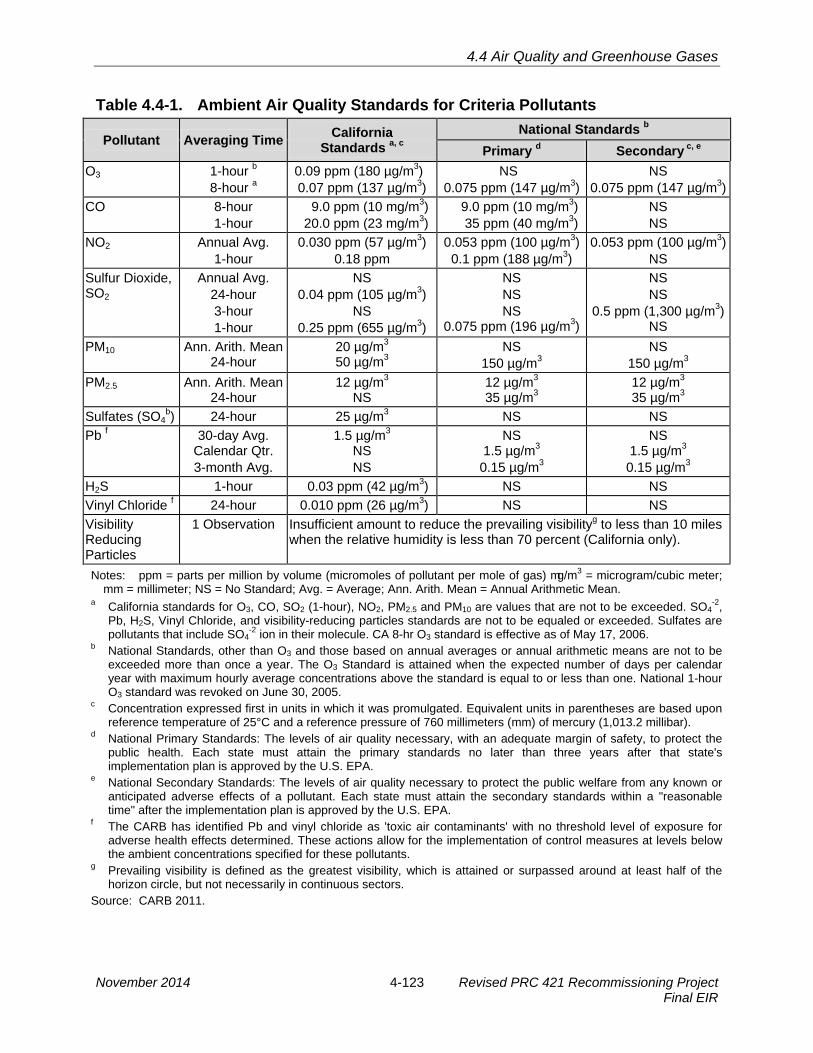
4.4 Air Quality and Greenhouse Gases
Table 4.4-1. Ambient Air Quality Standards for Criteria Pollutants
Pollutant Averaging Time California
Standards a, c National Standards b
Primary d Secondary c, e O3 1-hour b
8-hour a 0.09 ppm (180 µg/m3) 0.07 ppm (137 µg/m3)
NS 0.075 ppm (147 µg/m3)
NS 0.075 ppm (147 µg/m3)
CO 8-hour 1-hour
9.0 ppm (10 mg/m3) 20.0 ppm (23 mg/m3)
9.0 ppm (10 mg/m3) 35 ppm (40 mg/m3)
NS NS
NO2 Annual Avg. 1-hour
0.030 ppm (57 µg/m3) 0.18 ppm
0.053 ppm (100 µg/m3) 0.1 ppm (188 µg/m3)
0.053 ppm (100 µg/m3) NS
Sulfur Dioxide, SO2
Annual Avg. 24-hour 3-hour 1-hour
NS 0.04 ppm (105 µg/m3)
NS 0.25 ppm (655 µg/m3)
NS NS NS
0.075 ppm (196 µg/m3)
NS NS
0.5 ppm (1,300 µg/m3) NS
PM10 Ann. Arith. Mean 24-hour
20 µg/m3 50 µg/m3
NS 150 µg/m3
NS 150 µg/m3
PM2.5 Ann. Arith. Mean 24-hour
12 µg/m3 NS
12 µg/m3 35 µg/m3
12 µg/m3 35 µg/m3
Sulfates (SO4b) 24-hour 25 µg/m3 NS NS
Pb f 30-day Avg. Calendar Qtr. 3-month Avg.
1.5 µg/m3 NS NS
NS 1.5 µg/m3
0.15 µg/m3
NS 1.5 µg/m3
0.15 µg/m3 H2S 1-hour 0.03 ppm (42 µg/m3) NS NS Vinyl Chloride f 24-hour 0.010 ppm (26 µg/m3) NS NS Visibility Reducing Particles
1 Observation Insufficient amount to reduce the prevailing visibilityg to less than 10 miles when the relative humidity is less than 70 percent (California only).
Notes: ppm = parts per million by volume (micromoles of pollutant per mole of gas) mg/m3 = microgram/cubic meter; mm = millimeter; NS = No Standard; Avg. = Average; Ann. Arith. Mean = Annual Arithmetic Mean.
a California standards for O3, CO, SO2 (1-hour), NO2, PM2.5 and PM10 are values that are not to be exceeded. SO4-2,
Pb, H2S, Vinyl Chloride, and visibility-reducing particles standards are not to be equaled or exceeded. Sulfates are pollutants that include SO4
-2 ion in their molecule. CA 8-hr O3 standard is effective as of May 17, 2006. b National Standards, other than O3 and those based on annual averages or annual arithmetic means are not to be
exceeded more than once a year. The O3 Standard is attained when the expected number of days per calendar year with maximum hourly average concentrations above the standard is equal to or less than one. National 1-hour O3 standard was revoked on June 30, 2005.
c Concentration expressed first in units in which it was promulgated. Equivalent units in parentheses are based upon reference temperature of 25°C and a reference pressure of 760 millimeters (mm) of mercury (1,013.2 millibar).
d National Primary Standards: The levels of air quality necessary, with an adequate margin of safety, to protect the public health. Each state must attain the primary standards no later than three years after that state's implementation plan is approved by the U.S. EPA.
e National Secondary Standards: The levels of air quality necessary to protect the public welfare from any known or anticipated adverse effects of a pollutant. Each state must attain the secondary standards within a "reasonable time" after the implementation plan is approved by the U.S. EPA.
f The CARB has identified Pb and vinyl chloride as 'toxic air contaminants' with no threshold level of exposure for adverse health effects determined. These actions allow for the implementation of control measures at levels below the ambient concentrations specified for these pollutants.
g Prevailing visibility is defined as the greatest visibility, which is attained or surpassed around at least half of the horizon circle, but not necessarily in continuous sectors.
Source: CARB 2011.
November 2014 4-123 Revised PRC 421 Recommissioning Project Final EIR

4.4 Air Quality and Greenhouse Gases
Table 4.4-2. Ambient Air Quality Summary for Project Area (2010 through 2012) and Attainment Status of Santa Barbara County (2012)
Maximum Observed Concentration (# of Days Standard was Exceeded)a
Pollutant Year Goleta - Fairview Santa Barbara
O3, ppm
1-hour 8-hour 2010 0.072 (0)
0.065 (0) 0.075 (0) 0.062 (0)
1-hour 8-hour 2011 0.091 (0)
0.076 (1 day) 0.089 (0) 0.077 (1 day)
1-hour 8-hour 2012 0.065 (0)
0.056 (0) 0.071 (0) 0.058 (0)
CO, ppm 8-hour 2010 0.56 (0) 1.07 (0) 8-hour 2011 0.57 (0) 1.89 (0) 8-hour 2012 0.65 (0) b (0)
NO2, ppm
1-hour Annual Average 2010 0.044 (0)
0.006 0.090 (0)
0.009 1-hour
Annual Average 2011 0.052 (0) 0.006
0.049 (0) 0.010
1-hour Annual Average 2012 0.041 (0)
b (0) 0.048 (0)
b (0) SO2 No data available (monitoring station does not monitor this pollutant)
PM2.5, µg/m3
24-hour Ann. Arith. Mean 2010 23.6 (0)
8.2 17.4 (0)
b
24-hour Ann. Arith. Mean 2011 18.4 (0)
8.4 b
b
24-hour Ann. Arith. Mean 2012 29.0 (0)
9.0 b
b
PM10, µg/m3
24-hour Ann. Arith. Mean 2010 45.2 (0)
b57.6 (3 days)
b
24-hour Ann. Arith. Mean 2011
70.0 (2 days) b
69.4 (3 days) 25.0
24-hour Ann. Arith. Mean 2012
48.0 (0) 18.8
59.2 (2 days) b
Attainment Status 1-hour O3
c 8-hour O3 CO NO2 SO2 PM2.5 PM10 CA Fed CA Fed CA Fed CA Fed CA Fed CA Fed CA Fed A N/A N U/A A U/A A U/A A U/A U U/A N U/A
Notes: The values are provided in the units promulgated by the U.S. EPA. CA = California State Standards; A = Attainment of Standards; N = Nonattainment; U = Unclassified; U/A = Unclassified/Attainment, NA = not applicable. Ann. Arith. Mean = Annual Arithmetic Mean.
a Number or percent of exceedances of the most restrictive standard (usually, the State Standard). b Insufficient data available to determine value. c National 1-hour O3 standard was revoked on June 30, 2005, with all applicable designations. Source: CARB 2013; Santa Barbara County APCD 2013.
Revised PRC 421 Recommissioning Project 4-124 November 2014 Final EIR

4.4 Air Quality and Greenhouse Gases
Ozone (O3). The most widespread air quality problem in the State, O3, is a colorless gas 1 with a pungent, irritating odor. O3 is not emitted directly into the atmosphere; it is formed 2 primarily when reactive organic compounds (ROCs) and nitrous oxide (NOx) react in the 3 presence of sunlight. O3 may pose its worst health threat to those who already suffer 4 from respiratory diseases; however, it also harms healthy people. The health effects of 5 O3 can include reduced lung function, aggravated existing respiratory illness, and 6 irritated eye, nose, and throat tissues. Chronic exposure can cause permanent damage 7 to the alveoli of the lungs. 8
Sulfur Dioxide (SO2). SO2 is a colorless gas. At high concentrations, it has a pungent, 9 irritating odor. In the atmosphere, it reacts with oxidants or particles to form sulfates and 10 sulfuric acid particles in equilibrium, both of which are more hazardous than the original 11 SO2. The main sources of SO2 are fuel burning and metal ore processing. Sulfur is an 12 impurity in fossil fuels (especially coal) and in many ores. Santa Barbara County has 13 been in attainment with the California and national SO2 standards for the last 10 years. 14
Lead (Pb). Pb in the atmosphere occurs as PM. The combustion of leaded gasoline is 15 the primary source of Pb emissions in the South Coast Air Basin. Other sources of Pb 16 include the manufacturing of batteries, paint, ink, ceramics, and ammunition and 17 secondary Pb smelters. With the phase-out of leaded gasoline, secondary Pb smelters, 18 battery recycling, and manufacturing facilities are becoming Pb emission sources of 19 greater concern. Prolonged exposure to atmospheric Pb poses a serious threat to 20 human health. Health effects associated with exposure to Pb include gastrointestinal 21 disturbances, anemia, kidney disease, and in severe cases, neuromuscular and 22 neurological dysfunction. Of particular concern are low-level Pb exposures during 23 infancy and childhood. Such exposures are associated with decrements in 24 neurobehavioral performance (including intelligence quotient performance, psychomotor 25 performance, and reaction time) and growth. The county is in attainment with the 26 NAAQS and the CAAQS for Pb. 27
Nitrogen Dioxide (NO2). NO2 is a by-product of fuel combustion that absorbs blue light, 28 resulting in a brownish-red cast to the atmosphere and reduced visibility, and that 29 contributes to the formation of PM10. The principal form of nitrogen oxide (NO) produced 30 by combustion is nitric acid, but NO reacts quickly to form NO2 and NOx (a mixture of 31 NO and NO2). NO2 acts as an acute irritant, but is only potentially irritating at 32 atmospheric concentrations. There is some indication of a relationship between NO2 33 and chronic pulmonary fibrosis, while some increase in bronchitis in children (2 to 3 34 years old) has been observed at concentrations below 0.3 ppm. Santa Barbara County 35 is in attainment of the California and national 1-hour and 8-hour NO2 standards. 36
Carbon Monoxide (CO). Automobiles and other types of motor vehicles are the main 37 source of CO pollution in Santa Barbara County. CO gas is colorless and odorless, 38 which adds to its danger. CO concentrations typically peak nearest a source, such as 39
November 2014 4-125 Revised PRC 421 Recommissioning Project Final EIR

4.4 Air Quality and Greenhouse Gases
roadways, and decrease rapidly as distance from the source increases. In high 1 concentrations, CO can cause physiological and pathological changes, and ultimately 2 death, by incapacitating the red blood cells and interfering with their ability to carry 3 oxygen to body tissues. The symptoms of excessive exposure – headaches, fatigue, 4 slow reflexes, and dizziness – also can occur in healthy people. Santa Barbara County 5 is in attainment of the California and national one-hour and eight-hour CO standards. 6
Fine Particulate Matter (PM10 and PM2.5). PM10 and PM2.5 consist of extremely small 7 suspended particles or droplets that are 10 and 2.5 micrometers or smaller, 8 respectively, in diameter that can lodge in the lungs and contribute to respiratory 9 problems. PM10 and PM2.5 arise from such sources as road dust, diesel soot, 10 combustion products, abrasion of tires and brakes, demolition operations, and 11 windstorms. They also are formed in the atmosphere from NO2 and SO2 reactions with 12 ammonia. PM10 and PM2.5 scatter light and significantly reduce visibility. PM10 and PM2.5 13 pose a serious health hazard, alone or in combination with other pollutants. More than 14 half of the smallest particles inhaled would be deposited in the lungs and can cause 15 permanent lung damage. Fine particulates also can have a damaging effect on health 16 by interfering with the body’s mechanism for clearing the respiratory tract or by acting as 17 a carrier of an absorbed toxic substance. Santa Barbara County is in exceedance of the 18 California annual arithmetic mean and 24-hour PM10 standards (see Table 4.4-3). Santa 19 Barbara County is Unclassified for the recently added State PM2.5 Standard. 20
Hydrogen Sulfide (H2S). H2S is an odorous, toxic, gaseous compound that can be 21 detected by humans at very low concentrations. Concentrations detectable by smell 22 (this can vary from 0.5 parts per billion [ppb] detected by 2 percent of the population to 23 40 ppb, qualified as annoying by 50 percent of the population) are significantly lower 24 than concentrations that could affect human health (2 ppm [2,000 ppb] can cause 25 headaches and increased airway resistance in asthmatics; inhalation of 600 ppm is 26 lethal). The gas is produced during the decay of organic material and is also found 27 naturally in petroleum and natural gas. The county is in attainment of the H2S standard. 28
Toxic Air Contaminants (TACs). TACs are compounds that are known or suspected to 29 cause short-term (acute) and/or long-term (chronic non-carcinogenic or carcinogenic) 30 adverse health effects. Vulnerable subpopulations are those with preexisting respiratory 31 or cardiovascular disease, especially the elderly, while increased hospital admissions 32 and morbidity from respiratory disease have been associated with PM exposure in 33 adults and children. PM exposure is also associated with an increased risk of lung 34 cancer in epidemiological studies (CARB 2005). Sources of TACs within Santa Barbara 35 County include industrial processes, gasoline stations, paint/solvent operations, and 36 fossil fuel combustion. In 1998, CARB identified diesel particulate matter (DPM) as a 37 TAC based on its potential to cause cancer, premature deaths, and other health 38 problems. DPM is a by-product of the diesel fuel combustion process that is emitted in 39 exhaust from construction heavy equipment, trucks, marine vessels, and other sources. 40
Revised PRC 421 Recommissioning Project 4-126 November 2014 Final EIR

4.4 Air Quality and Greenhouse Gases
Regional Emissions 1
Emissions within the County are estimated annually by the APCD. Table 4.4-3 lists the 2 estimated emissions by source category. 3
Notes: MT/yr = metric tons per year. ROC and NOx from 2010 Clean Air Plan and reflect the year 2007; CO, SO2 and PM10 are no longer included in the
Clean Air Plan inventory and are from the 2002 Clean Air Plan Update Emissions Inventory representing 1999. a Petroleum activities are a part of Stationary Sources. Source: Santa Barbara County APCD 2002, 2011a.
Odor Issues Associated with Oil and Gas Production Facilities and PRC 421 4
Oil production facilities typically produce odors that can be objectionable to the public, 5 and of particular concern is H2S. Other Ellwood area oil facilities, including the Ellwood 6 Marine Terminal (EMT) and barges which are not part of the Project, have historically 7 produced odors that have generated complaints from the public. Approximately 50 8 complaints regarding odors from the EMT were received from 2005 to 2011, a 9 frequency of approximately eight complaints per year. The EOF has also generated 10 complaints and has been the subject of an abatement order from APCD. There were 11 two occurrences of odor complaints associated with EOF operations in 2007. One 12 complaint occurred on October 29, 2007, and the exact source of the release was not 13 confirmed, although a low-level H2S alarm near the edge of the Venoco's property line 14 was triggered. The other complaint occurred on November 14, 2007, and was attributed 15 to gas released from a water settling tank (T-201) and an oil shipping tank (T-202). An 16 H2S leak on February 11, 2010, also resulted in odor complaints, and was due to a tank 17 valve that was left open during maintenance on a compressor in the gas plant. 18 Automated systems shut down gas operations at Platform Holly and the EOF, until 19 APCD authorized restart later in the day. On May 31, 2010, the 16-inch main Lo-Cat 20 solution line came apart which resulted in the immediate shutdown of the Lo-Cat 21 process. The Lo-Cat process uses a non-hazardous chelated iron solution to convert 22
Table 4.4-3. Emission Inventory for Santa Barbara County Emission Sources a
CO (MT/yr)
ROC (MT/yr)
NOx (MT/yr)
SO2(MT/yr)
PM10 (MT/yr)
Onshore
Stationary 1,551 3,244 2,843 552 554 Area-Wide 9,433 3,051 333 8 10,584 Mobile 82,532 5,039 11,047 305 572 Natural 11,404 47,378 8,707 0 1,843 Total Onshore 103,369 58,712 22,930 865 13,553
Offshore
Stationary N/A 303 213 N/A N/A Mobile N/A 914 18,017 N/A N/A Natural N/A 2,004 0 N/A N/A Total Offshore N/A 3,221 18,230 - -
All Sources - 61,933 41,160 - -
November 2014 4-127 Revised PRC 421 Recommissioning Project Final EIR

4.4 Air Quality and Greenhouse Gases
H2S from the Platform Holly gas stream to elemental sulfur. The location of the leak was 1 the LoCat Unit, upstream of where the solution contacts the platform gas. As such, no 2 platform gas was released to the atmosphere. The leak caused some of the solution to 3 spray on to the fence, frontage road and some shrubbery. One fence line odor sensor 4 was activated at <1 ppm (City of Goleta 2011). 5
Some odor events could be attributed to natural gas seeps (a documented phenomenon 6 caused by the leaking of oil and gas from the sea-floor) near Platform Holly and offshore 7 of the Ellwood Coast. Off Coal Oil Point, portions of these seeps are captured by a large 8 subsea metal pyramid “tent” installed in the 1980s. However, natural seeps also occur 9 in other locations off of Coal Oil Point where they are not captured but escape into the 10 atmosphere, and create odors if H2S is present in the gas. 11
As noted in Section 4.2, Safety, “sweet” crude oil, with low sulfur content (below 0.6 12 percent) and low H2S content, is produced from PRC 421 (the H2S content in PRC 421 13 gas is approximately 10 ppm, below levels at which H2S is considered to be a potential 14 source of injury to humans [see Section 4.2, Safety, for a complete discussion]). Crude 15 produced from the South Ellwood Field (Platform Holly) contains much higher 16 concentrations of sulfur and H2S (see Table 4.2-2). The crude oil that would be 17 produced by the Project and transported through Line 96 would not be a source of acute 18 toxic impacts to human receptors if released and is not expected to be a source of 19 odors that would be a nuisance to the public. 20
Greenhouse Gases (GHGs) and Global Climate Change 21
Global climate change is a change in the average weather of the earth which can be 22 measured by wind patterns, storms, precipitation, and temperature. Scientific 23 consensus has identified that the human-related emission of GHGs above natural levels 24 is a significant contributor to global climate change. GHGs are any gases that absorb 25 infrared radiation in the atmosphere, including water vapor, carbon dioxide (CO2), 26 methane (CH4), nitrous oxide (N2O), fluorocarbons, and O3. GHGs lead to the trapping 27 and buildup of heat in the atmosphere near the earth’s surface, known as the 28 Greenhouse Effect. The atmosphere and the oceans are reaching their capacity to 29 absorb CO2 and other GHGs without significantly changing the earth’s climate. The 30 increase in GHGs in the earth’s climate is projected to substantially affect a wide range 31 of issues and resources, including sea level rise, flooding, water supply, agricultural and 32 forestry resources, and energy demand. California’s Climate Change Portal 33 (www.climatechange.ca.gov) states: 34
Climate change is expected to have significant, widespread impacts on California's 35 economy and environment. California's unique and valuable natural treasures - 36 hundreds of miles of coastline, high value forestry and agriculture, snow-melt fed 37 fresh water supply, vast snow and water fueled recreational opportunities, as well as 38 other natural wonders - are especially at risk. 39
Revised PRC 421 Recommissioning Project 4-128 November 2014 Final EIR

4.4 Air Quality and Greenhouse Gases
In addition, the Intergovernmental Panel on Climate Change (IPCC), in the section of its 1 Fifth Assessment Report by Working Group II, “Climate Change 2014: Impacts, 2 Adaptation, and Vulnerability,” (IPCC 2014; released March 31, 2014) specific to North 3 America (Chapter 26), stated in part: 4
North American ecosystems are under increasing stress from rising 5 temperatures, CO2 concentrations, and sea-levels, and are particularly 6 vulnerable to climate extremes (very high confidence). Climate stresses occur 7 alongside other anthropogenic influences on ecosystems, including land-use 8 changes, non-native species, and pollution, and in many cases will exacerbate these 9 pressures (very high confidence). [26.4.1; 26.4.3]. Evidence since the Fourth 10 Assessment Report (IPCC 2007) highlights increased ecosystem vulnerability to 11 multiple and interacting climate stresses in forest ecosystems, through wildfire 12 activity, regional drought, high temperatures, and infestations (medium confidence) 13 [26.4.2.1; Box 26-2]; and in coastal zones due to increasing temperatures, ocean 14 acidification, coral reef bleaching, increased sediment load in run-off, sea level rise, 15 storms, and storm surges (high confidence) [26.4.3.1]. 16
California has already been affected by climate change: sea level rise, increased 17 average temperatures, more extreme hot days and increased heat waves, fewer shifts 18 in the water cycle, and increased frequency and intensity of wildfires. Higher sea levels 19 can result in increased coastal erosion (which may have a secondary effect such as 20 uncovering hazards such as occurred in March 2014 along the Santa Barbara 21 coastline), more frequent flooding from storm surges, increased property damage, and 22 reduced waterfront public access options. Other projected climate change impacts in 23 California include: decreases in the water quality of surface water bodies, groundwater, 24 and coastal waters; decline in aquatic ecosystem health; lowered profitability for water-25 intensive crops; changes in species and habitat distribution; and impacts to fisheries 26 (California Regional Assessment Group 2002). These effects are expected to increase 27 with rising GHG levels in the atmosphere. 28
Fossil fuel combustion represents the vast majority of the anthropogenic GHG 29 emissions, with CO2 being the primary GHG. In 2010, total U.S. GHG emissions were 30 6,822 million metric tons7 (MMT) of carbon equivalents, of which 84 percent were CO2 31 emissions; approximately 33 percent of these GHG emissions were associated with 32 electricity generation, and approximately 26 percent were associated with transportation 33 (EPA 2012). About half of the electricity in the U.S. is generated from coal, producing a 34 U.S. GHG emissions rate of about 1,363 pounds per megawatt hour (lbs/MWh); this 35 rate is lower for western states, primarily due to the increased use of hydroelectric and 36 natural gas. The California Independent Service Operator area (which includes some 37 generation outside of California) has a GHG emission rate of about 687 lbs/MWh due to 38 the contribution of hydroelectric, nuclear and renewable sources. 39
7 A metric ton, or tonne, is a unit of weight equivalent to 1,000 kilograms (2,205 pounds) versus an Imperial unit ton which is the equivalent of 2,000 pounds (907 kilograms).
November 2014 4-129 Revised PRC 421 Recommissioning Project Final EIR

4.4 Air Quality and Greenhouse Gases
The majority of California’s GHG emissions (81%) are CO2 produced from fossil fuel 1 combustion (CARB 2008). In 2012, California’s gross GHG emissions totaled 458.68 2 MMT of CO2 equivalents (MMTCO2e), with the transportation sector the largest category 3 (167.38 MMTCO2e, 36%) followed by electrical power generation (95.09 MMTCO2e, 4 21%), industry (89.16 MMTCO2e, 19%), commercial/residential (42.28 MMTCO2e, 9%), 5 and agriculture (37.86 MMTCO2e, 8%) (CARB 2014; www.arb.ca.gov/cc/inventory/data/ 6 tables/ghg_inventory_scopingplan_00-12_2014-03-24.pdf.8 7
According to the IPCC, the concentration of CO2, the primary GHG, has increased from 8 approximately 280 parts per million (ppm) in pre-industrial times to well over 380 ppm. 9 The current rate of increase in CO2 concentrations is about 1.9 ppm/year; present CO2 10 concentrations are higher than any time in at least the last 650,000 years. To meet the 11 statewide GHG reduction target for 2020, requiring California to reduce its total 12 statewide GHG emissions to the level they were in 1990 (Health & Saf. Code, § 38550), 13 and the 2050 goal of 80 percent below 1990 levels (Executive Order S-3-05), not only 14 must projects contribute to slowing the increase in GHG emissions, but, ultimately, 15 projects should contribute to reducing the State’s output of GHGs. To reach California’s 16 GHG reduction targets, it is estimated that per capita emissions will need to be reduced 17 by slightly less than 5 percent per year during the 2020 to 2030 period, with continued 18 reductions required through midcentury. 19
In its 2008 “Report on Climate Change: Evaluating and Addressing Greenhouse Gas 20 Emissions from Projects Subject to the California Environmental Quality Act,” the 21 California Air Pollution Control Officers Association (CAPCOA) stated: 22
[w]hile it may be true that many GHG sources are individually too small to make any 23 noticeable difference to climate change, it is also true that the countless small 24 sources around the globe combine to produce a very substantial portion of total 25 GHG emissions (CAPCOA 2008). 26
The global warming potential (GWP), or potential of a gas or aerosol to trap heat in the 27 atmosphere, of different GHGs varies since GHGs absorb different amounts of heat. A 28 common reference gas, CO2, is used to relate the amount of heat absorbed to the 29 amount of the gas emissions, referred to as CO2 equivalent (CO2e). CO2e is the amount 30 of GHG emitted multiplied by the GWP. The GWP of CO2 is therefore defined as 1. 31 Methane has a GWP of 21; therefore, 1 pound of methane produce 21 pounds of CO2e. 32 Table 4.4-4 shows a range of gases with their associated GWP, their estimated lifetime 33 in the atmosphere, and the range in GWP over 20, 100, and 500 years. 34
GHG emissions are generally classified as direct and indirect. Direct emissions are 35 associated with the production of GHG emissions in the immediate Project area, and 36
37
include combustion of natural gas, combustion of fuel in engines and construction
8 Not all GHG sources are included, so the components do not add up to the total.
Revised PRC 421 Recommissioning Project 4-130 November 2014 Final EIR

4.4 Air Quality and Greenhouse Gases
Table 4.4-4. Global Warming Potential of Various Gases
Gas Life in Atmosphere (years)
20-year GWP (avg)
100-year GWP (avg)
500-year GWP (avg)
Carbon dioxide 50-200 1 1 1 Methane 12 21 56 6.5 Nitrous oxide 120 310 280 170 HFC-23 264 11,700 9,100 9,800 HFC-125 32.6 2,800 4,600 920 HFC-134a 14.6 1,300 3,400 420 HFC-143a 48.3 3,800 5,000 1,400 HFC-152a 1.5 140 460 42 HFC-227ea 36.5 2,900 4,300 950 HFC-236fa 209 6,300 5,100 4,700 HFC-4310mee 17.1 1,300 3,000 400 CF4 50,000 6,500 4,400 10,000 C2F6 10,000 9,200 6,200 14,000 C4F10 2,600 7,000 4,800 10,100 C6F14 3,200 7,400 5,000 10,700 SF6 3,200 23,900 16,300 34,900 Source: EPA 2007. GWP = Global Warming Potential; avg = average; CF = chlorfluorocarbon; HFC = hydroflourocarbon.
vehicles, and fugitive emissions from valves and connections of equipment used during 1 Project implementation or throughout the Project life. Indirect emissions include 2 emissions from vehicles (both gasoline and diesel). 3
4.4.2 Regulatory Setting 4
A summary of the Federal and State regulatory setting for air quality is provided in Table 5 4.0-1, while the local regulatory setting is discussed below. 6
Local 7
Santa Barbara County Air Pollution Control District (APCD) 8
As directed by the Federal and State Clean Air Acts, local air districts are required to 9 prepare plans with strategies for attaining and maintaining State and Federal O3 10 standards. To ultimately achieve the air quality standards, the rules and regulations limit 11 emissions and permissible impacts from activities within the local air districts. Some 12 rules also specify emission controls and control technologies for each type of emitting 13 source. The regulations also include requirements for obtaining an Authority to 14 Construct (ATC) permit and a Permit to Operate (PTO). 15
The Santa Barbara County APCD is the agency with jurisdiction over air quality 16 attainment in the County. The Project would be permitted as a stationary source, and all 17 aspects of the Project and alternatives occurring in the County must obtain an APCD 18 permit, if applicable. Increases in emissions of any non-attainment pollutant or its pre-19
November 2014 4-131 Revised PRC 421 Recommissioning Project Final EIR

4.4 Air Quality and Greenhouse Gases
cursor from a new or modified project that exceed thresholds identified in APCD Rule 1 802.E are required to be mitigated. Specific APCD permit requirements such as Best 2 Available Control Technology (BACT) would be addressed in the APCD permit process. 3
City of Goleta Climate Action Plan 4
The City of Goleta Climate Action Plan was developed as a response to the statewide 5 reduction goal outlined in Assembly Bill (AB) 32, also known as the Global Warming 6 Solutions Act of 2006 (Health & Saf. Code, § 38500 et seq.). The Scoping Plan for AB 7 32, developed and implemented by the CARB, identifies specific measures to achieve 8 these reductions and recommends that local governments establish GHG reduction 9 targets for both their municipal operations and the community that are consistent with 10 those of the State. The City’s Climate Action Plan meets the requirements of AB 32 and 11 Executive Order S-3-05. In order to reduce above GHG emissions, the Climate Action 12 Plan includes reduction measures of GHG sources for building energy, water 13 consumption, on-road and off-road transportation, and solid waste. 14
4.4.3 Significance Criteria 15
Construction Thresholds 16
Emissions from construction activities are generally short-term and temporary. Neither 17 the City of Goleta nor the APCD have daily or quarterly quantifiable emission thresholds 18 established for short-term construction emissions. Pursuant to APCD Rule 202, 19 construction emissions of any criteria pollutant (except CO) that has the potential to 20 exceed 25 tons per year in a 12-month period would require that the owner of the 21 stationary source provide offsets, per Rule 804. In the absence of adopted thresholds, 22 25 tons per year is used as the significance threshold for construction emissions of 23 ROG and NOx. PM10 emissions should be estimated and standard MMs implemented, 24 as required in the Santa Barbara County APCD (2005) Air Quality Attainment Plan. 25
Operational Thresholds 26
PRC 421 has not been operational and has not produced emissions since 1994 when 27 the facility was temporarily shut in to complete emergency repairs and clean-up, 28 following the discovery a leak in the PRC 421 6-inch line. Therefore, for the purposes of 29 this analysis, impacts to air quality from operations are compared to the existing 30 physical environmental baseline which is zero emissions. The APCD guidelines only 31 contain a peak daily emission threshold for criteria pollutants. Operations at Pier 421-2 32 would not result in substantial increase in peak daily emissions. However, the Project 33 would result in greater annual emissions. Therefore, to address potential long-term air 34 quality impacts, Project emissions were compared to an annual emission threshold. 35 Impacts are considered to be to be significant if operation of the Project would: 36
Revised PRC 421 Recommissioning Project 4-132 November 2014 Final EIR
4.4 Air Quality and Greenhouse Gases
· Emit from all Project sources, both stationary and mobile, more than the daily1 trigger for offsets or Air Quality Impact Analysis set in the APCD New Source2 Review Rule for pollutants (i.e., 240 lbs/day for ROC or NOx; 80 lbs/day for PM10.3 (CO, is an attainment pollutant and doesn’t have a daily operational threshold);4
· Emit more than 25 tons per year of any one criteria pollutant;5
· Emit more than 25 pounds per day of NOx or ROC from motor vehicle trips only;6
· Cause or contribute to a violation of any CAAQS or NAAQS (except ozone);7
· Exceed APCD Board-adopted health risk public notification thresholds; or8
· Not be consistent with the adopted Federal and State air quality plans for Santa9 Barbara County.10
Cumulative impacts would be deemed significant if the Project is found to have an 11 individually significant air quality impact. 12
Greenhouse Gas Thresholds 13
The SBCAPCD does not currently have a formally adopted GHG threshold; however, 14 CSLC staff recommend that Project-generated GHG impacts would be potentially 15 significant if any net Project-related increase in CO2e, occurred annually (i.e., a zero 16 emissions threshold for GHG emissions above baseline). The zero emissions threshold 17 assures that the Project would not contribute to any net increase in GHG emissions 18 over the current facility baseline, and would not impede further progress in meeting the 19 AB 32 mandated reductions and the S-3-05 Executive Order goal of an 80 percent 20 reduction by 2050. 21
4.4.4 Impact Analysis and Mitigation 22
The analysis of air quality impacts follows guidance provided by the Santa Barbara 23 County APCD Scope and Content of Air Quality Sections in Environmental Documents 24 (2011) and the State CEQA Guidelines. Air quality impacts associated with 25 recommissioning Pier 421-2 and decommissioning and removal of Pier 421-1 are 26 expected as a result of Project construction and operations. Project construction 27 emissions would include particulate and combustion emissions associated with 28 trenching for the purpose of installing new power cables and repairing the existing 6-29 inch line, and combustion of fossil fuels from travel on access roads, operation of the 30 drill rig during installation of the electric submersible pump (ESP), and operation of other 31 construction equipment during repairs to the caisson wall. Decommissioning and 32 removal of Pier 421-1 approximately 1 year after PRC 421 recommissioning would also 33 result in particulate and combustion emissions from operation of construction equipment 34 and earthwork related to demolition and removal of the pier and caisson. 35
November 2014 4-133 Revised PRC 421 Recommissioning Project Final EIR

4.4 Air Quality and Greenhouse Gases
Emissions from the Project, including decommissioning and removal of Pier 421-1, were 1 estimated using emission factors and equipment estimates from Venoco Inc.’s 2 Recommissioning Plan for Lease PRC 421 (May 2013). Operational emissions from 3 primary Project components would consist primarily of fugitive emissions from valves, 4 piping components, well heads, well cellars, and processing equipment at the EOF. 5 Operational emissions from secondary Project components would consist primarily of 6 fugitive emissions related to pipeline transport. Operational emissions from oil 7 transportation were calculated using emissions factors from the Line 96 Modification 8 Project EIR and those provided by Santa Barbara County APCD. Table 4.4-8, located at 9 the end of Section 4.4.4, provides a summary of air quality-related impacts and 10 recommended MMs to address these impacts. 11
Impact AQ-1: Increase in Emissions from Construction 12 Project construction could potentially result in increased emissions at the Project 13 site (Less than Significant). 14
Impact Discussion 15
Project construction would generate temporary air pollutant emission from a variety of 16 activities, including trenching, heavy construction equipment use, construction worker 17 trips, hauling of demolition material, delivery of building materials and equipment, and 18 future removal of existing structures, including from decommissioning and removal of 19 Pier 421-1. Table 4.4-5 shows the estimated emissions associated with Project 20 construction and following decommissioning and removal of Pier 421-1. The equipment 21 list was taken from Venoco’s Lease 421 Recommissioning Plan (May 2013). 22
Table 4.4-5. Estimated Project Construction Emissions Emission Source NOx tons ROC tons CO tons SO2 tons PM10 tons
2014
On-site Construction Emissions 6.36 0.74 3.06 0.007 0.28 Construction Traffic Emissions <0.01 0.00 0.03 0.00 0.06 Total 6.36 0.74 3.06 0.007 0.34
Significance Thresholds (tons/year) 25 25 25 25 25 Are Thresholds Exceeded? No No No No No
2015
On-site Construction Emissions 0.064 0.01 0.05 0.00 0.0075 Construction Traffic Emissions 0.002 0.00 0.005 0.00 0.105 Total 0.066 0.01 0.06 0.00 0.112
Significance Thresholds (tons/year) 25 25 25 25 25 Are Thresholds Exceeded? No No No No No
Note: Calculations include emissions from construction equipment and vehicles traveling to and from the site, including 10 trucks bringing supplies, 10 trucks hauling material to the recycling facility in Ventura, and 40 worker trips per day (this is a conservative estimate relative to the 12 workers that are estimated to be needed for Project construction). Additionally, emissions from 40 haul trips for decommissioning and removal activities in 2015 are included. Recommissioning activities in 2014 are assumed to occur over 90 days, and decommissioning activities in 2015 are assumed to occur over 30 days.
Revised PRC 421 Recommissioning Project 4-134 November 2014 Final EIR
4.4 Air Quality and Greenhouse Gases
Construction would occur over an estimated 90 days, 8 hours per day, 5 days per week, 1 with decommissioning and removal of Pier 421-1 requiring 30 days and occurring 1 year 2 after PRC 421 recommissioning. Project emissions (including from Pier 421-1 3 decommissioning/removal) are included in the following analysis. Assumptions are 4 shown in the table and footnotes. As indicated in Table 4.4-5, Project construction 5 would generate emissions due to construction equipment use and traffic associated with 6 construction workers, equipment/supply deliveries, and demolition debris hauling. Over 7 the Project life, including emissions from both Project construction in 2014 and Pier 421-8 1 decommissioning and removal in 2015, worst-case emissions from construction 9 activities are estimated at 6.426 tons for NOx, 0.75 tons for ROC, 3.12 tons for CO, 10 0.007 tons for SO2, and 0.452 tons for PM10. 11
As stated above, neither the City of Goleta nor the APCD have established thresholds 12 of significance for construction emissions, but the APCD generally considers emissions 13 of any criteria pollutant that exceed 25 tons per year to be significant. The emissions 14 from Project construction would be well below this level and therefore, impacts to air 15 quality from construction emissions would less than significant. Nevertheless, mitigation 16 is required by APCD policy for all construction activities to minimize emissions of ozone 17 precursors, fugitive dust, and particulate emissions from diesel exhaust. 18
Mitigation Measures 19
The estimated emissions presented in the table are shown without mitigation applied. 20 The following MMs should be incorporated into the construction phase of the Project, to 21 reduce impacts as much as feasible. 22
MM AQ-1a. Prohibit Unnecessary Truck Idling. The construction contractor shall 23 limit unnecessary truck idling on site in excess of five minutes. 24
MM AQ-1b. Use of Diesel Emission Reduction Measures. The construction 25 contractor shall implement the following measures, as feasible. 26 · Diesel construction equipment meeting the California Air Resources Board27
(CARB) Tier 1 emission standards for off-road heavy-duty diesel engines28 shall be used. Equipment meeting CARB Tier 2 or higher emission29 standards should be used to the maximum extent feasible.30
· Diesel powered equipment should be replaced by electric equipment31 whenever feasible.32
· If feasible, diesel construction equipment shall be equipped with selective33 catalytic reduction systems, diesel oxidation catalysts and diesel particulate34 filters as certified and/or verified by the U.S. Environmental Protection35 Agency (EPA) or California.36
· Catalytic converters shall be installed on gasoline-powered equipment, if37 feasible.38
· All construction equipment shall be maintained in tune per the39 manufacturer's specifications.40
November 2014 4-135 Revised PRC 421 Recommissioning Project Final EIR

4.4 Air Quality and Greenhouse Gases
· The engine size of construction equipment shall be the minimum practical 1 size.2
· The number of construction equipment operating simultaneously shall be3 minimized through efficient management practices to ensure that the4 smallest practical number is operating at any one time.5
· Construction worker trips should be minimized by requiring carpooling and6 by providing for lunch onsite.7
MM AQ-1c. Maintain Construction Equipment. All construction equipment shall be 8 properly maintained according to manufacturers’ specifications. 9
MM AQ-1d. Compliance with State Portable Air Toxics Control Measure. Any 10 portable diesel engines greater than 50 horsepower used in construction shall 11 comply with the State Portable Air Toxics Control Measure and be certified to 12 Tier 1, 2, or 3 non-road engine standards. 13
MM AQ-1e. Establish On-Site Equipment Staging Area and Worker Parking 14 Lots. The staging area and worker parking lots shall be restricted to either 15 paved surfaces or soil stabilized unpaved surfaces only. 16
MM AQ-1f. Fugitive Dust Management. Venoco shall implement the following 17 measures in accordance with requirements of the Santa Barbara Air Pollution 18 Control District. 19 · During construction, use water trucks or sprinkler systems to keep all areas20
of vehicle movement damp enough to prevent dust from leaving the site. At21 a minimum, this should include wetting down such areas in the late morning22 and after work is completed for the day. Increased watering frequency23 should be required whenever the wind speed exceeds 15 mph. Reclaimed24 water should be used whenever possible. However, reclaimed water should25 not be used in or around crops for human consumption.26
· Minimize amount of disturbed area and reduce on site vehicle speeds to 1527 miles per hour or less.28
· If importation, exportation and stockpiling of fill material is involved, soil29 stockpiled for more than two days shall be covered, kept moist, or treated30 with soil binders to prevent dust generation. Trucks transporting fill material31 to and from the site shall be tarped from the point of origin.32
· Gravel pads shall be installed at all access points to prevent tracking of33 mud onto public roads.34
· After clearing, grading, earth moving or excavation is completed, treat the35 disturbed area by watering, or revegetating, or by spreading soil binders36 until the area is paved or otherwise developed so that dust generation will37 not occur.38
· The contractor shall designate a person or persons to monitor the dust39 control program and to order increased watering, as necessary, to prevent40 transport of dust offsite. Their duties shall include holiday and weekend41 periods when work may not be in progress. The name and telephone42 number of such persons shall be provided to the Air Pollution Control43
Revised PRC 421 Recommissioning Project 4-136 November 2014 Final EIR

4.4 Air Quality and Greenhouse Gases
District prior to land use clearance for map recordation and land use 1 clearance for finish grading of the structure. 2
Rationale for Mitigation 3
Construction emissions would be reduced by idling time restrictions, using emission 4 reduction technologies, maintaining equipment in proper working order, compliance with 5 State measures calling for non-road engine standards certifications, fugitive dust control 6 measures, and reducing activity on unpaved surfaces. Particulate filters can reduce NOx7 emissions by 1.6 to 18 percent, and PM emissions by 20 to 62.9 percent. Combined use 8 of diesel particulate filters/catalysts are available for certain models of engines and 9 certain model years that can reduce diesel particulate emissions by 25 percent for Level 10 1 particulate controls, by 50 percent for Level 2 particulate controls (which includes 11 alternative fuels), and by 85 percent for Level 3 particulate controls. Certain diesel 12 particulate catalysts can also reduce NOx emissions by 25 percent. Use of alternative 13 diesel fuel would reduce NOx and PM emissions by 14 and 63 percent, respectively, 14 compared to use of conventional diesel (CARB 2001). Full implementation of these 15 measures would ensure Impact AQ-1 remains less than significant. 16
Impact AQ-2: Increase in Emissions from Operations 17 The Project would increase fugitive emissions from facilities at Pier 421-2, the 18 EOF, and the pipeline used to transport produced oil (Less than Significant). 19
Impact Discussion 20
Project operational emissions would consist primarily of fugitive emissions from piping 21 components, well heads and well cellars at Pier 421-2, as well as valves and other 22 components located along the pipelines used to transport the oil (Table 4.4-6). NOx is 23 not a pollutant associated with fugitive emissions from component leak paths and 24 therefore would not be emitted from these sources; however NOx operational emissions 25 from the EOF are currently 10 tons/year and would increase by 0.38 tons/year with 26 increased EOF operations for processing PRC 421 oil (see Appendix D). This would still 27 be below the 25 ton/year threshold for NOx. 28
Peak daily emissions are estimated to be well below daily thresholds of significance for 29 all criteria pollutants, and would be less than significant. These emissions would also 30 not reach the annual threshold of significance of 25 tons per year. 31
November 2014 4-137 Revised PRC 421 Recommissioning Project Final EIR

4.4 Air Quality and Greenhouse Gases
Table 4.4-6. Estimated Operational Emissions Pounds/Day Tons/Year
NOx ROC CO SOx PM10 NOx ROC CO SOx PM10 Fugitive Emissions from Pier1 N/A 2.096 - - -
N/A 0.583
0.383 - - -
Line 96 Pipeline Increased Throughput2 N/A N/A N/A N/A N/A N/A N/A N/A N/A N/A
Increased EOF Processing3
N/A 3.794
18.925 20.827 1.795 0.645 N/A
0.692 3.454 3.801 0.328 0.118
Total N/A
3.794 21.021 20.827 1.795 0.645
N/A 1.275
3.837 3.801 0.328 0.118
Significance Thresholds 55 55 NA NA 80 25 25 25 25 25
Thresholds Exceeded? No No NA NA No No No NA NA No 1 Refer to Appendix D for calculations of fugitive emissions. 2 Because the Line 96 Modification Project EIR (Santa Barbara County 2011) proposes to keep the
pipeline full at all times, the 3.6% increase in Project throughput would not be expected to increase fugitive pipeline emissions.
3 Based on increase of 150 barrels of oil per day (BOPD) from current operations at EOF as described in the Line 96 Modification Project Final EIR (Santa Barbara County 2011). Assumes increase in fugitive emissions would be linear with increased volume, which likely produces conservatively high estimates.
Mitigation Measures 1
None required. 2
Impact AQ-3: Odor Emissions from Operation 3 The Project could potentially result in increased nuisance odor events (Less than 4 Significant). 5
Impact Discussion 6
Releases of odorous compounds such as H2S or petroleum gases could create 7 nuisance odors affecting adjacent areas used for recreation, and residential areas within 8 0.6 mile and a school within 0.8 mile of the Project site. The potential for increased 9 odors from the introduction of PRC 421 crude oil into the Line 96 pipeline would be 10 minimal because the PRC 421 oil would represent only 3.61 percent of the total oil 11 transported through the pipeline, most of which is from Platform Holly, which produces 12 approximately 4,000 barrels of oil per day (BOPD) (City of Goleta 2013).9 Odor 13 nuisance due to increased venting resulting from mixing oils of different vapor pressures 14 is expected to minimally add to existing odors from oil well operation. Potential oil spills 15 could create objectionable odors due to evaporation of odorous compounds from the 16 spilled oil surface. However, oil produced from the PRC 421 is sweet and low in sulfur 17
9 Estimate is based on an estimated instantaneous production from PRC 421 not exceeding 500 BOPD and an average 150 BOPD for the first 2 years, dropping to 50 BOPD after this initial period.
Revised PRC 421 Recommissioning Project 4-138 November 2014 Final EIR
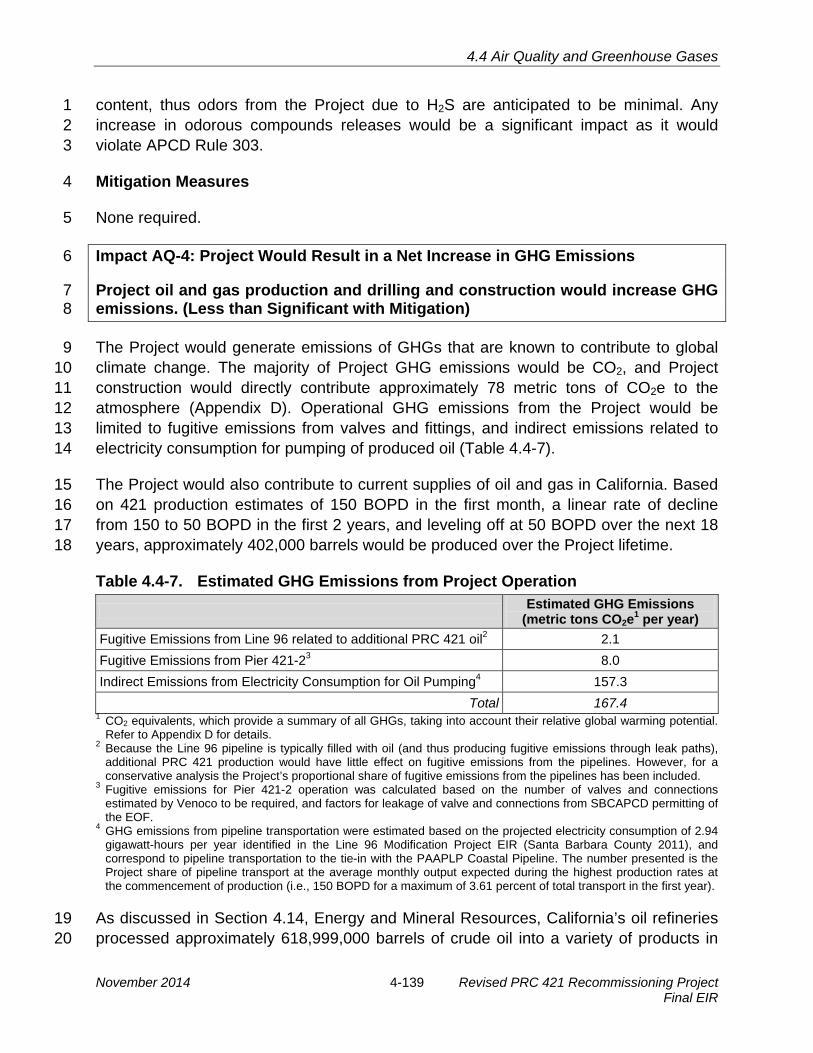
4.4 Air Quality and Greenhouse Gases
content, thus odors from the Project due to H2S are anticipated to be minimal. Any 1 increase in odorous compounds releases would be a significant impact as it would 2 violate APCD Rule 303. 3
Mitigation Measures 4
None required. 5
Impact AQ-4: Project Would Result in a Net Increase in GHG Emissions 6
Project oil and gas production and drilling and construction would increase GHG 7 emissions. (Less than Significant with Mitigation) 8
The Project would generate emissions of GHGs that are known to contribute to global 9 climate change. The majority of Project GHG emissions would be CO2, and Project 10 construction would directly contribute approximately 78 metric tons of CO2e to the 11 atmosphere (Appendix D). Operational GHG emissions from the Project would be 12 limited to fugitive emissions from valves and fittings, and indirect emissions related to 13 electricity consumption for pumping of produced oil (Table 4.4-7). 14
The Project would also contribute to current supplies of oil and gas in California. Based 15 on 421 production estimates of 150 BOPD in the first month, a linear rate of decline 16 from 150 to 50 BOPD in the first 2 years, and leveling off at 50 BOPD over the next 18 17 years, approximately 402,000 barrels would be produced over the Project lifetime. 18
Table 4.4-7. Estimated GHG Emissions from Project Operation Estimated GHG Emissions
(metric tons CO2e1 per year) Fugitive Emissions from Line 96 related to additional PRC 421 oil2 2.1 Fugitive Emissions from Pier 421-23 8.0 Indirect Emissions from Electricity Consumption for Oil Pumping4 157.3
Total 167.4 1 CO2 equivalents, which provide a summary of all GHGs, taking into account their relative global warming potential.
Refer to Appendix D for details. 2 Because the Line 96 pipeline is typically filled with oil (and thus producing fugitive emissions through leak paths),
additional PRC 421 production would have little effect on fugitive emissions from the pipelines. However, for a conservative analysis the Project’s proportional share of fugitive emissions from the pipelines has been included.
3 Fugitive emissions for Pier 421-2 operation was calculated based on the number of valves and connections estimated by Venoco to be required, and factors for leakage of valve and connections from SBCAPCD permitting of the EOF.
4 GHG emissions from pipeline transportation were estimated based on the projected electricity consumption of 2.94 gigawatt-hours per year identified in the Line 96 Modification Project EIR (Santa Barbara County 2011), and correspond to pipeline transportation to the tie-in with the PAAPLP Coastal Pipeline. The number presented is the Project share of pipeline transport at the average monthly output expected during the highest production rates at the commencement of production (i.e., 150 BOPD for a maximum of 3.61 percent of total transport in the first year).
As discussed in Section 4.14, Energy and Mineral Resources, California’s oil refineries 19 processed approximately 618,999,000 barrels of crude oil into a variety of products in 20
November 2014 4-139 Revised PRC 421 Recommissioning Project Final EIR

4.4 Air Quality and Greenhouse Gases
2012. The total amount of oil produced over the production period of the Project 1 represents less than 0.01 percent (approximately 0.0003 percent at peak year 2 production) when compared to California supplies in 2012 (618,999,000 barrels). This is 3 a nominal amount of production compared to California’s existing oil and gas supplies 4 and would incrementally contribute to the current supply of oil and gas. 5
Based on CO2 emission factors from the U.S. EPA (2013), end uses of the estimated 6 total oil produced from the Project (402,000 barrels) could potentially produce a total of 7 approximately 190,545 tons (0.17 MMTCO2e). See Appendix D for CO2 emissions by oil 8 product per barrel. Lifetime emissions from the refined oil produced from PRC 421 9 represent less than 0.04 percent of the 451.6 MMTCO2e GHG emissions produced in 10 California in 2010 (CARB 2013). This is a gross estimate of GHG emissions from the 11 eventual use of refined oil generated by the Project. Determining the exact products 12 yielded and emission comparisons from oil produced from PRC 421 is speculative and 13 subject to change depending on the refineries processing the oil, the CO2 emissions 14 from varying fuel products, and the varying sources consuming such products. As 15 provided above, this Project would incrementally contribute to the current demand and 16 consumption for oil and gas; however, it is too speculative at this time to conclude the 17 Project would have any overall net changes in GHG emissions from the end use of such 18 products. The CSLC has no control over the ultimate end products that may be 19 produced from the oil from recommissioning PRC 421 and no authority to regulate GHG 20 emissions from the use of such products. 21
Presently there are no State or Federal thresholds for GHG emissions. Subsequent to 22 the adoption of AB 32, there was little regulatory guidance with regard to analyzing 23 GHG emission impacts in CEQA-compliant documents. The State Office of Planning 24 and Research promulgated new regulations on March 18, 2010, amending the State 25 CEQA Guidelines to address evaluation of GHG emissions in CEQA documents. 26 Although the new regulations do not require lead agencies to adopt significance 27 thresholds with respect to GHG emissions, they do require lead agencies to determine 28 the significance of such emissions-based data. Currently the Santa Barbara County 29 APCD is proposing updates to their Environmental Review Guidelines to include 30 guidance for evaluating the significance of the impacts of GHG emissions from new or 31 modified stationary sources; however, as of the publication of this EIR there are no 32 County thresholds for GHG emissions from projects. Until such time the Santa Barbara 33 County APCD establishes GHG thresholds, the threshold of “zero net increase” for 34 GHG emissions recommended by CSLC staff would require mitigation and would be 35 less than significant with implementation of MM AQ-4. 36
Revised PRC 421 Recommissioning Project 4-140 November 2014 Final EIR

4.4 Air Quality and Greenhouse Gases
Mitigation Measures 1
The production of GHG emissions from Project construction would be reduced by the 2 implementation of MM AQ-1a through MM AQ-1e. GHG emissions from Project 3 operations would be mitigated by the following MM: 4
MM AQ-4 Greenhouse Gas Monitoring and Reduction Strategies. The Applicant 5 shall be required to quantify and report annually the greenhouse gas (GHG) 6 emissions associated with Project operations using methodologies prescribed 7 for the California Climate Action Registry General Reporting Protocol, the 8 California Air Resources Board (CARB) Compendium of Emission Factors and 9 Methods to Support Mandatory Reporting of Greenhouse Gas Emissions 10 (CCAR 2009, CARB 2007c) and the U.S. Environmental Protection Agency 11 (EPA) Mandatory Reporting of Greenhouse Gases annual reports. Copies shall 12 be provided to the California State Lands Commission (CSLC) and Santa 13 Barbara County Air Pollution Control District (APCD) staffs, including a 14 reporting of all mitigation measures applied. In addition, Venoco shall prepare 15 and submit a GHG emission reduction program to CSLC staff for review and 16 approval prior to issuance of the Land Use Permitcommencement of 17 construction. Venoco shall implement the approved GHG emission reduction 18 program detail specific measures to reduce net GHG emissions to zero on an 19 annual basis over the life of the Project. Annual updates shall specify any 20 changes in such measures required to meet targeted reductions. The following 21 measures, or their equivalent, shall be used individually or in combination to 22 achieve such reductions: 23 · On-site increased equipment efficiencies or operational modifications such24
as using more efficient de-watering systems at the EOF or other measures25 to reduce the need for crude heating;26
· Implementation of off-site GHG reduction programs in Santa Barbara27 County as approved by the APCD; and/or28
· Purchase of “credits” from a source or offsets through existing adopted plan29 or mitigation program such as CARB’s Cap-and-Trade program or Climate30 Action Reserve, the City of Goleta’s Climate Action Plan, or other31 equivalent approved or certified program that is verified by the CSLC staff32 or CARB. 33
Rationale for Mitigation 34
This measure implements the requirements of Section 15126.4, subdivision (a), of the 35 State CEQA Guidelines regarding GHG emissions. Consistent with these Guidelines, 36 this measure would allow for: 37
· Funding of measures in an existing adopted plan or mitigation program designed38 to reduce GHG emissions. These Plans include CARB’s Cap-and-Trade program39 or Climate Action Reserve, the City of Goleta’s Climate Action Plan or other40 equivalent approved or certified program.41
November 2014 4-141 Revised PRC 421 Recommissioning Project Final EIR

4.4 Air Quality and Greenhouse Gases
· Reductions in emissions resulting from the Project through implementation of 1 project features such as improvements in efficiency. 2
· Annual monitoring and reporting of GHG emissions and required reduction3 measures.4
MM AQ-4 requires the annual quantification of GHG emissions (already required by 5 State mandatory GHG reporting programs pursuant to Cal. Code Regs., tit. 17, § 95101 6 and AB 32 California cap-and-trade programs under AB 32 [Cal. Code Regs., tit. 17, § 7 95802]) to determine the level of reductions needed each year. This EIR estimates a 8 reasonable worst-case level of GHG emissions during the peak year of operations (with 9 peak gas and crude production levels as described in Section 2, Project Description). 10 Most years, GHG emissions would be less than that tabulated in this document. 11
The GHG emissions increases are estimated to be above the threshold applied in this 12 evaluation. If emissions levels exceed thresholds, implementation of reduction 13 measures is required to reduce these emissions to levels below the thresholds. As the 14 future operational characteristics of the processes cannot be exactly defined, GHG 15 emission reduction requirements would be determined each year. For example, the 16 crude oil/emulsion mix from the PRC 421 will vary over its productive life and will require 17 varying levels of heating during processing. 18
Although there is uncertainty with the absence of APCD regulatory requirements to 19 control GHG emissions and the exact levels of efficiency improvements that could be 20 implemented at the EOF, the emissions reductions that may be needed are not 21 substantial and could be achieved with onsite operational efficiency improvements. For 22 example, GHG reductions could be achieved by using high efficiency emulsion heaters 23 to replace the existing heater treaters. Reductions of more than 200 MT CO2e could be 24 achieved depending on the heater design. In the absence of other onsite measures, the 25 Applicant could also obtain off-site offsets or aid off-site GHG reduction projects to 26 reduce GHG emissions to the zero threshold through reductions in emissions at other 27 facilities, or by purchasing “credits” from the California Climate Action Reserve or 28 California’s Cap-and-Trade Program. 29
The incorporation of State accredited programs, such as Climate Action Reserve and 30 Cap-and-Trade and local adopted GHG reduction programs listed under the City of 31 Goleta Climate Action Plan, provide several options for the Project GHG reduction 32 program to achieve targets. The Applicant may choose to incorporate the following 33 State-accredited programs or local GHG reduction strategies into the GHG reduction 34 program: 35
· The Cap-and-Trade program administrated by CARB is a statewide initiative to36 achieve the requirements set by AB 32. It establishes market-based GHG37 regulation, establishing a price on carbon emissions, and sets a firm annual cap38
Revised PRC 421 Recommissioning Project 4-142 November 2014 Final EIR

4.4 Air Quality and Greenhouse Gases
on these emissions. Subsequently the cap will decline three percent per year. 1 Further details on the Cap-and-Trade program may be found at 2 http://www.arb.ca.gov/cc/capandtrade/capandtrade.htm. 3
· The Climate Action Reserve establishes standards for carbon offset projects,4 oversees independent third-party verification bodies, issues carbon credits5 generated from projects and tracks the transaction of credits in a transparent,6 publicly-accessible system. Further information may be found at7 http://www.climateactionreserve.org/.8
· The City of Goleta Climate Action Plan identifies various measures to effectively9 meet GHG reduction targets outlined in AB 32. These include a number of City-10 aided outreach programs that may be selected for the funding of off-site11 mitigation projects. The City of Goleta Climate Action Plan is available online at12 http://www.projectgoleta.com/wp-content/uploads/2014/06/COG-Final-Climate-13 Action-Plan.pdf14
Therefore, impacts would be less than significant with mitigation. 15
Table 4.4-8. Summary of Air Quality Impacts and Mitigation Measures Impact Mitigation Measures
AQ-1: Increase in Emissions from Construction
AQ-1a. Prohibit Unnecessary Truck Idling. AQ-1b. Use of Diesel Emission Reduction Measures. AQ-1c. Maintain Construction Equipment. AQ-1d. Compliance with State Portable Air Toxics Control Measure. AQ-1e. Establish On-Site Equipment Staging Area and Worker Parking Lots. AQ-1f. Fugitive Dust Management
AQ-2: Increase in Emissions from Operation None required. AQ-3: Odor Emissions from Operation None required. AQ-4: Project Would Result in a Net Increase in GHG Emissions
AQ-4. Greenhouse Gas Monitoring and Reduction Strategies. AQ-1a. Prohibit Unnecessary Truck Idling. AQ-1b. Use of Diesel Emission Reduction Measures. AQ-1c. Maintain Construction Equipment. AQ-1d. Compliance with State Portable Air Toxics Control Measure. AQ-1e. Establish On-Site Equipment Staging Area and Worker Parking Lots.
4.4.5 Cumulative Impacts Analysis 16
Project impacts were assessed in conjunction with the projects identified in Table 3-3. 17
November 2014 4-143 Revised PRC 421 Recommissioning Project Final EIR

4.4 Air Quality and Greenhouse Gases
Impact AQ-5: Project Would Contribute to Cumulative Air Quality Impacts 1 The Project would contribute to the cumulative increase in emissions in Santa 2 Barbara County, which is currently in non-attainment for the State Ambient Air 3 Quality Standards for ozone and PM10 (Less than Significant). 4
Impact Discussion 5
The Project would contribute to the cumulative increase in emissions in Santa Barbara 6 County, which is currently in non-attainment with California O3 and PM10 standards. 7 However, because Project operational emissions would be limited to fugitive emissions 8 from pipeline valves and joints, this contribution would not be significant. Two coastal oil 9 development projects proposed in Santa Barbara County (see Section 3, Cumulative 10 Impacts Methodology)—the Venoco Carpinteria Onshore project and Carpinteria Field 11 Redevelopment Project (located about 25 miles and 21 miles southeast of the Project 12 site, respectively)—are individually likely to have significant air quality impacts, along 13 with other residential, commercial, institutional, or recreational projects in the Project 14 area. For example, nearby residential projects could have significant air quality impacts 15 associated with new vehicle trips and any wood-burning (rather than gas-burning) 16 fireplaces. Because the Project would have a negligible contribution to these cumulative 17 impacts, this impact is less than significant. Project operations would also contribute to 18 the cumulative increase in GHG emissions, which would be less than significant with 19 implementation of MM AQ-4 requiring no net increase of GHG emissions. The end uses 20 of the estimated total oil produced from the Project would also cumulatively contribute to 21 GHG emissions. Lifetime emissions from the refined oil produced from PRC 421 22 represent less than 0.04 percent of the 451.6 MMTCO2e GHG emissions produced in 23 California in 2010 (CARB 2013). Based on the demand of oil based products, this 24 contribution would come from other sources if not produced from PRC 421. 25
Mitigation Measures 26
None required. 27
Revised PRC 421 Recommissioning Project 4-144 November 2014 Final EIR

4.5 Hydrology, Water Resources, and Water Quality
4.5 HYDROLOGY, WATER RESOURCES, AND WATER QUALITY 1
This section addresses potential impacts on marine and freshwater hydrology, water 2 resources, and water quality resulting from recommissioning State Oil and Gas Lease 3 PRC 421 (PRC 421). The environmental setting focuses on the most relevant 4 characteristics of existing marine and onshore water resources in the Project vicinity. 5 Offshore currents, wave action and marine and freshwater quality are important in 6 understanding the effects of a possible accidental release of oil or other hazardous 7 materials on these resources. The impact analysis evaluates the potential effects of the 8 Project, including cumulative impacts, and identifies potential mitigation measures 9 (MMs). This section does not address water use as the Project would only have one-10 time limited fresh water use for pipeline flushing. This section relies on information from 11 various sources including the National Oceanic and Atmospheric Administration 12 (NOAA), State Water Resources Control Board (SWRCB), Central Coast Regional 13 Water Quality Control Board (RWQCB), Santa Barbara County, and Scripps Institution 14 of Oceanography. 15
4.5.1 Environmental Setting 16
The primary study area for marine and freshwater hydrology, water resources, and 17 water quality includes the nearshore marine environment in the Project vicinity, Bell 18 Canyon and Tecolote Creeks to the northwest, and Devereux Creek to the southeast. 19 The secondary study area includes the waters of the Santa Barbara Channel, the 20 greater Southern California Bight, and the drainages that are located along the Line 96 21 pipeline to Las Flores Canyon (LFC). 22
Marine Environment 23
Regional Oceanographic Processes 24
The Project site is located along the landward edge of Santa Barbara Channel, near the 25 western edge of the City of Goleta, along an area known as the Ellwood Coast. Major 26 currents in the Project vicinity include the California Current, which dominates, and the 27 Southern California countercurrent that flows northward along the continental shelf 28 (Figure 4.5-1). 29
The California Current is an eastern-boundary current that flows south, carrying cool, 30 nutrient-rich water from the sub-arctic region of the Pacific (DiGiacamo et al. 1995). 31 Waters in the California Current are characterized by seasonably stable, low salinity (32 32 to 34 parts per thousand [ppt]), low temperature (55 to 68 °Fahrenheit [°F]), and high 33 nutrient concentrations. 34
November 2014 4-145 Revised PRC 421 Recommissioning Project Final EIR

San Clemente
San Diego
SanNicolas
Santa Cruz
SantaBarbara
SantaRosa
San Miguel
SantaCatalina
VandenbergAFB
Morro Bay
Point Conception SantaBarbara
Ventura
Goleta
LongBeach
LosAngeles
Gyre Southern CaliforniaCountercurrent
California
Current
PROJECTSITE
★
FIGURE4.5-1
0 35 70
SCALE IN MILES
Ocean Current System in the Project Vicinity
4-14
N
LEGEND
Surface Currents (0-25 meters)
Subsurface Currents (25-100 meters)
Source: Bakus 1989; Hickey 1978.

4.5 Hydrology, Water Resources, and Water Quality
The Southern California countercurrent carries warm, saline, and less oxygenated 1 waters from Baja California into the Channel. Typically, winds blow from the northwest, 2 parallel to the central California coast. The Southern California countercurrent is 3 strongest when these winds relax between the months of December and February. 4 When the winds gain strength between March and June, the Southern California 5 countercurrent relaxes and surface water near the coast is transported offshore and 6 down the coast and replaced by cooler, nutrient-rich seawater from underneath. This 7 process is referred to as upwelling. 8
Surface and Subsurface Flows in the Santa Barbara Channel 9
The mean flows of surface waters within the Channel are counter-clockwise and 10 monthly average flows reach 3 knots (nautical miles [nm] per hour) during most of the 11 year (Winnant et al. 1999). However, currents and surface transport are highly complex 12 within the Channel and are affected by periodic winds, coastal promontories, and 13 subsurface bathymetric features. Subsurface currents are important in determining the 14 fate of oil and other contaminants that may be released. Average monthly current 15 profiles in the Channel are often strongly sheared and rotate in a counter-clockwise 16 direction as depth increases. Average flow speed of subsurface flows increases with 17 depth throughout the majority of the year. The exception is during the late fall when the 18 surface flows intensify and become comparable to the speed of subsurface flows (CSLC 19 2009; NOAA 2005). 20
Local Wave Action 21
Waves generated on the surface of the ocean develop from a mixture of remotely 22 generated ocean swells and local winds. Due to the presence of the Channel Islands off 23 the coast, the Santa Barbara Channel is comparatively sheltered from swells generated 24 outside the Channel; consequently, wave heights within the Channel are typically low, 25 generally ranging from three to six feet throughout most of the year. Waves are typically 26 larger during winter storms that encroach on the California coastline from the west, 27 although the coastline is sheltered from North Pacific swells by Point Conception (CSLC 28 2009). However, large swells from winter and fall storms occasionally penetrate into the 29 Channel and create high surf conditions along the coast. For example, El Niño 30 conditions in 1983 generated very large surf, which combined with exceptionally high 31 tides to cause extensive damage along normally calm sections of the coastline within 32 the Channel. More recently, storms in the winter of 2005 to 2006 generated very high 33 surf along the Goleta coast, with wave heights exceeding 15 feet at exposed point 34 breaks (NOAA 2005). 35
Waves land on the mainland shore of the Channel at a slightly oblique angle, generally 36 from the west. This drives a long-shore current toward the east within the surf zone 37 (Hickey 1993). As a result, the net transport of particulates suspended in the water 38
November 2014 4-147 Revised PRC 421 Recommissioning Project Final EIR
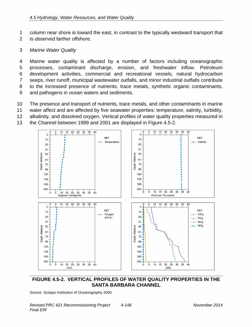
4.5 Hydrology, Water Resources, and Water Quality
column near shore is toward the east, in contrast to the typically westward transport that 1 is observed farther offshore. 2
Marine Water Quality 3
Marine water quality is affected by a number of factors including oceanographic 4 processes, contaminant discharge, erosion, and freshwater inflow. Petroleum 5 development activities, commercial and recreational vessels, natural hydrocarbon 6 seeps, river runoff, municipal wastewater outfalls, and minor industrial outfalls contribute 7 to the increased presence of nutrients, trace metals, synthetic organic contaminants, 8 and pathogens in ocean waters and sediments. 9
The presence and transport of nutrients, trace metals, and other contaminants in marine 10 water affect and are affected by five seawater properties: temperature, salinity, turbidity, 11 alkalinity, and dissolved oxygen. Vertical profiles of water quality properties measured in 12 the Channel between 1999 and 2001 are displayed in Figure 4.5-2. 13
FIGURE 4.5-2. VERTICAL PROFILES OF WATER QUALITY PROPERTIES IN THE SANTA BARBARA CHANNEL
Source: Scripps Institution of Oceanography 2000.
Revised PRC 421 Recommissioning Project 4-148 November 2014 Final EIR

4.5 Hydrology, Water Resources, and Water Quality
The vertical density structure or stratification (determined by temperature and salinity at 1 increasing depths within the water column) determines the amount of vertical mixing 2 that occurs within the water column. Highly stratified waters inhibit vertical mixing of 3 water, nutrients, and contaminants. Therefore, a contaminant introduced by a point 4 source (e.g., a leak in a pipeline at a specific depth) would remain within the water 5 column and would not rapidly rise to the ocean surface or sink into the bottom 6 sediments. In the winter and spring, the Channel is characterized by cold, high nutrient 7 surface water, and a shallow thermocline (i.e., highly stratified). In the summer and fall 8 the Channel is characterized by warm, low nutrient surface water, and a deep 9 thermocline (i.e., highly mixed) (Santa Barbara Long-Term Ecological Research 10 Program 2003). 11
Within the mixed surface waters, dissolved oxygen levels are uniformly high and near 12 saturation. This layer is known as the euphotic zone due to the penetration of light in 13 this zone. Correspondingly, nitrate and phosphate are depleted in the surface mixed 14 layer due to uptake by primary production (phytoplankton blooms) in the euphotic zone. 15 Wind-driven upwelling, which periodically replenishes surface waters with nutrient-rich 16 water from below, is an important feature of the Channel and is largely responsible for 17 its productive fishery. The presence of nutrient-rich water (high levels of nitrates and 18 phosphates) near the sea surface significantly enhances primary productivity. Below the 19 surface, oxygen concentrations steadily decrease with depth due to losses from 20 respiration and decomposition (CSLC 2009). Turbidity in the euphotic zone is 21 determined by the concentration of suspended particulate matter (PM) near the sea 22 surface. Turbidity is increased in coastal waters as a result of storm runoff, sediment re-23 suspension, discharge of wastewater, and phytoplankton blooms. 24
Trace Metals 25
Ambient trace metal concentrations in the water column typically occur at levels below 26 the detection limit of standard analytical methods. Therefore, to measure such 27 contaminants in seawater, resident California mussels (Mytilus californianus) are used 28 as indicator organisms to indirectly monitor water quality. Mussels accumulate 29 contaminants directly from the seawater and ingested food. Measuring the level of 30 concentrated contaminants in mussels in samples over specific periods of time provides 31 a measure of the concentration of contaminants in the water column over time. 32
The State Mussel Watch Program (run by the SWRCB) has been monitoring the 33 concentration of contaminants in mussels since 1971 and provides a long-term 34 indication of the ambient level of trace metals along the California coast. The objective 35 of this program is to examine trends in trace metals along the coast of California and 36 identify areas where spikes in certain metals occur (SWRCB 2004). Trace metal 37 concentrations at the nearest sampling location to the Project site, Santa Barbara 38
November 2014 4-149 Revised PRC 421 Recommissioning Project Final EIR

4.5 Hydrology, Water Resources, and Water Quality
Harbor, were higher than the average concentration of trace metals at all sampling 1 locations in the Channel with the exception of silver, arsenic, nickel, and selenium. 2
Petroleum Hydrocarbons 3
Petroleum hydrocarbons are organic contaminants that enter the ocean both naturally 4 and as the result of human error (i.e., oil spills). The principal sources of petroleum 5 hydrocarbons in the Channel include: 6
· Urban runoff of road material, auto exhaust, lubricating oils, gasoline, diesel fuel,7 and tire particles;8
· Produced-water discharges;9
· Atmospheric deposition from the combustion of fossil fuels;10
· Vessel leaks, spills, and exhaust;11
· Leaching of creosote from wooden pilings;12
· Oil and grease contained in municipal sewage effluent; and13
· Natural oil seeps.14
Natural seeps found along the coasts of Santa Barbara and Ventura counties discharge 15 significant quantities of oil and tar to the near-shore waters of the Channel. Studies 16 conducted in the late 1970s found that between 16,000 and 240,000 barrels of oil enter 17 the Channel annually from natural seeps. Further, the Western States Petroleum 18 Association estimates 150 to 170 barrels of oil seep from the sea floor near Coal Oil 19 Point (approximately 5 miles southeast of the Project area) each day (Helix 2006). 20 Consequently, the intertidal zone at Goleta, particularly along the Ellwood Coast in the 21 Project vicinity, frequently experiences naturally occurring oil and tar from the Coal Oil 22 Point Seep. 23
Generally, oil entering the ocean naturally through seeps does not severely degrade 24 open ocean water quality. Oil spills cause the most degradation to water quality during 25 and for a few weeks after each spill. Most components of crude oil are not soluble in 26 seawater and float on the sea surface; therefore, impacts to the water column are 27 limited. In addition, aromatic hydrocarbons, such as benzene and toluene, which are 28 considered the most toxic to marine life, evaporate quickly after a spill. Other 29 weathering processes, such as spreading, dissolution, dispersion, emulsification, 30 photochemical oxidation, and microbial degradation, decrease the volume of the oil slick 31 and increase the viscosity (thickness) of the spilled oil. Consequently, mortality of 32 marine organisms resulting from the physical effects of smothering and coating is the 33 greatest concern. However, toxicological effects from exposure to aromatic 34 hydrocarbons can be significant if unweathered oil reaches the shoreline, particularly in 35
Revised PRC 421 Recommissioning Project 4-150 November 2014 Final EIR

4.5 Hydrology, Water Resources, and Water Quality
areas with rocky shorelines, enclosed embayments, estuaries, and wetlands. These 1 impacts are discussed further in Section 4.6, Marine Biological Resources. 2
Aquatic Environment 3
Surface Water 4
Primary Project components are situated in the surf zone, near shore areas and on low-5 lying coastal areas immediately inland from the beach. The nearest drainages to the 6 Project area are Bell Canyon and Tecolote Creeks to the northwest and Devereux 7 Creek to the southeast. Bell Canyon and Tecolote Creeks drain primarily rural and 8 agricultural areas northwest of the urban areas of the City of Goleta and discharge into 9 lagoons at the west of the Project site. Devereux Creek drains a largely urbanized 10 watershed, which encompasses the western portions of the City of Goleta, and empties 11 into the Devereux Slough located approximately 1.8 miles southeast of the Project area. 12 Runoff from the inland portions of the Project site could potentially drain into Bell 13 Canyon Creek (Figure 4.5-3). 14
Four wetlands are located near the Project site: Bell Canyon Creek and three wetland 15 areas that are supported by seeps located along the toe of the bluff adjacent to the 16 Project access road. The largest (approximately 5,440 square feet) and most diverse of 17 the three seep-related wetlands is located east of the access road terminus and Well 18 421-2. The dominant species in all of these seep-related wetland areas is saltgrass 19 (Distichlis spicata), and the surface waters present in at least the larger seep-related 20 wetland are sufficient to support breeding populations of Pacific tree frogs (Pseudacris 21 regilla) and western toads (Anaxyrus boreas), and as habitat for avian species. 22
Water Quality 23
The SWRCB (2010) has listed Bell Canyon Creek as impaired for nitrates under their 24 303d listing program. Water quality sampling was performed during storm events in Bell 25 Canyon, Tecolote, and Devereux Creeks as part of the countywide “Project Clean 26 Water” program until 2002. The most recent Project Clean Water quality analysis report 27 that includes data for these creeks is for rain year 2001 to 2002. During this rain year, 28 both Bell Canyon and Devereux Creeks exceeded the maximum contaminant standards 29 for copper, mercury, and zinc. Tecolote Creek also exceeded the standard for copper 30 and zinc, but not mercury. In addition, Bell Canyon and Tecolote Creeks exceeded the 31 maximum diazinon standard and Devereux and Tecolote Creeks exceeded the 32 maximum standard for chlorpyrifos. Tecolote Creek also exceeded the maximum 33 standard for malathion. Oil and grease, and total petroleum hydrocarbon (TPH), were 34 not detected in any of the samples for either of these creeks (Santa Barbara County 35 2002). 36
November 2014 4-151 Revised PRC 421 Recommissioning Project Final EIR
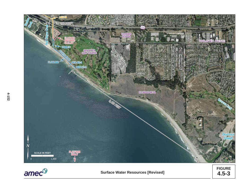
DevereuxDevereuxSloughSlough
PIER 421-1PIER 421-1
PIER 421-2PIER 421-2
PLATFORMPLATFORMHOLLYHOLLY
ELLWOODELLWOODSCHOOLSCHOOL
SANDPIPERSANDPIPERGOLF COURSEGOLF COURSE
ELLWOOD MESA ELLWOOD MESA
LINE 96LINE 96
ELLWOODONSHOREFACILITY
DevereuxSlough
ELLWOODONSHOREFACILITY
PIER 421-1
LINE 96
PIER 421-2
PLATFORMHOLLY
SANDPIPERGOLF COURSE
ELLWOODSCHOOL
ELLWOOD MESA
Bell
Bell
Teco
lote
Teco
lote
Cree
kCr
eek
Cree
kCr
eek
Cany
onCa
nyon
Bell
Cree
kCa
nyon
Teco
lote
Cree
k
Devereux Creek
Devereux Creek
HOLLLLISTTER AVVENUEE HOLLISTER AVENUE
101
259 FEET259 FEET
9,489 FEET
9,489 FEET
259 FEET
9,489 FEET
ACCESS ROAD
ACCESS ROAD
CABLESCABLES
FLOWLINEFLOWLINEFLOWLINE
CABLESACCESS ROAD
FIGURE4.5-3Surface Water Resources [Revised]
0 1,400
SCALE IN FEET
N
4-1

4.5 Hydrology, Water Resources, and Water Quality
Water quality data collected during two prior rain years (1999 to 2000 and 2000 to 2001) 1 were similar to 2001 to 2002 data. During the 2000-2001 rain year, both Bell Canyon 2 and Devereux Creeks exceeded the standard for copper, mercury and zinc, while 3 Tecolote Creek only exceeded the standard for copper and zinc. Similarly, all three 4 creeks exceeded the standard for diazinon. In addition, Bell Canyon and Tecolote 5 Creeks exceeded the standard for chloropyrifos. Tecolote Creek also exceeded the 6 standard for malathion. Oil and grease and TPH were not detected in any of the 7 samples for these creeks (Santa Barbara County 2001). Water quality sampling during 8 the 1999 to 2000 rain year detected oil and grease and TPH during one sampling event 9 of Bell Canyon Creek. In addition, all three creeks exceeded the standard for copper, 10 lead, and zinc. Bell Canyon Creek also exceeded the standards for arsenic, chromium, 11 diazinon and malathion (Santa Barbara County 2000). 12
Groundwater 13
The Project area is adjacent to the West Subbasin of the Goleta Groundwater Basin. 14 This underground reservoir is considered hydrologically separate from the North and 15 Central Subbasins of the Goleta Groundwater Basin. Available storage in the West 16 Basin is estimated to be 7,000 acre-feet (af). Based on the most recent analysis, the 17 West Subbasin is in a state of surplus. However, water in this subbasin is considered 18 poor quality and low yield, but is classified as beneficial use drinking water by the 19 RWQCB under the Water Quality Control Plan for the Central Coastal Region (Central 20 Coast Basin Plan) (Santa Barbara County 2005). 21
4.5.2 Regulatory Setting 22
Federal and State laws, regulations, and policies related to this issue area are 23 discussed in Table 4.0-1;e local laws, regulations, and policies are discussed below. 24
Local 25
Santa Barbara County Fire Department (SBCFD) 26
As noted in Sections 4.1, Geological Resources, and 4.2, Safety, the SBCFD is the 27 overseeing agency for implementing local regulations in the event of a hazardous waste 28 or petroleum spill. 29
Project Clean Water 30
The Santa Barbara County Water Agency, Project Clean Water was established to 31 reduce or eliminate discharges of pollution into creeks, rivers, ponds, or ocean waters, 32 through implementation of National Pollutant Discharge Elimination System (NPDES) 33 permit requirements and applicable regulations. This agency completes storm water 34 sampling at select locations throughout the county. The County Water Agency is 35
November 2014 4-153 Revised PRC 421 Recommissioning Project Final EIR

4.5 Hydrology, Water Resources, and Water Quality
currently in the process of adopting provisions of the Storm Water Phase II Final Rule, 1 which requires the operator of a regulated small municipal separate storm sewer system 2 (MS4) to obtain NPDES permit coverage because discharges of storm water from such 3 systems are considered point sources. 4
City of Goleta General Plan/Coastal Land Use Plan (GP/CLUP) 5
The City of Goleta adopted its GP/CLUP in November 2006. Included as part of its plan 6 are the policies of the California Coastal Act. GP/CLUP policies relevant to the Project 7 are described below: 8
· Land Use Policy 10.4(b) – If resumption of production is considered for approval9 for PRC 421, on-pier processing of the oil at a site within the tidal zone should10 not be approved unless it is demonstrated that there is no feasible and less11 environmentally damaging alternative to processing on the pier. The12 development of new processing facilities over the ocean would result in an13 increased level of risk of environmental damage.14
· Policy CE 2 – Preserve, restore, and enhance the physical and biological15 integrity of Goleta’s creeks and natural drainages and their associated riparian16 and creekside habitats.17
· Conservation Guiding Principle 5 – Protect water quality and the biological18 diversity of Goleta Slough and Devereux Slough.19
· Conservation Guiding Principle 9 – Manage water resources at the watershed20 level cooperatively with other agencies to maintain high groundwater and surface21 water quality and to protect marine aquatic habitats.22
· Policy CE 6 – Preserve and protect the biological integrity of marine habitats and23 resources within and adjacent to Goleta.24
· Policy CE 10 – Manage groundwater and surface water resources to promote25 water quality and quantity adequate to support natural ecosystem processes and26 functions.27
4.5.3 Significance Criteria 28
Impacts to water quality would be considered significant if: 29
· Contaminant concentrations within the Channel Islands National Marine30 Sanctuary (CINMS) or within Santa Barbara Channel coastal wetlands31 measurably increase relative to background concentrations;32
· Water quality objectives contained in the Central Coast Basin Plan are violated;33
· Water quality objectives contained in the California Ocean Plan are violated;34
· Water quality criteria in the Proposed California Toxics Rule are violated;35
Revised PRC 421 Recommissioning Project 4-154 November 2014 Final EIR

4.5 Hydrology, Water Resources, and Water Quality
· Project operations or discharges that change background levels of chemical and1 physical constituents or elevate turbidity producing long-term changes in the2 receiving environment of the site, area, or region, thereby impairing the beneficial3 uses of the receiving water occur; or4
· Contaminant levels in the water column are increased to levels with the potential5 to cause harm to marine organisms even if the levels do not exceed formal6 objectives in the Central Coast Basin Plan or California Ocean Plan.7
4.5.4 Impacts Analysis and Mitigation 8
Erosion and sedimentation from short-term construction activities, including trenching 9 for installation of two electrical cables and repair of the 6-inch line beneath the existing 10 access road, could adversely affect surface water quality in Bell Canyon Creek. 11 However, impacts would be reduced through the employment of standard erosion and 12 sediment control Best Management Practices (BMPs) that would be outlined in the 13 Erosion and Sediment Control Plan, required by the City of Goleta Grading Ordinance, 14 including watering of disturbed soils, silt fences, and temporary sediment barriers. In 15 addition, Venoco would be required to develop a Storm Water Pollution Prevention Plan 16 (SWPPP) for construction activities and obtain a General Construction Permit from the 17 SWRCB, which would prevent contaminated runoff from the construction site, which 18 could contain trace metals or small amounts of petroleum hydrocarbons, from entering 19 Bell Canyon Creek. Further, as construction would last for approximately 45 days; 20 impacts to surface water quality would be short-term and less than significant. 21
However, the Project would incrementally increase the potential for an accidental 22 release of limited amounts of crude oil to the marine environment. Analyses of risk 23 presented in Section 4.2, Safety, indicate the limited possibility of a release of crude oil 24 into the marine environment, including a potential for undetected slow leaks. In addition, 25 resuming production and prolonging the life of the aging caisson on Pier 421-2 could 26 increase the potential for a release of contaminated sediment to affect water quality 27 (see Section 4.3, Hazardous Materials). 28
Table 4.5-1, located at the end of Section 4.5.4, provides a summary of water-related 29 impacts and recommended MMs to address these impacts. 30
November 2014 4-155 Revised PRC 421 Recommissioning Project Final EIR

4.5 Hydrology, Water Resources, and Water Quality
Impact WQ-1: Temporary Construction Impacts to Marine Water Quality 1 Short-term construction activities along the access road and seawall, and in the 2 surf zone could adversely affect marine water quality (Less than Significant with 3 Mitigation). 4
Impact Discussion 5
With completion of the recent emergency repairs to the seaward-facing wall of the 6 caisson at Pier 421-2, construction activities on the beach and within the surf zone 7 would be limited, but may include use of vehicles and other construction equipment on 8 the beach for seawall repair, pipeline construction support, and Pier 421-2 9 improvements. Additionally, decommissioning activities at Pier 421-1—which would 10 include grading and excavation to remove the caisson, pier and piles—and 11 reinforcement of the seawall along the access road would disturb material in and 12 adjacent to the surf zone. 13
Potential environmental concern associated with excavation within the surf zone is that 14 potentially contaminated sediments would be exposed or contaminants would be 15 mobilized through pore water movement to the biologically active zone or overlying 16 water column. While disturbance of sediment can increase turbidity (suspended 17 sediments) in the water column, these effects would be temporary (for the duration of 18 any construction activities) and confined to the immediate Project vicinity. Further, 19 activity would occur within the active surf zone, a naturally turbid area within the ocean 20 environment. Proposed construction activities would disturb sand along the surf zone; 21 however, these sediments would be expected to settle rapidly and would not create 22 extensive turbidity plumes. Therefore, the potential increase in suspended sediments 23 during construction would result in a less than significant temporary impact. 24
In addition to potential turbidity, construction activities on the beach and within the surf 25 zone could release contaminated mud and sand from the caissons and underlying soil 26 to the ocean. Repair activities conducted on the Well 421-1 caissons detected two leaks 27 in the caisson wall which were sampled for contaminants. Results of chemical analyses 28 performed on mud and sand within the caisson revealed the presence of TPH at levels 29 of 100 to 200 parts per million (ppm). Tests for benzene, toluene, ethylbenzene, 30 xylenes, and short-chain hydrocarbons resulted in non-detectable results. In addition, 31 hydrocarbons were detected in the soil surrounding the piers at a depth of 15 feet below 32 ground. Further, analytical sampling conducted in October 2006 on water from the 33 caissons detected trace amounts of arsenic, mercury, and selenium; all amounts were 34 below water quality threshold levels. The potential release of hydrocarbon contaminated 35 sand from subsurface soil and rock soil into the surf zone is would be subject to feasible 36 mitigation as discussed below, and would be less than significant with mitigation. 37
Revised PRC 421 Recommissioning Project 4-156 November 2014 Final EIR

4.5 Hydrology, Water Resources, and Water Quality
Mitigation Measures 1
In addition to the implementation of MM HAZ-1a through HAZ-1d, the following MMs 2 would apply. 3
MM WQ-1a. Avoidance of High Tides and Silt Curtain. Venoco shall schedule in-4 water construction efforts to avoid times of high tides (defined herein as tides 5 greater than +5 feet as predicted by the National Oceanic and Atmospheric 6 Administration). Prior to implementation of any in-water construction, affected 7 sediments shall be tested for the presence of hydrocarbons and trace metals. 8 Any potentially contaminated sediment which may be disturbed during caisson 9 repairs would be contained within the Project area for off-site disposal at an 10 appropriate waste facility, and disposed of according to State and Federal 11 regulation. Regardless of the presence of contaminated sediment, Venoco 12 shall install measures to reduce siltation of the nearshore marine environment 13 during in-water construction, potentially including but not limited to a silt curtain, 14 installation of sheet piling, and/ or soil removal techniques such as hydro-15 displacement and weighted floating. Venoco shall prepare a plan to monitor the 16 performance of the adopted measure and identify thresholds for localized 17 turbidity to ensure that they are performing as expected and not impairing 18 water quality. If it is found that turbidity threshold values are being repeatedly 19 exceeded, construction activities shall be temporarily halted until a better 20 capture solution is implemented. Additionally, in order to protect spawning 21 endangered species, monitoring should occur to ensure that a turbidity plume 22 from construction in the marine environment does not reach the mouth of Bell 23 Creek or Tecolote Creek and that turbidity in the lagoon does not increase as a 24 result of construction activities. If a plume reaches the mouth of the lagoon, 25 construction should be halted until turbidity returns to normal levels. 26
MM WQ-1b. Water Quality Certification. Venoco shall complete and implement a 27 Spill Prevention, Control and Countermeasures (SPCC) Plan and implement 28 any additional MMs mandated by the State Water Resources Control Board 29 (SWRCB) through the Section 401 water quality certification process. 30
Rationale for Mitigation 31
Implementation of the MMs above would reduce potential water quality impacts to below 32 State thresholds. Removal of contaminated sediments from construction zones prior to 33 implementing the decommissioning and removal of Pier 421-1 and any additional 34 required in-water construction activities (if possible without impairing the integrity of Pier 35 421-2) would prevent the release of petroleum hydrocarbons resulting from Project 36 activities. Removal of contaminated sub-soil mobilized during drilling would prevent it 37 from reaching the surf zone. Erection of a silt curtain would reduce the dispersion of 38 contaminated sediments from the soils surrounding the piers into the water column and 39 prevent elevated turbidity levels within the active surf zone. Full implementation of these 40 measures would reduce Impact WQ-1 to less than significant. 41
November 2014 4-157 Revised PRC 421 Recommissioning Project Final EIR
4.5 Hydrology, Water Resources, and Water Quality
Impact WQ-2: Temporary Construction Impacts to Wetlands 1 Short-term construction activities along the access road and could adversely 2 affect water quality in adjacent wetlands (Less than Significant with Mitigation). 3
Impact Discussion 4
Construction activities along the access road may temporarily affect three small 5 wetlands located between the access road and the Sandpiper Golf Course. Such 6 activities include excavation and installation of subsurface cables for power and system 7 control between the Ellwood Onshore Facility (EOF) and Pier 421-2, and extending and 8 upgrading the existing 6-inch line to accommodate one internal 3-inch flowline from Pier 9 421-2 to the tie-in at the EOF. These activities may result in a disturbance to wetland 10 habitats and associated plant and wildlife species due to trenching, deposition of spoils, 11 and operation of heavy equipment. Additionally, decommissioning and removal of Pier 12 421-1 would include construction activities that may impact wetlands along the access 13 road when heavy construction machinery is used to remove the well, pier, and caisson 14 at Pier 421-1. Since a wetland delineation has not yet been performed for the Project 15 area, additional wetlands may be present that could be impacted by Project activities. 16
All wetland areas would be protected with temporary construction fencing to prevent 17 entrance into these areas during construction activities; however, the potential for the 18 Project, including subsequent decommissioning and removal of Pier 421-1, to disturb 19 wetlands would remain. This impact would be less than significant with mitigation. 20
Mitigation Measures 21
In addition to the implementation of MM TBIO-1a, TBIO-1b, TBIO-1d, and TBIO-1e 22 described in Section 4.7 Terrestrial Biological Resources, the following MM would apply. 23
MM WQ-2. Wetland Delineation, Avoidance and Minimization. Venoco shall 24 engage a qualified biologist to conduct a Wetland Delineation and prepare a 25 Wetland Delineation Report, subject to approval and permitting by the City of 26 Goleta, California Department of Fish and Wildlife, Army Corps of Engineers, 27 and California Coastal Commission, to determine the precise location of all 28 wetlands within and in the vicinity of the Project, including the access road, the 29 flow line, the cables, sea wall bulkheads, and riprap sea-walls. The Report 30 shall be reviewed and approved prior to City issuance of the Land Use Permit. 31 Prior to commencement of construction, all wetland areas located within and 32 adjacent to the Project area will be flagged for fencing by a qualified wetland 33 scientist. If wetlands identified in the Wetland Delineation Report cannot be 34 avoided, the Applicant shall consult with appropriate agencies including the 35 City of Goleta, California Department of Fish and Wildlife, California Coastal 36 Commission, and the Regional Water Quality Control Board to design 37 measures to minimize impacts to the wetland and appropriate restoration 38 standards and methods, if necessary following construction. 39
Revised PRC 421 Recommissioning Project 4-158 November 2014 Final EIR

4.5 Hydrology, Water Resources, and Water Quality
Rationale for Mitigation 1
Implementation of MMs WQ-2, TBIO-1a, TBIO-1b, TBIO-1d, and TBIO-1e would reduce 2 short-term construction-related impacts to wetlands by protecting biologically sensitive 3 areas in the immediate Project area, providing for construction supervision, and 4 requiring restoration and enhancement of impacted habitats. After implementation of 5 these MMs, impacts to wetlands from short-term construction activities would be 6 mitigated to a less than significant level. 7
Impact WQ-3: Oil Spill Impacts to Surface and Marine Water Quality 8 Accidental discharge of petroleum hydrocarbons into the surf zone from Pier 421-9 2 and flowline would adversely affect surface or marine water quality (Significant 10 and Unavoidable). 11
Impact Discussion 12
Upon Project implementation, oil would be produced at Well 421-2 (which is located in 13 the surf zone) and sent to the EOF via pipeline for processing. Transportation of oil that 14 has been processed at the EOF would be via the Line 96 onshore pipeline, connecting 15 to the Plains All American Pipeline, L.P. (PAAPLP) west of Las Flores Canyon (LFC). 16 The Project thus presents three possible sources of oil spill to marine or surface waters: 17 from Well 421-2, from the flowline to the EOF, and from Line 96. 18
An accidental release of oil during production at Pier 421-2 could occur from a well 19 casing blow out or from potential wave or seismic damage to the Project caisson, 20 seawall, or pipeline. The maximum amount of oil which could potentially be released 21 during a worst-case oil spill from Well 421-2 is 1.7 barrels (see Section 4.2, Safety). 22
The current PRC 421 flowline is located approximately 200 feet east of Bell Canyon 23 Creek. Proposed safety measures for the pipeline include repairing a deteriorated 24 section and pressure testing the existing 6-inch line, and inserting an internal liner and a 25 3-inch flowline within the existing pipeline. In the event of a leak in the 3-inch flowline, 26 the oil/gas/water emulsion would be contained within the 6-inch line. Upon detection of 27 liquid in the 6-inch line the well pump would be completely shut in. It is estimated that 28 shut in would be complete within 15 seconds of leak detection. A leak detection sensor 29 would also be provided within the 6-inch line and if a leak were detected shut in would 30 also automatically occur. The potential exists, however slight, for oil to be released from 31 the pipeline during the 15-second interval prior to shut in of the pump, in the time before 32 the leak is detected. The amount of oil potentially released to the environment during 33 this period of time is dependent on the size of the leak in the pipeline. 34
The transport of PRC 421 oil approximately 8.5 miles through the Line 96 pipeline would 35 also present a risk of oil release with impacts to in-stream water quality for multiple 36 creeks along the Gaviota Coast. Although pipelines are generally the safest method 37
November 2014 4-159 Revised PRC 421 Recommissioning Project Final EIR

4.5 Hydrology, Water Resources, and Water Quality
available for the transportation of crude oil, spills could potentially occur through 1 accidental damage to the pipeline caused by natural (e.g., seismic activity, flooding) or 2 man-made causes (e.g., construction activity, valve failure). However, because the 3 pipeline would be new and would include all of the most recent safety features, the 4 likelihood of a potential spill is low (see Section 4.2, Safety). The Line 96 pipeline 5 incorporates mainline block valves that limit the volume of oil that could potentially be 6 spilled to 60 barrels from Llagas Creek and 52 barrels from Corral Canyon. 7
A spill from the Pier 421-2, from the flowline, or from Line 96 could release limited 8 amounts of petroleum hydrocarbons into the marine environment within Santa Barbara 9 Channel. Devereux Creek and its mouth (Devereux Slough) are located approximately 1 10 mile southeast of the Project site. Devereux Slough is part of the University of California 11 Reserve System and is a protected wetland which provides habitat and nesting area for 12 numerous shorebirds and migrating birds (see Section 4.6, Marine Biological Resources 13 and Section 4.7, Terrestrial Biological Resources). Even a limited crude oil spill between 14 0.5 to 1.7 barrels from PRC 421 could introduce petroleum hydrocarbon contaminants 15 above background concentrations into the slough (see Section 4.2, Safety) and impact 16 the aquatic environment. Therefore, a large crude oil spill into marine or surface water 17 resources near the Project site could exceed stated significance thresholds (California 18 Toxics Rule, Ocean Plan, and Basin Plan) and would be significant. 19
Spilled oil results in impacts to marine water quality as addressed in the California 20 Ocean Plan (Table 4.5-1). Surface slicks limit equilibrium exchange of gases at the 21 ocean-atmosphere interface. This reduces near-surface oxygen concentrations, 22 particularly with the increased biochemical oxygen demand of crude-oil emulsions. As 23 the seawater-oil emulsion mixes into the water column, turbidity would increase and 24 toxic hydrocarbons would be released into the water column and seafloor sediments. 25 Weathering can widely disperse tar balls, which may eventually be ingested by pelagic 26 and benthic biota, with adverse effects. Although a surface slick can disperse within a 27 few hours of a spill in harsh sea conditions, lingering effects could persist for much 28 longer periods. For example, it took approximately two years for mussel tissue burdens 29 of aromatic hydrocarbons to return to background levels after the Exxon Valdez Oil Spill 30 (Boehm et al. 1995). Although this spill was several orders of magnitude larger than any 31 spill possible under implementation of the Project, monitoring results indicate the 32 potential for long-term effects. The increased potential for accidental discharges of 33 petroleum hydrocarbons into marine waters is considered a significant impact because 34 the Project would increase the likelihood of an oil spill at the Project site and because 35 such a spill could result in tangible damage to marine water quality in excess of 36 concentrations identified in regulatory criteria. 37
Oil from a surface spill would disperse and weathering would, in turn, affect the long-38 term persistence and toxicity of oil. Further, the soluble and more toxic components of 39 crude oil (e.g., benzenes and other lower molecular weight aromatic compounds), would 40
Revised PRC 421 Recommissioning Project 4-160 November 2014 Final EIR

4.5 Hydrology, Water Resources, and Water Quality
volatilize and dissipate naturally from the environment. Consequently, the toxicity of a 1 potential spill may be reduced somewhat by natural weathering processes during 2 dispersion. However, insoluble oil fractions could potentially settle in bottom sediments 3 or get trapped by aquatic vegetation and affect water quality for several years. This is 4 more likely to occur in Devereux Slough than Bell Canyon Creek as the current flows 5 from west to east and Bell Canyon Creek is located west of the Project. Further, oil 6 spills to Bell Canyon Creek would be near the mouth of the creek and spilled oil would 7 likely disperse quickly into the Pacific Ocean, particularly in winter months when 8 seasonal storms wash natural sand berms from the Bell Canyon Creek into the ocean 9 and water levels are higher; whereas spills within the Santa Barbara Channel and those 10 that flush out of Bell Canyon Creek are likely to flow towards Devereux Slough. 11
Venoco currently maintains two plans that deal with oil spills: an Emergency Action Plan 12 (EAP) and the South Ellwood Field Oil Spill Contingency Plan (OSCP). The EAP details 13 actions to occur following a spill, including directions on spill containment and logistical 14 details such as site access, staging areas, and boat launching locations (Venoco 15 2011a). The OSCP addresses inspection and maintenance, training and drills, 16 notification procedures, and provides general oil spill response and cleanup techniques 17 for various terrains, including for creeks and rivers (Venoco 2011b). OSCP appendices 18 contain maps and listings of potentially affected sensitive resources such as plant and 19 wildlife habitats, creeks and drainages, beaches, sloughs, marshes, etc., in the 20 surrounding area. Implementation of the above plans would reduce impacts associated 21 with larger oil spills. Nonetheless, impacts would be significant and unavoidable. 22
Mitigation Measures 23
In addition to the implementation of MMs described in Section 4.2, Safety, Section 4.6, 24 Marine Biological Resources, and Section 4.7, Terrestrial Biological Resources, the 25 following MMs would apply: 26
MM WQ-3a. Pipeline Monitoring. In addition to the installed safety measures on 27 the pipeline from Pier 421-2 to the EOF tie-in (e.g., low-pressure alarm system 28 and automatic shut-in), Venoco staff shall conduct daily visual monitoring of the 29 access road above the pipeline and soils adjacent to the access road. Staff 30 shall inspect for obvious indicators of a small leak such as petroleum smells 31 and any seepage of oil or visible sheen in soils adjacent to the roadway. If any 32 indicators are present, Venoco shall (1) notify City of Goleta and California 33 State Lands Commission (CSLC) staffs within 24 hours, (2) conduct further 34 investigations to determine the source of the indicator, and (3) repair the 35 pipeline as necessary upon City and CSLC staff approval. 36
MM WQ-3b. Storm Water Pollution Prevention Plan (SWPPP). A site-specific 37 SWPPP shall be prepared for construction activities and the existing Ellwood 38 area SWPPP shall be updated to include the Project and submitted to the 39 Regional Water Quality Control Board (RWQCB), Central Coast Region, and 40
November 2014 4-161 Revised PRC 421 Recommissioning Project Final EIR

4.5 Hydrology, Water Resources, and Water Quality
City of Goleta to prevent adverse impacts to nearby waterways associated with 1 oil spills and contaminated storm water releases not covered under the 2 Emergency Action Plan (EAP), which only applies to “significant events.” This 3 plan shall include site-specific diagrams illustrating primary surface drainage 4 features (e.g., Bell Canyon Creek, Devereux Creek and Devereux Slough, and 5 proposed spill containment, delineation of drainage features) and a description 6 of Best Management Practices (BMPs), including spill containment equipment 7 and procedures tailored for the Project site. 8
The Project also incorporates by reference MMs contained in the certified Line 96 9 Modification Project EIR, including MM BIO-3, which required preparation of an OSCP 10 to address sensitive biological resources along the pipeline alignment, and MM HM-3, 11 which required block valves on the Line 96 pipeline to be capable of remote actuation. 12
Rationale for Mitigation 13
Implementation of these MMs would reduce the probability of an oil spill and the 14 resulting consequences to the surface or marine waters. The identified measures would 15 enhance planning and preparedness to respond to the oil spill and would reduce both 16 the potential oil spill size and the potential for oil spills. The measures would also 17 increase the effectiveness of an oil spill cleanup effort. 18
Regular monitoring of the soils adjacent to the access road above pipeline would reveal 19 potential pipeline damage from third-party incidents or natural disasters and would help 20 identify potential hairline fractures and leaks that may not be detected by installed leak 21 detection systems. Regular monitoring would also encourage regular maintenance of 22 the pipeline to prevent spills. Implementation of the SWPPP would minimize potential 23 impacts of small spills and contaminated storm water releases by providing site-specific 24 information and management practices regarding protection of nearby water resources. 25 Incorporation of measures from the Line 96 Modification Project EIR would reduce the 26 likelihood and volume of an accidental oil release from the Line 96 pipeline. 27
Residual Impacts 28
Marine water quality impacts associated with accidental oil spills are categorized as 29 significant because the proposed MMs would not be completely effective in reducing the 30 significant risk of a spill, nor would they adequately eliminate the significant effect of a 31 spill on marine resources. A large spill (see definition in Section 4.2, Safety) would 32 violate many water quality regulations and have a deleterious effect on the marine 33 environment and biota. It would generate visible surface sheens, significantly reduce the 34 penetration of natural light, reduce dissolved oxygen, degrade indigenous biota, and 35 result in hydrocarbon contamination within the water column and marine sediments. The 36 duration and area of the impact would be largely dictated by the size and location of the 37
Revised PRC 421 Recommissioning Project 4-162 November 2014 Final EIR

4.5 Hydrology, Water Resources, and Water Quality
spill, and the various physical conditions of the sea at the time of the spill. Impacts 1 would last from days to weeks and extend for tens of miles. 2
Mitigation of water quality impacts from a major marine oil spill is largely a function of 3 the efficacy of the spill response measures. The effectiveness of spill cleanup measures 4 is dependent on the response time, availability and type of equipment, size of the spill, 5 and the weather and sea state during the spill. Only some of these aspects are within 6 the control of the spill response team. In addition, many oil spill response measures, 7 such as dispersants, have impacts of their own. 8
With the natural flushing processes of Bell Canyon Creek and implementation of the 9 SPCC Plan, safety measures for the pipeline, and the above MMs, impacts to surface 10 water quality in Bell Canyon Creek would be less than significant. However, 11 implementation of the OSCP, EAP, and other MMs would not reduce impacts of a large 12 oil spill to a less than significant level, particularly in Devereux Slough where insoluble 13 oil fractions could potentially be trapped in sediments for years or in creeks and 14 drainages present along the Line 96 pipeline route between the EOF and LFC. These 15 impacts are considered significant. 16
Under the regulatory-based significance criteria described in Section 4.5.3, Significance 17 Criteria, even small oil spills could potentially be significant. Many regulations and 18 guidelines establish limits based on the presence of a visible sheen on the ocean 19 surface. This criterion is reflected in the static sheen test for free oil identified in the 20 NPDES General Permit, U.S. Coast Guard (USCG) regulations, and the aesthetic 21 criterion C.1 in the Ocean Plan Standards (see Table 4.5-1). Therefore, even with the 22 imposition of the MMs, this impact remains significant and unavoidable. 23
Table 4.5-1. Summary of Hydrology and Water Quality Impacts and Mitigation Measures
Impact Mitigation Measures WQ-1: Temporary Construction Impacts to Marine Water Quality
HAZ-1a. Proper Personnel Training. HAZ-1b. Conduct Phase I ESA. HAZ-1c. Soil Sampling. HAZ-1d. Removal Action Plan. WQ-1a. Avoid High Tides and Silt Curtain. WQ-1b. Water Quality Certification.
WQ-2: Temporary Construction Impacts to Wetlands
WQ-2. Wetland Delineation, Avoidance and Minimization TBIO-1a. Locate Power Cables and Pipeline Outside Wetland Areas. TBIO-1b. Project and Biological Monitors. TBIO-1d. Protect Stockpiles of Excavated Material. TBIO-1e. Maintain Equipment.
WQ-3: Oil Spill Impacts to Surface and Marine Water Quality
WQ-3a. Pipeline Monitoring. WQ-3b. Storm Water Pollution Prevention Plan. All MMs described in Sections 4.3 4.2, Safety, 4.6, Biological Resources, and 4.7 Terrestrial Biological Resources and MM BIO-3 and MMHM-3 from the Line 96 Modification Project EIR would apply.
November 2014 4-163 Revised PRC 421 Recommissioning Project Final EIR

4.5 Hydrology, Water Resources, and Water Quality
4.5.5 Cumulative Impacts Analysis 1
Impact WQ-4: Cumulative Impacts to Marine Water Quality 2 Potential oil spills occurring as a result of recommissioning of PRC 421 could 3 result in contributions to cumulative water quality impacts on the waters of the 4 Santa Barbara Channel (Significant and Unavoidable). 5
Potential Project-related oil spills could contribute to cumulative water quality impacts 6 offshore the Project site. Projects which could produce an increased risk of oil spill that 7 could impact the same coastal areas as the Project are listed in Table 3-2 in Section 3, 8 Cumulative Impacts Methodology. The Carpinteria Offshore Field Redevelopment, 9 South Ellwood Field Project, and Carpinteria Onshore Projects would involve increased 10 offshore/near-shore drilling and associated crude oil transportation, which would also 11 increase the risks of oil spills and result in water quality impacts from the discharge of 12 produced water into the marine environment. Any development of the undeveloped 13 outer continental shelf (OCS) leases would result in additional exploratory drilling, 14 increases in vessel traffic and potential oil spills to the marine environment that would 15 have a cumulative effect alongside the Project. All of these projects would exacerbate 16 an already significant and unavoidable impact associated with the Project’s risks of 17 spills to the marine environment. 18
Mitigation Measures 19
Each of these projects must meet regulatory requirements designed to reduce the 20 probability and consequences of accidental releases to the environment. However, even 21 the best-designed and implemented MMs, such as safe design of the facilities, oil spill 22 contingency plans, training and drills, and availability of oil spill cleanup means, cannot 23 eliminate all risk of an oil spill. 24
Rationale for Mitigation 25
Implementing regulatory requirements with industry BMPs can lower the risk and 26 consequences of an accidental oil spill. 27
Residual Impacts 28
The Project’s contribution to cumulative impacts would remain significant and 29 unavoidable. 30
Revised PRC 421 Recommissioning Project 4-164 November 2014 Final EIR

4.6 Marine Biological Resources
4.6 MARINE BIOLOGICAL RESOURCES 1
This section describes the marine resources in the immediate Project area and Santa 2 Barbara Channel and the potential Project-related impacts, including unanticipated 3 accidents such as an oil spill, could have on those resources. The Environmental 4 Setting section is based primarily on existing literature, but has been augmented with 5 the authors' personal experience in the Project area. The impact section identifies 6 potential impacts to marine resources from decommissioning and removal of Pier 421-1 7 and caisson repairs on Pier 421-2, and identifies mitigation for potentially significant 8 impacts. Operational impacts would be limited to accidents including an oil spill. 9 Mitigation Measures (MMs) are identified to reduce the potential effects of these 10 accidents. 11
This document incorporates by reference the conclusions of the Ellwood Marine 12 Terminal (EMT) Lease Renewal Environmental Impact Report (EIR) (California State 13 Lands Commission [CSLC] 2009) and Line 96 Modification Project EIR (Santa Barbara 14 County 2011) regarding marine biological resources and summarizes these conclusions 15 where appropriate. This document also incorporates data from Santa Barbara County 16 01-ND-34 and City of Goleta 06-MND-01. 17
4.6.1 Environmental Setting 18
The primary study area includes the Ellwood Coast region and marine habitats that 19 extend approximately 1 mile seaward from the PRC 421 piers. The secondary study 20 area includes the Gaviota Coast along the Line 96 pipeline and the Santa Barbara 21 Channel. 22
Study Area 23
PRC 421 is located on the Ellwood coast in the Santa Barbara Channel, which occupies 24 the northwest corner of the Southern California Bight. The sea floor in the Santa 25 Barbara Channel consists of a complex topography of ridges, islands, and basins. The 26 complicated physiography of the region has created a diverse collection of marine 27 environments. The bathymetric features greatly influence such factors as current flow 28 and sediment transport and these processes in turn have profound effects on the 29 biological communities (Chambers Group 1987, Dailey et al. 1993). In Southern 30 California, upwelling occurs along both mainland and island shores as northwest winds 31 displace coastline surface water that is then replaced by nutrient rich deeper water. 32 Upwelling is most intense in April, May, and June and is one of the factors that accounts 33 for the high productivity and diversity of marine life in the study area. 34
The Santa Barbara Channel is bordered on its seaward margin by the northern Channel 35 Islands consisting of Anacapa, Santa Cruz, Santa Rosa, and San Miguel. These islands 36 support unique and important marine communities and also shelter the mainland coast 37
November 2014 4-165 Revised PRC 421 Recommissioning Project Final EIR

4.6 Marine Biological Resources
from the direct force of the incoming south swell. Point Conception shelters the Channel 1 from northwest swells. The Channel thus provides a relatively protected and benign 2 environment for marine organisms. The Channel lies along important migration routes 3 for marine mammals, fishes and seabirds and also contains a rich, diverse assemblage 4 of resident marine life. These abundant marine resources support a number of 5 important commercial fisheries, aquaculture, and kelp harvesting. Marine habitats within 6 the Channel include mud, sand, and rocky bottoms, as well as scattered offshore reefs 7 and extensive kelp forests along the coastal and island margins. Sandy and rocky 8 beaches as well as mud-bottom marshes and estuaries line the coast. 9
The Ellwood Coast region extends for approximately 2 miles west from Coal Oil Point to 10 the Bacara Resort. This section of coast is characterized by a broad sweep of south-11 facing sandy beach, broken in several places by rocky intertidal habitat and the mouths 12 of one major and two minor estuaries. Within this reach, rocky intertidal habitat is 13 concentrated at Coal Oil Point and within the bay approximately 1 mile west of Coal Oil 14 Point, opposite the western areas of the Ellwood Open Space and the east end of 15 Sandpiper Golf Course (Figure 4.6-1). Sandy beaches tend to aggregate in areas 16 surrounding the estuary mouths and can be ephemeral and replaced by shale or 17 sandstone shingle in areas away from sand sources during the winter months. The 18 mouth of the area’s major estuary, the Devereux Slough, lies approximately 0.25 mile 19 west of Coal Oil Point. Seasonal freshwater discharge and sand deposition from this 20 slough provide substantial input to the marine environment, including supporting a wide 21 sandy beach backed by an extensive dune system west of the slough mouth. Toward 22 the western border of the Ellwood Coast, the estuaries of two perennial coastal streams, 23 Bell and Tecolote Canyon creeks, contribute both sand and seasonal freshwater input 24 into this coastal ecosystem. 25
The offshore regions of the Ellwood Coast are characterized by a gently sloping 26 seafloor that averages 36 feet in depth approximately 1 mile from the shoreline. These 27 offshore areas include a mix of low rocky reef and sand bottom substrate. Both the 28 eastern reaches of this area west of Coal Oil Point and the western areas off of Bell and 29 Tecolote Canyon creeks appear to be dominated by sandy substrate, becoming 30 increasingly rocky toward the central area of the Ellwood Coast, including areas 31 offshore from the Project site (Figure 4.6-2; Chambers Group 1987; Santa Barbara 32 County 1991). Kelp beds are scattered throughout both sandy and rocky substrate 33 areas offshore of the Ellwood Coast, but tend to be concentrated and most persistent in 34 areas of rocky substrate. The immediate Project vicinity supports the Ellwood Coast’s 35 largest kelp bed. This kelp bed encompasses over 50 acres and begins approximately 36 500 feet offshore of the existing caissons and extends for over 1 mile east southeast 37 along the Ellwood Coast before terminating in areas apparently dominated by sandy 38 bottom substrate east of the Sandpiper Golf Course (Figure 4.6-2). 39
Revised PRC 421 Recommissioning Project 4-166 November 2014 Final EIR

101
154
101
246
1
1
1
135
135
166
166
33
33
GoletaSanta Barbara
S A N T A B A R B A R A C H A N N E L
Pt. Conception
Pt. Sal
246
VA
ND
EN
BE
RG
AIR
FO
RC
E B
AS
E
Lompoc
SantaMaria
S A N L U I S O B I S P O C O .
S A N T A B A R B A R A C O .
VE
NT
UR
A
C
O.
SA
NT
A
B
AR
BA
RA
CO
.
Buellton
Carpinteria
Oxnard
101
1
126
K E R N C O .
V E N T U R A C O .
Ventura
✪ ✪✪
✪
✪
✪
Hollister Ranch
Burmah Beach
GoletaRocks
Carpinteria SloughNaples Reef
Carpinteria Reef
Chevron Pier
Ventura River Mouth
Santa Clara River Mouth
McGrath Lake
Mugu Lagoon
Santa RosaIsland
Santa CruzIsland
Coal OilPoint
Devereaux/GoletaSlough
Gaviota
San MiguelIsland
AnacapaIsland
Pt. Arguello
★
Project Site
KE
RN
CO
.
Cetacean Migration Path
Kelp Bed Habitat
Reef
University Research Sites
Area of Special BiologicalSignificance
State Oil and Gas Sanctuary
Santa Barbara Oil Sanctuary
State and Federal Marine Protected Areas
Harbor Seal Haulout Area
LEGEND
✪
0 12 24
SCALE IN MILES
N
T
H
BOUNDARY CHANNEL ISLANDSMARINE SANCTUARY
ception
uel
Sensitive Biological and Marine Resource Areas in theRegion of the Proposed Project
FIGURE4.6-1
4-16

DevereuxSlough
PIER 421-1PIER 421-1
PIER 421-2PIER 421-2
ELLWOODONSHOREFACILITY
DevereuxSlough
ELLWOODONSHOREFACILITY
PIER 421-1
PIER 421-2
HOLLISTER AVENUE HOLLISTER AVENUE
101
TecoloteTecoloteCreek EstuaryCreek Estuary
Devereux SloughDevereux SloughMarshMarsh
Bell CanyonBell CanyonCreek EstuaryCreek Estuary
TecoloteCreek Estuary
Devereux SloughMarsh
Bell CanyonCreek Estuary
10
20
30
40
3
15
5
4
1
5
1
3
2
LINE 96LINE 96LINE 96Rocky Intertidal Habitat
Ephemeral Beach/Rocky Shingle
Sandy Beach
Kelp Beds
Estuaries
State Marine ConservationArea (SCMA)
Bathymetric Contour Lineand Depth in Meters
LEGEND
1
2
3
5
4
FIGURE4.6-2
Marine Habitats in theVicinity of the Proposed Project
0 1,650
SCALE IN FEET
N
4-16
FLOWLINEFLOWLINEFLOWLINE
CAMPUSCAMPUSPOINTPOINTSMCASMCA
CAMPUSPOINTSMCA

4.6 Marine Biological Resources
The importance of marine resources in the Ellwood area has been recognized through 1 the establishment of the Naples and Campus Point State Marine Conservation Areas 2 (SMCAs). Campus Point SMCA was established in 2012 to protect marine resources 3 along and off the coast of UCSB, Isla Vista, and the Coal Oil Point Reserve. Campus 4 Point SMCA is designed to protect habitat and species diversity and a wide diversity of 5 habitat types including eelgrass, surfgrass, kelp, rocky reefs, shallow subtidal, rocky 6 intertidal, oil seeps, sand, and the estuarine inputs of Devereux Slough. This SMCA 7 covers 10.51 square miles, including Campus Point. The Naples SMCA covers 2.58 8 square miles, and protects Naples Reef, located approximately 0.75 mile offshore. 9 These SMCAs are “no take” areas that protect natural habitats and marine life, with both 10 commercial and recreational fishing or removal of wildlife prohibited; take of marine 11 resources pursuant to operation and maintenance of artificial structures per any 12 required federal, state and local permits, or as otherwise authorized by the CDFW is 13 permitted. 14
Marine Biological Resources 15
Plankton 16
The term plankton refers to organisms that drift with the current. Plankton includes 17 phytoplankton (drifting primary producers, such as diatoms and dinoflagellates) and 18 zooplankton (slightly mobile animals, such as small crustaceans, swimming mollusks, 19 jellyfish, and the drifting eggs and larvae of fishes and benthic invertebrates). Planktonic 20 communities are characterized by patchiness or unevenness in distribution, 21 composition, and abundance. 22
The most comprehensive data for zooplankton in California waters come from the 23 California Cooperative Oceanic Fisheries Investigations (CalCOFI) program initiated in 24 1949. This program has shown that zooplankton tend to be extremely variable in space 25 and time. Zooplankton abundance at any given location may vary by as much as an 26 order of magnitude from season to season and year to year. The occurrence of 27 particular zooplankton species or populations along the California coast is largely 28 governed by currents. Long-term averages of the zooplankton standing stock in the 29 study area show peak zooplankton abundances in the spring and summer months, and 30 lowest abundances during the winter (Kramer and Smith 1972; Dawson and Pieper 31 1993). Copepods, thalaceans, euphausiids, and chaetognaths usually account for most 32 of the biomass in CalCOFI samples. The most abundant fish larvae are northern 33 anchovy (Engraulis mordax), Pacific hake (Merluccius productus), and rockfish 34 (Sebastes spp). 35
Phytoplankton assemblages are affected by nutrients, light, water temperature, currents 36 and upwelling, and grazing (Hardy 1993). Species assemblages of phytoplankton in the 37 study area differ spatially and temporally (Hardy 1993). Near the thermocline, for 38
November 2014 4-169 Revised PRC 421 Recommissioning Project Final EIR
4.6 Marine Biological Resources
example, an area of elevated chlorophyll concentration often occurs with a vertical 1 species assemblage that is different from that of the surface layer. Onshore-offshore 2 phytoplankton assemblages differ, but temporal changes between stratified and 3 upwelling conditions tend to be more significant than onshore-offshore changes. 4
A subsurface chlorophyll maximum layer generally is present in the study area; in 5 general, phytoplankton abundance and primary production are higher near-shore than 6 offshore (Hardy 1993). The biomass of phytoplankton in Southern California has been 7 found to decrease with increasing distance from shore within the first 6 miles offshore. 8 The depth of maximum phytoplankton abundance usually differs between individual 9 species. Large dinoflagellates are often numerous near the surface, while diatoms are 10 more abundant below a water depth of about 65 feet. Primary production generally 11 shows a subsurface maximum in the study area. 12
Zooplankton populations in the study area can be divided into near-shore and offshore 13 populations (Dawson and Pieper 1993). The near-shore region includes those waters 14 shoreward of the continental shelf/slope break or approximately at the 650 feet depth 15 contour. Transects along the shelf in the study area have shown that the near-shore 16 zooplankton biomass decreases at stations farther from the coast (Dawson and Pieper 17 1993). However, different taxa had different distributions and some taxa were more 18 abundant farther from shore than inshore. 19
Zooplankton of the offshore region include many of the same species found near-shore, 20 but also include more oceanic and deeper water species (Dawson and Pieper 1993). 21 Offshore from the edge of the shelf, zooplankton biomass is variable with depth, but 22 generally higher in the region of chlorophyll, with a maximum at 73 to 83 feet. 23 Zooplankton biomass off Southern California declined during the El Niño years of the 24 1990s but appears to have recovered (Goericke et al. 2005). 25
Fish eggs and larvae (ichthyoplankton) are an important component of the planktonic 26 community. Because of the importance of commercial and recreational fisheries, 27 ichthyoplankton are the most studied component of plankton in the study area. Northern 28 anchovy is by far the most abundant species of ichthyoplankton in the study area (Cross 29 and Allen 1993). Other abundant ichthyoplankton taxa in the study area include 30 rockfish, California smoothtongue (Leuroglossus stilbius), Pacific hake, Mexican 31 lampfish (Triphotorus mexicanus), and various species of croaker (scianidae). Within 32 the study area, the larvae of jack mackerel, Pacific hake, and mesopelagic fishes (fishes 33 of mid-water depths) are most abundant 6 to 60 miles from the coast (Cross and Allen 34 1993). California halibut (Paralichthys californicus), turbots (Peluronichthys spp.), sea 35 basses (Paralabrax spp.), and blennies (Hypsoblennius spp) have larvae that are most 36 abundant within 6 miles of the coast. The larvae of clinids (Gibbonsia spp.), queenfish 37 (Seriphus politus), California clingfish (Gobiesox rhessodon), gobies, silversides, and 38 diamond turbot (Hypsopsetta guttulata) are most abundant within 1.2 miles of the coast. 39
Revised PRC 421 Recommissioning Project 4-170 November 2014 Final EIR

4.6 Marine Biological Resources
Northern anchovy, rockfish, and sanddab (Citharichthys spp.) larvae are common both 1 onshore and offshore. 2
Intertidal Habitat 3
The mainland shoreline of the Santa 4 Barbara Channel is primarily sandy. 5 Approximately 74 percent of the Santa 6 Barbara County coastline consists of sandy 7 beach and approximately 93 percent of the 8 Ventura County coastline is sand (Dugan et 9 al. 2000). Boulder fields are often present 10 under sandy beaches along the Santa 11 Barbara coast and are alternately exposed 12 and covered by shifting sand. Only about 23 13 percent of the shores of the Channel Islands 14 consist of sand beach. 15
The beach adjacent to Piers 421-1 and 421-2 is ephemeral and primarily sandy during 16 the summer months but exhibiting patchy sand with large areas of exposed shale 17 shingle shelf during the winter months. Intertidal boulder fields also are present in the 18 Ellwood area and significant tidepool habitat occurs within the bend of “Ellwood Cove” 19 approximately 0.5 mile east of the Project site and off Coal Oil Point further to the 20 southeast. Rocky intertidal habitat, primarily boulders and cobble, also occurs west of 21 the Project area up-coast from the Bacara Resort. Rocky intertidal habitat is designated 22 as environmentally sensitive habitat (ESH) by the City of Goleta General Plan/Coastal 23 Land Use Plan (GP/CLUP), the Santa Barbara Local Coastal Plan (LCP), and the 24 University of California Santa Barbara (UCSB) Long Range Development Plan. 25
Sandy beaches in California are inhabited by an abundant invertebrate community that 26 is an important food source for vertebrate predators including shorebirds, seabirds, 27 marine mammals, and fishes (Dugan et al. 2000). More than 60 different species of 28 intertidal invertebrates were identified in a survey of 15 beaches in Santa Barbara and 29 Ventura counties (Dugan et al. 2003). Intertidal invertebrates of sandy beaches show a 30 characteristic zonation related to tidal exposure. The composition of the invertebrate 31 community at a given beach as well as the zonation tends to be extremely dynamic due 32 to the highly mobile nature of the sandy substrate and the resources on which these 33 animals depend (Dugan and Hubbard 2006). Most exposed sandy beaches have two to 34 three zones inhabited by distinct groups of mobile animals. These zones generally 35 correspond to the relatively dry substrate of the upper intertidal zone at and above the 36 drift line, the damp sand of the mid-intertidal zone, and the wet sand of the lower 37 intertidal zone. Sandy beaches on the mainland coasts of Ventura and Santa Barbara 38 counties are generally richer in species than beaches of the Channel Islands. 39
Extensive rocky intertidal habitats exist within the Project vicinity.
November 2014 4-171 Revised PRC 421 Recommissioning Project Final EIR

4.6 Marine Biological Resources
The lower intertidal zone (swash zone) in Southern California sandy beaches is 1 dominated by the filter feeding mole crab, Emerita analoga, which moves up and down 2 the beach with the tides. The polychaete "bloodworm," Euzonus, also is common in the 3 mid to lower intertidal. In the upper intertidal, drift kelp is an important source of food for 4 many invertebrates. Common organisms associated with macrophyte wrack include 5 beach hoppers (Megalorchestia spp.), kelp flies (Coleopa vanduzeei), isopods 6 (Alloniscus perconvexus and Tylos punctata) and various species of beetles. 7
The sandy intertidal areas at Ellwood Beach were sampled in 1986 (Chambers Group 8 1987) and the dominant organisms collected were the sand crabs, Emerita analoga and 9 Blepharipoda occidentalis, and the polychaete worm Nephtys californiensis in the lower 10 intertidal; the isopod Excirolana linguifrons and the bloodworm Euzonus muronata in the 11 mid-intertidal; and the beach hoppers Megalorchestia californiana and M. corniculata in 12 the upper intertidal. 13
Engle (2001) sampled the sandy intertidal organisms at Ellwood just up the coast (west) 14 from the PRC 421 piers in 2001. The upper beach was characterized by large numbers 15 of isopods (Tylos punctatus), beach hoppers, and kelp flies. The mid-intertidal was 16 dominated by the isopod Excirolana chiltoni and beach hoppers. Infauna sampled in the 17 lower intertidal included mole crabs (Emerita analoga), polychaete worms (Lumbrinereis 18 zonata and Nephtys californiensis), Pismo clams (Tivela stultorum), and bean clams 19 (Donax gouldi). 20
Rocky intertidal organisms, like those in the sandy intertidal, tend to be distributed in 21 bands or zones related to tidal height. The occurrence of particular species is based on 22 physical and biological factors such as the ability to withstand exposure to air and to 23 survive "sanding-in" as well as competition for limiting resources, especially space 24 (Chambers Group 1987, Thompson et al. 1993). 25
The boulder field at Ellwood has been extensively studied by researchers from the 26 UCSB (Dixon 1978; Fawcett 1978; Sousa 1977; Thompson et al. 1993). This type of 27 habitat is subject to repeated natural disturbance, both through agitation and 28 overturning of the cobbles by wave action and by periodic sand inundation. The 29 structure and composition of the marine community attached to the boulders depend on 30 the severity of past disturbance and on how long the boulders have been exposed for 31 recolonization by larvae and or regrowth of colonies surviving the last disaster. Early 32 successional stages of the boulder community tend to be characterized by the green 33 algae (Ulva spp.) and the barnacles (Chthamalus spp.). Perennial red algae of several 34 species typify the next successional stage. If two years or more went by without major 35 disturbance the tops of the boulders became dominated by the red alga Gigartina 36 caliculata. The important feature of this system is that for both invertebrate and algal 37 assemblages, diversity was highest at intermediate frequencies of disturbance. 38
Revised PRC 421 Recommissioning Project 4-172 November 2014 Final EIR

4.6 Marine Biological Resources
The Ellwood boulder field community underwent a profound change in composition and 1 dynamics after the large storms of 1983 (Thompson et al. 1993). Wave energy was so 2 high that virtually all of the boulders were violently tumbled and all species of algae and 3 invertebrates were driven to low abundances. Early recolonization by Ulva and the tube-4 building polychaete Phragmatopoma californica occurred but later successional stages 5 were slow to re-appear. 6
Intertidal habitat at Coal Oil Point to the east of PRC 421 consists of flat sandstone 7 shingle with scattered boulders and a high sand influence, especially in the upper zones 8 (Ambrose et al. 1992). Tidepools are extensive along the beach and the area is 9 characterized by tar from oil seeps (Tway 1991). The boulder habitat is dominated by 10 the green algae Ulva and Enteromorpha. Larger rocks are dominated by the acorn 11 barnacle Chthamalus and the anemone Anthopleura elegantissima. Clusters of mussels 12 Mytilus californianus also occur. Several species of red algae also are present. The 13 rocky intertidal at Coal Oil Point has been designated an Environmentally Sensitive 14 Habitat Area (ESHA) in the Santa Barbara County LCP for its remarkable rich intertidal 15 invertebrate fauna (Santa Barbara County 1982). 16
Subtidal Habitat 17
The vast majority of the subtidal benthic habitat on the study area consists of soft 18 bottom. The soft bottom benthic invertebrates of the Southern California mainland shelf 19 have been studied extensively. Twelve of the 15 most abundant infaunal taxa in this 20 region are annelid worms; 11 were various taxa of polychaetes and the twelfth was 21 oligochaetes (Ranasinghe et al. 2003). The most abundant taxon on the mainland shelf 22 was the spionid polychaete worm (Spiophanes duplex), followed by the brittle star 23 (Amphiodia urtica), phoronid worms, and another spionid polychaete (Prionospio 24 pinnata). Infaunal assemblages in very shallow water, less than 33 feet deep, are very 25 much influenced by wave surge and tend to be dominated by fast-moving crustaceans 26 and opportunistic polychaetes (Thompson et al. 1993). 27
Epifaunal communities (invertebrates that live primarily on the surface of the sediments) 28 include a total of 313 species of epifaunal invertebrates (Allen et al. 2002). Three widely 29 occurring species were white sea urchin (Lytechinus pictus), California sand star 30 (Astropecten verrelli), and ridgeback shrimp (Sicyonia ingentis). The shallow inner shelf, 31 of less than 70 feet depth, has the lowest invertebrate abundance, biomass, and 32 diversity. Invertebrate abundance, biomass, and diversity increased from the inner to 33 the middle shelf, and from the middle shelf to the outer shelf. Characteristic species of 34 the inner shelf included blackspotted bay shrimp (Crangon nigromaculata), tuberculate 35 pear crab (Pyromaia tuberculata), spiny sand star (Astropecten armatus), and yellowleg 36 shrimp (Farfantepenaeus californiensis). California sand star, ridgeback rock shrimp, 37 and white sea urchin characterized the middle shelf. Species typical of the outer shelf 38 (deeper than 330 feet [100m]) included orange bigeye octopus (Octopus californicus), 39
November 2014 4-173 Revised PRC 421 Recommissioning Project Final EIR

4.6 Marine Biological Resources
northern heart urchin (Brisaster latifrons), mustache bay shrimp (Neocrangon zacae), 1 flagnose bay shrimp (Neocrangon resima), and hinged shrimp (Pantomus affinis). 2
In the shallow sandy subtidal habitat at Ellwood, the tube worm Diopatra ornata is the 3 dominant epifaunal invertebrate (Chambers Group 1987). Sand dollar beds (Dendraster 4 excentricus) occur in 20 to 30 foot water depths. Other characteristic species on the 5 sand bottom between 20 and 50 foot water depths at Ellwood include the Kellett's whelk 6 (Kelletia kelleti), the tube dwelling anemone (Pachycerianthus imbricata), the elbow 7 crab (Heterocrypta occidentalis), the hermit crabs (Paguristes spp.), and the cone snail 8 (Conus californicus). 9
An introduced species of eelgrass (Zostera asiatica) occurs in about 18 to 40 foot water 10 depth on soft bottom along the southern Santa Barbara mainland coast. Eelgrass is a 11 flowering plant that enhances biological value where it grows. Eelgrass beds provide 12 important habitat for invertebrates as a source of food and attachment, and for marine 13 fishes that seek the shelter of the beds for protection and also forage on invertebrates 14 that colonize the eelgrass blades and sediments in and around eelgrass vegetation. 15 Small amounts of eelgrass were observed off Ellwood during underwater surveys in 16 1986 (Chambers Group 1987). 17
Subtidal hard bottom habitat is limited off the mainland shelf of the study area, although 18 subtidal rocky habitat is much more common off the Channel Islands. Rocky subtidal 19 habitat has particular biological value because it provides attachment sites for algae 20 including giant kelp (Macrocystis pyrifera) and sessile invertebrates and it provides 21 shelter and food for fishes and mobile invertebrates such as spiny lobster (Panulirus 22 interruptus). 23
The coastline in the Project region has typically been characterized by large beds of 24 giant kelp, which comprise a distinct and complicated type of marine community. Kelp 25 offers food, attachment sites and microhabitats for invertebrates and provides food and 26 shelter for fishes. Kelp beds off the Santa Barbara County mainland coast between 27 Jalama and Carpinteria are designated an ESHA area in the Santa Barbara County 28 LCP (Santa Barbara County 1982). 29
Two kinds of beds of giant kelp historically have occurred off the Santa Barbara coast 30 east of Point Conception: kelp growing on rocks and kelp growing on sand. In most 31 locations off California, kelp holdfasts require solid substrate for secure attachment, 32 especially in wave-exposed conditions. The kelp beds along the Santa Barbara coast 33 southeast of Point Conception lie in well protected areas and the sand-based kelp had 34 unusual holdfasts that were able to penetrate into the soft bottom and persist (North 35 1994). 36
In 1982 and 1983, most of the extensive kelp beds near Santa Barbara were destroyed 37 by large waves and poor growing conditions associated with an El Niño event (MBC 38
Revised PRC 421 Recommissioning Project 4-174 November 2014 Final EIR

4.6 Marine Biological Resources
Applied Environmental Sciences 1992). The rock-based kelp recovered but the sand 1 based kelp never did. By the late 1980s and early 1990s, after a long period of drought 2 years, sand based kelp began to show signs of recovery. Starting in 1993, several years 3 (e.g., 1993, 1995, and 1998) of heavy rainfall and rough seas occurred in Southern 4 California. In addition, 1998 was another El Niño year. The high temperatures and low 5 nutrients associated with the El Niño conditions are stressful for giant kelp. Most of the 6 sand-based kelp that had started to return to the southern Santa Barbara shoreline 7 disappeared between 1993 and 1998. In the years since the 1998 El Niño, sand-based 8 kelp has returned sporadically to the mainland coast of the Santa Barbara Channel. 9 However, the only persistent kelp beds have been those associated with hard substrate. 10 Effects of the most recent El Niño (2009-2010) were not yet available. 11
Some rocky subtidal habitat supporting giant kelp occurs in the eastern portion of the 12 Ellwood area offshore from Pier 421-2 (Chambers Group 1987). The rocky subtidal 13 habitat off Ellwood consists of low rocky reef in 25 to 35 foot water depth. Dominant 14 invertebrates in this habitat include pholad clams, the tunicate Styela montereyensis, 15 the urchins Strongylocentrotus franciscanus, S. purpuratus, and Lytechinus anamesus 16 as well as the hydroid Aglaopenia struthionides. Giant kelp is common on these low 17 reefs. Other kelp species in this habitat include Egregia menzisii and Cystoseira 18 osmundacea. 19
Significant subtidal rocky habitat supporting a large kelp forest occurs offshore of the 20 Isla Vista area between Coal Oil Point and Goleta Point east of PRC 421. Common 21 invertebrates in this area include Kellet's whelk, wavy top shell (Astraea undosa), sea 22 urchins (S; strongylocentrotus and S. purpuratus), tunicates (Styela montereyens), sea 23 stars (Pisaster giganteus and P. brevispinus) and giant keyhole limpets (Megathura 24 crenulata) (N. Davis, personal observations). In addition to giant kelp, the brown alga 25 Pterygophora californica is common in the Isla Vista kelp bed. 26
Naples Reef, located approximately 2 miles to the northwest of PRC 421, is a significant 27 rocky reef and kelp area that is designated as an ESHA in the Santa Barbara County 28 LCP (Santa Barbara County 1982). Naples Reef supports a great diversity of 29 invertebrates and algae. The reef is about 1 acre in size and averages 26 to 40 foot 30 depth (Chambers Group 1987). Naples Reef is an important fishing and SCUBA diving 31 area and has been used as a research site by UCSB marine biologists for decades. 32
Fishes 33
Common water column fishes in the upper water column and near-shore waters of the 34 study area include northern anchovy and Pacific mackerel (Scomber japonicus) and 35 predatory schooling fishes, such as Pacific bonito (Sarda chilensis) and yellowtail 36 (Seriola lalandi); and by large solitary predators, like blue sharks (Prionice glauca) and 37 swordfish (Xiphias gladius) (Cross and Allen 1993). Northern anchovy is the most 38
November 2014 4-175 Revised PRC 421 Recommissioning Project Final EIR

4.6 Marine Biological Resources
abundant epipelagic fish in the study area (Aspen 2005). The largest schools occur 1 within 25 miles of the coast over deepwater, particularly escarpments and submarine 2 canyons. During daylight hours in summer and fall, large compact anchovy schools may 3 be found at depths of 360 to 600 feet. These schools rise to the surface at night and 4 disperse. In spring, many small schools are found at the surface during the day, and the 5 fish scatter over a wide area at night. Most fishes of the epipelagic zone are widely 6 distributed in the study area. 7
Common water column species of near-shore soft bottoms include jacksmelt 8 (Atherinopsis californiensis), topsmelt (Atherinops affinis), California grunion 9 (Leuresthes tenuis), queenfish, walleye surfperch (Hyperprosopon argenteum), white 10 seaperch (Phanerodon furcatus), northern anchovy, and white croaker (Genyonemus 11 lineatus), a bottom feeder that lives in the water column (Cross and Allen 1993; 12 Chambers Group 1994). A number of other water column species including Pacific 13 bonito, jackmackerel (Trachurus symmetricus), and brown smoothhound (Mustelus 14 henlei) also sometimes occur in near-shore waters. Most of the water column species 15 found in California near-shore waters are widely distributed from bays and estuaries out 16 to ocean depths of 100 feet or more (Love 1996). 17
Demersal fishes of the study area soft bottom habitats in the study area a total of at 18 least 143 species of fish, with white croaker, Pacific sanddab (Citharichthys sordidus), 19 California lizardfish (Synodus lucioceps), and queenfish among the most abundant 20 (Allen et al. 2002). The lowest values of fish abundance, biomass, and species richness 21 are generally found on the inner shelf at depths shallower than 100 feet, with the middle 22 shelf of depths of 100 to 400 feet having higher numbers of species (Allen et al. 2002). 23
Characteristic species of the inner shelf include California halibut, barred sand bass 24 (Paralabrax nebulifer), speckled sanddab (Citharichthys stigmaeus), and white croaker 25 (Allen et al. 2002). Species typical of the middle shelf include yellowchin sculpin 26 (Icelinus quadriseriatus), hornyhead turbot (Pleuronichthys verticalis), bigmouth sole 27 (Hippoglossina stomata), longfin sanddab (Citharichthys xanthostigma), California 28 lizardfish, longspine combfish (Zaniolepis latipinnis), pink seaperch (Zalembius 29 rosaceus), plainfin midshipman (Porichthys notatus), and California tonguefish 30 (Symphurus atricaudus). Finally, abundant species of the outer shelf, at water depths of 31 430 feet or greater, included Dover sole (Microstomus pacificus), Pacific sanddab, 32 slender sole (Lyopsetta exilis), and shortspine combfish (Zaniolepis frenata). 33
The most abundant fish observed in soft bottom habitat during underwater surveys off 34 Ellwood was the speckled sanddab (Chambers Group 1987). Other fish species 35 observed in the sandy subtidal off Ellwood included thornback ray (Platyrhinoides 36 triseriata), California halibut, California lizardfish, pipefish (Syngnathus sp.), diamond 37 turbot, and round stingray (Urolophus halleri). 38
Revised PRC 421 Recommissioning Project 4-176 November 2014 Final EIR

4.6 Marine Biological Resources
Many fish species are associated with rocky habitat. Fishes congregate around rocky 1 features. Fish abundance on reefs is related to the presence or absence of kelp 2 (Macrocystis pyrifera) and substrate relief, although bottom relief greater than 3 feet has 3 been found to have little effect on fish species diversity and abundance (Cross and 4 Allen 1993). 5
Common fish species of shallow reefs in the study area include garibaldi (Hypsypops 6 rubiunda), blacksmith (Chromis punctipinnis), bass (Paralabrax spp), halfmoon 7 (Medialuna californiensis), sheephead (Semicossyphus pulcher), opaleye (Girella 8 nigricans), painted greenling (Oxylebius pictus), rock wrasse (Halichoeres semicinctus), 9 seniorita (Oxyjulis californica), and various species of surf perches (Family 10 Embiotocidae) and rockfish (Cross and Allen 1993). Deep reefs are dominated by 11 rockfish. 12
Depletion of rocky substrate fishes by over fishing has recently become of considerable 13 concern. Species considered over fished include widow rockfish (Sebastes entomelas), 14 canary rockfish (Sebastes pinniger), yelloweye rockfish (Sebastes ruberrimus), 15 darkblotched rockfish (Sebastes crameri), bocaccio (Sebastes paucispinus), Pacific 16 ocean perch (Sebastes alutus), lingcod (Ophiodon elongates), and cowcod (Sebastes 17 levis). To protect these species, Cowcod Conservation Areas have been established. 18
The most frequently observed fish species in rocky areas during underwater surveys off 19 Ellwood was the kelp bass (Paralabrax clathratus) (Chambers Group 1987). Other 20 common fish species associated with shallow water hard substrate at Ellwood included 21 blacksmith, sheephead, seniorita, pile perch (Rhacochilus vacca), black perch 22 (Embiotica jacksoni), sand bass, lingcod, cabezon (Scorpaenichthys mrmoratus), 23 sarcastic fringehead (Neoclinus blanchardii), and several species of rockfish (Sebastes 24 atrovirens, S. caurinus, S. chrysomelas, and S. rastrelliger). 25
Fish species killed during detonations to remove an abandoned pier from PRC 421 in 26 October 2005 were identified and counted (Howarth 2006). The most abundant fish 27 species affected by explosives on PRC 421 were topsmelt and Pacific sardine 28 (Sardinops sagax caeruleus). Other species collected included jack mackerel, black 29 surfperch, rainbow surfperch (Hypsurus caryi), shiner surfperch (Cymatogaster 30 aggregate), white surfperch, kelp surfperch (Brachyistius frenatus), striped surfperch 31 (Embiotica lateralis), rubberlip surfperch (Rhacochilus toxotes), halfmoon, sheephead, 32 giant kelpfish (Heterostichus rostratus), pink surfperch, and several rockfishes 33 (Sebastes chrysomelas, S. rastrelliger, S. atroviresn, S. serranoides, and S. 34 paucispinis). 35
Sandy intertidal habitat in Southern California is used for spawning by a near-shore fish, 36 the California grunion, which lays its eggs in the high intertidal zone between March and 37 August. During the grunion spawning season, eggs and developing embryos are buried 38
November 2014 4-177 Revised PRC 421 Recommissioning Project Final EIR

4.6 Marine Biological Resources
in the sand to incubate between the highest tides of each month, at the full and new 1 moon. Beaches in the Project area are used by grunion (City of Goleta 2006). 2
Seabirds 3
The continental shelf in the study area is biologically productive and supports a wide 4 variety of seabirds, many in high densities (Mills et al. 2005). Their distribution and 5 abundance is subject to temporal fluctuations, both seasonally and from year to year, as 6 prey population densities fluctuate. Seabirds are wide-ranging and many of the seabirds 7 that occur in the Project area migrate seasonally through the area. Other species are 8 resident to the area. Many species roost and nest on the Channel Islands. Seabirds 9 forage widely. Those roosting and nesting on the Channel Islands forage in offshore 10 waters and around the islands, but many species including brown pelicans (Pelecanus 11 occidentali californicus) and cormorants (Phalcrocorax spp.) often fly from the islands 12 each day to forage in near-shore waters. Seabirds, sea ducks (scoters), loons (Gavia 13 spp.), and western grebes (Aechmorphus occidentalis) constitute most of the avifauna 14 that use the study area (Baird 1993). Seabird densities tend to be greatest near the 15 northern Channel Islands (i.e., San Miguel, Santa Rosa, Santa Cruz, and Anacapa) in 16 winter and north of Point Conception in spring. Seabird densities are higher along island 17 and mainland coastlines as compared to the open ocean (Mills et al. 2005). 18
Seabirds tend to congregate at the shelf/slope break, where water depth increases 19 rapidly from about 330 to 6,500 feet. The shelf break/slope fronts and convergences are 20 important habitats for seabirds due to physical processes that promote productivity and 21 concentrate prey (Mills et al. 2005). The diversity of seabirds in the study area is lowest 22 from May to August and highest from fall to early spring (Baird 1993). 23
The Channel is noted for its rich marine avifauna (Chambers Group 1992). A variety of 24 marine birds including pelicans, gulls, terns, sea ducks, cormorants, grebes and true 25 sea birds occur in the near-shore waters off the Santa Barbara coast and would be 26 expected in the Ellwood area. Large numbers of seabirds pass through the area during 27 this migration on their way to northern breeding grounds. Lehman recorded spring 28 seabird migration at Goleta Point, approximately 3 miles east of PRC 421 (Lehman 29 1994). The most abundant species observed were Arctic loon (Gavia arctica), surf 30 scoter (Melanitta perspicillta), brant (Branta bernicia), Brandt's cormorant 31 (Phalacrocorax pencillatus), Bonaparte's gull (Larus philadelphia) and Forster's tern 32 (Sterna forsteri). 33
The Channel Islands, especially the northern islands, are extremely important breeding 34 areas for seabirds. These islands support 12 breeding species, including the State’s 35 entire population of brown pelicans, Xantus's murrelets (Synthliboramphus hypoleucus 36 scrippsi), and black storm-petrels (Oceanodroma melania) (Mills et al. 2005). The 37 greatest number of species and individual breeding seabirds occur on San Miguel 38
Revised PRC 421 Recommissioning Project 4-178 November 2014 Final EIR

4.6 Marine Biological Resources
Island (Mills et al. 2005). The California brown pelican breeds on Anacapa and Santa 1 Barbara Islands. 2
In the fall of 2005, the offshore portion of Pier 421-1, which had become separated from 3 the mainland pier and remained under ARCO’s ownership, was removed. This pier, 4 which became known as "Bird Island," supported large numbers of roosting brown 5 pelicans and cormorants (Phalacrocorax spp.) and also supported nesting by Brandt's 6 cormorants. In addition to brown pelicans and cormorants, other marine birds that were 7 observed to use the old pier included snowy egret (Egretta thula), little blue heron (E. 8 caerulea), Heermann's gull (Larus heermanni), California gull (L. californicus), and 9 western gull (L. occidentalis ) (Compton 2006). The pier was located about 850 feet 10 offshore in 32 feet of water and consisted of a wooden deck with steel supports. 11
To compensate for the loss of bird habitat from removal of the pier, a new structure was 12 installed. Each of the new structures consists of a large column supporting three 13 triangularly shaped platforms projecting out from the column at different directions and 14 at slightly different heights (Compton 2006). Below these three platforms is a circular 15 ledge extending all the way around the column. The structures are arranged in a line 16 extending southwest to northeast in the same general area as the abandoned pier. The 17 Audubon Society was contracted to survey the structures after completion, and have 18 observed nesting Brandt's cormorant, brown pelican, double-crested cormorant (P. 19 auritus), snowy egret, Heermann's gull, and western gull (Santa Barbara Audubon 20 Society 2011). Between 2005 and 2010, Brandt’s cormorant was by far the most 21 abundant species on the structures, and use by other bird species was noted to be less 22 than for the old pier (Santa Barbara Audubon Society 2011). 23
The waters off Ellwood were monitored for marine mammals during the removal of the 24 old pier on PRC 421. The monitors also recorded observations on seabirds. Seabirds 25 observed in Project area waters included California brown pelican, Brandt's cormorant, 26 double-crested cormorant, Arctic loon, brant, western gull, Heermann's gull, California 27 gull, horned grebe (Podiceps auritus) and great egret (Casmerodius albus). 28
Marine Mammals 29
The marine mammal fauna of the study area includes at least 34 species that have been 30 identified from sightings or strandings (Bonnell and Daily 1993). All marine mammals are 31 protected under the Marine Mammal Protection Act of 1972 (MMPA). Marine mammals 32 that may occur in the Project area include mysticetes (baleen whales), odontocetes 33 (toothed whales), pinnipeds (seals and sea lions), and the southern sea otter (Enhydra 34 lutris nereis). Six species of cetacean are listed as Federal endangered. Two species of 35 pinniped and the southern sea otter are listed as Federal threatened. Listed marine 36 mammals are discussed in detail in the Sensitive Marine Species section below. 37
November 2014 4-179 Revised PRC 421 Recommissioning Project Final EIR

4.6 Marine Biological Resources
California gray whales (Eschrichtius robustus) pass through California during their 1 annual migrations between their summer feeding grounds in Alaska and their breeding 2 and calving grounds in Baja California. They are the most common baleen whale in the 3 Channel. Southbound gray whales usually occur in the study area between December 4 and mid-February (Bonnell and Daily 1993). The northbound migration occurs between 5 mid-February and May. Gray Whales Count observed southbound gray whales from 6 November to April and northbound gray whales from January to mid-May (Gray Whales 7 Count 2007). The migration pathway through the study area is broad and somewhat 8 diffuse (Bonnell and Daily 1993). Some whales travel close to the mainland while others 9 follow a more offshore route along the Channel Islands. 10
The Channel Islands support pinniped rookeries for four species – California sea lions 11 (Zalophus californianus), northern fur seals (Callorhinus ursinus), northern elephant 12 seals (Mirounga angustirostris), and harbor seals (Phoca vitulina richardsi) (Aspen 13 2005). Two of the Channel Islands, San Miguel and San Nicolas, are the largest 14 pinniped rookeries on the west coast south of Alaska. California sea lions are the most 15 abundant pinniped in the Santa Barbara Channel. 16
Marine mammals in the Project area were monitored during the demolition of the 17 abandoned pier on PRC 421 in October and November 2005. The most frequently 18 sighted species were harbor seals and California sea lions. Bottlenose dolphins 19 (Tursiops truncatus) also were observed frequently. Between 55 and 75 common 20 dolphin (Delphinus sp.) were seen about 3 nautical miles (nm) from the pier. 21
In August 2006, from their observation location at Coal Oil Point, Gray Whales Count 22 observed 34 southbound gray whales (including one calf), 989 bottlenose dolphins 23 (including 217 calves), 12 sea otters, 40 humpback whales, 28 unidentified large 24 whales, and one northern elephant seal. Over the course of 2007, Gray Whales Count 25 observed 567 northbound gray whales (including 52 calves), 28 southbound gray 26 whales, 901 bottlenose dolphins (including 24 calves), 1,060 common dolphin species, 27 three Pacific white-sided dolphins, 66 sea otters, eight unidentified large whales, six 28 humpback whales, and one northern elephant seal (Gray Whales Count 2007). 29
Harbor seals haul out about 0.4 mile east of Naples Point at a site known locally as 30 “Burmah Beach,” about 2 miles up the coast from the PRC 421 wells. This secluded 31 hauling ground and rookery has been used both day and night by as many as 200 32 harbor seals (Santa Barbara County 2008). The Naples harbor seal rookery is 33 designated an ESHA in the Santa Barbara County LCP (Santa Barbara County 1982). 34
Sensitive Marine Species 35
Table 4.6-1 lists sensitive marine species that may occur in the Ellwood area. 36
Revised PRC 421 Recommissioning Project 4-180 November 2014 Final EIR

4.6 Marine Biological Resources
Table 4.6-1. Listed Marine Species that May Occur in the Ellwood Area Common
Name Scientific Name Status Habitat Notes/Occurrence Frequency
Invertebrates White Abalone
Haliotis sorenseni FE Open, low relief rock or boulder habitat surrounded by sand at 80 to 200 feet depths (Hobday and Tegner 2000)
Point Conception to Baja CA; in water as shallow as 25 feet in the Santa Barbara Channel (Aspen 2005)
Moderate
Fishes Southern Steelhead
Oncorhynchus mykiss
FE (south of Point Concep-tion); CSC
Anadromous; returns to natal streams and rivers to spawn;
Spawns in coastal streams in Santa Barbara County
High
Reptiles Loggerhead Sea Turtle
Caretta caretta FT Open ocean, coastal waters, and beaches
Nest primarily near Japan and Australia (Aspen 2005); occasionally observed off southern CA usually during the summer months
Low
Pacific Ridley Sea Turtle
Lepidochelys olivacea
FT Open ocean, coastal waters, and beaches tropical and warm temperate waters
Nesting beaches are along the coasts of Mexico and Costa Rica (Aspen 2005); infrequent visitors to waters north of Mexico, although stranded turtles have been found as far north as Washington
Low
Leatherback Sea Turtle
Dermochelys coriacea
FE Open ocean, coastal waters, and beaches
Most common sea turtle in U.S. waters north of Mexico; frequently off CA during the summer and fall over the continental slope (Aspen 2005); eastern pacific migratory corridor occurs along the west coast of the U.S. and Mexico
Low
Birds California Least Tern
Sterna antillarum browni
FE; SE (nesting colony)
Near-shore waters; breeding populations in CA restricted to coastal locations; forage close to their breeding colonies in bays, harbors, and near-shore ocean waters
Least terns successfully produced chicks at Coal Oil Point in 2006 for the first time in 40 years.
High
Marbled Murrelet
Brachyramphus marmoratus
FT; SE Forages in near-shore waters
Late summer, fall, winter visitor to southern CA, including Channel Islands
Moderate
November 2014 4-181 Revised PRC 421 Recommissioning Project Final EIR

4.6 Marine Biological Resources
Table 4.6-1. Listed Marine Species that May Occur in the Ellwood Area (continued) Common
Name Scientific Name Status Habitat Notes/Occurrence Frequency
Xantus’ Murrelet
Synthliboramphus hypoleucus
ST Forages in near-shore waters
Breeds on Santa Barbara, Anacapa, and San Clemente Islands
Moderate
Mammals Guadalupe Fur Seal
Arctocephalus townsendi
FT Rocky shorelines and caves
Breeds primarily on Isla de Guadalupe off Baja CA, Mexico coast (Carretta et al. 2004); second rookery was discovered at Isla Benito del Este, Baja CA; individual animals appear regularly at the Channel Islands (Aspen 2005)
Low
Steller Sea Lion
Eumetopias jubatus
FT Rocky and sandy beaches; temperate waters
Southernmost breeding ground is Año Nuevo Island in central CA (Aspen 2005); uncommon in southern CA (Bonnell and Dailey 1993)
Low
Southern Sea Otter
Enhydra lutris nereis
FT Shallow near-shore waters with rocky or sandy bottoms that support large populations of their benthic invertebrate prey (Aspen 2005)
Population occurs primarily from north of Año Nuevo Island in to Point Conception (U.S. Geological Survey [USGS] 2004); small numbers observed regularly east of Point Conception
High
Blue Whale Balaenoptera musculus
FE Cold and temperate waters offshore
Aggregate in Santa Barbara Channel along the shelf break at about the 650 feet isobath (Aspen 2005); most frequent west of San Miguel Island and along the north sides of San Miguel and Santa Rosa, and the western half of Santa Cruz Island; offshore Channel Islands (Larkman and Veit 1998)
Low
Sei Whale Balaenoptera borealis
FE Temperate and subtropical waters
Wintering grounds to feeding grounds that extend from west of the Channel Islands as far north as Alaska in summer (Aspen 2005); rare in CA waters
Low
Fin Whale Balaenoptera physalus
FE Cold and temperate waters offshore
Summer distribution is generally offshore and south of the northern Channel Island chain, particularly over the Santa Rosa-San Nicolas Ridge
Low
Revised PRC 421 Recommissioning Project 4-182 November 2014 Final EIR

4.6 Marine Biological Resources
Table 4.6-1. Listed Marine Species that May Occur in the Ellwood Area (continued) Common
Name Scientific Name Status Habitat Notes/Occurrence Frequency
Humpback Whale
Megaptera novaeangliae
FE Migrate along submarine ridges and occasionally enter the coastal waters of the San Pedro and Santa Barbara Channels (Lagomarsino and Price 2001)
Summer through fall along the shelf break off the Channel Islands (Aspen 2005)
Low
North Pacific Right Whale
Eubalaena japonica
FE Temperate waters along the shelf and slope
Since 1955, only five sightings of right whales have been recorded in waters off southern CA (Aspen 2005)
Low
Sperm Whale
Physeter macrocephalus
FE Offshore waters year-round in water depths greater than 3330 feet
Peak abundance from April to mid-June and again from late August through November as they pass by during migration (Aspen 2005)
Low
FE = Federal Endangered; ST = State Threatened; FT = Federal Threatened; SE = State Endangered; FP = CDFW Fully Protected.
White Abalone (Haliotis sorenseni) – Federal Endangered: In May 2001, white1 abalone became the first marine invertebrate to be listed as a Federal endangered 2 species. White abalone is a mollusk that occurs on rocky habitat from Point Conception 3 to Baja California at 80 to 200 feet depths (Hobday and Tegner 2000). White abalone 4 has been recorded in water as shallow as 25 feet in the Santa Barbara Channel (Aspen 5 2005). White abalone are typically found in open low relief rock or boulder habitat 6 surrounded by sand (Hobday and Tegner 2000). There has been a greater than 99 7 percent decline in both the abundance and density of white abalone in California since 8 the 1970s (Hobday and Tegner 2000). The abalone fishery contributed to the decline of 9 white abalone by over harvesting and reduced the density to the point where 10 recruitment success has been unlikely. White abalone have a moderate potential to 11 occur in rocky habitat in the Ellwood area. 12
Southern Steelhead (Oncorhynchus mykiss) – Federal Endangered: Steelhead are 13 the ocean-going form of rainbow trout. They spawn in coastal streams, but spend their 14 adult lives in the ocean. The southern Evolutionarily Significant Unit of steelhead 15 extends from the Santa Maria River in San Luis Obispo County to the U.S.-Mexican 16 Border. Steelhead occur at times in many of the coastal streams in Santa Barbara 17 County. Steelhead enter their home streams from November to April to spawn (Aspen 18 2005). Juveniles usually migrate to sea in spring. 19
Green Sea Turtle (Chelonian mydas) – Federal Threatened: Green sea turtles nest 20 primarily in Mexico and on the Galapagos Islands (Aspen 2005). Off the Pacific coast, 21 sightings have been recorded as far north as British Columbia, although most 22 observations of this species are from northern Baja California and Southern California 23
November 2014 4-183 Revised PRC 421 Recommissioning Project Final EIR

4.6 Marine Biological Resources
(Aspen 2005). Green sea turtles once were common in San Diego Bay, but now appear 1 to be limited to a single channel in the southern part of the bay where they are year-2 round residents (Aspen 2005). Green sea turtles are seen from time to time off the 3 Southern California coast, usually during the summer months. 4
Loggerhead Sea Turtle (Caretta caretta) – Federal Threatened: Loggerhead sea 5 turtles occur worldwide, but nest primarily near Japan and Australia (Aspen 2005). 6 Loggerhead sea turtles are occasionally observed off Southern California during the 7 summer months. In 2005, the National Marine Fisheries Service (NMFS) issued a final 8 rule to protect loggerhead sea turtles that follow warmer El Niño currents and risk 9 becoming entangled in drift gillnet fishing operations. The regulation prohibits drift gillnet 10 fishing in U.S. waters off Southern California for the months of June, July, and August 11 during an El Niño year that raises sea surface temperatures off Southern California. 12
Pacific Ridley Sea Turtle (Lepidochelys olivacea) – Federal Threatened: This 13 species also sometimes is called the Olive Ridley sea turtle. Ridley sea turtles occur 14 worldwide in tropical and warm temperate waters. In the eastern north Pacific, this 15 species’ major nesting beaches are along the coasts of Mexico and Costa Rica (Aspen 16 2005). These sea turtles are infrequent visitors to waters north of Mexico, although 17 stranded Ridley sea turtles have been found as far north as Washington. A Ridley sea 18 turtle was stranded at Ellwood Beach in 2004 (J. Cordaro, NMFS, pers. com. 2006). 19
Leatherback Sea Turtle (Dermochelys coriacea) – Federal Endangered: 20 Leatherback sea turtles in the eastern Pacific are probably part of the western Mexico, 21 Central America, and northern Peru breeding population (Aspen 2005). Leatherbacks 22 are the most common sea turtle in U.S. waters north of Mexico. Leatherback sea turtles 23 are sighted relatively frequently off California, particularly during the summer and fall. 24 Most observations of leatherback sea turtles off California have been over the 25 continental slope (Aspen 2005). It has been suggested that an eastern Pacific migratory 26 corridor for leatherback sea turtles occurs along the west coast of the U.S. and Mexico. 27
California Least Tern (Sterna antillarum browni) – Federal Endangered; State 28 Endangered: The California least tern ranges from the San Francisco Bay area 29 southward into South America. They are present in California during their breeding 30 season of mid-April to mid-September. Recently, least terns have started nesting at the 31 Coal Oil Point Reserve, just east of Ellwood, and in 2006 produced the first chicks there 32 in 40 years. Least terns forage close to their breeding colonies in bays, harbors, and 33 near-shore ocean waters. Least terns forage in the ocean from just beyond the surf line 34 to up to 1 to 2 miles out to sea (Collins et al. 1979). The majority of least tern foraging in 35 the ocean is within 1 mile of shore in water less than 60 feet deep (Atwood and Minsky 36 1983). Least terns would be expected to forage in Project area waters during their 37 breeding season. 38
Revised PRC 421 Recommissioning Project 4-184 November 2014 Final EIR

4.6 Marine Biological Resources
Xantus’ Murrelet (Synthliboramphus hypoleucus) – State Threatened: Xantus’ 1 murrelets range from Baja California to Oregon and Washington. Xantus’ murrelets are 2 common spring and summer residents to the Channel Islands and near-shore islands 3 and offshore mainland waters (Lehman 1994). They nest colonially in only 12 to 15 4 locations, including Santa Barbara, Anacapa, San Miguel, Santa Catalina, San 5 Clemente, and Santa Cruz Islands. Santa Barbara Island contains the largest breeding 6 concentration of this species in the world (Burkett et al. 2003). An effort to remove black 7 rats from Anacapa Island has re-established nesting by Xantus’ murrelets there. This 8 species forages throughout the study area from these nest sites, particularly in the area 9 between Santa Barbara and Santa Catalina Islands and the mainland, but densities are 10 low (Mills et al. 2005). 11
Marbled Murrelet (Brachyramphus marmoratus) – Federal Threatened; State 12 Endangered: Marbled murrelets are very rare late summer, fall, and winter visitors to 13 near-shore waters in Southern California, including several of the Channel Islands 14 (Lehman 1994). They breed in old-growth coniferous forests along the north coast of 15 California northward through coastal British Columbia and Alaska. The U.S. Fish and 16 Wildlife Service (USFWS) designated critical habitat for this species, and a recovery 17 plan is in effect. The breeding range in California is north of Monterey County. Like 18 Xantus’ murrelet, this species forages in near-shore waters around the islands, as well 19 as more widely in the study area, which could bring them to Ellwood, but the species is 20 expected to occur here in very low numbers. 21
Guadalupe Fur Seal (Arctocephalus townsendi) – Federal Threatened: Guadalupe 22 fur seals breed primarily on Isla de Guadalupe off the coast of Baja California, Mexico 23 (Carretta et al. 2004). In 1997, a second rookery was discovered at Isla Benito del Este, 24 Baja California. Individual animals appear regularly at the Channel Islands, and a single 25 pup was born on San Miguel Island in 1997 (Aspen 2005). 26
Steller Sea Lion (Eumetopias jubatus) – Federal Threatened: Steller sea lions occur 27 from the Bering Strait in Alaska to Southern California. Their southernmost breeding 28 ground is Año Nuevo Island in Central California (Aspen 2005). Steller sea lions are 29 uncommon in the study area (Bonnell and Dailey 1993). A few adult or subadult males 30 are sometimes seen during the summer around the west end of San Miguel Island, but 31 no breeding has occurred in Southern California since 1980. Steller sea lions would be 32 very unlikely to occur in the Project area off Ellwood. 33
Southern Sea Otter (Enhydra lutris nereis) – Federal Threatened: The southern sea 34 otter ranges from north of Año Nuevo Island in to Point Conception (USGS 2004). 35 Although the sea otter population is concentrated in central California, otters are 36 frequently sighted south of Point Conception. In January 1999, more than 150 otters 37 were counted south of Point Conception (Aspen 2005). In the spring 2004 sea otter 38 survey, 8 sea otters were observed southeast of Point Conception and in spring 2006, 39
November 2014 4-185 Revised PRC 421 Recommissioning Project Final EIR

4.6 Marine Biological Resources
93 sea otters were counted east of the Point (USGS 2004, 2006). Sea otters are 1 relatively rare in the vicinity of Ellwood but they would be expected to occur in the 2 Project area. A sea otter was sighted off More Mesa (Howarth 2006) and in September 3 of 2006, one was seen in Goleta Bay (N. Davis, personal observation 2006). Sea otters 4 usually inhabit shallow near-shore waters with rocky or sandy bottoms that support 5 large populations of their benthic invertebrate prey (Aspen 2005). In California, otters 6 generally live in waters less than 60 feet deep and less than 1.2 miles offshore. 7
Blue Whale (Balaenoptera musculus) – Federal Endangered: In the eastern north 8 Pacific, blue whales are found from the Gulf of Alaska south to at least Costa Rica 9 (Aspen 2005). In Southern California, blue whales tend to aggregate in the Santa 10 Barbara Channel along the shelf break at about the 650 feet isobath (Aspen 2005). Blue 11 whale occurrence in Southern California is strongly seasonal. Blue whales tend to be 12 present in California waters in June through October with peak numbers in August 13 through October (Larkman and Veit 1998). They are almost never seen in winter. Blue 14 whale sightings are most frequent west of San Miguel Island and along the north sides 15 of San Miguel, Santa Rosa, and the western half of Santa Cruz Island. All blue whales 16 observed in the study area during CalCOFI cruises between 1987 and 1995 were 17 offshore of the Channel Islands (Larkman and Veit 1998). The largest aggregations 18 were seen off San Miguel Island and southwest of the south end of San Clemente 19 Island. The stock estimate was 1,480 whales in 2004 (Carretta et al. 2004). 20
Sei Whale (Balaenoptera borealis) – Federal Endangered: Sei whales migrate 21 northward from wintering grounds in temperate and subtropical waters to feeding 22 grounds that extend from west of the Channel Islands as far north as Alaska in the 23 summer (Aspen 2005). Sei whales are rare in California waters. The population off 24 California is believed to be very low (i.e., tens to several hundred). 25
Fin Whale (Blaenoptera physalus) – Federal Endangered: Fin whales occur year-26 round off central and Southern California with peak numbers in summer and fall (Aspen 27 2005). In the study area, summer distribution is generally offshore and south of the 28 northern Channel Island chain, particularly over the Santa Rosa-San Nicolas Ridge. 29 Estimates place the fin whale population between California and Washington at about 30 3,279 animals (Carretta et al. 2004). Fin whales may occasionally occur within the 31 Project area, but they would be expected to be rare. 32
Humpback Whale (Megaptera novaeangliae) – Federal Endangered: Humpback 33 whales occur in California in summer through fall. In the study area, humpback whales 34 tend to concentrate along the shelf break off the Channel Islands (Aspen 2005). 35 Humpbacks often migrate along submarine ridges and occasionally enter the coastal 36 waters of the San Pedro and Santa Barbara channels (Lagomarsino and Price 2001). 37 The total humpback whale population in the North Pacific is now believed to number 38
Revised PRC 421 Recommissioning Project 4-186 November 2014 Final EIR

4.6 Marine Biological Resources
more than 6,000 animals with the 2004 estimate for the California/Mexico stock at 681 1 (Carretta et al. 2004). 2
North Pacific Right Whale (Eubalaena japonica) – Federal Endangered: Since 1955, 3 only five sightings of right whales have been recorded in waters off Southern California 4 (Aspen 2005). All of these sightings were recorded between February and May. 5
Sperm Whale (Physeter macrocephalus) – Federal Endangered: Sperm whales are 6 the largest of the toothed whales. Off California, sperm whales are present in offshore 7 waters year-round, with peak abundance from April to mid-June and again from late 8 August through November as they pass by during migration (Aspen 2005). Sperm 9 whales are a pelagic species and usually are found in water depths greater than 3,300 10 feet. A 2004 abundance estimate for the sperm whale population along the west coast 11 of the U.S. between Washington and California was 1,233 whales (Carretta et al. 2004). 12
In addition to the aforementioned Federal and State threatened and endangered marine 13 species, several species of special concern to the State are known to frequent the 14 Project area. These include, but are not limited to, great egret (Ardea alba), great blue 15 heron (Ardea herodias), and long-billed curlew (Numenius americanus). 16
Commercial and Recreational Fishing 17
Fisheries in the Santa Barbara Channel 18
A wide variety of finfish and shellfish species are harvested in the Santa Barbara 19 Channel. Commercial and recreational fish harvests are tracked by the California 20 Department of Fish and Wildlife (CDFW) and monthly catch data are reported within 21 rectangular blocks, covering 100 square miles (mile2) each. A total of 179 different fish 22 taxa were harvested commercially in the 27 fish blocks within the Santa Barbara 23 Channel from 1999 to 2005 (CDFW 2006). From 1999 to 2005, the 199,000-ton harvest 24 was valued at $92.1 million. 25
A few major taxonomic groups represented the bulk of the commercial catch in the 26 Santa Barbara Channel. In particular, market squid (Loligo opalescens) represented 27 almost 70 percent of the biomass and 44 percent of the dollar value of the catch. 28 Urchins (Strongylocentrotus franciscanus), California spiny lobster (Panulirus 29 interruptus), California halibut, crab (Cancer spp.), prawns (Sicyonia ingentis and 30 Pandalus platyceros), sardines (Sardinops sagax), and anchovies (Engraulis mordax) 31 made up most of the remaining biomass. Together with the market squid, these groups 32 made up nearly 92 percent of the catch value and 98 percent of the catch biomass 33 within the Channel between 1999 and 2005. 34
November 2014 4-187 Revised PRC 421 Recommissioning Project Final EIR

GoletaSanta Barbara
S A N T A B A R B A R A C H A N N E L
Pt. Conception
Lompoc VE
NT
UR
A
C
O.
SA
NT
A
B
AR
BA
RA
CO
.
Buellton
Carpinteria
Oxnard
Ventura
Coal OilPoint
Gaviota
Santa RosaIsland
Santa Cruz Island
San MiguelIsland
AnacapaIsland
Pt. Arguello
★
PRC 421
Fishing Block and Number
Source: CDFG 2006.
LEGEND
654
101
154
101
246
1
1
33
246
101
1
126
652
665666667668669670671672
684 683685686687688689690691
653654
655656657658
California Department of Fish and Fish Blocks within the Santa Barbara Channel
0 9
SCALE IN MILES
N
FIGURE4.6-3
4-18
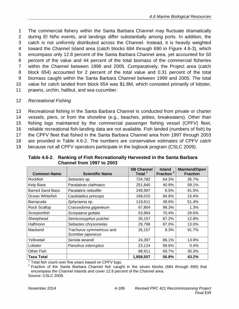
4.6 Marine Biological Resources
The commercial fishery within the Santa Barbara Channel may fluctuate dramatically 1 during El Niño events, and landings differ substantially among ports. In addition, the 2 catch is not uniformly distributed across the Channel. Instead, it is heavily weighted 3 toward the Channel Island area (catch blocks 684 through 690 in Figure 4.6-3), which 4 encompass only 12.8 percent of the Santa Barbara Channel area, yet accounted for 50 5 percent of the value and 44 percent of the total biomass of the commercial fisheries 6 within the Channel between 1999 and 2005. Comparatively, the Project area (catch 7 block 654) accounted for 2 percent of the total value and 0.31 percent of the total 8 biomass caught within the Santa Barbara Channel between 1999 and 2005. The total 9 value for catch landed from block 654 was $1.8M, which consisted primarily of lobster, 10 prawns, urchin, halibut, and sea cucumber. 11
Recreational Fishing 12
Recreational fishing in the Santa Barbara Channel is conducted from private or charter 13 vessels, piers, or from the shoreline (e.g., beaches, jetties, breakwaters). Other than 14 fishing logs maintained by the commercial passenger fishing vessel (CPFV) fleet, 15 reliable recreational fish-landing data are not available. Fish landed (numbers of fish) by 16 the CPFV fleet that fished in the Santa Barbara Channel area from 1997 through 2003 17 are provided in Table 4.6-2. The numbers are conservative estimates of CPFV catch 18 because not all CPFV operators participate in the logbook program (CSLC 2009). 19
Table 4.6-2. Ranking of Fish Recreationally Harvested in the Santa Barbara Channel from 1997 to 2003
Common Name Scientific Name SB Channel
Total 1Island
Fraction 2Mainland/Open
Fraction Rockfish Sebastes sp. 724,782 64.3% 35.7% Kelp Bass Paralabrax clathratus 251,840 40.9% 59.1% Barred Sand Bass Paralabrix nebulifer 249,997 8.5% 91.5% Ocean Whitefish Caulolatilus princeps 168,015 84.6% 15.4% Barracuda Sphyraena sp. 119,611 48.6% 51.4% Rock Scallop Crassedoma giganteum 67,804 98.3% 1.3% Scorpionfish Scorpaena guttata 53,964 70.4% 29.6% Sheephead Semicossyphus pulcher 30,157 87.2% 12.8% Halfmoon Sebastes chrysomelas 29,798 87.0% 13.0% Mackerel Trachurus symmetricus and
Scomber japonicus 26,157 8.3% 91.7%
Yellowtail Seriola lanandi 24,397 86.1% 13.9% Lobster Panulirus interruptus 23,124 99.6% 0.4% Other Fish 88,911 69.7% 30.3% Taxa Total 1,858,557 56.8% 43.2% 1 Total fish count over five years based on CPFV logs. 2 Fraction of the Santa Barbara Channel fish caught in the seven blocks (684 through 690) that
encompass the Channel Islands and cover 12.8 percent of the Channel area. Source: CSLC 2009.
November 2014 4-189 Revised PRC 421 Recommissioning Project Final EIR

4.6 Marine Biological Resources
Over half (56.8 percent) of the total CPFV catch in the Santa Barbara Channel occurred 1 near the Channel Islands. The CPFV catch fraction around the islands significantly 2 exceeded the fractional area for all but two major taxa (barred sand bass and 3 mackerel). 4
Abalone (Haliotis sp.) were once common in the rocky coastal habitat of the Santa 5 Barbara Channel, but currently all five major species of abalone in central and Southern 6 California are depleted, a result of cumulative impacts from commercial harvest, 7 increased market demand, sport fishery expansion, depredation by sea otters, pollution 8 of mainland habitat, disease, loss of kelp populations associated with El Niño events, 9 substantial poaching losses, and inadequate wild stock management. The California 10 Fish and Game Commission closed the commercial and recreational abalone fishery in 11 southern and central California under emergency action in May 1997. By legislative 12 action in January 1998, the closure was extended indefinitely (CSLC 2009). The 13 Cultured Abalone, a local abalone mariculture company, operates near Dos Pueblos 14 Canyon. 15
Kelp Beds and Mariculture 16
In addition to providing habitat as described above, kelp is harvested commercially 17 within the Santa Barbara Channel for various uses. Algin is extracted from a large 18 proportion of the harvest and used as a thickening, stabilizing, suspending, and gelling 19 agent in a wide variety of food, paper, pharmaceutical, cosmetic, and dental products. 20 Mariculture companies are also increasingly using giant kelp as food for their abalone 21 stock. Kelp beds along the coast can produce as much as 1,000 tons of kelp per year, 22 much of which is harvested for use by abalone farming operations. 23
4.6.2 Regulatory Setting 24
Federal and State laws that may be relevant to the Project are identified in Table 4.0-1. 25 Local laws, regulations, and policies are discussed below. 26
Local 27
Santa Barbara County 28
The coastal reaches adjacent to PRC 421 fall under the local jurisdictions of the City of 29 Goleta and Santa Barbara County. Santa Barbara County’s LCP (Santa Barbara County 30 1982) identifies ESHAs in the Project vicinity, which include the rocky intertidal habitat 31 at Coal Oil Point and between Point Conception and Ellwood, harbor seal hauling 32 grounds east of Naples, Naples Reef and kelp beds from Jalama to Carpinteria. 33
Revised PRC 421 Recommissioning Project 4-190 November 2014 Final EIR

4.6 Marine Biological Resources
City of Goleta General Plan/Coastal Land Use Plan (GP/CLUP) 1
City of Goleta GP/CLUP policies that are relevant to the Project in regard to marine 2 biological resources are: 3
· Policy CE 1 – To identify, preserve, and protect the city’s natural heritage by4 preventing disturbance of ESHAs.5
· Policy CE 6 – Preserve and protect the biological integrity of marine habitats and6 resources within and adjacent to Goleta.7
· Policy 8 – To preserve and protect habitats for threatened, endangered, or other8 special-status species of plants and animals to maintain biodiversity.9
4.6.3 Significance Criteria 10
An impact on biological resources would be considered significant if any of the following 11 apply: 12
· There is a potential for any part of the population of a threatened, endangered, or13 candidate species to be directly affected or if its habitat is lost or disturbed;14
· If a net loss occurs in the functional habitat value of: a sensitive biological habitat,15 including salt, freshwater, or brackish marsh; marine mammal haul-out or16 breeding area; eelgrass; river mouth; coastal lagoons or estuaries; seabird17 rookery; ESHA or Area of Special Biological Significance;18
· Permanent change in the community composition or ecosystem relationships19 among species recognized for scientific, recreational, ecological, or commercial20 importance;21
· Prolonged disturbance to or destruction of habitat (or functional habitat value) of22 a species recognized as biologically or economically significant in local, State, or23 Federal policies, statutes, or regulations;24
· There is a potential for the movement or migration of fish or wildlife to be25 impeded; or26
· If a substantial loss occurs in the population or habitat of any native fish, wildlife,27 or vegetation or if there is an overall loss of biological diversity. Substantial is28 defined as any change that could be detected over natural variability.29
An impact to commercial or recreational fishing would be considered significant if the 30 Project would: 31
· Temporarily reduce any fishery in the vicinity by 10 percent or more during a32 season, or reduce any fishery by 5 percent or more for more than one season;33
· Affect kelp and aquaculture harvest areas by 5 percent or more;34
November 2014 4-191 Revised PRC 421 Recommissioning Project Final EIR

4.6 Marine Biological Resources
· Result in loss or damage to commercial fishing or kelp harvesting equipment; or 1
· Harvesting time lost due to harbor closures, impacts on living marine resources2 and habitat, and equipment or vessel loss, damage, or subsequent replacement.3
4.6.4 Impact Analysis and Mitigation 4
Potential construction- and operations-related impacts to marine biological resources 5 are evaluated below. Table 4.6-3, located at the end of Section 4.6.4, provides a 6 summary of such impacts and recommended MMs to address these impacts. 7
Impact MBIO-1: Disturbance to Intertidal Organisms during Construction 8 Construction activities during recommissioning activities at Pier 421-2 and 9 following decommissioning and removal of Pier 421-1 would disturb and kill 10 intertidal invertebrates and might dislodge grunion eggs (Less than Significant 11 with Mitigation). 12
Impact Discussion 13
Disturbance of sediment during construction activities associated with caisson repairs 14 on Pier 421-2 and recommissioning of Well 421-2 have the potential to impact marine 15 resources due to excavation and jetting of sand around the piles. Additionally, 16 decommissioning and removal of Pier 421-1, estimated to occur 1 year following Project 17 completion, would produce similar potential impacts. 18
The Project would require operation of heavy construction equipment on the beach to 19 improve all three non-seaward-facing walls on the caisson at Pier 421-2 as well as to 20 perform repairs to the 25-foot section of 6-inch pipeline near the 12th tee of the 21 Sandpiper Golf Course. These Caisson reinforcements would include construction of 22 walls similar to the one built on the seaward-facing side of Pier 421-2 in 2011. This 23 would include installation of steel piles in 25-foot-deep holes drilled around the caisson 24 and concrete panels between the steel piles. Concrete slurry will then be poured 25 between the new panels and the old caisson walls. To perform this work, an excavator 26 would be located on the beach to scrape sand from between the piles and cut into the 27 bedrock to key the concrete panels in the Monterey shale base. As the bottom panel of 28 each section is being set, a sand jet unit on top of the caisson would clear the sand so 29 that the panel would sit directly on or near the Monterey shale base. The excavation of 30 sand at the base of the caisson would kill intertidal invertebrates living in the sand. The 31 amount of sandy intertidal habitat affected by these construction activities would be 32 small (less than 0.5 acre). Additionally, repair of the 25-foot section of 6-inch pipeline 33 along the access road would also require that construction equipment access the beach 34 adjacent to this section of pipeline. Intertidal invertebrate communities are adapted to 35 the seasonal shifting of sand off and on the beach and repopulate rapidly. Because of 36 the small amount of intertidal habitat that would be affected and the fact that the 37
Revised PRC 421 Recommissioning Project 4-192 November 2014 Final EIR

4.6 Marine Biological Resources
intertidal invertebrate community would be expected to re-establish within a year, these 1 impacts would be less than significant. 2
Decommissioning and removal of Pier 421-1, including the well, pier, and caisson, 3 would disturb the sand at the base of the pier and the surrounding area. Removal of 4 Pier 421-1 would require operation of heavy construction equipment on the beach to 5 decommission the well and deconstruct and remove the caisson and the pier. This 6 activity would include excavating around the piles to perform thermal cuts below the 7 existing ground surface so that the piles can be removed from the beach. This activity 8 would kill intertidal invertebrates living in the sand; however, the construction area 9 would be small and the invertebrate community would be expected to re-establish within 10 a year. This construction activity would be located approximately 250 feet west of the 11 construction activity associated with improvements to Pier 421-2, which is anticipated to 12 occur 1 year earlier. Therefore, it would not interfere with recently recovered or 13 recovering invertebrate populations at Pier 421-2. Because of the small amount of 14 intertidal habitat that would be affected and the fact that the intertidal invertebrate 15 community would be expected to re-establish within a year, these impacts would be less 16 than significant. 17
If caisson repair on Pier 421-2 or decommissioning and removal of Pier 421-1 occurs 18 between March and September, excavation or jetting of sand would potentially expose 19 grunion eggs deposited in the high intertidal zone. Because grunion populations are 20 declining and the beaches where they spawn are limited, destruction of grunion eggs 21 would result in a loss of the functional value of the beach as grunion spawning habitat. 22 The deposition of grunion eggs on a beach is patchy and even a small area can contain 23 a significant number of grunion eggs (Martin 2006). The destruction of grunion eggs is 24 considered less than significant with mitigation. 25
Mitigation Measures 26
MM MBIO-1. Avoid Caisson Repair on Pier 421-2 and Removal of Pier 421-1 27 during Grunion Spawning Season. Project activities that require equipment 28 access on the beach shall be scheduled to avoid, to the extent possible, 29 anticipated California grunion runs. In the event that construction will occur 30 during the seasonally predicted run period and egg incubation period for 31 California grunion as identified by the California Department of Fish and 32 Wildlife, a Project Biological Monitor, hired by the City of Goleta and paid by 33 Venoco, shall be present on the Project site each night, for the entire night, 34 from one night before the beginning of each seasonally predicted grunion run 35 until one night after the end of each run to monitor the presence of grunion on 36 the site. If any adult grunion are observed at the Project site, no construction 37 activities requiring equipment access within the area of the observed grunion 38 will be allowed until after the next predicted grunion run (or two weeks after the 39 last run in August) in which no adult grunion have been observed on the 40
November 2014 4-193 Revised PRC 421 Recommissioning Project Final EIR

4.6 Marine Biological Resources
Project site, unless otherwise approved by the California State Lands 1 Commission staff. 2
Rationale for Mitigation 3
Avoiding caisson repair and pier removal activities during the grunion spawning season 4 would ensure that no grunion eggs were killed or damaged by these activities. If pier 5 removal or caisson repair must occur between March and September, monitoring of 6 grunion spawning and avoiding disturbance to any areas where spawning occurred 7 would also avoid impacts to grunion eggs. Full implementation of MM MBIO-1 would 8 reduce Impact MBIO-1 to less than significant. 9
Impact MBIO-2: Impacts to Marine Organisms from Sediment Resuspension in the 10 Near-Shore Zone due to Disturbance of Sediments during Construction 11 Activities during construction activities such as caisson repairs on non-seaward 12 facing walls on Pier 421-2 and later decommissioning and removal of Pier 421-1 13 would have the potential to resuspend sediments in near-shore waters due to the 14 disturbance of beach sediments. Resuspension of sediment, particularly 15 contaminated sediments, could have adverse impacts on marine organisms (Less 16 than Significant with Mitigation). 17
Impact Discussion 18
Caisson repairs of the non-seaward facing walls on Pier 421-2 would disturb sediments 19 by excavation, jetting and the removal and placement of structures in the sand. 20 Additionally, decommissioning and removal of Pier 421-1, expected to occur about 1 21 year following recommissioning of Pier 421-2, would disturb the sand at the base of the 22 pier and the surrounding area during removal of the pier and caisson. Because the piers 23 are located in the intertidal zone, some of this sediment may become suspended in 24 near-shore waters. Suspended sediment may have a number of adverse effects on 25 marine organisms. Sand can interfere with the appendages of filter feeding 26 invertebrates and clog respiratory appendages of invertebrates. The gills of fishes may 27 become abraded by sediments, but usually fishes move out of the area before they 28 suffer harm. Suspended sediments may increase turbidity over the short term and 29 interfere with the foraging activities of visual predators including fishes, marine 30 mammals, and seabirds such as California brown pelicans and California least terns. 31
The proposed repair of the caisson at Pier 421-2 and future removal of the pier and 32 caisson at Pier 421-1 would disturb sand in the surf zone. These sediments would be 33 expected to settle rapidly and would not create extensive turbidity plumes. Marine 34 macrophytes like surfgrass, eelgrass, and kelp require light and, therefore, can be 35 affected adversely if turbidity reduces light levels for an extended period of time. No 36 surfgrass occurs in the Project vicinity. Some eelgrass and kelp beds are found 37 offshore. Because kelp and eelgrass are adapted to periods of natural turbidity, 38
Revised PRC 421 Recommissioning Project 4-194 November 2014 Final EIR

4.6 Marine Biological Resources
temporary increases in turbidity during construction would not be expected to have an 1 adverse impact on these habitats. Impacts to marine organisms from suspended 2 sediments would be minimal because of the short duration and limited spatial extent of 3 the impacts and because turbidity would occur in the intertidal and shallow subtidal 4 zones that typically are subjected to sediment resuspension from wave action. Impacts 5 would be less than significant. 6
As discussed in Section 4.5, Hydrology, Water Resources, and Water Quality, although 7 no contaminants were discovered during recent repairs, subsurface soils and soil 8 surrounding the piers have some potential to be contaminated. If these sediments are 9 released into the marine environment during construction, contaminants may be at 10 levels that could have an adverse impact on marine organisms. This impact would be 11 less than significant with mitigation. 12
Mitigation Measures 13
Implement MMs WQ-1a through WQ-1b and MMs HAZ-1c through HAZ-1-d. 14
Rationale for Mitigation 15
Removal of contaminated sediments prior to in-water construction activities would 16 prevent the release of existing petroleum hydrocarbons resulting from Project activities. 17 Removal of contaminated sub-soil mobilized during drilling would prevent it reaching the 18 surf zone. Erection of a silt curtain would reduce the dispersion of contaminated 19 sediments from the soils surrounding the piers into the water column and would prevent 20 resuspended sediments from dispersing beyond the immediate construction area. Full 21 implementation of these measures would reduce Impact MBIO-2 to less than significant. 22
Impact MBIO-3: Noise Impacts to Marine Life During Caisson Repairs on Pier 421-23 2 and Decommissioning and Removal of Pier 421-1 24 Construction activities during caisson repairs on non-seaward facing walls on 25 Pier 421-2 and decommissioning and removal of Pier 421-1 have the potential to 26 generate noise from operation of heavy construction equipment and from 27 excavation to install new piles and panels. Jetting of sand also can create high 28 noise levels. Construction noise may disturb marine animals, especially marine 29 mammals (Less than Significant). 30
Impact Discussion 31
Construction activities associated with the repair of the caisson on Pier 421-2, as well 32 as to perform repairs to the 25-foot section of 6-inch pipeline near the 12th tee of the 33 Sandpiper Golf Course have the potential to produce loud noises due to operation of 34 heavy equipment on the beach, including excavation for the installation of new piles and 35 panels. Additionally, decommissioning and removal of PRC 421, expected to occur 1 36
November 2014 4-195 Revised PRC 421 Recommissioning Project Final EIR

4.6 Marine Biological Resources
year following recommissioning of Pier 421-2, would also require operation of heavy 1 equipment on the beach. The noise and activity of construction may alter the behavior 2 of fishes in the immediate vicinity of the pier or cause them to avoid the construction 3 area temporarily. Information on the sound levels to which fishes are sensitive is limited. 4 Fish sensitivity to noise depends on whether they have any sort of auditory mechanisms 5 for improving hearing sensitivity (Southall 2005). Most fishes do not have special 6 auditory mechanisms and are hearing generalists with relatively poor hearing sensitivity 7 over a narrow band of low sound frequencies (about 0.1 to 1.0 kilohertz [kHz]). Hearing 8 specialists have unique anatomical features that afford them greater hearing sensitivity 9 over a relatively wider range of low sound frequencies (about 0.1 to 3.0 kHz). Hastings 10 et al. (1996) exposed fish (Astronotus ocellatus, the oscar) in the laboratory to sounds 11 to determine the effects of sound at various levels typical of man-made sources on the 12 sensory epithelia of the ear and the lateral line. Sounds varied in frequency (60 to 300 13 hertz [Hz]), duty cycle (20 percent or continuous) and intensity (100, 140, or 180 14 decibels standardized at 1 micropascal at 1 meter [dB//1uPa]). The only damage that 15 was observed was in four of five fish stimulated with 300-Hz continuous tones at 180 16 dB//1uPa and allowed to survive for four days. Damage was limited to small regions of 17 the ear. These data suggest that for at least some types of fish only limited physical 18 damage will occur even at exposure to very high levels. 19
Loud noises may disturb California brown pelicans and cormorants roosting on the 20 structures offshore from Piers 421-1 and 421-2. Varanus Biological Services monitored 21 the behavior of brown pelicans roosting on the breakwater during dredging of the Marina 22 del Rey entrance channel (Varanus 1999). Punctuated events including dredge start-up 23 after periods of inactivity and the tugboat passing between the dredge and the breakwater 24 to retrieve the haul barge caused disturbance to the colony including movements of 25 occasionally large numbers of birds. However, these impacts were generally of short 26 duration (a few minutes) and resulted in pelicans shifting positions along the breakwater. 27 Unusual, sudden or infrequent events of a dramatic nature (fireworks, spotlighting the 28 colony by a boat closely approaching the breakwater, illuminating the breakwater by the 29 dredge after long periods of inactivity) displaced roosting pelicans from the breakwater for 30 lengthy periods of time. The largest reaction to disturbance observed during the 31 monitoring was to an earthquake. All the pelicans left the breakwater in reaction to the 32 event and did not return for 45 minutes. The Bird Island structures are located over 800 33 feet offshore from the Project site. Noise from Project construction would be expected to 34 attenuate to the 60 to 65 dBA range by this distance and it is unlikely the noise would 35 disturb the roosting birds on the structure. 36
Noise associated with any potential excavation or drilling would not disturb marine 37 mammals. Baleen whales are thought to be most sensitive to low frequency sounds 38 (about 0.01 kHz to 5 kHz) based on characteristics of their auditory morphology and 39 sound production (Southall 2005). Most odontocete cetaceans that have been directly 40 tested have relatively good hearing sensitivity across a broader range of mid to high 41
Revised PRC 421 Recommissioning Project 4-196 November 2014 Final EIR

4.6 Marine Biological Resources
frequencies (about 4 kHz to 100 kHz). Sea lions and fur seals have been shown to be 1 sensitive to a fairly wide range of mid frequencies (about 1 kHz to 30 kHz). True seals 2 are generally capable of hearing across a wide range of low to mid sound frequencies 3 (about 0.2 kHz to 50 kHz). The dominant components of the "communication" calls of 4 most marine mammals fall within the 20 Hz to 20 kHz range (CSLC 2009). 5
NMFS has adopted 160 decibels (dB) as an acceptable level of impulsive underwater 6 sound. Based on available scientific evidence, acoustic harassment of marine mammals 7 would not be expected to occur below this conservative level. No Project activities are 8 expected to exceed 160 dB; therefore, pier removal and caisson repair operations 9 would not have the potential to produce noises at a level high enough to have adverse 10 impacts to marine mammals. 11
Marine mammal monitors were present during caisson repair on Pier 421-1 in 2004 and 12 on Pier 421-2 in 2011 (City of Goleta 2006; J. Storrer pers. comm. 2011). A 500-foot 13 safety zone was established for marine mammals and a vibrating pile driver was used, 14 which generated greater noise levels than would occur under the Project. During pile 15 driving activities, monitors neither observed any marine mammals within the 500-foot 16 safety zone nor did they observe changes in the movement or behavior of more distant 17 individuals that would indicate any reaction to pile driving noise. 18
Because no adverse impacts to marine mammals were noted during previous pile 19 driving operations at PRC 421, and Project activities would generate less noise than 20 occurred during those activities, the Project would have less than significant effects on 21 marine life. 22
Mitigation Measures 23
None required. 24
Impact MBIO-4: Oil Spill Impacts to Marine Resources 25 Leaks and spills of petroleum hydrocarbons into the ocean could adversely affect 26 marine organisms (Significant and Unavoidable). 27
Impact Discussion 28
Oil production on PRC 421 and transport of crude oil from the Project via onshore 29 pipeline have the potential to result in the accidental release of limited quantities of 30 petroleum hydrocarbons. Potential oil spill releases from the Project are discussed in 31 Section 4.2, Safety. A release at Pier 421-2 or from PRC 421 pipelines under most 32 conditions would immediately contact the shore. Oil released to marine waters from the 33 PRC 421 Project area was assumed to be transported approximately 1 mile west of the 34 site and 2 miles to the east, as shown in Figure 4.2-9. A number of sensitive marine 35 habitats occur within the area most vulnerable to a Project-related oil spill such as those 36
November 2014 4-197 Revised PRC 421 Recommissioning Project Final EIR

4.6 Marine Biological Resources
within the Campus Point SMCA. The Bell Canyon Creek lagoon and the Devereux 1 Slough estuary are estuarine habitats that would be highly likely to suffer impacts in the 2 event of a Project-related oil spill if their mouths were open. Tecolote Creek estuary also 3 is within the area most likely to be affected by an oil spill from the Project. 4
Significant rocky intertidal habitat that would be vulnerable to a Project oil spill occurs 5 near Coal Oil Point east of PRC 421 and within the bend of "Ellwood Cove" 6 approximately 0.5 mile east of the Project site. Rocky intertidal habitat, primarily 7 boulders and cobble, also occurs west of the Project area up-coast from the Bacara 8 Resort. These rocky intertidal areas are used for research by UCSB. 9
A sizable kelp bed is located approximately 500 feet offshore of the existing caissons 10 and extends for over 1 mile southeast along the Ellwood Coast. Some eelgrass also 11 occurs offshore the PRC 421 piers. 12
The Bird Island structures, constructed about 850 feet offshore Pier 421-1, support large 13 numbers of roosting seabirds including the brown pelican and double-crested 14 cormorant, a California Species of Special Concern. These birds would be vulnerable to 15 an oil spill when they are foraging in the water. A Project-related spill could also impact 16 beaches used as foraging and nesting habitat by the Federal threatened western snowy 17 plover and waters used for foraging by the State and Federal endangered California 18 least tern, which nests at Coal Oil Point. Although not common, the Federal threatened 19 southern sea otter occurs in the Project area. This species is very vulnerable to oil. 20
Small spills from the Line 96 pipeline (less than 1 gallon) would be highly unlikely to 21 reach the marine environment. Significant impacts to marine biological resources could 22 result in the unlikely event that a large spill from the Line 96 pipeline (greater than 1 23 gallon) occurred during high winds or tides that would convey the spilled material 24 towards the shoreline and to sensitive habitats such as Devereux Slough, Goleta 25 Slough, Naples Reef, or Refugio Canyon. 26
Oil spills have been found to have varying effects on marine resources (Aspen 2005). 27 Documented biological damage from an oil spill has ranged from little apparent damage 28 in the Apex Galveston Bay spill (Greene 1991) to widespread and long-term damage, 29 such as the 1969 West Falmouth spill (Sanders 1977). Some factors influencing the 30 extent of damage caused by a spill are the dosage of oil, type of oil, local weather 31 conditions, location of the spill, time of year, methods used for cleanup, and the affected 32 area’s previous exposure to oil. Other levels of concern are the possibility of food chain 33 contamination by petroleum products and the impact of an oil spill on the structure of 34 biological communities as a whole. The effects of the 2010 spill in the Gulf of Mexico 35 from the Deepwater Horizon are still under investigation, but research published to date 36 on the short-term impacts indicates increased developmental abnormalities in fish 37 (Dubansky et al. 2013; Whitehead 2012), substantial shifts in the composition of 38
Revised PRC 421 Recommissioning Project 4-198 November 2014 Final EIR
4.6 Marine Biological Resources
microbial species in the water column (Rivers et al. 2013), and significant reductions in 1 the abundance and diversity of benthic fauna (Montagna et al. 2013). 2
Oil spilled into the ocean gradually changes in chemical and physical makeup as it is 3 dissipated by evaporation, dissolution and mixing, or dilution in the water column. 4 Various fractions respond differently to these processes, and the weathered residue 5 behaves differently from the material originally spilled. Toxicity usually tends to 6 decrease as oil weathers. Depending on tidal stage and wave energy, oil can become 7 deeply buried in sand and later re-exposed, causing recurrent releases, possibly 8 spanning months or longer. 9
Laboratory tests have demonstrated the toxicity of petroleum hydrocarbons for many 10 organisms. Soluble aromatic compounds in crude oil are generally toxic to marine 11 organisms at concentrations of 0.1 to 100 ppm. Planktonic larval stages are usually the 12 most sensitive. Very low levels of petroleum, below 0.01 mg/L, can affect such delicate 13 organisms as fish larvae (National Response Center [NRC] 1985). Concentrations as 14 low as 0.4 parts per billion (ppb) caused premature hatching and yolk-sac edema in 15 Pacific herring eggs exposed to weathered Alaska crude oil (NRC 2003). 16
Biological impacts of oil spills include lethal and sublethal effects and indirect effects 17 resulting from habitat alteration and/or destruction or contamination of a population’s 18 food supply. Directly lethal effects may be chemical (i.e., poisoning by contact or 19 ingestion) or physical (i.e., coating or smothering with oil). A second level of interaction 20 is sublethal effects, which are those which do not kill an individual but which render it 21 less able to compete with individuals of the same and other species. 22
Impacts to plankton from oil pollution could range from direct lethal effects caused by 23 high concentrations of oil in the surface layers of the water column after a major spill to 24 a variety of sublethal effects such as decreased phytoplankton photosynthesis and 25 abnormal feeding and behavioral patterns in zooplankton. Studies of oil spills have 26 generally failed to document major damage to plankton, although lethal effects or 27 severe oiling of individual zooplankton organisms in the immediate vicinity of a spill has 28 been reported in a number of studies. Because plankton distribution and abundance are 29 variable in time and space, any evidence of damage would be very difficult to document. 30
Plankton populations on the open coast are expected to have low vulnerability to a 31 project-related oil spill. Even if a large number of individual organisms were oiled, rapid 32 replacement by individuals from adjacent waters is expected. In addition, the 33 regeneration time of phytoplankton cells is rapid (9 to 12 hours) and zooplankton 34 organisms are characterized by wide distributions, large numbers, short generation 35 times, and high fecundity (NRC 1985). The impacts to plankton of a spill from PRC 421 36 operations are expected to be adverse but less than significant. 37
November 2014 4-199 Revised PRC 421 Recommissioning Project Final EIR

4.6 Marine Biological Resources
Open coast sandy beaches, like those immediately adjacent to Piers 421-1 and 421-2 1 generally would not be expected to suffer long-term damage from a project-related oil 2 spill. Once the oil has been removed, recolonization by sandy beach organisms tends to 3 be rapid (Aspen 2005). However, if large amounts of oil coat the beach, substantial loss 4 of intertidal organisms could occur. Sand and gravel beach habitat was adversely 5 affected by the 1997 Torch/Platform Irene spill off the south-central coast of California 6 (Torch/Platform Irene Trustee Council 2006). After the spill, invertebrates on the beach, 7 particularly sand crabs, and Pismo clams, likely suffered significant mortality due to 8 smothering under blankets of oil and sand compression caused by heavy equipment 9 from cleanup operations. Therefore, in the event of a large spill, impacts to sandy beach 10 habitat could be significant. 11
Most studies of oil spills have shown that rocky intertidal communities tend to suffer 12 harmful impacts, although spills have occurred where no impacts to this habitat were 13 observed (e.g., Chan 1987). Oil represents a physical and chemical hazard, and 14 intertidal organisms are especially vulnerable to the physical effects of oil (Percy 1982). 15 Sessile species, such as barnacles, may be smothered, while mobile animals, such as 16 amphipods, may be immobilized and glued to the substrate or trapped in surface slicks 17 in tidepools. It has been hypothesized (Hancock 1977) that organisms in the upper 18 intertidal areas where the oil dries rapidly are more apt to be affected by physical effects 19 of oil, such as smothering, whereas organisms in the lower intertidal areas are more 20 exposed to the chemical toxic effect of the liquid petroleum. 21
The 1997 Torch/Platform Irene spill oiled rocky intertidal habitat in many places along 22 the shoreline. Although levels of injury greater than 10 percent were not documented, 23 the oil exposure was thought to cause low levels of injury to a variety of rocky intertidal 24 species including crustacea, mollusks, arthropods, and algae (Torch/Platform Irene 25 Trustee Council 2006). Black abalone (Haliotis cracherodii) and mussel beds were 26 observed to be coated with oil along or near the shores of Vandenberg Air Force Base 27 and at other nearby rocky shorelines. 28
If an intertidal area suffers severe damage from an oil spill, it may take years for 29 complete recovery. A study of recovery of rocky intertidal communities of central and 30 northern California (Foster et al. 1991) suggested that the high intertidal, algal-31 dominated Endocladia/Mastocarpus community would take one to six years to recover 32 in places where a large area had been decimated, while the mid-intertidal mussel bed 33 assemblage would be likely to take more than 10 years to recover from a disturbance 34 that affected a large area. Mussel beds have been found to trap oil and under some 35 circumstances may allow the oil to persist for years after a spill (NRC 2003). 36 Documented recovery times of intertidal communities from actual oil spills have varied, 37 but have been generally consistent with the above predictions. In contrast, McCall and 38 Pennings (2012) found intertidal crabs and terrestrial arthropods (insects and spiders) to 39
Revised PRC 421 Recommissioning Project 4-200 November 2014 Final EIR

4.6 Marine Biological Resources
be resilient to oil exposure; although populations were suppressed following the 2010 1 Deepwater Horizon spill in the Gulf of Mexico, they had largely recovered after 1 year. 2
Impacts to valuable intertidal habitat in the immediate Project area is of particular 3 concern because oil spilled from the piers or pipelines could reach these areas rapidly. 4 Rocky intertidal ESHAs occur at “Ellwood Cove” east of the site, Coal Oil Point, and 5 areas along the Gaviota Coast. Impacts to rocky intertidal habitat from a Project-related 6 petroleum spill could potentially be significant. 7
Compared to the readily observable impact on intertidal communities, impacts on 8 benthic subtidal communities have been more difficult to document. This lack of 9 documented impacts has been found both in the shallow (6 to 60 feet) and deep (>60 10 feet) subtidal areas. However, the studies that have shown impacts have generally been 11 of shallow water benthic habitats. Often the lack of effects on subtidal communities 12 appears to be because oil does not sink to the bottom. For example, in shallow subtidal 13 SCUBA diving surveys following the 1988 Nestucca spill in Gray’s Harbor, Washington, 14 no evidence of subtidal oil deposits was found, and no sediment samples contained oil 15 and grease above detection limits (Carney and Kvitek 1990). 16
Most studies have failed to document negative effects of oil spills on kelp beds. 17 However, Thom et al. (1993) found that the tissues of bull kelp, Nereocystis luetkeana, 18 were damaged following direct exposure to several oil types, including intermediate fuel 19 oil, diesel fuel, and Prudhoe Bay crude oil. Furthermore, oil can cling to kelp and cause 20 the surrounding shoreline to be repeatedly doused by oil as happened in the 1992 Avila 21 spill (Togstad 1993). Kelp holdfasts also can retain oil for years after a spill (NRC 2003). 22 Impacts to Project area kelp beds are unlikely to significantly affect the kelp itself but the 23 oil could persist and affect the associated ecosystem. 24
Oil spills can affect seabirds directly through oil contamination and indirectly through 25 degradation of important habitat. The direct effect of oiling on birds is predominantly 26 contamination of feathers, removing insulative qualities and reducing buoyancy (Holmes 27 and Cronshaw 1977; Moskoff 2000). Oiling of feathers leads to elevated metabolic rate 28 and hypothermia (Hartung 1967). Oiled birds may also ingest oil through preening of 29 feathers or feeding on contaminated prey. Effects of ingested oil can range from acute 30 irritation and difficulties in water absorption to general pathologic changes in some 31 organs (e.g., Crocker et al. 1974; Fry 1987; Nero and Associates 1983). Ingestion of oil 32 can also result in changes in yolk structure, and reduction in number of eggs laid and 33 egg hatchability (Hartung 1965; Grau et al. 1977). Oiled birds that are able to return to a 34 nest can contaminate the exterior of eggs, reducing hatchability (e.g., Hartung 1965; 35 Patten and Patten 1977). Indirect effects result principally from contamination of habitat 36 where feeding occurs. 37
November 2014 4-201 Revised PRC 421 Recommissioning Project Final EIR

4.6 Marine Biological Resources
Marine birds are known to be conspicuous casualties of oil spills (Hope-Jones et al. 1 1970; Ford et al. 1991; Torch/Platform Irene Trustee Council 2006). For example, it has 2 been estimated that between 100,000 and 435,000 birds died within three months of the 3 Exxon Valdez spill (Moskoff 2000). Nearly 11 million gallons of oil, orders of magnitude 4 more oil than could be spilled from the Project, were spilled in the 1989 Exxon Valdez 5 spill, but the effects of the Exxon Valdez spill are mentioned to illustrate the extreme 6 vulnerability of seabirds to spilled oil. Those species suffering greatest mortality from 7 past spills along the outer coast have been alcids, cormorants, loons, grebes, and 8 scoters (Smail et al. 1972; Dobbin et al. 1986; Page and Carter 1986). These groups 9 are more vulnerable because they are found in large numbers on the water. Other birds 10 (e.g., gulls and pelicans) typically spend less time on the water or will relocate from the 11 area affected by a spill (Sowls et al. 1980). In the years since the Exxon Valdez spill 12 several species of birds have demonstrated indirect or delayed responses to the spill 13 (NRC 2003). These responses were found in sea ducks and shorebirds, species that 14 forage primarily on intertidal and shallow subtidal invertebrates, as well as several 15 species that forage on small fish found in inshore waters. 16
The Torch/Platform Irene spill is estimated to have adversely impacted between 635 17 and 815 seabirds and shorebirds (Torch/Platform Irene Trustee Council 2006). Seabird 18 species impacted by the spill included Brandt's cormorants, common murres (Uria 19 aalgae), western grebe, rhinoceros auklet (Cerorhinca monocerata), pigeon guillemot 20 (Cepphus columba), elegant tern (Sterna elegans), common loon (Gavia immer), 21 California brown pelican and several species of shearwaters and gulls. 22
California brown pelicans and cormorants roosting on the Bird Island structures on PRC 23 421 are likely to suffer impacts from a Project-related oil spill at Pier 421-2. These birds 24 would be expected to forage in Project area waters and are likely to be oiled. If a spill 25 occurred during the least tern nesting season, California Least Terns from the colony at 26 the Coal Oil Point Reserve might be impacted by the oil. Clearly, a Project-related oil 27 spill has the potential to significantly impact seabirds. 28
Direct effects of oiling on pinnipeds and sea otters include both surface contamination of 29 fur and possible ingestion of oil while grooming or during suckling of pups. Harbor seals, 30 elephant seals, and sea lions rely predominantly on subcutaneous fat and a high 31 metabolic rate to keep warm. In contrast, fur seals and sea otters depend on the 32 integrity of an air layer trapped in clean fur to provide insulation and buoyancy. Harbor 33 seal pups may be born with a lanugo coat of dense wooly fur to keep them warm until 34 they have stored sufficient subcutaneous fat. These fur-bearing pinnipeds are at 35 particular risk from an oil spill because oiling can reduce the heat-retaining properties of 36 the fur and result in hypothermia and death. 37
Sea otters, fur seals, and very young harbor seal pups are at extreme risk of mortality 38 from oil spills. Although the main sea otter population is north of Point Conception and 39
Revised PRC 421 Recommissioning Project 4-202 November 2014 Final EIR

4.6 Marine Biological Resources
would only be vulnerable to a Project-related spill from the transportation of PRC 421 oil 1 to the San Francisco area, sea otters do occur in the Ellwood area and one or more 2 otters could be oiled from a spill at Pier 421-2 or the pipeline to the EOF. There is no 3 evidence that sea otters are able to successfully avoid oiling if a spill reaches near-4 shore waters, and both adults and younger animals are equally susceptible to death 5 from oiling. Fur seals, while sensitive to oiling, are typically found over the continental 6 slope and waters farther offshore and are rare in Project area waters. Harbor seal pups 7 with a lanugo coat are susceptible to impacts from oil spills in the first week of life. After 8 molt of the natal fur, and when sufficient fat has been acquired, oil contamination is not 9 likely to have adverse effects. If oil spilled in Project area waters reached the harbor 10 seal rookery east of Naples when pups were present, their fur could become oiled. 11 Impacts of an oil spill on sea otters or harbor seal pups would be significant. 12
Cetaceans have smooth skin to which oil does not readily adhere. Direct effects of oil 13 spills are limited in large part to inhalation of volatile components and ingestion during 14 feeding by baleen whales. Baleen whales feed opportunistically, but regularly visit 15 specific feeding grounds where euphausiid crustaceans and other invertebrates or small 16 fish form dense shoals. Gray whales, although abundant in winter and spring, feed 17 infrequently and only opportunistically during migration. 18
The extent to which large whales will avoid oil spills is still unclear. Migrating gray 19 whales have been noted making some attempt to avoid natural oil seeps, but the 20 behavior is inconsistent (Kent et al. 1983). Humpback whales have been observed 21 feeding in an area off Cape Cod where thin oil sheens were present from the Regal 22 Sword spill (Goodale et al. 1979). 23
Toothed whales, which use echo-location to orient and find prey, may be able to avoid 24 oil slicks. In studies with captive animals, bottlenose dolphins were found to reliably 25 detect oil in a slick one millimeter thick and avoid contact (Geraci et al. 1983; Smith et 26 al. 1983). However, a recent study in the Gulf of Mexico after the Deepwater Horizon 27 spill found increased rates of lung disease and hypoadrenocorticism in bottlenose 28 dolphins (Schwake 2013). 29
Mitigation Measures 30
In addition to the measures listed below, MM BIO-4a from the Line 96 Modification 31 Project EIR required update of the OSCP to protect sensitive resources along the 32 pipeline route, and reduces impacts to marine biological resources from oil spills that 33 could reach the ocean through drainages. 34
MM MBIO-4a. Update South Ellwood Field Oil Spill Contingency Plan (OSCP) 35 to Address a Spill from Lease PRC 421 Oil Production. Prior to beginning 36 construction at PRC 421 and prior to the City of Goleta’s issuance of the Land 37 Use permit , Venoco shall update the South Ellwood Field OSCP to address 38
November 2014 4-203 Revised PRC 421 Recommissioning Project Final EIR
4.6 Marine Biological Resources
protection of sensitive biological resources disturbed during an oil spill or 1 cleanup activities. The revised OSCP shall include specific measures to avoid 2 impacts on Federal- and State-listed endangered and threatened species, and 3 shall specifically identify training and procedures to contain oil spilled from 4 production at Lease PRC 421. The OSCP shall identify sensitive resources, 5 including the birds on the Bird Island platforms, kelp beds offshore the piers, 6 intertidal and subtidal resources within the Campus Point SMCA such as those 7 at Coal Oil Point, the harbor seal rookery at Burmah Beach and Naples Reef, 8 and the Naples MPA that could be oiled rapidly from a spill on PRC 421. Rapid 9 response procedures to protect those sensitive resources shall be identified. 10 Venoco shall submit the updated South Ellwood Field and OSCP to the 11 California State Lands Commission, Department of Fish and Wildlife Office of 12 Spill Prevention and Response, California Coastal Commission, Santa Barbara 13 County, and City of Goleta staffs for review and approval prior to operation of 14 the recommissioned facilities. 15
MM MBIO-4b. Develop a Protection Plan to Keep Birds Roosting on Bird Island 16 from Harm in the Event of an Oil Spill on Lease PRC 421. Prior to starting 17 construction at PRC 421 and prior to the City of Goleta’s issuance of a Land 18 Use Permit, Venoco shall engage a biologist experienced with wildlife and bird 19 rehabilitation to determine whether it is necessary to develop a plan specifically 20 to protect pelicans and cormorants roosting on the Bird Island platforms from 21 harm in the event of an oil spill. The biologist shall submit a memorandum 22 explaining their position to the California State Lands Commission staff for 23 review and approval. If the biologist deems plan preparation necessary, 24 Venoco shall include this plan within the revised OSCP, potentially including 25 methods to deter the birds from feeding or resting in oiled waters. The plan 26 also shall include procedures to capture and rehabilitate oiled birds. If the plan 27 is deemed necessary, Venoco shall submit the Plan to the California State 28 Lands Commission, California Coastal Commission, Santa Barbara County, 29 and City of Goleta staffs for review and approval prior to operation of the 30 recommissioned facilities. 31
Rationale for Mitigation 32
The South Ellwood Field EAP refers to the beachfront leases of PRC 421 but no 33 procedures specific to those leases are identified. With the resumption of oil production 34 from PRC 421, the potential exists for oil to be spilled from Pier 421-2 and during 35 transport by onshore pipeline. Procedures to protect sensitive marine resources in the 36 immediate vicinity of Pier 421-2 would help to keep oil from reaching these resources. 37 Pelicans and cormorants roosting on the Bird Island platforms in Lease PRC 421 are in 38 immediate danger from a spill at the lease. The development of specific procedures to 39 deter birds from oiled areas and rehabilitate oiled birds would help to reduce impacts on 40 these species. 41
Revised PRC 421 Recommissioning Project 4-204 November 2014 Final EIR

4.6 Marine Biological Resources
Residual Impacts 1 Even with specific procedures to protect sensitive marine resources in the Project 2 vicinity, impacts of a major oil spill would be significant and unavoidable. 3
Impact MBIO-5: Oil Spill Impacts to Commercial and Recreational Fishing 4 Accidental discharge of petroleum hydrocarbons into marine waters would 5 adversely affect commercial and recreational fishing (Significant and 6 Unavoidable). 7
Impact Discussion 8
A wide variety of fish and shellfish species are commercially harvested in the Project 9 area and biota residing in intertidal and shallow subtidal habitats are vulnerable to oil 10 spills. Several species are commercially and recreationally harvested in the intertidal 11 zone. Sea urchins, for example, ranked first in both pounds landed and dollar value over 12 the six-year period from 1999 to 2005. Both sea urchins and lobsters are high-value 13 species that are harvested commercially and recreationally in the immediate Project 14 area. In addition, market squid alone accounted for over half (70 percent) of the dollar 15 value of the commercial catch during the six years, and accounted for 44 percent of the 16 total catch in biomass. Other intertidal or shallow subtidal organisms such as sea 17 cucumbers and whelks are also harvested within the Santa Barbara Channel. 18 Additionally, The Cultured Abalone relies on kelp harvest from lease 27 located near the 19 Project area. 20
In the event of an oil spill, impacts could occur to the local commercial and recreational 21 fishing industry. The degree of oiling and the oil spill impacts depend on several factors. 22 These include location of spill, volume, type of oil, amount of weathering, evaporation, 23 dispersion of oil into the water column or shoreline, weather conditions at the time of the 24 spill and immediately following, and the amount of oil that is contained and cleaned 25 immediately after a spill. Although large spills, e.g., greater than 2,000 barrels, are rare, 26 the Santa Barbara oil spill of 1969 was estimated at 80,900 barrels (CSLC 2009). The 27 1997 spill from the rupture of the Torch Pedernales pipeline was estimated at 163 to 28 1,242+ barrels (CSLC 2009). While the probability for a spill that would cause oil to 29 contact and foul the shoreline or shallow subtidal areas where commercial or 30 recreational species are harvested is low, the potential for such a spill exists. While 31 contaminated shorelines may be cleaned, in some instances, depending on substrate 32 type, oil may persist in sediments for several years. 33
Since the Exxon Valdez spill in 1989 and the Deepwater Horizon spill in 2010 several 34 studies have described the effects of oil spills in marine environments, the results of 35 which are incorporated into this analysis by reference (Hayes and Michel 1998, Coats et 36 al. 1999, Spies et al. 1996, and Brown et al. 1996; Dubansky et al. 2013; Rivers et al. 37 2013; Montagna et al. 2013). Adult fish, due to their mobility, may be able to avoid or 38
November 2014 4-205 Revised PRC 421 Recommissioning Project Final EIR

4.6 Marine Biological Resources
minimize exposure to spilled oil. However, there is no conclusive evidence that fish 1 would avoid spilled oil. Egg and larval stages would also not be able to avoid exposure 2 to spilled oil. The resultant potential losses to commercial and recreational fish 3 resources and those losses due to closure of fishing areas for most or all of a fishing 4 season is considered a potentially significant impact. In addition, fish harvested from 5 contaminated areas may also be reduced in value, and fishing gear may be damaged 6 due to oil fouling, causing additional significant impacts. This impact would be significant 7 and unavoidable. 8
Mitigation Measures 9
Implementation of MMs identified in Sections 4.2, Safety; 4.5, Hydrology, Water 10 Resources, and Water Quality; and 4.7, Terrestrial Biological Resources, for 11 contingency planning and spill response would be required. 12
Rationale for Mitigation 13
The measures presented in the above-mentioned sections provide improved oil spill 14 response capabilities, oil spill containment measures, and protection of resources. With 15 implementation of those measures, the risk to the marine environment and impacts to 16 commercial and recreational fishing may be reduced. 17
Residual Impacts 18
Because there are limitations to thorough containment and cleanup of an offshore oil 19 spill, significant impacts would remain for commercial and recreational fisheries in the 20 intertidal and shallow subtidal zones after mitigation. 21
Impact MBIO-6: Impacts to Kelp Harvesting 22 Oil spills could cause damage to kelp beds, which would subsequently affect kelp 23 harvesting. Damage would likely be minor, and kelp would likely recover rapidly 24 (Less than Significant). 25
Impact Discussion 26
The effects of oil spills from the Project on beds of giant kelp along the Pacific Coast 27 have been examined several times. Oil spills have caused little damage to the giant kelp 28 beds, even with considerable quantities of crude oil fouling the surface canopies (CSLC 29 2009). It appears crude oil stays on the surface of the water and does not tend to 30 adhere to the fronds of the giant kelp. The literature indicates that an oil spill and its 31 cleanup cause little damage to kelp beds. Should damage occur, recruitment and 32 recolonization occur rapidly. Therefore, although impacts could occur to kelp canopies, 33 which could affect commercial kelp harvesting, they are generally localized and 34
Revised PRC 421 Recommissioning Project 4-206 November 2014 Final EIR

4.6 Marine Biological Resources
temporary in nature. Hence, impacts to kelp and commercial and recreational kelp 1 harvesting operations are adverse but not significant. 2
Mitigation Measures 3
None required. 4
Table 4.6-3. Summary of Marine Biological Resources Impacts and Mitigation Measures
Impact Mitigation Measures MBIO-1: Disturbance to Intertidal Organisms during Construction
MBIO-1a. Avoid Caisson Repair or Pier Removal During the Grunion Spawning Season.
MBIO-2: Impacts to Marine Organisms from Sediment Resuspension in the Near-Shore Zone due to Disturbance of Sediments during Construction
HAZ-1c. Soil Sampling. HAZ-1d. Removal Action Plan. WQ-1a. Avoidance of High Tides and Silt Curtain. WQ-1b. Water Quality Certification.
MBIO-3: Noise Impacts to Marine Life during Removal of Pier 421-1 and Caisson Repairs on Pier 421-2
None required.
MBIO-4: Oil Spill Impacts to Marine Resources MBIO-4a. Update the South Ellwood Field OSCP to Address a Spill from Lease PRC 421 Oil Production. MBIO-4b. Develop a Protection Plan to Keep Birds Roosting on Bird Island from Harm in the Event of an Oil Spill on Lease PRC 421. MM BIO-4a (update Emergency Action Plan and Oil Spill Contingency Plan) contained in the certified Line 96 Modification Project EIR.
MBIO-5: Oil Spill Impacts to Commercial and Recreational Fishing
Implementation of MMs identified in Sections 4.2, Safety; 4.5, Hydrology, Water Resources, and Water Quality; and 4.7, Terrestrial Biological Resources for contingency planning and spill response.
MBIO-6: Impacts to Kelp Harvesting None required.
4.6.5 Cumulative Impacts Analysis 5
The proposed oil development on PRC 421 would add to the cumulative risk of impacts 6 to marine resources from an oil spill. 7
Impact MBIO-7: Cumulative Impacts of an Oil Spill on Marine Resources 8 Oil development at PRC 421 would add to the cumulative risk that marine 9 resources would be impacted by one or more oil spills (Significant and 10 Unavoidable). 11
Impact Discussion 12
Oil development projects that would add to the risk of an oil spill in the study area 13 include the Carpinteria Field Redevelopment Project, with the proposed drilling of up to 14 25 new wells from Platform Hogan, Venoco’s Carpinteria Onshore Project, Venoco’s 15
November 2014 4-207 Revised PRC 421 Recommissioning Project Final EIR
4.6 Marine Biological Resources
South Ellwood Field Project, and maintenance projects such as the Santa Ynez Unit 1 Offshore Power System Reliability – B Project. The maintenance of the cooperative oil 2 response company, Clean Seas, helps to address cumulative oil spill impacts by 3 maintaining oil spill containment and clean-up equipment, vessels and trained personnel 4 in the study area. The Project-specific contribution of the Project on PRC 421 to 5 cumulative oil spill impacts would be addressed by its EAP for the South Ellwood Field 6 and the SPCC Plan for PRC 421. Project specific MMs MBIO-4a and MBIO-4b would 7 apply to the Project's share of the cumulative oil spill risk; however, potential cumulative 8 impacts would remain significant and unavoidable. 9
Mitigation Measures 10
Implementation of MMs MBIO-4a and MBIO-4b would be required. 11
Rationale of Mitigation 12
Implementation of Project-specific MMs would help to reduce the impacts of a Project-13 related oil spill. 14
Residual Impact 15
Even with specific procedures to reduce the risk of a Project-related oil spill, the 16 cumulative impacts of an oil spill would remain significant and unavoidable. 17
Revised PRC 421 Recommissioning Project 4-208 November 2014 Final EIR

4.7 Terrestrial Biological Resources
4.7 TERRESTRIAL BIOLOGICAL RESOURCES 1
This section describes terrestrial biological resources in the Project vicinity including 2 local habitats, communities, and sensitive species and evaluates the impacts that 3 implementation of the Project may have on these resources. This analysis focuses on 4 terrestrial biological resources that could be affected by construction and operation as 5 well as removal of primary Project components, including operation of Well 421-2 and 6 decommissioning and removal of Well 421-1 and the associated pier. This analysis also 7 briefly discusses area resources that could be affected by the operation of secondary 8 Project components (existing facilities not proposed for modification) such as the Line 9 96 pipeline. 10
This analysis is based on reconnaissance level fields surveys, information from the 11 California Natural Diversity Database (CNDDB) (California Department of Fish and 12 Wildlife [CDFW] 2013), U.S. Fish and Wildlife Service (USFWS), City of Goleta 2006 13 Mitigated Negative Declaration (MND) (06-MND-001), and Santa Barbara County 2001 14 MND (01-ND-34) and an accompanying wetland delineation study prepared by URS 15 Corporation, incorporates by reference the conclusions of the Ellwood Marine Terminal 16 (EMT) Lease Renewal Environmental Impact Report (EIR) (California State Lands 17 Commission [CSLC] 2009) and Line 96 Modification Project EIR (Santa Barbara County 18 2011) regarding area biological resources and the potential impacts on such resources 19 associated with operation of the Line 96 pipeline, and summarizes these where 20 appropriate. 21
4.7.1 Environmental Setting 22
Study Area Location and Description 23
The primary Project study area comprises the immediate onshore areas of the Ellwood 24 Coast that could be subject to direct impacts as a result of Project implementation. This 25 area includes existing PRC 421 facilities, access road, the flowline route along the 26 access road, coastal bluff, golf course easement, and tie-in at the existing Ellwood 27 Onshore Facility (EOF) and adjacent habitats such as Bell Canyon Creek. The 28 secondary Project study area includes the Gaviota Coast and is only discussed in 29 environmental issue areas where the potential exists for impacts that are different from 30 those identified in the certified Line 96 Modification Project EIR. 31
The primary Project site is located west of the Ellwood-Devereux Open Space and 32 Habitat area and is bordered to the north by the Sandpiper Golf Course. The 33 undeveloped open space surrounding the Ellwood Mesa and Devereux Slough supports 34 the largest complex of coastal ecosystems remaining in the urban area of the south 35 coast of Santa Barbara County. To the west of the primary Project area is Bell Canyon, 36 which drains northwestern Goleta and coastal slopes of the Transverse Range. 37
November 2014 4-209 Revised PRC 421 Recommissioning Project Final EIR

4.7 Terrestrial Biological Resources
The secondary study area includes an 8.5-mile-long segment of the Gaviota Coast that 1 is traversed by the Line 96 pipeline, particularly drainages such as Tecolote, Las Varas, 2 Gato, Dos Pueblos, and Las Flores Creeks. 3
Sensitive area habitats in these areas include native grasslands, vernal pools, riparian 4 areas, coastal salt marsh and freshwater wetlands, coastal dunes, strand, and sage 5 scrub. These sensitive habitats support a variety of rare plant and animal species which 6 are discussed below. For more details on these habitats and associated species, see 7 the EMT Lease Renewal and Line 96 Modification Project EIRs. To the south of the 8 Project study areas lies the Santa Barbara Channel, which supports a variety of marine 9 species and habitats. Section 4.6, Marine Biological Resources, discusses area marine 10 biological resources and impacts of the Project on such resources. 11
Historical Repairs of PRC 421 Access Road 12
As discussed further below, the PRC 421 access road crosses three wetland areas of 13 concern. In 2001, Venoco was granted emergency permits by Santa Barbara County to 14 conduct major repairs on the PRC 421 access road to permit access to PRC 421-1 and 15 421-2 for a major well stabilization project. According to the County’s environmental 16 document (Santa Barbara County 01-ND-34), the access road to PRC 421 had become 17 “severely eroded and was in need of major repair.” Based on 01-ND-34, Venoco used 18 an “excavator, grading tractor, front end loader, backhoe, compactor, road grader, 10 19 wheeler trucks, and a 2,000 gallon water truck” to effectuate major repairs to the road. 20 Approximately 200 tons of rip rap were installed within the gaps of the existent 21 beachside rock revetment to enhance road stability and afford protection from wave 22 erosion. The access road was graded and compacted and then topped with at least 3 23 inches of road base gravel. Float rock was installed beneath the road base in areas with 24 poor subsurface drainage (e.g., wetland areas). One hundred tons of both road base 25 and float rock were used to adequately secure the road for heavy equipment travel. 26
URS Corporation prepared a wetland delineation report for three wetlands along the 27 PRC 421 access road, which totaled 6,125 square feet at that time and supported 28 hydrophytic vegetation, wetland hydrology, and hydric soils. Two of the smaller wetland 29 areas were filled in with float rock and road base as avoidance was deemed infeasible. 30 The third (easternmost) wetland at the end of the access road at PRC 421-2 was more 31 substantial, encompassing approximately 5,855 square feet, with wetland hydrology and 32 vegetation. The County estimated that 19.8 percent (1,157 square feet) of that wetland 33 would be impacted through installation of rock base in the area to provide an adequate 34 road and load-bearing surface. In order to stabilize the road, topsoil and biomass in 35 wetland areas, ranging between 6 inches and 2.5 feet deep were removed and three 36 layers of rock were used to fill the excavated area, angular large rock (4- to 12-inch size 37 rock), crushed rock (2-inch size rock), and a final 3-inch layer of road base to complete 38 the surface construction of the area. The County required a 3:1 replacement ratio for the 39
Revised PRC 421 Recommissioning Project 4-210 November 2014 Final EIR

4.7 Terrestrial Biological Resources
first and second (westernmost) wetland areas, while a 5:1 ratio was used for the larger, 1 more significant third (easternmost) wetland area. This information remains relevant to 2 the remaining wetlands along this road with potential to be impacted by the Project. 3
Biological Communities 4
The following habitats occur in the Project vicinity and are considered in the City of 5 Goleta General Plan to be ESHAs: marine resources, beach and shoreline resources, 6 coastal dunes, coastal bluff scrub, foredune, oak woodlands/savannah, dense stands of 7 native grasslands, all wetlands such as vernal pools, riparian habitats, butterfly roosts, 8 raptor roosts and nests, and habitats that support special-status plant and wildlife 9 species, including western snowy plover habitat. 10
Upland Habitats 11
Native upland habitat in the Project vicinity consists of southern coastal bluff scrub, 12 which consists of dwarf shrubs, herbaceous perennials, and annuals; and may also 13 include succulent species. It occurs on poor soils exposed to high salt- and moisture-14 content winds. Dominant species of this habitat in the area include Brewer’s saltbush 15 (Atriplex lentiformis ssp. breweri), lemonade berry (Rhus integrifolia), and seashore blite 16 (Suaeda taxifolia) (CSLC 2009). Coyote bush (Baccharis pilularis ssp. consanguinea) 17 and prickly pear cactus (Opuntia sp.) were also noted in the area during a field visit. 18 Since the shoreline area of the Project is armored with a seawall, southern dune 19 habitats are absent from the immediate area of the Project. Therefore, southern coastal 20 bluff scrub habitat begins at the upper boundary of the beach and extends to the bluff 21 crest. Within this habitat, particularly in the vicinity of the seawall, giant reed (Arundo 22 donax) has begun to colonize the area just above the armoring structure. 23
The area north and northeast of the Project above the bluff crest consists of the 24 Sandpiper Golf Course and can be characterized as a developed area; however, the 25 golf course vegetation does include species which are used by wildlife, including 26 eucalyptus, coyote bush, and coast live oaks (Quercus agrifolia). 27
Wetland Habitats 28
Wetlands and wetland buffers are protected habitat under the Goleta General Plan and 29 the Coastal Act. Although no wetland delineation has been conducted for the Project, at 30 least four wetlands are located in close proximity to the to the Project site. Three of 31 these wetland areas are supported by seeps located along the toe of the bluff 32 immediately adjacent to the project access road. As discussed above, this access road 33 consists of 3 inches of road base gravel and overlies a layer of larger float rock. In 34 addition, each of these wetland areas appears to have been at least partially or wholly 35 excavated and backfilled with rock during past emergency repairs. The largest 36 (approximately 5,440 square feet) and most diverse of the three seep-related wetlands 37
November 2014 4-211 Revised PRC 421 Recommissioning Project Final EIR

4.7 Terrestrial Biological Resources
is located east of the access road terminus and Well 421-2. The dominant species in all 1 of these seep-related wetland areas is saltgrass (Distichlis spicata). The larger seep-2 related fresh/brackish water marsh wetland also supports cattail (Typha domingensis), 3 rabbitsfoot grass (Polypogon monspeliensis), African brassbuttons (Cotula 4 coronopifolia), and saltmarsh sandspurry (Spergularia marina). The surface waters 5 present in at least this larger wetland are sufficient to support breeding populations of 6 Pacific tree frogs (Pseudacris regilla) and western toads (Anaxyrus boreas), and as 7 habitat for avian species. These wetlands are generally located landward of the existing 8 roadbed; however, wet un-vegetated soils exist within the roadbed. 9
The fourth wetland area is at Bell Canyon Creek, located approximately 100 feet west of 10 the access road (Figure 4.7-1). Portions of the marsh nearest the beach outlet function 11 as a saltmarsh and exhibit typical southern coastal salt marsh vegetation including 12 saltgrass, pickleweed (Salicornia virginica), and the non-native giant reed. Limited areas 13 of dune habitat are also present, especially along the western mouth of the canyon. 14 Upper reaches of Bell Canyon in the Project area function as coastal freshwater marsh, 15 riparian scrub, or riparian forest. In the immediate vicinity of the Project site, vegetation 16 includes Brewer’s saltbush and bush sunflower (Encelia californica). The eastern bank 17 of the canyon has also been used as an oak woodland mitigation site for impacts due to 18 the construction of the Bacara Resort, which is located west of the canyon. 19
Two other significant coastal estuaries exist in the Project vicinity. Tecolote Creek, 20 located approximately 0.25 mile east of the Project site, is characterized by habitats and 21 species similar to those found at Bell Canyon Creek. Tecolote Creek exhibits the same 22 type of small coastal estuary fronted by a small dune area, with limited open water and 23 salt marsh habitat, which transition into freshwater and riparian areas away from the 24 beach. To the east, approximately 2 miles from the primary Project site, lies regionally 25 significant Devereux Slough coastal salt marsh. The Devereux Slough and surrounding 26 areas support a variety of wetland habitats and associated rare and endangered 27 species and is fronted by the largest coastal dune complex on the south coast of Santa 28 Barbara County. In recognition of its ecological significance, the Devereux Slough and 29 portions of the surrounding habitats have been incorporated into the University of 30 California Santa Barbara’s (UCSB's) Natural Land and Water Reserve system as the 31 Coal Oil Point Ecological Reserve. See the EMT Lease Renewal EIR (CSLC 2009) for a 32 complete discussion of these habitats. 33
Special Status Species 34
Special status species data were collected from a variety of sources, including the 35 CNDDB, California Native Plant Society’s (CNPS’s) Inventory of Rare and Endangered 36 Plants of California (2013), and available literature for information on the presence and 37 distribution of State or Federal endangered species. 38
Revised PRC 421 Recommissioning Project 4-212 November 2014 Final EIR

DevereuxSlough
PIER 421-1PIER 421-1
PIER 421-2PIER 421-2
ELLWOODONSHOREFACILITY
DevereuxSlough
ELLWOODONSHOREFACILITY
PIER 421-1
PIER 421-2
HOLLLISSTER AAVVENNUE HOLLISTER AVENUE
101
TecoloteTecoloteCreek EstuaryCreek Estuary
DevereuxDevereuxSloughSloughEstuaryEstuary
Bell CanyonBell CanyonCreek EstuaryCreek Estuary
TecoloteCreek Estuary
DevereuxSloughEstuary
Bell CanyonCreek Estuary
LINE 96LINE 96LINE 96
FLOWLINEFLOWLINEFLOWLINE
Beach and Shoreline
Coal Oil Point Preserve
Coastal Dunes
Estuaries
Monarch Butterfly and/orRaptor Roosting Habitat
Native Grassland
Native Upland Woodlands/Savannahs
Open Water
Riparian/Marsh/Vernal Pool
Sage Scrub/Dune/Bluff Scrub
Unvegetated Open Creek Channel
Western Snowy PloverCritical Habitat
Wetlands
LEGENDEnvironmentally Sensitive Habitats
Cooper’s Hawk Nest
Globose Dune Beetle
Kite Nest
Monarch ButterflyAggregation
Ellwood Main MonarchGrove
Red-Legged Frog
Red-Shouldered Hawk Nest
Red-Tailed Hawk Nest
Tidewater Goby
Vulture Roost
Western Snowy Plover
Black-Flowered Figwort
Santa BarbaraHoneysuckle
Special Status Species
FIGURE4.7-1
Terrestrial Biological Resources in theProject Vicinity
0 1,650
SCALE IN FEET
N
4-2
DuneDuneSwaleSwalePondPond
ELLWOOD MESA OPEN SPACEELLWOOD MESA OPEN SPACEELLWOOD MESA OPEN SPACE
DuneSwalePond

4.7 Terrestrial Biological Resources
Special Status Plant Species 1
No Federal- or State-listed rare, threatened, or endangered plant species are known to 2 occur within the Project area; however, several rare, threatened, or endangered plant 3 species are reported or have been recorded to occur in the Project vicinity, and are 4 listed in Table 4.7-1. 5
Table 4.7-1. Sensitive Plants that are Known or Have the Potential to Occur in the Project Vicinity
Species Status1 Notes/Occurrence Atriplex coulteri Coulter's saltbush
List 1B Spreading perennial, occurs on coastal bluffs. Reported to occur on ocean bluffs near UCSB.
Atriplex serenana ssp. davidsonii Davidson's saltbush
List 1B Annual herb, occurs in coastal bluff scrub. May be extirpated from Santa Barbara County, historical occurrence at UCSB.
Baccharis plummerae ssp. plummerae Plummer's baccharis
List 4 Shrub, may occur in coastal scrub. Reported to occur at UCSB lagoon and Coal Oil Point Reserve.
Calystegia sepium ssp. binghamiae Santa Barbara morning-glory
List 1A Perennial herb, occurs in marshes and swamps. Presumed extinct, noted to have historically occurred in the Project area in a local lagoon.
Centromadia parryi ssp. australis Southern tarplant
List 1B Annual herb, occurs in moist places such as margins of marshes and mesic grassland.
Horkelia cuneata ssp. puberula Mesa Horkelia
List 1B Perennial herb, may occur in sandy/gravelly coastal shrub habitat; listed in the Dos Pueblos Canyon U.S. Geological Survey (USGS) grid (CNPS 2013); not known to occur at the Project site.
Lasthenia conjugens Contra Costa goldfields
List 1B Annual herb, occurs in Isla Vista open space and vernal pool reserves; not known to occur in area
Lonicera subspicata ssp. subspicata Santa Barbara honeysuckle
List 1B Shrub, occurs in chaparral and coastal scrub. Known to occur at scattered locations in the Project vicinity.
Malacothrix incana Dunedelion
List 4 Perennial herb, occurs in coastal dunes and coastal scrub. Reported from dunes near Goleta Slough. Not known to occur in Project area.
Malacothrix saxatilis var. saxatilis Cliff malacothrix
List 4 Perennial herb, occurs in coastal bluff scrub and coastal scrub. Known to occur in the Project vicinity.
Scrophularia atrata Black-flowered figwort
List 1B Perennial herb, occurs in chaparral, coastal scrub, coastal dunes and riparian scrub. Reported from dunes near Devereux Slough and Coal Oil Point.
Suaeda esteroa Estuary seablite
List 1B Perennial herb, occurs in coastal salt marshes. Historically reported from Goleta Slough near the beach.
Suaeda taxifolia Woolly seablite
List 4 Shrub, occurs on margins of salt marshes and in coastal scrub and coastal bluff scrub. Present on the Ellwood Mesa and West Campus Bluffs Nature Park.
1 California Native Plant Society status codes: List 1A Presumed extinct in California List 1B Rare, threatened, or endangered in California and elsewhere List 4 Plants of limited distribution Sources: CSLC 2009; CNPS 2013.
Revised PRC 421 Recommissioning Project 4-214 November 2014 Final EIR

4.7 Terrestrial Biological Resources
Of the plant species listed in Table 4.7-1, only the southern tarplant (Centromadia 1 [=Hemizonia] parryi ssp. australis) is known to occur in the immediate vicinity of the 2 Project. Southern tarplant is an annual herb that geminates in the spring and blooms 3 from June to November. It is a member of the sunflower family and has small, yellow 4 flowers and green, bristly, spine-tipped leaves. The largest local population of this 5 species is reported to occur within the EMT lease boundary, which would not be 6 affected by the Project (CSLC 2009). 7
Avian Special Status Species 8
A number of avian special status species inhabit the Project area, including the Western 9 snowy plover (Charadrius alexandrinus nivosus), Belding’s savannah sparrow, and 10 white-tailed kites (Elanus leucurus) (City of Goleta 2004). The CNDDB also lists the 11 ferruginous hawk (Buteo regalis), a State watch list species, within the Dos Pueblos 12 Canyon USGS grid. These individual species, as well as other potentially occurring 13 special status species, are further discussed below. 14
Western Snowy Plover. The Western snowy plover was listed by the USFWS as 15 threatened on March 5, 1993. Critical habitat was designated for this species in 1999 16 and a draft recovery plan for the Western snowy plover is available. A revised version of 17 critical habitat has been proposed for the species which includes a series of beaches 18 along the Pacific coastline from Washington to Southern California, and includes beach 19 habitat along the western side of Coal Oil Point (USFWS 2011). 20
The Western snowy plover breeds on the Pacific coast from southern Washington to 21 southern Baja California, Mexico, and in interior areas of Oregon, California, Nevada, 22 Utah, New Mexico, Colorado, Kansas, Oklahoma, and north-central Texas, as well as 23 coastal areas of Texas and possibly northeastern Mexico. The Pacific coast population 24 of the Western snowy plover (defined as those individuals that nest adjacent to or near 25 tidal waters, and includes all nesting colonies on the mainland coast, peninsulas, 26 offshore islands, adjacent bays, and estuaries) is genetically isolated from Western 27 snowy plovers breeding in the interior. The coastal population of the Western snowy 28 plover consists of both resident and migratory birds; some birds winter in the same 29 areas used for breeding (CSLC 2009). Migratory individuals of the coastal Western 30 snowy plover travel either north or south within their coastal range. 31
The Western snowy plover forages primarily in wet sand at the beach-surf interface and 32 feeds on marine worms, small crustaceans, and insects. This species is most likely to 33 nest in shallow depressions on undisturbed, flat areas with loose substrate, such as 34 sandy beaches and dried mudflats along the California coast. Normally, two to three 35 eggs are laid and incubated by both sexes, and hatch in 25 to 30 days. Hatchlings 36 fledge at about 31 days. The breeding season for this species can extend from mid-37 March through mid-September. 38
November 2014 4-215 Revised PRC 421 Recommissioning Project Final EIR

4.7 Terrestrial Biological Resources
The decline in the Western snowy plover population is attributed primarily to human 1 disturbance, predation, and loss of nesting habitat to encroachment of introduced 2 European beachgrass (Ammophila arenaria), and urban development (CSLC 2009). 3
Devereux Beach is included as a critical habitat unit for 3.1 miles of beach along Coal 4 Oil Point, to the east of the Project site. Beginning at the western limit of Isla Vista 5 County Park, the critical habitat unit follows the beach around Coal Oil Point to the 6 beach adjacent to the end of Santa Barbara Shores Drive and covers a total of 36 acres 7 (CSLC 2009). Within Coal Oil Point Reserve, the mouth of the Devereux Slough is 8 overwintering and breeding habitat for the Western snowy plover (City of Goleta 2004). 9 The wintering plover population reached a maximum of 406 individuals in 2003. The 10 number of breeding pairs reached a maximum of 26 in 2004 (CSLC 2009). 11 Management efforts to protect these plovers include the installation of signage and 12 fences delineating protected areas to limit impacts from beach use on this sensitive 13 species. 14
Belding's Savannah Sparrow. Belding's savannah sparrows (Passerculus 15 sandwichensis beldingi) are non-migratory, year-round residents of coastal salt marshes 16 from Santa Barbara County south into Baja California, Mexico. Their wintering habitat 17 may also include upland habitats. As with other coastal marsh species, development 18 along Southern California's coastline has eliminated much of the sparrow’s habitat. 19 Many of the high tidal marsh areas used by this species for nesting have been diked or 20 filled for houses, roads, and other uses. In response to a decline in populations and 21 habitat fragmentation, the Belding's savannah sparrow was listed as endangered under 22 the California Environmental Species Act (CESA) on January 10, 1974; in 1986, a 23 survey of 27 California marsh areas found approximately 2,274 pairs of Belding's 24 savannah sparrows. Approximately 45 percent of the individuals are located on U.S. 25 Navy lands and in the Tijuana Estuary National Wildlife Refuge (CSLC 2009). 26
Belding's Savannah sparrows feed on sand flies and insects found on mudflats, 27 beaches and coastal vegetation. The breeding season ranges from February through 28 September, with nesting usually occurring from mid-March through early July. Pairs may 29 have multiple clutches in a breeding season. They nest in pickleweed, just above the 30 high tide line, and have also been observed to nest in salt grass. A concealed cup nest 31 is constructed, usually with its rim flush to the ground. Belding's savannah sparrows 32 have been observed on the Ellwood Mesa and within the Goleta Slough (CSLC 2009). 33 Territorial pairs and adults with fledglings have been observed in salt marsh vegetation 34 around Devereux Slough since the spring of 1990 (City of Goleta 2004). There is 35 potential for Belding’s savannah sparrows to occur in the Bell Canyon Creek habitat. 36
Raptors. Due to the presence of grassland habitat at Ellwood Mesa and open space at 37 the Sandpiper Golf Course, numerous raptor species have been observed in the Project 38 vicinity. Cooper’s hawk (Accipiter cooperi), ferruginous hawk, loggerhead shrike, long-39
Revised PRC 421 Recommissioning Project 4-216 November 2014 Final EIR

4.7 Terrestrial Biological Resources
eared owl, and northern harrier, all of which are California watch-listed species, and 1 white-tailed kites (a California fully protected species) have been documented to occur 2 in the Project vicinity (City of Goleta 2004, CNDDB 2013). Other raptors observed in the 3 Project vicinity include sharp-shinned hawk, burrowing owls, and American prairie 4 falcon. 5
Turkey vulture (Cathartes aura) roosting sites (which are listed as “an ecological 6 community of great interest” in the Santa Barbara County (2002) Comprehensive Plan 7 and nesting sites of other raptors have also been observed in the area. Nests and 8 breeding sites of these species (and others) are protected under the Migratory Bird 9 Treaty Act (MBTA). Lands near to the Project area include large eucalyptus trees which 10 may be used by these species for reproduction. As such, trees would be protected from 11 disruption if breeding or nesting activities occurred in them during the breeding season. 12
Light-footed Clapper Rail. With fewer than 400 breeding pairs left in the wild, the 13 Federal- and State-endangered light-footed Clapper Rail (Rallus longirostris levipes) is 14 one of the most endangered birds in California. The decline of the light-footed clapper 15 rail is believed to be directly related to the degradation and destruction of coastal salt 16 marsh habitat. The light-footed clapper rail was last documented in the Goleta Slough 17 marshes in the 1960s and in Devereux Slough during the 1940s (Lehman 1994). It is 18 considered a rare migrant and unlikely to occur in the Project area due to lack of 19 suitable habitat and extreme rarity. 20
California Least Tern. Information on the California least tern (Sterna antillarum 21 browni), which was federally listed as endangered in 1970 and State-listed in 1971, is 22 provided in Section 4.6.1, Environmental Setting (Marine Biological Resources). 23
Invertebrate Special Status Species 24
Two local beetle species are included on the CDFW Special Animals list, but are not 25 formally protected. They inhabit foredune habitat, and are therefore unlikely to reside in 26 the immediate vicinity of the Project site (due to the armoring present at the base of the 27 bluff); however, suitable habitat for these species is present in the Project vicinity. 28
Globose Dune Beetle. The globose dune beetle (Coelus globosus) is one of four 29 species of dune beetles restricted to coastal sand dunes and beaches along the Pacific 30 Coast. This species, similar to the other three, is strongly fossorial (burrowing). The 31 globose dune beetle’s distribution covers coastal dunes from northwestern Baja 32 California Norte in Mexico to British Columbia (City of Goleta 2004). It is further 33 restricted to foredunes immediately adjacent to the ocean and can tolerate frequent 34 inundation from ocean tides. Globose dune beetles occur in foredunes around Bell 35 Canyon and Tecolote creeks (City of Goleta 2004). The globose dune beetle has not 36 been recorded within the primary Project area; the nearest observation was within the 37 dune system at Haskell’s Beach, approximately 1,800 feet west of the EOF (CDFW 38
November 2014 4-217 Revised PRC 421 Recommissioning Project Final EIR

4.7 Terrestrial Biological Resources
2013). With the exception of a limited dune field at Bell Canyon Creek mouth, existing 1 intertidal ephemeral beach habitats adjacent to Pier 421-1 and 421-2 do not provide 2 high quality habitat for this species which generally requires foredunes or at least 3 persistent beach berms. 4
Sandy Beach Tiger Beetle. The sandy beach tiger beetle (Cicindela hirticollis gravida) 5 occupies sandy beaches and coastal scrub habitats near estuaries in central and 6 Southern California. The larvae use the moist margin of estuaries for burrowing. The 7 adult beetles are carnivorous and feed on flies and other insects common to the tidal 8 zone. The sandy beach tiger beetle has been observed around the mouth of Devereux 9 Slough on the Coal Oil Point Reserve and at Goleta Beach. Suitable habitat also occurs 10 in foredunes at the base of the bluffs along the Ellwood Mesa (City of Goleta 2004). The 11 sandy beach tiger beetle has not been recorded within the primary project area; the 12 closest known observation is within the dune system in the Coal Oil Point Reserve, 13 approximately one mile east of the site (CDFW 2013). With the exception of a limited 14 dune field at Bell Canyon Creek mouth, existing intertidal ephemeral beach habitats 15 adjacent to Pier 421-1 and 421-2 do not provide high quality habitat for this species 16 which generally requires foredunes or at least persistent beach berms. 17
Monarch Butterfly. The monarch butterfly (Danaus plexippus) is a common winter 18 migrant in Santa Barbara County known to occur within 1 mile of the Project site. 19 Monarchs are included in the CDFW’s Special Animals List, and overwintering sites are 20 protected under the Santa Barbara County Local Coastal Program (LCP) and City of 21 Goleta (2006) General Plan/Coastal Land Use Plan (GP/CLUP) as environmentally 22 sensitive habitat (ESH). Butterfly aggregation sites within the City of Goleta’s portion of 23 Open Space Plan Area are referred to as the Ellwood Complex (CSLC 2009; City of 24 Goleta 2004). The Ellwood Complex consists of six localized sites. All of these sites 25 consist of large clusters or windrows of eucalyptus trees. Roosting monarch butterflies 26 have not been observed at the Project site. 27
Estuarine and Riparian Special Status Species 28
Bell Canyon to the west of the Project site contains marsh habitats which qualify both as 29 estuarine (due to the influence of the adjacent ocean) and freshwater (further 30 upstream). Two special status species have been documented to reside in the area and 31 are discussed below: 32
Southwestern Pond Turtle. The southwestern pond turtle (Clemmys marmorata 33 pallida) is a California Species of Special Concern and is currently listed as a candidate 34 for Federal protection. Historically, the southwestern pond turtle had a relatively 35 continuous range along the Pacific slope drainages from southern Washington to Baja 36 California. Habitat requirements for this species include still or slow-moving water and 37 the availability of aerial and aquatic basking sites. The southwestern pond turtle is 38
Revised PRC 421 Recommissioning Project 4-218 November 2014 Final EIR
4.7 Terrestrial Biological Resources
known to occur in Devereux Slough, Goleta Slough, and the Campus Lagoon at UCSB. 1 There is potential for this species to occur in the middle and upper portions of Ellwood 2 Canyon, Bell Canyon Creek, and Tecolote Creek (City of Goleta 2004). 3
Tidewater Goby. The tidewater goby (Eucylogobius newberryi) was federally listed as 4 endangered in 1994 by the USFWS. It is a small estuarine fish reaching only 2 inches in 5 length. Preferred habitat for this species includes lagoons, marshes, and tributaries with 6 tidal influence between Del Norte County and San Diego County, California. The goby 7 resides in coastal streams within 2 miles of the ocean and slow, shallow, brackish 8 water. They usually inhabit water with salinities less than 10 parts per thousand (ppt) 9 (City of Goleta 2004); however, they can tolerate salinities up to 60 ppt. This species 10 feeds on small aquatic invertebrates and insect larvae. The majority of tidewater gobies 11 live only one year, making this species highly sensitive to adverse environmental 12 conditions during the breeding season. In the spring and summer of 1998, 1999, and 13 2002, dense populations of juvenile and adult tidewater gobies were present in the 14 terminal lagoons and lower reaches of Tecolote Creek and Bell Canyon Creek (City of 15 Goleta 2004). 16
California Red-Legged Frog. The California red-legged frog is listed as threatened by 17 the USFWS, and is considered a Species of Special Concern (CDFW 2009). Its 18 preferred habitats are freshwater marshes and streams with thick growths of emergent 19 vegetation in association with “plunge pools” of moderately deep water. According to the 20 City of Goleta General Plan Conservation Element, California red-legged frogs have 21 been recorded in Bell Canyon and Tecolote creeks (City of Goleta 2006). 22
Invasive and Non-Native Species 23
The giant reed, an invasive species native to the Middle East, is apparent in some areas 24 of the Project site and is believed to have been introduced to the area from upstream 25 sources or via rafting. In particular, loosely distributed clumps of the reed are present in 26 the vegetated areas just upslope from the shoreline armoring structures. The California 27 Invasive Plant Council (CIPC) has ranked the giant reed as a species with “severe 28 ecological impacts on physical processes, plant and animal communities, and 29 vegetation structure” (CIPC 2006). 30
Overview of Biological Resources in the Secondary Study Area 31
The 8.5-mile-long Line 96 oil pipeline traverses a range of habitat types which support a 32 variety of sensitive species. Most of the reach of this pipeline crosses agricultural lands, 33 disturbed or ruderal habitats along roadways and road corridors, and non-native annual 34 grasslands that do not typically support sensitive species. However, the pipeline also 35 crosses known environmentally sensitive habitats, particularly those found within and on 36 the slopes above drainages including Tecolote, Las Varas, Gato, Dos Pueblos, and Las 37 Flores Creeks. These coastal streams typically support coastal sage scrub and oak 38
November 2014 4-219 Revised PRC 421 Recommissioning Project Final EIR
4.7 Terrestrial Biological Resources
woodland habitats on the slopes that are traversed by the Line 96 pipeline as well as 1 sensitive riparian woodlands along much of the pipeline’s route. Where these creeks 2 drain to the Pacific Ocean, small estuaries and wetlands are present. 3
A variety of sensitive species that could be affected by operation of the Line 96 pipeline 4 can be found within these drainages. Of particular concern are sensitive in-stream fauna 5 that could be affected by a potential future oil spill from this pipeline, including the 6 federally endangered southern steelhead trout (Oncorhyncus mykiss iridius), the 7 federally threatened California red-legged frog (Rana draytonii), and the southwestern 8 pond turtle, a California species of special concern. 9
The habitats and sensitive species found along the Line 96 pipeline alignment that could 10 potentially be affected by pipeline operation are discussed in detail in the Line 96 11 Modification Project EIR (Santa Barbara County 2011). 12
4.7.2 Regulatory Setting 13
Terrestrial biological resources in and around the Project area are governed by a variety 14 of Federal, State, and local laws and regulations. Quantitative guidelines, standards, 15 limits, and restrictions promulgated in the regulations form the basis for many for the 16 criteria used to evaluate the significance of the Project’s impacts to biological resources. 17 Federal and State laws that may be relevant to the Project, including the California and 18 Federal Endangered Species Acts, are identified in Table 4.0-1. Local laws, regulations, 19 and policies are discussed below. 20
Local 21
The City of Goleta GP/CLUP 22
The City of Goleta GP/CLUP has established policies relating to protecting biological 23 resources in the city limits in the Open Space and Conservation Elements. These 24 policies focus on the preservation and protection of Goleta’s environmental resources, 25 including valuable habitat areas, to the maximum extent feasible, while allowing 26 reasonable development in conformance with the provisions of the Land Use Element. 27
The Santa Barbara County Comprehensive Plan 28
The Santa Barbara County Comprehensive Plan has established policies related to 29 protecting biological resources in the County. The Environmental Thresholds and 30 Guidelines Manual (1995), including Appendix A of the Manual, established significance 31 criteria and thresholds that supplement those provided in the State CEQA Guidelines for 32 determination of significant environmental effects. For the purpose of this analysis, the 33 Project is subject to Comprehensive Plan policies. 34
Revised PRC 421 Recommissioning Project 4-220 November 2014 Final EIR

4.7 Terrestrial Biological Resources
4.7.3 Significance Criteria 1
Impacts to terrestrial biological resources would be considered significant if the Project 2 results in: 3
· The potential for any part of the population of a threatened, endangered, or4 candidate species to be directly affected or if its habitat is lost or disturbed;5
· Any “take” of a Federal- or State-listed endangered, threatened, regulated, fully6 protected, or sensitive species;7
· Prolonged disturbance to, or destruction of, the habitat (or its functional habitat8 value) of a species that is recognized as biologically or economically significant in9 local, State, or Federal policies, statutes, or regulations;10
· A net loss in the functional habitat value of any Environmentally Sensitive Habitat11 Area (ESHA), including but not limited to salt, freshwater, or brackish marsh;12 marine mammal haul-out or breeding area; eelgrass; river mouth; coastal lagoon13 or estuary; seabird rookery; or Area of Special Biological Significance;14
· Permanent change in the community composition or ecosystem relationships15 among species that are recognized for scientific, recreational, ecological, or16 commercial importance;17
· Permanent alteration or destruction of habitat that precludes reestablishment of18 native biological populations;19
· Potential for the movement or migration of fish or wildlife to be impeded; or20
· A substantial loss in the population or habitat of any native fish, wildlife, or21 vegetation or if there is an overall loss of biological diversity. Substantial is22 defined as any change that could be detected over natural variability.23
4.7.4 Impact Analysis and Mitigation 24
Potential construction- and operations-related impacts to terrestrial biological resources 25 are evaluated below. Table 4.7-2, located at the end of this section, provides a 26 summary of these impacts and recommended MMs to address these impacts. 27
Impact TBIO-1: Short-Term Construction Impacts to Biological Resources 28 Construction activities associated with installation of underground cables, repair 29 of pipelines, recommissioning of Pier 421-2, and decommissioning and removal 30 of Pier 421-1 and related infrastructure may impact existing wetlands along the 31 project access road and nearby ESHAs (Less than Significant with Mitigation). 32
November 2014 4-221 Revised PRC 421 Recommissioning Project Final EIR

4.7 Terrestrial Biological Resources
Impact Discussion 1
Project construction in the area involves the following components: (1) extending and 2 upgrading the existing 6-inch line to accommodate one internal 3-inch flowline from Pier 3 421-2 to the tie-in at the EOF; (2) installing subsurface cables for power and system 4 control between the EOF and Pier 421-2; and (3) installing an ESP and other equipment 5 to facilitate recommissioning of Pier 421-2; and (4) installing support equipment within 6 the already developed areas of the EOF, including the programmable logic controller 7 cabinet, variable speed drive package, transformer, and various pressure sensors and 8 gauges. This equipment would be located approximately 25 to 50 feet from the western 9 fenceline of the EOF and Bell Canyon Creek beyond, immediately adjacent to existing 10 industrial equipment. Additionally, within 90 days of recommissioning of Pier 421-2 11 Venoco would apply for decommissioning and removal of Pier 421-1 and its associated 12 well and caisson; this latter activity is expected to occur approximately 1 year following 13 Project construction, and is considered in this analysis. Designated Environmental 14 Sensitive Habitat Areas (ESHAs) of sage scrub/dune/bluff scrub are located on the bluff 15 behind the PRC 421 piers and Bell Canyon Creek and Sperling Preserve are located 16 less than 300 feet from the area that would be impacted by construction activities 17 related to the Project, including the subsequent decommissioning and removal of Pier 18 421-1. 19
Excavation for the new subsurface cables would occur in the vicinity of the 12th tee of 20 Sandpiper Golf Course, a highly disturbed area of limited habitat value, with the 21 exception of possible use by raptors for foraging. Use of this area would be expected to 22 include golfing and recreation, and the habitat value is therefore judged to be of similar 23 negligible value. Further, only a Areas near the ends of the 6-inch line would be affected 24 as construction procedures entail opening both ends of the line and sliding the internal 25 3-inch flowline inside. Additionally, the 6-inch pipeline extensions at both ends, including 26 the approximately 50-foot section by the EOF and 450-foot section along Pier 421-2 and 27 between Piers 421-1 and 421-2, as well as the repair of the 25-foot section near the 12th 28 tee of the Sandpiper Golf Course, would involve some excavation along and adjacent to 29 the access road. No excavation would occur within Bell Canyon Creek and no native 30 riparian vegetation would be removed in this area. Excavation of cable trenches and 31 installation of power and system control lines would take place along the PRC 421 32 access road right of way, an area which borders three small known wetlands. Impacts to 33 native species and habitats could occur through disturbance to fresh-/brackish-water 34 marsh wetland habitats and associated plant and wildlife species by trenching, 35 deposition of spoils, and operation of heavy equipment resulting in ground disturbance 36 and increased noise levels. Installation of support equipment at the EOF would occur 37 within the existing developed area of the EOF, adjacent and east of the access road, 38 removed by 25 to 50 feet from the ESHA within Bell Canyon Creek. Impacts to special 39 status species potentially including California red-legged frogs are not expected as a 40 result of these construction activities; however, incidental disturbance by equipment, 41
Revised PRC 421 Recommissioning Project 4-222 November 2014 Final EIR

4.7 Terrestrial Biological Resources
indirect construction effects, and impacts from accidental fuel or oil releases are 1 possible. If nesting birds are present near the Project, these animals could be disturbed 2 by construction activities. This impact would be less than significant with mitigation. 3
Mitigation Measures 4
In addition to mitigation listed below, MM WQ-2 would apply and would require wetland 5 avoidance and minimization measures be in place before construction commences. 6
MM TBIO-1a. Locate Power Cables and Pipeline Outside ESHA. To the 7 maximum extent feasible, Venoco shall locate new power cables and pipeline 8 repair activities outside existing wetland areas and wetland buffers (defined as 9 undeveloped lands surrounding wetlands) along the access road. A wetland 10 delineation shall be performed in accordance with MM WQ-2. The delineation 11 report and related restoration plan, if required, will establish construction 12 avoidance techniques and restoration where impacts cannot be avoided. The 13 City of Goleta requires a minimum 3 to 1 ratio for wetland or wetland buffer 14 impacts. The wetland delineation, wetland protection plan, and related 15 restoration plan shall be prepared by Venoco for the City of Goleta and Coastal 16 Commission comment and final approval prior to issuance of the City’s Land 17 Use Permit. To protect adjacent small wetlands from disturbance, the inland 18 edge of the access road shall be fenced prior to commencement of 19 construction activities. Any unavoidable intrusion of construction activities into 20 this area shall only be performed under the supervision of a City of Goleta-21 approved biologist. Venoco shall also engage a qualified biologist to prepare a 22 Native Habitat and Special Status Species Survey and Protection Plan 23 (Protection Plan) to be submitted to the City of Goleta and the California 24 Coastal Commission for review and approval prior to the issuance of the City's 25 Land Use Permit. The Protection Plan will map and describe accurate locations 26 of resources in the City's jurisdiction, from the mean high tide line north to 27 Hollister Avenue, in the context of the Project features and all construction 28 staging, laydown, stockpile, and parking areas and shall identify methods to 29 avoid or reduce related impacts to sensitive biological resources and resource 30 buffers. Protection measures will include, at a minimum, a requirement for pre-31 construction surveys, worker training, the presence of the Project Biological 32 Monitor during all construction activities, and authorization of the Project 33 Biological Monitor to stop work if threats to any sensitive species or habitats 34 are identified during monitoring. 35
MM TBIO-1b. Project Biological Monitors. The City of Goleta shall hire a Project 36 Biological Monitor, paid for by Venoco, to supervise pipeline and cable 37 installation, and oversee all construction activities that cross sensitive biological 38 areas and habitat restoration and enhancement activities. The Project 39 Biological Monitor shall ensure that damage to any sensitive wetland habitat 40 within or adjacent to construction zones is minimized. The Project Biological 41 Monitor and the project engineer shall clearly designate “sensitive resource 42 zones” on the project maps and construction plans, which would include the 43 mouth of Bell Canyon Creek. Sensitive resource zones shall be defined in the 44
November 2014 4-223 Revised PRC 421 Recommissioning Project Final EIR

4.7 Terrestrial Biological Resources
Native Habitat and Special Status Species Survey and Protection Plan 1 (required under MM TBIO-1a), to avoid impacts to special status biological 2 resources. If the Project Biological Monitor determines that birds are nesting 3 and/or breeding in the Project vicinity, Venoco shall cease Project activities that 4 may affect these birds during the breeding season. 5
MM TBIO-1c. Restoration Plan/Restoration. Venoco shall submit a Restoration 6 Plan prepared by a consultant specializing in restoration ecology to the City, 7 California State Lands Commission, California Coastal Commission, and 8 California Department of Fish and Wildlife staffs for review and approval prior 9 to the issuance of the City’s Land Use Permit. The Restoration Plan shall 10 include at least the following elements and shall be consistent with the wetland-11 specific guidance and Native Habitat and Special Status Species Survey and 12 Protection Plan associated with implementation of MM WQ-2a and TBIO-1a. 13 · Venoco shall restore any plant communities disturbed by Project14
construction activities within 90 days of completion of Project construction in15 conformance with the City-approved Restoration Plan.16
· The Plan shall include criteria for evaluating success of restoration efforts17 and contingencies in the event efforts and not successful.18
· Any salvaging and replanting of existing native vegetation shall be19 undertaken as much as feasible at the direction of the Project Biological20 Monitor.21
· Only native vegetation and locally derived seeds shall be planted in project22 restoration areas.23
· Monitoring and reporting of restored sites by the Project Biological Monitor24 shall occur for a minimum of 5 years after Project completion, with changes25 made as necessary based on annual monitoring reports.26
MM TBIO-1d. Protect Stockpiles of Excavated Material. In addition to Best 27 Management Practices identified in the State Water Resource Control Board 28 401 certification, materials excavated to install the underground cables shall be 29 stockpiled in such a way that they will not inadvertently spill into or be washed 30 into wetland areas. Stockpile areas shall be located at least 100 feet from 31 delineated wetlands. Drainages and any riparian areas shall be prohibited from 32 use for disposal or temporary placement of excess fill. The Project Biological 33 Monitor shall ensure compliance with this mitigation measure during 34 construction monitoring activities. 35
MM TBIO-1e. Equipment Use, Storage, and Maintenance. Prior to issuance of the 36 Project Land Use Permit, Venoco shall submit an equipment use, storage, and 37 maintenance work plan to the City of Goleta and California State Lands 38 Commission staffs for review and approval. The work plan shall include at least 39 the following elements. 40 · Heavy equipment and construction activities shall be restricted to the41
defined construction right-of-way. Vehicles and personnel shall only use42 existing access roads to the maximum degree feasible.43
Revised PRC 421 Recommissioning Project 4-224 November 2014 Final EIR

4.7 Terrestrial Biological Resources
· Emergency provisions shall be in place at all drainage crossings prior to the 1 onset of construction to deal with accidental spills.2
· All equipment used on site and in or near drainages shall be maintained3 such that no leaks of oil, fuel, or vehicle residues will take place.4
· Provisions shall be in place to remediate any accidental spills.5 · All machinery shall be stored and fueled in designated locations, such as6
the equipment laydown areas next to the Ellwood Onshore Facility, as7 specified in previous sections.8
MM TBIO-1f. Biological Enhancement Activities. Where possible (e.g., not 9 including steep slopes adjacent to the roadway), existing native habitats within 10 100 feet of the proposed trenching activities shall be enhanced in terms of their 11 biological value through removal of invasive, non-native species and the 12 planting of appropriate native species. Enhancement activities are to include 13 removal of the non-native giant reed (Arundo donax) and other invasive 14 species identified by the Project Biological Monitor. Hand-removal of above-15 ground stalk and rhizome biomass shall be undertaken to prevent damage to 16 adjacent native plants. Monitoring and reporting of restored sites by the Project 17 Biological Monitor shall occur for a minimum of 5 years after Project 18 completion, with changes made as necessary based on annual monitoring 19 reports. 20
Rationale for Mitigation 21
Implementation of MMs TBIO-1a through TBIO-1f would reduce short-term construction 22 related impacts to onshore biological resources by protecting sensitive resources in the 23 immediate Project area, providing for construction supervision, and requiring 24 restoration-enhancement of impacted habitats. 25
After implementation of MMs TBIO-1a through TBIO-1f, impacts to terrestrial biological 26 resources from short-term construction activities would be mitigated to a less than 27 significant level. 28
Impact TBIO-2: Oil Spill Impacts to Terrestrial Biological Resources 29 An accidental oil spill and subsequent cleanup efforts during operation of the 30 Project would potentially result in the loss or injury of threatened, endangered, or 31 candidate species such as the Western snowy plover; the loss or degradation of 32 functional habitat value of sensitive biological habitats such as coastal wetlands; 33 or cause a substantial loss of a population or habitat of native fish, wildlife, or 34 vegetation (Significant and Unavoidable). 35
Impact Discussion 36
An oil spill could occur from Project components including the wells or caisson at Pier 37 421-2 the pipeline from Pier 421-2 to the EOF, or the Line 96 pipeline; an oil spill would 38
November 2014 4-225 Revised PRC 421 Recommissioning Project Final EIR

4.7 Terrestrial Biological Resources
cause a potentially significant impact to biological resources. Spills in the primary study 1 area would likely be limited to a maximum of 1.7 barrels and those within the secondary 2 study area to a maximum of 60 barrels along the Line 96 pipeline for Llagas Creek and 3 52 barrels from Corral Canyon. While these spills are relatively small, the threshold for 4 such spills is zero and impacts would be considered potentially significant. 5
These impacts could include (1) the loss or injury of Federal- or State-listed wildlife 6 species, (2) the loss or degradation of upland, wetland, aquatic, or sensitive biological 7 habitat (including salt, freshwater, or brackish marsh; river mouth; coastal lagoons, 8 estuaries, and breeding habitat designated as critical for the Western snowy plover), or 9 (3) injury to plants and terrestrial and aquatic wildlife (potentially including California red-10 legged frogs) through direct toxicity, smothering, or entrapment from cleanup efforts. 11 Small leaks or spills that would be contained and remediated quickly could have minor 12 or negligible impacts on biological resources while large spills have the potential to 13 spread onto larger surface areas and may increase the potential for long-term impacts 14 on biological resources. Any large spill from the onshore pipeline would require 15 subsequent cleanup. The cleanup operations and repair would result in impacts on 16 habitat in the Project vicinity, with the extent of disturbance determined by the 17 magnitude of the spill. 18
Spills from activities from the wells, caissons, pipelines near or on the beach, or 19 disturbances resulting from cleanup efforts within the sandy beach and foredune 20 habitats could affect Western snowy plover and California least tern, especially if a spill 21 were to occur during the breeding seasons for these species. Western snowy plovers 22 use Devereux Slough and the adjacent beaches to the west as wintering and nesting 23 sites. Proposed critical habitat for the Western snowy plover would include Devereux 24 Beach. Effects of an oil spill in this area during the breeding season would potentially 25 increase mortality of nesting plovers, chicks, and fledglings depending on the timing of 26 the spill. A spill would also contaminate or increase mortality of invertebrates that are 27 forage material for the plover, therefore resulting in indirect impacts on individual 28 plovers and/or breeding success. Western snowy plover populations have been 29 decreasing throughout California; however, the population at Coal Oil Point Reserve 30 has increased since 2001 due to successful management efforts by the reserve’s staff 31 and volunteer docents (Coal Oil Point Reserve 2008). An accidental oil spill and cleanup 32 activities would interfere with restoration efforts intended to improve the status of the 33 species and would degrade critical habitat. Other sensitive beach area species 34 potentially affected by a spill include the globose dune beetle, the sandy tiger beetle, 35 California red-legged frog, and the tidewater goby in the Bell Canyon and Tecolote 36 Creek marshes, or to steelhead or steelhead Critical Habitat in Tecolote Creek. 37
Similarly, spills from activities from the wells, caissons, pipelines near or on the beach, 38 or disturbances resulting from cleanup efforts within areas coastal estuaries such as 39 Tecolote Creek and the Devereux Slough could impact sensitive coastal wetland 40
Revised PRC 421 Recommissioning Project 4-226 November 2014 Final EIR

4.7 Terrestrial Biological Resources
habitats and dependent species. See the EMT Lease Renewal EIR (CSLC 2009) and 1 Line 96 Expansion Project EIR (Santa Barbara County 2011) for more discussions of 2 potential impacts to regional wetland habitat areas from an oil spill. 3
A rupture in the proposed 3-inch flowline connecting Well 421-2 to the EOF would likely 4 be contained within the 6-inch line and detected at the control facility where a proper 5 response would be initiated. However, if a spill was not contained, it would likely flow 6 downhill through the coastal bluff scrub habitat and potentially onto the upper intertidal 7 and/or into marsh areas adjacent to the site (either at the terminus of the access road or 8 Bell Canyon). Alternatively, if the spill occurred along the western portion of the pipeline, 9 oil would flow into Bell Canyon Creek. Due to the area’s topography, most spills from 10 this portion of the pipeline with sufficient volume to have overland flow would potentially 11 affect the coastal bluff scrub, marsh, dune, and marine habitats. 12
Spills that enter drainages or riparian corridors along the Line 96 pipeline route to the 13 Plains All American Pipeline L.P. (PAAPLP) Coastal Pipeline tie-in could affect federally 14 listed species, including southern steelhead trout, California red-legged frog, and 15 tidewater goby, especially if a spill occurred during these species’ breeding season. 16 Line 96 is designed with numerous safety systems to prevent spills and minimize the 17 potential amount of oil that can be spilled into sensitive areas. These include regular 18 pipeline monitoring and inspection, block valves and flow controls. However, the Project 19 would result in an incremental increase in oil transport operations associated with the 20 Line 96 pipeline, which would incrementally increase the potential for a pipeline failure. 21 Small leaks or spills that could be contained and remediated quickly would potentially 22 have minor or negligible impacts on onshore biological resources. In contrast, large 23 spills or pipeline ruptures that have the potential to spread onto larger surface areas 24 would have significant impacts to terrestrial biological resources. The new pipeline 25 crosses several major streams and tributaries that flow to the Pacific Ocean. 26
The effects of spilled oil on terrestrial biological resources would depend on factors such 27 as the physical and chemical properties of the oil, specific environmental conditions at 28 the time of the spill, and the species present. Certain types of communities would be 29 more severely affected by an oil spill than others. Salt or fresh water marshes would be 30 most sensitive because the biological activity is concentrated near the soil or water 31 surface where oil would be stranded. Oil could also be potentially widely dispersed by 32 stream or tidal flow, depending on season and meteorological conditions. 33
An oil spill would impact vegetation both directly and indirectly. Direct effects include 34 smothering of plants that would reduce the availability of water, nutrients, and oxygen to 35 the plant root system. This would potentially result in reduced growth or death. 36 Vegetation recovery would potentially be slow in areas of oiled soils because of 37 lingering toxicity or altered soil characteristics. Impacts of cleanup might be more 38 substantial than the effect of the spilled oil, depending on the remediation method. 39
November 2014 4-227 Revised PRC 421 Recommissioning Project Final EIR

4.7 Terrestrial Biological Resources
Clearing or grading would potentially be required to provide access to ruptured pipelines1 and oiled vegetation; soils would likely need to be removed and disposed. 2
Direct impacts on wildlife from oil spills include physical contact with oil, ingestion of oil, 3 and loss of food and critical nesting and foraging habitats. Aquatic reptiles, amphibians, 4 and birds would be the most vulnerable to oil spills. For any impacted sensitive wildlife 5 species, the level of impact would depend on the size and location of the spill, the 6 amount of habitat affected, and the number of individuals and species affected. Impacts 7 on sensitive wildlife species could be short to long term depending on the amount of oil 8 spilled, environmental conditions at the time, containment and cleanup measures taken, 9 and length of time for habitat and sensitive species recovery. This impact would be 10 significant and unavoidable. 11
Mitigation Measures 12
Venoco currently maintains an oil spill contingency play plan (OSCP) that addresses 13 spill response actions to be completed in the event of a “significant event” (Venoco 14 2011a; 2011b). Where a spill or cleanup has the potential to result in impacts on 15 sensitive biological resources or the loss of native vegetation, implementing the 16 following updates to the Venoco OSCP would reduce impacts to onshore biological 17 resources. 18
MM TBIO-2a. Oil Spill Contingency Plan (OSCP) Measures Regarding 19 Protection of Biological Resources. Before re-starting production at PRC 20 421, Venoco shall revise and update the OSCP to address protection of 21 sensitive biological resources disturbed during an oil spill or cleanup activities. 22 The revised OSCP shall, at a minimum, include: (1) specific measures to avoid 23 impacts on Federal- and State-listed endangered and threatened species and 24 Environmentally Sensitive Habitat Areas (ESHAs) during response and 25 cleanup operations; (2) identify, feasible, low-impact, site-specific, and species-26 specific techniques; (3) identify standards of a spill response personnel training 27 program; (4) funding (up to $5,000 each) for City and Coal Oil Point Reserve 28 updates to multi-hazard response plans and other emergency response 29 documents (e.g., those for Coal Oil Point Reserve) to ensure clear internal and 30 inter-agency communication in the event of an accident and for spill clean-31 up/restoration; and (5) provide one-time training and a brief checklist regarding 32 the OSCP and the Emergency Action Plan for Neighborhood Services and 33 Public Safety Department and Planning and Environmental Review 34 Department, and the staff of the Coal Oil Point Reserve. Venoco shall submit 35 the updated OSCP to the California State Lands Commission, Department of 36 Fish and Wildlife Office of Spill Prevention and Response, California Coastal 37 Commission, Santa Barbara County, and City of Goleta staffs for review and 38 approval prior to operation of the recommissioned facilities. 39
MM TBIO-2b. Oil Spill Contingency Plan (OSCP) Measures Regarding Habitat 40 Protection and Restoration. Before re-starting production at PRC 421, 41
Revised PRC 421 Recommissioning Project 4-228 November 2014 Final EIR

4.7 Terrestrial Biological Resources
Venoco shall revise and update the OSCP to address revegetation of any 1 areas disturbed during an oil spill or cleanup activities. The revised OSCP shall 2 include: (1) preemptive identification of access and egress points, staging 3 areas, and material stockpile areas that avoid sensitive habitat areas; (2) 4 stipulations for development and implementation of site-specific habitat 5 restoration plans and other site-specific and species-specific measures; (3) 6 identification of sources for restoration project implementation (e.g., restoration 7 contractors, seed vendors, native plant nursery facilities, academic institution 8 support); (4) procedures for timely re-establishment of vegetation; (5) 9 monitoring procedures and minimum success criteria to be satisfied for 10 restoration areas; (6) funding (up to $5,000 each) for City and Coal Oil Point 11 Reserve updates to multi-hazard response plans and other emergency 12 response documents to ensure clear internal and inter-agency communication 13 in the event of an accident and for spill clean-up/restoration; and (7) provide 14 one-time training a brief checklist regarding the OSCP and the Emergency 15 Action Plan for Neighborhood Services and Public Safety Department and 16 Planning and Environmental Review Department. Venoco shall submit the 17 updated OSCP to the California State Lands Commission, Department of Fish 18 and Wildlife Office of Spill Prevention and Response, California Coastal 19 Commission, Santa Barbara County, and City of Goleta staffs for review and 20 approval prior to operation of the recommissioned facilities. 21
The certified Line 96 Modification Project EIR (Santa Barbara County 2011) also 22 included MM BIO-4a that required an update to the OSCP to protect sensitive biological 23 resources in the vicinity of the pipeline route; that MM has been implemented. 24
Rationale for Mitigation 25
MM TBIO-2a would provide greater specificity to the OSCP by planning for targeted 26 efforts to minimize remediation impacts on special status species and their habitats, 27 identifying methodologies to reduce impacts from an oil spill, and minimizing the use of 28 procedures that have the potential to cause more damage to a sensitive habitat than the 29 oil spill itself. This measure would also permit training and provide funding for related 30 revisions to plans by the two understaffed agencies most responsible for oversight of 31 the sensitive biological resources potentially affected by a Project-related oil spill. 32
MM TBIO-2b would ensure that restoration efforts after an impacting event are 33 undertaken efficiently and effectively by establishing plans for mitigating impacts on 34 local populations of sensitive wildlife species and to restore native plant and animal 35 communities to pre-spill conditions. It would include preemptive identification of access 36 and egress points, staging areas, and material stockpile areas that avoid sensitive 37 habitat areas. Assistance and training would be provided to the two agencies with 38 management authority for wetlands and beaches potentially affected by such a spill. 39
November 2014 4-229 Revised PRC 421 Recommissioning Project Final EIR

4.7 Terrestrial Biological Resources
Residual Impacts 1
An oil spill that potentially results in impacts on Federal- or State-listed wildlife species, 2 such as the Western snowy plover and California least tern, cannot be reduced below 3 significance criteria. Although implementation of MMs TBIO-2a and TBIO-2b would 4 reduce impacts on plant communities and common wildlife species, and could reduce 5 impacts on Federal- and State-listed species and other sensitive plant and wildlife 6 species and their habitats, it would not entirely eliminate the risk of spill impacts to these 7 and other biological resources. 8
MM TBIO-2a would require Venoco to undertake a planning effort addressing 9 contingencies for an oil response. Contingencies would be targeted and focused on 10 preserving species of concern and their habitat and other plant and wildlife communities 11 to the maximum extent practicable. MM TBIO-2b would provide greater information and 12 capabilities on how to develop and implement habitat restoration plans needed to 13 effectively restore native plant and animal communities to pre-spill conditions and 14 provide monitoring effectiveness criteria. These would help minimize potential oil spill-15 induced impacts on biological resources including sensitive species, sensitive species 16 habitat, the nearby dune swale pond, surrounding wetland areas, and Devereux Slough. 17 Revegetating with native species in areas where vegetation is removed or otherwise 18 impacted by a spill or cleanup activities would potentially reduce significant impacts on 19 native vegetation and wildlife habitats to below significance criteria; however, large spills 20 that result in impacts to designated (or proposed) critical habitat, wetland and aquatic 21 habitats, and biota, including Federal- and State-listed species would remain significant 22 even after mitigation. 23
MM BIO-4a from the Line 96 Modification Project EIR required update of the OSCP to 24 ensure protection of sensitive resources, and ensures that response capabilities are in 25 place to address potential future oil spills from this pipeline as required to ensure spill 26 cleanup and protection of sensitive habitats and species. 27
Table 4.7-2. Summary of Terrestrial Biological Resources Impacts and Mitigation Measures
Impact Mitigation Measures TBIO-1: Short-Term Construction Impacts to Biological Resources
TBIO-1a. Locate Power Cables and Pipeline Outside ESHA. TBIO-1b. Project and Biological Monitors. TBIO-1c. Restoration Plan/Restoration. TBIO-1d. Protect Stockpiles of Excavated Material. TBIO-1e. Equipment Use, Storage, and Maintenance. TBIO-1f. Biological Enhancement Activities. WQ-2. Wetland Delineation, Avoidance and Impact Minimization
TBIO-2: Oil Spill Impacts to Biological Resources
TBIO-2a. OSCP Measures Regarding Protection of Biological Resources. TBIO-2b. OSCP Measures Regarding Habitat Protection and Restoration. MM BIO-4a (update Emergency Action Plan and Oil Spill Contingency Plan) contained in the certified Line 96 Modification Project EIR.
Revised PRC 421 Recommissioning Project 4-230 November 2014 Final EIR

4.7 Terrestrial Biological Resources
4.7.5 Cumulative Impacts Analysis 1
Impact TBIO-3: Cumulative Impacts to Terrestrial Biological Resources 2 Potential oil spills occurring as a result of recommissioning Pier 421-2 could 3 result in contributions to cumulative terrestrial biological resource impacts 4 (Significant and Unavoidable). 5
Impact Discussion 6
Potential Project-related oil spills could contribute to cumulative impacts to terrestrial 7 biological resources in the Project vicinity. Section 3, Cumulative Impacts Methodology, 8 details projects in the surrounding area that could produce impacts to terrestrial 9 biological resources similar to those anticipated by the Project. Several residential, 10 commercial, institutional, and recreational projects are under environmental review, 11 pending approval, or approved in the Project vicinity and Line 96 pipeline. All of these 12 projects would involve ground disturbance that may impact onshore biological resources 13 in the Project area, as may other approved and probable future projects. The region of 14 influence for onshore biological resource impacts includes Devereux, Bell, Tecolote, 15 Eagle, Dos Pueblos, Las Varas, Gato, Las Llagas, El Capitan, and Corral/Las Flores 16 creeks. Much of the past, present and foreseeable onshore development activity is 17 concentrated within the Devereux Creek area. Potential oil spills from production at 18 PRC 421 and transport through the Line 96 pipeline, when combined with the potential 19 for spills from on-going operations at the LFC processing facility and the PAAPLP 20 Coastal Pipeline could result in adverse biological impacts to Corral/Las Flores Creek. 21 Potential oil spills occurring as a result of Project completion could cumulatively 22 contribute to those impacts. Because of the severity of impacts associated with potential 23 large oil spills from the EOF or Line 96 pipeline, the Project’s contribution to the 24 cumulative degradation of Devereux Slough and other waterways and habitat along the 25 pipeline route would be significant and unavoidable. 26
Mitigation Measures 27
MMs TBIO-2a and -2b would apply to this impact. MM BIO-4a from the Line 96 28 Modification Project EIR required update of the OSCP to protect sensitive resources, 29 which further protects sensitive terrestrial biological resources. 30
Residual Impacts 31
Each of these projects must meet regulatory requirements designed to reduce the 32 probability and consequences of accidental releases to the environment. However, even 33 the best designed and implemented MMs, such as safe design of the facilities, oil spill 34 contingency plans, training and drills, and availability of oil spill cleanup means, cannot 35 eliminate all risk of an oil spill. The Project’s contribution to cumulative impacts would 36 remain significant and unavoidable. 37
November 2014 4-231 Revised PRC 421 Recommissioning Project Final EIR

4.7 Terrestrial Biological Resources
This page intentionally left blank.
Revised PRC 421 Recommissioning Project 4-232 November 2014 Final EIR

4.8 Land Use, Planning, and Recreation
4.8 LAND USE, PLANNING, AND RECREATION 1
This section details the existing land use, planning, and recreation conditions in the 2 Project vicinity, outlines applicable land use plans and policies, and summarizes 3 potential land use, planning, or recreation impacts and mitigation measures (MMs) 4 associated with the Project. Information in this section is primarily based on the: 5
· City of Goleta General Plan/Coastal Land Use Plan (GP/CLUP) Land Use, Open6 Space, and Conservation Elements;7
· City of Goleta Coastal Zoning Ordinance;8
· City of Goleta GP/CLUP Environmental Impact Report (EIR); and9
· Santa Barbara County Comprehensive and Coastal Plans.10
This section also summarizes and incorporates by reference the conclusions of the 11 Ellwood Marine Terminal (EMT) Lease Renewal EIR (California State Lands 12 Commission [CSLC] 2009) and Line 96 Modification Project EIR (Santa Barbara County 13 2011) regarding potential land use impacts, including agriculture resources, associated 14 with operation of the Line 96 pipeline. This document also incorporates data from Santa 15 Barbara County 01-ND-34 and City of Goleta 06-MND-001. 16
4.8.1 Environmental Setting 17
Study Area Location and Description 18
The primary Project study area comprises the areas of the Ellwood coast that surround 19 the Project site and would be subject to land use or recreational impacts or potential 20 policy inconsistencies as a result of Project implementation. The secondary Project 21 study area includes the Gaviota Coast as discussed in the certified Line 96 Modification 22 Project EIR. 23
The Project site is located in Santa Barbara County in the City of Goleta, just south of 24 the Sandpiper Golf Course, east of the Bacara Resort north of the Pacific Ocean, and 25 west of the Ellwood Mesa Open Space. As shown in Figure 4.8-1, jurisdiction over the 26 primary Project elements is shared by the CSLC, California Coastal Commission (CCC), 27 and City of Goleta. Santa Barbara County would also have permit authority over 28 changes to facilities under its jurisdiction that may be required as mitigation for this 29 Project, as well as operation and maintenance of the Line 96 pipeline. The majority of 30 the Project located below the mean high tide line (i.e., caissons, wells, electric 31 submersible pump (ESP), and associated construction activities) is under the 32 jurisdiction of the CSLC and CCC, while portions of the Project located above the mean 33 high tide line (including the piers, pipelines, and access road are under the jurisdiction 34 of the City of Goleta and the CCC. 35
November 2014 4-233 Revised PRC 421 Recommissioning Project Final EIR
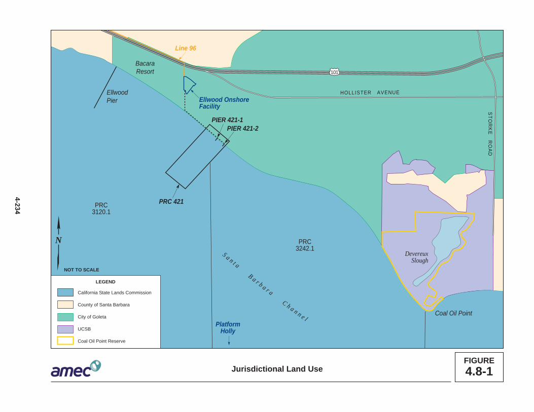
Ellwood OnshoreFacility
PlatformHolly
S a n t aB a r b a r a
C h a n n e l
DevereuxSlough
Coal Oil Point
STO
RK
E R
OA
D
HOLLISTER AVENUE
101
EllwoodPier
BacaraResort
PRC3120.1
PRC3242.1
PIER 421-1PIER 421-2
PRC 421
Line 96
California State Lands Commission
County of Santa Barbara
City of Goleta
UCSB
Coal Oil Point Reserve
LEGEND
FIGURE4.8-1
N
NOT TO SCALE
Jurisdictional Land Use
4-2

4.8 Land Use, Planning, and Recreation
4.8.2 Land Use and Zoning Designations 1
State Oil and Gas Lease PRC 421 (PRC 421) 2
As stated above, the PRC 421 wells and caissons are primarily under the jurisdiction of 3 the CSLC and the CCC, as all or most of these facilities are located below the mean 4 high tide line.10 Land surrounding the piers that is above the mean high tide line is within 5 the City of Goleta and is designated as a Open Space/Active Recreation area by the 6 City’s Land Use Element and is zoned as Recreation by the City’s Coastal Zoning 7 Ordinance (City of Goleta 2006b, 2006c). Figure 4.8-2 summarizes land use in the 8 Project vicinity. While the PRC 421 piers are not used for recreational purposes, the site 9 is surrounded by recreational uses including the Sandpiper Golf Course, the Bacara 10 Resort, and by Ellwood and Haskell’s beaches, which serve as major public coastal 11 access points and are frequented by beach goers, joggers, surfers and walkers (City of 12 Goleta 2006c). The Ellwood Onshore Facility (EOF) and Sandpiper Golf Course are 13 designated as Open Space/Active Recreation and zoned Coastal Recreation. The 14 Bacara Resort is designated as Commercial Visitor-Serving by the Goleta GP/CLUP 15 and is zoned C-V, Resort/Visitor Serving Commercial (City of Goleta 2006b, 2006c). 16
Other Ellwood Area Facilities Related to the Project 17
Ellwood Onshore Facility: The Project would transport oil/gas/water pumped at Pier 18 421-2 to existing facilities at the EOF for processing, along with Platform Holly 19 production, and subsequent delivery into the Line 96 pipeline. The Project would also 20 modify and depend upon control facilities located at the EOF. The EOF is zoned 21 Recreation and has been a legal nonconforming use since implementation of this 22 designation in 1991 (City of Goleta 2006b, 2006c). The change in land-use and zoning 23 designations in 1991 converted the EOF to a legal nonconforming use that allows the 24 facility to continue to operate under the rights of its current permit, but not to expand, 25 extend, enlarge, or exceed the current rights. The existing EOF is an oil and gas 26 treating facility with the capability to treat 20,000 barrels of oil per day (BOPD) of wet oil 27 and 20,000 million standard cubic feet per day of gas. Currently, Santa Barbara County 28 APCD Permit 7904-R7 limits throughput at the EOF to 13,000 BOPD dry basis 29 (excluding water content), based on permit emissions limits of dry crude oil tanks TK-30 202 and TK-203. 31
10 The mean high tide demarcates the jurisdiction boundary between local governments such as the City of Goleta and the inter-tidal or offshore waters under jurisdiction of the CSLC. Determination of the mean high tide line requires a survey which has not been performed to date. For that reason, the precise boundary between State and local jurisdiction is not determined.
November 2014 4-235 Revised PRC 421 Recommissioning Project Final EIR

101
EllwoodOnshoreFacility
Access Road
Pier 421-2
Pier 421-1
10
812.3
12.3�
Hollister Avenue
Calle RealLine 96
Residential Uses
Single-Family
Planned Residential
Medium Density
High Density
Mobile Home Park
Commercial Uses
Regional
Community
Visitor-Serving
Intersection
General
Office and Industrial
Business Park
Office and Institutional
#
�
Goleta City Boundary
Coastal Zone Boundary
School
Maximum Density inPlanned Residential Area(units/acre)
Source: City of Goleta 2006.
LEGEND
Other Uses
Agricultural
Open Space/Passive Recreation
Open Space/Active Recreation
Public/Quasi-Public
FIGURE4.8-2
0 1,200 2,400
SCALE IN FEET
Land Use Designations in the Project Vicinity
4-2
N

4.8 Land Use, Planning, and Recreation
Line 96 Pipeline: The Project would use the 8.5-mile-long Line 96 pipeline to transport 1 oil produced at PRC 421. This pipeline connects to the Plains All American Pipeline L.P. 2 (PAAPLP) Coastal Pipeline west of Las Flores Canyon (LFC). This pipeline is mostly 3 located in areas under County jurisdiction, with a limited portion located under City of 4 Goleta jurisdiction (see Figure 4.8-1). The lands under County jurisdiction are primarily 5 zoned for agricultural use. Impacts to agricultural resources were fully analyzed and 6 mitigated for the construction and operation of the new pipeline in the Line 96 7 Modification Project EIR (Santa Barbara County 2011). 8
4.8.3 Recreation 9
The Project site is located in a region that offers a wealth of recreational opportunities, 10 due to its natural beauty, undeveloped beaches and open space, topography, and 11 climate (Figure 4.8-3). PRC 421 is located on the beach, just east of the Bacara Resort, 12 the only beachfront resort in the City of Goleta, and due south of Sandpiper Golf 13 Course, which is open to the public. Sands Beach, the University of California Santa 14 Barbara’s (UCSB's) Coal Oil Point Reserve and open lands, and the Ellwood Mesa 15 Open Space and associated five coastal access points are all located east of and within 16 2 miles of the site. These undeveloped open spaces and beaches are major coastal 17 recreational areas used by thousands of beach goers annually. The combination of the 18 miles of beach front, varied ecological habitats, and scenic ocean and mountain vistas 19 attracts many visitors to the area. This is a heavily used, passive recreation area that 20 provides high quality recreational opportunities to the inhabitants of the surrounding 21 areas, as well as of the greater Santa Barbara area and beyond. Passive recreational 22 activities currently take place over most of the area that is accessible to the public. 23
The primary recreational activities that currently take place in the Project vicinity include 24 walking, jogging, picnicking, wildlife viewing, mountain biking, horseback riding, sun 25 bathing, swimming, surfing, surf fishing, dog walking, bird-watching, and photography. 26 One public golf course is in the immediate vicinity of the Project area: the 200-acre, 18-27 hole Sandpiper Golf Course, located due north of and adjacent to the Project area 28 (CSLC 2009). Additional recreational resources are maintained and operated by a 29 number of entities, including Santa Barbara County, City of Goleta, and private 30 providers. 31
The City of Goleta has six park types including one community center, three mini parks, 32 five community parks, seven regional open spaces, eight neighborhood parks, and 14 33 neighborhood open spaces, totaling approximately 526 acres. The three larger City-34 owned regional open space preserves—the Sperling Preserve, Santa Barbara Shores 35 Open Space (which together comprise the Ellwood Mesa), and Lake Los Carneros 36 Natural and Historical Preserve—collectively account for 363 acres. 37
November 2014 4-237 Revised PRC 421 Recommissioning Project Final EIR

California Coastal Trail(dashed indicates proposed)
Juan Bautista de Anza Trail(dashed indicates proposed)
Other Trail
LEGEND
FIGURE4.8-3Recreational Uses in the Project Vicinity
0 1,650 3,300
SCALE IN FEET
N DevereuxSlough
PIER 421-1PIER 421-1
PIER 421-2PIER 421-2
BACARABACARA
ELLWOODONSHOREFACILITY
DevereuxSlough
ELLWOODONSHOREFACILITY
PIER 421-1
PIER 421-2
4-2
HOLLISTTEER AAVENUEEHOLLISTER AVENUE
101
HASKELL’SHASKELL’SBEACHBEACH
BACARABACARABEACHBEACH
ACCESSACCESSELLWOODELLWOODPIERPIER
SANDPIPERSANDPIPERGOLF COURSEGOLF COURSE
GIRSHGIRSHPARKPARK
OPEN MEADOWSOPEN MEADOWSGOLFGOLF
COURSECOURSE
ELLWOOD MESAELLWOOD MESAOPEN SPACEOPEN SPACE
SANDSSANDSBEACHBEACH
BEACH ACCESSBEACH ACCESS
BIKE PATHBIKE PATH
BIKEBIKEPATHPATH
BIKE PATHSBIKE PATHSBEACH ACCESSBEACH ACCESS
BIKE PATH
BIKEPATH
BIKE PATHS
HASKELL’SBEACH
BACARABEACH
ACCESS
BACARA
ELLWOODPIER
SANDPIPERGOLF COURSE
ELLWOOD MESAOPEN SPACE
SANDSBEACH
BEACH ACCESS
BEACH ACCESS
GIRSHPARK
OPEN MEADOWSGOLF
COURSE
Bell C
anyo
n Cre
ekBe
ll Can
yon C
reek
Bell C
anyo
n Cre
ek
LINE 96LINE 96LINE 96
FLOWLINEFLOWLINEFLOWLINE

4.8 Land Use, Planning, and Recreation
Approximately 40 percent of the city’s 2.0 miles of Pacific shoreline is in city ownership 1 (City of Goleta 2006c). The Santa Barbara Shores Park is located due east of 2 Sandpiper Golf Course and the Sperling Preserve adjacent to the eastern boundary of 3 the park, approximately 0.8 mile east of the Project site (City of Goleta 2006c). The 4 Santa Barbara Shores Park currently provides an entry point for equestrian use for the 5 system of interconnected trails in the Ellwood-Devereux open space area (CSLC 2009). 6
4.8.4 Regulatory Setting 7
No Federal regulations, authorities, or administering agencies that regulate land use are 8 specifically applicable to recreational resources with respect to the Project; State laws, 9 regulations, and policies, including those of the California Coastal Act, are discussed in 10 Table 4.0-1, while the local regulatory setting is discussed below. 11
The Coastal Commission (CCC) was established by voter initiative in 1972 (Proposition 12 20) and later made permanent by the Legislature through adoption of the California 13 Coastal Act of 1976. The CCC, in partnership with coastal cities and counties, plans and 14 regulates the use of land and water in the coastal zone. Development activities, which 15 are broadly defined by the Coastal Act to include (among others) construction of 16 buildings, divisions of land, and activities that change the intensity of use of land or 17 public access to coastal waters, generally require a coastal permit from either the CCC 18 or the local government. Implementation of Coastal Act policies is accomplished 19 primarily through the preparation of local coastal programs (LCPs) that are required to 20 be completed by each of the counties and cities located in whole or in part in the coastal 21 zone. Completed LCPs must be submitted to the CCC for review and approval. 22 Following certification of an LCP, coastal permit authority is delegated to the local 23 jurisdiction, but the CCC retains original permit jurisdiction over certain specified lands 24 (such as tidelands and public trust lands). The CCC also has appellate authority over 25 development approved by local governments in specified geographic areas as well as 26 certain other developments (e.g., oil and gas projects). The City of Goleta has not yet 27 submitted their LCP to the CCC for certification and as such, Project components within 28 the coastal zone of the City will require a coastal development permit from the CCC. 29 The standard of the review for the CCC is the Chapter 3 policies of the Coastal Act. 30 Table 4.8-2, located at the end of Section 4.8, summarizes some of the Coastal Act 31 policies as they relate to the Project. 32
The CSLC has jurisdiction and management authority over all ungranted tidelands, 33 submerged lands, and the beds of navigable lakes and waterways. All tidelands and 34 submerged lands, granted or ungranted, as well as navigable lakes and waterways, are 35 subject to the protections of the Common Law Public Trust. 36
As general background, the State of California acquired sovereign ownership of all 37 tidelands and submerged lands and beds of navigable lakes and waterways upon its 38
November 2014 4-239 Revised PRC 421 Recommissioning Project Final EIR

4.8 Land Use, Planning, and Recreation
admission to the United States in 1850. The State holds these lands for the benefit of all 1 people of the State for statewide Public Trust purposes, which include but are not 2 limited to waterborne commerce, navigation, fisheries, water-related recreation, habitat 3 preservation, and open space. 4
Local 5
Santa Barbara County Goleta Community Plan 6
The Goleta Community Plan provides development policies, including the general type 7 and location of land uses, specifically tailored for the unincorporated Goleta area and 8 identifies measures to implement those policies. All development within the 9 unincorporated Goleta area must comply with the policies set forth in the Goleta 10 Community Plan. In addition, those portions of the Goleta Community Plan located 11 within the coastal zone have also been incorporated into Santa Barbara County’s LCP. 12
Santa Barbara County LCP 13
The LCP contains principal land use policies for development within the coastal zone in 14 Santa Barbara County. The project component that lies in the jurisdictional authority of 15 the County’s LCP is the Line 96 pipeline that extends west from the City of Goleta. The 16 County’s LCP, pursuant to requirements of the Coastal Act (section 30108.5), contains 17 the relevant portion of a local government’s general plan, or local coastal element, 18 which indicates the kinds, location, and intensity of land uses, the applicable resource 19 protection and development policies, and a listing of implementing actions. The LCP 20 first came into effect in 1982, and has been revised periodically to update policies. The 21 CLUP represents one component of the LCP, which also includes the Land Use Maps 22 of the Coastal Zone, the Coastal Zoning Ordinance (codified as Article II of Chapter 35 23 in the Santa Barbara County Code), and the Coastal Zoning Maps (CSLC 2009). 24
The County has incorporated numerous goals and policies into the LCP to ensure 25 conformance with Coastal Act policies. These include multiple policies intended to 26 protect environmentally sensitive habitats and associated species. Some recent 27 amendments to these policies are intended to update the county’s oil transportation 28 policies to bring the policies and ordinances into accordance with present-day 29 circumstances and into consistency with current California law, including amendments 30 to the Coastal Act contained in Assembly Bill (AB) 16, which was adopted in 2003. 31 These amendments would revise several sections of the Coastal Plan and Land Use 32 Element of Santa Barbara’s County’s Comprehensive Plan, and sections of the Coastal 33 and Inland Zoning Ordinances (Articles II and III, Chapter 35, Santa Barbara County 34 Code); however, these amendments have not been certified by the CCC (CSLC 2009). 35
Revised PRC 421 Recommissioning Project 4-240 November 2014 Final EIR

4.8 Land Use, Planning, and Recreation
Santa Barbara County Land Use Development Code 1
The Santa Barbara County Land Use and Development Code, adopted January 2007, 2 constitutes a portion of Chapter 35 of the Santa Barbara County Code. This Code 3 carries out the policies of the Santa Barbara County Comprehensive Plan and LCP by 4 classifying and regulating the uses of land and structures within the County. The Land 5 Use Development Code describes numerous land use zones, including Coastal Zone, 6 Oil and Gas Facilities, and describes allowed uses and permitting provisions. However, 7 the Coastal Zone portions of the Land Use Development Code must be certified by the 8 CCC, and there is currently no estimated time when that will occur. Until the Coastal 9 Zone portions are certified, Article II (Coastal Zoning Ordinance) is still in effect. 10
City of Goleta GP/CLUP 11
The Goleta GP/CLUP, which was adopted on October 2, 2006, governs land use and 12 physical development within the city limits. The Coastal Zone portions of this GP/CLUP 13 have not yet been certified by the CCC; until these portions of the GP/CLUP are 14 certified, the CCC retains jurisdiction over the Coastal Zone. 15
The Goleta GP/CLUP includes elements that contain policies to guide development 16 while protecting the natural resources within and integrity of the city (City of Goleta 17 2006c). Because the GP/CLUP has not been certified by the CCC, the City’s policies do 18 not apply to the issuance of a CDP for the Project; the standard of review for issuance 19 of a CDP for the Project is Chapter 3 of the Coastal Act. City policies apply to other 20 required City permits and approvals. The standard of review for any Project components 21 within the City of Goleta will be the following elements of the Goleta GP/CLUP 22 governing land use at the Project site: 23
· Land Use Element – The Land Use Element consists of a policy statement and a24 land use plan map showing the spatial distribution, location, and extent of lands25 designated for housing, business, industry, open space, agriculture, and other26 categories of public and private uses of land.27
· Open Space Element – The Open Space Element ensures that Goleta28 recognizes that open space land is a limited and valuable resource that must be29 conserved wherever possible and establishes policies to protect open space in30 the city.31
· Conservation Element – The Conservation Element addresses conservation,32 development, and use of natural resources, including water, creeks, soils,33 wildlife, and other natural resources. Population growth and development34 generally require the consumption of both renewable and nonrenewable natural35 resources. One role of the Conservation Element is to establish policies that36 reconcile conflicting demands placed on natural resources and define the37 balance sought between managed use and preservation of resources38
November 2014 4-241 Revised PRC 421 Recommissioning Project Final EIR

4.8 Land Use, Planning, and Recreation
· Visual and Historic Resources Element – This element establishes policies and 1 development standards to protect scenic resources and viewsheds.2
· Safety Element – The Safety Element addresses general safety policies, as well3 as bluff erosion and retreat, beach erosion and shoreline hazards, soil and slope4 stability hazards, flood hazards, urban and wildland fire hazards, oil and gas5 industry hazards, airport-related hazards, hazardous materials and facilities, and6 emergency preparedness. The Safety Element contains policies that prevent7 development or land use activities in hazardous areas, and/or require appropriate8 mitigation to minimize hazards.9
· Noise Element – The Noise Element identifies and evaluates noise problems in10 the surrounding community and includes current and projected noise contour11 maps showing the intensities of noise associated with various sources such as12 highways, freeways, railroads, airports, industrial plants, etc. Noise contours are13 considered in establishing the pattern of land uses in a manner that minimizes14 the exposure of residents to excessive noise.15
· Public Facilities Element – The Public Facilities Element addresses the nature of16 existing infrastructure facilities and services, available service capacities,17 generalized long-term policies to meet future needs, and financing options. This18 element discusses acceptable levels of service, funding priorities, timing of19 facility or service availability, and the location of future facilities and20 improvements to ensure that facilities and services are provided to existing and21 future development in an efficient and cost-effective manner.22
· Transportation Element – The Transportation Element guides the continued23 development and improvement of the transportation system to support land uses.24 This element contains policies and plans that integrate the transportation and25 circulation system with planned land uses, promotes the safe and efficient26 transport of goods and the safe and effective mobility of all segments of the27 population, and protects environmental quality and promotes the wise and28 equitable use of economic and natural resources.29
Key policies from these elements of the Goleta GP/CLUP and their relationship to the 30 Project are summarized in Table 4.8-3 at the end of Section 4.8. Although the Project is 31 in the Coastal Zone, which is currently governed by the Coastal Act, a policy 32 consistency analysis is included in Table 4.8-3 for information purposes and to address 33 consistency with the GP/CLUP when these policies become active. 34
City of Goleta Coastal Zoning Ordinance 35
The City of Goleta Coastal Zoning Ordinance is the tool used to implement the policies 36 of the GP/CLUP. This ordinance largely mirrors County Coastal Zoning Ordinance, 37
Revised PRC 421 Recommissioning Project 4-242 November 2014 Final EIR

4.8 Land Use, Planning, and Recreation
Article II, which restricts the location and type of development permissible within the 1 city. The following provisions are most applicable to the Project (City of Goleta 2006b): 2
· Section 35-61: Beach Development. Prohibits permanent above-ground3 structures on the dry sandy beach except facilities necessary for public health4 and safety, such as lifeguard towers, or where such restriction would cause the5 inverse condemnation of the lot by the county. This section also requires all new6 development between the first public road and the ocean to grant lateral7 easements to allow for public access along the shoreline. In coastal areas, where8 the bluffs exceed 5 feet in height, the lateral easement shall include all beach9 seaward of the base of the bluff.10
· Section 35-89: Recreation District. This district provides open space for11 various forms of outdoor recreation of either a public or private nature. The intent12 is to encourage outdoor recreational uses which will protect and enhance areas13 which have both active and passive recreation potential because of their beauty14 and natural features. No permits for development including grading shall be15 issued except in conformance with an approved Final Development Plan, as16 provided in Sec. 35-174 (Development Plans), and with Sec. 35-169 (Coastal17 Development Permits).18
· Section 35-160, Nonconforming Structures and Uses, Purpose and Intent.19 This section permits nonconformities until they are removed, but does not20 encourage their survival.21
· Section 35-174: Development Plans. No permit shall be issued for any22 development, including grading, for any property subject to the provisions of this23 section until a Preliminary and/or Final Development Plan has been approved.24
4.8.5 Significance Criteria 25
Land use and recreational impacts will be considered significant if the Project would 26 result in: 27
· Conflicts with adopted land use plans, policies, or ordinances, including the28 Coastal Act and Goleta GP/CLUP and zoning ordinance;29
· Conflicts with planning efforts to protect recreational resources of the Project30 area;31
· Incompatible adjacent land uses as defined by planning documentation; or32
· Residual impacts on sensitive shoreline lands, and/or water and non-water33 recreation due to a release of oil.34
November 2014 4-243 Revised PRC 421 Recommissioning Project Final EIR
4.8 Land Use, Planning, and Recreation
4.8.6 Impact Analysis and Mitigation 1
The Project could create short-term episodic impacts to public recreation due to 2 disruption of ongoing recreational activities during Project construction. These would be 3 considered insignificant due to their short-term nature (3 months) and because the 4 project contains best management practices (BMPs) (e.g., roping off construction areas, 5 directing beach users around the site, removal of equipment from the beach) which 6 would ensure that recreation activities are not unduly disrupted during construction. 7 Table 4.8-1, located at the end of this section, provides a summary of these impacts 8 and recommended MMs to address these impacts. 9
Impact LU-1: Conflicts with Goleta General Plan/Coastal Land Use Plan and 10 underlying Coastal Act Policies 11 Production of oil and gas at PRC 421 would increase the potential for accidental 12 releases of oil into the environment and conflict with policies contained within the 13 Goleta General Plan/Coastal Land Use Plan (GP/CLUP) Land Use, Open Space, or 14 Conservation Elements and relevant underlying Coastal Act policies (Significant 15 and Unavoidable). 16
Impact Discussion 17
Implementation of the Project, particularly the potential for impacts resulting from the 18 accidental release of oil into the environment, would conflict with the City of Goleta 19 Coastal Zoning Ordinance, several policies of the Goleta GP/CLUP, and with the 20 Coastal Act upon which the Goleta GP/CLUP is based. Direct releases of oil onto 21 Goleta area beaches are projected to be limited to approximately 1.7 barrels of oil; 22 however, the Project would incrementally contribute to larger spills upcoast into Gaviota 23 area streams, with a low potential for spills as large as 60 barrels of oil, a portion of 24 which could find its way to the shoreline and potentially onto downcoast Goleta area 25 beaches. However, the Project has been designed to minimize potential for an 26 accidental release of oil and to be generally consistent with the policies included in the 27 Goleta GP/CLUP and the Coastal Act. 28
Coastal Zoning Ordinance Section 35-160, Nonconforming Structures and Uses, 29 Purpose and Intent. This ordinance directs that the City shall not encourage the 30 survival of nonconforming uses such as the EOF by permitting modifications that may 31 increase its utility or extend its useful life. The Project is potentially inconsistent with this 32 ordinance, though it is not clear that the proposed minor changes to the EOF qualify as 33 “modifications” under this ordinance. 34
The Goleta GP/CLUP is not yet certified by the CCC, so it does not currently act as the 35 standard of review for issuance of a CDP for the Project. However, the city has adopted 36 the program and, following certification these policies, the Goleta GP/CLUP will become 37 the governing policy document for the primary Project study area. Therefore, the 38
Revised PRC 421 Recommissioning Project 4-244 November 2014 Final EIR

4.8 Land Use, Planning, and Recreation
following policy consistency analysis is currently informational, but addresses 1 consistency with the GP/CLUP when these policies become active. 2
Policy LU 10.1: Oil and Gas Processing Facilities. This policy details City support for 3 the County’s policies that emphasize consolidation of oil and gas processing in the 4 South Coast Consolidation Planning Area11, located at LFC in the unincorporated area 5 west of Goleta, and emphasizes that the EOF is currently operating as a nonconforming 6 use of the Project site. The new or upgraded support facilities proposed to be added to 7 the EOF to accommodate production of the PRC 421 product may be considered an 8 enlargement, expansion or extension of the EOF’s nonconforming use that is prohibited 9 by the Goleta Municipal Code, section 35-160 et seq. The Goleta Municipal Code also 10 requires the City to approve a Development Permit and Major Conditional Use Permit 11 (CUP) for Venoco to process the PRC 421 product at the EOF. Therefore, the Project 12 would potentially be inconsistent with Policy LU 10.1 and impacts would be significant 13 and unavoidable. 14
Policy LU 10.4: CSLC Lease PRC 421. This policy documents the city’s intention not 15 to support recommissioning oil production at PRC 421 due to the environmental 16 hazards posed by the resumption of oil production and processing over coastal waters 17 and the impacts to visual resources and recreation at the beach. The policy states: 18
Unless it is determined that there is a vested right to resume production at PRC 19 421, the city supports termination of the lease by the CSLC and/or a quitclaim of 20 the lease by the owner/operator…. If resumption of production is considered for 21 approval, on pier processing…shall not be approved unless it is demonstrated 22 that there is no feasible and less damaging alternative…. 23
Recommissioning of oil production at Pier 421-2 would incrementally increase the 24 potential for oil spills from the Project site; however, the Project has been designed to 25 minimize the potential for spills in the tidal zone by moving all processing of 26 oil/gas/water to the EOF. This would eliminate the need for processing on Pier 421-2 27 demonstrating a feasible and less environmentally damaging alternative, consistent with 28 Policy LU 10.4. Additionally, the Project calls for decommissioning Pier 421-1 29
11 The Santa Barbara County’s consolidation policy (Zoning Code, Art. II, § 35-154) provides that all “new production” must be processed at designated consolidated oil and gas processing sites on the South Coast. New production is defined as: · “The development of any oil and/or gas after the adoption of these policies which requires new
discretionary local, state, or federal permits unless it’s from an existing well or platform; or · The development of any oil and/or gas which, after the adoption of these policies, requires
approval of a new platform, or a new subsea or onshore well completion.” Because the PRC 421 wells were in existence (producing and operating) as of the date of the adopted policies and there is an existing lease with existing wells, production from PRC 421 is not considered new production under the above definition; therefore, the production is not subject to the consolidation policy. Processing PRC 421 oil at the EOF, however, could be in conflict with other policies due to the nonconforming use of the EOF.
November 2014 4-245 Revised PRC 421 Recommissioning Project Final EIR

4.8 Land Use, Planning, and Recreation
immediately and proper abandonment of all PRC 421 facilities at the end of the Project 1 life, including restoration of the site to its natural conditions. Nonetheless, because oil 2 production would be resumed at PRC 421, the Project would be inconsistent with the 3 intent of Policy 10.4 and impacts to land use from the Project are would be significant 4 and unavoidable. 5
Mitigation Measures/Rationale for Mitigation 6
Implementation of MMs identified in Sections 4.1, Geological Resources; 4.2, Safety, 7 4.3 Hazardous Materials; 4.5, Hydrology, Water Resources, and Water Quality; 4.6, 8 Marine Biological Resources, and 4.7, Terrestrial Biological Resources for properly 9 engineered reinforcement of caisson containment walls and contingency planning and 10 spill response would reduce oil spill impacts (see cited Sections for rationale). 11
MM LU-1a. Obtain Property Owner Authorizations. Prior to issuance of any Land 12 Use Permit, Venoco shall secure all required property owner authorizations or 13 other documentation, including encroachment permits or easements to the 14 satisfaction of the City allowing the project on or within property not owned by 15 the permittee, including, but not limited to property owned by Sandpiper Golf 16 Trust and the City. 17
MM LU-1b. Obtain Permits Required by Title 15 of Goleta Municipal Code. 18 Venoco shall obtain from the City’s Planning and Environmental Review 19 Department all Building, Electrical, Well or other Permits required by Title 15 of 20 the Goleta Municipal Code prior to the construction, erection, moving, 21 alteration, enlarging, rebuilding of any building, structure, or improvement, or 22 any other action(s) requiring a Building Permit pursuant to Title 15 of the 23 Goleta Municipal Code. 24
MM LU-1c. Obtain City Land Use Permit Prior to Development. The permittee 25 shall obtain from the City’s Planning and Environmental Review Department a 26 Land Use Permit prior to commencement of any uses and/or development 27 authorized by this permit. 28
Residual Impacts 29
With implementation of MMs for oil spill impacts, land- and water-related land use and 30 recreational uses may be impacted from oil spills from primary Project components. 31 Implementation of MM LU-1a through -1c would reduce but not eliminate the conflict 32 with Goleta GP/CLUP Policies, inconsistency with GP Land Use designations, or 33 inconsistency with City zoning; therefore, this impact would remain significant and 34 unavoidable. 35
Revised PRC 421 Recommissioning Project 4-246 November 2014 Final EIR

4.8 Land Use, Planning, and Recreation
Impact LU-2: Oil Releases Could Affect Recreational Activities 1 High-quality recreational resources are located within the area and could be 2 impacted by the spread of oil from an accidental release from surf zone 3 production activities at Pier 421-2, associated pipelines, and transportation by the 4 Line 96 pipeline. Shoreline and water-related uses would be disrupted by oil on 5 the shoreline and in the water, resulting in significant impacts to on- and off-6 shore public recreation (Significant and Unavoidable). 7
Impact Discussion 8
Impacts from accidental oil releases could preclude the use of beach areas and 9 associated recreational activities. The degree of impact is influenced by many factors 10 including, but not limited to, spill location, spill size, type of material spilled, prevailing 11 wind and current conditions, the vulnerability and sensitivity of the resource, and 12 response capability. 13
Spill risk is addressed in Section 4.2, Safety. The greatest risk of spills occurs at Pier 14 421-2, where small spills could occur during normal operations, as well as from leaks at 15 pipe fittings and valves. Direct releases of oil onto Goleta area beaches are projected to 16 be limited to approximately 1.7 barrels of oil; however, the Project would incrementally 17 contribute to larger spills upcoast into Gaviota area streams, with a low potential for 18 spills as large as 60 barrels of oil, a portion of which could find its way to the shoreline 19 and potentially onto downcoast Goleta area beaches. The capability to immediately 20 respond and deploy appropriate containment booming would also influence the extent 21 of affected area. Response capability is analyzed in Section 4.2, Safety. 22
As discussed above, the Project area provides high quality recreational opportunities for 23 local residents and tourists. Shoreline and water-related uses would be disrupted by oil 24 on the beach and in the water. While not readily quantifiable, a coastal spill could 25 significantly affect coastal recreation and tourism, resulting in lost commercial recreation 26 and tourism revenues. Several sections of this EIR (e.g., Sections 4.1, 4.3, 4.4, 4.5, 4.6, 27 4.7, 4.12, and 4.13) discuss in detail the effects of a spill on the local environmental 28 resources. Because it is impossible to predict with any certainty the potential 29 consequences of spills, impacts are considered to be significant and unavoidable, 30 because large spills could have residual impacts that could affect the beach and 31 recreational uses. 32
Mitigation Measures/Rationale for Mitigation 33
Implementation of MMs identified in Sections 4.1, Geological Resources; 4.2, Safety; 34 4.3 Hazardous Materials; 4.5, Hydrology, Water Resources, and Water Quality; 4.6, 35 Marine Biological Resources; and 4.7, Terrestrial Biological Resources, for protection of 36 the proposed oil separator, reinforcement of caisson containment walls, and 37
November 2014 4-247 Revised PRC 421 Recommissioning Project Final EIR

4.8 Land Use, Planning, and Recreation
contingency planning and spill response would reduce impacts to recreational activities 1 associated with oil releases (see cited Sections for rationale). 2
Residual Impacts 3
Even with implementation of MMs for oil spill impacts, land- and water-related 4 recreational uses may be impacted from large spills and impacts would remain 5 significant and unavoidable. 6
Impact LU-3: Oil Releases from Pier 421-2 or Pipelines Could Affect Sensitive 7 Area Resources and Raise Consistency Issues with Adopted Policies. 8 Spills that reach the shore along sensitive land use areas or heavily used areas, 9 including recreational areas, would limit or preclude such uses and result in 10 significant adverse impacts (Significant and Unavoidable). 11
Impact Discussion 12
Depending on spill size and location, a spill could affect sensitive resources in the area 13 including Environmentally Sensitive Habitat Areas (ESHAs) and sensitive species. 14 Direct releases of oil onto Goleta area beaches are projected to be limited to 15 approximately 1.7 barrels of oil, a relatively modest amount; however, the Project would 16 incrementally contribute to larger spills upcoast into Gaviota area streams, with a low 17 potential for spills as large as 60 barrels of oil, a portion of which could find its way to 18 the shoreline and potentially onto downcoast Goleta area beaches. Although spills from 19 Project facilities are anticipated to be limited, even spills of limited magnitude would 20 exceed adopted thresholds. Conflicts with the Goleta GP/CLUP Conservation Element 21 Policy would result from an oil spill impacting such resources. Specific to the Project, 22 Policy CE 1.2 designates all marine areas offshore from Goleta extending from the 23 mean high tide line seaward to the outer limit of State waters and all areas extending 24 from the mean high tide line landward to the top of the ocean bluffs as ESHAs, as well 25 as Tecolote Creek and Lagoon, Bell Canyon Creek and Lagoon, Sandpiper Golf Course 26 pond, and Devereux Creek. Therefore, the vast majority of the immediate Project area 27 and several key nearby resources are designated as ESHAs. An oil spill from the 28 Project could impact these resources and violate the intentions of several Conservation 29 Element policies including CE 1.6, Protection of ESHAs, CE 6.2, Protection of Marine 30 ESHAs, and CE 7.3, Protection of Beach Areas. 31
Spills on the shore would damage existing resources and would result in significant 32 adverse impacts (see Sections 4.1, Geological Resources; 4.4, Air Quality; 4.5, 33 Hydrology, Water Resources, and Water Quality; 4.6, Marine Biological Resources; 4.7, 34 Terrestrial Biological Resources; 4.12, Aesthetic/Visual Resources; and 4.13, Cultural, 35 Historical, and Paleontological Resources). 36
Revised PRC 421 Recommissioning Project 4-248 November 2014 Final EIR

4.8 Land Use, Planning, and Recreation
Transportation of oil through the Line 96 pipeline from the EOF to the PAAPLP Coastal 1 Pipeline west of LFC could create potential impacts through an increased potential for 2 spills from the pipeline, potentially inconsistent with City of Goleta policies (e.g., LU 10.1 3 and 10.3) as well as with County LCP policies regarding protection of ESHAs, certain 4 other creeks, associated riparian and wetland habitats, and agricultural areas. Although 5 the possibility of a spill or release exists, pipelines are the safest method available for 6 the transportation of crude oil. Further, the new 8.5-mile-long pipeline is equipped with 7 state-of-the-industry safety measures, including cathodic protection against corrosion, 8 check valves and shut off valves to limit accidental releases both up and downstream of 9 major creek crossings and “smart pigging” capabilities. These new state-of-the-industry 10 construction and safety features, when combined with the Project’s operating horizon 11 would substantially reduce the potential for pipeline spills (see Impact S-6). 12
Because it is impossible to predict with any certainty the potential consequences of 13 spills, impacts are considered to be significant and unavoidable since severe spills 14 could have residual impacts that could affect the beach and/or recreational uses. 15
Mitigation Measures/Rationale for Mitigation 16
Implementation of MMs identified in Sections 4.2, Safety; 4.5, Hydrology, Water 17 Resources, and Water Quality; 4.6, Marine Biological Resources; and 4.7, Terrestrial 18 Biological Resources, for reinforcement of caisson containment walls and contingency 19 planning and spill response (see cited Sections for rationale.) The certified Line 96 20 Modification Project EIR (Santa Barbara County 2011) provides MM AG-2 that is 21 incorporated by reference into this document (see Appendix H). This MM requires all 22 agricultural areas contaminated as a result of an oil leak or spill along the pipeline route 23 be restored to their prior state with equivalent soils and agricultural resources resulting 24 in a less than significant impact. 25
Residual Impacts 26
Even with implementation of MMs for oil spill impacts, sensitive biological and water 27 resources may be impacted from large spills and impacts would remain significant and 28 unavoidable. 29
November 2014 4-249 Revised PRC 421 Recommissioning Project Final EIR

4.8 Land Use, Planning, and Recreation
Table 4.8-1. Summary of Land Use and Recreation Impacts and Mitigation Measures
Impact Mitigation Measures LU-1: Conflicts with Goleta GP/CLUP Policies MMs identified in Sections 4.1, Geological
Resources; 4.2, Safety, 4.3 Hazardous Materials; 4.5, Hydrology, Water Resources, and Water Quality; 4.6, Marine Biological Resources, and 4.7, Terrestrial Biological Resources. MM LU-1a. Obtain Property Owner Authorizations. MM LU-1b. Obtain Permits Required by Title 15 of Goleta Municipal Code. MM LU-1c. Obtain City Land Use Permit Prior to Development.
LU-2: Oil Releases Could Affect Recreational Activities
Implementation of those measures identified in Sections 4.1, Geological Resources; 4.2, Safety, 4.3 Hazardous Materials; 4.5, Hydrology, Water Resources, and Water Quality; 4.6, Marine Biological Resources; and 4.7, Terrestrial Biological Resources. MM AG-2 contained in the certified Line 96 Modification Project EIR would also apply to LU-3.
LU-3: Oil Releases from Pier 421-2 or Pipelines Could Affect Sensitive Area Resources and Raise Consistency Issues with Adopted Policies
4.8.7 Cumulative Impacts Analysis 1
Project impacts were assessed in conjunction with the projects identified in Table 3-2. 2
Impact LU-4: Cumulative Impacts of Potential Project-Related Oil Spills on Area 3 Land Use and Recreational Uses 4 Impacts to sensitive shoreline lands, and/or water and non-water recreation due 5 to a release of oil would result in potentially significant impacts. When the 6 cumulative environment is considered, the contribution from the Project could be 7 significant (Significant and Unavoidable). 8
Impact Discussion 9
The risk of an oil release associated with Project operation would contribute to impacts 10 to the cumulative environment given increased demand for the transportation of oil. 11 Over the lifetime of the Project, this would represent an incremental increase in spill risk 12 and oil spill risks to land uses and recreational uses would be associated with that 13 increase. Other projects would contribute to the spill risk, exacerbating an already 14 significant impact. When the cumulative environment is considered, the contribution 15 from the Project adds to the cumulative risks of an oil spill. Impacts to sensitive 16 shoreline lands, and/or water and non-water recreation due to a release of oil would 17 remain significant and unavoidable. 18
Revised PRC 421 Recommissioning Project 4-250 November 2014 Final EIR

4.8 Land Use, Planning, and Recreation
Mitigation Measures/Rationale for Mitigation 1
Implementation of those measures identified in Sections 4.2, Safety; 4.5, Hydrology, 2 Water Resources, and Water Quality; 4.6, Marine Biological Resources; and 4.7, 3 Terrestrial Biological Resources, for properly engineered reinforcement of caisson 4 containment walls and contingency planning and spill response would be required (see 5 cited Sections for rationale.) 6
Residual Impacts 7
Impacts would remain significant and unavoidable. 8
November 2014 4-251 Revised PRC 421 Recommissioning Project Final EIR

4.8 Land Use, Planning, and Recreation
Table 4.8-2. California Coastal Act Policy Summary Policy Relationship to Project
Section 30230: Marine resources shall be maintained, enhanced, and where feasible, restored. Special protection shall be given to areas and species of special biological or economic significance. Uses of the marine environment shall be carried out in a manner that will sustain the biological productivity of coastal waters and that will maintain healthy populations of all species of marine organisms adequate for long-term commercial, recreational, scientific, and educational purposes.
Potentially inconsistent. The Project is located in an area of special biological importance with identified marine resources including kelp beds, rocky intertidal habitat, and three coastal estuaries. Primary issues of concern affecting these resources include potential for oil spills from the caisson and pipelines. Direct releases from PRC 421 and the flow line are projected to be limited to 1.75 barrels of oil; releases from Line 96 would be limited to 60 barrels, only portions of which would reach the shoreline. Project construction could also affect marine water quality through mobilization of sediments and potential release of contaminated materials.
Section 30240: (a) Environmentally sensitive habitat areas (ESHAs) be protected against any significant disruption of habitat values, and only uses dependent on those resources shall be allowed within those areas. (b) Development in areas adjacent to environmentally sensitive habitat areas and parks and recreation areas shall be sited and designed to prevent impacts which would significantly degrade those areas, and shall be compatible with the continuance of those habitat and recreation areas.
Potentially inconsistent. There are several ESHAs in the Project vicinity, including the Devereux Slough, Bell and Tecolote Creeks, two small wetlands adjacent to the access road, snowy plover habitat near Coal Oil Point, and rocky intertidal areas. Primary issues of concern affecting these resources include the potential for oil spills from the caisson and pipelines in the volumes listed above. Project construction could also affect the two small wetlands.
Section 30232: Oil and hazardous substance spills Protection against the spillage of crude oil, gas, petroleum products, or hazardous substances shall be provided in relation to any development or transportation of such materials. Effective containment and cleanup facilities and procedures shall be provided for accidental spills that do occur.
Potentially consistent. The Project site is located in an area prized for public recreation and that also supports numerous ESHAs. Implementation of the Project would increase the likelihood of a release of oil from PRC 421 as well as one related to pipeline operations which could adversely impact recreational activities and biological resources. However, production from PRC 421 could reduce the potential for small incremental oil releases from old, improperly abandoned sub-sea oil wells as the pressure in the reservoir appears to be rising since production was shut terminated in 1994
Section 30250: Location; existing developed area. (a) New residential, commercial, or industrial development, except as otherwise provided in this division, shall be located within, contiguous with, or in close proximity to, existing developed areas able to accommodate it or, where such areas are not able to accommodate it, in other areas with adequate public services and where it will not have significant adverse effects, either individually or cumulatively, on coastal resources.
Potentially consistent. The Project is located in an area that was historically developed and is located on a site where oil and gas development has taken place since 1928.
Section 30251: Scenic and visual qualities. The scenic and visual qualities of coastal areas shall be considered and protected as a resource of public importance. Permitted development shall be sited and designed to protect views to and along the ocean and scenic coastal areas, to minimize the
Potentially consistent. The proposed development would consist of minor alternations to the existing development on Pier 421-2, which would be generally compatible with the character of the area. Additionally, the Project would include the decommissioning and removal of Pier 421-1, which
alteration of natural land forms, to be visually would generate beneficial impacts to the aesthetic
Revised PRC 421 Recommissioning Project 4-252 November 2014 Final EIR

4.8 Land Use, Planning, and Recreation
Table 4.8-2. California Coastal Act Policy Summary Policy Relationship to Project
compatible with the character of surrounding areas, and, where feasible, to restore and enhance visual quality in visually degraded areas.
resources of the Project area.
Section 30101: Coastal-dependent development. "Coastal-dependent development or use" means any development or use which requires a site on, or adjacent to, the sea to be able to function at all.
Consistent. The Project requires a site on, or adjacent to, the sea in order for its use to function.
Section 30260: Coastal-dependent industrial facilities. Coastal-dependent industrial facilities shall be encouraged to locate or expand within existing sites and shall be permitted reasonable long-term growth where consistent with this division. However, where new or expanded coastal-dependent industrial facilities cannot feasibly be accommodated consistent with other policies of this division, they may nonetheless be permitted in accordance with this section and Sections 30261 and 30262 if (1) alternative locations are infeasible or more environmentally damaging; (2) to do otherwise would adversely affect the public welfare; and (3) adverse environmental effects are mitigated to the maximum extent feasible.
Consistent. The Project includes no new coastal industrial facilities – only repairs and modifications to existing facilities and decommissioning and removal of Pier 421-1 and the associated well. In the unlikely event that Project design is altered to include new facilities, the Project would qualify for consideration of override approval under the three tests of this policy.
Section 30211: Development not to interfere with access. Development shall not interfere with the public's right of access to the sea where acquired through use or legislative authorization, including, but not limited to, the use of dry sand and rocky coastal beaches to the first line of terrestrial vegetation.
Potentially inconsistent. The Project is located in an area of moderate to heavy public beach use. This public beach access could be intermittently impacted during construction activities if the public was not allowed to pass under or in front of the structure for public safety reasons. The resulting development would not interfere with the public’s right of access to the ocean or beach area.
Section 30262: Oil and gas development. a) Oil and gas development shall be permitted inaccordance with Section 30260, if the following conditions are met: (1) The development is performed safely and consistent with the geologic conditions of the well site. (2) New or expanded facilities related to that development are consolidated, to the maximum extent feasible and legally permissible. (5) The development will not cause or contribute to subsidence hazards unless it is determined that adequate measures will be undertaken to prevent damage from such subsidence.
Potentially consistent. The recommissioning of PRC 421 would return oil and gas production to the immediate project area. This development would be subject to regulation to ensure safety and consistent with geologic conditions of the site, and would not contribute to a subsidence hazard.
November 2014 4-253 Revised PRC 421 Recommissioning Project Final EIR

4.8 Land Use, Planning, and Recreation
Table 4.8-3. Goleta GP/CLUP Policy Summary Policy Relationship to Project
LAND USE ELEMENT (LU) LU 1.7 New Developments and Protection of Environmental Resources. Approvals of all new development shall require adherence to high environmental standards and the preservation and protection of environmental resources, such as environmentally sensitive habitats, consistent with the standards set forth in the Conservation Element and the City’s Zoning Code.
Potentially inconsistent. ESHAs near the Project site include Bell Creek, Tecolote Creek, two wetland areas adjacent to Sandpiper Golf Course, snowy plover habitat, and all areas located below the mean high tide line. Although direct releases from PRC 421 are projected to be limited to 1.75 barrels of oil, accidental oil releases could adversely affect these environmental resources. Project implementation would incrementally increase the potential for accidental releases.
LU 1.3 Adequate Infrastructure and Services. For health, safety, and general welfare reasons, approvals of new development shall be subject to a requirement that adequate infrastructure will be available, including the following: a. Project-specific and cumulative traffic volumes shallnot cause the level of service standards established in Transportation Element Policy TE 4 to be exceeded. b. Any transportation improvements needed to maintainthe level of service standard have been programmed and funding has been committed consistent with Transportation Element Sub-policies TE 13.3 and TE 13.4. c. Environmental review of needed circulationimprovement projects has been completed. d. Sewer, water, and other infrastructure capacities aresufficient to serve the new development or will be available by the time the development is constructed.
Consistent. The Project would generate limited additional vehicular movement along roads in the Project vicinity, including Highway 101, Winchester Canyon and Storke Road interchanges, Hollister Avenue, and the Bacara Access Road. A traffic management plan has not yet been prepared by Venoco and precise estimates of construction-related traffic are unavailable. However, it is anticipated that construction- related traffic would be short-term and would not adversely affect long-term area roadway or intersection operations. Operation-generated traffic would be minimal. Sewer, water, and other infrastructure capacities are sufficient for the Project and Venoco will be required to contribute towards fire response improvements through an impact development fee payment.
LU 6.3 Open Space/Passive Recreation. This designation is intended to identify existing or planned areas for public parks and active recreational activities and facilities, such as playgrounds, picnic areas, tennis courts, ballparks, and sports fields. This use category is also intended to apply to significant private outdoor recreational facilities, such as golf courses and privately owned parks. Individual recreational areas may include a mix of passive and active recreational features or improvements. Appropriate caretaker facilities and residences may also be allowed if consistent with the character of the planned uses. The designation may also include storm drainage facilities.
Inconsistent. The industrial uses at PRC 421 are not compatible with the recreation land use designation. The portions of the Project within the City’s jurisdiction comprise a legal nonconforming use. Expansion or extension of such use is prohibited.
LU 9.2 Site #2 – Coastal Recreation. This parcel, occupied as of 2005 by the Venoco EOF, is designated in the Open Space/Active Recreation use category. The requirements applicable to this site are as follows: a. Despite the Recreation designation, thenonconforming status of the existing use may continue as long as the project does not enlarge, expand or extend the nonconforming use. The use was nonconforming at the time of incorporation of the City of
Potentially inconsistent. The legal nonconforming status of the EOF allows it to continue to operate at this site, despite the inconsistent land use category, as long as the project does not enlarge, expand or extend the nonconforming use. a. The EOF would continue to operate as anonconforming use for the site. b. Oil and gas processing would not expandbeyond currently permitted quantities, however,
Revised PRC 421 Recommissioning Project 4-254 November 2014 Final EIR

4.8 Land Use, Planning, and Recreation
Table 4.8-3. Goleta GP/CLUP Policy Summary (continued) Policy Relationship to Project
Goleta. Its nonconforming status dates to the early 1990s when the property’s zoning was changed by the County of Santa Barbara to the Recreation District as part of a plan to consolidate onshore oil and gas processing at the Las Flores Canyon site in the unincorporated area west of Goleta. b. The intent is that in the long-term use of the property foroil and gas processing shall be terminated. The processing of hazardous materials and the risks associated with air emissions make this location, which is adjacent to Bacara Resort and Sandpiper Golf Course and near Ellwood School and the residential neighborhoods of Santa Barbara Shores and Winchester Commons, unsuitable for oil and gas processing in the long term. c. Until such time as the oil and gas processing use isterminated, any modifications or alternations of the existing facilities must be in accordance with the provisions of LU 10.1 and the City of Goleta zoning ordinances and shall be limited to and designed to improve air quality, reduce environmental impacts and hazards, and improve safety for nearby lodging, recreational, and residential uses. d. Upon termination of the oil and gas processing use, thepriority use for the site shall be coastal-dependent and coastal-related recreational uses that are conducted primarily outdoors or limited to small-scale structures. Adequate onsite parking shall be provided to serve all recreational uses (see related Policy OS 2).
improvements proposed to be added to the EOF to accommodate production of the PRC 421 product may be considered an enlargement, expansion or extension of the EOF’s nonconforming use that is prohibited by the Goleta Municipal Code. c. The EOF would be decommissioned at thesame time as Platform Holly, regardless of its use for processing PRC 421 oil. Project approval would not extend the life of the EOF. d. The Project requires some modifications tothe EOF. e. Upon termination of the nonconforming use,the site would be redeveloped for recreational use following decommissioning of the EOF.
LU 10: Energy-Related On- and Off-Shore Uses Objective: To promote the discontinuation of onshore processing and transport facilities for oil and gas, the removal of unused or abandoned facilities, and the restoration of areas affected by existing or former oil and gas facilities within the city.
Inconsistent. The Project would restart production of PRC 421 facilities.
LU 10.1 Oil and Gas Processing Facilities. The following standards shall apply to oil and gas processing facilities: a. The City supports county policies regarding consolidationof oil and gas processing in the South Coast Consolidation Planning Area at Las Flores Canyon…. No new oil and gas processing facilities shall be permitted within Goleta. b. The Venoco EOF site is an inappropriate location forprocessing of oil and gas because of the public safety and environmental hazards associated with this type of use… . c. The EOF shall continue to be subject to the rights andlimitations applicable to nonconforming uses under California law. No modifications or alterations of the facility or other actions shall be authorized that would result in the expansion of the permitted throughput capacity of the EOF or that would enlarge, expand or extend the nonconforming use of the EOF. d. Until the EOF use is terminated, the priority shall be toinsure that the facility strictly meets or exceeds all applicable environmental and safety standards.
Potentially inconsistent. The Project would restore production at an existing well with oil/gas/water produced at this well processed at existing facilities at the EOF. a) The Project would not involve constructionof new oil and gas processing facilities and would use existing facilities at the EOF and pipelines to LFC. b) The Project would not extend the life of theEOF. c) The Project would not result in modificationsor alterations that would result in the expansion of the permitted throughput capacity of the EOF. However, the new or upgraded support facilities proposed to be added to the EOF to accommodate production of the PRC 421 product may be considered an enlargement, expansion or extension of the EOF’s nonconforming use that is prohibited by the Goleta Municipal Code and could result in the use being terminated before the
November 2014 4-255 Revised PRC 421 Recommissioning Project Final EIR

4.8 Land Use, Planning, and Recreation
Table 4.8-3. Goleta GP/CLUP Policy Summary (continued) Policy Relationship to Project
completion of the Project. d) Measures are included to meet applicableenvironmental and safety standards.
LU 10.3 Oil and Gas Transport and Storage Facilities. The following shall apply to oil and gas transport and storage facilities within the city: a. New oil and gas pipelines and storage facilities, exceptfor transmission and distribution facilities of a Public Utility Commission (PUC) regulated utility, shall not be approved within the city unless there is no feasible or less environmentally damaging alternative location for a proposed pipeline. b. In the event that extended field development fromPlatform Holly is approved, the City supports the processing of oil and gas production at the South Coast Consolidation Planning Area at Las Flores Canyon. c. Unused, inactive, or abandoned pipelines as of 2005,including the remnants of the Arco pipeline, shall be required to be decommissioned. d. Existing pipelines that were actively used as of 2005shall be decommissioned as part of and concurrent with the decommissioning of the related oil and gas facilities. e. When onshore and offshore oil and gas pipelines aredecommissioned…the pipeline and all related debris shall be removed. f. The existing owner/operator of a pipeline to bedecommissioned shall be responsible for all costs related to the decommissioning.
Potentially inconsistent. Under the Project, the Line 96 pipeline connecting the EOF to the PAAPLP Coastal Pipeline west of LFC (Line 96 Pipeline EOF-PAAPLP Connection) would be used. It is an existing pipeline and has available capacity to support the Project. A new oil flowline would be constructed between Pier 421-2 and the EOF, but would be installed within an existing 6-inch line.
LU 10.4 State Lands Commission Lease 421. a. The City’s intent is that oil production not berecommenced at PRC because of the environmental hazards posed by the resumption of oil production and processing over coastal waters and the impacts to visual resources and recreation at the beach. Unless it is determined that there is a vested right to resume production at PRC 421, the City supports termination of the lease by the CSLC and/or a quitclaim of the lease by the owner/operator. b. If resumption of production is considered for approval, onpier processing of the oil at a site within the tidal zone shall not be approved unless it is demonstrated that there is no feasible and less environmentally damaging alternative to processing on the pier. The development of new processing facilities over the sea would result in an increased and unacceptable level of risk of environmental damage. c. Decommissioning and proper abandonment of S.L. 421facilities, including the piers and riprap seawall, shall be required concurrent with decommissioning of the EOF or immediately upon termination of S.L. 421. d. Decommissioning work shall include restoration of thesite to its natural pre-Project conditions.
Potentially inconsistent. Under the Project, processing would occur at the EOF; however, a potential release could occur during production activities at Pier 421-2 or from the pipeline that carries oil/gas/water to the EOF. a) While the proposed recommissioning ofPRC 421 may raise consistency issues with this policy, the use of the EOF for processing/ separation may be the option most in line with the intent of this policy. Processing of oil would not occur over coastal waters. Further, Venoco has a vested right to produce oil at this site as it has a valid State oil and gas lease. b) The Project would not include processing ofoil at a site within the tidal zone; oil separation would occur at the EOF, a location determined to be the environmentally superior option. c) PRC 421 facilities are not required to bedecommissioned at this time as the use of the EOF has not yet been terminated. If recommissioning PRC 421 is approved, Pier 421-1 would be decommissioned within 1 year; infrastructure and pipelines associated with Pier 421-2 would then be decommissioned at the end of the Project in 20 or more years.
Revised PRC 421 Recommissioning Project 4-256 November 2014 Final EIR

4.8 Land Use, Planning, and Recreation
Table 4.8-3. Goleta GP/CLUP Policy Summary (continued) Policy Relationship to Project
d) Decommissioning of Pier 421-1 would occurwithin 1 year of project operation; decommissioning and restoration of the pier and caisson at 421-2 and the access road and seawall would occur at the end of the Project life.
LU 10.6 Oil and Gas Production Areas. a. The City shall oppose any new leases in the westernSanta Barbara Channel for offshore oil and gas production within State waters and within the waters of the OCS. b. The City shall oppose the construction of any new oil andgas production or processing facilities in the waters offshore of Goleta. c. Upon cessation of production at Platform Holly, the Citysupports the timely quitclaim of all associated leases, permanent discontinuation of all oil and gas production, and inclusion of all former lease areas into the California Coastal Sanctuary offshore of Goleta and the Santa Barbara County. d. If oil and gas production from new offshore leases orfacilities occurs, the new production shall not be processed at the EOF. Any such production shall be transported by pipeline to the nearest consolidated processing facility as defined by the Santa Barbara County’s South Coast Consolidation Planning Area policies.
Potentially inconsistent. Existing oil production facilities at Pier 421-2 would be recommissioned. No new production facilities would be constructed with processing occurring at existing facilities located at the EOF. a) PRC 421 is an existing lease.b) No new oil and gas production orprocessing facilities would be constructed. c) Production at PRC 421 would bediscontinued when production at Platform Holly is discontinued (if not already terminated). d) PRC 421 is an existing lease. The new orupgraded support facilities proposed to be added to the EOF to accommodate production of the PRC 421 product may be considered an enlargement, expansion or extension of the EOF’s nonconforming use that is prohibited by the Goleta Municipal Code and could result in earlier termination of the use at the EOF.
OPEN SPACE ELEMENT (OS) OS 1.3 Preservation of existing coastal access and recreation. Goleta’s limited Pacific shoreline of approximately 2 miles provides a treasured and scarce recreational resource for residents of the city, region, and State. Existing public beaches, shoreline, parklands, trails, and coastal access facilities shall be protected and preserved and shall be expanded or enhanced where feasible.
Potentially inconsistent. The Project may result in short-term disruption of lateral access during initial construction and future repair activities. Pier 421-2 and its caisson would continue to inhibit or block the public’s view laterally along the coast. During high tide events, continuation of the Project pier and seawall would inhibit lateral access along this section of coast as higher tides, particularly during low sand conditions in fall, winter and spring can reach to the base of the seawall rendering lateral access along the beach infeasible.
OS 1.10 Management of Public Lateral Access Areas. The following criteria and standards shall apply to use and management of lateral shoreline access areas: a. Private commercial uses of public beach areas shall belimited to coastal dependent recreational uses, including but not limited to surfing schools, ocean kayaking, and similar uses. All commercial uses of beach areas and other lateral accessways shall be subject to approval of a permit by the City. The number, size, duration, and other characteristics of commercial uses of beach areas may be limited in order to preserve opportunities for use and enjoyment of the beach area by the general public. For-profit commercial uses at the City-owned Santa Barbara Shores Park and Sperling Preserve (the Ellwood-Devereux
Potentially inconsistent. The PRC 421 piers are surrounded by recreational uses including the Sandpiper Golf Course, the Bacara Resort, and by Ellwood and Haskell’s beaches which serve as major public coastal access points and are frequented by beach goers, joggers, surfers, and walkers. This is a heavily used, passive recreation area that provides high quality recreational opportunities to the inhabitants of the surrounding areas and of greater Santa Barbara. Project construction activities could disrupt recreational activities along the Ellwood beach area in the vicinity of the PRC 421 piers, but impacts would be
November 2014 4-257 Revised PRC 421 Recommissioning Project Final EIR

4.8 Land Use, Planning, and Recreation
Table 4.8-3. Goleta GP/CLUP Policy Summary (continued) Policy Relationship to Project
Open Space and Habitat Management Plan [OSHMP] area) are prohibited (see related Policy OS 5). b. Temporary special events shall minimize impacts topublic access and recreation along the shoreline. Coastal Development Permits shall be required for any temporary event that proposes to use a sandy beach area and involves a charge for admission or participation. c. Where sensitive habitat resources are present, limited orcontrolled methods of access and/or mitigation designed to eliminate or reduce impacts to ESHAs shall be implemented. d. The hours during which coastal access areas areavailable for public use shall be the maximum feasible while maintaining compatibility with nearby neighborhoods and land uses. The hours for public use shall be set forth in each individual coastal development permit. Unless specific hours are described within a permit, the access shall be deemed to be 24 hours per day and 7 days per week. e. In order to maximize public use and enjoyment, userfees for access to lateral beach and shoreline areas shall be prohibited. Activities and/or uses that would deter or obstruct public lateral access shall be prohibited. f. Overnight camping and use of motorized vehicles, exceptfor public safety vehicles and vehicles associated with construction of access improvements and maintenance and restoration or enhancement activities, shall be prohibited in lateral shoreline access areas.
short-term. However, oil releases could affect recreational activities and sensitive area resources. Despite MMs designed to prevent oil releases and impacts to the public and sensitive terrestrial and marine biological resources, should oil be released, potential conflicts with adopted policies could occur.
OS 1.4 Minimization of impacts to lateral coastal access. New development, including expansions and/or alterations of existing development, shall be sited and designed to avoid impacts to public access and recreation along the beach and shoreline. If there is no feasible alternative that can eliminate all access impacts, then the alternative that would result in the least significant adverse impact shall be required. Impacts shall be mitigated through the dedication of an access and/or trail easement where the Project site encompasses an existing or planned coastal access way.
Potentially inconsistent. The Project may result in short-term disruption of lateral access during initial construction and future repair activities. Pier 421-2 and its caisson would continue to inhibit or block the public’s view laterally along the coast. During high tide events, continuation of the Project pier and seawall would inhibit lateral access along this section of coast as higher tides, particularly during low sand conditions in fall, winter and spring can reach to the base of the seawall rendering lateral access along the beach infeasible.
CONSERVATION ELEMENT (CE) CE 1.2 Designation of Environmentally Sensitive Habitat Areas. ESHAs include the following resources: a. Creek and riparian areas;b. Wetlands, such as vernal pools;c. Coastal dunes, lagoons or estuaries, and coastal bluffs;d. Beach and shoreline habitats;e. Marine habitats;f. Coastal sage scrub and chaparral;g. Native woodlands and savannahs;h. Native grassland;i. Monarch butterfly aggregation sites, including autumnaland winter roost sites, and related habitat areas; j. Beach and dune areas that are nesting and foraging
Consistent. This policy designates areas surrounding the Project as ESHAs, including Bell Canyon Creek and Lagoon, Tecolote Creek, and all areas seaward and landward of the mean high tide line up to the northern edge of the Venoco access road, the boundary of the project area.
Revised PRC 421 Recommissioning Project 4-258 November 2014 Final EIR

4.8 Land Use, Planning, and Recreation
Table 4.8-3. Goleta GP/CLUP Policy Summary (continued) Policy Relationship to Project
locations for the Western Snowy Plover; k. Nesting and roosting sites and related habitat areas forvarious species of raptors; l. Other habitat areas for species of wildlife or plantsdesignated as rare, threatened, or endangered under State or Federal law; and m. Any other habitat areas that are rare or especiallyvaluable from a local, regional, or statewide perspective. CE 1.6 Protection of ESHAs. ESHAs shall be protected against significant disruption of habitat values, and only uses or development dependent on and compatible with maintaining such resources shall be allowed within ESHAs or their buffers. The following shall apply: a. No development, except as otherwise allowed by thiselement, shall be allowed within ESHAs. b. A setback or buffer separating all permitted developmentfrom an adjacent ESHA shall be required and shall have a minimum width as set forth in subsequent policies of this element. The purpose of such setbacks shall be to prevent any degradation of the ecological functions provided by the habitat area.
Potentially inconsistent. Recommissioning PRC 421 would incrementally increase to the potential for oil spills from the Project site and Line 96 Pipeline EOF-PAAPLP Connection. Direct releases from PRC 421 and the flow line are projected to be limited to 1.75 barrels of oil; releases from Line 96 would be limited to 60 barrels, only portions of which would reach the shoreline. However, such spills have the potential to create unavoidable and significant impacts to ESHAs near the Project site.
CE 6.1 Designation of Marine ESHAs. All marine areas offshore from Goleta extending from the mean high tide line seaward to the outer limit of state waters are hereby designated ESHAs. These areas include Areas of Special Biological Significance and Marine Protected Areas (as designated by the California Department of Fish and Game), and shall be granted the protections provided for ESHAs in this plan.
Potentially inconsistent. The Project has the potential to affect marine ESHAs as it would incrementally increase the potential for oil spills from the Project site and Line 96 Pipeline EOF-PAAPLP Connection. Such spills have the potential to create unavoidable and significant impacts to ESHAs near the Project site, with resultant potential policy conflicts.
CE 6.2. Protection of Marine ESHAs. The following protections shall apply to marine ESHAs: a. Marine ESHAs shall be protected against significantdisruption of habitat values, and only uses dependent on such resources, such as fishing, whale watching, ocean kayaking, and similar recreational activities, shall be allowed within the offshore area. b. All existing oil and gas production facilities, includingplatform Holly and the piers at PRC 421, shall be decommissioned immediately upon termination of production activities. All facilities and debris shall be completely removed and the sites restored to their prior natural condition as part of the decommissioning activities. No new oil and gas leases or facilities shall be allowed within State waters offshore from Goleta. c. Permitted uses or developments shall be compatible withmarine and beach ESHAs. d. Any development on beach or ocean bluff areasadjacent to marine and beach habitats shall be sited and designed to prevent impacts that could significantly degrade the marine ESHAs. All uses shall be compatible with the maintenance of the biological productivity of such areas. Grading and landform alteration shall be limited to minimize impacts from erosion and sedimentation on
Potentially inconsistent. Recommissioning PRC 421 reduces impacts to marine ESHAs through MMs designed to reduce impacts to water quality and biological resources. However, recommissioning PRC 421 would incrementally increase the potential for oil spills from the project site and Line 96 Pipeline EOF-PAAPLP Connection. Direct releases from PRC 421 and the flow line are projected to be limited to 1.75 barrels of oil; releases from Line 96 would be limited to 60 barrels, only portions of which would reach the shoreline. Although limited, such spills have the potential to create unavoidable and significant impacts to ESHAs near the Project site.
November 2014 4-259 Revised PRC 421 Recommissioning Project Final EIR

4.8 Land Use, Planning, and Recreation
Table 4.8-3. Goleta GP/CLUP Policy Summary (continued) Policy Relationship to Project
marine resources. e. Marine mammal habitats, including haul-out areas, shallnot be altered or disturbed by development of recreational facilities or activities, or any other new land uses and development. f. Near-shore shallow fish habitats and shore fishing areasshall be preserved and, where appropriate and feasible, enhanced. g. Activities by the CDFG; Central Coast RWQCB; CSLC;and Division of Oil, Gas and Geothermal Resources to increase monitoring to assess the conditions of near-shore species, water quality, and kelp beds, and/or to rehabilitate areas that have been degraded by human activities, such as oil and gas production facilities, shall be encouraged and allowed. CE 7.1 Designation of Beach and Shoreline ESHAs. All marine areas offshore from Goleta extending from the mean high tide line seaward to the outer limit of state waters are hereby designated ESHAs. These areas include Areas of Special Biological Significance and Marine Protected Areas (as designated by the California Department of Fish and Game), and shall be granted the protections provided for ESHAs in this plan.
Potentially inconsistent. The Project has the potential to affect beach and shoreline ESHAs. Several MMs are designed to reduce impacts to these ESHAs. However, recommissioning PRC 421 would incrementally increase the potential for oil spills from the Project site and Line 96 Pipeline EOF-PAAPLP Connection. Although limited, such spills have the potential to create unavoidable and significant impacts to ESHAs near the Project site and associated potential conflicts with adopted policy.
CE 7.3 Protection of Beach Areas. Access to beach areas by motorized vehicles, including off-road vehicles, shall be prohibited, except for beach maintenance and emergency response vehicles of public agencies. Emergency services shall not include routine vehicular patrolling by private security forces. Any beach grooming activities shall employ hand-grooming methods, and mechanical beach grooming equipment and methods shall be prohibited. All vehicular uses on beach areas shall avoid ESHAs to the maximum extent feasible.
Potentially consistent. The Project would entail utilizing construction equipment in beach areas to perform construction activities associated with recommissioning Pier 421-2 and decommissioning and removing Pier 421-1. Such construction would be performed in a manner to minimize impacts to beach resources.
CE 12.2 Control of Air Emissions from New Development. The following shall apply to reduction of air emissions from new development: a. Any development proposal that has the potential toincrease emissions of air pollutants shall be referred to the Santa Barbara County Air Pollution Control District for comments and recommended conditions prior to final action by the City. b. All new commercial and industrial sources shall berequired to use the best available air pollution control technology. Emissions control equipment shall be properly maintained to ensure efficient and effective operation. c. Wood-burning fireplace installations in new residentialdevelopment shall be limited to low-emitting state- and U.S. Environmental Protection Agency (EPA)-certified fireplace inserts and woodstoves, pellet stoves, or natural gas fireplaces. In locations near monarch butterfly ESHAs,
Potentially consistent. The Project would increase emissions through construction and operation. Both the APCD and the City of Goleta have been consulted and worst case scenarios for emissions were calculated and analyzed for impacts. MMs contained within the EIR are designed to reduce emissions from the Project through proper maintenance, the use of diesel emission reduction measures, etc.
Revised PRC 421 Recommissioning Project 4-260 November 2014 Final EIR

4.8 Land Use, Planning, and Recreation
Table 4.8-3. Goleta GP/CLUP Policy Summary (continued) Policy Relationship to Project
fireplaces shall be limited to natural gas. d. Adequate buffers between new sources and sensitivereceptors shall be required. e. Any permit required by the Santa Barbara County AirPollution Control District shall be obtained prior to issuance of final development clearance by the City. CE 12.3 Control of Emissions During Grading and Construction. Construction site emissions shall be controlled by using the following measures: a. Watering active construction areas to reduce windborneemissions. b. Covering trucks hauling soil, sand, and other loosematerials. c. Paving or applying nontoxic solid stabilizers on unpavedaccess roads and temporary parking areas. d. Hydroseeding inactive construction areas.e. Enclosing or covering open material stockpiles.f. Revegetating graded areas immediately upon completionof work.
Potentially consistent. The EIR recommends several MMs to reduce the impact of increased emissions. Emissions from construction activities would be reduced by idling time restrictions, utilizing emission reduction technologies, properly maintaining equipment to ensure proper working order, using cleaner burning fuels, watering to control dust, and hydro-seeding of disturbed areas.
SAFETY ELEMENT (SE) SE 2.6 Prohibition of Structures on Bluff Faces. No permanent structures shall be permitted on a bluff face, except for engineered public beach access ways. Such structures shall be designed and constructed to prevent any further erosion of the bluff face and to be visually compatible with the surrounding area.
Potentially consistent. No new structures are proposed for the bluff face.
SE 3.10 Complete and Prompt Abandonment of Shoreline Structures. Upon decommissioning of the two shoreline oil wells (State Lease 421 wells), the complete demolition and removal of all associated structures shall be required. The timeframe for complete demolition shall be within 3 years of the ceasing of production operations in accordance with LU 10.4. Associated structures include but are not limited to the caisson walls, the piers, the revetment, and any inactive pipelines within 100 feet of the top of the revetment. Abandonment in place for inactive pipelines associated with State Lease 421 production shall not be permitted, as subsequent coastal erosion could expose these structures. Pier supports and pilings shall be cut below the surface as far as possible, and ideally down to bedrock to prevent subsequent exposure by winter beach scour.
Potentially consistent. Pier 421-1 would be abandoned within 1-2 after resumption of production at Pier 421-2. Pier 421-2 and remaining facilities such as the access road and seawall would be abandoned after cessation of production. CSLC standards require submittal of an abandonment application within 6 months of decommissioning. Activities under such an application would be required to adhere to this policy.
SE 8.6 Quantitative Risk Assessment. The City shall require a Quantitative Risk Assessment to be a component of any application for a new oil and gas production and processing facility or for any proposed substantial alterations of existing oil and gas production and processing facilities. The scope of the assessment should include any pipelines associated with or serving the facility. The Quantitative Risk Assessment should identify and quantify any new or substantially changed risks and show any substantial changes to hazard footprints, such that any potential impacts to surrounding development and uses can be assessed and mitigated. The Quantitative Risk
Consistent. MM S-4e requires a Quantitative Risk Assessment prior to issuance of a Land Use Permit for this Project.
November 2014 4-261 Revised PRC 421 Recommissioning Project Final EIR
4.8 Land Use, Planning, and Recreation
Table 4.8-3. Goleta GP/CLUP Policy Summary (continued) Policy Relationship to Project
Assessment should also recommend any appropriate mitigation measures to limit exposure of new or expanded hazards to surrounding development and uses. SE 8.10 Safety, Inspection, and Maintenance of Oil and Gas Pipelines. The City shall condition discretionary land use approvals of new or substantially upgraded gas and oil pipelines to require a Safety Inspection, Maintenance, and Quality Assurance Program or similar mechanism to ensure adequate ongoing inspection, maintenance, and other operating procedures. Any such mechanism shall be subject to City approval prior to commencement of pipeline operations and provide for systematic updates as appropriate. Requirements shall be commensurate with the level and anticipated duration of the risk.
Consistent. This would apply to those areas of the Project within City jurisdiction. It is unclear whether the Project’s pipeline upgrades would be considered “substantial” under this policy. Implementation of MM S-5c. Safety, Inspection, and Maintenance of Oil and Gas Pipelines would ensure that the Project would comply with this policy as required.
SE 8.14 Pipeline Burial Depths. New oil and gas pipelines, or relocation of existing oil and gas pipelines, excluding gas distribution pipelines, shall be buried at an appropriate depth, one that safely accommodates potential of scouring, slope failure, and other forms of natural or human-caused erosion and earth movement. The calculation of initial burial depth should take into account depth reduction via erosion and other forms of earth movement (including grading and construction) unless other means of maintaining a safe minimum burial depth can be incorporated throughout the operating life of a pipeline. Pipeline operators should assess burial depths every five years, or at a more frequent interval when geologic characteristics, flooding, and other circumstances indicate a prudent need for special monitoring. These requirements shall apply to new and existing pipelines where burial depths are specified. It shall also apply to existing, buried pipelines where depths are not prescribed but maintenance of a minimum depth is warranted. A minimum burial depth shall be maintained for the entire operating life of the pipelines.
Consistent. Would require that any new or relocated pipelines associated with the Project be buried to a sufficient depth that they would not exceed the minimum burial depth during the Project lifetime. The Project would comply with this policy as required.
SE 8.15 Pipeline Marking and Warning. New oil and gas pipelines, or relocation of existing pipelines, shall include measures to clearly warn outside parties about the presence of the pipeline, including proper marking of the right-of-way (ROW) with signage and use of brightly colored warning tape approximately 1 foot above buried pipelines where feasible.
Consistent. Would require that any new or relocated pipelines be marked appropriately and be accompanied with adequate warning information. The Project would comply with this policy as required.
VISUAL AND HISTORIC RESOURCES ELEMENT (VH) VH 1.1 Scenic Resources. An essential aspect of Goleta’s character is derived from the various scenic resources within and around the city. Views of these resources from public and private areas contribute to the overall attractive-ness of the city and the quality of life enjoyed by its residents, visitors, and workforce. The City shall support the protection and preservation of the following scenic resources: a. The open waters of the Pacific Ocean/Santa BarbaraChannel, with the Channel Islands visible in the distance; b. Goleta’s Pacific shoreline, including beaches, dunes,
Potentially consistent. The facilities have been on site for over 70 years and are part of the existing visual environment. Removal of Pier 421-1 and its associated caisson would be visually beneficial. Although visual changes to the long-existing facilities of Pier 421-2 would be minimal, the pier and associated caisson would remain in place, continuing to disrupt foreground lateral visual access along this section of coast by inhibiting or blocking portions of the public’s view laterally along the
Revised PRC 421 Recommissioning Project 4-262 November 2014 Final EIR

4.8 Land Use, Planning, and Recreation
Table 4.8-3. Goleta GP/CLUP Policy Summary (continued) Policy Relationship to Project
lagoons, coastal bluffs, and open costal mesas; c. Goleta and Devereux Sloughs; andd. Creeks and the vegetation associated with their ripariancorridors.
coast for several hundred feet.
VH 1.2 Scenic Resources Map. The Scenic Resources Map in Figure 6-1 [of the Goleta GP/CLUP] identifies locations on public roads, trails, parks, open spaces, and beaches that serve as public vantage points for viewing scenic resources. Views from these locations shall be protected by minimizing any impairment that could result from new development.
Potentially consistent. Accidental spills or road closures could temporarily prevent public access to portions of the beaches near PRC 421; however, the relatively short duration of project construction and applicable MMs would limit displacement of recreational uses.
VH 1.3 Protection of Ocean and Island Views. Ocean and island views from public viewing areas shall be preserved. View preservation associated with development shall be accomplished first through site selection and then by use of design alternatives that enhance rather than obstruct or degrade such views. To minimize impacts to these scenic resources and ensure visual compatibility, the following development practices shall be used, where appropriate: a. Limitations on the height and size of structures;b. Limitations on the height and use of reflective materialsfor exterior walls (including retaining walls) and fences; c. Clustering of building sites and structures;d. Shared vehicular access to minimize curb cuts;e. Downcast, fully shielded, full cut off lighting of theminimum intensity needed for the purpose; f. Use of landscaping for screening purposes and/orminimizing view blockage as applicable; and g. Selection of colors and materials that harmonize with thesurrounding landscape.
Potentially consistent. Development of the Project would not degrade views of the ocean or islands. The existing facilities have been in place since 1928 and are part of the current visual setting. The Project would include removal of Pier 421-1 and the associated caisson, so these facilities would no longer be part of the visual environment. Pier 421-2 and the associated caisson would be repaired and remain in place, so there would be no significant change to these facilities.
PUBLIC FACILITIES (PF) PF 9.1 Integration of Land Use and Public Facilities Planning. The Land Use Plan and actions on individual development applications shall be consistent with the existing or planned capacities of necessary supporting public facilities and the fiscal capacity of the City to finance new facilities. a. The City shall integrate its land use and public worksplanning activities with an ongoing program of long-range financial planning to ensure that the City’s Land Use Plan is supported by quality public facilities. b. Individual land use decisions, including but not limited toGeneral Plan amendments, shall be based on a finding that any proposed development can be supported by adequate public facilities.
Potentially inconsistent. The project would create new demand for City public facilities at the PRC 421 facilities; demand for fire protection services would be offset by payment of a fee.
Source: City of Goleta 2006c.
November 2014 4-263 Revised PRC 421 Recommissioning Project Final EIR

4.8 Land Use, Planning, and Recreation
This page intentionally left blank.
Revised PRC 421 Recommissioning Project 4-264 November 2014 Final EIR

4.9 Public Services
4.9 PUBLIC SERVICES 1
This section characterizes the fire protection and emergency response impacts generated 2 by the Project, including the ability of locally provided and funded fire protection and 3 emergency response services to respond to emergency situations at PRC 421 and the 4 impacts of the Project on these services and capabilities. The Environmental Setting 5 discusses the capacity of the Santa Barbara County Fire Department (SBCFD) and Santa 6 Barbara County Office of Emergency Management (OEM) to respond to incidents at PRC 7 421. This section also describes Venoco’s existing fire protection and emergency 8 response systems and equipment at PRC 421. 9
The Project would not increase population in the area, and no employment increases 10 would occur except for the temporary construction crews and thus there would be no 11 impacts to police services or schools. Project construction would require some water 12 use for dust control, equipment washing, and hydrotesting of pipelines. In addition, 13 decommissioning of Pier 421-1 would generate waste requiring disposal. However, 14 operation of the Project would not increase water consumption, solid waste generation, 15 or discharges to sewers. Therefore, impacts to these public services are not examined 16 further in this document. 17
A detailed analysis of risks from fires, explosions, and oil spills associated with the 18 Project is presented in Section 4.2, Safety. Details regarding the emergency response 19 capability for potential incidents (e.g., oil spills) are also discussed in Section 4.2, 20 Safety. Crude oil generally has a relatively low potential for ignition or explosion, 21 particularly the heavier oils such as that produced from Platform Holly. However, due to 22 a higher percentage of light volatile compounds, the light “sweet” crude oil produced at 23 PRC 421 may present a somewhat increased risk of fire or explosion than that 24 associated with existing production from Platform Holly. 25
Information contained in this section was derived from the Goleta General Plan/Coastal 26 Land Use Plan (GP/CLUP), and several Venoco emergency preparedness plans, 27 including the South Ellwood Field Emergency Action Plan (EAP) and South Ellwood 28 Facilities Fire Prevention and Preparedness Plan. This section also incorporates by 29 reference and summarizes the conclusions of the Ellwood Marine Terminal (EMT) 30 Lease Renewal Environmental Impact Report (EIR) (California State Lands Commission 31 [CSLC] 2009) and Line 96 Modification Project EIR (Santa Barbara County 2011), as 32 appropriate. Where this document relies upon mitigation measures (MMs) contained in 33 these EIRs to address Project impacts, these measures are summarized to permit 34 comprehension of their relationship to the Project. 35
November 2014 4-265 Revised PRC 421 Recommissioning Project Final EIR

4.9 Public Services
4.9.1 Environmental Setting 1
Study Area Location and Description 2
The primary Project study area comprises the immediate areas of the Ellwood coast 3 that surround PRC 421 and would be subject to direct impacts as a result of Project 4 implementation. This area includes existing PRC 421 facilities, access road, and the 5 flowline route along the access road, coastal bluff, golf course easement, and tie-in at 6 the existing Ellwood Onshore Facility (EOF). The secondary Project study area includes 7 the Gaviota Coast and is only discussed in environmental issue areas where potential 8 exists for impacts that are different from those identified in the certified Line 96 9 Modification Project EIR. 10
Regional Fire Protection and Emergency Response 11
The SBCFD, which serves an area of approximately 1,441 square miles of 12 unincorporated and incorporated areas of the county, provides fire protection services to 13 the Project area. The SBCFD has 16 fire stations. Five fire stations are located in the 14 Goleta valley and three (Fire Stations 11, 12, and 14) are located within Goleta’s city 15 limits. A sixth station, located on the Gaviota Coast (Station 18) assists in responding to 16 calls in the rural Gaviota area. In general, all firefighters are trained as emergency 17 medical technicians (City of Goleta 2006).The SBCFD employs the following three 18 standards with respect to provision of fire protection services: 19
1. Firefighter-to-population ratio of one firefighter on duty 24 hours a day for20 every 2,000 in population as the ideal goal, and one firefighter per 4,000 in21 population as the absolute maximum population that can be adequately22 served. Fire stations 11, which services the Project area, and 12 fell short of this23 service standard as of 2005, as indicated in Table 4.9-1. The current ratio of24 firefighters-to-population is 1 per 4,909 citywide.25
Table 4.9-1. Goleta Fire Station Service Characteristics, 2010 Station Number Location/Address Population
Served1 Personnel2 Equipment3 Population per Firefighter
114 6901 Frey Way (Storke Rd. south of Hollister Ave.)
21,594 6 P, T, RP, WR, US&R
3,599
12 5330 Calle Real 16,623 3 P, RP 5,541 14 320 Los Carneros 5,960 3 P, BT 1,987
Total 44,177 12 3,681 1 Population estimated as of 2010 U.S. Census. 2 Personnel on duty for each shift, plus one chief officer not assigned to a particular station. 3 P = pumper; T = ladder truck; RP = reserve pumper; WR = water rescue; US&R = urban search and rescue; BT =
brush truck 4 Truck 11 and 3 additional firefighters serve as countywide emergency response and are not dedicated to serve
solely station 11’s district. Source: US Census 2010, City of Goleta 2006.
Revised PRC 421 Recommissioning Project 4-266 November 2014 Final EIR

■
■
■
●
■
■
■
101
154
217
101
EllwoodOnshoreFacility
Pier 421-2Pier 421-1
UCSBUCSBIsla Vistala Vista
Cathedral Oaks
Puente
Turnpike
Las
Palm
as
Vieja
Santa BarbaraMunicipal Airport
Hollister Ave
Glen
Annie
Cathedral Oaks
Storke
Calle Real
Fairview
Phelps
Hollister
HolliHollisterer
Calle Real
Mesa
Patterson
LaPatera
El Colegio
Los Carneros
Kellog
g
Fairview
Campumpus LLagooagoo n
Deverevereux Slougux Slough
UCSBIsla Vista
Cathedral Oaks
Puente
Turnpike
Las
Palm
as
Vieja
Santa BarbaraMunicipal Airport
Hollister Ave
Glen
Annie
Cathedral Oaks
Storke
Calle Real
Fairview
Phelps
Hollister
Hollister
Calle Real
Mesa
Patterson
LaPatera
El Colegio
Los Carneros
Kellog
g
Fairvttew
Gole ta Slou
Campus Lagoo n
gh
Devereux Slough
Goleta Point
Goleta Pier
Coal Oil Point
Ellwood Pier
Pacific Ocean
■
●
Goleta City Boundary
Fire Station –Santa Barbara CityFire Department
Fire Station –Santa Barbara CountyFire Department
Future Fire Station
Source: City of Goleta 2006.
LEGEND
FIGURE4.9-1
0 1 2
SCALE IN MILES
Fire Protection Services in the Project Vicinity
4-
N
Line 96Line 96Line 96

4.9 Public Services
2. A ratio of one engine company with a four-person crew per 16,000 in1 population. The National Fire Protection Association (NFPA) guidelines state2 that engine companies shall be staffed with a minimum of four on-duty personnel.3 Currently all three fire stations within the Goleta city limits are staffed with only4 three-person crews (refer to Table 4.9-1).5
3. A 5-minute response time in urban areas. Most of Goleta falls within the6 5-minute response time from existing fire stations; however, the western city7 edge and some northern neighborhoods may experience longer response times8 (City of Goleta 2006). Fire station response times to PRC 421 are shown in9 Table 4.9-2.10
Table 4.9-2. Goleta Fire Station Response Times to PRC 421 Station Number Location/Address Distance to PRC 421
(miles) Response Time to PRC 421
11 6901 Frey Way (Storke Rd. south of Hollister Ave.)
3.5 8-10 minutes
12 5330 Calle Real 4.0 12-14 minutes 14 320 Los Carneros 5.5 10-12 minutes
Source: SBCFD 2006.
The OEM was once a division of the SBCFD but currently acts under direction from the 11 County Executive Offices. 12
In addition, a fire station at Santa Barbara Municipal Airport is staffed by Santa Barbara 13 city firefighter personnel and responds only to fires in the Airport Operating Area (AOA), 14 the area located within the security fence that surrounds the airport consisting primarily 15 of runways and taxiways. These firefighters and their specialized equipment are 16 prohibited by Federal Aviation Administration (FAA) regulations from leaving the AOA. 17 County firefighters are called upon to supplement Santa Barbara city fire staff in the 18 event of an airport emergency. Fire Station 17, located on the UCSB campus, provides 19 service to University of California, Santa Barbara (UCSB) and most of Isla Vista. Engine 20 17 is a county fire engine and, if available, may be called upon for assistance when 21 needed. The ambulance and station are owned and operated by UCSB. Fire Station 18, 22 located on the Gaviota Coast west of Las Flores Canyon (LFC), provides service to this 23 rural area and would respond to emergencies occurring along Line 96. 24
The SBCFD has determined that the most under-served area in the City of Goleta is the 25 extreme western portion, which encompasses the Project location. 26
Fire Protection and Emergency Response at PRC 421 27
According to Venoco’s South Ellwood Field EAP, Venoco will call 911 to notify the 28 SBCFD, the Santa Barbara County Sheriff, Santa Barbara County OEM, Santa Barbara 29
Revised PRC 421 Recommissioning Project 4-268 November 2014 Final EIR

4.9 Public Services
County Energy Division, and the City of Goleta for all emergencies. In addition to Santa 1 Barbara County’s publicly provided fire protection and emergency response equipment, 2 oil facilities are required by Federal and State regulations to have onsite firefighting 3 equipment as well as materials to control oil spills or other hazardous materials 4 releases. Venoco has fire fighting and emergency response capabilities for its South 5 Ellwood Field facilities in accordance with these regulations. Table 4.9-3 lists fire 6 protection and control equipment available at the EOF and Ellwood Pier. 7
Table 4.9-3. Venoco Fire Protection and Control Equipment Facility Equipment
EOF Extinguishers, hoses, fire foam and fire monitors, hydrants, fire blankets, fire alarm, smoke detectors, and combustible gas detector
Ellwood Pier Extinguishers, fire water tank, and fire hose reels Source: Venoco 2011.
Venoco Emergency Management System 8
All emergency incidents that occur on Venoco property or facilities are managed using 9 an Incident Command System (ICS) consistent with standard Federal and State 10 emergency command structure guidelines. This system provides the capability and 11 flexibility to respond to a wide range of emergency incidents, allows for complete 12 integration with all government agency emergency response organizations, and ensures 13 the proper and efficient response to all emergency incidents. 14
The Venoco Emergency Management System is a two-tier organization consisting of a 15 corporate sustained incident response team (SIRT) and a facility-based initial incident 16 response team (IIRT). Personnel assigned specific positions on the SIRT and IIRT are 17 required to be thoroughly familiar with their roles and responsibilities and to participate 18 in specified training programs and exercises simulating emergency events. Emergency 19 response contractors and Oil Spill Response Organizations are also integrated into this 20 emergency management system. The Venoco Emergency Management System is 21 described in detail in the South Ellwood Field EAP (Venoco 2011). 22
Initial Incident Response Team 23
In the event of an emergency incident, the IIRT would be activated immediately and 24 would provide Venoco’s initial response. The IIRT consists of all facility personnel on 25 site at the time of an incident and all other facility personnel who may be available for 26 immediate return (Venoco 2003). 27
PRC 421 would not be staffed with on-site personnel, however all operational systems 28 and safety systems from Well 421-2 would be monitored on a real-time basis at the 29 EOF. Venoco’s onsite response techniques, including those for PRC 421, are built upon 30 the equipment and manpower resources available at the EOF, Platform Holly, and from 31
November 2014 4-269 Revised PRC 421 Recommissioning Project Final EIR
4.9 Public Services
Clean Seas, an oil-spill-response cooperative to which Venoco is a member. Facility1 staff at the EOF, consisting of two to three people at night and as many as 10-12 people 2 during the day, would be the first to be alerted of an incident at PRC 421, and would be 3 the first in-time to respond to such an incident. 4
The IIRT Incident Commander, which would be the facility supervisor or the operator-in-5 charge, would work with local agency emergency response organization incident 6 commanders within a unified command structure. The unified command formulates 7 tactical and strategic decisions to ensure efficient and effective response to the 8 emergency. Depending on the size and complexity of the incident, the IIRT Incident 9 Commander may expand the response organization to include members of the SIRT as 10 necessary. At any time during the incident, the IIRT Incident Commander may request 11 transfer of command to the SIRT, or the SIRT Incident Commander may formally take 12 command of the incident. 13
Sustained Incident Response Team 14
Venoco’s SIRT is designed and organized to respond to a major onsite incident or major 15 incident with onsite and offsite consequences. The SIRT is designed to augment and/or 16 expand the capabilities of the IIRT as needed. The degree to which the SIRT is 17 activated is dependent on the nature and size of the incident. The SIRT Command Post 18 is designated as the Clean Seas Support Yard in Carpinteria, California (Venoco 19 2011a). 20
The SIRT is organized into five functional sections: Command, Operations, Planning, 21 Logistics, and Finance. The Command Section is responsible for overall management 22 of the response and includes certain staff functions required to support command 23 function. The Operations Section is responsible for directing and coordinating all 24 offshore, shoreline, and land operations responses to an incident. The Planning Section 25 is responsible for the collection, evaluation, and dissemination of tactical information 26 about the incident. The Logistics Section is responsible for providing all support needs 27 to the response efforts. The Finance Section is responsible for providing financial 28 services (Venoco 2003). 29
When activated by the SIRT Incident Commander, representatives from the five 30 functional sections of the SIRT will respond to the Command Post within 12 hours of the 31 onset of the event. Emergency response contractors and Oil Spill Response 32 Organizations will respond in accordance with Federal and State requirements and 33 Venoco emergency response plans (Venoco 2011a; 2011b). 34
Fire Prevention and Preparedness Plan 35
Venoco does not have a fire protection plan specific to PRC 421 facilities. Venoco has a 36 South Ellwood Facilities Fire Prevention and Preparedness Plan (Venoco 2003) that 37
Revised PRC 421 Recommissioning Project 4-270 November 2014 Final EIR

4.9 Public Services
defines the measures to be implemented and maintained by Venoco personnel in the 1 event of a fire. The plan contains safety and fire prevention, detection, and protection 2 systems for the EMT and the EOF. This plan is designed to be implemented in 3 conjunction with the South Ellwood Field EAP, Emergency Evacuation Plans, and 4 hydrogen sulfide (H2S) Contingency Plans; however, the plan does not contain 5 measures specific to PRC 421. 6
4.9.2 Regulatory Setting 7
Fire protection systems detailed in fire protection plans must include systems and 8 designs that ensure compliance with a range of codes and standards. A number of 9 Federal, State, and local laws that regulate oil production and processing facilities, and 10 oil and gas transport pipelines also have implications for fire protection and emergency 11 response. Please refer to Section 4.2, Safety and Table 4.0-1, for a complete 12 description of these requirements, while the local regulatory setting is discussed below. 13
Local 14
Santa Barbara County and the City of Goleta have a number of requirements governing 15 fire protection and emergency response applicable to PRC 421. 16
· Santa Barbara County Code Chapter 15, Amendments to the 2001 California17 Fire Code (CFC);18
· SBCFD Standard 1, Private Road and Driveway Standards;19
· SBCFD Standard 2, Fire Hydrant Spacing and Flow Rates;20
· SBCFD Standard 3, Stored Water Fire Protection Systems Serving One and Two21 Family Dwellings;22
· SBCFD Standard 4, Automated Fire Sprinkling Systems;23
· SBCFD Standard 5, Automatic Alarm System Standards.24
· Santa Barbara County Permit Conditions, Various;25
· Santa Barbara County Public Works Engineering Design Standards, Roadways;26
· Santa Barbara County Ordinance 2919 [95-DP-024] (Venoco, Inc.’s Operating27 Permit for the EOF and the EMT);28
· City of Goleta GP/CLUP, Policy SE 8.3 requires annual safety audits of all new29 and existing oil and gas production, processing, and storage facilities. The City,30 or its agent, shall participate in these safety audits. All deficiencies noted in each31 audit shall be addressed promptly, in timeframes as recommended by the audit’s32 conclusions;33
November 2014 4-271 Revised PRC 421 Recommissioning Project Final EIR

4.9 Public Services
· City of Goleta GP/CLUP, Policy SE 8.6 requires a Quantitative Risk Assessment1 to be included as a component of any application for a new oil and gas2 production and processing facility or for any proposed substantial alterations of3 existing oil and gas production and processing facilities (required under MM S-4 4e);5
· City of Goleta GP/CLUP Policy SE 8.10 requires a Safety Inspection,6 Maintenance, and Quality Assurance Program or similar mechanism to ensure7 adequate ongoing inspection, maintenance, and other operating procedures.8 This would apply to those areas of the Project within City jurisdiction;9
· City of Goleta GP/CLUP Policy SE 8.14 requires that new or relocated oil and/or10 gas pipelines be buried at an appropriate depth. The calculation of burial depth11 should take into account depth reduction via erosion and other forms of earth12 movement; and13
· City of Goleta GP/CLUP Policy SE 8.15 requires that new or relocated oil and/or14 gas pipelines be marked appropriately and be accompanied with adequate15 warning information.16
Other Recognized Codes and Standards 17
Other codes and standards are specified by the American National Standards Institute 18 (ANSI), American Petroleum Institute (API), Industrial Risk Insurers (IRI), NFPA, and 19 CFC (see Table 4.9-4). 20
4.9.3 Significance Criteria 21
Impacts to fire protection and emergency response services would be considered 22 significant if: 23
· Operation of the Project creates the need for one or more additional employees24 in order to maintain the current level of fire protection and emergency response25 services;26
· The Project results in the need for new or physically altered governmental27 facilities, the construction of which could cause significant environmental28 impacts, to maintain the current level of fire protection and emergency response29 services;30
· The Project is located more than 10 miles or 15 minutes from an emergency31 response location with fire fighting and spill response capabilities;32
· Accessibility to the Project site is difficult or limited; or33
· The Project does not have an approved fire protection or emergency response34 plan.35
Revised PRC 421 Recommissioning Project 4-272 November 2014 Final EIR

4.9 Public Services
Table 4.9-4. Applicable Standards and Codes Code/Standard Description
ANSI B31.4 Liquid Petroleum Transportation Piping Systems API RP 500 Classification of Hazardous Areas in Petroleum Pipeline Facilities API Pub 2004 Inspection for Fire Protection
API 14C Recommended Practice for Analysis, Design, Installation, and Testing of Basic Surface Safety Systems for Offshore Production Platforms
API 1104 Standard for Welding of Pipelines and Related Facilities IRI IM.2.5.2 Plant Layout and Spacing for Oil and Chemical Plants
IRI IM 17.3.3 Guiding Principles For Loss Prevention and Protection of Crude Oil and Petroleum Products Pumping Stations
IRI IM 17.3.4 Guiding Principles For Loss Prevention and Protection of Crude Oil and Petroleum Products Storage Terminals
NFPA 11 Low Expansion Foam and Combined Agent Systems NFPA 12 A&B Halogenated Extinguishing Agent Systems NFPA 15 Water Spray Fixed Systems NFPA 20 Centrifugal Fire Pumps; NFPA 22 Water Tanks for Private Fire Protection NFPA 24 Installation of Private Fire Service Mains and Their Appurtenances
NFPA 25 Inspection, Testing and Maintenance of Water-Based Fire Protection Systems
NFPA 30 Flammable and Combustible Liquids Code NFPA 70 National Electric Code CFC Article 02, Division II Special Procedures CFC Article 04 Permitting CFC Article 09 Definitions and Abbreviations CFC Article 10 Fire Protection CFC Article 11 General Precautions Against Fire CFC Article 12 Maintenance of Exits and Occupant Load Control CFC Article 13 Smoking CFC Article 14 Fire Alarm Systems CFC Article 49 Welding and Cutting CFC Article 79 Flammable and Combustible Liquids CFC Article 80 Hazardous Materials CFC Article 85 Electrical Systems ANSI - American National Standards Institute API - American Petroleum Institute CFC - California Fire Code IM - Instructional Memorandum IRI - Industrial Risk Insurers NFPA - National Fire Protection Association
November 2014 4-273 Revised PRC 421 Recommissioning Project Final EIR

4.9 Public Services
4.9.4 Impact Analysis and Mitigation 1
Construction of the Project would not substantially increase ongoing demand for Public 2 Services. However, PRC 421 is located in an area that is identified as being under-3 served by fire protection services available by the SBCFD. The EOF and PRC 421 piers 4 and wells are outside of the standard safe response time of 5 minutes, but within the 5 significance threshold of 15 minutes, and the firefighter ratio does not meet standard 6 requirements. Recommissioning PRC 421 would not create the need for additional 7 SBCFD firefighters or for a new fire station in Goleta, but would (1) incrementally 8 contribute to demand for fire inspection and protection services in an area that is 9 currently under-serviced; and (2) require additional fire inspection and protection 10 services in an area on the beach that has difficult and limited accessibility. 11
Table 4.9-5, located at the end of this section, provides a summary of these impacts 12 and recommended MMs to address these impacts 13
Impact PS-1: Adequacy of Fire Response 14 The incremental increase for fire protection services caused by reactivating oil 15 production in an area which is currently under-serviced with difficult and limited 16 accessibility contributes to the need for new and/or expanded fire inspection and 17 protection services in western Goleta (Significant and Unavoidable). 18
Impact Discussion 19
The SBCFD has determined that the most under-served area in Goleta is the western 20 part of the City, including the Project area, due to both response times and the 21 population to firefighter ratio. Annual inspections, emergency response, and planning 22 activities at the EOF and PRC 421 associated with the Project would incrementally add 23 to the demand for fire protection services. The PRC 421 piers and associated pipelines 24 are located along the beach in an area that is difficult to access with limited accessibility 25 on a Sandpiper Golf Course gravel and dirt access road, making fire inspection and fire 26 protection challenging. Because the Project area is currently underserved in terms of 27 both an acceptable ratio of firefighter-to-population ratio and in terms of the fire service 28 response time, potential impacts to fire protection and emergency response services 29 would be considered significant for the Project, but can be partially mitigated with the 30 implementation of MM PS-1a. The mitigation measure was developed in consultation 31 with SBCFD (SBCFD letter to CSLC, dated March 18, 2014). However, because the 32 mitigation measure does not directly increase the firefighter-to-population ratio nor does 33 not improve the fire service response time, this impact would remain significant and 34 unavoidable. 35
Revised PRC 421 Recommissioning Project 4-274 November 2014 Final EIR

4.9 Public Services
Mitigation Measure 1
MM PS-1. Impact Development Fee. Venoco shall provide an impact development 2 fee payment to the City of Goleta that would be directed toward fire response 3 improvements. The fee would be determined based on the County of Santa 4 Barbara’s Development Fee Ordinance (County Ordinance 4745), which 5 assesses a fee of $1,007.00 per 1,000 sf for non-retail commercial 6 development in Fiscal Year 2013-2014. For the purposes of determining the 7 fee, the Project area would consist of the PRC 421 piers, pipeline corridor, and 8 roadbed, which has a total cost of $26,168. Fire response upgrades, which 9 may include maintenance of a 12-foot-wide all-weather access road and 10 installation of portable fire extinguishers, shall be implemented per Santa 11 Barbara County Fire Department (SBCFD) requirements. Venoco shall also 12 obtain a hot-work permit from SBCFD before any hot-work. 13
Rationale for Mitigation 14
The City of Goleta currently charges fees to address fire service impacts in Goleta. MM 15 PS-1 would provide a one-time fee of $26,168 to contribute towards a new fire facility. 16 The mitigation measure will also provide fire response upgrades to the piers. 17
Residual Impact 18
Although providing the fire response upgrades and accepting a one-time payment fee 19 would offset the costs of responding to potential emergencies at Project facilities, this 20 impact remains significant due to the uncertainty of fire response adequacy in western 21 Goleta. 22
Impact PS-2: Operation without an Approved Fire Prevention Plan 23 Operating PRC 421 without an approved fire protection plan could result in an 24 unsafe situation if an emergency requiring response by Venoco or by the Santa 25 Barbara County Fire Department (SBCFD) were to occur (Less than Significant 26 with Mitigation). 27
Impact Discussion 28
As detailed above, PRC 421 must meet a number of Federal, State, and local 29 requirements relating to fire protection and emergency response. The SBCFD and 30 OEM, in addition to other agencies, conduct an annual operational and safety inspection 31 of the PRC 421 facilities. Venoco has an emergency management system in place to 32 facilitate management and response activities for emergency incidents occurring in the 33 South Ellwood Field. However, Venoco does not have an approved fire protection plan 34 for PRC 421. Operating PRC 421 without an approved fire protection plan could result 35 in an unsafe situation if an emergency requiring response by Venoco or by the SBCFD 36
November 2014 4-275 Revised PRC 421 Recommissioning Project Final EIR

4.9 Public Services
were to occur. With regard to fire protection and emergency response services, this 1 impact would be less than significant with the implementation of MM PS-2. 2
Mitigation Measure 3
MM PS-2. Prepare Fire Prevention Plan for PRC 421. Prior to re-starting oil and 4 gas production at PRC 421, Venoco shall prepare a fire prevention plan that 5 includes fire prevention strategies for the Project area. The plan may either be 6 in the form of a stand-alone plan for the PRC 421 facilities or included as an 7 update to the South Ellwood Facilities Fire Prevention and Preparedness Plan. 8 The Plan shall be submitted to the City of Goleta and the Santa Barbara 9 County Fire Department (SBCFD) for review and approval prior to the issuance 10 of the City's Land Use Permit. 11
Rationale for Mitigation 12
A fire prevention plan is required for the operation of PRC 421. Preparation of this plan 13 will meet requirements and will reduce the significance of Impact PS-2. Full 14 implementation of this measure would reduce Impact PS-2 to less than significant. 15
Table 4.9-5 Summary of Public Services Impacts and Mitigation Measures Impact Mitigation Measures
PS-1: Adequacy of Fire Response PS-1. Impact Development Fee. PS-2: Operation without an Approved Fire Prevention Plan PS-2. Prepare Fire Prevention Plan
for PRC 421.
4.9.5 Cumulative Impacts Analysis 16
Increased oil and gas, residential, and commercial development in the Project area has 17 cumulatively affected the SBCFD. Currently the maximum acceptable ratio of firefighter-18 to-population is exceeded in the Goleta area. Additionally, the western Goleta area is 19 underserved in terms of response time. As other regional projects are developed, the 20 firefighters-to-population ratio will worsen as will fire response time. The Project would 21 add incrementally to the demand for publicly provided fire protection and emergency 22 response services in this under-serviced area. Therefore, the Project would cause a 23 significant cumulative impact to publicly provided fire protection and emergency 24 services. 25
Revised PRC 421 Recommissioning Project 4-276 November 2014 Final EIR

4.10 Transportation and Circulation
4.10 TRANSPORTATION AND CIRCULATION 1
This section describes both onshore and offshore transportation systems in the Project 2 vicinity and the impacts of the Project on both roadway and marine transportation and 3 circulation. The analysis focuses on area roadways most likely to be affected by 4 construction and operation of Project components, and transportation of oil via onshore 5 pipeline. The analysis in this section is based on and incorporates by reference 6 conclusions from the Ellwood Marine Terminal (EMT) Lease Renewal Environmental 7 Impact Report (EIR) (California State Lands Commission [CSLC] 2009) and Line 96 8 Modification Project EIR (Santa Barbara County 2011). This analysis also includes a 9 review of data from the City of Goleta’s 2006 General Plan/Coastal Land Use Plan 10 (GP/CLUP), associated EIR, and local and regional maps; incorporates data from Santa 11 Barbara County (01-ND-34) on pier fortification and road stabilization activities that 12 occurred in 2001; and includes information from contacts with appropriate agencies. 13
4.10.1 Environmental Setting 14
Study Area Location and Description 15
The primary Project study area comprises Ellwood and areas of west Goleta that could 16 be impacted by Project-generated traffic, extending roughly from Storke Road to the 17 western City limit. Because pipeline operations do not generate substantial traffic 18 volume, there is no secondary Project study area for transportation-related issues. 19
Transportation 20
Roadway Classification 21
Roadway conditions are typically described in terms of Level of Service (LOS), with 22 LOS A indicating free traffic flow conditions and LOS F indicating stop-and-go traffic. 23 LOS A, B, and C are typically considered satisfactory with generally free flowing 24 conditions, while LOS D, E, and F are often considered unacceptable because they 25 represent increased congestion and delays. LOS D is typified by increasing congestion, 26 stable flows, where speed and freedom to maneuver severely restricted, and the driver 27 experiences a poor level of comfort. At LOS E, roadways are near capacity and operate 28 with significant delays and low average speeds. LOS F is defined by forced or 29 breakdown flow and roadways operate at extremely low speeds. 30
Existing Transportation System 31
Major transportation corridors in the Project vicinity include Highway 101, Hollister 32 Avenue, and Storke Road. The Project is located at 7979 Hollister Avenue at the far 33 west end of the urbanized area of the City of Goleta, California. Access to the Project 34 site is provided off of Hollister Avenue via Bacara Access Road to the Ellwood Onshore 35
November 2014 4-277 Revised PRC 421 Recommissioning Project Final EIR

4.10 Transportation and Circulation
Facility (EOF) driveway. A dirt road runs south from the EOF across Sandpiper Golf 1 Course and links to the beachfront dirt road which runs along the toe of the bluff to PRC 2 421. In the Project vicinity, access to Hollister Avenue is provided by two freeway exits, 3 Winchester Canyon Road or Storke Road, approximately 0.5 mile west and 2.3 miles 4 east of the EOF driveway, respectively. Descriptions of the major roadways in the 5 Project vicinity are detailed below (CSLC 2009): 6
Highway 101: Highway 101 extends along the Pacific Coast between Los Angeles and 7 San Francisco. Within Santa Barbara County, the 101 operates as a four- to six-lane 8 highway and provides the principal route between Goleta and the cities of Santa Barbara, 9 Carpinteria, and Ventura to the south, and Buellton and Santa Maria to the north. 10 Highway 101 generally operates at an acceptable LOS in the Project vicinity, but 11 experiences increasing congestion east of its interchange with Highway 217. 12
Hollister Avenue: Hollister Avenue is primarily a four-lane arterial roadway that is the 13 main east/west surface street in Goleta. Hollister Avenue extends easterly from its 14 terminus at the new Hollister Avenue Interchange (formerly Winchester 15 Canyon/Highway 101 interchange) through the City of Goleta and the unincorporated 16 Goleta Valley where it connects to State Street in the City of Santa Barbara. Hollister 17 Avenue generally operates at an acceptable LOS in the Project vicinity, except west of 18 its intersection with Storke Road where congestion increases (Figure 4.10-1). Hollister 19 Avenue is a main transit corridor in Goleta and supports the trans-Goleta Valley bus line 20 11 and bus line 25 between Sandpiper Golf Course and University of California Santa 21 Barbara (UCSB). Hollister is striped with a Class II bike path its entire length. 22
Storke Road: Storke Road extends from Highway 101 in the north, approximately 1.2 23 miles south to El Colegio Road. Between Highway 101 and Phelps road, Storke is a 24 four-lane arterial roadway, but narrows to three lanes south of Phelps Road. Storke 25 Road provides the primary freeway in western Goleta via the Storke Road/Highway 101 26 interchange. Storke Road is signalized at the Highway 101 interchange northbound and 27 southbound ramps, and at Hollister Avenue, Marketplace Drive, Phelps Road, and El 28 Colegio Road. Storke Road generally operates at an acceptable LOS in the Project 29 vicinity, except south of its intersection with Highway 101 where congestion increases 30 (Figure 4.10-1). Storke Road also serves as a main transit route, and provides transit to 31 access UCSB and the Camino Real shopping center via lines 6, 10, 12, 23, 24, 25, and 32 27. Storke Road is also striped with a Class II bike path along its entire reach. 33
Bacara Access Road: This two-lane road provides access to Sandpiper Golf Course, 34 Bacara Resort, the EOF, and the Project site from Hollister Avenue. Its intersection with 35 Hollister Avenue is controlled by a stop sign. Access to the EOF is controlled by a locked 36 gate. Line of sight from this entrance driveway is more than 300 feet to the east and west. 37
Revised PRC 421 Recommissioning Project 4-278 November 2014 Final EIR

Line 96Line 96
EllwoodOnshoreFacility
Bacara
SandpiperGolf
Course
Access Road
Line 96
Pier 421-2
Pier 421-1
DevereuxSlough
Coal Oil Point
40,000
19,000
14,400
15,800
40,000
21,300
21,000
20,600
21,500
15,900
20,500
18,900
29,500
62,000
17,500
18,400
6,050
3,600
4,250
6,9005,300
2,000
101101
GLEN ANNIE ROAD
GLEN ANNIE ROAD
STORKE ROADSTORKE ROAD
PHELPS ROADPHELPS ROAD
HOLLISTER AVENUEHOLLISTER AVENUE
CALLE REALCALLE REAL
DRIVE
WHITTIER
EL COLEGIO ROADEL COLEGIO ROADVENOCO ACCESS ROADVENOCO ACCESS ROAD
PACIFICOAKS
ROAD
CANYONGREEN
DRIVE
LOS CARNEROS ROADLOS CARNEROS ROAD
GLEN ANNIE ROAD
STORKE ROAD
PHELPS ROAD
HOLLISTER AVENUE
CALLE REAL
DRIVE
WHITTIER
EL COLEGIO ROADVENOCO ACCESS ROAD
PACIFICOAKS
ROAD
CANYONGREEN
DRIVE
LOS CARNEROS ROAD
MESA ROAD
16,000 Average DailyTraffic Volume
Note: ADTs based on rate of growth fromCity of Goleta 2006, City of Goleta 2004,Comstock EIR 2004, and UCSB 2004.
LEGEND
FIGURE4.10-1
Transportation Network and Average Daily Traffic Volumesin the Project Vicinity
0 2,000 4,000
SCALE IN FEET
N
Note: The existing Line 96 pipeline, EMT, and bargeloading line will be decommissioned after completionof the Line 96 Modification Project.
4-2

4.10 Transportation and Circulation
Existing and Future Roadway Conditions 1
Existing and future roadway conditions were derived based upon data from the EMT 2 Lease Renewal EIR as well as that from the EIR on the City of Goleta’s adopted 3 GP/CLUP. Because the EMT Lease Renewal EIR appears to rely upon older data 4 (2004), more recent data from the city’s GP/CLUP EIR were also reviewed and used 5 where applicable. That EIR, however, only assessed the impacts of full development of 6 Goleta’s GP/CLUP over the next 15 to 20 years and therefore these more recent data 7 would exceed the scope of required cumulative analysis for an individual project. As a 8 result, this EIR relies primarily upon the older data and analysis contained in the EMT 9 Lease Renewal EIR. Estimated current and future roadway and intersection conditions 10 in the Project vicinity are summarized in Tables 4.10-1 and 4.10-2. 11
Table 4.10-1. Roadway Traffic in the Project Vicinity
Roadway Classification Existing Future*
ADT LOS ADT LOS Hollister Ave. at intersection with Storke Rd. 4-lane Arterial 29,500 C 31,900 D Hollister Ave. at northern ramp of Highway 101** 2-lane Arterial 6,900 A 7,700 A Hollister Ave. (without Pacific Oaks) 2-lane Arterial 11,400 A 13,000 B Hollister Ave. without Canyon Green Dr. 4-lane Arterial 19,000 A 21,000 A Storke Rd. (Highway 101 ramp—Hollister Ave.) 4-lane Arterial 40,000 F 41,900 F Storke Rd. (Hollister Ave —Phelps Rd.) 4-lane Arterial 21,000 A 24,100 B Storke Rd. (Phelps Rd.—El Colegio) 3-lane Arterial 15,800 A 16,200 A * Includes the proposed projects in the vicinity. LOS = level of service; ADT = average daily traffic.12 ** Note: New traffic counts for the realigned Hollister Avenue Interchanges with Highway 101 are not available.13 Source: CSLC 2009; City of Goleta 2006a.14
Table 4.10-2. Intersection Traffic in the Project Vicinity
Roadway Control Existing Future*
V/C Ratio or Delay LOS V/C Ratio
or Delay LOS
Hollister Ave./Highway 101 southbound Ramps** Stop-Sign 10.3 sec. B 11.4 B Hollister Ave./Ellwood School Signal 0.36 A 0.40 A Hollister Ave./Santa Barbara Shores Drive Stop-Sign 8.5 sec. A 8.7 sec. A Storke Rd./Hollister Ave.1 Signal 0.76 C 0.97 E Storke Rd./Highway 101 northbound Ramps Signal 0.59 A 0.61 B Storke Rd./Highway 101 southbound Ramps Signal 0.49 A 0.52 A * Includes the proposed projects in Goleta. LOS = level of service; ADT = average daily traffic.1 The EMT Lease Renewal EIR identifies this intersection as operating at LOS D; more recent data from
the Goleta Community Plan EIR identify this intersection as operating at LOS C as shown in this table.** Note: New traffic counts for the realigned Hollister Avenue Interchanges with Highway 101 are not
available.Source: CSLC 2009; City of Goleta 2006a.
Revised PRC 421 Recommissioning Project 4-280 November 2014 Final EIR

4.10 Transportation and Circulation
As can be seen from the information in these tables, most roads and intersections in the 1 Project vicinity operate at an acceptable LOS (LOS A-C) and would continue to do so 2 even with the addition of substantial traffic associated with development of pending 3 projects. However, the section of Storke Road south of Highway 101 currently operates 4 at LOS F and the segment of Hollister west of Storke Road is projected to operate at 5 LOS D with cumulative traffic. Currently, the intersection of Hollister Avenue and Storke 6 Road operates at LOS C and is projected to decline to LOS F with the addition of 7 cumulative traffic. 8
Offshore Traffic 9
The Project would not directly affect offshore vessel traffic, which in the immediate 10 project vicinity consists primarily of recreational boating. Marine traffic is typically 11 described in numbers of port calls per vessel category, e.g., tankers, container vessels, 12 and the number of vessels that traverse a given waterway. Offshore waters in high 13 traffic areas can be designated as safety fairways to prohibit the placement of surface 14 structures such as oil platforms in the area. The U.S. Army Corps of Engineers 15 (USACE) is prohibited from issuing permits for surface structures within safety fairways, 16 which are frequently located between a port and the entry into a Traffic Separation 17 Scheme (TSS) (CSLC 2009). 18
4.10.2 Regulatory Setting 19
The Federal government passes the responsibilities of maintaining and regulating 20 highways and roadways to the State and local levels; therefore, there are no Federal 21 agencies or regulations related to this resource area. A summary of the regulatory 22 setting at the State level is provided in Table 4.0-1 and the local level is provided below. 23
Local 24
The Santa Barbara County Association of Governments (SBCAG) has responsibility for 25 all regional transportation planning and programming activities. 26
The Project would be subject to the provisions of the City of Goleta GP/CLUP 27 Transportation Element and the Santa Barbara County Congestion Management 28 Program (CMP). The CMP is a comprehensive program designed to reduce auto-29 related congestion and designates major highway and road segments within the Project 30 vicinity. The CMP requires an assessment of the Project’s potential impacts on the 31 designated roadways, which include Hollister Avenue and Highway 101. 32
The Goleta GP/CLUP Transportation Element contains general goals and policies to 33 improve overall circulation in Goleta and ensure that future development is supported by 34 appropriate transportation facilities. 35
November 2014 4-281 Revised PRC 421 Recommissioning Project Final EIR

4.10 Transportation and Circulation
4.10.3 Significance Criteria 1
Thresholds of significance were derived from the State CEQA Guidelines, County of 2 Santa Barbara Environmental Thresholds and Guidelines Manual, and City of Goleta. 3 Traffic impacts would be considered significant if any of the following apply: 4
· The addition of project traffic to an intersection increases the volume to capacity5 ratio (V/C) by the value provided in Table 4.10-3, or adds at least 5, 10, or 156 trips to intersections operating at LOS F, E, and D, respectively.7
Table 4.10-3. City of Goleta LOS Significance Thresholds LOS (including Project)1 Increase in V/C Greater Than
A 0.20 B 0.15 C 0.10
Or the addition of: D 15 trips2 E 10 trips2 F 5 trips2
1 The adopted standard for city roadways and intersections is LOS C; with the exception of the intersection of Hollister Avenue/Storke Road, which has been built to its planned capacity, and thus under GP/CLUP policy subsection TE 4.2 has a standard of LOS D.
2 For purposes of analysis of the 2030 buildout, it was conservatively assumed that any increase in V/C projected over existing conditions reflects an increase of at least the threshold number of trips defined in this table, indicating a significant impact.
Source: City of Goleta 2006b.
· Project access to a major road or arterial road would require a driveway that8 would create an unsafe situation or a new traffic signal or major revisions to an9 existing traffic signal.10
· Project adds traffic to a roadway that has design features (e.g., narrow width,11 roadside ditches, sharp curves, poor sight distance, inadequate pavement12 structure) or receives use which would be incompatible with substantial increases13 in traffic (e.g., rural roads with use by farm equipment, livestock, horseback14 riding, or residential roads with heavy pedestrian or recreational use) that will15 become potential safety problems with the addition of Project or cumulative16 traffic. Exceedance of the roadway’s designated Transportation Element17 Capacity may indicate the potential for the occurrence of the above impacts.18
· Project traffic would use a substantial portion of an intersection’s capacity where19 the intersection is currently operating at acceptable LOS (A through C) but with20 cumulative traffic would degrade to or approach LOS D (V/C 0.80) or lower.21 Substantial is defined as a minimum change of 0.03 V/C for intersections that22 would operate from 0.80 to 0.85 V/C and a change of 0.02 V/C for intersections23
Revised PRC 421 Recommissioning Project 4-282 November 2014 Final EIR

4.10 Transportation and Circulation
that would operate from 0.86 to 0.90 V/C, and 0.01 V/C for intersections 1 operating at anything higher than 0.90 V/C. 2
· Project traffic or construction must use an access road that is already at or3 exceeds LOS E or brings a roadway down to LOS E.4
· Project results in a roadway being degraded to a lower LOS.5
· Project results in a substantial safety hazard to motorists, bicyclists, or6 pedestrians.7
· Project results in insufficient parking.8
· Project restricts one or more lanes of a primary or secondary arterial roadway9 during peak hour traffic, thereby reducing its capacity and creating congestion.10
· Project results in a noticeable deterioration of pavement or roadway surfaces.11
· Project activities would reduce the existing level of safety for navigating vessels.12
4.10.4 Impact Analysis and Mitigation 13
There is currently very limited regular daily traffic associated with PRC 421, as it is 14 currently not under production. Existing traffic is limited to daily security patrols, which 15 also provide security to the EOF. Future traffic generation associated with Project 16 implementation would consist of construction- and limited operation-related traffic. Table 17 4.10-4, located at the end of this section, provides a summary of Project impacts and 18 recommended MMs to address these impacts. 19
Impact TR-1: Construction-Generated Traffic 20 Traffic generated from construction activities would have a short-term, less than 21 significant impact on local transportation and circulation (Less than Significant 22 with Mitigation). 23
Impact Discussion 24
Traffic generated from construction activities would consist of daily trips from employees 25 and periodic trips associated with delivery of equipment and construction materials and 26 hauling of debris. Additionally, during the decommissioning and removal of Pier 421-1, 27 expected to occur approximately 1 year following recommissioning of Pier 421-2, 28 construction traffic would include traffic from similar activities, as well as regular hauling 29 trips to remove debris. Venoco estimates that Project construction would require 90 30 working days; depending upon weather and other factors this may not be continuous 31 and may extend over 3 or more months. Therefore, any potential impacts associated 32 with traffic generated from construction activities would be of a short duration. The 33 decommissioning and removal of Pier 421-1 is expected to have a 30-day construction 34 schedule, so it would also be short in duration. 35
November 2014 4-283 Revised PRC 421 Recommissioning Project Final EIR

4.10 Transportation and Circulation
Project construction would generate additional vehicular movement along roads in the 1 Project vicinity, including Highway 101, Winchester Canyon and Storke Road 2 interchanges, Hollister Avenue, and the Bacara Access Road. Venoco has not prepared 3 a traffic management plan and precise estimates of construction-related traffic are 4 unavailable. However, this EIR uses data for similar recent repair projects at PRC 421 5 to provide a reasonable worst case estimate of Project-related short-term traffic likely to 6 be generated from construction activities. In 2004, caisson repair and stabilization 7 efforts at Pier 421-1 required approximately 60 tractor trailer one-way trips 8 entering/leaving the EOF and 88 round trips across the easement road between the 9 EOF and PRC 421 access road. Repair of the caisson walls at Pier 421-2 would be the 10 primary Project component generating construction traffic; installation of new cables and 11 piping would have a limited traffic impact because there would be no import or export of 12 excavated material. Therefore, the following estimates are consistent with construction 13 traffic that would be generated by the Project. 14
Up to an estimated 90 tractor trailer one-way trips entering/leaving the EOF and 90 15 round trips across the easement road between the EOF and PRC 421 (an estimate of 16 an average of two per day over the estimated 90-day construction period) associated 17 with construction equipment and material deliveries would be required for other Project 18 elements such as power cable installation and Pier 421-2 repairs and improvements. In 19 addition, during periods of peak construction such as pipeline and power cable 20 installation or use of the workover rig at Pier 421-2, up to 12 construction workers would 21 be onsite, generating approximately 12 morning and afternoon peak hour trips to the 22 site (24 total). When added to material and construction equipment deliveries, 23 construction traffic could average approximately 15 peak hour trips per day, peaking at 24 up to 40 to 60 average daily trips per day during the most intensive construction 25 activities. Construction traffic is anticipated to add 15 trips per day during a “normal” 26 construction period and 40 to 60 trips during an “intensive” construction period. Over an 27 8-hour work day, approximately two trips an hour would take place during “normal” 28 construction and at most eight trips an hour during “intensive” construction. Trips 29 associated with “normal” construction would not exceed significance criteria according 30 to City of Goleta and Santa Barbara County for one roadway categorized with an LOS 31 of F (Storke Road between Hollister Road and the Highway 101 on-ramp) but under 32 “intensive” construction (eight trips per hour) these criteria may be exceeded. However, 33 this impact would be temporary, lasting an estimated 90 days; therefore, this impact 34 would be less than significant. 35
Construction trips associated with decommissioning and removal of Pier 421-1 would be 36 similar to Project construction in terms of daily traffic loads; however, the duration of this 37 activity would be shorter (30 days). Roughly 40 haul trips would be required to remove 38 debris (an average of under three per day over the estimated 30-day construction 39 period). Trips associated with “normal” construction would not exceed significance 40 criteria according to City of Goleta and Santa Barbara County for one roadway 41
Revised PRC 421 Recommissioning Project 4-284 November 2014 Final EIR

4.10 Transportation and Circulation
categorized with an LOS of F but under “intensive” construction these criteria may be 1 exceeded. However, decommissioning and removal activity would be temporary, and 2 impacts would therefore be less than significant. 3
The short-term, construction-related traffic would not be expected to adversely affect 4 long-term area roadway or intersection operations. In addition, Venoco has proposed 5 scheduling construction activities and associated traffic to begin at 7:00 a.m. and end at 6 7:00 p.m. to avoid the morning and afternoon peak hour. Trucks would use the 7 northbound and southbound Winchester Canyon exits to access the EOF, which operate 8 at LOS A, meaning free flowing traffic conditions. Although Project construction would 9 span a short duration of time, increased truck volume resulting from the Project could 10 incrementally contribute to delays at already congested facilities such as Storke Road 11 south of Highway 101; however, this is not anticipated to be frequent or significant. 12 Hollister Avenue has adequate capacity to handle increased traffic resulting from this 13 Project. Should any traffic be diverted to the Storke Road/Highway 101 exits, impacts 14 would also be less than significant due to majority of construction-generated truck trips 15 taking place during off-peak hours. 16
Parking would be provided at an existing easement area immediately adjacent to the 17 EOF west fence line. There are two staging areas at the EOF and a 30- by 30-foot 18 helipad at the south end of the EOF could also be used as an additional staging area for 19 vehicles and material should the need arise. Therefore, no parking would obstruct 20 Hollister Avenue. 21
Further, implementation of the Project would not restrict access to or from private 22 property or adjacent land uses like the beach, restrict movements of emergency 23 vehicles with no reasonable alternative access routes, impede pedestrian movements 24 or bike trails, with no suitable alternative routes, but could result in noticeable 25 deterioration of pavement or roadway surfaces. Therefore, construction-generated 26 traffic impacts associated with the Project would be less than significant with mitigation. 27
Mitigation Measures 28
The following recommended measures would ensure that construction-related traffic 29 impacts are less than significant. 30
MM TR-1a. Route Construction Traffic to Avoid Congested Intersections. To 31 minimize the potential for adverse impacts, Venoco shall direct Project 32 construction traffic, particularly heavy trucks, during non-emergency trips, to 33 avoid congested areas at Storke Road and use the Winchester Canyon 34 Overpass to access the Project site. Venoco shall prepare and implement a 35 Construction Traffic Control Plan that would apply to all construction activities, 36 including but not limited to recommissioning and decommissioning activities, 37 for review and approval by the City of Goleta. 38
November 2014 4-285 Revised PRC 421 Recommissioning Project Final EIR

4.10 Transportation and Circulation
MM TR-1b. Repair/Upgrade Any Damage to Access Road. To minimize the 1 potential for adverse impacts, Venoco shall repair/upgrade the access road if it 2 receives damage or degradation as a result of construction-related traffic. The 3 access road shall be inspected and photographed before and after the Project, 4 and a determination will be made regarding any needed repairs. 5
Rationale for Mitigation 6
When combined with the Applicant-proposed measure to schedule trips outside the 7 peak hour, MM TR-1a would ensure that the short-term Impact TR-1 would remain less 8 than significant with respect to transportation and circulation. Similarly, MM TR-1b 9 would ensure that short-term impacts would remain less than significant on the access 10 road. 11
Impact TR-2: Operation-Generated Traffic 12 Traffic from operation of the Project would have a less than significant impact on 13 transportation and circulation (Less than Significant). 14
Impact Discussion 15
On-road traffic generated by Project operations would be minimal. Venoco proposes 16 that all operational maintenance issues would be handled by existing staff at the EOF; 17 therefore, the facility would require only limited and periodic maintenance beyond that 18 provided by existing EOF staff. Daily security patrols are already ongoing. Traffic 19 associated with pipeline transportation to the Plains All American Pipeline L.P. 20 (PAAPLP) Coastal Pipeline would not increase as a result of the Project because the 21 additional throughput would not require additional personnel or facilities. As a result, the 22 Project would not generate any increase in ongoing operational average daily or peak 23 hour trips for the Project’s duration. 24
Mitigation Measures 25
None required. 26
Impact TR-3: Increased Potential for Traffic Accidents 27 Large trucks and construction equipment coming to and leaving from the Project 28 site could increase the potential for traffic accidents due to delays and backups 29 on Hollister Avenue and at the Winchester Canyon Road bridge over Highway 101 30 (Less than Significant). 31
Impact Discussion 32
The intersection of the Bacara access road with Hollister Avenue has been recently 33 realigned as part of the relocation of the Winchester Canyon/ Hollister Avenue 34
Revised PRC 421 Recommissioning Project 4-286 November 2014 Final EIR

4.10 Transportation and Circulation
interchange with U.S. Highway 101. This new intersection consists of a standard "T” 1 alignment, with Hollister Avenue forming the east leg, the Bacara Access Road the west 2 approach and the Winchester Canyon Road bridge over Highway 101 the north leg. All 3 approaches are controlled by stop signs and line of sight and visibility are excellent. 4 While the addition of large heavy trucks from the Project to this interchange could 5 incrementally increase delays at this intersection, these impacts would be short-term 6 and intermittent and are considered insignificant. 7
Mitigation Measures 8
None required. 9
Table 4.10-4. Summary of Transportation and Circulation Impacts and Mitigation Measures
Impact Mitigation Measures TR-1: Construction-Generated Traffic TR-1a. Route Construction Traffic to Avoid Congested
Intersections. TR-1b. Repair/Upgrade Any Damage to Access Road.
TR-2: Operation-Generated Traffic None required. TR-3: Increased Potential for Traffic Accidents None required.
4.10.5 Cumulative Impacts Analysis 10
Other projects proposed in the Project area would contribute to transportation 11 congestion; however, because the Project would have no long-term transportation 12 impacts, it would not have a cumulative impact on transportation and circulation in the 13 Project vicinity. 14
November 2014 4-287 Revised PRC 421 Recommissioning Project Final EIR

4.10 Transportation and Circulation
This page intentionally left blank.
Revised PRC 421 Recommissioning Project 4-288 November 2014 Final EIR

4.11 Noise
4.11 NOISE 1
This section describes the noise environment in the Project vicinity and potential 2 impacts to the noise environment associated with Project implementation. This 3 document incorporates by reference the conclusions of the Ellwood Marine Terminal 4 (EMT) Lease Renewal Environmental Impact Report (EIR) (California State Lands 5 Commission [CSLC] 2009) and Line 96 Modification Project EIR (Santa Barbara County 6 2011) regarding baseline noise environment conditions. Where this document relies 7 upon mitigation measures (MMs) contained in those EIRs to address Project impacts, 8 these are summarized to permit report reviewers to understand their relationship to the 9 Project. 10
4.11.1 Environmental Setting 11
Study Area Location and Description 12
The primary Project study area comprises the Ellwood area immediately surrounding 13 and adjacent to PRC 421 that could be impacted by Project-generated noise, extending 14 roughly from the Ellwood Mesa on the east to Bacara Resort to the west. Because 15 pipeline operations do not generate substantial noise, there is no secondary Project 16 study area for noise-related issues. 17
Definitions 18
Noise is defined as unwanted sound that is heard by people or wildlife and that 19 interferes with normal activities or otherwise diminishes the quality of the environment. 20 Noise is usually measured as sound level on a logarithmic decibel (dB) scale, with the 21 frequency spectrum adjusted by the A-weighting network. The dB is a unit division on a 22 logarithmic scale that represents the intensity of sound relative to a reference intensity 23 near the threshold of normal human hearing. The A-weighting network is a filter that 24 approximates the response of the human ear at moderate sound levels. The resulting 25 unit of measure is the A-weighted decibel, or dBA. 26
To analyze the overall noisiness of an area, noise events are combined for an 27 instantaneous value or averaged over a specific time period, e.g., one hour, multiple 28 hours, 24 hours. The time-weighted measure is referred to as Equivalent Sound Level 29 and represented by Leq. The equivalent sound level is defined as the same amount of 30 sound energy averaged over a given time period. The percentage of time that a given 31 sound level is exceeded can also be represented. For example, L10 is a sound level that 32 is exceeded 10 percent of the time over a specified period. 33
November 2014 4-289 Revised PRC 421 Recommissioning Project Final EIR

4.11 Noise
Effects on Wildlife 1
Wildlife response to noise is dependent not only on the magnitude, but also the 2 characteristic of the sound, or the sound frequency distribution. Wildlife is affected by a 3 broader range of sound frequencies than humans. Determining the effects of noise on 4 wildlife is complicated because responses vary between species and individuals of a 5 population. However, noise is known to affect an animal’s physiology and behavior, and 6 chronic noise-induced stress is deleterious to an animal’s energy budget, reproductive 7 success, and long-term survival (Radle 2001). Noise impacts to marine wildlife are 8 detailed in Section 4.6, Marine Biological Resources. 9
Effects on Humans 10
Human response to noise is dependent not only on the magnitude but also on the 11 characteristic of the sound, or the sound frequency distribution. Generally, the human 12 ear is more susceptible to higher frequency sounds than lower frequency sounds. 13 Human response to noise is also dependent on the time of day and expectations based 14 on location and other factors. For example, a person sleeping at home might react 15 differently to the sound of a car horn than to the same sound while driving during the 16 day. The regulatory process has attempted to account for these factors by developing 17 overall noise ratings such as Community Noise Equivalent Level (CNEL) and the Day-18 Night Average Noise Level (Ldn) which incorporate penalties for noise occurring at night. 19 The Ldn rating is an average of noise over a 24-hour period in which noises occurring 20 between 10:00 p.m. and 7:00 a.m. are increased by 10 dBA. The CNEL is similar but 21 also adds a weighting of 3 dBA to noises that occur between 7:00 p.m. and 10:00 p.m. 22 Average noise levels over daytime hours only (7:00 a.m. to 7:00 p.m.) are represented 23 as Ld and nighttime noises as Ln. Figure 4.11-1 is a scale showing typical noise levels 24 encountered in common daily activities. 25
The effects of noise are considered in two ways: how a proposed project may increase 26 existing noise levels and affect surrounding land uses and how a proposed land use 27 may be affected by existing surrounding land uses. The Goleta General Plan/Coastal 28 Land Use Plan (GP/CLUP) Noise Element focuses on particular types of land uses 29 (sensitive receptors) when measuring the effects of noise. These “sensitive receptors” 30 include residences, transient lodging, such as hotels and motels, hospitals, nursing 31 homes, convalescent hospitals, schools, libraries, houses of worship, and public 32 assembly places. 33
When a new noise source is introduced, most people begin to notice a change in noise 34 levels at approximately 5 dBA. Typically, average changes in noise levels of less than 5 35 dBA cannot be definitely considered as producing an adverse impact. For changes in 36 levels above 5 dBA, it is difficult to quantify the impact beyond recognizing that greater 37 noise level changes would result in greater impacts (CSLC 2009). 38
Revised PRC 421 Recommissioning Project 4-290 November 2014 Final EIR

4.11 Noise
FIGURE 4.11-1. COMMON ENVIRONMENTAL NOISE LEVELS Source: Adapted from FAA 2005.
November 2014 4-291 Revised PRC 421 Recommissioning Project Final EIR
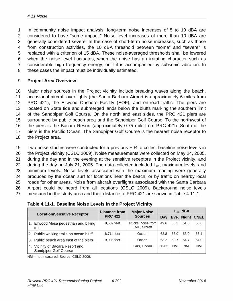
4.11 Noise
In community noise impact analysis, long-term noise increases of 5 to 10 dBA are 1 considered to have “some impact.” Noise level increases of more than 10 dBA are 2 generally considered severe. In the case of short-term noise increases, such as those 3 from construction activities, the 10 dBA threshold between “some” and “severe” is 4 replaced with a criterion of 15 dBA. These noise-averaged thresholds shall be lowered 5 when the noise level fluctuates, when the noise has an irritating character such as 6 considerable high frequency energy, or if it is accompanied by subsonic vibration. In 7 these cases the impact must be individually estimated. 8
Project Area Overview 9
Major noise sources in the Project vicinity include breaking waves along the beach, 10 occasional aircraft overflights (the Santa Barbara Airport is approximately 6 miles from 11 PRC 421), the Ellwood Onshore Facility (EOF), and on-road traffic. The piers are 12 located on State tide and submerged lands below the bluffs marking the southern limit 13 of the Sandpiper Golf Course. On the north and east sides, the PRC 421 piers are 14 surrounded by public beach area and the Sandpiper Golf Course. To the northwest of 15 the piers is the Bacara Resort (approximately 0.75 mile from PRC 421). South of the 16 piers is the Pacific Ocean. The Sandpiper Golf Course is the nearest noise receptor to 17 the Project area. 18
Two noise studies were conducted for a previous EIR to collect baseline noise levels in 19 the Project vicinity (CSLC 2009). Noise measurements were collected on May 24, 2005, 20 during the day and in the evening at the sensitive receptors in the Project vicinity, and 21 during the day on July 21, 2005. The data collected included Leq, maximum levels, and 22 minimum levels. Noise levels associated with the maximum reading were generally 23 produced by the ocean surf for locations near the beach, or by traffic on nearby local 24 roads for other areas. Noise from aircraft overflights associated with the Santa Barbara 25 Airport could be heard from all locations (CSLC 2009). Background noise levels 26 measured in the study area and their distance to PRC 421 are shown in Table 4.11-1. 27
Table 4.11-1. Baseline Noise Levels in the Project Vicinity
Location/Sensitive Receptor Distance from PRC 421
Major Noise Sources
Leq, dBA Day Eve. Night CNEL
1. Ellwood Mesa pedestrian and bikingtrail
8,509 feet Trucks, noise from EMT, aircraft
49.6 56.3 51.3 58.6
2. Public walking trails on ocean bluff 8,714 feet Ocean 63.8 63.0 58.0 66.4
3. Public beach area east of the piers 9,008 feet Ocean 63.2 59.7 54.7 64.0
4. Vicinity of Bacara Resort andSandpiper Golf Course
Cars, Ocean 60-63 NM NM NM
NM = not measured; Source: CSLC 2009.
Revised PRC 421 Recommissioning Project 4-292 November 2014 Final EIR

4.11 Noise
A third noise monitoring study was conducted August 9, 2005, near the Line 96 tie-in at 1 the EOF, in the vicinity of the Bacara Resort, Sandpiper Golf Course, and residences on 2 the north side of Highway 101. This study examined only daytime ambient noise levels 3 and determined that day background Leq noise levels in this location were between 60 4 and 63 dBA. Figure 4.11-2 shows a map of the background-noise-monitoring locations. 5
4.11.2 Regulatory Setting 6
Noise is regulated at the Federal, State, and local levels through regulations, policies, 7 and/or local ordinances. Local policies are commonly adaptations of Federal and State 8 guidelines, based on prevailing local conditions or special requirements. These 9 guidelines have been developed at the Federal level by the U.S. Environmental 10 Protection Agency (EPA) and at the State level by the now-defunct California Office of 11 Noise Control. A summary of the regulatory setting for noise at the Federal and State 12 level is provided in Table 4.0-1 and the local level is provided below. 13
Local 14
City of Goleta GP/CLUP 15
The intent of the Noise Element (NE) contained within the City of Goleta GP/CLUP is to 16 limit exposure of residents, workers, and visitors to excessive noise levels, while 17 allowing future development consistent with the Land Use Element and other plan 18 elements. The Noise Element also contains policies that serve to achieve certain 19 resource protection objectives of the Open Space and Conservation Elements. 20
The Goleta GP/CLUP NE 1.1 protects noise sensitive interior uses by minimizing noise 21 impacts: 22
The City shall use the standards and criteria of Table 9-2 [within the Noise 23 Element] to establish compatibility of land use and noise exposure. The City shall 24 require appropriate mitigation, if feasible, or prohibit development that would 25 subject proposed or existing land uses to noise levels that exceed acceptable 26 levels as indicated in this table. Proposals for new development that would cause 27 standards to be exceeded shall only be approved if the project would provide a 28 substantial benefit to the City (including but not limited to provision of affordable 29 housing units or as part of a redevelopment project), and if adequate mitigation 30 measures are employed to reduce interior noise levels to acceptable levels. 31
November 2014 4-293 Revised PRC 421 Recommissioning Project Final EIR

DevereuxDevereuxSloughSlough
PIER 421-1PIER 421-1PIER 421-2PIER 421-2
PLATFORMPLATFORMHOLLYHOLLY
ELLWOODELLWOODSCHOOLSCHOOL
SANDPIPERSANDPIPERGOLF COURSEGOLF COURSE
ELLWOOD MESA ELLWOOD MESA
ELLWOODONSHOREFACILITY
DevereuxSlough
ELLWOODONSHOREFACILITY
PIER 421-1PIER 421-2
PLATFORMHOLLY
SANDPIPERGOLF COURSE
ELLWOODSCHOOL
ELLWOOD MESA
Bell
Bell
Cree
kCr
eek
Cany
onCa
nyon
Bell
Cree
kCa
nyon
Devereux Creek
Devereux Creek
HOLLLLISTER AVVENUEHOLLISTER AVENUE
101
1
8
2
3 7
4
5
6
DevereuxDevereuxSchoolSchool
Single FamilySingle FamilyResidencesResidences
DevereuxSchool
Single FamilyResidences
LINE 96LINE 96LINE 96
FIGURE4.11-2Noise Monitoring Locations
0 1,400
SCALE IN FEET
N
4-

4.11 Noise
NE 1.4 outlines the makeup of acoustical studies: 1
An acoustical study that includes field measurement of noise levels may be 2 required for any proposed project that would: a) locate a potentially intrusive 3 noise source near an existing sensitive receptor, or b) locate a noise-sensitive 4 land use near an existing known or potentially intrusive noise source such as a 5 freeway, arterial roadway, railroad, industrial facility, or airport traffic pattern. 6 Acoustical studies should identify noise sources, magnitudes, and potential noise 7 mitigation measures and describe existing and future noise exposure. The 8 acoustical study shall be funded by the applicant and conducted by a qualified 9 person or firm that is experienced in the fields of environmental noise 10 assessment and architectural acoustics. The determination of applicability of this 11 requirement shall be made by the Planning and Environmental Services 12 Department by applying the standards and criteria outlined within the standards 13 and criteria of Table 9-2 [of the Noise Element]. 14
NE 5.1 addresses new, expanded, or upgraded stationary noise sources: 15
The City shall require proposals for new stationary sources or expansions or 16 alterations of use for an existing stationary source to include appropriate noise 17 mitigation measures. Retrofits and facility upgrades under the permitting 18 jurisdiction of the City should ensure that noise levels are reduced, particularly for 19 sources that impact adjacent sensitive receivers. 20
NE 5.2 discusses equipment maintenance: 21
The City shall require that new and existing heating, ventilation, and air 22 conditioning equipment and other commercial/industrial equipment be adequately 23 maintained in proper working order so that noise levels emitted by such 24 equipment remain minimal. The City shall also require noise shielding or 25 insulation for such equipment if operation of the equipment results in 26 objectionable noise levels at adjacent properties. 27
NE 5.4 promotes the use of noise barriers for industrial or heavy commercial uses: 28
Absorptive types of noise barriers or walls should be used to reduce noise levels 29 generated by industrial and certain heavy commercial uses. To be considered 30 effective, the noise barrier should provide at least a 5-dBA-CNEL noise 31 reduction. 32
The Goleta GP/CLUP NE 6.4 places restrictions on construction hours. The policy 33 states: 34
Noise-generating construction activities for projects near or adjacent to 35 residential buildings and neighborhoods or other sensitive receptors shall be 36 limited to Monday through Friday, 8:00 a.m. to 5:00 p.m. Construction in 37 nonresidential areas away from sensitive receivers shall be limited to Monday 38 through Friday, 7:00 a.m. to 4:00 p.m. Construction shall generally not be 39 allowed on weekends and State holidays…. All construction sites subject to such 40
November 2014 4-295 Revised PRC 421 Recommissioning Project Final EIR

4.11 Noise
restrictions shall post the allowed hours of operation near the entrance to the 1 site, so that workers are aware of this limitation. 2
The NE provides Noise and Land Use Compatibility Criteria for various land uses. One 3 criterion identifies noise levels of 50-70 dBA as “Normally Acceptable” levels at golf 4 courses, riding stables, water recreation, and cemeteries. Levels between 70 and 80 5 dBA are classified as “Normally Unacceptable” and levels above 80 dBA are classified 6 as “Clearly Unacceptable.” 7
NE 6.5 states: 8
The following measures shall be incorporated into grading and building plan 9 specifications to reduce the impact of construction noise: 10
a. All construction equipment shall have properly maintained sound-control11 devices, and no equipment shall have an unmuffled exhaust system. 12
b. Contractors shall implement appropriate additional noise mitigation measures13 including, but not limited to, changing the location of stationary construction 14 equipment, shutting off idling equipment, and installing acoustic barriers around 15 significant sources of stationary construction noise. 16
c. To the extent practicable, adequate buffers shall be maintained between17 noise-generating machinery or equipment and any sensitive receptors. The 18 buffer shall ensure that noise at the receiver site does not exceed 65 dBA CNEL. 19 For equipment that produces a noise level of 95 dBA at 50 feet, a buffer of 1,600 20 feet is required for attenuation of sound levels to 65 dBA (City of Goleta 2006). 21
NE 7.1 necessitates the control of noise at the source: 22
The City shall require that primary emphasis on the control of noise be 23 accomplished at the source by reducing the intensity of the noise generated or 24 through appropriate placement of noisy components of a project or use. 25 Secondary emphasis should be through site design of receiver sites and noise 26 attenuation and insulation measures. 27
4.11.3 Significance Criteria 28
A noise impact is considered significant if noise levels from Project operations exceed 29 the local policies and noise standards. Thus, the noise policies of the Santa Barbara 30 County and the City of Goleta shall be adhered to. Impacts of the Project would 31 therefore be considered significant if: 32
· A noise level of greater than 65 dBA resulted from grading and construction33 activity proposed within 1,600 feet of sensitive receptors, including schools,34 residential development, commercial lodging facilities, hospitals or care facilities35 (City of Goleta 2006);36
Revised PRC 421 Recommissioning Project 4-296 November 2014 Final EIR

4.11 Noise
· Noise levels at neighborhood parks increased above 70 dBA, or levels at golf 1 courses and riding stables increased above 70 dBA (City of Goleta 2006);2
· Outdoor living areas of noise sensitive uses that are subject to noise levels in3 excess of 65 dBA CNEL would generally be presumed to be significantly4 impacted by ambient noise. A significant impact would also generally occur5 where interior noise levels cannot be reduced to 45 dBA CNEL or less (Santa6 Barbara County 2002); or7
· A project will generally have a significant effect on the environment if it will8 increase substantially the ambient noise levels for noise-sensitive receptors9 adjoining areas. This may generally be presumed when ambient noise levels10 affecting sensitive receptors are increased to 65 dBA CNEL or more. However, a11 significant effect may also occur when ambient noise levels affecting sensitive12 receptors increase substantially but remain less than 65 dBA CNEL, as13 determined on a case-by-case level (Santa Barbara County 2002).14
4.11.4 Impact Analysis and Mitigation 15
The nearest sensitive human receptor, as defined by the Goleta GP/CLUP, is the 16 Bacara Resort, which is approximately 3,800 feet west of the Project area. The nearest 17 residences to the Project site are approximately 2,500 feet east of the Project area. 18 However, noise-sensitive recreational uses occur on the beach surrounding the project 19 site and on the adjacent Sandpiper Golf Course. Current daytime background Leq noise 20 levels in the Project vicinity, the Sandpiper Golf Course, and the adjacent beach area 21 are in the range of 60 to 63 dBA, as determined by the noise study performed on 22 August 9, 2005, for the EMT Lease Renewal EIR. The primary noise source in the 23 beach area is breaking waves. Noise impacts to biological resources are discussed in 24 Sections 4.6 and 4.7, Marine Biological Resources and Terrestrial Biological Resources, 25 respectively. 26
The Project has the potential to create both short-term construction-related and long-27 term operational noise impacts. Elevated noise levels from construction and grading 28 activities would not occur within 1,600 feet of any residential or commercial human 29 sensitive receptors and would not conflict with the significance threshold (under 65 dBA) 30 for these distant locations. However, as discussed below, operation of construction 31 equipment would generate short-term periodic high noise levels (e.g., 90 dBA at 50 feet) 32 on the beach surrounding PRC 421 and to a lesser extent on limited portions of the 33 adjacent Sandpiper Golf Course. 34
Noise associated with the Project would generally not exceed existing noise levels. The 35 use of a downhole electric submersible pump (ESP) would eliminate the need for 36 surface pumping equipment and noise associated with such equipment. The ESP would 37 be installed at such a depth within the well that noise levels at the surface would be 38
November 2014 4-297 Revised PRC 421 Recommissioning Project Final EIR

4.11 Noise
negligible. Therefore, Project implementation would temporarily and minimally increase 1 noise levels of outdoor or interior living areas during periods of construction, and create 2 very limited long-term changes in ambient noise levels from operation of the ESP and 3 other infrastructure at Pier 421-2. No noise impacts to residences or human sensitive 4 receptors would occur. 5
Table 4.11-2, located at the end of this section, provides a summary of Project-related 6 noise impacts and recommended MMs to address these impacts. 7
Impact NZ-1: Construction Impacts to Beach Users and Golfers 8 Short-term noise levels would increase during Project construction potentially 9 affecting a public beach and the Sandpiper Golf Course (Less than Significant). 10
Impact Discussion 11
Noise levels from construction machinery were modeled using documented noise levels 12 (EPA 1971). The loudest piece of construction equipment that would be used during the 13 Project would be diesel trucks and heavy equipment. Noise at 50 feet from diesel-14 powered equipment would not exceed 90 dBA Leq; however, at 1,000 feet, Leq would be 15 64 dBA. Such increases in noise are anticipated to be periodic during the Project’s 16 proposed 90 days of construction. The public beach area adjacent to the Project site is 17 a relatively low-use beach area due to its distance from nearby access points 18 (approximately 0.5 mile west of access from Ellwood Mesa and 0.5 mile east of access 19 from the Bacara Resort). However, ambient noise levels at the beach area adjacent to 20 the piers would increase noticeably during re-commissioning of Well 421-2 and 21 decommissioning and removal of Well 421-1 and the associated infrastructure. Beach 22 areas which are more heavily used by the public are approximately 0.5 mile in each 23 direction from the Project site and ambient noise levels at these more distant beaches 24 would not be significantly increased during construction activities at PRC 421. Because 25 of the short-term periodic nature of construction-related increases in noise and the 26 limited number of affected beach goers, noise impacts to beach users, while periodically 27 exceeding the threshold for the beach area directly adjacent to the Project site, would 28 be considered an adverse but less than significant impact. 29
Wells 421-1 and 421-2 are approximately 200 feet from the southern edge of Sandpiper 30 Golf Course, where construction-related Leq could reach 78 dBA for brief periods, which 31 is above the 70 dBA threshold identified by the Goleta GP/CLUP Noise Element. The 32 access road and proposed pipeline replacements are adjacent to the 12th green at 33 Sandpiper Golf Course, where Leq would be even greater during construction. The 34 Applicant anticipates that construction activities along the access road and pipeline area 35 will take 1 day; however, these activities could take up to 1 week. All other construction 36 activities are anticipated to last for approximately 90 days. However, the City GP/CLUP 37 policy states that noise in the vicinity of golf course and other recreational facilities be 38
Revised PRC 421 Recommissioning Project 4-298 November 2014 Final EIR

4.11 Noise
reduced to the extent practicable and does not specify construction noise. Therefore, 1 this policy would be more applicable to long-term operational noise which would be 2 below the 70 dBA threshold. Further, standard noise reduction best management 3 practices (BMPs) should be employed during construction including installing noise 4 mufflers on all construction equipment and erecting temporary barriers between 5 construction activities and Sandpiper Golf Course. In addition, in compliance with the 6 City GP/CLUP Noise Element policy NE 6.4, construction activities would occur 7 between 8:00 a.m. and 5:00 p.m. Monday through Friday. Construction would generally 8 not be allowed on weekends and state holidays. Exceptions to these restrictions may be 9 made in extenuating circumstances (e.g., in the event of an emergency) on a case-by-10 case basis at the discretion of the City of Goleta’s Director of Planning and 11 Environmental Services. Because high construction noise levels would be episodic 12 during a limited 90-day construction period and would affect golfers only on a limited 13 segment (e.g., two holes) of the Sandpiper Golf Course, noise impacts to recreational 14 golfers would be short-term and less than significant. 15
Mitigation Measures 16
Although this impact would be less than significant, the following measures would be 17 incorporated into grading and building plan specifications as required by City of Goleta 18 ordinances to reduce the impact of construction noise: 19
MM NZ-1a. Sound-Control Devices. All construction equipment shall have properly 20 maintained sound-control devices, and no equipment should have an 21 unmuffled exhaust system. 22
MM NZ-1b. Additional Best Management Practices (BMPs). Contractors shall 23 implement appropriate BMPs to avoid impacting the public including but not 24 limited to changing the location of stationary construction equipment, shutting 25 off idling equipment, and installing acoustic barriers around significant sources 26 of stationary construction noise, so that the noise at sensitive receptors such 27 as golf courses, water recreation areas, and riding stables does not exceed 70 28 A-weighted decibels (dBA) California Noise Equivalent Level (CNEL). 29
MM NZ-1c. Buffers. To the maximum extent feasible, adequate distance buffers 30 shall be maintained between noise-generating machinery or equipment and 31 any sensitive receptors. The buffer shall be of a width that will ensure that 32 noise at the receiver site such as a residence does not exceed 65 A-weighted 33 decibels (dBA) California Noise Equivalent Level (CNEL), and at receptors 34 such as golf courses, water recreation areas, and riding stables, the noise does 35 not exceed 70 dBA CNEL. For equipment that produces a noise level of 95 36 dBA at 50 feet, a buffer of 1,600 feet is required for attenuation of sound levels 37 to 65 dBA. 38
November 2014 4-299 Revised PRC 421 Recommissioning Project Final EIR

4.11 Noise
Rationale for Mitigation 1
While there would be no significant impacts, the above MMs (NZ-1a through NZ-1c) are 2 required by the City of Goleta and would further reduce noise generated from the 3 Project. 4
Impact NZ-2: Operational Impacts to Beach Users and Golfers 5 Noise levels associated with the long-term operation of the Project potentially 6 affecting a public beach and the Sandpiper Golf Course (Less than Significant). 7
Impact Discussion 8 The use of a downhole ESP would eliminate the need for surface pumping equipment 9 and the noise associated with the above-ground oil pumping equipment. Therefore, 10 upon Project implementation, less than significant long-term noise impacts to recreational 11 users would occur. 12
Mitigation Measures 13
None required. 14
Table 4.11-2. Summary of Noise Impacts and Mitigation Measures Impact Mitigation Measures
NZ-1: Construction Impacts to Beach Users and Golfers
NZ-1a. Sound-Control Devices. NZ-1b. Additional Best Management Practices. NZ-1c. Buffers.
NZ-2: Operational Impacts to Beach Users and Golfers
None required.
4.11.5 Cumulative Impacts Analysis 15
A number of projects are located near the Project site. As stated above, no noise 16 impacts would occur during operation of PRC 421; therefore, cumulative noise impacts 17 would be limited to temporary construction noise. For the purposes of this analysis, 18 cumulative impacts are only considered significant for projects with the potential to be 19 under construction during the same time period as PRC 421. These could include minor 20 ongoing habitat restoration and well decommissioning on the Ellwood Mesa. In the 21 event that these projects are implemented concurrently with the Project, the Project 22 would contribute to cumulative noise impacts. However, impacts would be temporary 23 (last only the duration of construction) and all projects would be required to comply with 24 City of Goleta noise standards. 25
Revised PRC 421 Recommissioning Project 4-300 November 2014 Final EIR

4.12 Aesthetic/Visual Resources
4.12 AESTHETIC/VISUAL RESOURCES 1
This section describes the onshore and offshore visual environments in the Ellwood 2 area and addresses the potential for the Project to impact the visual resources in the 3 Project vicinity and its regional context. Potential impacts to visual resources created by 4 the Project are based on a change from existing conditions. 5
The analysis in this section is based on field surveys of the Project study area and 6 surrounding area and also incorporates by reference the conclusions of the Ellwood 7 Marine Terminal (EMT) Lease Renewal Environmental Impact Report (EIR) (California 8 State Lands Commission [CSLC] 2009) and Line 96 Modification Project EIR (Santa 9 Barbara County 2011) regarding area visual resources and the potential impact on such 10 resources associated with oil development projects, and summarizes these where 11 appropriate. Where this document relies upon mitigation measures (MMs) contained in 12 those EIRs to address Project impacts, these are summarized to allow report reviewers 13 to understand the relationship of the MMs to the Project. This document also 14 incorporates data from Santa Barbara County 01-ND-34 and City of Goleta 06-ND-001. 15
4.12.1 Analysis of Visual Impacts 16
Impacts to aesthetics and visual resources are determined by identifying the visual 17 sensitivity and visual character of an environment. Visual impacts are then evaluated in 18 the context of the character of these views. 19
Visual Sensitivity 20
Visual sensitivity is defined as the public attitudes about specific views, or interrelated 21 views, and is a key factor in assessing how important a visual impact may be and 22 whether or not it represents a significant impact. Visual sensitivity has three defined 23 levels (see also Table 4.12-1): 24
High Sensitivity. High sensitivity suggests that at least some part of the public is likely to 25 react strongly to a threat to visual quality. Concern is expected to be great because the 26 affected views are rare, unique, or in other ways are special to the region or locale. A 27 highly concerned public is assumed to be more aware of any given level of adverse 28 change and less tolerant than a public that has little concern. A small modification of the 29 existing landscape may be visually distracting to a highly sensitive public and represent 30 a substantial reduction in visual quality. 31
November 2014 4-301 Revised PRC 421 Recommissioning Project Final EIR

4.12 Aesthetic/Visual Resources
Table 4.12-1. Indicators of Visual Sensitivity High Sensitivity
§ Views of and from areas the aesthetic values of which are protected in laws, public regulations andpolicies, and public planning documents;
§ Views of and from designated areas of aesthetic, recreational, cultural, or scientific interest, includingnational, State, county, and community parks, reserves, memorials, scenic roads, trails, interpretivesites of scientific value, scenic overlooks, recreation areas, and historic structures, sites, and districts;
§ Views of and from areas or sites of cultural/religious importance to Native Americans;§ Views from national- or State-designated scenic highways or roads, or designated scenic highways or
roads of regional importance;§ Views from resort areas;§ Views from urban residential subdivisions; and§ Views from segments of travel routes, such as roads, rail lines, pedestrian and equestrian trails, and
bicycle paths near designated areas of aesthetic, recreational, cultural, or scientific interest leadingdirectly to them. Views seen while approaching an area of interest may be closely related to theappreciation of the aesthetic, cultural, scientific, or recreational significance of that destination.
Moderate Sensitivity § Views from segments of travel routes near highly sensitive use areas of interest, serving as a
secondary access route to those areas;§ Views from rural residential areas and segments of roads near them which serve as their primary
access route;§ Views of and from undesignated but protected or popularly used or appreciated areas of aesthetic,
recreational, cultural, or scientific significance at the local, county, or State level;§ Views from highways or roads locally designated as scenic routes and of importance only to the local
population, or informally designated as such in literature, road maps, and road atlases;§ Views from travel routes, such as roads, trails, bicycle paths, and equestrian trails leading directly to
protected or popularly used undesignated areas important for their aesthetic, recreational, cultural, orscientific interest; and
§ Views of and from religious facilities and cemeteries.
Low Sensitivity § Views from travel routes serving as secondary access to moderately sensitive areas;§ Views from farmsteads, or groupings of fewer than four residences; and§ Views from industrial research/development, commercial, and agricultural use areas.
Moderate Sensitivity. Moderate sensitivity suggests that the public would probably voice 1 some concern over substantial visual impacts. Often the affected views are secondary 2 in importance or are similar to others commonly available to the public. Noticeably 3 adverse changes would probably be tolerated if the essential character of the views 4 remains dominant. 5
Low Sensitivity. Low sensitivity is considered to prevail where the public is expected to 6 have little or no concern about changes in the landscape. This may be because the 7 affected views are not “public” (not accessible to the public) or because there are no 8 indications that the affected views are valued by the public. For instance, little public 9
Revised PRC 421 Recommissioning Project 4-302 November 2014 Final EIR

4.12 Aesthetic/Visual Resources
concern for aesthetics is assumed to pertain to views from industrial, commercial, and 1 purely agricultural areas. There are exceptions: some agricultural areas are prized for 2 their open space value, and views of such are highly sensitive. Visual sensitivity is low 3 for views from all sites, areas, travel routes, and sections of travel routes not identified 4 as moderate or high in sensitivity. 5
Visual Character 6
The visual character of a landscape is typically described in terms of its land forms, 7 vegetation, water features, and the “built” features of the environment. There are three 8 objectives in assessing visual character. One is to identify the types of features 9 considered to be inherent to the area, those features that are expressive of the 10 prevailing land uses or of the ecological processes in the natural landscape. The 11 second objective is to identify patterns or distribution of features characteristic of the 12 affected setting. The third objective is to describe the existing quality of the visual 13 resources, which varies inversely with how noticeable incongruous features may be 14 within public views. The current visual quality of the physical environment is described 15 as its existing visual condition, which is defined in terms of four Visual Modification 16 Classes (VMC), noted in Table 4.12-2. 17
Table 4.12-2. Visual Modification Class (VMC) Definitions VMC Definition
1 Not noticeable Changes in the landscape are within the field of view but generally would be overlooked by all but the most concerned and interested viewers; they generally would not be noticed unless pointed out (inconspicuous because of such factors as distance, screening, low contrast with context, or other features in view, including the adverse impacts of past activities).
2 Noticeable, visually subordinate Changes in the landscape would not be overlooked (noticeable to most without being pointed out); they may attract some attention but do not compete for it with other features in the field of view, including the adverse impacts of past activities. Such changes often are perceived as being in the background.
3 Distracting, visually co-dominant Changes in the landscape compete for attention with other features in view, including the adverse impacts of past activities (attention is drawn to the change about as frequently as to other features in the landscape).
4 Visually dominant, demands attention Changes in the landscape are the focus of attention and tend to become the subject of the view; such changes often cause a lasting impression on the affected landscape.
4.12.2 Environmental Setting 18
Study Area Location and Description 19 The primary Project study area comprises the beach in the immediate Project vicinity 20 that could be impacted by Project-related visual changes as well as beaches and bluff 21
November 2014 4-303 Revised PRC 421 Recommissioning Project Final EIR

4.12 Aesthetic/Visual Resources
tops the Ellwood area extending roughly from Coal Oil Point west to Bacara Resort. A 1 secondary study area includes creeks and beaches along the Gaviota Coast that have a 2 low potential to be impacted by an oil spill from the Line 96 pipeline as described in the 3 EIR for that project (Santa Barbara County 2011). 4
Onshore Visual Environment 5
The primary Project area is located on the beach within the Ellwood Coast, an area 6 widely recognized for its scenic beauty. The natural environment of the Project area 7 consists of open sandy beach and dune vegetation interspersed with urban 8 development. Significant visual resources include views of open water, bluffs, and an 9 area of wetland at Bell Creek. The Project area is used for both passive (beach walks, 10 bird watching) and active recreation (Sandpiper Golf Course). Public beach access is 11 provided near the Project site at Bacara Resort/Haskell’s Beach approximately 0.5 mile 12 west of Pier 421-1. Beach access in this area is constrained during periods of high tide 13 and by the flow of water from Bell Canyon Creek. Figure 4.12-1 shows existing beach 14 access under the existing piers during low tide. 15
FIGURE 4.12-1. CURRENT VIEW OF PIER 421-2 FROM THE BEACH SHOWING PEDESTRIAN BEACH ACCESS
Revised PRC 421 Recommissioning Project 4-304 November 2014 Final EIR

4.12 Aesthetic/Visual Resources
Bell Creek is an Environmentally Sensitive Habitat vegetated with native and non-native 1 plant species. It serves as a nesting habitat for avian species, as well as a number of 2 State and federally listed species (e.g., tidewater goby). For beachgoers and 3 birdwatchers, Bell Canyon Creek is a significant visual feature. Development in the area 4 includes the Sandpiper Golf Course, the Ellwood Onshore Facility (EOF), Piers 421-1 5 and 421-2, the EMT, “Bird Island” (the converted platforms of the old State Lease 421 6 pier extension, which lies offshore the Project area), and facilities associated with the 7 Bacara Resort such as tennis courts, public restrooms, and pedestrian access from a 8 public parking lot at Haskell’s Beach. The Sandpiper Golf Course, a public golf course, 9 is located on a bluff just north of and adjacent to the Project area, but at a higher 10 elevation that makes Piers 421-1 and 421-2 only partially visible to golfers. Although dirt 11 access roads serving the EOF and piers exist, there are no public trails from the golf 12 course to the beach. The beach provides the only public access to the Project site. The 13 EOF is the last oil and gas processing plant located in the City of Goleta. Once 14 considered to be located in a remote area, the EOF now lies between Sandpiper Golf 15 Course and the Bacara Resort (see Figure 2-2). Piers 421-1 and 421-2 have been part 16 of the visual setting for over 75 years, or since the mid-1920s. A man-made access road 17 and rock revetment leading to Pier 421-1 and Pier 421-2 runs alongside the toe of a 18 bluff that extends to the end of the State Lease boundary. 19
Existing prominent oil and gas facilities may detract from the open views of the water, 20 bluffs and wetland vegetation. Other manmade facilities exist within the viewshed, 21 including the rock revetment, access roads, the EOF, and Sandpiper Golf Course; 22 however, the pier structures are more prominent than these other facilities. 23
Offshore Visual Environment 24
The offshore visual environment associated with the Project is frequently enjoyed by 25 commercial and recreational fishermen, surfers, swimmers, and boaters. Views of Piers 26 421-1 and 421-2 from the ocean are unobscured and the piers stand out on the sand. In 27 a regional context, however, the piers blend in with the development in the region, 28 including the Ellwood Pier, the EOF, Sandpiper Golf Course, Platform Holly, and the 29 EMT (Figure 4.12-2). 30
Visual Sensitivity and Classification of the Ellwood Coast 31
The visual sensitivity of the Ellwood Coast is determined to be high due to the presence 32 of scenic bluffs, wide sandy beaches, dunes and wetlands. The visual sensitivity of the 33 Project area is determined to be moderate, as defined in Table 4.12-1, due to existing 34 development such as the PRC 421 piers, caissons and seawall, which suggests that the 35 public would voice some concern over substantial visual impacts. However, noticeable 36 changes would probably be tolerated if the essential open space character of the views 37
November 2014 4-305 Revised PRC 421 Recommissioning Project Final EIR
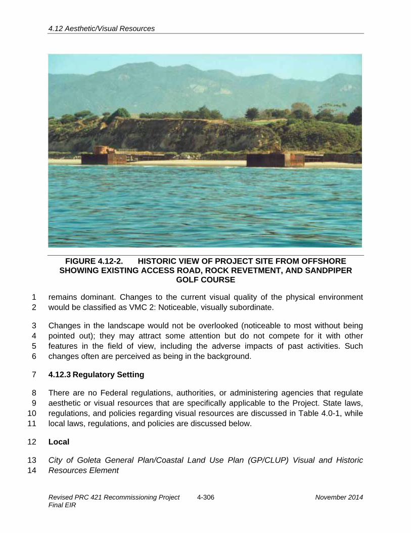
4.12 Aesthetic/Visual Resources
FIGURE 4.12-2. HISTORIC VIEW OF PROJECT SITE FROM OFFSHORE SHOWING EXISTING ACCESS ROAD, ROCK REVETMENT, AND SANDPIPER
GOLF COURSE
remains dominant. Changes to the current visual quality of the physical environment 1 would be classified as VMC 2: Noticeable, visually subordinate. 2
Changes in the landscape would not be overlooked (noticeable to most without being 3 pointed out); they may attract some attention but do not compete for it with other 4 features in the field of view, including the adverse impacts of past activities. Such 5 changes often are perceived as being in the background. 6
4.12.3 Regulatory Setting 7
There are no Federal regulations, authorities, or administering agencies that regulate 8 aesthetic or visual resources that are specifically applicable to the Project. State laws, 9 regulations, and policies regarding visual resources are discussed in Table 4.0-1, while 10 local laws, regulations, and policies are discussed below. 11
Local 12
City of Goleta General Plan/Coastal Land Use Plan (GP/CLUP) Visual and Historic 13 Resources Element 14
Revised PRC 421 Recommissioning Project 4-306 November 2014 Final EIR

4.12 Aesthetic/Visual Resources
The Goleta GP/CLUP Visual and Historic Resources Element policies VH1.1, VH1.2, 1 and VH1.5 apply to the Project. Policy VH1.1 states that Goleta shall support the 2 protection and preservation of the Pacific shoreline, including beaches, dunes, lagoons, 3 coastal bluffs, and open coastal mesas. Policy VH1.2 refers to a Scenic Resources Map 4 which identifies the coastline and Hollister Avenue as public vantage points for viewing 5 scenic resources. Policy VH1.5 states that views of open space from public areas shall 6 be preserved. To minimize impacts to scenic resources, the following standard 7 regulatory conditions would be applied to the Project, where appropriate, as part of the 8 City of Goleta Development Plan permit. 9
· Limitations on the height and size of structures;10
· Downcast, fully shielded, full cut off lighting of the minimum intensity needed for11 the purpose;12
· Use of landscaping for screening purposes and /or minimizing view blockage as13 appropriate; and14
· Selection of color and materials that harmonize with the surrounding landscape.15
Santa Barbara County Local Coastal Program (LCP) 16
The Santa Barbara County LCP recognizes that industrial and energy facilities, 17 particularly when sited within view corridors, may represent major impacts on scenic 18 and visual resources. The Santa Barbara County Comprehensive Plan Land Use 19 Element Visual Resources Policy 1 states that “All commercial, industrial, planned 20 development shall be required to submit a landscaping plan to the county for approval.” 21
Similarly, Local Coastal Policy 6-2 states that a plan for eliminating or substantially 22 mitigating adverse impacts on scenic resources due to siting, construction, or operation 23 of facilities shall accompany a Development Plan filed with the Petroleum Administrator. 24
4.12.4 Significance Criteria 25
Visual impacts are considered significant if one or a combination of the following apply: 26
· The project is inconsistent with or in violation of public policies, goals, plans,27 laws, regulations or other directives concerning visual resources;28
· Routine operations and maintenance visually contrast with or degrade the29 character of the viewshed;30
· The project results in a perceptible reduction of visual quality, lasting for more31 than one year that is seen from moderately to highly sensitive viewing positions.32 A perceptible reduction of visual quality occurs when, for a highly sensitive view,33 the visual condition is lowered by at least one Visual Modification Class (VMC);34 or for a moderately sensitive view, the condition is lowered by at least two VMCs;35
November 2014 4-307 Revised PRC 421 Recommissioning Project Final EIR

4.12 Aesthetic/Visual Resources
· Night lighting would result in glare conditions affecting nearby residences; or 1
· Because of the time factor involved in oil dispersion, visual impacts from spills2 are considered to be significant (i.e., a significant impact that remains significant3 after mitigation) if first response efforts would not contain or clean up the spill,4 resulting in residual impacts that would be visible to the general public on5 shoreline or water areas.6
4.12.5 Impact Analysis and Mitigation 7
The visual resources assessment focuses on identifying potentially significant impacts, 8 with the analysis directed toward public views in which the Project would be most 9 visible. Critical views are partly defined as those that are moderately to highly sensitive. 10 The public is considered to have a substantial concern over adverse changes in the 11 quality of such views. Critical views also are defined as being those public views that 12 would be most affected by the subject action, e.g., the greatest intensity of impact due 13 to viewer proximity to the Project and duration of the affected view. Critical views in the 14 Project area were identified as those from the beach and bluffs toward the onshore and 15 offshore portions of the Project located at the Ellwood Coast (Piers 421-1 and 421-2). 16
Table 4.12-3, located at the end of this section, provides a summary of Project-related 17 aesthetic/visual impacts and recommended MMs to address these impacts. 18
Impact VR-1: Visual Effects from Construction Activities at PRC 421 19 Construction activities would create negative visual impacts (Less than 20 Significant with Mitigation). 21
Impact Discussion 22
Construction activities associated with Project implementation would have potentially 23 significant short-term impacts to the visual quality of the Project area. The visual 24 environment would be disturbed by construction equipment (particularly the large 25 workover rig), construction fencing, construction materials, and occasional stockpiling of 26 debris on the upper reaches of the beach overnight for pick up and removal the next 27 day for the duration of the 90-day construction schedule. Given that the visual 28 environment at PRC 421 is enjoyed daily by beach goers, golfers, boaters, fishermen, 29 and surfers, views in the Project area would be significantly degraded on a daily basis 30 for the duration of the construction activities; however, these impacts would be 31 temporary and no permanent changes to the visual character of the area would occur 32 as a result of the Project. Night lighting would likely be used infrequently and for short 33 periods of time during Project construction since, by necessity, work on the Project 34 would need to be performed during low tide, which occurs late in the day during the fall 35 and early winter months when natural lighting is low. Per City of Goleta GP/CLUP Policy 36 NE 6.4, work would stop by 5:00 p.m., substantially reducing potential night lighting 37
Revised PRC 421 Recommissioning Project 4-308 November 2014 Final EIR

4.12 Aesthetic/Visual Resources
needs. However, as the Applicant has stated that construction hours would need to 1 extend until 7:00 p.m., this impact would remain potentially significant. 2
Mitigation Measures 3
MM VR-1a. Use Laydown Areas for Overnight Storage of Equipment. Equipment 4 placed on the beach shall be returned to the laydown areas at the end of each 5 workday, both for public safety and for aesthetic considerations. 6
MM VR-1b. Caution Tape around Materials Placed on Beach. Materials 7 temporarily placed on the upper reaches of the beach shall be roped-off with 8 caution tape and removed within 24 hours in most cases. 9
MM VR-1c. Material Removal at Construction Completion. All materials, 10 equipment, and debris shall be removed from the site upon completion of the 11 Project construction. Venoco shall revegetate all areas subject to ground 12 disturbance associated with project construction with species that are 13 biologically and visually compatible with the surroundings in accordance with a 14 Restoration Plan approved by the City of Goleta as identified in MM TBIO-1c 15 Restoration Plan/Restoration. 16
MM VR-1d. Minimal Night Lighting. Lighting shall use the minimum number of 17 fixtures and intensity needed for construction activities. Fixtures shall be fully 18 shielded and have full cut-off lights to minimize visibility from public viewing 19 areas, wildlife habitats, migration routes, and other sensitive environs. Venoco 20 shall prepare and implement a Night Lighting Plan to ensure that night lighting 21 is minimal and directed away from sensitive habitats to the maximum extent 22 feasible, for review and approval by the City of Goleta. 23
MM VR-1e. No Night Lighting After 5:00 p.m. Night lighting and work shall not 24 occur past the 5:00 p.m. work stoppage deadline. 25
Rationale for Mitigation 26
The above MMs would reduce the amount of time construction equipment would be 27 visible from the beach and minimize the use of night lighting, thereby reducing visual 28 impacts from construction activities. Full implementation of these measures would 29 reduce Impact VR-1 to less than significant. 30
Impact VR-2: Visual Effects from Accidental Oil Spills 31 Project implementation would incrementally increase the likelihood of oil spill 32 from primary or secondary Project components, including Pier 421-2, associated 33 pipelines, and the Line 96 pipeline (Significant and Unavoidable). 34
Impact Discussion 35
A large spill from the Project could cause visual impacts ranging from oil sheens to 36 heavy oiling including floating lumps of tar. Heavy crude oil may disappear over the 37
November 2014 4-309 Revised PRC 421 Recommissioning Project Final EIR

4.12 Aesthetic/Visual Resources
duration of several days, with remaining heavy fractions floating at or near the surface in 1 the form of mousse, tarballs, or mats, and lasting from several weeks to several months. 2 Therefore, the presence of oil on the water would change the color and, in heavier 3 oiling, textural appearance of the water surface. Oil on shoreline surfaces or near shore 4 marsh areas would cover these surfaces with a brownish-blackish, gooey substance. 5 However, direct releases of oil onto Goleta area beaches are projected to be limited to 6 approximately 1.75 barrels of oil, a relatively modest amount; however, the Project 7 would incrementally contribute to larger spills from Line 96 upcoast into Gaviota area 8 streams, with a low potential for spills as large as 60 barrels of oil, a portion of which 9 could find its way to the shoreline and potentially onto downcoast Goleta area beaches. 10
Although the potential for spills is low and volumes would not be large, such oiling would 11 result in a negative impression of the highly sensitive viewshed. The public would likely 12 react negatively to the visual effects. Without rapid containment by immediate booming 13 and cleanup, the visual effects of even a small spill can leave residual impacts, and can 14 be significant. 15
The impact of a spill could last for a long period of time, depending on the level of 16 physical impact and effectiveness of clean up. Even in events where light oiling would 17 disperse rapidly, significant impacts are expected. In events where medium to heavy 18 oiling occurs over a widespread area, and where first response cleanup efforts are not 19 effective, leaving residual effects of oiling, significant impacts would be expected. The 20 physical efforts associated with cleanup efforts would also contribute to a negative 21 impression of the environment and the visual impact, particularly in the primary study 22 area along the Ellwood Coast which receives substantial recreational use of beaches 23 and trails. It is impossible to predict with any certainty the potential visual consequences 24 of spills; therefore visual impacts are considered significant. 25
Mitigation Measures 26
Implementation of those measures identified in Sections 4.2, Safety; 4.3, Hazardous 27 Materials; 4.5 Hydrology, Water Resources, and Water Quality, 4.6, Marine Biological 28 Resources; and 4.7 Terrestrial Biological Resources for contingency planning and spill 29 response shall be required. 30
Rationale for Mitigation 31
Even with implementation of the measures presented in the above-mentioned sections, 32 which provide improved oil spill capabilities, spill containment measures, and protection 33 of resources, the risk to the visual environment may be significant, even for small spills. 34
Revised PRC 421 Recommissioning Project 4-310 November 2014 Final EIR

4.12 Aesthetic/Visual Resources
Residual Impacts 1
Even with successful implementation of MMs for oil spill impacts, visual resources may 2 be affected by spills and impacts would remain potentially significant. 3
Impact VR-3: Visual Improvements due to Removal of Pier 421-1 4 Removal of Pier 421-1 would restore the natural appearance along this section of 5 the beach (Beneficial). 6
Impact Discussion 7
Decommissioning and removal of Pier 421-1 and restoration of the beach along this 8 stretch would restore the aesthetic value of this stretch of coastline. Removal of the pier 9 would allow a greater view of the Pacific Ocean and other sensitive view sheds of the 10 Ellwood-Devereux Coast (Figure 4.12-3). Additionally, views from the ocean toward the 11 beach would no longer include this structure. Therefore, the Project would produce 12 beneficial impacts to aesthetic and visual resources of the area. 13
FIGURE 4.12-3. VIEW OF PIER 421-2 FROM THE BEACH WITH REMOVAL OF 14 PIER 421-1 15
Mitigation Measures 16
No mitigation required. 17
November 2014 4-311 Revised PRC 421 Recommissioning Project Final EIR

4.12 Aesthetic/Visual Resources
Impact VR-4: Visual Changes to Pier 421-2 1 Modifications to Pier 421-2 would change the appearance of this structure (Less 2 than Significant). 3
Impact Discussion 4
Recommissioning of Pier 421-2 would include installation of new caisson walls on the 5 non-seaward-facing sides, new handrails, and new decking. Pier 421-2 has been part of 6 the visual setting since the mid-1920s, but has been substantially changed over time. 7 Further, these changes would constitute improvements to the aesthetics of the pier, 8 which has suffered the effects of corrosion and weathering from environmental 9 exposure. Therefore, impacts would be less than significant. 10
Mitigation Measures 11
No mitigation required. 12
Table 4.12-3. Summary of Aesthetics/Visual Resources Impacts and Mitigation Measures
Impact Mitigation Measures VR-1: Visual Effects from Construction Activities at PRC 421
VR-1a. Use Laydown Areas for Overnight Storage of Equipment. VR-1b. Caution Tape around Materials Placed on Beach. VR-1c. Material Removal at Construction Completion. VR-1d. Minimal Night Lighting. VR-1e. No Night Lighting After 5:00 p.m.
VR-2: Visual Effects from Accidental Oil Spills
Implementation of those measures identified in Sections 4.2, Safety; 4.3, Hazardous Materials; 4.5 Hydrology, Water Resources, and Water Quality, 4.6, Marine Biological Resources; and 4.7 Terrestrial Biological Resources.
VR-3: Visual Improvements due to Removal of Pier 421-1
None required.
VR-4: Visual Changes to Pier 421-2 None required.
4.12.6 Cumulative Impacts Analysis 13
Cumulative impacts associated with the Project include the continued urbanization of 14 the Ellwood area, including the proposed expansion of the Bacara Resort, 15 improvements to Sandpiper Golf Course, and the partially completed construction of 62 16 homes by Comstock Homes. The Project would remove one existing pier, a beneficial 17 contribution to the cumulative impacts from historic oil development in the area. 18 However, development activity at PRC 421 would increase the public’s awareness of oil 19 production occurring in the region. Depending on the viewers’ personal and cultural 20 interpretations of oil production, this awareness would affect their coastal experience. 21
Revised PRC 421 Recommissioning Project 4-312 November 2014 Final EIR

4.13 Cultural, Historical, and Paleontological Resources
4.13 CULTURAL, HISTORICAL, AND PALEONTOLOGICAL RESOURCES 1
This section identifies cultural, historical, and paleontological resources in the Project 2 area, including PRC 421 itself, and evaluates impacts to such resources that would 3 potentially result from Project development. This document incorporates by reference 4 the conclusions of the Ellwood Marine Terminal (EMT) Lease Renewal Environmental 5 Impact Report (EIR) (California State Lands Commission [CSLC] 2009) and Line 96 6 Modification Project EIR (Santa Barbara County 2011) regarding cultural, historical, and 7 paleontological resources and summarizes these conclusions where appropriate. 8 Where this document relies upon mitigation measures (MMs) contained in those EIRs to 9 address Project impacts, these are summarized to permit report reviewers to 10 understand their relationship to the Project. This document also incorporates data from 11 Santa Barbara County 01-ND-34 and City of Goleta 06-MND-01 which included 12 assessment of cultural resources in the Project vicinity. 13
4.13.1 Environmental Setting 14
Study Area Location and Description 15
The primary Project study area comprises the immediate vicinity of PRC 421 that would 16 be subject to direct impacts as a result of Project implementation. This area includes 17 existing PRC 421 facilities, access road, and the pipeline route along the access road, 18 coastal bluff, golf course easement, and tie-in at the existing Ellwood Onshore Facility 19 (EOF). Impacts related to construction of the Line 96 Pipeline project were addressed in 20 the EIR for that project, but a secondary Project study area is associated with the Line 21 96 pipeline alignment due to the potential for spill effects on Cultural, Historical, and 22 Paleontological Resources. 23
Cultural Resources 24
Evidence exists for the presence of humans in the Santa Barbara coastal area for more 25 than ten thousand years. While some researchers (e.g., Orr 1968) have suggested that 26 the Santa Barbara Channel area may have been settled as early as 40,000 years ago, 27 only limited evidence for occupation much earlier than 9,500 years has been 28 discovered. Even so, human prehistory along the Santa Barbara channel area coast 29 may extend back as much as 12,000 years (Erlandson et al. 1987; Erlandson et al. 30 1996).Due to the rich food resources found on land and in the sea, Native American 31 populations grew over time and their organization became more complex. The area’s 32 various sources of fresh water, including Tecolote and Winchester Canyon creeks to the 33 west and Glen Annie Creek and the Goleta Slough to the east, were ideal locations for 34 permanent and semi-permanent village settlements that provided abundant fish, birds, 35 and plants for hunting and gathering. 36
November 2014 4-313 Revised PRC 421 Recommissioning Project Final EIR

4.13 Cultural, Historical, and Paleontological Resources
Current models of cultural evolution along the Santa Barbara Channel recognize that 1 over time, prehistoric peoples became increasingly dependent upon marine resources 2 though they required greater energy to procure. Populations also became less 3 dependent upon terrestrial resources such as large game animals due to reduced 4 numbers of game. The need for more sophisticated subsistence technologies and group 5 cooperation resulted in increasingly complex cultural interactions, culminating in the 6 Chumash culture and complex social organization encountered by the Spanish in the 7 1500s (Arnold et al. 1997; Glassow et al. 1990; Wilcoxon et al. 1982). Climatic change 8 during the transition from the Middle to Late Period around A.D. 1150 to 1300 may have 9 played an important role in this process (Raab and Larson 1997), although others 10 consider that pressures from increased population were also involved (Arnold et al. 11 1997). 12
A Sacred Lands File search conducted for the Project area failed to indicate presence of 13 Native American traditional cultural places (Native American Heritage Commission 14 2013). Within the Project vicinity, cultural resources include six documented sites within 15 the Bacara Resort property. Among these is Site SBa-71, which covers two-thirds of the 16 East Terrace at the Bacara Resort and was an area of permanent habitation by the 17 Chumash and “is designated highly sensitive because of its relatively undisturbed 18 nature, dense deposits, and extensive burials” (California Coastal Commission 2013). 19
There is a potential for offshore cultural resources in the Project vicinity, however none 20 are known from within 1 mile of shore. Refer to the Line 96 Modification Project EIR 21 (Santa Barbara County 2011) for detailed description of offshore cultural resources 22 along the coastline. 23
Historical Resources 24
Oil exploration began in Santa Barbara County when significant discoveries of oil were 25 successfully tapped in the Santa Maria Valley, 45 miles northwest of the current Project 26 area, during the 1880s. During the 1890s, the first offshore oil drilling piers were built in 27 the waters off Summerland, 17 miles east of the Project area. Other significant 28 discoveries followed in the early 1900s at the Orcutt and Cat Canyon fields. One well in 29 the Orcutt field struck an oil reservoir in 1904 that produced one million barrels of oil in 30 its first 100 days of operation, causing a sensation in the rest of the country which 31 proclaimed it to be “the greatest gusher in the world” (Santa Barbara County 2006). 32
World War I marked increased demand for oil that lasted through the 1920s. Even after 33 the disastrous stock market collapse of 1929, foreign demand for U.S. oil in the 1930s 34 spurred further oil development in Santa Barbara County. Oil production in the Orcutt 35 Hills hit an all-time high during World War I and then declined temporarily until rising 36 domestic automobile use in the 1920s necessitated more production. 37
Revised PRC 421 Recommissioning Project 4-314 November 2014 Final EIR

4.13 Cultural, Historical, and Paleontological Resources
Following the peak of World War II oil demands, oil and gas production in Santa 1 Barbara County declined. Beginning in the late 1950s, oil companies began to explore 2 for oil in State tidelands. The first offshore drilling platform off the Santa Barbara County 3 coast was installed in 1958 near Carpinteria. Eight other platforms and other facilities 4 were installed in State tidelands off of Santa Barbara County between 1956 and 1966. 5 On January 28, 1969, Union Oil's Platform A suffered a blowout in the Dos Cuadras 6 field installation that lasted eight days. The resulting spill of 90,000 barrels of crude oil 7 affected over 40 miles of coastline. Several environmental laws were passed at the 8 Federal and State levels following the incident, including the National Environmental 9 Policy Act (NEPA) and California Environmental Quality Act (CEQA). 10
The Ellwood Oil Field was discovered in 1928. PRC 421 was also built and 11 commissioned in 1928 and Piers 421-1 and 421-2 are historic structures, though they 12 are without historic or cultural significance to the community, State or nation. Although 13 they are the last remaining surf zone wells in California, they have been modified 14 significantly since the 1930s and do not maintain historic integrity (Figure 4.13-1; the red 15 arrow points to Pier 421-2). Further, based on review of historical photographs the Piers 16 were changed from the historic configuration sometime between 1979 and 1987; 17 therefore, making most of the structures less than 40 years old. 18
FIGURE 4.13-1. 1938 PHOTO OF ELLWOOD OIL PIERS
November 2014 4-315 Revised PRC 421 Recommissioning Project Final EIR

4.13 Cultural, Historical, and Paleontological Resources
Known historic resources near the Project site consist of a landmark site at the 1 northeast corner of the Sandpiper Golf course, located approximately 0.52 mile away. 2
Paleontological Resources 3
The Project area is situated on Pleistocene older alluvium deposits, consisting primarily 4 of relatively unconsolidated silt, sand, and gravel. These alluvial deposits overlie the 5 Miocene Sisquoc Formation, which is exposed in the coastal bluff northwest of the 6 Project area and consists of silty, diatomaceous, clay shale (Dibblee 1987). 7
Paleontological resources are commonly found in sedimentary rock units. The 8 boundaries of a sedimentary rock unit generally define the limits of paleontological 9 sensitivity in a given region. Paleontological sites are normally discovered in cliffs, 10 ledges, steep gullies, or along wave-cut terraces where vertical rock sections are 11 exposed. Fossil material may be exposed by a trench, ditch, or channel created by 12 construction. 13
Paleontologists examine invertebrate fossil sites differently than vertebrate fossil sites. 14 Invertebrate fossils in microscopic form such as diatoms, foraminifera, and radiolarians 15 can be so prolific as to constitute major rock material in some areas. Invertebrate fossils 16 are normally of marine origin and are widespread, abundant, fairly well preserved, and 17 predictable as to fossil sites. Therefore, the same or similar fossils can be located at any 18 number of sites throughout central California. 19
Vertebrate fossil sites are usually found in non-marine or continental deposits. 20 Vertebrate fossils of continental material are usually rare, sporadic, and localized. 21 Scattered vertebrate remains (mammoth, mastodon, horse, groundsloth, camel, and 22 rodents) have been identified from the Pleistocene non-marine continental terrace 23 deposits on Vandenberg Air Force Base, but these resources would not be expected in 24 the Project site and vicinity (Gray 2003). 25
The invertebrate fossils that would be expected to exist within Project site geologic rock 26 units are widespread and abundant in many areas throughout the Pacific Coastline 27 including the Santa Barbara County (Gray 2003). The overwhelming bulk of invertebrate 28 fossil material in these rocks is due to the deposition of sediment in marine basins. Very 29 seldom are vertebrate marine fossils such as whale, porpoise, seal, or sea lion found in 30 marine rock units such as the Miocene Monterey Formation and the Pliocene Sisquoc 31 Formations located within the PRC 421 Project area and vicinity. Therefore, the 32 sensitivity for encountering important paleontological resources within the PRC 421 33 Project area and vicinity is considered low (CSLC 2009). 34
Revised PRC 421 Recommissioning Project 4-316 November 2014 Final EIR

4.13 Cultural, Historical, and Paleontological Resources
4.13.2 Regulatory Setting 1
There are several Federal regulations related to cultural resources and paleontological 2 resources. Both cultural and paleontological resources are regulated at the State level. 3 Federal and State laws, regulations, and policies related to cultural and paleontological 4 resources are discussed in Table 4.0-1, while the local regulatory setting is discussed 5 below. 6
Local 7
Cultural Resources 8
The Santa Barbara County Coastal Plan has several policies that address the 9 preservation of significant cultural resources. Policy 10-1 states that all available 10 measures must be explored to avoid development on significant historic, prehistoric, 11 archaeological and other classes of cultural sites. Policy 10-2 states that project design 12 shall be required to avoid impacts on archaeological or other cultural sites if possible. 13 Policy 10-3 states that where avoidance of construction impacts is not possible, 14 adequate mitigation shall be required in accordance with State Office of Historic 15 Preservation and Native American Heritage Commission guidance. Policy 10-4 states 16 that indirect activities including off-road vehicle use, unauthorized artifact collection or 17 similar actions capable of destroying or damaging archaeological or cultural sites is 18 prohibited. Policy 10-5 states that Native Americans shall be consulted when 19 development is proposed that would potentially impact significant archaeological or 20 cultural sites. Santa Barbara County Cultural Resource Guidelines provide direction to 21 archaeologists on what types of research topics and research questions are appropriate 22 to determine the significance of an archaeological site. 23
The City of Goleta’s General Plan/Coastal Land Use Plan (GP/CLUP) contains several 24 policies in the Open Space and Visual and Historic Resources Elements pertaining to 25 cultural resources. One of the main goals in the Open Space Element is to ensure the 26 protection of areas associated with Native American culture, including burial sites, 27 religious and ceremonial sites, archaeological or historical sites, and other cultural sites. 28 Policy OS 7.1 contains a measure to protect the places, features, and objects 29 associated with Native American cemeteries, religious or ceremonial sites, 30 archaeological or historical sites, or other cultural sites. Policy OS 8 contains several 31 measures by which to identify and protect prehistoric and historic cultural sites and 32 resources from destruction or harmful alteration. Policies VH 2.2 and 2.3 both call for 33 the preservation and protection of historic structures and/or sites. The most relevant 34 policy is Policy VH 5, the Protection of Native American and Paleontological Resources, 35 the objective of which is to identify, protect, and encourage preservation of significant 36 architectural, historic, and prehistoric sites, structures, and properties that comprise 37 Goleta’s heritage. Table 6.1 of the Visual and Historic Resources Element lists historic 38
November 2014 4-317 Revised PRC 421 Recommissioning Project Final EIR

4.13 Cultural, Historical, and Paleontological Resources
resources in Goleta, none of which are located at or near the Project site. Lastly, Policy 1 VH 6 seeks to identify, preserve, protect, and enhance significant historic landscaping, 2 gardens, and open spaces which contribute to the setting or context of Goleta. 3
Paleontological Resources 4
Policy VH 5, discussed above, addresses potential impacts to paleontological 5 resources. 6
4.13.3 Significance Criteria 7
Cultural Resources 8
The State CEQA Guidelines section 15064.5 defines a significant cultural resource, 9 either prehistoric or historic, as a “historical resource.” Public Resources Code section 10 5020.1 subdivision (j) defines a historical resource as: 11
"Historical resource" includes, but is not limited to, any object, building, structure, 12 site, area, place, record, or manuscript which is historically or archaeologically 13 significant, or is significant in the architectural, engineering, scientific, economic, 14 agricultural, educational, social, political, military, or cultural annals of California. 15
A resource included in a local register of historical resources, as defined in Public 16 Resources Code section 5020.1, subdivision (k) or identified as significant in an 17 historical resource survey meeting the requirements of section 5024.1, subdivision (g), 18 shall be presumed to be historically or culturally significant. Public agencies must treat 19 any such resource as significant unless the preponderance of evidence demonstrates 20 that it is not historically or culturally significant. Generally, a resource shall be 21 considered by the lead agency to be “historically significant” if the resource meets the 22 criteria for listing on the California Register of Historical Resources (Pub. Resources 23 Code, § 5024.1 and Cal. Code Regs. tit. 14, § 4852), including the following: 24
(A) Is associated with events that have made a significant contribution to the 25 broad patterns of California’s history and cultural heritage; 26
(B) Is associated with the lives of persons important in our past; 27
(C) Embodies the distinctive characteristics of a type, period, region, or method of 28 construction, or represents the work of an important creative individual, or 29 possesses high artistic values; or 30
(D) Has yielded, or may be likely to yield, information important in prehistory or 31 history. 32
The fact that a resource is not listed in, or determined to be eligible for listing in the 33 California Register of Historical Resources, not included in a local register of historical 34 resources (pursuant to Pub. Resources Code, § 5020.1, subd. (k)), or identified in an 35
Revised PRC 421 Recommissioning Project 4-318 November 2014 Final EIR

4.13 Cultural, Historical, and Paleontological Resources
historical resources survey (meeting the criteria in § 5024.1, subd. (g)) does not 1 preclude a lead agency from determining that the resource may be a historical resource 2 as defined in sections 5020.1, subdivision (j), or 5024.1. 3
The State CEQA Guidelines section 15064.5, subdivision (b) provides significance 4 threshold criteria for determining a substantial adverse change to the significance of a 5 cultural resource: 6
1. Substantial adverse change in the significance of an historical resource means7 physical demolition, destruction, relocation, or alteration of the resource or its8 immediate surroundings such that the significance of an historical resource would9 be materially impaired.10
2. The significance of an historical resource is materially impaired when a project:11
(A) Demolishes or materially alters in an adverse manner those physical12 characteristics of an historical resource that convey its historical significance 13 and that justify its inclusion in, or eligibility for, inclusion in the California 14 Register of Historical Resources; or 15
(B) Demolishes or materially alters in an adverse manner those physical 16 characteristics that account for its inclusion in a local register of historical 17 resources pursuant to section 5020.1(k) of the Public Resources Code or its 18 identification in an historical resources survey meeting the requirements of 19 section 5024.1(g) of the Public Resources Code, unless the public agency 20 reviewing the effects of the project establishes by a preponderance of 21 evidence that the resource is not historically or culturally significant; or 22
(C) Demolishes or materially alters in an adverse manner those physical 23 characteristics of a historical resource that convey its historical significance 24 and that justify its eligibility for inclusion in the California Register of 25 Historical Resources as determined by a lead agency for purposes of 26 CEQA. 27
Paleontological Resources 28
The State CEQA Guidelines Appendix G, which includes an Environmental Checklist 29 Form, provides a suggested significance threshold for impacts to paleontological 30 resources: 31
· Would directly or indirectly destroy a unique paleontological resource or site or32 unique geologic feature.33
4.13.4 Impact Analysis and Mitigation 34
Impacts to cultural resources can occur by direct or indirect impacts. Direct impacts 35 result from ground disturbances directly and indirectly caused by facility construction, 36
November 2014 4-319 Revised PRC 421 Recommissioning Project Final EIR

4.13 Cultural, Historical, and Paleontological Resources
decommissioning, operation or maintenance. Indirect impacts result from increased 1 access to archaeological sites, i.e., construction or facility employees participating in 2 unauthorized artifact collecting. 3
Table 4.13-1, located at the end of this section, provides a summary of Project-related 4 cultural resources impacts and recommended MMs to address these impacts. 5
Impact CR-1: Potential Impacts to Previously Undiscovered Cultural Resources 6 During Construction 7 Although no cultural resources are known to be present within the Project area 8 and Project activities would generally occur in previously disturbed areas, 9 excavations around the EOF and along the Project access road could exceed 10 previous depths and disturb previously undiscovered cultural resources (Less 11 than Significant with Mitigation). 12
Impact Discussion 13
Potential for impacts to subsurface cultural resources is limited due to the fact that 14 construction and decommissioning for the Project would take place on artificial fill along 15 the seawall access road, on previously graded and developed areas and on existing 16 piers. Previous reviews of cultural resources in the area to be affected by the project 17 have not identified significant cultural resources (Santa Barbara County 2001; City of 18 Goleta, 2006; Santa Barbara County 2011). The seaward portion of the EOF, the 19 access road, and PRC 421 pier area consists of relatively loose beach sand that is 20 prone to erosion and scour (i.e., the removal of sand due to wave action along the 21 oceanfront, sometimes to shale bedrock). Due to the open exposure, the oceanfront is 22 generally not considered suitable for occupation by prehistoric peoples. Additionally, 23 due to the movement of sand on a seasonal basis (i.e., sand is generally scoured off the 24 beach during the winter months as a result of high surf activity, but is generally 25 deposited during the summer months of gentle surf), intact prehistoric cultural material 26 is generally not found along the oceanfront. Therefore, there is no archaeological 27 sensitivity within most of the Project site, and little to no potential for impacts. As 28 described above, the sensitivity for encountering important paleontological resources 29 within the Project area and vicinity is considered low. However, there remains a 30 potential that Project-related ground disturbance would exceed previous depths and 31 affect heretofore undiscovered cultural resources, such as along the access road or 32 within the EOF. Therefore, this impact would be less than significant with mitigation. 33
Mitigation Measures 34
MM CR-1. Cultural Resources Monitor. A qualified cultural resources expert shall 35 act as a construction monitor during all ground-disturbing work. The expert 36 shall be retained by the City of Goleta and paid for by Venoco. The Cultural 37 Resources Monitor shall prepare a Cultural Resources Monitoring Plan, 38
Revised PRC 421 Recommissioning Project 4-320 November 2014 Final EIR

4.13 Cultural, Historical, and Paleontological Resources
outlining the approach to monitoring, involvement of the affected Native 1 American nation, and detailing pre-construction workshops for construction 2 personnel for review approval by the City of Goleta and paid for by Venoco. In 3 the event archaeological resources are encountered during grading, as 4 observed by the cultural resources monitor or their designee, work shall be 5 stopped immediately or redirected until the City-approved archaeologist and 6 local Chumash observer can evaluate the significance of the find pursuant to 7 Phase 2 investigation standards set forth in the City Archaeological Guidelines. 8 The Phase 2 shall be funded by Venoco. If resources are found to be 9 significant, they shall be subject to a Phase 3 mitigation program consistent 10 with City Archaeological Guidelines. The Phase 3 shall be funded by the 11 permittee. This requirement shall be printed on all plans submitted for any City 12 of Goleta Land Use Permit, building, grading, or demolition permits. 13
Rationale for Mitigation 14
Although the potential for encountering cultural resources in previously disturbed areas 15 and on the wave-cut beach is considered extremely low, the above MM would ensure 16 that any cultural resources inadvertently exposed during construction would be 17 protected and properly documented. Full implementation of this measure would reduce 18 Impact CR-1 to less than significant. 19
Impact CR-2: Potential Impacts to Cultural Resources Due to Oil Spill and 20 Cleanup Activities 21
A potential oil spill from PRC 421 facilities or from Project-related oil transported 22 in the Line 96 pipeline could result in primary impacts to undiscovered cultural 23 resources from contamination, or secondary impacts related to spill cleanup 24 activities (Less than Significant). 25
Impact Discussion 26
Although no cultural resources have been identified within the primary Project area, 27 there is a potential for undiscovered cultural resources outside previously disturbed 28 portions of the site. In the event of a spill from Pier 421-2 or the flowline, those cultural 29 resources could become contaminated and damaged during clean-up activities. Further, 30 efforts to remediate contaminated soils may require additional ground disturbance. For 31 Line 96, the primary concern would be spills in areas adjacent to coastal drainages that 32 have a high sensitivity for prehistoric archaeological resources. Refer to Impact CR-5 in 33 the Line 96 Modification Project Final EIR (Santa Barbara County 2011). There are also 34 no known shipwrecks near the Project area that would be vulnerable to Project-related 35 oil spills (Santa Barbara County 2011). Given the production levels at PRC 421, the 36 Project presents a low risk of a spill that would require extensive ground disturbance 37 and subsequent damage to undiscovered cultural resources. As described in Section 38 4.2 Safety, spills from PRC 421 facilities are estimated to be limited to 1.7 barrels. 39
November 2014 4-321 Revised PRC 421 Recommissioning Project Final EIR

4.13 Cultural, Historical, and Paleontological Resources
Potential spills from Line 96 would involve larger volumes, but procedures are already in 1 place to reduce those potential impacts to undiscovered cultural resources. Therefore, it 2 is a less than significant impact. 3
Mitigation Measures 4
None required. However, MM CR-1b from the Line 96 Modification Project EIR (see 5 Appendix H) would apply and would reduce potential oil spills impacts from oil 6 transportation to less than significant. Further, any ground disturbing work related to oil 7 spill cleanup within the Project area would be subject to the requirements of MM CR-1 8 in this EIR, requiring a Cultural Resources Monitor to be present. 9
Table 4.13-1. Summary of Cultural, Historical, and Paleontological Resources Impacts and Mitigation Measures
Impact Mitigation Measures CR-1: Potential Impacts to Previously Undiscovered Cultural Resources During Construction
MM CR-1: Cultural Resources Monitor
CR-2: Potential Impacts to Cultural Resources Due to Oil Spill and Cleanup Activities
None required.
4.13.5 Cumulative Impacts Analysis 10
Historic archaeological sites are non-renewable resources that have been destroyed at 11 an alarming rate State-wide and locally. Thus, the assessment of potential cumulative 12 impacts on cultural resources within the Project area considers these past activities 13 resulting in loss of historic sites, along with other probable future projects in the vicinity. 14
The Project would have a less than significant contribution to cumulative impacts to 15 undiscovered cultural resources within the Project area. 16
Revised PRC 421 Recommissioning Project 4-322 November 2014 Final EIR

4.14 Energy and Mineral Resources
4.14 ENERGY AND MINERAL RESOURCES 1
This section describes energy and mineral resources such as natural gas, oil, and sand 2 and gravel in the Project vicinity and evaluates the impacts that the Project may have on 3 these resources. The analysis provides an overview of energy consumption and energy 4 sources and focuses upon area energy and mineral resources that could be affected by 5 the construction and operation, and/or decommissioning, of primary Project 6 components, such as the construction and operation of Well 421-2 and 7 decommissioning and removal of Pier 421-1. This analysis also briefly discusses area 8 resources that could be affected by the operation of secondary Project components 9 (existing facilities not proposed for modification) such as the Ellwood Onshore Facility 10 (EOF) and Line 96 pipeline. For a full discussion of such resources, see the Ellwood 11 Marine Terminal (EMT) Lease Renewal Environmental Impact Report (EIR) (California 12 State Lands Commission [CSLC] 2009) and Line 96 Modification Project EIR (Santa 13 Barbara County 2011). 14
Potential impacts to energy and mineral resources created by the Project are based on 15 a change from existing conditions. Significance criteria are used to assess the 16 significance of the impacts, and whether mitigation measures (MMs) can be applied to 17 reduce the level of significance. 18
This document uses information from the U.S. Energy Information Administration 19 (USEIA), California Energy Commission (CEC) 2011 Integrated Energy Policy Report 20 (IEPR) and 2012 IEPR Update, California Department of Conservation Division of Oil, 21 Gas, and Geothermal Resources (DOGGR) 2012 Preliminary Report of California Oil 22 and Gas Production Statistics, City of Goleta 2006 MND (06-MND-001), and Santa 23 Barbara County 2001 MND (01-ND-34) and incorporates by reference the conclusions 24 of the Line 96 Modification Project EIR and EMT Lease Renewal EIR regarding area 25 mineral and energy resources and the potential impacts on such resources associated 26 with operation of area oil facilities, and summarizes these where appropriate. 27
4.14.1 Environmental Setting 28
State Overview 29
California largely relies on electricity, natural gas, and petroleum-based fuels for its 30 energy (Figure 4.14-1). Due to high energy demand, California imports more energy 31 than any other state (USEIA 2013). The following information provides a summary of 32 the State’s energy sources, including energy production and consumption in California. 33
November 2014 4-323 Revised PRC 421 Recommissioning Project Final EIR

4.14 Energy and Mineral Resources
Electricity (2010) In-State Generation Source Natural Gas 53.4% Nuclear 15.7% Large Hydro 14.6% Coal 1.7% Renewable 14.6%
Natural Gas (2010) Source In State 12% Canada 22% Rockies 23% Southwest 42%
Crude Oil (2011) Source In State 38.22% Alaska 11.84% Foreign 49.94%
Source: http://energyalmanac.ca.gov/overview/energy_sources.html
FIGURE 4.14-1. CALIFORNIA’S ENERGY SOURCES (2010-2011)
Electricity 1
According to the CEC 2012 IEPR Update, Californians consumed 273,103 gigawatt 2 hours (GWh) of electricity in 2010 with consumption projected to increase to between 3 308,677 and 333,838 GWh annually by 2022. This reflects an annual average growth 4 rate of between 1.03 and 1.69 percent. Natural gas-fired power plants account for about 5 one-half of State electricity generation followed by nuclear power, hydropower, and 6 renewable energy; California leads the nation in electricity generation from non-7 hydroelectirc hydroelectric renewable energy sources, including wind, geothermal, 8 solar, fuel wood, and municipal solid waste/landfill gas resources (USEIA 2013). 9
Natural Gas and Petroleum 10
According to the CEC (2013), Californians consumed 12,774 million (MM) therms 11 (1,277 billion cubic feet) of natural gas in 2010, not including gas used in natural gas-12 fired power plants (which provided more than 40 percent of California’s electricity in 13 2010). By 2022, projected annual customer demand is estimated range from 13,688 to 14
Revised PRC 421 Recommissioning Project 4-324 November 2014 Final EIR

4.14 Energy and Mineral Resources
14,075 MMtherms, an estimated growth rate of between 0.58 and 0.81 percent. In 2011, 1 according to the USEIA (2013; www.eia.gov/state/data.cfm?sid=CA), Californians 2 consumed 2,153 billion cubic feet of natural gas (including natural gas used for 3 electricity) and 642.9 million barrels of petroleum. 4
California’s demand for gas and oil exceeds in-State production. According to the 5 USEIA (2013), California natural gas production typically accounts for less than 2 6 percent of total U.S. production and satisfies less than one-fifth of State demand. 7 Although California is currently the third-ranked oil-producing state in the nation (behind 8 Texas and Alaska), California receives more crude oil from non-California sources (i.e., 9 Alaska, foreign countries) than from sources in California. In 2012, 222.4 billion cubic 10 feet of natural gas and 197.5 million barrels of oil were produced in-State; crude oil 11 production averaged 541,100 barrels per day (DOGGR 2013) (see Table 4.14-1). 12
Table 4.14-1. California Gas and Oil Production (2008-12) 2012 2011 2010 2009 2008
Net Gas Production (billions of cubic feet) 222.4 244.4 255.4 245.2 265.5 Oil Production (millions of barrels): TOTAL
· State Onshore· State Offshore
197.5 196.8 200.9* 207.2 214.6 184.3 184.5 187.8 194.9 200.5
13.2 12.3 13.0 13.3 14.1 * Rounded to significant figures; therefore, added totals may not agree with onshore/offshore subtotals.Source: DOGGR (2013; ftp://ftp.consrv.ca.gov/pub/oil/annual_reports/2012/PR03_Preannual_2012.pdf).
Renewable Energy Sources 13
California, with its abundant natural resources, has a long history of support for 14 renewable energy. According to the CEC’s California Renewable Energy Overview and 15 Programs website (www.energy.ca.gov/renewables/index.html), in 2009, 11.6 percent of 16 all electricity came from renewable resources such as wind, solar, geothermal, biomass 17 and small hydroelectric facilities; large hydroelectric plants generated another 9.2 18 percent of State electricity generation. 19
In 2002, Senate Bill (SB) 1078 established California’s Renewables Portfolio Standard 20 (RPS) Program, with the goal of increasing the percentage of renewable energy in the 21 State's electricity mix to 20 percent of retail sales by 2017. In 2003, the CEC, California 22 Public Utilities Commission (CPUC), and the now defunct Consumer Power and 23 Conservation Financing Authority (CPA) jointly adopted the State Energy Action Plan 24 (Energy Action Plan I), which described a “loading order” (a priority sequence for 25 actions) to address increasing energy needs: (1) cost-effective energy efficiency and 26 demand response; (2) renewable resources, including moving the 20 percent RPS 27 target from 2017 to 2010; (3) distributed generation; (4) combined heat and power 28 applications; and (5) clean and efficient fossil-fired generation. 29
November 2014 4-325 Revised PRC 421 Recommissioning Project Final EIR
4.14 Energy and Mineral Resources
The 2007 IEPR (CEC 2007) added policies and provided a comprehensive set of 1 recommended actions to enable California to meet its energy needs while achieving 2 Assembly Bill (AB) 32 greenhouse gas (GHG) reduction goals. In 2011, Governor 3 Brown signed SBX1 2, which requires one-third of California’s electricity to come from 4 renewable sources (the legislation increased California’s RPS target from 20 percent to 5 33 percent) by December 31, 2020. The CEC’s 2012 IEPR Update (CEC 2012) focuses 6 on, and identifies five strategies and specific actions related to, the renewable resources 7 component of the loading order in the Energy Action Plan. The five strategies are: (1) 8 Identify Preferred Geographic Areas for Renewable Development; (2) Maximize Value 9 Through Appropriate Assessment of Benefits and Costs; (3) Minimize Interconnection 10 and Integration Costs and Requirements; (4) Economic Development With Renewable 11 Energy; and (5) Research and Development and Financing. 12
Regional Overview 13
Santa Barbara County has been an oil and gas producing region, including oil and gas 14 produced off its coast, since the late-1880s, following the discovery of the Summerland 15 oil field. Oil production in Santa Barbara County, including offshore production landed in 16 the County, reached an all-time high of 68,798,091 barrels in 1995, while natural gas 17 production reached an all-time high of 99,425,269 thousand cubic feet in 1967; in recent 18 years, the predominant focus in production has shifted from onshore and near-shore 19 fields to fields underlying federal waters more than 3 nautical miles from shore 20 (www.sbcountyplanning.org/energy/information/oilGasProduction.asp). 21
Historically, minerals produced in Santa Barbara County have included “asphalt and 22 bituminous rock, clay, diatomaceous earth, gypsum, limestone, sandstone, oil, shale, 23 miscellaneous stone products, mineral water, copper, chromite, gold, silver, quicksilver, 24 and petroleum and natural gas” (California Division of Mines 1949). Other than 25 oil/petroleum and natural gas, however, there are no known mineral resources in the 26 Project area (City of Goleta 2004; Santa Barbara County 2004). 27
4.14.2 Regulatory Setting 28
Local 29
The City of Goleta regulates energy sector development through its General Plan and 30 Coastal Land Use Plan. In the coastal zone, priority is given to coastal-dependent 31 projects, including oil and gas projects that involve offshore oil and gas resources and 32 facilities. In addition, priority is also given to efficient harnessing of energy through 33 recommendations provided in the Energy Element of the Santa Barbara Comprehensive 34 Plan. Section 13 of the City of Goleta’s Conservation Element contains policies for the 35 conservation of energy. Its main objective is to promote energy efficiency in future land 36 use and development within Goleta, encourage the use of renewable energy sources, 37 and reduce reliance upon fossil fuels. Policy CE 13.2, in particular, addresses industrial 38
Revised PRC 421 Recommissioning Project 4-326 November 2014 Final EIR
4.14 Energy and Mineral Resources
development with measures intended to reduce energy consumption in existing and 1 new [commercial and] industrial buildings. 2
4.14.3 Significance Criteria 3
Impacts to energy and mineral resources would be considered significant if the Project 4 would: 5
· Result in the loss of availability of a known energy or mineral resource (i.e., oil)6 that would be of value to the region and the residents of the State;7
· Conflict with the adopted California energy conservation plans;8
· Use non-renewable energy resources in a wasteful and inefficient manner;9
· Result in a substantial increase in demand upon existing power or natural gas10 utilities; or11
· Result in a need for new systems or supplies or substantial alterations to the12 existing power and natural gas utilities.13
4.14.4 Impact Analysis and Mitigation 14
The Project would produce crude oil for delivery to markets in the San Francisco and 15 Los Angeles areas. As discussed in Section 2.4.1, production from PRC 421 is 16 expected to average no more than 150 barrels of oil per day (BOPD) over the 17 production life of the well; with average production of 150 BOPD for the first month, 18 converging to 50 BOPD after 2 years, and leveling off at 50 BOPD for the following 18 19 years. Based on these estimates and a linear rate of decline from 150 to 50 BOPD over 20 the first 2 years, if implemented, the Project is anticipated to produce a total of 21 approximately 402,000 barrels over the lifetime of the Project. 22
Operations at PRC 421 would use electricity to operate the oil and gas production 23 equipment and operational and safety controls. Electric power for the Project would be 24 obtained from the existing Southern California Edison (SCE) electric grid system, via 25 electricity lines that would be extended from the EOF. It is projected that the Project 26 would have an electric power consumption rate of 80 kilowatts (kW). 27
Implementation of the Project would increase direct fossil fuel consumption from 28 operation of construction equipment, and indirect fossil fuel consumption from 29 consumption of electricity for production and transportation of oil. Table 4.14-2, located 30 at the end of this section, provides a summary of Project-related impacts and 31 recommended MMs to address these impacts. 32
Impact EMR-1: Increase in Electricity Use 33 The Project would increase electricity use (Less than Significant). 34
November 2014 4-327 Revised PRC 421 Recommissioning Project Final EIR

4.14 Energy and Mineral Resources
Impact Discussion 1
The Project would increase electricity use in the area due to operation of electrical oil 2 production equipment. The expected total electricity usage by the Project facilities is 3 approximately 80 kW, or 0.701 GWh/year. These numbers are estimated assuming the 4 equipment runs 24 hours a day and 365 days per year. This increase in electricity use is 5 negligible compared to the 3,235 GWh/year consumed in Santa Barbara County or 6 257,275 GWh/year consumed in California (CEC 2011). Therefore, the Project would 7 have adverse, but less than significant, impacts on electrical energy resources. 8
Mitigation Measures 9
None required. 10
Impact EMR-2: Conflict with State-Adopted Energy Conservation Plans 11 The Project would not substantially conflict with energy conservation plans 12 adopted by the State (Less than Significant). 13
The Project would incrementally increase the availability of oil and natural gas, which 14 could incrementally reduce the cost of these non-renewable resources. Such an 15 increase would be very small, given that the annual production from PRC 421 would be 16 less than 0.001 percent of Statewide consumption. Further any production from PRC 17 421 would be expected to displace oil imported from distant locations, reducing the 18 lifecycle energy expenditure by reducing transportation. Therefore, although the Project 19 would include development and processing of non-renewable fuels, it would not 20 substantially affect the market for renewable energy nor would it conflict with adopted 21 State policies for energy conservation and development of renewable energy. 22
Mitigation Measures 23
None required. 24
Table 4.14-2. Summary of Energy and Mineral Resources Impacts and Mitigation Measures
Impact Mitigation Measures EMR-1: Increase in Electricity Use None required. EMR-2: Conflict with State-Adopted Energy Conservation Plans None required.
4.14.5 Cumulative Impacts Analysis 25
The Project is part of the energy resource production chain (crude oil transportation to a 26 location where fuels are produced), as it supplies energy to other projects that might be 27 consumers of energy. Therefore, the Project’s cumulative energy impact would be 28 beneficial, because it would help to partially offset increases in energy consumption. 29
Revised PRC 421 Recommissioning Project 4-328 November 2014 Final EIR

4.15 Socioeconomics and Environmental Justice
4.15 SOCIOECONOMICS AND ENVIRONMENTAL JUSTICE 1
This section analyzes the distributional patterns of high-minority and low-income 2 populations on a regional basis and characterizes the distribution of such populations 3 adjacent to the Project. This analysis focuses on whether the Project has the potential 4 to adversely and disproportionately affect minority populations, low-income 5 communities, and industries, thus creating a conflict with the intent of the California 6 State Lands Commission’s (CSLC’s) Environmental Justice Policy. 7
This section relies on economic and population data from the U.S. Census Bureau and 8 incorporates by reference the conclusions of the Ellwood Marine Terminal (EMT) Lease 9 Renewal Environmental Impact Report (EIR) (CSLC 2009) and Line 96 Modification 10 Project EIR (Santa Barbara County 2011), and summarizes these conclusions where 11 applicable. However, the community of Isla Vista warrants an examination of the intent 12 of the policy in light of the community’s unique economic structure. This document also 13 incorporates data from Santa Barbara County 01-ND-34 and City of Goleta 06-MND-01. 14
4.15.1 Background 15
On February 11, 1994, President Clinton issued an “Executive Order on Federal Actions 16 to Address Environmental Justice in Minority Populations and Low-Income Populations” 17 designed to focus attention on environmental and human health conditions in areas of 18 high minority populations and low-income communities, and promote non-discrimination 19 in programs and projects substantially affecting human health and the environment 20 (White House 1994). The order requires Federal agencies (as well as State agencies 21 receiving Federal funds) to identify and address any disproportionately high and 22 adverse human health or environmental effects of their programs, policies, and activities 23 on minority and/or low-income populations. 24
CSLC Policy 25
The CSLC has developed and adopted an Environmental Justice Policy to ensure 26 equity and fairness in its own processes and procedures. The CSLC adopted and 27 amended the Environmental Justice Policy on October 1, 2002, to ensure consideration 28 of environmental justice as part of CSLC processes, decisions, and programs. The 29 policy stresses equitable treatment of all members of the public and commits to 30 consider environmental justice in its processes, decision-making, and regulatory affairs. 31 It is implemented, in part, through identification of, and communication with, relevant 32 populations that could be adversely and disproportionately affected by CSLC projects or 33 programs, and by ensuring that a range of reasonable alternatives is identified that 34 would minimize or eliminate environmental issues affecting such populations. This 35 discussion is provided in this document consistent with and in furtherance of the CSLC’s 36 Environmental Justice Policy. 37
November 2014 4-329 Revised PRC 421 Recommissioning Project Final EIR

4.15 Socioeconomics and Environmental Justice
4.15.2 Environmental Setting 1
Project Study Area and Communities of Comparison 2
According to U.S. Environmental Protection Agency (EPA) guidance, a minority or low-3 income community is disparately affected when the community would bear a 4 disproportionate level of health and environmental effects when compared to the 5 general population. Further, the guidelines recommend that the Communities of 6 Comparison selected be the smallest governmental unit that encompasses the footprint 7 for each resource. PRC 421 is located on State tide and submerged lands adjacent to 8 the City of Goleta, in Santa Barbara County. Therefore, for the purposes of this 9 environmental justice assessment, the Project study area includes the southwestern 10 portion of the City of Goleta, south of Highway 101, west of Fairview Avenue, and east 11 of the Bacara Resort. This area includes census tracts 29.15, 29.22, 29.24, 29.26, 12 29.28 and 29.30 (Figure 4.15.1). U.S. Census data from 2010 for these census tracts 13 were used to characterize the Project study area for this analysis. 14
FIGURE 4.15-1. CENSUS TRACTS IN THE PROJECT VICINITY
The Line 96 pipeline crosses under U.S. Highway 101 near the Ellwood Onshore 15 Facility (EOF) and runs parallel to the north side of the highway for approximately 8.5 16 miles to Las Flores Canyon (LFC). At LFC, the pipeline runs a short distance up the 17 canyon to the Plains All American Pipeline L.P. (PAAPLP) Coastal Pipeline pump 18
Revised PRC 421 Recommissioning Project 4-330 November 2014 Final EIR

4.15 Socioeconomics and Environmental Justice
station that is located at the ExxonMobil Santa Ynez Unit (SYU) oil and gas processing 1 facility. The Line 96 pipeline ties directly into the PAAPLP Coastal Pipeline and does not 2 use any ExxonMobil SYU storage tanks. The pipeline was installed along Calle Real, 3 parallel to and north of U.S. Highway 101. Since Calle Real does not run the entire 4 length of the pipeline route, the pipeline also crosses a few stretches of private 5 ranch/agricultural roads that parallel U.S. Highway 101. Because the Line 96 pipeline 6 alignment is not in proximity to environmental justice populations and potential impacts 7 related to the pipeline only extend a short distance from the pipeline, no conflict with the 8 CSLC’s environmental justice policy occurs from usage of the Line 96 pipeline to the 9 PAAPLP Coastal Pipeline, and census tracts along the pipeline route are not included in 10 the study area. 11
Study Area Demographics 12
In 2010, the population of the City of Goleta was 29,888 and the population of Santa 13 Barbara County was 423,895. The total population of all census tracts within the study 14 area was 31,997 (U.S. Census Bureau 2010). Within the study area census tracts, 15 minorities comprised 33.8 percent of the population in 2000, compared to 30.3 percent 16 in the City of Goleta and 30.4 percent in Santa Barbara County (see Table 4.15-1). The 17 minority composition of the study area (35.3 percent) may not be statistically significant 18 from the minority composition of Santa Barbara County (30.4 percent), and therefore, 19 likely does not comprise a disproportionately minority population. 20
Table 4.15-1. 2010 Ethnicity Data for the City of Goleta and Santa Barbara County Study Area Goleta Santa Barbara County
Population Percentage Population Percentage Population Percentage White 20,691 64.7 20,883 69.7 295,124 69.6 Minority 11,306 35.3 9,005 30.3 128,771 30.4 Black 774 2.4 469 1.6 8,513 2.0 Asian 4,501 14.1 2,728 9.1 20,665 4.9 Pacific Islander 53 0.2 26 0.1 806 0.2 Native American 178 0.6 283 0.9 5,485 1.3 Other 3,873 12.1 4,182 14.0 73,860 17.4 Two or More 1,927 6.0 1,367 4.6 19,442 4.6 Hispanic* 8,008 25.0 9,824 32.9 181,687 42.9 *May be counted in one or more of the other categories as well.Source: U.S. Census Bureau 2010, 2010 Census Summary File 1.
Asians comprised the largest minority group within the study area (14.1 percent), while 21 Pacific Islander and Native American groups comprised the smallest percentage of the 22 population (0.2 percent combined). Hispanic or Latino write-in respondents could 23 potentially be categorized under any of the classification groups designated by the U.S. 24 Census Bureau, including “other,” in addition to the Hispanic classification. Hispanic is 25
November 2014 4-331 Revised PRC 421 Recommissioning Project Final EIR

4.15 Socioeconomics and Environmental Justice
considered an origin, not a race, by the U.S. Census Bureau. An origin can be viewed 1 as the heritage, nationality group, lineage, or country of birth of the person or the 2 person’s parents or ancestors before their arrival in the United States. Therefore, people 3 who identify their origin as Spanish, Hispanic, or Latino may be of any race. Within the 4 study area, Hispanic/Latino write-in respondents comprised 25.0 percent of the 5 population, as compared to 42.9 percent of Santa Barbara County. 6
Census data were also analyzed to determine poverty status in the study area. As 7 displayed in Table 4.15-2, approximately 38 percent of the individuals residing within the 8 study area had income levels below the poverty level in 2010; however, these residents 9 are typically students who may not be financially independent and would therefore not 10 represent a disadvantaged population. In contrast, 9 percent of Goleta residents and 14 11 percent of Santa Barbara County residents had income levels below the poverty level in 12 2010. 13
Table 4.15-2. Poverty Status in 2010
Project Study Area Goleta Santa Barbara County
Income in 2010 Below Poverty Level 9,842 2,629 57,463
Population for Whom Poverty Status was Determined
25,919 28,867 400,584
Percent with Income in 2010 Below Poverty Level
38.0 9.1 14.3
Source: U.S. Census Bureau 2010, 2006-2010 American Community Survey 5-Year Estimates, Poverty Status in the Past 12 Months.
Due to the wide discrepancy between the number of residents below the poverty level 14 within the study area and the number in the surrounding communities, further analysis 15 regarding the study area was conducted. 16
Census tracts 29.28, 29.26, and 29.24 are directly adjacent to the University of 17 California Santa Barbara (UCSB), in the community of Isla Vista. UCSB has an average 18 enrollment of 19,600 students, including approximately 2,600 graduate students, the 19 vast majority of which live within the Isla Vista area (CSLC 2009) and may comprise 85 20 to 90 percent of that community’s population. University students tend to be younger 21 than the general population, which is represented by the fact that approximately 93 22 percent of the population in Census Tract 29.24 is between the ages of 18 and 24. The 23 median age in this census tract is 21.0 years. Likewise, census tracts 29.28, 29.26, and 24 29.15 have approximately 80 percent, 85 percent, and 73 percent of their respective 25 populations between the ages of 18 and 24. The median age in these census tracts is 26 21.3, 21.1, and 28.4 years, respectively. In contrast, the percentage of Santa Barbara 27 County residents between the ages of 18 and 24 is 14.9 percent and the median age is 28 33.6 years while Goleta has approximately 12.7 percent of the population between the 29 ages of 18 and 24, and the median age is 36.5 years (U.S. Census Bureau 2010). 30
Revised PRC 421 Recommissioning Project 4-332 November 2014 Final EIR

4.15 Socioeconomics and Environmental Justice
In addition to being younger than the general population, university students tend to 1 have less income due to the time-consuming nature of their studies and are often not 2 economically independent. Therefore, in the census tracts with the highest percentage 3 of population between the ages of 18 and 24, the percentage of those who had income 4 in 2010 below the poverty level was also high. Approximately 38 percent of the 5 predominantly student population of Isla Vista was at or below the poverty level in 2010, 6 which is double the poverty level of many of the most impoverished counties in the 7 nation (U.S. Census Data 2005). However, this population is able to live in a desirable 8 Southern California beach community and afford to attend college. It should be noted 9 that the median annual parental income for the 2007 class of UCSB was reported as 10 $79,000, which is substantially above the poverty level (UCSB 2008). Therefore, while 11 standard analyses of census data identified Isla Vista with an extremely large portion of 12 the population at or below poverty level, these analyses did not identify a truly 13 economically disadvantaged community as intended in the CSLC’s Environmental 14 Justice Policy. 15
4.15.3 Policy Issues 16
A conflict with the CSLC’s Environmental Justice Policy would occur if the Project 17 would: 18
· Have the potential to disproportionately affect minority and/or low-income19 populations at levels exceeding the corresponding medians for the County in20 which the Project is located; or21
· Result in a substantial, disproportionate decrease in the employment and22 economic base of minority and/or low-income populations residing in the County23 and/or immediately surrounding cities.24
4.15.4 Policy Analysis and Conditions 25
Policy Discussion 26
As discussed in Section 4.2, Safety, and Section 4.5, Hydrology, Water Resources, and 27 Water Quality, Project construction and operation would incrementally increase the risk 28 for a small crude oil spill which would expose people located in the Project vicinity to 29 potential health, safety, and economic effects. The Project is located 0.6 mile from the 30 nearest residence and 0.8 mile from the nearest school. People with the greatest 31 potential to be affected by the Project are users of Sandpiper Golf Course and 32 recreational beach users. The golf course is located approximately 200 feet away from 33 Piers 421-1 and 421-2 and at an elevation of about 50 feet higher. The 6-inch line 34 traverses the golf course near the 12th tee and leaks at that point represent the only real 35 hazard to golfers. The beach near PRC 421 is used much less often than other beaches 36 in the area as the adjacent beach is ephemeral with sand present only part of the year. 37
November 2014 4-333 Revised PRC 421 Recommissioning Project Final EIR

4.15 Socioeconomics and Environmental Justice
Further, the nearest beach access is approximately 0.5 mile in either direction, at the 1 Bacara Resort and beneath Ellwood Mesa. Potential users of the adjacent beach could 2 come from any ethnicity or income level. In contrast, users of Sandpiper Golf Course 3 are more likely to be comprised of upper-middle and upper-class income levels. 4
As discussed in Section 4.5, Hydrology, Water Resources, and Water Quality, a 5 potential spill from PRC 421 could travel east toward Devereux Slough. Devereux 6 Slough is located adjacent to Isla Vista, a community dominated by UCSB students. A 7 larger spill, such as a spill of up to 60 barrels from Line 96 along the Gaviota Coast 8 would potentially affect recreational opportunities and visual resources for the residents 9 of Isla Vista if the majority of this oil reached the ocean and drifted to Isla Vista. 10 However, this would be a low probability, all of this spilled oil would be unlikely to reach 11 the ocean and such a spill would be located more than 5 miles west of Isla Vista. In 12 addition, potential malodor and air quality effects would disproportionately affect the 13 coastal residents in this town compared to the general population of Goleta and Santa 14 Barbara County. However, the demographics of Isla Vista do not qualify the community 15 as a disadvantaged population within the CSLC’s Environmental Justice Policy. 16 Therefore, Project construction and operation would not disproportionately affect 17 minority or low-income populations or result in a substantial disproportionate decrease 18 in the employment and economic base of minority and/or low-income populations in the 19 area. 20
4.15.5 Cumulative Policy Analysis 21
The projects identified in Section 3.0, Cumulative Impacts Methodology, primarily affect 22 residents of south Santa Barbara County and the City of Goleta. People from every 23 ethnicity and income level would be included in the potentially affected area. Some of 24 these projects may be found to have a disproportionate effect on a minority or low-25 income population. Project effects associated with marine spills would affect resources 26 used by many different people, regardless of ethnicity or income, and would therefore 27 not have a disproportionate effect on a minority or low-income population. Therefore, 28 the Project would not conflict with the CSLC’s Environmental Justice Policy. 29
Revised PRC 421 Recommissioning Project 4-334 November 2014 Final EIR