3_D-parcelprofilesarea2
11
Parcel 2A Existing Condition Woo dland Drive Wat er St reet Hetherington Drive
-
Upload
miguel-hincapie -
Category
Documents
-
view
212 -
download
0
description
Parcel 2A H e t h e r in g t o n D r iv e Existing Condition ����� ������ ��� ���� ����� ����� ����� � � � � � � � � � � ��������������������������� � �� � �� � � � � � � � � � � � �������� � ��������� ������������������ ������������� ������ ��� � ��� � Woo dland Drive H e t h e r in g t o n D r iv e W a t e r S t r e e t Existing Condition
Transcript of 3_D-parcelprofilesarea2

Parcel 2A
Existing Condition
Woodland Drive
Water S
treetHetherington D
rive

Trent University - Endowment Lands Master Plan
113
�
�
��
�
�
�
��
�
��
�
�
�
�
�����������
���������
����������������
�����������
����
����
������������
��
������������
���������
������
������
������
���
��
����
������
������
��������
�������������
����
����
���
��
��
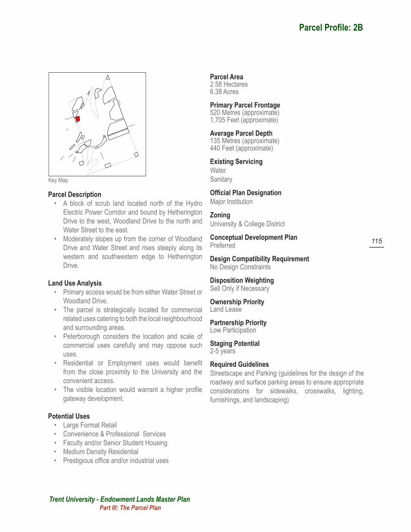
Key Map
Parcel Profile: 2A
Parcel Description• A linear strip of land located west of Hetherington
Road and running north from the Hydro Electric Power Corridor to Woodland Drive.
• The site slopes moderately up to the west.
Land Use Analysis• The parcel is strategically located for commercial
related uses catering to the local community.• Peterborough considers the location and scale of
commercial uses carefully and may oppose such uses in this location.
• There is a strong likelihood that the adjacent property would seek to consolidate this parcel as part of a larger residential or commercial development.
Potential Uses• Retail, Convenience & Professional Services • Large Format Retail (if amalgamated)• Medium Density Residential
Parcel Area0.81 Hectares2.00 Acres
Primary Parcel Frontage 245 Metres (approximate)800 Feet (approximate)
Average Parcel Depth35 Metres (approximate)115 Feet (approximate)
Existing ServicingWaterSanitary
Official Plan DesignationMajor Institution
Zoning University & College District
Conceptual Development PlanNot Required
Design Compatibility Requirement No Design Constraints
Disposition Weighting Sell Only if Necessary
Ownership Priority Land Lease
Partnership Priority Low Participation
Staging Potential 2-5 years
Required Guidelines Streetscape and Parking (guidelines for the design of the roadway and surface parking areas to ensure appropriate considerations for sidewalks, crosswalks, lighting, furnishings, and landscaping)
Part III: The Parcel Plan

Parcel 2B
Existing Condition
Woodland Drive
Water S
treet
Hetherington D
rive
Trent University - Endowment Lands Master Plan
115
�
�
��
�
�
�
��
�
��
�
�
�
�
�����������
���������
����������������
�����������
����
����
������������
��
������������
���������
������
������
������
���
��
����
������
������
��������
�������������
����
����
���
��
��
Key Map
Parcel Profile: 2B
Parcel Description• A block of scrub land located north of the Hydro
Electric Power Corridor and bound by Hetherington Drive to the west, Woodland Drive to the north and Water Street to the east.
• Moderately slopes up from the corner of Woodland Drive and Water Street and rises steeply along its western and southwestern edge to Hetherington Drive.
Land Use Analysis• Primary access would be from either Water Street or
Woodland Drive.• The parcel is strategically located for commercial
related uses catering to both the local neighbourhood and surrounding areas.
• Peterborough considers the location and scale of commercial uses carefully and may oppose such uses.
• Residential or Employment uses would benefit from the close proximity to the University and the convenient access.
• The visible location would warrant a higher profile gateway development.
Potential Uses• Large Format Retail • Convenience & Professional Services • Faculty and/or Senior Student Housing• Medium Density Residential • Prestigious office and/or industrial uses
Parcel Area2.58 Hectares6.38 Acres
Primary Parcel Frontage 520 Metres (approximate)1,705 Feet (approximate)
Average Parcel Depth135 Metres (approximate)440 Feet (approximate)
Existing ServicingWaterSanitary
Official Plan DesignationMajor Institution
Zoning University & College District
Conceptual Development PlanPreferred
Design Compatibility Requirement No Design Constraints
Disposition Weighting Sell Only if Necessary
Ownership Priority Land Lease
Partnership Priority Low Participation
Staging Potential 2-5 years
Required Guidelines Streetscape and Parking (guidelines for the design of the roadway and surface parking areas to ensure appropriate considerations for sidewalks, crosswalks, lighting, furnishings, and landscaping)
Part III: The Parcel Plan
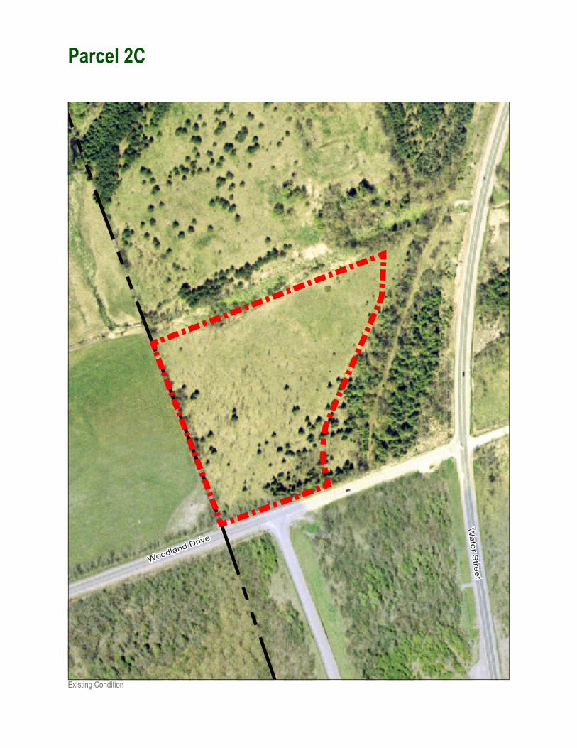
Parcel 2C
Existing Condition
Woodland Drive
Water S
treet

Trent University - Endowment Lands Master Plan
117
�
�
��
�
�
�
��
�
��
�
�
�
�
�����������
���������
����������������
�����������
����
����
������������
��
������������
���������
������
������
������
���
��
����
������
������
��������
�������������
����
����
���
��
��
Key Map
Parcel Profile: 2C
Parcel Description• Located north of Woodland Drive at the northern end
of Hetherington Drive.• A block of scrub land surrounded by Nature Areas
and active farm land.
Land Use Analysis• The parcel is strategically located for commercial
related uses catering to both the local neighbourhood and surrounding areas.
• Peterborough considers the location and scale of commercial uses carefully and may oppose such uses.
• Residential or Employment uses would benefit from the close proximity to the University and the convenient access.
Potential Uses• Large Format Retail • Convenience & Professional Services • Faculty and/or Senior Student Housing• Medium Density Residential • Prestigious office and/or industrial uses
Parcel Area3.16 Hectares7.81 Acres
Primary Parcel Frontage 110 Metres (approximate)360 Feet (approximate)
Average Parcel Depth175 Metres (approximate)575 Feet (approximate)
Existing ServicingWaterSanitary
Official Plan DesignationMajor Institution
Zoning University & College District
Conceptual Development PlanNot Required
Design Compatibility Requirement To be Compatible with Nature Area
Disposition Weighting Appropriate to Sell
Ownership Priority Land Lease
Partnership Priority Low Participation
Staging Potential 2-5 years
Required Guidelines • Nature Area (guidelines for appropriate transition
and interfacing to minimize environmental impact)• Streetscape and Parking (guidelines for the design
of the roadway and surface parking areas to ensure appropriate considerations for sidewalks, crosswalks, lighting, furnishings, and landscaping)
Part III: The Parcel Plan

Parcel 2D
Existing Condition
Wat
er S
tree
t

Trent University - Endowment Lands Master Plan
119
�
�
��
�
�
�
��
�
��
�
�
�
�
�����������
���������
����������������
�����������
����
����
������������
��
������������
���������
������
������
������
���
��
����
������
������
��������
�������������
����
����
���
��
��
Key Map
Parcel Profile: 2D
Parcel Description• A large parcel of gently sloping scrub land located
west of Water Street and at the north-west extremities of the Endowment Lands.
Land Use Analysis• The parcel’s scale and location on a relatively clear
and flat piece of land, with good access and close to servicing makes it an appropriate location for residential or employment uses.
• Residential would capitalize both on the proximity to the University and adjacent Natural Areas.
• Development of the parcel would require the extension of servicing 250 metres north of Woodland Drive.
Potential Uses• Lifestyle Community• Large Format Retail • Convenience & Professional Services • Faculty and/or Senior Student Housing• Medium Density Residential • Prestigious office and/or industrial uses
Parcel Area15.71 Hectares38.82 Acres
Primary Parcel Frontage 265 Metres (approximate)870 Feet (approximate)
Average Parcel Depth265 Metres (approximate)870 Feet (approximate)
Existing ServicingNone but full servicing exists at Woodland Drive 250m to the south
Official Plan DesignationMajor Institution
Zoning University & College District
Conceptual Development PlanNot Required
Design Compatibility Requirement To be Compatible with Nature Area
Disposition Weighting Appropriate to Sell
Ownership Priority Land Lease
Partnership Priority Low Participation
Staging Potential 0-2 years
Required Guidelines Nature Area (guidelines for appropriate transition and interfacing to minimize environmental impact)
Part III: The Parcel Plan

Parcel 2E
Existing Condition
Wat
er S
tree
t

Trent University - Endowment Lands Master Plan
121
�
�
��
�
�
�
��
�
��
�
�
�
�
�����������
���������
����������������
�����������
����
����
������������
��
������������
���������
������
������
������
���
��
����
������
������
��������
�������������
����
����
���
��
��
Key Map
Parcel Profile: 2E
Parcel Description• A strip of steeply sloping woodland along the eastern
side of Water Street, approximately 250m north of Woodland Drive.
Land Use Analysis• Commercial development in this location would
benefit from high visibility, through-traffic and access to the University community and surrounding residential areas.
• Development of the parcel would require the extension of servicing 250m north of Woodland Drive.
Potential Uses• Convenience or Highway related Retail • Convenience & Professional Services • Faculty and/or Senior Student Housing• Medium Density Residential • Prestigious office and/or industrial uses
Parcel Area1.44 Hectares3.56 Acres
Primary Parcel Frontage 290 Metres (approximate)950 Feet (approximate)
Average Parcel Depth45 Metres (approximate)145 Feet (approximate)
Existing ServicingNone but full servicing exists along Woodland Drive 250m to the south
Official Plan DesignationMajor Institution
Zoning University & College District
Conceptual Development PlanPreferred
Design Compatibility Requirement To be Compatible with Nature Area
Disposition Weighting Don’t Sell
Ownership Priority Land Lease
Partnership Priority Low Participation
Staging Potential 0-2 years
Required Guidelines • Nature Area (guidelines for appropriate transition
and interfacing to minimize environmental impact)• Streetscape and Parking (guidelines for the design
of the roadway and surface parking areas to ensure appropriate considerations for sidewalks, crosswalks, lighting, furnishings, and landscaping)
Part III: The Parcel Plan

Parcel 3A
Existing Condition
Nassau M
ills Road