3D Model-based Planning-Design-Construction-O&M …€¦ · 3D Model-based...
64
3D Model-based Planning-Design-Construction-O&M Best Practices for Transportation Project Delivery: Focus on Traffic and Safety for DOTs Lance Parve, MSEng, PG Design-Construction Engineer, SEF CIM Coordinator Wisconsin DOT SE Freeways Design-Construction Missouri DOT Traffic and Safety Conference
Transcript of 3D Model-based Planning-Design-Construction-O&M …€¦ · 3D Model-based...
3D Model-based Planning-Design-Construction-O&M Best Practices for Transportation Project Delivery:
Focus on Traffic and Safety for DOTs
Lance Parve, MSEng, PG
Design-Construction Engineer, SEF CIM Coordinator
Wisconsin DOT SE Freeways Design-Construction
Missouri DOT Traffic and Safety Conference
Bio: Lance Parve, MSEng, P.G.
Mr. Parve works as a Sr. Project Engineer/CIM Coordinator for the WisDOT
in SE Freeways. His work involves planning, design, and construction of
transportation projects greater than $500 million and also provides CIM-
CAD-GIS, 3D technologies, and LiDAR survey coordination and support.
Working for WisDOT since 2007 involving public sector work, with 15 years
previous involvement in private sector civil and environmental infrastructure
work, he has been involved in numerous successful planning, design, and
construction mega-major transportation projects at WisDOT. He has a MS
Engineering degree, MS Certificate Urban Planning GIS degree, and a BS
Geological Sciences degree from the UW-Milwaukee. Additionally, he
serves as Co-chairperson of the CIM-VDC Subcommittee of the National
Academy of Sciences Transportation Research Board (TRB) ABJ95
Visualization in Transportation Committee.
Contact: [email protected]
Phone: 262-548-8702 / 414-731-5375
Contact: christopher [email protected]
Phone: 262-521-4433
Contact: [email protected]
Phone: 414-940-9652
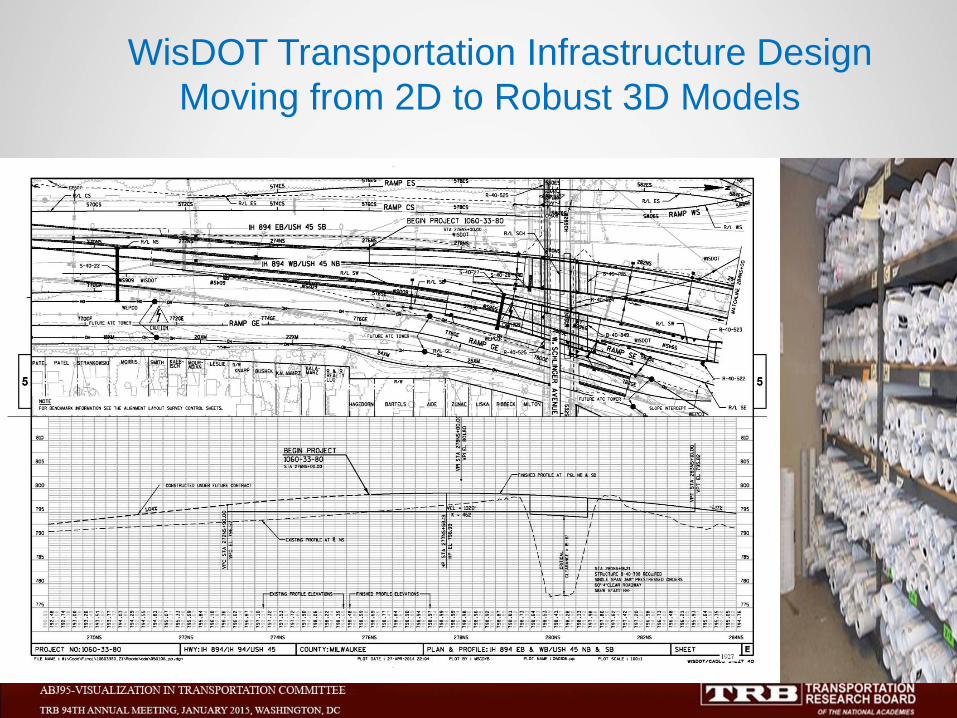
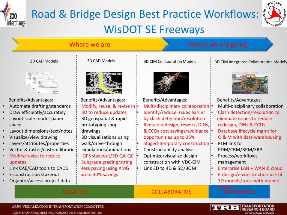
WisDOT Transportation Infrastructure Design
Moving from 2D to Robust 3D Models
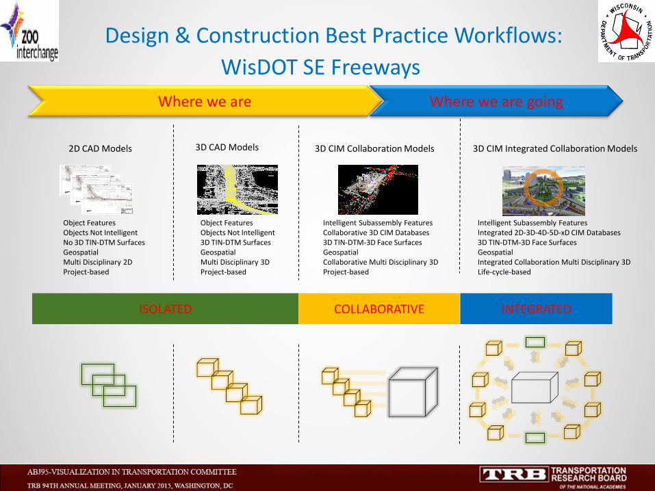
2D CAD Models 3D CAD Models 3D CIM Collaboration Models 3D CIM Integrated Collaboration Models
ISOLATED COLLABORATIVE INTEGRATED
Where we are going Where we are
Object Features Objects Not Intelligent No 3D TIN-DTM Surfaces Geospatial Multi Disciplinary 2D Project-based
Object Features Objects Not Intelligent 3D TIN-DTM Surfaces Geospatial Multi Disciplinary 3D Project-based
Intelligent Subassembly Features Collaborative 3D CIM Databases 3D TIN-DTM-3D Face Surfaces Geospatial Collaborative Multi Disciplinary 3D Project-based
Intelligent Subassembly Features Integrated 2D-3D-4D-5D-xD CIM Databases 3D TIN-DTM-3D Face Surfaces Geospatial Integrated Collaboration Multi Disciplinary 3D Life-cycle-based
Design & Construction Best Practice Workflows:
WisDOT SE Freeways
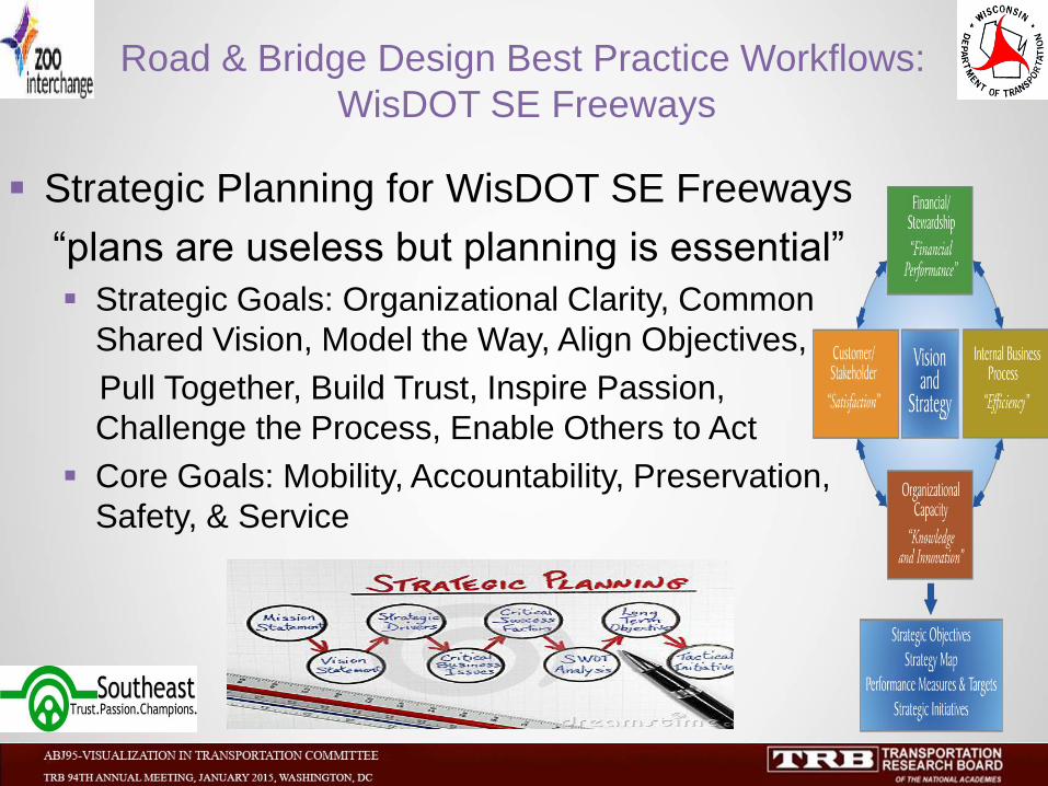
Strategic Planning for WisDOT SE Freeways
“plans are useless but planning is essential”
Strategic Goals: Organizational Clarity, Common
Shared Vision, Model the Way, Align Objectives,
Pull Together, Build Trust, Inspire Passion,
Challenge the Process, Enable Others to Act
Core Goals: Mobility, Accountability, Preservation,
Safety, & Service
Road & Bridge Design Best Practice Workflows:
WisDOT SE Freeways
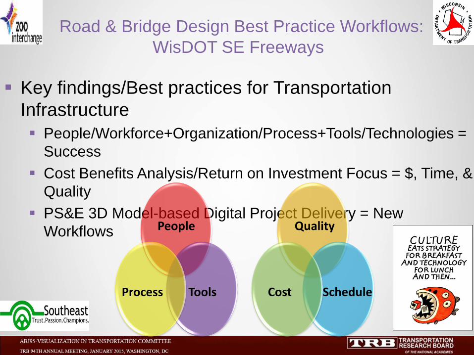
Key findings/Best practices for Transportation
Infrastructure
People/Workforce+Organization/Process+Tools/Technologies =
Success
Cost Benefits Analysis/Return on Investment Focus = $, Time, &
Quality
PS&E 3D Model-based Digital Project Delivery = New
Workflows
Road & Bridge Design Best Practice Workflows:
WisDOT SE Freeways
Quality
Schedule Cost
People
Tools Process

Key findings/Best practices for Transportation
Infrastructure
Have Organizational Strategic Plan for 3D Technologies
Implementation
Manage Change for Disruption to Current/Future
Workflows/Dataflows
Use Best Available Tools & Technologies to Achieve Business
Goals
Road & Bridge Design Best Practice Workflows:
WisDOT SE Freeways
Goals
Dataflows Workflows
People
Tools Process
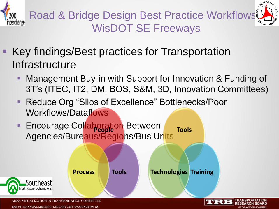
Key findings/Best practices for Transportation
Infrastructure
Management Buy-in with Support for Innovation & Funding of
3T’s (ITEC, IT2, DM, BOS, S&M, 3D, Innovation Committees)
Reduce Org “Silos of Excellence” Bottlenecks/Poor
Workflows/Dataflows
Encourage Collaboration Between
Agencies/Bureaus/Regions/Bus Units
Road & Bridge Design Best Practice Workflows:
WisDOT SE Freeways
Tools
Training Technologies
People
Tools Process
2D CAD Models 3D CAD Models 3D CIM Collaboration Models 3D CIM Integrated Collaboration Models
ISOLATED COLLABORATIVE INTEGRATED
Where we are going Where we are
Benefits/Advantages: • Automate drafting/standards • Draw efficiently/accurately • Layout scale model-paper
space • Layout dimensions/text/notes • Visualize/view drawing • Layers/attributes/properties • Vector & raster/custom libraries • Modify/revise to reduce
updates • Link CAE/CAD tools to CADD • E-construction stakeout • Organize/access project data
Benefits/Advantages: • Multi-disciplinary collaboration • Identify/reduce issues earlier
by clash detection/resolution • Reduce redesign, rework, DINs,
& CCOs cost savings/avoidance opportunities up to 25%
• Staged-temporary construction • Constructability analysis • Optimize/visualize design-
construction with VDC-CIM • Link 3D to 4D & 5D/BOM
Benefits/Advantages: • Multi-disciplinary collaboration • Clash detection/resolution to eliminate issues to reduce
redesign, DINs & CCOs • Database lifecycle mgmt for
O & M with data warehousing • PLM link to
PDM/CRM/BPM/ERP • Process/workflows
management • Enterprise LAN + WAN & cloud • E-design/e-construction use of
3D models/tools with mobile devices
Road & Bridge Design Best Practice Workflows:
WisDOT SE Freeways
Benefits/Advantages: • Modify, reuse, & revise in
3D to reduce updates • 3D geospatial & rapid
prototyping shop drawings
• 3D visualizations using walk/drive-through
simulations/animations • GPS stakeout/3D QA-QC • Subgrade grading/string -less paving using AMG up to 30% savings
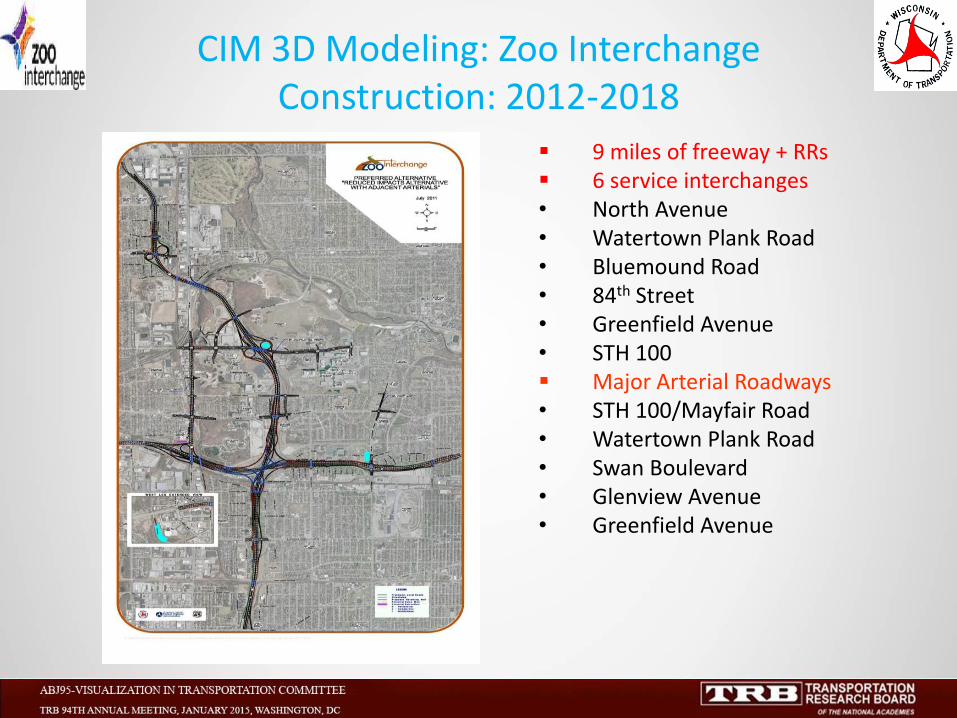
CIM 3D Modeling: Zoo Interchange Construction: 2012-2018
9 miles of freeway + RRs 6 service interchanges • North Avenue • Watertown Plank Road • Bluemound Road • 84th Street • Greenfield Avenue • STH 100 Major Arterial Roadways • STH 100/Mayfair Road • Watertown Plank Road • Swan Boulevard • Glenview Avenue • Greenfield Avenue
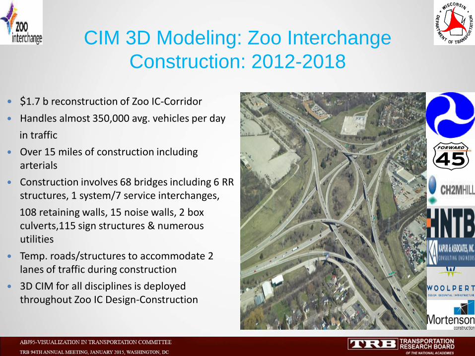
$1.7 b reconstruction of Zoo IC-Corridor
Handles almost 350,000 avg. vehicles per day
in traffic
Over 15 miles of construction including arterials
Construction involves 68 bridges including 6 RR structures, 1 system/7 service interchanges,
108 retaining walls, 15 noise walls, 2 box culverts,115 sign structures & numerous utilities
Temp. roads/structures to accommodate 2 lanes of traffic during construction
3D CIM for all disciplines is deployed throughout Zoo IC Design-Construction
CIM 3D Modeling: Zoo Interchange
Construction: 2012-2018
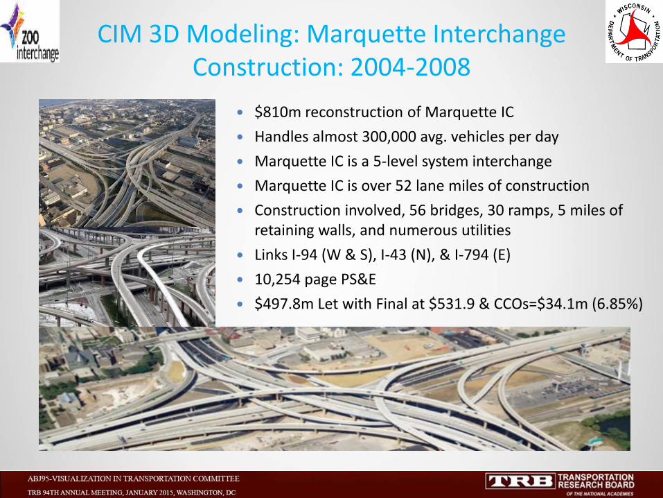
CIM 3D Modeling: Marquette Interchange Construction: 2004-2008
$810m reconstruction of Marquette IC
Handles almost 300,000 avg. vehicles per day
Marquette IC is a 5-level system interchange
Marquette IC is over 52 lane miles of construction
Construction involved, 56 bridges, 30 ramps, 5 miles of retaining walls, and numerous utilities
Links I-94 (W & S), I-43 (N), & I-794 (E)
10,254 page PS&E
$497.8m Let with Final at $531.9 & CCOs=$34.1m (6.85%)
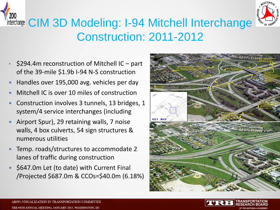
• $294.4m reconstruction of Mitchell IC – part of the 39-mile $1.9b I-94 N-S construction
Handles over 195,000 avg. vehicles per day
Mitchell IC is over 10 miles of construction
Construction involves 3 tunnels, 13 bridges, 1 system/4 service interchanges (including
Airport Spur), 29 retaining walls, 7 noise walls, 4 box culverts, 54 sign structures & numerous utilities
Temp. roads/structures to accommodate 2 lanes of traffic during construction
$647.0m Let (to date) with Current Final /Projected $687.0m & CCOs=$40.0m (6.18%)
CIM 3D Modeling: I-94 Mitchell Interchange
Construction: 2011-2012
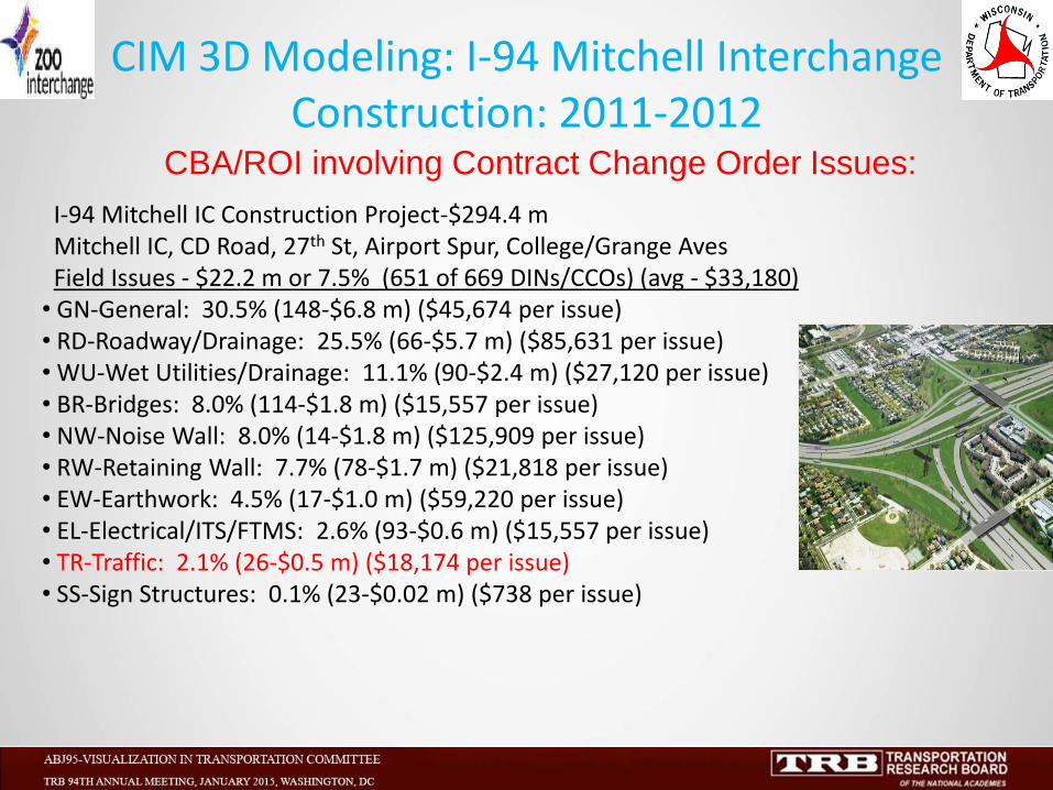
CBA/ROI involving Contract Change Order Issues:
I-94 Mitchell IC Construction Project-$294.4 m Mitchell IC, CD Road, 27th St, Airport Spur, College/Grange Aves Field Issues - $22.2 m or 7.5% (651 of 669 DINs/CCOs) (avg - $33,180) • GN-General: 30.5% (148-$6.8 m) ($45,674 per issue) • RD-Roadway/Drainage: 25.5% (66-$5.7 m) ($85,631 per issue) • WU-Wet Utilities/Drainage: 11.1% (90-$2.4 m) ($27,120 per issue) • BR-Bridges: 8.0% (114-$1.8 m) ($15,557 per issue) • NW-Noise Wall: 8.0% (14-$1.8 m) ($125,909 per issue) • RW-Retaining Wall: 7.7% (78-$1.7 m) ($21,818 per issue) • EW-Earthwork: 4.5% (17-$1.0 m) ($59,220 per issue) • EL-Electrical/ITS/FTMS: 2.6% (93-$0.6 m) ($15,557 per issue) • TR-Traffic: 2.1% (26-$0.5 m) ($18,174 per issue) • SS-Sign Structures: 0.1% (23-$0.02 m) ($738 per issue)
CIM 3D Modeling: I-94 Mitchell Interchange Construction: 2011-2012
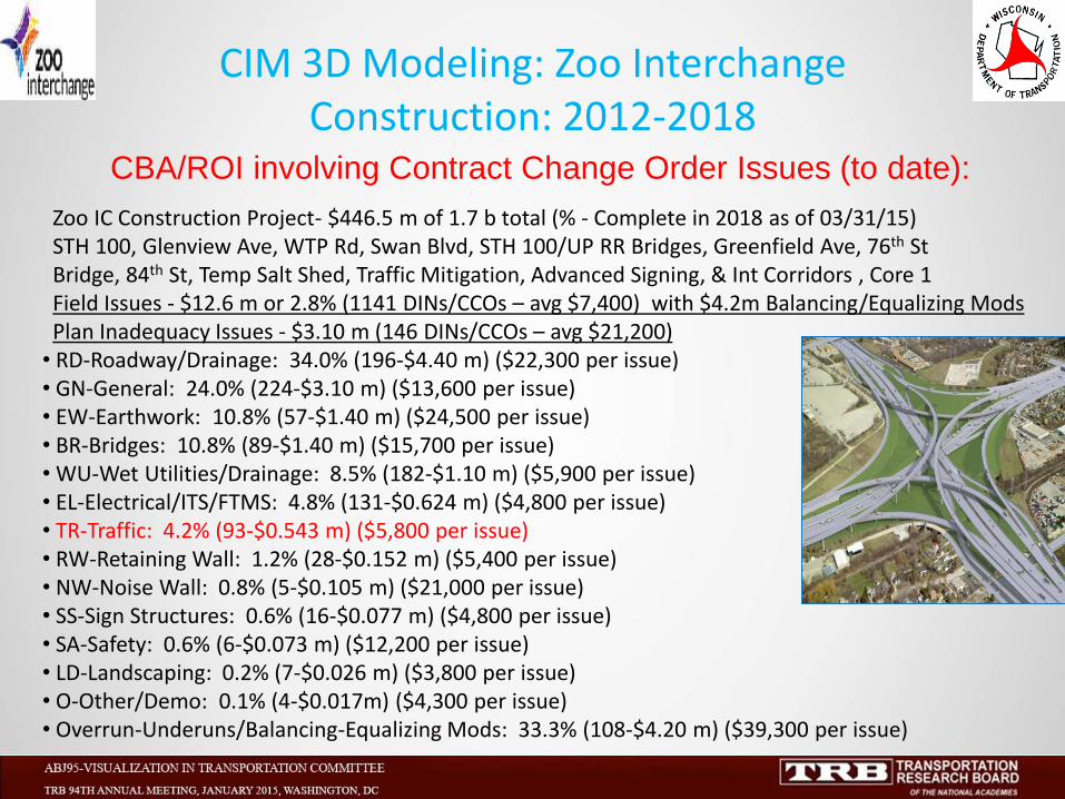
CBA/ROI involving Contract Change Order Issues (to date):
Zoo IC Construction Project- $446.5 m of 1.7 b total (% - Complete in 2018 as of 03/31/15) STH 100, Glenview Ave, WTP Rd, Swan Blvd, STH 100/UP RR Bridges, Greenfield Ave, 76th St Bridge, 84th St, Temp Salt Shed, Traffic Mitigation, Advanced Signing, & Int Corridors , Core 1 Field Issues - $12.6 m or 2.8% (1141 DINs/CCOs – avg $7,400) with $4.2m Balancing/Equalizing Mods Plan Inadequacy Issues - $3.10 m (146 DINs/CCOs – avg $21,200) • RD-Roadway/Drainage: 34.0% (196-$4.40 m) ($22,300 per issue) • GN-General: 24.0% (224-$3.10 m) ($13,600 per issue) • EW-Earthwork: 10.8% (57-$1.40 m) ($24,500 per issue) • BR-Bridges: 10.8% (89-$1.40 m) ($15,700 per issue) • WU-Wet Utilities/Drainage: 8.5% (182-$1.10 m) ($5,900 per issue) • EL-Electrical/ITS/FTMS: 4.8% (131-$0.624 m) ($4,800 per issue) • TR-Traffic: 4.2% (93-$0.543 m) ($5,800 per issue) • RW-Retaining Wall: 1.2% (28-$0.152 m) ($5,400 per issue) • NW-Noise Wall: 0.8% (5-$0.105 m) ($21,000 per issue) • SS-Sign Structures: 0.6% (16-$0.077 m) ($4,800 per issue) • SA-Safety: 0.6% (6-$0.073 m) ($12,200 per issue) • LD-Landscaping: 0.2% (7-$0.026 m) ($3,800 per issue) • O-Other/Demo: 0.1% (4-$0.017m) ($4,300 per issue) • Overrun-Underuns/Balancing-Equalizing Mods: 33.3% (108-$4.20 m) ($39,300 per issue)
CIM 3D Modeling: Zoo Interchange Construction: 2012-2018
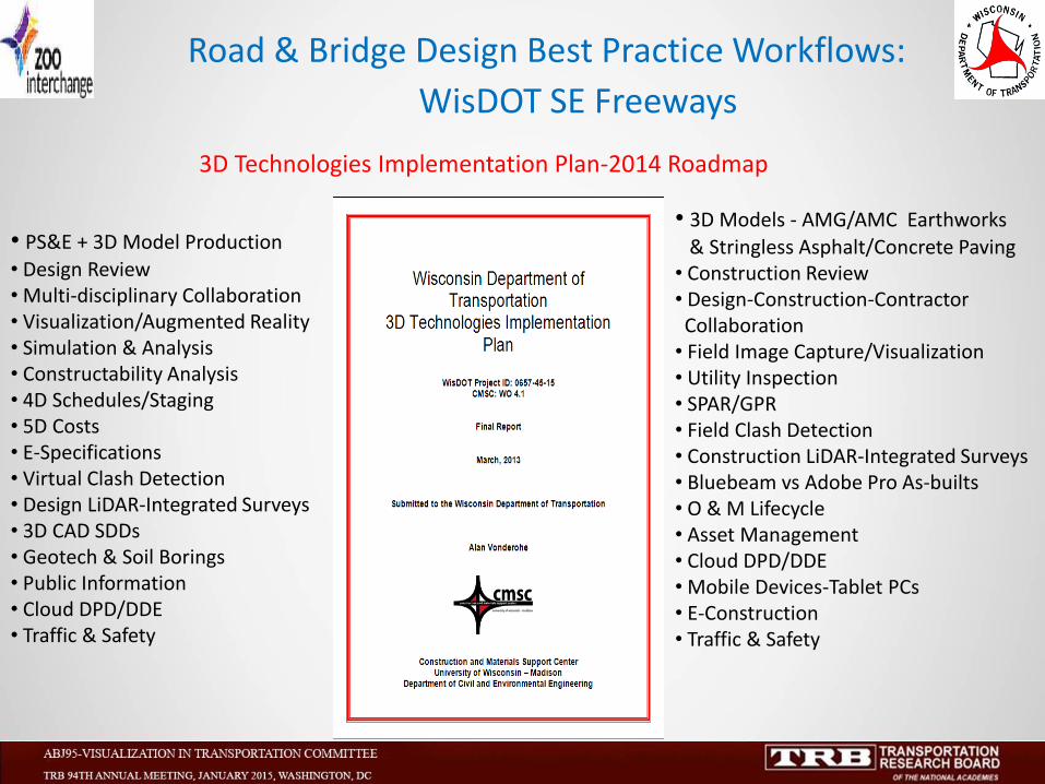
3D Technologies Implementation Plan-2014 Roadmap
• 3D Models - AMG/AMC Earthworks
& Stringless Asphalt/Concrete Paving • Construction Review • Design-Construction-Contractor Collaboration • Field Image Capture/Visualization • Utility Inspection • SPAR/GPR • Field Clash Detection • Construction LiDAR-Integrated Surveys • Bluebeam vs Adobe Pro As-builts • O & M Lifecycle • Asset Management • Cloud DPD/DDE • Mobile Devices-Tablet PCs • E-Construction • Traffic & Safety
• PS&E + 3D Model Production
• Design Review • Multi-disciplinary Collaboration • Visualization/Augmented Reality • Simulation & Analysis • Constructability Analysis • 4D Schedules/Staging • 5D Costs • E-Specifications • Virtual Clash Detection • Design LiDAR-Integrated Surveys • 3D CAD SDDs • Geotech & Soil Borings • Public Information • Cloud DPD/DDE • Traffic & Safety
Road & Bridge Design Best Practice Workflows:
WisDOT SE Freeways

C3D Technologies/3D Modeling Workflow involving Zoo IC:
Zoo IC Construction Project- $1.7 b total (2007 to Completion in 2018) • LiDAR and Integrated Survey - Pre-Design Data Collection: • CIM Project Execution Plan (PXP): • 3D Modeling – Roads: • 3D Modeling - Structures: • 3D Modeling – Utilities: • 3D Modeling - Traffic: • 3D Modeling - PI: • 3D Modeling - Other: • 3D Modeling QA/QC: • 3D Modeling e-Construction/3D Rovers (CEC): • LiDAR and Integrated Survey – Post-Design Data Collection: • As-built 3D Modeling: • 3D Modeling Tools • O-Other:
CIM 3D Modeling: Zoo Interchange Construction: 2012-2018
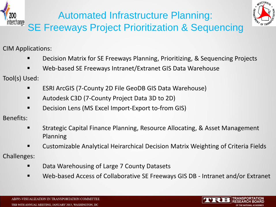
CIM Applications:
Decision Matrix for SE Freeways Planning, Prioritizing, & Sequencing Projects
Web-based SE Freeways Intranet/Extranet GIS Data Warehouse
Tool(s) Used:
ESRI ArcGIS (7-County 2D File GeoDB GIS Data Warehouse)
Autodesk C3D (7-County Project Data 3D to 2D)
Decision Lens (MS Excel Import-Export to-from GIS)
Benefits:
Strategic Capital Finance Planning, Resource Allocating, & Asset Management Planning
Customizable Analytical Heirarchical Decision Matrix Weighting of Criteria Fields
Challenges:
Data Warehousing of Large 7 County Datasets
Web-based Access of Collaborative SE Freeways GIS DB - Intranet and/or Extranet
Automated Infrastructure Planning:
SE Freeways Project Prioritization & Sequencing
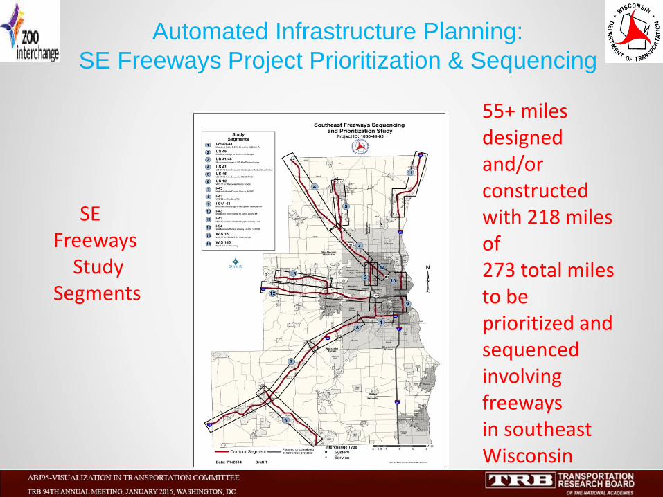
SE Freeways Study Segments
55+ miles designed and/or constructed with 218 miles of 273 total miles to be prioritized and sequenced involving freeways in southeast Wisconsin
Automated Infrastructure Planning:
SE Freeways Project Prioritization & Sequencing
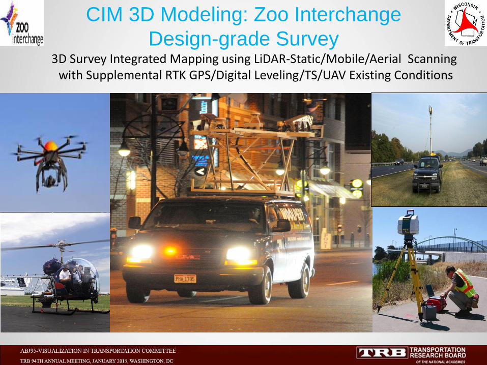
3D Survey Integrated Mapping using LiDAR-Static/Mobile/Aerial Scanning with Supplemental RTK GPS/Digital Leveling/TS/UAV Existing Conditions
CIM 3D Modeling: Zoo Interchange
Design-grade Survey
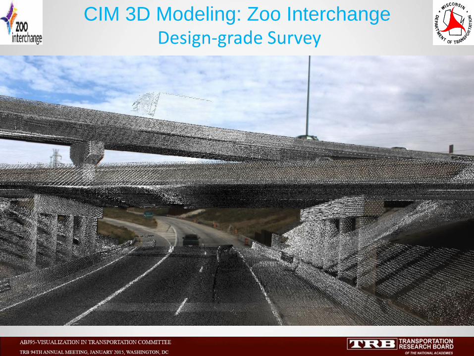
CIM 3D Modeling: Zoo Interchange Design-grade Survey
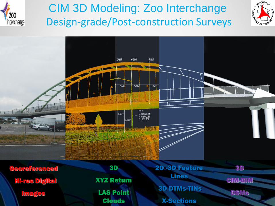
3D
CIM-BIM
DSMs
2D -3D Feature
Lines
3D DTMs-TINs
X-Sections
3D
XYZ Return
LAS Point
Clouds
Georeferenced
Hi-res Digital
Images
CIM 3D Modeling: Zoo Interchange Design-grade/Post-construction Surveys
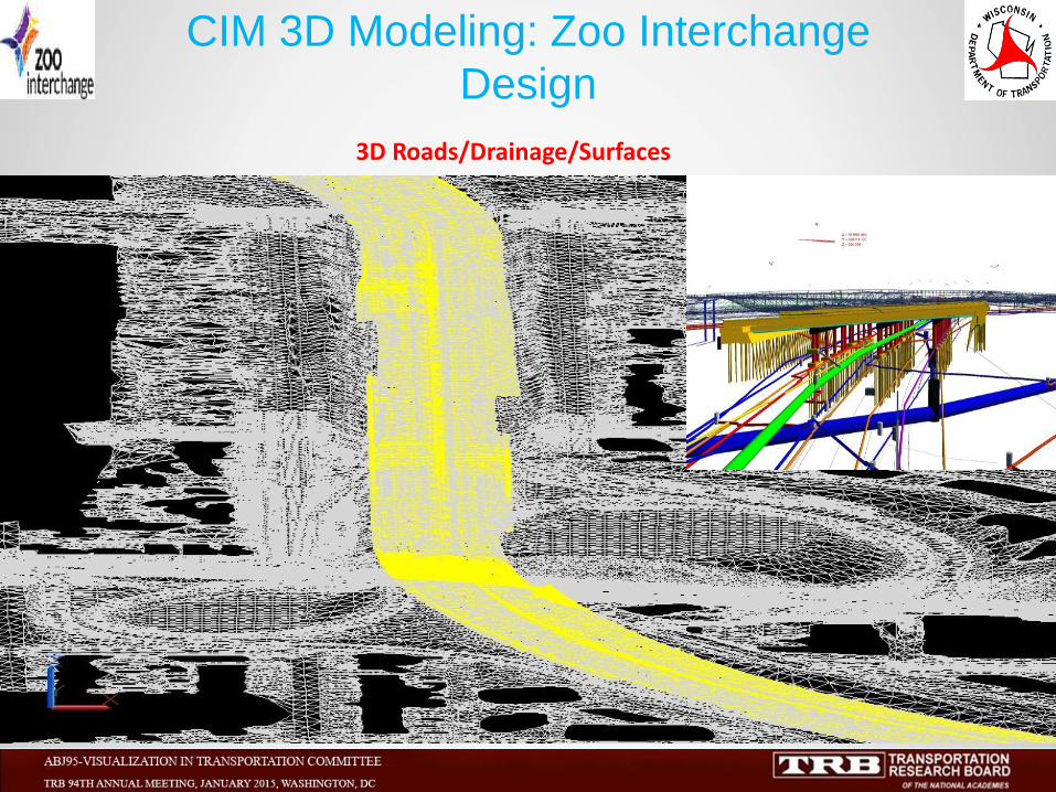
3D Roads/Drainage/Surfaces
CIM 3D Modeling: Zoo Interchange
Design
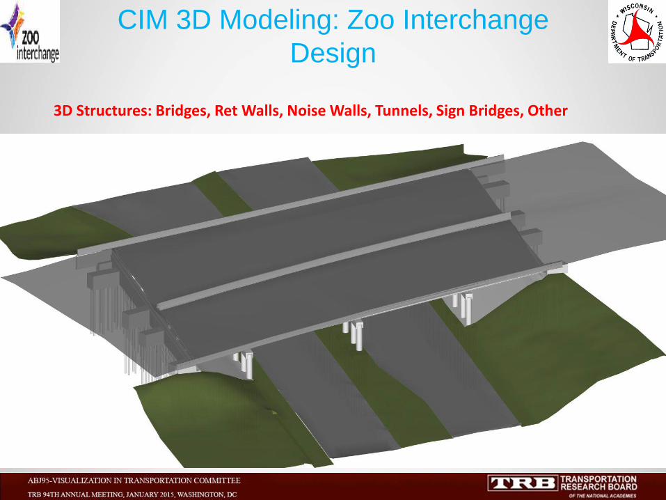
3D Structures: Bridges, Ret Walls, Noise Walls, Tunnels, Sign Bridges, Other
CIM 3D Modeling: Zoo Interchange
Design
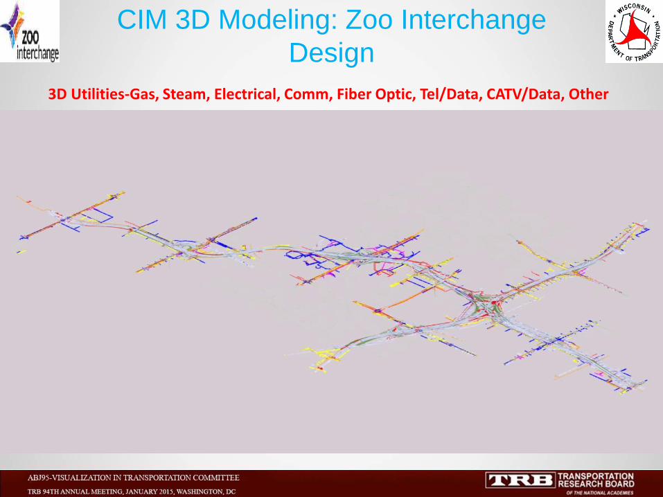
3D Utilities-Gas, Steam, Electrical, Comm, Fiber Optic, Tel/Data, CATV/Data, Other
CIM 3D Modeling: Zoo Interchange
Design
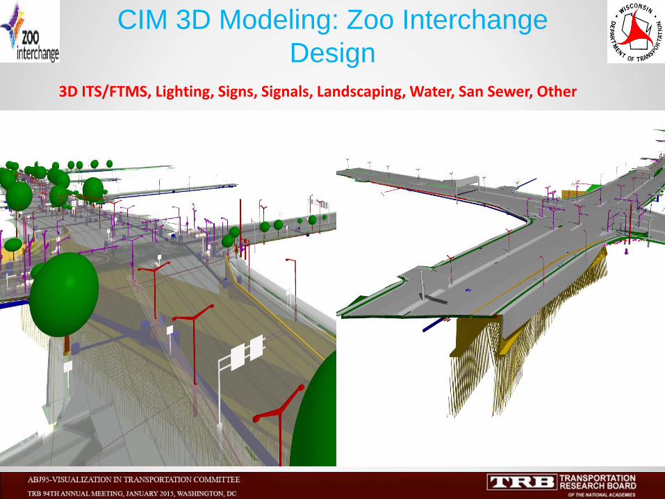
3D ITS/FTMS, Lighting, Signs, Signals, Landscaping, Water, San Sewer, Other
CIM 3D Modeling: Zoo Interchange
Design
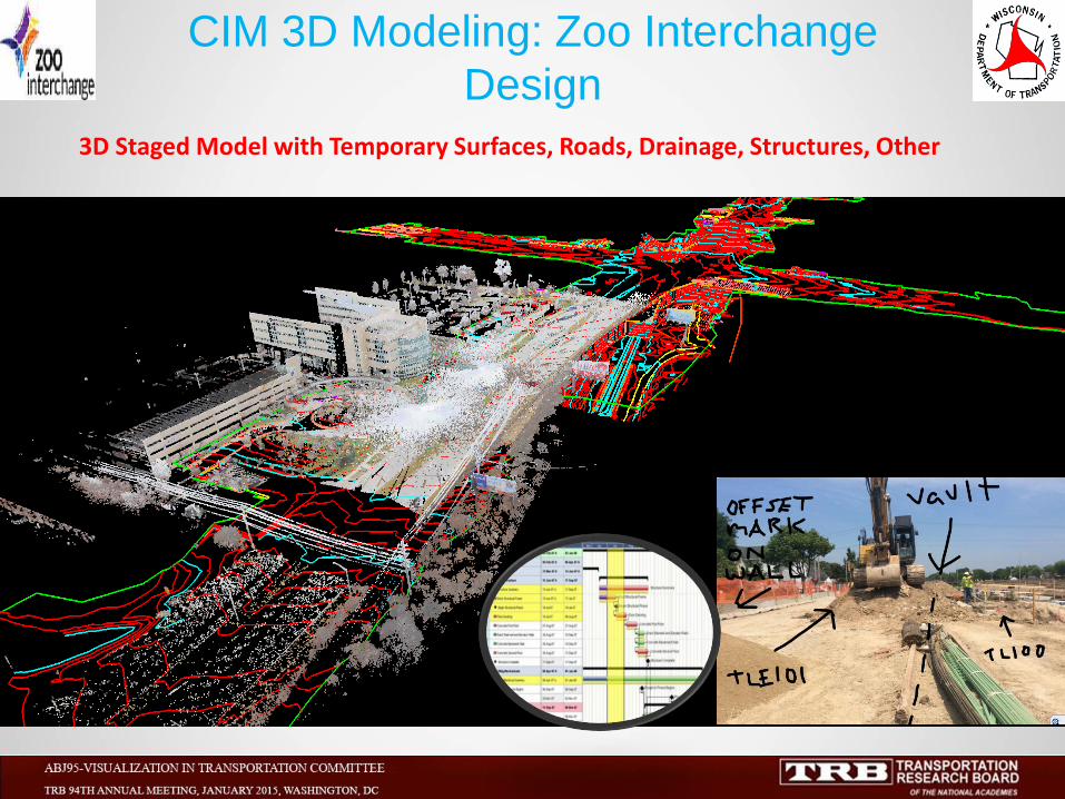
3D Staged Model with Temporary Surfaces, Roads, Drainage, Structures, Other
CIM 3D Modeling: Zoo Interchange
Design
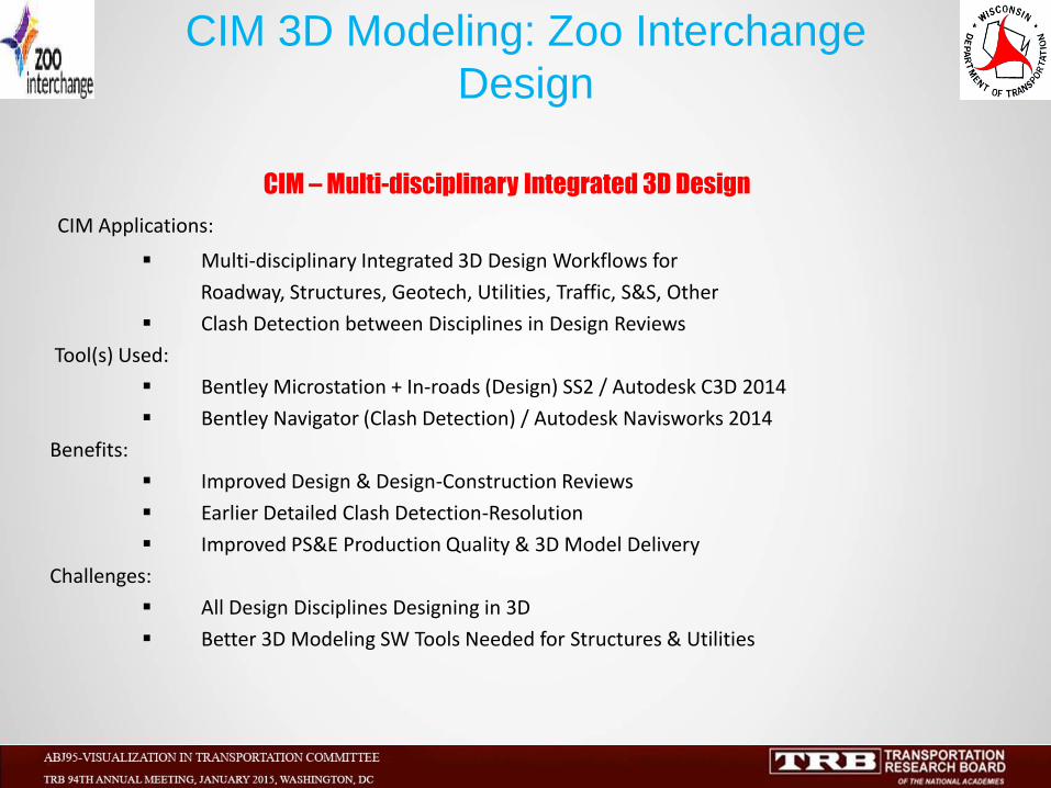
CIM – Multi-disciplinary Integrated 3D Design
CIM Applications:
Multi-disciplinary Integrated 3D Design Workflows for
Roadway, Structures, Geotech, Utilities, Traffic, S&S, Other
Clash Detection between Disciplines in Design Reviews
Tool(s) Used:
Bentley Microstation + In-roads (Design) SS2 / Autodesk C3D 2014
Bentley Navigator (Clash Detection) / Autodesk Navisworks 2014
Benefits:
Improved Design & Design-Construction Reviews
Earlier Detailed Clash Detection-Resolution
Improved PS&E Production Quality & 3D Model Delivery
Challenges:
All Design Disciplines Designing in 3D
Better 3D Modeling SW Tools Needed for Structures & Utilities
CIM 3D Modeling: Zoo Interchange
Design
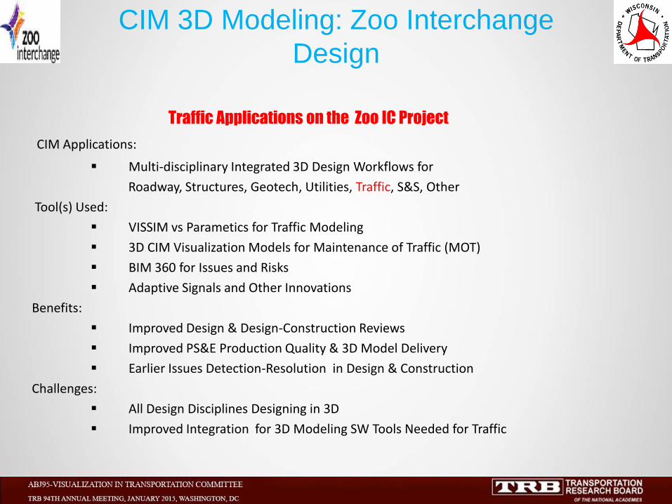
Traffic Applications on the Zoo IC Project
CIM Applications:
Multi-disciplinary Integrated 3D Design Workflows for
Roadway, Structures, Geotech, Utilities, Traffic, S&S, Other
Tool(s) Used:
VISSIM vs Parametics for Traffic Modeling
3D CIM Visualization Models for Maintenance of Traffic (MOT)
BIM 360 for Issues and Risks
Adaptive Signals and Other Innovations
Benefits:
Improved Design & Design-Construction Reviews
Improved PS&E Production Quality & 3D Model Delivery
Earlier Issues Detection-Resolution in Design & Construction
Challenges:
All Design Disciplines Designing in 3D
Improved Integration for 3D Modeling SW Tools Needed for Traffic
CIM 3D Modeling: Zoo Interchange
Design

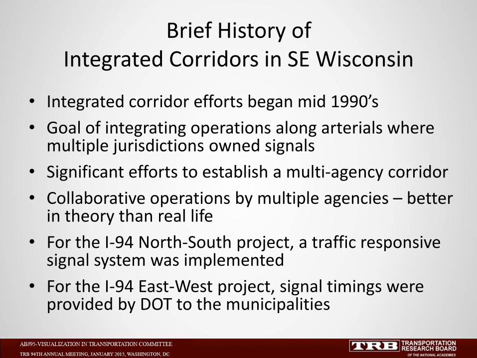
Brief History of Integrated Corridors in SE Wisconsin
• Integrated corridor efforts began mid 1990’s
• Goal of integrating operations along arterials where multiple jurisdictions owned signals
• Significant efforts to establish a multi-agency corridor
• Collaborative operations by multiple agencies – better in theory than real life
• For the I-94 North-South project, a traffic responsive signal system was implemented
• For the I-94 East-West project, signal timings were provided by DOT to the municipalities
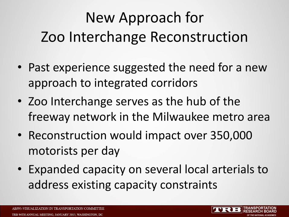
New Approach for Zoo Interchange Reconstruction
• Past experience suggested the need for a new approach to integrated corridors
• Zoo Interchange serves as the hub of the freeway network in the Milwaukee metro area
• Reconstruction would impact over 350,000 motorists per day
• Expanded capacity on several local arterials to address existing capacity constraints
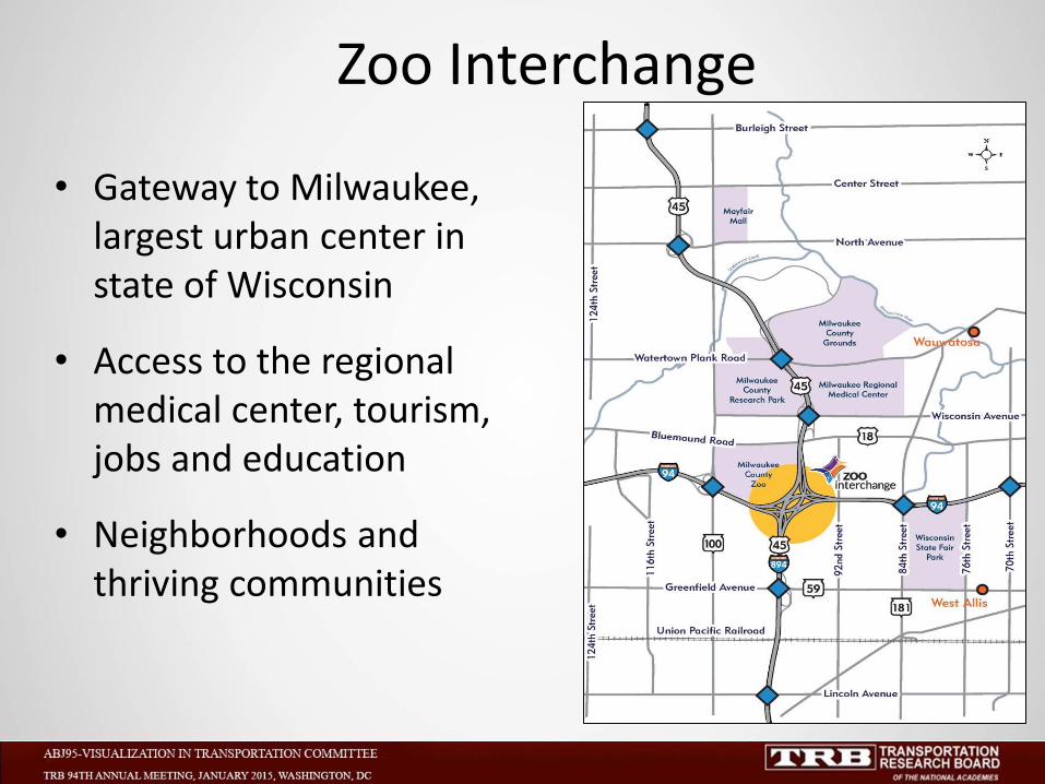
Zoo Interchange
• Gateway to Milwaukee, largest urban center in state of Wisconsin
• Access to the regional medical center, tourism, jobs and education
• Neighborhoods and thriving communities
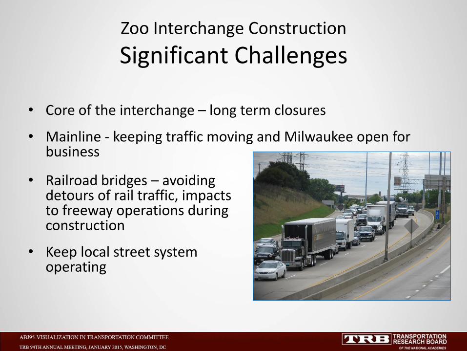
Zoo Interchange Construction
Significant Challenges
• Core of the interchange – long term closures
• Mainline - keeping traffic moving and Milwaukee open for business
• Railroad bridges – avoiding detours of rail traffic, impacts to freeway operations during construction
• Keep local street system operating
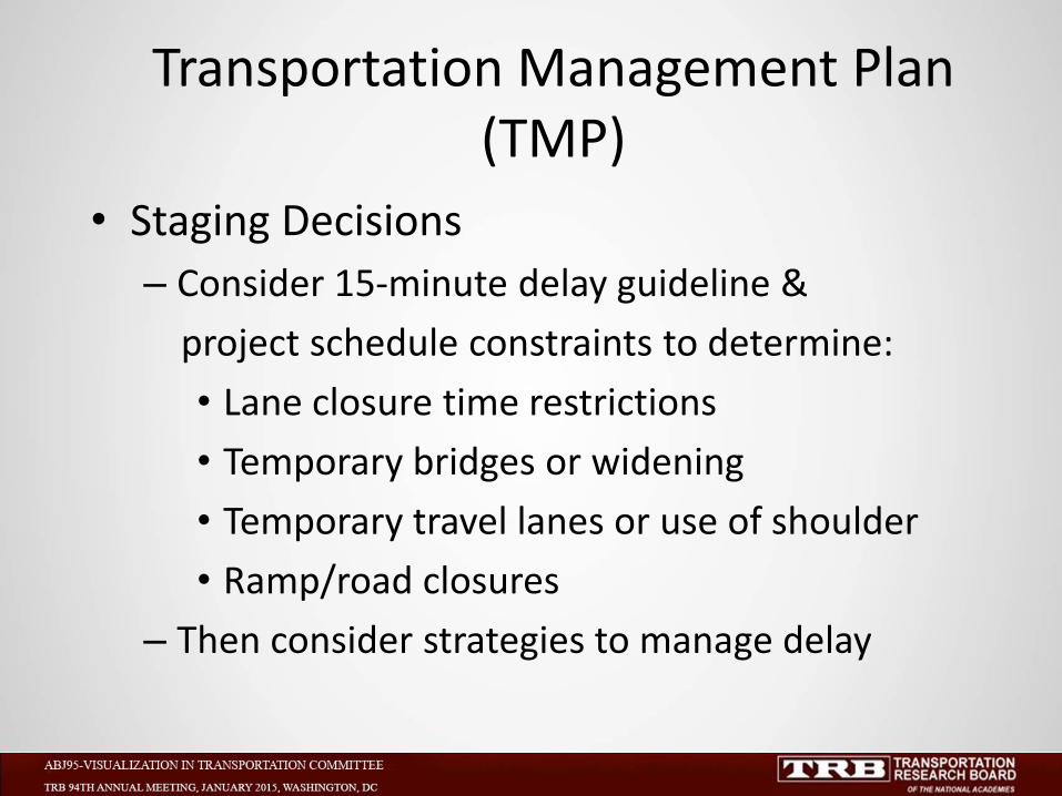
Transportation Management Plan (TMP)
• Staging Decisions
– Consider 15-minute delay guideline &
project schedule constraints to determine:
• Lane closure time restrictions
• Temporary bridges or widening
• Temporary travel lanes or use of shoulder
• Ramp/road closures
– Then consider strategies to manage delay
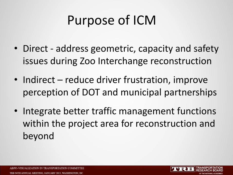
• Direct - address geometric, capacity and safety issues during Zoo Interchange reconstruction
• Indirect – reduce driver frustration, improve perception of DOT and municipal partnerships
• Integrate better traffic management functions within the project area for reconstruction and beyond
Purpose of ICM
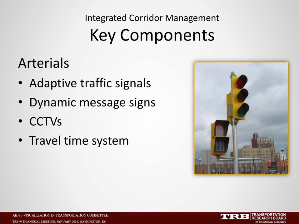
Integrated Corridor Management
Key Components
Arterials
• Adaptive traffic signals
• Dynamic message signs
• CCTVs
• Travel time system
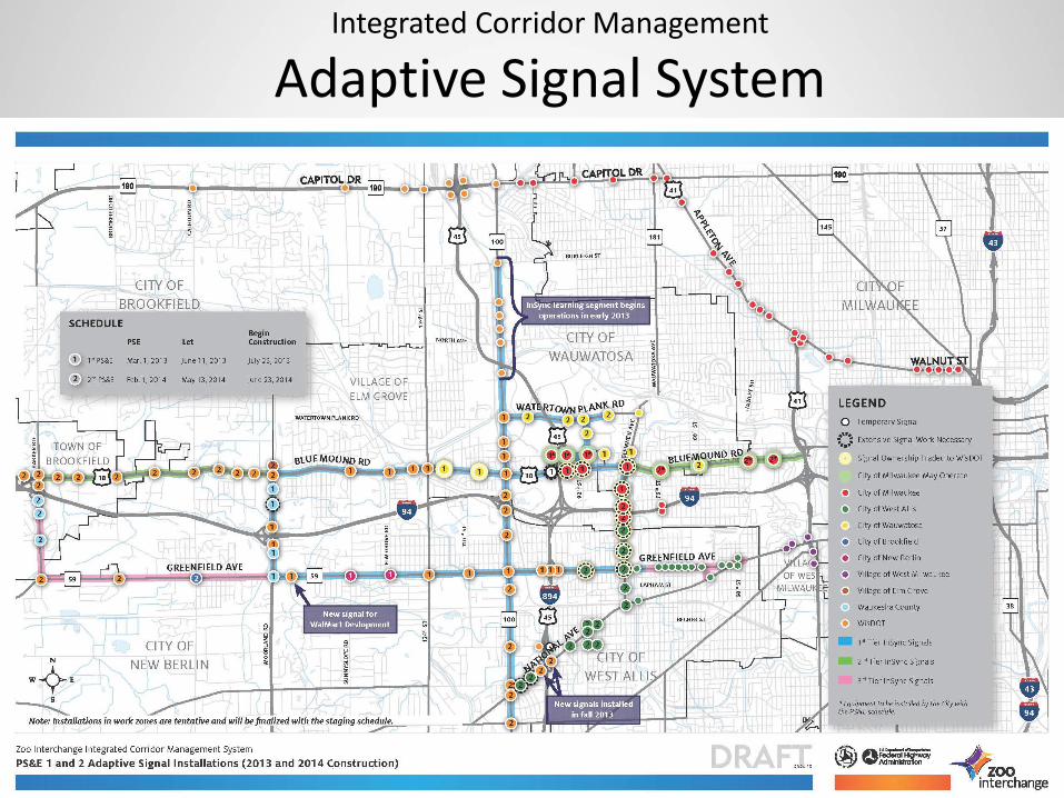
Integrated Corridor Management
Adaptive Signal System

Adaptive Signal System
Learning Segment
• Rhythm Engineering - InSync
• 70+ signalized intersections
• All WisDOT owned signals
• Cost of ~$200k for pilot 6 signals
• Includes an evaluation of operations
• Lessons learned for wider use
Learning Segment
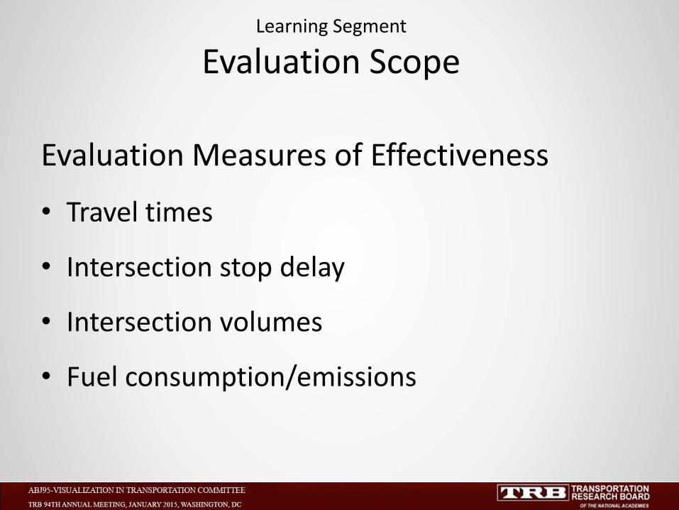
Evaluation Scope
Evaluation Measures of Effectiveness
• Travel times
• Intersection stop delay
• Intersection volumes
• Fuel consumption/emissions
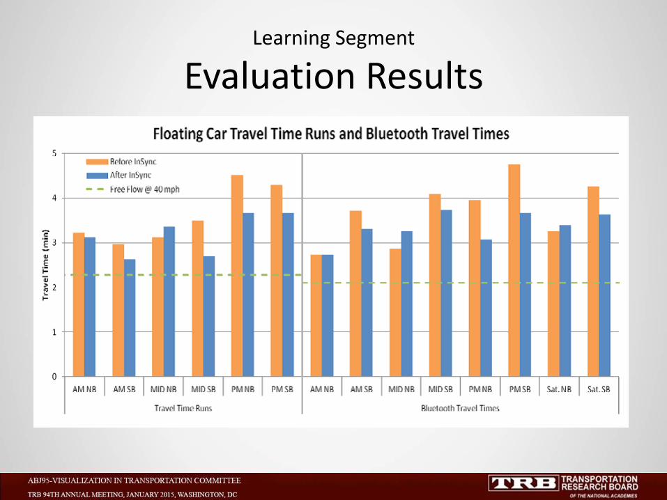
Learning Segment
Evaluation Results

History of Orange Pavement Markings
• Never used before in the United States • Used before in other countries (Canada, Germany, Holland, Switzerland and New Zealand) in work zones • Provide color correlation with other work zone devices
Orange Pavement Marking
41
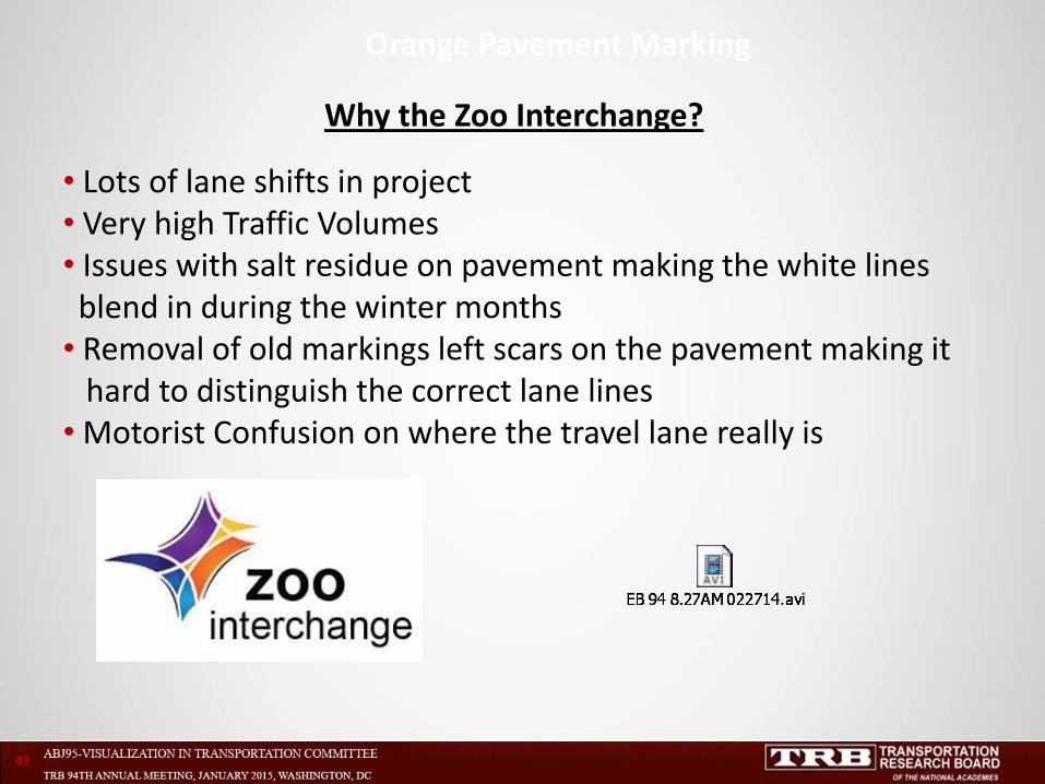
Why the Zoo Interchange?
• Lots of lane shifts in project • Very high Traffic Volumes • Issues with salt residue on pavement making the white lines blend in during the winter months • Removal of old markings left scars on the pavement making it hard to distinguish the correct lane lines • Motorist Confusion on where the travel lane really is
Orange Pavement Marking
42
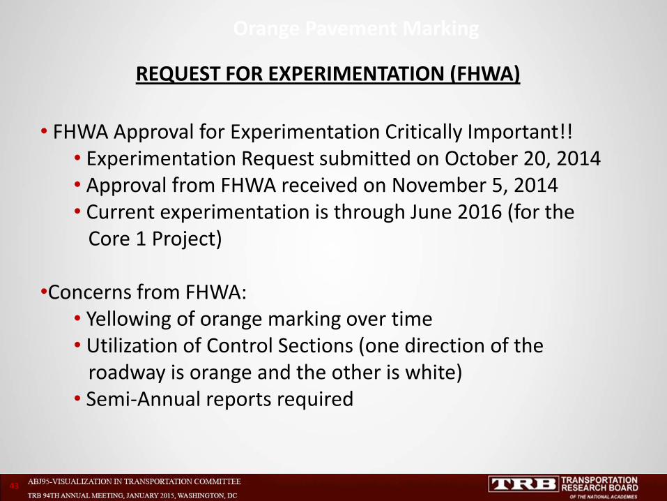
REQUEST FOR EXPERIMENTATION (FHWA)
• FHWA Approval for Experimentation Critically Important!! • Experimentation Request submitted on October 20, 2014 • Approval from FHWA received on November 5, 2014 • Current experimentation is through June 2016 (for the Core 1 Project)
•Concerns from FHWA: • Yellowing of orange marking over time • Utilization of Control Sections (one direction of the roadway is orange and the other is white) • Semi-Annual reports required
Orange Pavement Marking
43
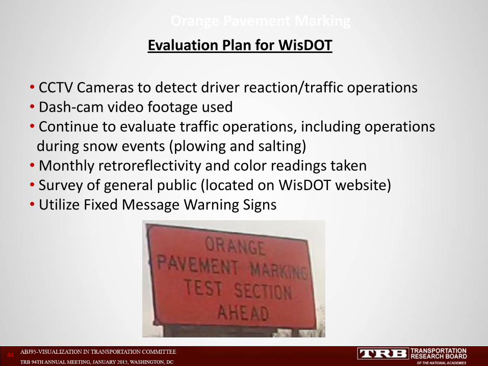
Evaluation Plan for WisDOT
• CCTV Cameras to detect driver reaction/traffic operations • Dash-cam video footage used • Continue to evaluate traffic operations, including operations during snow events (plowing and salting) • Monthly retroreflectivity and color readings taken • Survey of general public (located on WisDOT website) • Utilize Fixed Message Warning Signs
Orange Pavement Marking
44
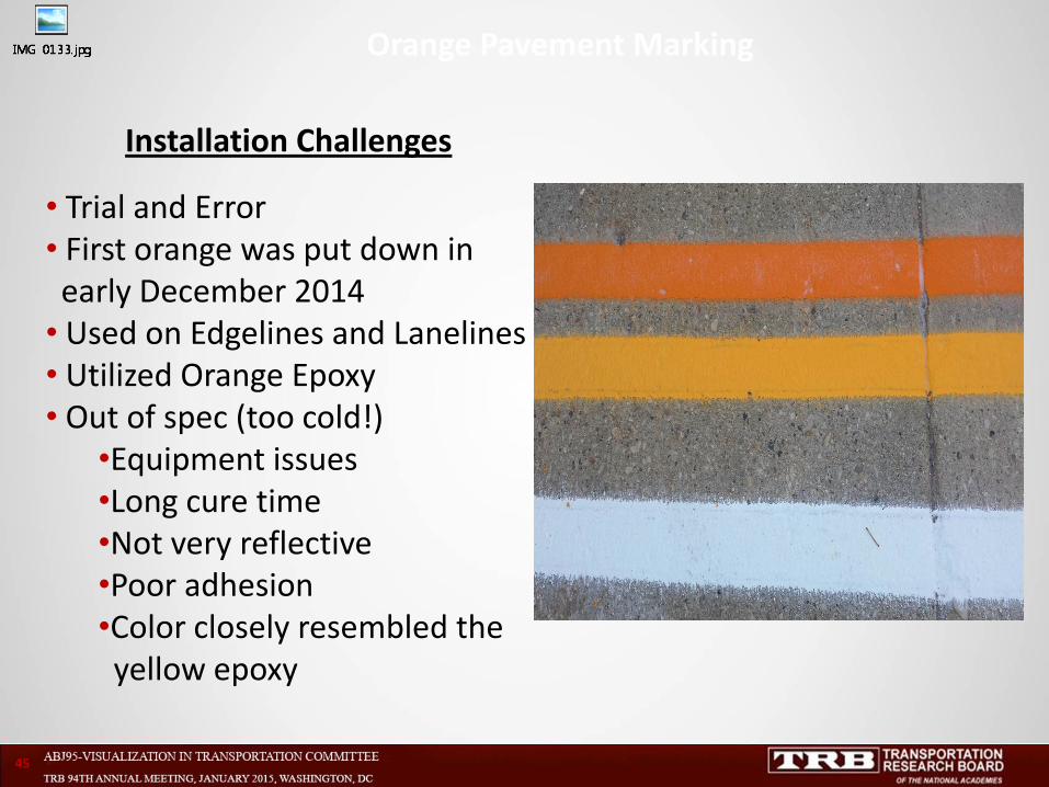
Installation Challenges
• Trial and Error • First orange was put down in early December 2014 • Used on Edgelines and Lanelines • Utilized Orange Epoxy • Out of spec (too cold!)
•Equipment issues •Long cure time •Not very reflective •Poor adhesion •Color closely resembled the yellow epoxy
Orange Pavement Marking
45
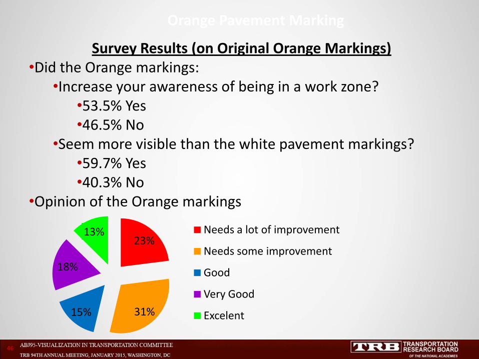
Survey Results (on Original Orange Markings) •Did the Orange markings:
•Increase your awareness of being in a work zone? •53.5% Yes •46.5% No
•Seem more visible than the white pavement markings? •59.7% Yes •40.3% No
•Opinion of the Orange markings
Orange Pavement Marking
46
23%
31% 15%
18%
13% Needs a lot of improvement
Needs some improvement
Good
Very Good
Excelent

Survey Results
•
Orange Pavement Marking
47
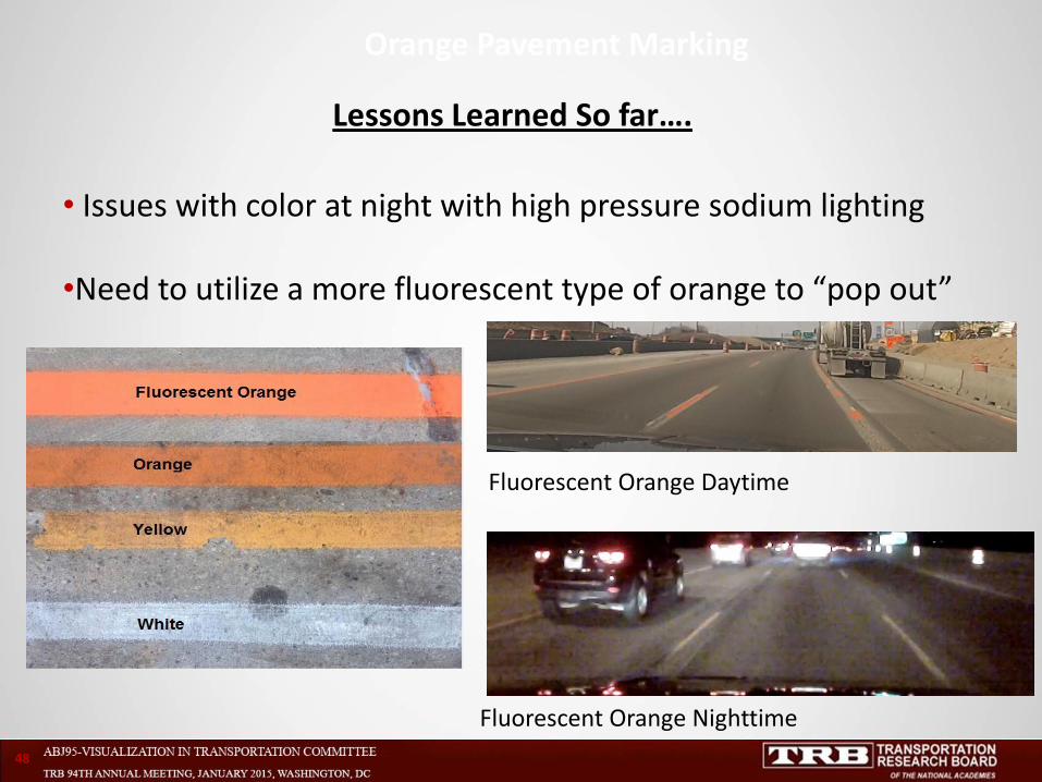
Lessons Learned So far….
• Issues with color at night with high pressure sodium lighting
•Need to utilize a more fluorescent type of orange to “pop out”
Orange Pavement Marking
48
Fluorescent Orange Daytime
Fluorescent Orange Nighttime
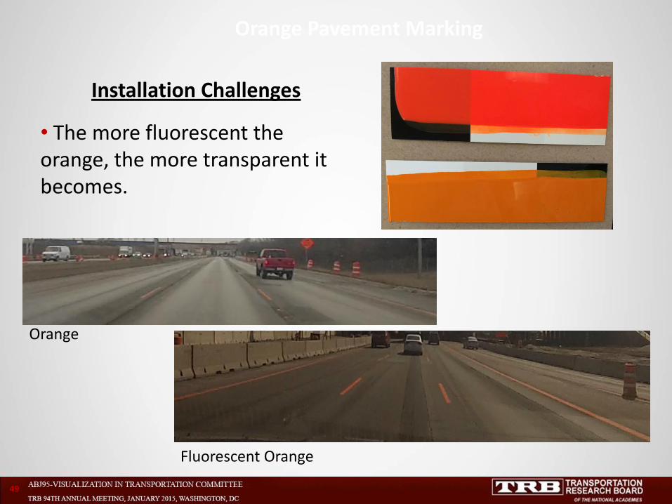
Installation Challenges
• The more fluorescent the orange, the more transparent it becomes.
Orange Pavement Marking
49
Orange
Fluorescent Orange
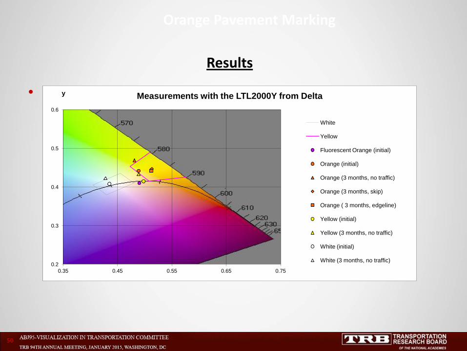
Results
•
Orange Pavement Marking
50
0.2
0.3
0.4
0.5
0.6
0.35 0.45 0.55 0.65 0.75
y Measurements with the LTL2000Y from Delta
White
Yellow
Fluorescent Orange (initial)
Orange (initial)
Orange (3 months, no traffic)
Orange (3 months, skip)
Orange ( 3 months, edgeline)
Yellow (initial)
Yellow (3 months, no traffic)
White (initial)
White (3 months, no traffic)
.
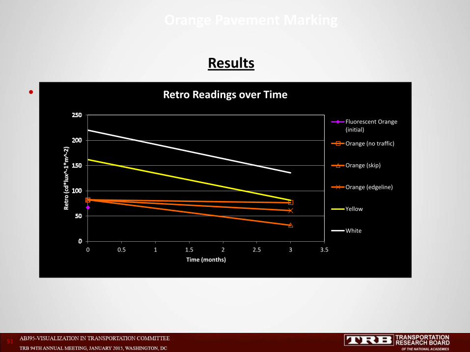
Results
•
Orange Pavement Marking
51
0 0.5 1 1.5 2 2.5 3 3.5
Time (months)
Retro Readings over Time
Fluorescent Orange (initial)
Orange (no traffic)
Orange (skip)
Orange (edgeline)
Yellow
White
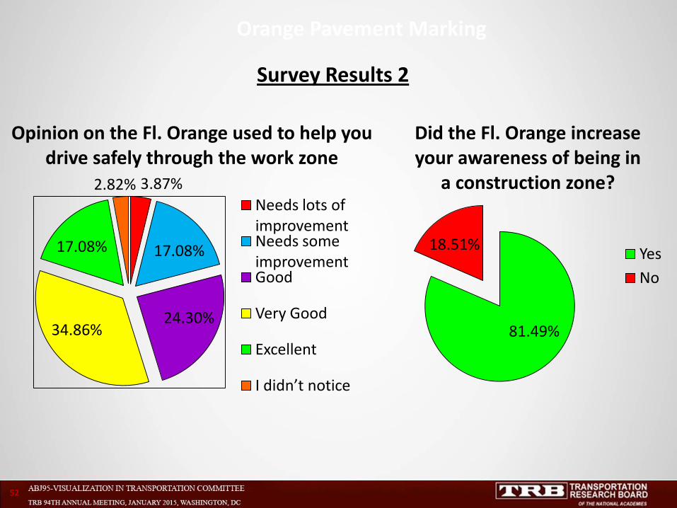
Survey Results 2
Orange Pavement Marking
52
3.87%
17.08%
24.30% 34.86%
17.08%
2.82%
Opinion on the Fl. Orange used to help you drive safely through the work zone
Needs lots of improvement Needs some improvement Good
Very Good
Excellent
I didn’t notice
81.49%
18.51%
Did the Fl. Orange increase your awareness of being in
a construction zone?
Yes
No
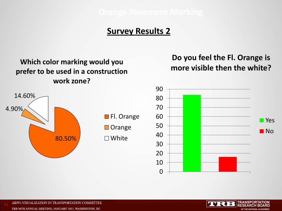
Survey Results 2
Orange Pavement Marking
53
80.50%
4.90%
14.60%
Which color marking would you prefer to be used in a construction
work zone?
Fl. Orange
Orange
White
0
10
20
30
40
50
60
70
80
90
Do you feel the Fl. Orange is more visible then the white?
Yes
No
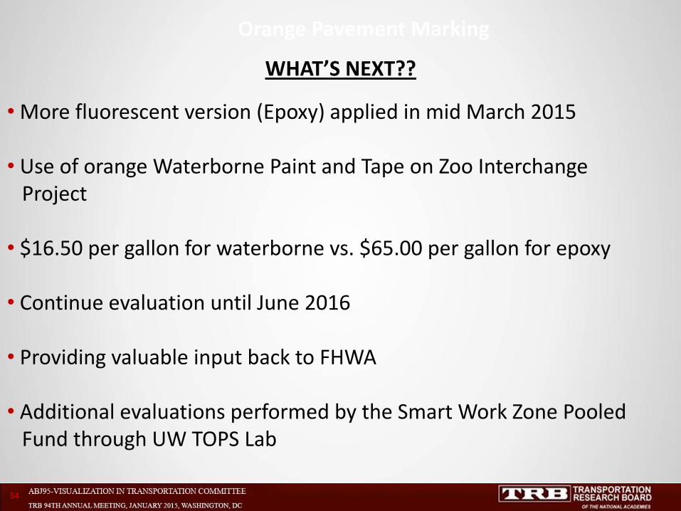
WHAT’S NEXT??
• More fluorescent version (Epoxy) applied in mid March 2015
• Use of orange Waterborne Paint and Tape on Zoo Interchange Project • $16.50 per gallon for waterborne vs. $65.00 per gallon for epoxy • Continue evaluation until June 2016 • Providing valuable input back to FHWA
• Additional evaluations performed by the Smart Work Zone Pooled Fund through UW TOPS Lab
Orange Pavement Marking
54
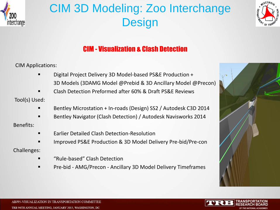
CIM - Visualization & Clash Detection
CIM Applications:
Digital Project Delivery 3D Model-based PS&E Production +
3D Models (3DAMG Model @Prebid & 3D Ancillary Model @Precon)
Clash Detection Preformed after 60% & Draft PS&E Reviews
Tool(s) Used:
Bentley Microstation + In-roads (Design) SS2 / Autodesk C3D 2014
Bentley Navigator (Clash Detection) / Autodesk Navisworks 2014
Benefits:
Earlier Detailed Clash Detection-Resolution
Improved PS&E Production & 3D Model Delivery Pre-bid/Pre-con
Challenges:
“Rule-based” Clash Detection
Pre-bid - AMG/Precon - Ancillary 3D Model Delivery Timeframes
CIM 3D Modeling: Zoo Interchange
Design
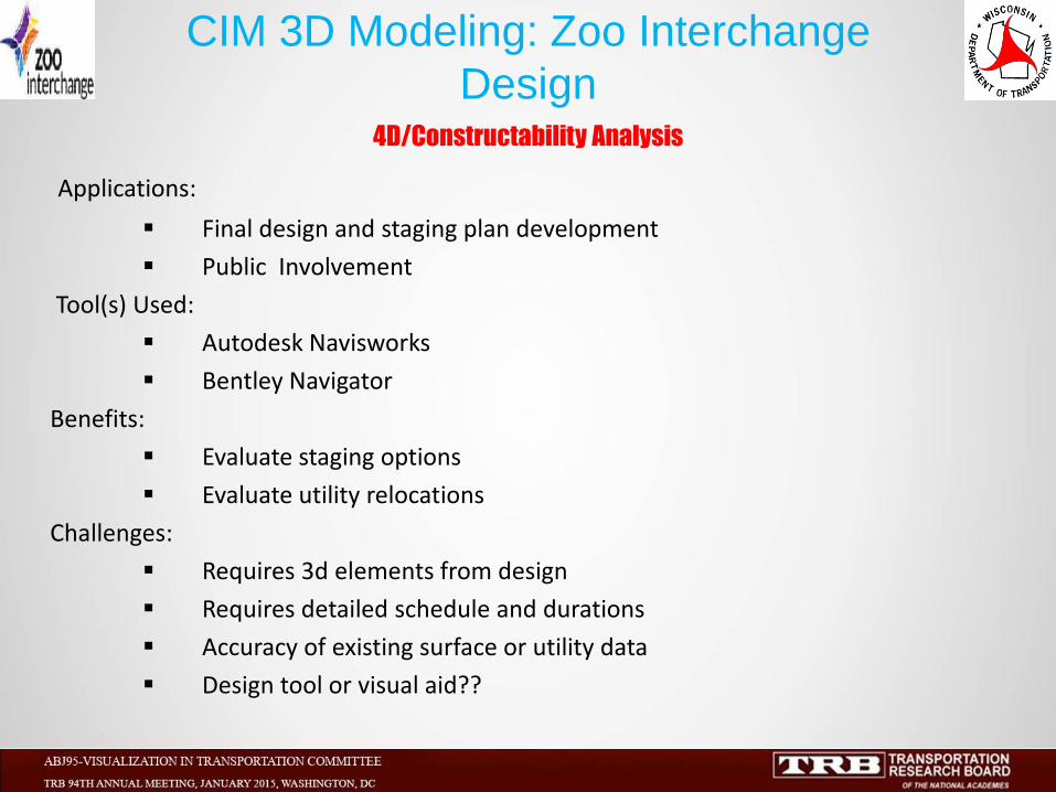
4D/Constructability Analysis
Applications:
Final design and staging plan development
Public Involvement
Tool(s) Used:
Autodesk Navisworks
Bentley Navigator
Benefits:
Evaluate staging options
Evaluate utility relocations
Challenges:
Requires 3d elements from design
Requires detailed schedule and durations
Accuracy of existing surface or utility data
Design tool or visual aid??
CIM 3D Modeling: Zoo Interchange
Design
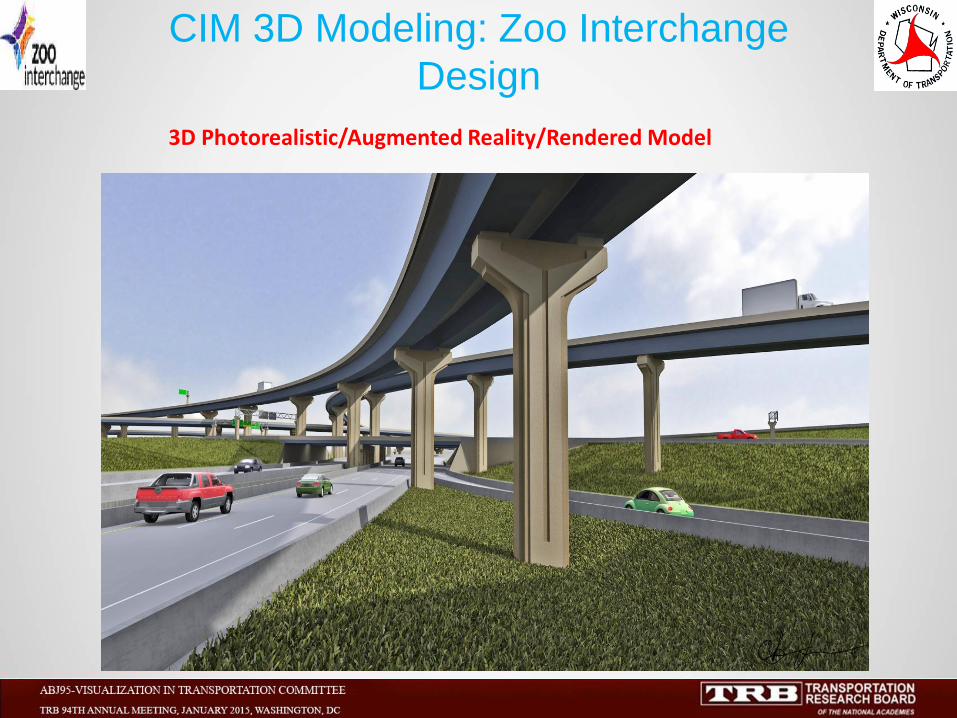
3D Photorealistic/Augmented Reality/Rendered Model
CIM 3D Modeling: Zoo Interchange
Design
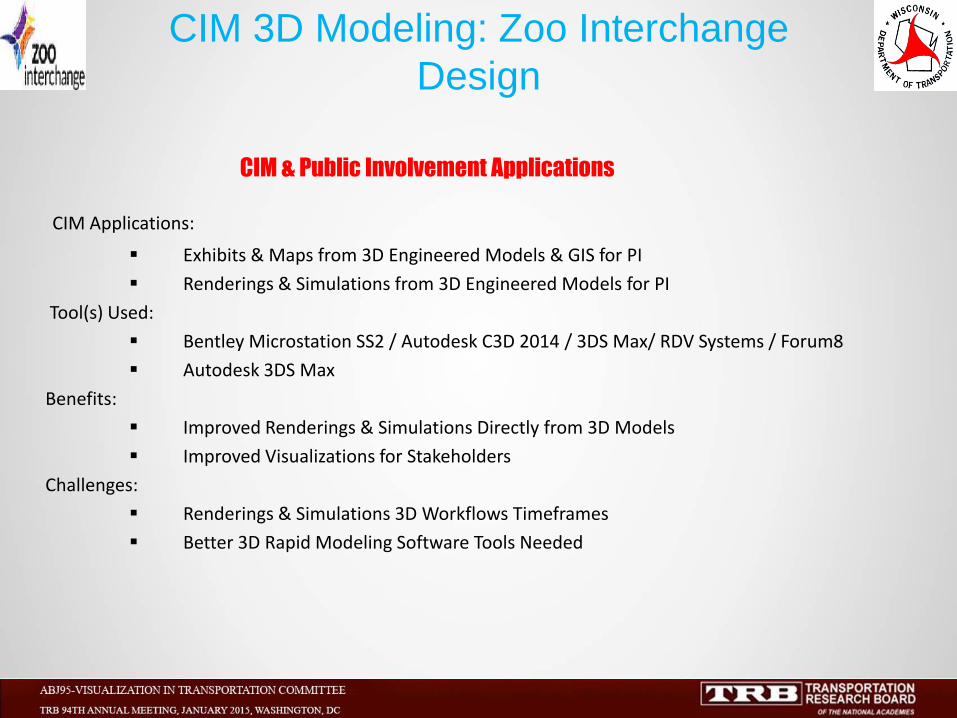
CIM & Public Involvement Applications
CIM Applications:
Exhibits & Maps from 3D Engineered Models & GIS for PI
Renderings & Simulations from 3D Engineered Models for PI
Tool(s) Used:
Bentley Microstation SS2 / Autodesk C3D 2014 / 3DS Max/ RDV Systems / Forum8
Autodesk 3DS Max
Benefits:
Improved Renderings & Simulations Directly from 3D Models
Improved Visualizations for Stakeholders
Challenges:
Renderings & Simulations 3D Workflows Timeframes
Better 3D Rapid Modeling Software Tools Needed
CIM 3D Modeling: Zoo Interchange
Design
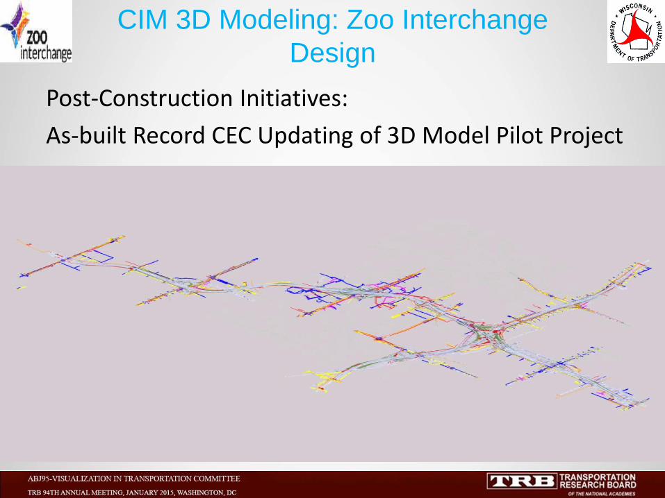
Post-Construction Initiatives:
As-built Record CEC Updating of 3D Model Pilot Project
CIM 3D Modeling: Zoo Interchange
Design
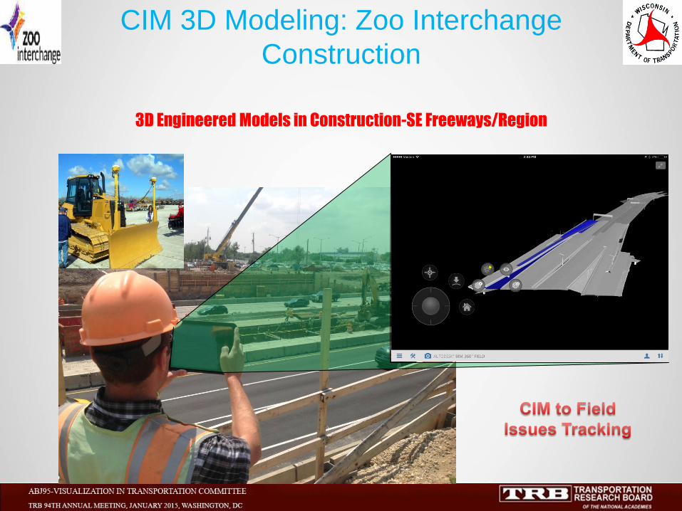
3D Engineered Models in Construction-SE Freeways/Region
CIM 3D Modeling: Zoo Interchange
Construction
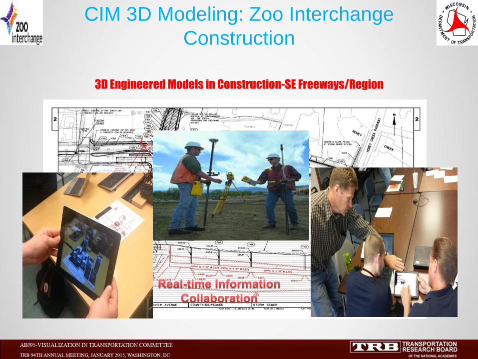
3D Engineered Models in Construction-SE Freeways/Region
CIM 3D Modeling: Zoo Interchange
Construction
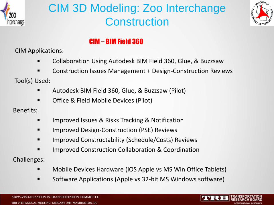
CIM – BIM Field 360
CIM Applications:
Collaboration Using Autodesk BIM Field 360, Glue, & Buzzsaw
Construction Issues Management + Design-Construction Reviews
Tool(s) Used:
Autodesk BIM Field 360, Glue, & Buzzsaw (Pilot)
Office & Field Mobile Devices (Pilot)
Benefits:
Improved Issues & Risks Tracking & Notification
Improved Design-Construction (PSE) Reviews
Improved Constructability (Schedule/Costs) Reviews
Improved Construction Collaboration & Coordination
Challenges:
Mobile Devices Hardware (iOS Apple vs MS Win Office Tablets)
Software Applications (Apple vs 32-bit MS Windows software)
CIM 3D Modeling: Zoo Interchange
Construction
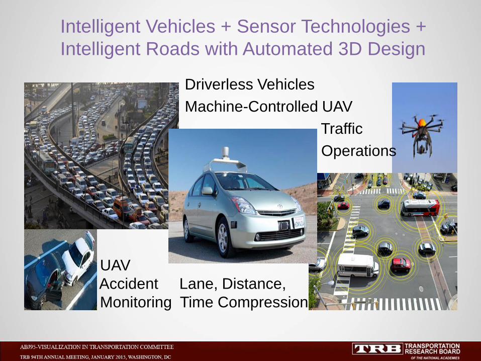
Intelligent Vehicles + Sensor Technologies +
Intelligent Roads with Automated 3D Design
Driverless Vehicles
Machine-Controlled UAV
Traffic
Operations
UAV
Accident Lane, Distance,
Monitoring Time Compression