2.11 ASSET REGISTER - brisbane.qld.gov.au · 2.11 ASSET REGISTER The asset register is an essential...
15
Urban Management Division Subdivision and Development Guidelines Part D Design & Construction Procedures November 2004 20 2.11 ASSET REGISTER The asset register is an essential part of the engineering and architectural plans and should be accurate and included on the leading drawing, generally in accordance with the proforma set out in Table D1.1. The applicant is required to identify and quantify the asset only as the actual construction costs may not be known at the design stage. The register should include all structures and items associated with the subdivision or development that which will be handed over to Council following Off Maintenance. These items are generally referred to as donated or contributed assets. Table D1.1 lists a comprehensive set of donated assets excluding water supply and sewerage items. It is envisaged that only a subset of the listed items will apply in most cases as the list also incorporates historical asset such as arched brick drains and heritage construction material such as porphyry. The applicant should not assume that the listed item will imply automatic acceptance of a particular material or product, for example, the use of pavers is now restricted. The final asset register should reflect the actual construction and should be submitted as part of the As Constructed Drawings. For each item, the applicant should specify the asset type, quantity, unit rate, and estimated value. Council will use the unit rates solely for the purpose of asset valuation and capitalisation.
Transcript of 2.11 ASSET REGISTER - brisbane.qld.gov.au · 2.11 ASSET REGISTER The asset register is an essential...

Urban Management DivisionSubdivision and Development Guidelines
Part D Design & Construction Procedures
November 200420
2.11 ASSET REGISTERThe asset register is an essential part of the engineering and architectural plans andshould be accurate and included on the leading drawing, generally in accordance withthe proforma set out in Table D1.1. The applicant is required to identify and quantify theasset only as the actual construction costs may not be known at the design stage. Theregister should include all structures and items associated with the subdivision ordevelopment that which will be handed over to Council following Off Maintenance.These items are generally referred to as donated or contributed assets.
Table D1.1 lists a comprehensive set of donated assets excluding water supply andsewerage items. It is envisaged that only a subset of the listed items will apply in mostcases as the list also incorporates historical asset such as arched brick drains andheritage construction material such as porphyry. The applicant should not assume thatthe listed item will imply automatic acceptance of a particular material or product, forexample, the use of pavers is now restricted.
The final asset register should reflect the actual construction and should besubmitted as part of the As Constructed Drawings. For each item, the applicantshould specify the asset type, quantity, unit rate, and estimated value. Council will usethe unit rates solely for the purpose of asset valuation and capitalisation.
Urban Management DivisionSubdivision and Development Guidelines
Part D Design & Construction Procedures
November 200421
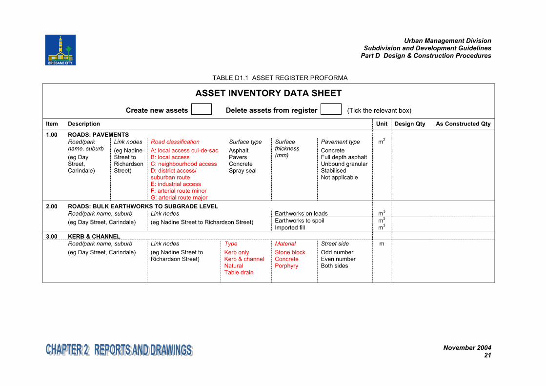
TABLE D1.1 ASSET REGISTER PROFORMA
ASSET INVENTORY DATA SHEET
Create new assets Delete assets from register (Tick the relevant box)
Item Description Unit Design Qty As Constructed Qty
1.00 ROADS: PAVEMENTSRoad/parkname, suburb(eg DayStreet,Carindale)
Link nodes(eg NadineStreet toRichardsonStreet)
Road classificationA: local access cul-de-sacB: local accessC: neighbourhood accessD: district access/suburban routeE: industrial accessF: arterial route minorG: arterial route major
Surface typeAsphaltPaversConcreteSpray seal
Surfacethickness(mm)
Pavement typeConcreteFull depth asphaltUnbound granularStabilisedNot applicable
m2
2.00 ROADS: BULK EARTHWORKS TO SUBGRADE LEVELEarthworks on leads m3
Earthworks to spoil m3Road/park name, suburb(eg Day Street, Carindale)
Link nodes(eg Nadine Street to Richardson Street)
Imported fill m3
3.00 KERB & CHANNELRoad/park name, suburb(eg Day Street, Carindale)
Link nodes(eg Nadine Street toRichardson Street)
TypeKerb onlyKerb & channelNaturalTable drain
MaterialStone blockConcretePorphyry
Street sideOdd numberEven numberBoth sides
m
Urban Management DivisionSubdivision and Development Guidelines
Part D Design & Construction Procedures
November 200422
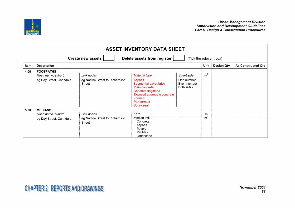
ASSET INVENTORY DATA SHEET
Create new assets Delete assets from register (Tick the relevant box)
Item Description Unit Design Qty As Constructed Qty
4.00 FOOTPATHSRoad name, suburbeg Day Street, Carindale
Link nodeseg Nadine Street to RichardsonStreet
Material typeAsphaltSegmental paver/brickPlain concreteConcrete flagstoneExposed aggregate concreteFormedPart formedSpray seal
Street sideOdd numberEven numberBoth sides
m2
5.00 MEDIANSKerb mRoad name, suburb
eg Day Street, CarindaleLink nodeseg Nadine Street to RichardsonStreet
Median infillConcreteAsphaltPaversPebblesLandscape
m2
Urban Management DivisionSubdivision and Development Guidelines
Part D Design & Construction Procedures
November 200423
ASSET INVENTORY DATA SHEET
Create new assets Delete assets from register (Tick the relevant box)
Item Description Unit Design Qty As Constructed Qty
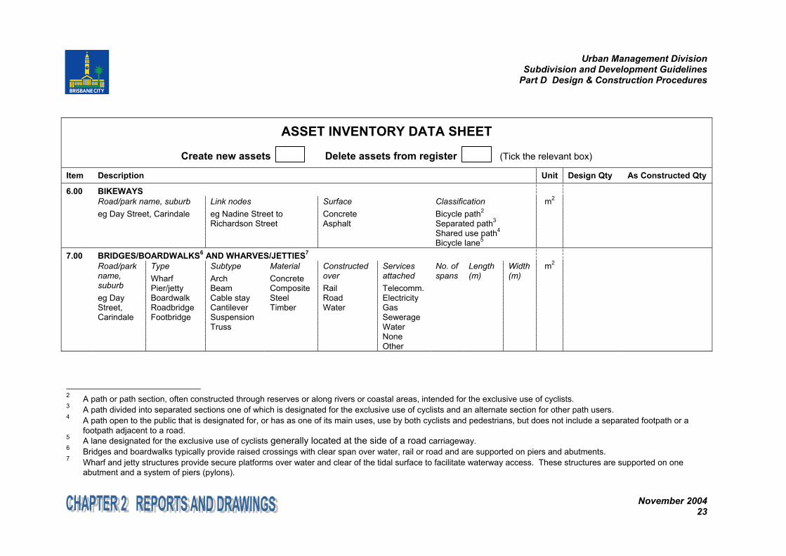
6.00 BIKEWAYSRoad/park name, suburbeg Day Street, Carindale
Link nodeseg Nadine Street toRichardson Street
SurfaceConcreteAsphalt
ClassificationBicycle path2
Separated path3
Shared use path4
Bicycle lane5
m2
7.00 BRIDGES/BOARDWALKS6 AND WHARVES/JETTIES7
Road/parkname,suburbeg DayStreet,Carindale
TypeWharfPier/jettyBoardwalkRoadbridgeFootbridge
SubtypeArchBeamCable stayCantileverSuspensionTruss
MaterialConcreteCompositeSteelTimber
ConstructedoverRailRoadWater
ServicesattachedTelecomm.ElectricityGasSewerageWaterNoneOther
No. ofspans
Length(m)
Width(m)
m2
2 A path or path section, often constructed through reserves or along rivers or coastal areas, intended for the exclusive use of cyclists.3 A path divided into separated sections one of which is designated for the exclusive use of cyclists and an alternate section for other path users.4 A path open to the public that is designated for, or has as one of its main uses, use by both cyclists and pedestrians, but does not include a separated footpath or a
footpath adjacent to a road.5 A lane designated for the exclusive use of cyclists generally located at the side of a road carriageway.6 Bridges and boardwalks typically provide raised crossings with clear span over water, rail or road and are supported on piers and abutments.7 Wharf and jetty structures provide secure platforms over water and clear of the tidal surface to facilitate waterway access. These structures are supported on one
abutment and a system of piers (pylons).
Urban Management DivisionSubdivision and Development Guidelines
Part D Design & Construction Procedures
November 200424
ASSET INVENTORY DATA SHEET
Create new assets Delete assets from register (Tick the relevant box)
Item Description Unit Design Qty As Constructed Qty
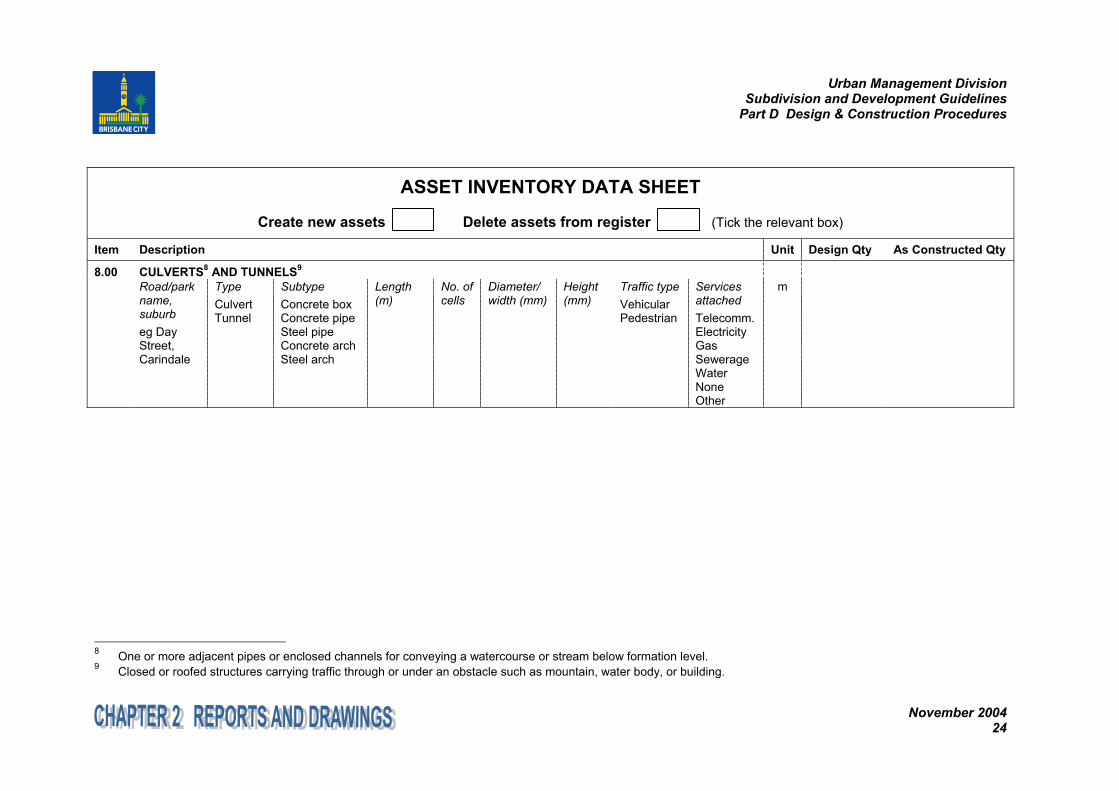
8.00 CULVERTS8 AND TUNNELS9
Road/parkname,suburbeg DayStreet,Carindale
TypeCulvertTunnel
SubtypeConcrete boxConcrete pipeSteel pipeConcrete archSteel arch
Length(m)
No. ofcells
Diameter/width (mm)
Height(mm)
Traffic typeVehicularPedestrian
ServicesattachedTelecomm.ElectricityGasSewerageWaterNoneOther
m
8 One or more adjacent pipes or enclosed channels for conveying a watercourse or stream below formation level.9 Closed or roofed structures carrying traffic through or under an obstacle such as mountain, water body, or building.
Urban Management DivisionSubdivision and Development Guidelines
Part D Design & Construction Procedures
November 200425
ASSET INVENTORY DATA SHEET
Create new assets Delete assets from register (Tick the relevant box)
Item Description Unit Design Qty As Constructed Qty
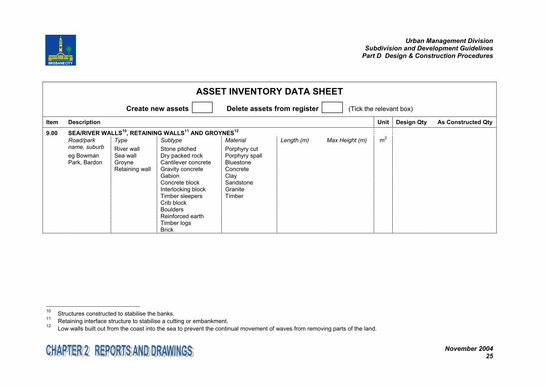
9.00 SEA/RIVER WALLS10, RETAINING WALLS11 AND GROYNES12
Road/parkname, suburbeg BowmanPark, Bardon
TypeRiver wallSea wallGroyneRetaining wall
SubtypeStone pitchedDry packed rockCantilever concreteGravity concreteGabionConcrete blockInterlocking blockTimber sleepersCrib blockBouldersReinforced earthTimber logsBrick
MaterialPorphyry cutPorphyry spallBluestoneConcreteClaySandstoneGraniteTimber
Length (m) Max Height (m) m2
10 Structures constructed to stabilise the banks.11 Retaining interface structure to stabilise a cutting or embankment.12 Low walls built out from the coast into the sea to prevent the continual movement of waves from removing parts of the land.
Urban Management DivisionSubdivision and Development Guidelines
Part D Design & Construction Procedures
November 200426
ASSET INVENTORY DATA SHEET
Create new assets Delete assets from register (Tick the relevant box)
Item Description Unit Design Qty As Constructed Qty
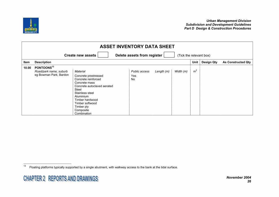
10.00 PONTOONS13
Road/park name, suburbeg Bowman Park, Bardon
MaterialConcrete prestressedConcrete reinforcedConcrete massConcrete autoclaved aeratedSteelStainless steelAluminiumTimber hardwoodTimber softwoodTimber plyCompositeCombination
Public accessYesNo
Length (m) Width (m) m2
13 Floating platforms typically supported by a single abutment, with walkway access to the bank at the tidal surface.
Urban Management DivisionSubdivision and Development Guidelines
Part D Design & Construction Procedures
November 200427
ASSET INVENTORY DATA SHEET
Create new assets Delete assets from register (Tick the relevant box)
Item Description Unit Design Qty As Constructed Qty
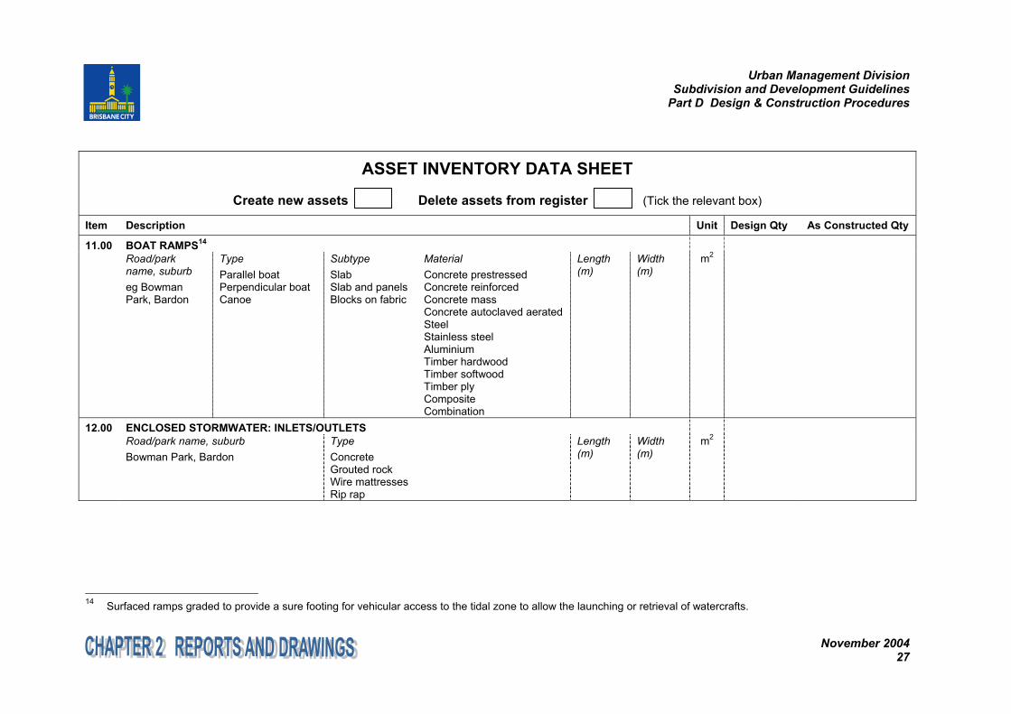
11.00 BOAT RAMPS14
Road/parkname, suburbeg BowmanPark, Bardon
TypeParallel boatPerpendicular boatCanoe
SubtypeSlabSlab and panelsBlocks on fabric
MaterialConcrete prestressedConcrete reinforcedConcrete massConcrete autoclaved aeratedSteelStainless steelAluminiumTimber hardwoodTimber softwoodTimber plyCompositeCombination
Length(m)
Width(m)
m2
12.00 ENCLOSED STORMWATER: INLETS/OUTLETSRoad/park name, suburbBowman Park, Bardon
TypeConcreteGrouted rockWire mattressesRip rap
Length(m)
Width(m)
m2
14 Surfaced ramps graded to provide a sure footing for vehicular access to the tidal zone to allow the launching or retrieval of watercrafts.
Urban Management DivisionSubdivision and Development Guidelines
Part D Design & Construction Procedures
November 200428
ASSET INVENTORY DATA SHEET
Create new assets Delete assets from register (Tick the relevant box)
Item Description Unit Design Qty As Constructed Qty
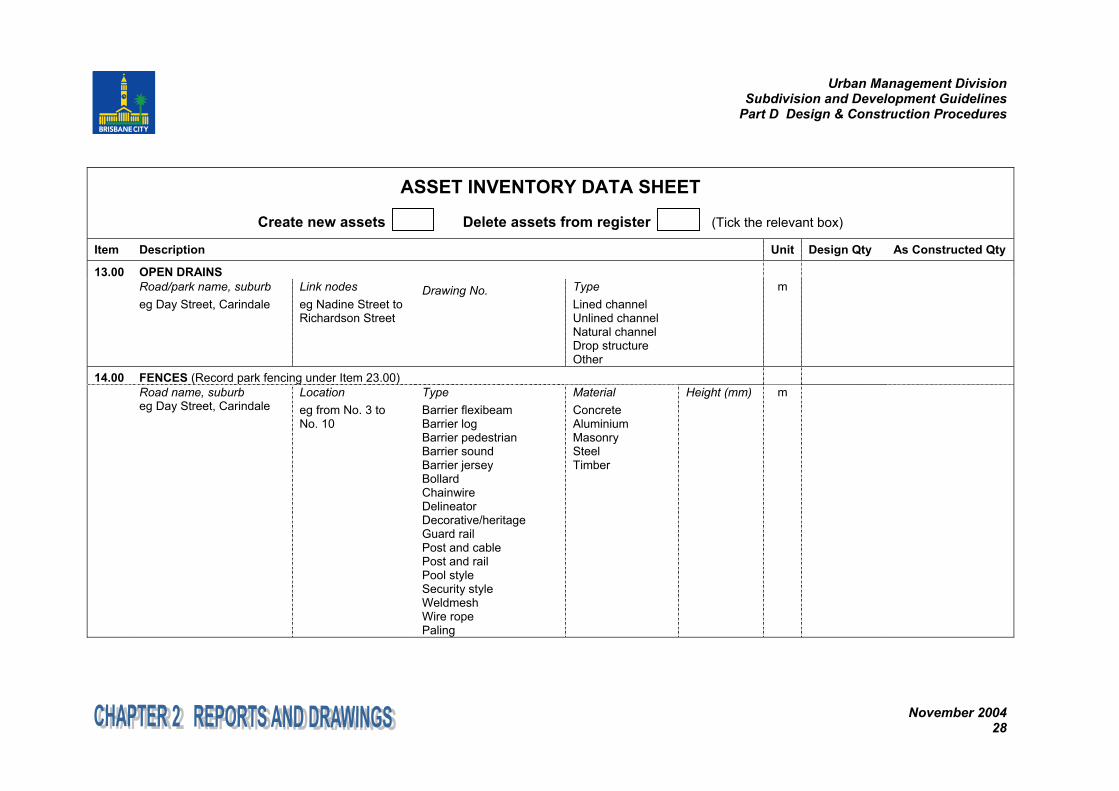
13.00 OPEN DRAINSRoad/park name, suburbeg Day Street, Carindale
Link nodeseg Nadine Street toRichardson Street
Drawing No. TypeLined channelUnlined channelNatural channelDrop structureOther
m
14.00 FENCES (Record park fencing under Item 23.00)Road name, suburbeg Day Street, Carindale
Locationeg from No. 3 toNo. 10
TypeBarrier flexibeamBarrier logBarrier pedestrianBarrier soundBarrier jerseyBollardChainwireDelineatorDecorative/heritageGuard railPost and cablePost and railPool styleSecurity styleWeldmeshWire ropePaling
MaterialConcreteAluminiumMasonrySteelTimber
Height (mm) m
Urban Management DivisionSubdivision and Development Guidelines
Part D Design & Construction Procedures
November 200429
ASSET INVENTORY DATA SHEET
Create new assets Delete assets from register (Tick the relevant box)
Item Description Unit Design Qty As Constructed Qty
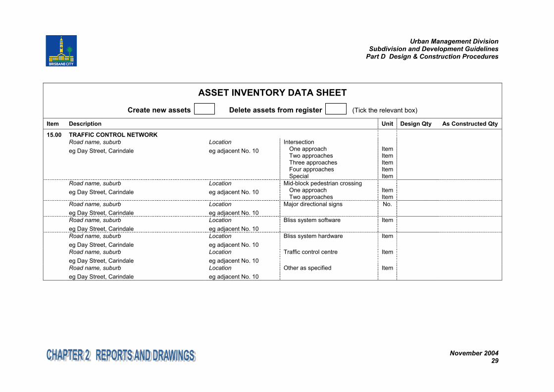
15.00 TRAFFIC CONTROL NETWORKRoad name, suburbeg Day Street, Carindale
Locationeg adjacent No. 10
IntersectionOne approachTwo approachesThree approachesFour approachesSpecial
ItemItemItemItemItem
Road name, suburbeg Day Street, Carindale
Locationeg adjacent No. 10
Mid-block pedestrian crossingOne approachTwo approaches
ItemItem
Road name, suburbeg Day Street, Carindale
Locationeg adjacent No. 10
Major directional signs No.
Road name, suburbeg Day Street, Carindale
Locationeg adjacent No. 10
Bliss system software Item
Road name, suburbeg Day Street, Carindale
Locationeg adjacent No. 10
Bliss system hardware Item
Road name, suburbeg Day Street, Carindale
Locationeg adjacent No. 10
Traffic control centre Item
Road name, suburbeg Day Street, Carindale
Locationeg adjacent No. 10
Other as specified Item

Urban Management DivisionSubdivision and Development Guidelines
Part D Design & Construction Procedures
November 200430
ASSET INVENTORY DATA SHEET
Create new assets Delete assets from register (Tick the relevant box)
Item Description Unit Design Qty As Constructed Qty
16.00 EASEMENTS AND CONTRIBUTED LANDAddress and R.P.description
TypeUnderground pipe drainage easement in favour of CouncilOpen cut drainage easement in favour of CouncilOverland flow easement in favour of CouncilCombined underground/ aboveground drainage easement in favour of CouncilContributed land eg dedicated parklandEasements over contributed land in favour of others eg EnergexOther as specified eg access and turning areas to facilitate on-site refuse collection
m2
17.00 PARKS: ACCESSTypeCar parksPathsStairwaysPlatformsDecksWalking tracksFormed management access (eg firebreak & driveway)Other as specified
Asset limits and/orlocationeg Smith Street carpark to toilet block,GPS coordinates
SurfacingAsphaltSpray sealTimberAggregateEarthDecoConcrete
Width(m)
Length(m)
m2
Urban Management DivisionSubdivision and Development Guidelines
Part D Design & Construction Procedures
November 200431
ASSET INVENTORY DATA SHEET
Create new assets Delete assets from register (Tick the relevant box)
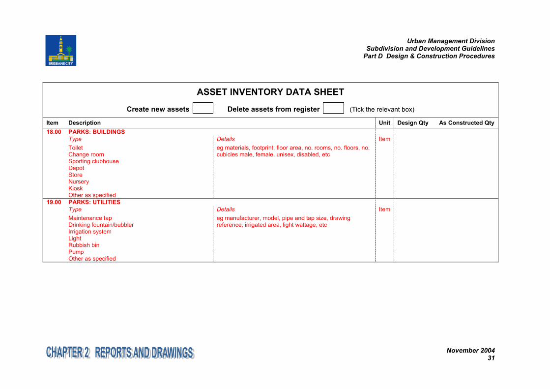
Item Description Unit Design Qty As Constructed Qty18.00 PARKS: BUILDINGS
TypeToiletChange roomSporting clubhouseDepotStoreNurseryKioskOther as specified
Detailseg materials, footprint, floor area, no. rooms, no. floors, no.cubicles male, female, unisex, disabled, etc
Item
19.00 PARKS: UTILITIESTypeMaintenance tapDrinking fountain/bubblerIrrigation systemLightRubbish binPumpOther as specified
Detailseg manufacturer, model, pipe and tap size, drawingreference, irrigated area, light wattage, etc
Item
Urban Management DivisionSubdivision and Development Guidelines
Part D Design & Construction Procedures
November 200432
ASSET INVENTORY DATA SHEET
Create new assets Delete assets from register (Tick the relevant box)
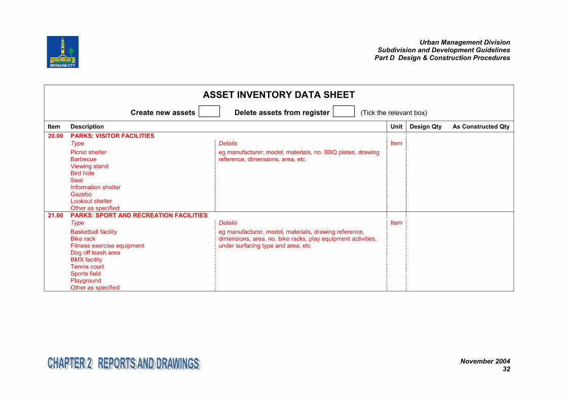
Item Description Unit Design Qty As Constructed Qty20.00 PARKS: VISITOR FACILITIES
TypePicnic shelterBarbecueViewing standBird hideSeatInformation shelterGazeboLookout shelterOther as specified
Detailseg manufacturer, model, materials, no. BBQ plates, drawingreference, dimensions, area, etc
Item
21.00 PARKS: SPORT AND RECREATION FACILITIESTypeBasketball facilityBike rackFitness exercise equipmentDog off leash areaBMX facilityTennis courtSports fieldPlaygroundOther as specified
Detailseg manufacturer, model, materials, drawing reference,dimensions, area, no. bike racks, play equipment activities,under surfacing type and area, etc
Item
Urban Management DivisionSubdivision and Development Guidelines
Part D Design & Construction Procedures
November 200433
ASSET INVENTORY DATA SHEET
Create new assets Delete assets from register (Tick the relevant box)
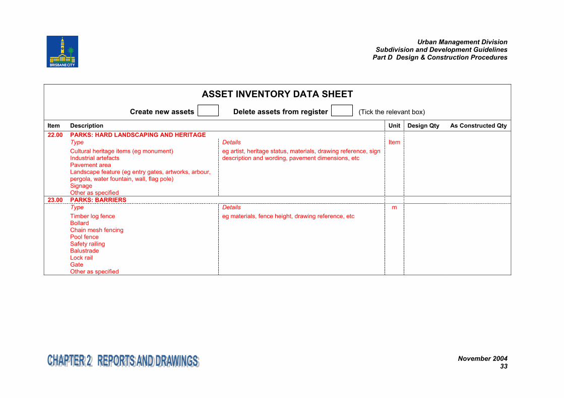
Item Description Unit Design Qty As Constructed Qty22.00 PARKS: HARD LANDSCAPING AND HERITAGE
TypeCultural heritage items (eg monument)Industrial artefactsPavement areaLandscape feature (eg entry gates, artworks, arbour,pergola, water fountain, wall, flag pole)SignageOther as specified
Detailseg artist, heritage status, materials, drawing reference, signdescription and wording, pavement dimensions, etc
Item
23.00 PARKS: BARRIERSTypeTimber log fenceBollardChain mesh fencingPool fenceSafety railingBalustradeLock railGateOther as specified
Detailseg materials, fence height, drawing reference, etc
m
Urban Management DivisionSubdivision and Development Guidelines
Part D Design & Construction Procedures
November 200434
ASSET INVENTORY DATA SHEET
Create new assets Delete assets from register (Tick the relevant box)
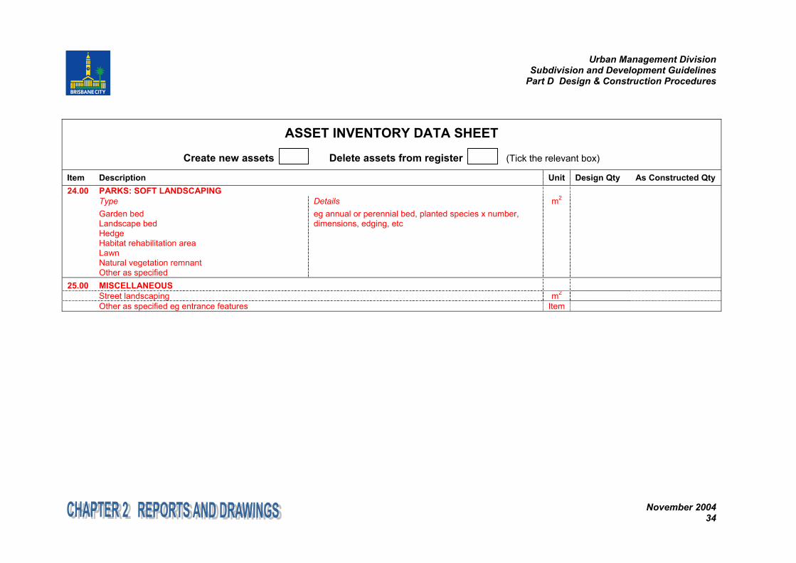
Item Description Unit Design Qty As Constructed Qty24.00 PARKS: SOFT LANDSCAPING
TypeGarden bedLandscape bedHedgeHabitat rehabilitation areaLawnNatural vegetation remnantOther as specified
Detailseg annual or perennial bed, planted species x number,dimensions, edging, etc
m2
25.00 MISCELLANEOUSStreet landscaping m2
Other as specified eg entrance features Item