2012 West Virginia GIS Conference The Nature Conservancy of West Virginia Ruth Thornton Conservation...
15
2012 West Virginia GIS Conference The Nature Conservancy of West Virginia Ruth Thornton Conservation Information Manager
-
Upload
kathryn-griffin -
Category
Documents
-
view
220 -
download
2
Transcript of 2012 West Virginia GIS Conference The Nature Conservancy of West Virginia Ruth Thornton Conservation...

2012 West Virginia GIS Conference
The Nature Conservancy of West Virginia
Ruth ThorntonConservation Information Manager

WEST VIRGINIA WATERSHED ASSESSMENT PILOT PROJECT
2012 West Virginia GIS Conference
Gauley River ©Kent Mason

Project Objectives
Design and test a watershed assessment process that can be replicated in WV’s remaining watersheds
Find datasets & develop metrics to measure Current Condition/Function & Future Threats
Rank planning units in terms of Restoration & Protection Priorities
Provide a decision support tool to assist partners, stakeholders, and regulatory staff with decisions affecting aquatic resources
Identify data gaps & data needs

Project Study Area
Five WV HUC8 Watersheds:
Monongahela Elk Gauley Little Kanawha Upper
Guyandotte

Upper & Lower Monongahela HUC8 Watersheds

Planning Units: HUC12s
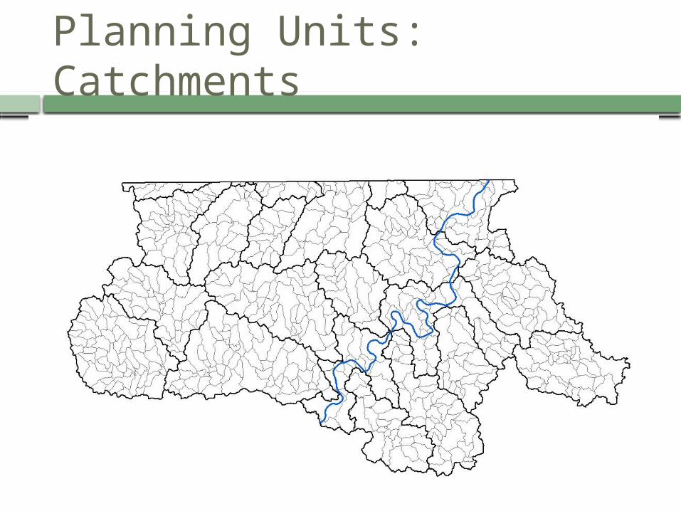
Planning Units: Catchments
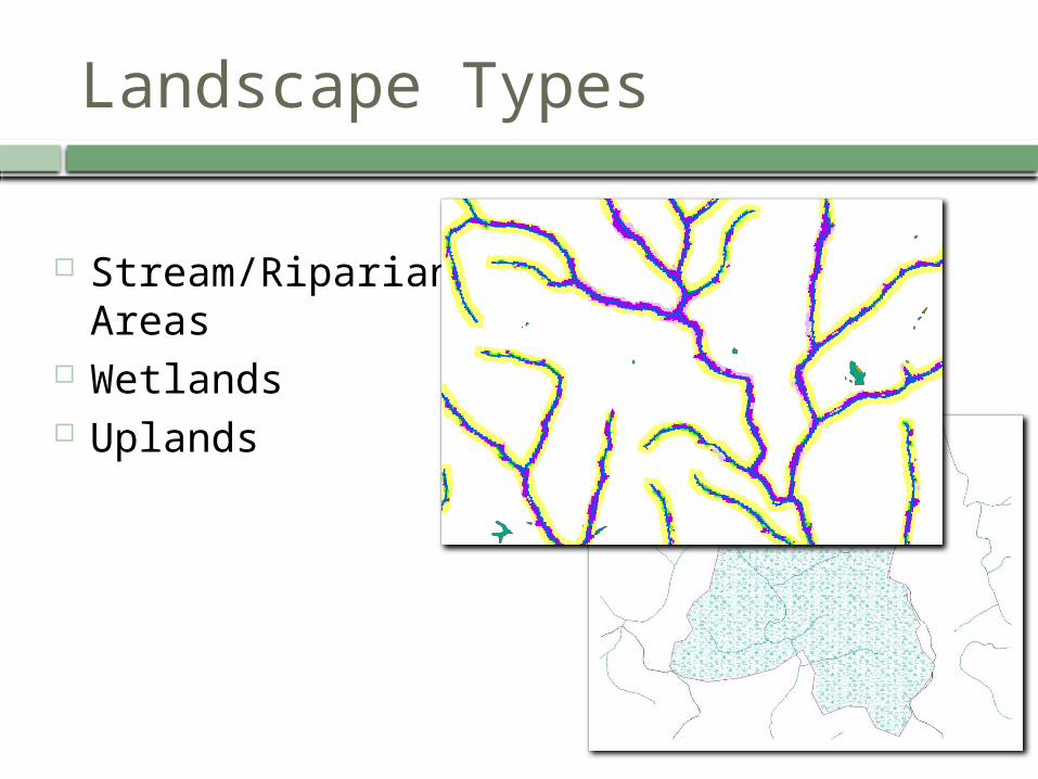
Landscape Types
Stream/Riparian Areas
Wetlands Uplands

Model Structure
Hierarchical Structure: 3 Models:
Streams Wetlands Uplands
2 Categories: Condition/Function Consolidated Analysis
Several Indices per Category Multiple Metrics to define each index

STREAMS/ RIPARIAN
PRIORITY MODEL
CONDITION/
FUNCTION
Water quality
Impaired streams (303d, AMD,
TMDL)
Water quality parameters (pH,
metals, etc)
Land use (ag, graze, developed, natural
cover)
Percent imperviousness
Road/rail density
Active underground/
surface mining;coal production
Wells; well production
NPDES; Septic systems
Landfills; Voluntary remediation;
Superfund sites
Mineral operations; Timber harvesting
Wetland area
Headwater catchment forests/
local integrity
Highly erodible soils
Boat launch sites
Water quantity
Public water supply sites/tributaries
Large quantity users
Wastewater treatment plants
Percent imperviousness
Dam drainage area
Active surface mining
Consumptive use
Hydrologic connectivity
Unimpeded
streams
Temperature impaired streams
(303d)
Headwaters
Power plants
Land use (riparian forest)
Dams
Stream crossings (culverts)
Bridges
Biodiversity
Rare species
Rare species index
Mussels
Trout streams
Habitat types
Non-native invasive species
Corbicula/Zebra (invasive mussels)
Infected/infested/ quarantined
counties
Riparian
Habitat
Riparian land use (ag, graze,
developed, natural)
Active/legacy surface mining
(riparian)
Wells (riparian)
Road/rail density (riparian)
Energy; pipelines; wind (riparian)
Buildings
(riparian)
Protected
Lands
Secured lands (GAP 1, 2, 3)
Metrics
CategoryIndex
1 of 3 Models

Metrics
CategoryIndex
Subindex
CONSOLIDATED ANALYSIS
Future Threats
Energy
Well potential
Proposed Wells
Wind Potential
Proposed Wind Development
Proposed Transmission Lines
Proposed Pipelines
Proposed Power Plants
Geothermal Potential
Unmined Coal
Unmined Coal Under Permit
Population/ Development
Future Growth Areas
Development Potential
Proposed Dams
Future Roads
Population Projections
Climate Change
Resiliency
Current Density
Precipitation Change
Temperature Change
Projected Land Use
Projected Urban
Projected Agriculture
Projected Barren Lands
Projected Forests
Priority Interest Areas
TNC Aquatic Portfolio
TNC Terrestrial Portfolio
USFS Priority Areas
WVDOF Priority Areas

Project Outputs
Five watershed assessment reports
Will include specific priorities and strategies, as well as detailed methodology, references and lessons learned
Interactive web mapping application
A spatial decision support tool to assist stakeholders in identifying target areas, strategies and actions

Interactive Web Mapping Application
Desktop tool that will allow users to: View the various datasets in one application Develop customized scenarios to rank target
areas for restoration and/or protection projects according to their priorities
Manipulate weighting of different factors

Partners
US Environmental Protection Agency WV Department of Environmental Protection Many individuals from several agencies, organizations, watershed associations:
US Geological Survey US Army Corps of Engineers US Office of Surface Mining US Department of Agriculture - NRCS WV Division of Natural Resources WV Geological and Economic Survey Region 3 Intergovernmental Council The Conservation Agency Trout Unlimited West Virginia University WV Rivers Coalition WV Land Trust Canaan Valley Institute Potesta & Associates Triad Engineering Morgantown Utility Board Several Watershed Associations

THANK YOU!
Elk River at Birch Run, WV ©www.over-land.comGauley River ©Kent MasonMon River at Friendship Hill ©photos.igougo.com