2005 PROARCA/APM, Regional Environmental · MARN Ministerio de Ambiente y Recursos Naturales...
62
Transcript of 2005 PROARCA/APM, Regional Environmental · MARN Ministerio de Ambiente y Recursos Naturales...

2005 PROARCA/APM, Regional EnvironmentalProgram for Central America / Protected Areas andEnvironmental Marketing Components, a USAID-CCAD project, The Nature Conservancy (TNC). 12Avenida 14-41, Zona 10 Colonia OaklandGuatemala 01010, Guatemala
Regional Environmental Program for CentralAmerica / Protected Areas and EnvironmentalMarketing Components Fundación Mario Dary. SiteConservation Planning Gulf of Honduras: Belize,Guatemala and Honduras /PROARCA/APM,Guatemala, Guatemala, 2005. 60 p. ; 8,5 X 11 c.m.
Designations used in this publication, and themanner in which this publication presents its data,do not imply any judgment by the members of thePROARCA/APM consortium, USAID, nor CCAD on thelegal status of countries, territories, cities, or zones,nor of their authorities, nor the disposition of theirborders.
This publication was made possible through supportprovided by the Office of Regional SustainableDevelopment, Bureau for Latin America and theCaribbean, United States Agency for InternationalDevelopment and The Nature Conservancy, underthe terms of Award No. 596-A-00-01-00116-00. Theopinions expressed herein are those of the authorsand do not necessarily reflect the views of the USAgency for International Development.
Editors: Jean-Luc Betoulle andAstrid Alvarado (FUNDARY)
CollaboratorsandReviewers: Juan Carlos Villagrán
Lenín CorralesIngrid Arias (TRIGOH)
Graphic Design: María del Rosario Calderón
Photography: Fundary

Site Conservation PlanningGulf of Honduras: Belize, Guatemala and
Honduras

44444
Site Conservation Planning Gulf of Honduras

Site Conservation Planning Gulf of Honduras
55555
TABLE OF CONTENTS
LIST OF ACRONYMS.............................................................................................................................................. 6PRESENTATION .................................................................................................................................................... 10EXECUTIVE SUMMARY ........................................................................................................................................ 11
I. INTRODUCTION..................................................................................................................... 121.1 Background and Plan Objectives ............................................................................................. 121.2 Site Description .............................................................................................................................. 13
II. ELEMENTS OF CONSERVATION AND THREATS ................................................................... 162.1 Coral Reefs ..................................................................................................................................... 162.2 Mangrove Forests .......................................................................................................................... 192.3 Marine grasslands .......................................................................................................................... 222.4 Beach Systems ................................................................................................................................ 252.5 Estuaries and Coastal Lagoons ................................................................................................... 282.6 Herbaceous Wetlands, Flood forests, and their supporting Aquatic Systems ................... 31
III. CONSERVATION STRATEGIES AND ACTIONS .................................................................... 33Strategy # 1: Complete the protected areas system, and improve protected area man-agement and protection ................................................................................................................... 34Strategy # 2: Create mechanisms for the financial sustainability of protected area man-agement ................................................................................................................................................ 35Strategy # 3: Develop and implement Land Use Regulation Plans and Sector Plans ........... 36Strategy # 4: Make and execute protection plans for endangered, and economicallyimportant species ................................................................................................................................ 37Strategy # 5: Support the regulation of fisheries and sustainable fishing ................................. 38Strategy # 6: Revise, develop, and enforce, in a participative manner, norms and mecha-nisms to regulate the sustainable use of natural resources ......................................................... 39Strategy # 7: Promote alternate economic activities in the local communities .................... 40Strategy # 8: Implement education, sensitizing, awareness-raising, and divulgation pro-grams about the environmental problems and their solutions with inhabitants, resourceusers, and governments ...................................................................................................................... 41Strategy # 9: Implement institutional strengthening programs, and coordination and citizenparticipation mechanisms, for the protection of natural systems .............................................. 42
IV. MEASURES OF SUCCESS .................................................................................................... 43
V. BIBLIOGRAPHY .................................................................................................................... 46
VI. ANEXES .............................................................................................................................. 49The Site Conservation Planning method ......................................................................................... 50Map 1. Base map of the Gulf of Honduras .................................................................................... 55Map 2. Ecoregions .............................................................................................................................. 56Map 3. Life Zones, according to Holdridge.................................................................................... 57Map 4. Conservation Elements ......................................................................................................... 58Map 5. Stresses ..................................................................................................................................... 59Map 6. Sources of stress ..................................................................................................................... 60
66666
Site Conservation Planning Gulf of Honduras
LIST OF ACRONYMS
APE Área de Protección EspecialSpecial Protection AreaBTB Belize Tourism BoardCCAD Comisión Centroamericana de Ambiente y Desarrollo
(Central American Commission on the Environment andDevelopment)
CCO Cuerpo de Conservación Omoa Baracoa (Omoa BaracoaConservation Corps, Honduras)
CEMA Centro de Estudios del Mar y Acuicultura, Universidad de San Carlosde Guatemala(Center for Sea and Aquaculture Studies of theGuatemalan state university)
CISP Comitato Internazionale per lo Sviluppo dei Popoli(International Committee for the Development of Peoples, based inItaly)
CITES Convention on the Illegal Trade of Endangered SpeciesCOCODES Comité Comunitario de Desarrollo(Community Development
Committee, Guatemala)COHDEFOR Corporación Hondureña de Desarrollo Forestal
(Honduran Forestry Development Corporation, = Honduran forestservice)
CONAMA Comisión Nacional del Medio Ambiente(National Commission on the Environment, forerunner of MARN,Guatemala)
CONAP Consejo Nacional de Áreas Protegidas(National Protected Areas Council, Guatemala)
CZMA/I Coastal Zone Management Authority / Institute (Belize)DIGEPESCA Dirección General de Pesca y Acuicultura
(General Directorate of Fishing and Aquaculture, Honduras)EMPORNAC Empresa Portuaria Nacional de Santo Tomás de Castilla
(Santo Tomás de Castilla National Port Company, Guatemala)ENP Empresa Nacional Porturaria
(National Port Company, Honduras)FOPECO Foro Permanente de Ecoturismo y Conservación de
Guatemala(Guatemala Permanent Ecotourism and Conservation Forum)
FUNDAECO Fundación para el Ecodesarrollo y la Conservación(Foundation for Eco-Development and Conservation, Guatemala)
FUNDARY Fundación para la Conservación del Medio Ambiente y de losRecursos Naturales “Mario Dary Rivera(“Mario Dary Rivera” Foundation for Conservation of the Environmentand Natural Resources, Guatemala)
GIS Geographic Information SystemGO Government OrganizationGOH Gulf of HondurasICSED Inter-American Center for Sustainable Ecosystems Development
(Chile)IDEADS Instituto de Derecho Ambiental y Desarrollo Sustentable
(Environmental Law and Sustainable Development Institute,Guatemala)
IHT Instituto Hondureño de Turismo(Honduran Tourism Institute)INAB Instituto Nacional de Bosques (National Forest Institute,
Guatemala)INGUAT Instituto Guatemalteco de Turismo(Guatemalan Tourism
Institute)

Site Conservation Planning Gulf of Honduras
77777
INTECAP Instituto Técnico de Capacitación(Capacity-Building Technical Institute, Guatemala)
MARN Ministerio de Ambiente y Recursos Naturales(Ministry of Environment and Natural Resources, Guatemala)
MARPOL International Convention for the Prevention of Pollution fromShips
MBC Mesoamerican Biological CorridorMBRS Mesoamerican Barrier Reef SystemMINUGUA Misión de Verificación de las Naciones Unidas en Guatemala
(United Nations Verification Mission in Guatemala)MoES Ministry of Education and Sports (Belize)NGC/TDC National Garifuna Council / Toledo Development Corporation
(Belize)IMO International Maritime OrganizationPA Protected AreaPDO Private Development OrganizationPROARCA/APM Programa Ambiental Regional para Centro América / Áreas
Protegidas y Mercadeo Ambiental (Regional EnvironmentalProgram for Central America / Protected Areas andEnvironmental Marketing)
PROARCA/CAPAS Programa Ambiental Regional para Centro América / SistemaCentroamericano de Áreas Protegidas (Regional EnvironmentalProgram for Central America / Central American ProtectedAreas System)
PROARCA/Costas Programa Ambiental Regional para Centro América / Manejode Zonas Costeras (Regional Environmental Program for CentralAmerica / Coastal Zones Management)
PROECO Programa Ecológico de Centroamérica (Central AmericanEcologic Program. A Swiss Contact program based inHonduras)
PROLANSATE Fundación para la Protección de Lancetilla, Punta Sal, yTexiguat (Foundation for the Protection of Lancetilla, Punta Sal,and Texiguat, Honduras)
SCP Site Conservation PlanningSERNA Secretaría de Estado en el Despacho de Recursos Naturales y
Ambiente (State Secretariat for Natural Resources andEnvironment, Honduras)
SOLAS International Convention for the Safety Of Lives At SeaTASTE Toledo Association for Sustainable Tourism and Empowerment
(Belize)TIDE Toledo Institute for Development and Environment (Belize)TNC The Nature ConservancyTRIGOH Tri-National Alliance for the Conservation of the Gulf of
HondurasUN United NationsUNDP United Nations Development ProgrammeUNIPESCA Unidad Especial de Pesca y Acuicultura (Special Fishing and
Aquaculture Unit, Guatemala)USAID United States Agency for International DevelopmentUVG Universidad del Valle de Guatemala (University of the Valley of
Guatemala)WB World Bank

88888
Site Conservation Planning Gulf of Honduras
Site Conservation Planning Gulf of Honduras
99999
The Protected Areas and Environmental Marketing Component of the RegionalEnvironmental Program for Central America (PROARCA/APM) is an initiative of theCentral American Commission on the Environment and Development (CCAD),funded by the United States Agency for International Development (USAID). TheNature Conservancy (TNC) is implementing this five-year initiative (2001-2006). Itsgeneral objective is to contribute to the improved management of theMesoamerican Biological Corridor (MBC), for which it is structured in two components:
Intermediate Result 1 (IR1): Improved protected areas management. Thiscomponent comprises three fields of action to improve or assure the viability ofbiodiversity in the four MBC key functional landscapes. 1) Development ofeffective alliances for protected areas management supports a legal frameworkand policies oriented to improve management (environmental services,conservation in private lands, and co-management) and strengthen institutions(governments, private development organizations, communities). 2) Improvedfinancial management in protected areas works on financial planning andmanagement, and the increase of complementary investment. 3) Application ofbest management practices adopts and applies methods for ecoregionalplanning, Site Conservation Planning, management effectiveness, and definingindicators for biomonitoring and for the Central American Protected Areas System,among others.
Intermediate Result 2 (IR2): Expanded access to markets for environmentallysound products and service. This component works in two fields of action withinforestry and sustainable tourism, to diminish threats to biodiversity in the four MBCkey functional landscapes: 1) Increased availability of environmentally soundproducts publishes requirements, options, and benefits of adopting betterproduction practices. 2) Effective alliances for the commercialization ofenvironmentally sound products and services publishes information on the offerand demand for products, and strengthens the capacity of producers toparticipate in innovative markets.
PROARCA/APM emphasizes two areas considered key functional landscapes withinthe Mesoamerican Biological Corridor, which represent four priority areas of theCentral American Biodiversity Agreement:
1. Gulf of Honduras (Belize, Guatemala, Honduras)4. Amistad – Cahuita – Río Cañas (Coast Rica, Panamá)
The work PROARCA/APM has done in the functional landscapes will serve for casestudies to systematize methods and experiences, contributing to the development ofregional policies.
1010101010
Site Conservation Planning Gulf of Honduras
It is a pleasure for me, as Director of the Protected Areas and Environmentally SoundMarketing components of the Regional Environmental Program for Central America(PROARCA/APM) of CCAD, funded by USAID, to present the Site Conservation Plan forthe Gulf of Honduras.
This Site Conservation Plan is the result of an approximately one-year-long processwhich collected information and analyzed strategies to conserve biodiversity in thetri-national area formed by the south of Belize, the Caribbean coast of Guatemala,and part of the north Caribbean coast of Honduras, known as the Gulf of Honduras.The chief virtues of this document are rooted in the following elements:
1. The Site Conservation Plan reflects the effort and cooperation of more than 60persons over several workshops. All of them, concerned for conservation inthis area, were summoned under the leadership of the Tri-National Alliance forthe Conservation of the Gulf of Honduras (TRIGOH), one of the most successfulcoalitions that PROARCA has supported, by means of PROARCA/Costas andPROARCA/CAPAS in the beginning of PROARCA, and by PROARCA/APM at thepresent time.
2. Another important virtue of this work is the identification of conservationelements in the Gulf of Honduras (scored according to their viability) as well asthe principal threats to them in the area. Long work hours were needed toprioritize and establish elements of the area’s biodiversity that will allow anadequate representation of it. Local actors identified the threats and theirsources, to enable the identification of mechanisms and strategies that willallow their attenuation or elimination.
3. Finally, the greatest virtue of the Site Conservation Plan is that it has allowedthe establishment of a series of strategies, which you will find in this document.These establish a criterion of priorities as to what needs to be done urgently inthe Gulf of Honduras to guarantee the main objectives of the SiteConservation Plan: first, achieve the maintenance, and if possible,improvement of the viability of the most important conservation elements, andsecond, the attenuation or elimination of the threats and their sources.
I would like to thank the unnamable list of persons and institutions that participated inthis process, especially the Tri-National Alliance for the Conservation of the Gulf ofHonduras (TRIGOH), which demonstrated its leadership and summoning power,without which it would have been impossible to make this Site Conservation Plan.
I leave this work instrument in your hands, which will surely change over the next yearsas the environmental situation in the Gulf of Honduras changes, hopefully for the best.
I thank any comment that allows improving the information provided here. I remindyou that this plan reflects the information that the participants collected and used toarrive to the conclusions poured into this document. Nothing remains but toencourage the readers and beneficiaries of this Site Conservation Plan to transform itinto living words and deeds, in order to achieve the conservation of the naturalresources of the Gulf of Honduras and to promote their sustainable use.
Very faithfully yours,
Néstor Windevoxhel, M.S.Director
PRESENTATION
Site Conservation Planning Gulf of Honduras
1111111111
PROARCA, with technical support from TNC, has implemented Site ConservationPlanning as an instrument for regional planning in functional landscapes. Thisdocument presents the work done by members of the Tri-National Alliance for theConservation of the Gulf of Honduras (TRIGOH), diverse actors from governmentaland private development organizations, projects, and diverse initiatives andorganizations to identify the conservation priorities in the Gulf of Honduras tri-nationalsite (Belize, Guatemala, and Honduras).
The Gulf of Honduras is defined as the marine and coastal areas between PuntaIzopo, in the northern coast of Honduras, and Gladden Spit in Belize. It thereforeincludes the southwest end of the Mesoamerican Barrier Reef System. The Gulf coversapproximately 10,000 Km2, which include parts of the Exclusive Economic Zones of thethree countries. Marine productivity within the Gulf is maintained to a large extent bythe contributions of the most important rivers, their estuaries, and the humid coastallands bathed by tides, populated especially by mangroves. The Gulf has populationsof shrimp (Penaeus spp.), lobster (Panulirus argus), queen conch (Strobus gigas), aswell as commercially exploited scale fish and important sport fish populations. TheGulf also provides habitat for several endangered species, including: West Indiesmanatee (Trichechus manatus), Atlantic spotted dolphin (Stenella frontalis),bottlenose dolphin (Tursiops truncates), whale shark (Rhincodon typus), yellow-headed parrot (Amazona oratrix), and the following sea turtles: green (Cheloniamydas), hawksbill (Eretmochelys imbricata), leatherback (Dermochelys coriacea),and loggerhead (Caretta caretta). The Gulf has half a million inhabitants, mainlyconcentrated in the port cities of Santo Tomás de Castilla and Puerto Barrios(100,000+), Puerto Cortés (100,000), and Livingston (40,000).
Site Conservation Planning has allowed the identification of some of the mostimportant systems that need to be protected to guarantee the conservation of thelargest possible sample of biodiversity in this tri-national site. All the selectedconservation elements are coastal-marine ecosystems: coral reefs, mangrove forests,marine grasslands, beach systems, estuaries and coastal lagoons, and herbaceouswetlands (which include flood forests). The viability of all these conservation elementsis considered good.
The identification of the main conservation elements has in turn allowed theidentification of the main sources of stress acting on the long-term viability of theelements. The greatest stress is “altered composition and structure”, which stronglyaffects 4 conservation elements, and has a medium effect on another. All the coastalelements –mangrove forests, beach systems, and herbaceous wetlands– have highlyfragmented habitat. The greatest threat to them is urban development and theconstruction of access roads, which is very strongly degrading the beach systems,and strongly degrading the mangrove forests, estuaries and coastal lagoons, andherbaceous wetlands. Other threats with a “high” global score include inappropriateagricultural and animal farming practices, tourism development, wildlife poaching,inappropriate fishing practices, and climate change. The threatened state for focalobjects and the site as a whole is very high.
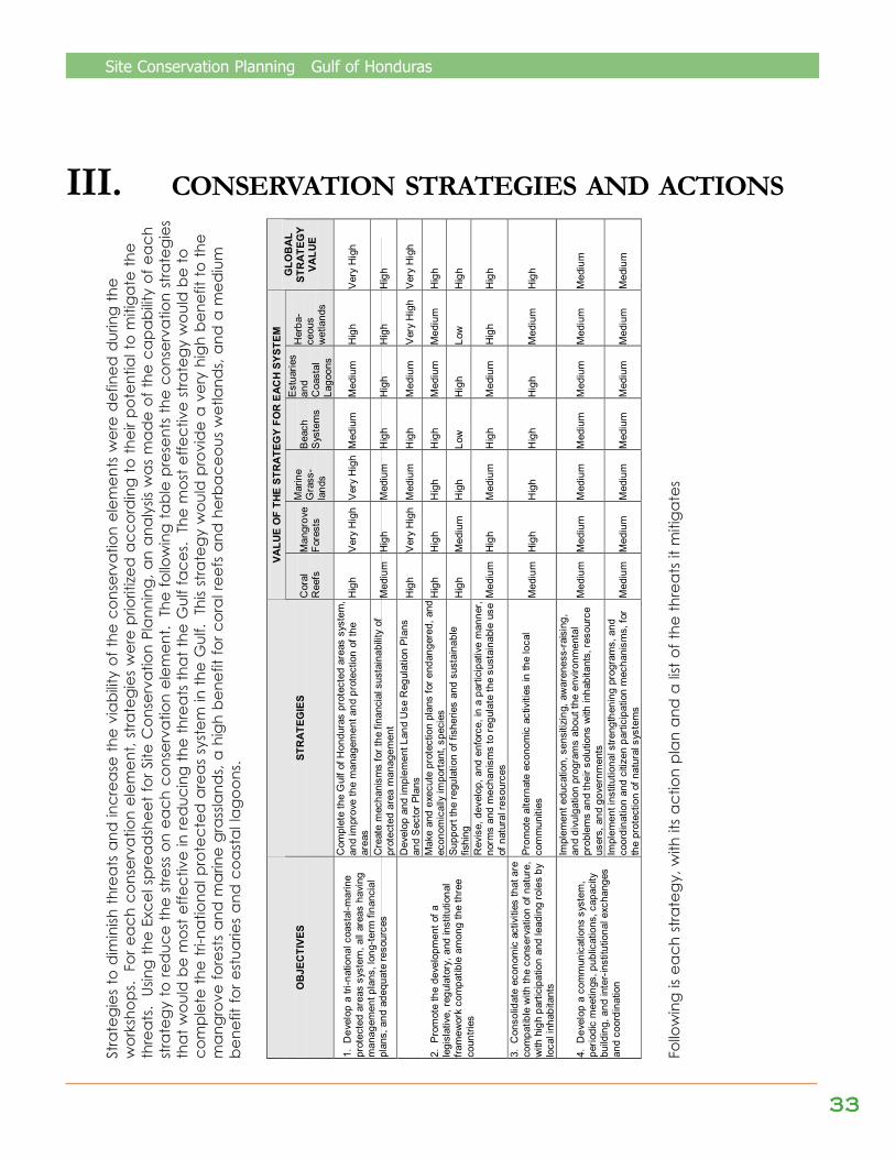
This analysis allowed the identification of institutional capabilities and the strategiesneeded to attack the critical threats and to improve the viability of biodiversity in themedium and long terms. Nine principal strategies were identified, of which “completethe protected areas system”; “support the regulation of fisheries” and “promotealternate economic activities” were defined as the most effective to mitigate thethreats. The effectiveness of efforts to conserve biodiversity associated to theseimportant coastal-marine ecosystems can be evaluated with this information, usingthe “Measures of conservation success” method.
EXECUTIVE SUMMARY
1212121212
Site Conservation Planning Gulf of Honduras
1.1 Background and PlanObjectives
The Tri-National Alliance for theConservation of the Gulf of Honduras(TRIGOH) was created in 1996, with thesupport of PROARCA/Costas, byrepresentatives of private developmentorganizations (PDOs) from Belize,Guatemala, and Honduras, whorecognized the Gulf as a sharedecosystem and saw the need tocollaborate in the management of thecoastal-marine resources of the Gulf. Atthis time, there were PDOs working onprotected areas management in eachcountry: TIDE in Port Honduras andPaynes Creek, FUNDAECO in Cerro SanGil and Sarstún, FUNDARY in Punta deManabique, and PROLANSATE in PuntaSal (Jeannette Kawas National Park) andPunta Izopo. Other PDOs were workingon environmental policy in the threecountries. Recognizing that theconservation of the Gulf required a tri-national vision, they decided to beginworking on landscapes.
The mission of TRIGOH is to conserve thebiodiversity of the Gulf of Honduras andto improve the quality of life of the localcommunities, through tri-nationalcoordination in the sustainablemanagement of the coastal-marineresources. TRIGOH founds its work on thefollowing values: 1) an ecosystemic andintegral vision of the Gulf of Honduras, 2)the participation of all the actors, withoutany discrimination, 3) tri-nationalcoordination at all levels, 4) theapplication of multidisciplinary scientificinformation, and 5) respect for traditionalvalues and knowledge of the severalethnic and indigenous groups (TRIGOH,1999).
TRIGOH held a series of strategicplanning exercises, and decided tofocus its work on the following sevenobjectives:
1. Develop a tri-national system ofcoastal-marine protected areas,co-managed by public andprivate entities, with the activeparticipation of localcommunities. Have all areasendowed with managementplans, long-term financial plans,and adequate resources.
2. Promote the development of alegislative, regulatory, andinstitutional frameworkcompatible among the threecountries, and a tri-nationalagreement for the sustainablemanagement of fishing in theGulf, based on scientificinformation and theorganizational and participativestructures of local fishermen andother key actors.
3. Promote the development andstrict enforcement ofenvironmental criteria andstandards for the largeeconomic developmentactivities in the Gulf, especiallycoastal development and theenvironmental management ofports and maritime traffic.
4. Promote and consolidateeconomic activities compatiblewith the conservation of nature,especially the establishmentand joint marketing of tri-national sustainable tourismroutes, with high participationand leadership from localinhabitants.
I. INTRODUCTION
Site Conservation Planning Gulf of Honduras
1313131313
5. Protect endangered species,especially the West Indiesmanatee and sea turtles, in ajoint, coordinated manner.
6. Carry out joint, coordinatedresearch and environmentalmonitoring activities, in support ofthe systematic application ofcoastal zone integratedmanagement processes.
7. Strengthen the coordinationforum by developing acommunications system, periodicmeetings, publications, capacitybuilding, fund raising, exchangeprograms, and the creation ofalliances with internationalinstitutions.
TRIGOH and PROARCA, first throughCostas and now through APM, havecollaborated on the development of thisSite Conservation Plan for the Gulf, withthe active participation of otherinstitutions. The development of this plancomplements the objectives andactivities of TRIGOH, by creating aframework to establish priorities of action.
The purpose of the plan is to define whichecosystems and species are to beconserved, which threats are beingfaced by these ecosystems and species,which strategies and actions can beimplemented to reduce the threats, andhow progress in conservation can bemeasured.
The Site Conservation Plan is a workinstrument that allows the prioritization ofactions, and the efficient focusing of theuse of limited resources available forconservation. This work will have multipleevaluations with the purpose ofmeasuring management effectivenessand new needs that might arise from thedynamic changes caused by the use ofresources and their conservation in theGulf of Honduras tri-national site.
1.2 Site Description
PROARCA/Costas defined the Gulf ofHonduras as the coastal-marine areasbetween Punta Izopo, (N15.9 andW87.6) in the northern coast ofHonduras, and Gladden Spit (N16.5and W88.0), Belize, therefore includingthe southwestern end of theMesoamerican Barrier Reef System (seethe “Base map of the Gulf ofHonduras” in the Annexes).
During the workshops, it was decidedthat it would not be feasible to includethe whole area of the watersheds ofthe Gulf, because the extent of some(Motagua, Ulúa, Dulce-Polochic, andChamelecón) is ample. So, it wasdecided to include only the lower partof the watersheds, up to 500 m abovesea level (Cerro San Gil, Sierra Caral,Sierra de las Minas, and Sierra SantaCruz in Guatemala; Sierra Meledón inHonduras; Maya Mountains in Belize).In Guatemala, it was decided toextend the Gulf to the western limit of ElGolfete, because the seawater of thetides reaches there.
The Gulf covers approximately some10,000 Km2, including parts of theExclusive Economic Zones of the threecountries.
The narrow proximity between theenvironments of riverine estuaries,mangrove swamps, marine grasslands,reefs, and deep ocean waterscontribute to the high marineproductivity and the high biodiversityfound within the Gulf.
The Mesoamerican Barrier Reef Systemis the largest in the hemisphere, andwhen the Presidents of Mexico, Belize,Guatemala, and Honduras signed theTulum Agreements of 1997 in Mexico,they committed to collaborate toachieve its conservation.

1414141414
Site Conservation Planning Gulf of Honduras
The coastal-marine system of the Gulf isinfluenced by three mainoceanographic and hydrologicprocesses, the most important one beingthe forking of the Cayman currentcoming from the north, which inducesthe spin of a countercurrent, resulting in asouth current of 2 to 4 Km/h west of theBelize barrier reef and within the Gulf.The second phenomenon isprecipitation, which surpasses 3,000 mmin the Gulf, and the presence of 15 rivers,including 3 big ones (Motagua,Chamelecón, and Ulúa), whichcontribute a large discharge offreshwater and sediments. The third, andoccasional, phenomenon is the entry ofnutrient-rich oceanic waters into Gulf, inthe opposite direction to the prevailingsurface current (ICSED, volume I, 2000).
The coastal zone of southern Belize ischaracterized by lowland habitats thatinclude great areas of freshwaterwetlands, tropical hardwood forests, pineforests, open savannas, and vastmangrove swamps that have beenformed as a result of changes in the sealevel, which rises and floods the coastallowlands (see the “Ecoregions” map andthe “Life Zones, according to Holdridge”map in the Annexes). The coast of Belizealso has an area of cayes dominated bymangrove forests inland and submergedbanks with marine grasses – an extensivehabitat for marine and estuarine, benthicand pelagic fish and invertebrates. TheSapodilla Cayes form the southwest endof the Belize Barrier Reef, and are foundwithin the Gulf of Honduras.
The coast of Guatemala is, in general, amore abrupt littoral, with high, forestedareas looking out on the coast.Amatique Bay is a complex ecosystem,composed of coastal lagoons, mangroveforests, herbaceous wetlands, floodforests, and marine grasslands, allinfluenced by marine currents, riverinesystems (Río Dulce-El Golfete, Río Sarstún,and Motagua River), and canals.According to Yañez-Arancibia et al.
(1999), Amatique Bay is the mostimportant estuarine ecosystem ofGuatemala, due to its size, state ofconservation, ecologic and socio-economic value, and great ecotourismpotential. The benthic communitieswithin Amatique Bay are controlled byan influx of much sediment andfreshwater, and are less diverse andproductive than the benthiccommunities farther north. Exceptionsto this are the Río Sarstún mouth, whichsustains the largest shrimp production inthe Gulf, and Río Dulce, which oncewas one of the most productive rivers inthe region.
Marine productivity within the Gulf ismaintained in great measure by thecontributions of the most importantrivers, their estuaries, and the humidcoastlands bathed by tides, populatedmostly by mangroves. The mangroveforests of the Sarstún-Temash systemand the Port Honduras-Payne’s Creeksystem together constitute the largestmangrove forest area in all Belize andthe Caribbean coast of Guatemala;they provide critical habitat for most ofthe marine vertebrate and invertebratespecies within the Gulf and beyond.The cayes within Port Honduras are theonly mangrove cayes in this humidtropical climate, and shelter asignificant diversity of scale fish. Marinegrasslands are abundant in the coast ofGuatemala, close to Punta deManabique, as well as within PortHonduras.
The Gulf has commercially exploitedpopulations of shrimp, lobster, conch,and scale fish (e.g., snapper, jack,mackerel, snook, and grouper), andimportant populations of sport fish(tarpon, permit, snook). Also, the Gulfprovides habitat for severalendangered species, including theWest Indies manatee (Trichecusmanatus manatus), bottlenose andAtlantic spotted dolphins (Tursiopstruncatus and Stenella frontalis), whale
Site Conservation Planning Gulf of Honduras
1515151515
shark (Rhincodon typus), Americancrocodile (Crocodylus acutus), yellow-headed parrot (Amazona oratrix), andthe following sea turtles: green (Cheloniamydas), hawksbill (Eretmochelysimbricata), leatherback (Dermochelyscoriacea), and loggerhead (Carettacaretta).
The Gulf has half a million inhabitants,mainly concentrated in the port cities ofSanto Tomás de Castilla and PuertoBarrios (100,000+), and Puerto Cortés(100,000). Livingston (40,000) and Tela aresmaller cities, and on the south of Belize,Punta Gorda has a population of only4,000 inhabitants (Heyman and Graham,2000 and PROLANSATE, 1999). The highestpopulation density is found in Guatemala(95 persons / Km2); it is lower in Honduras(49 persons / Km2), and lowest in Belize (9persons / Km2). This uneven distribution isreflected in the use of natural resources.For example, when fisheries resources inGuatemala and Honduras are depleted,fishermen from these countries fishillegally in Belizean waters (Heyman andBjörn, 1999).
1616161616
Site Conservation Planning Gulf of Honduras
II. ELEMENTS OF CONSERVATION AND THREATS
All the selected conservation elementsare coastal-marine ecosystems: coralreefs, mangrove forests, marinegrasslands, beach systems, estuaries andcoastal lagoons, and herbaceouswetlands (which include flood forests).There was a long discussion on how toinclude endangered and commercialspecies. Instead of including them asconservation elements, apart fromecosystems, it was decided toincorporate each species in theecosystems in which it is found. Forexample, sea turtles are found within the“beach systems” element, where theynest, and within marine grasslands, wherethey feed. This means that whenanalyzing the viability of each element,the viability of the populations of thesespecies was taken into account. Forexample, when defining threats faced bybeaches, illegal extraction of sea turtleeggs was included.
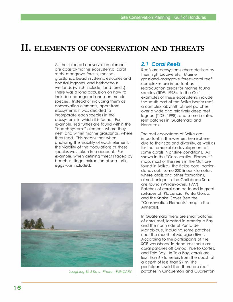
2.1 Coral ReefsReefs are ecosystems characterized bytheir high biodiversity. Marinegrassland–mangrove forest–coral reefcomplexes are important asreproduction areas for marine faunaspecies (TIDE, 1998). In the Gulf,examples of these ecosystems includethe south part of the Belize barrier reef,a complex labyrinth of reef patchesover a wide and relatively deep reeflagoon (TIDE, 1998); and some isolatedreef patches in Guatemala andHonduras.
The reef ecosystems of Belize areimportant in the western hemispheredue to their size and diversity, as well asfor the remarkable development ofsome corals in pristine conditions. Asshown in the “Conservation Elements”map, most of the reefs in the Gulf arefound in Belize. The Belize coral barrierstands out: some 220 linear kilometerswhere atolls and other formations,almost unique in the Caribbean Sea,are found (Windevoxhel, 1997).Patches of coral can be found in greatsurfaces off Placencia, Punta Gorda,and the Snake Cayes (see the“Conservation Elements” map in theAnnexes).
In Guatemala there are small patchesof coral reef, located in Amatique Bayand the north side of Punta deManabique, including some patchesnear the mouth of Motagua River.According to the participants of theSCP workshops, in Honduras there arecoral patches off Omoa, Puerto Cortés,and Tela Bay. In Tela Bay, corals areless than 6 kilometers from the coast, ata depth of less than 27 m. Theparticipants said that there are reefpatches in Cincuentón and Cuarentón,Laughing Bird Key. Photo: FUNDARY
Site Conservation Planning Gulf of Honduras
1717171717
represent almost the whole reefcover of the Gulf.
Due to the natural effect ofhurricanes, added to the increasein seawater temperature, coralbleaching is present in a highpercentage of the corals in theBelizean continental platform,between 2 and 4 meters deep; itsrecuperative capacity is unknown.Also, algae cover is greater than itused to be. In general, the coralsmost resistant to bleaching are theones in the greatest depths, onwalls, and close to outcroppings,where there is less direct sunlightand temperatures are low. Anatural reef quality gradient exists:from best in the Belizean part of theGulf, to worst in Guatemala andHonduras. Therefore, a goodcondition is based both on healthand distribution.
¨ Landscape context: Good. There isgreat representation of non-fragmented reefs in the south ofBelize. The rest of reefs are naturallyseparate, and their connection isfor the most part by means ofmarine currents. The corals to thesouth are product of the large areain Belize, so all corals in the Gulf ofHonduras are recognized as asingle system.
Stresses (Global Value: high)
¨ Habitat destruction and conversion:Medium. High severity, low extent.In the Sapodilla Cayes there isphysical damage, and evendestruction, of coral reefs byanchors dropped on the reefs andby tourists collecting pieces assouvenirs. Also, constructions in theBelize Cayes have caused coralreef destruction and conversion.
¨ Sedimentation: Medium. Highseverity, medium extent.
off Río Quehueche, off La Guaira, TiranaGú Los Altares (near Bajo de Heredia), inEl Pulpo, Langua, Faro Blanco, and FaroRojo. They also said that there are coralsat approximately 72 kilometers off thecoast, at depths between 36 and 90 m.
Participants of the first workshopemphasized the importance of reefswhere spawning aggregations takeplace, because these sites sustain thefisheries of several places. For example,Gladden Spit is a site in the south of Belizewhere several snapper and grouperspecies spawn, and where whale sharksfeed.
Endangered species associated to thereefs include the whale shark (Rhincodontypus), the bottlenose dolphin (Tursiopstruncatus), the Atlantic spotted dolphin(Stenella frontalis), and the following seaturtles: green (Chelonia mydas),leatherback (Dermochelys coriacea),hawksbill (Eretmochelys imbricata), andloggerhead (Caretta caretta).Commercial species include: lobster(Panulirus argus), queen conch (Strombusgigas), crabs (Calianactus sp.), tarpon(Megelops atlantica), grouper(Epinephelus sp.), jack (familyCarangidae), snapper (familyLutjanidae), dolphinfish (Coryphainahippurus), mackerel (family Scombridae),and bonefish (Albula vulpes). Snapperand cubera snapper (family Lutjanidae)are fished in the rocky corals ofGuatemala.
Viability (Global Value: good)
¨ Size: Good. The largest coral reefareas are in Belize, with some inGuatemala and some off theHonduran coast.
¨ Condition: Good, in general. InGuatemala and Honduras thecondition of the reefs is poor, but theyare represented in the whole area. InBelize, the reef system is big and itscondition good, and these reefs

1818181818
Site Conservation Planning Gulf of Honduras
There is much sedimentation at themouths of the Motagua River inGuatemala and the Ulúa andChamelecón rivers in Honduras,caused in large part by intensiveagriculture in the Motagua and Sulavalleys. Sediments transported by RíoUlúa travel all the way to the reef offTela Bay and the Punta Sal reefs.There is less sedimentation in Belizethan in the other two countries.
¨ Habitat perturbation: High. Highseverity, very high extent. Tourism is asource of physical perturbation of thecoral reefs. In Placencia, Belize,remains of corals can be seen. Thereare places where black coral islooted to make tourist artifacts.
¨ Altered composition and structure:High. Very high severity, high extent.Natural events like hurricanes andclimate change (which causes coralbleaching in shallow areas) affect thecoral reefs. The elimination of somepredators (such as groupers) affectsthe whole system.
Sources of stress (Global Value: high)
¨ Tourism development: High. Touristsand tour operators drop anchors onthe reef, ripping pieces off, and theybuild in sensitive areas such as theBelize Cayes.
¨ Climate change: High. The effectof climate change is seen in thebleaching of corals, which hashappened throughout the wholedistribution of reefs, especiallyaffecting corals in shallow waters.The recuperative capacity of coralsis yet unknown.
¨ Inappropriate agricultural andanimal farming practices: Medium.These include banana, Africanpalm, sugarcane, and melonplantations in the Sula valley(Honduras) and the Motagua valley(Guatemala). In the department ofIzabal, Guatemala, cattle raisers digdrainage ditches to dry swamps,which cause sedimentation. Also,shrimp and citric fruit farms inPlacencia contribute to thecontamination and sedimentationof waters.
¨ Inappropriate fishing practices:High. Includes the use of illegalfishing methods (such as harpoons),use of gill nets and dragnets,uncontrolled industrial fishing,indiscriminate capture ofaccompanying fauna, fishingduring no take seasons and in no-take areas, illegal cross-borderfishing, and fishing in spawningaggregations.
Viability Value Stresses Value Sources of stress Value Size Good Habitat destruction Medium Tourism development High Condition Good Sedimentation Medium Climate change High Landscape context Good Habitat perturbation High Inappropriate agricultural and
animal farming practices Medium
Altered composition and structure High Inappropriate fishing practices High Global Value Good Global Value High Global Value High
Table 1. Hierarchical values for viability, stresses, and sources of stress for coral reefs

Site Conservation Planning Gulf of Honduras
1919191919
2.2 Mangrove Forests
Mangrove forests constitute veryparticular forest ecosystems, becausemangroves are facultative halophyteplants that grow in environments underthe influence of continuous tidefluctuation. They possess adaptationsthat make them highly competitive inenvironments where other plants cannotsubsist.
Mangroves are particularly important inecologic terms, because they providehabitats or banks for crustaceans,mollusks, and fish; wintering habitat formigratory birds; and habitat for residentbirds, reptiles, and mammals.
Along the Gulf, in the islands, estuaries,and coastal lagoons that are under theinfluence of tidal fluctuation, mangroveforests can be seen growing, with relativeabundance of different genera.
The dominant species is red mangrove(Rhizophora mangle); there is a smallerproportion of black mangrove(Avicennia germinans), white mangrove(Laguncularia racemosa), andbuttonwood mangrove (Conocarpuserectus). The mangrove forests of theGulf can be classified as riverine, littoral,and insular mangrove forests.
As the “Conservation Elements” mapshows (see the Annexes), there aremangrove forests in almost the wholesouth coast of Belize, especially inPlacencia, Port Honduras, and the banksof the main rivers: Deep, Sarstoon, andTemash.
According to Yáñez-Arancibia et al.(1999), an analysis of aerial photographsand satellite images has shown thatmangrove forests colonize 91.9 Km of theCaribbean coast of Guatemala (which issome 185 Km long).
There are approximately 707 Ha ofmangrove forests in La Graciosa Bay,Canal Inglés, Cocolías, Sarstún, Puntade Palma, and Amatique Bay. InHonduras, mangrove forests surroundall the coastal lagoons, being moreabundant in De Alvarado Lagoon, DeLos Micos Lagoon in the JeannetteKawas National Park, Laguna Negra inTela, and the Punta Izopo NationalPark. The largest mangrove forestregion in the Gulf is the Sarstún-Temashbi-national (Belize-Guatemala) area.
Endangered species associated tomangrove forests include West Indiesmanatee (Trichechus manatus),American crocodile (Crocodylusacutus), ducks (Dendrocygnaautomnalis and Anas discor), greatcurassow (Crax rubra), and capuchin,howler, and spider monkeys (Cebuscapucinus, Allouatta pigra, and Atelesgeoffroyi).
The main commercial species includequeen conch (Strombus gigas), crownconch (Melongena sp.), shrimp(Penaeus spp.), crabs (Calianactus sp.),tarpon (Megelops atlantica), grouper(Epinephilas sp.) and snapper (familyLutjanidae).
Laguna de Los Micos, Jeannette Kawas National ParkPhoto: FUNDARY

2020202020
Site Conservation Planning Gulf of Honduras
Viability (Global Value: good)
¨ Size: Good. The size is consideredgood, because there are mangroveforests in all the places mentionedabove, but there is fragmentation insome sites caused by humanactivities. Guatemala has lessmangrove forest cover than Belizeand Honduras.
¨ Condition: Good. The condition ofthe mangrove is good, since there isrepresentation in all the area.
¨ Landscape context: Fair. There existstresses (such as fragmentation andhabitat conversion) on the mangroveforests and coastal forests thatdiminish connectiveness.
Stresses (Global Value: high)
¨ Habitat destruction and conversion:High. High severity, high extent.Higher in Guatemala and Hondurasthan in Belize. For example, inHonduras the development ofinfrastructure and agriculturalplantations have caused destructionand conversion of the mangroveforests.
¨ Habitat fragmentation: High. Highseverity and high extent. Mangroveforests have been fragmented in thecoastline of Guatemala in Sarstúnand Punta de Palma, because of thebuilding of chalets and the expansionof coastal communities. In Río Dulceand El Golfete there are patches ofmangrove forest, but veryfragmented by constructions. InHonduras, there is fragmentationbecause of the construction of theroad that connects Guatemala withPuerto Cortés. In Belize there isfragmentation because of theconstruction of the south road.
¨ Habitat perturbation: Medium.
Medium severity, high extent.Perturbation is related to theecosystem function of mangroveforests. They are not highlyperturbed – they still function asecologic niches for the feeding andreproduction of certain species, butsome species stop behaving in anatural manner. Human activitiessuch as fishing, hunting, and boattraffic can displace certain species,or change their behavior.
¨ Altered composition and structure:Medium. Medium severity, mediumextent. The horizontal and verticalstructure of mangrove forests hasbeen altered by the extraction offirewood (roots and branches), andby the construction of infrastructureand the expansion of agriculturalareas. The fragmentation alters thestructure of mangrove forests, andthat degrades niches for bird,mammal, and other species.
¨ Nutrient overload: Medium.Medium severity, high extent.Caused by agricultural practices,such as the use of fertilizers in ricecrops in Honduras; wastewater; andsolid wastes, especially in the citiesof Puerto Barrios and Puerto Cortés.
Sources of stress (Global Value: high)
¨ Inappropriate agricultural andanimal farming practices: High.These forest ecosystems are beingthreatened by tree cutting forfirewood, construction, and by thechange of land use (Espinal, 1994).The latter is caused by productiveactivities, such as intensive andsubsistence agriculture, cattleraising, and aquaculture.
¨ Pollution by wastewater and solidwastes: Medium. Includes the lackof management of wastewater andsolid wastes in coastal cities andcommunities.

Site Conservation Planning Gulf of Honduras
2121212121
¨ Urban development and accessroads: High. Expansion of coastalcities and communities, andconstruction of the south road inToledo, Belize, and the road betweenPuerto Cortés and Izabal, Guatemala.
¨ Development of industrialinfrastructure: High. Expansion of theports.
¨ Tourism development: High. Thedevelopment of tourism infrastructure(hotels, restaurants, country houses,marinas, and private piers) affects themangrove forests systems.
¨ Selective extraction of timber andfirewood: Medium. In El Triunfo andin Laguna Negra, Honduras,community people extract mangroveto make charcoal.
¨ Wildlife poaching: Medium. WestIndies manatee, great curassow, andother species are illegally hunted.
¨ Maritime transportation: Low. Thefrequent passage of ships and boatsalong the maritime transportationroutes contributes to habitatperturbation.
Table 2. Hierarchical values for viability, stresses, and sources of stress for mangroveforests
Viability Value Stresses Value Sources of stress Value
Size Good Habitat destruction High Inappropriate agricultural and animal farming practices High
Condition Good Habitat fragmentation High Contamination by solid wastes Medium Landscape context Fair Habitat perturbation Medium Urban development and access roads High
Altered composition and structure Medium Development of industrial infrastructure High
Nutrient overload Medium Tourism development High
Selective extraction of timber and firewood Medium
Wildlife poaching Medium Maritime transportation Low Global Value Good Global Value High Global Value High

2222222222
Site Conservation Planning Gulf of Honduras
2.3 Marine grasslands
Marine grasslands are marine ecosystemscomposed of aquatic plants of theSyringodium and Thalassia genera(FUNDARY, 2001 and TIDE, 1998),colonized by stable and tranquil (withoutmuch wave motion) sediments in shallowwaters, with high transparency andintermediate salinity. Marine grasslandsare frequently associated to coral reefs.They constitute biotic systems with a highrelevance as producers in the trophicchain. They serve as important breedingareas for many fish and invertebratespecies, and they provide importantfeeding habitat for the sea turtles of theGulf.
In the Gulf, the dominant species isThalassia testudinum, but patches ofHalodule wrigthii and Syringodiumfiliforme can also be found. There areapproximately 15 Ha of Vallisneriaamericana in El Golfete (Yáñez-Arancibia et al., 1999).
According to the “ConservationElements” map (see the Annexes), thelargest marine grasslands are found offthe coast of Belize and around thebarrier reefs and reef patches, to adepth of approximately 5 meters.In Guatemala, there are approximately3,750 Ha of marine grasslands in thecentral and eastern parts of AmatiqueBay and La Graciosa Bay (ibid.).
There are also patches in LagunaGrande in Sarstún, to the south of themouth of Río Sarstún, in El Golfete,Bahía Santo Tomás, the mouth of RíoSan Carlos and Punta de Palma, andthe north side of Punta de Manabique.In the north coast of Honduras, thereare marine grasslands between Omoaand Chachaguala, in the JeannetteKawas National Park and in Tela Bay.
Endangered species associated withmarine grasslands include West Indiesmanatee (Trichechus manatus),bottlenose and Atlantic spotteddolphins (Tursiops truncatus, Stenellafrontalis), and the following sea turtles:green (Chelonia mydas), leatherback(Dermochelys coriacea), hawksbill(Eretmochelys imbricata), andloggerhead (Caretta caretta).
Commercial species include lobster(Panulirus argus), queen conch(Strombus gigas), crown conch(Melongena sp.), shrimp (Penaeus spp.),crabs (Calianactus sp.), anchovy(Anchoa sp.), tarpon (Megelopsatlantica), and bonefish (Albulavulpes).
Viability (Global Value: good)
¨ Size: Good. Marine grasslands arerepresented in all the Gulf ofHonduras, and they have areaslarge enough to ensure theirrecuperation.
Bahía La Graciosa, APE Punta de Manabique.Photo: FUNDARY
Site Conservation Planning Gulf of Honduras
2323232323
¨ Condition: Good. In Honduras,specifically in Omoa, marine grassesare suffering a disease that begins atthe tips of the leaves and extendstowards the stems. Sedimentation isalso affecting the grasslands. It is afactor that inhibits connectiveness.
¨ Landscape context: Fair. The diseasethat affects the grasses is fragmentingand inhibiting the connectiveness,and can constitute a threat.
Stresses (Global Value: medium)
¨ Sedimentation: Low. Low severity,very high extent. It diminishesphotosynthesis of the marine grassesand causes deposition. InGuatemala, severity is moderate,because the marine grasslands arewithin Amatique Bay, while thegreatest sources of sedimentation arethe rivers, especially Motagua River.Anyhow, sediment deposits fromdredging are high. In Belize, theeffect of sediments in the river mouthsis low. The marine grassland sites thatare affected by sedimentation areManabique and Río Dulce. Inconclusion, the effect ofsedimentation is low, becausesediments disperse before reachingthe marine grasslands.
¨ Habitat perturbation: High. Highseverity, high extent. The speed ofmarine grassland restoration isunknown. Grasses are destroyed bydragnets used by shrimp boats,mainly in Amatique Bay and in theBelize Cayes, off Placencia. Theseverity of habitat perturbation is highbecause the nets completely pull outsome grasses.
Currently there is not as much fishingin the coast as before, because thereare no white shrimp. Therefore, fishingoccurs in deeper waters, andgrasslands are not very degraded.
¨ Contamination by toxic substances:Medium. High severity, mediumextent. It is a current and also apotential stress. Contaminationoccurs when ships empty theirtanks, when ships are painted,when small spills take place, and byinappropriate disposal of used oiland other toxic substances in theports of the Gulf.
As a potential stress, it is speculatedthat the effect of a possible oil (orother toxic substance) spill couldhave a high extent, depending onthe location and size of the spill andthe strength of the marine currents.
¨ Altered composition and structure:High. High severity, very highextent.
There is a change in the structure ofthe marine grasslands, due to theoverfishing of conch, sea turtles(green, especially), West Indiesmanatee, fish, mollusks, andcrustaceans that spend part of theirlives in the grasslands. The extent isvery high because there are nosites in the Gulf that have not beenaffected by this stress.
Sources of stress (Global Value: high)
¨ Inappropriate agricultural andanimal farming practices: Low.
This source of stress is a combinationof intensive and subsistenceagriculture, and cattle raisingpractices. Intensive agriculture isresponsible for contamination bytoxic substances.
¨ Tourism development: Low. Manyowners remove marine grass andsubstitute it with sand, to createartificial beaches or to extendexisting beaches.
2424242424
Site Conservation Planning Gulf of Honduras
¨ Inappropriate fishing practices: High.The overexploitation of conch andother species alters the structure andcomposition of associated speciespopulations.
¨ Maritime transportation: Medium.Includes development of marinasand contamination from spills. The riskof spills from the toxic materialtransportation is high.
¨ Petroleum exploration andexploitation: Low. This is a potentialthreat.
¨ Wildlife poaching: High. Contributesto altered composition and structure.Includes manatee poaching and thecapture of sea turtles in fishing nets.
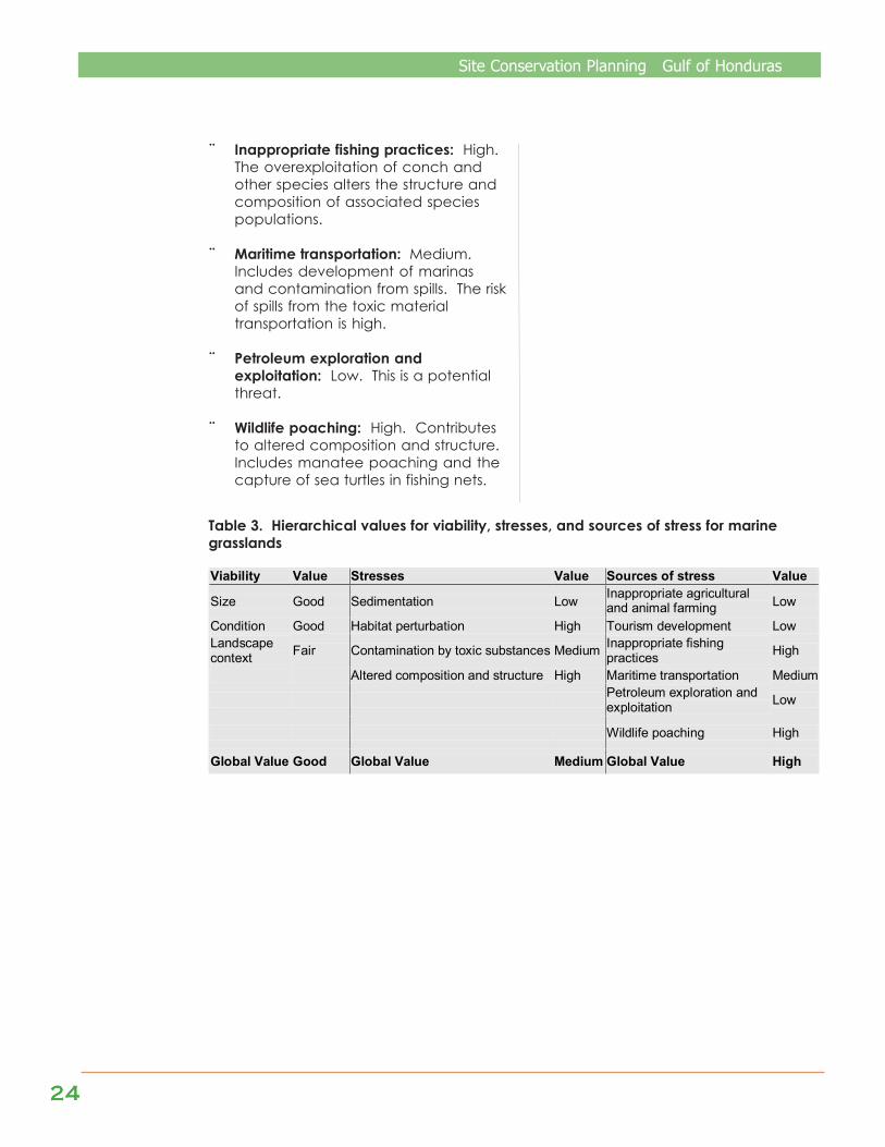
Table 3. Hierarchical values for viability, stresses, and sources of stress for marinegrasslands
Viability Value Stresses Value Sources of stress Value
Size Good Sedimentation Low Inappropriate agricultural and animal farming Low
Condition Good Habitat perturbation High Tourism development Low Landscape context Fair Contamination by toxic substances Medium Inappropriate fishing
practices High
Altered composition and structure High Maritime transportation Medium
Petroleum exploration and exploitation Low
Wildlife poaching High
Global Value Good Global Value Medium Global Value High
Site Conservation Planning Gulf of Honduras
2525252525
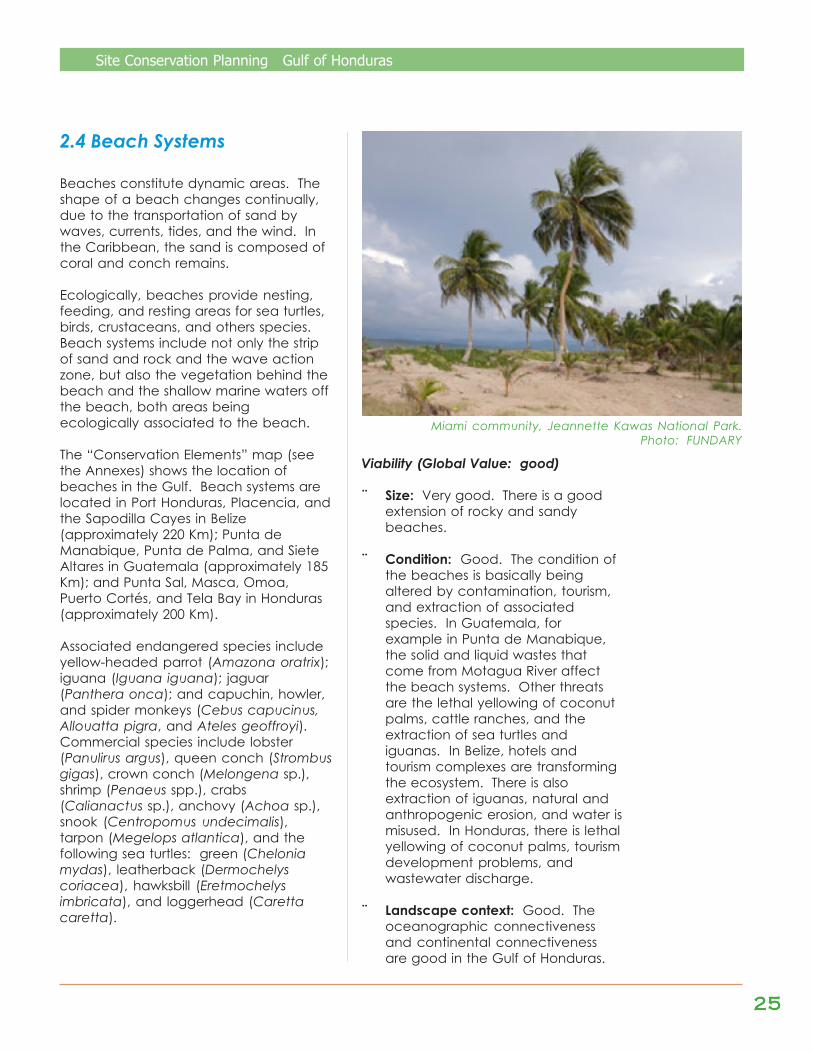
2.4 Beach Systems
Beaches constitute dynamic areas. Theshape of a beach changes continually,due to the transportation of sand bywaves, currents, tides, and the wind. Inthe Caribbean, the sand is composed ofcoral and conch remains.
Ecologically, beaches provide nesting,feeding, and resting areas for sea turtles,birds, crustaceans, and others species.Beach systems include not only the stripof sand and rock and the wave actionzone, but also the vegetation behind thebeach and the shallow marine waters offthe beach, both areas beingecologically associated to the beach.
The “Conservation Elements” map (seethe Annexes) shows the location ofbeaches in the Gulf. Beach systems arelocated in Port Honduras, Placencia, andthe Sapodilla Cayes in Belize(approximately 220 Km); Punta deManabique, Punta de Palma, and SieteAltares in Guatemala (approximately 185Km); and Punta Sal, Masca, Omoa,Puerto Cortés, and Tela Bay in Honduras(approximately 200 Km).
Associated endangered species includeyellow-headed parrot (Amazona oratrix);iguana (Iguana iguana); jaguar(Panthera onca); and capuchin, howler,and spider monkeys (Cebus capucinus,Allouatta pigra, and Ateles geoffroyi).Commercial species include lobster(Panulirus argus), queen conch (Strombusgigas), crown conch (Melongena sp.),shrimp (Penaeus spp.), crabs(Calianactus sp.), anchovy (Achoa sp.),snook (Centropomus undecimalis),tarpon (Megelops atlantica), and thefollowing sea turtles: green (Cheloniamydas), leatherback (Dermochelyscoriacea), hawksbill (Eretmochelysimbricata), and loggerhead (Carettacaretta).
Viability (Global Value: good)
¨ Size: Very good. There is a goodextension of rocky and sandybeaches.
¨ Condition: Good. The condition ofthe beaches is basically beingaltered by contamination, tourism,and extraction of associatedspecies. In Guatemala, forexample in Punta de Manabique,the solid and liquid wastes thatcome from Motagua River affectthe beach systems. Other threatsare the lethal yellowing of coconutpalms, cattle ranches, and theextraction of sea turtles andiguanas. In Belize, hotels andtourism complexes are transformingthe ecosystem. There is alsoextraction of iguanas, natural andanthropogenic erosion, and water ismisused. In Honduras, there is lethalyellowing of coconut palms, tourismdevelopment problems, andwastewater discharge.
¨ Landscape context: Good. Theoceanographic connectivenessand continental connectivenessare good in the Gulf of Honduras.
Miami community, Jeannette Kawas National Park.Photo: FUNDARY

2626262626
Site Conservation Planning Gulf of Honduras
There exists connectiveness betweenthe beaches and other ecosystemsby means of marine currents and thetransportation of river sand. However,the continental connectiveness isbeing threatened by the cultivationof African palm and by tourismdevelopment.
Stresses (Global Value: high)
¨ Beach erosion: Medium. Highseverity, medium extent. Drainageditches, dikes, sea walls, andbreakwaters have been built.Hurricanes have contributed highly toerosion, which is irreversible. There isbeach erosion in Cortés, MonkeyRiver, the Sapodilla Cayes, the southof Manabique, between Punta dePalma and Santa María, and inBajamar (in the Chamelecón Riversandbar) in Honduras.
¨ Habitat fragmentation: High. Highseverity, very high extent. It is duemainly to urban development,tourism development, andinappropriate agricultural and animalfarming practices. For example, theconstruction of houses (countryhouses and the expansion of ruralcommunities) has eliminated thevegetation behind the beaches inTela (Triunfo de la Cruz, Ensenada,Tela, Tornabé, and San Juan),between Puerto Cortés and Tulián,from Omoa to the Guatemalanborder, in Punta de Manabique, andin Placencia.
¨ Altered composition and structure:High. High severity, very high extent.Poaching iguanas, sea turtle eggs,parrots, and other species associatedto beaches has had a negativeimpact on their populations. Iguanasare hunted in the beaches of Tela,Omoa, and Punta de Manabique.Toucans are hunted in Tela, Omoa,and Manabique.
There is poaching of monkeys inBajamar and Cerro Cardona (to theeast of Puerto Cortés). Parrots arehunted in Omoa and Manabique.Shrimp and lobster are overfishedoff the beaches of Tela, as arecrabs in Puerto Cortés. InGuatemala, the overfishing ofanchovy (Achoa sp.) occursbetween San Francisco del Mar andCabo Tres Puntas, and in EsteroLagarto, Pichilingo, Punta de Palma,and Santa María. Sea turtle eggsare illegally collected betweenQuetzalito and San Francisco delMar.
¨ Nutrient overload: High. Highseverity, high extent. It is due mainlyto urban development, with a highand irreversible contribution, due tothe high cost of reversion. It occursin Cortés, Tela, and Manabique,through the mouths of the Ulúa,Chamelecón, and Motagua riversand the Canal Martínez.
¨ Hydrologic alteration: High. Highseverity, very high extent. Thereexists hydrologic alteration causedby sand extraction. Also, thedegradation of watersheds affectsthe speed, direction, and salinity ofmarine water streams and thataffects the beaches. For example,there are strong discharges of freshwater after the rains, and nowatershed recuperation has beenobserved after Hurricane Mitch. Inhydrologic alteration, thecontribution is medium, and theirreversibility is also medium. There ishydrologic alteration in the riversTinto, Ulúa, Chamelecón, Tulián,Omoa, Masca, Motagua,Chachaguala, and Cuyamel.
¨ Contamination by toxic substances:High. High severity, high extent.Includes contamination byagrochemicals, solid wastes, andship wastes.
Site Conservation Planning Gulf of Honduras
2727272727
Sources of stress (Global Value: veryhigh)
¨ Urban development and accessroads: Very high. Causes theelimination or fragmentation ofvegetation behind the beaches.
¨ Maritime transportation: High. Theconstruction of breakwaters and seawalls has a reduced contribution tothe stress of erosion, because it is nota highly generalized practice and isreversible, using legislation. Forhabitat fragmentation, it provides amedium contribution and mediumirreversibility. For composition andstructure, the sea walls alter thecurrents where they are placed, butthe impact is low throughout the Gulf.
¨ Climate change: High. The sea levelincrease due to climate change iscontributing highly to the erosion ofbeaches. In the case of Belize,beaches have almost been lost. Thesea level is expected to increasebetween 2 and 6 millimeters eachyear, equivalent of up to 6centimeters in 10 years.
¨ Tourism development: High. Tourisminfrastructure (hotels, country houses,and / or piers) has been built inalmost all the beaches of the Gulf. Inhabitat fragmentation, thecontribution of tourism development
Table 4. Hierarchical values for viability, stresses, and sources of stress for beachsystems
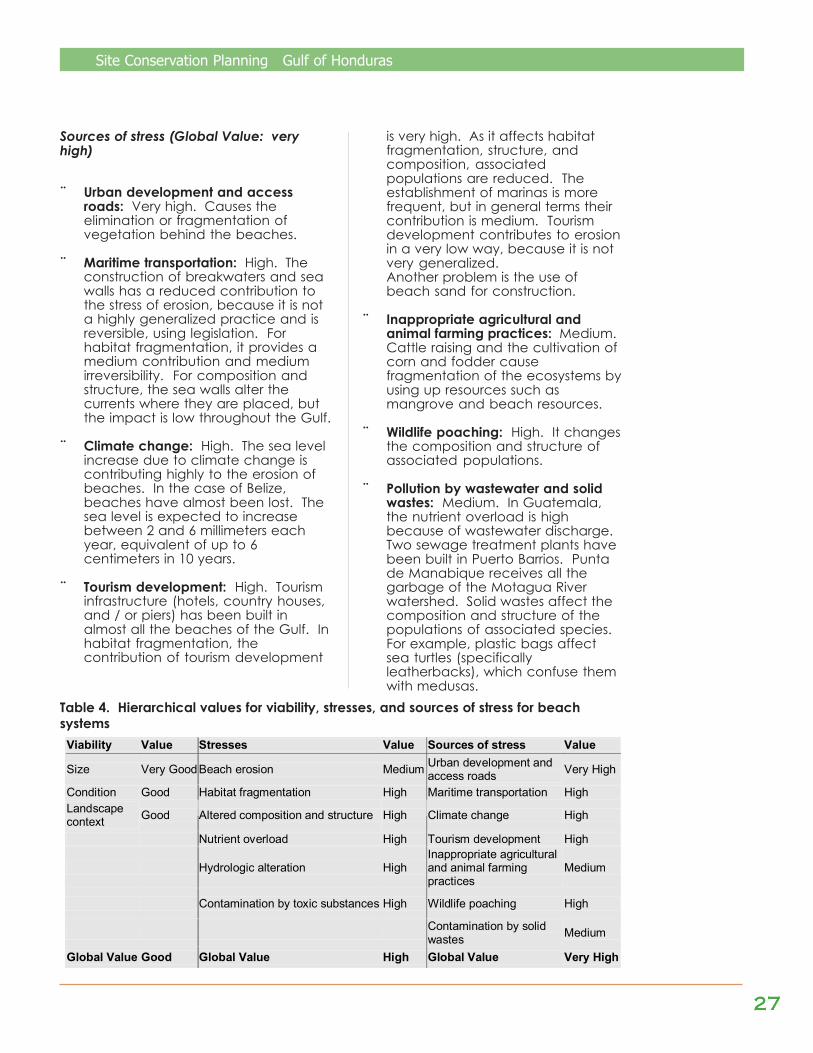
Viability Value Stresses Value Sources of stress Value
Size Very Good Beach erosion Medium Urban development and access roads Very High
Condition Good Habitat fragmentation High Maritime transportation High Landscape context Good Altered composition and structure High Climate change High
Nutrient overload High Tourism development High
Hydrologic alteration High Inappropriate agricultural and animal farming practices
Medium
Contamination by toxic substances High Wildlife poaching High
Contamination by solid wastes Medium
Global Value Good Global Value High Global Value Very High
is very high. As it affects habitatfragmentation, structure, andcomposition, associatedpopulations are reduced. Theestablishment of marinas is morefrequent, but in general terms theircontribution is medium. Tourismdevelopment contributes to erosionin a very low way, because it is notvery generalized.Another problem is the use ofbeach sand for construction.
¨ Inappropriate agricultural andanimal farming practices: Medium.Cattle raising and the cultivation ofcorn and fodder causefragmentation of the ecosystems byusing up resources such asmangrove and beach resources.
¨ Wildlife poaching: High. It changesthe composition and structure ofassociated populations.
¨ Pollution by wastewater and solidwastes: Medium. In Guatemala,the nutrient overload is highbecause of wastewater discharge.Two sewage treatment plants havebeen built in Puerto Barrios. Puntade Manabique receives all thegarbage of the Motagua Riverwatershed. Solid wastes affect thecomposition and structure of thepopulations of associated species.For example, plastic bags affectsea turtles (specificallyleatherbacks), which confuse themwith medusas.

2828282828
Site Conservation Planning Gulf of Honduras
2.5 Estuaries and CoastalLagoonsEstuaries are complex aquatic systemswhere seawater and freshwater mix.They are directly influenced by tidalfluctuation: the extension of brackishwater varies during the rainy and dryseasons. They are high biodiversityecosystems, which receive nutrients fromthe watersheds. Lankford (1977) definesa coastal lagoon as a “depression of thecoastal zone, below the average of thehighest tides, having a permanent orephemeral communication with the sea,but protected from the sea by some typeof barrier.”
The “Conservation Elements” map (seeAnnexes) shows the location of theestuaries and coastal lagoons in the Gulf.The estuaries are found in the mouths ofthe principal rivers, such as Monkey River,Deep River, Río Temash, Sarstún, RíoDulce, Bahía Santo Tomás, Río Pichilingo,La Graciosa Bay and Canal Inglés, andthe rivers San Francisco, Motagua, Ulúa,Chamelecón, Coto, Frío, Tulián, andCuyamel. The number and size ofcoastal lagoons is larger in Belize, thenHonduras, followed last by Guatemala.In Belize there are coastal lagoons inPlacencia, Monkey River, and PuntaYcacos.
In Honduras lagoons include DeAlvarado, De los Micos, DeChachaguala, De los Diamantes,Verde, Negra, Río Tinto, De Cintino, andDe Jaloa. Finally, in Guatemala, thelagoons are Laguna Grande in Sarstún,Verde in Punta de Palma, Santa Isabel,Escondida, Estero Lagarto, Quetzalito,Chocón Machacas, Cocolí, SanFrancisco, and Jabalí.
It is important to mention the presenceof West Indies manatee (Trichechusmanatus) in these systems: it has beenseen in Port Honduras, Río Sarstún, ElGolfete, La Graciosa Bay, the mouth ofMotagua River, and in various coastallagoons of Honduras.
Also to be found here are the Americancrocodile (Crocodylus acutus),bottlenose and Atlantic spotteddolphins (Tursiops truncatus andStenella frontalis), and ducks(Dendrocygna automnalis and Anasdiscor). Commercial species associatedwith these ecosystems include crownconch (Melongena sp.), shrimp(Penaeus spp.), crabs (Calianactus sp.),anchovy (Anchoa sp.), snook(Centropomus undecimalis), tarpon(Megelops atlantica), jacks (familyCarangidae), snappers (familyLutjanidae), dolphinfish (Coryphaenahippurus), and mojarra (Cichlasomasp.).
Viability (Global Value: good)
¨ Size: Very good. There areextensive areas of estuaries andcoastal lagoons in the Gulf.
¨ Condition: Good. In general, thecondition of the estuaries andcoastal lagoons is considered good.In Belize, the estuaries and coastallagoons are in a good state,because the water quality is good,and because there are manyspecies present. In Guatemala,there are healthy areas andBahía de la Graciosa, APE Punta de Manabique.
Photo: FUNDARY

Site Conservation Planning Gulf of Honduras
2929292929
degraded areas. Sarstún, SantaIsabel Lagoon, and Quetzalito havelittle contamination and low resourceextraction. However, Amatique Bayand Motagua River are highlypolluted, and the lagoons of ChocónMachacas suffer vegetationextraction. In Honduras,contamination harms De AlvaradoLagoon, and there is sedimentationcaused by deforestation. De LosMicos Lagoon has mediumcontamination, but the rest of smalllagoons are in good conditions. Theestuaries are in good condition: theyare not very contaminated.
¨ Landscape context: Good. Thedegradation of watersheds causesthe degradation and disappearanceof some estuaries and coastallagoons. In Belize, there is only oneestuary (Agua Caliente) wheredegradation of the watershed affectsthe connectiveness between theestuary and the watershed. InGuatemala, the landscape context isfair, because of the watersheddegradation and the lack ofintegrated management of theMotagua, Polochic, and Sarstúnwatersheds. In Honduras, thelandscape context is good, exceptfor De Alvarado Lagoon, which ishighly affected by the degradation ofChamelecón River.
Stresses (Global Value: high)
¨ Habitat perturbation: Medium.Medium severity, high extent. Severalactivities contribute to thedegradation of estuarine habitats:use of improper fishing methods,dredging in the ports and maritimetransportation routes, deposition ofdredge residue in estuarine areas (LaGraciosa Bay), and water pollution.
¨ Sedimentation: High. High severity,high extent. Sedimentation is highdue to the change in land use,
especially in the watersheds ofGuatemala and Honduras. Themain rivers (Motagua, Ulúa, andChamelecón) produce largeplumes of sediments that stronglyaffect the areas close to theirmouths. De Alvarado Lagoonreceives sediments fromChamelecón River. Dredging hasincreased the amount of sedimentsto the south of Placencia; inGuatemala there are manysediments in the mouths of the riversMotagua, Sarstún, and Dulce, andin Santo Tomás Bay.
¨ Nutrient overload: Medium. Highseverity, medium extent. Thenutrient overload includes nitratesand phosphates carried by therivers. It comes from wastewaterfrom the cities (Puerto Barrios, SantoTomás, Puerto Cortés, Tela), andfrom the fertilizers and wastes ofagricultural and industrialcompanies. Fertilizers andwastewater pollute Río Dulce, whilea butter factory pollutes De LosMicos Lagoon.
¨ Hydrologic alteration: Medium.Medium severity, medium extent.The degradation of watershedsaffects the distribution of freshwaterover time, producing higher peaksin the rainy season (less salinity) andless flow in the dry season (highersalinity). In Honduras, the damconstructed in Río Ulúa affects thedirection of flow towards thelagoon and wetlands in Tela Bay.
¨ Habitat conversion: Low. Mediumseverity, low extent. Mangrove isextracted for firewood in thelagoons. For example, in Hondurasmuch of the mangrove forestsaround De Los Micos Lagoon andDe los Diamantes Bay have beendestroyed.
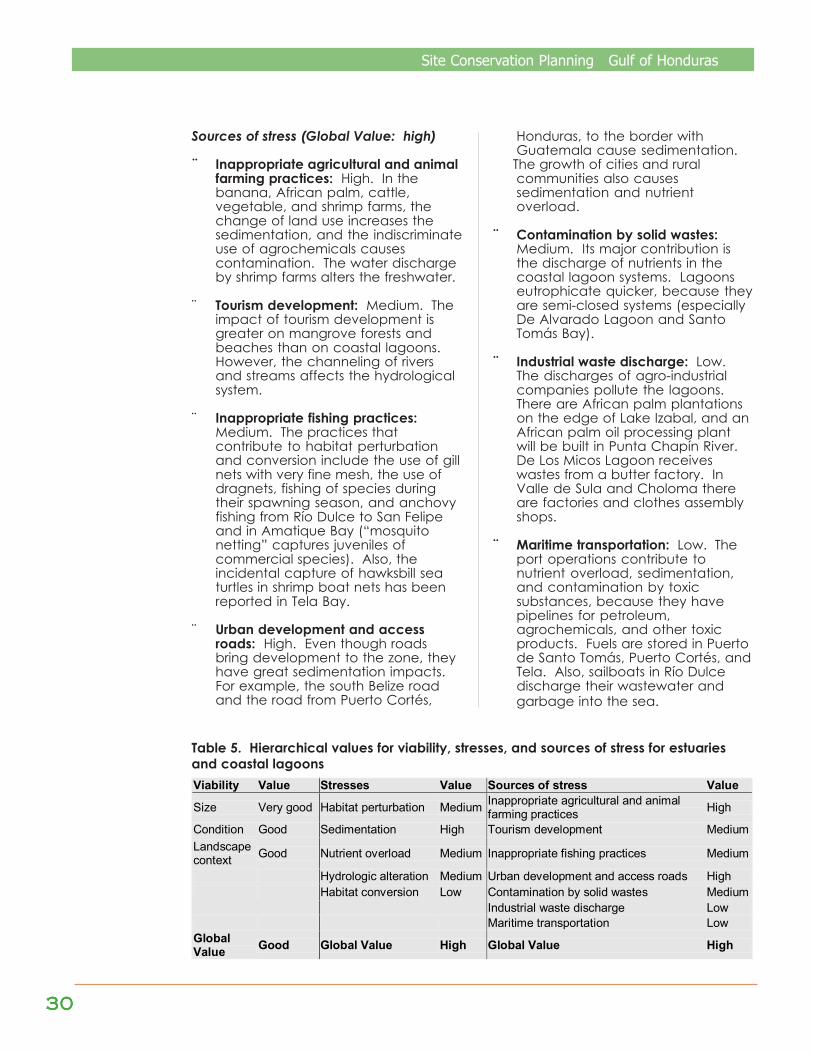
3030303030
Site Conservation Planning Gulf of Honduras
Sources of stress (Global Value: high)
¨ Inappropriate agricultural and animalfarming practices: High. In thebanana, African palm, cattle,vegetable, and shrimp farms, thechange of land use increases thesedimentation, and the indiscriminateuse of agrochemicals causescontamination. The water dischargeby shrimp farms alters the freshwater.
¨ Tourism development: Medium. Theimpact of tourism development isgreater on mangrove forests andbeaches than on coastal lagoons.However, the channeling of riversand streams affects the hydrologicalsystem.
¨ Inappropriate fishing practices:Medium. The practices thatcontribute to habitat perturbationand conversion include the use of gillnets with very fine mesh, the use ofdragnets, fishing of species duringtheir spawning season, and anchovyfishing from Río Dulce to San Felipeand in Amatique Bay (“mosquitonetting” captures juveniles ofcommercial species). Also, theincidental capture of hawksbill seaturtles in shrimp boat nets has beenreported in Tela Bay.
¨ Urban development and accessroads: High. Even though roadsbring development to the zone, theyhave great sedimentation impacts.For example, the south Belize roadand the road from Puerto Cortés,
Honduras, to the border withGuatemala cause sedimentation.
The growth of cities and ruralcommunities also causessedimentation and nutrientoverload.
¨ Contamination by solid wastes:Medium. Its major contribution isthe discharge of nutrients in thecoastal lagoon systems. Lagoonseutrophicate quicker, because theyare semi-closed systems (especiallyDe Alvarado Lagoon and SantoTomás Bay).
¨ Industrial waste discharge: Low.The discharges of agro-industrialcompanies pollute the lagoons.There are African palm plantationson the edge of Lake Izabal, and anAfrican palm oil processing plantwill be built in Punta Chapín River.De Los Micos Lagoon receiveswastes from a butter factory. InValle de Sula and Choloma thereare factories and clothes assemblyshops.
¨ Maritime transportation: Low. Theport operations contribute tonutrient overload, sedimentation,and contamination by toxicsubstances, because they havepipelines for petroleum,agrochemicals, and other toxicproducts. Fuels are stored in Puertode Santo Tomás, Puerto Cortés, andTela. Also, sailboats in Río Dulcedischarge their wastewater andgarbage into the sea.
Table 5. Hierarchical values for viability, stresses, and sources of stress for estuariesand coastal lagoonsViability Value Stresses Value Sources of stress Value
Size Very good Habitat perturbation Medium Inappropriate agricultural and animal farming practices High
Condition Good Sedimentation High Tourism development Medium Landscape context Good Nutrient overload Medium Inappropriate fishing practices Medium
Hydrologic alteration Medium Urban development and access roads High Habitat conversion Low Contamination by solid wastes Medium Industrial waste discharge Low Maritime transportation Low Global Value Good Global Value High Global Value High

Site Conservation Planning Gulf of Honduras
3131313131
2.6 Herbaceous Wetlands,Flood forests, and theirsupporting Aquatic Systems
As the “Conservation Elements” mapshows (see the Annexes), there areherbaceous wetlands and / or floodforests in Punta de Manabique, PuertoCortés, the western part of Santo TomásBay (San Carlos), and on the eastern partof Punta Izopo. In Guatemala, Yañez-Arancibia et al. (1999) estimate thatherbaceous wetlands and flood forestscover approximately 9,261 Ha of theCaribbean coast of Guatemala, bothbeing covered by water for the greaterpart of each year. The endangeredspecies associated with the herbaceouswetlands include yellow-headed parrot(Amazona oratrix); American crocodile(Crocodylus acutus); iguana (Iguanaiguana); freshwater turtles; ducks(Dendrocygna automnalis, Anas discor);jaguar (Panthera onca); capuchin,howler, and spider monkeys (Cebuscapucinus, Allouatta pigra and Atelesgeoffroyi); tapir (Tapirus bardii); peccary(Tayassu tajacu); and great curassow(Crax rubra). The commercial speciesinclude snook (Centropomusundecimalis) and tarpon (Megelopsatlantica).
Viability (Global Value: good)
¨ Size: Good. The herbaceouswetlands and flood forests havegreater extensions than themangrove forests. In Belize they arevery good, in Guatemala good, andin Honduras fair.
¨ Condition: Good. The floodedcondition of wetlands makes accessdifficult, helping to conserve them.However, in Honduras the wetlandsare highly deteriorated; theircondition is fair. In Guatemala, thereis wood extraction for charcoal, androads have altered the secondaryforest.
¨ Landscape context: Fair. Manywetlands connected to the tropicalforests in Izabal, Guatemala, andthe north coast of Honduras, butmany of these forests have beenconverted to agricultural areas.
Stresses (Global Value: high)
¨ Habitat conversion: High. Highseverity, high extent. Theherbaceous wetlands and floodforests are highly stressed by habitatconversion, since most of them arenot protected. Healthy examplesare found only in patches with littleagricultural and cattle-raisinginterest, since their soils are not fitfor these activities.
¨ Habitat fragmentation: High. Highseverity, high extent. Much of thelow tropical forest that used to bebehind the wetlands, between 25and 500 m above sea level, hasbeen destroyed. There is also woodextraction in the flood forests, forfirewood, charcoal, andconstruction, for example inManabique and Sarstún.
¨ Hydrologic alteration: Medium.High severity, medium extent.
Polochic River Natural Wildlife RefugePhoto: FUNDARY
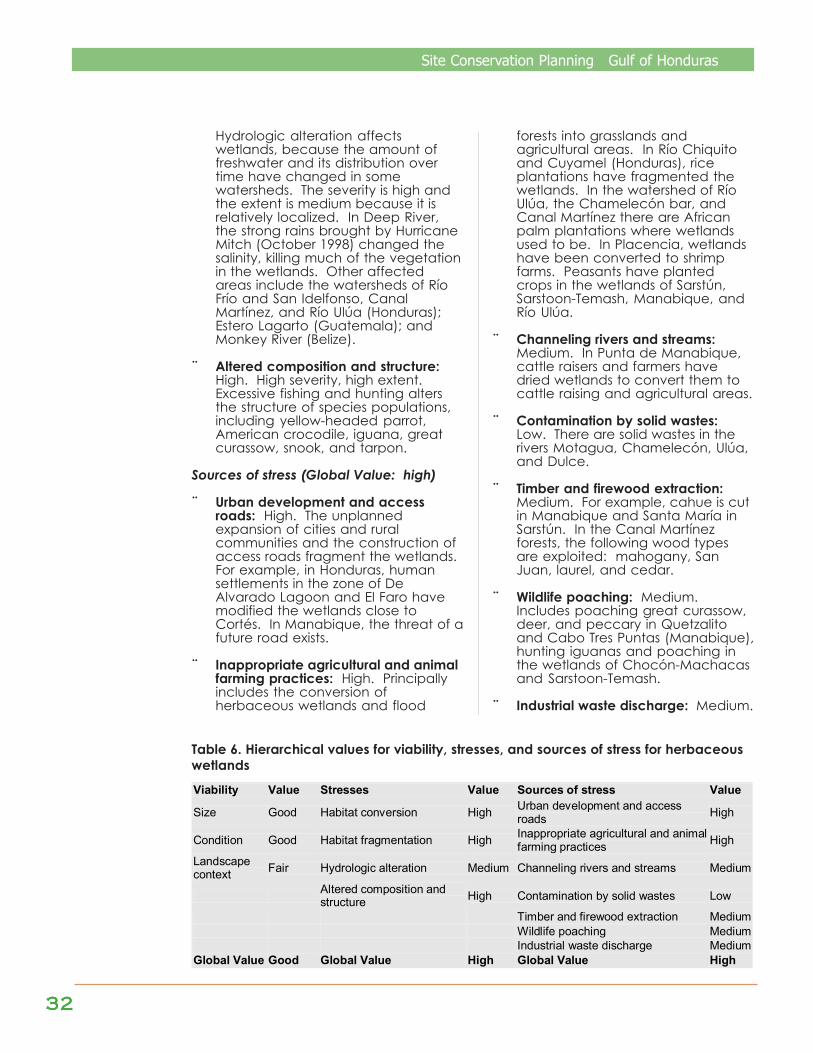
3232323232
Site Conservation Planning Gulf of Honduras
Hydrologic alteration affectswetlands, because the amount offreshwater and its distribution overtime have changed in somewatersheds. The severity is high andthe extent is medium because it isrelatively localized. In Deep River,the strong rains brought by HurricaneMitch (October 1998) changed thesalinity, killing much of the vegetationin the wetlands. Other affectedareas include the watersheds of RíoFrío and San Idelfonso, CanalMartínez, and Río Ulúa (Honduras);Estero Lagarto (Guatemala); andMonkey River (Belize).
¨ Altered composition and structure:High. High severity, high extent.Excessive fishing and hunting altersthe structure of species populations,including yellow-headed parrot,American crocodile, iguana, greatcurassow, snook, and tarpon.
Sources of stress (Global Value: high)
¨ Urban development and accessroads: High. The unplannedexpansion of cities and ruralcommunities and the construction ofaccess roads fragment the wetlands.For example, in Honduras, humansettlements in the zone of DeAlvarado Lagoon and El Faro havemodified the wetlands close toCortés. In Manabique, the threat of afuture road exists.
¨ Inappropriate agricultural and animalfarming practices: High. Principallyincludes the conversion ofherbaceous wetlands and flood
forests into grasslands andagricultural areas. In Río Chiquitoand Cuyamel (Honduras), riceplantations have fragmented thewetlands. In the watershed of RíoUlúa, the Chamelecón bar, andCanal Martínez there are Africanpalm plantations where wetlandsused to be. In Placencia, wetlandshave been converted to shrimpfarms. Peasants have plantedcrops in the wetlands of Sarstún,Sarstoon-Temash, Manabique, andRío Ulúa.
¨ Channeling rivers and streams:Medium. In Punta de Manabique,cattle raisers and farmers havedried wetlands to convert them tocattle raising and agricultural areas.
¨ Contamination by solid wastes:Low. There are solid wastes in therivers Motagua, Chamelecón, Ulúa,and Dulce.
¨ Timber and firewood extraction:Medium. For example, cahue is cutin Manabique and Santa María inSarstún. In the Canal Martínezforests, the following wood typesare exploited: mahogany, SanJuan, laurel, and cedar.
¨ Wildlife poaching: Medium.Includes poaching great curassow,deer, and peccary in Quetzalitoand Cabo Tres Puntas (Manabique),hunting iguanas and poaching inthe wetlands of Chocón-Machacasand Sarstoon-Temash.
¨ Industrial waste discharge: Medium.
Table 6. Hierarchical values for viability, stresses, and sources of stress for herbaceouswetlands
Viability Value Stresses Value Sources of stress Value
Size Good Habitat conversion High Urban development and access roads High
Condition Good Habitat fragmentation High Inappropriate agricultural and animal farming practices High
Landscape context Fair Hydrologic alteration Medium Channeling rivers and streams Medium
Altered composition and structure High Contamination by solid wastes Low
Timber and firewood extraction Medium Wildlife poaching Medium Industrial waste discharge Medium Global Value Good Global Value High Global Value High
Site Conservation Planning Gulf of Honduras
3333333333
III. CONSERVATION STRATEGIES AND ACTIONS
Stra
tegi
es to
dim
inish
thre
ats
and
incr
ease
the
via
bilit
y of
the
cons
erva
tion
elem
ents
wer
e d
efin
ed d
urin
g th
ew
orks
hops
. Fo
r ea
ch c
onse
rva
tion
elem
ent,
stra
tegi
es w
ere
prio
ritize
d a
ccor
din
g to
thei
r pot
entia
l to
miti
gate
the
thre
ats.
Usin
g th
e Ex
cel s
prea
dsh
eet f
or S
ite C
onse
rvat
ion
Plan
ning
, an
anal
ysis
was
mad
e of
the
capa
bilit
y of
eac
hst
rate
gy to
red
uce
the
stre
ss o
n ea
ch c
onse
rvat
ion
elem
ent.
The
follo
win
g ta
ble
pres
ents
the
cons
erva
tion
stra
tegi
esth
at w
ould
be
mos
t effe
ctiv
e in
red
ucin
g th
e th
reat
s th
at th
e G
ulf f
aces
. Th
e m
ost e
ffect
ive
stra
tegy
wou
ld b
e to
com
plet
e th
e tri
-na
tiona
l pro
tect
ed a
rea
s sy
stem
in th
e G
ulf.
Thi
s st
rate
gy w
ould
pro
vid
e a
very
hig
h be
nefit
to th
em
angr
ove
fore
sts
and
mar
ine
gras
sland
s, a
high
ben
efit
for c
oral
reef
s an
d h
erba
ceou
s w
etla
nds,
and
a m
ediu
mbe
nefit
for e
stua
ries
and
coa
sta
l la
goon
s.
VALU
E O
F TH
E S
TRA
TEG
Y FO
R E
ACH
SYS
TEM
OB
JEC
TIVE
S ST
RAT
EGIE
S C
oral
R
eefs
M
angr
ove
Fore
sts
Mar
ine
Gra
ss-
land
s
Bea
ch
Sys
tem
s
Est
uarie
s an
d C
oast
al
Lago
ons
Her
ba-
ceou
s w
etla
nds
GLO
BA
L ST
RAT
EGY
VA
LUE
Com
plet
e th
e G
ulf o
f Hon
dura
s pr
otec
ted
area
s sy
stem
, an
d im
prov
e th
e m
anag
emen
t and
pro
tect
ion
of th
e ar
eas
Hig
h V
ery
Hig
h V
ery
Hig
h M
ediu
m
Med
ium
H
igh
Ver
y H
igh
1. D
evel
op a
tri-n
atio
nal c
oast
al-m
arin
e pr
otec
ted
area
s sy
stem
, all
area
s ha
ving
m
anag
emen
t pla
ns, l
ong-
term
fina
ncia
l pl
ans,
and
ade
quat
e re
sour
ces
Cre
ate
mec
hani
sms
for t
he fi
nanc
ial s
usta
inab
ility
of
prot
ecte
d ar
ea m
anag
emen
t M
ediu
m
Hig
h M
ediu
m
Hig
h H
igh
Hig
h H
igh
Dev
elop
and
impl
emen
t Lan
d U
se R
egul
atio
n P
lans
an
d S
ecto
r Pla
ns
Hig
h V
ery
Hig
h M
ediu
m
Hig
h M
ediu
m
Ver
y H
igh
Ver
y H
igh
Mak
e an
d ex
ecut
e pr
otec
tion
plan
s fo
r end
ange
red,
and
ec
onom
ical
ly im
port
ant,
spec
ies
Hig
h H
igh
Hig
h H
igh
Med
ium
M
ediu
m
Hig
h
Supp
ort t
he re
gula
tion
of fi
sher
ies
and
sust
aina
ble
fishi
ng
Hig
h M
ediu
m
Hig
h Lo
w
Hig
h Lo
w
Hig
h
2. P
rom
ote
the
deve
lopm
ent o
f a
legi
slat
ive,
regu
lato
ry, a
nd in
stitu
tiona
l fra
mew
ork
com
patib
le a
mon
g th
e th
ree
coun
tries
R
evis
e, d
evel
op, a
nd e
nfor
ce, i
n a
parti
cipa
tive
man
ner,
norm
s an
d m
echa
nism
s to
regu
late
the
sust
aina
ble
use
of n
atur
al re
sour
ces
Med
ium
H
igh
Med
ium
H
igh
Med
ium
H
igh
Hig
h
3. C
onso
lidat
e ec
onom
ic a
ctiv
ities
that
are
co
mpa
tible
with
the
cons
erva
tion
of n
atur
e,
with
hig
h pa
rtici
patio
n an
d le
adin
g ro
les
by
loca
l inh
abita
nts
Prom
ote
alte
rnat
e ec
onom
ic a
ctiv
ities
in th
e lo
cal
com
mun
ities
M
ediu
m
Hig
h H
igh
Hig
h H
igh
Med
ium
H
igh
Impl
emen
t edu
catio
n, s
ensi
tizin
g, a
war
enes
s-ra
isin
g,
and
divu
lgat
ion
prog
ram
s ab
out t
he e
nviro
nmen
tal
prob
lem
s an
d th
eir s
olut
ions
with
inha
bita
nts,
reso
urce
us
ers,
and
gov
ernm
ents
Med
ium
M
ediu
m
Med
ium
M
ediu
m
Med
ium
M
ediu
m
Med
ium
4.
Dev
elop
a c
omm
unic
atio
ns s
yste
m,
perio
dic
mee
tings
, pub
licat
ions
, cap
acity
bu
ildin
g, a
nd in
ter-
inst
itutio
nal e
xcha
nges
an
d co
ordi
natio
n Im
plem
ent i
nstit
utio
nal s
treng
then
ing
prog
ram
s, a
nd
coor
dina
tion
and
citiz
en p
artic
ipat
ion
mec
hani
sms,
for
the
prot
ectio
n of
nat
ural
sys
tem
s M
ediu
m
Med
ium
M
ediu
m
Med
ium
M
ediu
m
Med
ium
M
ediu
m
Follo
win
g is
each
stra
tegy
, with
its
act
ion
pla
n a
nd a
list
of t
he th
rea
ts it
miti
gate
s
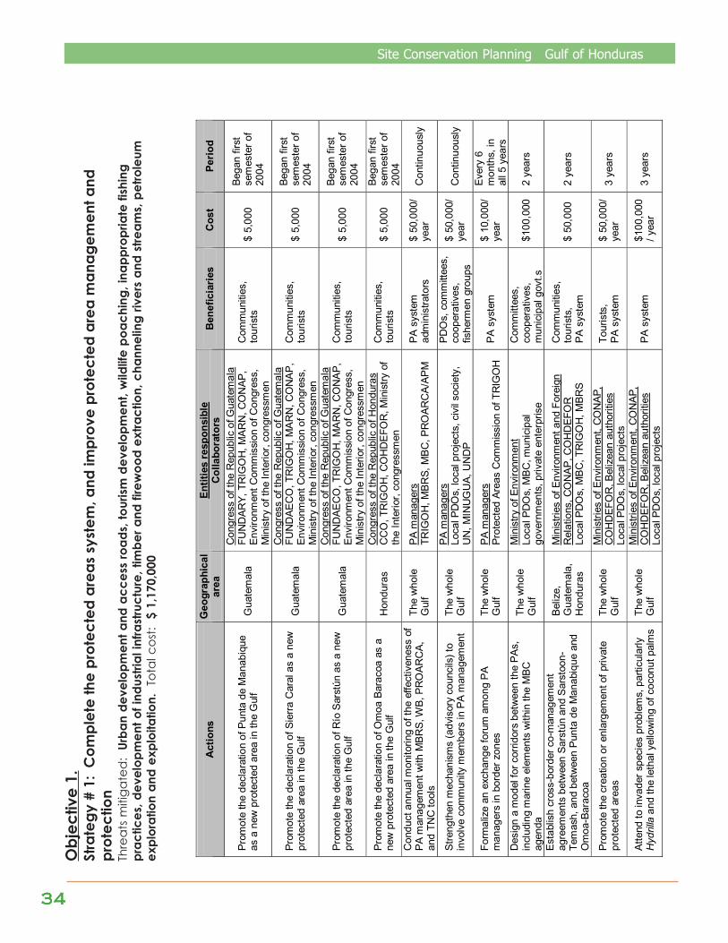
3434343434
Site Conservation Planning Gulf of Honduras
Act
ions
G
eogr
aphi
cal
area
En
titie
s re
spon
sibl
e C
olla
bora
tors
B
enef
icia
ries
Cos
t Pe
riod
Prom
ote
the
decl
arat
ion
of P
unta
de
Man
abiq
ue
as a
new
pro
tect
ed a
rea
in th
e G
ulf
Gua
tem
ala
Con
gres
s of
the
Rep
ublic
of G
uate
mal
a FU
ND
ARY,
TR
IGO
H, M
AR
N, C
ON
AP,
Envi
ronm
ent C
omm
issi
on o
f Con
gres
s,
Min
istry
of t
he In
terio
r, co
ngre
ssm
en
Com
mun
ities
, to
uris
ts
$ 5,
000
Bega
n fir
st
sem
este
r of
2004
Prom
ote
the
decl
arat
ion
of S
ierra
Car
al a
s a
new
pr
otec
ted
area
in th
e G
ulf
Gua
tem
ala
Con
gres
s of
the
Rep
ublic
of G
uate
mal
a FU
ND
AEC
O, T
RIG
OH
, MA
RN
, CO
NA
P,
Envi
ronm
ent C
omm
issi
on o
f Con
gres
s,
Min
istry
of t
he In
terio
r, co
ngre
ssm
en
Com
mun
ities
, to
uris
ts
$ 5,
000
Bega
n fir
st
sem
este
r of
2004
Prom
ote
the
decl
arat
ion
of R
ío S
arst
ún a
s a
new
pr
otec
ted
area
in th
e G
ulf
Gua
tem
ala
Con
gres
s of
the
Rep
ublic
of G
uate
mal
a FU
ND
AEC
O, T
RIG
OH
, MA
RN
, CO
NA
P,
Envi
ronm
ent C
omm
issi
on o
f Con
gres
s,
Min
istry
of t
he In
terio
r, co
ngre
ssm
en
Com
mun
ities
, to
uris
ts
$ 5,
000
Bega
n fir
st
sem
este
r of
2004
Prom
ote
the
decl
arat
ion
of O
moa
Bar
acoa
as
a ne
w p
rote
cted
are
a in
the
Gul
f H
ondu
ras
Con
gres
s of
the
Rep
ublic
of H
ondu
ras
CC
O, T
RIG
OH
, CO
HD
EFO
R, M
inis
try o
f th
e In
terio
r, co
ngre
ssm
en
Com
mun
ities
, to
uris
ts
$ 5,
000
Bega
n fir
st
sem
este
r of
2004
C
ondu
ct a
nnua
l mon
itorin
g of
the
effe
ctiv
enes
s of
PA
man
agem
ent w
ith M
BR
S, W
B, P
RO
AR
CA,
an
d TN
C to
ols
The
who
le
Gul
f PA
man
ager
s TR
IGO
H, M
BR
S, M
BC
, PR
OAR
CA/
APM
PA
sys
tem
ad
min
istra
tors
$
50,0
00/
year
C
ontin
uous
ly
Stre
ngth
en m
echa
nism
s (a
dvis
ory
coun
cils
) to
invo
lve
com
mun
ity m
embe
rs in
PA
man
agem
ent
The
who
le
Gul
f
PA m
anag
ers
Loca
l PD
Os,
loca
l pro
ject
s, c
ivil
soci
ety,
U
N, M
INU
GU
A, U
ND
P
PDO
s, c
omm
ittee
s,
coop
erat
ives
, fis
herm
en g
roup
s
$ 50
,000
/ ye
ar
Con
tinuo
usly
Form
aliz
e an
exc
hang
e fo
rum
am
ong
PA
man
ager
s in
bor
der z
ones
Th
e w
hole
G
ulf
PA m
anag
ers
Prot
ecte
d Ar
eas
Com
mis
sion
of T
RIG
OH
PA
sys
tem
$
10,0
00/
year
Ever
y 6
mon
ths,
in
all 5
yea
rs
Des
ign
a m
odel
for c
orrid
ors
betw
een
the
PAs,
in
clud
ing
mar
ine
elem
ents
with
in th
e M
BC
agen
da
The
who
le
Gul
f
Min
istry
of E
nviro
nmen
t Lo
cal P
DO
s, M
BC
, mun
icip
al
gove
rnm
ents
, priv
ate
ente
rpris
e
Com
mitt
ees,
co
oper
ativ
es,
mun
icip
al g
ovt.s
$1
00,0
00
2 ye
ars
Esta
blis
h cr
oss-
bord
er c
o-m
anag
emen
t ag
reem
ents
bet
wee
n Sa
rstú
n an
d S
arst
oon-
Tem
ash,
and
bet
wee
n P
unta
de
Man
abiq
ue a
nd
Om
oa-B
arac
oa
Bel
ize,
G
uate
mal
a,
Hon
dura
s
Min
istri
es o
f Env
ironm
ent a
nd F
orei
gn
Rel
atio
ns, C
ON
AP, C
OH
DEF
OR
Lo
cal P
DO
s, M
BC
, TR
IGO
H, M
BRS
Com
mun
ities
, to
uris
ts,
PA s
yste
m
$ 50
,000
2
year
s
Prom
ote
the
crea
tion
or e
nlar
gem
ent o
f priv
ate
prot
ecte
d ar
eas
The
who
le
Gul
f
Min
istri
es o
f Env
ironm
ent,
CO
NAP
, C
OH
DEF
OR
, Bel
izea
n au
thor
ities
Lo
cal P
DO
s, lo
cal p
roje
cts
Tour
ists
, PA
sys
tem
$
50,0
00/
year
3
year
s
Atte
nd to
inva
der s
peci
es p
robl
ems,
par
ticul
arly
Hydrilla
and
the
leth
al y
ello
win
g of
coc
onut
pal
ms
The
who
le
Gul
f
Min
istri
es o
f Env
ironm
ent,
CO
NAP
, C
OH
DEF
OR
, Bel
izea
n au
thor
ities
Lo
cal P
DO
s, lo
cal p
roje
cts
PA s
yste
m
$100
,000
/ yea
r 3
year
s
Obj
ectiv
e 1.
Stra
tegy
# 1
: C
ompl
ete
the
prot
ecte
d ar
eas
syst
em, a
nd im
prov
e pr
otec
ted
area
man
agem
ent a
ndpr
otec
tion
Thre
ats
miti
gate
d:
Urba
n de
velo
pmen
t and
acc
ess
road
s, to
urism
dev
elop
men
t, w
ildlif
e po
achi
ng, i
napp
ropr
iate
fish
ing
prac
tices
, dev
elop
men
t of i
ndus
trial
infra
stru
ctur
e, ti
mbe
r and
fire
woo
d ex
tract
ion,
cha
nnel
ing
river
s an
d st
ream
s, p
etro
leum
expl
orat
ion
and
expl
oita
tion.
Tot
al c
ost:
$ 1
,170
,000
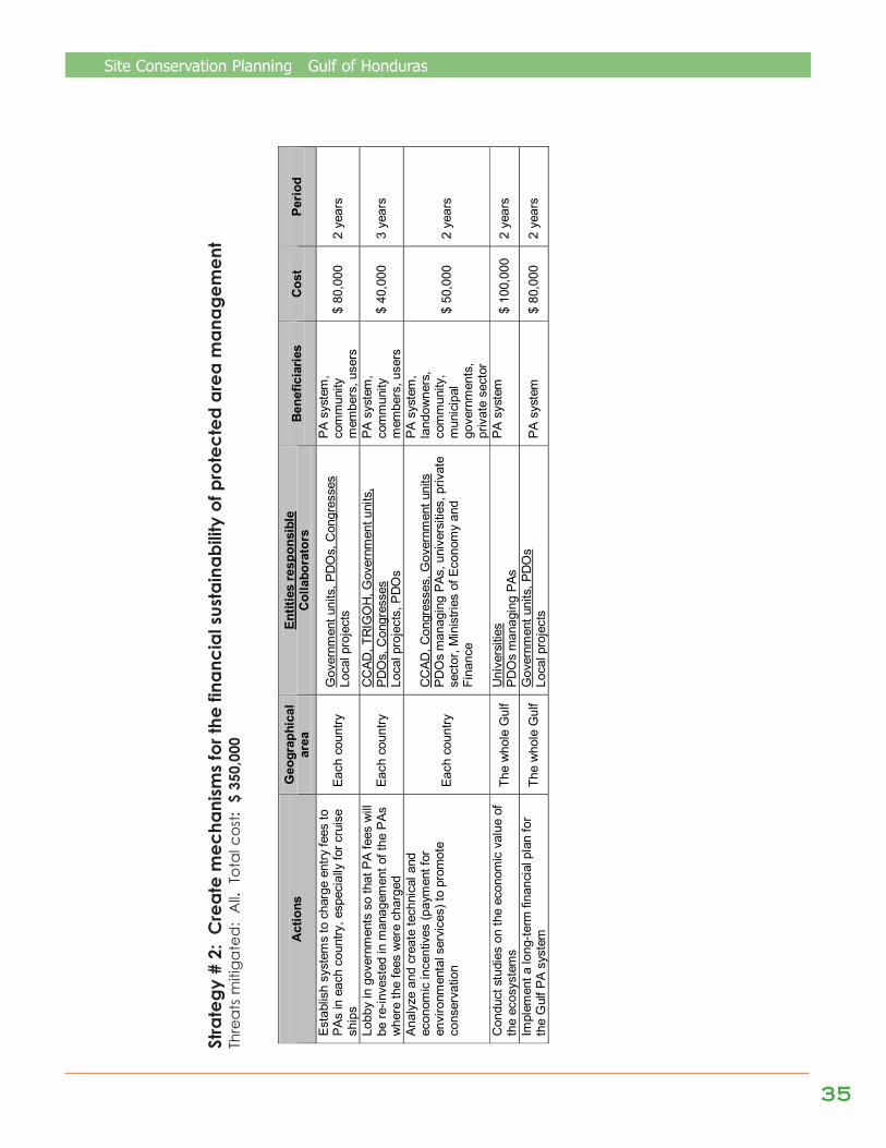
Site Conservation Planning Gulf of Honduras
3535353535
Act
ions
G
eogr
aphi
cal
area
En
titie
s re
spon
sibl
e C
olla
bora
tors
B
enef
icia
ries
Cos
t Pe
riod
Esta
blis
h sy
stem
s to
cha
rge
entry
fees
to
PAs
in e
ach
coun
try, e
spec
ially
for c
ruis
e sh
ips
Each
cou
ntry
G
over
nmen
t uni
ts, P
DO
s, C
ongr
esse
s Lo
cal p
roje
cts
PA s
yste
m,
com
mun
ity
mem
bers
, use
rs
$ 80
,000
2
year
s
Lobb
y in
gov
ernm
ents
so
that
PA
fees
will
be
re-in
vest
ed in
man
agem
ent o
f the
PAs
w
here
the
fees
wer
e ch
arge
d Ea
ch c
ount
ry
CC
AD, T
RIG
OH
, Gov
ernm
ent u
nits
, PD
Os,
Con
gres
ses
Loca
l pro
ject
s, P
DO
s
PA s
yste
m,
com
mun
ity
mem
bers
, use
rs
$ 40
,000
3
year
s
Anal
yze
and
crea
te te
chni
cal a
nd
econ
omic
ince
ntiv
es (p
aym
ent f
or
envi
ronm
enta
l ser
vice
s) to
pro
mot
e co
nser
vatio
n
Each
cou
ntry
CC
AD, C
ongr
esse
s, G
over
nmen
t uni
ts
PDO
s m
anag
ing
PAs,
uni
vers
ities
, priv
ate
sect
or, M
inis
tries
of E
cono
my
and
Fina
nce
PA s
yste
m,
land
owne
rs,
com
mun
ity,
mun
icip
al
gove
rnm
ents
, pr
ivat
e se
ctor
$ 50
,000
2
year
s
Con
duct
stu
dies
on
the
econ
omic
val
ue o
f th
e ec
osys
tem
s Th
e w
hole
Gul
f U
nive
rsiti
es
PDO
s m
anag
ing
PAs
PA s
yste
m
$ 10
0,00
0 2
year
s
Impl
emen
t a lo
ng-te
rm fi
nanc
ial p
lan
for
the
Gul
f PA
syst
em
The
who
le G
ulf
Gov
ernm
ent u
nits
, PD
Os
Lo
cal p
roje
cts
PA s
yste
m
$ 80
,000
2
year
s
Stra
tegy
# 2
: C
reat
e m
echa
nism
s fo
r the
fina
ncia
l sus
tain
abili
ty o
f pro
tect
ed a
rea
man
agem
ent
Thre
ats
miti
gate
d:
All.
Tot
al c
ost:
$ 3
50,0
00
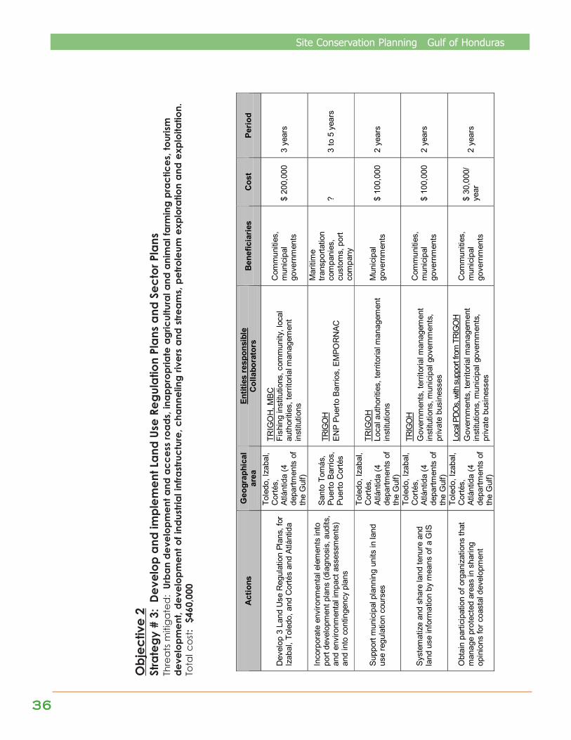
3636363636
Site Conservation Planning Gulf of Honduras
Obj
ectiv
e 2
Stra
tegy
# 3
: De
velo
p an
d im
plem
ent L
and
Use
Regu
latio
n Pl
ans
and
Sect
or P
lans
Thre
ats
miti
gate
d:
Urba
n de
velo
pmen
t and
acc
ess
road
s, in
appr
opria
te a
gric
ultu
ral a
nd a
nim
al fa
rmin
g pr
actic
es, t
ouris
mde
velo
pmen
t, de
velo
pmen
t of i
ndus
trial
infra
stru
ctur
e, c
hann
elin
g riv
ers
and
stre
ams,
pet
role
um e
xplo
ratio
n an
d ex
ploi
tatio
n.To
tal c
ost:
$46
0,00
0
Act
ions
G
eogr
aphi
cal
area
En
titie
s re
spon
sibl
e C
olla
bora
tors
B
enef
icia
ries
Cos
t Pe
riod
Dev
elop
3 L
and
Use
Reg
ulat
ion
Plan
s, fo
r Iz
abal
, Tol
edo,
and
Cor
tés
and
Atlá
ntid
a
Tole
do, I
zaba
l, C
orté
s,
Atlá
ntid
a (4
de
partm
ents
of
the
Gul
f)
TRIG
OH
, MBC
Fi
shin
g in
stitu
tions
, com
mun
ity, l
ocal
au
thor
ities
, ter
ritor
ial m
anag
emen
t in
stitu
tions
Com
mun
ities
, m
unic
ipal
go
vern
men
ts
$ 20
0,00
0 3
year
s
Inco
rpor
ate
envi
ronm
enta
l ele
men
ts in
to
port
deve
lopm
ent p
lans
(dia
gnos
is, a
udits
, an
d en
viro
nmen
tal i
mpa
ct a
sses
smen
ts)
and
into
con
tinge
ncy
plan
s
Sant
o To
más
, Pu
erto
Bar
rios,
Pu
erto
Cor
tés
TRIG
OH
ENP
Puer
to B
arrio
s, E
MPO
RN
AC
Mar
itim
e tra
nspo
rtatio
n co
mpa
nies
, cu
stom
s, p
ort
com
pany
? 3
to 5
yea
rs
Supp
ort m
unic
ipal
pla
nnin
g un
its in
land
us
e re
gula
tion
cour
ses
Tole
do, I
zaba
l, C
orté
s,
Atlá
ntid
a (4
de
partm
ents
of
the
Gul
f)
TRIG
OH
Lo
cal a
utho
ritie
s, te
rrito
rial m
anag
emen
t in
stitu
tions
Mun
icip
al
gove
rnm
ents
$
100,
000
2 ye
ars
Syst
emat
ize
and
shar
e la
nd te
nure
and
la
nd u
se in
form
atio
n by
mea
ns o
f a G
IS
Tole
do, I
zaba
l, C
orté
s,
Atlá
ntid
a (4
de
partm
ents
of
the
Gul
f)
TRIG
OH
Gov
ernm
ents
, ter
ritor
ial m
anag
emen
t in
stitu
tions
, mun
icip
al g
over
nmen
ts,
priv
ate
busi
ness
es
Com
mun
ities
, m
unic
ipal
go
vern
men
ts
$ 10
0,00
0 2
year
s
Obt
ain
parti
cipa
tion
of o
rgan
izat
ions
that
m
anag
e pr
otec
ted
area
s in
sha
ring
opin
ions
for c
oast
al d
evel
opm
ent
Tole
do, I
zaba
l, C
orté
s,
Atlá
ntid
a (4
de
partm
ents
of
the
Gul
f)
Loca
l PDO
s, wi
th su
ppor
t from
TRI
GO
H G
over
nmen
ts, t
errit
oria
l man
agem
ent
inst
itutio
ns, m
unic
ipal
gov
ernm
ents
, pr
ivat
e bu
sine
sses
Com
mun
ities
, m
unic
ipal
go
vern
men
ts
$ 30
,000
/ ye
ar
2 ye
ars
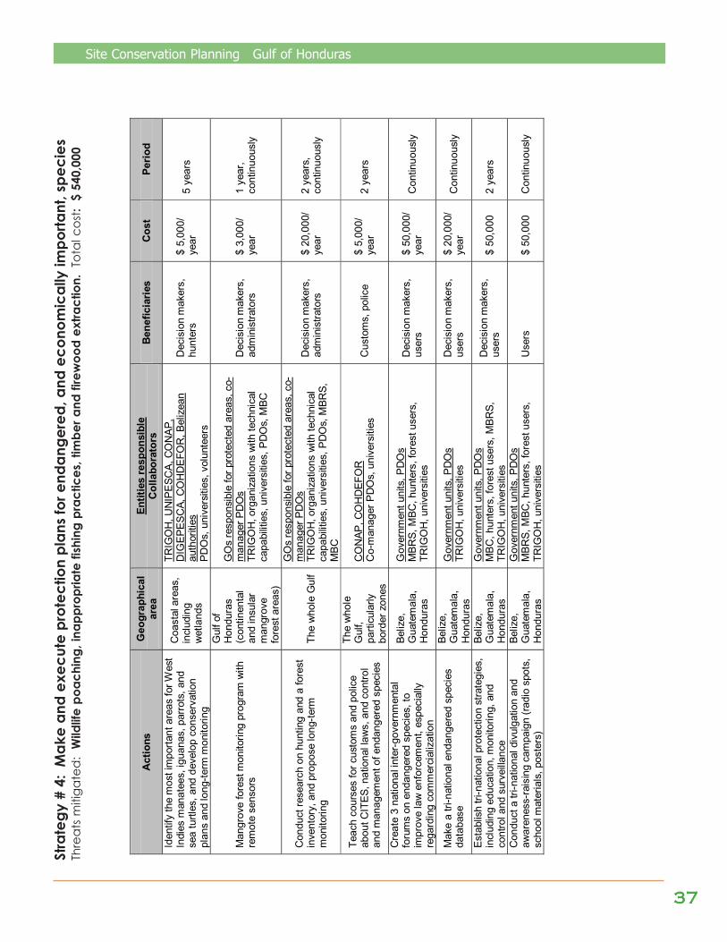
Site Conservation Planning Gulf of Honduras
3737373737
Stra
tegy
# 4
: M
ake
and
exec
ute
prot
ectio
n pl
ans
for e
ndan
gere
d, a
nd e
cono
mic
ally
impo
rtant
, spe
cies
Thre
ats
miti
gate
d:
Wild
life
poac
hing
, ina
ppro
pria
te fi
shin
g pr
actic
es, t
imbe
r and
fire
woo
d ex
tract
ion.
Tot
al c
ost:
$ 5
40,0
00
Act
ions
G
eogr
aphi
cal
area
En
titie
s re
spon
sibl
e C
olla
bora
tors
B
enef
icia
ries
Cos
t Pe
riod
Iden
tify
the
mos
t im
porta
nt a
reas
for W
est
Indi
es m
anat
ees,
igua
nas,
par
rots
, and
se
a tu
rtles
, and
dev
elop
con
serv
atio
n pl
ans
and
long
-term
mon
itorin
g
Coa
stal
are
as,
incl
udin
g w
etla
nds
TRIG
OH
, UN
IPES
CA,
CO
NAP
, D
IGEP
ESC
A, C
OH
DEF
OR
, Bel
izea
n au
thor
ities
PD
Os,
uni
vers
ities
, vol
unte
ers
Dec
isio
n m
aker
s,
hunt
ers
$ 5,
000/
ye
ar
5 ye
ars
Man
grov
e fo
rest
mon
itorin
g pr
ogra
m w
ith
rem
ote
sens
ors
Gul
f of
Hon
dura
s (c
ontin
enta
l an
d in
sula
r m
angr
ove
fore
st a
reas
)
GO
s re
spon
sibl
e fo
r pro
tect
ed a
reas
, co-
man
ager
PD
Os
TR
IGO
H, o
rgan
izat
ions
with
tech
nica
l ca
pabi
litie
s, u
nive
rsiti
es, P
DO
s, M
BC
Dec
isio
n m
aker
s,
adm
inis
trato
rs
$ 3,
000/
ye
ar
1 ye
ar,
cont
inuo
usly
Con
duct
rese
arch
on
hunt
ing
and
a fo
rest
in
vent
ory,
and
pro
pose
long
-term
m
onito
ring
The
who
le G
ulf
GO
s re
spon
sibl
e fo
r pro
tect
ed a
reas
, co-
man
ager
PD
Os
TR
IGO
H, o
rgan
izat
ions
with
tech
nica
l ca
pabi
litie
s, u
nive
rsiti
es, P
DO
s, M
BRS,
M
BC
Dec
isio
n m
aker
s,
adm
inis
trato
rs
$ 20
,000
/ ye
ar
2 ye
ars,
co
ntin
uous
ly
Teac
h co
urse
s fo
r cus
tom
s an
d po
lice
abou
t CIT
ES, n
atio
nal l
aws,
and
con
trol
and
man
agem
ent o
f end
ange
red
spec
ies
The
who
le
Gul
f, pa
rticu
larly
bo
rder
zon
es
CO
NAP
, CO
HD
EFO
R
Co-
man
ager
PD
Os,
uni
vers
ities
C
usto
ms,
pol
ice
$ 5,
000/
ye
ar
2 ye
ars
Cre
ate
3 na
tiona
l int
er-g
over
nmen
tal
foru
ms
on e
ndan
gere
d sp
ecie
s, to
im
prov
e la
w e
nfor
cem
ent,
espe
cial
ly
rega
rdin
g co
mm
erci
aliz
atio
n
Beliz
e,
Gua
tem
ala,
H
ondu
ras
Gov
ernm
ent u
nits
, PD
Os
MBR
S, M
BC, h
unte
rs, f
ores
t use
rs,
TRIG
OH
, uni
vers
ities
Dec
isio
n m
aker
s,
user
s $
50,0
00/
year
C
ontin
uous
ly
Mak
e a
tri-n
atio
nal e
ndan
gere
d sp
ecie
s da
taba
se
Beliz
e,
Gua
tem
ala,
H
ondu
ras
Gov
ernm
ent u
nits
, PD
Os
TRIG
OH
, uni
vers
ities
D
ecis
ion
mak
ers,
us
ers
$ 20
,000
/ ye
ar
Con
tinuo
usly
Esta
blis
h tri
-nat
iona
l pro
tect
ion
stra
tegi
es,
incl
udin
g ed
ucat
ion,
mon
itorin
g, a
nd
cont
rol a
nd s
urve
illanc
e
Beliz
e,
Gua
tem
ala,
H
ondu
ras
Gov
ernm
ent u
nits
, PD
Os
MBC
, hun
ters
, for
est u
sers
, MBR
S,
TRIG
OH
, uni
vers
ities
Dec
isio
n m
aker
s,
user
s $
50,0
00
2 ye
ars
Con
duct
a tr
i-nat
iona
l div
ulga
tion
and
awar
enes
s-ra
isin
g ca
mpa
ign
(radi
o sp
ots,
sc
hool
mat
eria
ls, p
oste
rs)
Beliz
e,
Gua
tem
ala,
H
ondu
ras
Gov
ernm
ent u
nits
, PD
Os
MBR
S, M
BC, h
unte
rs, f
ores
t use
rs,
TRIG
OH
, uni
vers
ities
U
sers
$
50,0
00
Con
tinuo
usly
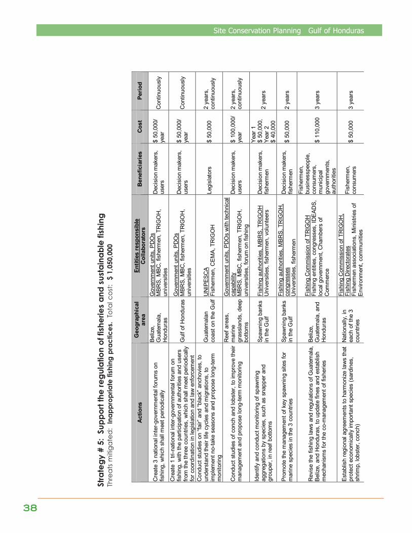
3838383838
Site Conservation Planning Gulf of Honduras
Stra
tegy
# 5
: Su
ppor
t the
regu
latio
n of
fish
erie
s an
d su
stai
nabl
e fis
hing
Thre
ats
miti
gate
d:
Inap
prop
riate
fish
ing
prac
tices
. To
tal c
ost:
$ 1
,050
,000
Act
ions
G
eogr
aphi
cal
area
En
titie
s re
spon
sibl
e C
olla
bora
tors
B
enef
icia
ries
Cos
t Pe
riod
Cre
ate
3 na
tiona
l int
er-g
over
nmen
tal f
orum
s on
fis
hing
, whi
ch s
hall
mee
t per
iodi
cally
Beliz
e,
Gua
tem
ala,
H
ondu
ras
Gov
ernm
ent u
nits
, PD
Os
MBR
S, M
BC, f
ishe
rmen
, TR
IGO
H,
univ
ersi
ties
Dec
isio
n m
aker
s,
user
s $
50,0
00/
year
C
ontin
uous
ly
Cre
ate
1 tri
-nat
iona
l int
er-g
over
nmen
tal f
orum
on
fishi
ng, w
ith th
e pa
rtici
patio
n of
aut
horit
ies
and
user
s fro
m th
e th
ree
coun
tries
, whi
ch s
hall
mee
t per
iodi
cally
fo
r coo
rdin
atio
n in
legi
slat
ion
and
law
enf
orce
men
t
Gul
f of H
ondu
ras
Gov
ernm
ent u
nits
, PD
Os
MBR
S, M
BC, f
ishe
rmen
, TR
IGO
H,
univ
ersi
ties
Dec
isio
n m
aker
s,
user
s $
50,0
00/
year
C
ontin
uous
ly
Con
duct
stu
dies
on
“fair”
and
“bla
ck” a
ncho
vies
, to
unde
rsta
nd th
eir l
ife c
ycle
s an
d m
igra
tions
, to
impl
emen
t no-
take
sea
sons
and
pro
pose
long
-term
m
onito
ring
Gua
tem
alan
co
ast o
n th
e G
ulf
UN
IPES
CA
Fish
erm
en, C
EMA,
TR
IGO
H
Legi
slat
ors
$ 50
,000
2
year
s,
cont
inuo
usly
Con
duct
stu
dies
of c
onch
and
lobs
ter,
to im
prov
e th
eir
man
agem
ent a
nd p
ropo
se lo
ng-te
rm m
onito
ring
Ree
f are
as,
mar
ine
gras
slan
ds, d
eep
botto
ms
Gov
ernm
ent u
nits
, PD
Os
with
tech
nica
l ca
pabi
lity
MBR
S, M
BC, f
ishe
rmen
, TR
IGO
H,
univ
ersi
ties,
foru
m o
n fis
hing
Dec
isio
n m
aker
s,
user
s $
100,
000/
ye
ar
2 ye
ars,
co
ntin
uous
ly
Iden
tify
and
cond
uct m
onito
ring
of s
paw
ning
ag
greg
atio
ns b
y sp
ecie
s, s
uch
as s
napp
er a
nd
grou
per,
in re
ef b
otto
ms
Spaw
ning
ban
ks
in th
e G
ulf
Fish
ing
auth
oriti
es, M
BRS,
TR
IGO
H
Uni
vers
ities
, fis
herm
en, v
olun
teer
s D
ecis
ion
mak
ers,
fis
herm
en
Year
1
$ 50
,000
, Ye
ar 2
$
40,0
00
2 ye
ars
Prom
ote
the
man
agem
ent o
f key
spa
wni
ng s
ites
for
mar
ine
spec
ies
in th
e 3
coun
tries
Sp
awni
ng b
anks
in
the
Gul
f
Fish
ing
auth
oriti
es, M
BRS,
TR
IGO
H,
cong
ress
es
Uni
vers
ities
, fis
herm
en
Dec
isio
n m
aker
s,
fishe
rmen
$
50,0
00
2 ye
ars
Rev
ise
the
fishi
ng la
ws
and
regu
latio
ns o
f Gua
tem
ala,
Be
lize,
and
Hon
dura
s, to
upd
ate
fines
and
est
ablis
h m
echa
nism
s fo
r the
co-
man
agem
ent o
f fis
herie
s
Beliz
e,
Gua
tem
ala,
and
H
ondu
ras
Fish
ing
Com
mis
sion
of T
RIG
OH
Fi
shin
g en
titie
s, c
ongr
esse
s, ID
EAD
S,
loca
l gov
ernm
ent,
Cha
mbe
rs o
f C
omm
erce
Fish
erm
en,
busi
ness
peop
le,
cons
umer
s,
mun
icip
al
gove
rnm
ents
, au
thor
ities
$ 11
0,00
0 3
year
s
Esta
blis
h re
gion
al a
gree
men
ts to
har
mon
ize
law
s th
at
prot
ect e
cono
mic
ally
impo
rtant
spe
cies
(sar
dine
s,
shrim
p, lo
bste
r, co
nch)
Nat
iona
lly, i
n ea
ch o
f the
3
coun
tries
Fish
ing
Com
mis
sion
of T
RIG
OH
, Fi
shin
g D
irect
orat
es
Fish
erm
en a
ssoc
iatio
ns, M
inis
tries
of
Envi
ronm
ent,
com
mun
ities
Fish
erm
en,
cons
umer
s $
50,0
00
3 ye
ars
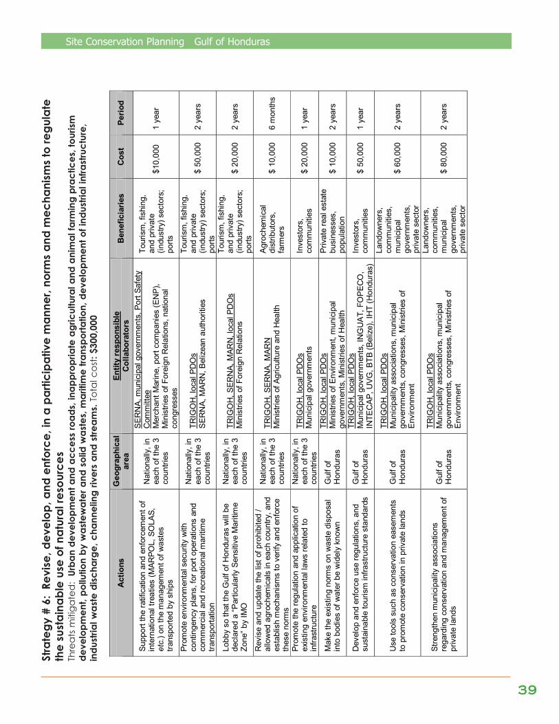
Site Conservation Planning Gulf of Honduras
3939393939
Stra
tegy
# 6
: Re
vise
, dev
elop
, and
enf
orce
, in
a pa
rtici
pativ
e m
anne
r, no
rms
and
mec
hani
sms
to re
gula
teth
e su
stai
nabl
e us
e of
nat
ural
reso
urce
sTh
rea
ts m
itiga
ted
: Ur
ban
deve
lopm
ent a
nd a
cces
s ro
ads,
inap
prop
riate
agr
icul
tura
l and
ani
mal
farm
ing
prac
tices
, tou
rism
deve
lopm
ent,
pollu
tion
by w
aste
wat
er a
nd s
olid
was
tes,
mar
itim
e tra
nspo
rtatio
n, d
evel
opm
ent o
f ind
ustri
al in
frast
ruct
ure,
indu
stria
l was
te d
ischa
rge,
cha
nnel
ing
river
s an
d st
ream
s. T
otal
cos
t: $3
00,0
00
Act
ions
G
eogr
aphi
cal
area
En
tity
resp
onsi
ble
Col
labo
rato
rs
Ben
efic
iarie
s C
ost
Perio
d
Supp
ort t
he ra
tific
atio
n an
d en
forc
emen
t of
inte
rnat
iona
l tre
atie
s (M
ARPO
L, S
OLA
S,
etc.
) on
the
man
agem
ent o
f was
tes
trans
porte
d by
shi
ps
Nat
iona
lly, i
n ea
ch o
f the
3
coun
tries
SER
NA,
mun
icip
al g
over
nmen
ts, P
ort S
afet
y C
omm
ittee
M
erch
ant M
arin
e, p
ort c
ompa
nies
(EN
P),
Min
istri
es o
f For
eign
Rel
atio
ns, n
atio
nal
cong
ress
es
Tour
ism
, fis
hing
, an
d pr
ivat
e (in
dust
ry) s
ecto
rs;
ports
$10,
000
1 ye
ar
Prom
ote
envi
ronm
enta
l sec
urity
with
co
ntin
genc
y pl
ans,
for p
ort o
pera
tions
and
co
mm
erci
al a
nd re
crea
tiona
l mar
itim
e tra
nspo
rtatio
n
Nat
iona
lly, i
n ea
ch o
f the
3
coun
tries
TRIG
OH
, loc
al P
DO
s S
ERN
A, M
ARN
, Bel
izea
n au
thor
ities
Tour
ism
, fis
hing
, an
d pr
ivat
e (in
dust
ry) s
ecto
rs;
ports
$ 50
,000
2
year
s
Lobb
y so
that
the
Gul
f of H
ondu
ras
will
be
decl
ared
a “P
artic
ular
ly S
ensi
tive
Mar
itim
e Zo
ne” b
y IM
O
Nat
iona
lly, i
n ea
ch o
f the
3
coun
tries
TRIG
OH
, SER
NA,
MAR
N, l
ocal
PD
Os
Min
istri
es o
f For
eign
Rel
atio
ns
Tour
ism
, fis
hing
, an
d pr
ivat
e (in
dust
ry) s
ecto
rs;
ports
$ 20
,000
2
year
s
Rev
ise
and
upda
te th
e lis
t of p
rohi
bite
d /
allo
wed
agr
oche
mic
als
in e
ach
coun
try, a
nd
esta
blis
h m
echa
nism
s to
ver
ify a
nd e
nfor
ce
thes
e no
rms
Nat
iona
lly, i
n ea
ch o
f the
3
coun
tries
TRIG
OH
, SER
NA,
MAR
N
Min
istri
es o
f Agr
icul
ture
and
Hea
lth
Agr
oche
mic
al
dist
ribut
ors,
fa
rmer
s $
10,0
00
6 m
onth
s
Prom
ote
the
regu
latio
n an
d ap
plic
atio
n of
ex
istin
g en
viro
nmen
tal l
aws
rela
ted
to
infra
stru
ctur
e
Nat
iona
lly, i
n ea
ch o
f the
3
coun
tries
TRIG
OH
, loc
al P
DO
s M
unic
ipal
gov
ernm
ents
In
vest
ors,
co
mm
uniti
es
$ 20
,000
1
year
Mak
e th
e ex
istin
g no
rms
on w
aste
dis
posa
l in
to b
odie
s of
wat
er b
e w
idel
y kn
own
Gul
f of
Hon
dura
s
TRIG
OH
, loc
al P
DO
s M
inis
tries
of E
nviro
nmen
t, m
unic
ipal
go
vern
men
ts, M
inis
tries
of H
ealth
Priv
ate
real
est
ate
busi
ness
es,
popu
latio
n $
10,0
00
2 ye
ars
Dev
elop
and
enf
orce
use
regu
latio
ns, a
nd
sust
aina
ble
tour
ism
infra
stru
ctur
e st
anda
rds
Gul
f of
Hon
dura
s
TRIG
OH
, loc
al P
DO
s M
unic
ipal
gov
ernm
ents
, IN
GU
AT,
FO
PEC
O,
INTE
CAP
, UVG
, BTB
(Bel
ize)
, IH
T (H
ondu
ras)
Inve
stor
s,
com
mun
ities
$
50,0
00
1 ye
ar
Use
tool
s su
ch a
s co
nser
vatio
n ea
sem
ents
to
pro
mot
e co
nser
vatio
n in
priv
ate
land
s G
ulf o
f H
ondu
ras
TRIG
OH
, loc
al P
DO
s M
unic
ipal
ity a
ssoc
iatio
ns, m
unic
ipal
go
vern
men
ts, c
ongr
esse
s, M
inis
tries
of
Envi
ronm
ent
Land
owne
rs,
com
mun
ities
, m
unic
ipal
go
vern
men
ts,
priv
ate
sect
or
$ 60
,000
2
year
s
Stre
ngth
en m
unic
ipal
ity a
ssoc
iatio
ns
rega
rdin
g co
nser
vatio
n an
d m
anag
emen
t of
priv
ate
land
s
Gul
f of
Hon
dura
s
TRIG
OH
, loc
al P
DO
s
Mun
icip
ality
ass
ocia
tions
, mun
icip
al
gove
rnm
ents
, con
gres
ses,
Min
istri
es o
f E
nviro
nmen
t
Land
owne
rs,
com
mun
ities
, m
unic
ipal
go
vern
men
ts,
priv
ate
sect
or
$ 80
,000
2
year
s
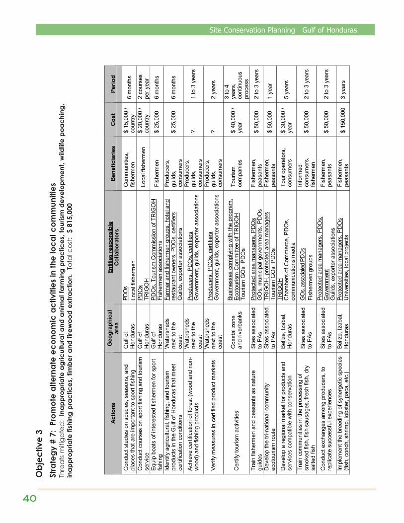
4040404040
Site Conservation Planning Gulf of HondurasO
bjec
tive
3St
rate
gy #
7:
Prom
ote
alte
rnat
e ec
onom
ic a
ctiv
ities
in th
e lo
cal c
omm
uniti
esTh
rea
ts m
itiga
ted
: In
appr
opria
te a
gric
ultu
ral a
nd a
nim
al fa
rmin
g pr
actic
es, t
ouris
m d
evel
opm
ent,
wild
life
poac
hing
,in
appr
opria
te fi
shin
g pr
actic
es, t
imbe
r and
fire
woo
d ex
tract
ion.
Tot
al c
ost:
$ 8
15,0
00
Act
ions
G
eogr
aphi
cal
area
En
titie
s re
spon
sible
C
olla
bora
tors
B
enef
icia
ries
Cos
t Pe
riod
Con
duct
stu
dies
on
spec
ies,
sea
sons
, and
pl
aces
that
are
impo
rtant
to s
port
fishi
ng
Gul
f of
Hon
dura
s PD
Os
Loca
l fis
herm
en
Com
mun
ities
, fis
herm
en
$ 15
,000
/ co
untry
6
mon
ths
Con
duct
cou
rses
on
spor
t fis
hing
and
tour
ism
se
rvic
e
Gul
f of
Hon
dura
s PD
Os
TRIG
OH
Lo
cal f
ishe
rmen
$
20,0
00 /
coun
try
2 co
urse
s pe
r yea
r Eq
uip
boat
s of
inte
rest
ed fi
sher
men
for s
port
fishi
ng
Gul
f of
Hon
dura
s PD
Os,
Tou
rism
Com
mis
sion
of T
RIG
OH
Fi
sher
men
ass
ocia
tions
Fi
sher
men
$
25,0
00
6 m
onth
s
Iden
tify
agric
ultu
ral,
fishi
ng, a
nd to
uris
m
prod
ucts
in th
e G
ulf o
f Hon
dura
s th
at m
eet
certi
ficat
ion
cond
ition
s
Wat
ersh
eds
next
to th
e co
ast
Farm
er a
nd fi
sher
men
gro
ups,
hot
el a
nd
rest
aura
nt o
wne
rs, P
DO
s, c
ertif
iers
G
uild
s, e
xpor
ter a
ssoc
iatio
ns
Prod
ucer
s,
guild
s,
cons
umer
s $
25,0
00
6 m
onth
s
Achi
eve
certi
ficat
ion
of fo
rest
(woo
d an
d no
n-w
ood)
and
fish
ing
prod
ucts
Wat
ersh
eds
next
to th
e co
ast
Prod
ucer
s, P
DO
s, c
ertif
iers
G
over
nmen
t, gu
ilds,
exp
orte
r ass
ocia
tions
Prod
ucer
s,
guild
s,
cons
umer
s ?
1 to
3 y
ears
Verif
y m
easu
res
in c
ertif
ied
prod
uct m
arke
ts
Wat
ersh
eds
next
to th
e co
ast
Prod
ucer
s, P
DO
s, c
ertif
iers
G
over
nmen
t, gu
ilds,
exp
orte
r ass
ocia
tions
Prod
ucer
s,
guild
s,
cons
umer
s ?
2 ye
ars
Cer
tify
tour
ism
act
iviti
es
Coa
stal
zon
e an
d riv
erba
nks
Busi
ness
es c
ompl
ying
with
the
prog
ram
, Ec
otou
rism
Com
mitt
ee o
f TR
IGO
H
Tour
ism
GO
s, P
DO
s
Tour
ism
co
mpa
nies
$
40,0
00 /
year
3 to
4
year
s,
cont
inuo
us
proc
ess
Tr
ain
fishe
rmen
and
pea
sant
s as
nat
ure
guid
es
Site
s as
soci
ated
to
PAs
Pr
otec
ted
area
man
ager
s, P
DO
s G
Os,
mun
icip
al g
over
nmen
ts, P
DO
s Fi
sher
men
, pe
asan
ts
$ 50
,000
2
to 3
yea
rs
Dev
elop
the
tri-n
atio
nal c
omm
unity
ec
otou
rism
rout
e Si
tes
asso
ciat
ed
to P
As
TRIG
OH
, pro
tect
ed a
rea
man
ager
s To
uris
m G
Os,
PD
Os
Fish
erm
en,
peas
ants
$
50,0
00
1 ye
ar
Dev
elop
a re
gion
al m
arke
t for
pro
duct
s an
d se
rvic
es c
ompa
tible
with
con
serv
atio
n Be
lize,
Izab
al,
Hon
dura
s
TRIG
OH
C
ham
bers
of C
omm
erce
, PD
Os,
co
mm
unic
atio
ns m
edia
Tour
ope
rato
rs,
cons
umer
s $
30,0
00 /
year
5
year
s
Trai
n co
mm
uniti
es in
the
proc
essi
ng o
f sm
oked
fish
, fis
h sa
usag
es, f
resh
fish
, dry
sa
lted
fish
Site
s as
soci
ated
to
PAs
G
Os,
asso
ciate
d PD
Os
Fish
erm
en g
roup
s
Info
rmed
co
nsum
ers,
fis
herm
en
$ 50
,000
2
to 3
yea
rs
Con
duct
exc
hang
es a
mon
g pr
oduc
ers,
to
repl
icat
e su
cces
sful
exp
erie
nces
Si
tes
asso
ciat
ed
to P
As
Prot
ecte
d ar
ea m
anag
ers,
PD
Os,
G
over
nmen
t G
uild
s, e
xpor
ter a
ssoc
iatio
ns
Fish
erm
en,
peas
ants
$
50,0
00
2 to
3 y
ears
Impl
emen
t the
bre
edin
g of
syn
erge
tic s
peci
es
(fish
, con
ch, s
hrim
p, lo
bste
r, pa
ca, etc.)
Beliz
e, Iz
abal
, H
ondu
ras
Prot
ecte
d ar
ea m
anag
ers,
PD
Os
Uni
vers
ities
, loc
al p
roje
cts
Fish
erm
en,
peas
ants
$
150,
000
3 ye
ars
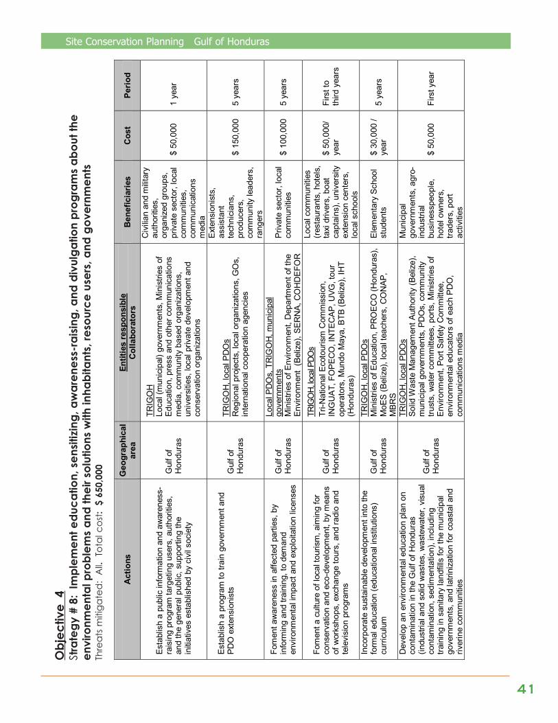
Site Conservation Planning Gulf of Honduras
4141414141
Obj
ectiv
e 4
Stra
tegy
# 8
: Im
plem
ent e
duca
tion,
sen
sitizi
ng, a
war
enes
s-ra
ising
, and
div
ulga
tion
prog
ram
s ab
out t
heen
viro
nmen
tal p
robl
ems
and
thei
r sol
utio
ns w
ith in
habi
tant
s, re
sour
ce u
sers
, and
gov
ernm
ents
Thre
ats
miti
gate
d:
All.
Tot
al c
ost:
$ 6
50,0
00
Act
ions
G
eogr
aphi
cal
area
En
titie
s re
spon
sibl
e C
olla
bora
tors
B
enef
icia
ries
Cos
t Pe
riod
Esta
blis
h a
publ
ic in
form
atio
n an
d aw
aren
ess-
rais
ing
prog
ram
targ
etin
g us
ers,
aut
horit
ies,
an
d th
e ge
nera
l pub
lic, s
uppo
rting
the
initi
ativ
es e
stab
lishe
d by
civ
il so
ciet
y
Gul
f of
Hon
dura
s
TRIG
OH
Lo
cal (
mun
icip
al) g
over
nmen
ts, M
inis
tries
of
Educ
atio
n, p
ress
and
oth
er c
omm
unic
atio
ns
med
ia, c
omm
unity
bas
ed o
rgan
izat
ions
, un
iver
sitie
s, lo
cal p
rivat
e de
velo
pmen
t and
co
nser
vatio
n or
gani
zatio
ns
Civ
ilian
and
milit
ary
auth
oriti
es,
orga
nize
d gr
oups
, pr
ivat
e se
ctor
, loc
al
com
mun
ities
, co
mm
unic
atio
ns
med
ia
$ 50
,000
1
year
Esta
blis
h a
prog
ram
to tr
ain
gove
rnm
ent a
nd
PDO
ext
ensi
onis
ts
Gul
f of
Hon
dura
s
TRIG
OH
, loc
al P
DO
s R
egio
nal p
roje
cts,
loca
l org
aniz
atio
ns, G
Os,
in
tern
atio
nal c
oope
ratio
n ag
enci
es
Exte
nsio
nist
s,
assi
stan
t te
chni
cian
s,
prod
ucer
s,
com
mun
ity le
ader
s,
rang
ers
$ 15
0,00
0 5
year
s
Fom
ent a
war
enes
s in
affe
cted
par
ties,
by
info
rmin
g an
d tra
inin
g, to
dem
and
envi
ronm
enta
l im
pact
and
exp
loita
tion
licen
ses
Gul
f of
Hon
dura
s
Loca
l PD
Os,
TR
IGO
H, m
unic
ipal
go
vern
men
ts
Min
istri
es o
f Env
ironm
ent,
Dep
artm
ent o
f the
En
viro
nmen
t (B
eliz
e), S
ERN
A, C
OH
DEF
OR
Priv
ate
sect
or, l
ocal
co
mm
uniti
es
$ 10
0,00
0 5
year
s
Fom
ent a
cul
ture
of l
ocal
tour
ism
, aim
ing
for
cons
erva
tion
and
eco-
deve
lopm
ent,
by m
eans
of
wor
ksho
ps, e
xcha
nge
tour
s, a
nd ra
dio
and
tele
visi
on p
rogr
ams
Gul
f of
Hon
dura
s
TRIG
OH,
loca
l PDO
s Tr
i-Nat
iona
l Eco
tour
ism
Com
mis
sion
, IN
GU
AT, F
OPE
CO
, IN
TEC
AP, U
VG, t
our
oper
ator
s, M
undo
May
a, B
TB (B
eliz
e), I
HT
(Hon
dura
s)
Loca
l com
mun
ities
(r
esta
uran
ts, h
otel
s,
taxi
driv
ers,
boa
t ca
ptai
ns),
univ
ersi
ty
exte
nsio
n ce
nter
s,
loca
l sch
ools
$ 50
,000
/ ye
ar
Firs
t to
third
yea
rs
Inco
rpor
ate
sust
aina
ble
deve
lopm
ent i
nto
the
form
al e
duca
tion
(edu
catio
nal i
nstit
utio
ns)
curri
culu
m
Gul
f of
Hon
dura
s
TRIG
OH
, loc
al P
DO
s M
inis
tries
of E
duca
tion,
PR
OEC
O (H
ondu
ras)
, M
oES
(Bel
ize)
, loc
al te
ache
rs, C
ON
AP,
MBR
S
Elem
enta
ry S
choo
l st
uden
ts
$ 30
,000
/ ye
ar
5 ye
ars
Dev
elop
an
envi
ronm
enta
l edu
catio
n pl
an o
n co
ntam
inat
ion
in th
e G
ulf o
f Hon
dura
s (in
dust
rial a
nd s
olid
was
tes,
was
tew
ater
, vis
ual
cont
amin
atio
n, s
edim
enta
tion)
, inc
ludi
ng
train
ing
in s
anita
ry la
ndfil
ls fo
r the
mun
icip
al
gove
rnm
ents
, and
latri
niza
tion
for c
oast
al a
nd
river
ine
com
mun
ities
Gul
f of
Hon
dura
s
TRIG
OH
, loc
al P
DO
s So
lid W
aste
Man
agem
ent A
utho
rity
(Bel
ize)
, m
unic
ipal
gov
ernm
ents
, PD
Os,
com
mun
ity
trust
s, w
ater
com
mitt
ees,
por
ts, M
inis
tries
of
Envi
ronm
ent,
Port
Safe
ty C
omm
ittee
, en
viro
nmen
tal e
duca
tors
of e
ach
PDO
, co
mm
unic
atio
ns m
edia
Mun
icip
al
gove
rnm
ents
, agr
o-in
dust
rial
busi
ness
peop
le,
hote
l ow
ners
, tra
ders
, por
t ac
tiviti
es
$ 50
,000
Fi
rst y
ear

4242424242
Site Conservation Planning Gulf of Honduras
Stra
tegy
# 9
: Im
plem
ent i
nstit
utio
nal s
treng
then
ing
prog
ram
s, a
nd c
oord
inat
ion
and
citiz
en p
artic
ipat
ion
mec
hani
sms,
for t
he p
rote
ctio
n of
nat
ural
sys
tem
sTh
rea
ts m
itiga
ted
: in
appr
opria
te a
gric
ultu
ral a
nd a
nim
al fa
rmin
g pr
actic
es, w
ildlif
e po
achi
ng, i
napp
ropr
iate
fish
ing
prac
tices
,po
llutio
n by
was
tew
ater
and
sol
id w
aste
s, ti
mbe
r and
fire
woo
d ex
tract
ion.
Tot
al c
ost:
$ 3
65,0
00
Act
ions
G
eogr
aphi
cal
area
En
titie
s re
spon
sibl
e C
olla
bora
tors
B
enef
icia
ries
Cos
t Pe
riod
Mak
e kn
own
the
resu
lts o
f the
nat
iona
l in
itiat
ives
on
publ
ic /
soci
al p
artic
ipat
ion,
to
mak
e re
gion
al a
dapt
atio
ns (f
or
exam
ple,
adv
isor
y co
unci
ls in
Gua
tem
ala)
Gul
f of
Hon
dura
s
TRIG
OH
, loc
al P
DO
s H
uman
righ
ts o
rgan
izat
ions
, pro
ject
s,
Min
istri
es o
f Hea
lth, s
ocia
l wor
kers
Loca
l PD
Os,
GO
s,
auth
oriti
es, u
sers
, di
rect
ors
of n
atur
al
reso
urce
man
agin
g or
gani
zatio
ns,
orga
nize
d gr
oups
$ 10
0,00
0 2
year
s
Stre
ngth
en th
e ca
paci
ty o
f mun
icip
al
gove
rnm
ents
for e
nviro
nmen
tal
man
agem
ent,
by c
reat
ing
an a
ssoc
iatio
n of
the
mun
icip
aliti
es in
volv
ed in
the
area
of
act
ion
in th
e G
ulf o
f Hon
dura
s, b
y tra
inin
g, b
y in
form
ing,
and
by
visi
ts to
the
Mun
icip
al G
over
nmen
t of C
orté
s as
an
exam
ple
for t
he re
gion
Gul
f of
Hon
dura
s TR
IGO
H, l
ocal
PD
Os
MBR
S, M
BC, P
RO
ARC
A, u
nive
rsiti
es
Mun
icip
al
gove
rnm
ents
, vi
llage
cou
ncils
, C
OC
OD
ES
(Gua
tem
ala)
$ 11
0,00
0 5
year
s
Cre
ate
fishe
rmen
and
reso
urce
use
r or
gani
zatio
ns, a
ccom
pani
ed b
y:
Trai
ning
in m
anag
emen
t, pr
ojec
t des
igns
, ac
coun
ting,
org
aniz
atio
n O
btai
ning
lega
l reg
istra
tion
for t
he lo
cal
orga
niza
tions
N
atio
nal a
nd tr
i-nat
iona
l exc
hang
es, a
nd
educ
atio
nal t
ours
Gul
f of
Hon
dura
s
TRIG
OH
, loc
al P
DO
s Fi
shin
g au
thor
ities
, fis
herm
en
asso
ciat
ions
, CO
CO
DES
, oth
er re
sour
ce
user
ass
ocia
tions
Fish
erm
en (s
ports
, in
dust
rial,
and
non-
indu
stria
l), re
sour
ce
user
s,
CO
CO
DES
(G
uate
mal
a)
$ 15
5,00
0 5
year
s
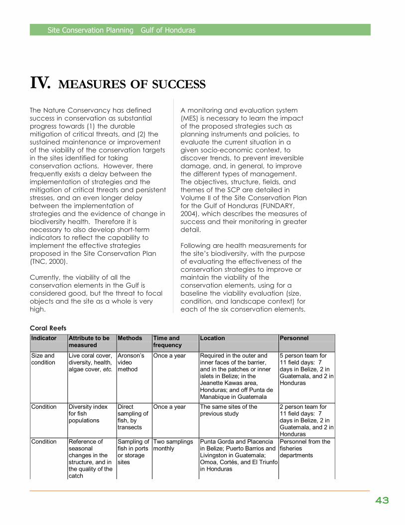
Site Conservation Planning Gulf of Honduras
4343434343
IV. MEASURES OF SUCCESS
The Nature Conservancy has definedsuccess in conservation as substantialprogress towards (1) the durablemitigation of critical threats, and (2) thesustained maintenance or improvementof the viability of the conservation targetsin the sites identified for takingconservation actions. However, therefrequently exists a delay between theimplementation of strategies and themitigation of critical threats and persistentstresses, and an even longer delaybetween the implementation ofstrategies and the evidence of change inbiodiversity health. Therefore it isnecessary to also develop short-termindicators to reflect the capability toimplement the effective strategiesproposed in the Site Conservation Plan(TNC, 2000).
Currently, the viability of all theconservation elements in the Gulf isconsidered good, but the threat to focalobjects and the site as a whole is veryhigh.
A monitoring and evaluation system(MES) is necessary to learn the impactof the proposed strategies such asplanning instruments and policies, toevaluate the current situation in agiven socio-economic context, todiscover trends, to prevent irreversibledamage, and, in general, to improvethe different types of management.The objectives, structure, fields, andthemes of the SCP are detailed inVolume II of the Site Conservation Planfor the Gulf of Honduras (FUNDARY,2004), which describes the measures ofsuccess and their monitoring in greaterdetail.
Following are health measurements forthe site’s biodiversity, with the purposeof evaluating the effectiveness of theconservation strategies to improve ormaintain the viability of theconservation elements, using for abaseline the viability evaluation (size,condition, and landscape context) foreach of the six conservation elements.
Coral Reefs
Indicator Attribute to be measured
Methods Time and frequency
Location Personnel
Size and condition
Live coral cover, diversity, health, algae cover, etc.
Aronson’s video method
Once a year Required in the outer and inner faces of the barrier, and in the patches or inner islets in Belize; in the Jeanette Kawas area, Honduras; and off Punta de Manabique in Guatemala
5 person team for 11 field days: 7 days in Belize, 2 in Guatemala, and 2 in Honduras
Condition Diversity index for fish populations
Direct sampling of fish, by transects
Once a year The same sites of the previous study
2 person team for 11 field days: 7 days in Belize, 2 in Guatemala, and 2 in Honduras
Condition Reference of seasonal changes in the structure, and in the quality of the catch
Sampling of fish in ports or storage sites
Two samplings monthly
Punta Gorda and Placencia in Belize; Puerto Barrios and Livingston in Guatemala; Omoa, Cortés, and El Triunfo in Honduras
Personnel from the fisheries departments
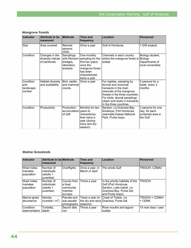
4444444444
Site Conservation Planning Gulf of Honduras
Mangrove Forests Indicator Attribute to be
measured Methods Time and
frequency Location Personnel
Size Area covered Remote sensors (GIS)
Once a year Gulf of Honduras 1 GIS analyst
Condition Changes in the diversity indices of benthoids
Samplings with Ekmann dredges, laboratory analysis
One monthly sampling for the first two years; once the mangrove forest has been characterized, twice a year
Channels in each country where the mangrove forest is widest
Biology student, Biology Departments of local universities
Condition and landscape context
Habitat diversity and availability
Bird, reptile, and mammal counts
Once a year For reptiles, sampling by diurnal and nocturnal transects in the main channels of the mangrove forests in the three countries. For birds, diurnal samplings (dawn and dusk) in transects in the three countries.
2 persons for a week, every 3 months
Condition Productivity Production, accumulation of duff
Monthly for two years to characterize, then twice a year (during rainy and dry season)
Sarstún, La Graciosa Bay, Amatique, Port Honduras, Jeannette Kawas National Park, Punta Izopo
3 persons for one day, for each protected area in the Gulf
Marine Grasslands
Indicator Attribute to be measured
Methods Time and frequency
Location Personnel
West Indies manatee population
Number of individuals (adults + juveniles)
Overflights Once a year, in March or April
The whole Gulf TRIGOH, CZMA/I
West Indies manatee population
Number of individuals (adults + juveniles)
Counts from a boat, community member surveys
Thrice a year
In the priority habitats of the Gulf (Port Honduras, Sarstún, Lake Izabal, La Graciosa Bay, Punta Sal, and Punta Izopo)
TRIGOH
Marine grass abundance
Density (number / m2)
Parcels and sub-aquatic photography
Twice a year (in the dry and rainy seasons)
Coast of Toledo, La Graciosa, Punta Sal
TRIGOH + CZMA/I + CEMA
Condition: sedimentation
Turbidity, depth
Secchi disk, rod
Thrice a year River mouths and lagoon outlets
15 man days / year

Site Conservation Planning Gulf of Honduras
4545454545
Beach Systems
Indicator Attribute to be measured
Methods Time and frequency
Location Personnel
Cover and current use
Natural and perturbed Ha
Remote sensor (Spot)
Dry season, every 2 years
The whole Gulf 1 GIS analyst
Biodiversity in the area
Biodiversity index
Sampling Dry season, every 2 years
Sampling sites in the whole Gulf
TRIGOH + Universities
Estuaries and Coastal Lagoons
Indicator Attribute to be measured
Methods Time and frequency
Location Personnel
Size: area and number of water surfaces
Water surface hectares
Satellite photographs, remote sensors
Twice a year, once each in the dry and rainy seasons
Coastal-marine zone PDOs, two persons per country
Condition: heavy metals
Mercury, cadmium, lead, copper, and organochlorates
Chemical determination
Once a year River mouths and lagoon outlets
Laboratory
Condition: sedimentation
Turbidity, depth Secchi disk, rod
Thrice a year River mouths and lagoon outlets
15 man days / year
Condition: presence of species
Number of individuals
Samplings Once a year / one month of research
River mouths and lagoon outlets
Landscape: increase in tourism infrastructure
Number of marinas, rooms, and hotels
Inventories, samplings, surveys
Once a year / one month of research
Coastal-marine zone Tourism Commission of TRIGOH
Landscape: increase in roads and urban infrastructure
Number, quality, and length (in Km) of roads
Remote sensors, routes, trails
Once a year Rangers
Herbaceous Wetlands
Indicator Attribute to be measured
Methods Time and frequency
Location Personnel
Size: habitat conversion
Hectares of forest and wetland cover
Maps, aerial photographs, remote sensors
Once a year Coastal-marine zone GIS personnel of PDOs
Landscape: urban growth
Number of roads, houses, canals, and inhabitants
Remote sensors, censuses, routes, population censuses
Once a year GIS personnel of PDOs, Statistics Institutes, Ministries of Health and Education
Condition: water flow
Depths, canals, seasonality of the water surface, yearly precipitation
Rod, volumetric methods, satellite images, sampling points at depth
Twice a year, once each in the dry and rainy seasons
Selected forests of the Gulf Internship students, graduation research students, universities, rangers

4646464646
Site Conservation Planning Gulf of Honduras
AUIL, N. 1998. Sustainable development and management of biologically diversecoastal resources management project. Belize City, Belize.
BROWN, M. 1998. Minicasos sobre asuntos clave de manejo y grupos de interesadosrelacionados con el Golfo de Honduras. PROARCA/Costas and PROARCA/CAPAS,Guatemala, Guatemala.
CEDEX. 1999. Plan director para el saneamiento integral y la gestión de residuossólidos de los apartamentos poblacionales del Parque Nacional “Río Dulce” y dela Amatique Bay, Informe final, Tomos I, II, III y IV, informe técnico para Ministeriode Asuntos Exteriores, Secretaría de Estado de Cooperación Internacional y paraIbero América, Agencia Española de Cooperación Internacional (AECI),convenio para realización de trabajos y actividades de cooperación técnica enmateria de medio ambiente e infraestructuras, con los países de Centroaméricaafectados por el Huracán Mitch. II informes de los Proyectos del convenio,Proyecto Guatemala 2 Centro de Estudios Hidrográficos, clave CEDEX 45-499-7-001. Madrid, Spain.
CENTRAL STATISTICAL OFFICE, MINISTRY OF FINANCE. 2000. Environmental Statistics ForBelize 2000. Belmopan, Belize.
CHACON & GERSON. 1998. Comercialización de la manjúa Anchoa iyolepsis yanálisis de la Asociación de Pescadores. Punta de Manabique, Puerto Barrios,Izabal, Guatemala.
COASTAL MANAGEMENT ZONE. 1999. Coastal Water Quality, Belize. Belize City, Belize.COMITÉ DE RESPUESTA A CRISIS DEL MEDIO AMBIENTE MARINO–COSTERO IZABAL, 1998.
Plan de 1998. Contingencias contra derrames de hidrocarburos / químicos.Diálogos de políticas ambientales. Puerto Barrios Izabal, Guatemala.
CONAMA. 1997. Anteproyecto “Reglamento especial para la navegación en elParque Nacional Río Dulce”. Guatemala, Guatemala.
CONAMA. 1998. Proyecto de reglamento de navegación de las aguas del ParqueNacional Río Dulce. Guatemala, Guatemala.
DITEPESCA. Plan de Ordenamiento Pesquero. Guatemala.ENVIRONMENTAL & SOCIAL TECHNICAL ASISTANCE PROJECT. 1999. Regional
Development Plan For Southern Belize – Draft. Belize City, Belize.ESPINAL, M. 1994. Diagnóstico de los recursos costeros en la zona del Golfo de
Honduras (Parte Hondureña). Honduras.FISHERIES DEPARTMENT, MINISTRY OF AGRICULTURE AND FISHERIES & TOLEDO INSTITUTE
ON DEVELOPMENT AND ENVIRONMENT. 1998. Port Honduras Marine Reserve(Draft Management Plan). Belize.
FUNDARY. 2001. Evaluación Ecológica Rápida del Refugio de Vida Silvestre Punta deManabique, Izabal, Guatemala, C. A. Guatemala. 240 p. + maps.
GÁLVEZ J. J. 2001. Sistema de monitoreo y evaluación de la biodiversidad delproyecto MIRNA. Sección 2: Recomendaciones para el sistema de seguimiento yevaluación del proyecto MIRNA. MAGA / MARN / CONAP / INAB, Guatemala.30 p.
HEYMAN, W. D. 1996. Integrated coastal zone management and sustainabledevelopment for tropical estuarine ecosystems: A case study of Port Honduras,Belize. Belize.
HEYMAN, W. & R. GRAHAM. 2000. La voz de los pescadores de la Costa Atlántica deGuatemala.
HEYMAN, W. & T. HYAT. 1996. An analysis of commercial and sport fishing in theproposed Port Honduras Marine Reserve, Belize. Belize Centre for EnvironmentalStudies, Belize.
HEYMAN, W. & B. KJERFVE. 1999. Hydrological and oceanographic considerations forintegrated coastal zone management in Southern Belize.
ICSED. 2000. Desarrollo de herramientas económicas para la preparación depolíticas sostenibles en el sector pesquero del Golfo de Honduras. Tomo I.PROARCA/CAPAS, Guatemala, Guatemala.
V. BIBLIOGRAPHY
Site Conservation Planning Gulf of Honduras
4747474747
ICSED. 2000. Desarrollo de herramientas económicas para la preparación depolíticas sostenibles en el sector pesquero del Golfo de Honduras. Tomo II.PROARCA/CAPAS, Guatemala, Guatemala.
JICA. 1993. Informe de la investigación sobre recursos pesqueros en la República deHonduras. Honduras.
LANKFORD, R.R. 1977. Coastal lagoons of Mexico: Their origin and classification, p.182-215. In: Wiley, M. (Ed.) Estuarine Processes. Academic Press, Inc., New York,2: 428 pp.
MONGE, L. 1998. Memoria del taller regional sobre manejo de pesquerías en elSistema Arrecifal del Caribe Mesoamericano, organizado y financiado porPROARCA/Costas y PROARCA/CAPAS, con apoyo de la Alianza Trinacional deONGs del Golfo de Honduras - TRIGOH. PROARCA/CAPAS, Guatemala.
MUNICIPALIDAD DE LIVINGSTON. “Información general sobre Livinsgston y lacomunidad Garífuna”.
PELTIER, N. 1997. El transporte de productos peligrosos en el Golfo de Honduras:Evaluación del riesgo, políticas de prevención y plan de contingencia,Guatemala.
PROARCA/APM. 2003. Perfil del sitio de trabajo: Golfo de Honduras, borrador.PROARCA/APM, Guatemala. 70 p.
PROARCA/Costas. 2001. Perfil del sitio Golfo de Honduras (borrador). PROARCA/Costas, Guatemala.
PROARCA/Costas, PROARCA/CAPAS. 1999. Memoria del taller regional sobreconservación del manatí en el Golfo de Honduras, Guatemala. PROARCA/CAPAS, Guatemala.
PROGRAM FOR BELIZE, BID. 1995. National protected areas system plan for Belize.Synthesis report. Belize.
PROLANSATE. 1999. La voz de los pescadores de Honduras, Honduras.PROLANSATE. 2000. Ayuda de memoria de la IX Reunión de la TRIGOH, Punta Gorda,
Belice.PROMACO/ORCA. 1992. Memorias, Consulta Nacional en Guatemala.RODA. 1999. Marco legal e institucional para la protección de manatí en el Golfo de
Honduras / Centroamérica. Informe comparado trinacional.RODRÍGUEZ, J. 1996. Muestreo biológico de pesca artesanal de la langosta común
(Panulirus argus) en la Bahía de Omoa, Cortés, Honduras.RODRIGUEZ, J. 1998. Informe, V campaña de los monitoreos biológicos de pesca
artesanal de la langosta común (Panulirus argus) en la Bahía de Omoa, Cortés,Tegucigalpa, Honduras.
TNC. 2000. Esquema de las cinco S para la conservación de sitios: Un manual deplanificación para la conservación de sitios y medición del éxito enconservación. 62 p.
TOLEDO INSTITUTE FOR DEVELOPMENT AND ENVIRONMENT (TIDE). 1998. Draftmanagement plan for Paynes Creek National Park. Belize.
TRIGOH, LA ALIANZA TRINACIONAL PARA LA CONSERVACION DEL GOLFO DEHONDURAS. 1998. Plan estratégico y operacional.
TRIGOH, LA ALIANZA TRINACIONAL PARA LA CONSERVACION DEL GOLFO DEHONDURAS. 2003. Plan estratégico y operacional.
URQUIZÚ, S. M. 1993. Reconocimiento arqueológico de la costa atlántica periféricaal Área de Protección Especial Cerro San Gil, Departamento de Izabal,Guatemala. USAC, Guatemala.
Yañez-Arancibia, A. D. 1999. The ecosystem framework for planning andmanagement of the Atlantic Coast of Guatemala. In: Ocean and CoastalManagement 42 (1999), pp. 283-317.
Yañez-Arancibia, A. D., Zárate Lomelí, and A. Terán Cuevas. 1995. Evaluation of thecoastal and marine resources of the Atlantic Coast of Guatemala. EPOMEX: CEPTechnical Report No. 34. UNEP Caribbean Environment Programme, Kingston,Jamaica. 64 p.
ZISMAN, S. 1996. (Compilation) The Directory of Belizean Protected Areas and Sites ofNature Conservation Interest, Second Edition. Belize.
4848484848
Site Conservation Planning Gulf of Honduras

Site Conservation Planning Gulf of Honduras
4949494949
VI. ANEXES
The Site Conservation Planning method
MapsMap 1. Base map of the Gulf of HondurasMap 2. EcoregionsMap 3. Life Zones, according to HoldridgeMap 4. Conservation elementsMap 5. StressesMap 6. Sources of stress
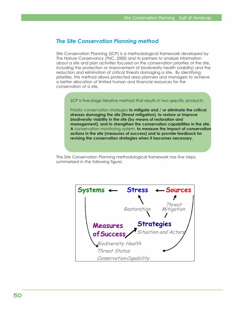
5050505050
Site Conservation Planning Gulf of Honduras
The Site Conservation Planning method
Site Conservation Planning (SCP) is a methodological framework developed byThe Nature Conservancy (TNC, 2000) and its partners to analyze informationabout a site and plan activities focused on the conservation priorities of the site,including the protection or improvement of biodiversity health (viability) and thereduction and elimination of critical threats damaging a site. By identifyingpriorities, this method allows protected area planners and managers to achievea better allocation of limited human and financial resources for theconservation of a site.
SCP is five-stage iterative method that results in two specific products:
Priority conservation strategies to mitigate and / or eliminate the criticalstresses damaging the site (threat mitigation), to restore or improvebiodiversity viability in the site (by means of restoration andmanagement), and to strengthen the conservation capabilities in the site.A conservation monitoring system, to measure the impact of conservationactions in the site (measures of success) and to provide feedback forrevising the conservation strategies when it becomes necessary.
The Site Conservation Planning methodological framework has five steps,summarized in the following figure:
Systems Stress Sources
Biodiversity Health
Measures
of Success
Threat Status
Threat Mitigation Restoration
Conservation Capability
Situation and Actors Strategies

Site Conservation Planning Gulf of Honduras
5151515151
COMPONENT 1:SYSTEMS AND CONSERVATION ELEMENTS
Systems and Conservation elements:
The important species, ecologiccommunities, and ecologic systems –-including the natural processes thatmaintain them— that justify the selectionof a site for conservation actions.Once the key elements to ensure thelong-term viability of each system havebeen identified—including species,communities, and processes—, threecharacteristics of the systems must beanalyzed:
¨ Size: measurement of the area orabundance of the occurrence of theconservation element
¨ Condition: integrated measurementof the composition, structure, and thebiotic interactions that characterizethe occurrence
¨ Landscape context: integratedmeasurement of two factors: thedominant environmental regimes andprocesses that establish and maintainthe occurrence of the conservationelement, and connectiveness
A category evaluation (Very Good,Good, Fair, Poor) of the current state ofthese three factors allows acharacterization of the viableoccurrences of the systems within the site.
COMPONENT 2: STRESSES
Stresses:
The types of degradation and damageto the size, condition, and / or landscapecontext of a system or conservationelement that result in the reduction of theviability and health of the system. Theanalysis of stresses in this step and theanalysis of the sources of stress in the nextstep are key to learn what the problemsof the site are, and to focus theconservation strategies on the priority
threats from an ecologic perspective.The following important points must beconsidered when identifying thestresses acting on the systems and theirassociated conservation elements:
¨ Only the destruction ordegradation of systems and theirassociated conservation elementsresulting from human (non-natural)causes must be considered as astress.
¨ To be considered, the stress must behappening at the present, or havea high probability of happening inthe near future.
¨ Stresses damaging each systemmust be identified.
¨ It is important to be as precise aspossible when identifying stresses;this will help identify sources ofstress.
A hierarchical value (Very High, High,Medium or Low) is assigned to thestresses acting on each conservationelement. Even though all the stressesacting on the biodiversity aredocumented, it is critical to prioritizethese stresses based on the severityand extent of each stress. Theconservation strategies must reduce oreliminate those stresses that have ahigh severity combined with an ampleextent.
COMPONENT 3: SOURCES OF STRESS
Sources of stress:
The actions, processes, or agents, ofhuman or natural origin, that generateor cause stress. Together, the sourcesof stress and the stresses they exert onthe systems constitute the threats to theecosystems.
Most of the sources of stress areassociated to the environmentallyunsound use of soil, water, and natural

5252525252
Site Conservation Planning Gulf of Honduras
resources by humans, which are takingplace or have taken place in the past,yet continue having an impact. Severalpoints must be considered whenidentifying sources of stress forconservation elements:
¨ When multiple sources of stresscontribute to a single stress, threatmitigation strategies must be focusedon the sources that have the mostimpact on that stress.
¨ Focus must be placed on thosesources of stress that would have along-term impact, like urbandevelopment.
¨ To be considered, the sources ofstress must be happening at thepresent, or have a high probability ofhappening in the near future.
¨ The sources of stress closest to theconservation elements must beidentified, rather than the mostdistant sources, to ensure thedevelopment of direct and feasibleconservation strategies.
On the basis of the best knowledge andexpert judgment available, each sourceof stress must be evaluated according tothe criteria of contribution andirreversibility:
It is critical that investments made toimplement site conservation strategies befocused on the mitigation of the mostcritical threats, instead of less destructiveand easier to confront threats.
The final step in the evaluation of stressesand sources of stress is to make asynthesis of the individual analyses ofeach stress and source of stress, whichidentifies the critical threats over thesystems or conservation elements in asite, and allows the definition of priorities.
COMPONENT 4: CONSERVATION STRATEGIES
Conservation strategies:The conservation actions developed andimplemented to:
¨ Mitigate and / or eliminate thecritical stresses that are damagingthe site
¨ Restore or improve the viability ofbiodiversity in the site
¨ Strengthen the conservationcapabilities in the site
The ultimate objective of theconservation strategies is to reduce thestresses that act on the systems orconservation elements, reducing theirviability. To develop conservationstrategies, the following points must betaken into account:
¨ Conduct an analysis of the situationand the actors in the whole sitelinked to each threat
¨ Make a list of the proposedconservation strategies
¨ Evaluate the proposedconservation strategies accordingto the following criteria: thebenefits acquired by implementingthem; the feasibility of their beingsuccessful; and the costs
¨ Prioritize the conservation strategiesfor the whole site, to determine thelines of action
Making the Situation and Key ActorsDiagram generates a graphicrepresentation of the cause and effectrelations between the sources of stress,human activities, key actors, and theirmain motivations.
COMPONENT 5: MEASURES OF CONSERVATIONSUCCESS
Measures of conservation success:The measurements of conservationimpact consist of monitoringbiodiversity health and the state ofcritical threats, to provide feedback forthe adaptive management of the site,and for the revision of the conservationstrategies when necessary. Also,measuring conservation capabilitymonitors the institutional support for the

Site Conservation Planning Gulf of Honduras
5353535353
implementation of the conservationstrategies. The measures of conservationsuccess are sets of monitoring indicatorsclassified in the following manner:
¨ Biodiversity health: Evaluates theeffectiveness of conservationstrategies to improve or maintain theviability of the conservation elements(size, condition, and landscapecontext).
¨ State of critical threats: Evaluates theeffectiveness of conservationstrategies to diminish or eliminatecritical threats over time.
¨ Conservation capability: Provides away to monitor the following factors,key to the success of a site project:
¨ Project leadership and support:Responsible and experiencedpersonnel, support equipment
¨ Strategic method: Understandingand application of the SiteConservation Planningmethodological framework, aniterative and adaptive method todevelop and implement keyconservation strategies
¨ Project financing and sustainability:Initial or short-term financing,sustainable support
DEVELOPMENT OF THE SITE CONSERVATIONPLANNING PROCESS FOR THE GULF OF HONDURAS
In the year 2001, with the support ofPROARCA/Costas, the basis for the SiteConservation Plan (SCP) for the Gulf ofHonduras was formulated. To this effect,a site profile was developed, and jointlywith tri-national key actors, including themembers of the Tri-National Alliance forthe Conservation of the Gulf of Honduras(TRIGOH), three workshops were held toidentify conservation elements, stresses,sources of stress, work strategies, andmeasures of success for the conservation
of the site. Thematic maps of the Gulfwere also produced, to support theanalysis and the formulation of the SCP.
The first workshop was held inGuatemala City, from 2 to 4 May 2001.The objectives were to identify, in aparticipative manner, the conservationelements and the principal threats tothe tri-national area of the Gulf ofHonduras, and to define the indicatorsto monitor those conservation elementsand threats. There were 42participants. The second workshop washeld in Guatemala City, from 24 to 26July 2001. The objectives were to mapthe threats (stresses and sources ofstress) that are degrading the targetelements, to identify in a participativeway the strategies to conserve thetarget elements, and to conduct ananalysis of actors to involve in theimplementation of the strategies. Therewere 35 participants. The process wasfinalized with a third workshop, held inAntigua Guatemala on 30 and 31August 2001. The objectives were tovalidate and refine the strategies andaction plans generated by theanalyses in the previous activities, toensure an effective conservation of thebiodiversity of the site. There were 19participants. Besides all the membersof TRIGOH, universities, Ministries of theEnvironment and Agriculture, municipalgovernments of the three countries,MBC, PROARCA, and TNC allparticipated in these workshops.
However, the original process was notcompleted; the systematization of theinformation produced in the workshopswas lacking.
When the new vision of PROARCA/APMwas manifested, it became necessaryto include some terrestrial regions, inorder to complete the information ofthe “from the watershed to the reef”proposal, and to validate the resultswith a new workshop. It was held from4 to 6 December 2003, in Puerto Barrios.

5454545454
Site Conservation Planning Gulf of Honduras
The objectives of the workshop were tovalidate the strategies and the measuresof success. Participants from Guatemalawere 3 persons from FUNDARY, 4 personsfrom FUNDAECO, and 1 representativefrom Defensores de la Naturaleza; fromBelize, 1 representative from TASTE, 1representative from TIDE, 1 representativefrom NGC/TDC, 1 representative fromFriends Of Nature, and 2 representativesfrom CISP/Proyecto GOH, for a total of 14participants.
Before the workshop, suggestions fromFundación Fasquelle and PROLANSATE(Honduras), and TIDE and NGC/TDC(Belize) were taken into account, bymeans of visits to Honduras and Belize.

Site Conservation Planning Gulf of Honduras
5555555555
Map
1.
Base
map
of t
he G
ulf o
f Hon
dur
as
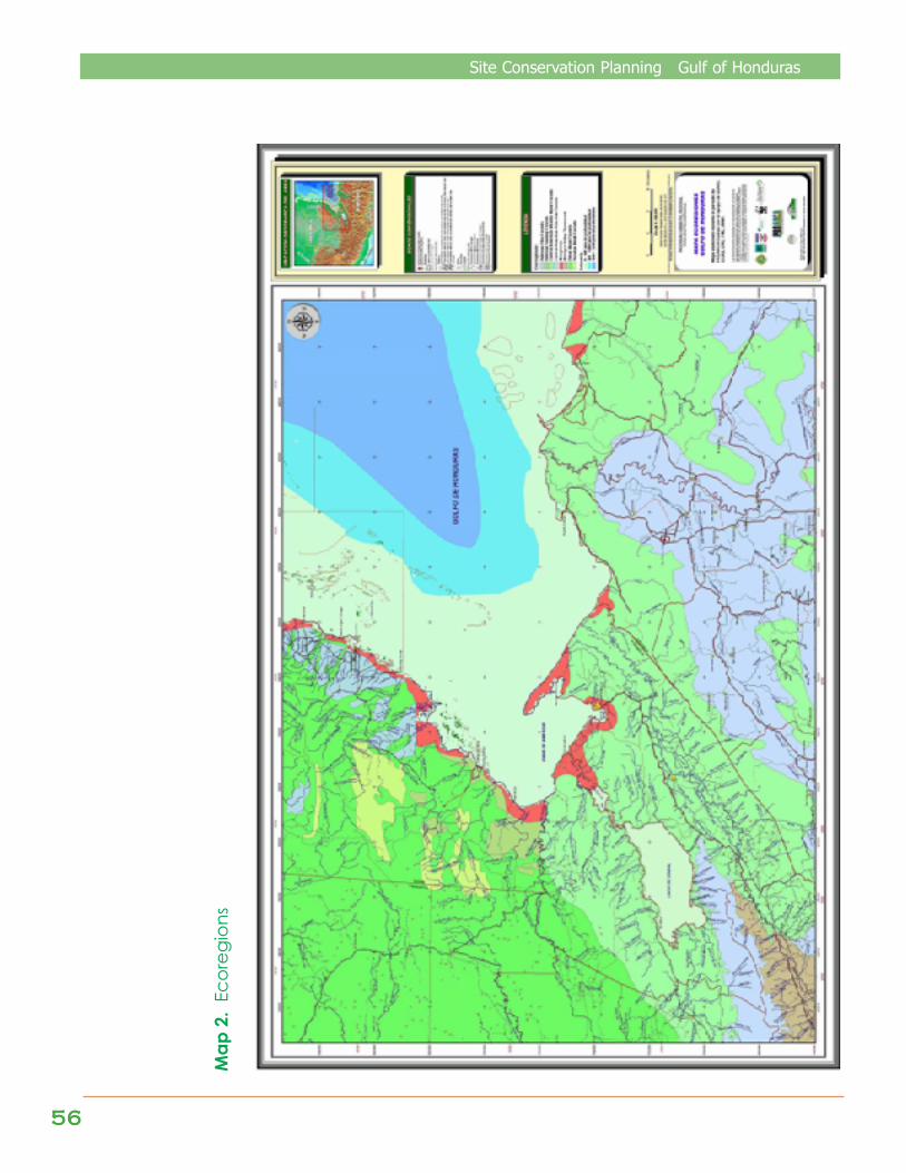
5656565656
Site Conservation Planning Gulf of Honduras
Map
2.
Ecor
egio
ns
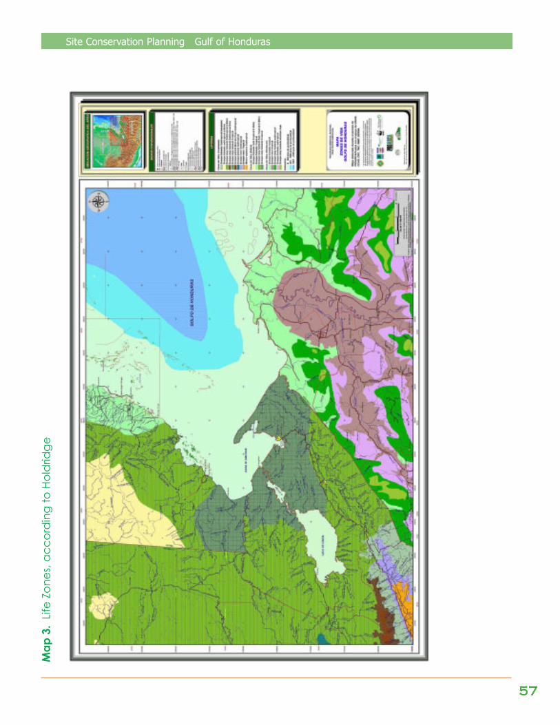
Site Conservation Planning Gulf of Honduras
5757575757
Map
3.
Life
Zone
s, ac
cord
ing
to H
old
ridge

5858585858
Site Conservation Planning Gulf of Honduras
Map
4.
Con
serv
atio
n El
emen
ts
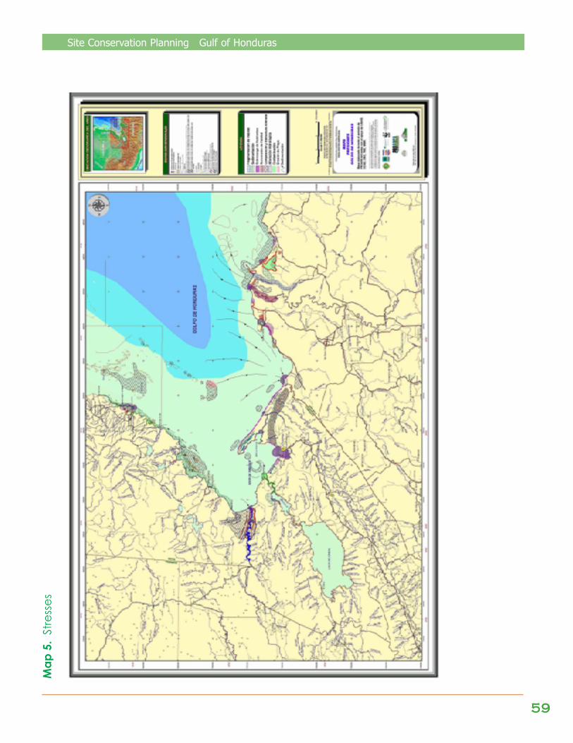
Site Conservation Planning Gulf of Honduras
5959595959
Map
5.
Stre
sses
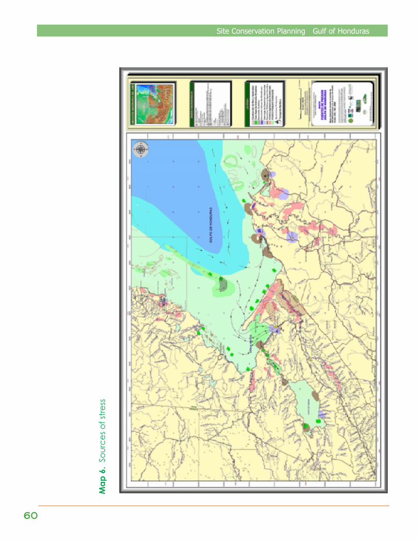
6060606060
Site Conservation Planning Gulf of Honduras
Map
6.
Sour
ces o
f stre
ss
In the Presidential Summit of 1989, the Chiefs of State signed the Central AmericanAgreement for the Protection of the Environment, thus forming the Central AmericanCommission on the Environment and Development (CCAD), as part of the CentralAmerican Integration System (SICA). The principles that provide the basis for theobjectives of CCAD are:
To value and protect the heritage of the region, which is characterized by a diverse biology anddiverse ecosystems. CCAD is called to be the link that establishes collaboration between thecountries of the region in jointly seeking the adoption of sustainable development styles and theparticipation of all entities concerned with development. Meanwhile, it should promotecoordinated actions between governmental and international entities to use the natural resourcesof the area in an optimal and rational way, and in the same manner seek actions destined tocontrol contamination and seek efforts to re-establish the ecologic equilibrium. Another of itsobjectives is to negotiate the obtaining of regional and international financial resources to fulfill itsconservation and development goals.
United States Agency for International Development
Since its founding by President John F. Kennedy in 1961 as an independent federalagency, the US Agency for International Development – USAID – has helped
developing countries to provide opportunities to their people and to combat hunger, poverty,sickness, and environmental degradation. The international assistance programs of the UnitedStates have a long and distinguished history of achievements attained with half of one percent ofthe federal budget. Throughout more than 40 years, the programs of USAID have significantlycontributed to democratic government, the facilitation of economic growth, natural resource andprotected area management, biodiversity conservation, conflict reduction and management,and the provision of humanitarian aid in more than 200 countries in the world.
The Nature Conservancy was established in 1951 as a non-profit organization.Currently, it is the largest private organization dedicated to conservation inthe United States. Its mission is:
To preserve the plants, animals, and natural communities that represent the diversity of life in theworld, by protecting the lands and waters that these need to survive. Since 1980, the LatinAmerican and Caribbean Division of The Nature Conservancy has worked with associates in 20countries to protect over 22 million hectares of critical habitats.
The basic goals of The Nature Conservancy are:
· Conserve, with a scientific basis. The organization was created by a group of ecologists;therefore science has always been the basis for its actions.
· Obtain on site results. TNC concentrates its efforts on in situ conservation, from the acquisitionof lands to marking borders and patrolling protected areas, and training and equippingrangers.
Organizaciones que forman parte del Consorcio de Ejecución de PROARCA/APM