2 Aerial reconnaissance in Northamptonshire
5
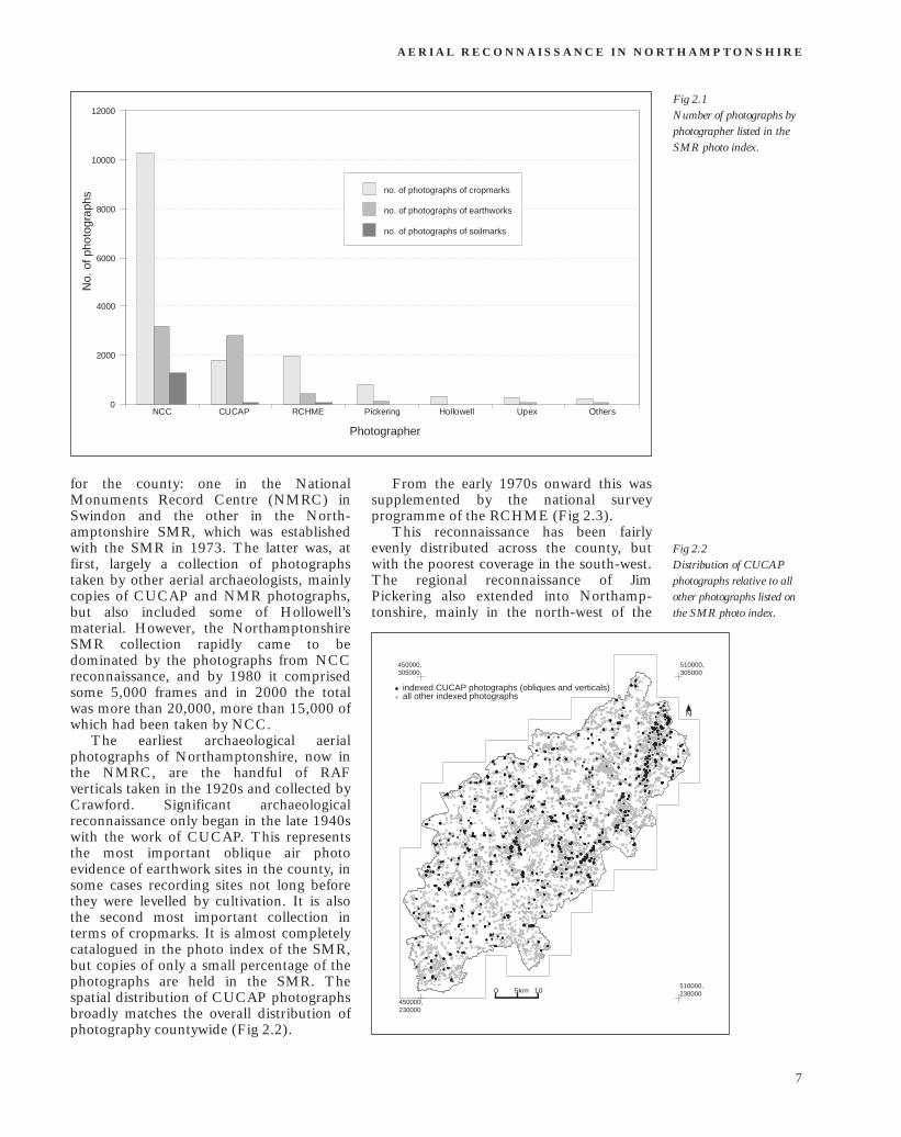
2 Aerial reconnaissance in Northamptonshire by Glenn Foard Introduction This chapter represents the first substantial review of the history of aerial recon naissance in Northamptonshire, although a brief overview of the history of aerial reconnaissance in Northamptonshire up to the late 1970s was published by this author in 1979 (Foard 1979a, 91). This chapter briefly considers the work of all practitioners but focuses primarily upon the intensive reconnaissance programme of Northamp tonshire County Council between 1977 and 1996. The analysis is based on published reports, flight logs by Foard and Cowley 1977–96, unpublished reports, and the SMR photo index. Although the latter was substantially updated as part of the NMP as a record of the project, there were various limitations in the potential for the present analysis resulting from incon sistencies in the entries in the index; but it is not believed that these limitations have significantly compromised the analysis presented here. Aerial reconnaissance by others There have been six substantial programmes of archaeological aerial reconnaissance that included all or part of the county: conducted by Hollowell, Upex, Pickering, RCHME, CUCAP and NCC (Everson and Cowley 1974–5; Foard 1976–96). The remainder of the reconnaissance by others comprises together no more than perhaps 300 frames (Table 2.1 and Fig 2.1). There are two major archives of aerial photographs Table 2.1 Number of photographs by photographer listed in the SMR photo index photographer dates cropmark earthwork soilmark total number photographs photographs photographs of photographs NCC 1973–1997 10259 3176 1269 15406 CUCAP 1947–2000 1791 2810 79 5129 RCHME 1971–2000 1963 402 76 3184 Pickering 1963–1986 779 113 13 1008 Hollowell 1961–1977 329 4 0 446 Upex 1971–1979 285 77 18 449 Others — 209 32 0 283 OTHERS Ashmolean — 0 5 0 5 Baker — 25 0 0 30 Buckinghamshire Museum — 8 2 0 34 Crawford (RAF) — 3 1 0 13 Field — 22 0 0 26 Foster — 4 2 0 6 Hartley/Leics Museum — 25 3 0 28 Lyall — 14 0 0 14 Moore — 73 6 0 79 Poulton — 15 0 0 15 Rollings — 4 4 0 8 Warhurst/Northampton Museum — 6 9 0 15 Williams — 10 0 0 10 6
Transcript of 2 Aerial reconnaissance in Northamptonshire

2 Aerial reconnaissance in
Northamptonshire by Glenn Foard
Introduction
This chapter represents the first substantial review of the history of aerial reconnaissance in Northamptonshire, although a brief overview of the history of aerial reconnaissance in Northamptonshire up to the late 1970s was published by this author in 1979 (Foard 1979a, 91). This chapter briefly considers the work of all practitioners but focuses primarily upon the intensive reconnaissance programme of Northamptonshire County Council between 1977 and 1996. The analysis is based on published reports, flight logs by Foard and Cowley 1977–96, unpublished reports, and the SMR photo index. Although the latter was substantially updated as part of the NMP as a record of the project, there were
various limitations in the potential for the present analysis resulting from inconsistencies in the entries in the index; but it is not believed that these limitations have significantly compromised the analysis presented here.
Aerial reconnaissance by others
There have been six substantial programmes of archaeological aerial reconnaissance that included all or part of the county: conducted by Hollowell, Upex, Pickering, RCHME, CUCAP and NCC (Everson and Cowley 1974–5; Foard 1976–96). The remainder of the reconnaissance by others comprises together no more than perhaps 300 frames (Table 2.1 and Fig 2.1). There are two major archives of aerial photographs
Table 2.1 Number of photographs by photographer listed in the SMR photo index
photographer dates cropmark earthwork soilmark total number photographs photographs photographs of photographs
NCC 1973–1997 10259 3176 1269 15406 CUCAP 1947–2000 1791 2810 79 5129 RCHME 1971–2000 1963 402 76 3184 Pickering 1963–1986 779 113 13 1008 Hollowell 1961–1977 329 4 0 446 Upex 1971–1979 285 77 18 449 Others — 209 32 0 283
OTHERS Ashmolean — 0 5 0 5 Baker — 25 0 0 30 Buckinghamshire Museum — 8 2 0 34 Crawford (RAF) — 3 1 0 13 Field — 22 0 0 26 Foster — 4 2 0 6 Hartley/Leics Museum — 25 3 0 28 Lyall — 14 0 0 14 Moore — 73 6 0 79 Poulton — 15 0 0 15 Rollings — 4 4 0 8 Warhurst/Northampton Museum — 6 9 0 15 Williams — 10 0 0 10
6
A E R I A L R E C O N N A I S S A N C E I N N O RT H A M P TO N S H I R E
Fig 2.1 N
o. o
f pho
togr
aphs
12000
10000
no. of photographs of cropmarks
8000 no. of photographs of earthworks
no. of photographs of soilmarks
6000
4000
2000
0 NCC CUCAP RCHME Pickering Hollowell Upex Others
Photographer
Number of photographs by photographer listed in the SMR photo index.
for the county: one in the National From the early 1970s onward this was Monuments Record Centre (NMRC) in supplemented by the national survey Swindon and the other in the North- programme of the RCHME (Fig 2.3). amptonshire SMR, which was established This reconnaissance has been fairly with the SMR in 1973. The latter was, at evenly distributed across the county, but Fig 2.2 first, largely a collection of photographs with the poorest coverage in the south-west. Distribution of CUCAP taken by other aerial archaeologists, mainly The regional reconnaissance of Jim photographs relative to all copies of CUCAP and NMR photographs, Pickering also extended into Northamp- other photographs listed on but also included some of Hollowell’s tonshire, mainly in the north-west of the the SMR photo index. material. However, the Northamptonshire SMR collection rapidly came to be dominated by the photographs from NCC 450000, 510000,
305000 305000reconnaissance, and by 1980 it comprised indexed CUCAP photographs (obliques and verticals) some 5,000 frames and in 2000 the total all other indexed photographs
was more than 20,000, more than 15,000 of N
which had been taken by NCC. The earliest archaeological aerial
photographs of Northamptonshire, now in the NMRC, are the handful of RAF verticals taken in the 1920s and collected by Crawford. Significant archaeological reconnaissance only began in the late 1940s with the work of CUCAP. This represents the most important oblique air photo evidence of earthwork sites in the county, in some cases recording sites not long before they were levelled by cultivation. It is also the second most important collection in terms of cropmarks. It is almost completely catalogued in the photo index of the SMR, but copies of only a small percentage of the photographs are held in the SMR. The 510000,
0 5km 10 230000spatial distribution of CUCAP photographs 450000, 230000broadly matches the overall distribution of
photography countywide (Fig 2.2).
7
M A P P I N G A N C I E N T L A N D S C A P E S I N N O RT H A M P T O N S H I R E
450000, 305000
510000, 305000
450000, 305000
510000, 305000
indexed RCHME photographs all other indexed photographs
indexed Pickering photographs all other indexed photographs
0
450000, 230000
Fig 2.3 Distribution of RCHME photographs relative to all other photographs listed on the SMR photo index.
Fig 2.4 Distribution of Pickering’s photographs relative to all other photographs listed on the SMR photo index.
N
510000,5km 10 230000
450000, 230000
county, with images taken between the early 1960s and the late 1980s (Fig 2.4). These two collections are largely catalogued in the SMR photo index, but prints of only a proportion of the images are held there.
Locally, various archaeologists, both amateur and professional, have conducted aerial survey ranging from just a few flights to extensive reconnaissance over many years.
A rapid assessment of this work was undertaken in 1977, and the results integrated into the SMR photo index and summarised in print (Foard 1979a, 91). This revealed that in 1959 Warhurst (Northampton Museum) made several flights, leaving a small collection of aerial photographs in the Northampton Museum collection, all now copied in the SMR. In the early 1970s there were several others who carried out flights. The late Alex Rollings had a collection of c 200–50 transparencies, mainly of sites along the middle and upper Nene. Although the location of his archive is not known, copies of a few of his images are in the SMR. Ken Field photographed a number of sites, especially on the Northamptonshire/ Buckinghamshire and Bedfordshire border, and copies of some of these are in the SMR. Others include Moore (Northampton Museum), whose slides are in the Northampton Museum collection but
N
510000,0 5km 10 230000
are copied in the SMR, and Williams (Northampton Development Corporation) whose whole archive is in the SMR.
By far the most important of this early local work was that conducted by Hollowell. Impressed by the results achieved by Warhurst, Hollowell persuaded various pilots to allow him to accompany them on flights (Moore 1980). Working from 1961 to the early 1970s his aerial reconnaissance was concentrated in central Northamptonshire, especially immediately to the north and east of Northampton and along the Nene valley as far as Nassington (Fig 2.5) (Brown 1998). The results of this reconnaissance together with his ground-breaking field-walking survey and other fieldwork, were reviewed in a volume edited by Brown in 1971, which included sketch plans of several of the most extensive cropmark complexes (Hollowell and Brown 1971). The slide copies and copy-negatives for this book, comprising an almost complete copy of the Hollowell collection, have been deposited in the SMR and the NMRC. The original slides from his work were retained by Hollowell until his death in 1998, but their current whereabouts are not known.
The other significant local work was by Upex (Nene Valley Research Committee), who carried out intensive reconnaissance 1971–9 in the Middle Nene Valley from
8

A E R I A L R E C O N N A I S S A N C E I N N O RT H A M P TO N S H I R E
450000, 510000, 450000, 510000, 305000 305000 305000 305000
indexed Hollowell photographs all other indexed photographs
indexed Upex photographs all other indexed photographs
N N
0 5km 10
450000, 230000
Oundle north-eastward, including the Soke of Peterborough, producing an archive of more than 2,500 frames (Fig 2.6) (Upex 1977). While some of Upex’s early photographs were available to the project, results from more recent reconnaissance was not mapped as part of the Northamptonshire NMP project.
In addition to this oblique, specifically archaeological photography there are the wide range of vertical surveys from the 1940s onwards by the Luftwaffe, RAF, Ordnance Survey and others, most of which are held in the NMRC. There are also a number of vertical surveys of the county conducted for or purchased by NCC, which can be accessed there. The most important are from 1979 and 1990, as well as the 2000 national survey, for which NCC holds a copy of Northamptonshire in GIS format.
South Northamptonshire Council also hold a district-wide vertical survey conducted in 1999.
While the verticals held in the NMRC were generally used for the NMP mapping, the locally-held vertical surveys were not.
Aerial reconnaissance by NCC
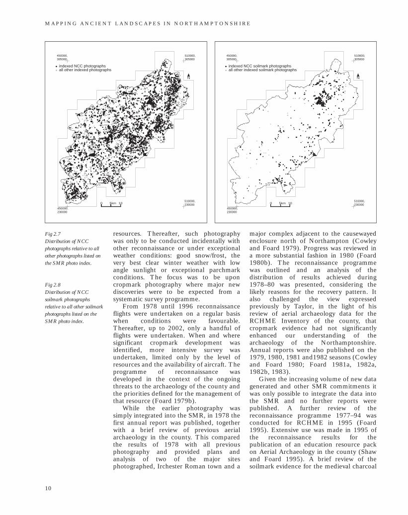
The air photo collection produced by NCC reconnaissance is by far the largest of all such collections for the county, comprising more than 15,000 frames. It dominates
510000, 230000 0 5km 10
450000, 230000
the cropmark record for the county, is the only collection with substantial soil mark evidence and in earthwork coverage is exceeded in terms of the range and importance of targets only by the CUCAP collection. Although the distribution is still inevitably dominated by the effects of geology and land use, especially through its influence on cropmark formation, the collection provides by far the most consistent countywide coverage. In the south and south west of the county it is almost the only significant cropmark record and in Rockingham Forest it provides almost the only soilmark coverage (Figs 2.7 and 2.8).
The County Council began archaeological reconnaissance following the appointment of Paul Everson as the first Northamptonshire County Archaeologist, 1973–4. He carried out a number of flights with pilot Derek Cowley, the Deputy County Architect. Cowley continued survey work in the year following Everson’s departure. The author, who was appointed as SMR Assistant in December 1976, joined Cowley as the photographer on most of the flights undertaken in 1977. A re-assessment of the reconnaissance programme was conducted at the end of that season. This indicated that earthwork photography, which had dominated the earlier work, was not the most productive use of the limited
510000, 230000
Fig 2.5 Distribution of Hollowell’s photographs relative to all other photographs listed on the SMR photo index.
Fig 2.6 Distribution of Upex’s photographs relative to all other photographs listed on the SMR photo index.
9
M A P P I N G A N C I E N T L A N D S C A P E S I N N O RT H A M P T O N S H I R E
450000, 305000
510000, 305000
450000, 305000
510000, 305000
indexed NCC photographs all other indexed photographs
indexed NCC soilmark photographs all other indexed soilmark photographs
0
450000, 230000
Fig 2.7 Distribution of NCC photographs relative to all other photographs listed on the SMR photo index.
Fig 2.8 Distribution of NCC soilmark photographs relative to all other soilmark photographs listed on the SMR photo index.
N
510000,5km 10 230000
450000, 230000
resources. Thereafter, such photography was only to be conducted incidentally with other reconnaissance or under exceptional weather conditions: good snow/frost, the very best clear winter weather with low angle sunlight or exceptional parchmark conditions. The focus was to be upon cropmark photography where major new discoveries were to be expected from a systematic survey programme.
From 1978 until 1996 reconnaissance flights were undertaken on a regular basis when conditions were favourable. Thereafter, up to 2002, only a handful of flights were undertaken. When and where significant cropmark development was identified, more intensive survey was undertaken, limited only by the level of resources and the availability of aircraft. The programme of reconnaissance was developed in the context of the ongoing threats to the archaeology of the county and the priorities defined for the management of that resource (Foard 1979b).
While the earlier photography was simply integrated into the SMR, in 1978 the first annual report was published, together with a brief review of previous aerial archaeology in the county. This compared the results of 1978 with all previous photography and provided plans and analysis of two of the major sites photographed, Irchester Roman town and a
N
510000,0 5km 10 230000
major complex adjacent to the causewayed enclosure north of Northampton (Cowley and Foard 1979). Progress was reviewed in a more substantial fashion in 1980 (Foard 1980b). The reconnaissance programme was outlined and an analysis of the distribution of results achieved during 1978–80 was presented, considering the likely reasons for the recovery pattern. It also challenged the view expressed previously by Taylor, in the light of his review of aerial archaeology data for the RCHME Inventory of the county, that cropmark evidence had not significantly enhanced our understanding of the archaeology of the Northamptonshire. Annual reports were also published on the 1979, 1980, 1981 and1982 seasons (Cowley and Foard 1980; Foard 1981a, 1982a, 1982b, 1983).
Given the increasing volume of new data generated and other SMR commitments it was only possible to integrate the data into the SMR and no further reports were published. A further review of the reconnaissance programme 1977–94 was conducted for RCHME in 1995 (Foard 1995). Extensive use was made in 1995 of the reconnaissance results for the publication of an education resource pack on Aerial Archaeology in the county (Shaw and Foard 1995). A brief review of the soilmark evidence for the medieval charcoal
10