1.3.6 The emergence of urban settlements and villages near the pithead due to the primitive ......
37
Thematic History of the City of Wollongong – FINAL REPORT 36 __________________________________________________________________________________ Accommodating miners and their families (Miners’ cottages, 438-446, 443-5, 449, 453-5 Lawrence Hargrave Drive, Scarborough; Kembla Heights Heritage Conservation Area) Rescuing miners Memorialising mine disasters (Mount Kembla mine memorial, Cemetery, Cordeaux Road, Mount Kembla) Improving mine safety Moving coal mining west of the escarpment 1.3.6 The emergence of urban settlements and villages Wollongong was the first urban centre in the district and remains as the major centre to the present day. For much of the nineteenth century, it was the only urban centre but small centres emerged at Brownsville (later Dapto), and Woonona/Bulli by the 1870s. The establishment of coalmines fostered a number of small villages at each pithead housing their employees across the northern parts of the area so that a network of small villages focussed on coalmines was evident by 1900. Since miners needed to live near the pithead due to the primitive state of transport, the coalmines fostered the establishment of villages or urban settlements on the escarpment away from the coastal plain. 1 To the south, smaller centres such as Dapto catered for the rural community in that area. By the 1890s, the entry of the railway meant that access to Sydney was improved and a string of villages focussed on the tourist trade began to emerge. Population of Wollongong Urban Centres 1871 to 1901 Town or Village 1871 1881 1891 1901 Habitations 1901 Bulli & Woonona - 1628 2578 2720 Illawarra Central (municipality) 2392 2550 3247 4664 967 Illawarra North (municipality) 763 1011 2515 3190 642 Wollongong (municipality) 1297 1635 3041 3545 680 Source: Census of New South Wales, 1901 1 Illawarra Escarpment Heritage Assessment 2007, Mayne-Wilson & Associates and Heritage Futures in association with Godden Mackay Logan, For Wollongong City Council, Part II – Thematic Essay – Theme 2, p 2
Transcript of 1.3.6 The emergence of urban settlements and villages near the pithead due to the primitive ......
Thematic History of the City of Wollongong – FINAL REPORT 36 __________________________________________________________________________________
Accommodating miners and their families (Miners’ cottages, 438-446, 443-5, 449, 453-5 Lawrence Hargrave Drive, Scarborough; Kembla Heights Heritage Conservation Area) Rescuing miners Memorialising mine disasters (Mount Kembla mine memorial, Cemetery, Cordeaux Road, Mount Kembla) Improving mine safety Moving coal mining west of the escarpment
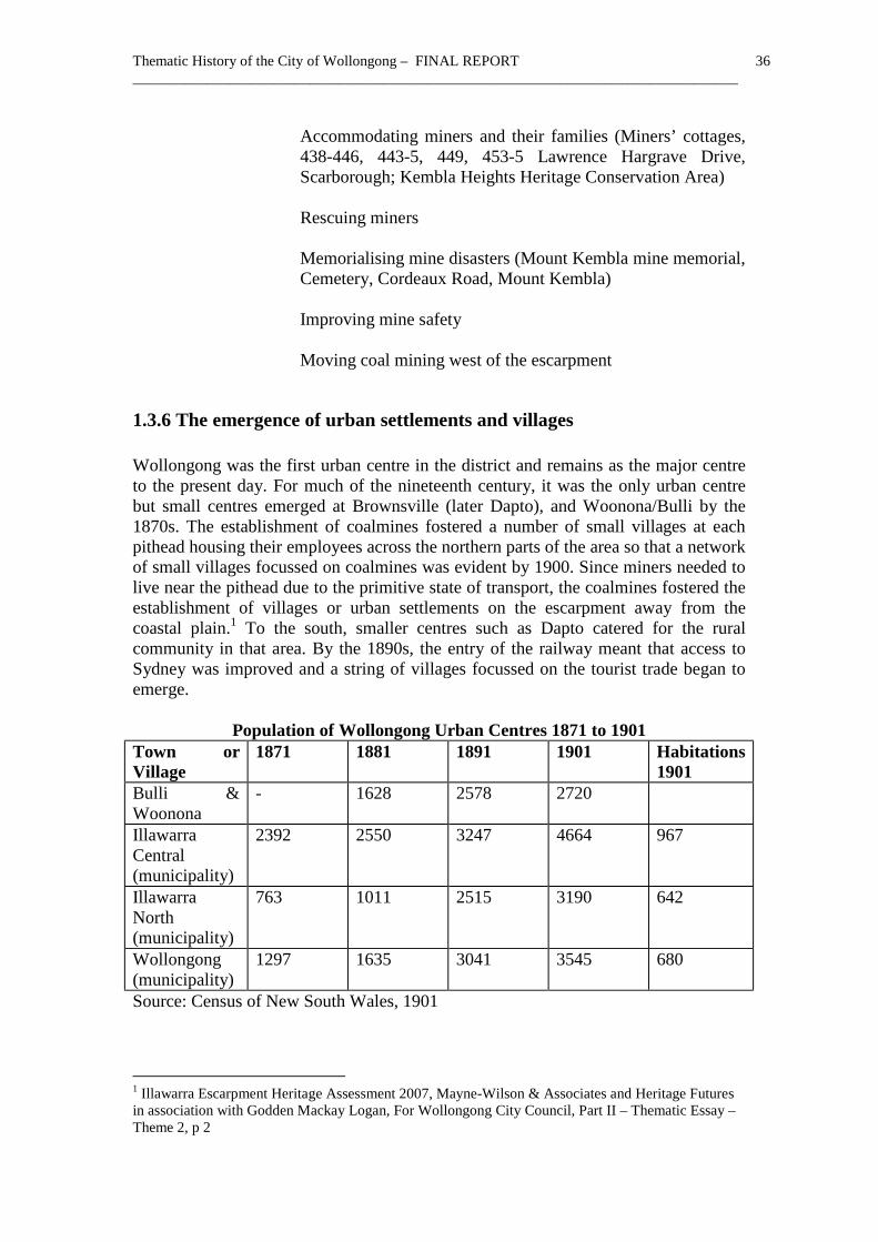
1.3.6 The emergence of urban settlements and villages Wollongong was the first urban centre in the district and remains as the major centre to the present day. For much of the nineteenth century, it was the only urban centre but small centres emerged at Brownsville (later Dapto), and Woonona/Bulli by the 1870s. The establishment of coalmines fostered a number of small villages at each pithead housing their employees across the northern parts of the area so that a network of small villages focussed on coalmines was evident by 1900. Since miners needed to live near the pithead due to the primitive state of transport, the coalmines fostered the establishment of villages or urban settlements on the escarpment away from the coastal plain.1 To the south, smaller centres such as Dapto catered for the rural community in that area. By the 1890s, the entry of the railway meant that access to Sydney was improved and a string of villages focussed on the tourist trade began to emerge.
Population of Wollongong Urban Centres 1871 to 1901 Town or Village
1871 1881 1891 1901 Habitations 1901
Bulli & Woonona
- 1628 2578 2720
Illawarra Central (municipality)
2392 2550 3247 4664 967
Illawarra North (municipality)
763 1011 2515 3190 642
Wollongong (municipality)
1297 1635 3041 3545 680
Source: Census of New South Wales, 1901
1 Illawarra Escarpment Heritage Assessment 2007, Mayne-Wilson & Associates and Heritage Futures in association with Godden Mackay Logan, For Wollongong City Council, Part II – Thematic Essay – Theme 2, p 2

Thematic History of the City of Wollongong – FINAL REPORT 37 __________________________________________________________________________________
The following two sections (1.3.6.1, 1.3.6.2 and 1.3.6.3) outline basic information about the establishment of the different urban centres and villages. They are not intended as comprehensive histories of those settlements.
1.3.6.1 Theme - Establishing rural centres
Dapto Dapto emerged as a rural centre catering for surrounding farms. George Brown transferred an existing licence for the Ship Inn in 1834 and a small settlement developed near his hotel. After being burned down in 1843, a new hotel, the Illawarra Hotel, replaced it. The hotel is located at what is now known as Brownsville, close to Mullet Creek where the original core of settlement developed. A Roman Catholic cemetery was dedicated in 1838. A Roman Catholic school was in operation in December 1839. It was reported in 1840 that Dapto was growing rapidly. It had George Brown's steam engine in full operation and a flourmill erected by Mr Bourne was expected to start in 1841. The Church of England that was almost complete was licensed for service in February 1845. A Wesleyan chapel opened in November 1848 and was shifted to a new site where it reopened in October 1861.1 By 1850, when Brown died, the private town of Dapto (later Brownsville) was established with some semblance of an ordered layout.2 A Presbyterian school was complete in 1851.3 By 1856, there were about half a dozen houses, a post office, a school at some distance plus the hotel and store at Dapto.4 By 1871, Dapto included the hotel conducted by that time by George Osborne, the mill, the school and the Central Illawarra Municipal Council chambers plus a large store owned by K McKenzie, which included the post office.5 A public school operated briefly in 1852 but was not permanently established until August 1875.6 The arrival of the railway in the 1880s made the town shift from its original older site near Mullet Creek (later known as Brownsville) to a new location next to the platform, which took the name of Dapto.7 Brown’s old hotel known as the Lake Illawarra continued to trade until September 1937 when approval was granted to transfer its licence.8 A butter factory established in 1887 by Mr Harvey of the Country Milk Company would operate from Brown's old mill.9
1 W G McDonald, Nineteenth-Century Dapto, Illawarra Historical Society, Wollongong, 1976, p 44-6; Jervis, ‘Illawarra’, p 150-2 2 Secomb, Dapto, np 3 Jervis, ‘Illawarra’, p 151 4 Jervis, ‘Illawarra’, p 152; Note that the Dapto post office file at National Archives of Australia goes back to 1864. 5 Jervis, ‘Illawarra’, p 152 6 NSW – Dept of School Education, Government Schools of New South Wales 1848 to 1993, Dept of School Education, 1993, Sydney, p 59 7 W G McDonald, Nineteenth-Century Dapto, p 67 8 Lake Illawarra Hotel Card, Licences Reduction Board, Hotel Cards, District of Wollondilly, SRNSW 3/7886 9 Jervis, ‘Illawarra’, p 153

Thematic History of the City of Wollongong – FINAL REPORT 38 __________________________________________________________________________________
The subdivision of the Marshall Mount Estate extending from Cleveland Street to Unarra Street west of the station and Byamee to Werowi Street east of the station in June 1890 ensured that population moved to the railway station and enabled a viable community to emerge. The late 1890s was a boom period in Dapto. Over 400 men were employed at the smelting works but its closure in 1905 turned Dapto back into a quiet rural village.1 After the post office had shifted from various locations, the government erected an official post office on Bong Bong Road in 1904. Dapto boomed again from the 1950s onwards as many new subdivisions were opened up in the vicinity. Dapto received numerous British migrants settled in a Commonwealth Housing area on Yalunga Street colloquially known as ‘Pommy Hill’ in the 1950s.2
Sherbrooke A settlement developed where the road from Georges River met the road from Appin at the top of Bulli Mountain. It was known originally as Bulli Mountain and Upper Bulli and was named Sherbrooke in 1883.3 A public school opened as Bulli Mountain in May 1870.4 The public school was replaced by a stone building on 21 September 1883.5 William Brown had selected land in 1873 he named ‘Ferndale’ and set up a renowned orchard. In May 1878, Knight set up a sawmill and erected a dam to serve his steam engine. Sherbrooke post office operated from 1882 to 1904. A Church of England opened in May 1882.6 The area was a renowned orchard centre for some years. Workers constructing Cataract Dam went to ‘Cataract City’ where a complete commercial centre with churches operated down river from Sherbrooke. A tram ran from Gallagher’s quarry at Sherbrooke seven miles to the dam wall.7 Sherbrooke village was resumed in 1903 since it was in the catchment area for Cataract Dam. All buildings such as the church were removed except the stone schoolhouse. The former schoolhouse was burnt out in 1968 and its shell was moved.8
Secondary themes
Providing retail services Orcharding Building up community facilities (Former West Dapto Public School, Sheaffes Road, West Dapto)
1 Secomb, Dapto, np 2 Secomb, Dapto, np 3 Bayley, Bulli, p 41 4 NSW – Dept of School Education, Government Schools of New South Wales 1848 to 1993, Dept of School Education, 1993, Sydney, p 129 5 Bayley, Bulli, p 41 6 Bayley, Bulli, p 41 7 Bayley, Bulli, p 56-7 8 A Gibbs & C Warne, Wollongong: A Pictorial History, Kingsclear, 1995, p 52
Thematic History of the City of Wollongong – FINAL REPORT 39 __________________________________________________________________________________
Servicing the population (Former Lake Illawarra Hotel, Dapto)
1.3.6.2 Theme - Establishing mining villages Many of Wollongong’s suburbs were originally created as villages associated with nearby coalmines. A sample of these is discussed below. It is not a comprehensive listing. Others such as Balgownie, Wongawilli, Kembla Heights, etc have not been discussed.
Bulli Bulli is located on grants made to Cornelius O’Brien, William Bowman and George Tate. The only house in 1825 was that of Cornelius O’Brien but by 1828, Peggy McGawley’s and Gerraty Brothers had joined it. Both Bulli and Woonona were important early settlements and their history was often intertwined. From the 1840s onwards, land was sold at Bulli. The Bulli estate of 900 acres was offered for private sale in 1841. It was later subdivided and 22 lots of 25 to 165 acres were offered for sale. Captain Westmacott's residence was offered for lease in September 1844. Robert Somerville, a local notable, erected a steam mill in 1858. Services including shops were soon in business. A Sunday school was in operation in 1861 and the Bellambi and Bulli School of Arts had been organised.1 It was not until 21 December 1863, that the Bellambi and Bulli School of Arts opened in Gray Street, Woonona.2 Cockerton and Co opened a new store in 1861.3 The coal mine opened in 1863 and it was reported that more substantial buildings were replacing the original workers’ huts.4 In September 1864, the Illawarra Mercury noted how the opening of the mine had created a village at Bulli.5 Wesleyan Church services were held as early as 1857 and later a building was altered as a church, which opened on 27 January 1862. A stone Wesleyan Chapel erected by contractor Thackeray opened on 7 May 1865.6 The Bulli and Bellambi Benefit Society was formed in 1865.7 Bulli School opened on 7 July 1869.8 A post office opened at Bulli on 1 October 1869.9 The Presbyterian Church opened at Gray Street, Woonona on 29 September 1871 and a cemetery was set up next to it.10 The first burial in the Church of England cemetery in Park Road occurred in 1878.11 A branch
1 Jervis, ‘Illawarra’, p 93-4 2 Bayley, Bulli, p 29 3 Jervis, ‘Illawarra’, p 94 4 Jervis, ‘Illawarra’, p 95 5 Bayley, Bulli, p 33 6 Bayley, Bulli, p 31 7 Bayley, Bulli, p 35-6 8 Bayley, Bulli, p 33 9 Bayley, Bulli, p 37 10 Bayley, Bulli, p 29 11 Bayley, Bulli, p 34
Thematic History of the City of Wollongong – FINAL REPORT 40 __________________________________________________________________________________
of the Government Savings Bank was established at Bulli on 4 June 1877.1 The telegraph line was extended to Bulli from Bellambi in 1877.2 The E S and A Bank opened a branch in 1878.3 After closure of its mine in 1879, Woonona declined as the district centre to be supplanted by Bulli.4 On 11 April 1879, a postal inspector reported, ‘Within the last two or three years the population of Bulli has very much increased and instead of a solitary store and public house there are now 5 public houses and 5 stores.’5 The village known as Robbinsville after a large landholder had emerged north of Bulli. It was also known as Newtown.6 It subsequently became Thirroul. As Bulli supplanted Woonona as the centre, it acquired additional functions. A new courthouse and hotel were under construction in 1880.7 A police lock-up with two cells was also under construction.8 The courthouse opened in 1882.9 The Bulli and Clifton Times was first issued on 3 July 1886.10 A major improvement in local facilities occurred on 20 May 1893 when the Bulli Hospital built by John Myles was officially opened.11 A host of new churches were also established. In July 1880, Bishop Polding blessed a new Catholic church and a school to be called St Joseph. The church was officially blessed on 11 September 1881 and the school opened in 1882.12 The new Church of England to the design of Edmund Blacket was consecrated on 22 October 1884.13 On 23 August 1885, the new Primitive Wesleyan Methodist church opened. In later years it became the Bulli Workers’ Club.14 A public cemetery was finally set up near Woniora Point in 1887.15 A new St Joseph’s Roman Catholic Church opened on 26 August 1900. The adjacent convent was built in 1903.16 Erection of the railway platform inspired the shift of the core of the town away from ‘Old Bulli’ to a new location near the station. Roger and Sarah Heard erected the Bulli Railway Guest House about 1887 to coincide with the construction of the railway.17 George Croft’s Hotel was the finest building erected in the area for many years, consisting of three storeys costing £4,000 and let to William Dickson for the first five years. Older hotels such as the Black Diamond closed to become a boarding house, whilst the Denmark Hotel closed in 1894 and the Star of the Sea and Railway
1 M77/1584, Post Office File, Bulli Part 1, NAA, CRS SP32/1 2 Rogers, ‘Thematic History’, p 42 3 Bayley, Bulli, p 37 4 Bayley, Bulli, p 48 5 Letter 2947, Post Office File, Bulli Part 1, NAA, CRS SP32/1 6 Jervis, ‘Illawarra’, p 95 7 Jervis, ‘Illawarra’, p 96 8 Bayley, Bulli, p 38 9 Rogers, ‘Thematic History’, p 42 10 Bayley, Bulli, p 38 11 Bayley, Bulli, p 58 12 Jervis, ‘Illawarra’, p 96 13 Bayley, Bulli, p 35 14 Bayley, Bulli, p 34 15 Bayley, Bulli, p 35 16 Bayley, Bulli, p 58 17 Maureen Slapp, ‘Railway Guest House Bulli – Family Reminiscences’, in http://www.uow.edu.au/%7Emorgan/railwayinn.htm, Accessed 13 May 2010

Thematic History of the City of Wollongong – FINAL REPORT 41 __________________________________________________________________________________
Hotel also closed.1 The pace of development left what became ‘Old Bulli’ marooned away from the railway, though significant items such as the Denmark Hotel survive, as well as a very early slab miner’s cottage.2 In 1914, the Bulli Pass Hotel was demolished for a new two-storey brick building on a site at the corner of George and Philip Streets. By 1914, Bulli shopping centre was moving near the railway line.3
Woonona H S Fry established the first store at Woonona in 1857. He went on to become a significant local figure. On 1 October 1859, Fry opened a post office named ‘Wonona’. In the late 1860s, Woonona was the main centre of the Bulli area centred on the hilltop where the tramway from Hale’s South Bulli mine crossed the road south of Gray Street.4 A Church of England school had been established in 1865.5 In 1871, a branch of the Government Bank opened.6 A Presbyterian Church opened on 29 September 1871.7 Charles Pope built a series of cottages in 1878 on the site of Popes Lane, originally known as Black’s Bush after James Black, an earlier resident.8 A public school opened in November 1882.9 By 1879, when the coalmine was no longer operating, many workers had moved to Bulli.10 Woonona declined as the district centre to be supplanted by Bulli.11 In any case, many services such as the courthouse and police station had been centrally located between the two centres. The subdivision and auction on 18 April 1889 of Hale’s estate between Gray and Stanhope Streets east of the main road near his former mine later conducted by the Bellambi Coal Company revived Woonona.12 It was a subdivision of parts of lots 1, 2 and 3 of the Bellambi Estate subdivided in the 1840s.13 Commercial activity resurged and stores opened.14 According to Bayley, ‘Houses and stores sprang up on every hand’.15 The Public School commenced in a newly built building at Gray Street in February 1885.16 A brick building with two rooms for the Infants’ Department was added to the
1 Bayley, Bulli, p 57 2 A Wood, Tales from Our Streets: A Photographic History of Wollongong, Author, Figtree, 1999, p 68-9; Pers comm., Meredith Hutton, 3 June 2010 3 Bayley, Bulli, p 70 4 Bayley, Bulli, p 29 5 Hagan & Wells, p 191 6 Bayley, Bulli, p 29 7 Jervis, ‘Illawarra’, p 99 8 Bayley, Bulli, p 30 9 NSW – Dept of School Education, Government Schools of New South Wales 1848 to 1993, Dept of School Education, 1993, Sydney, p 154 10 Jervis, ‘Illawarra’, p 100 11 Bayley, Bulli, p 48 12 SMH, 12 April 1889, p 11 13 Plan 149 (A), LPMA 14 The plan number is DP 2697, which suggests a plan registration date of 1891. 15 Bayley, Bulli, p 54 16 Bayley, Bulli, p 28

Thematic History of the City of Wollongong – FINAL REPORT 42 __________________________________________________________________________________
school in 1890.1 A new official post office opened in 1903.2 The friendly societies of the district built a hall on the main road in 1905 used jointly for many years that was later sold for a motor garage.3 During the 1900s, additional subdivisions opened up the area including Hale’s, Campbell’s and Ziems’ estates.4 The first service at the newly erected Woonona Methodist Church was held on 28 May 1909.
Figure 7 Woonona village subdivision of April 1889. Source: Woonona
Subdivision Plans, ML, ZTP: W34/4
1 Bayley, Bulli, p 54 2 Bayley, Bulli, p 55 3 Bayley, Bulli, p 54 4 Bayley, Bulli, p 55
Thematic History of the City of Wollongong – FINAL REPORT 43 __________________________________________________________________________________
American Creek/Mount Kembla Four grants were made out to Henry Gordon near American Creek on 28 March 1843. Another grant of 24 acres was issued to Patrick Leahey.1 A small settlement arose and a National School was completed there in March 1859. A Church of England church was erected in 1860.2 A significant early industry was the production of oil shale, which had been discovered at American Creek on Portions 4 and 160, Parish of Kembla.3 In 1865, a retort plant had been constructed for £4,000 and commenced operation. In 1870, there were 23 retorts producing kerosene for proprietors John, Edward and Neville Graham. In 1874, it was sold to the Mount Kembla Coal and Oil Company. After working intermittently after 1876, it was finally abandoned after 1880.4 By then, there were proposals to mine coal from the escarpment nearby. The Mount Kembla Coal and Oil Co Ltd was established. Its railway line to Port Kembla was operating in February 1883.5 The Mount Kembla mine was operating in 1882. Most miners lived in a company village at Kembla Heights in cottages built by the mine company. Others resided on freehold land nearby.6 Community facilities emerged. In 1884, the Primitive Methodist Church opened followed in 1888 by the Presbyterian Church. St Clement's Roman Catholic Church was dedicated in 1892.7 A post office opened in 1892.8 The Mount Kembla or Violet Hill school, as it was known until April 1884, served the mining community as well as the existing farming community, though miners unsuccessfully called for a school more accessible to their children.9 Unable to obtain a hotel for their community, in 1896, miners formed the Kembla Heights Workmen’s Club, which also obtained a liquor licence.10
Helensburgh Helensburgh was originally named Camp Creek and emerged when coalmines opened in 1884 in anticipation of the rail line. The South Cumberland Coal Mining Co began opening a shaft at ‘Camp Creek’ in June 1886. Mining operations commenced under a new company, the Metropolitan Coal Company in March 1888.11 The original settlement was a tent village for construction workers on the railway. A post office was set up in 1886. The name Helensburgh came into use in May 1887. A public school opened in July 1887.12
1 Shown as Patrick Lehaey on parish maps. 2 Jervis, ‘Illawarra’, p 88 3 A P Fleming, The Pioneer Kerosene Works at American Creek (Mt Kembla, NSW), Illawarra Historical Society, Wollongong, 1976, p 4-5 4 Ibid, p 4-5, 9-10; Jervis, ‘Illawarra’, p 297 5 A P Fleming, The Pioneer Kerosene Works at American Creek, p 10 6 S Piggin & H Lee, The Mt Kembla Disaster, Oxford University Press, Melbourne, 1992, p 15 7 Piggin & Lee, Mt Kembla Disaster, p 32 8 Piggin & Lee, Mt Kembla Disaster, p 15 9 Piggin & Lee, Mt Kembla Disaster, p 16; NSW – Dept of School Education, Government Schools of New South Wales 1848 to 1993, Dept of School Education, 1993, Sydney, p 106 10 Piggin & Lee, Mt Kembla Disaster, p 32 11 Jervis, ‘Illawarra’, p 295 12 NSW – Dept of School Education, Government Schools of New South Wales 1848 to 1993, Dept of School Education, 1993, Sydney, p 80

Thematic History of the City of Wollongong – FINAL REPORT 44 __________________________________________________________________________________
A private village laid out on land owned by Sir John Robertson was sold in August 1887.1 Since the coal company kept tight control of its land around the mine the government proclaimed the Village of Helensburgh West on 15 February 1892 with sites for a school, town hall, post office, police station and courthouse. There were already a number of miners’ cottages dotted along the road on what became Section 1 of the new village.2 Apart from Wollongong, it is the only government town in the area. All the other towns and villages arose from private subdivisions.
Figure 8 Section 1, Village of Helensburgh West, March 1893, showing existing
buildings. Source: Village Map, Dept of Lands, Image 14035201 A recreation ground was gazetted on 29 March 1892.3 The miners formed a co-operative store in 1892.4 The School of Arts building in Walker Street opened on its own grant on 10 September 1894.5 The Helensburgh Workmen’s Social and Literary
1 Bayley, Bulli, p 47-8 2 Town Map, Helensburgh West, 1892 3 Bayley, Bulli, p 61 4 Rogers, ‘Thematic History’, p 42 5 Bayley, Bulli, p 61
Thematic History of the City of Wollongong – FINAL REPORT 45 __________________________________________________________________________________
Club was formed in its own premises in Main Street in 1898.1 A new post office opened on 25 February 1901 at the corner of Cowper and Parkes Streets built by G Ricketts.2
Secondary themes
Housing miners and their families (Slab former miner’s cottage, 200 Princes Highway, Bulli; Mount Kembla miners’ cottages, Kembla Heights) Providing retail services (Former Denmark Hotel, 202 Princes Highway, Bulli) Establishing religious facilities (Roman Catholic Church, 356 Cordeaux Road, Mount Kembla) Building a community culture (Woonona/Bulli School of Arts, 479 Princes Highway, Bulli) Supplying and maintaining mining equipment and consumables
1.3.6.3 Theme - Creating seaside resorts
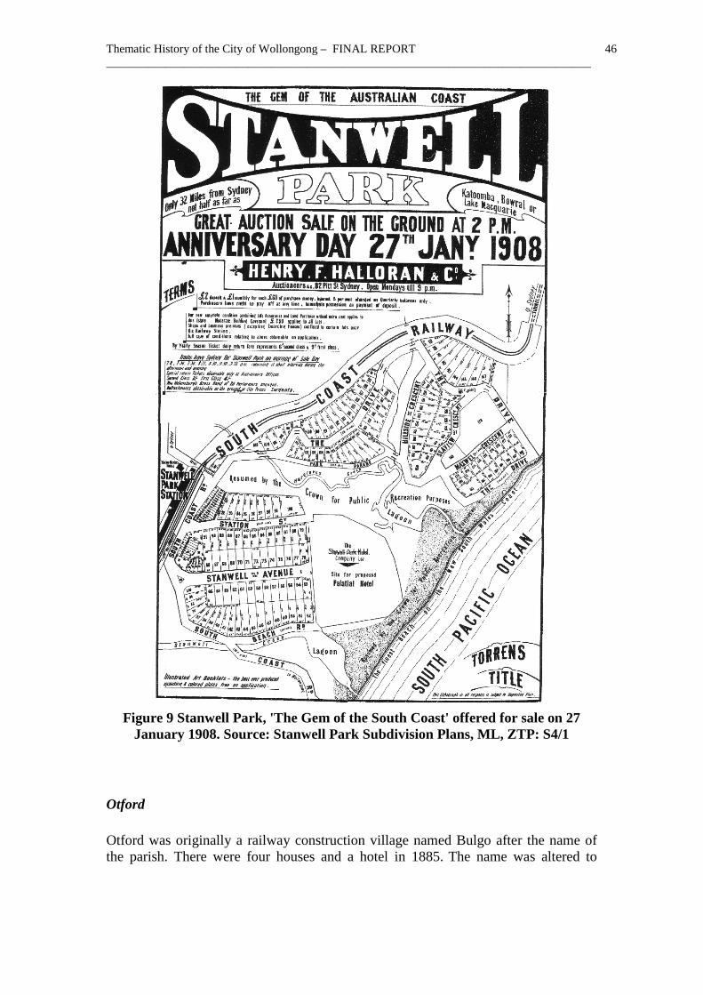
Stanwell Park On 13 August 1824, Matthew John Gibbons obtained a permit to occupy land at ‘Watermolly’, which appears to have been the future site of Stanwell Park. A grant for this promise was issued on 31 August 1833.3 Early access was difficult but a railway platform built for Lawrence Hargrave made Stanwell Park more accessible to the general public.4 Major sales of building lots in 1908 and 1914 opened up the area as a tourist and surfing destination.5 On 27 January 1908, Henry F Halloran conducted a major auction sale of Stanwell Park covering the whole subdivision.6 Shortly afterwards, on 11 February 1908, the Helensburgh-Stanwell Park Life Saving Club was formed.7
1 Rogers, ‘Thematic History’, p 42 2 Bayley, Bulli, p 61 3 RPA 15052 4 A Gibbs & C Warne, Wollongong: A Pictorial History, Kingsclear, 1995, p 73 5 Bayley, Bulli, p 69 6 Stanwell Park Subdivision Plans, ML, ZTP:S4/1 7 Bayley, Bulli, p 69
Thematic History of the City of Wollongong – FINAL REPORT 46 __________________________________________________________________________________
Figure 9 Stanwell Park, 'The Gem of the South Coast' offered for sale on 27
January 1908. Source: Stanwell Park Subdivision Plans, ML, ZTP: S4/1
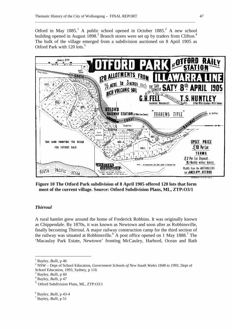
Otford Otford was originally a railway construction village named Bulgo after the name of the parish. There were four houses and a hotel in 1885. The name was altered to
Thematic History of the City of Wollongong – FINAL REPORT 47 __________________________________________________________________________________
Otford in May 1885.1 A public school opened in October 1885.2 A new school building opened in August 1898.3 Branch stores were set up by traders from Clifton.4 The bulk of the village emerged from a subdivision auctioned on 8 April 1905 as Otford Park with 120 lots.5
Figure 10 The Otford Park subdivision of 8 April 1905 offered 120 lots that form
most of the current village. Source: Otford Subdivision Plans, ML, ZTP:O3/1
Thirroul A rural hamlet grew around the home of Frederick Robbins. It was originally known as Chippendale. By 1870s, it was known as Newtown and soon after as Robbinsville, finally becoming Thirroul. A major railway construction camp for the third section of the railway was situated at Robbinsville.6 A post office opened on 1 May 1888.7 The ‘Macaulay Park Estate, Newtown’ fronting McCauley, Harbord, Ocean and Bath
1 Bayley, Bulli, p 46 2 NSW – Dept of School Education, Government Schools of New South Wales 1848 to 1993, Dept of School Education, 1993, Sydney, p 116 3 Bayley, Bulli, p 60 4 Bayley, Bulli, p 47 5 Otford Subdivision Plans, ML, ZTP:O3/1 6 Bayley, Bulli, p 43-4 7 Bayley, Bulli, p 51
Thematic History of the City of Wollongong – FINAL REPORT 48 __________________________________________________________________________________
Streets and the Esplanade was sold in 1888. A later sale of unsold lots was held on 20 October.1 A public school known as Robbinsville opened in July 1889.2 According to Bayley, a brick public school opened on 24 May 1889. The name of the settlement was altered officially to Thirroul on 1 November 1891.3 The Thirroul Park subdivision auctioned on 1 October 1906 spurred home building.4 By 1907, there were 112 householders.5 Railway shunting yards and a locomotive depot were established at Thirroul in 1915, which affected the tourist market but inspired 160 railway workers to settle in the town.6 Tourist functions shifted to Austinmer.7
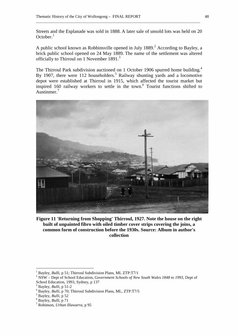
Figure 11 'Returning from Shopping' Thirroul, 1927. Note the house on the right
built of unpainted fibro with oiled timber cover strips covering the joins, a common form of construction before the 1930s. Source: Album in author's
collection
1 Bayley, Bulli, p 51; Thirroul Subdivision Plans, ML ZTP:T7/1 2 NSW – Dept of School Education, Government Schools of New South Wales 1848 to 1993, Dept of School Education, 1993, Sydney, p 137 3 Bayley, Bulli, p 51-2 4 Bayley, Bulli, p 70; Thirroul Subdivision Plans, ML, ZTP:T7/5 5 Bayley, Bulli, p 52 6 Bayley, Bulli, p 71 7 Robinson, Urban Illawarra, p 95

Thematic History of the City of Wollongong – FINAL REPORT 49 __________________________________________________________________________________
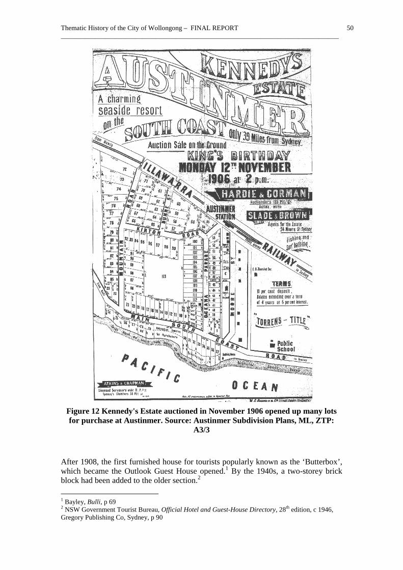
Austinmer The 1861 Crown Lands Alienation Act opened up the area from Bulli to Coal Cliff later known as Austinmer. Surveyor Arnheim opened a road from the bottom of Bulli Pass to Coal Cliff in October 1868.1 Originally the settlement was known as Bulli North or ‘Little Bulli’. A National school was established at Bulli North (later Austinmer) in 1866. 2 A new public school opened on 6 May 1871.3 A brick school building was completed at ‘North Bulli’ in 1892.4 Once the North Bulli Coal and Iron Mining Co was formed and opened up the seam in 1876, the area began to grow. The name ‘Austermere’ was used for a while with various spellings until it became Austinmer by the mid 1890s.5 A post office opened at ‘North Bulli’ near the coal company jetty on 1 May 1887 but was soon moved south to the village where it operated from Anthony Cram’s store in the main street from 1 March 1888.6 In March 1888, the Centennial Hall opened between the railway and the main road.7 St John’s Church of England opened on 12 March 1904.8
The beach was cleared of stone in 1899, which was used to ballast the road opening up the beach to surf bathing and tourists.9 New baths were erected at Austinmer in 1917.10 Though there were only 26 dwellings in 1901, by 1910, five subdivisions had created 450 building lots as far south as Thirroul.11 Kennedy's estate auctioned by Slade and Brown on 12 November 1906 with 70 lots facing Mountain, Kirton and the South Coast Road, Dunne Street and Oceana Parade opened up the area.12 Austinmer grew actively from then onwards.
1 Bayley, Bulli, p 40 2 NSW – Dept of School Education, Government Schools of New South Wales 1848 to 1993, Dept of School Education, 1993, Sydney, p 25 3 Bayley, Bulli, p 42 4 Bayley, Bulli, p 53 5 Bayley, Bulli, p 16 6 Bayley, Bulli, p 53 7 Bayley, Bulli, p 43 8 Bayley, Bulli, p 53 9 Bayley, Bulli, p 53 10 Bayley, Bulli, p 69 11 Rogers, ‘Thematic History’, p 51 12 Bayley, Bulli, p 53; Austinmer Subdivisions, ML ZTP:A3/3
Thematic History of the City of Wollongong – FINAL REPORT 50 __________________________________________________________________________________
Figure 12 Kennedy's Estate auctioned in November 1906 opened up many lots for purchase at Austinmer. Source: Austinmer Subdivision Plans, ML, ZTP:
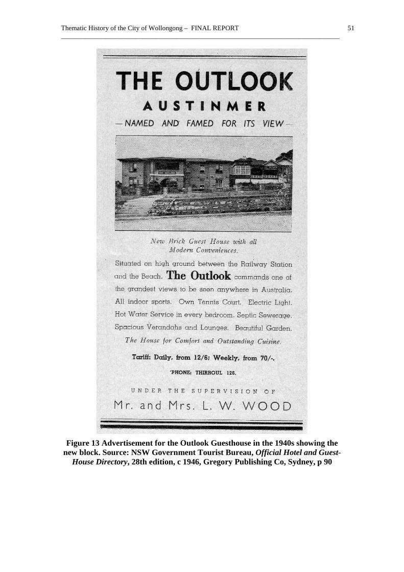
A3/3 After 1908, the first furnished house for tourists popularly known as the ‘Butterbox’, which became the Outlook Guest House opened.1 By the 1940s, a two-storey brick block had been added to the older section.2 1 Bayley, Bulli, p 69 2 NSW Government Tourist Bureau, Official Hotel and Guest-House Directory, 28th edition, c 1946, Gregory Publishing Co, Sydney, p 90
Thematic History of the City of Wollongong – FINAL REPORT 51 __________________________________________________________________________________
Figure 13 Advertisement for the Outlook Guesthouse in the 1940s showing the
new block. Source: NSW Government Tourist Bureau, Official Hotel and Guest-House Directory, 28th edition, c 1946, Gregory Publishing Co, Sydney, p 90
Thematic History of the City of Wollongong – FINAL REPORT 52 __________________________________________________________________________________
Windang The initial subdivisions at Windang appear to have been on the waterfront at Judbooley Parade in 1920.1 A post office was set up in Turnbull’s store, which occupied Windang House, in 1924. 2 The fifth subdivision of the Peterborough Estate in 1925 offered land for sale. In 1926, Turner offered the Berrwarra Estate adjoining his house ‘Wyndang’ for sale.3 Further subdivisions occurred in 1928.4 A number of major subdivisions were made in 1940 and 1941.5 Windang Public School opened in January 1942.6 In 1936, Ben Howard built Windang Boat Shed hiring boats to tourists and selling fish.7 The main growth of both Primbee and Windang occurred after the Second World War as steady rather than spectacular growth.8
Secondary themes
Subdividing and promoting seaside estates (Subdivision layout, Stanwell Park) Changing mining villages into seaside resorts (Austinmer Heritage Conservation Area) Providing retail services Establishing bathing and swimming facilities (Austinmer Baths, Lawrence Hargrave Drive, Austinmer) Forming surf life saving clubs (North Beach Surf Club, North Wollongong)
1.3.7 Theme - Developing an urban network to 1948 The industrialisation of Illawarra commenced with the founding of the Electrolytic Refining and Smelting Co (ERS) at Port Kembla in December 1908 moved from its original location at Kanahooka where it had been operating since the 1890s. Production commenced in 1909.9 Metal Manufactures Ltd formed in March 1916 bought a site at Port Kembla next to ERS to convert copper into wire, cable, sheet,
1 DP 9944. Date inferred from DP sequence 2 Davis, Lake Illawarra, p 89 3 Davis, Lake Illawarra, p 89 4 DP 14600, 15415, Date inferred from DP sequence 5 DP 19008, 19359 Date inferred from DP sequence 6 NSW – Dept of School Education, Government Schools of New South Wales 1848 to 1993, Dept of School Education, 1993, Sydney, p 151 7 Davis, Lake Illawarra, p 95 8 Eklund, Steel Town, p 152 9 Hagan & Wells, p 53
Thematic History of the City of Wollongong – FINAL REPORT 53 __________________________________________________________________________________
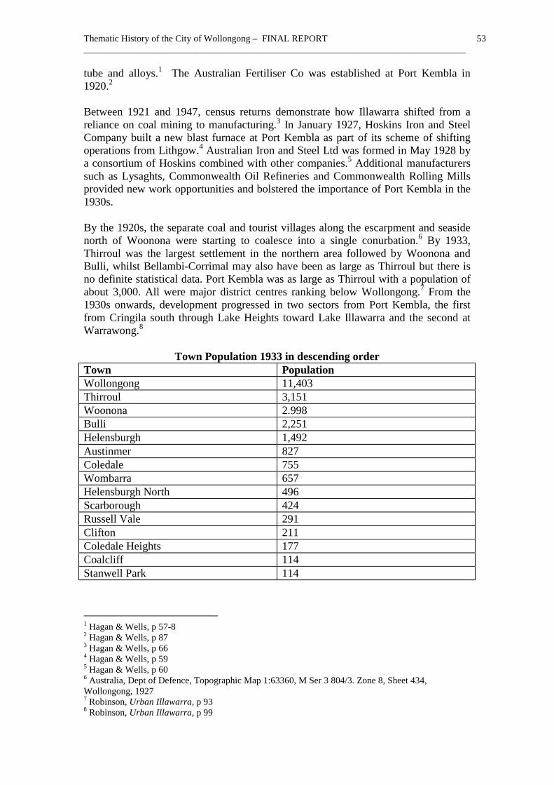
tube and alloys.1 The Australian Fertiliser Co was established at Port Kembla in 1920.2 Between 1921 and 1947, census returns demonstrate how Illawarra shifted from a reliance on coal mining to manufacturing.3 In January 1927, Hoskins Iron and Steel Company built a new blast furnace at Port Kembla as part of its scheme of shifting operations from Lithgow.4 Australian Iron and Steel Ltd was formed in May 1928 by a consortium of Hoskins combined with other companies.5 Additional manufacturers such as Lysaghts, Commonwealth Oil Refineries and Commonwealth Rolling Mills provided new work opportunities and bolstered the importance of Port Kembla in the 1930s. By the 1920s, the separate coal and tourist villages along the escarpment and seaside north of Woonona were starting to coalesce into a single conurbation.6 By 1933, Thirroul was the largest settlement in the northern area followed by Woonona and Bulli, whilst Bellambi-Corrimal may also have been as large as Thirroul but there is no definite statistical data. Port Kembla was as large as Thirroul with a population of about 3,000. All were major district centres ranking below Wollongong.7 From the 1930s onwards, development progressed in two sectors from Port Kembla, the first from Cringila south through Lake Heights toward Lake Illawarra and the second at Warrawong.8
Town Population 1933 in descending order Town Population Wollongong 11,403 Thirroul 3,151 Woonona 2.998 Bulli 2,251 Helensburgh 1,492 Austinmer 827 Coledale 755 Wombarra 657 Helensburgh North 496 Scarborough 424 Russell Vale 291 Clifton 211 Coledale Heights 177 Coalcliff 114 Stanwell Park 114
1 Hagan & Wells, p 57-8 2 Hagan & Wells, p 87 3 Hagan & Wells, p 66 4 Hagan & Wells, p 59 5 Hagan & Wells, p 60 6 Australia, Dept of Defence, Topographic Map 1:63360, M Ser 3 804/3. Zone 8, Sheet 434, Wollongong, 1927 7 Robinson, Urban Illawarra, p 93 8 Robinson, Urban Illawarra, p 99

Thematic History of the City of Wollongong – FINAL REPORT 54 __________________________________________________________________________________
Town Population Otford 102 Austinmer North 86 Source: NSW - Premier’s Department – Division of Reconstruction and Development, The Illawarra Region: A preliminary survey of resources, Government Printer, Sydney, 1948, p 31 Note that centres in Central Illawarra Municipality such as Dapto are not included. Despite the importance of coal mining in the northern parts, the southern parts remained rural. The area south-west of Wollongong and Port Kembla continued to be used for growing market garden crops and raising dairy cattle. Within living memory, Dapto was a country village dominated by its dairy factories and farmers coming to town. Elsewhere, clinging to the escarpment and wedged in between the mining villages were modest farms and forest industries. In 1945, sawmills in the area included Martin Brothers at Bellambi, Molloy Brothers at Bulli and H A Cram at Corrimal.1 Since the original cedar had been largely exhausted, millers cut the hardwoods left behind for building and for the mines.
Figure 14 Aerial view of Wollongong in 1937. Source: SR Map 32145
1 NSW - Premier’s Department – Division of Reconstruction and Development, The Illawarra Region: A preliminary survey of resources, Government Printer, Sydney, 1948, pp 26
Thematic History of the City of Wollongong – FINAL REPORT 55 __________________________________________________________________________________
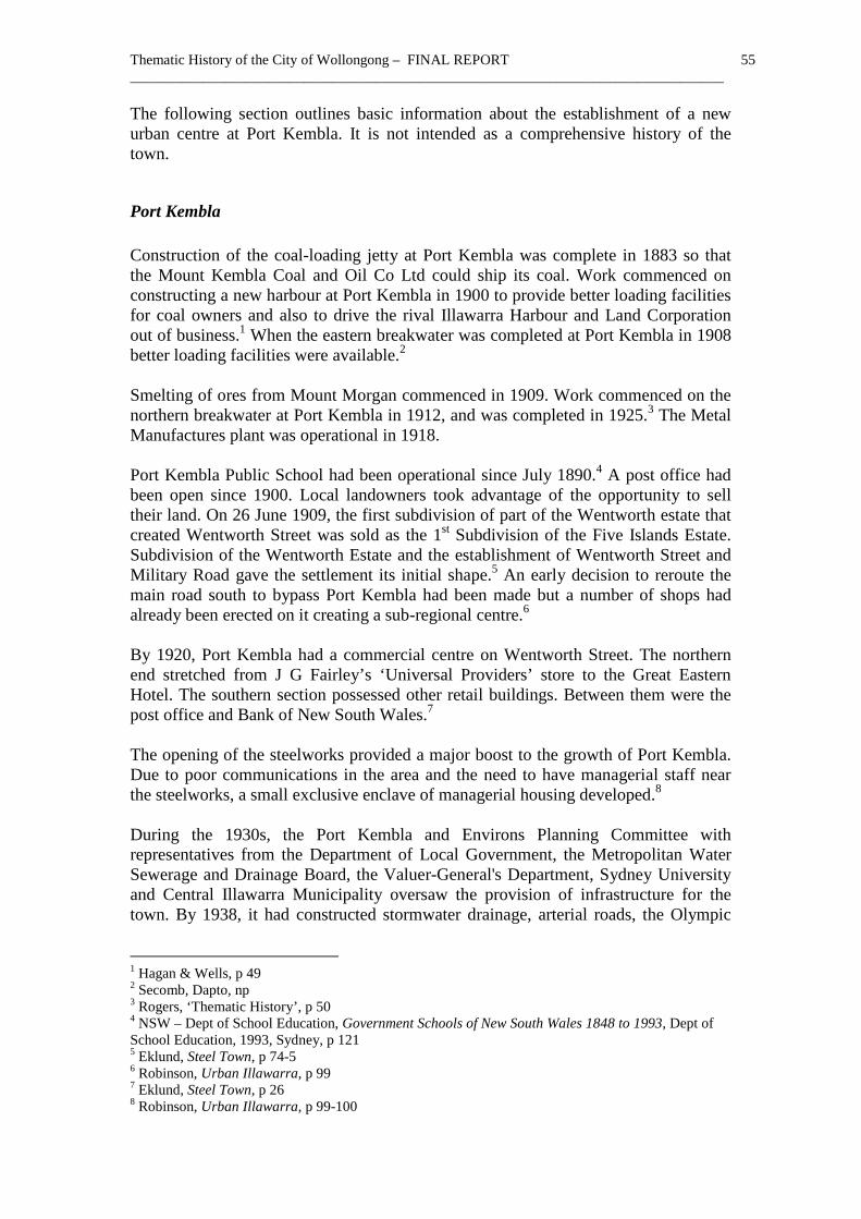
The following section outlines basic information about the establishment of a new urban centre at Port Kembla. It is not intended as a comprehensive history of the town.
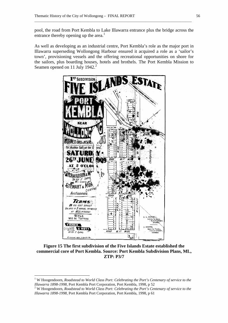
Port Kembla Construction of the coal-loading jetty at Port Kembla was complete in 1883 so that the Mount Kembla Coal and Oil Co Ltd could ship its coal. Work commenced on constructing a new harbour at Port Kembla in 1900 to provide better loading facilities for coal owners and also to drive the rival Illawarra Harbour and Land Corporation out of business.1 When the eastern breakwater was completed at Port Kembla in 1908 better loading facilities were available.2 Smelting of ores from Mount Morgan commenced in 1909. Work commenced on the northern breakwater at Port Kembla in 1912, and was completed in 1925.3 The Metal Manufactures plant was operational in 1918. Port Kembla Public School had been operational since July 1890.4 A post office had been open since 1900. Local landowners took advantage of the opportunity to sell their land. On 26 June 1909, the first subdivision of part of the Wentworth estate that created Wentworth Street was sold as the 1st Subdivision of the Five Islands Estate. Subdivision of the Wentworth Estate and the establishment of Wentworth Street and Military Road gave the settlement its initial shape.5 An early decision to reroute the main road south to bypass Port Kembla had been made but a number of shops had already been erected on it creating a sub-regional centre.6 By 1920, Port Kembla had a commercial centre on Wentworth Street. The northern end stretched from J G Fairley’s ‘Universal Providers’ store to the Great Eastern Hotel. The southern section possessed other retail buildings. Between them were the post office and Bank of New South Wales.7 The opening of the steelworks provided a major boost to the growth of Port Kembla. Due to poor communications in the area and the need to have managerial staff near the steelworks, a small exclusive enclave of managerial housing developed.8 During the 1930s, the Port Kembla and Environs Planning Committee with representatives from the Department of Local Government, the Metropolitan Water Sewerage and Drainage Board, the Valuer-General's Department, Sydney University and Central Illawarra Municipality oversaw the provision of infrastructure for the town. By 1938, it had constructed stormwater drainage, arterial roads, the Olympic
1 Hagan & Wells, p 49 2 Secomb, Dapto, np 3 Rogers, ‘Thematic History’, p 50 4 NSW – Dept of School Education, Government Schools of New South Wales 1848 to 1993, Dept of School Education, 1993, Sydney, p 121 5 Eklund, Steel Town, p 74-5 6 Robinson, Urban Illawarra, p 99 7 Eklund, Steel Town, p 26 8 Robinson, Urban Illawarra, p 99-100
Thematic History of the City of Wollongong – FINAL REPORT 56 __________________________________________________________________________________
pool, the road from Port Kembla to Lake Illawarra entrance plus the bridge across the entrance thereby opening up the area.1 As well as developing as an industrial centre, Port Kembla’s role as the major port in Illawarra superseding Wollongong Harbour ensured it acquired a role as a ‘sailor’s town’, provisioning vessels and the offering recreational opportunities on shore for the sailors, plus boarding houses, hotels and brothels. The Port Kembla Mission to Seamen opened on 11 July 1942.2
Figure 15 The first subdivision of the Five Islands Estate established the
commercial core of Port Kembla. Source: Port Kembla Subdivision Plans, ML, ZTP: P3/7
1 W Hoogendoorn, Roadstead to World Class Port: Celebrating the Port’s Centenary of service to the Illawarra 1898-1998, Port Kembla Port Corporation, Port Kembla, 1998, p 52 2 W Hoogendoorn, Roadstead to World Class Port: Celebrating the Port’s Centenary of service to the Illawarra 1898-1998, Port Kembla Port Corporation, Port Kembla, 1998, p 61
Thematic History of the City of Wollongong – FINAL REPORT 57 __________________________________________________________________________________
Secondary themes
Providing retail services for an industrial town (Wentworth Street, Port Kembla) Accommodating industrial workers Accommodating industrial managerial and professional staff
1.3.8 Theme - Creating a city after 1948 After World War Two, Greater Wollongong expanded markedly and swamped a number of villages in the district so that many lost their separate identity. The total population of the Wollongong Council area grew by over 100% between 1947 and 1961 with much of the change due to migration. The population grew from 62,960 in 1947 in the four local government areas that were combined in 1947 to form the City of Wollongong to 131,754 in 1961.1 Since much of the post-war employment was tied to the steelworks there was huge demand for residential land near the works, at Port Kembla, Warrawong, Cringila, Berkeley and Unanderra. The open spaces between the separate coal and rural villages started to fill up as well.2 This permitted the land speculatively subdivided from 1910 to 1939 to be finally built upon. Between 1948 and 1955, residential development finally linked Brownsville with Dapto.3 An influx of migrants brought significant changes to Illawarra. Previously, non-British migrants had been a small though often significant element of the population. Migrants such as the Frenchman Eugene D Nicolle, the Polish-born Ignacy Zlotkowski and the Chinese Dion family had an important impact on the district. From 1945 onwards, the social, cultural, linguistic and economic impact of the new waves of migration altered Illawarra forever. New social clubs were formed. Sport was enlarged with new entrants. New businesses, often conducted by newly arrived migrants, grew to cater for their demands, producing new foods and altering tastes in fashions and furnishings and myriad other areas of life. However, housing construction continued to fall behind the pace of demand. Migrants were forced to live in hostels longer than they wished due to the shortage of accommodation. Others lived in caravans and even tents set up at Stuart Park.4 Meanwhile, other migrants as well as Australians took advantage of a temporary relaxation of local government rules about building and accommodation standards to build a garage and live in it whilst a house was constructed on their allotment, often after work or at weekends. Many migrants settled near the hostels where they had originally been accommodated so the hostels had a significant impact on the locational pattern of incoming migrants. 1 Commonwealth of Australia, Census, 1947, 1961 2 Rogers, ‘Thematic History’, p 60 3 Secomb, Dapto, np 4 M Walker, ‘First accommodation for Migrants arriving in Wollongong post World War 2’, Wollongong’s Migrant Heritage Places Study 2007, p 22-3
Thematic History of the City of Wollongong – FINAL REPORT 58 __________________________________________________________________________________
The 1968 Illawarra Planning Scheme zoned residential areas around all towns and villages. Until then, most residential development had been in Wollongong and the northern towns but that scheme directed development to the south-west. From the 1970s onwards, the main area for residential development at Dapto has been West Dapto.1 This area is currently undergoing change from rural to suburban land-uses creating tensions between developers, conservationists and landowners about the impact on the escarpment. Flat or multi-unit houses were being purpose-built in Wollongong by the 1930s. That trend continued in the post-war years. A further surge of applications followed after the war rising to applications for 11 new blocks of flats in 1955.2 During the 1960s, flat development accelerated especially with redevelopment of sites in older areas but then decreased markedly in the mid 1970s.3 Though construction of houses on vacant sites had long bypassed Wollongong, by the 1980s, demand for accommodation in the centre of Wollongong was fuelling high-rise development.4 High demand for accommodation in the centre drove the construction of new blocks of multi-unit residential buildings, some as flat blocks and others as home unit developments, with a separate title for each unit of accommodation. In the late 1950s, as demand for smaller individual dwellings increased, the existing form of tenure for legal ownership was found to be relatively inflexible. Ownership of individual flats was not possible. Only whole blocks could be owned. Pressure built for changes to the law. Lobbying by real estate developers and the Real Estate Institute of NSW ensured the passing of the Strata Titles Act, 1961, which permitted the ownership of individual home units.5 A flood of unit developments followed across Sydney and ultimately in the City of Wollongong. By the early 1970s, an oversupply of home units in Sydney was encouraging developers to shift their attention to Wollongong. Demand for owner-occupied home units in central Wollongong was so high that most units were sold to owner-occupiers rather than being used for rental. Older flat blocks were converted to strata title to keep up with the demand for owner-occupied units. The construction of home units for sale rather than rent was also expanding into the outer suburbs by the mid 1970s.6 That boom profoundly changed the character of the centre of Wollongong where multi-unit blocks dominate the ridges. Cringila was an example of how a suburb evolved from the influx of migrants and suburban development in the post war period and its suburban origins will be briefly outlined below.
1 Secomb, Dapto, np 2 Statistical Register of New South Wales, 1955, p 412 3 I Pratt, Production, distribution and consumption of housing, p 29 4 Rogers, ‘Thematic History’, p 65 5 T Kass, The Sign of the Waratah: A history of the Real Estate Institute of NSW – The first 75 Years, Real Estate Institute of NSW, Sydney, 1987, pp 176-7 6 B Ross & P J Wilson, The Market for Rental Housing in Wollongong, Economic Research Bulletin 4, Dept of Economics, Wollongong University College, University of NSW, July 1973, p 14
Thematic History of the City of Wollongong – FINAL REPORT 59 __________________________________________________________________________________
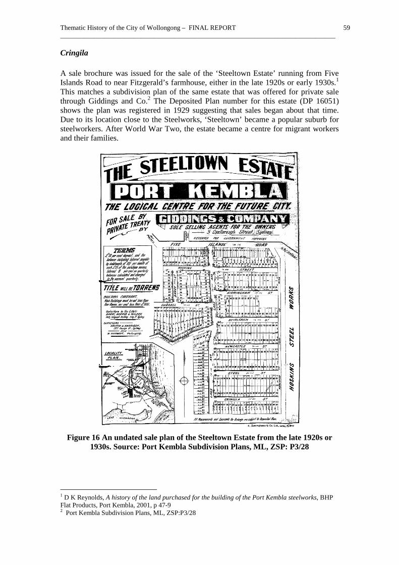
Cringila A sale brochure was issued for the sale of the ‘Steeltown Estate’ running from Five Islands Road to near Fitzgerald’s farmhouse, either in the late 1920s or early 1930s.1 This matches a subdivision plan of the same estate that was offered for private sale through Giddings and Co.2 The Deposited Plan number for this estate (DP 16051) shows the plan was registered in 1929 suggesting that sales began about that time. Due to its location close to the Steelworks, ‘Steeltown’ became a popular suburb for steelworkers. After World War Two, the estate became a centre for migrant workers and their families.
Figure 16 An undated sale plan of the Steeltown Estate from the late 1920s or
1930s. Source: Port Kembla Subdivision Plans, ML, ZSP: P3/28
1 D K Reynolds, A history of the land purchased for the building of the Port Kembla steelworks, BHP Flat Products, Port Kembla, 2001, p 47-9 2 Port Kembla Subdivision Plans, ML, ZSP:P3/28
Thematic History of the City of Wollongong – FINAL REPORT 60 __________________________________________________________________________________
An aerial photograph of 1936 showed the outline of streets at Cringila but hardly any settlement.1 However, there were enough local residents to ensure that Steeltown Public School was opened in 1935 on Flagstaff Avenue. A post office also operated nearby at the corner of Fitzgerald Street and Lake Avenue. The public school pupils were moved to Berkeley Public School in 1942 away from gun emplacements built to protect the steelworks and the post office also moved about that time. The shifting away of the facilities associated with the name of the estate ensured the name of the railway station nearby Cringila (originally spelt Cringilla) came to be applied to this area. The current Cringila Public School opened in January 1957. 2 The Karingal Migrant hostel conducted by Australian Iron and Steel was located nearby at the corner of Five Islands Road and Springhill Road from 1948 to 1984 accommodating single men employed by Australian Iron and Steel. In addition, the Steelhaven hostel in Warrawong and the Unanderra hostel were also close.3 Situated next to the steelworks, the Steeltown Estate attracted many new migrants wanting to build their own homes after 1945. On 26 April 2005, the unveiling of the Cringila communal oven not only united Cringila communities also demonstrated the diverse mix of the population when Macedonians, Aboriginals and Muslims attended the event. A sure sign of the fusion of diverse cooking styles emerged when one participant outlined how she had combining traditional Aboriginal and Western foods in her cooking for years.4
Secondary themes
Housing post-war migrants and their families Living in hostels (Balgownie Hostel, Montague Street, Fairy Meadow) Diversifying the housing stock Exploring diverse foods
1 D K Reynolds, A history of the land, p 34 2 D K Reynolds, A history of the land, p 49 3 M Walker, ‘First accommodation for Migrants arriving in Wollongong post World War 2’, Wollongong’s Migrant Heritage Places Study 2007, p 6, 39 4 Illawarra Mercury, 27 April 2005

Thematic History of the City of Wollongong – FINAL REPORT 61 __________________________________________________________________________________
1.4 Contextual Essay - Making a Living Work ranges from professional occupations through commercial activities with their own special forms of knowledge and expertise, notably in small business through to the skilled, semi-skilled and unskilled. Even apparently ‘unskilled’ jobs, such as ploughing, horse breaking or milking a cow had their distinct sets of special knowledge.
1.4.1 Theme - Working on the land Convicts supplied the bulk of the rural labour force in the early period of settlement but by the 1840s this was changing. The 1841 census showed that free settlers were already becoming a significant proportion of the labour force.1 The Paulsgrove diary is a remarkable record of the work regime on such properties, with a round of sowing, harrowing, burning off scrub, occasionally enlivened by a bout of shooting in the bush or even events such as the beaching of a whale.2 Transportation of convicts had ceased in 1840. With no ready supply of cheap labour to clear and work their properties, landowners had to use other methods. Clearing leases were used to clear land cheaply. Subdividing estates for letting as clearing leases or for sale cut up their properties allowing a rural yeomanry to settle on the land. Once the area was identified as an ideal production area with the appropriate climate and soils and access to market, dairying became the main activity for small farmers. Factors which promoted the success of dairying included the introduction of refrigeration using the Mort-Nicolle system; the use of the factory system to manufacture butter; the introduction of the cream separator; the formation of co-operative societies to market and then manufacture dairy products; and lastly the extension of the railway to Illawarra making access to market much easier.3 Gathering wild or semi-wild products has long been a supplement to farmed food, a resource relied on heavily by the Aboriginals. Blackberries that had run wild infesting land near Bulli and Sherbrooke were harvested by local residents for sale to jam making factories in the 1900s and served as a supplementary item of diet for years.4 They were still a notable part of the local economy in the 1940s.5
Secondary themes Working for private persons as an assigned convict
1 K & T Henderson, Early Illawarra - People, houses, life, History Project Inc, Canberra, 1983, p 25 2 W G McDonald (ed), The Paulsgrove Diary: Illawarra 1833-1834, Illawarra Historical Society, Wollongong, 1988 3 Jervis, ‘Illawarra’, p 279 4 Bayley, Bulli, p 59 5 NSW - Premier’s Department – Division of Reconstruction and Development, The Illawarra Region: A preliminary survey of resources, Government Printer, Sydney, 1948, p 14
Thematic History of the City of Wollongong – FINAL REPORT 62 __________________________________________________________________________________
Returning convicts to civil society Labouring on rural properties Working on dairy farms (‘Glen Ayre’, Sheaffes Road, West Dapto, including cow stalls) Hunting
1.4.2 Theme - Fishing the waters Long before white Europeans came to Illawarra, the local Aboriginals were fishing Lake Illawarra. They often fished in the dark using torches made of bark to lure the fish, which were impaled by a multi-pronged spear, and thrown ashore. In time, they adopted European fishing techniques. In the 1870s, they were using European boats and tackle when George Timbery and William Saddler requested a boat and tackle from the government. Once the boat was in their possession they were able to fish deeper waters as well as the Lake.1 European settlers also gathered food from the wild. The most notable activity was fishing. Cornelius O’Brien had a scheme to use Bulli harbour as a boiling down site for whales.2 By the 1870s, a retired sailor named Perkins lived on one of the Five Islands catching sharks and selling their oil in Sydney.3 In May 1893, fishing in the open sea commenced from Wollongong Harbour to supply fish to Sydney.4 Lake Illawarra has extensive sea grass beds and small fish which provide food for prawns and fish so it is a major breeding area for fish such as sea mullet, bream, whiting, luderick and prawns. The arrival of the railway in the 1880s enabled Lake Illawarra fishermen to load fish at Unanderra to sell at Sydney. Lots in the fishing village near Lake Illawarra facing Lake, Short and George Streets were auctioned on 29 November 1905.5 A small fishing community had emerged. On 8 April 1908, when a number of lots at Unanderra station were auctioned, the fishing village at Berkeley was also shown on the plan.6 In the early twentieth century, fishermen located at ‘Fishtown’, later known as Berkeley included Harry Green, Andy Dennis, Dick Sheldon and Dick Shepherd.7 Italian fishermen operated out of Wollongong Harbour. Bob West remembered catching prawns on the Lake in the 1920s and 1930s.8 1 J Davis, Lake Illawarra – an Ongoing History, Lake Illawarra Authority, Wollongong, 2005, p 76 2 N S King, Cornelius O’Brien: Pioneer of Bulli, Illawarra Historical Society, Wollongong, 1965, p 10-11 3 Jervis, ‘Illawarra’, p 132 4 M Hutton, Conservation Study for Belmore Basin Conservation Area, Wollongong, NSW, June 1997, For Wollongong City Council, p 20 5 County Camden Subdivision Plans, ML, ZCP:C1/29 6 County Camden Subdivision Plans, ML, ZCP:C1/43 7 Davis, Lake Illawarra, p 76 8 B West, My Port Kembla, Illawarra Historical Society, Wollongong, 1999, p 3
Thematic History of the City of Wollongong – FINAL REPORT 63 __________________________________________________________________________________
After the Second World War, concrete tetrahedrons from a major tank trap that ran from Mullet Creek to Kembla Grange were used to construct the breakwater at Berkeley.1 In 1926, the Illawarra Coastal Fishery Co was formed at ‘Fish Town’, which became Berkeley. A Fishermen’s Co-operative was set up at Berkeley in 1985.2
Secondary themes Fishing (Berkeley Harbour) Hunting and processing whales
1.4.3 Theme - Mining The development of coal mining has been dealt with in Section 1.3.5 above. Though coal was the main focus of mining activity, other mining and quarrying occurred. From the 1940s to the 1970s, large quantities of sand were quarried from the peninsula south of Port Kembla running south to Windang for construction, filling and even for export.3 Beach sands were mined at Bulli, and Wollongong-Port Kembla beaches to extract 3,319 tons of rutile and 3,071 tons of zircon concentrate between 1953 and 1958.4
1.4.3.1 Theme - Making coke The production of coke originally using small waste coal or dust was an ancillary industry of some significance. In 1875, James Osborne and William Ahern erected a coke works near Flagstaff Point, Wollongong to process the slack from the Osborne mine but it did not operate for long.5 The ovens were sold in June 1879 and dismantled. In 1885, William Ashley re-established coke ovens at the Wollongong Harbour site and worked it until 1890 when the lease expired.6 It was reported in 1885 that a site for a coke works had been selected that would commence production in January. It was associated with the Broker’s Nose Colliery on a property at Mount Corrimal and would manufacture 600 tons per week using slack from the mine.7 It was in operation by 1886 but out of production by 1890.8
1 Davis, Lake Illawarra, p 96-9 2 Secomb, Dapto, np 3 Davis, Lake Illawarra, p 100-4 4 D W Wynn, Mineral resources of the Illawarra region – limestone and beach sand minerals, Dept of Mineral Resources, Report GS1963/037 5 Jervis, ‘Illawarra’, p 296 6 M Hutton, Conservation Study for Belmore Basin Conservation Area, Wollongong, NSW, June 1997, For Wollongong City Council, p 72 7 Jervis, ‘Illawarra’, p 296 8 Rogers, ‘Thematic History’, p 33
Thematic History of the City of Wollongong – FINAL REPORT 64 __________________________________________________________________________________
The Australian Coke Making Company erected 20 ovens at Unanderra in 1888 with other ovens added in 1889. They used slack coal from the Southern Coal Company's Corrimal Colliery. Also in 1889, Figtree and Robshaw [sic] erected 4 beehive ovens near the Mount Pleasant tramway overbridge at the government railway.1 The Bulli Coke Company owned by George Adams began operating with 20 modified coppee ovens near Bulli Jetty on 20 July 1889 becoming the first viable works. It was later linked with the government railway line.2 The Mount Lyell Co established a battery of ovens near the Mount Kembla Coal Co jetty to supply its works in 1899. Their coke works continued until 1925.3 BHP opened 100 coke ovens between Bellambi and Woonona in 1903 to produce coke for Broken Hill.4 In 1906, the North Bulli coke works opened at Coledale.5 By 1907, Wollongong was the centre of the state coke industry, with 453 ovens producing 83 per cent of the state's total coke output.6 In 1910, the Mount Lyell Company's coke ovens were set up at Port Kembla, and operated until they were demolished in 1926. Also in 1910, a new plant at North Bulli run by Figtree Brothers superseded the Mount Pleasant coke works. After a coke works was set up at Corrimal in 1912, the Unanderra Coke works closed. The Illawarra Coke Company set up 50 ovens at Coalcliff in 1914.7 After purchasing the Wongawilli coalmine, Hoskins Iron and Steel was sending 1,600 tons of coke per month to Lithgow from its coke ovens at Wongawilli by April 1918.8 Rationalisation of the industry caused a series of closures from the 1930s onwards. In 1930, the coke works of the Bulli Coke Company closed. BHP’s Bellambi Coke works closed in 1935. The Wongawilli coke works closed in 1945 when additional coke ovens were erected at Port Kembla.9 The Federal Coke Company North Wollongong works closed in 1971.10 Cokeworks still operate at Coalcliff, Corrimal and Port Kembla.
1.4.4 Theme - Working in workshops, mills or factories Manufacturing can be divided into those activities which processed rural raw materials, some of them associated with food such as slaughter yards or mills; workshop style production where the employer or owner worked on the floor with his employees and with no more than 5 to 10 employees; and large ‘factory' style enterprises. 1 Rogers, ‘Thematic History’, p 33 2 Rogers, ‘Thematic History’, p 33; Bayley, Bulli, p 19 3 Rogers, ‘Thematic History’, p 33 4 Bayley, Bulli, p 19 5 Rogers, ‘Thematic History’, p 50 6 Hagan & Wells, p 50 7 Rogers, ‘Thematic History’, p 50 8 Hagan & Wells, p 59 9 Rogers, ‘Thematic History’, p 56 10 Rogers, ‘Thematic History’, p 60
Thematic History of the City of Wollongong – FINAL REPORT 65 __________________________________________________________________________________
Rural processing industries are often the first to commence in any newly settled district and Illawarra was no exception. Cornelius O’Brien had a scheme to use Bulli harbour as a boiling down site for whales.1 As has been noted in other studies, there is no evidence it was ever operational.2 Others set up flour mils to grind the grain from local growers. J S Spearing set up two water driven mills on Para Creek in the early 1830s, followed by a windmill. A steam flourmill was later set up at Fairy Meadow.3 Rural processing handling grain began to close down as wheat growing ceased, from the 1860s onwards. The mill at Wollongong had to obtain supplies from Sydney and the mill at Dapto was converted into cheese factory.4 Early in the nineteenth century, Gooseberry Island in Lake Illawarra was used by M A Brown to produce salt. Lime was also produced there by burning shells.5 A small salt works was erected at the south end of Austinmer beach for the Illawarra Salt Co in 1893 and in 1894, the Sydney Salt Co constructed a much more elaborate scheme at Hicks Point south of Austinmer jetty. Both soon closed. From the mid 1890s, pharmacist Courtney Puckey experimented with a small salt works near North Beach.6 The Illawarra Meat Company was formed in 1921, when Hutton Brothers shifted their butchering operations from Camden to Bellambi after buying J J Smale’s abattoir and grazing paddocks, a butcher shop at Woonona and a delivery wagon. The firm expanded, buying the South Coast Meat Co Pty Ltd, in Crown Street, Wollongong in 1933 and entering a partnership with J H Lindsay with shops at Port Kembla and North Wollongong and a pig farm at West Dapto in 1935.7 Dairying also produced processing plants. A dairy factory was operating at Dapto in 1886.8 In 1890, the NSW Fresh Food and Ice Co built a factory at Dapto on a three-acre site south of the Dapto railway station. By 1899, the Farmers and Dairymen’s Company works in Hamilton Street was also in operation. The Dapto Co-operative Dairy Company factory was in Station Street. The Dapto Co-operative Dairy was formed in 1900. In 1901, the NSW Fresh Food and Ice Co set up a creamery at Avondale.9 In 1900, the Country Milk Co had a creamery at Brownsville.10 A significant early industry was the production of oil shale, which was discovered at American Creek in 1864. 11 In 1865, a retort plant had been constructed for £4,000 and commenced operation. In 1870, there were 23 retorts producing kerosene for proprietors John, Edward and Neville Graham. In 1874, it was sold to the Mount 1 N S King, Cornelius O’Brien: Pioneer of Bulli, Illawarra Historical Society, Wollongong, 1965, p 10-11 2 Therin Archaeological Consulting, Sandon Point Aboriginal Heritage Study, Volume 1, Report, For Wollongong City Council, June 2003, p 51 3 Cousins, Garden of New South Wales, p 97, 203 4 Jervis, ‘Illawarra’, p 276 5 Barwick, Berkeley, p 9 6 Rogers, ‘Thematic History’, p 33 7 Based on ‘The Illawarra Meat Company: Outline History’ by Richard Dallison Hutton, supplied by Meredith Hutton, 21 July 2010 8 Jervis, ‘Illawarra’, p 281 9 Secomb, Dapto, np 10 Yewen's Directory of the Landholders of New South Wales, 1900, Farm & Dairy Publishing Co, Sydney, 1900, p 571 11 Jervis, ‘Illawarra’, p 296

Thematic History of the City of Wollongong – FINAL REPORT 66 __________________________________________________________________________________
Kembla Coal and Oil Company. After working intermittently after 1876, it was finally abandoned after 1880.1 Small workshop type manufacturing enterprises also supplied local and regional markets. An early activity was shipbuilding at Wollongong Harbour, which straddles the boundary between the workshop and the factory style of production. On 28 June 1833, instructions were issued to survey an acre at Wollongong for shipbuilder John Cunningham for a shipyard on the harbour. 2 He built a number of vessels there. 3 W Davies’ Lilleshall iron and steel foundry was in operation in Charlotte Street, Wollongong by 1882, making cast iron products such as grates and wagon wheels.4 In 1883, James Parkinson set up a cordial factory in Achilles and Flinders Streets, North Wollongong. He later shifted to Crown Street and finally to Kenny Street. He died in 1903.5 Shelleys bought the firm when it was situated in Kenny Street in 1966 but closed the works on 23 June 1978.6 The Wollongong Cycle and Engineering Works manufactured bicycles in 1902 and claimed to have the most advanced bicycle works outside Sydney.7
Figure 17 Parkinson's Cordial Factory in 1895 at the corner of Achilles and
Flinders Streets, North Wollongong. Source: Illawarra Images, No P02/P02524
1 A P Fleming, The Pioneer Kerosene Works at American Creek (Mt Kembla, NSW), Illawarra Historical Society, Wollongong, 1976, p 4-5, 9-10; Jervis, ‘Illawarra’, p 297 2 Jervis, ‘Illawarra’, p 103 3 Jervis, ‘Illawarra’, p 298 4 Rogers, ‘Thematic History’, p 33 5 A Wood, Tales from Our Streets: A Photographic History of Wollongong, Author, Figtree, 1999, p 86-7 6 A Gibbs & C Warne, Wollongong: A Pictorial History, Kingsclear, 1995, p 119 7 Illawarra and South Coast Tourist’s Guide, 1902-3, Wilson & Co, Sydney, 1902, p 35
Thematic History of the City of Wollongong – FINAL REPORT 67 __________________________________________________________________________________
Production of building products was active in the nineteenth century. Initially, cedar was cut from the forests of Illawarra to ship to Sydney. By the 1850s, local sawmills were operating. In July 1858, Robert Somerville set up a steam sawmill in the Bulli area followed in 1864 by another set up by John Somerville. William Somerville operated a sawmill in Bulli and another was established at the top of Bulli Mountain in 1878.1 Thomas Pendlebury’s brickworks opened on a new site on the main road near Gray Street, Woonona in 1901. Bricks from the works were used to erect the Queen Victoria Building in Sydney and the Bulli Parish hall.2 The Illawarra Fireclay and Brick Co was formed in 1907 to use the same seam as Pendlebury to produce refractory bricks for use in coke ovens and steel furnaces. It was located between Woonona and Bellambi station.3 Another brickworks opened at Thirroul in 1919.4 The Bulli Brick & Tile Co opened near Slacky Flat in ‘Woods Farm’ paddock in 1948.5 From 1910 until the 1990s, the Vulcan Fire Brick Company operated at Thirroul undertaking extensive quarrying next to Hewitts Creek.6 Metal refining and processing in the twentieth century were instrumental in converting Wollongong from an area reliant upon coal and dairying into an industrial metropolis. It commenced with the government provision of adequate harbour facilities, first developed to ship coal, but it drew metal firms to the area. In 1895, the private Illawarra Harbour and Land Corporation erected a smelter at Dapto to process ore for Broken Hill Pty Co.7 But industrialisation of Illawarra really began with the founding the Electrolytic Refining and Smelting Co (ERS) at Port Kembla in December 1908. 8 In the wake of the embargo on enemy ownership of Australian companies, three of the Collins House group of companies combined in March 1916 to form Metal Manufactures Ltd, which bought a site at Port Kembla next to ERS to convert its copper into wire, cable, sheet, tube and alloys. Metal Manufactures Ltd commenced operations with 79 employees in February 1918.9 The Australian Fertiliser Co was established at Port Kembla in 1920.10 Between 1921 and 1947, the census returns demonstrate how the Wollongong area shifted from a reliance on coal mining to manufacturing. 11 In January 1927, Hoskins Iron and Steel Company built a new blast furnace at Port Kembla as part of its scheme of shifting operations from Lithgow to obtain better access to coal and water access to
1 Bayley, Bulli, p 30 2 Bayley, Bulli, p 55 3 W Gemmell, And So We Graft From Six to Six: The brickmakers of New South Wales, Angus & Robertson, Sydney, 1986, p 83 4 Bayley, Bulli, p 78 5 Bayley, Bulli, p 82 6 Therin Archaeological Consulting, Sandon Point Aboriginal Heritage Study, Volume 1, Report, For Wollongong City Council, June 2003, p 10 7 Hagan & Wells, p 47 8 Hagan & Wells, p 53 9 Hagan & Wells, p 57-8 10 Hagan & Wells, p 87 11 Hagan & Wells, p 66
Thematic History of the City of Wollongong – FINAL REPORT 68 __________________________________________________________________________________
iron ore from other states plus shorter and cheaper shipping costs to Sydney.1 Australian Iron and Steel Ltd was formed in May 1928 by a consortium of Hoskins combined with other companies.2 Its No 1 blast furnace was blown in on 24 August 1928.3 But the onset of the Great Depression, inadequate capital backing and fierce cost cutting competition from BHP soon made the firm unsteady and seeking new capital. In 1935, Broken Hill Pty Ltd took over AIS, which was suffering from capital problems and price-cutting by BHP.4 The Australian Iron and Steel Ltd Act, 1936 (No 36) facilitated the purchase of an additional 1,665 acres of land at Tom Thumb Lagoon.5 In 1932, the railway link from Moss Vale to Port Kembla was complete. It had been built at the insistence of Hoskins to allow him to ship limestone from Marulan to Port Kembla for his furnaces.6 AIS turned the area into one dominated by one big industry rather than one with lots of small coal mining companies.7 BHP bought coalmines at Bulli in 1936 and Mount Keira in 1937 to feed its steelmaking plant. From March 1936 to December 1938, Lysaghts operated an old sheet mill but opened its own new mill in January 1939 to produce rolled steel sheet.8 Commonwealth Oil Refineries opened a petrol-blending works in 1937 utilising benzol produced by the BHP coke works. The Commonwealth Rolling Mills began producing high finish steel for car bodies and appliances in February 1939. 9 World War Two encouraged BHP to add engineering to its works at Port Kembla making machinery and parts and Lysaghts also diversified with the production of the Owen gun.10 During the Second World War, Wollongong and its partner Port Kembla were a vital element of the Australian war effort. By end of World War Two, due to the large investment in Wollongong industry from outside the area including from overseas, decisions affecting those industries would be taken by those with no direct relationship with the place.11 A listing of manufacturing industries in the Greater Wollongong area in 1945 is provided in Section 6.0. Between 1945 and 1976, expansion of the steel industry drove the expansion of Wollongong, which was one of the fastest growing areas in Australia.12 Many of the steelworkers were migrants, some of them sponsored by the steelworks. Declining world demand for steel and the entry of more efficient and cheaper competitors overseas meant that BHP was less able to sell its surplus output overseas. There were
1 Hagan & Wells, p 59 2 Hagan & Wells, p 60 3 Rogers, ‘Thematic History’, p 50 4 Hagan & Wells, p 62 5 D K Reynolds, A history of the land purchased for the building of the Port Kembla steelworks, BHP Flat Products, Port Kembla, 2001, p 26 6 Hagan & Wells, p 59 7 Hagan & Wells, p 87 8 Hagan & Wells, p 62 9 Hagan & Wells, p 62 10 Hagan & Wells, p 65 11 Hagan & Wells, p 70 12 Hagan & Wells, p 71
Thematic History of the City of Wollongong – FINAL REPORT 69 __________________________________________________________________________________
massive reductions of staff especially in 1982-3.1 Other producers also suffered. Southern Copper closed down in 1995.2 As well as being one of the most significant areas for metal manufacturing in Australia, Illawarra has also had a marked impact on Australian eating habits. In 1920, Edwin Street began producing hand-churned custards at his grocer’s shop in Corrimal, which he sold to other shops. It was promoted as ‘The Cream of the Coast’. In 1934, he bought the Corrimal Ice Works and set up Streets Ice Cream Ltd and the Illawarra Delicacy Co. He later shifted production to Sydney.3 By 1928, Frank Guest was operating the Popular Café in Crown Street, when began to produce pies with his brother. They branched into cake making and the firm had 10 shops and many franchises in 1995.4 The post-war migrant influx inspired new food processors and manufacturers supplying the diverse foods demanded by migrants, whose initial experience of Australo-British cuisine in the hostels was not a happy one.5 The purchase by the Illawarra Meat Company of a smallgoods depot and partly constructed factory at Woonona in 1948 from George Thorburn coupled with sponsoring the emigration of two Dutch smallgoods makers allowed it to introduce production of European style smallgoods to the Illawarra. In later years, it also introduced halal certified meat production. After Wollongong Council decided that all slaughtering and rendering must be carried out in a new Noxious Industry Zone established at Yallah, the company bought 80 acres of land in 1974 establishing an export quality abattoir. Dorahy Brothers also bought land and re-established at Yallah. Once Parrish Meat shifted to Yallah, all the noxious industries were concentrated there. Though parts of the Illawarra Meat Company have been sold off, the smallgoods operation is still in the hands of the family. The Illawarra Meat Company currently operates a modern factory at Fairy Meadow.6 The meatworks at Yallah closed due to encroaching suburbia in 1987.7 No abattoirs currently operate in the City of Wollongong. Though metal manufacturing tended to dominate the workforce and skyline of Illawarra, the district was also notable for employing large numbers of women often from a migrant background producing clothing and associated goods. During World War Two, women entered the engineering and manufacturing industry in some number though they were relegated to less demanding roles after the war.8 Afterwards, they took up jobs in the clothing industries set up in the area. In June 1945, the Helensburgh Manufacturing Co was established to produce clothing.9 A rayon mill was opened at Bulli in 1951 by John Vicars & Co, which became Bulli
1 Hagan & Wells, p 73 2 Hagan & Wells, p 77 3 S Garton, ‘ E Street (1891-1975)’, ADB, Supplement 1580-1980, Melbourne University Press, Melbourne, 2005, pp 371-2 4 A Gibbs & C Warne, Wollongong: A Pictorial History, Kingsclear, 1995, p 120-1 5 See, for example, N Postiglione, ‘ “It was just horrible” The food experience of immigrants in 1950s Australia’, History Australia, 7, 1, 2010, p 09.3 – 09.5 6 Based on ‘The Illawarra Meat Company: Outline History’ by Richard Dallison Hutton, supplied by Meredith Hutton, 21 July 2010 7 Secomb, Dapto, np 8 Hagan & Wells, p 66-7 9 Bayley, Bulli, p 76
Thematic History of the City of Wollongong – FINAL REPORT 70 __________________________________________________________________________________
Spinners Pty Ltd in 1955. 1 By 1955, the first two bays of the Crystal Clothing factory at Marshall Street, Dapto were operating.2 Clothing and textile factories that opened and later employed large numbers of migrant women included L E Isaacs Ltd opened in September 1943, later situated in Gladstone Avenue. Silknit and Champion Knitting Mills Pty Ltd in Keira Street had also opened by 1943. Berlei opened on 27 September 1945 followed in 1946 by Duncan and Sons in Keira and Burelli Streets. The largest manufacturers of men's shirts is Australia, the Crystal Shirt Manufacturing Company opened its purpose built factory in Ellen Street in February 1948 with another factory opening at Marshall Street, Dapto in 1953. King Gee opened at Corrimal in 1952.3 By the 1960s, policies promoting regional development ensured there were more jobs for women largely in clothing and textiles, but the reduction of tariffs from 1973 onwards had a negative impact on them. By the 1990s, only King Gee and Bulli Spinners were still operating.4 By 1961, industries near Dapto included Monier Pipe Works at Kembla Grange, plus Hancock’s Skin Driers at Yallah, Rubber Roller industries near Dapto. A large area of 2,000 acres was zoned for light and special industry in 1962 plus an area stretching from Kembla Grange to Mullet Creek, owned by AIS, set aside for heavy industry.5
Secondary themes
Processing animal products Processing agricultural products Milling timber Building and operating harbour facilities Operating private railways Constructing public works Building ships and boats Distilling kerosene (Site of former Pioneer Kerosene Works, Between American Creek & Cordeaux Road, Mount Kembla) Making steel (AIS steelworks) Smelting non-ferrous metals (Former Dapto smelter, Kanahooka Road, Kanahooka)
1 Bayley, Bulli, p 85 2 Secomb, Dapto, np 3 L Thom, ‘The Places Migrant Women found Work in Wollongong 1943-1990’, Wollongong’s Migrant Heritage Places Study 2007, p 3-7 4 Hagan & Wells, p 77 5 Secomb, Dapto, np
Thematic History of the City of Wollongong – FINAL REPORT 71 __________________________________________________________________________________
Turning metals into semi-finished or finished products (Metal Manufacturers works, Port Kembla) Refining salt (Saltworks site, North Beach, Wollongong) Producing dairy products Celebrating work
1.4.5 Theme - Uniting to protect working conditions A tradition of militant and strong trade unions developed in Illawarra due to the heavy use of wage labour in coalmines, the poor working and living conditions and the management style of mine owners.1 By the late nineteenth century, most of the mine owners were not residents of Illawarra. Working conditions did not concern them. The Byrnes family associated with the Mount Pleasant mine were based in Parramatta whilst Ebenezer Vickery of the Mount Kembla Coal and Oil Co and the Coal Cliff Coal Co was based at Waverley near Sydney. What eventually became a strong union movement in Illawarra commenced with the concern by workers to ensure security of income when out of work or in case of accident. The tradition of friendly societies or workers' benefit societies that would support them in time of illness, accident or unemployment had a long tradition going back to England and Scotland. Those who had come there to work brought those traditions to Illawarra. The Illawarra Miners’ Protective Association commenced as a benefit society in 1878 as the first stage of burgeoning trade unionism, but collapsed about 1879. Miners' lodges joined the Coal Miners' Mutual Protective Association in 1885 but it collapsed in the 1890s depression.2 Trade unionism revived in the early 1900s when Dapto smelter workers formed one of the earliest trade unions in Illawarra.3 In 1902, the Illawarra Colliery Employees’ Association was registered under the new Arbitration Act.4 The recommendations of the Royal Commission into the Mount Kembla mining disaster were soon a dead letter. Few recommendations were put into effect. There was little in the way of significant legislation to make mines safer and mine owners and operators were too uninterested to change practices.5 Remedies lay in the hands of the mineworkers. Like other wage earners they had suffered considerably during the depressed 1890s when work was short and times were hard. Unions emerged as the creation of trade unions was permitted by legislation. As their demands were not met, militancy grew. The Labor governments received early support from Illawarra. In May 1891, miners at Mount Keira established a Labor Electoral League in response to calls from the NSW
1 Hagan & Wells, p 81 2 Hagan & Wells, p 82 3 Hagan & Wells, p 83 4 Hagan & Wells, p 84 5 S Piggin & H Lee, The Mt Kembla Disaster, Oxford University Press, Melbourne, 1992, p 230-5
Thematic History of the City of Wollongong – FINAL REPORT 72 __________________________________________________________________________________
Trades and Labour Council. From 1891 to 1950, all the electorates that included the Illawarra coalfields sent Labor representatives to the NSW Parliament.1 Mining unions and the unions which emerged from the metal working industries continued to press for better working conditions and defended their members from wage reductions but were less successful in opposing workforce reductions when the steelworks and coal mines rationalised after the 1970s. Union solidarity and awareness of matters wider than their immediate working conditions was a crucial factor in the refusal of waterside workers at Port Kembla to load Australian pig iron for Japan in 1938. This dispute, named after the name of the ship, the Dalfram, was an attempt to prevent strategic materials and those useful in war being sent to Japan which was then fighting a war of conquest in China. It was a landmark in the Australian trade union tradition and signified that trade unions were less optimistic about the ambitions of the fascist powers in Europe and the imperial ambitions of Japan than the commercial middle class. Miners not only joined their unions but they formed the bulk of members of the local Labor Party branches. In July 1949, the Miners’ Federation with Communist leaders called a strike in Illawarra coalmines in defiance of the Federal Labor Government. The NSW Labor Party was opposed to the strike as was the Federal Labor party. Troops were sent into the mines.2 These events seemed to confirm that the Communist Party was using the labour movement and the Labor Party as a front to take over the nation. The subsequent election of the Menzies Liberal–National coalition government at the federal level in 1949 benefited from that perception. It also inaugurated decades of Liberal–National party rule. Today, the State and Federal parliamentary seats for Illawarra remain safe Labor seats.
Secondary themes
Uniting to defend and improve working conditions Expressing union solidarity Changing society through direct action Creating facilities for workers (Miners’ club room, Cordeaux Road, Kembla Heights) Enduring unemployment
1 H Lee and J Hagan, ‘The Illawarra’, in J Hagan (ed), People and Politics in Regional New South Wales, Volume 1, Federation Press, Annandale, 2006, p 94 2 H Lee and J Hagan, ‘The Illawarra’, p 99