13. Ludlow Place Plan Area - Shropshire · 13.3. Ludlow (2016 population 10,717) is the smaller of...
11
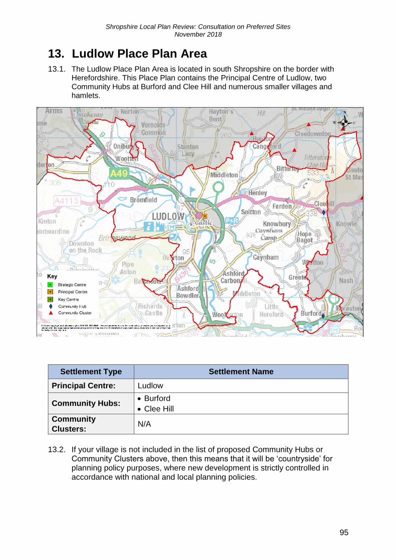
Shropshire Local Plan Review: Consultation on Preferred Sites November 2018 95 13. Ludlow Place Plan Area 13.1. The Ludlow Place Plan Area is located in south Shropshire on the border with Herefordshire. This Place Plan contains the Principal Centre of Ludlow, two Community Hubs at Burford and Clee Hill and numerous smaller villages and hamlets. Settlement Type Settlement Name Principal Centre: Ludlow Community Hubs: • Burford • Clee Hill Community Clusters: N/A 13.2. If your village is not included in the list of proposed Community Hubs or Community Clusters above, then this means that it will be ‘countryside’ for planning policy purposes, where new development is strictly controlled in accordance with national and local planning policies.
Transcript of 13. Ludlow Place Plan Area - Shropshire · 13.3. Ludlow (2016 population 10,717) is the smaller of...
Shropshire Local Plan Review: Consultation on Preferred Sites November 2018
95
13. Ludlow Place Plan Area 13.1. The Ludlow Place Plan Area is located in south Shropshire on the border with
Herefordshire. This Place Plan contains the Principal Centre of Ludlow, two Community Hubs at Burford and Clee Hill and numerous smaller villages and hamlets.
Settlement Type Settlement Name
Principal Centre: Ludlow
Community Hubs: • Burford
• Clee Hill
Community
Clusters: N/A
13.2. If your village is not included in the list of proposed Community Hubs or Community Clusters above, then this means that it will be ‘countryside’ for planning policy purposes, where new development is strictly controlled in accordance with national and local planning policies.
Shropshire Local Plan Review: Consultation on Preferred Sites November 2018
96
Principal Centre: Ludlow
13.3. Ludlow (2016 population 10,717) is the smaller of the principal market towns in Shropshire but is strategically located on the southern boundary of the County and is also accessible to other settlements and rural communities in Herefordshire and Worcestershire. This important and historic market town is therefore a significant service centre for the more sparsely populated areas of south Shropshire and beyond. The town also has a national reputation as a significant and well conserved historic town and so, has a significant tourist and visitor economy.
13.4. Ludlow is located between the course of the River Teme, which contributed to the defences of the town with its impressive and well conserved castle and the contemporary communications provided by the A49 trunk road and its station on
the Shrewsbury Cardiff rail line. The A49 forms two important junctions; the B4364 extending east to the Community Hub settlement of Clee Hill and The Sheet leading across the uplands of the Clees to the second Community Hub settlement of Burford on the A456 linking to Worcestershire.
13.5. Housing delivery rates in Ludlow have varied significantly over recent years but have achieved an average of around 35 dwellings per year. It is expected that the
lower rates of delivery reflect the impacts of the economic downturn and the uncertainty associated with the recent planning appeals which do, however, indicate the likely demand for housing in the town. The significant strategy now identified for Ludlow will require a delivery rate of around 60 dwellings per year. This is higher than the recent average, but these levels have been achieved in the past and the strategy is considered to be realistic and deliverable.
13.6. In the recent past, Ludlow breached the historical boundary created by the A49 with mixed use developments around The Sheet that are currently being delivered within the adjoining Parish of Ludford. The smaller scale of residual housing development requiring additional land can now be accommodated on brownfield and windfall sites coming forward within the town. Therefore, the housing expansion into the adjoining parish area can be subject to a period of respite for the foreseeable future.
13.7. To assist the economic growth objectives for the County, 11 hectares of employment development will be required in Ludlow over the Local Plan Review period. As the town currently has employment commitments of 7 hectares only 4 hectares of land remain to be found. It is considered that a consolidation of opportunity at The Sheet provides the better strategy for Ludlow to attract business investment interest into the local economy.
13.8. A local economic growth strategy is being prepared for Ludlow which will set out Shropshire Council’s local economic delivery plan in this area, helping the
Council to address priorities outlined in the overarching Economic Growth Strategy at a local level. This strategy will also have a key role in supporting existing business growth and attracting new business and investment into not just the town but also the surrounding areas.
13.9. A detailed profile of the principal Market Town of Ludlow providing more detailed
information about key local characteristics and issues is available here: https://shropshire.gov.uk/media/9687/ludlow.pdf.
13.10. Identified critical infrastructure priorities for Ludlow include:
• Waste water treatment and sewerage capacity.
• Additional primary school provision and consideration of the need for additional secondary school provision.
Shropshire Local Plan Review: Consultation on Preferred Sites November 2018
97
• Consideration of the need for additional medical facilities.
• Local and strategic highway improvements, including provision of a foot/cycle bridge over the A49 (to be delivered through current site allocations).
• Provision of additional leisure, recreation, and amenity facilities.
• Further information on infrastructure constraints and priorities are available within the Ludlow Place Plan.
13.11. As the Local Plan Review progresses additional infrastructure requirements are likely to become apparent.
Development Strategy
13.12. Ludlow is a principal Market Town settlement that contributes towards the
strategic growth objectives in the south of the County. It is expected that Ludlow will continue to explore ways in which it can effectively implement the ambitious growth strategy that has been identified within the SAMDev Plan and significantly augmented by recent committed development particularly two large appeals sustained for housing development at Bromfield Road (north) and Foldgate Lane (south).
13.13. The SAMDev Plan established two key allocations at Rocks Green and Sheet Road to continue the development of the eastern extension of Ludlow in the
neighbouring parish of Ludford. These two areas of new development will soon enter the housing land supply in Ludlow and each will provide access to land running along the east of the A49 route by-passing the town. In the period since the adoption of the SAMDev Plan, the housing supply in Ludlow has been significantly augmented by the housing development at Bromfield Road (north) and Foldgate Lane (south). There is, therefore, only a limited need for additional housing land in Ludlow that can be met from existing brownfield opportunities in the town that are already being marketed for redevelopment or are at an advanced stage in the planning of their redevelopment. There will also be an allowance for windfall development in the town and these sites should assist in the recycling and repurposing of under-used or are also expected to be constrained in this way.
13.14. It is therefore proposed that any further housing expansion into the adjoining Ludford parish should be subject to a period of respite for the foreseeable future to focus on the delivery of housing within the built area of the town.
13.15. The Council will consider the need to bring forward an outline masterplan for this
potential urban extension under their duty to keep under review matters affecting the proper and effective planning of the County.
13.16. The housing requirement for Ludlow comprises a significant provision of 1,000 dwellings. The effect of the SAMDev plan and the scale of development committed since the adoption, leaves a nominal additional requirement for only 148 dwellings. This is to be satisfied from two significant brownfield site releases and further windfall development. It is expected that this development will be designed to respect the historic character of Ludlow using good contemporary design within schemes that provides and appropriate scale and form of landscaping, open space and car parking.
13.17. The rate of development in Ludlow has been lower than anticipated for some time despite these significant commitments. The Council will require those landowners and developers with sites that form part of the current commitments to act swiftly to bring forward their land to consent for development and to commence
Shropshire Local Plan Review: Consultation on Preferred Sites November 2018
98
construction. The objective will be to bring dwellings to the market and to prove the demand for new homes in the town.
13.18. The employment needs of Ludlow are proposed to be met through an extension
of the existing allocation south of Sheet Road increasing the size of the overall allocation from 3.5 hectares to around 8 hectares. The development of these two inter-related sites should significantly change the employment land offer within Ludlow. This effect should improve the offer of employment land, commercial premises, business representation and employment in the town. This newly combined employment allocation is expected to create a critical mass for development in terms of the provision of infrastructure and the suitability of the site for larger building footprints. Development must deliver good contemporary design with appropriate use of materials, layout and landscaping. The development scheme should also include improvements to the A49 / Sheet Road junction and provide a suitable access to the site in combination with the adjacent existing employment allocation. The site is situated within an open aspect in an important landscape close to historic and environmental assets and the development scheme will be expected to respect and conserve these important natural and historic assets.
Summary of residential requirements
Number of Dwellings
Preferred dwelling guideline 2016-2036 1,000
Dwellings completed in 2016-17* 14
Dwellings committed as at 31st March 2017* 840
Remaining dwelling requirement to be identified 146
Dwellings to be allocated 84
Balance/Windfall allowance** 62
*Analysis of Housing Supply as at 31st March 2018 will be provided towards the end of 2018.
**Local Plan policies will allow flexibility for appropriate windfall, rural exception and cross-
subsidy development.
Summary of employment land requirements
Employment Land
(Ha)
Preferred employment land guideline 2016-2036 11
Commitments and allocations as at 31st March 2017* 7
Employment land shortfall 4
Employment land to be allocated 4
Balance/Windfall allowance** 0
*Analysis of Employment Supply at 31st March 2018 will be provided towards the end of 2018. **Local Plan policies will allow flexibility for appropriate windfall development.
Shropshire Local Plan Review: Consultation on Preferred Sites November 2018
99
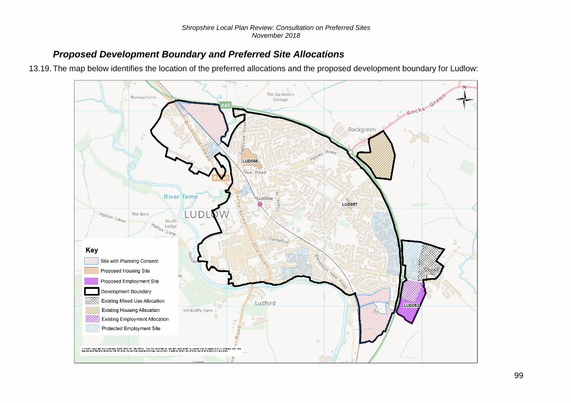
Proposed Development Boundary and Preferred Site Allocations
13.19. The map below identifies the location of the preferred allocations and the proposed development boundary for Ludlow:
Shropshire Local Plan Review: Consultation on Preferred Sites November 2018
100
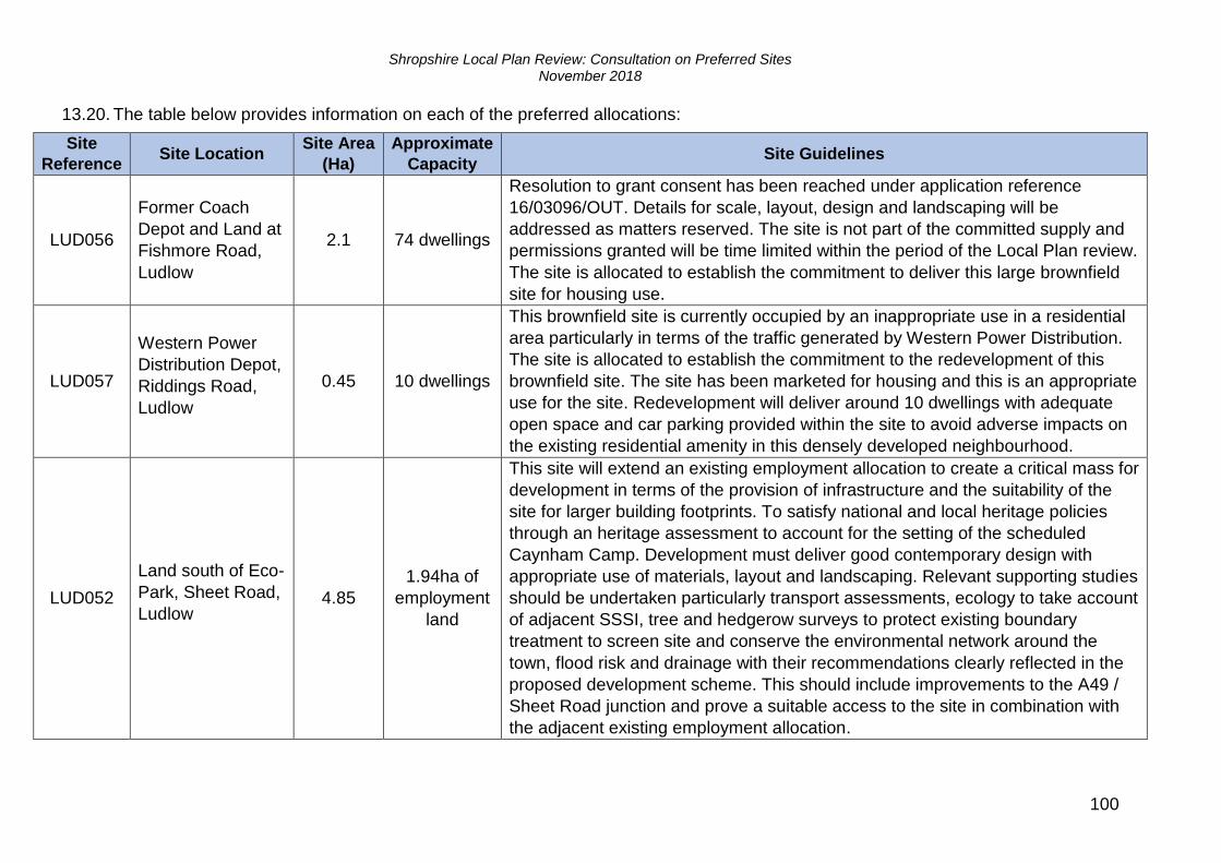
13.20. The table below provides information on each of the preferred allocations:
Site
Reference Site Location
Site Area
(Ha)
Approximate
Capacity Site Guidelines
LUD056
Former Coach
Depot and Land at
Fishmore Road,
Ludlow
2.1 74 dwellings
Resolution to grant consent has been reached under application reference
16/03096/OUT. Details for scale, layout, design and landscaping will be
addressed as matters reserved. The site is not part of the committed supply and
permissions granted will be time limited within the period of the Local Plan review.
The site is allocated to establish the commitment to deliver this large brownfield
site for housing use.
LUD057
Western Power
Distribution Depot,
Riddings Road,
Ludlow
0.45 10 dwellings
This brownfield site is currently occupied by an inappropriate use in a residential
area particularly in terms of the traffic generated by Western Power Distribution.
The site is allocated to establish the commitment to the redevelopment of this
brownfield site. The site has been marketed for housing and this is an appropriate
use for the site. Redevelopment will deliver around 10 dwellings with adequate
open space and car parking provided within the site to avoid adverse impacts on
the existing residential amenity in this densely developed neighbourhood.
LUD052
Land south of Eco-
Park, Sheet Road,
Ludlow 4.85
1.94ha of
employment
land
This site will extend an existing employment allocation to create a critical mass for
development in terms of the provision of infrastructure and the suitability of the
site for larger building footprints. To satisfy national and local heritage policies
through an heritage assessment to account for the setting of the scheduled
Caynham Camp. Development must deliver good contemporary design with
appropriate use of materials, layout and landscaping. Relevant supporting studies
should be undertaken particularly transport assessments, ecology to take account
of adjacent SSSI, tree and hedgerow surveys to protect existing boundary
treatment to screen site and conserve the environmental network around the
town, flood risk and drainage with their recommendations clearly reflected in the
proposed development scheme. This should include improvements to the A49 /
Sheet Road junction and prove a suitable access to the site in combination with
the adjacent existing employment allocation.
Shropshire Local Plan Review: Consultation on Preferred Sites November 2018
101
Community Hubs
13.21. Shropshire Council has undertaken an assessment of the local services, facilities, employment and public transport links available within rural settlements, in order to identify those which are considered to function as Community Hubs. This assessment is summarised within the Hierarchy of Settlements evidence base document available via the Shropshire Council website at: http://shropshire.gov.uk/planning-policy/local-plan/local-plan-partial-review-2016-2036/
13.22. Two proposed Community Hubs has been identified within the Ludlow Place Plan area, these are:
• Buford
• Clee Hill
Burford
13.23. Burford is a moderate size town located on the A456 Kidderminster Road. The
town forms a southern gateway for Shropshire at its border with Worcestershire marked by the course of the River Teme. Burford is located at the junctions of the A456 / A4112 / B4214 leading to the river bridge connecting Burford with its larger ‘sister’ settlement of Tenbury Wells located in Worcestershire.
13.24. Burford offers the most extensive range of services and facilities of all of Shropshire’s Community Hubs partly due to its proximity to services within Tenbury wells. As a measure of the inter-relationship between these two towns,
Burford accommodates a range of services including some key services and facilities operated and funded by Worcestershire authorities (e.g. its hospital and fire station). However, Burford accommodates an extensive and successful employment area comprising the Upper and Lower Teme Business Parks that are protected by Shropshire’s Local Plan policies which also benefit the community of Tenbury Wells.
13.25. Burford is an existing Community Hub but the town did not receive any allocations of land for development and so, the village has not seen planned development for some time. Although there have been progressive intensification of the employment uses at the Upper and Lower Teme Business Parks with some
small scale, windfall housing development in the village. It is intended to maintain a small allowance for windfall housing development in Burford.
13.26. Burford is therefore a sustainable development location in need of new land for housing and employment investment. This will support demands from business from within and beyond the town, to sustain the vitality of the local community and to support the local services within Buford and Tenbury Wells. Local aspirations for this Community Hub are for the significant new housing development to be delivered on a single allocation to provide high quality, affordable housing across a range of tenures to meet local needs. Employment land should be co-located with the existing Business Parks and is expected to be brought forward under criteria based policies to be identified in a later consultation on the Local Plan review.
Shropshire Local Plan Review: Consultation on Preferred Sites November 2018
102
Development Strategy
13.27. Over the period to 2036, a significant increase in housing is to be encouraged in Burford to support the role of the town as a Community Hub and to sustain its proven function as a key service centre with Tenbury Wells on the Shropshire / Worcestershire border.
13.28. The Call for Sites in the Local Plan review consultation in March 2017 did yield sites but these were not actively promoted as part of the Local Plan review. These circumstances have been brought to the attention of local landowners who are currently considering the development potential of their landholdings. The matter of future land allocations for housing and employment development in Burford will therefore be clarified in a later consultation on the Local Plan review.
Summary of residential requirements
Number of Dwellings
Preferred dwelling guideline 2016-2036 100
Dwellings completed in 2016-17* 1
Dwellings committed as at 31st March 2017* 3
Remaining dwelling requirement to be identified 96
Dwellings to be allocated and/or windfall allowance** 96
*Analysis of Housing Supply as at 31st March 2018 will be provided towards the end of 2018.
**Local Plan policies will allow flexibility for appropriate windfall, rural exception and cross-
subsidy development.
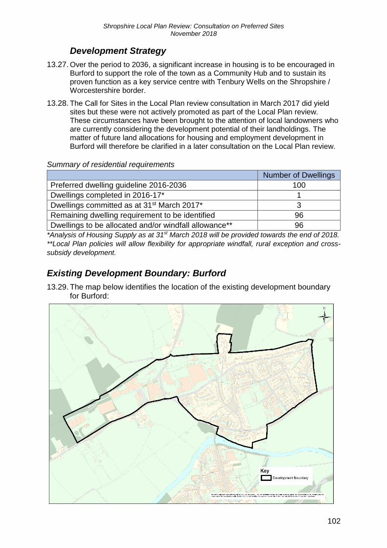
Existing Development Boundary: Burford
13.29. The map below identifies the location of the existing development boundary for Burford:

Shropshire Local Plan Review: Consultation on Preferred Sites November 2018
103
Clee Hill
13.30. Clee Hill is a village in the south of Shropshire. It lies between Ludlow and Cleobury Mortimer on the A4117 and has a range of local services and facilities. The village was identified as a Community Hub in the SAMDev Plan with a housing guideline of 30 dwellings to be delivered by infilling, groups of houses and conversions. Between 2006/7 and 2016/17, three houses were built in Clee Hill, two of them in 2016/17. There is also planning permission or prior approval for 47 other dwellings – the majority of which are at the Springfield Park site.
13.31. Key issues for planning in Clee Hill include; its location in the Shropshire Hills AONB; the designation of extensive tracts of land adjacent to the development boundary in the east as Wildlife Sites; other Wildlife Sites to the south and west and the Clee Hill Quarries SSSI to the north.
Development Strategy
13.32. Over the period to 2036, a modest amount of further housing of around 26
dwellings, to supplement the existing committed sites, will provide an opportunity to deliver a range of accommodation types to help meet local housing
needs and support investment in community facilities and infrastructure improvements. As more than half the development guideline is already committed, one site allocation is proposed to deliver around 20 houses, together with an allowance of 6 homes to be delivered through windfall sites.
Summary of residential requirements
Number of Dwellings
Preferred dwelling guideline 2016-2036 75
Dwellings completed in 2016-17* 2
Dwellings committed as at 31st March 2017* 47
Remaining dwelling requirement to be identified 26
Dwellings to be allocated 20
Balance/Windfall allowance** 6
*Analysis of Housing Supply as at 31st March 2018 will be provided towards the end of 2018.
**Local Plan policies will allow flexibility for appropriate windfall, rural exception and cross-
subsidy development.
Shropshire Local Plan Review: Consultation on Preferred Sites November 2018
104
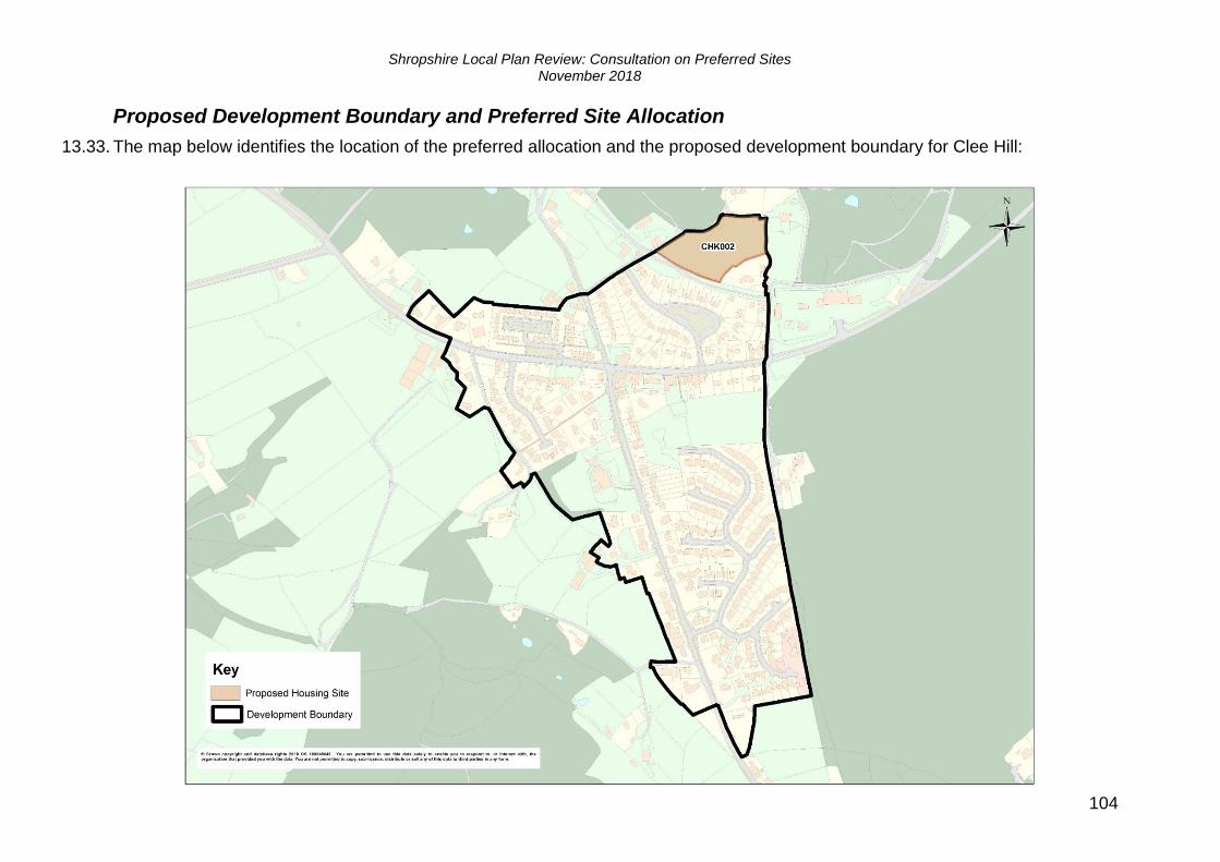
Proposed Development Boundary and Preferred Site Allocation
13.33. The map below identifies the location of the preferred allocation and the proposed development boundary for Clee Hill:

Shropshire Local Plan Review: Consultation on Preferred Sites November 2018
105
13.34. The table below provides information on the preferred allocation:
Site
Reference
Site
Location
Site
Area
(Ha)
Approximate
Capacity Site Guidelines
CHK002 Land to the
north of the
Crescent 0.95 20
A heritage assessment (archaeological) will be
needed to determine interest from early coal
and ironstone working. There is the potential
for restoration of priority habitat as part of the
development. The cattle grid on the access into
the site may need to be removed as part of the
development.
Community Clusters
13.35. The identification of Community Clusters will primarily be based on the aspirations of those communities, as expressed by their Parish Council(s)/Parish Meeting(s). Regard will also be given to the Local Plan Review evidence base and the views expressed by promoters of sites, residents and other stakeholders.
13.36. Based on the responses received during previous stages of consultation on the Local Plan Review, no Community Clusters are proposed to be designated in the Ludlow Place Plan area.
13.37. Within Community Clusters, it is proposed that a criteria based policy will manage development. A draft of this policy was provided within the previous Preferred Scale and Distribution of Development Consultation Document, available to view at: https://shropshire.gov.uk/media/7632/preferred-options-consultation-final.pdf