1102-48 N. 2ND ST - Philadelphia N 2nd ST_CDR.pdf1102-48 n. 2nd st type f elevation facade 32...
46
CIVIC DESIGN REVIEW Date: 01.23.2018 01 1102-48 N. 2ND ST 1102-48 N. 2ND ST
Transcript of 1102-48 N. 2ND ST - Philadelphia N 2nd ST_CDR.pdf1102-48 n. 2nd st type f elevation facade 32...

CIVIC DESIGN REVIEWDate: 01.23.2018
011102-48 N. 2ND ST
1102-48 N. 2ND ST
CIVIC DESIGN REVIEWDate: 01.23.2018
021102-48 N. 2ND ST
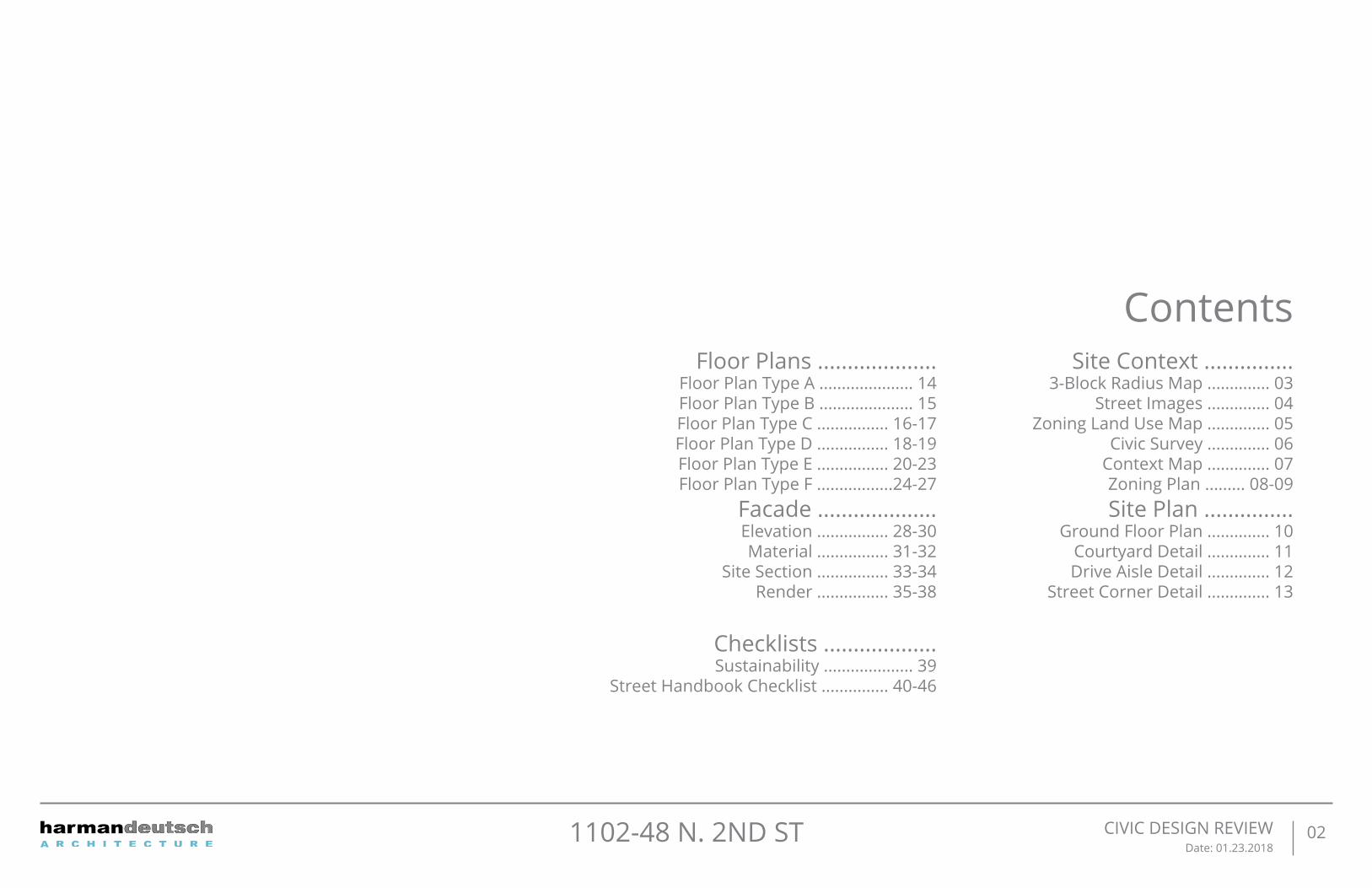
ContentsSite Context ...............
3-Block Radius Map .............. 03Street Images .............. 04
Zoning Land Use Map .............. 05Civic Survey .............. 06
Context Map .............. 07Zoning Plan ......... 08-09Site Plan ...............
Ground Floor Plan .............. 10Courtyard Detail .............. 11Drive Aisle Detail .............. 12
Street Corner Detail .............. 13
Floor Plans ....................Floor Plan Type A ..................... 14Floor Plan Type B ..................... 15Floor Plan Type C ................ 16-17Floor Plan Type D ................ 18-19 Floor Plan Type E ................ 20-23Floor Plan Type F .................24-27
Facade ....................Elevation ................ 28-30Material ................ 31-32
Site Section ................ 33-34Render ................ 35-38
Checklists ...................Sustainability .................... 39
Street Handbook Checklist ............... 40-46

MFL
2ND
STGIRARD AVE
GERMANTOWN AVE
FRO
NT
ST
3RD ST
4TH ST
031102-48 N. 2ND ST SITE CONTEXT3 BLOCK RADIUS MAP
1
2
4
3
5
6
7
9
12
10
13
14
11
8
The Site (1102-48 N. 2nd St)
ACME Supermarket
WeWork
The Schmidt’s Commons
Liberty Land Park
Orianna Hill Dog Park
Bodine High School
Cruz Playground
The Fillmore Philadelphia
Crane Arts Center
Punch Line Philly
TIPTOP PLAYGROUND
Hancock Playground
St John Neumann Shrine / St Peter’s Roman Catholic School
3 BLOCKRADIUS
TROLLY
LIGHT RAIL1
6
7
89 10
11
12
13
143
4
2
5
#5
#5
#57
#57

041102-48 N. 2ND ST SITE CONTEXTSTREET IMAGES
1
4
2
5
3
12
34
5
W. GIRARD AVE - LOOKING WEST
GERMANTOWN AVE. - LOOKING NW
N. 2ND ST - LOOKING SOUTH
W. GIRARD. - LOOKING EAST
SITE
N. 2
ND
ST
W.GIRARD AVE
GERMAN
TOW
N AVE
N. 2ND ST. - LOOKING NORTH
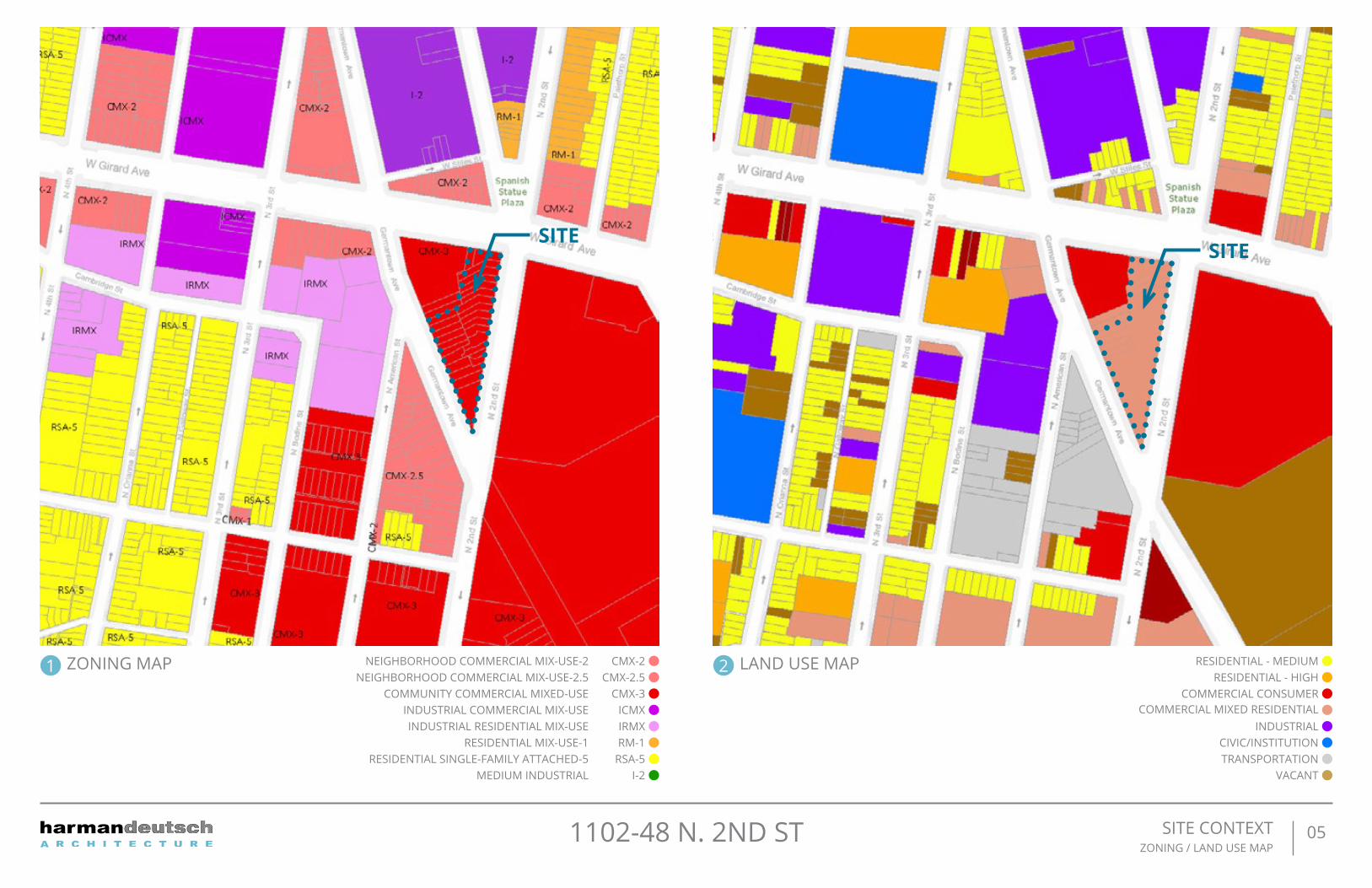
051102-48 N. 2ND ST SITE CONTEXTZONING / LAND USE MAP
1 2ZONING MAP
SITESITE
CMX-2NEIGHBORHOOD COMMERCIAL MIX-USE-2 RESIDENTIAL - MEDIUMCMX-2.5NEIGHBORHOOD COMMERCIAL MIX-USE-2.5 RESIDENTIAL - HIGH
CMX-3COMMUNITY COMMERCIAL MIXED-USE COMMERCIAL CONSUMERICMXINDUSTRIAL COMMERCIAL MIX-USE COMMERCIAL MIXED RESIDENTIALIRMXINDUSTRIAL RESIDENTIAL MIX-USE INDUSTRIALRM-1RESIDENTIAL MIX-USE-1 CIVIC/INSTITUTION
RSA-5RESIDENTIAL SINGLE-FAMILY ATTACHED-5 TRANSPORTATIONI-2MEDIUM INDUSTRIAL VACANT
LAND USE MAP

061102-48 N. 2ND ST SITE CONTEXTCIVIL SURVEY
TOTALAREA = 31462.47SF SF

071102-48 N. 2ND ST SITE CONTEXTCONTEXT MAP
W G
IRA
RD
AVE
N 2ND ST
N AMERICAN ST
W G
EOR
GE ST
N
TWO STORY BUILDINGCOMMERCIALONE STORY BUILDING
COMMERCIAL W/ ROOFTOPPARKING
BLDG #2
4 STORY STRUCTURE
TWO [2] FAMILY DWELLING
624 SF FOOTPRINT
3,210 GFA
BLDG #3
4 STORY STRUCTURE
TWO [2] FAMILY DWELLING
624 SF FOOTPRINT
3,210 GFA
BLDG #4
4 STORY STRUCTURE
TWO [2] FAMILY DWELLING
624 SF FOOTPRINT
3,210 GFA
BLDG #5
4 STORY STRUCTURE
TWO [2] FAMILY DWELLING
624 SF FOOTPRINT
3,210 GFA
BLDG #6
4 STORY STRUCTURE
TWO [2] FAMILY DWELLING
624 SF FOOTPRINT
3,210 GFA
BLDG #7
4 STORY STRUCTURE
TWO [2] FAMILY DWELLING
624 SF FOOTPRINT
3,210 GFA
BLDG #8
4 STORY STRUCTURE
TWO [2] FAMILY DWELLING
624 SF FOOTPRINT
3,210 GFA
BLDG #9
4 STORY STRUCTURE
TWO [2] FAMILY DWELLING
624 SF FOOTPRINT
3,210 GFA
BLDG #10
4 STORY STRUCTURE
TWO [2] FAMILY DWELLING
624 SF FOOTPRINT
3,210 GFA
BLDG #11
4 STORY STRUCTURE
TWO [2] FAMILY DWELLING
618 SF FOOTPRINT
3,180 GFA
BLDG #12
4 STORY STRUCTURE
TWO [2] FAMILY DWELLING
624 SF FOOTPRINT
3,210 GFA
BLDG #14
4 STORY STRUCTURE
TWO [2] FAMILY DWELLING
806.6 SF FOOTPRINT
4,123 GFABLDG #13
4 STORY STRUCTURE
SINGLE FAMILY DWELLING
449.2 SF FOOTPRINT
2,336 GFA
BLDG #1
4 STORY STRUCTURE
THIRTEEN [13] FAMILY DWELLING
3,744 SF FOOTPRINT
13,984 GFA
SIDEWALK
BLDG #15
6 STORY STRUCTURE
1 STORY PORTION
OPEN AREA
6'-0" EASEMENT @
GRADE (10'-0" TALL)
PROPOSED7500 GSF
PROPOSED TENANT
SPACE # 23550 GSF
BLDG #14
4 STORY STRUCTURE
TWO [2] FAMILY DWELLING
806.6 SF FOOTPRINT
4,123 GFA
ONE STORY BUILDINGCOMMERCIAL
THREE STORY BUILDINGS RESIDENTIAL W/
COMMERCIALFIRST FLOOR
THREE STORY BUILDINGS RESIDENTIAL W/
COMMERCIALFIRST FLOOR
THREE STORY BUILDINGSCOMMERCIAL
ONE STORYBUILDING
COMMERCIAL
ONE STORY BUILDINGRESIDENTIAL
ONE STORY
BUILDING
COMMERCIAL
THREE STORY BUILDINGS RESIDENTIAL W/
COMMERCIALFIRST FLOOR
THREE STORY BUILDINGS RESIDENTIAL W/
COMMERCIALFIRST FLOOR
FOUR STORY BUILDINGRESIDENTIALFOUR STORY
BUILDINGRESIDENTIAL
FOUR STORYBUILDING
RESIDENTIAL
FOUR STORYBUILDING
RESIDENTIAL
THREE STORYBUILDING
RESIDENTIAL
THREE STORYBUILDINGS
RESIDENTIAL W/COMMERCIALFIRST FLOOR
THREE STORYBUILDINGS
RESIDENTIAL W/COMMERCIALFIRST FLOOR
THREE STORY BUILDINGRESIDENTIAL
THREE STORY BUILDINGS RESIDENTIAL W/
COMMERCIALFIRST FLOOR
THREE STORY BUILDINGS RESIDENTIAL W/
COMMERCIALFIRST FLOOR
THREE STORYBUILDINGS
RESIDENTIAL W/COMMERCIALFIRST FLOOR
THREE STORYBUILDINGS
RESIDENTIAL W/COMMERCIALFIRST FLOOR
THREE STORYBUILDINGS
RESIDENTIAL W/COMMERCIALFIRST FLOOR
SEVEN STORY BUILDINGSMIX-USE
SIX STORY BUILDINGSMIX-USE
ONE STORY
COMMERCIAL
THREE STORY BUILDING
S
RESIDENTIAL
W STILES AVE
N AMERICAN ST
N PALETHORP ST
VACANT LOT/PARKING
GERMANTOWN AVE
SEVEN STORY BUILDINGSMIX-USE VACANT LOT/
PARKING
THREE STORY BUILDINGS RESIDENTIAL
TWO STORY BUILDINGS RESIDENTIAL W/
COMMERCIALFIRST FLOOR
THREESTORY
BUILDINGS
RESIDENTIALW/
COMMERCIALFIRST
FLOOR

TYPE F
081102-48 N. 2ND ST SITE CONTEXTZONING PLAN
ZONING CHARTBASE DISTRICT: CMX-3ABUTTING DISTRICT: N/ADISTRICT ACROSS STREET: CMX-2, CMX-2.5, CMX-3, IRMXLOT AREA: 31,462.47 SFUSE: 82 DWELLINGS (1) SINGLE-FAMILY DWELLING (12) DUPLEX DWELLING (1) 13-FAMILY DWELLING (1) MIX-USE BLDGs W/ (1) COMMERCIAL UNIT AND (44) DWELLING UNITS
DIMENSIONAL STANDARDS: REQUIRED / ALLOWED PROPOSEDOPEN AREA: 6,292.494 SF (20%) 6375.76 SF (20.26%)OCCUPIED AREA: 25,169.976 SF (80%) 25,086.71SF (79.74%)FRONT YARD SETBACK: N/A N/A SIDE YARD: 8’ IF USED N/AREAR YARD: N/A 0’HEIGHT: N/A TYPE A-E: 55’ MAX TYPE F: +/- 76-6”FLOOR AREA RATIO: 500% 397.04%
GFA: N/A 124,918.13 SFSTREET TREES: 22 23
PARKING: REQUIRED PROPOSEDAUTO PARKING: 20 STALLS / 2 ADA 37 STALLS (31) STALLS+(3)ADA VAN (1) CAR SHARE + (2)EV
BIKE PARKING: 33 STALLS 43 TYPE 1A STALLS 14 STALLS ON SIDEWALK
RIGHT-OF-WAY COMPONENTS: N.2ND ST GERMANTOWN AVE GIRARD AVEPEDESTRIAN ZONE: 6’-0” 6’-0” 9’-0”FURNISHING ZONE: 4’-0” 4’-0” 4’-0”BUILDING ZONE: 3’-0’ 3’-0” 3’-0”
RIGHT-OF-WAY ENCROACHMENTS (TYP.):STAIR ENCROACHMENT: 3’-0”EGRESS WELLS: 3’-0”

CIVIC DESIGN REVIEWDate: 01.23.2018
091102-48 N. 2ND ST
Building - Type AZONING PLAN
Building - Type BZONING PLAN
Building - Type CZONING PLAN
Building - Type DZONING PLAN
Building - Type EZONING PLAN

101102-48 N. 2ND ST SITE PLANGROUND FLOOR PLAN
1
2
4 3

111102-48 N. 2ND ST SITE PLAN - 1COURTYARD DETAIL

121102-48 N. 2ND ST SITE PLAN - 2DRIVE AISLE DETAIL

131102-48 N. 2ND ST SITE PLAN - 3/4CORNER DETAIL
COMMERCIAL ENTRY DETAIL GERMANTOWN AVE CORNER DETAIL

141102-48 N. 2ND ST FLOOR PLAN - TYPE AUNIT 1 : 1109 SFUNIT 2 : 1909 SF
BASEMENT 1ST FL 2ND FL
3RD FL 4TH FL ROOF
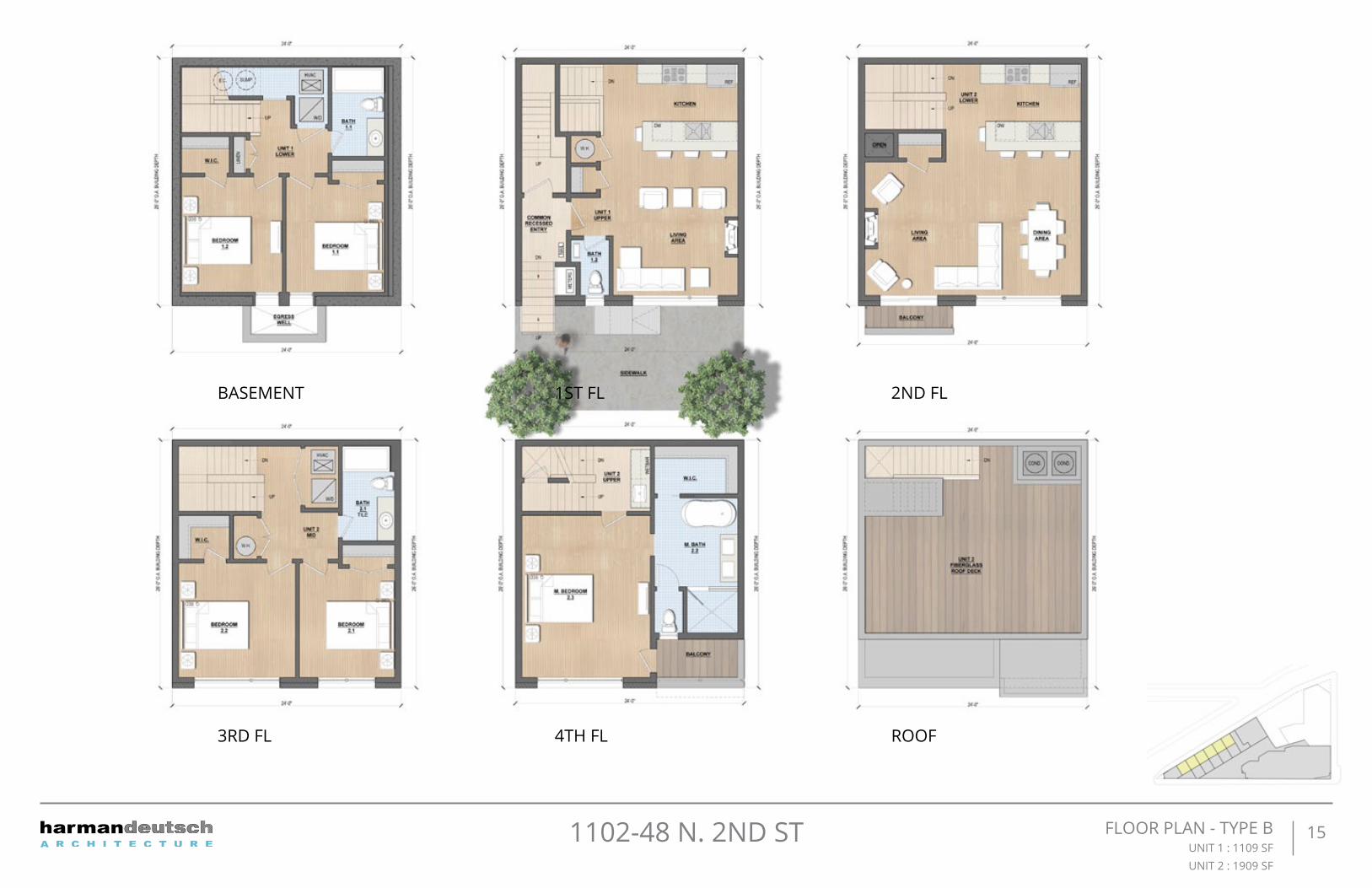
151102-48 N. 2ND ST FLOOR PLAN - TYPE BUNIT 1 : 1109 SFUNIT 2 : 1909 SF
BASEMENT 1ST FL 2ND FL
3RD FL 4TH FL ROOF

BASEMENT 1ST FL
161102-48 N. 2ND ST FLOOR PLAN - TYPE CUNIT 1 : 1471 SFUNIT 2 : 2416 SF

2ND FL 3RD FL
4TH FLROOF
171102-48 N. 2ND ST FLOOR PLAN - TYPE CUNIT 1 : 1471 SFUNIT 2 : 2416 SF

181102-48 N. 2ND ST FLOOR PLAN - BUILDING DUNIT 1 : 2224 SF
BASEMENT 1ST FL
2ND FL 3RD FL

4TH FL ROOF
191102-48 N. 2ND ST FLOOR PLAN - TYPE DUNIT 1 : 2224 SF

201102-48 N. 2ND ST
BASEMENT
FLOOR PLAN - BUILDING E-
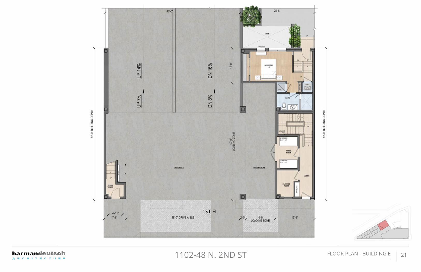
211102-48 N. 2ND ST
1ST FL
FLOOR PLAN - BUILDING E-

221102-48 N. 2ND ST
2ND FL
FLOOR PLAN - BUILDING E-
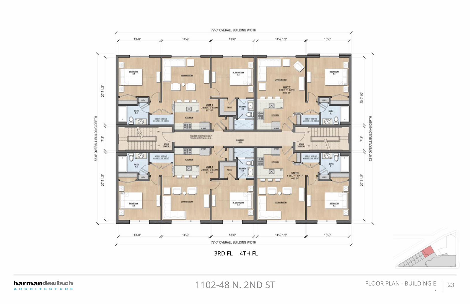
231102-48 N. 2ND ST
3RD FL 4TH FL
FLOOR PLAN - BUILDING E-

LOWER LEVEL
241102-48 N. 2ND ST FLOOR PLAN - BUILDING F-

GROUND FLOOR
251102-48 N. 2ND ST FLOOR PLAN - BUILDING F-

2ND FLOOR
261102-48 N. 2ND ST FLOOR PLAN - BUILDING F-

3RD - 5TH FLOOR
271102-48 N. 2ND ST FLOOR PLAN - BUILDING F-

281102-48 N. 2ND ST
ELEVATION A - GERMANTOWN AVE
ELEVATION B - GERMANTOWN AVE REAR
ELEVATION-
CB
A
ELEVATION B - CORNER OF
GERMANTOWN AVEAND 2ND ST

291102-48 N. 2ND ST
ELEVATION C - N. 2N STREET
ELEVATION D - GIRARD AVE
ELEVATION-
E
D

301102-48 N. 2ND ST ELEVATION-
ELEVATION E - N. 2ND ST REAR
ELEVATION F - INTERIOR RESIDENTIAL ENTRANCE
F
E

311102-48 N. 2ND ST Type A Elevation FacadeMaterial
42” HIGH, BLACK POWER COATED METAL GUARDRAIL
BUILT-IN PLANTER
METAL PANELCENTRIACOLOR: DARK BRONZE
ALUMINUM CLAD WINDOWJELD-WENLUXURY BRONZE
6
5
7
8RECESSED LANDSCAPE LIGHTING
GLASS RAIL BALCONY
METAL SIDINGCENTRIA [VERSA-SEAM]COLOR: LIMESTONE
BRICKMCAVOYFULL RANGE CHARLESTOWNGROUT COLOR: COLONIAL BROWN
3
1
2
4

321102-48 N. 2ND ST Type F Elevation FacadeMaterial
BUILD-IN BENCH
CONCRETE PLANTER
BIKE RACK
GLASS RAIL BALCONY
ALUMINUM CLAD WINDOWJELD-WENLUXURY BRONZE
METAL SIDINGCENTRIA [VERSA-SEAM]COLOR: LIMESTONE
METAL PANELCENTRIACOLOR: DARK BRONZE
BRICKMCAVOYFULL RANGE CHARLESTOWNGROUT COLOR: COLONIAL BROWN
3
8
1
2
5
4
4
6

AB
331102-48 N. 2ND ST Site Section-
SECTION A
SECTION B

c
341102-48 N. 2ND ST Site Section-
SECTION C
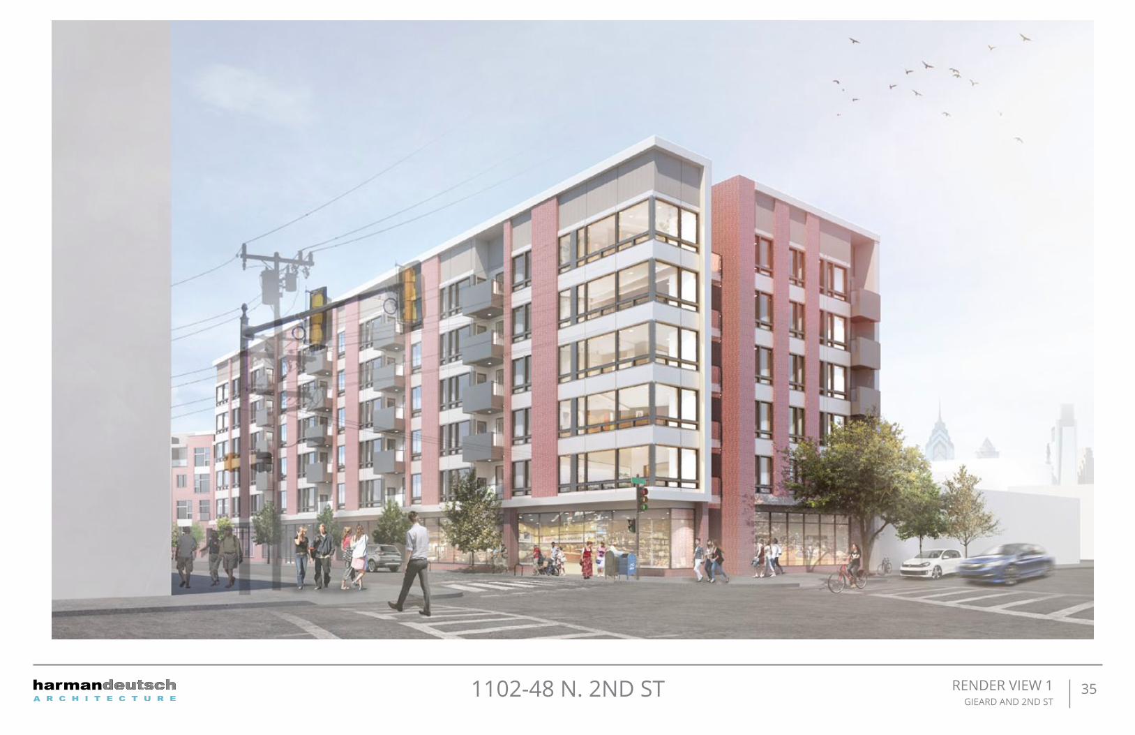
351102-48 N. 2ND ST RENDER VIEW 1 GIEARD AND 2ND ST
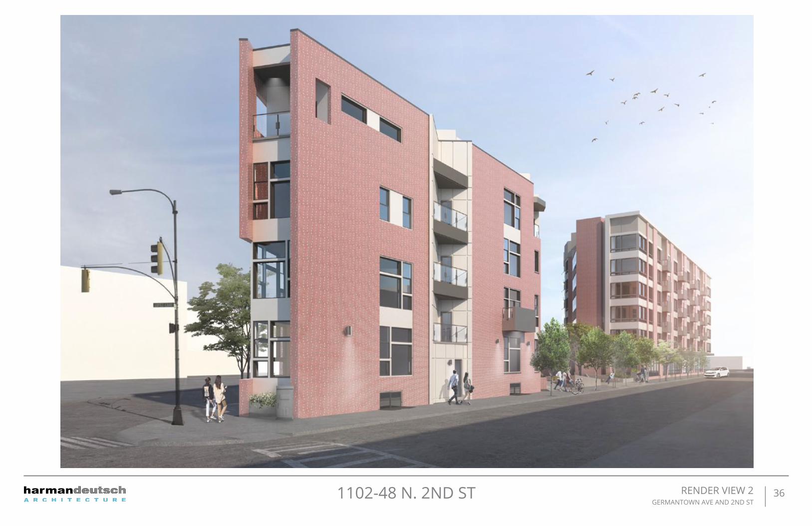
361102-48 N. 2ND ST RENDER VIEW 2 GERMANTOWN AVE AND 2ND ST

371102-48 N. 2ND ST RENDER VIEW 3GERMANTOWN AVE

381102-48 N. 2ND ST RENDER VIEW 4COURTYARD ON 2ND ST

391102-48 N. 2ND ST Sustainability-
Civic Design Review, Philadelphia Sustainability Questionnaire
Categories Benchmark
Meets or Exceeds the Benchmark (yes or no)?
If yes, please describe how or reference the applicable document in the CDR
submission.
Location and Transportation
Access to Quality Transit
Locate a functional entry of the project within a ¼-mile (1312-feet) walking distance of existing or planned bus, streetcar,or rideshare stops, bus rapid transit stops, light or heavy rail stations.
Reduced Parking Footprint
All new parking areas to be located in the rear yard of the property or under the building, and unenclosed or uncovered parking areas are 40% or less of the site area.
Green Vehicles
Designate 5% of all parking spaces used by the project as preferred parking for green vehicles or car share vehicles. Clearly identify and enforce for sole use by car share or green vehicles, which include plug-in electric vehicles and alternative fuel vehicles.
Bike Share StationIncorporate a bike share station in coordination with and conformance to the standards of Philadelphia Bike Share.
Sustainable Sites
Pervious Site Surfaces
Provides vegetated and/or pervious open space that is 30% or greater of the site's Open Area, as de�ned by the zoning code. Vegetated and/or green roofs can be included in this calculation.
Rainwater Management
Conform to the stormwater requirements of the Philadelphia Water Department(PWD) and either: A)Develop a green street and donate it to PWD, designed and constructed in accordance with the PWD Green Streets Design Manual, OR B) Manage additional runo� from adjacent streets on the development site, designed and constructed in accordance with speci�cations the PWD Stormwater Management Regulations
Heat Island Reduction (excluding roofs)
Reduce the heat island e�ect through either of the following strategies for 50% or more of all on-site hardscapes: A) Hardscapes that have a high re�ectance, an SRI>29. B) Shading by trees, structures, or solar panels.
Yes. - Bus 5 @ Girard ave and 2nd St. - Bus 57 @ Girard ave and 3rd St.- LR @ Girard ave and 2nd St.- MFL @ Girard Station
Yes, additional runnoff from adjacent streets will be managed on-site in accordance with the PWD stormwater management regulations.
Yes, all parking to be in garage@grade and garage@basement
Yes, (1) car share and (2) EV spots included
Yes, - @ Girard Ave and 3rd St
Yes, 63.7% of open space is perviousTotal open = 6375.76sfprevious = 4061.38sf
Yes, hardscapes will meet an SRI>29
(yes or no)? Categories Benchmark
Meets or Exceeds the Benchmark (yes or no)?
If yes, please describe how or reference the applicable document in the CDR
submission.
Water E�ciency
Outdoor Water Use
Maintain on-site vegetation without irrigation. OR, reduce the watering requirements to at least 50% from the calculated baseline for the site's peak watering month.
Energy and Atmosphere
Energy Commissioning
Acquire a separate, independent commissioning service to insure that the energy related systems are installed, calibrated, and perform as intended.
Energy Performance
The project will reduce energy consumption by: Achieving 10% energy saving or more from an established baseline using ASHRAE standard 90.1-2010, OR by conforming to ASHRAE Advanced Energy Design Guide for Commercial Buildings.
On-Site Renewable Energy
Produce renewable energy on-site that will provide at least 3% of the project's anticipated energy usage.
Innovation
InnovationAny other sustainable measures that could positively impact the public realm.
Civic Design Review, Philadelphia Sustainability Questionnaire
Yes, on-site vegetation will be maintained without irrigation.
No, independent commissioning services will not be contracted.
Yes, the design team will evaluate how to reduce energy consumption to be above ASHRAE standards.
No, renewable energy will not be produced on-site.
No applicable.

401102-48 N. 2ND ST COMPLETE STREETS HANDBOOK CHECKLIST-
COMPLETE STREETS HANDBOOK CHECKLIST Philadelphia City Planning Commission
1
INSTRUCTIONS This Checklist is an implementation tool of the Philadelphia Complete Streets Handbook (the “Handbook”) and enables City engineers and planners to review projects for their compliance with the Handbook’s policies. The handbook provides design guidance and does not supersede or replace language, standards or policies established in the City Code, City Plan, or Manual on Uniform Traffic Control Devices (MUTCD).
The Philadelphia City Planning Commission receives this Checklist as a function of its Civic Design Review (CDR) process. This checklist is used to document how project applicants considered and accommodated the needs of all users of city streets and sidewalks during the planning and/or design of projects affecting public rights‐of‐way. Departmental reviewers will use this checklist to confirm that submitted designs incorporate complete streets considerations (see §11‐901 of The Philadelphia Code). Applicants for projects that require Civic Design Review shall complete this checklist and attach it to plans submitted to the Philadelphia City Planning Commission for review, along with an electronic version.
The Handbook and the checklist can be accessed at http://www.phila.gov/CityPlanning/projectreviews/Pages/CivicDesignReview.aspx
PRELIMINARY PCPC REVIEW AND COMMENT:
DATE
FINAL STREETS DEPT REVIEW AND COMMENT:
DATE
COMPLETE STREETS HANDBOOK CHECKLIST Philadelphia City Planning Commission
2
INSTRUCTIONS (continued) APPLICANTS SHOULD MAKE SURE TO COMPLY WITH THE FOLLOWING REQUIREMENTS:
� This checklist is designed to be filled out electronically in Microsoft Word format. Please submit the Word version of the checklist. Text fields will expand automatically as you type.
� All plans submitted for review must clearly dimension the widths of the Furnishing, Walking, and Building Zones (as defined in Section 1 of the Handbook). “High Priority” Complete Streets treatments (identified in Table 1 and subsequent sections of the Handbook) should be identified and dimensioned on plans.
� All plans submitted for review must clearly identify and site all street furniture, including but not limited to bus shelters, street signs and hydrants.
� Any project that calls for the development and installation of medians, bio‐swales and other such features in the right‐of‐way may require a maintenance agreement with the Streets Department.
� ADA curb‐ramp designs must be submitted to Streets Department for review
� Any project that significantly changes the curb line may require a City Plan Action. The City Plan Action Application is available at http://www.philadelphiastreets.com/survey‐and‐design‐bureau/city‐plans‐unit . An application to the Streets Department for a City Plan Action is required when a project plan proposes the:
o Placing of a new street; o Removal of an existing street; o Changes to roadway grades, curb lines, or widths; or o Placing or striking a city utility right‐of‐way.
Complete Streets Review Submission Requirement*:
EXISTING CONDITIONS SITE PLAN, should be at an identified standard engineering scale
o FULLY DIMENSIONED
o CURB CUTS/DRIVEWAYS/LAYBY LANES
o TREE PITS/LANDSCAPING
o BICYCLE RACKS/STATIONS/STORAGE AREAS
o TRANSIT SHELTERS/STAIRWAYS
PROPOSED CONDITIONS SITE PLAN, should be at an identified standard engineering scale
o FULLY DIMENSIONED, INCLUDING DELINEATION OF WALKING, FURNISHING, AND BUILDING ZONES AND PINCH POINTS
o PROPOSED CURB CUTS/DRIVEWAYS/LAYBY LANES
o PROPOSED TREE PITS/LANDSCAPING
o BICYCLE RACKS/STATIONS/STORAGE AREAS
o TRANSIT SHELTERS/STAIRWAYS
*APPLICANTS PLEASE NOTE: ONLY FULL‐SIZE, READABLE SITE PLANS WILL BE ACCEPTED. ADDITIONAL PLANS MAY BE REQUIRED AND WILL BE REQUESTED IF NECESSARY

411102-48 N. 2ND ST
COMPLETE STREETS HANDBOOK CHECKLIST Philadelphia City Planning Commission
3
GENERAL PROJECT INFORMATION 1100‐48 N. 2ND St 01.23.2017
1. APPLICANT NAME
Rustin Ohler [Harman Deutsch Arch]
2. APPLICANT CONTACT INFORMATION
Harman Deutsch Architecture 0 631 N. 12th st. Phila pa
3. PROJECT AREA: list precise street limits and scope
31,462.47 sf
4. OWNER NAME
Streamline Philly
5. OWNER CONTACT INFORMATION
2301 Washington Ave Phila Pa
6. APPLICANT NAME
Rustin Ohler [Harman Deutsch Arch]
7. APPLICANT CONTACT INFORMATION
Harman Deutsch Architecture 0 631 N. 12th st. Phila pa
8. STREETS: List the streets associated with the project. Complete Streets Types can be found at www.phila.gov/map under the “Complete Street Types” field. Complete Streets Types are also identified in Section 3 of the Handbook.
STREET FROM TO COMPLETE STREET TYPE
N. 2nd St. Germantown Ave. Girard Ave. Walkable Commercial Corridors
Germantown Ave. N. 2nd St. Girard Ave. Walkable Commercial Corridors
Girard Ave. N. 2nd St. Germantown Ave. Walkable Commercial Corridors
11. Does the Existing Conditions site survey clearly identify the following existing conditions with dimensions?
a. Parking and loading regulations in curb lanes adjacent to the site YES NO
b. Street Furniture such as bus shelters, honor boxes, etc. YES NO N/A
c. Street Direction YES NO
d. Curb Cuts YES NO N/A
e. Utilities, including tree grates, vault covers, manholes, junction boxes, signs, lights, poles, etc.
YES NO N/A
f. Building Extensions into the sidewalk, such as stairs and stoops YES NO N/A
APPLICANT: General Project Information
Additional Explanation / Comments:
DEPARTMENTAL REVIEW: General Project Information
Reviewer Comments:
COMPLETE STREETS HANDBOOK CHECKLIST Philadelphia City Planning Commission
4
COMPLETE STREETS HANDBOOK CHECKLIST-

421102-48 N. 2ND ST
COMPLETE STREETS HANDBOOK CHECKLIST Philadelphia City Planning Commission
5
PEDESTRIAN COMPONENT (Handbook Section 4.3) 12. SIDEWALK: list Sidewalk widths for each street frontage. Required Sidewalk widths are listed in Section 4.3 of the
Handbook. STREET FRONTAGE TYPICAL SIDEWALK WIDTH
(BUILDING LINE TO CURB) Required / Existing / Proposed
CITY PLAN SIDEWALK WIDTH Existing / Proposed
Girard Ave. 16 / 16 / 16 16 / 16
Germantown Ave. 13 / 13 / 13 13 / 13
N. 2nd St. 13 / 13 / 13 13 / 13
/ / /
13. WALKING ZONE: list Walking Zone widths for each street frontage. The Walking Zone is defined in Section 4.3 of the Handbook, including required widths.
STREET FRONTAGE WALKING ZONERequired / Existing / Proposed
Girard Ave. 6 / 12 / 9
Germantown Ave. 6 / 9 / 6
N. 2nd St. 6 / 9 / 6
/ /
14. VEHICULAR INTRUSIONS: list Vehicular Intrusions into the sidewalk. Examples include but are not limited to; driveways, lay‐by lanes, etc. Driveways and lay‐by lanes are addressed in sections 4.8.1 and 4.6.3, respectively, of the Handbook.
EXISTING VEHICULAR INTRUSIONS INTRUSION TYPE INTRUSION WIDTH PLACEMENT
PROPOSED VEHICULAR INTRUSIONS INTRUSION TYPE INTRUSION WIDTH PLACEMENT
Curb cut 12’ Germantown Ave.
Curb cut 24’ Germantown Ave.
COMPLETE STREETS HANDBOOK CHECKLIST Philadelphia City Planning Commission
6
PEDESTRIAN COMPONENT (continued) DEPARTMENTAL
APPROVAL
15. When considering the overall design, does it create or enhance a pedestrian environment that provides safe and comfortable access for all pedestrians at all times of the day?
YES NO YES NO
APPLICANT: Pedestrian Component
Additional Explanation / Comments:
DEPARTMENTAL REVIEW: Pedestrian Component
Reviewer Comments:
COMPLETE STREETS HANDBOOK CHECKLIST-

431102-48 N. 2ND ST
COMPLETE STREETS HANDBOOK CHECKLIST Philadelphia City Planning Commission
7
BUILDING & FURNISHING COMPONENT (Handbook Section 4.4) 16. BUILDING ZONE: list the MAXIMUM, existing and proposed Building Zone width on each street frontage. The Building
Zone is defined as the area of the sidewalk immediately adjacent to the building face, wall, or fence marking the property line, or a lawn in lower density residential neighborhoods. The Building Zone is further defined in section 4.4.1 of the Handbook.
STREET FRONTAGE MAXIMUM BUILDING ZONE WIDTHExisting / Proposed
Girard Ave. 0 / 0’‐0”
Germantown Ave. 0 / 3’‐0”
N. 2nd St. 0 / 3’‐0”
/
17. FURNISHING ZONE: list the MINIMUM, recommended, existing, and proposed Furnishing Zone widths on each street frontage. The Furnishing Zone is further defined in section 4.4.2 of the Handbook.
STREET FRONTAGE MINIMUM FURNISHING ZONE WIDTHRecommended / Existing / Proposed
Girard Ave. 4’‐0” / 3’‐6” / 3’‐6”
Germantown Ave. 4’‐0” / 3’‐6” / 3’‐6”
N. 2nd St. 4’‐0” / 3’‐6” / 3’‐6”
/ /
18. Identify proposed “high priority” building and furnishing zone design treatments that are incorporated into the design plan, where width permits (see Handbook Table 1). Are the following treatments identified and dimensioned on the plan?
DEPARTMENTAL APPROVAL
Bicycle Parking YES NO N/A YES NO Lighting YES NO N/A YES NO Benches YES NO N/A YES NO Street Trees YES NO N/A YES NO Street Furniture YES NO N/A YES NO
19. Does the design avoid tripping hazards? YES NO N/A YES NO
20. Does the design avoid pinch points? Pinch points are locations where the Walking Zone width is less than the required width identified in item 13, or requires an exception
YES NO N/A YES NO
COMPLETE STREETS HANDBOOK CHECKLIST Philadelphia City Planning Commission
8
BUILDING & FURNISHING COMPONENT (continued)
APPLICANT: Building & Furnishing Component
Additional Explanation / Comments:
DEPARTMENTAL REVIEW: Building & Furnishing Component
Reviewer Comments:
21. Do street trees and/or plants comply with street installation requirements (see sections 4.4.7 & 4.4.8)
YES NO N/A YES NO
22. Does the design maintain adequate visibility for all roadway users at intersections?
YES NO N/A YES NO
COMPLETE STREETS HANDBOOK CHECKLIST-

441102-48 N. 2ND ST
COMPLETE STREETS HANDBOOK CHECKLIST Philadelphia City Planning Commission
9
BICYCLE COMPONENT (Handbook Section 4.5) 23. List elements of the project that incorporate recommendations of the Pedestrian and Bicycle Plan, located online at
http://phila2035.org/wp‐content/uploads/2012/06/bikePedfinal2.pdf
24. List the existing and proposed number of bicycle parking spaces, on‐ and off‐street. Bicycle parking requirements are provided in The Philadelphia Code, Section 14‐804.
BUILDING / ADDRESS REQUIRED SPACES
ON‐STREETExisting / Proposed
ON SIDEWALK Existing / Proposed
OFF‐STREETExisting / Proposed
N. 2nd St. 33 0 / 0 0 / 14 0 / 43
/ / /
/ / /
/ / /
25. Identify proposed “high priority” bicycle design treatments (see Handbook Table 1) that are incorporated into the design plan, where width permits. Are the following “High Priority” elements identified and dimensioned on the plan?
DEPARTMENTAL APPROVAL
Conventional Bike Lane YES NO N/A YES NO Buffered Bike Lane YES NO N/A YES NO Bicycle‐Friendly Street YES NO N/A YES NO
26. Does the design provide bicycle connections to local bicycle, trail, and transit networks?
YES NO N/A YES NO
27. Does the design provide convenient bicycle connections to residences, work places, and other destinations?
YES NO N/A YES NO
APPLICANT: Bicycle Component
Additional Explanation / Comments:
DEPARTMENTAL REVIEW: Bicycle Component
Reviewer Comments:
COMPLETE STREETS HANDBOOK CHECKLIST Philadelphia City Planning Commission
10
CURBSIDE MANAGEMENT COMPONENT (Handbook Section 4.6) DEPARTMENTAL
APPROVAL
28. Does the design limit conflict among transportation modes along the curb?
YES NO YES NO
29. Does the design connect transit stops to the surrounding pedestrian network and destinations?
YES NO N/A YES NO
30. Does the design provide a buffer between the roadway and pedestrian traffic?
YES NO N/A YES NO
31. How does the proposed plan affect the accessibility, visibility, connectivity, and/or attractiveness of public transit?
YES NO
APPLICANT: Curbside Management Component
Additional Explanation / Comments:
DEPARTMENTAL REVIEW: Curbside Management Component
Reviewer Comments:
COMPLETE STREETS HANDBOOK CHECKLIST-

451102-48 N. 2ND ST
COMPLETE STREETS HANDBOOK CHECKLIST Philadelphia City Planning Commission
11
VEHICLE / CARTWAY COMPONENT (Handbook Section 4.7) 32. If lane changes are proposed, , identify existing and proposed lane widths and the design speed for each street
frontage; If not, go to question No. 35 STREET FROM TO LANE WIDTHS
Existing / Proposed DESIGN SPEED
/
/
/
/
DEPARTMENTAL APPROVAL
33. What is the maximum AASHTO design vehicle being accommodated by the design?
P YES NO
34. Will the project affect a historically certified street? An inventory of historic streets(1) is maintained by the Philadelphia Historical Commission.
YES NO YES NO
35. Will the public right‐of‐way be used for loading and unloading activities?
YES NO YES NO
36. Does the design maintain emergency vehicle access? YES NO YES NO
37. Where new streets are being developed, does the design connect and extend the street grid?
YES NO N/A YES NO
38. Does the design support multiple alternative routes to and from destinations as well as within the site?
YES NO N/A YES NO
39. Overall, does the design balance vehicle mobility with the mobility and access of all other roadway users?
YES NO YES NO
APPLICANT: Vehicle / Cartway Component
Additional Explanation / Comments:
DEPARTMENTAL REVIEW: Vehicle / Cartway Component
Reviewer Comments:
(1) http://www.philadelphiastreets.com/images/uploads/documents/Historical_Street_Paving.pdf
COMPLETE STREETS HANDBOOK CHECKLIST Philadelphia City Planning Commission
12
URBAN DESIGN COMPONENT (Handbook Section 4.8) DEPARTMENTAL
APPROVAL
40. Does the design incorporate windows, storefronts, and other active uses facing the street?
YES NO N/A YES NO
41. Does the design provide driveway access that safely manages pedestrian / bicycle conflicts with vehicles (see Section 4.8.1)?
YES NO N/A YES NO
42. Does the design provide direct, safe, and accessible connections between transit stops/stations and building access points and destinations within the site?
YES NO N/A YES NO
APPLICANT: Urban Design Component
Additional Explanation / Comments:
DEPARTMENTAL REVIEW: Urban Design Component
Reviewer Comments:
COMPLETE STREETS HANDBOOK CHECKLIST-

461102-48 N. 2ND ST
COMPLETE STREETS HANDBOOK CHECKLIST Philadelphia City Planning Commission
13
INTERSECTIONS & CROSSINGS COMPONENT (Handbook Section 4.9) 43. If signal cycle changes are proposed, please identify Existing and Proposed Signal Cycle lengths; if not, go to question
No. 48. SIGNAL LOCATION EXISTING
CYCLE LENGTH PROPOSEDCYCLE LENGTH
DEPARTMENTAL APPROVAL
44. Does the design minimize the signal cycle length to reduce pedestrian wait time?
YES NO N/A YES NO
45. Does the design provide adequate clearance time for pedestrians to cross streets?
YES NO N/A YES NO
46. Does the design minimize pedestrian crossing distances by narrowing streets or travel lanes, extending curbs, reducing curb radii, or using medians or refuge islands to break up long crossings?
If yes, City Plan Action may be required.
YES NO N/A YES NO
47. Identify “High Priority” intersection and crossing design treatments (see Handbook Table 1) that will be incorporated into the design, where width permits. Are the following “High Priority” design treatments identified and dimensioned on the plan?
YES NO
Marked Crosswalks YES NO N/A YES NO Pedestrian Refuge Islands YES NO N/A YES NO Signal Timing and Operation YES NO N/A YES NO Bike Boxes YES NO N/A YES NO
48. Does the design reduce vehicle speeds and increase visibility for all modes at intersections?
YES NO N/A YES NO
49. Overall, do intersection designs limit conflicts between all modes and promote pedestrian and bicycle safety?
YES NO N/A YES NO
APPLICANT: Intersections & Crossings Component
Additional Explanation / Comments:
DEPARTMENTAL REVIEW: Intersections & Crossings Component
Reviewer Comments:
COMPLETE STREETS HANDBOOK CHECKLIST Philadelphia City Planning Commission
14
ADDITIONAL COMMENTS
APPLICANT
Additional Explanation / Comments:
DEPARTMENTAL REVIEW
Additional Reviewer Comments:
COMPLETE STREETS HANDBOOK CHECKLIST-
COMPLETE STREETS HANDBOOK CHECKLIST-