1.0 hours Exercise Geologic Features of Venus -...
12
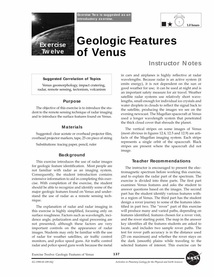
Purpose The objective of this exercise is to introduce the stu- dent to the remote sensing technique of radar imaging and to introduce the surface features found on Venus. Materials Suggested: clear acetate or overhead projector film, overhead projector markers, tape, 25 cm piece of string Substitutions: tracing paper, pencil, ruler Background This exercise introduces the use of radar images for geologic feature identification. Most people are not familiar with radar as an imaging system. Consequently, the student introduction contains extensive information to aid in completing this exer- cise. With completion of the exercise, the student should be able to recognize and identify some of the major geologic features found on Venus and under- stand the use of radar as a remote sensing tech- nique. The explanation of radar and radar imaging in this exercise is highly simplified, focusing only on surface roughness. Factors such as wavelength, inci- dence angle, polarization and signal processing are not presented, although these factors are very important controls on the appearance of radar images. Students may only be familiar with the use of radar for weather satellites, air traffic control monitors, and police speed guns. Air traffic control radar and police speed guns work because the metal in cars and airplanes is highly reflective at radar wavelengths. Because radar is an active system (it emits energy), it is not dependent on the sun or good weather for use; it can be used at night and is an important safety measure for air travel. Weather satellite radar systems use relatively short wave- lengths, small enough for individual ice crystals and water droplets in clouds to reflect the signal back to the satellite, producing the images we see on the evening newscast. The Magellan spacecraft at Venus used a longer wavelength system that penetrated the thick cloud cover that shrouds the planet. The vertical stripes on some images of Venus (most obvious in figures 12.4, 12.5 and 12.9) are arti- facts of the Magellan imaging system. Each stripe represents a single orbit of the spacecraft. Black stripes are present where the spacecraft did not image. Teacher Recommendations The instructor is encouraged to present the elec- tromagnetic spectrum before working this exercise, and to explain the radar part of the spectrum. The exercise is divided into three parts. The first part examines Venus features and asks the student to answer questions based on the images. The second part has the student identify various features with- in a region of Venus. The third part has the student design a rover journey to some of the features iden- tified in part two. The rover part of this exercise will produce many and varied paths, depending on features identified, features chosen for a rover visit, and the rover starting point. The map in the answer key identifies all the features students are asked to locate, and includes two sample rover paths. The test for rover path accuracy is in the distance used (25 cm maximum) and whether the rover stays on the dark (smooth) plains while traveling to the selected features of interest. This exercise can be Exercise Twelve: Geologic Features of Venus Exercise Twelve Geologic Features of Venus Instructor Notes Suggested Correlation of Topics Venus geomorphology, impact cratering, radar, remote sensing, tectonism, volcanism 1.0 hours Exercise Two is suggested as an introductory exercise. 137 EG-1998-03-109-HQ Activities in Planetary Geology for the Physical and Earth Sciences
Transcript of 1.0 hours Exercise Geologic Features of Venus -...
PurposeThe objective of this exercise is to introduce the stu-
dent to the remote sensing technique of radar imagingand to introduce the surface features found on Venus.
MaterialsSuggested: clear acetate or overhead projector film,
overhead projector markers, tape, 25 cm piece of string
Substitutions: tracing paper, pencil, ruler
BackgroundThis exercise introduces the use of radar images
for geologic feature identification. Most people arenot familiar with radar as an imaging system.Consequently, the student introduction containsextensive information to aid in completing this exer-cise. With completion of the exercise, the studentshould be able to recognize and identify some of themajor geologic features found on Venus and under-stand the use of radar as a remote sensing tech-nique.
The explanation of radar and radar imaging inthis exercise is highly simplified, focusing only onsurface roughness. Factors such as wavelength, inci-dence angle, polarization and signal processing arenot presented, although these factors are veryimportant controls on the appearance of radarimages. Students may only be familiar with the useof radar for weather satellites, air traffic controlmonitors, and police speed guns. Air traffic controlradar and police speed guns work because the metal
in cars and airplanes is highly reflective at radarwavelengths. Because radar is an active system (itemits energy), it is not dependent on the sun orgood weather for use; it can be used at night and isan important safety measure for air travel. Weathersatellite radar systems use relatively short wave-lengths, small enough for individual ice crystals andwater droplets in clouds to reflect the signal back tothe satellite, producing the images we see on theevening newscast. The Magellan spacecraft at Venusused a longer wavelength system that penetratedthe thick cloud cover that shrouds the planet.
The vertical stripes on some images of Venus(most obvious in figures 12.4, 12.5 and 12.9) are arti-facts of the Magellan imaging system. Each striperepresents a single orbit of the spacecraft. Blackstripes are present where the spacecraft did notimage.
Teacher RecommendationsThe instructor is encouraged to present the elec-
tromagnetic spectrum before working this exercise,and to explain the radar part of the spectrum. Theexercise is divided into three parts. The first partexamines Venus features and asks the student toanswer questions based on the images. The secondpart has the student identify various features with-in a region of Venus. The third part has the studentdesign a rover journey to some of the features iden-tified in part two. The ÒroverÓ part of this exercisewill produce many and varied paths, depending onfeatures identified, features chosen for a rover visit,and the rover starting point. The map in the answerkey identifies all the features students are asked tolocate, and includes two sample rover paths. Thetest for rover path accuracy is in the distance used(25 cm maximum) and whether the rover stays onthe dark (smooth) plains while traveling to theselected features of interest. This exercise can be
Exercise Twelve: Geologic Features of Venus
ExerciseTwelve
Geologic Featuresof Venus
Instructor Notes
Suggested Correlation of Topics
Venus geomorphology, impact cratering,radar, remote sensing, tectonism, volcanism
1.0 hours
Exercise Two is suggested as anintroductory exercise.
137
EG-1998-03-109-HQ Activities in Planetary Geology for the Physical and Earth Sciences
138
Activities in Planetary Geology for the Physical and Earth Sciences EG-1998-03-109-HQ
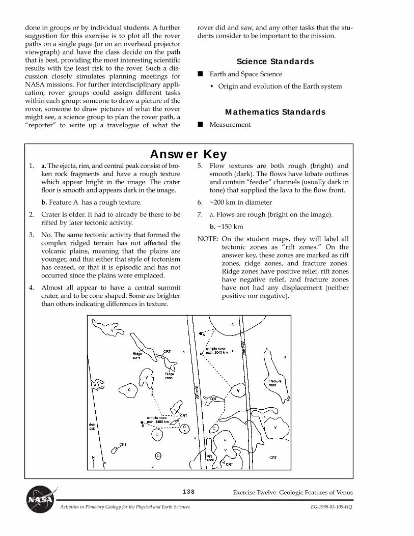
1. a. The ejecta, rim, and central peak consist of bro-ken rock fragments and have a rough texturewhich appear bright in the image. The craterfloor is smooth and appears dark in the image.
b. Feature A has a rough texture.
2. Crater is older. It had to already be there to berifted by later tectonic activity.
3. No. The same tectonic activity that formed thecomplex ridged terrain has not affected thevolcanic plains, meaning that the plains areyounger, and that either that style of tectonismhas ceased, or that it is episodic and has notoccurred since the plains were emplaced.
4. Almost all appear to have a central summitcrater, and to be cone shaped. Some are brighterthan others indicating differences in texture.
5. Flow textures are both rough (bright) andsmooth (dark). The flows have lobate outlinesand contain ÒfeederÓ channels (usually dark intone) that supplied the lava to the flow front.
6. ~200 km in diameter
7. a. Flows are rough (bright on the image).
b. ~150 km
NOTE: On the student maps, they will label alltectonic zones as Òrift zones.Ó On theanswer key, these zones are marked as riftzones, ridge zones, and fracture zones.Ridge zones have positive relief, rift zoneshave negative relief, and fracture zoneshave not had any displacement (neitherpositive nor negative).
Answer Key
Exercise Twelve: Geologic Features of Venus
done in groups or by individual students. A furthersuggestion for this exercise is to plot all the roverpaths on a single page (or on an overhead projectorviewgraph) and have the class decide on the paththat is best, providing the most interesting scientificresults with the least risk to the rover. Such a dis-cussion closely simulates planning meetings forNASA missions. For further interdisciplinary appli-cation, rover groups could assign different taskswithin each group: someone to draw a picture of therover, someone to draw pictures of what the rovermight see, a science group to plan the rover path, aÒreporterÓ to write up a travelogue of what the
rover did and saw, and any other tasks that the stu-dents consider to be important to the mission.
Science Standards■ Earth and Space Science
¥ Origin and evolution of the Earth system
Mathematics Standards■ Measurement
139
EG-1998-03-109-HQ Activities in Planetary Geology for the Physical and Earth Sciences
Exercise Twelve: Geologic Features of Venus
Name
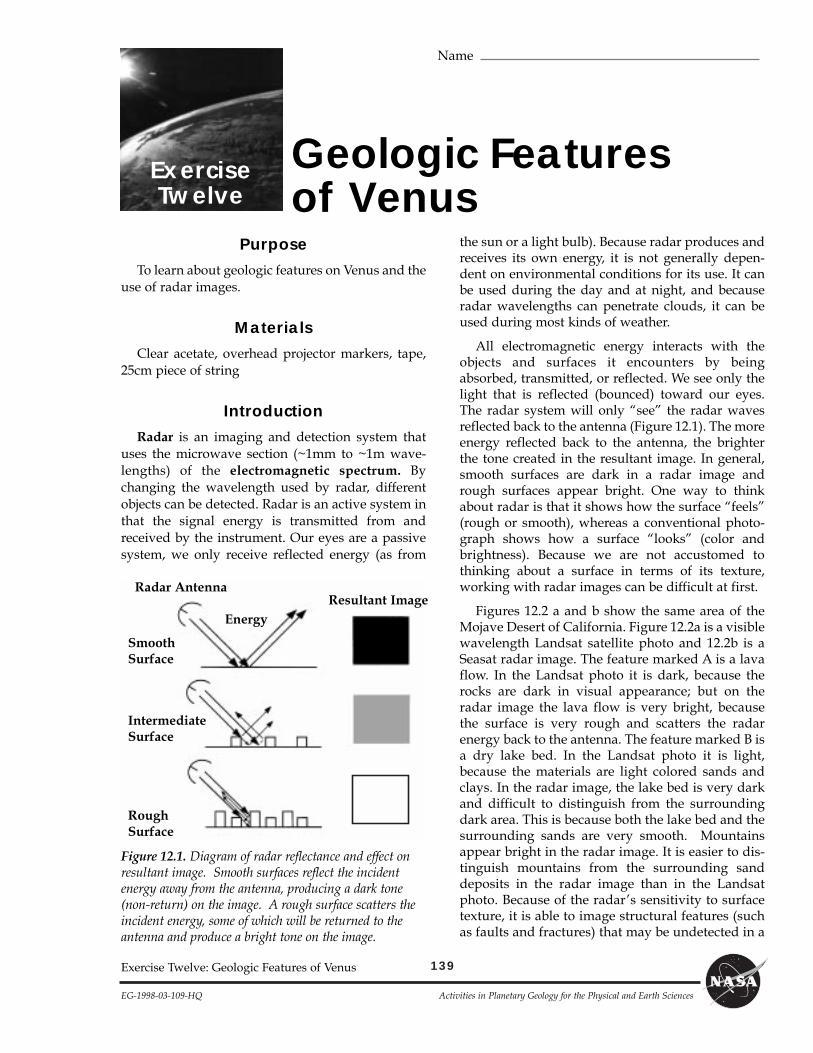
ExerciseTwelve
Geologic Featuresof Venus
PurposeTo learn about geologic features on Venus and the
use of radar images.
MaterialsClear acetate, overhead projector markers, tape,
25cm piece of string
IntroductionRadar is an imaging and detection system that
uses the microwave section (~1mm to ~1m wave-lengths) of the electromagnetic spectrum. Bychanging the wavelength used by radar, differentobjects can be detected. Radar is an active system inthat the signal energy is transmitted from andreceived by the instrument. Our eyes are a passivesystem, we only receive reflected energy (as from
the sun or a light bulb). Because radar produces andreceives its own energy, it is not generally depen-dent on environmental conditions for its use. It canbe used during the day and at night, and becauseradar wavelengths can penetrate clouds, it can beused during most kinds of weather.
All electromagnetic energy interacts with theobjects and surfaces it encounters by beingabsorbed, transmitted, or reflected. We see only thelight that is reflected (bounced) toward our eyes.The radar system will only ÒseeÓ the radar wavesreflected back to the antenna (Figure 12.1). The moreenergy reflected back to the antenna, the brighterthe tone created in the resultant image. In general,smooth surfaces are dark in a radar image andrough surfaces appear bright. One way to thinkabout radar is that it shows how the surface ÒfeelsÓ(rough or smooth), whereas a conventional photo-graph shows how a surface ÒlooksÓ (color andbrightness). Because we are not accustomed tothinking about a surface in terms of its texture,working with radar images can be difficult at first.
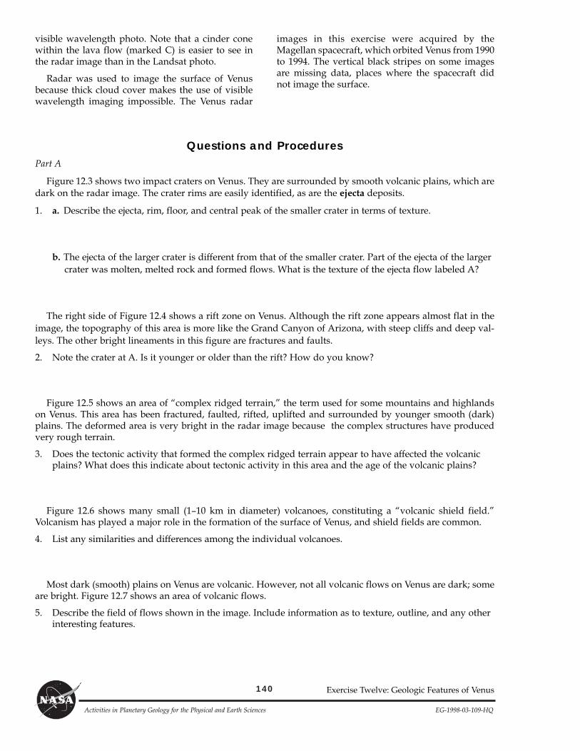
Figures 12.2 a and b show the same area of theMojave Desert of California. Figure 12.2a is a visiblewavelength Landsat satellite photo and 12.2b is aSeasat radar image. The feature marked A is a lavaflow. In the Landsat photo it is dark, because therocks are dark in visual appearance; but on theradar image the lava flow is very bright, becausethe surface is very rough and scatters the radarenergy back to the antenna. The feature marked B isa dry lake bed. In the Landsat photo it is light,because the materials are light colored sands andclays. In the radar image, the lake bed is very darkand difficult to distinguish from the surroundingdark area. This is because both the lake bed and thesurrounding sands are very smooth. Mountainsappear bright in the radar image. It is easier to dis-tinguish mountains from the surrounding sanddeposits in the radar image than in the Landsatphoto. Because of the radarÕs sensitivity to surfacetexture, it is able to image structural features (suchas faults and fractures) that may be undetected in a
Figure 12.1. Diagram of radar reflectance and effect onresultant image. Smooth surfaces reflect the incidentenergy away from the antenna, producing a dark tone(non-return) on the image. A rough surface scatters theincident energy, some of which will be returned to theantenna and produce a bright tone on the image.
Energy
Radar Antenna
SmoothSurface
IntermediateSurface
RoughSurface
Resultant Image
140
Activities in Planetary Geology for the Physical and Earth Sciences EG-1998-03-109-HQ
Exercise Twelve: Geologic Features of Venus
visible wavelength photo. Note that a cinder conewithin the lava flow (marked C) is easier to see inthe radar image than in the Landsat photo.
Radar was used to image the surface of Venusbecause thick cloud cover makes the use of visiblewavelength imaging impossible. The Venus radar
images in this exercise were acquired by theMagellan spacecraft, which orbited Venus from 1990to 1994. The vertical black stripes on some imagesare missing data, places where the spacecraft didnot image the surface.
Questions and ProceduresPart A
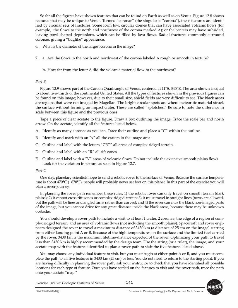
Figure 12.3 shows two impact craters on Venus. They are surrounded by smooth volcanic plains, which aredark on the radar image. The crater rims are easily identified, as are the ejecta deposits.
1. a. Describe the ejecta, rim, floor, and central peak of the smaller crater in terms of texture.
b. The ejecta of the larger crater is different from that of the smaller crater. Part of the ejecta of the largercrater was molten, melted rock and formed flows. What is the texture of the ejecta flow labeled A?
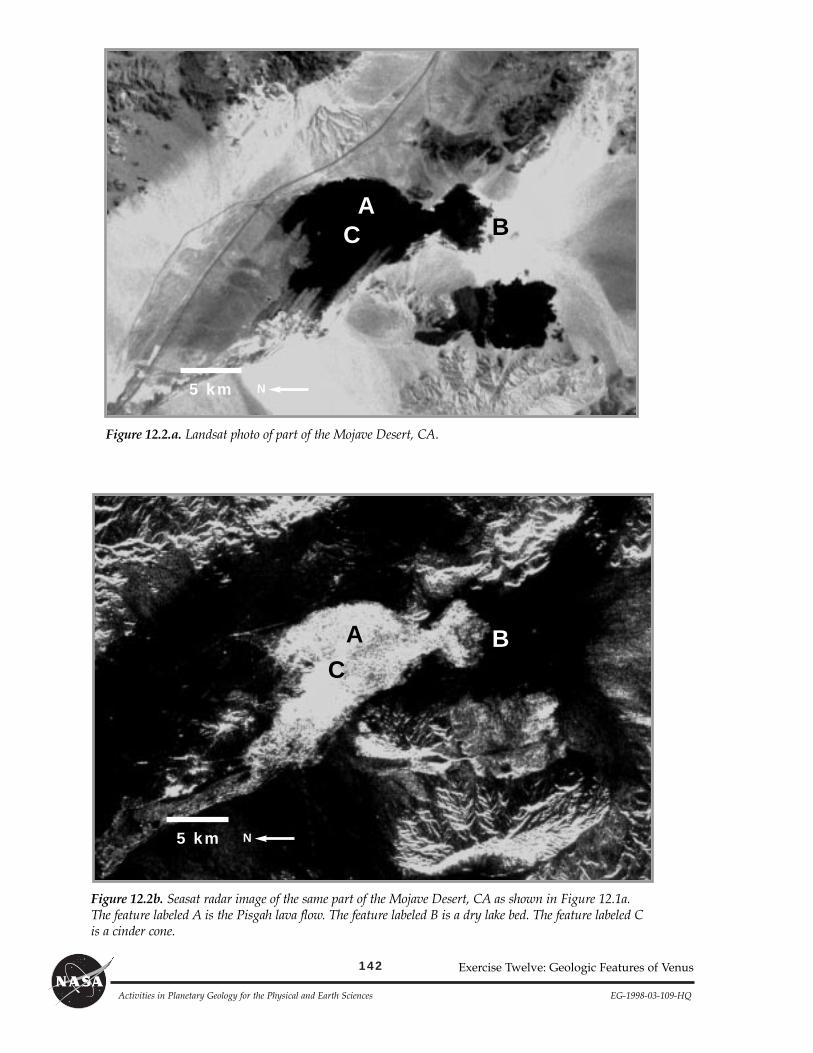
The right side of Figure 12.4 shows a rift zone on Venus. Although the rift zone appears almost flat in theimage, the topography of this area is more like the Grand Canyon of Arizona, with steep cliffs and deep val-leys. The other bright lineaments in this figure are fractures and faults.
2. Note the crater at A. Is it younger or older than the rift? How do you know?
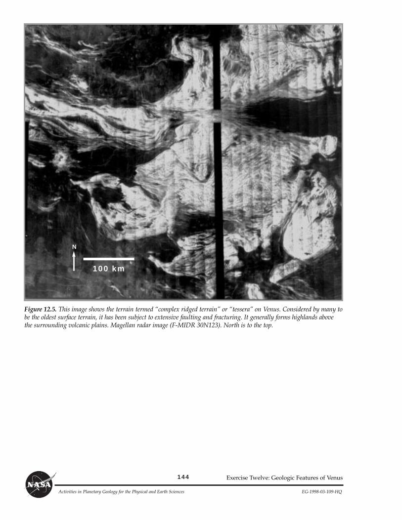
Figure 12.5 shows an area of Òcomplex ridged terrain,Ó the term used for some mountains and highlandson Venus. This area has been fractured, faulted, rifted, uplifted and surrounded by younger smooth (dark)plains. The deformed area is very bright in the radar image because the complex structures have producedvery rough terrain.
3. Does the tectonic activity that formed the complex ridged terrain appear to have affected the volcanicplains? What does this indicate about tectonic activity in this area and the age of the volcanic plains?
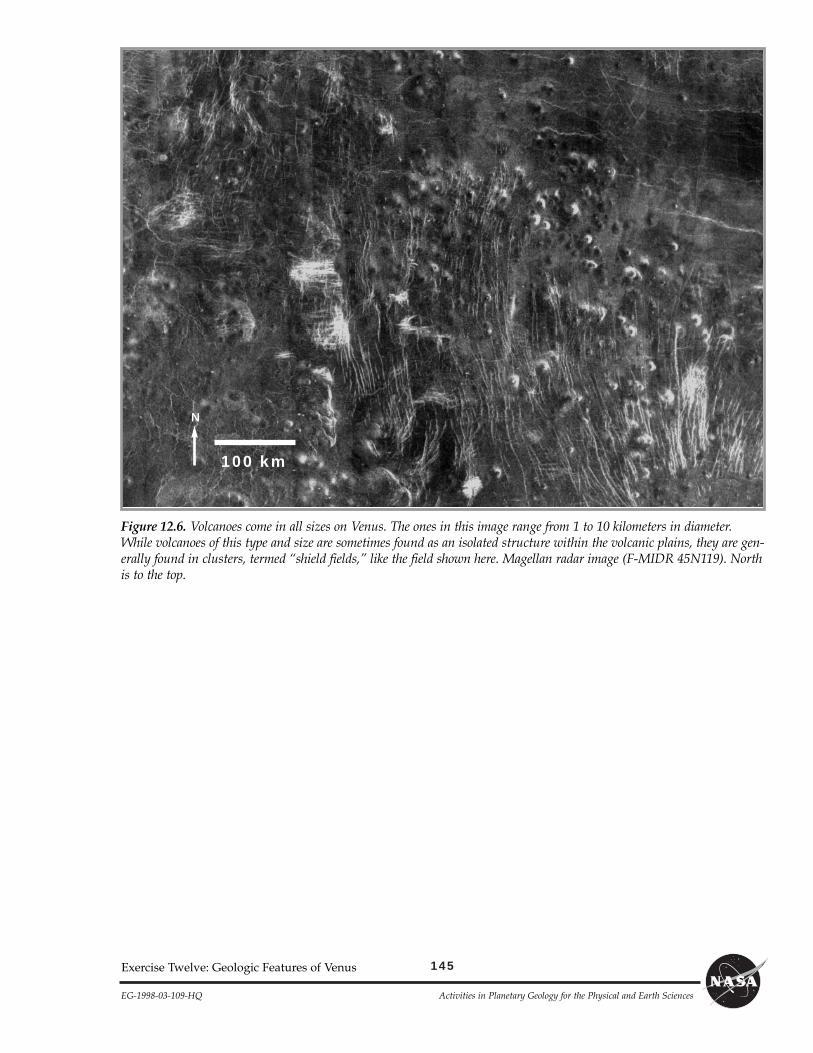
Figure 12.6 shows many small (1Ð10 km in diameter) volcanoes, constituting a Òvolcanic shield field.ÓVolcanism has played a major role in the formation of the surface of Venus, and shield fields are common.
4. List any similarities and differences among the individual volcanoes.
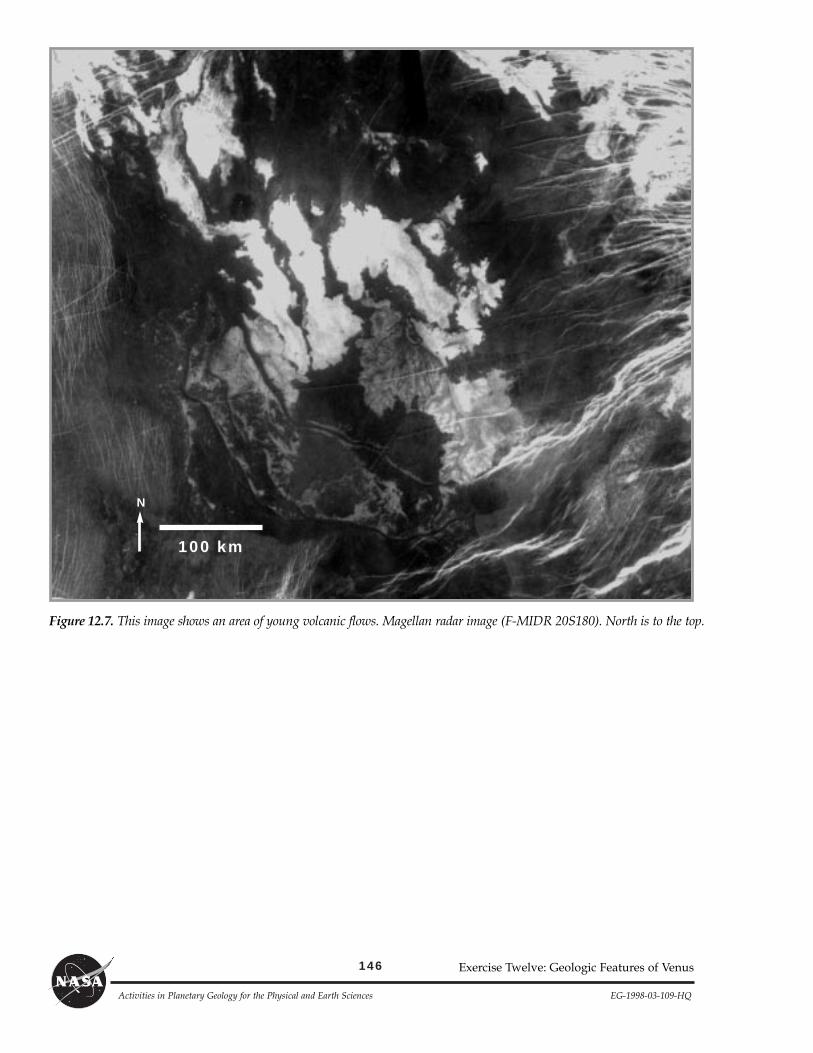
Most dark (smooth) plains on Venus are volcanic. However, not all volcanic flows on Venus are dark; someare bright. Figure 12.7 shows an area of volcanic flows.
5. Describe the field of flows shown in the image. Include information as to texture, outline, and any otherinteresting features.
141
EG-1998-03-109-HQ Activities in Planetary Geology for the Physical and Earth Sciences
Exercise Twelve: Geologic Features of Venus
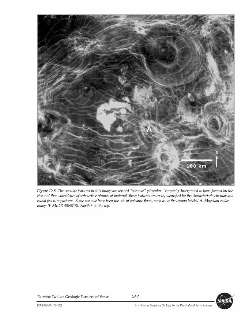
So far all the figures have shown features that can be found on Earth as well as on Venus. Figure 12.8 showsfeatures that may be unique to Venus. Termed ÒcoronaeÓ (the singular is ÒcoronaÓ), these features are identi-fied by circular sets of fractures. Some form low, circular domes that can have associated volcanic flows (forexample, the flows to the north and northwest of the corona marked A); or the centers may have subsided,leaving bowl-shaped depressions, which can be filled by lava flows. Radial fractures commonly surroundcoronae, giving a ÒbuglikeÓ appearance.
6. What is the diameter of the largest corona in the image?
7. a. Are the flows to the north and northwest of the corona labeled A rough or smooth in texture?
b. How far from the letter A did the volcanic material flow to the northwest?
Part B
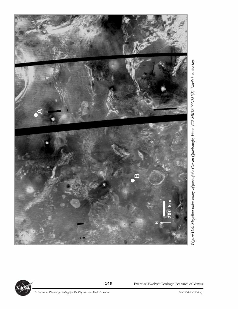
Figure 12.9 shows part of the Carson Quadrangle of Venus, centered at 11¡S, 345¡E. The area shown is equalto about two-thirds of the continental United States. All the types of features shown in the previous figures canbe found on this image; however, due to their small size, shield fields are very difficult to see. The black areasare regions that were not imaged by Magellan. The bright circular spots are where meteoritic material struckthe surface without forming an impact crater. These are called Òsplotches.Ó Be sure to note the difference inscale between this figure and the previous ones.
Tape a piece of clear acetate to the figure. Draw a box outlining the image. Trace the scale bar and northarrow. On the acetate, identify all the features listed below.
A. Identify as many coronae as you can. Trace their outline and place a ÒCÓ within the outline.
B. Identify and mark with an ÒxÓ all the craters in the image area.
C. Outline and label with the letters ÒCRTÓ all areas of complex ridged terrain.
D. Outline and label with an ÒRÓ all rift zones.
E. Outline and label with a ÒVÓ areas of volcanic flows. Do not include the extensive smooth plains flows.Look for the variation in texture as seen in Figure 12.7.
Part C
One day, planetary scientists hope to send a robotic rover to the surface of Venus. Because the surface tempera-ture is about 470¡C (~870¡F), people will probably never set foot on this planet. In this part of the exercise you willplan a rover journey.
In planning the rover path remember these rules: 1) the robotic rover can only travel on smooth terrain (darkplains); 2) it cannot cross rift zones or complex ridged terrain; 3) it must travel in straight lines (turns are allowed,but the path will be lines and angled turns rather than curves); and 4) the rover can cross the black non-imaged partsof the image, but you cannot drive for any great distance inside the black areas, because there may be unknownobstacles.
You should develop a rover path to include a visit to at least 1 crater, 2 coronae, the edge of a region of com-plex ridged terrain, and an area of volcanic flows (not including the smooth plains). Spacecraft and rover engi-neers designed the rover to travel a maximum distance of 3430 km (a distance of 25 cm on the image) startingfrom either landing point A or B. Because of the high temperatures on the surface and the limited fuel carriedby the rover, 3430 km is the maximum lifetime-distance expected of the rover. Optimizing your path to travelless than 3430 km is highly recommended by the design team. Use the string (or a ruler), the image, and youracetate map with the features identified to plan a rover path to visit the five features listed above.
You may choose any individual feature to visit, but you must begin at either point A or B, and you must com-plete the path to all five features in 3430 km (25 cm) or less. You do not need to return to the starting point. If youare having difficulty in planning the rover path, ask your instructor to check that you have identified all possiblelocations for each type of feature. Once you have settled on the features to visit and the rover path, trace the pathonto your acetate Òmap.Ó
142
Activities in Planetary Geology for the Physical and Earth Sciences EG-1998-03-109-HQ
Figure 12.2.a. Landsat photo of part of the Mojave Desert, CA.
Figure 12.2b. Seasat radar image of the same part of the Mojave Desert, CA as shown in Figure 12.1a.The feature labeled A is the Pisgah lava flow. The feature labeled B is a dry lake bed. The feature labeled Cis a cinder cone.
Exercise Twelve: Geologic Features of Venus
AC B
5 km N
AC
B
5 km N
143
EG-1998-03-109-HQ Activities in Planetary Geology for the Physical and Earth Sciences
Exercise Twelve: Geologic Features of Venus
Figure 12.3. Theprominent circularfeatures in thisimage are impactcraters. Magellanradar image (F-MIDR 30N287).North is to the top.
Figure 12.4. The right side ofthis image shows a majorzone of rifting. Note that thecrater labeled A has been cutby the rift, with part of thecrater visible on both sides ofthe rift. The thin linear fea-tures in the southern portionof this image are faults andfractures. Magellan radarimage (F-MIDR 30N281).North is to the top.
A
100 km
N
A
100 km
N
144
Activities in Planetary Geology for the Physical and Earth Sciences EG-1998-03-109-HQ
Exercise Twelve: Geologic Features of Venus
Figure 12.5. This image shows the terrain termed Òcomplex ridged terrainÓ or ÒtesseraÓ on Venus. Considered by many tobe the oldest surface terrain, it has been subject to extensive faulting and fracturing. It generally forms highlands abovethe surrounding volcanic plains. Magellan radar image (F-MIDR 30N123). North is to the top.
100 kmN
145
EG-1998-03-109-HQ Activities in Planetary Geology for the Physical and Earth Sciences
Exercise Twelve: Geologic Features of Venus
Figure 12.6. Volcanoes come in all sizes on Venus. The ones in this image range from 1 to 10 kilometers in diameter.While volcanoes of this type and size are sometimes found as an isolated structure within the volcanic plains, they are gen-erally found in clusters, termed Òshield fields,Ó like the field shown here. Magellan radar image (F-MIDR 45N119). Northis to the top.
100 km
N
146
Activities in Planetary Geology for the Physical and Earth Sciences EG-1998-03-109-HQ
Figure 12.7. This image shows an area of young volcanic flows. Magellan radar image (F-MIDR 20S180). North is to the top.
Exercise Twelve: Geologic Features of Venus
100 kmN
147
EG-1998-03-109-HQ Activities in Planetary Geology for the Physical and Earth Sciences
Exercise Twelve: Geologic Features of Venus
Figure 12.8. The circular features in this image are termed ÒcoronaeÓ (singular: ÒcoronaÓ). Interpreted to have formed by therise and then subsidence of subsurface plumes of material, these features are easily identified by the characteristic circular andradial fracture patterns. Some coronae have been the site of volcanic flows, such as at the corona labeled A. Magellan radarimage (F-MIDR 40N018). North is to the top.
100 kmN
A
148
Activities in Planetary Geology for the Physical and Earth Sciences EG-1998-03-109-HQ
Figu
re 1
2.9.
Mag
ella
n ra
dar
imag
e of
par
t of t
he C
arso
n Q
uadr
angl
e, V
enus
(C2-
MID
R 0
0N33
7;2)
. Nor
th is
to th
e to
p.
Exercise Twelve: Geologic Features of Venus
200
km
N
A
B