10. Hillslope Processes - University of...
16
10-1 10. Hillslope Processes Hillslopes essentially cover the whole landscape. Some are steep, others are gentle. Under the natural condition, water, sediments, and rocks move down slope. The present topography and soil thickness reflect a sensitive balance between weathering, erosion, and deposition. Human activities can upset the balance and cause; - loss of the fertile soil from cultivated lands - excessive erosion of lands and sediment load in streams - catastrophic disaster of landslides Planners need to understand geomorphic processes caused by the action of water on hillslope. Conditions of climate, vegetation, landuse, and topography under which various geomorphic processes dominate hillslope erosion (D&L, Fig. 15-1).
Transcript of 10. Hillslope Processes - University of...

10-1
10. Hillslope ProcessesHillslopes essentially cover the whole landscape. Some are steep, others are gentle. Under the natural condition, water, sediments, and rocks move down slope. The present topography and soil thickness reflect a sensitive balance between weathering, erosion, and deposition. Human activities can upset the balance and cause;- loss of the fertile soil from cultivated lands- excessive erosion of lands and sediment load in streams- catastrophic disaster of landslides
Planners need to understand geomorphic processes caused by the action of water on hillslope.
Conditions of climate, vegetation, landuse, and topography under which various geomorphic processes dominate hillslope erosion (D&L, Fig. 15-1).

10-2
Normal and accelerated erosionSoil profile develops over a long time. It reflects the balance of input (weathering of bed rock) and output (erosion). Normal rate of erosion keeps the soil profile stable under the current climate. Human activities can significantly accelerate erosion resulting in the soil loss.
The soil achieves a balance between the input and output of materials (D&L, Fig. 15-3).
Hillslope erosion by water
Erosion is driven by Horton overland flow, which primarily occurs on non-vegetated surface. Saturation overland flow does not contribute much because the soil surface is protected by a vegetative cover. Horton overland flow causes; rainsplash and sheetwash erosion, and gullying.

10-3
Rainsplash erosion
A moving object posses kinetic energy (e.g. a car on a highway). This energy is released when the object hits something (highway clash). Each rain drop has kinetic energy which is released to splash soil particles upon hitting the ground. On average, the travel distance of a particle landing on the down-slope side is greater than the opposite, resulting in net downward motion of the soil. Each drop splashes a little bit, but billions of drops can cause significant erosion.
rain drop
High-speed photograph of a raindrop impact on a soil surface (D&L, Fig. 15-4).
This process is particularly important on steep slopes devoid of vegetation. Thick vegetation protects soils from direct hits of rain drops. Soils are resistant to erosion when they have high organic content and reasonable amount of clay to develop aggregated structure. Tillage breaks down the structure and reduce the resistance to erosion and also the infiltration capacity.
10-4
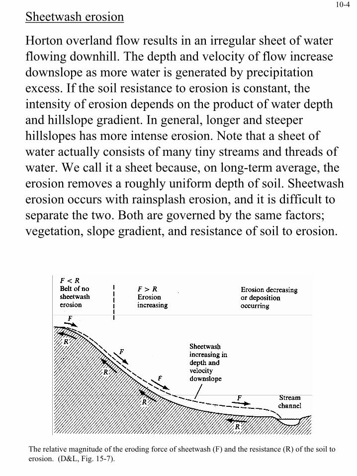
The relative magnitude of the eroding force of sheetwash (F) and the resistance (R) of the soil to erosion. (D&L, Fig. 15-7).
Sheetwash erosion
Horton overland flow results in an irregular sheet of water flowing downhill. The depth and velocity of flow increase downslope as more water is generated by precipitation excess. If the soil resistance to erosion is constant, the intensity of erosion depends on the product of water depth and hillslope gradient. In general, longer and steeper hillslopes has more intense erosion. Note that a sheet of water actually consists of many tiny streams and threads of water. We call it a sheet because, on long-term average, the erosion removes a roughly uniform depth of soil. Sheetwash erosion occurs with rainsplash erosion, and it is difficult to separate the two. Both are governed by the same factors; vegetation, slope gradient, and resistance of soil to erosion.
10-5
Rill and gully erosionIf the minute streams of water cut separate channels, the process is known as rill erosion. Water is concentrated in rills, and efficiency and intensity of erosion increases. When the depth of a rill exceeds about 0.3 m, it is called gully. Gully erosion produces incisions up to 101 m deep and 103
m long. Gullies occupy relatively small area. Contribution of gully erosion to overall erosion from a catchment is small (a few percent), but it has major localized effects.
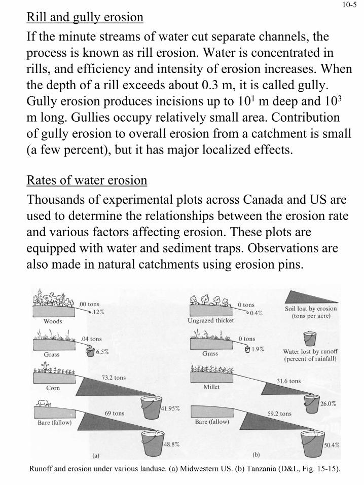
Rates of water erosionThousands of experimental plots across Canada and US are used to determine the relationships between the erosion rate and various factors affecting erosion. These plots are equipped with water and sediment traps. Observations are also made in natural catchments using erosion pins.
Runoff and erosion under various landuse. (a) Midwestern US. (b) Tanzania (D&L, Fig. 15-15).

10-6
Prediction of soil erosion
Planners frequently need to estimate the rate of soil erosion. The best method is to have some local field data, but that’s not always available. The Universal Soil-Loss Equation is commonly used to get a rough estimate. The use of the equation will be discussed in the lab session.
Significance of soil erosion
Soil erosion was recognized as a major threat to the continued productivity of the land in 1930’s. Wide-spread use of fertilizers in US and Canada seemed to solve this problem, but it created other problems such as lake eutrophication. Also, some countries cannot afford applying enormous amount of fertilizers. Overall, the soil erosion must be avoided to achieve sustainable development.
Population growth in tropical and subtropical countries generates pressure on food production and energy sources (i.e. firewood and charcoal), which accelerates deforestation. Once the soil is lost, the land cannot sustain plant growth and desertification results.
Soil erosion increases sediment load into streams, which endangers aquatic species and fills up reservoirs used for controlling floods and generating power.
Suggested reading: The permanent cover program - Is twice enough?(http://www.agr.ca/pfra/pub/pcpaper2.htm)

10-7
Control of soil erosion and sedimentaion
(1) Agricultural lands- Increase vegetative cover by adopting crop rotation that
includes plants that provide a good cover and improve soil structure (e.g. alfalfa).
- Avoid tilling as much as possible. Cultivate along topographic contour (contour cultivation) to increase surface detention capacity and promote infiltration.
- Plant grains and cover crop (alfalfa) alternately as strips along topographic contour (strip cropping).
- Cover the ground surface with hay, straw, or manure (mulching) to increase resistance and infiltration capacity.
- Divide the hillslope into small pieces of flat lands to reduce the length and slope gradient of each piece (terracing).
Relative erosion rates under different vegetal covers (D&L, Fig. 15-21).
10-8
(2) Rangelands- Control the number of stock to meet with carrying
capacity of the land.
(3) Forest- Log the trees so that forest duff layer is not destroyed.- Logging roads are the primary source of sediments. Try
to layout logging roads on the gentlest gradient possible, preferably along ridges. Restore the area once logging operation is complete.
(4) Mine sites- Restore the vegetation as much as possible, although this
may be difficult in areas affected by acid mine drainage.
(5) Urbanland- In construction sites, minimize the time the site is left
unprotected. Maintain as much original vegetation as possible. Cover the area with surface mulch.
- Planning is very important. Classify the lands according to soil depth, texture, and land gradient. Develop the areas based on the land classification.

10-9
Mass wasting
This mode of hillslope processes move enormous amount of mass, up to millions of m3, and often quite rapidly.- damage of houses and structures- economic damage (lost farms, power lines, filled up
reservoirs, etc.)- loss of human life
The hillslope failures are classified as follows.
Falls RockfallsSlides Planner failures (rock slides, debris slides)
Rotational failures (slumps)Flows Debris avalanches. Debris flows. Earthflows.
Mudflows. Solifluction (arctic region)Soil creep
The classification is by no means clear-cut and combination of several processes may occur.
Rockfalls occur on very steep slopes. Talus slopes and screes develop under such slopes. Cost of maintaining highways in rockfall-susceptible areas is expensive.

10-10
Types of hillslope failures (D&L, Fig. 15-29).

10-11
In slides the failure occurs along a surface or within a narrow zone of deformation. The failure surface may be planer along some well defined geological boundary, or may be arc-like. The size of relatively undeformed blocks range from 100 m3 to 109 m3. A planer slide is termed rock slide or debris slide depending on the material. Where the geologic materials are deep, uniform and cohesive, rotational slumps are common. A slump block does not usually move far but causes significant ground breakage.
Cross section of Castle Creek Slump, Oregon (D&L, Fig. 15-33).
In flows the movement of debris resembles that of a fluid; more or less continuous internal deformation of the material. High proportion of air, water, and fine-grained materials favor flow. As the moving mass breaks into smaller blocks, the term changes from debris slide to debris avalanche to debris flow.

10-12
A small debris slide near the head of a valley can flow down the valley and develop into a huge debris flow as it incorporate water in the valley and scour the materials along the valley.
Earthflows consist mainly of fine-grained materials. They usually occur when a slump or other failure mobilizes clays that have a very high water content. Once in motion, the mass begins to flow and it develops a surging and spreading toe of dense, viscous material, which can flow over gentle gradients.
Mudflows develop where mass failures in fine-grained material mix with streams. The mudflows travel down canyons and spread over gently sloping fans of debris at the mountain front.
Soil creep is the slow downhill movement of debris that results from disturbance of soil by freezing and thawing, wetting and drying, or slow plastic deformation under the soil’s own weight. It occurs on virtually all hillsides, and is responsible for most of the downslope transport of debris to streams channels in heavily vegetated areas.
Solifluction is the slow, viscous downslope flow of waterlogged soil underlain by an impervious layer, most commonly frozen ground. It is gaining considerable importance in development of arctic and subarctic regions.
10-13
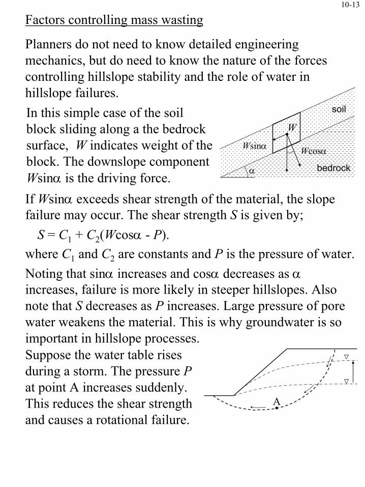
Factors controlling mass wasting
Planners do not need to know detailed engineering mechanics, but do need to know the nature of the forces controlling hillslope stability and the role of water in hillslope failures. In this simple case of the soil block sliding along a the bedrock surface, W indicates weight of the block. The downslope component Wsinα is the driving force. If Wsinα exceeds shear strength of the material, the slope failure may occur. The shear strength S is given by;
S = C1 + C2(Wcosα - P).where C1 and C2 are constants and P is the pressure of water.Noting that sinα increases and cosα decreases as αincreases, failure is more likely in steeper hillslopes. Also note that S decreases as P increases. Large pressure of pore water weakens the material. This is why groundwater is so important in hillslope processes.
A
Suppose the water table rises during a storm. The pressure Pat point A increases suddenly. This reduces the shear strength and causes a rotational failure.
bedrock
WWsinα Wcosα
soil
α

10-14
Geological factors
Earth quakes can cause short-period increases in the downslope force and trigger landslides. In tectonically active areas, slow tilting of the ground by mountain building forces tend to increase slope gradients. The nature keeps adjusting gradients by occasional slope failures.
Human factors
Undercutting during construction of highways and railroads increases the average slope gradients, and also increases the chance of slope failure.
Overloading the top of hillslopes by housing construction is common. This extra weight may increase the chance of slope failure.
Altering the hydrology may have dramatic effects on hillslope stability. For example, clear cutting trees promotes soil erosion and weaken the support of soils by tree roots. It also reduces evapotranspiration and raise the water table.

10-15
Recognition and avoidance of landslide hazards
Detailed analysis of hillslope stability requires the expertise of engineers. Planners need to decide;(1) whether a site is in a stable area(2) whether there is enough uncertainty to warrant a detailed
site investigation by an expert(3) whether the site is so obviously unstable that it should be
avoided.Techniques for evaluating landslide hazard involve recognizing at least one of the following.(1) Past hillslope failures
Direct evidence in airphoto, indirect evidence of altered vegetation, subtle topographic features, deposits formed by hillslope failures.
(2) Conditions that are conductive to hillslope failuresSteep slope gradients, mechanically weak geological material, poor permeability, high water table, seepage in the vicinity of steep slope.
(3) De-stabilizing effects of planned developmentUndercutting, overloading, changing hydrologic conditions.

10-16
Reading assignment
Sediment yield and seasonal soil erodibility for semiarid cropland in western Canada
B.G. McConkey et al., 1997. Canadian Journal of Soil Science, 77: 33-40
(1) What is the summer fallow practice and what is its merit?
(2) What is the demerit of summer fallow practice?
(3) The farming community perceives that summer storms cause most severe soil erosion. Is this really true?
(4) What is the short coming of the original USLE in the prairie environment? Why did the authors chose MUSLE in this study?
(5) Is soil erodibility factor (K) constant or seasonally variable?