1. Project Description - Glassboro-Camden Line
56
Glassboro-Camden Line EIS November 2020 Page 1 1. Project Description 1.1. SUMMARY The proposed Glassboro-Camden Line (“proposed GCL” or “proposed project”) would introduce new passenger rail service between the City of Camden in Camden County and the Borough of Glassboro in Gloucester County, expanding public transportation throughout an approximately 18-mile corridor in Southern New Jersey and providing a viable alternative to existing automobile dependency. The proposed GCL would expand on existing passenger rail service in New Jersey and would rely on light rail vehicles similar to vehicles operating on the New Jersey Transit (NJ TRANSIT) River LINE. The proposed GCL is at present sponsored by the Delaware River Port Authority (DRPA). As the project advances to preliminary engineering through construction and operation, the project sponsor could be subject to change. The GCL Project Team comprises DRPA, NJ TRANSIT, and STV Incorporated, the outside consultant responsible for project planning, conceptual design and environmental review. The proposed GCL would restore passenger rail service in a corridor that historically provided adjacent and surrounding communities with passenger rail service; although the passenger rail service is no longer in operation today, much of the corridor is characterized by rail infrastructure and activity, as it is currently occupied by Conrail freight operations. By being located primarily within an existing railroad right-of-way (ROW), the proposed GCL would minimize property acquisition and take advantage of an underutilized transportation corridor. Given that much of the GCL corridor is currently owned and operated by Conrail, several improvements and modifications to the GCL corridor related to Conrail operations have been incorporated into the conceptual design of the GCL to allow for shared use of the corridor between the existing and planned Conrail freight operations and the proposed GCL passenger service operations. The proposed GCL would traverse eleven communities including the City of Camden, Gloucester City, Brooklawn Borough, Westville Borough, the City of Woodbury, Woodbury Heights Borough, Wenonah Borough, Deptford Township, Mantua Township, Pitman Borough, and the Borough of Glassboro. The proposed GCL would provide 14 new transit stations, including five “walk-up” stations, four “moderate park-and-ride” stations, and five “park-and-ride” stations. In general, this new transit service would operate at-grade, but some portions would be grade-separated by viaducts carrying the rail infrastructure over existing roads and waterways. Four quadrant gated crossings would be used at at-grade roadway crossings along the GCL corridor. 1.2. PROJECT PURPOSE AND NEED Travel in the region is dominated by the automobile, with major roadways experiencing congestion during peak hours. The region has become almost entirely dependent on personal automobiles as transportation since passenger rail service in the GCL corridor ceased in the late 1960s, and regional roadway congestion has increased as residential development along the corridor has continued to grow.
Transcript of 1. Project Description - Glassboro-Camden Line
Glassboro-Camden Line EIS
November 2020 Page 1
1. Project Description
1.1. SUMMARY
The proposed Glassboro-Camden Line (“proposed GCL” or “proposed project”) would introduce new passenger rail service between the City of Camden in Camden County and the Borough of Glassboro in Gloucester County, expanding public transportation throughout an approximately 18-mile corridor in Southern New Jersey and providing a viable alternative to existing automobile dependency. The proposed GCL would expand on existing passenger rail service in New Jersey and would rely on light rail vehicles similar to vehicles operating on the New Jersey Transit (NJ TRANSIT) River LINE. The proposed GCL is at present sponsored by the Delaware River Port Authority (DRPA). As the project advances to preliminary engineering through construction and operation, the project sponsor could be subject to change. The GCL Project Team comprises DRPA, NJ TRANSIT, and STV Incorporated, the outside consultant responsible for project planning, conceptual design and environmental review.
The proposed GCL would restore passenger rail service in a corridor that historically provided adjacent and surrounding communities with passenger rail service; although the passenger rail service is no longer in operation today, much of the corridor is characterized by rail infrastructure and activity, as it is currently occupied by Conrail freight operations. By being located primarily within an existing railroad right-of-way (ROW), the proposed GCL would minimize property acquisition and take advantage of an underutilized transportation corridor. Given that much of the GCL corridor is currently owned and operated by Conrail, several improvements and modifications to the GCL corridor related to Conrail operations have been incorporated into the conceptual design of the GCL to allow for shared use of the corridor between the existing and planned Conrail freight operations and the proposed GCL passenger service operations.
The proposed GCL would traverse eleven communities including the City of Camden, Gloucester City, Brooklawn Borough, Westville Borough, the City of Woodbury, Woodbury Heights Borough, Wenonah Borough, Deptford Township, Mantua Township, Pitman Borough, and the Borough of Glassboro. The proposed GCL would provide 14 new transit stations, including five “walk-up” stations, four “moderate park-and-ride” stations, and five “park-and-ride” stations. In general, this new transit service would operate at-grade, but some portions would be grade-separated by viaducts carrying the rail infrastructure over existing roads and waterways. Four quadrant gated crossings would be used at at-grade roadway crossings along the GCL corridor.
1.2. PROJECT PURPOSE AND NEED
Travel in the region is dominated by the automobile, with major roadways experiencing congestion during peak hours. The region has become almost entirely dependent on personal automobiles as transportation since passenger rail service in the GCL corridor ceased in the late 1960s, and regional roadway congestion has increased as residential development along the corridor has continued to grow.
Glassboro-Camden Line EIS
November 2020 Page 2
Greater travel demands associated with anticipated future growth in population and employment are predicted for Camden and Gloucester counties. This growth, coupled with the lack of transit options, is projected to result in an increased intensity of traffic congestion, compromised mobility, and an increase in transportation-related air pollutants in the study area, which includes Gloucester and Camden counties.1 Transit access in the study area is limited, with difficult connections between major residential and employment areas. The quality of transit service is also limited, with service between many older and developing communities dependent on bus routes that offer low frequency service. The region needs viable alternatives to single-occupancy trips to offset this congestion. Transit options that are competitive in cost, time, and comfort with automobile travel are needed to divert trips from automobile to transit, so as to alleviate congestion, reduce transportation related air pollution, and expand travel options throughout the study area.
The purpose of the proposed GCL is to improve public transportation in Southern New Jersey and provide a reliable and viable alternative to existing automobile dependency. The project is expected to contribute to a collective of public transportation improvements in the State, including the River LINE2 (which opened in 2004 and operates between Trenton and the City of Camden) and service improvements to the Atlantic City Rail Line (ACRL) (operating between Philadelphia and Atlantic City), aimed to support State efforts to lessen the pace of automobile-dependent “sprawl” development and help reduce traffic congestion on the region’s already-burdened roadways. The proposed GCL is also expected to increase mobility between and within local communities and established activity and employment centers and improve connectivity regionally by providing connections (in the City of Camden) to Philadelphia, Trenton, and other points in the region via the PATCO Speedline, the NJ TRANSIT River LINE, and NJ TRANSIT bus routes.
Further, as mentioned above, locating the proposed GCL primarily within an existing Conrail ROW would minimize property acquisition and take advantage of an underutilized transportation corridor. Its location amid established communities is expected to support in-fill growth, redevelopment, and economic development consistent with “Smart Growth” programs and policies at local, State, and regional levels. By providing a reliable transit service competitive with automobile travel, linking activity centers, employment destinations, and established residential areas, the GCL would likely encourage a modal shift from automobile to transit and contribute to reductions in congestion, travel times, vehicle miles of travel, air pollutants, and greenhouse gases.
1.3. GCL BACKGROUND
1.3.1. Alternatives Considered
Following the completion of a feasibility study in 2005, DRPA/PATCO commissioned an Alternatives Analysis (AA) which was completed in 2009 – the Southern New Jersey to Philadelphia Mass Transit
1 Future projections on traffic congestion, mobility, and air pollution come from the Delaware Valley Regional Planning Commission (DVRPC) https://www.dvrpc.org/
2 The River LINE is a 34-mile, diesel light rail line in Southern New Jersey connecting the cities of Camden and Trenton.
Glassboro-Camden Line EIS
November 2020 Page 3
Expansion Alternative Analysis Study. The purpose of the AA was to recommend a specific transportation investment and corridor to serve the AA study area. A rigorous comparative evaluation of alternatives was conducted in order to determine the alternative that best served the AA study area. This analysis and decision-making process was advanced through an open public participation environment that featured extensive public and stakeholder outreach and agency coordination.
The AA examined five alternatives: four heavy-rail (PATCO-like) alternatives and one light rail (River LINE-like) alternative. Upon completion of the comprehensive alternatives identification, analysis, and evaluation process, one alternative (Alternative 4) was selected to be advanced to environmental review. This alternative comprises diesel light rail located mainly within the Conrail freight rail ROW from Camden to Glassboro. This selection was based on many criteria, including capital cost, operating cost, new transit riders, physical impacts to the ROW, and public and stakeholder support.
1.3.2. Alternative Refinement
Subsequent to the AA, the alternative developed in the AA phase was presented to Conrail who currently owns and operates on much of the GCL corridor. Through negotiations with Conrail, several improvements and modifications to the alternative proposed in the AA phase related to Conrail operations were incorporated in the development of the proposed GCL. These improvements aimed to accommodate Conrail’s requirement for 25-foot track centers between light rail and freight tracks, and to preserve space for a future Conrail second track located outside of the 25-foot track centers. This alternative is presented herein as the “proposed project” or “proposed GCL”. A description of the Conrail improvements is found in Section 1.5.1, “Conrail Improvements” in this Project Description.
1.4. GCL PROJECT DESCRIPTION
The purpose of this Project Description is to describe the environment in which the proposed GCL would be located, the physical components of the proposed GCL and their relationship to that environment, as well as the proposed construction and operation of the project. The description of the existing environment in which the proposed GCL is located includes a discussion of the regional context, followed by an explanation of the GCL corridor itself. Because of the unique nature of this corridor, insofar as it is primarily within an existing and active rail corridor, this subsection explains the property on which the GCL corridor is proposed.
Physical components of the proposed GCL include the alignment, stations, and component infrastructure. The alignment is further broken down into horizontal alignment and vertical alignment. Horizontal alignment refers to the horizontal configuration of tracks proposed along the GCL corridor. Vertical alignment refers to the vertical position of the proposed track relative to the grade of the existing corridor and describes the structure/fill on which the track would be laid. The description of the stations describes the type of station (in terms of how it would be accessed), station elevation, the type of station platform(s) (i.e. whether the platform is between two GCL tracks, or on either side of the GCL track), and any parking facilities proposed at stations. Lastly, component infrastructure discusses all the associated infrastructure that would be constructed or modified as a part of the proposed GCL. This includes: bridges, culverts, and elevated viaduct structures; ditches; retaining walls; a gas line relocation; one light-duty Vehicle
Glassboro-Camden Line EIS
November 2020 Page 4
Maintenance Facility (VMF); and one heavy-duty VMF. Taken together, these pieces comprise the physical elements of the proposed GCL.
The next subsection discusses the relationship of these physical project elements to the existing environment in which they are proposed. Most of the proposed GCL would be located on existing and active Conrail ROW. As such, this section describes the interaction of the proposed GCL elements with this existing rail infrastructure, as well as highlights those few elements of the proposed GCL that would be constructed outside of this existing rail ROW and would therefore represent a change to existing conditions.
A discussion of the proposed GCL operations and construction activities explain the non-physical parts of the proposed project.
1.4.1. Study Area
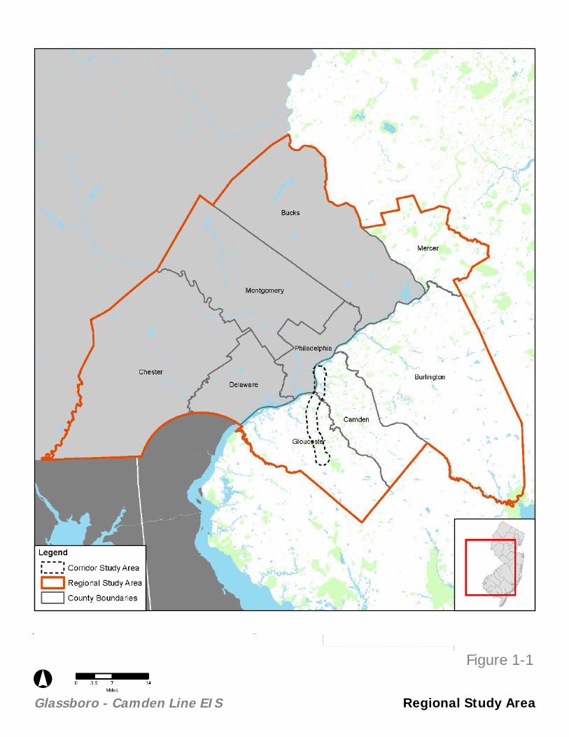
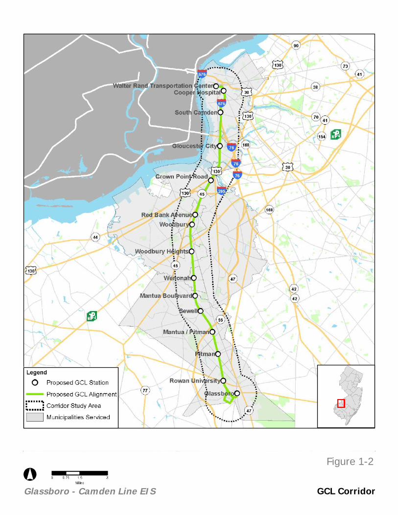
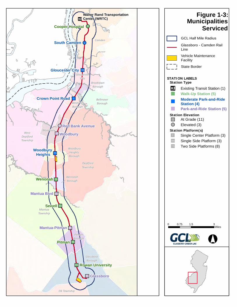
The regional study area of the proposed GCL consists of the entire Delaware Valley Regional Planning Commission (DVRPC) region, comprised of four counties in New Jersey and five counties in Pennsylvania (see Figure 1-1, “Regional Study Area”). Analysis specific study areas vary and are presented in their respective attachments to this EO215 document. The proposed GCL would provide service to the City of Camden, Gloucester City, Westville Borough, the City of Woodbury, Woodbury Heights Borough, Wenonah Borough, Mantua Township, Pitman Borough, and the Borough of Glassboro (see Figure 1-2, “GCL Corridor,” and Figure 1-3, “Municipalities Serviced”).
1.4.1.1. Corridor Ownership
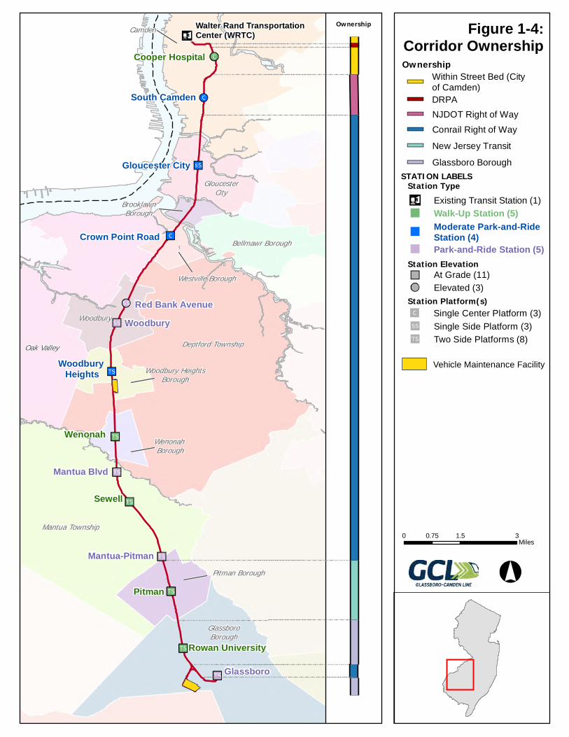
Along the GCL corridor, there are six property owners: The City of Camden, DRPA, New Jersey Department of Transportation (NJDOT), Conrail, NJ TRANSIT, and the Borough of Glassboro. Between the Walter Rand Transportation Center (WRTC), at the northern end of the corridor, and Kaighn Avenue to the south, the GCL corridor comprises the street bed owned by the City of Camden. Between Kaighn Avenue and the Conrail Beesley Point Secondary branch, the GCL corridor follows alongside I-676 and is owned by NJDOT. Between the Conrail Beesley Point Secondary branch and the Mantua-Pitman Station, as well as between University Road and Wilmer Street, the proposed GCL alignment would comprise a portion of the existing Conrail owned rail corridor. Between Mantua-Pitman Station and Cedar Avenue, the GCL corridor comprises land owned by NJ TRANSIT. Between Cedar Avenue and University Road, as well as between Wilmer Street and Glassboro Station, the GCL corridor is owned by the Borough of Glassboro (see Figure 1-4, “Corridor Ownership”).
DS, USDA,
Project Elements Beyond EstablishedRail Corridor - GCL Alignment
°Glassboro - Camden Line EIS Regional Study Area
Figure 1-1
F i
Project Elements Beyond EstablishedRail Corridor - GCL Alignment
°Glassboro - Camden Line EIS GCL Corridor
Figure 1-2
Ä!C
!!C
""SS
""C
!!SS
""SS
""ST
n"TS
n"TS
n"TS
n"TS
n"TS
n"TS
n"TS
n¤Walter Rand Transportation Center (WRTC)
Cooper Hospital
South Camden
Gloucester City
Crown Point Road
Red Bank AvenueWoodbury
Woodbury Heights
Wenonah
Mantua Blvd
Sewell
Mantua-Pitman
Pitman
Rowan University
Glassboro
Elk Township
GlassboroBorough
PitmanBorough
MantuaTownship
WenonahBorough
WoodburyHeightsBorough
Woodbury
DeptfordTownship
BellmawrBorough
WestDeptfordTownship
BrooklawnBorough
WestvilleBorough
GloucesterCity
Camden
MunicipalitiesServiced
0 1.5 30.75Miles
°
GCL Half Mile Radius
Glassboro - Camden Rail
Line
Vehicle Maintenance
Facility
State Border
Station ElevationAt Grade (11)""Elevated (3)!!
Station Platform(s)Single Center Platform (3)""C
Two Side Platforms (8)""ST
Single Side Platform (3)""SS
STATION LABELSStation Typen¤ Existing Transit Station (1)
Walk-Up Station (5)""
Park-and-Ride Station (5)""
Moderate Park-and-RideStation (4)""
Figure 1-3:
Oak Valley
Pitman
Sewell
Wenonah
Woodbury
Glassboro
Mantua Blvd
South Camden
Mantua-Pitman
Red Bank Avenue
Gloucester City
Cooper Hospital
Rowan University
Woodbury Heights
Crown Point Road
Walter Rand Transportation Center (WRTC)Camden
Deptford Township
Mantua Township
GlassboroBorough
Woodbury
GloucesterCity
Bellmawr Borough
Pitman Borough
Westville Borough
Wenonah Borough
Woodbury HeightsBorough
BrooklawnBorough
Figure 1-4:Corridor Ownership
Ownership
0 1.5 30.75Miles
Station ElevationAt Grade (11)
Elevated (3)
Station Platform(s)Single Center Platform (3)
Two Side Platforms (8)
Single Side Platform (3)
STATION LABELSStation Type
Existing Transit Station (1)
Walk-Up Station (5)
Park-and-Ride Station (5)
Moderate Park-and-RideStation (4)
Vehicle Maintenance Facility
Ownership
Conrail Right of Way
NJDOT Right of Way
New Jersey Transit
Glassboro Borough
Within Street Bed (City of Camden)
DRPA
Glassboro-Camden Line EIS
November 2020 Page 9
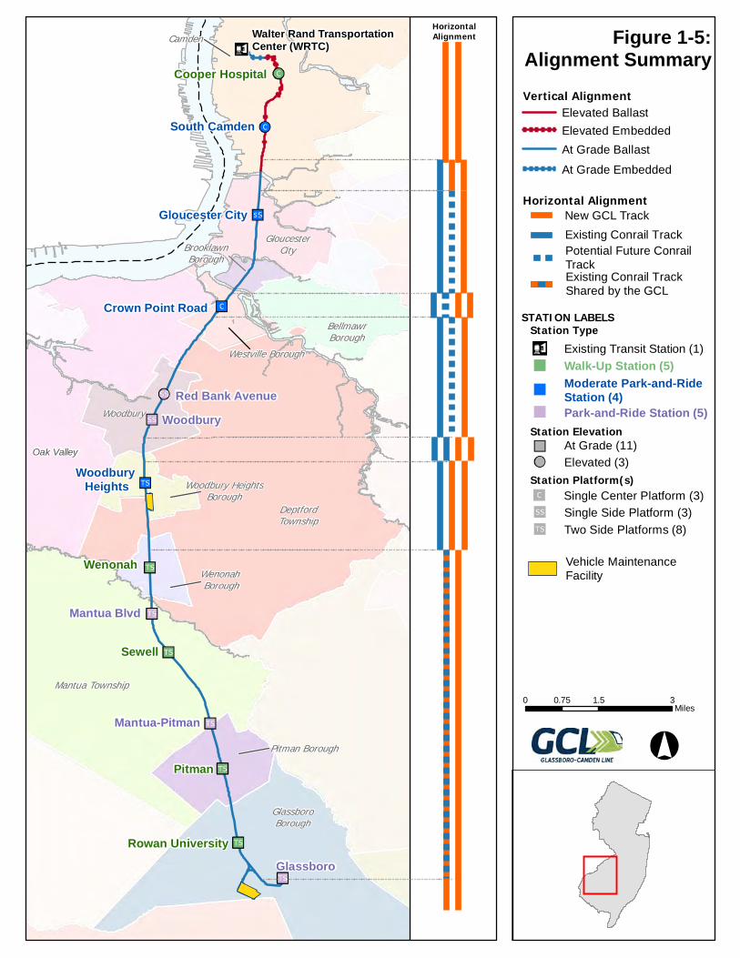
1.4.2. Alignment
The proposed GCL would traverse eleven communities between the City of Camden (Camden County) and the Borough of Glassboro (Gloucester County). These communities are the City of Camden (Camden), Gloucester City, Brooklawn Borough, Westville Borough, the City of Woodbury, Woodbury Heights Borough, Wenonah Borough, Deptford Township, Mantua Township, Pitman Borough, and the Borough of Glassboro (see Figure 1-3, “Municipalities Serviced”).
1.4.2.1. Horizontal Alignment
Horizontal alignment refers to the horizontal configuration of GCL track, as well as its relationship to existing Conrail track. As shown on Figure 1-5, “Alignment Summary,” there are six different horizontal alignment configurations proposed along the GCL corridor:
• There are two sections of the GCL corridor which would have two dedicated GCL tracks. This horizontal alignment is proposed between WRTC and Holtec Boulevard in the City of Camden, and between Zane Street and Glassboro Station in the Borough of Glassboro.
• There are three sections of the GCL corridor proposed to have two dedicated GCL tracks and one dedicated Conrail track. Portions of the GCL corridor with this horizontal alignment are proposed between Holtec Boulevard in the City of Camden and the Walt Whitman Bridge/I-76 in Gloucester City, between Redwood Avenue in Woodbury Heights Borough and Maple Street in Wenonah Borough, and between Wilmer Street and Zane Street in the Borough of Glassboro.
• There are two sections of the GCL corridor that would have one dedicated GCL track and one dedicated Conrail track with space reserved for a potential future second dedicated Conrail track. This horizontal alignment is proposed between Walt Whitman Bridge/I-76 in Gloucester City and River Road in Westville Borough.
• There is one section of the GCL corridor that would have two dedicated GCL tracks and one dedicated Conrail track with space reserved for a potential future second dedicated Conrail track between River Road and Park Avenue in Westville Borough.
• There is one section of the GCL corridor that would have two dedicated GCL tracks and two dedicated Conrail tracks between East Barber Avenue in the City of Woodbury and West Maple Street in Woodbury Heights Borough.
• There is one section of the GCL corridor that would have one dedicated GCL track and one shared GCL-Conrail track which runs between West Maple Street in Woodbury Heights Borough and Wilmer Street in the Borough of Glassboro (see Figure 1-5, “Alignment Summary”).
Oak Valley
Pitman
Sewell
Wenonah
Woodbury
Glassboro
Mantua Blvd
South Camden
Mantua-Pitman
Red Bank Avenue
Gloucester City
Cooper Hospital
Rowan University
Woodbury Heights
Crown Point Road
Walter Rand Transportation Center (WRTC)Camden
DeptfordTownship
Mantua Township
GlassboroBorough
Woodbury
GloucesterCity
BellmawrBorough
Pitman Borough
Westville Borough
Wenonah Borough
Woodbury HeightsBorough
BrooklawnBorough
Figure 1-5:Alignment Summary
HorizontalAlignment
0 1.5 30.75Miles
Elevated Ballast
Elevated Embedded
At Grade Ballast
At Grade Embedded
Vertical Alignment
Horizontal Alignment
Potential Future Conrail TrackExisting Conrail Track Shared by the GCL
New GCL Track
Existing Conrail Track
Station ElevationAt Grade (11)
Elevated (3)
Station Platform(s)Single Center Platform (3)
Two Side Platforms (8)
Single Side Platform (3)
STATION LABELSStation Type
Existing Transit Station (1)
Walk-Up Station (5)
Park-and-Ride Station (5)
Moderate Park-and-RideStation (4)
Vehicle MaintenanceFacility
Glassboro-Camden Line EIS
November 2020 Page 11
1.4.2.2. Vertical Alignment
The GCL is divided into four categories regarding vertical alignment: Elevated Ballast, Elevated Embedded, At-Grade Ballast, and At-Grade Embedded (see Figure 1-5, “Alignment Summary”). Ballast refers to the bed of material, generally crushed stone and fill dirt, on which rail tracks are laid. Elevated ballast is when this ballast and fill dirt material is piled in order to elevate the tracks high enough to pass over a roadway. At-grade ballast is simply when this ballast and fill dirt material is used at or near ground level to create a flat and level surface for track to be laid. Embedded track is track that is laid within an existing structure. At-grade embedded track in the case of the GCL refers to track laid directly within paved surface such as existing roadways. Elevated embedded track refers to track laid directly on an elevated structure.
The GCL would have five sections of elevated ballast track, four sections of elevated embedded track, one section of at-grade embedded track, and three sections of at-grade ballast track. Elevated ballast is proposed between Haddon Avenue and the existing NJ TRANSIT River LINE, Pine Street and 9th Street, Kaighn Avenue and Conrail Track (TP-010), Conrail track (TP-010) to Chelton Avenue, and Conrail Beasly Point Secondary track to Newton Creek. Elevated embedded track is proposed between Haddon Avenue and Pine Street, 9th Street and Kaighn Avenue, as well as at the Conrail track crossing (TP-010) and Conrail Beesley Point Secondary track crossing. At-grade ballast is proposed for the majority of the GCL corridor, from Newton Creek to Glassboro Station, as well as at the Woodbury and Glassboro VMFs. At-grade embedded track is proposed from the WRTC to approximately Haddon Avenue running along the existing street bed.
1.4.3. Stations
Fourteen proposed new stations are proposed: two stations in the City of Camden (Cooper Hospital Station and South Camden Station); one station in Gloucester City (Gloucester City Station); one station in Westville Borough (Crown Point Road Station); two stations in the City of Woodbury (Red Bank Avenue Station and Woodbury Station); one station in Woodbury Heights Borough (Woodbury Heights Station); one station in Wenonah Borough (Wenonah Station); three stations in Mantua Township (Mantua Boulevard Station, Sewell Station, and Mantua-Pitman Station); one station in Pitman Borough (Pitman Station); and two stations in the Borough of Glassboro (Rowan University Station and Glassboro Station). All stations would include facilities for bicyclists and pedestrians, including bike racks, sidewalks, and crosswalks. The proposed project would also include connections to the regional bus system.
1.4.3.1. Station Types
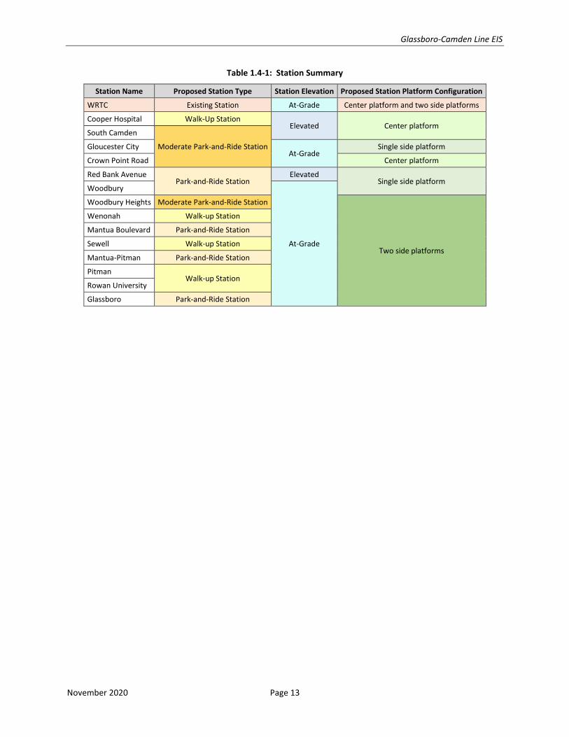
There are three station types proposed as a part of the proposed GCL: walk-up stations, moderate park-and-ride stations, and park-and-ride stations. Additionally, the proposed GCL would make use of one existing station, the WRTC. Walk-up stations do not include any parking lots or structures, and only include loading zones or limited temporary “kiss-and-ride” parking. Moderate park-and-ride stations are those which propose small parking lots of under 325 parking spots. Park-and-ride stations include larger parking lots and/or parking structures. There are five walk-up stations: Cooper Hospital, Wenonah, Sewell, Pitman, and Rowan University. There are four moderate park-and-ride stations: South Camden, Gloucester City, Crown Point Road, and Woodbury Heights. There are five park-and-ride stations: Red Bank Avenue, Woodbury, Mantua Boulevard, Mantua-Pitman, and Glassboro. (See Figure 1-5, “Alignment Summary,” and Table 1.4-1, “Station Summary”).
Glassboro-Camden Line EIS
November 2020 Page 12
1.4.3.2. Station Elevation
Stations along the proposed GCL are either at-grade or elevated. Eleven stations are at-grade: Gloucester City, Crown Point Road, Woodbury, Woodbury Heights, Wenonah, Mantua Boulevard, Sewell, Mantua Pitman, Pitman, Rowan University, and Glassboro (note: existing WRTC is also at-grade). Three stations would be elevated: Cooper Hospital, South Camden, and Red Bank Avenue. (See Figure 1-5, “Alignment Summary,” and Table 1.4-1, “Station Summary”).
1.4.3.3. Station Platforms
Three station platform configurations are currently contemplated for the proposed GCL stations: single center platform stations, single side platform stations, and two side platform stations, as follows:
• Three proposed GCL stations would be served by a single center platform: Cooper Hospital, South Camden, and Crown Point Road.
• Three proposed GCL stations would be served by a single side platform: Gloucester City, Red Bank Avenue, and Woodbury.
• Eight proposed GCL stations would be served by two side platforms: Woodbury Heights, Wenonah, Mantua Boulevard, Sewell, Mantua-Pitman, Pitman, Rowan University, and Glassboro.
• The existing WRTC would have a center platform as well as two side platforms. (See Figure 1-5, “Alignment Summary,” and Table 1.4-1, “Station Summary”). Platforms would be approximately 280 feet long to accommodate a two-car train. (See Figure 1-6, “Station Center - Platform Illustrative Concept,” and Figure 1-7, “Station Side - Platform Illustrative Concept”).
Table 1.4-1, “Station Summary,” indicates the characteristics of proposed improvements at the WRTC and the characteristics of the 14 proposed new GCL stations.
Glassboro-Camden Line EIS
November 2020 Page 13
Table 1.4-1: Station Summary
Station Name Proposed Station Type Station Elevation Proposed Station Platform Configuration
WRTC Existing Station At-Grade Center platform and two side platforms
Cooper Hospital Walk-Up Station Elevated Center platform
South Camden
Moderate Park-and-Ride Station Gloucester City At-Grade
Single side platform
Crown Point Road Center platform
Red Bank Avenue Park-and-Ride Station
Elevated Single side platform
Woodbury
At-Grade
Woodbury Heights Moderate Park-and-Ride Station
Two side platforms
Wenonah Walk-up Station
Mantua Boulevard Park-and-Ride Station
Sewell Walk-up Station
Mantua-Pitman Park-and-Ride Station
Pitman Walk-up Station
Rowan University
Glassboro Park-and-Ride Station
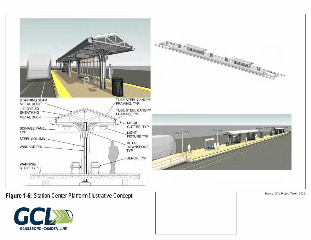
Source: GCL Project Team, 2020.Figure 1-6: Station Center Platform Illustrative Concept
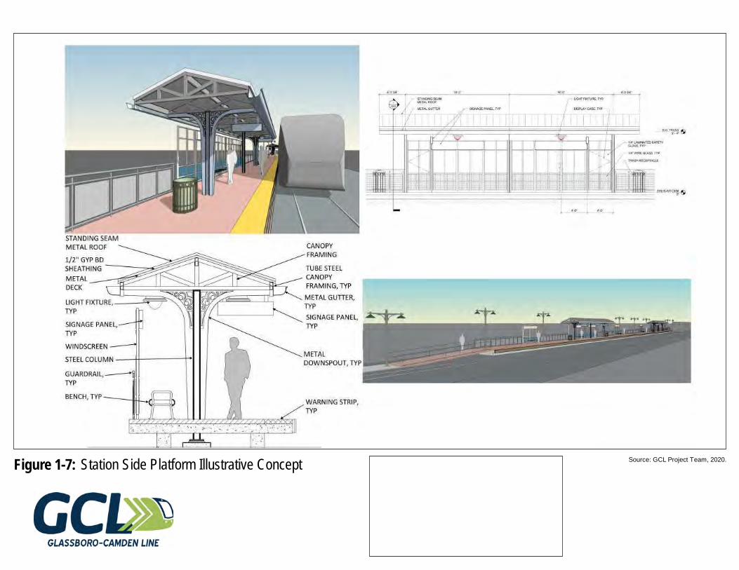
Source: GCL Project Team, 2020.Figure 1-7: Station Side Platform Illustrative Concept
Glassboro-Camden Line EIS
November 2020 Page 16
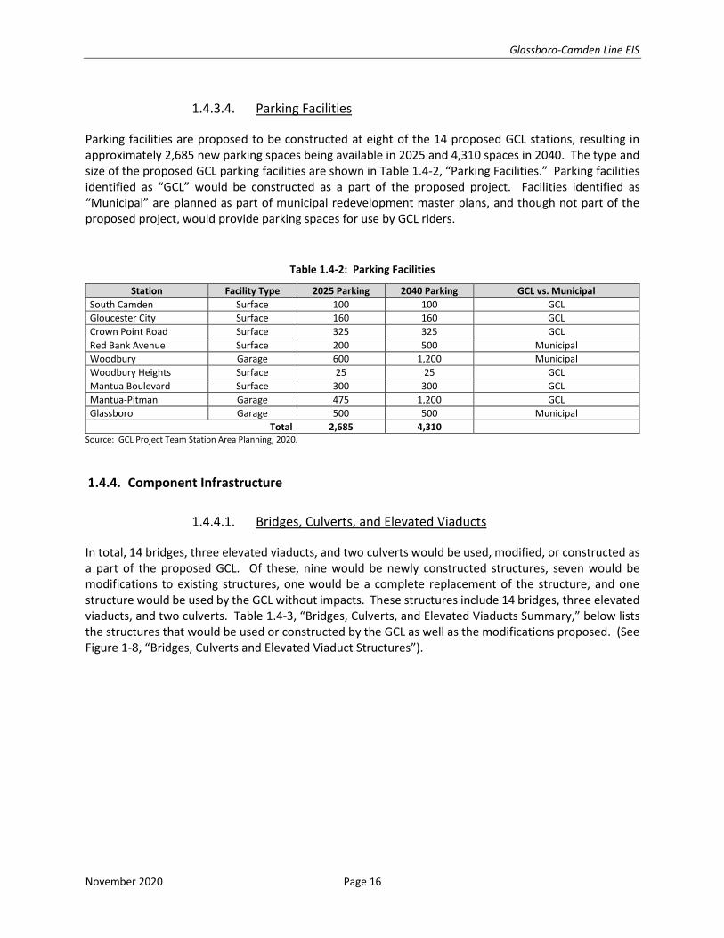
1.4.3.4. Parking Facilities
Parking facilities are proposed to be constructed at eight of the 14 proposed GCL stations, resulting in approximately 2,685 new parking spaces being available in 2025 and 4,310 spaces in 2040. The type and size of the proposed GCL parking facilities are shown in Table 1.4-2, “Parking Facilities.” Parking facilities identified as “GCL” would be constructed as a part of the proposed project. Facilities identified as “Municipal” are planned as part of municipal redevelopment master plans, and though not part of the proposed project, would provide parking spaces for use by GCL riders.
Table 1.4-2: Parking Facilities
Station Facility Type 2025 Parking 2040 Parking GCL vs. Municipal
South Camden Surface 100 100 GCL
Gloucester City Surface 160 160 GCL
Crown Point Road Surface 325 325 GCL
Red Bank Avenue Surface 200 500 Municipal
Woodbury Garage 600 1,200 Municipal
Woodbury Heights Surface 25 25 GCL
Mantua Boulevard Surface 300 300 GCL
Mantua-Pitman Garage 475 1,200 GCL
Glassboro Garage 500 500 Municipal
Total 2,685 4,310 Source: GCL Project Team Station Area Planning, 2020.
1.4.4. Component Infrastructure
1.4.4.1. Bridges, Culverts, and Elevated Viaducts
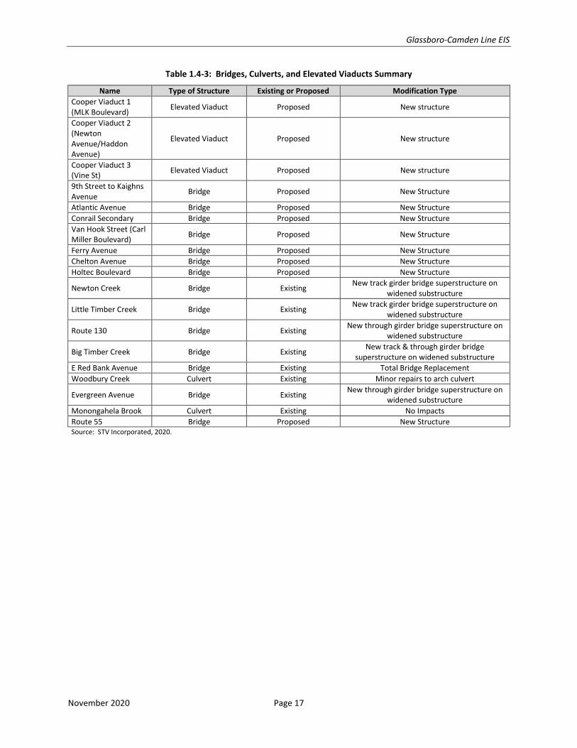
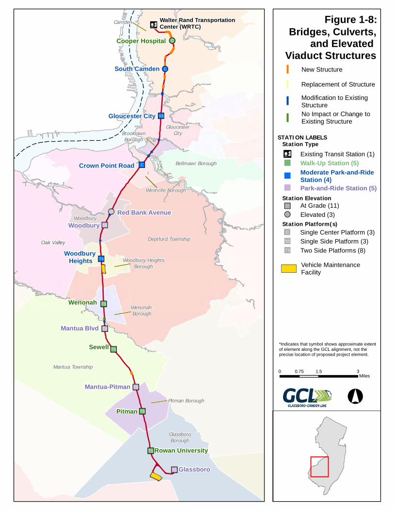
In total, 14 bridges, three elevated viaducts, and two culverts would be used, modified, or constructed as a part of the proposed GCL. Of these, nine would be newly constructed structures, seven would be modifications to existing structures, one would be a complete replacement of the structure, and one structure would be used by the GCL without impacts. These structures include 14 bridges, three elevated viaducts, and two culverts. Table 1.4-3, “Bridges, Culverts, and Elevated Viaducts Summary,” below lists the structures that would be used or constructed by the GCL as well as the modifications proposed. (See Figure 1-8, “Bridges, Culverts and Elevated Viaduct Structures”).
Glassboro-Camden Line EIS
November 2020 Page 17
Table 1.4-3: Bridges, Culverts, and Elevated Viaducts Summary
Name Type of Structure Existing or Proposed Modification Type
Cooper Viaduct 1 (MLK Boulevard)
Elevated Viaduct Proposed New structure
Cooper Viaduct 2 (Newton Avenue/Haddon Avenue)
Elevated Viaduct Proposed New structure
Cooper Viaduct 3 (Vine St)
Elevated Viaduct Proposed New structure
9th Street to Kaighns Avenue
Bridge Proposed New Structure
Atlantic Avenue Bridge Proposed New Structure
Conrail Secondary Bridge Proposed New Structure
Van Hook Street (Carl Miller Boulevard)
Bridge Proposed New Structure
Ferry Avenue Bridge Proposed New Structure
Chelton Avenue Bridge Proposed New Structure
Holtec Boulevard Bridge Proposed New Structure
Newton Creek Bridge Existing New track girder bridge superstructure on
widened substructure
Little Timber Creek Bridge Existing New track girder bridge superstructure on
widened substructure
Route 130 Bridge Existing New through girder bridge superstructure on
widened substructure
Big Timber Creek Bridge Existing New track & through girder bridge
superstructure on widened substructure
E Red Bank Avenue Bridge Existing Total Bridge Replacement
Woodbury Creek Culvert Existing Minor repairs to arch culvert
Evergreen Avenue Bridge Existing New through girder bridge superstructure on
widened substructure
Monongahela Brook Culvert Existing No Impacts
Route 55 Bridge Proposed New Structure Source: STV Incorporated, 2020.
Ä!C
!!C
""SS
""C
!!SS
""SS
""ST
n"TS
n"TS
n"TS
n"TS
n"TS
n"TS
n"TS
n¤
Oak Valley
Pitman
Sewell
Wenonah
Woodbury
Glassboro
Mantua Blvd
South Camden
Mantua-Pitman
Red Bank Avenue
Gloucester City
Cooper Hospital
Rowan University
Woodbury Heights
Crown Point Road
Walter Rand Transportation Center (WRTC)Camden
Deptford Township
Mantua Township
GlassboroBorough
Woodbury
GloucesterCity
Bellmawr Borough
Pitman Borough
Westville Borough
Wenonah Borough
Woodbury HeightsBorough
BrooklawnBorough
Bridges, Culverts,and Elevated
Viaduct Structures
0 1.5 30.75Miles
°
*Indicates that symbol shows approximate extentof element along the GCL alignment, not theprecise location of proposed project element.
Replacement of Structure
No Impact or Change toExisting Structure
New Structure
Station ElevationAt Grade (11)""Elevated (3)!!
Station Platform(s)Single Center Platform (3)""C
Two Side Platforms (8)""ST
Single Side Platform (3)""SS
STATION LABELSStation Typen¤ Existing Transit Station (1)
Walk-Up Station (5)""
Park-and-Ride Station (5)""
Moderate Park-and-RideStation (4)""
Vehicle MaintenanceFacility
Modification to ExistingStructure
Figure 1-8:
Glassboro-Camden Line EIS
November 2020 Page 19
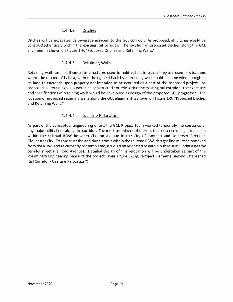
1.4.4.2. Ditches
Ditches will be excavated below-grade adjacent to the GCL corridor. As proposed, all ditches would be constructed entirely within the existing rail corridor. The location of proposed ditches along the GCL alignment is shown on Figure 1-9, “Proposed Ditches and Retaining Walls.”
1.4.4.3. Retaining Walls
Retaining walls are small concrete structures used to hold ballast in place; they are used in situations where the mound of ballast, without being held back by a retaining wall, could become wide enough at its base to encroach upon property not intended to be acquired as a part of the proposed project. As proposed, all retaining walls would be constructed entirely within the existing rail corridor. The exact size and specifications of retaining walls would be developed as design of the proposed GCL progresses. The location of proposed retaining walls along the GCL alignment is shown on Figure 1-9, “Proposed Ditches and Retaining Walls.”
1.4.4.4. Gas Line Relocation
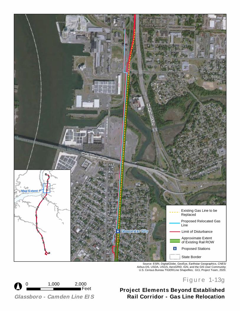
As part of the conceptual engineering effort, the GCL Project Team worked to identify the existence of any major utility lines along the corridor. The most prominent of these is the presence of a gas main line within the railroad ROW between Chelton Avenue in the City of Camden and Somerset Street in Gloucester City. To construct the additional tracks within the railroad ROW, this gas line must be removed from the ROW, and as currently contemplated, it would be relocated to within public ROW under a nearby parallel street (Railroad Avenue). Detailed design of this relocation will be undertaken as part of the Preliminary Engineering phase of the project. (See Figure 1-13g, “Project Elements Beyond Established Rail Corridor - Gas Line Relocation”).
Ä!C
!!C
""SS
""C
!!SS
""SS
""ST
n"TS
n"TS
n"TS
n"TS
n"TS
n"TS
n"TS
n¤
Oak Valley
Pitman
Sewell
Wenonah
Woodbury
Glassboro
Mantua Blvd
South Camden
Mantua-Pitman
Red Bank Avenue
Gloucester City
Cooper Hospital
Rowan University
Woodbury Heights
Crown Point Road
Walter Rand Transportation Center (WRTC)Camden
Deptford Township
Mantua Township
GlassboroBorough
Woodbury
GloucesterCity
Bellmawr Borough
Pitman Borough
Westville Borough
Wenonah Borough
Woodbury HeightsBorough
BrooklawnBorough
Proposed Ditchesand Retaining Walls
0 1.5 30.75Miles
°
Station ElevationAt Grade (11)""Elevated (3)!!
Station Platform(s)Single Center Platform (3)""C
Two Side Platforms (8)""ST
Single Side Platform (3)""SS
STATION LABELSStation Typen¤ Existing Transit Station (1)
Walk-Up Station (5)""
Park-and-Ride Station (5)""
Moderate Park-and-RideStation (4)""
Vehicle MaintenanceFacility
Retaining Walls*
Ditches*
*Indicates that symbol shows approximate extentof element along the GCL alignment, not theprecise location of proposed project element.
Figure 1-9:
Glassboro-Camden Line EIS
November 2020 Page 21
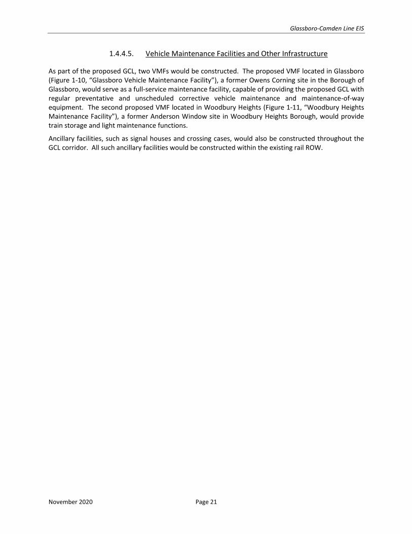
1.4.4.5. Vehicle Maintenance Facilities and Other Infrastructure
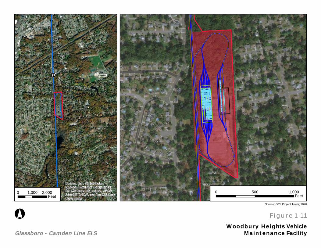
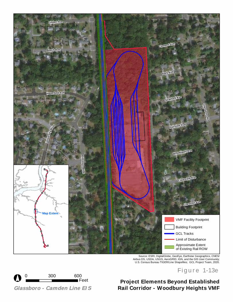
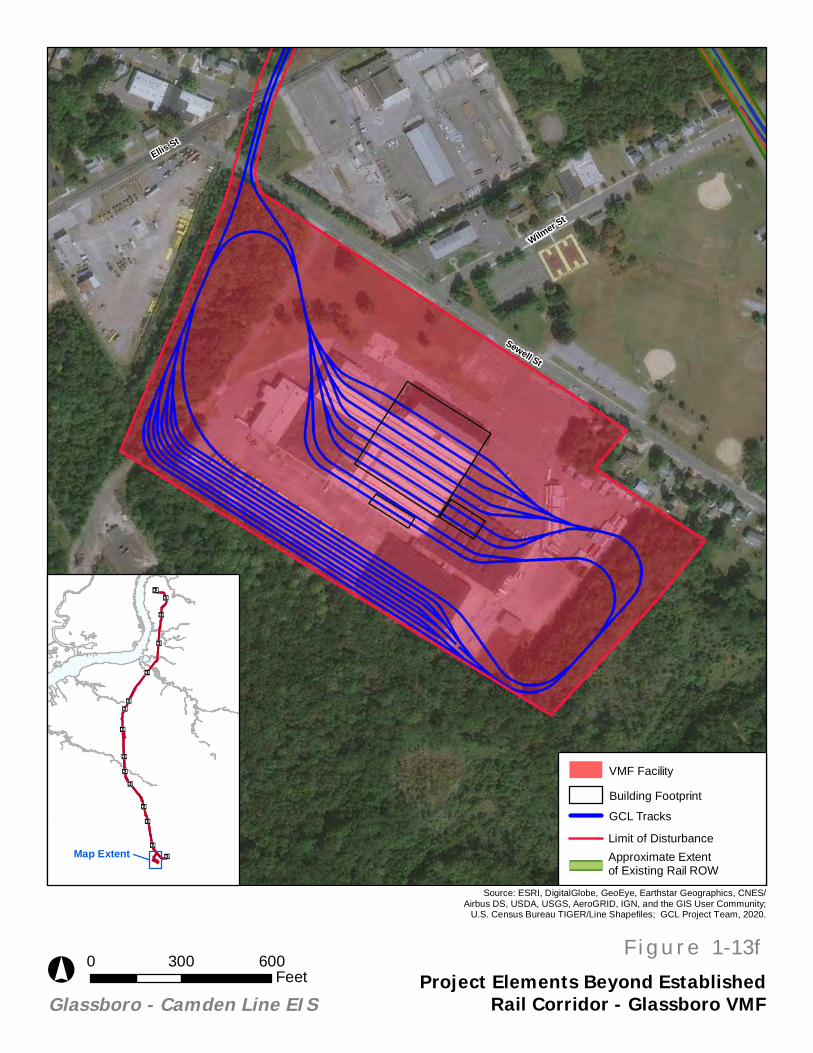
As part of the proposed GCL, two VMFs would be constructed. The proposed VMF located in Glassboro (Figure 1-10, “Glassboro Vehicle Maintenance Facility”), a former Owens Corning site in the Borough of Glassboro, would serve as a full-service maintenance facility, capable of providing the proposed GCL with regular preventative and unscheduled corrective vehicle maintenance and maintenance-of-way equipment. The second proposed VMF located in Woodbury Heights (Figure 1-11, “Woodbury Heights Maintenance Facility”), a former Anderson Window site in Woodbury Heights Borough, would provide train storage and light maintenance functions.
Ancillary facilities, such as signal houses and crossing cases, would also be constructed throughout the GCL corridor. All such ancillary facilities would be constructed within the existing rail ROW.
Source: Esri, DigitalGlobe, GeoEye, Earthstar Geographics,
CNES/Airbus DS, USDA, USGS, AeroGRID, IGN, and the GISUser Community
Glassboro VehicleMaintenance Facility
Source: GCL Project Team, 2020.
Glassboro - Camden Line EIS
n¤
n¤
Source: Esri, DigitalGlobe,
GeoEye, Earthstar Geographics,CNES/Airbus DS, USDA, USGS,AeroGRID, IGN, and the GIS User
Community
°
0 500 1,000Feet
0 1,000 2,000Feet
F i g u r e 1-10boro Vehicle
Source: Esri, DigitalGlobe, GeoEye, Earthstar Geographics,
CNES/Airbus DS, USDA, USGS, AeroGRID, IGN, and the GISUser Community
Woodbury Heights VehicleMaintenance Facility
Source: GCL Project Team, 2020.
Glassboro - Camden Line EIS
n¤
n¤
Source: Esri, DigitalGlobe,
GeoEye, Earthstar Geographics,CNES/Airbus DS, USDA, USGS,AeroGRID, IGN, and the GIS User
Community
°
0 500 1,000Feet
0 1,000 2,000Feet
F i g u r e 1-11ights Vehicle
Glassboro-Camden Line EIS
November 2020 Page 24
1.5. PROJECT RELATIONSHIP TO EXISTING AND ACTIVE RAIL RIGHT-OF-WAY
1.5.1. Conrail Improvements
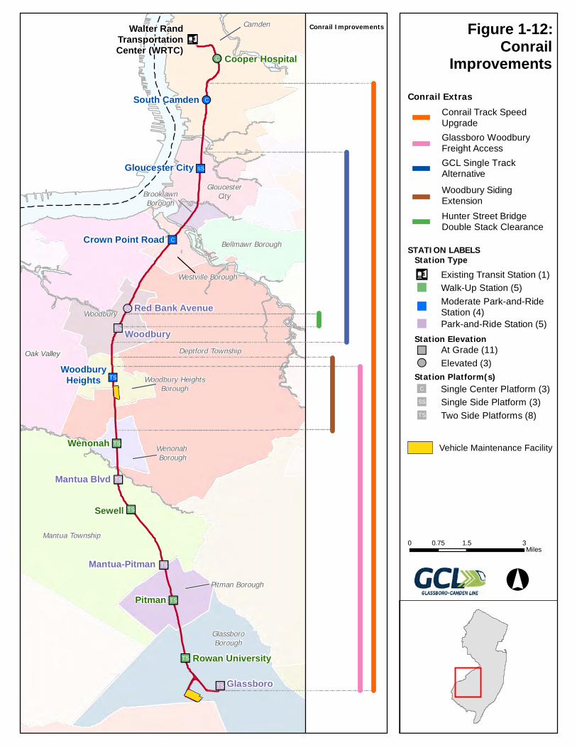
Through negotiations with Conrail, who currently operates on and owns much of the proposed GCL corridor, several improvements and modifications related to Conrail operations have been incorporated as a part of the proposed project. The proposed GCL was developed to accommodate Conrail’s desire for 25-foot track centers between the light rail and freight tracks, and to preserve space for a future Conrail second track located outside of the 25-foot track centers. (See Figure 1-12, “Conrail Improvements”). Other elements that are an inextricable part of the project are summarized below.
1.5.1.1. Woodbury Siding Extension
The Woodbury Siding Extension would extend the existing Conrail siding in the City of Woodbury for an additional 1.5 miles south so that it would extend from the New Jersey Turnpike to Maple Street. (See Figure 1-12, “Conrail Improvements”).
1.5.1.2. Conrail Track Speed Upgrade
It has been negotiated that, as a part of the proposed GCL, the GCL Project Team will move and rebuild most of Conrail’s existing track along the GCL corridor (Conrail’s Vineland Secondary Branch) to allow for 25-foot track centers. This represents a move still within the existing GCL/Vineland Secondary Branch Corridor that maximizes space between proposed GCL and Conrail track on that corridor and affords the opportunity to improve Conrail’s track so that they can operate at slightly higher speeds. (See Figure 1-12, “Conrail Improvements”).
1.5.1.3. Hunter Street Bridge Double Stack Clearance
This improvement involves the lowering of the Conrail and GCL track profile at the Hunter Street Bridge underpass (an existing Conrail underpass) in order to raise the under-clearance from 16 feet to 23 feet to give Conrail sufficient clearance for double stack freight cars. (See Figure 1-12, “Conrail Improvements”).
1.5.1.4. Glassboro to Woodbury Freight Access
This improvement extends Conrail’s operating window between the Borough of Glassboro and the City of Woodbury from the originally proposed 12:00 A.M to 5:00 A.M. to 9:00 P.M to 5:00 A.M. The proposed corridor would have two shared tracks between the Borough of Glassboro and the City of Woodbury both of which would be used by the GCL during the day and Conrail at night (during which time the GCL would not operate). The proposed Glassboro to Woodbury Freight Access improvement would allow for Conrail to use one track, and the GCL to use the other track during off-peak hours in the evening starting at 9:00 P.M. between the Woodbury Heights Siding and Glassboro. (See Figure 1-12, “Conrail Improvements”).
Ä!C
!!C
""SS
""C
!!SS
""SS
""ST
n"TS
n"TS
n"TS
n"TS
n"TS
n"TS
n"TS
n¤
Oak Valley
Camden
Deptford Township
Mantua Township
GlassboroBorough
Woodbury
GloucesterCity
Bellmawr Borough
Pitman Borough
Westville Borough
Wenonah Borough
Woodbury HeightsBorough
BrooklawnBorough
Woodbury
Glassboro
South Camden
Red Bank Avenue
WoodburyHeights
Crown Point Road
Pitman
Sewell
Wenonah
Gloucester City
Cooper Hospital
Rowan University
Mantua Blvd
Mantua-Pitman
Walter RandTransportationCenter (WRTC) Conrail
Improvements
0 1.5 30.75Miles
°
Conrail Improvements
Conrail Extras
Hunter Street BridgeDouble Stack Clearance
STATION LABELS
Station ElevationAt Grade (11)""Elevated (3)!!
Station Platform(s)Single Center Platform (3)""C
Two Side Platforms (8)""ST
Single Side Platform (3)""SS
Station Type
Park-and-Ride Station (5)""
Moderate Park-and-RideStation (4)
""
Walk-Up Station (5)"" n¤ Existing Transit Station (1)
Woodbury SidingExtension
GCL Single TrackAlternative
Glassboro WoodburyFreight Access
Conrail Track SpeedUpgrade
Vehicle Maintenance Facility
Figure 1-12:
Glassboro-Camden Line EIS
November 2020 Page 26
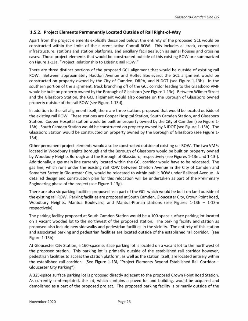
1.5.2. Project Elements Permanently Located Outside of Rail Right-of-Way
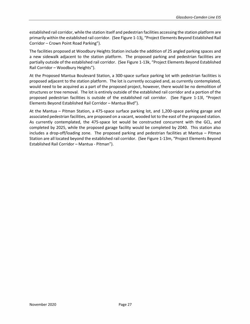
Apart from the project elements explicitly described below, the entirety of the proposed GCL would be constructed within the limits of the current active Conrail ROW. This includes all track, component infrastructure, stations and station platforms, and ancillary facilities such as signal houses and crossing cases. Those project elements that would be constructed outside of this existing ROW are summarized on Figure 1-13a, “Project Relationship to Existing Rail ROW.”
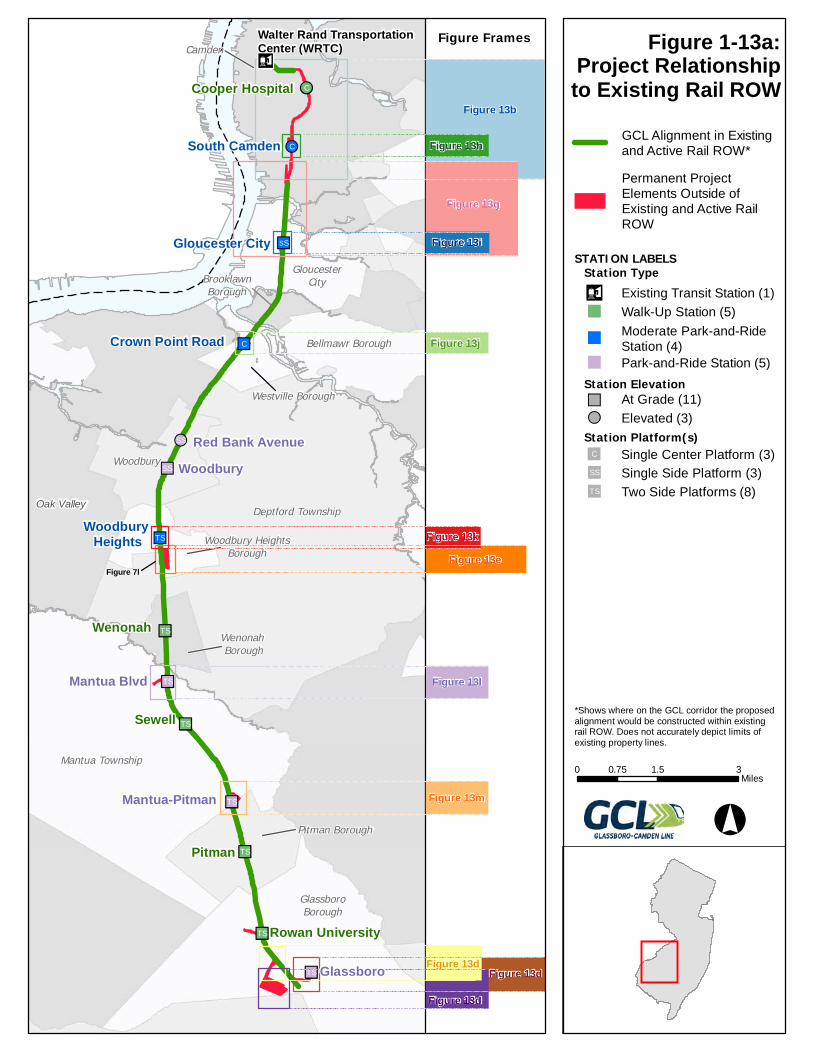
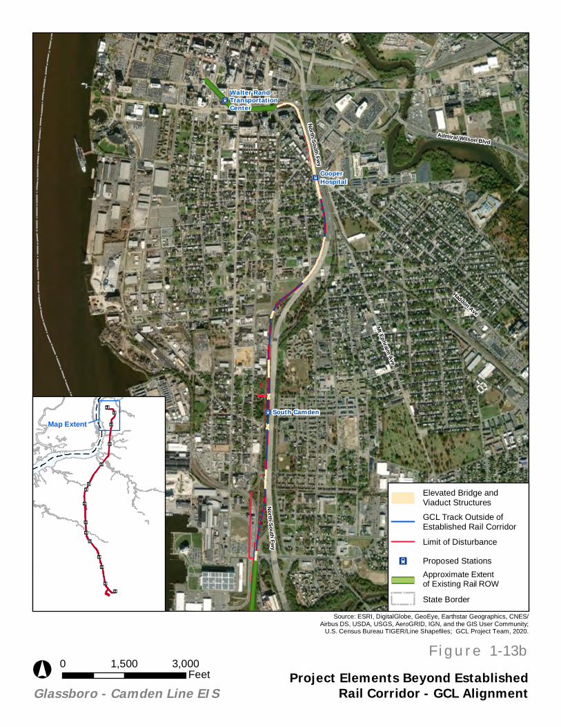
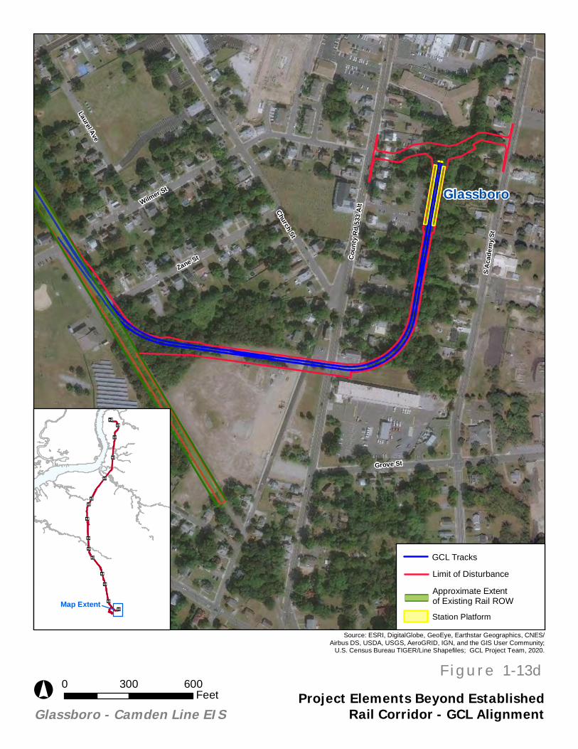
There are three distinct portions of the proposed GCL alignment that would be outside of existing rail ROW. Between approximately Haddon Avenue and Holtec Boulevard, the GCL alignment would be constructed on property owned by the City of Camden, DRPA, and NJDOT (see Figure 1-13b). In the southern portion of the alignment, track branching off of the GCL corridor leading to the Glassboro VMF would be built on property owned by the Borough of Glassboro (see Figure 1-13c). Between Wilmer Street and the Glassboro Station, the GCL alignment would also operate on the Borough of Glassboro owned property outside of the rail ROW (see Figure 1-13d).
In addition to the rail alignment itself, there are three stations proposed that would be located outside of the existing rail ROW. These stations are Cooper Hospital Station, South Camden Station, and Glassboro Station. Cooper Hospital station would be built on property owned by the City of Camden (see Figure 1-13b). South Camden Station would be constructed on property owned by NJDOT (see Figure 1-13b). The Glassboro Station would be constructed on property owned by the Borough of Glassboro (see Figure 1-13d).
Other permanent project elements would also be constructed outside of existing rail ROW. The two VMFs located in Woodbury Heights Borough and the Borough of Glassboro would be built on property owned by Woodbury Heights Borough and the Borough of Glassboro, respectively (see Figures 1-13e and 1-13f). Additionally, a gas main line currently located within the GCL corridor would have to be relocated. The gas line, which runs under the existing rail ROW between Chelton Avenue in the City of Camden and Somerset Street in Gloucester City, would be relocated to within public ROW under Railroad Avenue. A detailed design and construction plan for this relocation will be undertaken as part of the Preliminary Engineering phase of the project (see Figure 1-13g).
There are also six parking facilities proposed as a part of the GCL which would be built on land outside of the existing rail ROW. Parking facilities are proposed at South Camden, Gloucester City, Crown Point Road, Woodbury Heights, Mantua Boulevard, and Mantua-Pitman stations (see Figures 1-13h – 1-13m respectively).
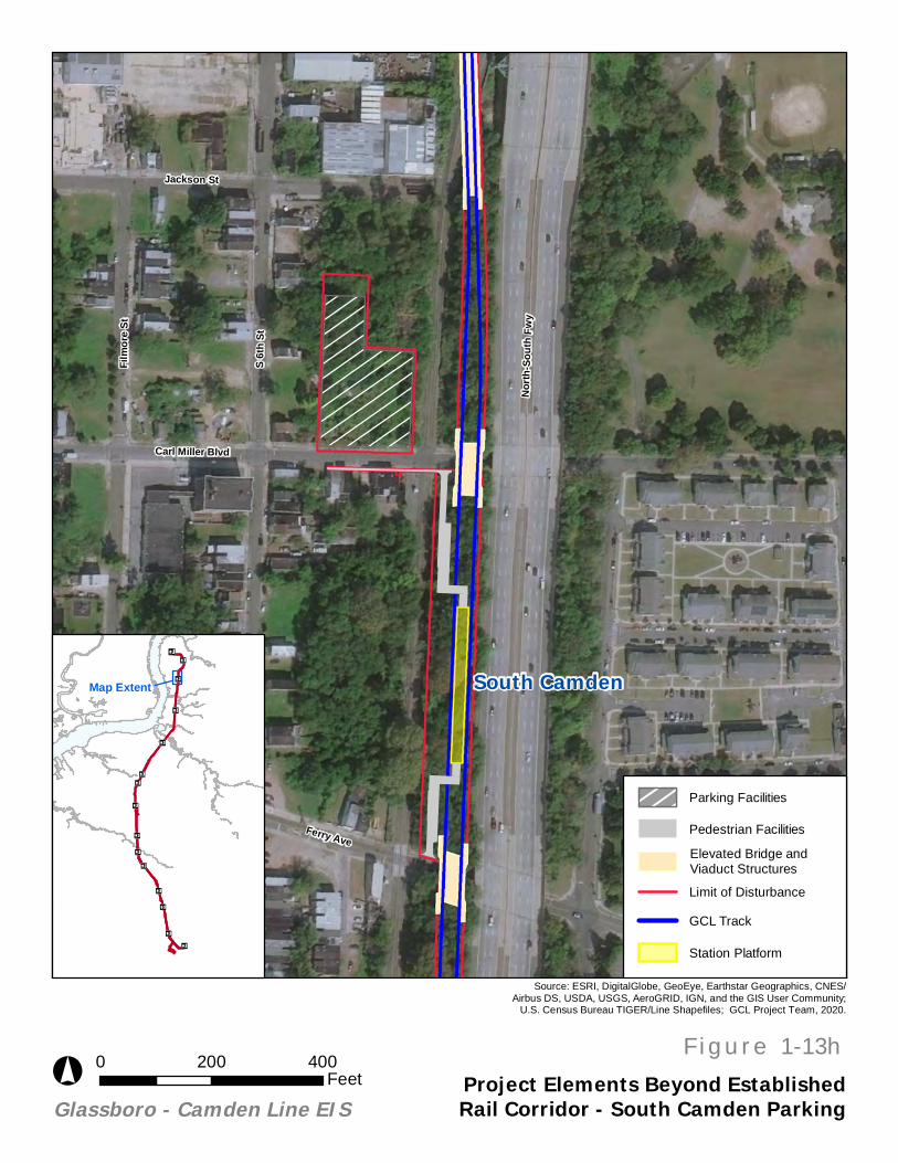
The parking facility proposed at South Camden Station would be a 100-space surface parking lot located on a vacant wooded lot to the northwest of the proposed station. The parking facility and station as proposed also include new sidewalks and pedestrian facilities in the vicinity. The entirety of this station and associated parking and pedestrian facilities are located outside of the established rail corridor. (see Figure 1-13h).
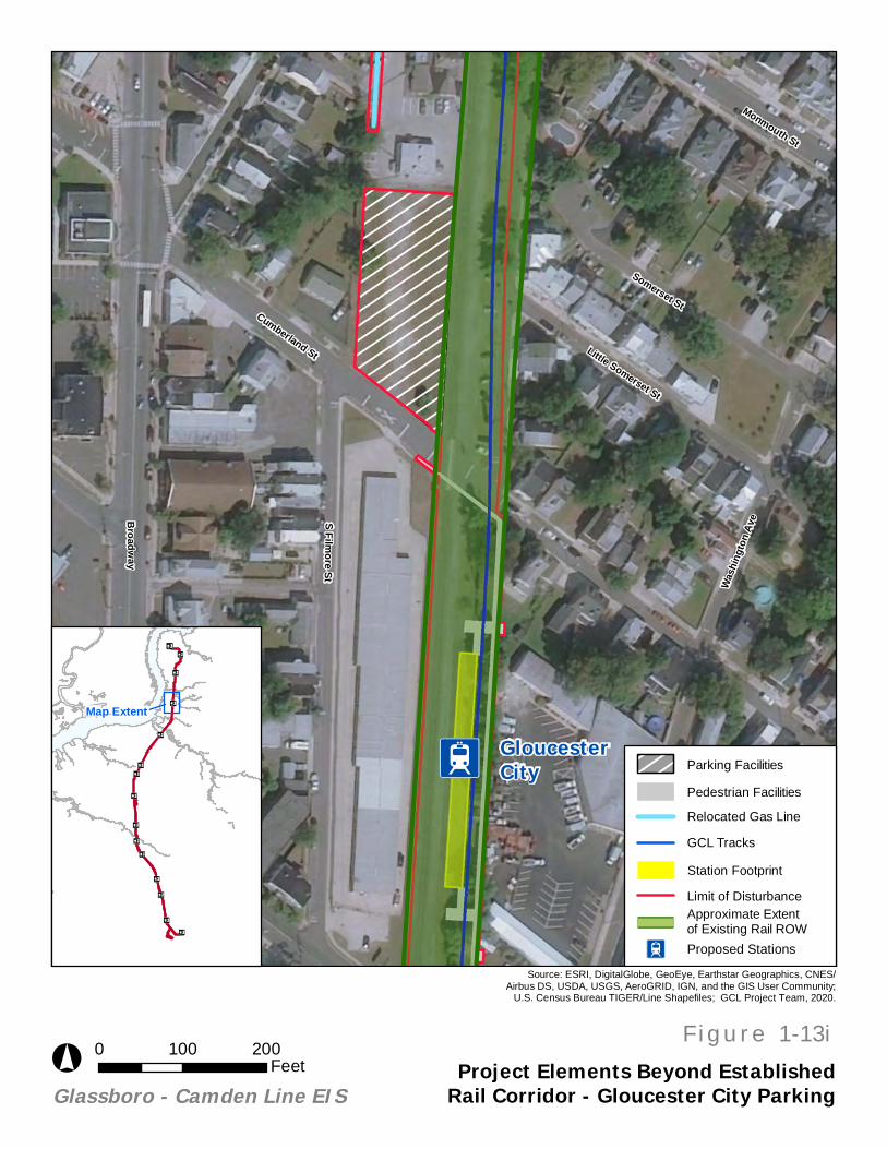
At Gloucester City Station, a 160-space surface parking lot is located on a vacant lot to the northwest of the proposed station. This parking lot is primarily outside of the established rail corridor however, pedestrian facilities to access the station platform, as well as the station itself, are located entirely within the established rail corridor. (See Figure 1-13i, “Project Elements Beyond Established Rail Corridor – Gloucester City Parking”).
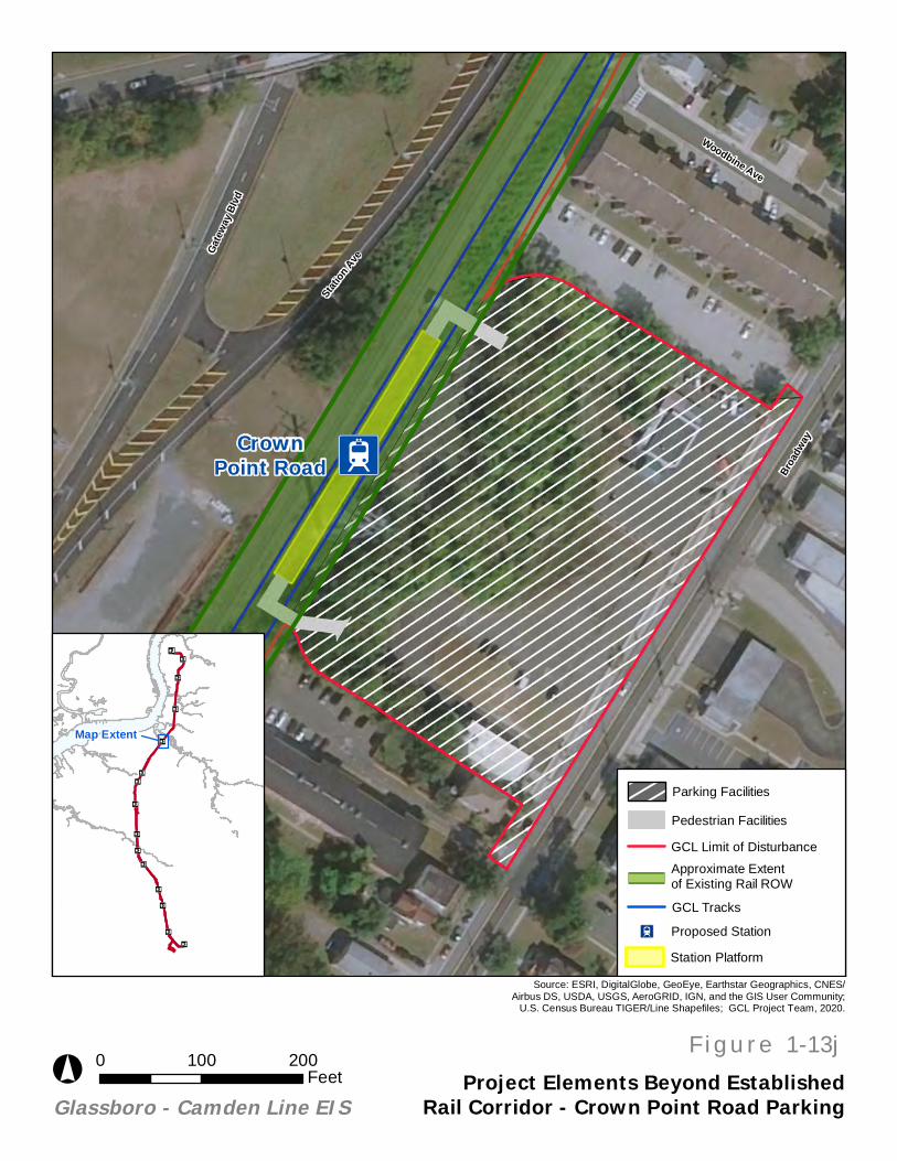
A 325-space surface parking lot is proposed directly adjacent to the proposed Crown Point Road Station. As currently contemplated, the lot, which contains a paved lot and building, would be acquired and demolished as a part of the proposed project. The proposed parking facility is primarily outside of the
Glassboro-Camden Line EIS
November 2020 Page 27
established rail corridor, while the station itself and pedestrian facilities accessing the station platform are primarily within the established rail corridor. (See Figure 1-13j, “Project Elements Beyond Established Rail Corridor – Crown Point Road Parking”).
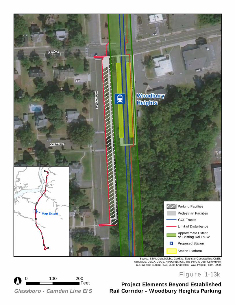
The facilities proposed at Woodbury Heights Station include the addition of 25 angled parking spaces and a new sidewalk adjacent to the station platform. The proposed parking and pedestrian facilities are partially outside of the established rail corridor. (See Figure 1-13k, “Project Elements Beyond Established Rail Corridor – Woodbury Heights”).
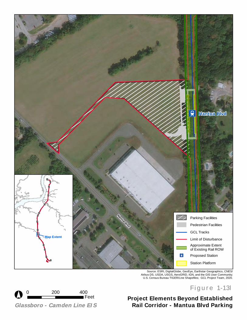
At the Proposed Mantua Boulevard Station, a 300-space surface parking lot with pedestrian facilities is proposed adjacent to the station platform. The lot is currently occupied and, as currently contemplated, would need to be acquired as a part of the proposed project, however, there would be no demolition of structures or tree removal. The lot is entirely outside of the established rail corridor and a portion of the proposed pedestrian facilities is outside of the established rail corridor. (See Figure 1-13l, “Project Elements Beyond Established Rail Corridor – Mantua Blvd”).
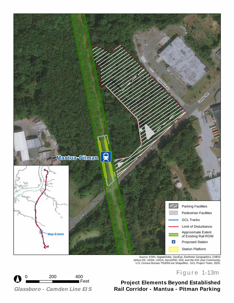
At the Mantua – Pitman Station, a 475-space surface parking lot, and 1,200-space parking garage and associated pedestrian facilities, are proposed on a vacant, wooded lot to the east of the proposed station. As currently contemplated, the 475-space lot would be constructed concurrent with the GCL, and completed by 2025, while the proposed garage facility would be completed by 2040. This station also includes a drop-off/loading zone. The proposed parking and pedestrian facilities at Mantua – Pitman Station are all located beyond the established rail corridor. (See Figure 1-13m, “Project Elements Beyond Established Rail Corridor – Mantua - Pitman”).
Ä!C
!!C
""SS
""C
!!SS
""SS
""ST
n"TS
n"TS
n"TS
n"TS
n"TS
n"TS
n"TS
Figure 7l
Figure 13d
Figure 13d
Figure 13d
Figure 13b
Figure 13h
Figure 13g
Figure 13i
Figure 13j
Figure 13kFigure 13e
Figure 13l
Figure 13m
Oak Valley
Pitman
Sewell
Wenonah
Woodbury
Glassboro
Mantua Blvd
South Camden
Mantua-Pitman
Red Bank Avenue
Gloucester City
Cooper Hospital
Rowan University
Woodbury Heights
Crown Point Road
Walter Rand Transportation Center (WRTC)Camden
Deptford Township
Mantua Township
GlassboroBorough
Woodbury
GloucesterCity
Bellmawr Borough
Pitman Borough
Westville Borough
Wenonah Borough
Woodbury HeightsBorough
BrooklawnBorough
n¤
Project Relationshipto Existing Rail ROW
0 1.5 30.75Miles
°
GCL Alignment in Existingand Active Rail ROW*
Permanent ProjectElements Outside ofExisting and Active RailROW
STATION LABELS
Station ElevationAt Grade (11)""Elevated (3)!!
Station Platform(s)Single Center Platform (3)""C
Two Side Platforms (8)""ST
Single Side Platform (3)""SS
Station Typen¤ Existing Transit Station (1)
Park-and-Ride Station (5)""
Moderate Park-and-RideStation (4)
""
Walk-Up Station (5)""
*Shows where on the GCL corridor the proposedalignment would be constructed within existingrail ROW. Does not accurately depict limits ofexisting property lines.
Figure Frames Figure 1-13a:
I2
I2
I2
Admiral Wilson Blvd
North-South Fwy
North-South Fwy
Mt Ephraim Ave
Haddon Ave
Walter RandTransportationCenter
CooperHospital
South Camden
Source: Esri, DigitalGlobe, GeoEye, Earthstar Geographics, CNES/Airbus
DS, USDA, USGS, AeroGRID, IGN, and the GIS User Community
F i g u r e 1-13b
Project Elements Beyond EstablishedRail Corridor - GCL Alignment
°Glassboro - Camden Line EIS
0 1,500 3,000Feet
Source: ESRI, DigitalGlobe, GeoEye, Earthstar Geographics, CNES/Airbus DS, USDA, USGS, AeroGRID, IGN, and the GIS User Community;
U.S. Census Bureau TIGER/Line Shapefiles; GCL Project Team, 2020.
n¤
n¤
n¤
n¤
n¤n¤
n¤
n¤
n¤
n¤
n¤
n¤
n¤
n¤
Map Extentn¤
State Border
Approximate Extentof Existing Rail ROW
I2 Proposed Stations
Limit of Disturbance
GCL Track Outside of Established Rail Corridor
Elevated Bridge and Viaduct Structures
Shown on Figure 13f, "ProjectElements Beyond Established Rail Corridor - Glassboro VMF"
Georgetown Rd
Dickinson Rd
Franklin Rd
Ellis St
Wilmer St
Sewell St
Oakwood Ave
High St W
Victoria St
Girard
Rd S
Princ
eton R
d S
Whitney Ave
Pennsylvania Rd
Source: Esri, DigitalGlobe, GeoEye, Earthstar Geographics, CNES/Airbus
DS, USDA, USGS, AeroGRID, IGN, and the GIS User Community
F i g u r e 1-13c
Project Elements Beyond EstablishedRail Corridor - GCL Alignment
°Glassboro - Camden Line EIS
0 400 800Feet
Source: ESRI, DigitalGlobe, GeoEye, Earthstar Geographics, CNES/Airbus DS, USDA, USGS, AeroGRID, IGN, and the GIS User Community;
U.S. Census Bureau TIGER/Line Shapefiles; GCL Project Team, 2020.
Vehicle Maintenance Facility
GCL Tracks
n¤
n¤
n¤
n¤
n¤n¤
n¤
n¤
n¤
n¤
n¤
n¤
n¤
n¤Map Extent
n¤
Approximate Extentof Existing Rail ROW
GCL Limit of Disturbance
Coun
ty Rd
533 A
lt
S Aca
demy
St
Church St
Zane St
Wilmer St
Grove St
Laurel Ave
Glassboro
Source: Esri, DigitalGlobe, GeoEye, Earthstar Geographics, CNES/Airbus
DS, USDA, USGS, AeroGRID, IGN, and the GIS User Community
F i g u r e 1-13d
Project Elements Beyond EstablishedRail Corridor - GCL Alignment
°Glassboro - Camden Line EIS
0 300 600Feet
Source: ESRI, DigitalGlobe, GeoEye, Earthstar Geographics, CNES/Airbus DS, USDA, USGS, AeroGRID, IGN, and the GIS User Community;
U.S. Census Bureau TIGER/Line Shapefiles; GCL Project Team, 2020.
n¤
n¤
n¤
n¤
n¤n¤
n¤
n¤
n¤
n¤
n¤
n¤
n¤
n¤Map Extent
n¤
Approximate Extentof Existing Rail ROW
GCL Tracks
Limit of Disturbance
Station Platform
Fairview Ave
Park Ave
Stratford Ave
Clearview Ave
Brooklawn Ave
Chestnut Ave
Clement Ave
Linden Ave
Beech Ave
Haverford Ave
Glassboro Rd
Unive
rsity
Blvd
Princeton Blvd
Source: Esri, DigitalGlobe, GeoEye, Earthstar Geographics, CNES/Airbus
DS, USDA, USGS, AeroGRID, IGN, and the GIS User Community
F i g u r e 1-13e
Project Elements Beyond EstablishedRail Corridor - Woodbury Heights VMF
°Glassboro - Camden Line EIS
0 300 600Feet
Source: ESRI, DigitalGlobe, GeoEye, Earthstar Geographics, CNES/Airbus DS, USDA, USGS, AeroGRID, IGN, and the GIS User Community;
U.S. Census Bureau TIGER/Line Shapefiles; GCL Project Team, 2020.
n¤
n¤
n¤
n¤
n¤n¤
n¤
n¤
n¤
n¤
n¤
n¤
n¤
n¤
Map Extent
n¤
Limit of Disturbance
VMF Facility Footprint
Building Footprint
GCL Tracks
Approximate Extentof Existing Rail ROW
Sewell St
Wilmer St
Ellis St
Source: Esri, DigitalGlobe, GeoEye, Earthstar Geographics, CNES/Airbus
DS, USDA, USGS, AeroGRID, IGN, and the GIS User Community
F i g u r e 1-13fProject Elements Beyond Established
Rail Corridor - Glassboro VMF°Glassboro - Camden Line EIS
0 300 600Feet
Source: ESRI, DigitalGlobe, GeoEye, Earthstar Geographics, CNES/Airbus DS, USDA, USGS, AeroGRID, IGN, and the GIS User Community;
U.S. Census Bureau TIGER/Line Shapefiles; GCL Project Team, 2020.
n¤
n¤
n¤
n¤
n¤n¤
n¤
n¤
n¤
n¤
n¤
n¤
n¤
n¤Map Extent
n¤
VMF Facility
Building Footprint
GCL Tracks
Limit of Disturbance
Approximate Extentof Existing Rail ROW
I2
Walt Whitman Bridge
North-South Fwy
Gloucester City
Source: Esri, DigitalGlobe, GeoEye, Earthstar Geographics, CNES/Airbus
DS, USDA, USGS, AeroGRID, IGN, and the GIS User Community
F i g u r e 1-13gProject Elements Beyond Established
Rail Corridor - Gas Line Relocation°Glassboro - Camden Line EIS
0 1,000 2,000Feet
Source: ESRI, DigitalGlobe, GeoEye, Earthstar Geographics, CNES/Airbus DS, USDA, USGS, AeroGRID, IGN, and the GIS User Community;
U.S. Census Bureau TIGER/Line Shapefiles; GCL Project Team, 2020.
n¤
n¤
n¤
n¤
n¤n¤
n¤
n¤
n¤
n¤
n¤
n¤
n¤
n¤
Map Extent
n¤
Approximate Extentof Existing Rail ROW
Existing Gas Line to beReplaced
Proposed Relocated GasLine
Limit of Disturbance
I2 Proposed Stations
State Border
North
-Sou
th Fw
y
Carl Miller Blvd
S 6th
St
Filmo
re St
Jackson St
Ferry Ave
South Camden
Source: Esri, DigitalGlobe, GeoEye, Earthstar Geographics, CNES/Airbus
DS, USDA, USGS, AeroGRID, IGN, and the GIS User Community
F i g u r e 1-13hProject Elements Beyond EstablishedRail Corridor - South Camden Parking
°Glassboro - Camden Line EIS
0 200 400Feet
Source: ESRI, DigitalGlobe, GeoEye, Earthstar Geographics, CNES/Airbus DS, USDA, USGS, AeroGRID, IGN, and the GIS User Community;
U.S. Census Bureau TIGER/Line Shapefiles; GCL Project Team, 2020.
n¤
n¤
n¤
n¤
n¤n¤
n¤
n¤
n¤
n¤
n¤
n¤
n¤
n¤
Map Extent
n¤
Station Platform
GCL Track
Limit of Disturbance
Elevated Bridge and Viaduct Structures
Pedestrian Facilities
Parking Facilities
Cumberland St
Broadway
S Filmore St
Somerset St
Little Somerset St
Monmouth St
Wash
ington
Ave
I2GloucesterCity
Source: Esri, DigitalGlobe, GeoEye, Earthstar Geographics, CNES/Airbus
DS, USDA, USGS, AeroGRID, IGN, and the GIS User Community
F i g u r e 1-13iProject Elements Beyond Established
Rail Corridor - Gloucester City Parking°Glassboro - Camden Line EIS
0 100 200Feet
Source: ESRI, DigitalGlobe, GeoEye, Earthstar Geographics, CNES/Airbus DS, USDA, USGS, AeroGRID, IGN, and the GIS User Community;
U.S. Census Bureau TIGER/Line Shapefiles; GCL Project Team, 2020.
n¤
n¤
n¤
n¤
n¤n¤
n¤
n¤
n¤
n¤
n¤
n¤
n¤
n¤
Map Extent
n¤
Approximate Extentof Existing Rail ROW
GCL Tracks
Pedestrian Facilities
Relocated Gas Line
Station Footprint
Proposed Stations2
Parking Facilities
Limit of Disturbance
I2
Gatew
ay Bl
vd
Statio
n Ave
Broad
way
Woodbine Ave
CrownPoint Road
Source: Esri, DigitalGlobe, GeoEye, Earthstar Geographics, CNES/Airbus
DS, USDA, USGS, AeroGRID, IGN, and the GIS User Community
F i g u r e 1-13jProject Elements Beyond Established
Rail Corridor - Crown Point Road Parking°Glassboro - Camden Line EIS
0 100 200Feet
Source: ESRI, DigitalGlobe, GeoEye, Earthstar Geographics, CNES/Airbus DS, USDA, USGS, AeroGRID, IGN, and the GIS User Community;
U.S. Census Bureau TIGER/Line Shapefiles; GCL Project Team, 2020.
n¤
n¤
n¤
n¤
n¤n¤
n¤
n¤
n¤
n¤
n¤
n¤
n¤
n¤
Map Extent
n¤
Parking Facilities
Pedestrian Facilities
GCL Limit of Disturbance
Approximate Extentof Existing Rail ROW
GCL Tracks
I2 Proposed Station
Station Platform
I2
Elm Ave
W Jersey AveCentral Ave
WoodburyHeights
Source: Esri, DigitalGlobe, GeoEye, Earthstar Geographics, CNES/Airbus
DS, USDA, USGS, AeroGRID, IGN, and the GIS User Community
F i g u r e 1-13kProject Elements Beyond Established
Rail Corridor - Woodbury Heights Parking°Glassboro - Camden Line EIS
0 100 200Feet
Source: ESRI, DigitalGlobe, GeoEye, Earthstar Geographics, CNES/Airbus DS, USDA, USGS, AeroGRID, IGN, and the GIS User Community;
U.S. Census Bureau TIGER/Line Shapefiles; GCL Project Team, 2020.
n¤
n¤
n¤
n¤
n¤n¤
n¤
n¤
n¤
n¤
n¤
n¤
n¤
n¤
Map Extent
n¤
Station Platform
I2 Proposed Station
Approximate Extentof Existing Rail ROW
Limit of Disturbance
GCL Tracks
Pedestrian Facilities
Parking Facilities
I2
Mantua BlvdMantua Blvd
Source: Esri, DigitalGlobe, GeoEye, Earthstar Geographics, CNES/Airbus
DS, USDA, USGS, AeroGRID, IGN, and the GIS User Community
F i g u r e 1-13lProject Elements Beyond Established
Rail Corridor - Mantua Blvd Parking°Glassboro - Camden Line EIS
0 200 400Feet
Source: ESRI, DigitalGlobe, GeoEye, Earthstar Geographics, CNES/Airbus DS, USDA, USGS, AeroGRID, IGN, and the GIS User Community;
U.S. Census Bureau TIGER/Line Shapefiles; GCL Project Team, 2020.
n¤
n¤
n¤
n¤
n¤n¤
n¤
n¤
n¤
n¤
n¤
n¤
n¤
n¤
Map Extent
n¤
Station Platform
I2 Proposed Station
Approximate Extentof Existing Rail ROW
Limit of Disturbance
GCL Tracks
Parking Facilities
Pedestrian Facilities
I2
Lambs Rd
Columbia Dr
Mantua-Pitman
Source: Esri, DigitalGlobe, GeoEye, Earthstar Geographics, CNES/Airbus
DS, USDA, USGS, AeroGRID, IGN, and the GIS User Community
F i g u r e 1-13mProject Elements Beyond Established
Rail Corridor - Mantua - Pitman Parking°Glassboro - Camden Line EIS
0 200 400Feet
Source: ESRI, DigitalGlobe, GeoEye, Earthstar Geographics, CNES/Airbus DS, USDA, USGS, AeroGRID, IGN, and the GIS User Community;
U.S. Census Bureau TIGER/Line Shapefiles; GCL Project Team, 2020.
n¤
n¤
n¤
n¤
n¤n¤
n¤
n¤
n¤
n¤
n¤
n¤
n¤
n¤
Map Extent
n¤
Station Platform
I2 Proposed Station
Approximate Extentof Existing Rail ROW
Limit of Disturbance
GCL Tracks
Parking Facilities
Pedestrian Facilities
Glassboro-Camden Line EIS
November 2020 Page 41
1.6. GCL OPERATIONS
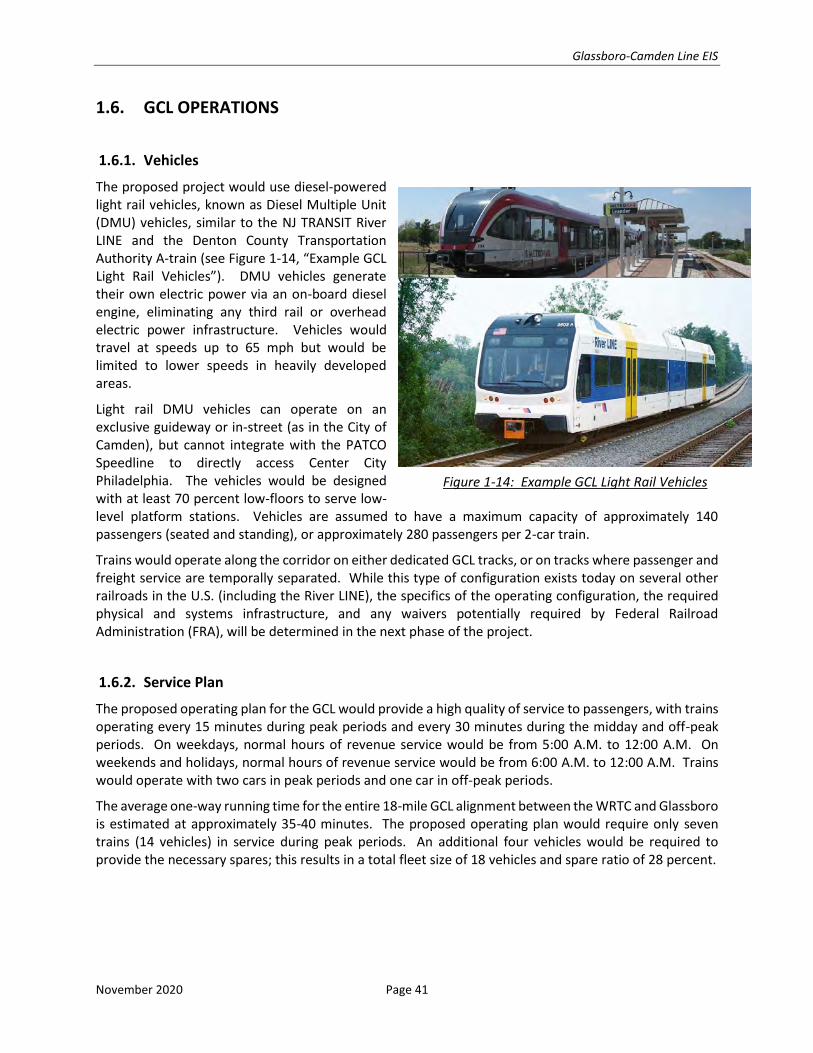
1.6.1. Vehicles
The proposed project would use diesel-powered light rail vehicles, known as Diesel Multiple Unit (DMU) vehicles, similar to the NJ TRANSIT River LINE and the Denton County Transportation Authority A-train (see Figure 1-14, “Example GCL Light Rail Vehicles”). DMU vehicles generate their own electric power via an on-board diesel engine, eliminating any third rail or overhead electric power infrastructure. Vehicles would travel at speeds up to 65 mph but would be limited to lower speeds in heavily developed areas.
Light rail DMU vehicles can operate on an exclusive guideway or in-street (as in the City of Camden), but cannot integrate with the PATCO Speedline to directly access Center City Philadelphia. The vehicles would be designed with at least 70 percent low-floors to serve low-level platform stations. Vehicles are assumed to have a maximum capacity of approximately 140 passengers (seated and standing), or approximately 280 passengers per 2-car train.
Trains would operate along the corridor on either dedicated GCL tracks, or on tracks where passenger and freight service are temporally separated. While this type of configuration exists today on several other railroads in the U.S. (including the River LINE), the specifics of the operating configuration, the required physical and systems infrastructure, and any waivers potentially required by Federal Railroad Administration (FRA), will be determined in the next phase of the project.
1.6.2. Service Plan
The proposed operating plan for the GCL would provide a high quality of service to passengers, with trains operating every 15 minutes during peak periods and every 30 minutes during the midday and off-peak periods. On weekdays, normal hours of revenue service would be from 5:00 A.M. to 12:00 A.M. On weekends and holidays, normal hours of revenue service would be from 6:00 A.M. to 12:00 A.M. Trains would operate with two cars in peak periods and one car in off-peak periods.
The average one-way running time for the entire 18-mile GCL alignment between the WRTC and Glassboro is estimated at approximately 35-40 minutes. The proposed operating plan would require only seven trains (14 vehicles) in service during peak periods. An additional four vehicles would be required to provide the necessary spares; this results in a total fleet size of 18 vehicles and spare ratio of 28 percent.
Figure 1-14: Example GCL Light Rail Vehicles
Glassboro-Camden Line EIS
November 2020 Page 42
1.6.3. Ridership Demand Forecast
A travel demand model for the corridor was developed using the Federal Transit Administration (FTA) STOPS model to forecast ridership on the proposed GCL. The model projects 16,500 daily boardings in 2025 and 18,000 daily boardings in 2040. Of these trips, 10,100 in 2025 and 11,000 in 2040 were estimated to be new transit trips, or trips that would otherwise be completed entirely by automobile. The remainder of the boardings reflects a redistribution of existing transit trips from the PATCO Speedline and from NJ TRANSIT bus service and the River LINE.
1.7. DESCRIPTION OF THE CONSTRUCTION PHASE
1.7.1. Introduction and Methodology
This section describes the anticipated construction methods, activities, and sequencing that can
reasonably be expected to be employed and undertaken during the construction of the proposed GCL.
This section presents a description of the construction process used for the purposes of quantification of
environmental-effect causing activities only as described in other chapters. This section is not intended
to describe the precise construction methods that may ultimately be used, nor is it intended to dictate or
confine the construction process. A number of construction methods could be used to build the GCL,
depending on geological and environmental conditions, cost, schedule, alignment, and other factors.
Detailed project design and construction information will advance as the project moves into the
preliminary engineering phase. Thus, construction methods and activities described herein are based on
conceptual studies, professional judgement, and other projects of a similar nature with regard to
construction methods and activities.
The construction of the GCL would generally use conventional construction techniques and equipment
currently used in the Southern New Jersey-Philadelphia region and throughout the United States. Major
project elements include construction of at-grade track, elevated guideway and station platforms, at-
grade station platforms, parking facilities, two VMFs, crossovers, expanded bridges over water resources,
improvements to roadway and pedestrian infrastructure, and the installation of specialty system work,
such as communications and signaling.
Construction specifications would require that construction contractors comply with applicable
environmental regulations and obtain necessary permits for the duration of construction. Construction
of the project would follow applicable Federal, State, and local laws for building and safety, as well as local
noise ordinances, as appropriate.
In an effort to avoid and/or minimize potential adverse effects during construction of the project, a
number of environmental commitments and mitigation measures have been identified. As such, these
environmental commitments and mitigation measures would be included as part of the project’s
construction contracts and/or permit conditions.
Glassboro-Camden Line EIS
November 2020 Page 43
1.7.1.1. General Description of Major Construction Activities and Equipment
The various work activities to be performed over an estimated three-year construction period would
include the following facility and system items:
• Construction of new GCL alignment between the line’s termini at the WRTC in the city of Camden and Glassboro Station in the Borough of Glassboro;
• Relocation and reconstruction of Conrail freight track to increase distance between freight and GCL track centers;
• Construction of two VMFs for storage and maintenance of up to 18 light rail vehicles;
• Construction of track crossovers to enable single track operations, as needed;
• Construction of elevated guideway from Haddon Avenue in Downtown Camden to Newton Creek;
• Construction of new bridge structures
• Modification/expansion of eight existing bridges, of which five are over waterways
• Construction of retaining walls for bridges and embankments for elevated sections of the alignment
• Modification/expansion of drainage culverts
• Construction of 14 stations including platforms, canopies, shelters, ticket vending equipment, station furniture, ramps, elevators, and other station finishes as applicable
• Construction of parking facilities at South Camden, Gloucester City, Crown Point Road, Woodbury Heights, Mantua Boulevard, and Mantua-Pitman stations
• Relocation, modification, or protection of utilities in conflict with project elements, or affected by construction activities
• Construction of expanded roadways at select intersections
• Construction of new or expanded sidewalks around stations
• Construction of both surface drainage and sub-drainage systems
• Installation of intersection controls including traffic and pedestrian signals,
• Reconstruction/expansion of highway – rail at-grade crossings and installation of grade crossing control and protection equipment
The types of equipment that would be used for construction activities include various earth-moving
apparatus (excavators, graders, bulldozers, loaders, etc.), cranes, pile drivers, augers, drilling equipment,
compaction rollers and tampers, concrete trucks, pumping equipment, generators/compressors,
specialized track construction equipment, and various types of trucks (flat bed, dumps, trailers, etc.).
Glassboro-Camden Line EIS
November 2020 Page 44
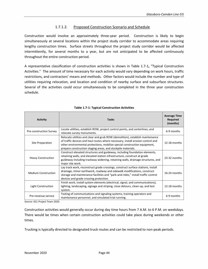
1.7.1.2. Proposed Construction Scenario and Schedule
Construction would involve an approximately three-year period. Construction is likely to begin
simultaneously at several locations within the project study corridor to accommodate areas requiring
lengthy construction times. Surface streets throughout the project study corridor would be affected
intermittently, for several months to a year, but are not anticipated to be affected continuously
throughout the entire construction period.
A representative classification of construction activities is shown in Table 1.7-1, “Typical Construction
Activities.” The amount of time necessary for each activity would vary depending on work hours, traffic
restrictions, and contractors’ means and methods. Other factors would include the number and type of
utilities requiring relocation, and location and condition of nearby surface and subsurface structures.
Several of the activities could occur simultaneously to be completed in the three year construction
schedule.
Table 1.7-1: Typical Construction Activities
Activity Tasks Average Time
Required (months)
Pre-construction Survey Locate utilities; establish ROW, project control points, and centerlines; and relocate survey monuments.
6-9 months
Site Preparation
Relocate utilities and clear and grub ROW (demolition), establish maintenance of traffic devices and haul routes where necessary, install erosion control and other environmental protections, mobilize special construction equipment, prepare construction staging areas, and stockpile materials.
12-18 months
Heavy Construction
Construct elevated structures and guideway, including foundation elements, retaining walls, and elevated station infrastructure; construct at grade guideway including trackway widening, retaining walls, drainage structures, and major site work.
23-32 months
Medium Construction
Lay track work, reconstruct grade crossings, construct surface stations, install drainage, minor earthwork, roadway and sidewalk modifications, construct storage and maintenance facilities and “park-and-rides,” install traffic control devices and grade crossing protection.
16-24 months
Light Construction Finish work, install system elements (electrical, signal, and communications), lighting, landscaping, signage and striping, close detours, clean-up, and test system.
12-18 months
Pre-revenue service Testing of communications and signaling systems, training operators and maintenance personnel, and simulated trial running.
6-9 months
Source: GCL Project Team 2020.
Construction activities would generally occur during day time hours from 7 A.M. to 6 P.M. on weekdays.
There would be times when certain construction activities could take place during weekends or other
times.
Trucking is typically directed to designated truck routes and can be restricted to non-peak periods.
Glassboro-Camden Line EIS
November 2020 Page 45
1.7.2. Overview of Construction Methods and Activities
The contractor(s) responsible for the construction of the GCL would likely organize the work around two
main issues: similar types of work, and interfacing with active freight operations within the Conrail ROW.
As contractors have done in the past on both the River LINE and Hudson Bergen Light Rail Transit System,
the alignment can be divided into work areas based on similarity of work as well as any potential work
restrictions due to freight operations or other considerations.
Further breakdown within similar type work areas may be done as well to help with scheduling flexibility
and logistics. For instance, in areas where daily freight movements occur, the new track would be
constructed first with appropriate barriers in place to facilitate safe construction while freight passes on
the existing track. If an unforeseen problem occurs, such as a delay in delivery of specialized material like
switches, the contractor can simply move its forces to a different portion of project with similar type work,
thereby mitigating potential delays.
Work area superintendents can concentrate on their work areas’ unique characteristics. Work areas could
be broken down as follows:
• Outside of Conrail fouling distance (“fouling” refers to work being done within four feet of existing rail)/ROW Camden area
o Embedded track in Camden STA 592+62.87 to STA 612+19.57, from WRTC to just east of Haddon Avenue in Camden.
o Aerial Structure from STA 612+19.57 to STA 641+50, from Haddon Avenue to the abutment just south of Pine Street, including Cooper Hospital Station.
o Embankment structure and abutments STA 641+50 to STA 650+50.
o Aerial Structure from STA 650+50 to STA 663+00 just south of Kaighn Avenue.
o Embankment structure and abutments STA 663+00 to STA 685+00 just before a new bridge over Conrail tracks.
• Within Conrail fouling distance/within the railroad ROW
o At grade track structure from STA 685+00 in Camden to STA 1055+00 just south of the railroad wye in Woodbury.
o Embankment structure and abutments STA 685+00 to STA 741+00, Newton Creek, including South Camden Station.
o At grade track work and bridges from STA 741+00 to STA 1055+00 just south of the Woodbury wye. To expedite the schedule and provide flexibility the contractor(s) may divide the Conrail ROW area here.
o At-grade track work from STA 1055+00 to STA 1530+00 just past University Boulevard.
• Outside of Conrail fouling distance/ROW Glassboro area
o At grade track work from STA 1053+00 to STA 1578+40 at Glassboro Station and the track leading to the Glassboro VMF.
o Glassboro VMF.
Glassboro-Camden Line EIS
November 2020 Page 46
o Woodbury Heights VMF (service and inspection, and ROW equipment).
o All station parking lots and access outside of Conrail fouling limits.
1.7.2.1. Construction Staging Areas
Construction staging areas, or “laydown areas,” are sites that are used for the storage and staging of
materials and equipment, and other construction-related activities. Work zones are those areas where
the construction is occurring. Field offices for contractors and construction managers could be situated
in temporary job site trailers at staging areas or within existing office space near the work areas.
Staging areas are typically fenced and lit for security. Staging areas of adequate size and proximity to the
alignment are essential to minimize construction traffic through the project study corridor and to provide
adequate space and access for construction activities. The size of construction staging areas would vary
depending on the intensity and type of construction activities being supported by the staging area.
Where feasible, land area needs and impacts would be minimized by locating staging areas on sites
designated for permanent non-transitway elements of construction. In other cases, temporary
construction easements on public or private property would be required. To the extent possible, staging
areas would be located to provide direct access to the construction area to reduce the need for additional
movements of material and equipment.
As design advances, construction staging plans will be prepared and more specific staging and laydown
areas could be identified. Staging areas would be selected to avoid the disruption of adjacent land uses
and impacts to environmental resources. It is common for the construction contractors to obtain
additional staging sites to facilitate their construction approach. If contractor(s) choose to obtain and use
additional staging areas, they would be required to obtain the necessary permits and approvals from
applicable Federal, State, and local regulatory agencies, and to comply with the commitments for
minimizing and mitigating construction impacts as described in this Environmental Impact Statement
(EIS).
1.7.2.2. Utility Relocations
Utilities affected by project construction typically include water, sewer, gas, electric, telephone, cable
television, and fiber optic. As such, where these utilities affect construction activities, relocation or
protection would be required. As the design progresses, these impacts would be identified, and
engineering solutions developed.
Temporary interruptions in utility services could be experienced during relocation or re-routing of utilities.
To minimize scheduling conflicts and coordination issues during construction, it is anticipated that
numerous utility relocations could occur prior to the start of major construction activities as standalone
early action projects.
Glassboro-Camden Line EIS
November 2020 Page 47
The proposed GCL also includes the relocation and/or protection of a natural gas transmission pipeline in
Gloucester City and Camden, as well as fiber optic transmission lines along several sections of the rail
ROW. Due to the complexity of moving such utilities, these could be early action items and could be
coordinated and relocations started with the respective utility companies prior to the start of construction
of the GCL.
1.7.2.3. At-grade Configuration
An at-grade configuration would position the proposed GCL tracks at the same level as, and adjacent to,
the Conrail freight tracks with sufficient horizontal separation. Potential construction sequencing to
minimize disruptions to freight operations is outlined in Section 1.7.2.10, “General Construction
Sequencing.” Construction would include widening of the rail bed including earth fill or cut as well as the
installation of low retaining walls where necessary, modifying the drainage system, and reconstructing
the at-grade crossings. The majority of the construction of the at-grade sections would take place within
the existing and active rail ROW of the proposed GCL corridor. The Highway Rail at-grade crossings to be
reconstructed are identified in Attachment 5, “Traffic Analysis Technical Report.” Construction of the at-
grade configurations would involve temporary lane closures and in some cases traffic detours. These
would be coordinated with local municipalities and follow the NJDOT Diagnostic Teams Recommendations
and Orders.
1.7.2.4. Retained Fill Configuration
Construction of the retained fill portions of the GCL could coincide with or follow construction of grade-
separated sections, such as bridges and elevated viaduct structures, depending on the contractor’s
schedule. In a retained fill area, the location of the proposed alignment would be elevated above the
existing ground on fill material.
Construction of the retained fill areas would begin with excavation for retaining wall footings, which would
typically be performed using excavators and backhoes. Piles may be required depending upon soil
conditions and design requirements. Piles would be installed using either conventional pile drivers or
vibratory pile driving equipment. Retaining walls – typically mechanically stabilized earth (MSE) walls –
would subsequently be constructed. An earth embankment would form a part of the structure. Both
driven and hand-operated compacting equipment would be necessary for the backfilling operations.
1.7.2.5. Grade-Separated Configuration
Construction would include elevated viaduct segments and bridges vertically separating the alignment
over roadways, freight tracks, and water ways.
Construction of elevated viaduct elements would be similar to new bridge construction projects with
foundation elements and piers constructed first, followed by placement of the girders that support the
track. Temporary lane and road closures, if needed, would be utilized to accommodate construction
Glassboro-Camden Line EIS
November 2020 Page 48
sequencing. Temporary road closures could occur during nighttime hours to minimize traffic disruptions,
where practical. Temporary roadway widening may be needed to accommodate construction operations
and maintenance of traffic.
Grade-separated configurations would require the construction of foundation systems, which would
require excavation by means of excavators and backhoes. In addition, drill rigs and/or pile driving
equipment would be used to install various foundation elements. Cranes, track-mounted and/or truck
mounted, would subsequently be used to erect superstructure components, such as girders. Additional
all-terrain cranes would be used when installing other various bridge components.
Grade separations of bridges over waterways could include barges for work equipment to work from or
to float in sections of the bridge once the piers are constructed.
1.7.2.6. Track Work Installation
The proposed GCL would include the construction of new GCL track, as well as the replacement/relocation
of existing Conrail freight track to expand the distance between track centers. Proposed GCL and freight
track construction would include the installation of sub ballast, ballast, ties and rails, track switches, and
crossovers. These items would be placed in construction staging areas or along the trackway throughout
the corridor to minimize haul distances and facilitate construction.
1.7.2.7. Stations
The GCL would include the construction of 14 stations. The proposed GCL includes three stations with
center platforms between GCL tracks, three stations with single platforms adjacent the GCL track, and
eight stations with two side platforms located on either side of the GCL track(s). These station
configurations are described in Section 1.4.3.3, “Station Platforms.”
Construction of the at-grade stations involves excavation, placement of cast-in-place and/or pre-cast
concrete elements for the platforms, ramps, and stairs, installation of canopies, railings, lighting, seating,
signage, ticket vending equipment, etc.
1.7.2.8. Parking Facilities
Parking facilities would be constructed at six stations as a part of the proposed GCL: South Camden,
Gloucester City, Crown Point Road, Woodbury Heights, Mantua Boulevard, and Mantua-Pitman stations.
Construction of surface parking facilities would involve clearing of vegetation, as well as demolition and
removal of existing structures, as necessary. Utility relocation, grading, drainage system installation and
paving would follow. Installation of concrete curbs, lighting, driveways, sidewalks, erosion and sediment
control measures, stormwater management, and landscaping would be undertaken as necessary.
Glassboro-Camden Line EIS
November 2020 Page 49
1.7.2.9. Vehicle Maintenance Facilities
The GCL proposes the construction of two VMFs located in Woodbury Heights Borough and Glassboro
Borough. Construction for the VMFs would include site clearing, demolition and removal of existing
structures, as necessary, installation of underground utilities and drainage system, the construction of the
facility buildings, installation of track work and systems elements, paving and other site work (e.g.
sidewalks, lighting, landscaping).
1.7.2.10. General Construction Sequencing
This section outlines the general sequencing of construction that could be utilized by the contractor(s).
The contractor(s) would likely use the station parking areas as laydown and staging areas outside of
Camden itself. Camden City would present some staging challenges for the contractor, however, as was
the case during the construction of the NJ TRANSIT River LINE, it is anticipated that the contractor(s) would
be able to find sufficient laydown and staging areas nearby to support the construction.
• Work Outside the Conrail fouling distance in the Camden area.
o Embedded track – To minimize impacts to the River LINE and local roadways, the new third track between South Broadway and Federal Street would be constructed first as plans for a light rail bus bridge are put in place. After the bus bridge between Pennsauken and the Tweeter center is in place, the work on the reconfigured River LINE tracks can begin. With this work is the partial demolition and reconfiguration of the WRTC. The crossing of Haddon Avenue would be done during this time as well.
o Aerial Structure – The contractor(s) would need to submit Site Specific Work Plans (SSWPs) to PATCO to begin construction of the elevated viaduct over or next to PATCO tracks. The construction sequencing would likely be typical: foundations and columns, then structural beams or precast decks. Once the deck is in place, the contractor would survey the structure in order to set and pour the rail plinths. Cooper Hospital Station construction would be integrated into the first viaduct structure. The second viaduct structure, beginning near Walnut Street, would follow the same construction sequencing. Depending on the schedule both viaducts could be constructed at the same time, if need be, using multiple crews.
o Embankment Structure – Foundation work and bridge abutments could start in multiple locations and the earthen fill would follow. The bridge work, beams and decking etc. would likely be accomplished by another crew that could go from bridge to bridge installing the structural elements. Once the earthen work and bridge decks are in place, the contractor can start the track bed installation consisting of sub ballast, ballast, then ties and rail. Rail systems duct banks would be installed at this time as well.
• Work generally within the Conrail fouling limits from Camden to Glassboro.
o Although the work in the rail ROW between Camden and Glassboro is similar, it could be broken into two areas by the contractor to facilitate planning and scheduling.
o The contractor(s) would need to coordinate the work activities with Conrail to confirm that no adverse impacts to freight operations occur. Where required, Conrail would
Glassboro-Camden Line EIS
November 2020 Page 50
provide flag protection. Minimizing the need for flag protection can be a key strategy for the contractor(s) to complete the work with having to depend on the availability of Conrail personnel. By minimizing flag protection, the impact to freight operations and the contractor’s work flow would be minimized. To do this effectively, the contractor(s) must submit SSWPs and get Conrail’s approval. One work procedure that has been used effectively in the past is to erect barriers between the work zone(s) and the active freight track. This keeps the work zone clearly delineated and separate from freight operations.
o In this section of the alignment, the contractor(s) would need to create work areas clear of impediments. For example, they would have to relocate utilities, such as the gas line, out of the ROW and into adjacent street (Railroad Avenue). Work could then begin on the new GCL tracks. This work could be done behind appropriate barriers, subject to Conrail approval, that would minimize the required Conrail flag protection and not be interrupted by freight operations. Once the new track(s) are in place, a cutover would be made to move the existing freight operations from the current track to the new track. After that cutover the previously used freight track would be reconstructed to the GCL alignment and standards. The length of each track section to be cut over would be dependent on location of switches (temporary or permanent), the contractor’s schedule, and Conrail approval. Several cut overs could be made during the course of construction. Once a portion of the Conrail track is reconfigured, the freight can be moved back onto that track.
o Bridges – Undergrade bridges over roadways and water ways, such as Newton Creek, would be upgraded by first constructing the new structure ready to receive track. The contractor(s) would then bring the at-grade or embankment work up to the new bridge structures and then install large section of new track. Integrating completion of bridge work into the cutover schedule would be required.
o Stations – Stations, parking lots, and station access can be constructed independently of, and concurrently with, the main track work. The platform locations need to be coordinated with the track alignment to confirm proper platform edge clearance. With appropriate barriers in place, subject to Conrail approval, much of this work could be done while minimizing the need for flag protection. Station parking lots make excellent laydown and staging areas for the contractor to use.
o Woodbury Heights Vehicle Maintenance Facility – Similar to stations, this location can be constructed independently of the main track work and is a prime location for contractor staging.
• Work Outside the Conrail fouling distance in the Glassboro area.
o This work is primarily at-grade track and facility work. In this area, the contractor(s) would have a great deal of flexibility to plan the work without having to plan around freight operations. The only point would be when the new tracks to the Glassboro VMF and Glassboro Station are tied into the existing railroad ROW.
o The VMF would likely be a special focus for the contractor(s). Not only would the facility have multiple long lead equipment items to plan for, like a potential wheel trueing machine, but the new light rail vehicles would need the facility to undergo testing and commissioning. That activity is very likely to be on the projects critical path.
Glassboro-Camden Line EIS
November 2020 Page 51
Because of the linear nature of the construction that affects multiple communities, the contractor should
have a way to communicate construction updates as well as identify areas and dates of restricted access
or road closures.
1.7.2.11. Testing and Commissioning
As each segment of new track is installed, duct banks and manholes for communications, signals, and
supervisory control and data acquisition (SCADA) are likely to be installed. Testing of individual systems
components can begin as soon as they are installed, however for efficiency the contractor may wait until
a certain number of components are installed so that a testing team can go from one installation to the
next smoothly. Components to be tested include grade crossing equipment in both the rail ROW and in
the Camden street running section, train signal systems (which will require coordination with Conrail and
the FRA), station communications, and general SCADA.
During this time, the VMF and Operations Center would be getting fitted out and their systems tested. All
SCADA information would be transmitted to the Operations Center to display for dispatchers and
managers. Training of operations personnel would also begin during this phase.
After the individual systems have been tested, commissioning can begin. Light rail vehicles would operate
over the GCL rail system to, among other things, run the rust off the rail, test the rail to vehicle signal
interfaces, test transmission of SCADA to the operations center, and train engineers. Coordination and
approval from Conrail and the FRA would be required to run these commissioning tests. The light rail
revenue service operating schedule would then be run to prove out the end to end run times, meets, and
station stop dwell times. If any issues are encountered, they can be corrected prior to the start of revenue
service operations. Revenue service can begin once the GCL has satisfactorily completed the Safety
Certification process, and approval obtained approval from NJDOT and NJ TRANSIT.
1.8. AVAILABILITY OF INFRASTRUCTURE FOR PUBLIC SEWERAGE, WATER, ROADS, AND UTILITIES
Assessment of existing infrastructure for public sewerage, water, roads, and utilities would be incorporated in the preparation phase prior to construction through development of construction documents and procurement of environmental and construction permits. Overall, the proposed GCL would require minimum draw on local utilities, and have a negligible impact on roadway, sewer and water resources. Station sites and park-and-ride facilities would not include restrooms or enclosed heated areas. As a result, the 14 proposed new stations would require electricity for lighting, water for periodic cleaning, and communication lines for emergency phone services and security monitoring.
The Glassboro and Woodbury Heights VMF facilities would require water, sewer, electricity, and gas service. Water and sewer service would be provided by the Borough of Glassboro and the Borough of Woodbury Heights for the Glassboro VMF and Woodbury Heights VMF, respectively. Electricity and gas would be provided to the VMFs by PSE&G and Atlantic City Electric, respectively.
Glassboro-Camden Line EIS
November 2020 Page 52
1.9. LICENSES, PERMITS, AND CERTIFICATIONS
As detailed in Table 1.9-1, “NJDEP Permits and Approvals,” and described below, the proposed project would require permits from New Jersey Department of Environmental Protection (NJDEP) Division of Land Resource Protection, NJDEP Division of Parks and Forestry, the Bureau of Water Allocation, the Bureau of Surface Water, and the Bureau of Non-Point Pollution Control. The specific permits and approvals that would be required by the proposed GCL are described herein.
Table 1.9-1: NJDEP Permits and Approvals
NJDEP Division Permit/Approval
Division of Land Resource Protection
Individual Freshwater Wetlands Permit
Section 401 Water Quality Certificate
Flood Hazard Area Permit
Waterfront Development Permit
Stormwater Management Plan Review and Approval
Tidelands conveyance
Division of Land Resource Protection - Endangered & Threatened Species Unit
Scientific Collecting Permit
Division of Parks and Forestry Reforestation Plan Approval
Bureau of Water Allocation Well Permit
Bureau of Surface Water*
Short Term De Minimis NJPDES Discharge to Surface Water Permit
General Remediation Cleanup Permit
Bureau of Non-Point Pollution Control General Permit for Construction Activities (5G3)
Note: * Only one of the two permits associated with the Bureau of Surface Water would potentially be required, depending on whether the surface water discharge contains pollutants at levels exceeding applicable standards.
Source: GCL Project Team 2020
As over one acre of wetland impacts are anticipated, a NJDEP Individual Freshwater Wetlands Permit would be required to address impacts and compensatory mitigation requirements for wetlands and wetland transition areas, including protection of threatened and endangered species habitat in accordance with the New Jersey Freshwater Wetlands Protection Act. A Section 401 Water Quality Certificate would be issued in conjunction with the NJDEP Individual Freshwater Wetlands Permit.
Portions of the proposed GCL alignment would be located within floodplains and riparian zones; therefore, a NJDEP Flood Hazard Area Permit would be required to address impacts and compensatory mitigation requirements to riparian zones, including protection of threatened and endangered species habitat under the New Jersey Flood Hazard Control Act. Additionally, a NJDEP Waterfront Development Permit is mandated for activities within tidally-influenced waters and, as such, would be required to address impacts to applicable coastal zone policies, including protection of Special Areas such as threatened and endangered species habitat in accordance with the New Jersey Coastal Zone Management Rules.
As the proposed GCL would contain over a quarter acre of impervious surfaces, a NJDEP Stormwater Management Plan Review and Approval would be required for the protection of water quality and flood control in accordance with the New Jersey Stormwater Management Rules. The proposed GCL would also involve permanent use of tidal waters not previously conveyed, therefore necessitating tidelands conveyance.
Glassboro-Camden Line EIS
November 2020 Page 53
The proposed GCL would likely require additional survey work for rare mussel species as part of preliminary engineering to develop an Impact Avoidance Plan. This survey work would require Scientific Collecting Permit issued by NJDEP.
A NJDEP Reforestation Plan Approval would be required to allow for the replacement of forest in accordance with the New Jersey No Net Loss Compensatory Reforestation Act as tree removal on State owned or maintained lands would exceed a half acre.
Any dewatering wells or dewatering well points which are 25 feet or more in total depth or are six inches or more in borehole diameter that may be required by the proposed GCL would require a Well Permit issued by the Bureau of Water Allocation and Well Permitting.
New Jersey Pollutant Discharge Elimination System (NJPDES) Discharge to Surface Water permit would be required for any surface water discharge during construction. Either the Short Term De Minimis NJPDES Discharge to Surface Water Permit or General Remediation Cleanup Permit would be pursued depending on eligibility as described in Section 1.9.1.6, “Bureau of Source Water Permitting.”
As the construction of the proposed GCL would disturb more than one acre of land, a General Permit for Construction Activities from the Bureau of Non-Point Pollution Control would also be obtained prior to construction.
The GCL Project Team has been in coordination with the following NJDEP departments/bureaus throughout the development of the proposed project:
• Office of Permit Coordination and Environmental Review
• Division of Land Resource Protection (formerly Land Use Regulation)
• Historic Preservation Office
• Office of Natural Lands Management
• Division of Fish & Wildlife
• Division of Air Quality
• Division of Parks and Forestry
• Green Acres Program
In addition to NJDEP, the proposed project is also subject to U.S. Army Corp of Engineers (USACE) review. All relevant permits, approvals, and agency reviews would be obtained following the completion of this EIS.
1.9.1. NJDEP Preliminary Review
As part of initial and ongoing coordination between the GCL Project Team and NJDEP, the technical reports detailing the analyses, methodologies, impact determination, and proposed mitigations supporting this EIS were provided to NJDEP for comment. Based on the comments received from the preliminary review of the materials presented herein, the GCL Project Team acknowledges that the proposed GCL would be subject to the requirements identified below and that the actions and continued coordination summarized in this section would be required prior to and/or concurrent with the construction of the proposed project.
Glassboro-Camden Line EIS
November 2020 Page 54
1.9.1.1. Division of Land Resource Protection
Approvals from the NJDEP Division of Land Resource Protection would be required for any future activities that would result in disturbances to flood hazard areas, riparian zones, freshwater wetlands and/or transition areas, tidal waterways, or upland waterfront development areas.
1.9.1.2. Division of Land Resource Protection – Endangered and Threatened Species Unit
Survey work and the composition of an Impact Avoidance Plan is likely to be required for rare mussel species within Newton Creek, Big Timber Creek, and Little Timber Creek. Survey work for freshwater mussels would be conducted seasonally, from May 1st through September 15th, and no survey activity would commence until the proposal survey protocol is reviewed and approved by NJDEP in writing. A valid Scientific Collecting Permit, issued by NJDEP, would be required to conduct survey work.
1.9.1.3. Division of Parks and Forestry
A NJDEP Reforestation Plan Approval would be required to allow for the replacement of forest in accordance with the New Jersey No Net Loss Compensatory Reforestation Act as tree removal on State owned or maintained lands would exceed a half acre.
1.9.1.4. Division of Fish & Wildlife (NJDFW)
Regarding additional species identified in the June 19, 2020 NJDEP response, Attachment 1, “Natural Resources Technical Report,” noted the following related to the Eastern Pond Mussel and the Tidewater Mucket identified in Section 4.5.2.3, “Freshwater Mussels.”
Eastern Pond Mussel (Ligumia nasuta)
State Status: Threatened
Status in Natural Resources Study Area: Eastern Pond Mussels are found in the Cooper River, and an unnamed tributary to the Delaware River located approximately 1.5 miles south west of Big Timber Creek. These waterbodies occur to the north and west of the natural resources study area.
Tidewater Mucket (Leptodea ochracea)
State Status: Threatened
Status in the Natural Resources Study Area: The Tidewater Mucket has been observed in the Delaware River and the Cooper River. These water bodies are located north and west of the natural resources study area.
This data was obtained through previous coordination with NJDEP Fish & Wildlife starting in 2014. If either species is identified in the Creeks listed, additional minimization measures would be evaluated during preliminary design. If it is determined that there are sightings within the project waterways, Section 4.7.5.4, “Riparian Zones,” of Attachment 1, “Natural Resources Technical Report,” would be revised.
Within Section 4.7.5.2, “Submerged Vegetation Habitat,” of Attachment 1, “Natural Resources Technical Report,” Wild Celery has been added as a Species of Special Concern and its habitat noted. Wild Celery grows in fresh non-tidal and fresh to slightly brackish tidal waters around the world, usually in areas where
Glassboro-Camden Line EIS
November 2020 Page 55
the water is 2.75 to six feet deep. Wild celery prefers coarse soil that is silty or sandy, is more tolerant of murky, nutrient-rich waters, and withstands waves better than other bay grasses.
Within Section 4.6, “Species of Special Concern,” of Attachment 1, “Natural Resources Technical Report,” the Little Brown Bat and Tricolored Bat has been added to Table 8, “Species of Special Concern.” Measures to reduce impacts to bat habitat will be implemented as part of preliminary engineering.
Coordination with NJDFW would be required to determine measures to limit or avoid impacts to all species within the project area that are under their purview.
1.9.1.5. Bureau of Water Allocation and Well Permitting
Permits and approvals may be required for construction-related dewatering activities from the Well Permitting and Water Allocation Permitting sections in the Bureau of Water Allocation and Well Permitting. An approved Well Permit would be required for dewatering wells or dewatering well points which are 25 feet or more in total depth or are six inches or more in borehole diameter. All drilling activity would be performed and completed by a New Jersey licensed well driller of the proper class. If construction-related water use (including horizontal directional drilling, well, and/or trench dewatering) would be required at rates exceeding 70 gallons per minute pumping capacity from a single source or combination of sources in the same municipality, then that activity would be regulated. Any necessary approvals would be sought prior to construction with information gained during preliminary engineering.
1.9.1.6. Bureau of Surface Water Permitting
A New Jersey Pollutant Discharge Elimination System (NJPDES) Discharge to Surface Water permit would be required for any surface water discharge during construction (i.e., dewatering; pipe integrity testing, etc.). If the discharge does not contain pollutants at levels exceeding applicable standards, the Transcontinental Gas Pipeline Company (Transco) may be eligible for a B7 - Short Term De Minimis NJPDES discharge to surface water permit. Eligibility is determined by running a pollutant scan in which the data can be collected up to a year in advance of the discharge. However, if the discharge contains pollutants at levels exceeding applicable standards, Transco would be required to obtain a BGR – General Remediation Cleanup permit. Any necessary approvals would be sought prior to construction with information gained during preliminary engineering.
1.9.1.7. New Jersey Historic Preservation Office
As part of initial and ongoing correspondence between the GCL Project Team and the New Jersey Historic Preservation Office (NJ HPO), NJ HPO was provided the opportunity to comment on the proposed project beginning in 2010. NJ HPO and the GCL Project Team have agreed to the project’s area of potential effects (APE) and the list of properties to be surveyed. NJ HPO provided a cursory review of sample intensive level survey forms prepared by the GCL Project Team but will await the final submission of all the intensive level survey forms for formal review. In 2017, a review noted new project elements, including replacing the Red Bank Avenue bridge and a new bridge over Mantua Creek. NJ HPO has received various Phase I archaeological and architectural cultural resource surveys, but a full identification-level survey has not been completed to date while project elements continue to be modified in conceptual engineering designs. Once formal plans are submitted and all National Register of Historic Places-eligible and/or -listed historic and archaeological resources within the APE have been identified and impacts evaluated,
Glassboro-Camden Line EIS
November 2020 Page 56
NJ HPO will work with the applicant and lead permit, regulatory office, and/or Federal agency to avoid, minimize, and/or mitigate any adverse effects to historic properties.
1.9.1.8. Bureau of Mobile Sources
Heavy duty equipment used for construction would be required to adhere to No Idling regulations, including not idling for more than 15 minutes above 25 degrees Fahrenheit. Any and all light duty vehicles on the premises during construction would not idle for more than three minutes. Heavy duty equipment used for construction and demolition would be required to minimize idling whenever possible. As air emissions from construction would be insignificant, all medium- and heavy-duty equipment used for construction would be required to meet the EPA Tier 4 non-road emission standards and would use Ultra Low Sulfur Diesel (ULSD) fluid when applicable.
1.9.1.9. Green Acres Program
Impacts to 11 parkland resources encumbered by Green Acres and located along the GCL corridor would result from temporary construction activities and/or from the permanent operation of the proposed GCL. NJDEP can pursue the temporary impacts administratively; any permanent impacts (via fee or easement conveyance) would constitute a diversion/disposal of parkland requiring prior Green Acres review and NJDEP Commissioner and State House Commission approval.
Coordination with Green Acres would be required to determine measures to limit or avoid impacts to Green Acres encumbered properties or, if necessary, to discuss initiating the diversion/disposal application process with the local unit.
1.9.1.10. Office of Natural Lands Management
A comprehensive survey to locate the previously identified shingle oaks—as well as the potential presence of other shingle oaks within the Wenonah Ravine Natural Heritage Priority Site—will be conducted prior to permitting activities, within the approved survey window. Coordination with the Office of Natural Lands Management (ONLM) would be required to determine measures to limit or avoid impacts to the shingle oaks.
1.9.1.11. Bureau of Non-Point Pollution Control
As the proposed GCL would disturb more than one acre of land, a Construction Activity Stormwater General Permit would be obtained prior to construction in order to minimize pollutant discharge to surface waters from construction activities.


![Camden journal (Camden, S.C.).(Camden, S.C.) 1852-08-27 [p ].j \ * t - "V* J',. r * I i CAMD U. 1; VOLUME3. CAMDEN,SOUTH-CAROLINA,AUGUST^1852. ' NUMBER69. THE CAMDEN JOURNAL. published](https://static.fdocuments.in/doc/165x107/5fa2071a08dcde766c594b2a/camden-journal-camden-sccamden-sc-1852-08-27-p-j-t-v.jpg)