
1 National Urban Search & Rescue Response System Planning Team Training The following power point...
68
1 National Urban Search & Rescue Response System Planning Team Training The following power point training presentations must be viewed at unit training and/or under the supervision of an OSRT Officer. Members viewing the presentations must sign a OSRT sign in sheet. The completed sign in sheet must be submitted to the OSRT Planning (Training) Section to receive credit for the training.
-
Upload
andrew-ross -
Category
Documents
-
view
213 -
download
0
Transcript of 1 National Urban Search & Rescue Response System Planning Team Training The following power point...
1
National Urban Search & Rescue Response System
Planning Team Training
The following power point trainingpresentations must be viewed at unit training and/or under the supervision of an OSRT Officer.
Members viewing the presentations must sign a OSRT sign in sheet. The completed sign in sheet must be submitted to the OSRT Planning (Training) Section to receive credit for the training.
2
National Urban Search & Rescue Response System
Planning Team Training
US & R CATF-5 GPS Awareness Training

3
National Urban Search & Rescue Response System
Planning Team Training
Enabling Objectives
Identify the basic components of the GPS system
Identify benefits to Task Force

4
National Urban Search & Rescue Response System
Planning Team Training
This program will cover…
Components GPS/NAVSTAR
Features and operation of the GPS unit
Benefits to the Task Force
Using a GPS unit in US&R Operations

5
National Urban Search & Rescue Response System
Planning Team Training
Basic Components of GPS GPS Receiver handheld
device used to communicate with satellites to track position on earth.
Computer mapping software is used to produce maps with detail downloaded from GPS Receivers
GPS use with maps GPS use in the task force
setting

6
National Urban Search & Rescue Response System
Planning Team Training
Task Force Benefits
Better routing to and around mobilization site
More accurate mapping/documentation for TF Operations
Enhanced communications which enables pinpoint accurate location information
Limitations

7
National Urban Search & Rescue Response System
Planning Team Training
What is GPS?
Global Positioning System is a network of satellites that continually transmit coded information, which make It possible to identify positions on earth by measuring distance from satellites. Those positions are reported in coordinates. (i.e..Lat/Long,USNG,etc)

8
National Urban Search & Rescue Response System
Planning Team Training
Four Primary Functions
Provides a position and coordinates Can calculate distance and direction
between any two waypoints, or a position and a waypoint.
Provides travel progress reports, like est. time to waypoint.
Accurate time measurement

Control Segment• 5 control worldwide stations• Corrects orbit / time info
Space Segment• 24 satellites• Alt. of 12,000 mi• Radio signals
User Segment• The GPS• GPS User
Monitor Stations
GroundAntennas
Master Station
NAVSTAR: 3 Segments

10
National Urban Search & Rescue Response System
Planning Team Training
How Does GPS Work? Start up
Cold start up is when a unit is started for the first time in a new area or after a long time of no use. It will take longer for the unit to locate & identify satellites.Thus longer time to usable data.
This can be overcome by turning on the GPS receiver prior to use. This way it can get your general location and be usable in a shorter time frame. This is termed a warm start up.
If you are going to be using a GPS Unit, turn it on as soon as you can to allow for proper set up.

11
National Urban Search & Rescue Response System
Planning Team Training
How a ReceiverDetermines Its Position

Receiver is somewhere on this sphere
Signal from One Satellite

Signals from Two Satellites
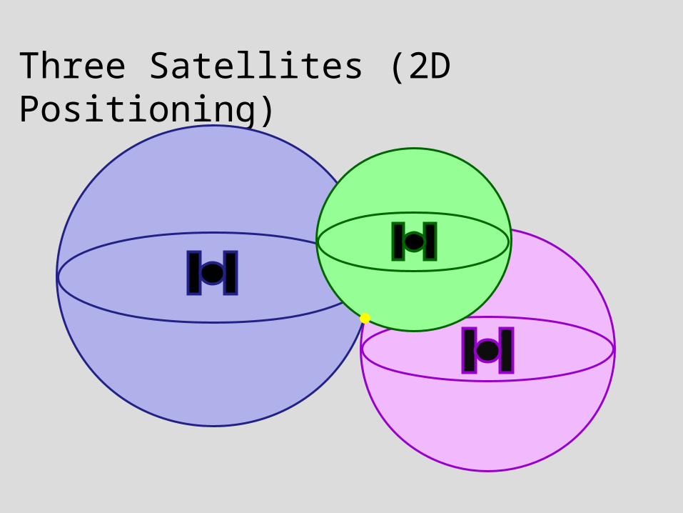
Three Satellites (2D Positioning)

Three Dimensional (3D) Positioning(Best)

16
National Urban Search & Rescue Response System
Planning Team Training
Selective Availability (S/A)
Department of Defense placed “dithered” satellite time message to prevent GPS from being used against us. This made the coordinates only accurate to a set area which the military could change as they needed. In May 2000, Pentagon set S/A to Zero meters error. S/A can be reactivated,by the military, at any time.

17
National Urban Search & Rescue Response System
Planning Team Training
Wide Area Augmentation System (WAAS) Ground based
correction signal Corrects GPS satellite
orbit and clock drift plus signal delays caused by atmosphere
If your GPS is WAAS enabled be sure to have it turned on in the set up
This will give an even more accurate location

18
National Urban Search & Rescue Response System
Planning Team Training
Wide Area Augmentation System (WAAS)
+ -3 m
+- 15 m
With Selective Availability set to zero, and under ideal conditions, a GPS receiver without WAAS can achieve 15-meter accuracy most of the time.*
Under ideal conditions, a WAAS equipped GPS receiver can achieve 3-meter accuracy 95% of the time.*
* Precision depends on good satellite geometry, open sky view, and no user-induced errors.

Sources of GPS ErrorsReceiver Errors are Cumulative!
Earth’s Atmosphere
Solid Structures
Metal Electro-magnetic Fields

20
National Urban Search & Rescue Response System
Planning Team Training
Sources of Errors
Reflections- signals can reflect off of buildings,rocks,metal objects
Electromagnetic fields (power lines etc) Buildings, while inside signal may be
blocked. Best to try and maintain clear view of the sky. The more obstacles to view sky the higher the
likelihood of errors.

21
National Urban Search & Rescue Response System
Planning Team Training
Minimizing User Errors
Keep GPS away from your body with antenna directed skyward for best reception
Always verify your GPS is set to correct DATUM and coordinate system( This is the biggest cause of errors)
Always verify you are receiving enough signals before making critical navigational decisions(at least three signals)

IdealSatelliteGeometry
N
S
W E

PoorSatelliteGeometry
N
S
W E

24
National Urban Search & Rescue Response System
Planning Team Training
Summary
Satellites have very low powerPoor to no reception in buildings or under cover
Be aware of interference and obstructions Cold versus warm start-up issues
Cold start is first time unit starts in area of operation must locate itself.(Takes longer)
Always keep extra batteries Try to obtain 3D (DGPS) positioning Keep a paper map as a backup

25
National Urban Search & Rescue Response System
Planning Team Training
Basic GPS Training
GPS UseProper initial setup
Basic features
Key functions and routines

The GPSmap Key Layout
POWER Key
IN/OUT Zoom Keys
FIND/MOB Key
MARK Key
QUIT Key
ROCKER Key
PAGE/COMPASS Key
MENU Key
ENTER Key

Power Considerations Two AA batteries, USB
cable, 12v DC adapter Battery Life: 18 hours Alkaline batteries lose
capacity in low temps Lithium batteries in below
freezing temperatures Extensive use of
backlighting, electronic compass, and audible tones significantly reduce battery life
Memory Card Location
Battery Compartment

28
National Urban Search & Rescue Response System
Planning Team Training
Power On the GPS
Press and hold the POWER key Title screen appears Satellite status page
Title Screen Satellite Status

Satellite Status Page Horizon
45 from the horizon
Heading bug – travel direction
Satellite signal strength
Searching / Acquiring
2D Fix (3 Satellites)
3D Fix (4+ Satellites)

30
National Urban Search & Rescue Response System
Planning Team Training
Main Pages Cycle through pages using PAGE or QUIT
Satellite Trip Map Compass Altimeter (CSx Model)
Main Menu

31
National Urban Search & Rescue Response System
Planning Team Training
2 X
Main Menu Press MENU button twice for Main Menu from
any Page

32
National Urban Search & Rescue Response System
Planning Team Training
GPSmap 60CSx
Searching / Acquiring
2D Fix (3 Satellites)
3D Fix (4+ Satellites)
Battery Power / Level
Auxiliary Power
Backlight Usage
USB Cable Connection
Electronic Compass On
Main Menu (continued)

Adjusting Screen Settings
To minimize battery drain, limit or turn off backlightPress and quickly release the
POWER button.
Press up on ROCKER to increase, down to decrease.
Press ENTER or QUIT to close Backlight adjustment window.

34
National Urban Search & Rescue Response System
Planning Team Training
System Setup Pages

35
National Urban Search & Rescue Response System
Planning Team Training
System Setup Page Press MENU twice for Main Menu,
select Setup, and press ENTER. Important Setup Menu pages
System Display Time Units Heading Calibration

36
National Urban Search & Rescue Response System
Planning Team Training
Setup: System GPS
Normal – for everyday use Demo – for indoor training
WAAS Enabled
Battery Type Alkaline NiMH
Proximity Alarms On

37
National Urban Search & Rescue Response System
Planning Team Training
Setup: Display Display Mode
Auto – Switch between Day and Night modes at sunrise and sunset
Backlight Timeout On continuous or timed. Setting
ignored if external power used.
Backlight Level Backlight setting will increase or
decrease battery life

38
National Urban Search & Rescue Response System
Planning Team Training
Setup: Time
Time FormatSet to 24-hour format
Time ZoneTime zone for the area of
operations
UTC OffsetChanges with Time Zone
Daylight Saving TimeSet to Auto

39
National Urban Search & Rescue Response System
Planning Team Training
Setup: Units Position Format (pick approriate
one) USNG – United States National Grid
(DHS Standard) MGRS – Military Grid Reference
System hdddºmm.mmm'
Map Datum WGS 84 NAD27 CONUS – USGS Maps

40
National Urban Search & Rescue Response System
Planning Team Training
Setup: Heading
North Reference – Specifies the type or north reference used to calculate your headingSet to “True”

41
National Urban Search & Rescue Response System
Planning Team Training
Waypoints

42
National Urban Search & Rescue Response System
Planning Team Training
Waypoints Waypoints are locations you record and
store in your GPS
Waypoints are created in 3 ways Press the MARK key while at a location.
Create a waypoint on the Map page.
Enter the coordinates for a waypoint manually.

43
National Urban Search & Rescue Response System
Planning Team Training
Waypoints: Available Map Symbols
GPSmap 60C Display

44
National Urban Search & Rescue Response System
Planning Team Training
Waypoints: Common Abbreviations PX – Picture (note
direction of photo) HAZ – Hazards H-1 – Helispot 1 Hosp – Hospital Str – Structure Sz – Safety Zone POA – Point of Arrival
POD – Point of Departure
BoO – Base of Operations
Fwd BoO – Forward Base of Operations
Stg – Staging
Utl – Utilities
Apt – Apartment
Air – Airport

Waypoints: Mark Current LocationQuickest way to mark a waypoint Press and hold the MARK key until the Mark
Waypoint page appears.
To accept the waypoint with the default information, highlight OK and press ENTER.
Icon Waypoint Name
CoordinateNotes

Waypoints: Mark a Location on Map Page On the Map page, use the ROCKER to move the
arrow to the location to mark as a waypoint. Press and quickly release the ENTER key to
capture location and open the information page. Highlight OK and press ENTER to save.
Map Pointer Mode
Original Location
New Location
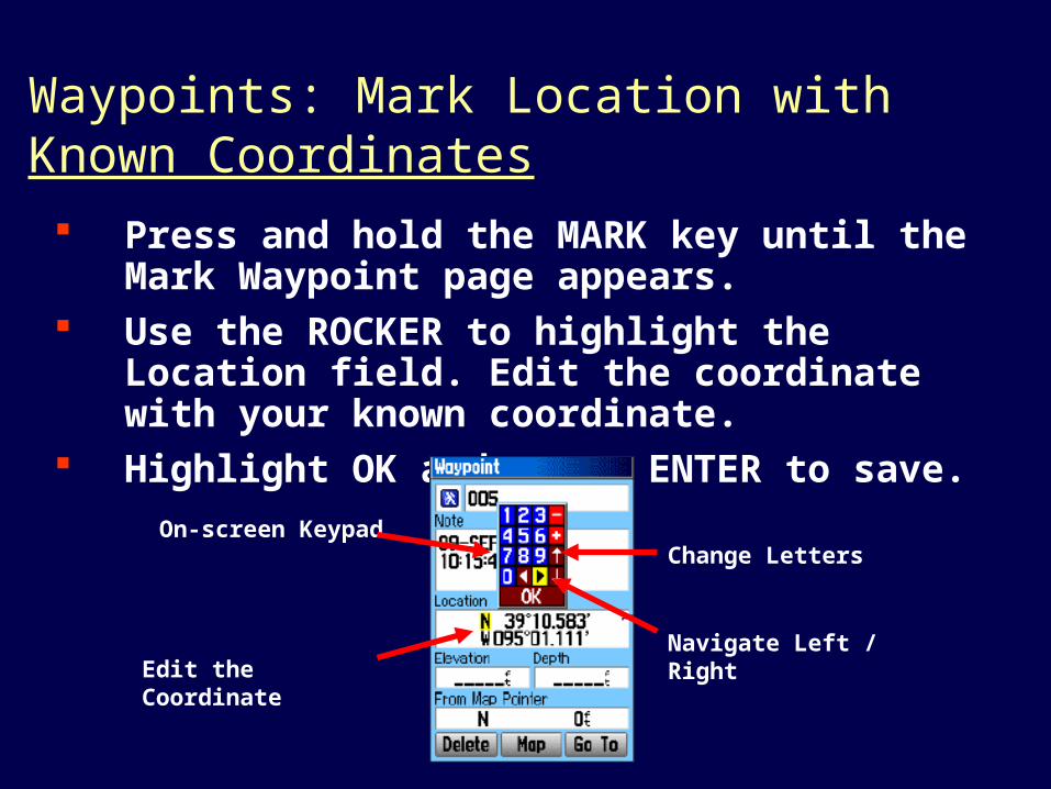
Waypoints: Mark Location with Known Coordinates Press and hold the MARK key until the Mark
Waypoint page appears. Use the ROCKER to highlight the Location field.
Edit the coordinate with your known coordinate. Highlight OK and press ENTER to save.
On-screen Keypad
Edit the Coordinate
Change Letters
Navigate Left / Right

48
National Urban Search & Rescue Response System
Planning Team Training
Working with waypoints
Use a note pad to note default waypoint number and detailed description.
When manually entering waypoints be sure Datum is the same in the GPS unit as the one you are inputting

49
National Urban Search & Rescue Response System
Planning Team Training
Tracks

50
National Urban Search & Rescue Response System
Planning Team Training
Track Log Creates an electronic
“breadcrumb” trail or track log while you travel
Each point in the track contains information on time, location, elevation and depth
51
National Urban Search & Rescue Response System
Planning Team Training
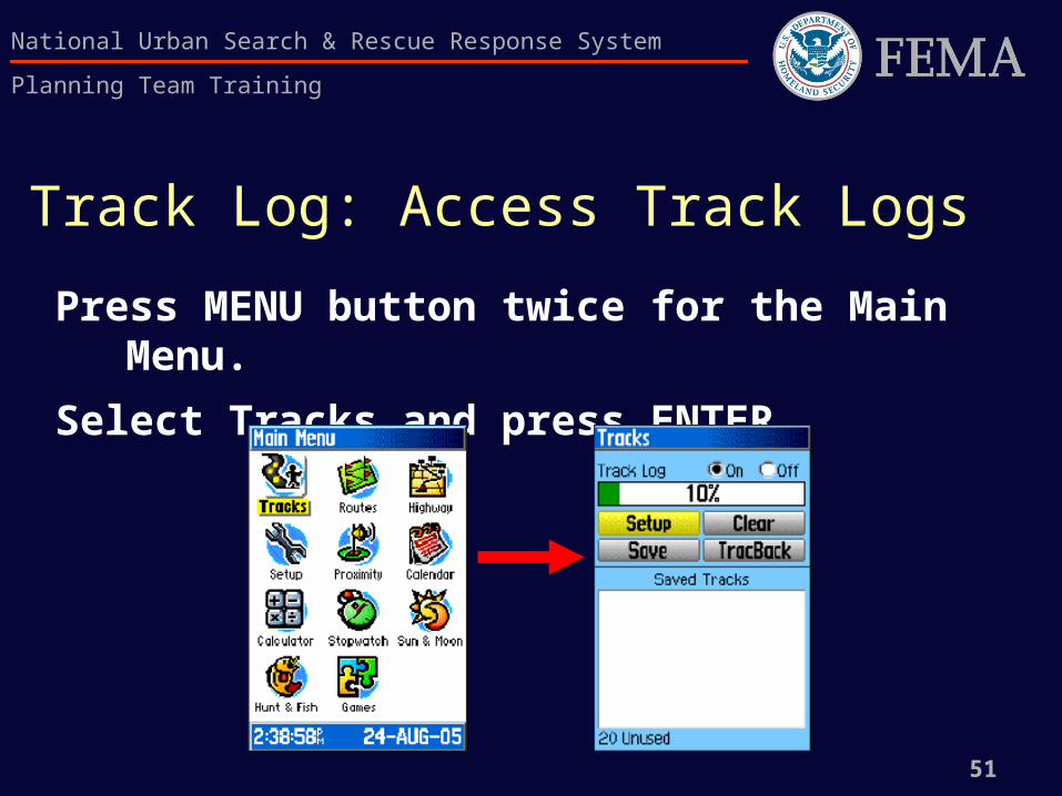
Track Log: Access Track Logs
Press MENU button twice for the Main Menu.
Select Tracks and press ENTER.

52
National Urban Search & Rescue Response System
Planning Team Training
Track Log: Access Tracks Logs (continued)
On/Off toggle
Percentage of memoryused
List of saved Tracks
Remaining availablelogs
53
National Urban Search & Rescue Response System
Planning Team Training
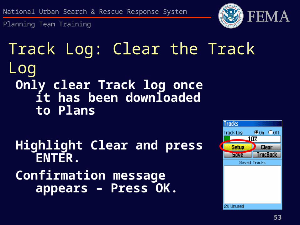
Track Log: Clear the Track Log
Only clear Track log once it has been downloaded to Plans
Highlight Clear and press ENTER.
Confirmation message appears – Press OK.

Track Log: Set Up a Track Log
Highlight Setup and press ENTER to open the Track Log Setup page.
Data Card Option
55
National Urban Search & Rescue Response System
Planning Team Training
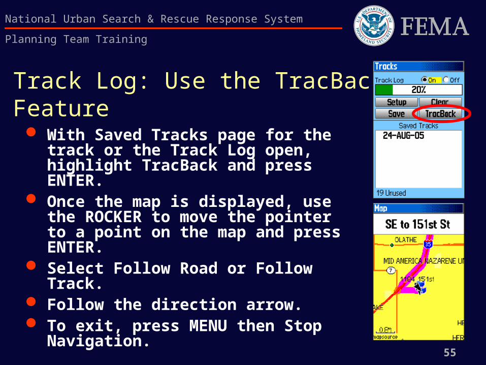
Track Log: Use the TracBack Feature With Saved Tracks page for the
track or the Track Log open, highlight TracBack and press ENTER.
Once the map is displayed, use the ROCKER to move the pointer to a point on the map and press ENTER.
Select Follow Road or Follow Track. Follow the direction arrow. To exit, press MENU then Stop
Navigation.

56
National Urban Search & Rescue Response System
Planning Team Training
Introduction to the US National Grid (USNG)
Nationally consistent map and grid system.
Provides a seamless reference system across judicial boundaries and map scales
It is a plane coordinates system that is simple enough to be taught and used at a fifth grade level
Developed from the military UTM system

57
National Urban Search & Rescue Response System
Planning Team Training
U.S. National Grid (USNG)History WW I- military determines grid systems are
good and everyone develops there own
WW II-Too many different grids systems.Need to develop one common grid system
1945 - 1949: US and British armies develop and implement UTM and Military Grid Reference System (MGRS).Great success story; Used in combat ever since.

58
National Urban Search & Rescue Response System
Planning Team Training
U.S. National Grid (USNG)History cont
Mid - 1990’s: No standard civilian grid equiv. GPS arrives. USNG developed by the FGDC. MGRS could be used as a model no need to reinvent the grid system.
All things seem to transfer fine except for issue with NAD27 US
USNG/NAD83 is equal to MGRS/NAD83 BUT… USNG/NAD27 is not equal to MGRS/NAD27 WGS84 is the international version on NAD83 thus are
interchangeable.

59
National Urban Search & Rescue Response System
Planning Team Training
U.S. National GridDatum use
The Standard Datum for USNG is NAD83 and should be used unless unable to use. NAD83 coordinates shall be designated 18SUJ23480647 NAD27 coordinates shall be designated
18SUJ23480647(NAD 27) When using NAD83 there is no need to report NAD83 when
reporting coordinates When using NAD27 note it by placing (NAD27) at the end of
the coordinates
60
National Urban Search & Rescue Response System
Planning Team Training
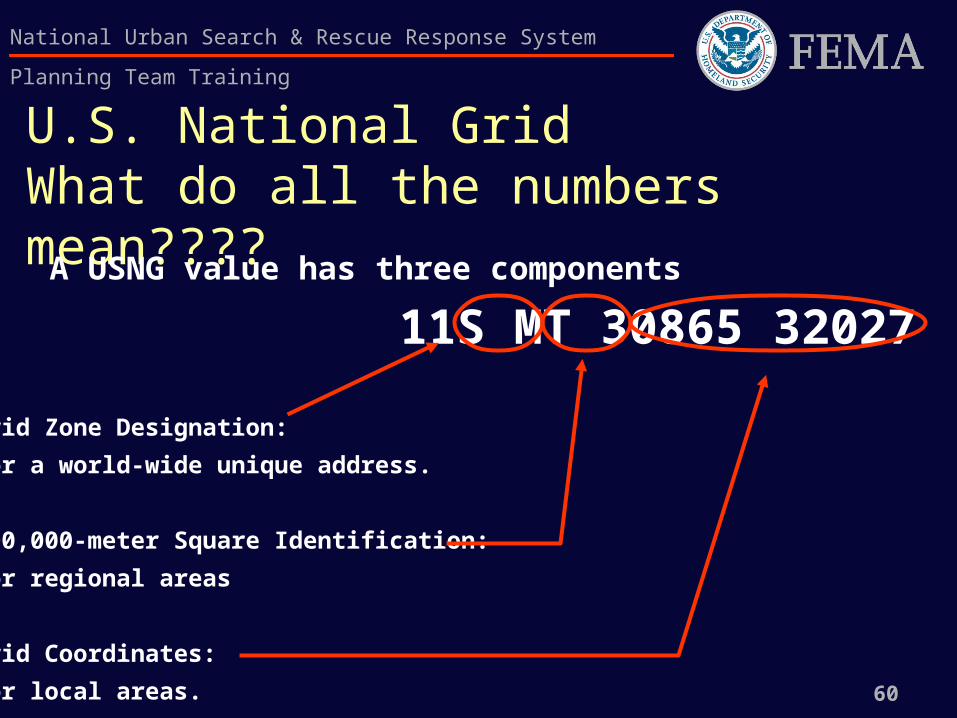
U.S. National GridWhat do all the numbers mean????
A USNG value has three components
11S MT 30865 32027
Grid Zone Designation:
for a world-wide unique address.
100,000-meter Square Identification:
for regional areas
Grid Coordinates:
for local areas.

61
National Urban Search & Rescue Response System
Planning Team Training
U.S. National Grid:Grid Zone Designator
The GZD’s divide the U.S. geographic area into 6 degree longitudinal zones designated by a number and 8 degree latitudinal bands designated by a letter. These zones and bands are taken from the MGRS.
The Continental U.S has 10 longitudinal zones
4 Latitudinal zones
11S MT 30865 32027 11S designates a GZD

62
National Urban Search & Rescue Response System
Planning Team Training
U.S. National Grid:Grid Zone Designator

63
National Urban Search & Rescue Response System
Planning Team Training
U.S. National Grid:100,000-m Square Identification Grid Zone Designators are further subdivided
into 100,000 meter Square Identifications. These squares are labelled by a two letter designator so as not to repeat themselves within approximately 1000 miles.
11S MT 30865 32027MT is the 100,000 meter Square Identification

64
National Urban Search & Rescue Response System
Planning Team Training
U.S. National Grid:100,000-m Square Identification
65
National Urban Search & Rescue Response System
Planning Team Training
U.S. National Grid Coordinates
The position within the 100,000-m Square identification is given by the UTM grid coordinates in terms of Easting (E) first then Northing(N) second.
The coordinates are always given in an even number then read from left to right with easting first, then northing
The number of digits used decides the accuracy of the coordinates

66
National Urban Search & Rescue Response System
Planning Team Training
U.S. National Grid Coordinates
11S MT 30865 32027
30 32- four digits locates within 1km
308 320-six digits locates within 100m– Football size area
3086 3202-eight digits locates within 10m– Modest size home
30865 32027-ten digits locates within 1m– Manhole cover size

67
National Urban Search & Rescue Response System
Planning Team Training
U.S. National Grid Coordinates
Use the number of digits needed for the accuracy desired.

68
National Urban Search & Rescue Response System
Planning Team Training
U.S. National Grid Further information
The following links have additional information on the USNG.
http://www.fgdc.gov/usng/index.html
http://www.fgdc.gov/usng/educational-resources/USNGInstruct_No1v4_No2_r.pdf