1 Australia Post — Print Post Publication No. … Australia Post — Print Post Publication No....
12
1 Australia Post — Print Post Publication No. PP329113/00038 ISSN 0813 - 2666 AURA Newsletter THE NEWSLETTER OF THE AUSTRALIAN ROCK ART RESEARCH ASSOCIATION (AURA) INC. Volume 21, Number 1 June 2004 21/1 AURA at Hamilton Compared to previous AURA conferences, the 2003 AURA Inter-Congress Symposium was a small affair, but it was also the most intimate and cordial AURA event held so far. It took place on the weekend of 4th and 5th October 2003 at the Hamilton Institute of Rural Learning, located on the northern outskirts of Hamilton. This consists of a sprawling complex of unique mud- brick buildings and superb gardens with adjacent bushland and small lakes, originally designed as an artists’ enclave. Despite its name, the centre is not used for teaching purposes, but is a com- munity centre used for social functions. We found it uniquely suited for a small conference such as ours. Hamilton, a friendly country town near the southernmost mountains of the Grampians (Gariwerd), is the world’s greatest centre of wool production (the district yields a sixth of Australia’s total output). At this time of the year, in spring, it is a brilliantly green region, with morning mists and crisp days, and the wood stoves in the centre were put to good use. In fact AURA Presi- dent Ken Mulvaney, down from the tropics of Dampier, was rarely seen more than a couple of metres from the stove. He opened the academic proceedings with his superb exposition of the current threats to the rock art of the Dampier Archipelago in Western Australia. As several participants have commented, all papers presented in Hamilton were of the best academic quality. Combined with the relaxed atmosphere and the ample opportunities for debate, this consistency alone rendered the event most satisfying. But other aspects added greatly to its value and pleasant atmosphere. For instance, the efficiency of the event’s honorary ‘caterers’, the Bednariks’ daughter Cathrin Plunkett and her husband Michael, deserves special mention. The Plunketts put on an im- From The Hamilton Spectator, with permission.
Transcript of 1 Australia Post — Print Post Publication No. … Australia Post — Print Post Publication No....

1Australia Post — Print Post Publication No. PP329113/00038 ISSN 0813 - 2666
AURA NewsletterTHE NEWSLETTER OF THE AUSTRALIAN ROCK ART RESEARCH ASSOCIATION (AURA) INC.THE NEWSLETTER OF THE AUSTRALIAN ROCK ART RESEARCH ASSOCIATION (AURA) INC.
Volume 21, Number 1 June 2004 21/1
AURA at HamiltonCompared to previous AURA conferences, the 2003 AURA
Inter-Congress Symposium was a small affair, but it was also themost intimate and cordial AURA event held so far. It took placeon the weekend of 4th and 5th October 2003 at the HamiltonInstitute of Rural Learning, located on the northern outskirts ofHamilton. This consists of a sprawling complex of unique mud-brick buildings and superb gardens with adjacent bushland andsmall lakes, originally designed as an artists’ enclave. Despite itsname, the centre is not used for teaching purposes, but is a com-munity centre used for social functions. We found it uniquelysuited for a small conference such as ours.
Hamilton, a friendly country town near the southernmostmountains of the Grampians (Gariwerd), is the world’s greatestcentre of wool production (the district yields a sixth of Australia’stotal output). At this time of the year, in spring, it is a brilliantly
green region, with morning mists and crisp days, and the woodstoves in the centre were put to good use. In fact AURA Presi-dent Ken Mulvaney, down from the tropics of Dampier, was rarelyseen more than a couple of metres from the stove. He opened theacademic proceedings with his superb exposition of the currentthreats to the rock art of the Dampier Archipelago in WesternAustralia.
As several participants have commented, all papers presentedin Hamilton were of the best academic quality. Combined withthe relaxed atmosphere and the ample opportunities for debate,this consistency alone rendered the event most satisfying. Butother aspects added greatly to its value and pleasant atmosphere.For instance, the efficiency of the event’s honorary ‘caterers’,the Bednariks’ daughter Cathrin Plunkett and her husbandMichael, deserves special mention. The Plunketts put on an im-
From The Hamilton Spectator, with permission.

2peccable barbecue on Saturday night, they prepared all tea breaksand organised lunches with great verve and competence, givingthe conference also a very personal touch. And Elfriede mannedthe registration desk with the proficiency AURA members havelong become accustomed to. It was, some have commented, oneof the best conferences they ever attended. That’s high praiseindeed, when one considers the international smorgasbord of rockart events available nowadays.
Still, the core of the symposium was the presentation of pa-pers. The event was chaired by ben Gunn and Robert Bednarik,who both presented new perspectives on subjects they had previ-ously visited. Ben addressed the design structure and spatial pat-terning in early Gariwerd rock art, Robert the recent develop-ments in his campaign to save the Dampier rock art. MichaelBarry presented a masterful and wide-ranging analysis of thehuman figures in the Gwion Gwion rock paintings of theKimberley, formerly known as Bradshaw figures. Caryll Seftonprovided a detailed report of her team’s survey work in the rug-ged Woronora Plateau and Southern Highlands of New SouthWales. John Clegg offered a challenging account of a bafflingseries of circular depressions found in the sandstone country nearSydney. Margaret Bullen provided a most erudite discussion ofthe shamanic explanation of rock art, showing that the occur-rence of such patterns as spirals, dots and circles is not at all atypical shamanic feature. Noelene Cole, who had recently un-dertaken a tour of numerous major public sites in Europe andIndia, compared these in terms of their different management
approaches and concluded that in certain respects Australia wasbeginning to lag behind overseas initiatives. John Morieson tappedinto his encyclopaedic knowledge of Victorian stone arrangementsand provided an overview of a series of sites he has closely stud-ied. Heather Builth, from the Winda-Mara Aboriginal Corpora-tion near Hamilton, expounded the findings of her study of stonestructures in the region, designed by the Gunditjmara for waterand resource control. Esmée Webb, together with ben Gunn, re-ported the discovery of new rock art near Cue, in Western Aus-tralia. The papers were followed by introductions to the destina-tions of the two post-conference field trips, one to the MountGambier cave art precinct, and the other to painting sites in thenearby Grampians/Gariwerd mountains.
About one half of the conference participants joined each ofthe two field trips. The Gariwerd one-day excursion was led byben Gunn, and was addressed on site by a representative of theGoolum Goolum Aboriginal Co-operative. The cave art tour oftwo days was led by parietal art specialist Geoffrey Aslin andincluded seven cave petroglyph sites (Paroong, Moora, Koongine,Malangine, Prung-kart and Gran Gran Caves, and Mt BurrRockshelter).
On behalf of all conference delegates I thank Cathrin andMichael Plunkett, Elfriede Bednarik, Geoffrey Aslin and benGunn for their invaluable contribution to making this conferencethe success that it was.
Robert G. Bednarik
Dampier report May 2004The Dampier Campaign seeks to prevent the destruction of
the huge petroglyph concentration of the Dampier Archipelago,Western Australia. There have been many new developments inthis campaign over the past year (see ‘Dampier report April 2003’,AURA Newsletter 20/1). In July 2003, a contract was awarded toconstruct a major service corridor across the Burrup Peninsula,which reportedly destroyed between 170 and 180 sites. In Au-gust, IFRAO (the International Federation of Rock Art Organisa-tions) advised the Chairman of the Dampier ‘emissions commit-tee’ that its proposed research program was unsuitable, and sub-mitted a detailed critique of the Draft Management Plan to theBurrup Peninsula Conservation Reserve Planning Advisory Com-mittee. On 25 September 2003, the World Monuments Fund ac-cepted IFRAO’s nomination of the Dampier rock art precinct,made on 24 October 2002, as one of the 100 most threatenedsites in the world. This is the first Australian site to be black-listed by the WMF. Four days later, Methanex, the proponent ofthe largest of the proposed industrial developments on Murujuga(Burrup), announced the cancellation of its plans. The officialreason given was that development costs are too high on the pen-insula. The Canadian firm is the largest methanol producer in theworld and has been in serious conflict with conservationists be-fore.
In the following month, work at the Woodside plant atDampier was significantly interrupted by a strike of 1700 work-ers. On 21 November 2003, militant trade unions won access toPilbara sites from which they had been excluded for well over adecade. This ushers in a new balance of political power in theregion.
On 12 January 2004, the President of the World MonumentsFund, Bonnie Burnham, travelled to Dampier with the Presidentof IFRAO to inspect the rock art and the industrial developmentwithin the rock art precinct. The Western Australian Minister for
State Development, Clive Brown, immediately condemned hervisit, even before her findings became available. On the follow-ing day, the WMF and IFRAO Presidents met a panel of govern-ment officials in Perth and informed them that nowhere else inthe world is there a monument of the magnitude and significanceof the Dampier rock art that has to share its locality with an in-dustrial estate. The WMF President requested that the new de-velopments be located elsewhere. Minister Brown rejected heradvice flatly, stating that Americans should focus on their ownenvironmental problems, ‘rather than coming to Australia andtelling people what to do’.
In late January 2004, the terms of reference of the BurrupRock Art Monitoring Management Committee were released, afterthe four study contracts had all been let to a governmental agency,CSIRO. Accordingly, two studies will cover the monitoring ofambient concentrations of air pollutants, and microclimate anddeposition. The two others will feature artificial fumigation ofrock surfaces and fieldwork on rock surface colour changes.Below is the full text of the summaries of the terms of referencesfor these studies, followed by a critical review of this program.
On 19 March 2004, IFRAO announced that it would expandRobert Bednarik’s rock art deterioration study he began in 1968.Three days later, IFRAO submitted the Dampier rock art pre-cinct for inclusion on the National Heritage List, and promptedits nomination for World Heritage by two other stake holders.On 26 April, Japanese conglomerate Japan DME announced thatits one-billion-dollar development at Dampier may not proceed.This follows the defections of all other major proponents.
In May 2004, the WMF confirmed that it would provide sub-stantial financial support for the IFRAO study. In view of thesedevelopments it is appropriate that the study conducted by theWestern Australian state government be reviewed comprehen-sively. This is attempted here.

3
SUMMARIES OF PROPOSED ROCK ARTMONITORING STUDIES
IntroductionListed below are summaries of the studies that have been
endorsed by the Burrup Rock Art Monitoring Management Com-mittee. These studies are the outcome of discussions between theCommittee, researchers and the local Aboriginal and broadercommunity following a Rock Art Monitoring Workshop inDampier in March 2003.
In accord with Government procedure these studies are be-ing finalised in terms of arranging contracts and engaging quali-fied consultants/researchers (external to government) to under-take and report on scientific findings. This process has followeda formal government tender process, which commenced with ad-vertising for tenders in July 2003. The successful consultants forthese studies were announced in February 2004 with commence-ment of field work expected in late April or early May followingmonitoring site establishment.
The Committee expects regular updates on the monitoringstudies with six-monthly and annual reporting to the Committee.These reports will be made available on the Web (www.doir.wa.gov.au). The Committee will continue to provide updates on theprogress of the rock art-monitoring program and will report to,and consult with the community annually.
Following completion of studies and peer assessment of thework of the consultants, the Committee will produce a final re-port to government and the community. It will then make recom-mendations to the Burrup conservation area management bodyfor the ongoing preservation and conservation of the rock art,whether further industrial development on the Burrup Peninsulaproceeds or not.
Study 1 - Air monitoring of ambientconcentrations of air pollutantsMonitoring required:• NO2, SO2, NH3, BTX
Monitoring locations:• Six locations selected (1 each at northern Dolphin Island and
northern Burrup Peninsula and 4 within the industrial area ofKing Bay-Hearson Cove).
• Note: SO2 and NH3 monitoring (1 control and 1 industrial lo-cation only).
Monitoring timeframe:• Initially for 1-year period with possible extension following
annual review of monitoring results.
Proposed sampling system:• Each sampling site to have anodised aluminium sampling lid
fitted with a rail with passive gas samplers for NO2, SO2,NH3. BTX samplers to be housed under the same lid and se-cured with metal clips. Aluminium casing to be attached to ametal or treated pine pole.
• Passive gas samplers to be mailed to a central location forexchange drop-off and pick-up by trained technician.
• Exposed samplers to be removed and placed in the vials andnew samplers installed into the housing.
• Record sheets to be used by operators to record time and dateof sampler installation and removal, serial number on the vial,average temperature and any additional observations/com-ments.
• Exposed samplers to be placed in pre-addressed envelopessupplied by researchers and posted to researchers for analy-sis.
Sampling period:• Monthly sampling periods.
Study 2 - Microclimate and deposition studyMonitoring required:• Temperature;• Relative humidity;• Wet deposition - amount and chemical composition;• Dry deposition - amount and chemical composition;• Bulk deposition - amount and chemical composition;• Chemical composition (including pH) of dew on rock sur-
faces on exposed and protected/shaded faces.Chemical composition shall include sodium, chloride, iron, totalnitrogen and sulphur.
Monitoring locations:Six locations selected (1 each at northern Dolphin Island andnorthern Burrup Peninsula and 4 within the industrial area ofKing Bay-Hearson Cove).
Monitoring timeframe:• Initially for 1-year period with possible extension following
annual review of monitoring results
Site establishment(equipment to be co-located with passive samplers)• Consists of a rainwater sampler, total suspended particulates
(TSP) particle sampler, a deposition sampler and tempera-ture and humidity meters.
• Rainwater and TSP particle samplers to be bolted to a free-standing concrete slab and placed in an appropriate position.
• Temperature and humidity will be measured electronicallywith a sensor mounted in a screened enclosure approximately1.5 m above ground, powered by a gel cell battery.
• During each visit the technician will download data to a note-book computer and e-mail the file to researchers. Notebookcomputer can be supplied by researchers if required.
Sampling period:• No greater than monthly sampling for wet, dry and bulk depo-
sition.
Sampling and analysis methodology:• Rainwater samples to be collected monthly using Ecotech
Model 200 ‘wet only’ rainwater samplers. These will be sup-plied with solar panels to charge the battery. To counteracteffects of bacteria consuming some species such as organicacids, ammonia and sulphate thymol (a biocide) will be addedto the sample bottle prior to field installation.
• At end of each month sampling period, data stored in thedata logger will be downloaded to the notebook computerand the data file e-mailed to researchers for chemical analy-sis.
• Dry deposition to be collected using Ecotech Microvol 1100samplers configured to collect TSP. They are fitted with asolar panel to charge a battery.
• After sampling the filters will be returned to researchers,extracted with high purity water and analysed for species asfor rainwater.
• For measurement of amount and chemical composition ofbulk deposition, a pre-cleaned plastic funnel and bottle ateach site exposed for monthly periods will be used. At end ofeach month, high purity water will be used at the site to washparticles deposited on the funnel into the bottle.
• Dew samples will be collected from rock and surrogate sur-faces using pre-cleaned pasteur pipettes. Samples to be trans-ferred to glass vials, sealed and sent to researchers for analy-sis as for rainwater.

4
• In all cases, record sheets will be provided by researchers tothe field technician to record sampling times, dates, volumesand any observations or comments.
Summary of joint proposals• Six sites for NO2, BTX, wet deposition, dry deposition and
bulk deposition measurements.• Two sites (1 control and 1 industrial site location) for NH3
and SO2 measurements.• Sampling for gases, rainwater and particles at monthly inter-
vals.• Sixteen dew samples at each site during the year.• Sixteen dew samples are on the basis of 4 samples/site un-
shaded and 4 shaded and a similar number on a surrogatesurface such as Teflon.
• Number of rainwater samples is estimated at 10 per year persite based on data from Bureau of Meteorology.
Study 3 - Field studies of colour changesMonitoring required:• There is a need to assess whether there is a loss of colour
contrast between rock art/petroglyphs and adjacent rock sur-faces, and to establish a scientifically valid baseline for fu-ture assessments. Physical assessments are required at a num-ber of monitoring sites to assess whether colour changes areoccurring and if these are occurring at a greater rate than thatdue to normal weathering.
• It is expected that due to the small changes expected, moni-
toring of the same sites would only be needed annually overthe four-year period study period.
• Any monitoring would need to ensure that there were con-trolled or carefully characterised conditions so that compari-sons are reproducible.
Monitoring locations:• Six monitoring locations (2 at northern Dolphin Island and 4
within King Bay-Hearson Cove).
Monitoring timeframe:• Annual monitoring over a 4-year period, with possibility of
extension following review of the monitoring results.
Proposed sampling system:• The proposed methodology demonstrated an understanding
of the need for a reproducible, reliable approach through theuse of a BYK-Gardner portable spectrophotometer with natu-ral light being excluded using a compressible collar. Such aninstrument has a range of standard illuminants, including thosefor natural light. It does not have the capability to providereadings for light in particular spectral intervals. It would,however, provide detailed comparable information aboutchanges in colour in standard natural light as perceived bythe eye.
• The measuring head measures a diameter of 4 mm, whichwould allow for measurement of contrast between engrav-ings and surrounding rock faces.
• Contrast in colour between engravings and adjacent rock faces
The sampling sites of the Burrup Rock Art Monitoring Management Committee

5would be in terms of Delta E, the standard CIE colour differ-ence method.
• Each petroglyph would be monitored at three points with threeadjacent points on the rock surface, each an average of 7readings — 42 readings per petroglyph.
• In order to relocate the instrument, digital photography witha macro lens will be used to relocate to within a millimetre.
Sampling period:• Annual
Study 4 - Artificial fumigation studiesof rock surface changesMonitoring required:• In order to gain some indication of the types of changes to be
expected from prolonged exposure to existing and possiblefuture industrial emissions it is considered that there may bevalue in conducting fumigation cabinet studies of typical rocksamples with weathered surfaces from the Burrup Peninsula.
• Fumigation trials of nitrogen dioxide, sulphur dioxide, am-monia, xylene, benzene and toluene would be needed at arange of concentrations to provide a dose-response assess-ment but in the above proportions with realistic Burrup tem-perature and humidity conditions. The fumigation trials shouldexamine the gases in combination for existing and future in-dustry scenarios and multiples of those concentrations to as-sess any physical, mineralogical or chemical changes.
Monitoring timeframe:• One-year period, exercisable at the absolute discretion of the
Rock Art Committee.
Proposed sampling system:• The proposed 8 cycles per day of dry/wet/dry transitions over
3 months would be equivalent to some 7 years of climaticcycles
• Further acceleration is proposed through ‘a combination ofadjusting temperature and pollutant dosage (to an extent lim-ited by the need of not distorting the damage mechanism’leading to obtaining ‘an equivalence of 20 years of climaticcycles’.
• Consideration will be given to assess possible damage over alonger period than 20 years, it would be necessary to identifyearly indicators of damage. These may be chemical changesin desert varnish or specific mineral structure alteration, iden-tified by analytical tools such as XRD or XPS.
• Possibly conduct a preliminary assessment to decide on thenumber and conditions of test cycles.
• There is also a proposal for a limited study using extremeexposure doses to assess the early indicators of chemical ormineral change mentioned above.
• Analysis will be done using SEM and XPS by the relevantresearchers.
A recipe for failureROBERT G. BEDNARIK
The Dampier rock art monitoring program by the Western Aus-tralian government was initiated in response to my paper ‘Thesurvival of the Murujuga (Burrup) petroglyphs’, in RAR 19(1).In that paper I had reported detecting quantifiable degradation ofthe ferruginous mineral crust in the Dampier Archipelago, onwhose preservation the rock art depends for its continued exist-ence. Having measured changes in colour and crust degradation
since the late 1960s, I had observed a marked deterioration sincethe late 1980s. In extrapolating from these empirical observa-tions I predicted that the proposed three-fold increase in acidicgaseous emissions would cause widespread loss of colour con-trast among the massive petroglyph corpus over the course of the21st century.
I have therefore every reason to welcome the initiative of thegovernment. Moreover, our knowledge base of the effects of at-mospheric acidification on mineral patinae remains woefully in-adequate, and any work that is designed to improve this is morethan welcome. However, if the full potential of such an opportu-nity is not realised, it is just an opportunity lost, and it is for thisreason that we need to examine the above proposals critically.
It seems to be agreed that the primary purpose of this exer-cise is to (a) determine the precise nature of the processes caus-ing deterioration, and its secondary purpose is (b) to use thisinformation to design ways of alleviating these effects. From ascientific perspective, the first purpose is the more valuable, be-cause it will enrich our generic understanding of threats to rockart. However, from a purely pragmatic point of view, only thesecondary purpose (b) is of ultimate interest, for the possibleimplementation of palliative measures. Nevertheless, it is obvi-ous that, in order to design such measures, it is imperative thatthe basic research be conducted under optimal conditions. Theterms of reference make it clear enough that this project will failto deliver the optimal information we require.
The main reason for this lies in the central assumption thatthe deterioration processes are very slow and gradual. This is nodoubt acceptable for Study 3, where colour changes are to beexamined. These occur over a long period of time and the pro-posed four-year period may in fact be inadequate. Moreover, noneof the studies is concerned with the key issue to be addressed:the physical degradation of the mineral accretions that are thevery centre of this preservation problem. Instead we have monthlymonitoring of four pollutants, which will offer vaguely relevantbackground information; we have monthly sampling of somefactors of atmospheric deposition, which is much more relevantbut is incompletely covered; the colour monitoring program; andsimplistic accelerated weathering experiments.
Dampier is a locality of climatic extremes, where most pre-cipitation occurs within a few weeks in the year. Gaseous emis-sions by themselves are not likely to dissolve the crusts, theywould become operative in the presence of moisture. Unless dewhas an effect, which remains unknown, we could reasonably as-sume that the deterioration only takes place in the course of afew weeks, essentially in the cyclon season. Obviously what weneed to know more than anything else is what happens at therock face when it rains. What I would like to know most is this:does solution take place only during rain, does it proceed evenlyor does it peak, for instance in the first ten minutes of rain, whenradicals in dormant solids are activated by the water? Or perhapsit takes a certain time of rainfall before the micro-erosional frontbecomes fully active? At this stage, we cannot claim to under-stand the processes of mineral accretion deterioration at all, there-fore any study must commence without unwarranted assump-tions. It is quite probable that most of the deterioration of thecrusts is by the reaction of NO2 and rainwater in the atmosphere,yielding nitric acid, but how does its effectiveness vary as a func-tion of duration of the precipitation event? We have no idea aboutthese crucial details, and the most obvious aspect of the proposedstudy project is that it cannot possibly provide such details. Thesimplistic design of the project prevents the acquisition of themost important data, and instead meaningless data are likely tobe collected.
It would have been much more appropriate to determine thevariation of rainwater pH at the atmosphere/lithosphere interface

6and to plot it against time over the duration of a rain episode. Themost relevant study would be a direct observation of the processunder a binocular microscope, visually observing the physicalmobilisation of material. The detailed recording of just one suchevent would tell the judicious analyst far more than four years ofunfocused and purposeless gathering of probably meaninglessdata. Moreover, such observation results would quickly lead tothe formulation of alleviating measures. For example, if it werefound that most of the degradation occurred in the early part of arain episode and is attributable to a flushing with nitric acid, thenit would be possible to avoid most damage simply by closingdown emissions several hours before rain. Since most rains oc-cur during a brief spell in the monsoon period, Woodside couldeasily schedule this period for annual maintenance shut-down,or for the periodic repairs or construction works entailed in thenormal operation of such installations.
I am of course not suggesting that this is the correct solution,I merely use this example to show that we must not make as-sumptions about the relevance of specific empirical indices. Allwe know with certainty is that there was deterioration of the ac-cretions since the late 1980s, because this has been monitoredover decades and is quantifiable. We also know, from my work,that the micro-morphology of the accretionary deposits in thePilbara is heavily influenced by precipitation. The core issue,then, is one of geochemistry. Emissions are the most obviousculprit, but it seems perfectly possible that factors or catalystswe have not even considered are contributing, or are even cru-cial. In science the solution to a problem can come from even themost unexpected direction. If we work from the assumption thatonly long-term average exposures are relevant, as the terms ofreference in this project stipulate, we may not just be limiting theeffectiveness of the project (if the short-term event peaks werethe problem), we may render the entire project ineffective. Andwe may miss a rare opportunity to conduct badly needed basicresearch into this generic subject area of iron-rich mineral crustdeterioration resulting from industry.
There are still other objections to the research proposal. Theaccelerated weathering study (‘fumigation’) is likely to lead toseverely misguided pronouncements about the effects of expo-sure to various gases. It does not simulate the natural exposureconditions, but will extrapolate from the probably negligible ef-fects of fumigation at multiples of concentration. If the gaseousemissions have little or no effect in the absence of water, as maybe the case, what is the point of demonstrating that they havealso little effect at twenty times the predicted concentration?
Of particular concern is the proposed methodology of moni-toring colour changes in the accretionary ferromanganous de-posits. As indicated in the above terms of reference, it is pro-posed to use a BYK-Gardner spectrophotometer with a 4 mmaperture opening for this purpose. Therefore the instrument pro-posed is the 45/0 model, catalogue number CB-6807. This in-strument is designed for manufacturing processes, e.g. of plas-tics products. It is highly sensitive to extreme conditions of tem-perature and relative air humidity, and cannot be operated eitherabove 42°C or above 85% relative humidity conditions thatboth occur commonly in the Dampier region. Moreover, the in-strument is very imprecise, with a spectral interval of 20 nm,over a spectral range from 400−700 nm. Hence it does not evencover the full range of visible light. Indeed, Gardner call it a‘colour guide’, a much more appropriate description than ‘spec-trophotometer’. The impression that an unsuitable methodologyhas been proposed is reinforced by the description of how thesampling site will be re-located (not ‘relocated’): digital photo-graphs will guide this process. Yet the baffle surrounding theaperture is of about 12 cm diameter. First, it will be physicallyimpossible to re-locate the baffle so that the original sampling
site is targeted ‘to within a millimetre’, as stated. Second, it shouldnot be approximately re-located, or within a millimetre, it mustbe precisely re-located, otherwise the result can only be impre-cise, if not meaningless.
What amazes me most about this methodological blunder isthe fact that a vastly more accurate method of colorimetry is avail-able. It was designed precisely for measuring changes in rockart, it has been published, and has been used in the Dampier Ar-chipelago for many years. The colorimetric method I have de-veloped specifically for rock art is much more accurate, simplerand cheaper, and I have used it not only at Dampier, but alsoelsewhere in the Pilbara (notably on repatinated inscriptions atSpear Hill) as well as on red pigment in Mladeè Cave, CzechRepublic, on petroglyphs in Saudi Arabia, and elsewhere. In thismethod with its spectrum of over 16 million colours, the spatialsampling accuracy is well under 100 microns. It requires no ex-pensive American gadget and measures colour change with muchgreater precision, by relying on aliquot readings rather than singlebut questionable values. Moreover, because calibrated photo-graphic records can be included to determine earlier colourchanges, the duration of the monitoring period can be extendedto the earliest such records we have. They are in this case of1968, so in 2008 they will provide coverage of the highest accu-racy for a total of forty years, whereas the results of this govern-ment endeavour will cover just 10% of that duration, at vastlyinferior accuracy, at massive cost (hundreds of thousands of dol-lars), and yield results which I can only reject: I remain uncon-vinced that the Gardner instrument is even remotely suitable forthis task.
Why, then, this unfortunate choice of methodology? The an-swer is simple. This Rock Art Committee does not include a singlerock art researcher, or even a specialist in accretionary mineralcrusts. This is despite the fact that such expertise would havebeen available in Perth, and amply available in the eastern statesof Australia. The committee is unaware of previous attempts tomeasure rock art deterioration by spectrophotometry or spectrom-etry, which were unproductive or inconclusive, and which werethe very reason why I opted for digitised colorimetry a long timeago. The exclusion from this project of rock art specialists isdeliberate, as shown by the simple fact that all four studies wereawarded to a single government agency (CSIRO) that, signifi-cantly, has no previous track record in rock art research or rockart conservation. Having conducted all previous analytical workon the Dampier rock art, and having prompted this project, I findit sad that I was not consulted on any aspect of its design. Itsmistakes were all avoidable.
Therein lies the problem: this is not an attempt to resolve theissue, but a political whitewash and a measure to procrastinatefurther. I predict that the results of this project in 2008 will beinconclusive and unreliable, and that the main finding will bethat CSIRO will require further funding to continue the work.Meanwhile the government expects to continue its destruction ofthe Dampier rock art, bulldozing many more sites, and permit-ting the huge petrochemical industries to belch out ever moreacidic emissions, at the rate of tens of thousands of tonnes peryear. And all the while, the alternative Maitland Industrial Estateremains unoccupied.
Footnote: the International Federation of Rock Art Organisa-tions (IFRAO) will this year expand the monitoring and in-ventorying program I began in the 1960s, and prepare thedocumentation and data required for the establishment of aNational Park in the Dampier Archipelago.
Please visit the Save the Dampier Rock Art site athttp://mc2.vicnet.net.au/home/dampier/web/index.html

7
Pinerolese rock paintings, western Alps, ItalyBy DARIO SEGLIE, MAURO CINQUETTI AND PIERO RICCHIARDI
Pre-History and rock art in the Pinerolese territoryThe Study Centre and Museum of Prehistoric Art of Pinerolo
(CeSMAP) was established in 1964 to continue the archaeologi-cal studies of the western Alps and Pinerolese territory, started inthe previous century by the scholars of the Turin Royal Academyof Sciences. The general directions were forged by Piero Baro-celli, dean of Italian archaeologists, by Carlo Carducci, Directorof the Piedmont Archaeological Regional Office, and by DiegoDe Castro, professor in Turin University.
The need to secure a continental dimension for the studieswas immediately manifested in Pinerolo, to best contextualiseand understand a characteristic and archaic phenomenon of theAlpine mountainous arc: rock art, the specific subject andspecialised sector of archaeological research by CeSMAP. Fromthe very beginning till today, the competence and the researchfield of the Pinerolese Centre was in continual expansion, bothin the Western Alps and around the world. In 1988, in Darwin,Australia, it took part in the founding of IFRAO (InternationalFederation of Rock Art Organisations). CeSMAP, in consider-ation of its great international engagement, was decorated withthe European Culture Award by the EU, and was recognised asIFRAO – UNESCO Liaison Office, c/o the Paris General Direc-tion. The Prehistoric Art Museum of Pinerolo possesses the widerinternational rock art collection.
The most important archaeological campaigns of theCeSMAP, accomplished in the last quarter of the last century,defined the overview of the peopling of the Pinerolo region sincepre-History, although an immense work of survey and excava-tion in this territory must still be accomplished. The area ischaracterised by a strong potential and high density of archaeo-logical finds, as it was already foretold by the early scholars inconnection with the strong rock art presence in this area.
The CeSMAP archaeological excavationsThe Balm’Chanto shelter, at 1500 m a.s.l. in the Chisone
valley, has yielded very important remains of human presence inthe Cottian Alps since the Epigravettian, at the end of the lastglaciation, from about 14 000 years BP, and also data on the popu-lation of the middle alpine slopes during the Copper Age, about4200 years ago, as confirmed by radiocarbon dating. The Rocdel Col site, in the high valley at 2083 m a.s.l., has furnished thedimensions of the agro-pastoral activities during the Bronze Age,about 3500 years ago. The Neolithic rock paintings, dated 6000years ago and the coeval VBQ sites of the Middle Neolithic, dis-covered at the Cavour Rock, testify to the presence of the oldestfarming communities of the Pinerolese region in north-westernItaly.
Recently, further excavations in the Piedmont territory con-firmed the presence of numerous sites indicating a flourishingoccupation during the last millennium B.C. and until Romani-sation, already surveyed by CeSMAP in the sub-alpine area, andconsisting of settlements raised on the first hills that stand on thePo plain.
Geographic environmental contextThe Piedmont region is in the west hemmed in by the alpine
chain raised by orogenetic pressures, lifting out from the Medi-terranean Basin since the Tertiary period. In the Piedmont regionthe mountains are present without calcareous deposits, while the
median belt is mainly formed by crystalline, eruptive and meta-morphic rocks. This fact has caused the absence of a sub-alpinebelt, consequently the distance between the highest ridges of thewatershed and the plain is very short, 45 km in average.
The Italian Western Alps show wide and short valley corri-dors that penetrate into the mountain chain, developing insome cases in the valley bottom true plain tongues. After thelast Würm glaciation, about 10 000 years ago, these morphologi-cal characters facilitated human colonisation. Man, also sporadi-cally present during the glacial era, progressively extended hiscontrol on the territory to totally occupy, from the Neolithic, thealpine system up to the belt of the high pasturages. Also, andparticularly in the Western Alps, thanks to the presence of fre-quent passes, the mountain relief rather than constituting anisolating motif for the local populations allowed frequent andcontinuous cultural and economic exchanges between the slopesand between the valleys.
This fact conferred to the western alpine region a sort of unityin the anthropic characters, from pre-History and proto-Historytill today. This cultural unity is also traceable in the rock art mani-festations ascribed to the post-Palaeolithic period, although onecan also see petroglyphs that date back only to the Middle Ages.
The surfaces engraved are variously dispersed in the terri-tory, but are principally sited on the sides of ancient paths, inprominent positions. Rock art is often present in particular placesthat could have been experienced as sanctuaries by the pre-His-toric populations settled here.
Rock painting sitesThe name ‘rock art’ is traditionally attributed to all non-utili-
tarian anthropic markings on rock surfaces, made either by anadditive process (pictogram, rock painting) or by a reductive pro-cess (petroglyph, rock carving). It is important to underline thatthe term ‘art’ is utilised latu sensu, without aesthetic implica-tions, according to the Latin etymology that defines the humanactivity of producing artefacts, hence the derivation of the wordsartisan, artificer, artist. Still today, the traditional populations thatmake rock art, like Australian Aborigines, African San people orAmerican Indians, lack words for defining ‘art’ as an autono-mous activity because it is the result of ceremonies and compli-cated creative acts, including also graphic expressions.
Rock art is today only the ‘residue’ of the old religious com-plex, conserved over time, while songs, prayers, dances, ges-tures, votive offerings etc. are unrecoverable, but it displays thespiritual abundance of our oldest ancestors.
Pre-Historic man placed rock art in selected dominant strate-gic sites, perhaps expressing ritual, symbolic and religious pos-session of the territory that converted chaotic and unknown landinto a domestic and recognisable landscape, garrisoned by a ge-nius loci, land of ancestors consecrated mother country.
The archaeological surveys undertaken since the 1920s, butparticularly since the 1960s by the research of CeSMAP, in theWestern Alps and Pinerolese region, have illuminated in somedetail the dynamics of the early human settlements in this terri-tory.
Cavour, RoccaAlso, in the case of Cavour Rock, the appearance of pre-
Historic art coincides with that of the Middle Neolithic in the

8Cavour territory, introduced by populations of the Late VBQ(Square Mouth Vase) culture, 4th millennium B.C. Evidence ofthe presence of shepherds and farmers was discovered byCeSMAP on the top of this curious inselberg, an isolated hill inthe alluviums of the Po plain, similar to Uluru (Ayers Rock) inthe centre of Australia, a monolith still today considered sacredby the Aborigines, with shelters painted and used for ceremoniesand initiation rites.
The Cavour paintings are formed by red, violaceous and blackpigments, covered by a translucent patina of whitish mineral ac-cretion that partially obliterates the panel (Figure 1). This depo-sition seems to have increased during the last decade, probablyin connection with the development of acid rain and pollution.
Figure 1 (above). Cavour, Pinerolese, Italy. The Cavourpaintings are formed by red, violaceous and blackpigments, covered by a translucent whitish mineral patinaof percolation. It is possible to see three anthropomorphousschematic figures and geometric horizontal series of dots.Fourth millennium B.C. (survey and tracing by Seglie D.,Ricchiardi P., CeSMAP, 1980).
It is possible to see three anthropomorphous schematic fig-ures and geometric horizontal series of dots. Only specialist ex-amination and eventually the removal of the superficial depositmay allow the revelation of elements of these complicated pre-Historic paintings.
A persuasive comparison of these paintings is possible withthe geographically nearest and coeval expressions existing inOlmeta Cave, in the north of the Corsica, and with the pre-His-toric rock art of eastern Spain and southern France. It is possibleto perceive chrono-cultural correlations in a very large area thatis lapped by the western Mediterranean Sea. The Cavour Rock isparticularly important for its conspicuous archaeological strati-fications dating from the Neolithic to the Roman period.
Monte Bracco, BalmalungaDuring the CeSMAP survey in 1994 to realise the archaeo-
logical map of this area for the Piedmont Archaeological Re-gional Direction, new rock paintings were discovered in connec-tion with pre-Historic settlement sites surveyed in the 1980s. Thepainting complex of Balmalunga (long shelter, in the local pa-tois) is formed by two panels showing an anthropomorphous fig-ure standing, with big hands, and a geometric composition of‘symbols’. The shelter is open at the bottom of the rocky slopewhere quarrying of quartzite continues, well known in the an-cient time and also mentioned by Leonardo da Vinci.
The paintings are formed by red pigment. The anthropomorphpresents what resembles a birth-mask, and another representa-
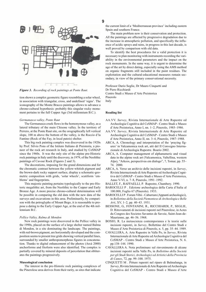
Figure 2 (below). Ponte Raut, Pinerolese, Italy. This big rockpainting complex was discovered in the 1920s by Prof.Silvio Pons of the Istituto Italiano di Preistoria, a pioneerof the rock art researches in Italy, and studied by CeSMAPsince the 1960s. The decorations, imposing for the granddimensions and for the chromatic contrast between theyellow-whitish pigment and the brown-dark rocky surface,display a schematic – geometric composition with grids,‘solar wheels’, scutiform ‘emblems’, and fingerprints. FirstCopper Age, at the end of the 4th millennium B.C. (surveyand tracing by Pons S., CeSMAP, 1964).
9
tion shows a complex geometric figure resembling a solar wheel,in association with triangular, cross, and undefined ‘signs’. Theiconography of the Monte Bracco paintings allows to advance achrono-cultural hypothesis: probably this singular rocky monu-ment pertains to the full Copper Age (3rd millennium B.C.).
Germanasca valley, Ponte RautThe Germanasca creek flows in the homonymous valley, as a
lateral tributary of the main Chisone valley. In the territory ofPerrero, at the Ponte Raut site, on the orographically left verticalslope, 100 m above the bottom of the valley, is the Roccio d’laFantino (Rock of the Fay, in local patois) shelter.
This big rock painting complex was discovered in the 1920sby Prof. Silvio Pons of the Istituto Italiano di Preistoria, a pio-neer of the rock art research in Italy, and studied by CeSMAPsince the 1960s. It was the only site of the alpine pre-Historicrock paintings in Italy until the discovery, in 1979, of the Neolithicpaintings of Cavour Rock (Figures 2 and 3).
The decorations, imposing for the grand dimensions and forthe chromatic contrast between the yellow-whitish pigment andthe brown-dark rocky support surface, display a schematic-geo-metric composition with grids, ‘solar wheels’, scutiform ‘em-blems’ and fingerprints.
This majestic painting pertains typologically to the pre-His-toric megalithic art, from the Neolithic to the Copper and EarlyBronze Age. A more precise chrono-cultural determination willbe possible in comparing the old data with the new data of thesurveys and excavations in this area. Preliminarily, by compari-son with the petroglyphs of Mount Bego, it is reasonable to pro-pose a dating to the Early Copper Age, at the end of the 4th mil-lennium B.C.
Pellice Valley, Balma di MondonNew rock paintings were discovered in the Pellice valley in
the 1990s, placed on the surface of a large shelter named Balmadi Mondon, in a site dominating the landscape. The paintings,with red-brown pigment, are horizontally developed and the com-position seems to present tree grids showing vertical parallel lines,surrounded by smaller anthropomorphous figures in concatena-tion. Thanks to digital enhancement of the photos (Arcà 2000)anchorforms and fitoform were also identified. The complex ispartially covered by mineral deposits of percolation that obliter-ates the paintings progressively.
Museological conclusionThe interest in the pre-Historic rock painting complexes of
the Pinerolese area derives from their rarity, as sites that indicate
the current limit of a ‘Mediterranean province’ including easternSpain and southern France.
The main problem now is their conservation and protection.All the paintings are affected by progressive degradation due tothe increase in atmospheric pollution, and specifically the influ-ence of acidic sprays and rains, in progress in this last decade, iswell proved by comparison with old data.
To identify the best procedures for a valid protection it isnecessary to plan monitoring with instruments recording the vari-ability in the environmental parameters and the impact on therock monuments. In the same way, it is urgent to determine theage of the art by direct dating, especially using the AMS methodon organic fragments still included in the paint residues. Theexploitation and the cultural-educational measures remain sec-ondary, in view of the primary conservational necessity.
Professor Dario Seglie, Dr Mauro Cinquetti andDr Piero RicchiardiCentro Studi e Museo d’Arte PreistoricaPineroloItaly
Reading list
AA.VV. Survey, Rivista Internazionale di Arte Rupestre edArcheologia Cognitiva del CeSMAP - Centro Studi e Museod’Arte Preistorica, Anno I, nn. 1–2, Pinerolo, 1985–1986.
AA.VV. Survey, Rivista Internazionale di Arte Rupestre edArcheologia Cognitiva del CeSMAP - Centro Studi e Museod’Arte Preistorica, Anno II, nn. 3–4, Pinerolo, 1987–1988.
ARCA, A. Chronology and interpretation of the ‘praying fig-ures’ in Valcamonica rock art, atti del II Convegno Interna-zionale di Archeologia Rupestre. Boario 2002.
ARCA, A. Computer management of alphanumeric and visualdata in the alpine rock art (Valcamonica, Valtellina, westernAlps), “Arkeos, perspectivas em dialogo”, 7, Tomar, pp. 55–74. 2000.
ARCA, A. Verso un archivio delle incisioni rupestri, in Survey,Rivista Internazionale di Arte Rupestre ed Archeologia Cogni-tiva del CeSMAP - Centro Studi e Museo d’Arte Preistorica,Anno V-VI, n. 7–8, Pinerolo, 1991–1992.
BALLET, F., RAFFAELLI, P. Rupestre, Chambery. 1990.BAROCELLI P . Edizione archeologica della Carta d’Italia al
100.000, Foglio 67 (Pinerolo). 1933.BAROCELLI P . Forum Vibii - Caburrum (Appunti archeologici),
in Bollettino della Società Piemontese di Archeologia e BelleArti, XV, 1–2, pp. 40–43. 1931.
BESSONE, G., FONTANINI, R., RICCHIARDI, P., SEGLIE,D. Ritrovamenti di incisioni rupestri nel Pinerolese, in Actesdu Congres des Societes Savantes de Savoie, Saint-Jean-de-Maurienne, pp. 46–56. 1968.
BOSIO, R. La metascienza contemporanea e le teorie sulleincisioni rupestri, in Survey, Bollettino del Centro Studi eMuseo d’Arte Preistorica di Pinerolo, n. 5, pp. 35–44. 1989.
CAVALLERA, A. Arte Rupestre in Valle Po, in Survey, RivistaInternazionale di Arte Rupestre ed Archeologia Cognitiva delCeSMAP - Centro Studi e Museo d’Arte Preistorica, N. 6.pp.138–144. 1990.
CAVALLERA A. Nota preliminare sul rinvenimento di alcuneincisioni rupestri nella Valle Po, in Bollettino della Societàper gli Studi Storici, Archeologici ed Artistici della Provinciadi Cuneo, 72, pp. 99–100. 1975.
CINQUETTI M . Pitture rupestri nel riparo di Balmalunga, inSurvey, Rivista Internazionale di Arte Rupestre ed ArcheologiaCognitiva del CeSMAP - Centro Studi e Museo d’Arte
Figure 3. Recording of rock paintings at Ponte Raut.

10Preistorica, Anni VII–X, n. 9–12, Pinerolo, pp. 153–158.1993–1994.
CINQUETTI, M. Preistoria nel Pinerolese: Progetto per la cartaarcheologica, in Survey, Rivista Internazionale di ArteRupestre ed Archeologia Cognitiva del CeSMAP - CentroStudi e Museo d’Arte Preistorica, n. 3–4, pp. 6–39. 1987–1988.
CINQUETTI, M. Preistoria nelle Alpi Cozie: Progetto per la cartaarcheologica, in Survey, Rivista Internazionale di ArteRupestre ed Archeologia Cognitiva del CeSMAP - CentroStudi e Museo d’Arte Preistorica, n. 5, pp. 45–58. 1989.
CINQUETTI, M. Survey sulla Rocca di Cavour, in Survey, RivistaInternazionale di Arte Rupestre ed Archeologia Cognitiva delCeSMAP - Centro Studi e Museo d’Arte Preistorica, 1–2,pp. 7–16. 1985–1986.
COÏSSON, O. Caratteristiche delle incisioni rupestri della ValPellice, in Atti del 1° Convegno di Studi preistorici, Pinerolo,pp. 59–74. 1973.
COÏSSON, O. Incisioni rupestri del versante italiano delle AlpiMarittime e Cozie, in Ampurias, 43, pp. 79–95. 1981.
COÏSSON, O. Incisioni rupestri nelle Alpi Occidentali e nellaValle del Pellice, in Bollettino del Centro Camuno di StudiPreistorici, III, pp. 97–109. 1967.
FOSSATI, A. Le rappresentazioni topografiche, in AA.VV., LePietre degli Dei. Menhir e statue stele dell’età del Rame inValcamonica e Valtellina, Bergamo, pp. 89–91. 1994.
FOZZATI, L, NISBET, R. Cavour, Rocca. Rilevamento archeolo-gico 1983–1984 (tavv. XXI-XXII), in Quaderni della Sopr-intendenza Archeologica del Piemonte, 4, pp. 33–4. 1985.
FOZZATI, L., NISBET, R., SEGLIE, D. Cavour, Rocca. Rileva-mento archeologico, in Quaderni della SoprintendenzaArcheologica del Piemonte, 3, p. 272. 1984.
GAMBARI, F. M. Pitture alla Rocca, in AA.VV. 1995, Immaginidalla Preistoria, incisioni e pitture rupestri, nuovi messaggidalle rocce incise delle Alpi Occidentali, catalogo della mostrain occasione della XXXII Riunione Scientifica dell’IstitutoItaliano di Preistoria e Protostoria, Alba settembre 1995, pp.90–95. 1995.
GAMBARI, F. M. Le pitture rupestri della Rocca di Cavour (TO)e le influenze mediterranee nell’arte rupestre dell’Italia nord-occidentale, in Atti della XXVII Riunione Scientificadell’Istituto Italiano di Preistoria e Protostoria, L’arte in Italiadal Paleolitico all’età del Bronzo, 20–22 11. 1992.
GAMBARI, F. M. Cronologia ed iconografia dell’arte rupestrein Piemonte, in Archeologia in Piemonte I La Preistoria, acura di L. Mercando e M. Venturino Gambari, Torino, pp.187–202. 1998
JALLA, J. Alcuni dati sulle antichità rintracciate nel Pinerolese,in Bollettino della Società Piemontese di Archeologia e BelleArti, XVIII, 1–2, pp. 30–4. 1933.
NISBET, R. Alcuni aspetti dell’ambiente umano nelle Alpi Coziefra quinto e quarto millennio BP, in Monografie di NaturaBresciana, 20, atti della International Round Table HighlandZone Exploitation in Southern Europe, 1994, pp. 259–271.1994.
NISBET, R., SEGLIE, D. Balm’Chanto - Archeologia della ValChisone, Pinerolo. 1983.
NISBET, R., SEGLIE, D. Cavour, Rocca. Rilevamento archeolo-gico (tav. LVI), in Quaderni della Soprintendenza Archeolo-gica del Piemonte, 2, p. 177–8. 1983.
PIVA ,A. Figure e incisioni rupestri. Ricerche preliminari eseguitesulle montagne Pinerolesi, in Bollettino della SocietàPiemontese di Archeologia e Belle Arti, XV, 3–4, pp. 79–83.1931.
PONS S. Le incisioni rupestri nelle Alpi Cozie, in Rivista Ingaunaed Intemelia, 5, pp. 68–105. 1940.
PONS, S. Un antico disegno nella valle della Germanasca: ildisegno di Ponte Raut, Relazione presentata al ConvegnoNazionale degli Speleologi d’Italia, Istituto Italiano diPaleontologia Umana, Firenze. 1929.
RICCHIARDI, P., SANTIANO, S., SEGLIE, D. Progetto A.R.Piemonte - Centro Regionale e Laboratorio di conservazionee restauro dell’Arte Rupestre, in Survey, cit., Anno V–VI, n.7–8, Pinerolo, pp. 171–178. 1991–1992.
ROSSI, M., MICHELETTA, P. Religiosità popolare e incisionirupestri in età storica. Un contributo allo studio delle religioninelle Alpi Piemontesi, Cuorgnè. 1981.
SEGLIE, D. Rock art makers and users, in Third AURA – IFRAOCongress, 10–14 July 2000, Alice Springs, Northern Terri-tory, Australia. (in press).
SEGLIE, D. Rock art, signs and symbols, in Proceedings of theXIII International Congress of Prehistoric and ProtohistoricSciences - Forlì 1996, vol. 4, pp. 47–64. 1998.
SEGLIE, D. La Science, la Recherche et l’Epistémologie de l’ArtRupestre. Eléments pour un debat, in ARKEOS-Perspectivasem dialogo, European Prehistoric Art - Methodology andContexts , N. 10- Atti del Curso de Arte Pré-HistoricaEuropeia, Politécnico de Tomar, UE, Programa Socrates,Tomar, pp. 19–31. 2000.
SEGLIE, D., RICCHIARDI, P. L’arte rupestre in Val Chisone enelle Alpi Occidentali, in Introduzione all’antropologia eall’archeologia territoriale: le Alpi Occidentali, RegionePiemonte, Torino, pp. 111–39. 1986.
SEGLIE, D., RICCHIARDI, P. L’arte rupestre preistorica nelleAlpi Cozie (Sistemi di rilevamento e di studio), in Atti delcongresso sul bimillenario della città di Aosta, 5–20 ottobre1975, Istituto Internazionale di Studi Liguri, Bordighera, pp.119–33. 1975.
SEGLIE, D., RICCHIARDI, P. Pitture rupestri di Ponte Raut inVal Germanasca, in Survey, Rivista Internazionale di ArteRupestre ed Archeologia Cognitiva del CeSMAP - CentroStudi e Museo d’Arte Preistorica, Rivista Internazionale diArte Rupestre ed Archeologia Cognitiva del CeSMAP - CentroStudi e Museo d’Arte Preistorica, Anno 2°, N. 3–4, pp. 71–73. 1987–1988.
SEGLIE, D., RICCHIARDI, P. Recenti scoperte di figurezoomorfe sub-naturalistiche in Val Germanasca, in Studi diarcheologia dedicati a Piero Barocelli, SoprintendenzaArcheologica del Piemonte, Torino, pp. 21–6. 1980.
SEGLIE, D., RICCHIARDI, P., BESSONE, G. Elementiarcheologici per una tesi interpretativa delle incisioni, in Attidel 1° Convegno di Studi preistorici, pp. 138–47.
SEGLIE, D., RICCHIARDI, P., CINQUETTI, M. L’Arte Rupestrenelle Alpi del Piemonte: temi, problemi e rapporti col MonteBego, santuario dell’Età del Bronzo, in Pre-actes du CongrèsLe Mont Bego, une montagne sacrée de l’Age du BronzeTende, 5–11 Juillet 1991, pp. 195–244. 1991.
SEGLIE, D., RICCHIARDI, P., CINQUETTI, M. European strat-egies on rock art: the INTERREG EU project for the westernAlps (Italy and France), in Third AURA – IFRAO Congress,10–14 July 2000, Alice Springs, Northern Territory, Austra-lia (in press).
SEGLIE D, RICCHIARDI P, CINQUETTI M . First AURA Con-gress: an archaeo-anthropological pattern for European Post-Palaeolothic rock art, in Survey, Rivista Internazionale di ArteRupestre ed Archeologia Cognitiva del CeSMAP - CentroStudi e Museo d’Arte Preistorica, Anno 3°, N. 5, pp. 16–18.1989.
SEGLIE, D., RICCHIARDI, P., CINQUETTI, M. Pitture rupestripreistoriche nel Parco Regionale Rocca di Cavour. Studi sullaconservazione. Progetto, in Survey, Rivista Internazionale diArte Rupestre ed Archeologia Cognitiva del CeSMAP - Centro

11Studi e Museo d’Arte Preistorica, Anno 2°, N. 3–4, pp. 40–42. 1987–1988.
SEGLIE, D., RICCHIARDI, P., CINQUETTI, M. Rocca diCavour: dall’orizzonte VBQ (Neolitico Medio) alla II Etàdel Ferro, in Atti del Congresso UISPP, Mainz. 1987.
SEGLIE, D., RICCHIARDI, P., CINQUETTI, M. L’uomopreistorico nelle Alpi Cozie piemontesi, in AntropologiaContemporanea, Vol. 14, n. 1–3, Firenze, pp. 167–184. 1991.
SEGLIE, D., RICCHIARDI, P., CINQUETTI, M. Prehistoric artin Italy: Palaeolithic cave art and post-Palaeolithic rock art,in Rock Art Quarterly, Journal of the Rock Art Association ofCanada, Vol. 2 (1–2), Toronto. pp. 8–14. 1991.
SEGLIE, D., RICCHIARDI, P., CINQUETTI, M., GUIOT, T.Scheda d’inventario e Tipologia - Commissione Internazio-nale Arte Rupestre Alpi Occidentali (CIARAO); Fiched’inventaire et Typologie - Commission Internazionale ArtRupestre Alpes Occidentales (CIARAO), in Survey, RivistaInternazionale di Arte Rupestre ed Archeologia Cognitiva del
CeSMAP - Centro Studi e Museo d’Arte Preistorica, AnnoIV, n. 6, pp. 30–42. 1990.
SEGLIE, D., RICCHIARDI, P., CINQUETTI, M., GUIOT, T.,BOSIO, R. Petroglyphs: from tri-dimensional recording inthe field to computerized filing, in Rock art and posterity:conserving, managing and recording rock art. Proceedingsof the First AURA Congress held in Darwin in 1988.Melbourne, pp. 121–124. 1991.
SEGLIE, D., RICCHIARDI, P., CINQUETTI, M. (curatori). Arterupestre nelle Alpi Occidentali - dalla Valle Po allaValchiusella, Cahier Museomontagna, Torino. 1987.
SEGLIE, D., RICCHIARDI, P., NISBET, R., CINQUETTI, M.,BRONZAT, F., BOSIO, R. Insediamenti preistorici nelPinerolese (Alpi Cozie, Italia): cronologia e collegamenticulturali, in Bulletin d’Etudes Préhistoriques et Archeolo-giques Alpines - Actes du Ve Colloque sur les Alpes dansl’Antiquité, Pila, Vallée d’Aoste, 11-13 sept. 1987, Aoste.pp. 351–366. 1990.
International conference
The Archaeology of World Megalithic CulturesTheme session: Euro-Mediterranean Megalithic Cultures, 5000−−−−−1300 B.C.Rhodes, Greece, 28-31 October 2004
Organising Institute: University of the Aegean, Dept. of Medi-terranean Studies, Laboratory of ArchaeometryOrganising Committee: Prof. I. Liritzis (Chairman), Prof. A.Sampson, Dr M. Stefanakis, Dr P. Kousoulis, Dr S. Spyropoulos,Asoc. Prof. S. VarlokostaTel.: +3022410-99385, 6 and 99320; Fax: +3022410-99320
The various world cultures that developed megalithic (or elsecyclopean) monuments during pre-History are not well known.The origin of these peoples, the acquisition of masonry techniques,their sudden decline and disappearance, the lack of sufficientarchaeological data concerning the interaction with neighbouringpeople, the indirect and thus insecure dating of these monuments,the lack of ancient literature or insufficient historical accountsregarding their construction, the submerged underwater monu-ments, the trade of goods during the period of megalithic cul-tures, the lost lands on which megalithic cultures once flourished,and many more intriguing issues will be tackled under the new-est available archaeological data, as well as with the applicationof archaeological sciences.
Particular topics will include:Dating of megalithic structures; Use of megalithic monuments;Analytical techniques applied to artifacts, pigments, and carvedrock for provenance studies; Religion and worshiping: the roleof priesthood; Earth goddess, figurines and gender; Archaeologi-cal context; Signs of writing; Trade of artefacts (obsidian, flint,ceramic pots, metals, etc); Autochthonous / semi-autochthonousdevelopment; DNA studies of bone remains within megalithicstructures; Mythological reports; Inundations, the decline ofmegalithic cultures and the survival of their cyclopean masonry;Natural / social factors causing their demise; Astronomical sig-nificance; Masonry techniques; Recording of meteorological /astronomical events; Art; Conservation techniques; World heri-tage megalithic monuments; Monumental buildings and statues;Parallel issues between distant megalithic cultures: signs of con-tact or archetypical conceptions?; Insular versus mainlandmegalithics; Satellite imagingThe theme session will include amongst others the following:
Egyptian temples and pyramids; Maltese pre-Historic temples;Mycenean masonry: their exact dating; Sardinian tombs of gi-ants; Rock carving structures and their use (hypogeum, oraclesof the death, sanctuaries); Stonehenge: direct and indirect dat-ing; Interaction between megalithic cultures in Mediterraneanduring 2nd millennium B.C.; The megalithics in central Europe;Karnack – Stonehenge – Corsica: similarities and differences;Working tools in carving techniques; South-eastern and westernMediterranean megalithic cultures: distant relatives or foreign-ers?; Legendary traits referring to the cyclopean monuments;Reconstruction of palaeocoastal lines during Holocene; Circum-Mediterranean rising and submergence of land due to seismicand volcanic activity: evidence of lost megalithic settlementsduring pre-History.
Registration fee: 350 euros. It includes conference material, fournights’ hotel accommodation with breakfast and lunches, guidedarchaeological tour, coffees and refreshments during breaks, galadinner, free-of-charge volume of proceedings).Languages: English and French (no translation)Abstracts: Potential presentations should include: title of pre-sentation, name of author(s), affiliation institute(s) and an ab-stract (200−400 words). All abstracts should be of concise andinformative content, and will be reviewed by the scientific com-mittee regarding acceptance, rejection or revision. They shouldinclude 1−3 references.Deadline of abstracts: 30 June 2004.Proceedings: Papers will be published in 2005 as a special issuein the international journal of Mediterranean Archaeology &Archaeometry (www.rhodes.aegean.gr/maa_journal), followingthe peer review procedure of the journal. Those who wish theirpaper to be published should prepare it according to the instruc-tions to authors of this journal and submit it to the registrationdesk during conference. Others may submit their papers until 20December 2004 to: Prof. Ioannis Liritzis, Editor-in-Chief, Medi-terranean Archaeology & Archaeometry, University of theAegean, Laboratory of Archaeometry, Dept. of MediterraneanStudies, 1 Demokratias Ave., Rhodes 85100, Greece (e-mail:[email protected]).

12
AURA NewsletterEditor: Robert G. Bednarik
Editorial address: AURA, P.O. Box 216, Caulfield South, Victoria 3162, AustraliaTel./Fax No.: (613) 9523 0549
E-mail: [email protected]© This publication is copyright. Published by Archaeological Publications, Melbourne.
Please visit the Save the Dampier Rock Art site athttp://mc2.vicnet.net.au/home/dampier/web/index.html
AURA Inter-Congress Symposium 2005, CairnsTo be held in conjunction with the international conference
‘Oxalate films on rocks and works of art’29 August – 1 September 2005
AURA invites expressions of interest in presenting apaper and/or displaying a poster at the AURA Inter-Con-gress Symposium of 2005. This event will be held at theconclusion of the Third International Conference on ‘Ox-alate Films associated with works of art’. Both conferenceswill be at the Cairns Colonial Club Resort, in Cairns,Queensland, Australia, from 29–30 August 2005.
Cairns is located in Far North Queensland, in close prox-imity to the Great Barrier Reef, the wet tropical rainforestand the magnificent Aboriginal rock art of the Laura andChillagoe regions. It is also a playground for holidaymakersand sports fishing enthusiasts. In September the weathershould be perfect: warm sunny days (26–28ºC), cool eve-nings (18-20ºC), fresh breezes and low humidity (65%).
The topics of the conference on oxalate films addressthe formation, environment, microbiology, conservationand dating of oxalate minerals in films on natural rock sur-faces and on various works of art. Techniques for sam-pling, microanalysis, restoration and conservation, syntheticproduction, microbiological control, monitoring, and agedetermination are welcomed and will be programmed inspecific sessions. Session chairpersons will be nominatedfrom the range of papers submitted. Session programmingof topics and their duration will be based on the titles ofthe papers received in the expressions of interest.
One topic of the AURA Inter-Congress Symposium,31 August – 1 September, will be
Rock art datingand will include presentations on all aspects of the age es-timation of rock art. There will be a second session entitled
New developments in rock art research.
Please send your proposals for presenting papersand posters for the oxalate conference to Dr Alan Watch-man, those for the AURA Symposium to Robert G.Bednarik, by no later than 31 August 2004.
Titles and Abstracts: are required by 31 December2004.
Final text copies and illustrations of papers by 31May 2005.
Final notification of posters by 31 July 2005.
Initial registration for the oxalate conference is by aform, which can be obtained from Dr Watchman and shouldbe returned to him by 31 August 2004. Further informa-tion will be provided later on a web site.
Registration forms for the AURA Inter-Congress Sym-posium will be distributed in the November 2004 issue ofRAR.
Dr Alan WatchmanProfessor Alan WatchmanDept Archaeology & Natural HistoryResearch School of Pacific and Asian StudiesAustralian National UniversityCanberra, ACT 0200E-mail: [email protected]
Robert G. BednarikAURAP.O. Box 216Caulfield South, VIC 3162AustraliaE-mail: [email protected]