09/03/2004/Apinya/KMUTTarc354slope analysis031 TOPOGRAPHY earth shape and earthwork Interpreting the...
29
09/03/2004 /Apinya/KMUTTarc354slope analysis03 1 TOPOGRAPHY earth shape and earthw ork Interpreting the topographic conto ur plan Slope analysis Grading grading for circulation
-
Upload
shanon-neal -
Category
Documents
-
view
214 -
download
1
Transcript of 09/03/2004/Apinya/KMUTTarc354slope analysis031 TOPOGRAPHY earth shape and earthwork Interpreting the...

09/03/2004 /Apinya/KMUTTarc354slope analysis03 1
TOPOGRAPHY earth shape and earth
work Interpreting the topo graphic contour
planSlope analysis
Grading grading for circulation

09/03/2004 /Apinya/KMUTTarc354slope analysis03 2
Topo graphy map Construction of a slo
pe profile from a top ographic contour ma
p
Contour interval: the height between each contour line.
Cross section of that shape
X axis represents distance, Y axis represents level change

09/03/2004 /Apinya/KMUTTarc354slope analysis03 3
Slope profile show s landform
What is landform?
Topography map :
Slope form

09/03/2004 /Apinya/KMUTTarc354slope analysis03 4
Topography map : Slope form
Convex slope Erosion
09/03/2004 /Apinya/KMUTTarc354slope analysis03 5
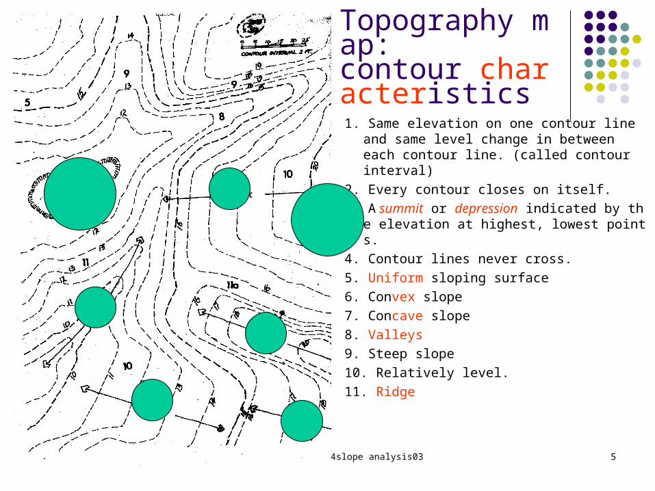
1. Same elevation on one ccccccc cccc and same level change in between each contour line. (called contour interval)
2. .Every contour closes on itself 3. A summit cc depression ccccccccc cc ccc cccccccc
cccccccc cccccc ccccccc,. 4. .Contour lines never cross 5. c cccccc sloping surface 6. Convex ccccc 7. Concave ccccc 8. ccccccc 9. Steep slope
10. Relatively level. 11. Ridge
Topography map:
contour characteristics

09/03/2004 /Apinya/KMUTTarc354slope analysis03 6
Topo graphic model
Models are good mediums to give the feeling of the earth form and study the natural drain age pattern

09/03/2004 /Apinya/KMUTTarc354slope analysis03 7
Drain age pattern 90Natural drainage pattern : Water always flows in degrees
cc ccccccc ccccc cccccc ccccc ccc cccccccccc cc ccccccc c. - ar ge scal e dr ai nage pat t er n besi des t he on si t e t opogr ap
hy to see how much water flow through the channel .

09/03/2004 /Apinya/KMUTTarc354slope analysis03 8
Grading formula G=D/L or L=D/G or D=GL Gradient percent = D/L*100
Map ping slope from Top ography map
09/03/2004 /Apinya/KMUTTarc354slope analysis03 9
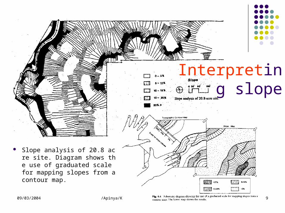
208Slope analysis of . acr ccccc ccccccc cccc. c the usc cc ccccccccc ccccc ccc c cc
ping slopes from a contour m.
Interpret ing slope

09/03/2004 /Apinya/KMUTTarc354slope analysis03 10
Interpret ing slope
09/03/2004 /Apinya/KMUTTarc354slope analysis03 11
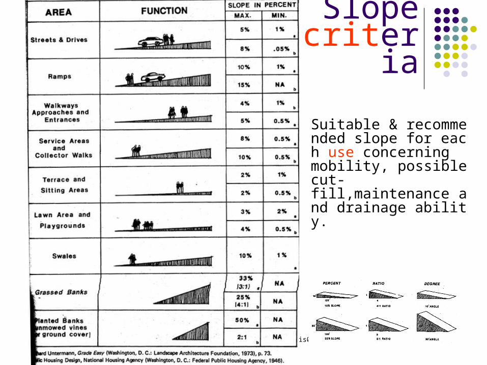
Slope criteria
Suitable & recomm ended slope for eac
h use concerningmobility, possible c
-ut fill,maintenance and drainage abilit
y.

09/03/2004 /Apinya/KMUTTarc354slope analysis03 12
Slope criteria
Angles of repose for various types o
f slope materials. ( Angles are given i
n degrees.) What is Angles of repose?
Maximum angle fo r earth material th
at it can be incline d, and it will fail if
beyond.

09/03/2004 /Apinya/KMUTTarc354slope analysis03 13
Grad ingGrading : is the act of remodeling the land form. It is
one of the most important items in site planning, l andscape design and construction. Grading serves
three main purposes: 1.To create a level to put something on; for a hous
e, car, sport play field, a hotel, etc. 2. To create circulation ways; road way, loading ra
mp, handicapped ramp, bicycle track, etc. 3. To create special effect and solve special proble
m; makea mound t o hi de par ki ng l ot or r educe sound, p reventer osi on and l andsl i de, aest het i c or psycholo gicalpur poses.

09/03/2004 /Apinya/KMUTTarc354slope analysis03 14
Grading making an area level to put so
mething on By cut ting only
t he soi l i s st abl e r equi r e l ess cost f or
f oundat i on const r uct i on
be able to do very stee p slope
cost to transport earth from the site

09/03/2004 /Apinya/KMUTTarc354slope analysis03 15
Grading making an area level to put
something on By fill ing only
easier to make a very l evel elevation
good for low land, flood problem area.
cccccccc cccccc ccccc c ccccccccccc Cost of transporting ear
th into the site

09/03/2004 /Apinya/KMUTTarc354slope analysis03 16
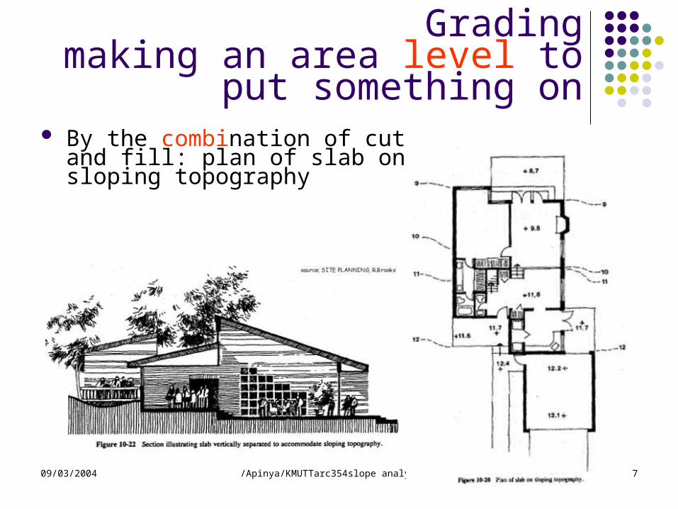
Grading making an area level to put
something on
By the combi nation of cut an d fill
balance earth in the site, n o transportation cost.
09/03/2004 /Apinya/KMUTTarc354slope analysis03 17
Grading making an area level to put so
mething on By the combi nation of cut and fi
ll: plan of slab on sloping topography
09/03/2004 /Apinya/KMUTTarc354slope analysis03 18
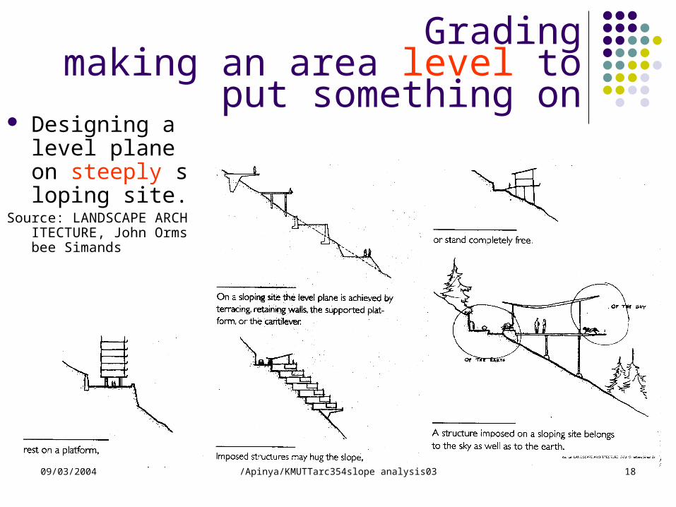
Desi gni ng a l evel pl ane
on steeply slopingsi te.
Source: LANDSCAPE ARC HITECTURE, John Orm
sbee Simands.
Grading making an area level to put
something on

09/03/2004 /Apinya/KMUTTarc354slope analysis03 19
Gradingwhen not to grade
Avoid grading on the following conditions 1. Grading that results in radical loss of veget at i
on and t opsoi l 2. Grading that interrupts the natural dr ai nage 3. Grading that results in aest he t i c degr adat i o
n 4. Grading on di ff icult slopes (excess of 25%) 5 . Grading in envccccc ccccc cccccc cccccccccc ccc
odplain, bogs, 6. Grading in areas effected by natural cccccccc ;
mudslides or along earthquake fault lines

09/03/2004 /Apinya/KMUTTarc354slope analysis03 20
Grading for circulation
Circulation routes should be level as possible. c wo ways to travel up ccccc ccccccc ( max imum slope for local street is 8%)

09/03/2004 /Apinya/KMUTTarc354slope analysis03 21
The normal grading method is something between the t wo extremes with roads or paths climbing and falling ge
ntry so as to allow the quickest trip with the least effort.
Gradingfor circulation
09/03/2004 /Apinya/KMUTTarc354slope analysis03 22
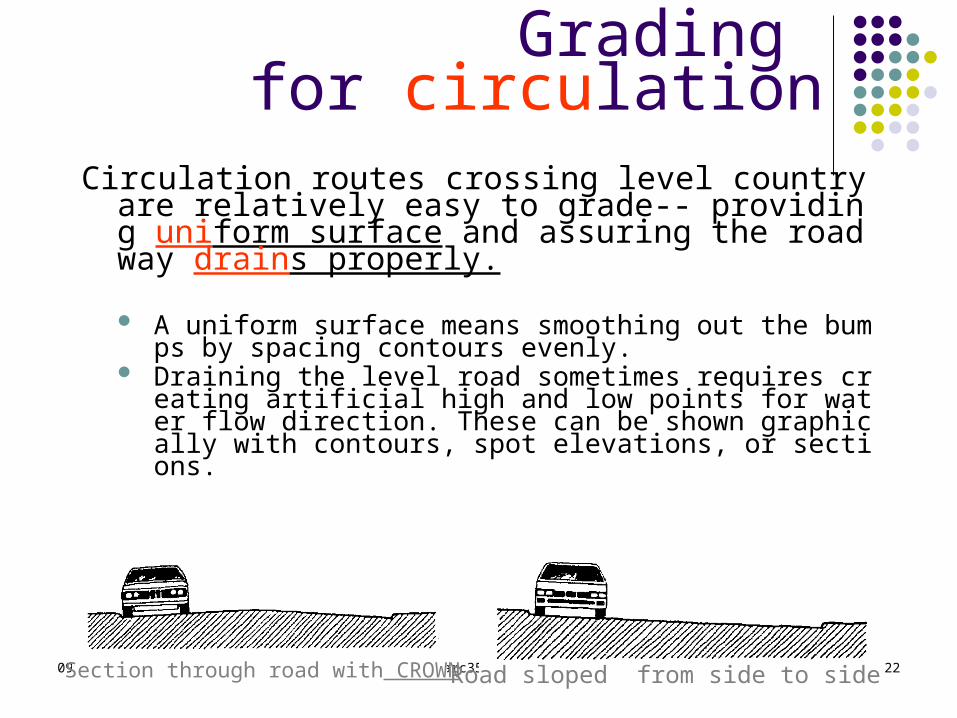
Circulation routes crossing level country are relati -- vely easy to grade providing uni form surface and assuring the roadway dr ai n s properly.
Auni f or msur f ace means smoot hi ng out t he bumps by spacingcont our s evenl y.
Drainingthelevelroadsomet i mes r equi r es cr eat i ng ar t i fi ci al hi gh an dlowpointsforwat er fl owdi r ect i on. These can be shown gr aphi c allywithcontours, spot el evat i ons, or sect i ons.
Grading for circulation
Section through road with CROWN Road sloped from side to side

09/03/2004 /Apinya/KMUTTarc354slope analysis03 23
Shortest distance but results extensive cutting, common design guide is to align the road centerli
ne with or parallel to the contour lines with minim al grading
Grading for circulation

09/03/2004 /Apinya/KMUTTarc354slope analysis03 24
When gr adi ng byCUTting , begin with t
he lowest contour an d work up, by fill ing,
begin with the top co ntour and work down.
Contours are spaced according to the grad
ient of the proposed r oute typically expres
sed in percent. For 10 % slope, one meter in
terval contours would be spaced 10 m. apar
t
Grading for circulation

09/03/2004 /Apinya/KMUTTarc354slope analysis03 25
Themost common way i f exi st i ng t opogr aphy i s NOT t o st eep. The procedure is to select the contour in the mid dle of the ro
ad and cut half the contour above, fill half of the contour belo w.
Grading for circulation

09/03/2004 /Apinya/KMUTTarc354slope analysis03 26
If cut/fill creates a steep bank, a heavy rainfall can induce mudslides and erosion. Alter natives to separate the road w
ay (if it is wide enough) should be considered along with th e use of retaining wall on the high side of the slope.
Grading for circulation

09/03/2004 /Apinya/KMUTTarc354slope analysis03 27
The r oad cr osses a ser i es of cont our and causes a ver y st eep bank si nce t h
e r oad needs UNI FORMslopedesi gn cr i t er i a. The situationshoul d t hen avoi d or t r y t o compr omi set he cut and fi l l al ong t he cent er l i n e.
Grading for circulation

09/03/2004 /Apinya/KMUTTarc354slope analysis03 28
Road crosses drainage swal e, the problem concerning t he i nt er section between ro ad and topographical depres
sion, theuse of BOX CULVERT or BRI DGE would be chosen depen
d on the length and depth of the swale and the image of t
he design.
Grading for circulation
09/03/2004 /Apinya/KMUTTarc354slope analysis03 29
Ref erence books 1. Grade Easy, 2 . Site Planning : Environmental process and developme
- 129171 07632nt P. , R. Gene Brooks, Prentice Hall N.J. 3. Site Planning p.83-106, Assoc.Professor Decha
Boomkum, Lecture sheet , Chulalongkorn University, Thailand
4. Time-Saver standards for Landscape Architecture, Chales W.Harris & Nicholas T.Dines