04.12.2015 г. An Open-Source WebGIS Platform for Rapid Disaster Impact Assessment Roya Olyazadeh,...
11
25.03.22 An Open-Source WebGIS Platform for Rapid Disaster Impact Assessment Roya Olyazadeh, Zar Chi Aye, Michel Jaboyedoff and Marc-Henri Derron
-
Upload
kerry-cooper -
Category
Documents
-
view
217 -
download
2
Transcript of 04.12.2015 г. An Open-Source WebGIS Platform for Rapid Disaster Impact Assessment Roya Olyazadeh,...
18.04.23
An Open-Source WebGIS Platform for Rapid Disaster Impact Assessment
Roya Olyazadeh, Zar Chi Aye, Michel Jaboyedoff and Marc-Henri Derron
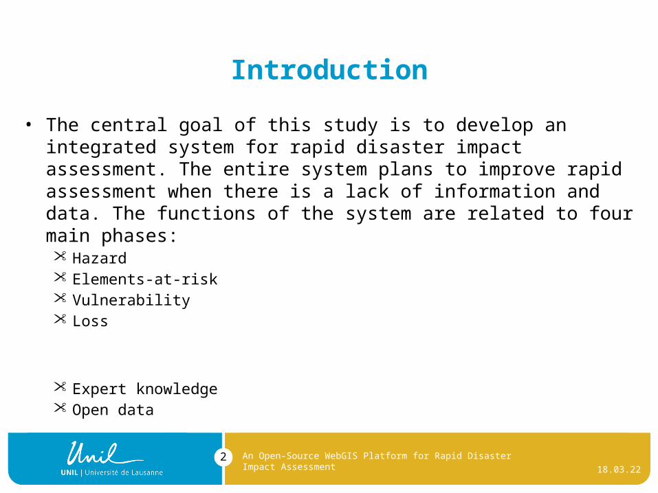
Introduction
• The central goal of this study is to develop an integrated system for rapid disaster impact assessment. The entire system plans to improve rapid assessment when there is a lack of information and data. The functions of the system are related to four main phases: Hazard Elements-at-risk Vulnerability Loss
Expert knowledge Open data
18.04.23
An Open-Source WebGIS Platform for Rapid Disaster Impact Assessment
2

Earthquake in Nepal 2015
18.04.23
An Open-Source WebGIS Platform for Rapid Disaster Impact Assessment
3
Shaking intensity map of Earthquake 7.8 M (from (Grossi 2015))
Magnitude 7.8 Earthquake in Nepal & Aftershocks (from (Robertson and Koontz 2015))

Losses
• Based on UN report:
1 More than 3 millions houses were damaged
2 160,786 houses destroyed
An Open-Source WebGIS Platform for Rapid Disaster Impact Assessment
18.04.23
An Open-Source WebGIS Platform for Rapid Disaster Impact Assessment
5
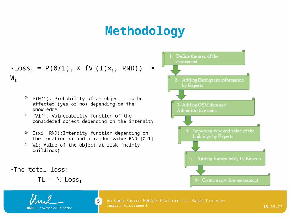
Methodology
•Lossi = P(0/1)i × fVi(I(xi, RND)) × Wi
P(0/1): Probability of an object i to be affected (yes or no) depending on the knowledge
fVi(): Vulnerability function of the considered object depending on the intensity I
I(xi, RND):Intensity function depending on the location xi and a random value RND [0-1]
Wi: Value of the object at risk (mainly buildings)
•The total loss:
TL = ∑ Lossi

Architecture
The platform consists of the following components:
Geo-database (PostgreSQL and PostGIS);
Geographic user interface, including maps (Extjs, OpenLayers and GXP)
Web-GIS server (Geoserver)
User management with SQL (UserCake: http://usercake.com/)
Data analysis and process in PHP
18.04.23
An Open-Source WebGIS Platform for Rapid Disaster Impact Assessment
6
CLIENT
SERVER
DATABASE
OpenLayers/GXP
JavaScript/Html/CSS
WWW
Apache-TomcatGeoServer
SQL PostgreSQL
PostGISUserCake
PHP

Main View of Application
18.04.23
An Open-Source WebGIS Platform for Rapid Disaster Impact Assessment
7
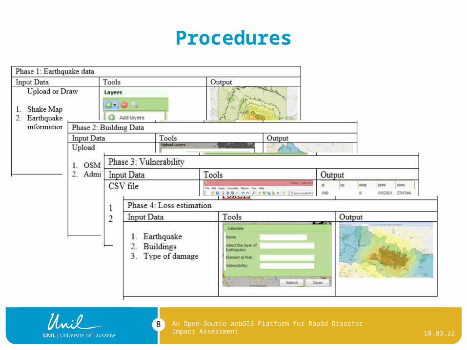
Procedures
18.04.23
An Open-Source WebGIS Platform for Rapid Disaster Impact Assessment
8

Results
18.04.23
An Open-Source WebGIS Platform for Rapid Disaster Impact Assessment
9

Conclusion
18.04.23
An Open-Source WebGIS Platform for Rapid Disaster Impact Assessment
10
Flexibility and usability
Fast with a modest budget
Huge amount of data
By using open data, elimination the lack of information and data (e.g., OSM, USGS, Numbeo and GADM database)
Pros:
It is not an accurate loss estimation
The full functional system is still under development in order to fulfill the lack of information, the user requirements and skilled knowledge of the earthquake experts.

Thank You!
You need more information,please contact me:
18.04.23
An Open-Source WebGIS Platform for Rapid Disaster Impact Assessment
11