
0121006891 - NE Sturdevant Road
97
Foley Land Northeast Sturdevant Road Toledo, Oregon 97391 BBG File #0121006891 Contract #ODF-2045A-21 Prepared For Mr. D. Chris Stewart Oregon Department of Forestry 2600 State St. Salem, OR 97310 Report Date June 16, 2021 Prepared By BBG, Inc., Portland Office 1220 SW Morrison Portland, OR 97205 503-478-1000 Client Manager: Owen Bartels, MAI [email protected]
Transcript of 0121006891 - NE Sturdevant Road

Foley Land Northeast Sturdevant Road
Toledo, Oregon 97391
BBG File #0121006891 Contract #ODF-2045A-21
Prepared For Mr. D. Chris Stewart
Oregon Department of Forestry 2600 State St.
Salem, OR 97310
Report Date June 16, 2021
Prepared By BBG, Inc., Portland Office
1220 SW Morrison Portland, OR 97205
503-478-1000
Client Manager: Owen Bartels, MAI [email protected]

FOLEY LAND APPRAISAL
June 16, 2021
Mr. D. Chris Stewart Oregon Department of Forestry 2600 State St. Salem, OR 97310
Re: Appraisal of Real Property
Foley LandNortheast Sturdevant Road Toledo, Oregon 97391
BBG File #0121006891 Contract #ODF-2045A-21
Dear Mr. Stewart:
In accordance with your authorization (per the engagement letter found in the addenda of this report), we have prepared an Appraisal of the above-referenced property.
The subject property consists of 5.54 acres of unimproved land comprised of two tax lots which are in the Urban Growth Boundary for the City of Toledo. The property owner is in the process annexing them into the City (with a change in residential zoning) and filing a lot line adjustment. Per the client's request, we consider that both the annexation (with related zoning change) and lot line adjustment have been completed.
Key to understanding the subject property is the recognition that it is not currently improved. There is no home, no septic or sewer to a building site, no well or public water installed, no driveway. The owner has expressed an intention to subdivide the property and sell individual lots, but there is not a plat map drawn or approved, nor an application for subdivision submitted, nor engineering drawings or approvals. As of the writing of this report, the property is raw land with some future development potential.
As of the valuation date of this report, Kelly and Lorraine Foley own the subject property. The client is considering the purchase of the property in order to develop an office on it (via a conditional use permit). A purchase price has not been established.
This appraisal report was prepared to conform with the requirements of the Uniform Standards of Professional Appraisal Practice (USPAP), and has been written in accordance with the Code of Ethics and the Standards of Professional Practice of the Appraisal Institute. In addition, this report is intended to be in compliance with additional requirements of Oregon Department of Forestry (client). The report is intended to be used by the client. No other party may rely upon the findings in this report.
The global outbreak of a "novel coronavirus" known as COVID-19 was officially declared a pandemic by the World Health Organization (WHO) on March 11, 2020, with the President of the United States declaring the COVID-19 outbreak a national emergency on March 13.
The goal is to encourage "social distancing," which health experts have stressed can slow the spread of the disease and keep health systems from being overwhelmed. The order will almost certainly help in

Mr. Stewart June 16, 2021 Page 2
FOLEY LAND APPRAISAL
mitigating the impact of the virus, particularly for the most vulnerable populations. However, while the economic effects of this order are currently unclear, the impact on the regional and state economy could be considerable.
During the initial stage of the response it was ordered that businesses that do not provide “essential” services must send workers home. Among those remaining open are grocery stores, pharmacies, restaurants for delivery only and hardware stores. Most workers are ordered to stay home, with exceptions including health care workers; police, fire and other emergency responders; and utility providers such as electricians, plumbers and sanitation workers. Public transportation will run for essential travel, and airports are not closing.
The impact of the virus has created near-term instability in the capital and real estate markets. It is currently unknown what direct, or indirect, effect, this event may have on the national economy, the local economy and the market in which the subject property is located for some time. The reader should note the data and comparables used in this report are data points that occurred in the past and there is projection risk associated with using lagging indicators. While every attempt has been made to determine the impact on value of the subject property, the associated risk may not yet be priced into the real estate market. Our conclusions have been based on best available market evidence including interviews with market participants and analysis of all relevant current market data.
Please reference the COVID-19 Disease overview section of this appraisal report for further discussion.
Note: Our opinion of market value is subject to the following Extraordinary Assumptions and/or Hypothetical Conditions:
Based on our inspection of the property and the investigation and the analysis undertaken, we have concluded the following value opinion(s).
This letter must remain attached to the report, which should be transmitted in its entirety, in order for the value opinion set forth to be considered valid.
Extraordinary Assumption(s) This apprai sa l empl oys no extraordinary ass umptions .
Hypothetical Condition(s) This apprai sa l is based on the hypothetical condi tion that the propos ed lot l ine is
complete, as indicated on the provi ded map for thi s appra is al .
This appra isa l is bas ed on the hypothetica l condition that the subject has been
incorporated into the Ci ty of Tol edo, a t the sel l er's expens e.
The val ues pres ented wi thin this apprai sa l report are s ubject to the extraordinary as sumpti ons and hypothetical
condi tions l i s ted below. Purs uant to the requi rement within Uniform Standards of Profess iona l Appra is al Practi ce
Standards , i t i s stated here that the us e of any extraordinary as sumpti ons might have affected the ass ignment
res ul ts .
EXTRAORDINARY ASSUMPTION(S) AND HYPOTHETICAL CONDITION(S)
Appraisal Premise Interest Appraised Date of Value Value Conclusion
Market Va lue - As Is Fee Simple May 13, 2021 $240,000
MARKET VALUE CONCLUSION(S)
Mr. Stewart June 16, 2021 Page 3
FOLEY LAND APPRAISAL
Our firm appreciates the opportunity to have performed this appraisal assignment on your behalf. If we may be of further service, please contact us.
Sincerely, BBG, Inc.
Owen Bartels , MAI Sydni A. Nicol ici
OR Certi fied Genera l Apprais er OR Certi fied Genera l Apprais er
License #: C000870 License #: C001356
503-478-1016 503-478-1011

FOLEY LAND APPRAISAL
TABLE OF CONTENTS
Subject Property ................................................................................................................................1
Summary of Salient Facts ...................................................................................................................2
Property History ................................................................................................................................3
Scope of Work ...................................................................................................................................4
Market Concerns................................................................................................................................8
Regional Analysis ............................................................................................................................. 19
Surrounding Area Analysis ............................................................................................................... 26
Market Analysis ............................................................................................................................... 30
Site Description................................................................................................................................ 32
Property Tax Analysis ....................................................................................................................... 44
Highest and Best Use ....................................................................................................................... 45
Valuation Process ............................................................................................................................ 48
Land Valuation ................................................................................................................................. 49
Certification ..................................................................................................................................... 61
Standard Assumptions and Limiting Conditions ................................................................................ 62
Addenda .......................................................................................................................................... 66

SUBJECT PROPERTY 1
FOLEY LAND APPRAISAL
SUBJECT PROPERTY
AERIAL PH OTOGRAPH

SUMMARY OF SALIENT FACTS 2
FOLEY LAND APPRAISAL
SUMMARY OF SALIENT FACTS
PROPERTY DATA
Property Name
Address
Location
County
Parcel Number
Census Tract No.
Legal Description
Site Area
Primary Site 241,322 s quare feet (5.5400 acres )
Zoning
Flood Status Zone AE is a Specia l Flood Hazard Area (SFHA) where base flood elevations are
provided. AE Zones are now used on new format Flood Insurance Rate Maps (FIRM)
instead of A1-A30 Zones . In communities that parti cipate in the Nationa l Flood
Insurance Program (NFIP), mandatory flood insurance purchase requi rements apply to
this zone.
Foley Land
Northeast Sturdevant Road
Toledo, Oregon 97391
The subject fronts the east s ide of SE Sturdevant Rd. and extends east to SE Chedester
Rd. in the UGB for the Ci ty of Toledo.
Lincoln
A portion of R273276, R508704
951400
A portion of Lot 1100 and al l of Lot 1000 in the Northeast 1/4 of Section 17, Township 11S,
Range 10W, WM, Lincoln County, Oregon. A more deta i led legal description was not
ava i lable and the subject i s currently subject to a lot l ine adjustment.
R-1; Medium Dens i ty Res identia l
Zone X (unshaded) i s a Non-Special Flood Hazard Area (NSFHA) of minimal flood hazard,
usual ly depicted on Flood Insurance Rate Maps (FIRM) as above the 500-year flood level .
Thi s is an area in a low to moderate risk flood zone that i s not in any immediate danger
from flooding caused by overflowing rivers or hard ra ins . In communities that parti cipate
in the National Flood Insurance Program (NFIP), flood insurance is avai lable to a l l
property owners and renters in thi s zone.
Advantages The subject wi l l be annexed into the City which market parti cipants indicate
increas es val ue.
The property i s fronted by a paved, publ i c roadway.
Electrici ty i s ava i lable to the s i te.
Challenges Publ ic sewer i s 500-600' away and the cost to extend would be s i gni fi cant.
The property i s heavi ly treed and wi l l need to be cl eared i n order to be developed.
RISK SUMMARY
As Is as of May 13, 2021
Approach Reliance
Value Conclusion - As Is $240,000 $0.99 Per Square Foot
Exposure Time (Months) 1-3 months
Marketing Time (Months) 1-3 months
VALUE INDICATIONS
Sales Comparison Approach

PROPERTY HISTORY 3
FOLEY LAND APPRAISAL
PROPERTY H ISTORY
The subject is owned by Kelly and Lorraine Foley. The client is considering the purchase of the property, although a purchase price has not been established as of yet. The subject owner purchased the property more than 10 years ago and has retained it as an investment. Due to the increased home values in the area, they decided it would be a good time to sell the property.
As part of the sale negotiations, the seller will manage and pay for the annexation of the subject into the City. Also, they will complete a lot line adjustment which provides a buffer to the home they own adjacent to the subject.
We interviewed the City and County regarding the subject. The representatives for each planning department stated the annexation process is typical of similar properties in the UGB. Steps for approval have been taken and the soonest annexation could occur was reported to be July. However, the City planner stated it may take longer and depends on the availability of committees for approvals.
Electricity is available to the site. However, the City of Toledo planner stated water and sewer are about 50—to 600’ away (to the south, near the school).
We are not aware of any other sale or listing activity of the subject in the past three years.
SCOPE OF WORK 4
FOLEY LAND APPRAISAL
SCOPE OF WORK
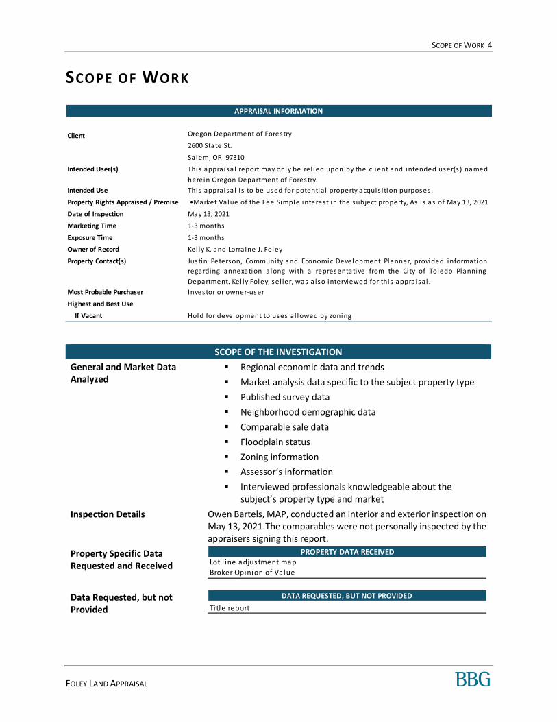
SCOPE OF THE INVESTIGATION
General and Market Data Analyzed
Regional economic data and trends
Market analysis data specific to the subject property type
Published survey data
Neighborhood demographic data
Comparable sale data
Floodplain status
Zoning information
Assessor’s information
Interviewed professionals knowledgeable about the subject’s property type and market
Inspection Details Owen Bartels, MAP, conducted an interior and exterior inspection on May 13, 2021.The comparables were not personally inspected by the appraisers signing this report.
Property Specific Data Requested and Received
Data Requested, but not Provided
APPRAISAL INFORMATION
Client
Intended User(s)
Intended Use
Property Rights Appraised / Premise
Date of Inspection
Marketing Time
Exposure Time
Owner of Record
Property Contact(s)
Most Probable Purchaser
Highest and Best Use
If Vacant
This appraisa l i s to be used for potential property acquis ition purposes .
Oregon Department of Forestry
2600 State St.
Sa lem, OR 97310
This appraisa l report may only be rel ied upon by the cl ient and intended user(s ) named
herein Oregon Department of Forestry.
•Market Value of the Fee Simple interest in the subject property, As Is as of May 13, 2021
May 13, 2021
1-3 months
1-3 months
Kel ly K. and Lorra ine J. Foley
Justin Peterson, Community and Economic Development Planner, provided information
regarding annexation a long with a representative from the Ci ty of Toledo Planning
Department. Kel ly Foley, sel ler, was a lso interviewed for this appra isal .
Investor or owner-user
Hold for development to uses al lowed by zoning
PROPERTY DATA RECEIVEDLot l ine adjustment map
Broker Opinion of Va lue
DATA REQUESTED, BUT NOT PROVIDED
Ti tle report
SCOPE OF WORK 5
FOLEY LAND APPRAISAL
Data Sources
VALUATION METHODOLOGY
Most Probable Purchaser To apply the most relevant valuation methods and data, the appraiser must first determine the most probable purchaser of the subject property.
The most probable purchaser of the subject is an investor looking to hold the property as an investment (until public utilities are pulled to the site) or an owner-user who will develop the property to uses allowed by zoning, which do not require public utilities.
Valuation Methods Utilized This appraisal employs only the Sales Comparison Approach. Based on our analysis and knowledge of the subject property type and relevant investor and buyer profiles, it is our opinion that this approach would be considered necessary and applicable for market participants. Since no improvements exist on site, the Cost Approach is not relevant. The property generates no income and is not typically marketed, purchased or sold on the basis of anticipated lease income; thus, the Income Capitalization Approach was precluded.
Si te SizeAs ses s or's Records & Propos ed Lot Line
Adjustment Map
Tax Data As ses s or's Records
Zoning InformationPlanning Dept (Ci ty of Toledo a nd Lincoln
County)
Flood Status FEMA
Demographics Reports Spotl ight
Comparable Land Sa lesMLS, Brokers , Phone Veri fi cations,
Appra is er's Fi les
DATA SOURCES
Extraordinary Assumption(s) This apprai sa l empl oys no extraordinary ass umptions .
Hypothetical Condition(s) This apprai sa l is based on the hypothetical condi tion that the propos ed lot l ine is
complete, as indicated on the provi ded map for thi s appra is al .
This appra isa l is bas ed on the hypothetica l condition that the subject has been
incorporated into the Ci ty of Tol edo, a t the sel l er's expens e.
The val ues pres ented wi thin this apprai sa l report are s ubject to the extraordinary as sumpti ons and hypothetical
condi tions l i s ted below. Purs uant to the requi rement within Uniform Standards of Profess iona l Appra is al Practi ce
Standards , i t i s stated here that the us e of any extraordinary as sumpti ons might have affected the ass ignment
res ul ts .
EXTRAORDINARY ASSUMPTION(S) AND HYPOTHETICAL CONDITION(S)
SCOPE OF WORK 6
FOLEY LAND APPRAISAL
DEFINITIONS
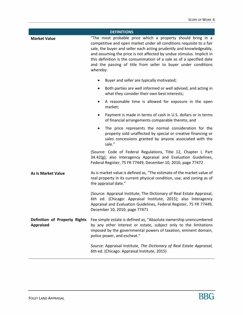
Market Value “The most probable price which a property should bring in a competitive and open market under all conditions requisite to a fair sale, the buyer and seller each acting prudently and knowledgeably, and assuming the price is not affected by undue stimulus. Implicit in this definition is the consummation of a sale as of a specified date and the passing of title from seller to buyer under conditions whereby:
Buyer and seller are typically motivated;
Both parties are well informed or well advised, and acting in what they consider their own best interests;
A reasonable time is allowed for exposure in the open market;
Payment is made in terms of cash in U.S. dollars or in terms of financial arrangements comparable thereto; and
The price represents the normal consideration for the property sold unaffected by special or creative financing or sales concessions granted by anyone associated with the sale.”
(Source: Code of Federal Regulations, Title 12, Chapter I, Part 34.42[g]; also Interagency Appraisal and Evaluation Guidelines, Federal Register, 75 FR 77449, December 10, 2010, page 77472
As Is Market Value As is market value is defined as, “The estimate of the market value of real property in its current physical condition, use, and zoning as of the appraisal date.”
(Source: Appraisal Institute, The Dictionary of Real Estate Appraisal, 6th ed. (Chicago: Appraisal Institute, 2015); also Interagency Appraisal and Evaluation Guidelines, Federal Register, 75 FR 77449, December 10, 2010, page 77471
Definition of Property Rights Appraised
Fee simple estate is defined as, “Absolute ownership unencumbered by any other interest or estate, subject only to the limitations imposed by the governmental powers of taxation, eminent domain, police power, and escheat.”
Source: Appraisal Institute, The Dictionary of Real Estate Appraisal, 6th ed. (Chicago: Appraisal Institute, 2015)

SCOPE OF WORK 7
FOLEY LAND APPRAISAL
Applicable Requirements
This appraisal is intended to conform to the requirements of the following:
Uniform Standards of Professional Appraisal Practice (USPAP);
Code of Professional Ethics and Standards of Professional Appraisal Practice of the Appraisal Institute;
Applicable state appraisal regulations.
LEVEL OF REPORTING DETAIL
Standards Rule 2-2 (Real Property Appraisal, Reporting) contained in USPAP requires each written real property appraisal report to be prepared as either an Appraisal Report or a Restricted Appraisal Report.
This report is prepared as an Appraisal Report. An Appraisal Report must at a minimum summarize the appraiser’s analysis and the rationale for the conclusions. This format is considered most similar to what was formerly known as a Summary Appraisal Report in prior versions of USPAP.

MARKET CONCERNS 8
FOLEY LAND APPRAISAL
MARKET CONCERNS
COVID-19 D ISEASE; SARS-COV-2 V IRUS
CDC
On January 30, 2020, the International Health Regulations Emergency Committee of the World Health Organization (WHO) declared the outbreak a “public health emergency of international concern” (PHEIC). On January 31, Health and Human Services Secretary Alex M. Azar II declared a public health emergency (PHE) for the United States to aid the nation’s healthcare community in responding to COVID-19. On March 11, WHO publicly characterized COVID-19 as a pandemic. On March 13, the President of the United States declared the COVID-19 outbreak a national emergency.
COSTAR | MARCH 1, 2021
The process for writing this column every week generally starts with updating a set of charts tracking high-frequency data on the economy and then discussing what they mean. The narrative direction for the week is born out of your authors’ ongoing Microsoft Teams chat, trading charts back and forth, sending quotes from Federal Reserve speeches, talking markets.
That process last week led to something of a landmark event for CoStar Economy: We’re feeling quite optimistic on the economy for the first time in a long time. Let’s explain why.
First, let’s check in on the most important graph for the economy: COVID-19 infection rates. This has been the graph to watch for nearly a full year as we are approaching the anniversary of the quarantine. As fast and furious as the rise in coronavirus infection rates was to close out 2020, they have come down just as quick. For the West and Midwest in particular, positive test rates are as low as they have been since the pandemic began.

MARKET CONCERNS 9
FOLEY LAND APPRAISAL
This is great news as the third wave of cases clearly affected economic and job growth, with net negative job growth over the months of December 2020 and January 2021. It appears that activity picked up quickly as the spread began to subside, almost concurrently. Some of our favorite high-frequency indicators are showing very strong signs that things are starting to get better. And quickly. Data from the reservation service OpenTable on restaurant traffic, below in red, is already back to its highest levels since the summer of 2020, when massive rehiring of leisure, hospitality and entertainment workers was driving monthly jobs gains into the millions. Credit and debit card spending, as measured by Affinity Solutions in blue, is also clearly rising in 2021 and currently stands at pandemic highs — even though the trend is pretty volatile.

MARKET CONCERNS 10
FOLEY LAND APPRAISAL
While restaurant traffic is still down a hefty 40% from a year ago, a combination of vaccinations, healthier restaurant practices and possibly herd immunity effects are pushing activity higher much faster. With Johnson & Johnson’s single-shot vaccine getting very positive news last week, this dynamic of increasing in-person activity should accelerate through the spring.
Consumer spending has been on an absolute tear as well, for all the reasons mentioned above but more importantly because of the fiscal stimulus enacted at the close of 2020. The chart below measures total personal income growth against personal income without emergency fiscal stimulus. Personal income in January 2021 skyrocketed to levels not seen since $1,200 checks were sent out in April 2020. While this time around the checks were only $600, these government benefits completely overshadowed the income growth weakness that began in December as hiring slowed to a standstill.

MARKET CONCERNS 11
FOLEY LAND APPRAISAL
With incomes boosted once again, and more freedom for individuals to move around and spend money, we can say with confidence this is the most optimistic backdrop we’ve had since the start of the crisis. The bond market has noticed this too, with 10-year U.S. Treasury rates hitting 1.6% briefly before falling back to close the week just below 1.5%. These are levels not seen since February 2020. Federal Reserve Chairman Jerome Powell stuck to his dovish script in front of Congress this past week, indicating “monetary policy is accommodative and it continues to need to be accommodative. ... Expect us to move carefully, patiently, and with a lot of advance warning.”
We feel compelled to offer a few reminders. First, rising long-term bond yields aren’t necessarily a bad thing! It’s less important to know that yields are rising than it is to know why they are rising. In this case, they are rising because economic growth is picking up. As of this writing, the Atlanta Fed’s GDPNow forecast for gross domestic product growth for the first quarter of 2021 is near 9%. That’s a good thing and will help make up the shortfall in GDP from pre-pandemic levels as well as assist in putting the roughly 10 million people without jobs back to work.
Second, the level of interest rates matters, not just the direction. The worry is that fast-rising interest rates will choke off economic growth. Does anyone here think 1.5% or even 2% interest rates are restrictive, hovering around zero when adjusted for inflation? As we wrote last week, housing market tailwinds will occur even at higher mortgage rates. Both mortgage and Treasury yields remain lower than at any level ever prior to 2020.
Lastly, the Fed has held strong in its conviction to keep short-term interest rates low until a rebound in the economy and labor market is well underway. The two-year Treasury rate agrees with them. While rates at points further out the curve have risen sharply, the two-year has barely budged and remains at

MARKET CONCERNS 12
FOLEY LAND APPRAISAL
only 0.14% as of this writing. That tells us that the Fed won’t be raising rates anytime soon to slow down the economy. That means the yield curve has been steepening quickly. Bizarrely, this has been pointed out as a bad sign for growth, or at least a reason to worry that growth will be crimped by higher interest rates. In fact, a steepening yield curve has been a clear leading indicator for an improving economy coming out of a recession. The move steeper over the last few weeks has been fairly sharp, but it’s actually just catching levels typically seen when coming out of a recession.
The yield curve tracks consumer and business sentiment indices quite closely. If this is an indication of anything, it’s of more strength to come.
We don’t want to miss the forest through the trees here: there is still a long, long way to go before cumulative conditions return to where we were a year ago, and millions upon millions are still out of work. But if these trends keep up, and especially if new stimulus passes, that could happen quite quickly. As our opening quote suggests, many households and industries were broken in 2020. The world itself broke, in a way. But it appears that we are healing, and becoming stronger in those broken places.
The Week Ahead …
Next week is all about jobs, with an update on employment in February to be released on Friday. As activity remained depressed as of early February, the report is unlikely to capture the optimism we discussed above. But we will continue to keep a close eye on hiring of employment service employees, a reliable leading indicator for broader hiring, as well as the working conditions for long-term unemployed and disaffected workers.
Secondary to the jobs report, but still important and perhaps more forward-looking, are the Institute for Supply Management surveys. Business confidence has been strong in light of improved vaccine news, and look to continue that way as the ISM manufacturing index is released on Monday and ISM services index on Wednesday.
MORT GA GE BAN KER S ASSOCIA TION: HOME PUR CHA SES | FE BRUARY 5, 2021
Mortgage applications to purchase a home have accelerated in the second half and the housing market remains healthy and active. Home purchases spur economic activity.

MARKET CONCERNS 13
FOLEY LAND APPRAISAL
INIT IA L JOBLE SS CLA IM S|FEBRUARY 25, 2021
On March 26th initial jobless claims showed an increase in unemployment by 3.1 million persons for the week of March 16th-20th, setting a record that would be broken the following week at 6.9 million. All weekly claims reported since March 26th are higher than any historical figure prior to COVID-19. The following chart illustrates the weekly initial jobless claims in 2020 and into 2021.
Jobless claims fell sharply last week despite severe winter storms that swept across Texas and other parts of the South, the Labor Department reported Thursday. First-time filings for unemployment insurance totaled 730,000 for the week ended Feb. 20, well below the Dow Jones estimate of 845,000.
MARKET CONCERNS 14
FOLEY LAND APPRAISAL
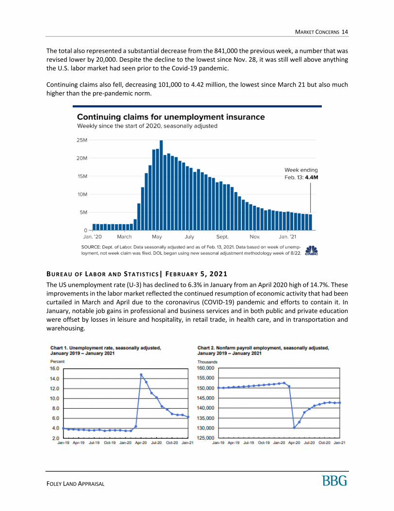
The total also represented a substantial decrease from the 841,000 the previous week, a number that was revised lower by 20,000. Despite the decline to the lowest since Nov. 28, it was still well above anything the U.S. labor market had seen prior to the Covid-19 pandemic.
Continuing claims also fell, decreasing 101,000 to 4.42 million, the lowest since March 21 but also much higher than the pre-pandemic norm.
BUREAU OF LABOR AND STA TISTIC S| FE BRUAR Y 5, 2021
The US unemployment rate (U-3) has declined to 6.3% in January from an April 2020 high of 14.7%. These improvements in the labor market reflected the continued resumption of economic activity that had been curtailed in March and April due to the coronavirus (COVID-19) pandemic and efforts to contain it. In January, notable job gains in professional and business services and in both public and private education were offset by losses in leisure and hospitality, in retail trade, in health care, and in transportation and warehousing.

MARKET CONCERNS 15
FOLEY LAND APPRAISAL
GDP FOREC A ST S
The following chart summarizes GDP forecasts from various economists and institutions. Please note the annualized figures are the quarterly change multiplied by four.
While Q2 was beyond painful, the worst is behind us and Q3 was outstanding. The fourth quarter was strong and the outlook for 2021 is much improved. High growth rates are expected into 2022.
NAREIT/TREPP: CMBS DEL IN QUENC Y| MARCH 2021
In February, the Trepp CMBS Delinquency Rate generated its largest improvement since the beginning of the pandemic. After two huge jumps in the reading in May and June of last year, the rate has now declined for eight consecutive months. The Trepp CMBS Delinquency Rate in February was 6.80%, a decline of 78 basis points from the January number, which is the biggest drop over the last eight months. The percentage of loans in the 30 days delinquent bucket is 0.58% – down 16 basis points for the month.
Source Date Q1 Q2 Q3 Q4 Full Year Q1 Q2 Q3 Q4 Full Year
CNBC/Moody's Consensus 3/1 -- -- -- -- -- 5.0% 8.5% 7.0% -- 6.0%
Mortgage Bankers Association 2/19 -- -- -- -- -- 4.8% 5.1% 7.2% 6.4% 5.9%
Goldman Sachs 2/9 -- -- -- -- -- -- -- -- -- 6.8%
Atlanta Fed GDP Now 3/1 -- -- -- -- -- 10.0% -- -- -- --
Actual -5.0% -32.8% 33.4% 4.0% -3.5% -- -- -- --
CNBC/Moody's Consensus -- -- -- -- -- 1.3% 2.1% 1.8% --
Mortgage Bankers Association -- -- -- -- -- 1.2% 1.3% 1.8% 1.6%
Goldman Sachs -- -- -- -- -- -- -- -- --
Atlanta Fed GDP Now -- -- -- -- -- 2.5% -- -- --
Actual -1.3% -8.2% 8.4% 1.0% -- -- -- --
2020 GDP Forecasts
Annualized
2021 GDP Forecasts
Annualized
Change from Previous Quarter

MARKET CONCERNS 16
FOLEY LAND APPRAISAL
URBAN LA ND INSTITUTE : REA L ESTATE EC ON OMIC FORECA ST| OC TOBER 2020
ULI compiled forecasts from 43 economist/analysts at 37 real estate organizations. The key findings are noted as follows.
Transaction Volume
Commercial real estate transaction volume reached $593 billion in 2019, a post-Great Financial Crisis peak. Volume is expected to be about 50% lower in 2020 with a forecast of $300 billion. Forecasts for ‘21 and ’22 show growth to $400 billion and $500 billion, respectively.
CRE Pricing
The RCA Commercial Property Price Index (CPPI) has experienced strong growth over the last nine years, staying consistently above 6 percent annually. Prices are expected to drop by 2% in 2020, remaining at that level with no change in ‘21 and then resuming growth in ‘22 with a 4% growth rate.

MARKET CONCERNS 17
FOLEY LAND APPRAISAL
MCK IN SEY & COM PAN Y | OCT OBER 30, 2020
The following from McKinsey & Company illustrates the many possible scenarios for the economic impact of the COVID-19 crisis. With a strong public health response and the stimulus package the most likely scenarios are A1 through A4. Other, more extreme scenarios can also be conceived, and some of them are already being discussed (B1–B5 in Exhibit 3). One can’t exclude the possibility of a “black swan of black swans”: structural damage to the economy, caused by a yearlong spread of the virus until a vaccine is widely available, combined with the lack of policy response to prevent widescale bankruptcies, unemployment, and a financial crisis.
If Scenario A1 occurs, McKinsey & Company projects US GDP will return to pre-crisis levels in the third quarter of 2022. If Scenario A3 occurs, McKinsey & Company projects US GDP will return to pre-crisis levels in the first quarter of 2021.
OTHER FEDERA L, STA TE AND LOCA L CON SIDER AT ION S
The federal government, states and municipalities are enacting legislation to lessen the economic impact of COVID-19. Landlords’, owners’ and tenants’ rights may be affected by such legislation. Many states and cities issued shelter-in-place orders forcing most residents to remain indoors except for essential needs like groceries and essential businesses. Several states have proposed legislation that would forgive rent and/or would allow termination of contracts. These issues should be closely monitored as they could place downward pressure on value.
FORCE MA JEURE
Force majeure clauses are contract provisions that excuse a party’s inability to perform its obligations under the contract if an unforeseeable event prevents such performance. Most leases have similar clauses. We are not experts with regard to force majeure contacts and laws. Should COVID-19 become accepted in the US as a force majeure event there may be additional risk for landlords.
MARKET CONCERNS 18
FOLEY LAND APPRAISAL
CONC LUSI ON
COVID-19 infections and overall economic implications are the primary concern of US and international investors; however, as vaccines are becoming more available and GDP growth rates have rebounded the worry among investors has been greatly reduced. Strong economic growth is expected throughout 2021 and into 2022 as rates are expected to remain near historical lows. Given recent bond yield increases, investors have expressed worries over upward pressure on interest rates; however, rates remain well below historical norms.
Medium and long-term outlooks are favorable and interest rates are expected to remain low into 2023, which could bode well for commercial real estate. Over the short-term hotels, restaurants and non-credit retail have taken the brunt of the declines while industrial, self-storage and multi-family have been the least affected. Office demand has faced downward pressures due to remote working trends and elevated levels of unemployment, which are declining. We will continue to interview market participants regarding changes in market conditions.

REGIONAL ANALYSIS 19
FOLEY LAND APPRAISAL
REGIONAL ANALYSIS
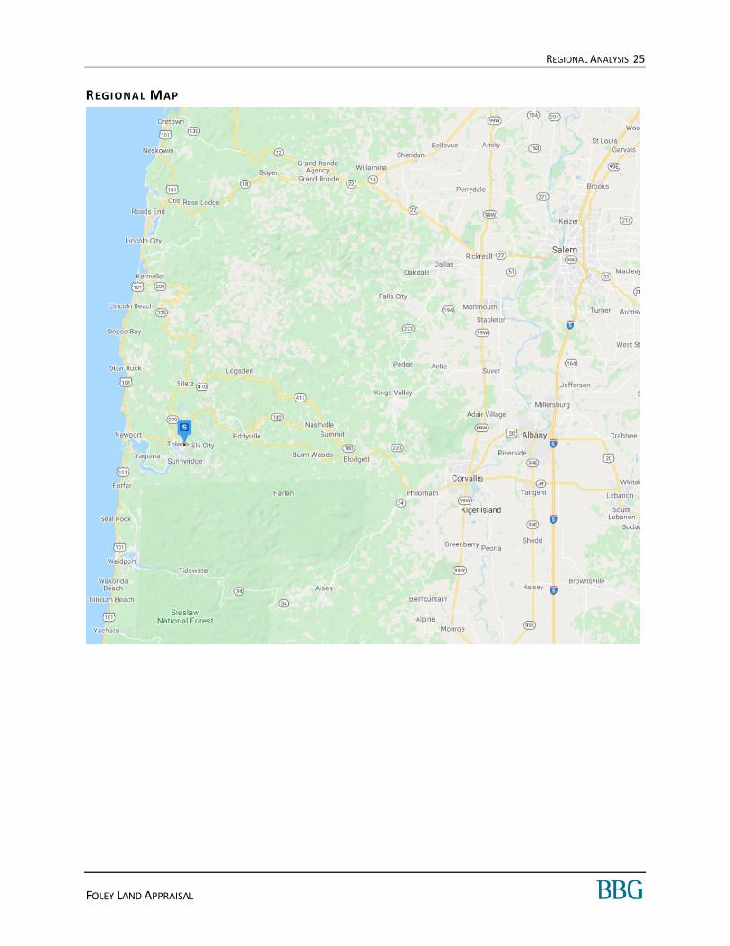
L INCOLN COUNTY AREA ANALYSIS
The subject of this appraisal is in the UGB of the City of Toledo, in Lincoln County, Oregon. Lincoln County is in coastal Oregon approximately 130 miles southwest of Portland. It is 980 square miles in size and has a population density of 49 persons per square mile.
Lincoln County extends some 60 miles north and south, but just 15 to 25 miles in width, and is bordered by the Pacific Ocean and the Coast Range. Lincoln County is part of the Central Oregon Coast region, and its northern border is about 80 miles south of the Columbia River. The county is bounded by the Pacific Ocean in the west, by Tillamook County in the north, by Polk and Benton counties in the east, and by Lane County in the south.
TOPOGRA PHY
Principal features of Lincoln County’s topography are rounded hills, and narrow, winding coastal valleys, with the coastal plains being broken at many points by rugged headlands rising abruptly from the ocean. Small, scattered areas of level bottom land border the rivers and streams. Some of the valleys lie only a few feet above sea level; others are as high as 400 feet. Ridge tops vary from 1,000 feet to 1,500 feet in elevation. Many peaks of the Coast Range rise more than 2,000 feet and Saddleback Mountain east of Otis in Clatsop County reaches 3,350 feet.
Lincoln County has five major rivers that run into the Pacific Ocean: the Alsea, Salmon, Siletz, Yachats, and the Yaquina. All have their principal headwaters near the crest of the Coast Range, winding west to the Pacific. Each has formed a small shallow bay at its mouth, the largest of which is the Yaquina, at Newport.
The climate of Lincoln County is greatly influenced by the prevailing westerly winds from the Pacific Ocean. Characteristic features are moderate temperatures, a long frost-free season, and abundant rainfall. Prevailing winds are usually southwest during the winter, and northwest during the summer. Other parts of Oregon at the same latitude are much colder in winter and hotter in the summer. Snow in Lincoln County is rare, except for light falls on the peaks of the Coast Range. The growing season averages 248 days in Newport, 195 days in the Toledo area inland. The last frost of winter can be as late as March 23rd, and the first fall frost as late as November 26th. Lincoln County's mild climate, long growing season, and generous amounts of precipitation are extremely favorable to the growth of vegetation, trees, shrubs, and flowers.
Lincoln County is classified as an entirely rural county by the Oregon Economic Development Department. Thirty-five percent of the county's total land mass is publicly owned--some 217,000 acres, while 65%, or 417,880 acres, is privately owned.
TRANSPORTA TI ON NE TW ORK
The transportation system has a profound impact on Oregon’s coastal counties.

REGIONAL ANALYSIS 20
FOLEY LAND APPRAISAL
H I GHWA YS
Two federal highways serve the county: Highway 101 runs along the Pacific Coast from the Mexican to the Canadian borders. Highway 20 follows a winding route through the Coast Range, connecting with Highway 191 at Newport and with Interstate-5 at Albany. All are winding two-lane highways.
State Routes 18 and 34 connect Lincoln County to the Willamette Valley and Interstate-5, the major West Coast north-south interstate. State Route 18 follows a northeast to southwest route to Lincoln City through McMinnville before connecting with Highway 99W in Newberg. State Route 34, the Alsea Highway, winds through the Coast Range between Waldport and Corvallis before continuing to Lebanon near the eastern edge of the Willamette Valley.
RAI L SERVI CE
The Portland & Western Railroad’s branch line from Albany through Corvallis to Toledo near the eastern end of Yaquina Bay exclusively serves Georgia Pacific’s Toledo pulp and paper mill.
A IRPORTS
Newport Municipal Airport is a city-owned, public use airport located three miles south of Newport’s CBD. It formerly supported commercial passenger service with connections to Portland International Airport, but SeaPort Airlines discontinued service to Newport in July 2011.
POPU LA TION
Lincoln County has an estimated 2021 population of 50,087, which represents an average annual 0.8% increase over the 2010 census of 46,034. Lincoln County added an average of 676 residents per year over the 2010-2021 period, but its annual growth rate lagged the State of Oregon rate of 1.0%.
Looking forward, Lincoln County's population is projected to increase at a 1.0% annual rate from 2021-2026, equivalent to the addition of an average of 432 residents per year. Lincoln County's growth rate is expected to equal that of Oregon, which is projected to be 1.0%.
EMP LOYMEN T
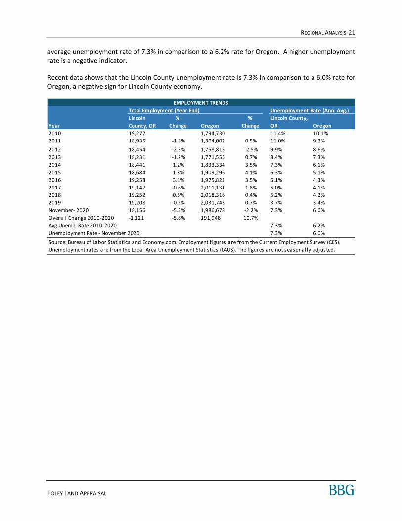
Total employment in Lincoln County is currently estimated at 18,156 jobs. Between year-end 2010 and the present, employment fell by 1,121 jobs, equivalent to a 5.8% decrease over the entire period. There were gains in employment in four out of the past ten years despite the national economic downturn and slow recovery. Along with Lincoln County's employment decreasing over the last decade, it also underperformed Oregon, which experienced an increase in employment of 10.7% or 191,948 jobs over this period.
A comparison of unemployment rates is another way of gauging an area’s economic health. Over the past decade, the Lincoln County unemployment rate has been generally higher than that of Oregon, with an
Population Compound Ann. % Chng
2010 Census 2021 Estimate 2026 Projection 2010 - 2021 2021 - 2026
Lincoln County, OR 46,034 50,087 52,249 0.8% 0.8%
Oregon 3,831,074 4,281,747 4,491,795 1.0% 1.0%
Source: Environics Analytics
POPULATION TRENDS
REGIONAL ANALYSIS 21
FOLEY LAND APPRAISAL
average unemployment rate of 7.3% in comparison to a 6.2% rate for Oregon. A higher unemployment rate is a negative indicator.
Recent data shows that the Lincoln County unemployment rate is 7.3% in comparison to a 6.0% rate for Oregon, a negative sign for Lincoln County economy.
Total Employment (Year End) Unemployment Rate (Ann. Avg.)
Year
Lincoln
County, OR
%
Change Oregon
%
Change
Lincoln County,
OR Oregon
2010 19,277 1,794,730 11.4% 10.1%
2011 18,935 -1.8% 1,804,002 0.5% 11.0% 9.2%
2012 18,454 -2.5% 1,758,815 -2.5% 9.9% 8.6%
2013 18,231 -1.2% 1,771,555 0.7% 8.4% 7.3%
2014 18,441 1.2% 1,833,334 3.5% 7.3% 6.1%
2015 18,684 1.3% 1,909,296 4.1% 6.3% 5.1%
2016 19,258 3.1% 1,975,823 3.5% 5.1% 4.3%
2017 19,147 -0.6% 2,011,131 1.8% 5.0% 4.1%
2018 19,252 0.5% 2,018,316 0.4% 5.2% 4.2%
2019 19,208 -0.2% 2,031,743 0.7% 3.7% 3.4%
November- 2020 18,156 -5.5% 1,986,678 -2.2% 7.3% 6.0%
Overall Change 2010-2020 -1,121 -5.8% 191,948 10.7%
Avg Unemp. Rate 2010-2020 7.3% 6.2%
Unemployment Rate - November 2020 7.3% 6.0%
EMPLOYMENT TRENDS
Source: Bureau of Labor Statistics and Economy.com. Employment figures are from the Current Employment Survey (CES).
Unemployment rates are from the Local Area Unemployment Statistics (LAUS). The figures are not seasonally adjusted.

REGIONAL ANALYSIS 22
FOLEY LAND APPRAISAL
MA JOR EM PLOYER S
Major employers in Lincoln County are shown in the following table.
HOU SEH OLD INC OME
Lincoln County has a considerably lower level of household income than Oregon. Median household income for Lincoln County is $51,631, which is 25.3% less than the corresponding figure for Oregon.
Name
1 Confederated Tribes of Siletz Indians
2 Samaritan Health Services
3 Lincoln County School District
4 Lincoln County
5 OSU Hatfield Marine Science Center
6 Georgia-Pacific - Toledo
7 Rogue Ales and Spirits
8 Fred Meyer
9 Wal-Mart Stores Inc.
10 Mo's Restaurants
11 City of Newport
12 Salishan Spa and Golf Resort
13 Safeway - Newport and Lincoln City
14 City of Lincoln City
15 NOAA - Land and at sea
16 Oksenholt Companies/Meredith
17 Central Lincoln PUD
18 Inn at Spanish Head
19 Oregon Coast Aquarium
20 Mid-Columbia Bus Company
MAJOR EMPLOYERS - LINCOLN COUNTY, OR
Source: Economic Development All iance of Lincoln County
Average Median
Lincoln County, OR $69,318 $51,631
Oregon $95,518 $69,151
Comparison of Lincoln County, OR to Oregon - 27.4% - 25.3%
Source: Environics Analytics
MEDIAN HOUSEHOLD INCOME - 2021
REGIONAL ANALYSIS 23
FOLEY LAND APPRAISAL
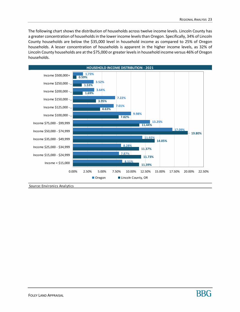
The following chart shows the distribution of households across twelve income levels. Lincoln County has a greater concentration of households in the lower income levels than Oregon. Specifically, 34% of Lincoln County households are below the $35,000 level in household income as compared to 25% of Oregon households. A lesser concentration of households is apparent in the higher income levels, as 32% of Lincoln County households are at the $75,000 or greater levels in household income versus 46% of Oregon households.
HOUSEHOLD INCOME DISTRIBUTION - 2021
Source: Environics Analytics
11.39%
11.73%
11.37%
14.05%
19.80%
11.44%
7.82%
4.63%
3.95%
1.69%
1.53%
0.59%
8.51%
7.87%
8.28%
11.92%
17.09%
13.25%
9.98%
7.01%
7.22%
3.64%
3.52%
1.73%
0.00% 2.50% 5.00% 7.50% 10.00% 12.50% 15.00% 17.50% 20.00% 22.50%
Income < $15,000
Income $15,000 - $24,999
Income $25,000 - $34,999
Income $35,000 - $49,999
Income $50,000 - $74,999
Income $75,000 - $99,999
Income $100,000 -…
Income $125,000 -…
Income $150,000 -…
Income $200,000 -…
Income $250,000 -…
Income $500,000+
Oregon Lincoln County, OR

REGIONAL ANALYSIS 24
FOLEY LAND APPRAISAL
EDUCAT ION AN D AGE
Residents of Lincoln County have a lower level of educational attainment than those of Oregon. An estimated 24% of Lincoln County residents are college graduates with four-year degrees, versus 32% of Oregon residents. People in Lincoln County are older than their Oregon counterparts. The median age for Lincoln County is 52 years, while the median age for Oregon is 40 years.
CONC LUSI ON
The Lincoln County economy will be affected by a growing population base and lower income and education levels. Lincoln County experienced growth in the number of jobs over the past decade, and it is reasonable to assume that employment growth will occur in the future. We anticipate that the Lincoln County economy will improve and employment will grow, strengthening the demand for real estate.
REGIONAL ANALYSIS 25
FOLEY LAND APPRAISAL
REGI ONA L MAP

SURROUNDING AREA ANALYSIS 26
FOLEY LAND APPRAISAL
SURROUNDING AREA ANALYSIS
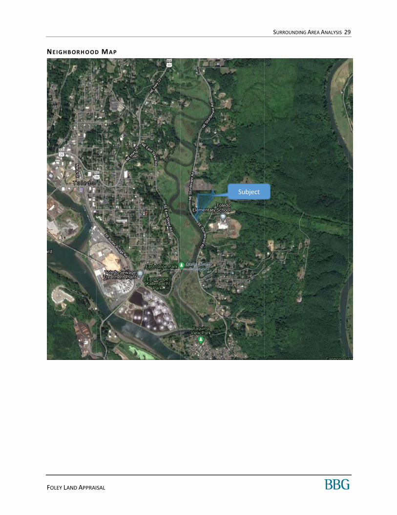
BOU NDAR IES
The subject is located in unincorporated Lincoln County, just outside of the City of Toledo, and within the UGB. This area is part of the Newport, OR MSA.
A map identifying the location of the property follows this section.
ACCESS A ND L I N KA GES
Primary access to the area is provided by Hwy 20, a major arterial that crosses the Lincoln County area in an east/west direction. Access to the subject from Hwy 20 is provided by Sturdevant Rd and travel time from the major arterial to the subject is about two minutes. Overall, vehicular access is good.
Public transportation is provided by Transit Intercity and provides access to major areas of Lincoln County. The nearest bus station is located at SE Sturdevant Rd & 10th, about one mile south of the subject. However, the primary mode of transportation in this area is the automobile.
The nearest municipal airport is located in Newport, 14.5 miles southwest from the property; travel time is about 22 minutes, depending on traffic conditions. A smaller, public airport, Toledo State Airport, is located just 5 minutes driving time from the subject in Toledo.
DEMA ND GE NERAT OR S
Major employers include Confederated Tribes of Siletz Indians, Samaritan Health Services, Lincoln County School District, Lincoln County, and OSU Hatfield Marine Science Center. These are located within 20 miles of the property, except for Samaritan Health Services, which is located in Corvallis about 47 miles away. These employers represent significant concentrations in the education, health, and government industries.
Coastal Oregon is a well-known tourist destination and is an additional significant demand generator for the county.
SURROUNDING AREA ANALYSIS 27
FOLEY LAND APPRAISAL
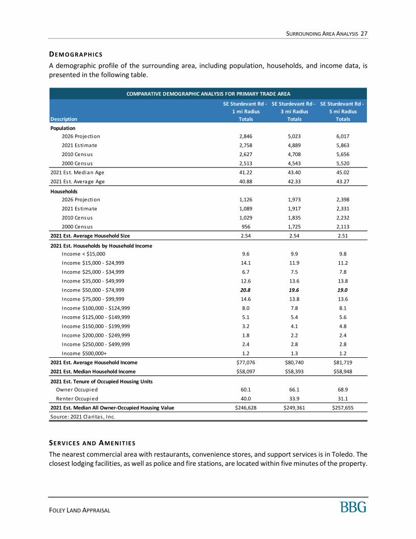
DEMOGRAPH IC S
A demographic profile of the surrounding area, including population, households, and income data, is presented in the following table.
SERVICE S AND AMEN IT IE S
The nearest commercial area with restaurants, convenience stores, and support services is in Toledo. The closest lodging facilities, as well as police and fire stations, are located within five minutes of the property.
COMPARATIVE DEMOGRAPHIC ANALYSIS FOR PRIMARY TRADE AREA
SE Sturdevant Rd -
1 mi Radius
SE Sturdevant Rd -
3 mi Radius
SE Sturdevant Rd -
5 mi Radius
Description Totals Totals Totals
Population
2026 Projection 2,846 5,023 6,017
2021 Estimate 2,758 4,889 5,863
2010 Census 2,627 4,708 5,656
2000 Census 2,513 4,543 5,520
2021 Est. Median Age 41.22 43.40 45.02
2021 Est. Average Age 40.88 42.33 43.27
Households
2026 Projection 1,126 1,973 2,398
2021 Estimate 1,089 1,917 2,331
2010 Census 1,029 1,835 2,232
2000 Census 956 1,725 2,113
2021 Est. Average Household Size 2.54 2.54 2.51
2021 Est. Households by Household Income
Income < $15,000 9.6 9.9 9.8
Income $15,000 - $24,999 14.1 11.9 11.2
Income $25,000 - $34,999 6.7 7.5 7.8
Income $35,000 - $49,999 12.6 13.6 13.8
Income $50,000 - $74,999 20.8 19.6 19.0
Income $75,000 - $99,999 14.6 13.8 13.6
Income $100,000 - $124,999 8.0 7.8 8.1
Income $125,000 - $149,999 5.1 5.4 5.6
Income $150,000 - $199,999 3.2 4.1 4.8
Income $200,000 - $249,999 1.8 2.2 2.4
Income $250,000 - $499,999 2.4 2.8 2.8
Income $500,000+ 1.2 1.3 1.2
2021 Est. Average Household Income $77,076 $80,740 $81,719
2021 Est. Median Household Income $58,097 $58,393 $58,948
2021 Est. Tenure of Occupied Housing Units
Owner Occupi ed 60.1 66.1 68.9
Renter Occupi ed 40.0 33.9 31.1
2021 Est. Median All Owner-Occupied Housing Value $246,628 $249,361 $257,655
Source: 2021 Clari tas , Inc.
SURROUNDING AREA ANALYSIS 28
FOLEY LAND APPRAISAL
LAN D USE
In the immediate vicinity of the subject, land uses are mixed. There are residential, commercial, light industrial, and agricultural properties surrounding the subject. Other land use characteristics are summarized in the following table.
SURROUNDING AREA LAND USES
Character of Area Suburban to Semi-Rural
Predominant Age of Improvements 10-100 years
Predominant Quality and Condition Average
Approximate Percent Developed 25%
Infrastructure/Planning Average
SUBJECT’S IMMEDIATE SURROUNDINGS
North BPA Toledo Substation
South Toledo Elementary School
East Single-Family Residences
West Single-Family Residences
DEVELOPME NT ACTI VITY AND TREND S
During the last five years, development in Lincoln County has been predominantly of retail and multi-family uses and has included two Dollar General stores and three Class A apartment buildings. Most of these buildings are located along the coast, and none were built in or near Toledo. The pace of development has generally been intermittent over this time.
OUTLOOK A ND CONC LU SION S
The area is in the growth stage of its life cycle. Given the history of the area and the growth trends, it is anticipated that property values will increase in the near future.
In comparison to other areas in the region, the area is rated as follows:
SURROUNDING AREA ATTRIBUTE RATINGS
Highway Access Above Average
Demand Generators Average
Convenience to Support Services Average
Convenience to Public Transportation Average
Employment Stability Average
Police and Fire Protection Average
Property Compatibility Average
General Appearance of Properties Average
Appeal to Market Average
Price/Value Trend Average
SURROUNDING AREA ANALYSIS 29
FOLEY LAND APPRAISAL
NEIGHBORH OOD MAP
Subject
MARKET ANALYSIS 30
FOLEY LAND APPRAISAL
MARKET ANALYSIS
RESIDENTIAL ANALYSIS
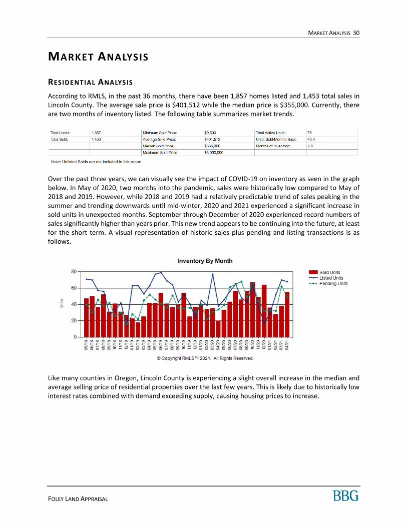
According to RMLS, in the past 36 months, there have been 1,857 homes listed and 1,453 total sales in Lincoln County. The average sale price is $401,512 while the median price is $355,000. Currently, there are two months of inventory listed. The following table summarizes market trends.
Over the past three years, we can visually see the impact of COVID-19 on inventory as seen in the graph below. In May of 2020, two months into the pandemic, sales were historically low compared to May of 2018 and 2019. However, while 2018 and 2019 had a relatively predictable trend of sales peaking in the summer and trending downwards until mid-winter, 2020 and 2021 experienced a significant increase in sold units in unexpected months. September through December of 2020 experienced record numbers of sales significantly higher than years prior. This new trend appears to be continuing into the future, at least for the short term. A visual representation of historic sales plus pending and listing transactions is as follows.
Like many counties in Oregon, Lincoln County is experiencing a slight overall increase in the median and average selling price of residential properties over the last few years. This is likely due to historically low interest rates combined with demand exceeding supply, causing housing prices to increase.
MARKET ANALYSIS 31
FOLEY LAND APPRAISAL
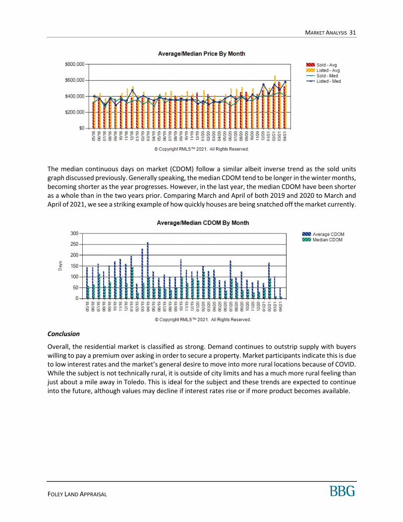
The median continuous days on market (CDOM) follow a similar albeit inverse trend as the sold units graph discussed previously. Generally speaking, the median CDOM tend to be longer in the winter months, becoming shorter as the year progresses. However, in the last year, the median CDOM have been shorter as a whole than in the two years prior. Comparing March and April of both 2019 and 2020 to March and April of 2021, we see a striking example of how quickly houses are being snatched off the market currently.
Conclusion
Overall, the residential market is classified as strong. Demand continues to outstrip supply with buyers willing to pay a premium over asking in order to secure a property. Market participants indicate this is due to low interest rates and the market’s general desire to move into more rural locations because of COVID. While the subject is not technically rural, it is outside of city limits and has a much more rural feeling than just about a mile away in Toledo. This is ideal for the subject and these trends are expected to continue into the future, although values may decline if interest rates rise or if more product becomes available.

SITE DESCRIPTION 32
FOLEY LAND APPRAISAL
S ITE DESCRIPTION
AERIAL MAP
INTRODUCTION
The description of the site is based upon our physical inspection of the property, information available from the client, and public sources. See the Data Sources Used Within This Appraisal table in the Scope of Work section for more detail.
SITE DESCRIPTION 33
FOLEY LAND APPRAISAL
GENERAL DESCRIPTION OVERVIEW
Location
Parcel Number A portion of R273276,
R508704
Legal Description
Site Area
Primary Site 241,322 s quare feet (5.5400 acres)
Configuration
Topography
Drainage
Utilities/Municipal Services
Floodplain Zone Map Date
Zone AE, X 41041C0531E October 18, 2019
Census Tract No.
Soil/Subsoil Conditions
Environmental Concerns
Land Use Restrictions
Hazards Nuisances
Enterprise Zone The s ubject i s not located within an opportuni ty zone.
We were not provided a current ti tle report to review. We are not aware of a ny
easements , encroachments , or res trictions that would adversely affect va lue. Our
valuation assumes no adverse impacts from easements , encroachments , or restrictions ,
a nd further a ssumes that the s ubject has clear and marketable ti tle.
No hazards or nuisances were obs erved.
An environmenta l as sess ment report was not provided for review, and during our
inspection, we did not obs erve any obvious s igns of contamination on or nea r the
s ubject. However, envi ronmenta l i ss ues are beyond our s cope of experti se. It i s
a ssumed tha t the property i s not advers ely affected by envi ronmenta l hazards .
The subject fronts the eas t s ide of SE Sturdeva nt Rd. and extends east to SE Chedes ter
Rd. in the UGB for the Ci ty of Toledo.
A portion of Lot 1100 a nd al l of Lot 1000 in the Northeast 1/4 of Section 17, Township 11S,
Range 10W, WM, Lincoln County, Oregon. A more deta i led legal des cription was not
a vai lable and the subject i s currently subject to a lot l ine adjustment.
Irregular
Sloping
Above street grade
Electrci ty i s avai lable to the s i te. Sewer and water a re approximately 500-600' to the
s outh of the s ubject (per Ci ty of Toledo).
Zone AE is a Specia l Flood Hazard Area (SFHA) where bas e flood eleva tions are
provided. AE Zones are now us ed on new format Flood Ins urance Rate Ma ps (FIRM)
instead of A1-A30 Zones . In communities tha t participate in the National Flood
Insurance Program (NFIP), ma ndatory flood ins urance purchase requirements apply to
this zone.
951400
We did not receive nor review a soi l report. However, we a ssume that the soi l 's load-
bearing capaci ty i s sufficient to support exis ting and/or proposed structure(s ). We did
not obs erve any evidence to the contra ry during our phys ica l inspection of the property.
Zone X (uns haded) is a Non-Specia l Flood Hazard Area (NSFHA) of minimal flood ha zard,
usual ly depicted on Flood Insura nce Rate Maps (FIRM) as above the 500-year flood level .
This is an area in a low to moderate risk flood zone that i s not in any immediate danger
from flooding caused by overflowing rivers or hard ra ins . In communities that participa te
in the Na tional Flood Ins urance Program (NFIP), flood insura nce is avai lable to al l
property owners and renters in this zone.

SITE DESCRIPTION 34
FOLEY LAND APPRAISAL
TOPOGRAPHY
The following graph indicates the general topography of the subject from north to south. The subject’s topography is gently sloping, from the highest elevation of 76 ft in the north to the lowest elevation of 19 ft in the south, towards SE Chedester Rd.
A topographic map of the property is below. The subject property line is estimated.
SITE DESCRIPTION 35
FOLEY LAND APPRAISAL
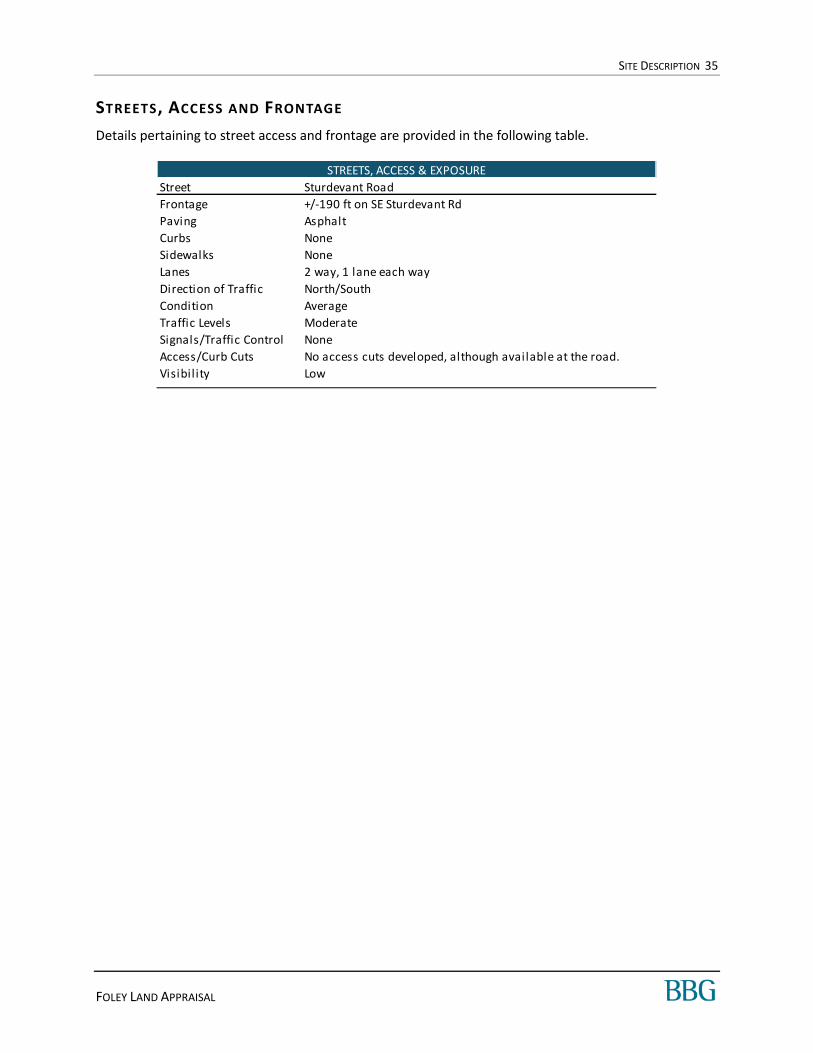
STREETS, ACCESS AND FRONTAGE
Details pertaining to street access and frontage are provided in the following table.
Street Sturdevant Road
Frontage +/-190 ft on SE Sturdevant Rd
Paving Asphalt
Curbs None
Sidewalks None
Lanes 2 way‚ 1 lane each way
Direction of Traffic North/South
Condition Average
Traffic Levels Moderate
Signals/Traffic Control None
Access/Curb Cuts No access cuts developed, although available at the road.
Visibil ity Low
STREETS, ACCESS & EXPOSURE
SITE DESCRIPTION 36
FOLEY LAND APPRAISAL
ZONING
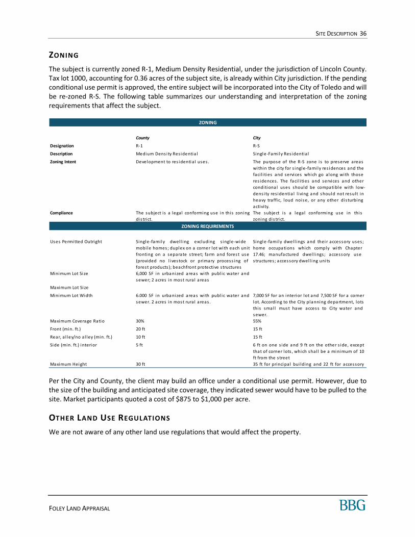
The subject is currently zoned R-1, Medium Density Residential, under the jurisdiction of Lincoln County. Tax lot 1000, accounting for 0.36 acres of the subject site, is already within City jurisdiction. If the pending conditional use permit is approved, the entire subject will be incorporated into the City of Toledo and will be re-zoned R-S. The following table summarizes our understanding and interpretation of the zoning requirements that affect the subject.
Per the City and County, the client may build an office under a conditional use permit. However, due to the size of the building and anticipated site coverage, they indicated sewer would have to be pulled to the site. Market participants quoted a cost of $875 to $1,000 per acre.
OTHER LAND USE REGULATIONS
We are not aware of any other land use regulations that would affect the property.
County City
Designation R-1 R-S
Description Medium Dens i ty Res identia l Single-Fami ly Res identia l
Zoning Intent Development to res identia l uses. The purpose of the R-S zone is to preserve areas
within the ci ty for s ingle-fami ly res idences and the
faci l i ties and services which go along with those
res idences . The faci l i ties and services and other
conditiona l uses should be compatible with low-
dens ity res identia l l i ving a nd s hould not result in
heavy traffic, loud nois e, or any other disturbing
activity.
Compliance The subject is a legal conforming use in this zoning
dis trict.
The subject i s a legal conforming use in this
zoning dis tri ct.
Uses Permitted Outright Single-family dwel l ing excluding s ingle-wide
mobile homes ; duplex on a corner lot wi th each unit
fronting on a separate s treet; fa rm and fores t us e
(provided no l ives tock or primary process ing of
forest products); beachfront protective structures
Single-family dwel l ings a nd thei r accessory uses ;
home occupa tions which comply with Chapter
17.46; ma nufactured dwel l ings; access ory us e
s tructures; a cces sory dwel l ing uni ts
Minimum Lot Si ze 6,000 SF in urba nized a rea s wi th publ ic water and
s ewer; 2 acres in most rural areas
Maximum Lot Si ze
Minimum Lot Width 6.000 SF in urba nized a rea s wi th publ ic water and
s ewer. 2 acres in most rural areas .
7,000 SF for an interior lot a nd 7,500 SF for a corner
lot. According to the Ci ty pla nning depa rtment, lots
thi s smal l mus t have acces s to Ci ty water and
s ewer.
Maximum Coverage Ratio 30% 55%
Front (min. ft.) 20 ft 15 ft
Rea r, a l ley/no a l ley (min. ft.) 10 ft 15 ft
Side (min. ft.) interior 5 ft 6 ft on one s ide a nd 9 ft on the other s ide, except
that of corner lots , which shal l be a minimum of 10
ft from the s treet
Maximum Height 30 ft 35 ft for principal bui lding and 22 ft for acces sory
ZONING REQUIREMENTS
ZONING
SITE DESCRIPTION 37
FOLEY LAND APPRAISAL
CONCLUSION OF S ITE ANALYSIS
The subject site contains 241,322 square feet or 5.54 acres of Medium Density Residential zoned land. It is currently being incorporated in the City of Toledo and will be zoned R-S, Single Family Residential. The site is irregularly shaped and has sloping topography. The shape is not ideal but would not impact the development of the site. Topography is not steep and also would not impact development.
The south portion of the property is in a flood zone. However, this area would be developed to an access drive and/or would be in the required setbacks. The remainder of the property is outside of the flood hazard area.
The site size and zoning requirements would permit subdivision and the development of multiple residences. However, according to the associated planning departments, the size of the lots would be determined by zoning and the availability of sewer and water. Larger lots would only be approved if sewer was not brought to the site. Sewer is reported to be 500-600’ feet away.
Overall, the physical characteristics of the site and the availability of utilities result in functional utility suitable for a variety of uses including those permitted by zoning. We are not aware of any other restrictions on development.
SITE DESCRIPTION 38
FOLEY LAND APPRAISAL
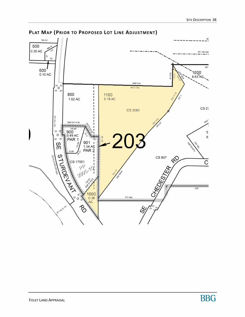
PLAT MAP (PRIOR TO PROPOSED LOT L INE ADJUSTMENT)
SITE DESCRIPTION 39
FOLEY LAND APPRAISAL
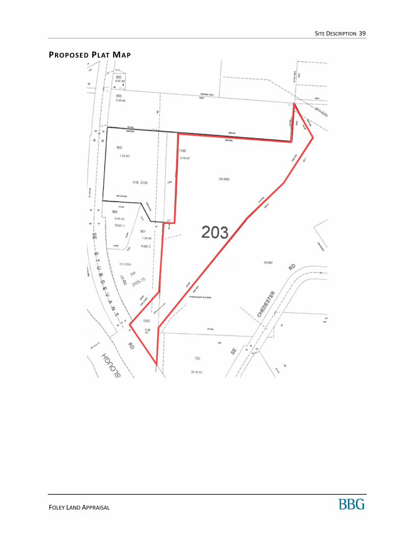
PROPOSED PLAT MAP

SITE DESCRIPTION 40
FOLEY LAND APPRAISAL
ZONING MAP – L INCOLN COUNTY
Subject’s approximate location

SITE DESCRIPTION 41
FOLEY LAND APPRAISAL
ZONING MAP – C ITY OF TOLEDO

SITE DESCRIPTION 42
FOLEY LAND APPRAISAL
FLOOD MAP

SITE DESCRIPTION 43
FOLEY LAND APPRAISAL
SUBJECT PHOTOS

PROPERTY TAX ANALYSIS 44
FOLEY LAND APPRAISAL
PROPERTY TAX ANALYSIS
State and local taxation in Oregon relies on income taxation at the state level and property taxes at the local level. The following is a summary of the Oregon property tax system.
Real estate taxes in the state and this jurisdiction represent ad valorem taxes, meaning a tax applied in proportion to assessed value.
Property taxes are collected locally to fund schools and governments in the area. The State does not receive any property tax revenue.
Property taxes are divided into school taxes and non-school taxes; non-school taxes raise revenue for City and County Governments, and educational service districts (community colleges, etc.).
In 1998, assessed value was rolled back to the 1996 real market value less 10%, and growth in assessed value was limited to 3% per year. Thus, property taxes are no longer directly tied in with real market value. There are some exceptions with respect to the 3% growth limit, such as new construction.
Property taxes may not exceed a limit of $5.00 per $1,000 of real market value for schools and $10.00 per $1,000 for non-schools
The limitation does apply to exempt bond levies that are approved by general election with at least half of the registered voters eligible to vote.
The tax year runs from July 1 through June 30, and the County Assessor's Office estimates value as of January 1 of each year. Property taxes are due and payable on November 15. A 3% discount is available if paid in full by November 15. A 2% discount is also obtainable if two-thirds of the amount is paid by this date. Another alternative is to make three equal (one-third) payments, on or before the 15th of November, February and May. Any balance owed begins to accrue interest after May 15, and counties initiate foreclosure if three years of taxes become delinquent.
Real estate taxes and assessments for the current tax year are shown in the following table.
Based on the concluded market value of the subject, the assessed value appears low. However, this is typical of the area and reassessment is not anticipated until development occurs.
Tax ID Land Improvements Total Mil lage Rate Assessed Value Real Estate Taxes
A portion of R273276 $99,470 $0 $99,470 15.67792208 $3,850 $60
R508704 $1,800 $0 $1,800 40.11538462 $780 $31
Totals $101,270 $0 $101,270 $4,630 $92
Assessor's Real Market Value Taxes and Assessments
REAL ESTATE TAXES 2020-2021

HIGHEST AND BEST USE 45
FOLEY LAND APPRAISAL
H IGHEST AND BEST USE
INTRODUCTION
The highest and best use is the reasonable, probable, and legal use of vacant land or an improved property that is physically possible, legally permissible, appropriately supported, financially feasible and that results in the highest value. These criteria are often considered sequentially. The tests of legal permissibility and physical possibility must be applied before the remaining tests of financial feasibility and maximal productivity. A financially feasible use is precluded if it is legally prohibited or physically impossible. If a reasonable possibility exists that one of the prior, unacceptable conditions can be changed, is it appropriate to proceed with the analysis with such an assumption.
H IGHEST AND BEST USE CRITERIA
The site’s highest and best use is analyzed both as vacant and as improved, and if improvements are proposed then an as proposed analysis is required. In all cases, the property’s highest and best use must meet four criteria: (1) legally permissible; (2) physically possible; (3) financially feasible; and (4) maximally productive.
H IGHEST AND BEST USE AS VACANT
LEGALLY PERMI SSI BLE
The subject is currently zoned R-1 Medium Density Residential which is a County Zone. This zone permits the development of residences on lots as small as 6,000 SF in urbanized areas with access to public utilities. Without utilities, the smallest parcel size is 2 acres. The property is in the UGB for the City of Toledo and the owner is currently in the process of annexing it. Upon annexation, the property will be zoned R-S, Single-Family Residential. The smallest residential lots permitted are 7,000 SF, assuming public utilities are at the site. Larger lots (as per review by the planning department) would be required if no sewer or water were available. In both jurisdictions and zones, government uses are permitted, although with a conditional use permit in some instances.
As has been mentioned in the Description section, the owner of the property has applied for annexation into the City of Toledo. He has expressed an intention to subdivide the property for development. As of the writing of this report, though, that is still a speculative idea only. There is no completed subdivision plat, no plat approvals from the City or the County. Subdivision would require those approvals, engineering, and additional survey and legal work.
While subdivision is likely legally permissible, the property’s legal status as of the effective date of this report is as a large lot with speculative potential.
A small portion of the property is in a flood zone, which cannot be developed with structures.
No other legal restrictions have been identified that would limit development of the property beyond the development standards stipulated by municipal code.
HIGHEST AND BEST USE 46
FOLEY LAND APPRAISAL
PHYSICA LLY POSSIBLE
The subject site contains 241,322 square feet or 5.54 acres of Medium Density Residential zoned land. It is currently being incorporated in the City of Toledo and will be zoned R-S, Single Family Residential. The site is irregularly shaped and has sloping topography. The shape is not ideal but would not impact the development of the site. Topography is not steep and also would not impact development.
The south portion of the property is in a flood zone. However, this area would be developed to an access drive and/or would be in the required setbacks. The remainder of the property is outside of the flood hazard area.
The site size and zoning requirements would permit subdivision and the development of multiple residences. However, according to the associated planning departments, the size of the lots would be determined by zoning and the availability of sewer and water. Larger lots would only be approved if sewer was not brought to the site. Sewer and water are reported to be 500-600’ feet away.
Overall, the physical characteristics of the site and the availability of utilities result in functional utility suitable for a variety of uses including those permitted by zoning. We are not aware of any other restrictions on development.
F INA NC IA LLY FEA SIBLE
The subject is not connected to public sewer, though public water is reportedly available in the street at the property corner. According to the planning department, sewer hookups are approximately 500-600’ feet away. The cost to extend, as reported by various market participants and sources is $875-$1,000 per foot. In the process of this appraisal we interviewed brokers and other market participants who indicated for similar properties, the cost to pull from significant distances is a barrier to most. Instead, they purchase parcels as an investment and/or on a speculative basis and wait until the City pays for extension or the parcels may be subdivided into larger lots with septic.
Sales in this report include parcels with no public utility access and others with public utilities in the street. Based on larger markets we have appraised in, we anticipated parcel value would be impacted by the availability and distance of public utilities. One participant stated the presence of public water and sewer in the street had a positive impact on value. Another stated they did not adjust their asking price, despite the availability of utilities to a parcel. We were unable to find any market data which supported an adjustment related to utility proximity. Considering these factors, speculative extension of the water and sewer line is not financially feasible.
As demonstrated in the Market Survey, residential demand has increased in the market over the past 12 months. Marketing times since January 2021 have dropped on average to less than 1 month. Currently there is approximately 1 month of inventory available. Despite this increased demand, we are not aware of any speculative development in the area. That strong demand for homes has not yet enticed subdivision approvals or development on any currently vacant acreage lots.
We anticipated zoning density would also impact value, but again were unable to locate any support for this factor. Instead, properties in or near designated communities, zoned for residential uses, are valued similarly by the market. However, when speaking with brokers, they stated higher values are associated with incorporated properties. To support this, we completed a survey of unincorporated, UGB, and incorporated (City or Planned Community) sales. We found incorporated properties sell for about 45% to
HIGHEST AND BEST USE 47
FOLEY LAND APPRAISAL
50% higher than unincorporated or UGB properties. Based on these factors, the annexation of the subject is considered ideal and financially feasible.
MAXI MA LLY PR ODUC TIV E
Based on the factors discussed under Financially Feasible, the annexation of the subject into the City of Toledo is maximally productive. Also retention of the site until utilities are extended by the City is also maximally productive. Immediate-term speculative subdivision or development of the property is not supported by the market.
In the course of the research for this appraisal, the appraisers identified a number of acreage lots with homes already constructed. Those were purchased by buyers who intended to immediately move in and use those homes. That is not the same as the subject, which has no home and will still require entitlements work prior to even the issuance of a building permit. The buyer of an existing home on acreage is not likely the same as the potential buyer for the subject. In other words, those properties do not share the subject’s highest and best use.

VALUATION PROCESS 48
FOLEY LAND APPRAISAL
VALUATION PROCESS
Valuation in the appraisal process generally involves three techniques, including the Cost Approach, Sales Comparison Approach and the Income Capitalization Approach.
These three valuation methods are defined in the following table:
VALUATION METHODS DEFINITION
Cost Approach In this approach, value is based on adding the contributing value of any improvements (after deductions for accrued depreciation) to the value of the land as if it were vacant based on its highest and best use. If the interest appraised is other than fee simple, additional adjustments may be necessary for non-realty interest and/or the impact of existing leases or contracts.1
Sales Comparison Approach In this approach, recent sales of similar properties in the marketplace are compared directly to the subject property. This comparison is typically accomplished by extracting “units of comparison”, for example, price per square foot, and then analyzing these units of comparison for differences between each comparable and the subject. The reliability of an indication found by this method depends on the quality of the comparable data found in the marketplace.
Income Capitalization Approach In this approach, a property is viewed through the eyes of a typical investor, whose primary objective is to earn a profit on the investment principally through the receipt of expected income generated from operations and the ultimate resale of the property at the end of a holding period.
VALUATION METHODS UTILIZED
This appraisal employs only the Sales Comparison Approach. Based on our analysis and knowledge of the subject property type and relevant investor and buyer profiles, it is our opinion that this approach would be considered necessary and applicable for market participants. Since no improvements exist on site, the Cost Approach is not relevant. The property generates no income and is not typically marketed, purchased or sold on the basis of anticipated lease income; thus, the Income Capitalization Approach was precluded.
The valuation process is concluded by analyzing each approach to value used in the appraisal. When more than one approach is used, each approach is judged based on its applicability, reliability, and the quantity and quality of its data. A final value opinion is chosen that either corresponds to one of the approaches to value, or is a correlation of all the approaches used in the appraisal.

LAND VALUATION 49
FOLEY LAND APPRAISAL
LAND VALUATION
METHODOLOGY
The Sales Comparison Approach is employed to develop an opinion of land value. In the Sales Comparison Approach, we developed an opinion of value by comparing similar, recently sold sites in the surrounding or competing area to the subject property. In order to determine the value of the subject property, these comparable sales and/or listings are then evaluated and adjusted based on their differences when compared to the subject property. Inherent in this approach is the principle of substitution, which states that when a property is replaceable in the market, its value tends to be set at the cost of acquiring an equally desirable substitute property, assuming that no costly delay is encountered in making the substitution.
The Sales Comparison Approach to value requires the following sequential steps:
Unit of Comparison The most widely used and market-oriented unit of comparison for properties with characteristics similar to those of the subject is sale price per square foot.
Search for Sales Research must be done to locate comparable sales, listings and contracts of sites that are similar to the subject. Similarities may include size, utility, zoning, physical characteristics, location and the date of the sale.
Confirmation All sales must be confirmed to verify that the data used is accurate, and that all of the sales, listings or contracts represent arm’s-length transactions.
Comparison Each of the sales that are chosen for this valuation is considered generally similar to the subject. Therefore, each difference between the comparables and the subject must be identified, and then adjusted for the various differences. All adjustments are made to the comparables as they relate to the subject property.
Reconciliation Once all of the comparables have been adjusted, a single-value must be concluded based on the indications produced from the analysis of the comparables.
To value the subject we considered parcels ranging from 3 to 10 acres zoned for residential uses. We considered sales in or near coastal communities as we were unable to locate any applicable transactions in the subject vicinity. An adjustment for location is made in order to account for this factor.
In our search, we attempted to locate sales which were incorporated into the city or designated communities. However, we were unable to locate an adequate number of transactions. Therefore, we consider one UGB sale and adjusted for this factor.
We considered listings but were unable to locate any applicable properties. Therefore, all comparables are pending or closed transactions. The sales occurred in the past 3 years.

LAND VALUATION 50
FOLEY LAND APPRAISAL
Because the subject is un-improved, our search for sales focused on sites that were purchased either as raw land to hold or as land purchased with some stated buyer expectation that it might be developed. It was that buyer motivation we sought out, even though none of the properties identified have actually been subdivided or developed since their purchase.
There are certainly sales of homes on acreage in the area as well. However, as has been discussed in the Highest and Best Use section of this report, those properties are not directly indicative of the value of the subject. The purchasing behaviors driving those were people purchasing a home. Our subject property has no home, so it cannot be immediately moved in to or lived in.
In order to isolate the value of vacant lands with development potential, only those types of properties were selected as Comparable to our subject.
COMPARABLE LAND SALES MAP
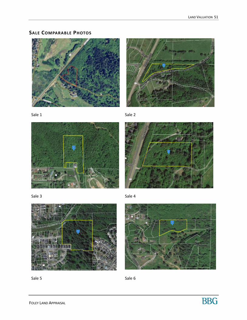
LAND VALUATION 51
FOLEY LAND APPRAISAL
SALE COMPARABLE PHOTOS
Sale 1 Sale 2
Sale 3 Sale 4
Sale 5 Sale 6

LAND VALUATION 52
FOLEY LAND APPRAISAL
SALE COMMENTS
Sale 1
This is a single lot which is heavily treed. The property is on the side of a hill which has partial views of the ocean. There is electricity and public water available to the site. Sewer is along Hwy. 101, about 100' to the south of the property.
The minimum lot size is 20,000 SF and septic must be approved for each lot before being subdivided.
The property is located in a CGB (Community Growth Boundary), recognized as an unincorporated community with special zoning and public utilities within the County.
The listing broker confirmed that the property is now pending but declined to share any other information. The listing price is used as the pending price.
Sale 2
The property is irregularly shaped but generally level and outside of the Tsunami zone. The site is a mix of native trees and meadow.
The property has access to electricity and water but no sewer which is on the other side of Hwy 101. The residential community to the south of the property is on septic, which the property would also have to be developed with/to.
The minimum lot size is 20,000 SF and septic must be approved for each lot before being subdivided.
SUMMARY OF LAND SALES
No. Property / Location
Date of
Sale
Transaction
Status
Site Size
(Ac)
Site Size
(SF) Building Zoning
Cash Eqiv
Sales Price
Price
per Acre
Price
per SF
1
Hi ghway 101 Res identi a l Land (NESK-
RR)
0 Highwa y 101
Neskowi n, OR
Pendi ng Contract 4.21 183,388NESK-RR, Neskowi n-
Rural Res i dentia l$239,000 $56,769 $1.30
2
Aeol i a n Res identi a l La nd
0 Aeol ia n Way
Neskowi n, OR
Pendi ng Contract 3.40 148,104NESK-RR, Neskowi n-
Rural Res i dentia l$159,900 $47,029 $1.08
3
Hol l ey Ave Res identia l La nd
0 Hol ly Avenue
Gari ba ldi , OR
Pendi ng Contract 5.65 246,114 R-1, Res identia l $225,000 $39,823 $0.91
4
Hi ghway 101 Res identi a l Land
46555 U.S. 101 South
Neskowi n, OR
07/23/2020 Closed 4.10 178,596NESK-RR, Nes kowin
Rura l Res identia l$250,000 $60,976 $1.40
5
NE 56th Res identi a l Land
2087 Northea st 56th Dri ve
Li ncoln Ci ty, OR
01/24/2020 Closed 9.00 392,040
Res - 1-A,
Res idential a nd
Manufa ctured
Home Zone
$175,000 $19,444 $0.45
6
Brooten Hi l l Res i dentia l Land
37005 Brooten Road
Cl overda le, OR
12/28/2019 Closed 3.42 148,975
PWC-R2, Pacific City
Medium Dens i ty
Res i denti al
$124,500 $36,404 $0.84
Subj.
Fol ey Land
Northeast Sturdevant Roa d
Tol edo, Oregon
— — 5.54 241,322 R-S, Res identia l — — —
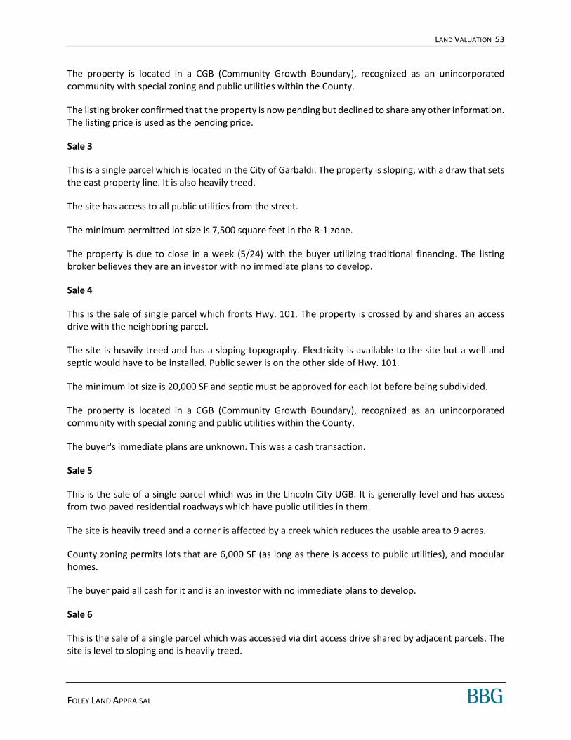
LAND VALUATION 53
FOLEY LAND APPRAISAL
The property is located in a CGB (Community Growth Boundary), recognized as an unincorporated community with special zoning and public utilities within the County.
The listing broker confirmed that the property is now pending but declined to share any other information. The listing price is used as the pending price.
Sale 3
This is a single parcel which is located in the City of Garbaldi. The property is sloping, with a draw that sets the east property line. It is also heavily treed.
The site has access to all public utilities from the street.
The minimum permitted lot size is 7,500 square feet in the R-1 zone.
The property is due to close in a week (5/24) with the buyer utilizing traditional financing. The listing broker believes they are an investor with no immediate plans to develop.
Sale 4
This is the sale of single parcel which fronts Hwy. 101. The property is crossed by and shares an access drive with the neighboring parcel.
The site is heavily treed and has a sloping topography. Electricity is available to the site but a well and septic would have to be installed. Public sewer is on the other side of Hwy. 101.
The minimum lot size is 20,000 SF and septic must be approved for each lot before being subdivided.
The property is located in a CGB (Community Growth Boundary), recognized as an unincorporated community with special zoning and public utilities within the County.
The buyer's immediate plans are unknown. This was a cash transaction.
Sale 5
This is the sale of a single parcel which was in the Lincoln City UGB. It is generally level and has access from two paved residential roadways which have public utilities in them.
The site is heavily treed and a corner is affected by a creek which reduces the usable area to 9 acres.
County zoning permits lots that are 6,000 SF (as long as there is access to public utilities), and modular homes.
The buyer paid all cash for it and is an investor with no immediate plans to develop.
Sale 6
This is the sale of a single parcel which was accessed via dirt access drive shared by adjacent parcels. The site is level to sloping and is heavily treed.
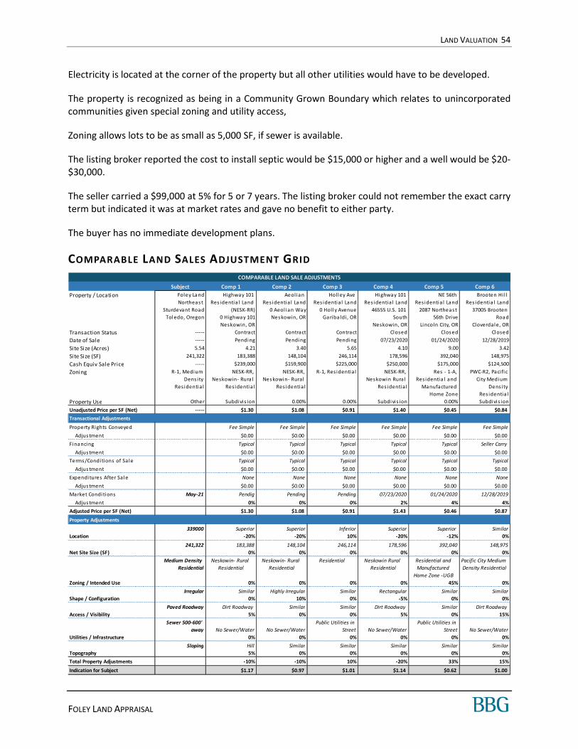
LAND VALUATION 54
FOLEY LAND APPRAISAL
Electricity is located at the corner of the property but all other utilities would have to be developed.
The property is recognized as being in a Community Grown Boundary which relates to unincorporated communities given special zoning and utility access,
Zoning allows lots to be as small as 5,000 SF, if sewer is available.
The listing broker reported the cost to install septic would be $15,000 or higher and a well would be $20-$30,000.
The seller carried a $99,000 at 5% for 5 or 7 years. The listing broker could not remember the exact carry term but indicated it was at market rates and gave no benefit to either party.
The buyer has no immediate development plans.
COMPARABLE LAND SALES ADJUSTMENT GRID
COMPARABLE LAND SALE ADJUSTMENTS
Subject Comp 1 Comp 2 Comp 3 Comp 4 Comp 5 Comp 6
Property / Location Foley Land
Northeas t
Sturdevant Road
Tol edo, Oregon
Hi ghway 101
Res identia l Land
(NESK-RR)
0 Highway 101
Neskowin, OR
Aeol ian
Res identia l Land
0 Aeol ian Way
Nes kowin, OR
Hol l ey Ave
Res identia l Land
0 Hol l y Avenue
Gariba ldi , OR
Hi ghway 101
Resi denti a l Land
46555 U.S. 101
South
Neskowin, OR
NE 56th
Res identia l Land
2087 Northeas t
56th Drive
Li ncoln City, OR
Brooten Hi l l
Res identia l Land
37005 Brooten
Road
Cloverdal e, OR
Transaction Status ----- Contract Contract Contract Closed Cl os ed Cl osed
Date of Sale ----- Pendi ng Pendi ng Pending 07/23/2020 01/24/2020 12/28/2019
Site Size (Acres) 5.54 4.21 3.40 5.65 4.10 9.00 3.42
Site Size (SF) 241,322 183,388 148,104 246,114 178,596 392,040 148,975
Cash Equiv Sale Price ----- $239,000 $159,900 $225,000 $250,000 $175,000 $124,500
Zoning R-1, Medium
Dens ity
Res identia l
NESK-RR,
Neskowin- Rura l
Res i denti al
NESK-RR,
Nes kowin- Rural
Res identia l
R-1, Res identia l NESK-RR,
Nes kowi n Rura l
Resi denti a l
Res - 1-A,
Res identia l and
Manufactured
Home Zone
PWC-R2, Pacifi c
City Medi um
Dens ity
Res identia l
Property Use Other Subdivis ion 0.00% 0.00% Subdi vis ion 0.00% Subdivis ion
Unadjusted Price per SF (Net) ----- $1.30 $1.08 $0.91 $1.40 $0.45 $0.84
Transactional Adjustments
Property Rights Conveyed Fee Simple Fee Simple Fee Simple Fee Simple Fee Simple Fee Simple
Adjus tment $0.00 $0.00 $0.00 $0.00 $0.00 $0.00
Financi ng Typical Typical Typical Typical Typical Seller Carry
Adjus tment $0.00 $0.00 $0.00 $0.00 $0.00 $0.00
Terms /Condi tions of Sa le Typical Typical Typical Typical Typical Typical
Adjus tment $0.00 $0.00 $0.00 $0.00 $0.00 $0.00
Expendi tures After Sal e None None None None None None
Adjus tment $0.00 $0.00 $0.00 $0.00 $0.00 $0.00
Market Condi ti ons May-21 Pendig Pending Pending 07/23/2020 01/24/2020 12/28/2019
Adjus tment 0% 0% 0% 2% 4% 4%
Adjusted Price per SF (Net) $1.30 $1.08 $0.91 $1.43 $0.46 $0.87
Property Adjustments
339000 Superior Superior Inferior Superior Superior Similar
Location -20% -20% 10% -20% -12% 0%
241,322 183,388 148,104 246,114 178,596 392,040 148,975
Net Site Size (SF) 0% 0% 0% 0% 0% 0%
Medium Density
Residential
Neskowin- Rural
Residential
Neskowin- Rural
Residential
Residential Neskowin Rural
Residential
Residential and
Manufactured
Home Zone -UGB
Pacific City Medium
Density Residential
Zoning / Intended Use 0% 0% 0% 0% 45% 0%
Irregular Similar Highly Irregular Similar Rectangular Similar Similar
Shape / Configuration 0% 10% 0% -5% 0% 0%
Paved Roadway Dirt Roadway Similar Similar Dirt Roadway Similar Dirt Roadway
Access / Visibility 5% 0% 0% 5% 0% 15%
Sewer 500-600'
away No Sewer/Water No Sewer/Water
Public Utilities in
Street No Sewer/Water
Public Utilities in
Street No Sewer/Water
Utilities / Infrastructure 0% 0% 0% 0% 0% 0%
Sloping Hill Similar Similar Similar Similar Similar
Topography 5% 0% 0% 0% 0% 0%
Total Property Adjustments -10% -10% 10% -20% 33% 15%
Indication for Subject $1.17 $0.97 $1.01 $1.14 $0.62 $1.00

LAND VALUATION 55
FOLEY LAND APPRAISAL
D ISCUSSION OF ADJUSTMENTS
PROPERTY R I GH TS CONV EYED
This adjustment accounts for any impact that the property rights transferred to the buyer may have on sale price. For leased fee properties, the length of leases in place and the relationship of market to contract rent could impact value. Some properties may have stronger appeal to an owner-user or an investor, resulting in a premium or discount associated with fee simple property rights. If a buyer acquires the leasehold interest in a comparable, then an adjustment may be necessary that accounts for the impact to the of ground rent and/or risk associated with the expiration of the ground lease to the sale price.
All of the comparables were considered similar to the subject and no adjustments were required for this category.
F INA NC IA L TERM S
This category accounts for differences in financing terms associated with the transaction. Financing arrangements that may require an adjustment include mortgage assumptions (at favorable interest rates), seller buydowns, installment sales, wrap-around loans, or any other atypical financing arrangements that do not represent cash-equivalent terms.
Sale 6 was carried by the seller. However, terms of the carry were at market and the listing broker reports there was no impact on value. Therefore, no adjustment for this factor was made.
CONDITIONS OF SA LE
Adjustments for conditions of sale typically reflect various motivations of the buyer and/or seller. This may include such factors as seller distress (short sale, REO, auction) or buyer motivation (assemblage, etc.). In some situations, the conditions of sale may significantly affect transaction prices. Properties that are listed for sale may require adjustments herein to account for any disparity between asking prices and the achievable sale price anticipated.
All of the comparables were considered similar to the subject and no adjustments were required for this category.
EXPEND ITURE S IMMED IA TELY AFTER SA LE
In order to arrive at the effective sale price, the actual sale price of each comparable is adjusted to account for any expenditures planned by the buyer immediately after sale, such as capital expenditures, cost to cure deferred maintenance, or lease-up costs.
All of the comparables were considered similar to the subject and no adjustments were required for this category.
MAR KET COND IT ION S
The sales included in this analysis transacted between December 2019 and July 2020. Based on the indications in the Market Survey, values have been increasing in the market since that time, with a 3% annual adjustment considered applicable. The remaining sales are pending and brokers indicate the escrow prices are near asking. Therefore, they are not adjusted.
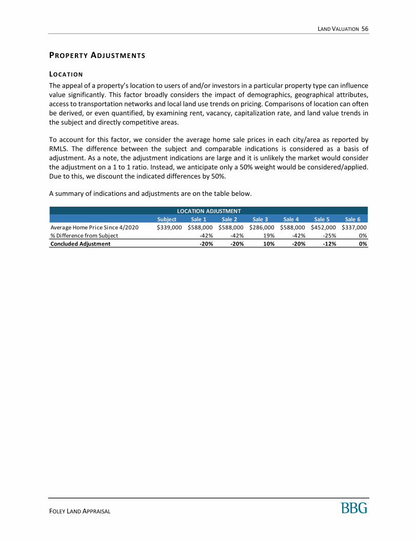
LAND VALUATION 56
FOLEY LAND APPRAISAL
PROPERTY ADJUSTMENTS
LOCA TION
The appeal of a property’s location to users of and/or investors in a particular property type can influence value significantly. This factor broadly considers the impact of demographics, geographical attributes, access to transportation networks and local land use trends on pricing. Comparisons of location can often be derived, or even quantified, by examining rent, vacancy, capitalization rate, and land value trends in the subject and directly competitive areas.
To account for this factor, we consider the average home sale prices in each city/area as reported by RMLS. The difference between the subject and comparable indications is considered as a basis of adjustment. As a note, the adjustment indications are large and it is unlikely the market would consider the adjustment on a 1 to 1 ratio. Instead, we anticipate only a 50% weight would be considered/applied. Due to this, we discount the indicated differences by 50%.
A summary of indications and adjustments are on the table below.
LOCATION ADJUSTMENT
Subject Sale 1 Sale 2 Sale 3 Sale 4 Sale 5 Sale 6
Average Home Price Since 4/2020 $339,000 $588,000 $588,000 $286,000 $588,000 $452,000 $337,000
% Difference from Subject -42% -42% 19% -42% -25% 0%
Concluded Adjustment -20% -20% 10% -20% -12% 0%
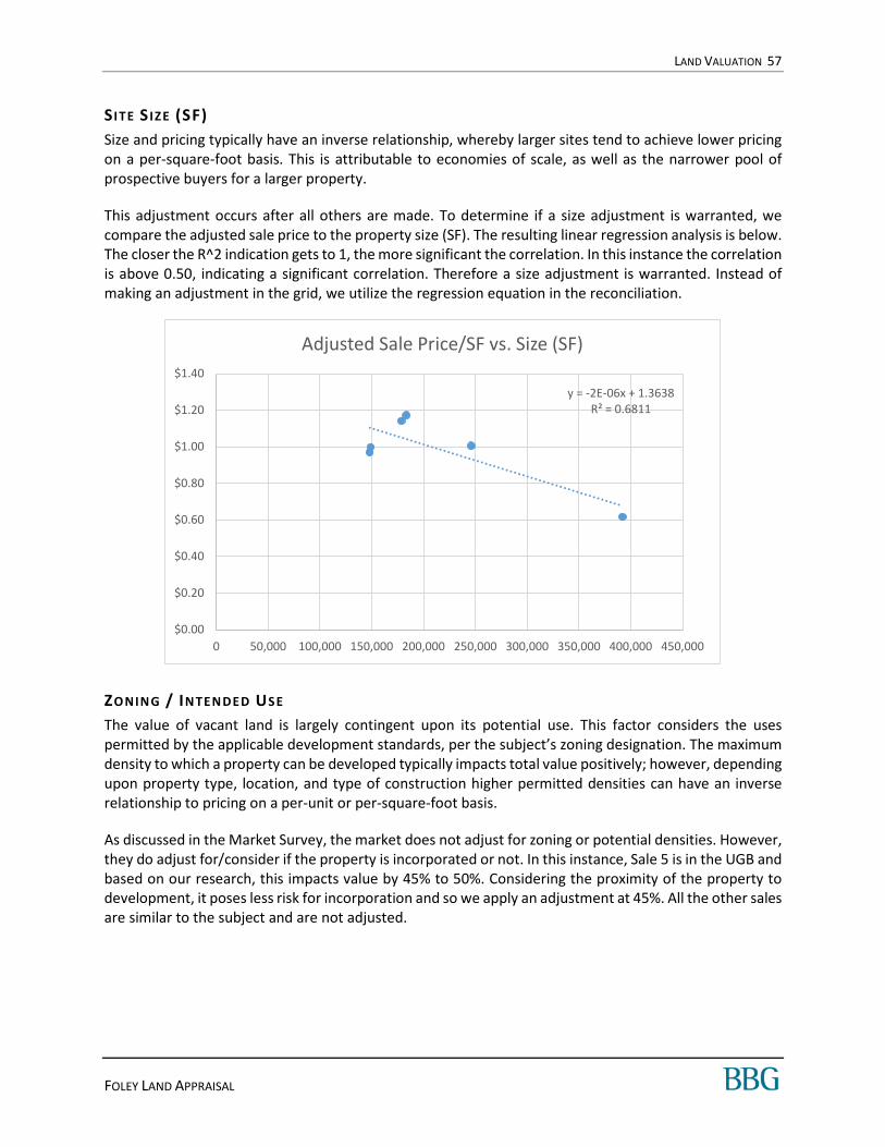
LAND VALUATION 57
FOLEY LAND APPRAISAL
S ITE S IZE (SF)
Size and pricing typically have an inverse relationship, whereby larger sites tend to achieve lower pricing on a per-square-foot basis. This is attributable to economies of scale, as well as the narrower pool of prospective buyers for a larger property.
This adjustment occurs after all others are made. To determine if a size adjustment is warranted, we compare the adjusted sale price to the property size (SF). The resulting linear regression analysis is below. The closer the R^2 indication gets to 1, the more significant the correlation. In this instance the correlation is above 0.50, indicating a significant correlation. Therefore a size adjustment is warranted. Instead of making an adjustment in the grid, we utilize the regression equation in the reconciliation.
ZONIN G / IN TEN DED USE
The value of vacant land is largely contingent upon its potential use. This factor considers the uses permitted by the applicable development standards, per the subject’s zoning designation. The maximum density to which a property can be developed typically impacts total value positively; however, depending upon property type, location, and type of construction higher permitted densities can have an inverse relationship to pricing on a per-unit or per-square-foot basis.
As discussed in the Market Survey, the market does not adjust for zoning or potential densities. However, they do adjust for/consider if the property is incorporated or not. In this instance, Sale 5 is in the UGB and based on our research, this impacts value by 45% to 50%. Considering the proximity of the property to development, it poses less risk for incorporation and so we apply an adjustment at 45%. All the other sales are similar to the subject and are not adjusted.
y = -2E-06x + 1.3638R² = 0.6811
$0.00
$0.20
$0.40
$0.60
$0.80
$1.00
$1.20
$1.40
0 50,000 100,000 150,000 200,000 250,000 300,000 350,000 400,000 450,000
Adjusted Sale Price/SF vs. Size (SF)

LAND VALUATION 58
FOLEY LAND APPRAISAL
SHA PE / CON FI GURA TION
The configuration, shape, dimensions and depth of a site determine its developability and overall utility. These factors can impact development costs, usable area of the site, and thereby, achievable pricing. The subject site is comprised of a single parcel.
The subject is irregularly shaped which could impact the development of the property to smaller lots allowed by zoning. Sale 2 is also irregular but its dimensions are less desirable and overall it is considered inferior to the subject. Therefore, it is adjusted upwards. Sale 4 is generally rectangular which is superior and it is adjusted downwards. All other sales are somewhat similar to the subject and are not adjusted.
ACCESS / V IS IB ILI TY
Adjustments for access/visibility allow for differences in accessibility to adjacent/nearby roadways, railways and/or waterways. Sites with visibility and exposure to heavier travelled thoroughfares normally command a premium over similar sites along tertiary thoroughfares.
The subject fonts a paved, public, roadway. Sales 1, 4 and 6 are accessed via private dirt drives. Therefore they are considered inferior and warrant upward adjustments. Sale 6 is setback from the roadway and would require significant access improvements to be similar to the subject. Therefore, it received the largest adjustment.
UTIL IT IE S / INFR ASTRUC TURE
Infrastructure adjustments may reflect differences in utility availability/capacity, developmental plans or other outside influences.
As discussed in the Highest and Best Use, the subject has water available at the street, but sewer service is 500-600’ feet away. Comparables range in having no potential access to utilities available in the street. However, there are no market indications that an adjustment for this factor is warranted. Therefore, we do not apply one to the comparables.
TOPOGRA PHY
Topography characteristics can influence pricing, as sites with more radical elevation changes typically increase site preparation/development costs when compared to a level site.
Sale 1 is on the site of the hill and has somewhat steep topography. Therefore, it is considered inferior and is adjusted upwards. All other sales are similar to the subject and are not adjusted.
Comparable No. 1 was judged inferior to the subject and received an upward adjustment of 5.0%.
CONCLUSION OF LAND VALUE
After adjustments, the comparable land sales reflect a range from $0.62 to $1.17 per square foot, with an average of $0.98 per square foot.
SALES SUMMARY Unadjusted Adjusted
Minimum $0.46 $0.62
Maximum $1.43 $1.17
Average $1.01 $0.98

LAND VALUATION 59
FOLEY LAND APPRAISAL
The lower level is set by Sale 5 which the largest property discussed. It is also in the UGB and is adjusted upwards for this factor. Adjustments are supported by market indications and once made, indicate this sale is applicable in estimating the value of the subject. The upper level is set by Sale 1 which is a pending sale which is smaller than the subject. It too is considered similar to the subject after adjustments are made.
The wide range in indications is due to the range in sale sizes. As discussed, we considered a linear regression analysis, which has the equation (Value Per Square Foot = -2E-06xSize (SF) + 1.3638). Utilizing this equation, the indicated value of the subject is $0.88 per square foot.
We recognize that the subject’s pending annexation and potential for subdivision are positive features. While those features are also incorporated into the Comparables, they put some upward pricing pressure on the subject.
We round this upwards to determine the value of the subject.
As a secondary check on reasonableness, we compare the concluded value of the subject to that of the comparables. In this instance, comparables range from $124,500 to $250,000 and average $196,000. The concluded value of the subject is bracketed by the comparables but is near the upper end of the range. However, with the appreciating market trends, we find the value is reasonable and consistent with market expectations.
F INAL OPINION(S) OF VALUE
Based on the inspection of the property and the investigation and the analysis undertaken, we have developed the following value opinion(s).
MARKETING T IME AND EXPOSURE T IME
Exposure time is the length of time the subject property would have been exposed for sale in the market had it sold on the effective valuation date at the concluded market value. Exposure time is always presumed to precede the effective date of the appraisal. Based on our review of recent sales transactions for similar properties, it is our opinion that the probable exposure time for the subject at the concluded market value stated previously is 1 to 3 months.
Marketing time is an estimate of the amount of time it might take to sell a property at the concluded market value immediately following the effective date of value. As we foresee no significant changes in market conditions in the near term, it is our opinion that a reasonable marketing period for the subject is
LAND VALUE CONCLUSION - AS IS
Indicated Va lue per SF $1.00
Net Si te Area (SF) x 241,322
Indicated Value $241,322
Rounded to nearest $10,000 $240,000
Per SF $0.99
Appraisal Premise Interest Appraised Date of Value Value Conclusion
Market Va lue - As Is Fee Simple May 13, 2021 $240,000
MARKET VALUE CONCLUSION(S)

LAND VALUATION 60
FOLEY LAND APPRAISAL
likely to be the same as the exposure time. Accordingly, we estimate the subject’s marketing period at 1 to 3 months.

CERTIFICATION 61
FOLEY LAND APPRAISAL
CERTIFICATION
We certi fy that, to the best of our knowledge and bel ief:
1. The s tatements of fact conta ined in this report are true and correct.
2. The reported analys es , opinions , and conclus ions are l imited only by the reported ass umptions
and l imiting conditions and are our personal , impartia l , and unbiased profes s iona l ana lys es ,
opinions , and conclus ions .
3. We have no present or pros pective interest in the property that is the s ubject of this report and
no pers onal interes t with respect to the parties involved with this as s ignment.
4. We have no bias with respect to the property that is the subject of this report or to the parties
involved with this as s ignment.
5. Our engagement in this ass ignment was not contingent upon developing or reporting
predetermined resul ts .
6. Our compens ation for completing this ass ignment is not contingent upon the development or
reporting of a predetermined value or direction in va lue that favors the cause of the cl ient, the
amount of the va lue opinion, the atta inment of a stipulated res ul t, or the occurrence of a
subsequent event di rectly related to the intended use of this appra is al .
7. This appra isa l ass ignment was not bas ed upon a reques ted minimum valuation, a speci fic
va luation, or the approva l of a loan.
8. Our analyses , opinions, and conclus ions were developed, and this report has been prepared, in
conformity with the Uniform Standards of Profess iona l Apprais a l Practice, as wel l as the
requirements of the state of Oregon.
9. The reported analyses , opinions , and Value Indications were developed, and this report has
been prepared, in conformity with the requirements of the Code of Profes s iona l Ethics and the
Standards of Profess iona l Practice of the Apprais al Insti tute.
10. The use of this report is subject to the requirements of the Appra isa l Insti tute relating to
review by i ts duly authorized repres entatives .
11. As of the date of this report, Owen Bartels , MAI has completed the continuing education
program for Des ignated Members of the Appra isa l Ins ti tute.
12. As of the date of this report, Sydni A. Nicol ici has completed the Standards and Ethics Education
Requirements for Candidates of the Appra isa l Ins ti tute.
13. Owen Bartels , MAI has and Sydni A. Nicol ici has not made a pers ona l inspection of the property
that i s the s ubject of this report.
14. No one provided s igni ficant real property apprais a l ass istance to the person s igning this
certi fi cation.
15. Owen Bartels , MAI has not and Sydni A. Nicol ici has not provided services , as an appra is er or in
any other capaci ty, regarding the property that is the s ubject of this report within the three-year
period immediately preceding the agreement to perform this ass ignment.
Owen Bartels , MAI Sydni A. Nicol ici
OR Certi fied Genera l Appra is er OR Certi fied Genera l Appra iser
License #: C000870 Licens e #: C001356
503-478-1016 503-478-1011
obartels@bbgres .com s nicol [email protected]

STANDARD ASSUMPTIONS AND LIMITING CONDITIONS 62
FOLEY LAND APPRAISAL
STANDARD ASSUMPTIONS AND L IMITING CONDITIONS
This appraisal report has been made with the following general assumptions:
1) Notwithstanding that Appraiser may comment on, analyze or assume certain conditions in the appraisal, BBG, Inc. shall have no monetary liability or responsibility for alleged claims or damages pertaining to: (a) title defects, liens or encumbrances affecting the property; (b) the property’s compliance with local, state or federal zoning, planning, building, disability access and environmental laws, regulations and standards; (c) building permits and planning approvals for improvements on the property; (d) structural or mechanical soundness or safety; (e) contamination, mold, pollution, storage tanks, animal infestations or other hazardous conditions affecting the property; and (f) other conditions and matters for which licensed real estate appraisers are not customarily deemed to have professional expertise. Accordingly: a) The Appraiser has not conducted any engineering or architectural surveys in connection with
this appraisal assignment. Information reported pertaining to dimensions, sizes, and areas is either based on measurements taken by the Appraiser or the Appraiser’s staff or was obtained or taken from referenced sources and is considered reliable. The Appraiser and BBG, Inc. shall not be monetarily liable or responsible for or assume the costs of preparation or arrangement of geotechnical engineering, architectural, or other types of studies, surveys, or inspections that require the expertise of a qualified professional.
b) Unless otherwise stated in the report, only the real property is considered, so no consideration is given to the value of personal property or equipment located on the premises or the costs of moving or relocating such personal property or equipment. Further, unless otherwise stated, it is assumed that there are no subsurface oil, gas or other mineral deposits or subsurface rights of value involved in this appraisal, whether they are gas, liquid, or solid. Further, unless otherwise stated, it is assumed that there are no rights associated with extraction or exploration of such elements considered. Unless otherwise stated it is also assumed that there are no air or development rights of value that may be transferred.
c) Any legal description or plats reported in the appraisal are assumed to be accurate. Any sketches, surveys, plats, photographs, drawings or other exhibits are included only to assist the intended user to better understand and visualize the subject property, the environs, and the competitive data. BBG, Inc. has made no survey of the property and assumes no monetary liability or responsibility in connection with such matters.
d) Title is assumed to be good and marketable, and in fee simple, unless otherwise stated in the report. The property is considered to be free and clear of existing liens, easements, restrictions, and encumbrances, except as stated. Further, BBG, Inc. assumes there are no private deed restrictions affecting the property which would limit the use of the subject property in any way.
e) The appraisal report is based on the premise that there is full compliance with all applicable federal, state, and local environmental regulations and laws unless otherwise stated in the appraisal report; additionally, that all applicable zoning, building, and use regulations and restrictions of all types have been complied with unless otherwise stated in the appraisal report. Further, it is assumed that all required licenses, consents, permits, or other legislative or administrative authority, local, state, federal and/or private entity or organization have been or can be obtained or renewed for any use considered in the value opinion. Moreover, unless otherwise stated herein, it is assumed that there are no encroachments or violations of any zoning or other regulations affecting the subject property, that the utilization of the
STANDARD ASSUMPTIONS AND LIMITING CONDITIONS 63
FOLEY LAND APPRAISAL
land and improvements is within the boundaries or property lines of the property described, and that there are no trespasses or encroachments.
f) The American Disabilities Act (ADA) became effective January 26, 1992. The Appraiser has not made a specific compliance survey or analysis of the property to determine whether or not it is in conformity with the various detailed requirements of ADA. It is possible that a compliance survey of the property and a detailed analysis of the requirements of the ADA would reveal that the property is not in compliance with one or more of the requirements of the Act. If so, this fact could have a negative impact upon the value of the property. Since the Appraiser has no direct evidence relating to this issue, possible noncompliance with the requirements of ADA was not considered in estimating the value of the property.
g) No monetary liability or responsibility is assumed for conformity to specific governmental requirements, such as fire, building, safety, earthquake, or occupancy codes, except where specific professional or governmental inspections have been completed and reported in the appraisal report.
h) It is assumed the subject property is not adversely affected by the potential of floods; unless otherwise stated herein. Further, it is assumed all water and sewer facilities (existing and proposed) are or will be in good working order and are or will be of sufficient size to adequately serve any proposed buildings.
i) Unless otherwise stated within the appraisal report, the depiction of the physical condition of the improvements described therein is based on visual inspection. No monetary liability or responsibility is assumed for (a) the soundness of structural members since no engineering tests were conducted; (b) the condition of mechanical equipment, plumbing, or electrical components, as complete tests were not made; and (c) hidden, unapparent or masked property conditions or characteristics that were not clearly apparent during the Appraiser’s inspection.
j) If building improvements are present on the site, it is assumed that no significant evidence of termite damage or infestation was observed during physical inspection, unless so stated in the appraisal report. Further, unless so stated in the appraisal report, no termite inspection report was available. No monetary liability or responsibility is assumed for hidden damages or infestation.
k) Unless subsoil opinions based upon engineering core borings were furnished, it is assumed there are no subsoil defects present, which would impair development of the land to its maximum permitted use or would render it more or less valuable. No monetary liability or responsibility is assumed for such conditions or for engineering which may be required to discover them.
l) BBG, Inc. is not an expert in determining the presence or absence of hazardous substances, defined as all hazardous or toxic materials, wastes, pollutants or contaminants (including, but not limited to, asbestos, PCB, UFFI, or other raw materials or chemicals) used in construction or otherwise present on the property. BBG, Inc. assumes no monetary liability or responsibility for the studies or analyses which would be required to determine the presence or absence of such substances or for loss as a result of the presence of such substances. Appraiser is not qualified to detect such substances. The Client is urged to retain an expert in this field; however, Client retains such expert at Client’s own discretion, and any costs and/or expenses associated with such retention are the responsibility of Client.
m) BBG, Inc. is not an expert in determining the habitat for protected or endangered species, including, but not limited to, animal or plant life (such as bald eagles, gophers, tortoises, etc.) that may be present on the property. BBG, Inc. assumes no monetary liability or responsibility for the studies or analyses which would be required to determine the presence or absence of

STANDARD ASSUMPTIONS AND LIMITING CONDITIONS 64
FOLEY LAND APPRAISAL
such species or for loss as a result of the presence of such species. The Appraiser hereby reserves the right to alter, amend, revise, or rescind any of the value opinions contained within the appraisal repot based upon any subsequent endangered species impact studies, research, and investigation that may be provided. However, it is assumed that no environmental impact studies were either requested or made in conjunction with this analysis, unless otherwise stated within the appraisal report.
2) If the Client instructions to the Appraiser were to inspect only the exterior of the improvements in the appraisal process, the physical attributes of the property were observed from the street(s) as of the inspection date of the appraisal. Physical characteristics of the property were obtained from tax assessment records, available plans, if any, descriptive information, and interviewing the client and other knowledgeable persons. It is assumed the interior of the subject property is consistent with the exterior conditions as observed and that other information relied upon is accurate.
3) If provided, the estimated insurable value is included at the request of the Client and has not been performed by a qualified insurance agent or risk management underwriter. This cost estimate should not be solely relied upon for insurable value purposes. The Appraiser is not familiar with the definition of insurable value from the insurance provider, the local governmental underwriting regulations, or the types of insurance coverage available. These factors can impact cost estimates and are beyond the scope of the intended use of this appraisal. The Appraiser is not a cost expert in cost estimating for insurance purposes.
4) The dollar amount of any value opinion herein rendered is based upon the purchasing power and price of the United States Dollar as of the effective date of value. This appraisal is based on market conditions existing as of the date of this appraisal.
5) The value opinions reported herein apply to the entire property. Any proration or division of the total into fractional interests will invalidate the value opinions, unless such proration or division of interests is set forth in the report. Any division of the land and improvement values stated herein is applicable only under the program of utilization shown. These separate valuations are invalidated by any other application.
6) Any projections of income and expenses, including the reversion at time of resale, are not predictions of the future. Rather, they are BBG, Inc.’s best estimate of current market thinking of what future trends will be. No warranty or representation is made that such projections will materialize. The real estate market is constantly fluctuating and changing. It is not the task of an appraiser to estimate the conditions of a future real estate market, but rather to reflect what the investment community envisions for the future in terms of expectations of growth in rental rates, expenses, and supply and demand. The forecasts, projections, or operating estimates contained herein are based on current market conditions, anticipated short-term supply and demand factors, and a continued stable economy. These forecasts are, therefore, subject to changes with future conditions.
7) The Appraiser assumes no monetary liability or responsibility for any changes in economic or physical conditions which occur following the effective date of value within this report that would influence or potentially affect the analyses, opinions, or conclusions in the report. Any subsequent changes are beyond the scope of the report.
8) Any proposed or incomplete improvements included in the appraisal report are assumed to be satisfactorily completed in a workmanlike manner or will be thus completed within a reasonable length of time according to plans and specifications submitted.
9) If the appraisal report has been prepared in a so-called “public non-disclosure” state, real estate sales prices and other data, such as rents, prices, and financing, are not a matter of public record. If this is such a “non-disclosure” state, although extensive effort has been expended to verify
STANDARD ASSUMPTIONS AND LIMITING CONDITIONS 65
FOLEY LAND APPRAISAL
pertinent data with buyers, sellers, brokers, lenders, lessors, lessees, and other sources considered reliable, it has not always been possible to independently verify all significant facts. In these instances, the Appraiser may have relied on verification obtained and reported by appraisers outside of our office. Also, as necessary, assumptions and adjustments have been made based on comparisons and analyses using data in the report and on interviews with market participants. The information furnished by others is believed to be reliable, but no warranty is given for its accuracy.
10) Although the Appraiser has made, insofar as is practical, every effort to verify as factual and true all information and data set forth in this report, no responsibility is assumed for the accuracy of any information furnished the Appraiser either by the Client or others. If for any reason, future investigations should prove any data to be in substantial variance with that presented in this report, the Appraiser reserves the right to alter or change any or all analyses, opinions, or conclusions and/or opinions of value.
11) The right is reserved by the Appraiser to make adjustments to the analyses, opinions, and conclusions set forth in the appraisal report as may be required by consideration of additional or more reliable data that may become available. No change of this report shall be made by anyone other than the Appraiser. The Appraiser shall have no monetary liability or responsibility for any unauthorized change(s) to the report.
12) The submission of the appraisal report constitutes completion of the services authorized and agreed upon. Such appraisal report is submitted on the condition the Client will provide reasonable notice and customary compensation, including expert witness fees, relating to any subsequent required attendance at conferences, depositions, or judicial or administrative proceedings. In the event the Appraiser is subpoenaed for either an appearance or a request to produce documents, a best effort will be made to notify the Client immediately. The Client has the sole responsibility for obtaining a protective order, providing legal instruction not to appear with the appraisal report and related work files, and will answer all questions pertaining to the assignment, the preparation of the report, and the reasoning used to formulate the opinion of value. Unless paid in whole or in part by the party issuing the subpoena or by another party of interest in the matter, the Client is responsible for all unpaid fees resulting from the appearance or production of documents regardless of who orders the work.
VALUATION ADVISORY ASSESSMENT ZONING
SERVICES
Valuation + Single Asset Valuation+ Portfolio Valuation+ Institutional Asset Valuation+ Appraisal Review+ Appraisal Management+ Lease and Cost Analysis+ Insurance Valuation+ Arbitration & Consulting+ Feasibility Studies+ Highest and Best Use Studies+ Evaluation+ Investment analysis+ Tax appeals+ Litigation Support
Advisory+ ASC 805 Business combinations+ ASC 840 Leases+ Purchase Price Allocations+ Portfolio Valuations for reporting net
asset values (NAV)+ Public and non-traded REIT valuations+ Valuations for litigation and
litigation support+ Sale-leaseback valuation analysis+ Valuations for bankruptcy/fresh
start accounting+ Cost segregation analysis
Assessment + Environmental due diligence + Property condition consulting+ Small loan services+ Energy consulting+ Environmental consulting+ Zoning+ ALTA Surveys
BBG OVERVIEW
BBG is one of the nation’s largest real estate due diligence firms with more than 35 offices across the country serving more than 2,700 clients. We deliver best-in-class valuation, advisory and assessment services with a singular focus of meeting our clients’ needs.
Our professional team offers broad industry expertise and deep market knowledge to help clients meet their objectives throughout the real estate life cycle.
BBG clients include commercial real estate professionals, investors, lenders, attorneys, accountants and corporations.
THE BBG DIFFERENCE
National Footprint. BBG is one of only two national firms offering in-house valuation and environmental and property condition assessment services for all commercial property types.
Customer-focused Growth. BBG is one of the largest national due diligence firms because we deliver best-in-class work product and provide excellent customer care.
Qualified Team. Over 50 percent of BBG appraisers are MAI designated and offer deep industry expertise gained through real-world experience.
Unbiased Independence. By focusing exclusively on due diligence services, BBG guarantees an independent perspective free from potential conflicts of interest.
Innovative Technology. BBG has made significant analytics and IT investments to continually improve our data and report quality.
Third-party reports by a true third party.

ADDENDA 66
FOLEY LAND APPRAISAL
ADDENDA
Glossary............................................................................................................................................ A
Letter of Engagement ........................................................................................................................ B
Appraiser Qualifications and Licenses ................................................................................................ C

ADDENDA A
FOLEY LAND APPRAISAL
GLOSSARY

Glossary Page 1
Assessed Value: The value of a property according to the tax rolls in ad valorem taxation; may be higher or lower than market value, or based on an assessment ratio that is a percentage of market value. 1
Asset: 1. Any item, the rights to which may have economic value, including
financial assets (cash or bonds), business interests, intangible assets (copyrights and trademarks), and physical assets (real estate and personal property).
2. In general business usage, something owned by a business and reflected in the owner’s business sheet.
Asset: A resource controlled by the entity as a result of past events and from which future economic benefits are expected to flow to the entity. 2
Capital Expenditure: Investments of cash (or the creation of liability) to acquire or improve an asset, e.g., land, buildings, building additions, site improvements, machinery, equipment; as distinguished from cash outflows for expense items that are normally considered part of the current period’s operations. 1
Cash Equivalency: An analytical process in which the sale price of a transaction with nonmarket financing or financing with unusual conditions or incentives is converted into a price expressed in terms of cash or its equivalent.1
Client:
1. The individual, group, or entity who engages a valuer to perform a service (USPAP)
2. The party or parties who engage, by employment or contract, an appraiser in a specific assignment. Comment: The client may be an individual, group, or entity, and may engage and communicate with the appraiser directly or through an agent (USPAP, 2016-17-ed).
3. Generally the party or parties ordering the appraisal report. It does not matter who pays for the work (CUSPAP, 2014-ed).1
Condominium Ownership: A form of fee ownership of separate units or portions of multiunit buildings that provides for formal filing and recording of a divided interest in real property.3
Cost Approach: A set of procedures through which a value indication is derived for the fee simple interest in a property by estimating the current cost to construct a reproduction of (or replacement for) the existing structure, including an entrepreneurial incentive, deducting depreciation from the total cost, and adding the estimated land value. Adjustments may then be made to the indicated fee simple value of the subject property to reflect the value of the property interest being appraised. 1
Credible:
1. Worthy of belief, supported by analysis of relevant information. Creditability is always measured in the context of intended use. (SVP)
2. Worthy of belief. Comment: Creditable assignment results require support, by relevant evidence and logic, to the degree necessary for the intended use. (USPAP, 2016-2017-ed.).1
Deferred Maintenance: Needed repairs or replacement of items that should have taken place during the course of normal maintenance. 1
Disposition Value: The most probable price that a specified interest in real property should bring under the following conditions: 1) Consummation of a sale within a specific time, which is short than the typical exposure time for such a property in that market. 2) The property is subjected to market conditions prevailing as of the date of valuation. 3) Both the buyer and seller are acting prudently and knowledgeably. 4) The seller is under compulsion to sell. 5) The buyer is typically motivated. 6) Both parties are acting in what they consider to be their best interests. 7) An adequate marketing effort will be made during the exposure time. 8) Payment will be made in cash in U.S. dollars (or the local currency) or in terms of financial arrangements comparable thereto. 9) The price represents the normal consideration of the property sold, unaffected by special or creative financing or sales concessions granted by anyone associated with the sale. This definition can also be modified to provide for valuation with specified financing terms. 1
Economic Life: The period over which improvements to real property contribute to property value. 1
Effective Date: 1) The date on which the analyses, opinions, and advice in an appraisal, review, or consulting service apply. 2) In a lease document, the date upon which the lease goes into effect.1
Effective Gross Income Multiplier (EGIM): The ratio between the sale price (or value) of a property and its effective gross income. 1
Effective Rent: Total base rent, or minimum rent stipulated in a lease, over the specified lease term minus rent concessions, the rent that is effectively paid by a tenant net of financial concessions provided by a landlord. 1
Exposure Time: 1) The time a property remains on the market. 2) The estimated length of time the property interest being appraised would have been offered on the market prior to the hypothetical consummation of a sale at market value on the effective date of the appraisal. Comment: Exposure time is a retrospective opinion based on an analysis of past events assuming a competitive and open market (USPAP 2016-2017-ed). 1
Extraordinary Assumptions: An assumption, directly related to a specific assignment, as of the effective date of the assignment results, which, if found to be false, could alter the appraiser’s opinions or conclusions. Comment: Extraordinary assumptions presume as fact otherwise uncertain information about physical, legal, or economic characteristics of the subject property, or about conditions external to the property, such as market conditions or trends; or about the integrity of data used in an analysis. (USPAP, 2016-2017 ed). 1
Fair Market Value: In nontechnical usage, a term that is equivalent to the contemporary usage of market value. 1
Fair Share: That portion of total market supply accounted for by a subject property. For example, a 100-key hotel in 1,000-key market has a fair share of 10%. 1
Fair Value:
1. The price that would be received to sell an asset or paid to transfer a liability in an orderly transaction between market participants at the measurement date. (FASB)
2. The estimated price for the transfer of an asset or liability between identified knowledgeable and willing parties that reflects the respective interests of those parties. (This does not apply to valuations for financial reporting.) (IVS).1
Fair Value: The price that would be received to sell an asset or paid to transfer a liability in an orderly transaction between market participants at the measurement date.2
Fee Simple Estate: Absolute ownership unencumbered by any other interest or estate, subject only to the limitations imposed by the governmental powers of taxation, eminent domain, police power, and escheat. 1
Floor Area Ratio (FAR): The relationship between the above-ground floor area of a building, as described by the zoning or building code, and the area of the plot on which it stands; in planning and zoning, often expressed as a decimal, e.g., a ratio of 2.0 indicates that the permissible floor area of a building is twice the total land area. 1
Going-Concern Value: 1) 73. An established and operating business having an indefinite future life. 2) 74. An organization with an indefinite life that is sufficiently long that, over time, all currently incomplete transformations [transforming resources from one form to a different, more valuable form] will be completed. 1
Gross Building Area (GBA): 1) Total floor area of a building, excluding unenclosed areas, measured from the exterior of the walls of the above-grade area. This includes mezzanines and basements if and when typically included in the market area of the type of property involved. 2) Gross leasable area plus all common areas. 3) 16. For residential space, the total area of all floor levels measured from the exterior of the walls and including the super structure and substructure basement; typically does not include garage space. 1

Glossary Page 2
Highest and Best Use: 1) The reasonably probable use of property that results in the highest value. The four criteria that the highest and best use must meet are legal permissibility, physical possibility, financial feasibility, and maximum productivity. 2) The use of an asset that maximizes its potential and that is possible, legally permissible, and financially feasible. The highest and best use may be for continuation of an asset’s existing use or for some alternative use. This is determined by the use that a market participant would have in mind for the asset when formulating the price that it would be willing to bid. (IVS). 3) [The] highest and most profitable use for which the property is adaptable and needed or likely to be needed in the reasonably near future. (Uniform Appraisal Standards for Federal Land Acquisitions) 1
Hypothetical Condition: 1) 117. A condition that is presumed to be true when it is known to be false. (SVP). 2) A condition, directly related to a specific assignment, which is contrary to what is known by the appraiser to exist on the effective date of the assignment results, but is used for the purpose of analysis. Comment: Hypothetical conditions are contrary to known facts about physical, legal, or economic characteristics of the subject property; or about conditions external to the property, such as market conditions or trends; or about the integrity of data used in an analysis. (USPAP, 2016-2017 ed.) 1
Income Capitalization Approach: Specific appraisal techniques applied to develop a value indication for a property based on its earning capability and calculated by the capitalization of property income. 1
Inspection: Personal observation of the exterior or interior of the real estate that is the subject of an assignment performed to identify the property characteristics that are relevant to the assignment, such as amenities, general physical condition, and functional utility. Note that this is not the inspection process performed by a licensed or certified building inspector. 1
Insurable Value: A type of value for insurance purposes. 1
Intangible Assets: 1) A nonmonetary asset that manifests itself by its economic properties. It does not have physical substance but grants rights and economic benefits to its owner. (IVS). 2) A nonphysical asset such as a franchise, trademark, patent, copyright, goodwill, equity, mineral right, security, and contract (as distinguished from physical assets) that grant rights and privileges, and have value for the owner. (ASA). 3) An identifiable nonmonetary asset without physical substance. An asset is a resource that is controlled by the entity as a result of past events (for ex-ample, purchase or self-creation) and from which future economic benefits (inflows of cash or other assets) are expected. [IAS 38.8] Thus, the three critical attributes of an intangible asset are: identifiability, control (power to obtain benefits from the asset), ·future economic benefits (such as revenues or reduced future costs). (IAS 38) 1
Intangible property: Nonphysical assets, including but not limited to franchises, trademarks, patents, copyrights, goodwill, equities, securities, and contracts as distinguished from physical assets such as facilities and equipment. (USPAP, 2016-2017 ed.) 1
Intended Use: 1) The valuer’s intent as to how the re-port will be used. (SVP) 2) The use or uses of an appraiser’s reported appraisal or appraisal review assignment opinions and conclusions, as identified by the appraiser based on communication with the client at the time of the assignment. (USPAP, 2016-2017 ed.) 1`
Intended User: 1) The party or parties the valuer intends will use the report. (SVP) 2) The client and any other party as identified, by name or type, as users of the appraisal or appraisal review report by the appraiser on the basis of communication with the client at the time of the assignment. (USPAP, 2016-2017 ed.) 1`
Internal Rate of Return (“IRR”): The annualized yield rate or rate of return on capital that is generated or capable of being generalized within an investment of portfolio over a period of ownership. Alternatively, the indicated return of capital associated with a projected or pro forma income stream. The discount rate that equates the present value of the net cash flows of a project with the present value of the capital investment. It is the rate at which the Net Present Value (NPV) equals zero. The IRR reflects both the return on invested capital and the return of the original investment, which are basic considerations of potential investors. Therefore, deriving the IRR from analysis of market transactions of similar properties having comparable income
patterns is a proper method for developing market discount rates for use in valuations to arrive at Market Value. Used in discounted cash flow analysis to find the implied or expected rate of return of the project, the IRR is the rate of return which gives a zero net present value (NPV). See also equity yield rate (YE); financial management rate of return (FMRR); modified internal rate of return (MIRR); yield rate (Y). 1
Investment Value: 1) The value of a property to a particular investor or class of investors based on the investor’s specific requirements. Investment value may be different from market value because it depends on a set of investment criteria that are not necessarily typical of the market. 2) The value of an asset to the owner or a prospective owner for individual investment or operational objectives. (IVS) 1
Leasehold Interest: The right held by the lessee to use and occupy real estate for a stated term and under the conditions specified in the lease. 1
Leased Fee Interest: The ownership interest held by the lessor, which includes the right to receive the contract rent specified in the lease plus the reversionary right when the lease expires. 1
Liquidation Value: The most probable price that a specified interest in real property should bring under the following conditions: 1) Consummation of a sale within a short time period; 2) The property is subjected to market conditions prevailing as of the date of valuation; 3) Both the buyer and seller are acting prudently and knowledgeably; 4) The seller is under extreme compulsion to sell; 5) The buyer is typically motivated. 6) Both parties are acting in what they consider to be their best interests. 7) A normal marketing effort is not possible due to the brief exposure time 8) Payment will be made in cash in U.S. dollars or in terms of financial arrangements comparable thereto. 9) The price represents the normal consideration for the property sold, unaffected by special or creative financing or sales concessions granted by anyone associated with the sale. This definition can also be modified to provide for valuation with specified financing terms. 1
Load Factor: A measure of the relationship of common area to useable area and therefore the quality and efficiency of building area layout, with higher load factors indicating a higher percentage of common area to overall rentable space than lower load factors; calculated by subtracting the amount of usable area from the rentable area and then dividing the difference by the usable area: 1
Load Factor =
(Rentable Area – Useable Area) Usable Area
Market Value. The major focus of most real property appraisal assignments. Both economic and legal definitions of market value have been developed and refined.*
1. The most widely accepted components of market value are incorporated in the following definition: The most probable price that the specified property interest should sell for in a competitive market after a reasonable exposure time, as of a specified date, in cash, or in terms equivalent to cash, under all conditions requisite to a fair sale, with the buyer and seller each acting prudently, knowledgeably, for self-interest, and assuming that neither is under duress.
2. Market value is described, not defined, in the Uniform Standards of Professional Appraisal Practice (USPAP) as follows: A type of value, stated as an opinion, that presumes the transfer of a property (i.e., a right of ownership or a bundle of such rights), as of a certain date, under specific conditions set forth in the definition of the term identified by the appraiser as applicable in an appraisal. Comment: Forming an opinion of market value is the purpose of many real property appraisal assignments, particularly when the client’s intended use includes more than one intended user. The conditions included in market value definitions establish market perspectives for development of the opinion. These conditions may vary from definition to definition but generally fall into three categories:
- the relationship, knowledge, and motivation of the parties (i.e., seller and buyer); - the terms of sale (e.g., cash, cash equivalent, or other terms); and - the conditions of sale (e.g., expo- sure in a competitive market for a reasonable time prior to sale).

Glossary Page 3
USPAP also requires that certain items be included in every appraisal report. Among these items, the following are directly related to the definition of market value: - Identifications of the specific property rights to be appraised. - Statement of the effective date of the value opinion. - Specification as to whether cash, terms equivalent to cash, or other precisely described financing terms are assumed as the basis of the appraisal. - If the appraisal is conditioned upon financing or other terms, specification as to whether the financing or terms are at, below, or above market interest rates and/or contain unusual conditions or incentives. The terms of above- or below-market interest rates and/or other special incentives must be clearly set forth; their contribution to, or negative influence on, value must be described and estimated; and the market data supporting the opinion of value must be described and explained. 3. The following definition of market value is used by agencies that regulate federally insured financial institutions in the United States: The most probable price that a property should bring in a competitive and open market under all conditions requisite to a fair sale, the buyer and seller each acting prudently and knowledgeably, and assuming the price is not affected by undue stimulus. Implicit in this definition is the consummation of a sale as of a specified date and the passing of title from seller to buyer under conditions whereby: Buyer and seller are typically motivated;
Both parties are well informed or well advised, and each acting in what they consider their own best interests;
A reasonable time is allowed for exposure in the open market; Payment is made in terms of cash in U.S. dollars or in terms of financial arrangements comparable thereto; and · The price represents the normal consideration for the property sold unaffected by special or creative financing or sales concessions granted by anyone associated with the sale. (12 C.F.R. Part 34.42(g); 55 Federal Register 34696, August 24, 1990, as amended at 57 Federal Register 12202, April 9, 1992; 59 Federal Register 29499, June 7, 1994)
4. The International Valuation Standards Council defines market value for the purpose of international standards as follows: The estimated amount for which an asset or liability should exchange on the valuation date between a willing buyer and a willing seller in an arm’s length transaction, after proper marketing and where the parties had each acted knowledgeably, prudently and without compulsion. (IVS)
5. The Uniform Standards for Federal Land Acquisitions defines market value as follows: Market value is the amount in cash, or on terms reason ably equivalent to cash, for which in all probability the property would have sold on the effective date of the appraisal, after a reasonable exposure time on the open competitive market, from a willing and reasonably knowledgeable seller to a willing and reasonably knowledgeable buyer, with neither acting under any compulsion to buy or sell, giving due consideration to all available economic uses of the property at the time of the appraisal. (Uniform Appraisal Standards for Federal Land Acquisitions) 1
Market Value "As If Complete" On The Appraisal Date: Market value as if complete on the effective date of the appraisal is an estimate of the market value of a property with all construction, conversion, or rehabilitation hypothetically completed, or under other specified hypothetical conditions as of the date of the appraisal. With regard to properties wherein anticipated market conditions indicate that stabilized occupancy is not likely as of the date of completion, this estimate of value should reflect the market value of the property as if complete and prepared for occupancy by tenants.
Market Value "As Is" On The Appraisal Date: Value As Is -The value of specific ownership rights to an identified parcel of real estate as of the effective date of the appraisal; relates to what physically exists and is legally permissible and excludes all assumptions concerning hypothetical market conditions or possible rezoning. See also effective date; prospective value opinion.
Market Value of the Total Assets of the Business: The market value of the total assets of the business is the market value of all of the tangible and intangible assets of a business as if sold in aggregate as a going concern. This assumes that the business is expected to continue operations well into the future. 4
Marketing Time: An opinion of the amount of time it might take to sell a real or personal property interest at the concluded market value level during the period immediately after the effective date of an appraisal. Marketing time differs from exposure time, which is always presumed to precede the effective date of an appraisal. (Advisory Opinion 7 of the Appraisal Standards Board of The Appraisal Foundation and Statement on Appraisal Standards No. 6, “Reasonable Exposure Time in Real Property Market Value Opinions” address the determination of reasonable exposure and marketing time.). 3
Net Lease: A lease in which the landlord passes on all expenses to the tenant. See also lease. 1
Net Rentable Area (NRA): 1) The area on which rent is computed. 2) The Rentable Area of a floor shall be computed by measuring to the inside finished surface of the dominant portion of the permanent outer building walls, excluding any major vertical penetrations of the floor. No deductions shall be made for columns and projections necessary to the building. Include space such as mechanical room, janitorial room, restrooms, and lobby of the floor. 5
Penetration Ratio (Rate): The rate at which stores obtain sales from within a trade area or sector relative to the number of potential sales generated; usually applied to existing facilities. Also called: penetration factor.1
Prospective opinion of value. A value opinion effective as of a specified future date. The term does not define a type of value. Instead it identifies a value opinion as being effective at some specific future date. An opinion of value as of a prospective date is frequently sought in connection with projects that are proposed, under construction, or under conversion to a new use, or those that have not yet achieved sellout or a stabilized level of long-term occupancy. 1
Reconciliation: A phase of a valuation assignment in which two or more value indications are processed into a value opinion, which may be a range of value, a single point estimate, or a reference to a benchmark value. 1
Reliable Measurement: [The IAS/IFRS framework requires that] neither an asset nor a liability is recognized in the financial statements unless it has a cost or value that can be measured reliably.2
Remaining Economic Life: The estimated period over which existing improvements are expected to contribute eco-nomically to a property; an estimate of the number of years remaining in the economic life of a structure or structural components as of the effective date of the appraisal; used in the economic age-life method of estimating depreciation. 1
Replacement Cost: The estimated cost to construct, at current prices as of the effective appraisal date, a substitute for the building being appraised, using modern materials and current standards, design, and layout. 1
Retrospective Value Opinion: A value opinion effective as of a specified historical date. The term retrospective does not define a type of value. Instead, it identifies a value opinion as being effective at some specific prior date. Value as of a historical date is frequently sought in connection with property tax appeals, damage models, lease renegotiation, deficiency judgments, estate tax, and condemnation. Inclusion of the type of value with this term is appropriate, e.g., “retrospective market value opinion.” 1
Glossary Page 4
Sales Comparison Approach: The process of deriving a value indication for the subject property by comparing sales of similar properties to the property being appraised, identifying appropriate units of comparison, and making adjustments to the sale prices (or unit prices, as appropriate) of the comparable properties based on relevant, market-derived elements of comparison. The sales comparison approach may be used to value improved properties, vacant land, or land being considered as though vacant when an adequate supply of comparable sales is available. 1
Scope of Work: 1) The type of data and the extent of research and analyses. (SVP). 2) The type and extent of research and analyses in an appraisal or appraisal review assignment. (USPAP, 2016¬2017 ed.) 1
Stabilized value: A value opinion that excludes from consideration any abnormal relationship between supply and demand such as is experienced in boom periods when cost and sale price may exceed the long-term value, or during periods of depression, when cost and sale price may fall short of long-term value. It is also a value opinion that excludes from consideration any transitory condition that may cause excessive construction costs, e.g., a premium paid due to a temporary shortage of supply.
Substitution: The principle of substitution states that when several similar or commensurate commodities, goods, services are available, the one with the lowest price will attract the greatest demand and widest distribution. This is the primary principle upon which the cost and sales comparison approaches are based. 3
Total Assets of a Business: Total assets of a business is defined by the Appraisal Institute as “the tangible property (real property and personal property, including inventory and furniture, fixtures and equipment) and intangible property (cash, workforce, contracts, name, patents, copyrights, and other residual intangible assets, to include capitalized economic profit).”
Use Value: The value of a property assuming a specific use, which may or may not be the property’s highest and best use on the effective date of the appraisal. Use value may or may not be equal to market value but is different conceptually. 1
1Appraisal Institute, The Dictionary of Real Estate Appraisal, 6th ed. (Chicago: Appraisal Institute 2010). 2Appraisal Institute, International Financial Reporting Standards for Real Property Appraiser, IFRS Website, www.ifrs-ebooks.com/index.html. 3Appraisal Institute, The Appraisal of Real Estate, 13th ed. (Chicago: Appraisal Institute 2008). 4 This definition is taken from “Allocation of Business Assets Into Tangible and Intangible Components: A New Lexicon,” Journal of Real Estate Appraisal, January 2002, Volume LXX, Number 1. This terminology is to replace former phrases such as: value of the going concern. 5Financial Publishing Company, The Real Estate Dictionary, 7
th
ed. 6 U.S. Treasury Regulations
ADDENDA B
FOLEY LAND APPRAISAL
LETTER OF ENGAGEMENT


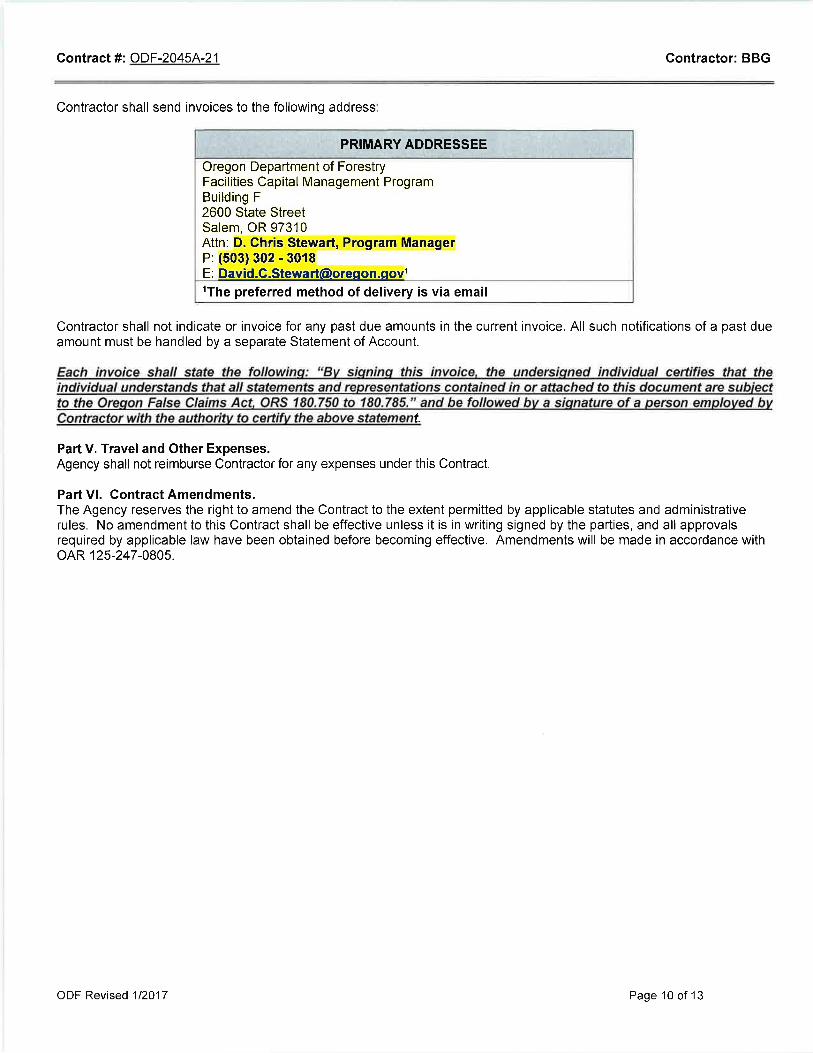

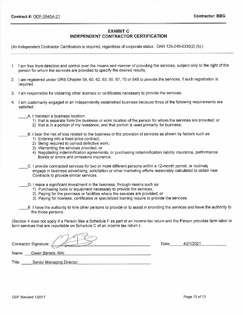

ADDENDA C
FOLEY LAND APPRAISAL
APPRAISER QUALIFICATIONS AND LICENSES

Owen E. Bartels, MAI Senior Managing Director
Work: 503.478.1016 [email protected]
Profile
Owen Bartels is a Senior Managing Director with BBG in the Portland, Oregon office. He oversees strategic initiatives
throughout Oregon and Southern Washington. He was the 2017 President of the Greater Oregon chapter of the
Appraisal Institute. Owen began his commercial real estate career with the Tacoma, Washington, Kidder Mathews
office in 2001 working as a researcher and financial analyst for industrial properties. He began his appraisal career
in 2003 with the Vancouver, Washington, office of PGP Valuation (now Colliers), and became a Certified General
Appraiser in both Oregon and Washington in 2006. He is a Member of the Appraisal Institute.
Owen has appraised properties in cities and towns throughout the Northwest, including southern Oregon, central
Washington, the Puget Sound region, both the Oregon and Washington coasts and, of course, throughout the
Portland metro area. Appraisal work includes industrial, retail, office, mixed use, both commercial and residential
condominium conversions, subdivisions, partial acquisitions, corridors, and specialized consulting projects. Owen
has recently expanded his work in Eminent Domain, including work for both public agencies and property owners.
Clients include lenders, development companies, government agencies, and private parties.
Owen is involved in local professional organization leadership, serving as President of the Greater Oregon chapter
of the Appraisal Institute after four years chairing the Government Affairs committee. He has also been one of the
Greater Oregon Chapter's representatives in Washington DC for the Leadership Development Advisory Committee
(LDAC). In 2014 he was awarded the Outstanding Service and Leadership Award by his local Appraisal Institute
chapter. In 2015 he received the President's Service Award for contributions to the chapter.
In addition, Owen a member of the Government Affairs committee of the Oregon Mortgage Bankers Association
(OMBA) and of the International Right of Way Association's Beaver State Chapter (Chapter 3).
Professional Affiliations
Appraisal Institute, Member (MAI)
Greater Oregon Chapter President 2017
Member, International Right of Way Association Beaver State Chapter
Adjunct Professor, Portland State University, 2018
General Certified Appraiser Oregon, Certified General, C000870
Washington, Certified General, 1101723
Michigan, Certified General, 1201076811
Education
University of Puget Sound: Bachelor's Degree in Economics, May 2003
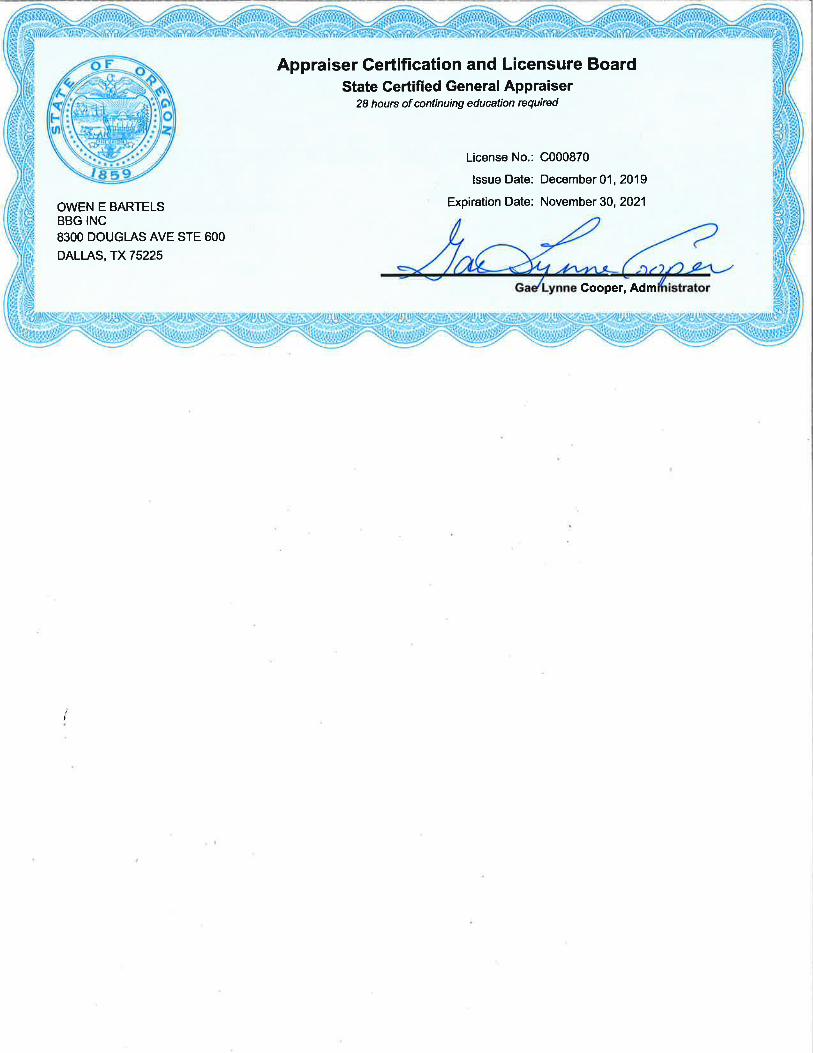

Sydni A. Nicolici Director
Work: 503.478.1011 [email protected]
Profile Sydni Nicolici is a Director at BBG in the Portland, Oregon office and holds three state appraisal licenses. Her current scope of work includes a broad range of commercial properties to include multifamily complexes, offices, and industrial facilities. She also specializes in agricultural appraisals (to include permanent plantings, irrigated land, processing facilities, and ranches), right of way, and tax appeals. In addition to appraising, she serves as a member of the CREW Awards Committee. Her appraisal career began in January 2012 as an intern for the San Luis Obispo County Assessor’s Office as a Residential Tax Assessment Intern. In March 2013 she began her appraisal trainee path and obtained state licensing in March 2017. She is currently an Appraisal Institute Candidate for Designation. Her career includes working as an Associate Appraiser with Michael Burger and Associates, now Valbridge│Central California, where she specialized in appraising office and retail properties throughout California’s Central Valley and Coast. During her time here she also appraised a variety of specialized agricultural facilities and an FBO complex.
Professional Affiliations Appraisal Institute Candidate for Designation CREW Awards Committee
Certified General Appraiser Oregon, Certified General (C001356) Washington, Certified General (1102531) California Certified General (3004402)
Education Masters of Business Administration, California State University, Bakersfield-Master in Business Administration (2013) Bachelor of Liberal Arts, California Polytechnic State University, San Luis Obispo-Liberal Arts and Engineering, Concentration: City and Regional Planning, Environmental Engineering, Business Law (2012) Certified General and MAI courses through the Appraisal Institute ASFMRA Introduction to Valuation of Permanent Plantings IRWA Easement Valuation C-403