01-1 - University of Alaska Fairbanks
40
The Alaska Public Land Planning Directory Agricultural & Forestry Experiment Station University of Alaska Fairbanks Misc. Publication 2001-1 December 2001 prepared by Susan Todd
Transcript of 01-1 - University of Alaska Fairbanks

The AlaskaPublic Land
Planning Directory
Agricultural & Forestry Experiment StationUniversity of Alaska Fairbanks
Misc. Publication 2001-1December 2001
prepared by Susan Todd

2
The University of Alaska Fairbanks is accredited by the Commission on colleges of the Northwest
Association of Schools and Colleges. UAF is an AA/EO employer and educational institution.
Alaska — The Planned Frontier!Perhaps no other state in the union has as much land planning as Alaska. This occurs because almost
90% of Alaska is managed by federal or state agencies (see page 4). By law, agencies are required to
prepare plans to guide and justify their activities. The Alaska Planning Directory provides a
comprehensive review of the agencies, their planning goals and processes, the opportunities for public
involvement they provide, and the plans they have produced and intend to produce.
Newcomers to Alaska, as well as many old-timers, are surprised to find out that Alaska, “The Last
Frontier”, has so much planning. A variety of acts, however, require that agencies prepare plans. These
acts include the Alaska Statehood Act, the Alaska Native Claims Settlement Act, the National Forest
Management Act, the Federal Land Policy Management Act, and the Alaska National Land
Conservation Act, among others. These acts subdivided Alaska into dozens of management units, giving
Alaska one of the most complicated land management patterns of any state in the nation. Given the
value of Alaska’s nature–its waters, land and wildlife–and the diversity of management institutions,
each with its own objectives, the plans provide the primary means of working out agreements on how
areas should be managed.
This report is intended for anyone with questions on public land management in Alaska: the general
public and tourists as well as professional planners, community leaders, business and development
managers, and nonprofit groups. Prior editions of this publication (1985, 1987, and 1991) were
distributed widely by the Cooperative Extension Service throughout the state.
The types of plans included are plans for public land owned by the federal and state government.
Public resources, such as fish and wildlife, are not included in this volume, although an edition on
planning for fish and wildlife populations is being considered.
I wish to thank Judy Skagerberg who updated this report in 1995, Tom Gallagher who authored the
first two editions, and Laura Walker who assisted in revising this edition. I would also like to thank all
of the agency people who took time from their busy schedules to help me bring this information up-to-
date. Corrections and suggestions are always welcome! Send them to me at:
Susan Todd
School of Agriculture & Land Resources Management
University of Alaska Fairbanks
PO Box 757200
Fairbanks, AK 99775
(907) 474-6930

3
Table of Contents
Introduction: Alaska — The Planned Frontier
Land Ownership in Alaska.....................................................................................................................4
Abbreviations........................................................................................................................................5
Federal Agencies
U.S. Department of Agriculture
Forest Service.............................................................................................................................6
U.S. Department of the Interior
Bureau of Land Management.....................................................................................................9
National Park Service................................................................................................................13
Fish and Wildlife Service..........................................................................................................17
State Agencies
Alaska Department of Fish and GameHabitat and Restoration Division..............................................................................................21
Alaska Department of Natural Resources
Division of Forestry...................................................................................................................24
Division of Mining, Land and Water.........................................................................................27
Division of Parks and Outdoor Recreation...............................................................................32
Office of the Governor
Division of Governmental Coordination, Coastal Management Program.................................36
4
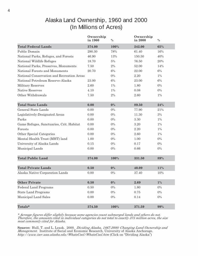
Alaska Land Ownership, 1960 and 2000(In Millions of Acres)
Ownership Ownershipin 1960 % in 2000 %
Total Federal Lands 374.00 100% 242.00 65%
Public Domain 290.30 78% 61.40 16%
National Parks, Refuges, and Forests 46.90 13% 150.50 40%
National Wildlife Refuges 18.70 5% 76.50 20%
National Parks, Preserves, Monuments 7.50 2% 52.00 14%
National Forests and Monuments 20.70 6% 22.00 6%
National Conservation and Recreation Areas 0% 2.20 1%
National Petroleum Reserve-Alaska 23.00 6% 23.00 6%
Military Reserves 2.60 1% 1.80 0%
Native Reserves 4.10 1% 0.08 0%
Other Withdrawals 7.50 2% 2.60 1%
Total State Lands 0.00 0% 89.50 24%
General State Lands 0.00 0% 77.90 21%
Legislatively-Designated Areas 0.00 0% 11.30 3%
Parks 0.00 0% 3.30 1%
Game Refuges, Sanctuaries, Crit. Habitat 0.00 0% 3.20 1%
Forests 0.00 0% 2.20 1%
Other Special Categories 0.00 0% 2.60 1%
Mental Health Trust (MHT) land 1.00 0% 1.00 0%
University of Alaska Lands 0.15 0% 0.17 0%
Municipal Lands 0.00 0% 0.66 0%
Total Public Land 374.00 100% 331.50 89%
Total Private Lands 0.50 0% 40.09 11%
Alaska Native Corporation Lands 0.00 0% 37.40 10%
Other Private 0.50 0% 2.69 1%
Federal Land Programs 0.50 0% 1.80 0%
State Land Programs 0.00 0% 0.75 0%
Municipal Land Sales 0.00 0% 0.14 0%
Totals* 374.50 100% 371.59 99%
* Acreage figures differ slightly because some agencies count submerged lands and others do not.Therefore, the amounts cited in individual categories do not total to exactly 375 million acres, the sizemost commonly cited for Alaska.
Source: Hull, T. and L. Leask. 2000. Dividing Alaska, 1867-2000: Changing Land Ownership andManagement. Institute of Social and Economic Research, University of Alaska Anchorage.http://www.iser.uaa.alaska.edu/WhatsCool/WhatsCool.htm (Click on “Dividing Alaska”)

5
ABBREVIATIONS
ACMP Alaska Coastal Management Program
ACZMA Alaska Coastal Zone Management Act of 1977
ADFG Alaska Department of Fish & Game
AIFMC Alaska Inter-agency Fire Management Council
ALUC Alaska Land Use Council
AMSA Areas which Merit Special Attention
ANCSA Alaska Native Claims Settlement Act of 1971
ANILCA Alaska National Interest Land Conservation Act of 1980
BLM Bureau of Land Management, US Department of the Interior
BPS Bureau Planning System
CCP Comprehensive Conservation Plan
CMP Coastal Management Program
CRSA Coastal Resource Service Area
CZM Coastal Zone Management
CZMA Coastal Zone Management Act of 1972 (federal)
DMLW Division of Mining, Land and Water, DNR, State of Alaska
DNR Department of Natural Resources, State of Alaska
EIS Environmental Impact Statement
FLPMA Federal Land Policy and Management Act of 1976
FWS Fish and Wildlife Service, US Department of the Interior
GMP General Management Plan
IRA Indian Reorganization Act
KRSMA Kenai River Special Management Area
LWCF Land and Water Conservation Fund (federal)
MFP Management Framework Plan
NEPA National Environmental Policy Act of 1969
NFMA National Forest Management Act of 1976
NPR-A National Petroleum Reserve-Alaska
NPS National Park Service, US Department of the Interior
NWR National Wildlife Refuge
RMP Resource Management Plan
RPA Resource Planning Act of 1974
SCORP Statewide Comprehensive Outdoor Recreation Plan
SCRAP Southcentral Recreation Action Plan
SFM Statement for Management
TBAP Tanana Basin Area Plan (DNR)
TLMP Tongass Land Management Plan
USFS US Forest Service, Department of Agriculture
6
Federal Agencies
U.S. Department of Agriculture —Forest Service
HISTORY — ALASKA’S NATIONAL FORESTSThe Alaska Region of the Forest Service extends northwestward from the southern end of Southeast
Alaska, along the coast of the Gulf of Alaska to Prince William Sound and across the Kenai Peninsula to
Cook Inlet. It contains two National Forests, the Tongass and the Chugach. http://www.fs.fed.us/r10
Tongass National ForestThe Tongass, which was established through a series of proclamations between 1902 and 1909 and
now contains about 16.9 million acres, is the largest National Forest in the nation. It also has the
distinction of containing two of the three Forest Service-administered National Monuments, Admiralty
Island (955,000 acres) and Misty Fjords (2,285,000 acres) (Mount St. Helens in the Pacific Northwest
Region is the other monument). Because of its great size, the Tongass is managed through three
administrative areas: the Chatham, Stikine, and Ketchikan. Each area has its own forest supervisor
and planning staff officer. http://www.fs.fed.us/r10/tongass/
Most of the 10.2 million acres of forested land on the Tongass is still old-growth and is part of the cool,
very moist temperate rain forest that extends along the Pacific coast from northern California to Cook
Inlet in Alaska. About 18% of the forested acres of the Tongass are currently available for commercial
timber harvest purposes. The trees on these and other non-federal lands are sold to supply the Southeast
Alaska timber industry with the wood it uses to produce forest products such as pulp and lumber. About
a third of the available forested acreage has been harvested since the 1950s, and new stands of trees are
rapidly replacing the old-growth stands that have been cut.
The Tongass is home for more than 450 different wildlife and fish species. Wildlife and fisheries
management on the Tongass National Forest occurs through close cooperation with the Alaska
Department of Fish and Game and the U.S. Fish and Wildlife Service. The anadromous fisheries
management program is the largest for any single forest in the National Forest System. Southeast
Alaska waters support a large commercial fisheries industry dependent upon salmon that spawn in the
streams and rivers within the National Forest.
The Tongass offers outstanding recreation opportunities. About 5.7 million acres of the Forest are now
included in the National Wilderness Preservation System and many other areas are being managed to
maintain primitive and semi-primitive recreation settings. The Forest is also known for its system of
remote area public use cabins, hiking trails, campgrounds, and visitor centers. Tourism has been
increasing at a rapid rate since about 1980. Local recreation use has also been growing, but at a lower
rate since the regional population has not been increasing as rapidly.
The Forest is considered rich in mineral resources and has a long mining history. Minerals found on
the Tongass include precious metals (gold, silver, and platinum) and base metals (copper, iron, lead, zinc,
nickel, cobalt, molybdenum, barium, and chromium). Nonmetallic minerals such as gypsum and
asbestos, as well as coal, oil, and gas deposits, also exist. Vast quantities of limestone and marble are
found in Southeast Alaska’s extensive karstlands, which are also becoming known for their outstanding
cave resources.
Chugach National ForestThe Chugach, which was established in 1907 and now contains about 5.7 million acres, is the second
largest National Forest in the nation. It is located along the Gulf of Alaska from Cape Suckling to
Cordova and contains most of the coastal lands and islands of Prince William Sound, several primarily
glacial areas reaching north from Prince William Sound, including the Nellie Juan River, the Sargent
Icefield and Controller Bay, and the northeast third of the Kenai Peninsula.
http://www.fs.fed.us/r10/chugach/

7
Like the Tongass, the Chugach is home to many different wildlife and fish species. Wildlife and
fisheries management on the Chugach National Forest occurs in cooperation with the Alaska
Department of Fish and Game and the U.S. Fish and Wildlife Service.
Forest recreation use has been increasing as the population of Southcentral Alaska (particularly in the
Anchorage area) has grown and because of a steady increase in tourism. Approximately 90% of the
recorded use occurs on the Kenai Peninsula. The Prince William Sound area is also experiencing
increasing recreation use pressures, and if plans for improved access to the Sound are realized in the
near future, this will intensify.
LEGAL BASIS FOR PLANNINGThe Forest Service conducts planning activities and makes decisions for administering the Tongass
and Chugach Forests in accordance with provisions of the National Forest Management Act (NFMA) of
1976, the National Environmental Policy Act of 1970, other applicable legislation, and related
implementing regulations.
PROCESS AND PARTICIPATIONPlanning is continuous at and between each of the above levels rather than sequential. Continuous
monitoring, evaluation, and adjustment through amendment and revision is required by NFMA for the
Forest Plans. All activities remain subject to site-specific and continuing compliance with Federal
environmental laws. The Forest Service publicizes and conducts public participation activities to obtain
adequate public input as part of the planning processes at each level. The Forest Service decisions made
at each level are subject to public review and appeal. Judicial review is also available at those points of
the decision-making process that represent “final agency action” and present a judicial controversy. In
general, management decisions become progressively more specific at each lower level.
PLANNING PROGRAMPlanning is done at three levels: the regional level, the forest level, and the project level. At the
Regional Level, a Regional Guide and Environmental Impact Statement (EIS) are required under
provisions of the NFMA implementing regulations (36 CFR 219). The 1983 Alaska Regional Guide
established standards and guidelines for Forest Service activities, and described measures for
coordinating the National Forest System, State and Private Forestry, and research programs of the
Forest Service in Alaska (among other provisions).
At the Forest Level, a Land and Resource Management Plan (LRMP) and EIS are required for each
Forest under provisions of the NFMA and 36 CFR 219. Forest Plans are to be amended as needed and
revised every 10–15 years. Forest Plans provide direction for all resource management programs,
practices, uses, and protection measures. The multiple-use goals, objectives, land allocations, and other
programmatic direction they contain establish the “ordinance” under which future project decisions are
made. The status of the two Forest Level plans in this region is as follows:
Tongass National Forest: Land and Resource Management Plan
The Tongass is the largest national forest in the nation. The present Tongass Land Management Plan
or “TLMP” was completed in 1997 and a revised Record of Decision was issued in 1999. Contact: John
Sherrod, Planning Staff Officer, Tongass National Forest, 204 Siginaka Way, Sitka, AK 99835-7316.
(907) 747-6671.
Chugach National Forest: Land and Resource Management Plan
The present plan is being revised with completion expected in 2001. Contact: Chuck Frey, Planning
Staff Officer, Chugach National Forest, 3301 C Street, Suite 300, Anchorage, AK 99503-3998.
(907) 271-2500.
At the Project Level, planning and decision-making implements the management practices that are
designed each year to achieve the goals and objectives of the current Forest Plans. This involves
additional site-specific analysis to meet NEPA requirements.

8
CONTACTSPrimary contacts for information about Forest Service planning and decision-making processes are:
Regional Office
Jan Lerum, Regional Planner
USDA Forest Service, Alaska Region
Box 21628
Juneau, AK 99802-1628
(907) 586-8796, fax (907) 586-7852
Chugach National Forest
Planning Staff Officer
Chugach National Forest
3301 C Street, Suite 300
Anchorage, AK 95503-3998
(907) 271-2500
Tongass National Forest
Chatham Area:
Planning Staff Officer
Tongass National Forest
204 Siginaka Way
Sitka, AK 99835
(907) 747-6671
Stikine Area:
Planning Staff Officer
Tongass National Forest
PO Box 309
Petersburg, AK 99833
(907) 772-3314
Ketchikan Area:
Planning Staff Officer
Tongass National Forest
Federal Building
Ketchikan, AK 99901
(907) 225-3101

9
U.S. Department of the Interior —Bureau of Land Management
HISTORYWhen Alaska became a state, the Bureau of Land Management was caretaker of 272 million acres, or
75% of Alaska’s 365 million upland acres. An additional 24% of the state was managed by other federal
agencies and less than one percent was in private ownership. Since then, however, several legislative
acts have transferred large portions of this federal trust land to other federal agencies, to the state, and
to Native corporations.
The transfers from the public domain to other agencies and private entities involved three major acts.
The Statehood Act of 1958 gave the new state the right to claim about 104 million acres; the Alaska
Native Claims Settlement Act of 1971 gave the Native people of Alaska, through newly formed
corporations, the right to select an additional 40 million acres; and the Alaska National Interest Lands
Conservation Act of 1980 created or modified a number of national parks, refuges, and forests, taking an
additional 104 million acres from BLM authority. The BLM currently manages about 100 million acres,
but when all selections are complete the agency will retain about 65 million acres, or 18% of the state.
LEGAL BASIS FOR PLANNINGBefore 1976, the BLM served as a caretaker of public lands in Alaska and was primarily involved in
land disposals (sales) and fire fighting. In the early 1970s the agency began preparing land use plans
called Management Framework Plans or MFPs.
In 1976 Congress passed the Federal Land Policy and Management Act (FLPMA) that revised the
operating mandate of the BLM, establishing it as a land management agency. The FLPMA stated that
the BLM would prepare land use plans to manage the “use, occupancy, and development” of federal
lands, and that such planning should be done in a “periodic and systematic” manner consistent with
National Environmental Policy Act (NEPA) guidelines. These FLPMA based plans are called Resource
Management Plans or RMPs.
PLANNING PROGRAMThe Bureau Planning System (BPS) has four tiers of plans: policy, land use, activity, and projects. The
policy plan consists of the FLPMA and administrative directives that affect statewide policy and give
direction to the more specific land use plans. The land use plans, or RMPs, “provide a general outline of
future land use management and establish resource priorities” within a specific planning area. Activity
plans provide even more specific policy guidelines for a particular activity such as forest management,
watershed management, fishery/wildlife management, and recreation management. At the most specific
level, the projects plans include drawings and specifications necessary to construct a facility or
implement a specific program.
From 1995 until now BLM only completed one land use plan and that was the Northeast National
Petroleum Reserve-Alaska Integrated Activity Plan/Environmental Impact Statement. Beginning this
year there is a new emphasis on planning in BLM Alaska, and we are amending the RMPs for Forts
Greeley and Wainwright that are on the list below. We are beginning a new RMP for South-
Southeastern Alaska, and we are developing a plan for the Colville River Area on the eastern edge of
NPR-A. In addition, next year the bureau will begin a new RMP for the northwestern part of NPR-A and
one for the lands near Glennallen.
PROCESS AND PARTICIPATIONFor the RMPs the BLM uses a nine-step process that meets NEPA and BPS guidelines. After a notice
of intent to plan is filed (published in the Federal Register), the agency completes the following steps:
Step 1. Identify issues (scoping meetings)
Step 2. Develop planning criteria
Step 3. Collect inventory data and information

10
Step 4. Analyze the management situation
Step 5. Formulate alternatives
Step 6. Estimate effects of alternatives and submit draft plan
(starts 90-day public review period)
Step 7. Review comments and prepare final plan, submit to director
Step 8. Record of decision by state director
(starts 60-day governor’s consistency review and 30-day public protest period)
Step 9. Implement, monitor, and evaluate plan
The BLM provides opportunities for public participation in steps 1, 2, 5, and 7. Legally mandated
participation occurs between steps 6 and 7 (the 90-day formal review of the draft plan) and following the
record of decision (a 30-day protest period). These formal opportunities and other less formal meetings
are announced by advertisements in local newspapers and through other methods that the planner in
charge feels are appropriate.
The BLM is in the process of reforming its advisory council, which reviews all agency plans. This
council will be known as a Resource Advisory Council. At this time, it is not known how many persons
will be on the council. The RMPs are amended on an as-needed basis.
PRODUCTSThe RMP, as it moves through the process, typically includes both the management plan and an
Environmental Impact Statement (EIS). The plan portion includes such sections as goals, management
prescriptions, and consistency with subsistence regulations. The EIS portion includes sections on
purpose, issues, criteria, alternatives, the affected environment, environmental consequences, and
participation. The final RMP is published without the EIS but with the record of decision.
INTERNET SITESBureau of Land Management
http://www.ak.blm.gov
Alaska Fire Service, Interagency Wildland Fire Management
http://fire.ak.blm.gov/
CONTACTSFor information about the BLM planning program contact:
Curtis Wilson, Land Use Planner
Division of Lands & Renewable Resources (AK-931)
Bureau of Land Management
222 West 7th Ave., #13
Anchorage, AK 99513
(907) 271-5546
In addition to the specific plan contacts provided below, the following offices are good sources of
general information:
Southern Area: Ed Bovy, External Affairs Office, Bureau of Land Management
222 West 7th Ave, #13, Anchorage, AK 99513
(907) 271-3318, [email protected]
Northern Area: Bob Schneider, Bureau of Land Management
1150 University Ave, Fairbanks, AK 99709
(907) 474-2216, [email protected]

11
LAND USE PLANS: ANCHORAGE DISTRICT
Southwest Management Framework Plan (12,000,000 acres) — Completed in 1982. Contact:
Anchorage District Manager, 6881 Abbott Loop Road, Anchorage, AK 99507. (907) 267-1248.
New Land Use Plan: Anchorage District South/Southeast RMP (acreage to be determined) —
Expected date of completion 2005. Contact: Anchorage District Manager, 6881 Abbott Loop Road,
Anchorage, AK 99507. (907) 267-1248.
LAND USE PLANS: GLENNALLEN DISTRICT
Southcentral Management Framework Plan (5,000,000 acres) — Completed in 1980. An RMP to
replace the MFP was initiated in 1989, but was placed on hold in 1992 pending state selections.
Contact: Glennallen District Manager, P.O. Box 147, Glennallen, AK 99588. (907) 822-3217.
New Land Use Plan: Glennallen District Alaska East RMP (acreage to be determined) —
Expected date of completion 2006. Contact: Glennallen District Manager, P.O. Box 147, Glennallen,
AK 99588. (907) 822-3217.
LAND USE PLANS: NORTHERN DISTRICTFor information about these land use plans, contact: Northern District Manager, 1150 University
Avenue, Fairbanks, AK 99709-3844. (907) 474-2302.
National Petroleum Reserve, Alaska (23,000,000 acres) — NPR-A, as it is called, was established
by Congress in 1923. The tract has been managed by the BLM since 1976 under guidelines of the
Naval Resource Production Act. A background study was completed in 1979 as required by the act.
The study consists of extensive inventories of abiotic, biotic, and cultural resources. The area is
managed primarily for oil and gas production with specific leasing plans prepared periodically. The
area does not have a formal RMP. It does, however, have several special study areas that were estab-
lished when the area was transferred to BLM management. These areas are the Teshekpuk Lake
Special Study Area, the Colville River Special Study Area, the Utukok Uplands Special Area, and the
Kaseguluk Lagoon Special Area. The Northeast National Petroleum Reserve-Alaska Integrated
Activity Plan/Environmental Impact Statement developed a multiple-use plan for 5.6 million acres in
the northeast corner of the area and was completed in 1998.
Central Yukon Resource Management Plan (9,400,000 acres) — The record of decision was signed
in October of 1986.
Fortymile Management Framework Plan (5,000,000 acres) — This plan was completed in 1980.
Since then, however, almost all BLM-administered land in the area has been set aside as parks or
refuges or has been selected by the state or Native corporations. The remaining large tract in the area
is the Fortymile Wild and Scenic River, which has its own, more specific, river management plan.
Northwest Management Framework Plan (7,648,000 acres) — The record of decision was signed in
1982.
Steese National Conservation Area Resource Management Plan (1,200,000 acres) — Specifically
required by ANILCA, this plan was completed in 1986. Includes the Birch Creek Wild River Manage-
ment Plan.

12
Utility Corridor Resource Management Plan (6,200,000 acres) — Acreage includes 1.5 million
acres in the utility corridor and 4.7 million acres between NPR-A, the Arctic National Wildlife Refuge,
and north of 68 degrees north latitude. This latter area, added by ANILCA Sec. 1001, requires special
assessment of oil and gas resources, review of wilderness characteristics, and protection of wildlife
resources. First completed as an MFP in 1980, with amendments in 1983, this plan has been revised
to RMP status. The record of decision was signed in January 1991.
White Mountains National Recreation Area Resource Management Plan (1,000,000 acres) —
Specifically required by ANILCA, this plan was completed in 1986. It includes the Beaver Creek Wild
River Management Plan.
The Fort Greeley Resource Management Plan (200,000 acres) — Completed in 1996 as was the
Fort Wainwright Resource Management Plan (600,000 acres).
NEW PLANS AND AMENDMENTS
Northwest National Petroleum Reserve: Alaska Integrated Activity Plan/Environmental
Impact Statement (acreage undetermined) — Contact: Gene Terland, Alaska State Office,
(907) 271-3344, [email protected]
Fort Greeley Resource Management Plan Amendment (200,000 acres) — Contact: Gary Foreman
Northern Field Office, (907) 474-2339, [email protected]
Fort Wainwright Resource Management Plan Amendment (600,000 acres) — Contact: Gary
Foreman Northern Field Office, (907) 474-2339, [email protected]
Colville River Integrated Management Plan (acreage to be determined) — Contact: Gary
Foreman Northern Field Office, (907) 474-2339, [email protected]
FIRE MANAGEMENT PLANSThe BLM, through its participation in the Alaska Interagency Wildland Fire Coordinating Group
(AIWFCG), is a cooperator in fire management plans which cover almost all of Alaska on an interagency
basis. For fire planning, the Alaska Interagency Fire Management plans divide the state into 12
planning areas. Boundaries are based on natural and administrative boundaries, fire occurrence
patterns, and vegetation patterns. The agencies have set four levels of protection: critical, full, limited,
and modified. The planning team establishes the level of protection, solicits public/interest group input,
and develops fire management options. The BLM began the first area fire plan, the Tanana-Minchumina
Plan, in 1979 and completed it in 1982. Since then, all of the other 11 plans have been completed.
Together, these regional scale plans make up the Alaska State Fire Plan. The BLM anticipates that
the regional scale plans will be incorporated into the wide range of land use plans prepared by other
agencies. In 1995, the AIWFCG approved the Alaska Consolidated Interagency Fire Management Plan.
This document is a consolidation of the Operational Guidelines and Direction found in all 12 individual
fire management plans. This consolidation gives users of the Plan one source instead of 12 for obtaining
guidance in the management of wildland fires in Alaska.
For further information on fire management planning, contact:
Manager, Alaska Fire Service, P.O. Box 35005, Fort Wainwright, AK 99703. (907) 356-5500.
Alaska Interagency Fire Planning Documents are available at:
http://fire.ak.blm.gov/unique/docs/planning/planning.asp
State Fire Management Planning information is available at:
http://www.dnr.state.ak.us/forestry/fireplans.htm

13
U.S. Department of the Interior —National Park Service
HISTORYThe Park Service Organic Act of 1916 states that the “fundamental purpose … of parks is to insure the
scenery and the natural and historic objects and wildlife therein and provide for the enjoyment of same
in such manner and by such means as will leave them unimpaired for the enjoyment of future
generations.” In 1910 the Park Service took on its first responsibility in Alaska when the President
established Sitka National Monument. Mount McKinley National Park was added in 1917, and other
park units followed, including Katmai National Monument, the Old Kasaan National Monument (now
part of the Tongass National Forest), and the Glacier Bay National Monument. Prior to 1980 the Park
Service acreage in Alaska totalled about 7.6 million acres. http://www.nps.gov/akso
The amount of park land in Alaska changed in 1978 when President Carter invoked the Antiquities
Act of 1906 to proclaim large acreages of National Monuments in Alaska. Then in 1980 ANILCA created
10 new national parks or preserves and enlarged three existing areas. Mount McKinley National Park
increased from 2.1 million acres to 5.7 million acres and became known as the Denali National Park and
Preserve. Katmai National Monument increased from 2.8 million acres to 4.3 million acres and became
the Katmai National Park and Preserve. Glacier Bay National Monument increased from 2.7 million
acres to 3.3 million acres and became the Glacier Bay National Park and Preserve. The total amount of
land now managed by the Park Service in Alaska is about 51 million acres.
Park Service lands are broadly classified as park, preserve, or monument. Parks and preserves are
established by Congress whereas a monument is established by presidential proclamation. Monument
designation is typically reserved for unusual or unique natural or cultural features, typically relatively
small in area. National parks and preserves involve larger areas of nationally significant scientific,
visual, and recreational value. Sport hunting is not permitted in parks or monuments, but it is permitted
in a preserve in accordance with Alaska game laws. Subsistence hunting is permitted in parks and
monuments in Alaska if consistent with subsistence hunting plans. These plans, required by ANILCA,
are now being prepared by subsistence resource commissions (for further information on these plans
contact the planning coordinator listed below).
LEGAL BASIS FOR PLANNINGThe Park Service is required to prepare general management plans by the National Park and
Recreation Act of 1978. This act “requires preparation and timely revision of general management plans
(GMP) for each unit in … the system.” The specific obligation to prepare plans for Park Service units in
Alaska is ANILCA, which states that “within five years from the date of enactment (December 2, 1980)
… the secretary shall develop and transmit … a conservation and management plan for each unit.” All
GMPs were approved as of November 1986.
PLANNING PROGRAMThe Park Service typically works from a base document called a statement for management or SFM.
The statement provides a review of existing conditions and a broad statement of management direction.
The SFM provides a basis for developing the GMP which addresses topics of resource management,
visitor use, park operations, and development. The GMPs are intended to direct management and
development for 10 to 15 years before they are redrafted or revised.
To implement the GMP the Park Service prepares the following action plans. They are prepared
concurrently with or after the GMP.
Land protection plan: Presents approaches to private or other non-NPS lands within the unit to
ensure compatibility of use.
Resource management plan (cultural and/or natural): Identifies actions to preserve resources,
including fire, river, or historic management plans.

14
Development concept plan: establishes basic types and sizes of facilities for specific locations.
Interpretive plan: describes the themes and media that will be used to interpret park resources.
Wilderness suitability reviews: determines which lands are suitable for inclusion in the national
wilderness system.
Other plans related to land use include the subsistence hunting plans noted above and comprehensive
mineral management plans. The mineral plans are required for the three park units that contain the
most mining activity: Denali National Park and Preserve, Yukon-Charley Rivers National Preserve, and
Wrangell-St. Elias National Park and Preserve. The plans provide an assessment of the cumulative
impact of mining, as required for an EIS on mining in the unit.
PROCESS AND PARTICIPATIONThe Park Service prepares GMPs using an eight step process:
Step 1. Identify relevant laws
Step 2. Identify issues and concerns (scoping)
Step 3. Collect data
Step 4. Identify alternatives
Step 5. Prepare draft plan
Step 6. Revise and consult
Step 7. Approve final plan
Step 8. Implement the plan
Public participation occurs in almost all steps but is strongest in steps 2 and 4. In step 2 the Park
Service holds public meetings and informal discussions to develop a sense of issues and concerns. The
public may also be involved in data collection as a source of information, but the next major opportunity
is in identifying alternatives, step 4, where the agency in the past has used mass mailings and held
public meetings to solicit ideas. After the agency prepares the draft plan it submits the document for 60
to 90 day public review. Public meetings are held in major cities and in the planning area.
PRODUCTA GMP typically contains the following sections: issues, affected environment, proposal, alternatives
considered, environmental consequences of the proposal and alternatives, appendices, executive
summary, and related action plans if complete. The plans focus on eight key resources: wilderness,
wildlife, history, archeology, paleontology, geology, recreation, and access.
INTERNET SITESThe Alaska National Park site is located at: http://www.nps.gov/akso/
See the Alaska Park Planning homepage for more information and copies of plans and compliance
documents at: http://www.nps.gov/akso/planning/home.htm
Each National Park also has a Web site; these are presented with their General Management Plan
information below.
CONTACTSFor general information about plans being prepared by the National Park Service contact:
Lucy Gonyea, Chief of Planning, Design, and Maintenance
National Park Service
2525 Gambell Street
Anchorage, AK 99503
(907) 257-2655, fax (907) 257-2510

15
For information about specific park plans contact the park superintendents listed below.
GENERAL MANAGEMENT PLANS
Aniakchak National Monument and Preserve (514,000 acres) — GMP approved 1986, includes:
Aniakchak Wild River Management Plan, land protection plan, and wilderness suitability review.
Contact: Bill Pierce, Superintendent, PO Box 7, King Salmon, AK 99613.
(907) 246-3305
http://www.nps.gov/ania/index.htm
Bering Land Bridge National Preserve (2,457,000 acres) — CMP approved 1986. Includes: land
protection plan and wilderness suitability review. Contact: Dave Spirtes, Superintendent, PO Box
220, Nome, AK 99762.
(907) 443-2522
http://www.nps.gov/bela/index.htm
Cape Krusenstern National Monument (560,000 acres) — CMP completed 1986, includes land
protection plan and wilderness suitability review. Resource management plan in progress. Contact:
Bob Gerhard, Superintendent, PO Box 1029, Kotzebue, AK 99752.
(907) 442-3890
http://www.nps.gov/cakr/index.htm
Denali National Park and Preserve (5,696,000 acres) — GMP completed 1986, includes a wilder-
ness suitability review. A development concept plan was completed in 1983. This more specific plan is
being used to direct improvements to the entry road, campgrounds, and visitor center at the park
entrance. Contact: Superintendent, PO Box 9, Denali Park, AK 99775.
(907) 683-2294
http://www.nps.gov/dena
Gates of the Arctic National Park and Preserve (8,472,845 acres) — GMP completed 1986. Plan
includes a wilderness suitability review and river management plans for the following rivers: Alatna,
Noatak, John, Tinayguk, Kobuk, and North Fork of the Koyukuk. Note: some 320,000 acres within the
park boundaries are privately owned. Contact: Dave Mills, Superintendent, PO Box 74680, Fairbanks,
AK 99707.
(907) 456-0281
http://www.nps.gov/gaar/
Glacier Bay National Park and Preserve (3,328,000 acres) — GMP approved 1984. Includes a
wilderness suitability review and development concept plan. Contact: Jim Brady, Superintendent,
Bartlett Cove, Gustavus, AK 99826.
(907) 697-2232
http://www.nps.gov/glba/
Katmai National Park and Preserve (4,268,000 acres) — GMP completed in 1986. Includes a
wilderness suitability review. Alagnak Wild River Management Plan completed as separate document
in 1983. Contact: Bill Pierce, Superintendent, PO Box 7, King Salmon, AK 99613.
(907) 246-3305
http://www.nps.gov/katm/
Kenai Fjords National Park (567,000 acres) — GMP approved 1984. Includes land protection plan
and development concept plan (for the Exit Glacier area). Contact: Anne Castellina, Superintendent,
PO Box 1727, Seward, AK 99664.
(907) 224-3175
http://www.nps.gov/kefj/

16
Kobuk Valley National Park (1,710,000 acres) — GMP approved 1986. Includes wilderness suitabil-
ity review, Salmon Wild River Management Plan, and land protection plan. Resource Management
Plan for cultural and natural resources in progress. Contact: Bob Gerhard, Superintendent, PO Box
1029, Kotzebue, AK 99752.
(907) 442-3890
http://www.nps.gov/kova/index.htm
Lake Clark National Park and Preserve (3,653,000 acres) — GMP approved in 1984, includes a
development concept plan and river management plans for three wild rivers: the Tlikalkila,
Mulchatna, and Chilikadrotna. Contact: Superintendent, 222 West 7th, Box 61, Anchorage, AK
99513-7539.
(907) 271-3751
http://www.nps.gov/lacl/
Noatak National Preserve (6,460,000 acres) — GMP approved 1986, includes a wilderness suitabil-
ity review and Noatak Wild and Scenic River Management Plan for the lower stretch of the Noatak.
Resource management plan for natural and cultural resources is in progress. Contact: Superinten-
dent, PO Box 1029, Kotzebue, AK 99672.
(907) 442-3890
http://www.nps.gov/noat/index.htm
Wrangell-St.Elias National Park and Preserve (12,318,000 acres) — GMP approved 1986. Includes
a wilderness suitability review. Contact: Superintendent, PO Box 29, Glennallen, AK 99588.
(907) 822-5235
http://www.nps.gov/wrst/
Yukon-Charley Rivers National Preserve (2,527,000 acres) — GMP approved 1985. Includes
wilderness suitability review, land protection plan, and Charley Wild River Management Plan.
Resource management plan for the preserve is in progress. Note: approximately 390,000 acres within
the preserve boundary are privately owned. Contact: Superintendent, PO Box 64, Eagle, AK 99738.
(907) 547-2233
http://www.nps.gov/yuch/index.htm
OTHER PARK SERVICE UNITS IN ALASKA
Klondike Gold Rush National Historic Park (13,271 acres) — GMP, called a master plan, approved
in 1976. Note: about 10,000 acres within the park boundary are state owned. Contact: Clay Alderson,
Superintendent, PO Box 517, Skagway, AK 99840.
(907) 983-2921
http://www.nps.gov/klgo/index.htm
Sitka National Historic Park (106 acres) — The statement for management was approved in 1980
and provides much of the detail normally found in a GMP. Other plans for the park include a land
acquisition plan–1980, a draft resource management plan for cultural resources–1984, and a land
management plan–1985. Contact: Gary Gauthier, Superintendent, PO Box 738, Sitka, AK 99835.
(907) 747-6281
http://www.nps.gov/sitk/index.htm

17
U.S. Department of the Interior —Fish and Wildlife Service
HISTORYThe first refuges in Alaska were set aside in the early 1900s. Major refuges in Alaska prior to
ANILCA included the Aleutian Islands Refuge, the Arctic National Wildlife Range, the Clarence
Rhodes National Waterfowl Refuge, the Kenai National Moose Range, and the Kodiak National Wildlife
Refuge. In 1966 Congress passed the National Wildlife Refuge System Administration Act which
established the administrative guidelines for the refuge system. At the time of ANILCA the total refuge
acreage in Alaska was 22.3 million acres. As of 2000 the total refuge acreage was more than 76.9
million acres.
LEGAL BASIS FOR PLANNINGThe National Wildlife Refuge System Administration Act of 1966, as amended by the National
Wildlife Refuge System Improvement Act of 1997, provides the legal basis for management of the
refuges. The Act directs the Service to ensure that the biological integrity, diversity, and
environmental health of the System are maintained for the benefit of present and future generations of
Americans. It also states that compatible wildlife-dependent recreation is a legitimate and appropriate
general public use of the System. The specific mandate to plan is contained in two sources. The
National Wildlife Refuge System Improvement Act of 1997 provides the basis for refuge planning for
those refuges outside of Alaska. ANILCA Section 304 requires the FWS to prepare and, from time to
time, revise a comprehensive conservation plan or CCP for each refuge in Alaska. All Alaska refuge
CCPs were completed by 1988. In 1998 the Service began the process of revising those plans.
PLANNING PROGRAMThe FWS prepares plans at three levels: CCP, refuge management plans, and annual work plans. The
CCP addresses topics of resource management, visitor use, refuge operations, and development in
general terms. Coordinated with this plan are the wilderness review of each area required by ANILCA
Section 1317, and an environmental impact statement. The refuge management plans are step-down
plans from the CCP and provide more specificity on how programs will be run or natural and cultural
resources protected. These may be titled under various headings, such as fishery management plan,
wildlife habitat management plan, fire management plan, or public use management plan. The annual
work plans identify specific projects to implement the management plans. Each CCP is expected to
guide management decisions for from five to 10 years.
PROCESS AND PARTICIPATIONThe FWS uses a 10 step process for preparation of the CCPs. The steps are:
Step 1. Pre-planning (identify laws, hold scoping meetings, identify management issues
and concerns)
Step 2. Inventory
Step 3. Formulate management alternatives
Step 4. Analyze management alternatives
Step 5. Evaluation of alternatives
Step 6. Plan selection
Step 7. Publish draft CCP/EIS
Step 8. Public comments
Step 9. Publish final CCP/EIS
Step 10. Issue record of decision

18
Public participation occurs in most steps, but is strongest in step 1 which involves scoping meetings,
during step 5 which involves meetings and workshops to evaluate alternatives, and during step 8 when
the public has a 90-day period to review and comment on the draft document. This period often involves
public meetings. The amount, timing, and level of public involvement is determined by the level of public
interest and complexity of the issues being addressed. The specific form of public involvement may vary
so as to adapt to differences in planning areas.
PRODUCTA typical CCP includes three major elements: comprehensive conservation plan, environmental impact
statement, and wilderness review. The table of contents are organized so that all three studies are
completed concurrently. A typical table of contents includes: introduction, affected environment,
wilderness review, wild and scenic river eligibility review, management direction, alternatives,
environmental consequences, and evaluation of the alternatives. Those refuges with designated wild
rivers may also contain wild river management plans as required the Wild and Scenic Rivers Act.
INTERNET SITESU.S. Department of the Interior, Fish and Wildlife Service
http://www.fws.gov/
Fish and Wildlife Service, Alaska Region
http://www.r7.fws.gov/
For the latest information on the Comprehensive Conservation Plan Revision Schedule, see:
http://www.r7.fws.gov/planning/schedule.html
See also the individual refuges listed below.
CONTACTSFor general information about FWS planning contact:
Ken Rice, Chief of Refuge Planning
Fish and Wildlife Service, Alaska Region
1011 East Tudor Road
Anchorage, AK 99503-6199
(907) 786-3502
COMPREHENSIVE CONSERVATION PLANS
Alaska Maritime National Wildlife Refuge (3,557,030 acres) — Includes a number of islands and
headlands along the coast of Alaska, from near Wainwright on the Chuckchi Sea as far south as
Ketchikan and including most of the Aleutian Islands. CCP completed in 1988. The CCP includes
wilderness review of the entire non-wilderness portion of the refuge (some 44%) and recommends
wilderness designation of: 182 acres in the Bering Sea Unit; 87,442 acres in the Aleutian Islands Unit;
8,000 acres of Unimak Island (proposed for transfer to Izembek National Wildlife Refuge); 9,139 acres
of the Alaska Peninsula Unit; and 4,885 acres in the Gulf of Alaska Unit. The CCP is scheduled to be
revised by 1012. Contact: Anne Morkill, Refuge Manager, 2355 Kachemak Drive, Suite 101, Homer,
AK 99603.
(907) 235-6546
For the Aleutian Islands Unit, contact: Box 5251, Adak, AK 99546.
(907) 592-2406
http://www.r7.fws.gov/nwr/akmnwr/akmnwr.html

19
Alaska Peninsula National Wildlife Refuge (3,500,000 acres) — CCP completed in 1985. This CCP
is being combined with the Becharof National Wildlife Refuge CCP and is currently being revised. A
Draft CCP and EIS should be available for public review in spring 2001. The revised plan will include
a wilderness review and revised direction to the Public Use Management Plan. Contact: Daryle Lons,
Refuge Manager, PO Box 277, King Salmon, AK 99613.
(907) 246-3339
http://www.r7.fws.gov/nwr/ap/index.html
Arctic National Wildlife Refuge (19,049,236 acres) — CCP completed 1987. Includes wilderness
review and wild river management plans for the Ivishak, Upper Sheenjek, and Wind Rivers. The CCP
is scheduled to be revised by 2012 Contact: Richard Voss, Refuge Manager, 101 12th Avenue, Room
236, Fairbanks, AK 99701.
(907) 456-0250
http://www.r7.fws.gov/nwr/arctic/index.html
Becharof National Wildlife Refuge (1,200,000 acres) — CCP completed in 1985. This CCP is
currently being revised and combined with the Alaska Peninsula CCP. A Draft CCP and EIS should
be available for public review in spring 2001. The revised plan will include a wilderness review and
revised direction to the Public Use Management Plan. Contact: Daryle Lons, Refuge Manager, PO Box
277, King Salmon, AK 99613.
(907) 246-3339
http://www.r7.fws.gov/nwr/bec/becnwr.html
Innoko National Wildlife Refuge (3,850,000 acres) — CCP completed 1987, includes a wilderness
review. Fisheries management plan completed. The CCP is scheduled to be revised by 2007. Contact:
Bill Schaff, Refuge Manager, PO Box 69, McGrath, AK 99627.
(907) 524-3251
http://www.r7.fws.gov/nwr/innoko/innwr.html
Izembek National Wildlife Refuge (320,893 acres) — CCP completed 1985, includes wilderness
review. Fisheries management plan currently under review. The CCP is scheduled to be revised by
2005. Contact: Rick Poetter, Refuge Manager, Box 127, Cold Bay, AK 99571.
(907) 532-2445
http://www.r7.fws.gov/nwr/izembek/iznwr.html
Kanuti National Wildlife Refuge (1,430,000 acres) — CCP completed 1987. Includes wilderness
review. The CCP is scheduled to be revised by 2004. Contact: Bob Schulz, Refuge Manager, 101 12th
Avenue, Room 262, Fairbanks, AK 99701.
(907) 456-0329
http://www.r7.fws.gov/nwr/kanuti/r7kanwr.html
Kenai National Wildlife Refuge (1,970,000 acres) — CCP completed 1985. Includes wilderness
review. The CCP is scheduled to be revised by 2004. Contact: Robin West, Refuge Manager, 2139 Ski
Hill Road, Soldotna, AK 99669-2139.
(907) 262-7021
http://www.r7.fws.gov/nwr/kenai/index.html
Kodiak National Wildlife Refuge (1,865,000 acres) — CCP completed in 1987. Includes wilderness
review. The CCP is currently being revised. A draft CCP and EIS should be available for public review
by fall 2001. Contact: Michael Getman, Acting Refuge Manager, 1390 Buskin River Road, Kodiak,
AK 99615.
(907) 487-2600
http://www.r7.fws.gov/nwr/kodiak/kodnwr.html

20
Koyukuk National Wildlife Refuge (3,550,000 acres) — Final CCP was completed in 1987. Includes
wilderness review. The CCP is scheduled to be revised by 2009. It will be combined with the Nowitna
CCP. Contact: Eugene Williams, PO Box 287, Galena, AK 99741.
(907) 656-1231
http://www.r7.fws.gov/nwr/koyukuk/kynwr.html
Nowitna National Wildlife Refuge (1,560,000 acres) — Final CCP was completed in 1987. Includes
wilderness review and the Nowitna Wild River Management Plan. The CCP is scheduled to be revised
by 2009. It will be combined with the Koyukuk CCP. Contact: Eugene Williams, PO Box 287, Galena,
AK 99741.
(907) 656-1231
http://www.r7.fws.gov/nwr/nowitna/nownwr.html
Selawik National Wildlife Refuge (2,150,000 acres) — Final CCP was completed in 1987. Includes
wilderness review and Selawik Wild River Management Plan. The CCP is scheduled to be revised by
2007. Contact: Leslie Kerr, Refuge Manager, PO Box 270, Kotzebue, AK 99572.
(907) 442-3799
http://www.r7.fws.gov/nwr/selawik/selnwr.html
Tetlin National Wildlife Refuge (700,000 acres) — Final CCP was completed in 1987. Includes
wilderness review. The CCP is scheduled to be revised by 2009. Contact: Ed Merritt, Refuge Manager,
PO Box 779, Mile Post 1314 Alaska Highway, Tok, AK 99780.
(907) 883-5312
http://www.r7.fws.gov/nwr/tetlin/tetnwr.html
Togiak National Wildlife Refuge (4,105,000 acres) — Final CCP completed in 1987. Includes wilder-
ness review. The CCP is currently being revised. A draft CCP and EIS should be available for public
review by fall 2001. Contact: Aaron Archibeque, Refuge Manager, PO Box 270, Dillingham, AK 99576.
(907) 842-1063
http://www.r7.fws.gov/nwr/togiak/tognwr.html
Yukon Delta National Wildlife Refuge (19,160,000 acres) — Final CCP completed in 1988. Includes
a wilderness review and the Andreafsky Wild River Management Plan. The CCP is scheduled to be
revised by 2005. Contact: Michael Rearden, Refuge Manager, PO Box 346, Bethel, AK 99559.
(907) 543-3151
http://www.r7.fws.gov/nwr/yd/ydnwr.html
Yukon Flats National Wildlife Refuge (8,630,000 acres) — Final CCP was completed in 1987.
Includes wilderness review and Beaver Creek Wild River Management Plan (lower portion). The CCP
is scheduled to be revised by 2009. Contact: Ted Heuer, Refuge Manager, 101 12th Avenue, Room 264,
Fairbanks, AK 99701.
(907) 456-0440
http://www.r7.fws.gov/nwr/yf/r7yflat.html

21
State Agencies
Alaska Department of Fish and Game —Habitat and Restoration Division
HISTORYThe Alaska State Legislature has classified certain areas as being essential to the protection of fish
and wildlife habitat. These areas are designated as either a refuge, critical habitat area, or sanctuary.
Management of these special areas is the responsibility of the Alaska Department of Fish and Game
(ADFG). Legislation pertaining to these lands may be found in Alaska Statutes Title 16, Chapter 20.
A special area permit is required for any habitat altering work, including any construction activity in a
designated state refuge, critical habitat area, or sanctuary. A special area permit application form can be
obtained from any Department of Fish and Game office. This form should be submitted to the Division of
Habitat and Restoration office representing the area in which the proposed activity will occur.
The state legislature established the Department of Fish and Game in 1959. In 1960 the legislature
created the first state wildlife areas: the Walrus Islands State Game Sanctuary, the Izembek Lagoon
State Game Refuge, and the Cape Newenham State Game Refuge. Since then the legislature has set
aside 28 additional areas of special value to wildlife. The special areas range in size from the 613 acre
Stan Price State Wildlife Sanctuary on Admiralty Island to the nearly 600,000 acre Copper River Delta
State Critical Habitat Area. The total system includes a little over three million acres. Much of this
acreage, however, is tideland or submerged land and is not part of Alaska’s 365 million upland acres.
The ADFG calls the 31 units special areas. They are classified as one of three types: refuge, sanctuary,
or critical habitat area. A refuge typically involves a rich habitat that attracts a large number and wide
variety of wildlife species. A sanctuary is more of an asylum for a particular species, such as during a
critical phase of their life cycle. A critical habitat area may be a complete biotic system or well-defined
area needed by wildlife for certain functions such as nesting or spawning. Each area is established for a
specific purpose described in the founding legislation.
LEGAL BASIS FOR PLANNINGStatutory authority for the ADFG is found in Alaska Statutes, Title 16. The department prepares
management plans under the authority of the commissioner.
PLANNING PROGRAMThe ADFG is undertaking a comprehensive special areas management planning process through its
Habitat and Restoration Division. The first management plan for a special area was completed in 1986.
The plans are intended to “describe management goals for the areas and their resources and [to] present
policies to be used in deciding what types of activities are compatible with the protection of fish and
wildlife, their habitats and public use of the special areas.” The plans do not address harvest regulations
or hunting and fishing activities. The plans are expected to be updated about every 10 years.
The plans, although coordinated by ADFG, are prepared by a planning team representing state,
federal, and municipal agencies. Individuals, citizen groups, and private organizations are also
encouraged to participate in the planning process.
Once the management plans are complete for a unit a more specific in-house operational plan is
prepared.
PROCESS AND PARTICIPATIONThe process used by the ADFG for the management plans has six steps:
Step 1. Public identifies issues
Step 2. Staff gather resource information
22
Step 3. Agency Planning Team prepares draft plan
Step 4. Public reviews draft plan
Step 5. Staff prepares final plan
Step 6. Adopt and implement the plan
Public participation occurs in step 1 when the agency holds public meetings to explain the planning
process and to solicit citizens’ issues, interests, and concerns. Public participation occurs again when the
draft plan is circulated for public review and public hearings are held to obtain comments and
recommendations.
PRODUCTThe management plan contains four sections: introduction, goals, policies, and implementation, as well
as an appendix of resource information and comments from public hearings.
INTERNET SITESAlaska Department of Fish and Game
http://www.state.ak.us/local/akpages/FISH.GAME/
ADFG Habitat and Restoration Division Home Page
http://www.state.ak.us/local/akpages/FISH.GAME/habitat/hab_home.htm
State Wildlife Refuges
http://www.state.ak.us/local/akpages/FISH.GAME/habitat/geninfo/refuges/refuges.htm
Habitat Division Contacts
http://www.state.ak.us/local/akpages/FISH.GAME/habitat/geninfo/contacts
CONTACTSFor information about ADFG special area planning contact:
Robin Willis, Planning Coordinator
Alaska Department of Fish and Game, Habitat and Restoration Division
333 Raspberry Road
Anchorage, AK 99518-1599
(907) 267-2285
SPECIAL AREA MANAGEMENT PLANSListed in alphabetical order. Unless otherwise noted special areas do not have a management plan.
Anchor River/Fritz Creek Critical Habitat Area (19,000 acres) — Plan completed in 1989.
Anchorage Coastal Wildlife Refuge (32,476 acres) — Plan completed in 1991.http://www.state.ak.us/local/akpages/FISH.GAME/wildlife/region2/refuge2/acwr.htm
Cape Newenham Game Refuge (13,952 acres).
Chilkat River (Bald Eagle) Critical Habitat Area (4,800 acres).http://www.state.ak.us/local/akpages/FISH.GAME/wildlife/region1/refuge1/chilkat.htm
Cinder River Critical Habitat Area (25,856 acres).
Clam Gulch Critical Habitat Area (2,560 acres).
Copper River Delta Critical Habitat Area (597,120 acres).

23
Creamer’s Field Migratory Waterfowl Refuge (1,664 acres) — Interim Management Plan com-pleted in 1993. Interpretive Master Plan completed in 1992.http://www.state.ak.us/local/akpages/FISH.GAME/wildlife/region3/refuge3/creamers.htm
Dude Creek Critical Habitat Area (4,083 acres).http://www.state.ak.us/local/akpages/FISH.GAME/wildlife/region1/refuge1/dude.htm
Egegik Critical Habitat Area (8,064 acres).
Fox River Flats Critical Habitat Area (7,104 acres) — Plan completed in 1993.
Goose Bay Game Refuge (10,880 acres). Located in upper Cook Inlet.http://www.state.ak.us/local/akpages/FISH.GAME/wildlife/region2/refuge2/goosebay.htm
Izembek Game Refuge (181,440 acres).
Kachemak Bay Critical Habitat Area (222,080 acres) — Plan completed in 1993. Amended in 2000to prohibit jet skis and clam farming.
Kalgin Island Critical Habitat Area (3,520 acres).
McNeil River Game Refuge (120,120 acres) and McNeil River Game Sanctuary (128,000 acres)— Plans completed in 1995.http://www.state.ak.us/local/akpages/FISH.GAME/wildlife/region2/refuge2/mr-home.htm
Mendenhall Wetlands Game Refuge (3,789 acres) — Plan completed in 1990.http://www.state.ak.us/local/akpages/FISH.GAME/wildlife/region1/refuge1/mendenha.htm
Minto Flats State Game Refuge (500,000 acres) — Plan completed in 1992.http://www.state.ak.us/local/akpages/FISH.GAME/wildlife/region3/refuge3/minto.htm
Palmer Hay Flats Game Refuge (26,048 acres) — Plan completed in 1986.http://www.state.ak.us/local/akpages/FISH.GAME/wildlife/region2/refuge2/hayflats.htm
Pilot Point Critical Habitat Area (46,016 acres).
Port Heiden Critical Habitat Area (72,128 acres).
Port Moller Critical Habitat Area (127,296 acres).
Redoubt Bay Critical Habitat Area (183,640 acres) — Plan completed in 1994.http://www.state.ak.us/local/akpages/FISH.GAME/wildlife/region2/refuge2/redoubt.htm
Stan Price State Wildlife Sanctuary (613 acres).http://www.state.ak.us/local/akpages/FISH.GAME/wildlife/region1/refuge1/pacreek.htm
Susitna Flats Game Refuge (300,800 acres) — Plan completed in 1988.http://www.state.ak.us/local/akpages/FISH.GAME/wildlife/region2/refuge2/suflats.htm
Tugidak Island Critical Habitat Area (50,240 acres) — Plan completed in 1995.
Trading Bay Game Refuge (160,960 acres) — Plan completed in 1994.
Walrus Islands Game Sanctuary (9,728 acres).http://www.state.ak.us/local/akpages/FISH.GAME/wildlife/region2/refuge2/rnd-isl.htm
Willow Mountain Critical Habitat Area (22,270 acres).
Yakataga State Game Refuge (90,000 acres) — Plan completed in 2000.
24
Alaska Department of Natural Resources —Division of Forestry
HISTORYThe Division of Forestry was created in 1981 by the state legislature. The division is headed by the
state forester and is guided by the Board of Forestry. The board consists of nine members, appointed by
the governor, representing a wide range of public interests. The division manages two state forests, the
Tanana Valley State Forest and the Haines State Forest Resource Management Area.
LEGAL BASIS FOR PLANNINGAlaska Statutes 41.17.200–230 establish the “state forest system” and the requirement for forest
management plans. These sections require that “the commissioner (of the DNR) shall prepare a
management plan consistent with AS 38.04.005 ... for each unit of a state forest.” Further, AS 38.05.112
now requires forest land use plans for individual timber sales, and AS 38.05.113 requires Five-Year
Schedules of Timber Sales.
PLANNING PROGRAMThe Division of Forestry plans for forest management at three levels. At the regional level, it develops
forestwide management plans for the legislatively designated State Forests, and participates in
development of DNR area plans for other state lands. At the area level, the Division publishes a
summary of proposed sales in a Five-Year Schedule of Timber Sales (FYSTS) for each of its eight area
offices. Third, detailed information on each individual sale proposal is developed in a Forest Land Use
Plan (FLUP).
State Forest management plans, like area plans, apply only to state-owned lands and identify specific
land uses, including uses other than forestry, such as mineral leasing, recreation, and wildlife. The
forests are managed under the concepts of multiple use and sustained yield. Forest plans provide a guide
to land management activities over a 20-year and longer period.
The Five-Year Schedules of Timber Sales give the public, timber industry, and other agencies an
overview of the division’s plans for timber sales. They summarize information on proposed timber
harvest areas, timber sale access, and reforestation actions.
FLUPs present detailed information on the location, access, harvest methods, duration, and proposed
reforestation for each timber sale.
PLANNING PROCESS AND PUBLIC PARTICIPATIONState Forest Management plans are prepared using a seven step process.
Step 1. Identify local and regional issues
Step 2. Gather and analyze natural resource data
Step 3. Working groups and Planning team identify and analyze management alternatives
Step 4. Prepare draft management plan
Step S. Review draft plan with agencies and public
Step 6. Prepare final plan
Step 7. Adopt plan
Actual preparation of a plan follows completion of an operational level forest inventory as required by
statute. Public participation occurs through the Board of Forestry, Tanana Valley State Forest Citizens’
Advisory Committee, and public meetings, workshops, working groups, and open houses during the
planning process. Participation occurs primarily during steps 1, 3, and 5. In addition, all planning team
meetings are open to the public.
25
PRODUCTSThe forest management plan for the Tanana Valley State Forest, for example, contains the following
chapters: Introduction (purpose, process, definitions); Forestwide Land Management Policies; Land
Management Policies for Management Units; Implementation.
INTERNET SITESDepartment of Natural Resources
http://www.dnr.state.ak.us/
Division of Forestry
http://www.dnr.state.ak.us/forestry
Tanana Valley State Forest Management Plan Revision
http://www.dnr.state.ak.us/forestry/tvsfmp.htm
Fire Management Plans
http://www.dnr.state.ak.us/forestry/fireplans.htm
Alaska Interagency Fire Planning Documents are available at:
http://fire.ak.blm.gov/unique/docs/planning/planning.asp
CONTACTSFor general questions about state forest planning contact:
Marty Freeman, Forest Resources Program Manager
Division of Forestry
Alaska Department of Natural Resources,
550 W. 7th Avenue, Suite 1450
Anchorage, AK 99501
(907) 269-8473
Joe Stam, Fire Program Manager
Alaska Department of Natural Resources
550 W. Seventh Avenue, Suite 1450
Anchorage, Alaska 99501-3566
(907) 269-8467
For the latest contact information, you can also refer to the Division Directory at:
http://www.dnr.state.ak.us/forestry/divdir.htm#DIR_OFF
FOREST PLANS
Haines State Forest Resource Management Plan — The plan for this forest, comprised of 247,000
acres of state-owned land, was revised in 1986. A second update will be completed in 2001. The 1986
revision was based in part on the Haines/Skagway Area Land Use Plan prepared in 1979. Focus is on
multiple use of state forest lands while protecting the Alaska Chilkat Bald Eagle Preserve (see State
Parks and Outdoor Recreation). Contact: Roy Josephson, Alaska Department of Natural Resources,
Division of Forestry, Northern Southeast Area Office, PO Box 263, Haines, AK 99827.
(907) 766-2120.

26
Tanana Valley State Forest Management Plan — This forest (1.81 million acres) was established by
the legislature in 1983. The plan was completed in June 1988. A second update will be completed in
2001. Contact: Paul Maki, Alaska Department of Natural Resources, Division of Forestry, Northern
Region Office, 3700 Airport Way, Fairbanks, AK 99709.
(907) 451-2661.
The revision documents can be found at:
http://www.dnr.state.ak.us/forestry/tvsfmp.htm.
OTHER PLANS WITH EXTENSIVE FOREST RESOURCESTwo other plans dealing with extensive forest resources include the Susitna Area Plan and the
Yakataga Area Plan, developed by the Resource Assessment and Development Section of the Division
of Land and Water. The Susitna Forestry Guidelines accompany the Susitna Area Plan and provide
detailed guidance for forest management in that area. Both of these are discussed in more detail in the
next section.
FIRE MANAGEMENT PLANSThe Division of Forestry, through its participation in the Alaska Interagency Wildland Fire
Coordinating Group (AIWFCG), is a cooperator in fire management plans which cover almost all of
Alaska. See BLM, above, for more information on fire management planning.
Alaska Interagency Fire Planning Documents are available at:
http://fire.ak.blm.gov/unique/docs/planning/planning.asp

27
Alaska Department of Natural Resources —Division of Mining, Lands and Water
HISTORYThe Territory of Alaska acquired land as early as 1915. In that year Alaska received the right
(48 USCA 353) to Sections 16 and 36 in each township for school support, and Section 33 in each
township in the Tanana Valley for university support. To be transferred, however, the sections had to be
surveyed and thus only about 106,000 acres of school lands and 15,000 acres of university lands were
transferred under this act.
Most of these lands were leased to private parties or turned into other non-school uses. Subsequently,
when the university was formed in 1917 it was given the right to select an additional 100,000 acres from
the federal domain. Since then the university has purchased, leased, or received donations of land
totaling 144,821 acres. Of this total, 11,271 acres are committed to strictly educational uses while the
remainder is treated as investment property. The acreage is spread among several hundred parcels and
is managed under a real estate management and development plan, last revised in 1983.
For further information, contact:
Director, University Land Management, 3890 University Lake Dr., Suite 103, Anchorage, AK 99508
(907) 786-7766
http://www.ualand.com
The Alaska Railroad, state-owned as of 1985, also manages acreage in Alaska. Authorized in 1915, the
railroad was completed in 1923. Associated lands now total about 36,200 acres, of which 13,738 are
devoted to right-of-way and another 4,520 acres are used for railroad operations. The remainder is
managed as investment property.
For further information, contact:
Vice President of Real Estate, Alaska Railroad, PO Box 107500, Anchorage, AK 99510-7500
(907) 265-2428, [email protected]
http://www.akrr.com/realestate/index.html
In 1956 the territory received the right to select one million acres to support the mental health
programs in the state. By 1966 the new state had completed the selections but placed the land among
general grant status land. A lawsuit in 1982 has since required the state to restore the trust, both in
land and money. Current trust lands include some 4,600 parcels scattered throughout Alaska.
For further information, contact:
Director, Mental Health Trust Land Office, 550 W. 7th Ave., Suite 1430, Anchorage, AK 99501-3566
(907) 269-8658
http://www.dnr.state.ak.us/mhtlo/
In 1959, the Statehood Act entitled Alaska to select 102.35 million acres of “general purpose” land from
the unreserved federal domain, and 400,000 acres of community expansion and recreation lands from the
national forests in the southeast portion of the state. These lands were to be selected within 25 years,
since extended to 1994. The selection process began rapidly with the state selecting the Prudhoe Bay
region and the Wood River-Tikchik Lake region. By 1968 selections totaled about 26 million acres.
Incentive to complete selections was reduced by two fiscal concerns: the federal government charged two
cents per acre per year for fire protection on state-owned lands, and the state received highway
improvement funds based on the number of acres of federal land in the state.
Thus, selections were delayed and eventually interrupted by both the Alaska Native Claims
Settlement Act of 1971 and the Alaska National Interest Land Conservation Act of 1980. Since then the
state resumed the selection process and in 1993, completed its land selections. When all land
conveyances from the federal government are completed, the people of the state will own land and
resources on 106 million acres. Approximately 90 million acres have been conveyed so far, and have
been either patented or tentatively approved. To be patented the land must be surveyed, an activity the
Bureau of Land Management estimates will require decades to complete. Numerous state selections
overlay or are overlain by Native corporation selections, a situation which will also require many years
to resolve.

28
LEGAL BASIS FOR PLANNINGAlaska is the only state in the nation that has a separate article in its constitution devoted exclusively
to natural resources. The delegates to the constitutional convention, in their Report to the People, stated
that, “The future wealth of the State of Alaska will depend largely on how it administers the immense
and the varied resources to which it will fall heir.” Article VIII states that the natural resources of
Alaska should be developed, managed as a public trust, provided with access, and managed on a
sustained yield basis when renewable. The specific requirement for land use planning is found in Title
38 of the Alaska Statutes. Section 38.04.005 reads in part, “it is the policy of the State of Alaska to plan
and manage state-owned land to establish a balanced combination of land available for both public and
private purposes. The choice of land best suited for public and private use shall be determined through
the inventory, planning, and classification processes set out in AS 38.04.060–38.04.070.” These specific
processes involve preparation and maintenance of an inventory of all state-owned land and water by
developing and maintaining land use plans. These plans classify land into management categories,
which include: agriculture, coal, forest, grazing, resource management, wildlife habitat, heritage
resources, material (sand and gravel), reserved use, public recreation, settlement, transportation, and
water resources. Some of these classifications must be retained in state ownership, while others may be
disposed of through municipal entitlements or through public disposal programs.
PLANNING PROGRAMThe DNR is responsible for management of Alaska’s general grant lands. The DNR has seven major
resource divisions: Agriculture; Forestry; Geological and Geophysical Surveys; Mining, Land and Water;
Oil and Gas; and Parks and Outdoor Recreation. The Division of Mining, Land and Water’s Resource
Assessment and Development Section has the responsibility for preparation of land use plans. The
Division of Forestry prepares land use plans for state forests and the Division of Parks and Outdoor
Recreation prepares plans for park units. The Division of Mining, Land and Water (DMLW) has
developed a two-tier planning framework: area plans, and management plans.
The DMLW has divided the state into planning regions for the area plans. Area plans cover one to 16
million acres of state-owned land and use larger-scale data (1:63,360 or 1:250,000) to provide
management guidelines for specific units of land. An inter-divisional and -departmental planning team,
coordinated by DMLW, develops the area plans.
Management plans guide activities within a region or subregion, generally contain more detailed
management guidelines than an area plan, and planning units and resources are mapped at a scale of
1:63,360 or finer. An interdivisional planning team, selected to fit the issues of the specific region,
prepares the plan. The management plan identifies planned actions, detailed site planning when
appropriate, management guidelines, and an implementation work plan, as well as other information
about resources, constraints, and management decisions.
PROCESS AND PARTICIPATIONThe following discussion primarily concerns area plans. DNR does not have a specific process required
by regulation but does use a traditional form of planning involving the following steps:
Step 1. Issue identification
Step 2. Data collection
Step 3. Data analysis
Step 4. Preparation, evaluation and public review of alternatives
Step 5. Development and review of a draft plan
Step 6. Development of a final plan
Step 7. Approval by the DNR commissioner
Step 8. Adoption and Implementation
The process typically takes from two to four years and involves a series of public participation events,
including workshops, meetings, and mailings. Most public participation is focused on issue identification,
development and evaluation of alternatives, and review of the draft plan.

29
PRODUCTThe final product of the process is a document that describes intended uses of state lands. Specifically,
the plan contains management guidelines and classifications for specific management units. The
document identifies what land should be retained by the state and what land may be sold or granted to
municipalities through the municipal entitlement process. Area plans can open and close areas to
mineral entry and can recommend legislative designations (for example, parks). The Tanana Basin Area
Plan, for example, includes: Introduction and Land Designation Summaries, Areawide Land
Management Policies, Land Management Policies for each Management Unit, Implementation, and
Appendices.
INTERNET SITESDepartment of Natural Resources
http://www.dnr.state.ak.us/
DNR, Division of Mining, Land and Water
http://www.dnr.state.ak.us/mlw/index.htm
Upper Yukon Area Plan Site
http://www.dnr.state.ak.us/land/uyap.htm
CONTACTFor information about the statewide resources plan and for general information about area plans,
contact:
Dick Mylius, Chief
Resource Assessment and Development Section
Division of Mining, Land and Water
Department of Natural Resources
550 W. 7th Ave., Suite 1050
Anchorage, AK 99501-3579
AREA PLANS AND MANAGEMENT PLANS
Bristol Bay Area Plan (13 million acres of state land) — Adopted in 1984, this plan was prepared
through a cooperative state-federal planning process.
Nushagak and Mulchatna Rivers Recreation Management Plan — Adopted in 1990, this plan was
written cooperatively with the Bristol Bay Coastal Resource Service Area.
Central Southeast Area Plan (3.3 million acres of state tidelands and submerged lands and
160,000 acres of uplands) — Adopted in November 2000.
Copper River Basin Area Plan (3.3 million acres of state land) — Adopted in 1986.
Dalton Highway/Coldfoot Management Plan — No schedule for plan preparation.
Haines–Skagway Area Plan — Most of the 400,000 acres in the original plan are now covered by the
Alaska Chilkat Bald Eagle Preserve Management Plan (1985) and the Haines State Forest Manage-
ment Plan (1986, currently being revised).

30
Juneau State Land Plan (26,000 acres of state uplands and 400,000 acres of state tidelands) —
Adopted in January 1993, this plan covers lands within the City and Borough of Juneau and proposed
annexation area on Admiralty Island.
Kenai Area Plan (2.1 million acres of state uplands and 2.6 million acres of state-owned
tidelands) — Adopted in January 2000, this plan covers lands within the Kenai Peninsula Borough
and along the Gulf of Alaska and Cook Inlet. Policies for state land in Caribou Hills were adopted in
April 1993. The Kenai Area Plan replaces the Deep Creek Management Plan (1981) and the Kenai
Area Land Management Planning Study (1979).
http://www.dnr.state.ak.us/land/kenap/text_1.html
Kodiak and Aleutians Area Plan — While no schedule has been determined for plan development,
work on this plan will commence in the near future. This plan will address state-owned tidelands and
submerged lands in the Kodiak Island Borough and west to Attu Island.
Kuskokwim Area Plan (16 million acres) — Adopted in March 1988, this plan includes the middle
and upper Kuskokwim River drainage.
Lower Yukon-Kuskokwim Region — No schedule for plan preparation. There are few state lands in
this region.
Northern Southeast Area Plan — Currently under development, the plan includes state tidelands,
submerged lands and uplands from Glacier Bay south to Prince of Wales Island, including Admiralty,
Baranof, and Chichagof islands. This process will include a revision to the Haines-Skagway Area
Plan. The plan will be completed in 2002.
North Slope Region (12,252,000 acres) — No schedule for plan preparation.
Northwest Area Plan (10 million acres) — Adopted in February 1989, this plan includes lands on
the Seward Peninsula, in the Northwest Arctic Borough, and in the western segment of the North
Slope Borough.
Prince of Wales Island Area Plan, Southwest Prince of Wales Island Area Plan (Both plans
cover about 72,000 acres of state uplands and about two million acres of state tidelands
and submerged lands) — A plan for the southwestern portion of the island was completed in June
1985 and revised in 1990. A plan for the remainder of the island was adopted in December 1988 and
revised in 1998 to reflect changes in the region’s timber economy.
Prince William Sound Area Plan (850,000 million acres of state uplands and most of the
tidelands and submerged lands in Prince William sound) — This plan was adopted in June
1988. While no schedule has been set for this plan’s revision, it is slated for the near future. The
revision will address lands in state ownership located between Cape Suckling and Cape Resurrection,
covering about one million acres of uplands and 3.8 million acres of tidelands and submerged lands.
The purpose of the revision will be to address changes in public use because of increased recreation
and tourism, altered land ownership from Exxon-Valdez acquisitions, and revisions to the Chugach
National Forest Management Plan.
Susitna Area Plan (9.5 million acres of state land) — Adopted in April 1985, this plan is in need of
revision in order to provide better guidance for management of land maintained in state ownership.
In 1982, an area plan was completed for the Willow Sub-Basin, a portion of the Susitna Basin. Man-
agement plans have been prepared for:
Susitna Recreation Rivers — A plan for six rivers, completed in 1991.
Susitna Forest Guidelines — Guidelines for forest management and timber access, completed in
1991.
31
Kashwitna — Deals with forestry, wildlife, and access issues.
Hatcher Pass and Hatcher Pass Amendment — Primary issues are recreation, mining, wildlife, and
ski area development.
Matanuska Valley Moose Range — Access, habitat management, and mining are concerns.
Fish Creek — Primary issues concern agricultural disposals.
Deception Creek — Former capitol site; was not included in Susitna or Willow plans.
Tanana Basin Area Plan (14.5 million acres of state land) — Adopted in 1985 and updated in 1991,
the plan covers lands in the Tanana Valley, including the Fairbanks area. This plan includes the
Goodpaster River amendment, completed in 1991. A management plan for the Tanana Valley State
Forest, prepared by the Division of Forestry, was adopted in 1988 and is currently being revised.
TBAP replaced the Delta-Salcha Area Plan (1982), the Delta II West Management Plan (1981), the
Little Chena Management Plan (1986), and the Nenana/Totchaket Management Plan (1982).
Turnagain Arm Management Plan (23,000 acres of state-selected land in Girdwood and Bear
Valley, and 25,000 acres of tidelands and submerged lands in Turnagain Arm) — This plan,
adopted in 1994, was coordinated with planning for the Municipality of Anchorage’s land entitlement.
The focus of both state and municipal planning efforts is future resort development.
Upper Yukon Area Plan (2.5 million acres of state-owned land) — Currently under development,
the plan includes lands near Eagle, along the Taylor Highway, and in the Fortymile River drainage.
The plan is scheduled for completion in 2003.
http://www.dnr.state.ak.us/land/uyap.htm
Yakataga Area Plan (490,000 acres of state uplands, plus tidelands and submerged lands
along the Gulf of Alaska and Icy and Yakutat Bays) — Adopted in 1995, the plan was mandated
by legislation.
Yukon-Koyukuk Region (8,122,000 acres) — No plan scheduled.
OTHER PLANS
State Critical Habitat Areas, Refuges and Sanctuaries. — The Department of Fish and Game,
Division of Habitat, prepares land use plans for these areas, in consultation with the Department of
Natural Resources.
State Park Units and State Forests — The DNR Division of Parks and Outdoor Recreation has
prepared land use plans for most major state park units. A management plan for the Tanana Valley
State Forest, prepared by the Division of Forestry, was adopted in 1988. The Division of Forestry is in
the process of revising this plan. The Haines State Forest Plan will be revised in 2001.

32
Alaska Department of Natural Resources —Division of Parks and Outdoor Recreation
HISTORYThe Parks Division was established in 1959. Since then it has grown to become the largest park
system in the United States with over three million acres of park land. The Alaska Constitution, Article
VIII, Section 7, permits the legislature to “provide for the acquisition of site, objects, and areas of natural
beauty for historic, cultural, recreational, or scientific value. It may reserve them from the public domain
and provide for their administration.”
In 1959 the Bureau of Land Management transferred 32 parks and campgrounds to the new parks
department. All of the parks were less than 640 acres, a maximum size for single use properties at that
time without legislative approval. Not until 1966, when the legislature created the Nancy Lake State
Recreation Area, did the state have a park greater than 640 acres. Subsequently, the legislature added
other major parks, including the Chena River State Recreation Area in 1967; the Chugach State Park,
Denali State Park, and Kachemak State Park in 1970; and the Wood River-Tikchik Lakes State Park in
1979. In 1986, 19 marine park units were added in the Southeast. These additions, along with new
legislative designations for Shuyak Island State Park, Afognak Island State Park and others, and
several administratively-created park units such as Hatcher Pass East Management Area, brought the
total number of units in the Alaska State Park System to 121 as of February 2001.
The park system includes nine different types of units:
State Park
State Marine Park
State Historic Park
State Historic Site
State Recreation Area
State Recreation Site
Special Management Area
State Trail [State Recreation River]
State [Scientific, Ecological or Educational] Preserve
Each type of unit has a different management direction, ranging from preservation to intensive public
use. Parks, historic parks and sites, and preserves are typically toward the preservation end of the
spectrum; recreation areas and sites are typically toward the intensive public use end. State trails and
rivers vary widely in management direction.
LEGAL BASIS FOR PLANNINGAs a division of the DNR, the agency conducts planning under the authority of Alaska Statute 41.21.
Specific management guidelines affecting planning are found within the division’s policy and procedure
manual.
PLANNING PROGRAMThe division prepares plans at four levels: statewide, regional, park unit, and site. The statewide plan,
called the Alaska State Park System: Statewide Framework, establishes the broad goals and
management strategies for the park system. The plan includes goals and policies concerning recreation,
preservation, cultural heritage, education, tourism, acquisition, planning, development, management,
concessions, and visitor information. The statewide plan also describes a method of land use zoning to be
used in preparing park unit plans.
The statewide framework is complemented by the Statewide Comprehensive Outdoor Recreation Plan,
or SCORP. This plan is required to qualify for and to receive federal funds through the Land and Water
Conservation Fund program.
Regional park system plans are based on data for a specific region. This data includes regional issues
and concerns, recreation use patterns and preferences, regional resource attributes, public use
33
determinants, and resource capabilities and sensitivities. These plans recommend a program of
acquisition, planning, development, and management of the units within the region. Prior to 1982 these
plans were prepared as separate documents from the area plans prepared by the Division of Land and
Water. One plan, for the southcentral region, was completed as a separate document. Since then,
regional recreation plans are completed as a recreation element within the area plans prepared by the
Division of Mining, Land and Water.
Park unit management plans are prepared for each unit. Each unit is zoned into lands suitable for
each of four categories: recreational development, natural, wilderness, and cultural. The allocation of
these uses is based on the type of unit and the unit’s special qualities and opportunities. These plans are
primarily in-house documents.
Site development plans are then prepared for specific improvements within the unit. These plans,
which include a scaled drawing of improvements, are used to guide engineering drawings.
PROCESS AND PARTICIPATIONThe division uses a nine-step process in preparing its regional plans, which are the primary division
document presented for public review. Unit and site plans are typically produced in-house with a similar
process but with public participation on a case-by-case basis. The nine steps used in preparing the
regional plans are:
Step 1. Goals and purpose: identify issues and concerns
Step 2. Inventory: evaluate other programs, analysis demand, evaluate land base
Step 3. Evaluate areas using criteria
Step 4. Develop draft recommendations
Step 5. Public and agency review and comment
Step 6. Final recommendations
Step 7. Plan adoption
Step 8. Implement plan
Step 9. Monitor and update
Public participation occurs primarily through meetings held in neighboring communities and through
surveys. Brochures are often prepared to explain the planning process and proposed recommendations. A
draft plan is made available for public and agency review.
PRODUCTEach regional plan contains sections dealing with purpose and scope, regional overview, factors
influencing participation in outdoor recreation, regional issues, regional role of the state park system,
recommendations, and an implementation program.
INTERNET SITESState Parks Web site
http://www.dnr.state.ak.us/parks/index.htm
Park Plans, several available through the Internet, are discussed at:
http://www.dnr.state.ak.us/parks/plans/softcopy.htm
Wood-Tikchik State Park Management Plan, is currently being revised.
http://www.dnr.state.ak.us/parks/plans/woodtpln.htm
Information on each park is available at:
http://www.dnr.state.ak.us/parks/units/

34
CONTACTSFor general questions concerning planning within the system, contact:
Peter J. Panarese, Chief
Field Operations, Division of Parks and Outdoor Recreation
Department of Natural Resources, 550 West 7th Ave., Suite 1380
Anchorage, Alaska 99501-3561
(907) 269-8702
For specific information about a particular unit, contact the appropriate regional manager:
Chugach State Park: Al Meiners
Potter Section House
HC 52, Box 8999
Indian, AK 99540
(907) 345-5014
Northern Area: Anna Plager
4420 Airport Way
Fairbanks, AK 99701
(907) 451-2698
Southeast Area: Bill Garry
400 Willoughby
Juneau, AK 99801
(907) 465-2481
The following area superintendents also have information on current planning:
Chris Degernes, Kenai Area Superintendent, PO Box 1247, Soldotna, Alaska 99669
(907) 262-5581
Dale Bingham, Matsu/Copper Basin Area Superintendent, HC 32, Box 6706, Wasilla,
Alaska 99654
(907) 745-8935
Wayne Biessel, Kodiak Area Ranger, 1400 Abercrombie Drive, Kodiak, Alaska 99615
(907) 486-6352
Dan Hourihan, Wood-Tikchik State Park Area Ranger, 550 West 7th Ave. Suite 1380,
Anchorage, Alaska 99501-3561
(907) 269-8698
STATEWIDE PARK PLANS
Alaska State Park System: Statewide Framework — Developed to be consistent with the Statewide
Natural Resources Plan completed in 1982. Provides general guidelines and planning philosophy.
Updated through the more specific regional and unit plans.

35
Statewide Comprehensive Outdoor Recreation Plan (SCORP) — Also called the Alaska Outdoor
Recreation Plan. The last SCORP was completed in 1981 to conform to the Federal Land and Water
Conservation Fund (LWCF) guidelines. Provides criteria for land acquisition, development funding,
and allocation of LWCF grants. SCORP updates were completed in 1987 and again in 1997.
REGIONAL PLANS
Southcentral Recreation Action Plan (SCRAP) — A special plan requested by and submitted to the
governor in 1985. Sets priorities for recreation land acquisition and development in the region. Coop-
erative plan with Department of Fish and Game.
Kenai River Special Management Area Plan — Initiated in 1984, completed in 1986. This effort
mandated by special state legislation which created the Kenai River Special Management Area
(KRSMA). Prepared in cooperation with the Kenai Peninsula Borough. Plan makes recommendations
for the Kenai River and for other lands in the river corridor with important habitat values. The
KRSMA Plan was updated in 1997 and published as the Kenai River Comprehensive Management
Plan in November 1998.
UNIT PLANS(only major parks are listed)
Park descriptions can be found at: http://www.dnr.state.ak.us/parks/units/
Caines Head Recreation Area (5,961 acres) — Master plan completed 1984.
Captain Cook State Recreation Area (3,620 acres) — Site development plans have been preparedfor specific areas.
Chena River State Recreation Area (254,080 acres) — Master plan completed 1984.
Chilkat Bald Eagle Preserve (49,000 acres) — Management plan completed in 1985.
Chilkat State Park (6,045 acres) — Specific site plans complete.
Chugach State Park (405,204 acres) — Master plan completed in 1980, amended in 1988. Trails Plancompleted 1986.
Denali State Park (421,120 acres) — Plan revised in 1988.
Independence Mine — Master plan prepared 1986.
Kachemak Bay State Park (328,290 acres) — Master plan updated in 1988.
Kepler-Bradley Lakes — Master Plan, 1987.
Nancy Lake State Recreation Area (22,685 acres) — Revised the Master Plan in 1987.
Shuyak Island — Master plan to draft stage in 1986.
Wood-Tikchik State Park (1,428,320 acres) — Plan approved by advisory council in spring 1987.Currently being revised. http://www.dnr.state.ak.us/parks/plans/woodtpln.htm
Kachemak Bay State Park and Kachemak Bay State Wilderness Park (370,500 acres approx.)— Plan adopted March 1995.
State Marine Parks: Prince William Sound and Resurrection Bay (32.560 acres) — Plan adoptedMarch 1995.

36
Office of the Governor —Division of Governmental Coordination,Alaska Coastal Management Program
HISTORYCongress passed the federal Coastal Zone Management Act in 1972. With this act it intended to create
a “partnership between state and local governments in the planning and management of coastal
resources.” Each of the thirty-five states with coastal waters was encouraged to develop a Coastal
Management Program (CMP). To gain state support, Congress incorporated several incentives in the act,
including federal assistance in planning, federal aid in coastal land acquisition, and a consistency
provision that provided states with a measure of control over federal agency actions once the state CMP
was approved.
The Alaska Legislature passed the Alaska Coastal Management Act, establishing the Alaska Coastal
Management Program (ACMP), in 1977. Since then the state has been actively involved in coastal
planning under the direction of the Alaska Coastal Policy Council, comprised of the commissioners of five
state departments, the Director of the Office of Management and Budget, and nine elected officials from
the coastal area (http://www.gov.state.ak.us /dgc/Contacts/cpclist.html). The Council has adopted
standards for development in the coastal area and approves district programs before they are forwarded
for federal review.
The ACMP is implemented through coastal districts, which include boroughs; unified home rule
municipalities; home-rule, first class, and some second class cities; and Coastal Resource Service Areas
(CRSAs). CRSAs were necessary to perform planning functions in areas where no borough was
organized. There are thirty-five coastal resource districts in Alaska of which four are CRSAs, special
forms of local government enabled under the 1977 act. As of 2001, thirty-three of the thirty-five coastal
districts have approved coastal management programs in place. Wrangell and Petersburg are the only
two districts that have yet to develop a local program.
District coastal management programs include a coastal management plan and the ACMP statewide
standards. In addition, the district program can include special area plans that focus on a particular
area, resource, or use issue within the coastal zone and provide possible management solutions. There
are three types of special area plans:
Area which Merits Special Attention (AMSA) plan within a coastal district;
Special Area Management Plan; and
Sensitive Area Policies within a district plan.
By offering three types of plans, the ACMP provides flexibility to use the type of special area plan that
best meets the needs of a particular area. There are currently thirty-three approved special area plans of
which thirty are AMSAs. Nine of the thirty-three special area plans are extraterritorial AMSAs, all
located in Southeast Alaska.
LEGAL BASIS FOR PLANNINGAlthough the original incentive began with the federal CZMA of 1972, the Alaska Coastal
Management Act of 1977 is the primary authority for state and coastal district activities. Under the
direction of the Coastal Policy Council, the ACMP has developed statewide regulatory Standards
(6 AAC 80) that govern resource development activities in Alaska’s coastal zone. The Council also
established regulatory Guidelines (6AAC 85) that establish content and process requirements for
developing district coastal management programs. In the mid 1980s regulations for a coordinated
consistency review process were developed (6 AAC 50) to clarify the process used to determine a project’s
consistency with the statewide Standards and coastal district plans.

37
PLANNING PROGRAMDistrict plans pass through a local, state, and federal review. At the local level the plan must be
approved by coastal cities and the borough in that district. At the state level the plan must be approved
by the Coastal Policy Council. The plan is finally forwarded to the Office of Ocean and Coastal Resource
Management for federal approval.
The plan, to be approved, must be consistent with both state and federal standards. These standards
address the following: coastal development; recreation; energy facilities; transportation and utilities; fish
and seafood processing; timber harvest and processing; mining and mineral processing; subsistence;
coastal habitats; air, land, and water quality; and historic, prehistoric, and archaeological resources.
PROCESS AND PARTICIPATIONThe significant amendment process was developed in the late 1980s to provide guidance to coastal
districts as they wrote or revised their local coastal management plans. In the mid-1990s, participants in
the ACMP identified the lack of a process for making minor changes to a district plan as a significant
barrier to keeping plans current. As a result, state regulations were changed in 1999 to create a process
for making minor changes to existing district plans. The major amendment regulations are found at
6 AAC 85.121 and the minor amendment regulations are found at 6 AAC 85.160. The significant and
minor amendment processes are described in detail in a publication titled Guidebook 2: Preparing a
District Coastal Management Program. This publication can be requested from the Division of
Governmental Coordination.
There are ten steps to the significant amendment planning process which is used only when a district
wants to write a plan or make substantial changes to an existing plan.
Step 1. Scoping
Step 2. Preparing a Public Hearing Draft
Step 3. Circulating a Public Hearing Draft for review
Step 4. Revising a Public Hearing Draft
Step 5. Achieving concept approval
Step 6. Reviewing and commenting on the Concept Approved Draft
Step 7. Obtaining approval from the Alaska Coastal Policy Council
Step 8. Earning federal concurrence
Step 9. Adopting the final plan
Step 10. Reaching the effective date
When a district wants to make a change to an existing plan that does not make a significant difference
in how the plan is implemented by the district or by government agencies, a minor amendment process
is initiated. There are six steps to the minor amendment process:
Step 1. The district submits a request to the Division of Governmental Coordination (DGC).
Step 2. DGC analyzes the request and prepares a recommendation to the Coastal Policy Council
(30 day time limit).
Step 3. The Council considers the request and the recommendation and renders a decision.
Step 4. The federal Office of Ocean and Coastal Resource Management considers the request.
Step 5. The district approves the request in its final form.
Step 6. The Council’s Order of Approval is filed with the Lieutenant Governor.
Public participation occurs at numerous points and in several different ways. Methods of participation
include surveys, public meetings and hearings, workshops, media announcements, and citizen advisory
and technical committee evaluations.
PRODUCTA typical plan, such as that for the North Slope Borough, contains sections titled: coastal area
boundary, goals and policies, natural resources, human resources, special areas, coastal management
program, and implementation.

38
The primary form of implementation for municipalities is through zoning and platting, AS Title 29.
Other ways to implement the program include the timing and location of capital improvements; land
acquisition, sales, or trades; transportation planning; annexation; easements and other less than fee
simple rights; eminent domain; and local review of state and federal permitting actions, among others.
The primary form of implementation for CRSAs is through participation in the state consistency review
process.
A primary benefit of a completed plan is the consistency review. This affects all development proposals
in or affecting the coastal zone including those initiated by local, state, and federal agencies. All projects
proposed in the coastal zone or that can be shown to affect coastal resources (even if they are located
outside the coastal zone) must comply with the standards of the ACMP and with the enforceable policies
of approved district coastal management plans. A few districts have designated “permit notification
areas” outside their district coastal zone boundaries so they can determine whether their coastal
management program would apply to a particular project.
CONTACTFor information about the Alaska Coastal Management Program contact:
Division of Governmental Coordination
PO Box 110030
Juneau, AK 99811-0030
(907) 465-3562, fax (907) 465-3075
http://www.alaskacoast.state.ak.us
COASTAL ZONE DISTRICT PLANSYou can find a web page for each coastal district with plan names and effective dates, coastal district
boundary maps, PDF and Word files of the enforceable policies, local contact information, community
links, and other useful information at:
http://www.gov.state.ak.us/dgc/Explore/Tour.html
All coastal management plans, including special area plans, are available from the coastal
coordinators of the appropriate coastal district, the Division of Governmental Coordination, the
Department of Community and Economic Development, or the Alaska State Library. The enforceable
policies, boundary maps, and enforceable policy maps for all of these plans are included in the three-
volume series:
Alaska Coastal Management Program Enforceable Policies & Standards. Alaska Office of the Governor,
Division of Governmental Coordination. September 1997, as revised.
COASTAL MANAGEMENT PLANS
Aleutians East Borough — Effective 11/16/92.
Aleutians West CRSA — Effective 8/30/91.
Anchorage, Municipality of — Effective 6/22/81.
Angoon, City of — Effective 5/25/90.
Bering Straits CRSA — Effective 12/22/89.
Bethel, City of — Effective 1/3/84.
Bristol Bay Borough — Effective 1/3/84.
Bristol Bay CRSA — Effective 2/17/87.
Cenaliulriit (Yukon-Kuskokwim) CRSA — Effective 9/24/99.
Cordova, City of — Effective 11/24/86.
Craig, City of — Effective 5/31/85.

39
Haines, City of — Effective 7/22/93.
Hoonah, City of — Effective 3/21/97.
Hydaburg, City of — Effective 5/21/84.
Juneau, City and Borough of — Effective 10/12/92.
Kake, City of — Effective 5/31/85.
Kenai Peninsula Borough — Effective 6/30/90.
Ketchikan Gateway Borough — Effective 5/1/84.
Klawock, City of — Effective 5/31/85.
Kodiak Island Borough — Effective 3/15/84.
Lake and Peninsula Borough (formerly part of Bristol Bay CRSA) — Effective 10/31/96.
Matanuska-Susitna Borough — Effective 2/15/84.
Northwest Arctic Borough (previously NANA CRSA) — Effective 1/7/98.
Nome, City of — Effective 3/15/84.
North Slope Borough — Effective 5/6/88.
Pelican, City of — Effective 1/10/94.
Petersburg, City of — Comments on projects using statewide standards, has not developed a localcoastal management program.
St. Paul, City of — Effective 4/14/00.
Sitka, City and Borough of — Effective 6/10/97.
Skagway, City of — Effective 3/23/90.
Thorne Bay, Prince of Wales Island — Effective 8/24/98.
Valdez, City of — Effective 2/4/87.
Whittier — Effective 2/4/87.
Wrangell, City of — Inactive.
Yakutat, City of — Effective 2/24/82.
SPECIAL AREA PLANSAcronyms used below are as follows: Areas Meriting Special Attention (AMSA) and Special Area
Management Plans (SAMP) both described above; Extra-territorial (ET) meaning the area is outside of
the coastal district boundary.
City of Angoon.
Chaik-Whitewater Bay AMSA, 1992. ET AMSA.
Hood Bay AMSA, 1992. ET AMSA.
Mitchell Bay AMSA, 1992. ET AMSA.
City of Haines.
Port Chilkoot/Portage Cove AMSA, 1980. AMSA.
City of Hydaburg.
Hetta Cove/Eek Inlet AMSA, 1983. ET AMSA.
Hydaburg River/Tidelands AMSA, 1983. AMSA and ET AMSA.

Jackson Island AMSA, 1983. ET AMSA.
McFarland Islands/Dunbar Inlet AMSA, 1983. ET AMSA.
Meares Passage-Arena Cove AMSA, 1983. ET AMSA.
Saltery Point-Crab Trap Cove AMSA, 1983. ET AMSA.
City and Borough of Juneau.
Downtown Waterfront AMSA, 1992. AMSA.
Juneau Wetlands Management Plan, 1993. SAMP.
City and Borough of Sitka.
Sitka Public Use Management Plan, 1993, 1997. SAMP.
Swan Lake AMSA, 1989. AMSA.
City of Skagway.
Port of Skagway AMSA, 1991. AMSA.
Pullen Creek AMSA, 1990. AMSA.
Skagway River AMSA. 1991. AMSA.
Yakutania Point AMSA, 1990. AMSA.
Municipality of Anchorage.
Anchorage Wetlands Management Plan, 1996. SAMP.
Andesite Dike at Potter’s Marsh on Old Seward Highway, 1987 AMSA.
Bird Creek Regional Park, 1987. AMSA.
Eagle River Valley Lowlands, 1987. AMSA.
Fish Creek Estuary, 1987. AMSA.
Old Girdwood Townsite South of Seward Highway, 1987. AMSA.
Point Campbell Dunes and Delta, 1987. AMSA.
Point Campbell-Point Woronzof Coastal Wetlands, 1987. AMSA.
Point Woronzof Bluffs, 1987. AMSA.
Port of Anchorage Area, 1987. AMSA.
Seward Highway/Turnagain Arm Scenic Corridor, 1987. AMSA.
City of Cordova.
Eyak Lake AMSA, 1986. AMSA.
Kenai Peninsula Borough.
Port Graham/Nanwalek AMSA, 1992. AMSA.
Lake and Peninsula Borough.
Nushagak/Mulchatna Rivers Recreation Management Plan, 1992. AMSA and DNR Area Plan.
Matanuska-Susitna Borough.
Point MacKenzie AMSA, 1993. AMSA.