
University of Belgrade, Faculty of Mining and Geology Provincial Secretariat for Energy and Mineral...
33
Webgis cadastre of abandoned mines in autonomous province of Vojvodina JUNE 2015, BELGRADE University of Belgrade, Faculty of Mining and Geology Provincial Secretariat for Energy and Mineral Resources
-
Upload
garry-corey-houston -
Category
Documents
-
view
214 -
download
0
Transcript of University of Belgrade, Faculty of Mining and Geology Provincial Secretariat for Energy and Mineral...
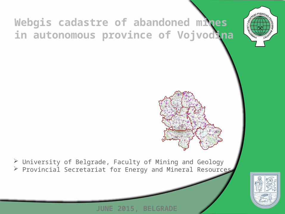
Webgis cadastre of abandoned mines in autonomous province of Vojvodina
JUNE 2015, BELGRADE
University of Belgrade, Faculty of Mining and Geology Provincial Secretariat for Energy and Mineral Resources
Goal
Gathering informations about number, geographical position, status and condition on abandoned mines
Gathering information on abandoned mines that are in need of remediation, and the mines which were recultivated
We can say:
«The goal is to provide safe and reliable data needed for the recultivation of abandoned mines in national parks and other
protected areas.»
HTTP://KANAKOV.VOJVODINA.GOV.RS

Experience in the world
INSPIRE (Infrastructure for Spatial Information in Europe)combines spatial data and web services across the continent, usingISO 19115 and ISO 19119
GeoMine (USA) geoportal supports the decision-making process in connection with activities related to surface mining of coal by improving access to data, timely dissemination of data and understanding of geospatial data on different scales and at different levels
U.S. Geoscience Information Network provides storaging and exchanging of data without commercial software.
Upper Midwest Environmental Sciences Center – developed geodatabase for Ohio Valley Abandoned Mine Lands
Abandoned Mine Land Inventory System (e-AMLIS) (USA) –includes information on abandoned mines that are in need of remediation, and the mines which were recultivated.
Serbian practice
One of the requirements in developing the new system was to integrate it with the existing GIS application GeolIEP
GeolIEP represents a basis for archiving and efficient handling of vector, raster and related thematic alphanumeric content
The use of GeolIEP results in cost reduction in data storage and archiving and accessibility of data to a wider circle of users рисника
The system is implemented within the ESRI ArcGIS technology framework as an ArcMap

Geodatabase model
The geodatabase model contains: The name and geographical location Administrative affiliation Owner (if exist) Geometry: polygon in space, height and number of floors,
overall depth or height, estimated volume Geological structure Status Field recording Photo Gallery ...

Data model
-noid : esriFieldTypeString+naziv_objekta : esriFieldTypeString«SubtypeField» +tip_objekta : esriFieldTypeInteger = 0+komentar : esriFieldTypeString+reg_noid : esriFieldTypeString+metapodatak_id : esriFieldTypeInteger+izvorna_nadmorska_visina : esriFieldTypeDouble+broj_etaza : esriFieldTypeInteger+visina_etaze : esriFieldTypeDouble+dubina : esriFieldTypeDouble+zapremina : esriFieldTypeDouble+efektivna_zapremina : esriFieldTypeDouble+max_zapremina_zapunjavanja : esriFieldTypeDouble+min_zapremina_zapunjavanja : esriFieldTypeDouble-mineralna_sirovina : esriFieldTypeString-pokrivenost_vegetacijom : esriFieldTypeString-rekultivacija_i_mere_sanacije : esriFieldTypeString-tip_rekultivacije : esriFieldTypeString+nivo_podzemne_vode : esriFieldTypeString-tip_dd : esriFieldTypeString+X : esriFieldTypeDouble+Y : esriFieldTypeDouble
objekat
-naziv_organizacije : esriFieldTypeString+kontakt_osoba : esriFieldTypeString+telefon : esriFieldTypeString+email : esriFieldTypeString+adresa : esriFieldTypeString+mesto : esriFieldTypeString+druga_adresa : esriFieldTypeString+web_adresa : esriFieldTypeString+pib : esriFieldTypeString+maticni_broj : esriFieldTypeString+priv_org_iz_apr : esriFieldTypeString
privredna_organizacija
0..*
1
+Shape : esriFieldTypeGeometry
ESRI Classes::Feature
-metapodatak_id : esriFieldTypeInteger-komentar : esriFieldTypeString
genericki_atributi
1
1..*
+noid : esriFieldTypeString+broj_tacke : esriFieldTypeInteger+x_koordinata : esriFieldTypeDouble+y_koordinata : esriFieldTypeDouble+srs : esriFieldTypeString
koordinate_objekta
-objekat1
-koordinate
1..*
-reg_noid : esriFieldTypeString+naziv_objekta : esriFieldTypeString+mesto : esriFieldTypeString+opstina : esriFieldTypeString+okrug : esriFieldTypeString+adresa : esriFieldTypeString+lokalitet : esriFieldTypeString«SubtypeField» +tip_objekta : esriFieldTypeInteger = 0+katastarska_parcela : esriFieldTypeString+privredna_organizacija_id : esriFieldTypeInteger+ima_titulara : esriFieldTypeString+br_odobrenja : esriFieldTypeString+god_pocetka_radova : esriFieldTypeInteger+god_obustave_radova : esriFieldTypeInteger+rastojanje_od_najblizeg_mesta : esriFieldTypeDouble+povrsina_po_odobrenju : esriFieldTypeDouble+lokalni_recipijent_voda : esriFieldTypeString-mineralna_sirovina : esriFieldTypeString-status_no : esriFieldTypeString-pravni_status : esriFieldTypeString-zahtev_za_rekultivaciju : esriFieldTypeString-pok_katastarski_broj : esriFieldTypeString-rep_katastarski_broj : esriFieldTypeString-katalog : esriFieldTypeString
registar_no
0..*
1
1
1..*
«SubtypeField» +tip_objekta = 0+broj_etaza = --+visina_etaze = --+zapremina = --+efektivna_zapremina = --+dubina = --+max_zapremina_zapunjavanja = --+min_zapremina_zapunjavanja = --
povrsinski_kop
«SubtypeField» +tip_objekta = 2
jaloviste
«SubtypeField» -tip_objekta = 5
ostalo
«SubtypeField» -tip_objekta = 4
radionica
«SubtypeField» -tip_objekta = 3
prerada
«SubtypeField» +tip_objekta = 1+zapremina = --+efektivna_zapremina = --+dubina = --+max_zapremina_zapunjavanja = --+min_zapremina_zapunjavanja = --
rudnik
-reg_noid : esriFieldTypeString-prezime_ime : esriFieldTypeString-datum : esriFieldTypeDate-izvor_podataka : esriFieldTypeString
terenski_zapis
+reg_noid : esriFieldTypeString+autor_i : esriFieldTypeString+datum : esriFieldTypeDate+lokalna_ili_url_adresa : esriFieldTypeString+naziv : esriFieldTypeString
multi_medijalni_podatak+noid : esriFieldTypeString+opis_kartirane_jedinice : esriFieldTypeString+stepen_ugrozenosti_pv : esriFieldTypeString+genetska_kategorija : esriFieldTypeString+tip_poroznosti : esriFieldTypeString+namena_zemljista : esriFieldTypeString+udalj_reke_lin : esriFieldTypeDouble+udalj_reke_pol : esriFieldTypeDouble+udalj_naselja : esriFieldTypeDouble+udalj_zasticenog_podr : esriFieldTypeDouble+tip_zasticenog_podrucja : esriFieldTypeString+br_stanovnika_buf_250m : esriFieldTypeDouble+br_stanovnika_buf_500m : esriFieldTypeDouble+br_stanovnika_buf_1000m : esriFieldTypeDouble
svojstva_no
-objekat1
-svojstva_no1..*

Geodatabase content
The geodatabase model was developed using UML (Unified Modeling Language) and CASE (I) tool Microsoft Visio
Database contains some of the next tables : Economic organization– contain basic informations about
economic organizations. Usualy, they are also the owners. Register of abandoned objects– contain basic informations
about registers Abandoned objects - contain basic informations about objects Multimedia– contain photos of abandoned objects Field records– descriptions about abandoned objects during
field visits
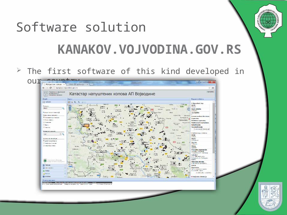
Software solution
The first software of this kind developed in our country
KANAKOV.VOJVODINA.GOV.RS

Software is developed in accordance with SDI-а (spatial data infrastructure)
Application is available at: http://kanakov.vojvodina.gov.rs/ It represents a good base for an upgrade, analyze and
display data from other areas (environmental protection, agriculture, hydrology, urban planning ...)
The accent is on the function of reporting that allows management of sustainable development, spatial planning and environmental security.
Contains information which are obtained by systematization and analysis of all electronic and paper documents
There are two part of application: First, that has public accessAnd second, which purpose is to adding data and
manage with available resources...
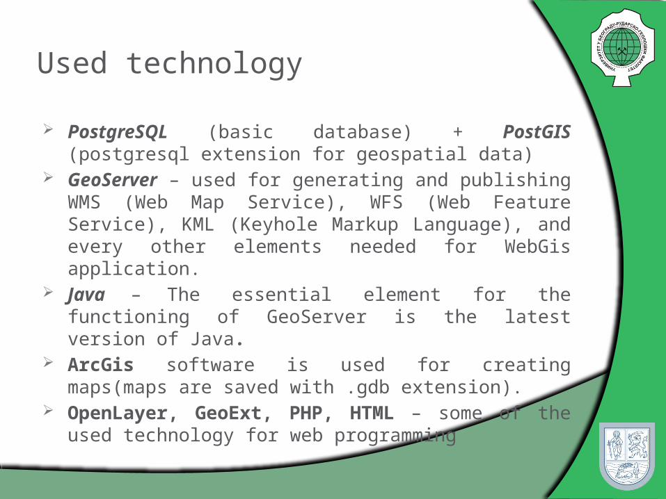
Used technology
PostgreSQL (basic database) + PostGIS (postgresql extension for geospatial data)
GeoServer – used for generating and publishing WMS (Web Map Service), WFS (Web Feature Service), KML (Keyhole Markup Language), and every other elements needed for WebGis application.
Java – The essential element for the functioning of GeoServer is the latest version of Java.
ArcGis software is used for creating maps(maps are saved with .gdb extension).
OpenLayer, GeoExt, PHP, HTML – some of the used technology for web programming
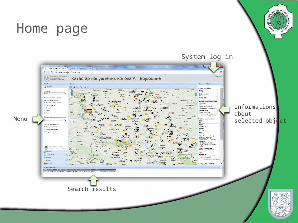
Home page
System log in
Search results
Menu
Informations aboutselected object
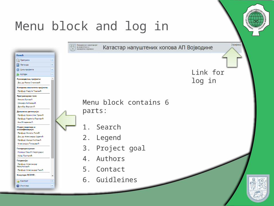
Menu block and log in
Menu block contains 6 parts:
1. Search
2. Legend
3. Project goal
4. Authors
5. Contact
6. Guidleines
Link for log in

Menu block - Search
Users can search portal in to ways:
1. Full database search, where user insert word/part of word and then system search the whole database and gives results to users
2. Advanced search provides user to choose group of polygons, status, owner or municipalities, and then system will search database, using selected values.
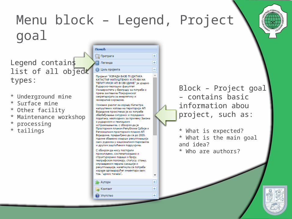
Menu block – Legend, Project goal
Legend containslist of all object types:
* Underground mine* Surface mine* Other facility* Maintenance workshop* processing* tailings
Block – Project goal – contains basic information abou project, such as:
* What is expected?* What is the main goal and idea?* Who are authors?

Menu block – Authors, Contact, Guidelines
Authors: List of application authors
Contact: Contact informations about application owner
Guidleines: Link for online guidliness in .pdf format.

Search result block
When search is done, in the bottom of application, users can se search results, that match specified conditions.
For each object, there are informations like name or municipalities
At the end of each row, there are two links: first, that allows user to see detailed informations about object, and secont that allows user to see all photos of object.
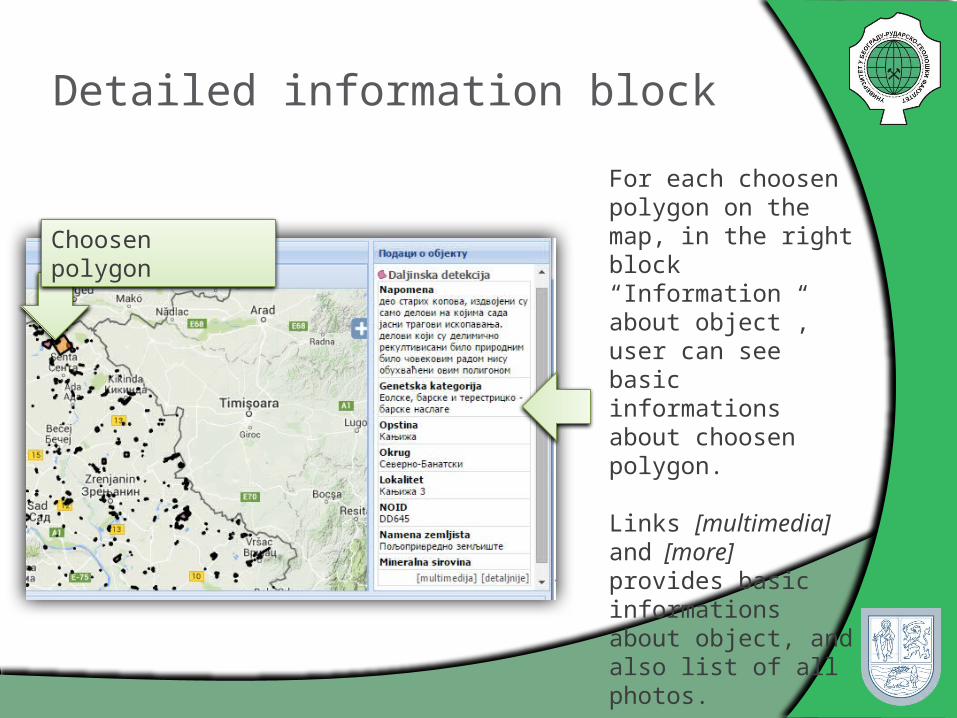
Detailed information block
For each choosen polygon on the map, in the right block “Information about object”, user can see basic informations about choosen polygon.
Links [multimedia] and [more] provides basic informations about object, and also list of all photos.
Choosen polygon
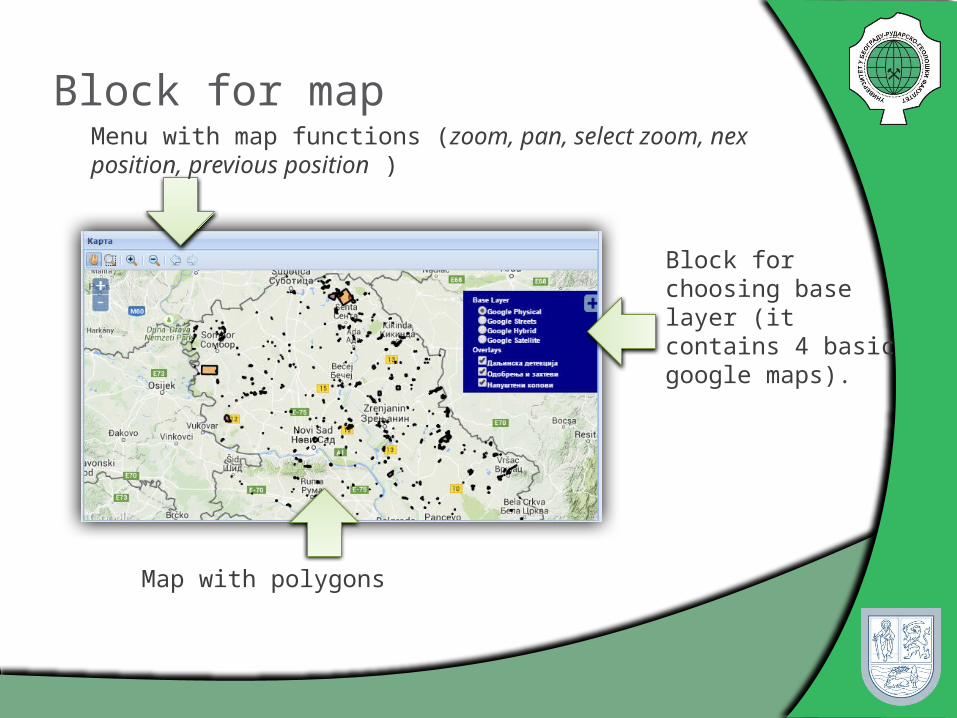
Block for mapMenu with map functions (zoom, pan, select zoom, nex position, previous position )
Block for choosing base layer (it contains 4 basic google maps).
Map with polygons

Detailed object information
Link more provides detailed informations.

Detailed object information

Second part of application – Enter and manage data
Second part of application refers on adding data such as owner, objects...
This part of application provides:
1. Enter, edit, view and delete users
2. Enter, edit, view and delete economic organizations
3. Enter, edit, view and delete registers
4. Enter, edit, view and delete objects
5. Reports
6. Statistics
7. Guidelines

Enter, edit, view and delete registers- View
At the registar page, there is the list of all registars that are in database, and there is also posibility of searching the list.
For each registar users can see detailed informations, and also registar can be edited or deleted. User can always enter new registar.

Enter, edit, view and delete registers- Enter

Enter, edit, view and delete registers- Edit
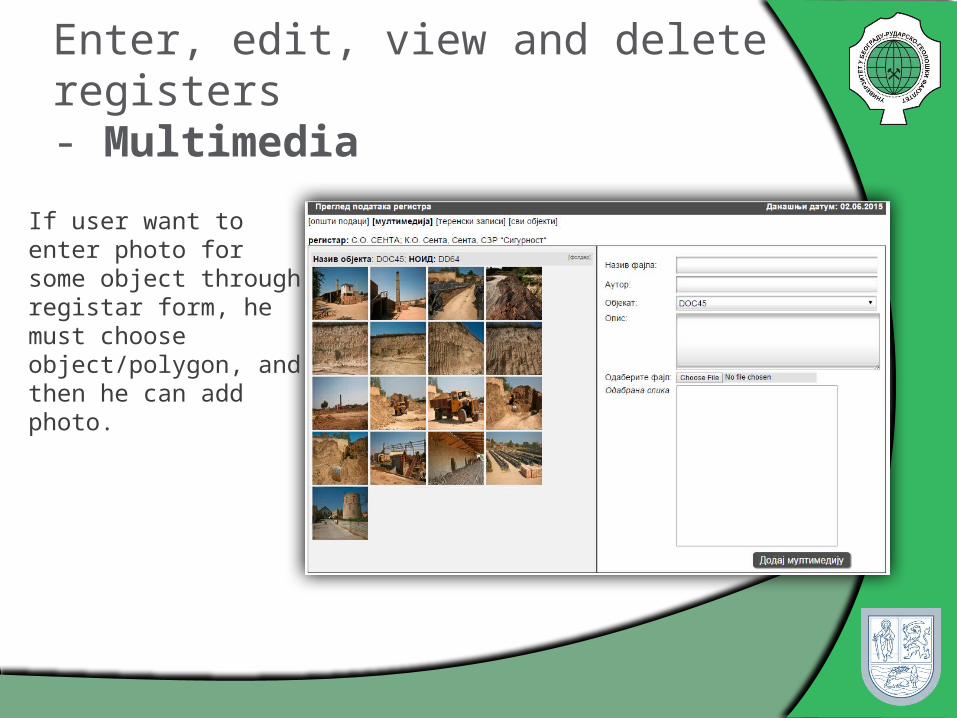
Enter, edit, view and delete registers- Multimedia
If user want to enter photo for some object through registar form, he must choose object/polygon, and then he can add photo.

Objects - View
All object are grouped:
1. Objects with known owner
2. Objects with unknown owner

Enter multimedia form - example
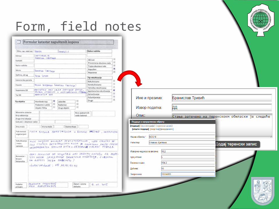
Form, field notes

Reports - example
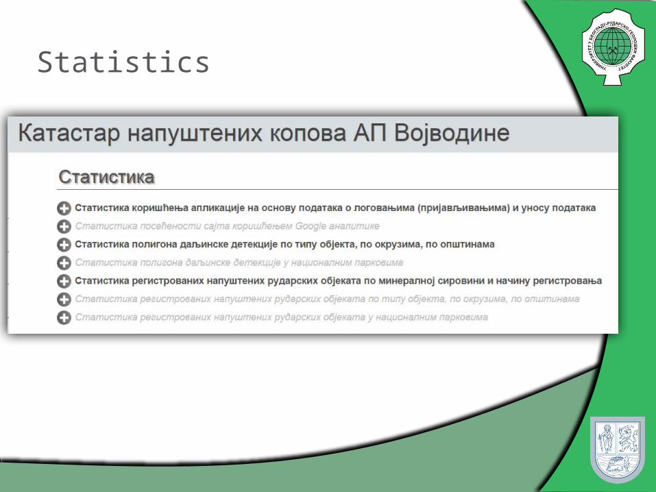
Statistics

Conclusion
KANAKOV application pointed out the usefulness, practical value and advantage of using WebGIS
This application provides more secure and reliable systematized data
Photos and the position of each of the abandoned objects are stored at one place
It is desirable to develope database using UML (Unified Modeling Language) and Microsoft Visio CASE tool
Application benefits, such as search form, provides users to get information about choosen object
Conclusion
The project activities preformed within the development of the Cadastre of abandoned mines in Vojvodina and the accompanying WebGIS application were complex and multidisciplinary, involving a team of experts form the geological, mining, economic, ecologic, informatics, mathematics and other domains.
Special attention was given to securing a high level and quality of project work
The application aspects are multiple, and relate not only to the relevant sectors of mining and geology, but also to economic, urban planning, spatial planning, agriculture, hydrology, ecology, safety and other sectors.

THANK YOU FOR YOUR ATTENTION !
AUTHORS: Ranka Stanković Nikola Vulović Nikola Lilić Ivan Obradović Radule Tošović Milica Pešić-Georgiadis