Wheatbelt Baselining Project Benchmarking Wheatbelt Vegetation · 2016-03-24 · Wheatbelt...
69
Wheatbelt Baselining Project Benchmarking Wheatbelt Vegetation Classification and Description of Eucalypt Woodlands Eucalyptus accedens woodland Tutanning Nature Reserve Judith Harvey and Greg Keighery
Transcript of Wheatbelt Baselining Project Benchmarking Wheatbelt Vegetation · 2016-03-24 · Wheatbelt...

Wheatbelt Baselining Project
Benchmarking Wheatbelt Vegetation
Classification and Description of Eucalypt Woodlands
Eucalyptus accedens woodland Tutanning Nature Reserve
Judith Harvey and Greg Keighery

Wheatbelt Baselining Project
Benchmarking Wheatbelt Vegetation
Classification and Description of Eucalypt Woodlands
June 2012
Prepared by Judith Harvey and Greg Keighery
Science Division
Department of Environment and Conservation
Cite as: Harvey, J.M. and Keighery G.J. (2012) Benchmarking Wheatbelt Vegetation. Classification and Description of Eucalypt Woodlands. Wheatbelt Baselining Project, Wheatbelt Natural Resource Management Region and Department of Environment and Conservation. Perth
This Project was funded by the Wheatbelt NRM

USE OF THIS REPORT Information used in this report may be copied or reproduced for study, research or educational purposes, subject to inclusion of acknowledgement of the source. DISCLAIMER In undertaking this work, the authors have made every effort to ensure the accuracy of the information used. Any information provided in the report, fact sheets and maps made available is presented in good faith and the authors and participating bodies take no responsibility for how this information is used subsequently by others and accept no liability whatsoever for a third party’s use of or reliance upon these reports, fact sheets maps, or any data or information accessed via related websites

TABLE OF CONTENTS 1. INTRODUCTION ................................................................................................................. 2
1.1 Background ............................................................................................................................ 2 1.2 Aims of the Project ................................................................................................................. 3 1.3 Intended users ....................................................................................................................... 3 1.4 Study area .............................................................................................................................. 4 1.5 Woodlands of the South West ............................................................................................... 6
2. VEGETATION CLASSIFICATION .............................................................................................. 7 2.1 Introduction ............................................................................................................................ 7 2.2 Limitations to classifying vegetation ...................................................................................... 9 2.3 Data input ............................................................................................................................. 10 2.4 Limitations of the data .......................................................................................................... 14 2.5 Methods summary................................................................................................................ 16 2.6 Limitations of the classification ............................................................................................ 17
3. RESULTS ................................................................................................................................. 17 3.1 Factsheets ............................................................................................................................ 35
4. DISCUSSION ........................................................................................................................... 35 5. POSSIBLE PRIORITY OR THREATENED ECOLOGICAL COMMUNITIES ........................... 38 6. BENCHMARKING AND VEGETATION CONDITION ASSESSMENT .................................... 39 DEFINITIONS .................................................................................................................................... 42 7. ACKNOWLEDGEMENTS ......................................................................................................... 42 8. REFERENCES ......................................................................................................................... 44 APPENDICES ................................................................................................................................... 49
Tables
Table 1 Comparison of selected vegetation classification systems (ESCAVI 2003; Hnatiuk, Thackway and Walker 2009; Walker and Hopkins 1990) ............................................................... 7
Table 2 Summary of projects and number of sites and polygons used in this woodland classification. ................................................................................................................................ 13
Table 3 Taxonomy recognizing the tree and mallee forms of some eucalypts in the Wheatbelt. .... 16 Table 4 The dominant eucalypt species considered in this Project. ................................................. 18 Table 5 The classification of eucalypt woodlands in the Wheatbelt. ................................................ 20 Table 6 The eucalypt woodland communities and sub-communities most commonly represented in
sites and polygons in this Project. ................................................................................................ 34 Table 7 The eucalypt woodland communities and sub-communities most poorly represented in sites
and polygons in this Project. ......................................................................................................... 35 Table 8 Definition of benchmarks: a comparison of major eastern states’ toolkits or approaches... 40 Table 9 Structural, compositional and functional attributes to describe benchmarks in the eastern
states. ........................................................................................................................................... 41
Figures
Figure 1 The Wheatbelt NRM region, defined by the Avon River Basin, in relation to the IBRA subregions of the South West of WA. ............................................................................................. 5
Figure 2 Woodlands of the western Wheatbelt in relation to topography and soils (Bamford 1995). 6
Figure 3 Woodlands of the eastern Wheatbelt in relation to topography and soils (Bamford 1995). 6
Figure 4 Location of sites used in the classification of eucalypt woodlands of the Wheatbelt. ..... 14


Benchmarking Wheatbelt Vegetation: Classification and Descriptions of Eucalypt Woodlands
1
SUMMARY
The Wheatbelt Baselining Project, initiated by the now Wheatbelt Natural Resource Management (Wheatbelt NRM) region, identified the need to provide benchmarks of vegetation against which assessments of vegetation condition can be made. Benchmarks need to be attributed to recognisable plant communities. A classification of eucalypt woodlands in the Western Australian Wheatbelt is presented here to trial a process which may be expanded to other vegetation types and regions. This is primarily a qualitative classification, similar to one carried out in Tasmania, based on site and polygon data and descriptions, interpretation of floristic analyses, interrogation of Geographic Information Systems (GIS) based spatial data, photographic interpretation and consultation with experts.
The Wheatbelt NRM region covers the 12 million hectares of the Avon River Basin, an area equivalent to the Avon River catchment, and encompasses a complex array of vegetation associations. Eucalypt woodlands once dominated the region, and are now restricted to reserves, roadsides, and remnants on private property.
Descriptions and data from 889 survey sites and 338 mapped polygons were the basis of a classification of 29 Eucalyptus species into 18 eucalypt woodland communities (12 of these, the mallets, have been considered one community group), and 62 sub-communities. Eucalypt woodland communities were defined primarily by the dominant Eucalyptus species; the sub-communities were defined by commonly observed structural formations, common co-dominant tree species, commonly occurring understorey genera or species, landform features or geographic distribution. The classification is open to challenge and further development, and serves as a ‘first cut’ presentation of the information currently collated.
The results of the classification have been presented as a set of web-based factsheets that include: for communities, soils, landforms, associated overstorey and understorey species, and sub-communities; for sub-communities, descriptions, maps, lists of sites including reference sites (where available) and photographs; and for reference sites, descriptions, species lists and photographs.
Benchmarking involves describing the near pristine state of a defined community in terms of species composition, species richness, vegetation structure and habitat value. Benchmark descriptions for 17 communities (excluding Eucalyptus marginata) and the mallet community group have been drafted against attributes used in the eastern states to give an indication of what the woodland communities look like when they are in pristine or excellent condition. This highlighted the need for collection of further data on attributes such as litter characteristics, regenerative strategies and faunal habitat needs.
The Benchmarking Wheatbelt Vegetation Project has produced:
a comprehensive structural – dominance classification of woodland communities and sub-communities which will help land managers, community organisations and students to understand these communities and their diversity and variability, to establish monitoring sites, and to assess their conservation status as a contribution to the nomination of potential Threatened Ecological Communities (TECs)
benchmark descriptions of main communities and draft methodology for recording selected attributes which will aid in the assessment of vegetation condition and direct and evaluate restoration activities
a set of web-based factsheets designed to provide information to land managers, community groups, scientists, students and naturalists about the diversity, composition and condition of the Wheatbelt woodlands and provide a framework for vegetation mapping, restoration and monitoring. The information can also inform enthusiasts wishing to travel through the Wheatbelt looking at the range of eucalypts
background information for the nomination of the eucalypt woodlands of the Avon Wheatbelt IBRA bioregion and western Mallee IBRA subregion as a Threatened Ecological Community under the federal Environment Protection and Biodiversity Conservation Act.
Benchmarking Wheatbelt Vegetation: Classification and Descriptions of Eucalypt Woodlands
2
1. INTRODUCTION
1.1 Background
The Baselining Project is one of the natural diversity projects funded largely by the federal government through the Wheatbelt Natural Resource Management, NRM (previously Avon Catchment Council, ACC). The Project’s primary purpose is to collate the biodiversity data and interpret these data to support other projects in the Wheatbelt NRM’s biodiversity theme. A preliminary role of Baselining was to identify key knowledge and operational gaps in natural diversity conservation within the Wheatbelt NRM region.
One of the five foundational gaps (typically higher-order gaps in knowledge that are required to inform the development, management and evaluation of natural diversity projects) identified was the need to benchmark Vegetation and to develop a condition assessment methodology (Richardson & Gamblin 2009). A detailed survey and analysis of floristic & environmental variables of the terrestrial and wetland vegetation of the WA agricultural region, funded by the Salinity Action Plan, SAP (Gibson et al. 2004), has identified 23 assemblages and related these to soils and topography. Vegetation mapping at a 1:250,000 scale has been amalgamated into a 1:1,000,000 scale map (Beard 1981). Numerous large scale maps, mainly of reserves and potential reserves, exist and have been compiled into a database to be incorporated into NatureMap. However, it was found that there is little knowledge of the extent (at a local scale) and condition of vegetation within the region (Richardson et al. 2007).
Knowledge of vegetation condition is critical for many of the Wheatbelt’s natural diversity projects; vegetation condition information is required to identify management actions, prioritise on-ground work and as a tool to evaluate project outputs. Assessing condition against benchmarks is an established way of identifying management actions and monitoring changes (Parkes et al. 2003). Benchmarks are defined from vegetation in a mature, long undisturbed state. Benchmarking involves describing the near pristine state of a defined community in terms of species composition, species richness, vegetation structure and habitat value. The definition of a benchmark adopted here is:
“A measure, for the purposes of biodiversity conservation, of indicators of vegetation composition, structure and function relative to a reference state (i.e. within the context of the presence or absence of threatening processes) at a patch or landscape (community or ecosystem) scale”(Bleby et al. 2008)
Before benchmark descriptions can be developed, the unit of assessment or vegetation community needs to be defined.
The native vegetation in the Avon River Basin is very diverse and complex with high species turnover at a patch and landscape scale, and a mosaic of structural formations varying with climate, landforms, soils and hydrology (Beard 1990). These issues present many challenges to those trying to map the vegetation.
The vegetation associations mapped by Beard at 1:250,000 are (in the majority) largely based on structure and dominant species. At this scale, the associations are too broad to account for the fine scale variations in the vegetation. For example, many of the woodland associations in the Wheatbelt are mapped as large units with up to six eucalypt species. These eucalypts do not all occur together but rather in patches, some together and others in mono-specific stands on localised specific soil types, e.g. mallet on breakaways. Vegetation is strongly linked to soil type which, in turn, is determined by the gently undulating landscape (Beard 1981, 1990).
Communities have been mapped at reserve scale (about 1:50,000) using a variety of methods (e.g. (Muir 1977; Coates 1990; Mattiske 1992). These and many more maps are being digitised and their attributes standardised according to the National Vegetation Information System, NVIS (ESCAVI 2003) as part of the Wheatbelt Baselining Project (Richardson et al. 2008); this work has been done by Ban Bayliss and is included on NatureMap.
Vegetation classifications tend to be based on: physiognomic characteristics, that is, structure and dominant species (Muir 1977; Beard 1981); or on numerical analysis of floristic composition, that is, species presence and absence, into assemblages, and incorporating environmental factors, such as soil types and climatic variables, into site groupings (e.g. (Gibson et al. 2004; Griffin 2008)).

Benchmarking Wheatbelt Vegetation: Classification and Descriptions of Eucalypt Woodlands
3
There are inherent problems with defining vegetation as it may gradually change across the landscape, and time since fire, grazing pressure, nutrient enrichment, weed infestation, salinity, and hydrological changes may influence floristic composition and structure.
It was decided to initially focus on the woodlands due to the complexity of the Wheatbelt vegetation; the knowledge available about eastern states woodlands; the fact that a relatively high proportion of woodlands have been cleared compared to other communities (Shepherd et al. 2002); the identification of three woodlands communities as potential Threatened and Priority Ecological Communities (DEC 2007); and the recent nomination of the WA Wheatbelt Woodlands as a Threatened Ecological Community under the federal Environment Protection and Biodiversity Conservation Act.
The Wheatbelt Woodlands are easily recognisable in the landscape, the eucalypt species are relatively easy to identify and they have been the focus of surveys (WWF 2001-2008), guides (Bamford 1995; Hussey 1999; McQuoid (in press)), descriptive catalogues (French 2012) and reviews (Yates et al. 2000).
Future extension of this exercise for the mallee, shrublands and kwongan will be challenging due to the way these formations intergrade, their high species richness and the lack of dominant species.
The following classification is based on descriptions of 889 sites and 338 polygons, species lists and photographs (where available), results of two floristic analyses, an existing list of communities and expert opinion from botanists working in the region.
1.2 Aims of the Project
The objectives and outputs of the Benchmarking Wheatbelt Vegetation component of the Wheatbelt Baselining Project are to:
classify and describe Wheatbelt eucalypt woodland communities based on available data from floristic surveys, GIS analysis, baseline vegetation mapping and expert opinion
document benchmarking methodology and prepare benchmark descriptions of the selected communities
develop a condition assessment methodology based on a selection of attributes and methods developed and tested in the eastern states, and some being developed in WA, and expert consultation.
An additional aim is to:
recommend necessary research and surveys to support nomination of communities as potential Priority Ecological Communities or Threatened Ecological Communities.
1.3 Intended users
The classification and benchmark descriptions are intended to assist:
Wheatbelt NRM to better understand the diversity and variability of these communities, to monitor and evaluate restoration activities, and to assess their conservation status
DEC regional staff doing reserve surveys to assess the conservation significance of woodlands on their reserves and crown land being considered for reserves
DEC officers to assess native vegetation clearance applications
Land for Wildlife and WWF personnel to assess the diversity and condition of woodland remnants in a regional context in order to implement land covenants
private land managers to assess and manage their woodland remnants
federal and state government officers to assess the nomination of the eucalypt woodlands of the Avon Wheatbelt IBRA bioregion and western Mallee IBRA subregion as a Threatened Ecological Community under the federal Environment Protection and Biodiversity Conservation Act
tourists, naturalists and eucalypt enthusiasts to plan their visits to the WA Wheatbelt

Benchmarking Wheatbelt Vegetation: Classification and Descriptions of Eucalypt Woodlands
4
students and scientists to carry out related research
community groups to plan and monitor restoration activities.
1.4 Study area
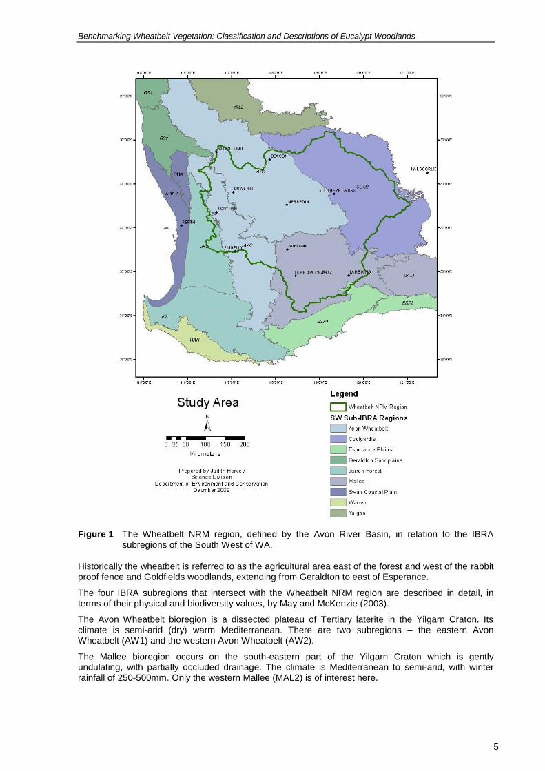
The area of focus for this Project is the Avon River Basin, which is the catchment for the Avon-Mortlock, Yilgarn and Lockhart river systems, and defines the Wheatbelt NRM region (referred to as the ‘Wheatbelt’ throughout this report). Figure 1 shows the Wheatbelt NRM region in relation to the Interim Biogeographic Regionalisation for Australia (IBRA) regions and subregions of the South West. In assessing whether communities are confined to the Wheatbelt NRM region, some site observations from outside the region were incorporated in the classification.
Benchmarking Wheatbelt Vegetation: Classification and Descriptions of Eucalypt Woodlands
5
Figure 1 The Wheatbelt NRM region, defined by the Avon River Basin, in relation to the IBRA subregions of the South West of WA.
Historically the wheatbelt is referred to as the agricultural area east of the forest and west of the rabbit proof fence and Goldfields woodlands, extending from Geraldton to east of Esperance.
The four IBRA subregions that intersect with the Wheatbelt NRM region are described in detail, in terms of their physical and biodiversity values, by May and McKenzie (2003).
The Avon Wheatbelt bioregion is a dissected plateau of Tertiary laterite in the Yilgarn Craton. Its climate is semi-arid (dry) warm Mediterranean. There are two subregions – the eastern Avon Wheatbelt (AW1) and the western Avon Wheatbelt (AW2).
The Mallee bioregion occurs on the south-eastern part of the Yilgarn Craton which is gently undulating, with partially occluded drainage. The climate is Mediterranean to semi-arid, with winter rainfall of 250-500mm. Only the western Mallee (MAL2) is of interest here.

Benchmarking Wheatbelt Vegetation: Classification and Descriptions of Eucalypt Woodlands
6
The Coolgardie bioregion is also within the Yilgarn Craton. Its granite basement includes Archaean Greenstone intrusions in parallel belts. Drainage is occluded. The climate is arid to semi-arid warm Mediterranean with 250-300mm of mainly winter rainfall. The western or Southern Cross subregion, COO2, is a largely uncleared area of gently undulating uplands on granite strata interspersed with broad valleys with bands of low greenstone hills. This is not included in this classification because of the lack of data and non-fragmented nature of the vegetation.
So the Project is actually focused on the area defined by the cleared area in the Avon River Basin covered by the AW1, AW2 and MAL2 IBRA regions.
1.5 Woodlands of the South West
Woodlands are defined as widely spaced trees with a canopy cover of less that 30% (ESCAVI 2003; Muir 1977; Specht 1970). Cover may exceed 30% after a disturbance such as fire but, over time, it tends to thin out. Woodlands featured here are all dominated by Eucalyptus species. Other woodlands of sheoak and banksia also occur in the Wheatbelt. The distribution of woodlands in the Wheatbelt, in relation to topography and soils, is presented in Figure 2 and Figure 3 (Bamford 1995).
In the Wheatbelt, woodland trees include Eucalyptus salmonophloia (Salmon Gum), E. loxophleba (York Gum) and E. salubris (Gimlet), all of which tend to regenerate from seed but may resprout from the stem and form multiple stems if logged. Some, such as E. loxophleba, may develop lignotubers and multiple stems following disturbance. Another group of trees, known as mallets, only regenerate from seed, are killed by fire and have no lignotuber; these include E. astringens, E. gardneri, E. urna and E. sargentii.
Figure 2 Woodlands of the western Wheatbelt in relation to topography and soils (Bamford 1995).
Figure 3 Woodlands of the eastern Wheatbelt in relation to topography and soils (Bamford 1995).

Benchmarking Wheatbelt Vegetation: Classification and Descriptions of Eucalypt Woodlands
7
2. VEGETATION CLASSIFICATION
2.1 Introduction
Hnatiuk et al. (2009) describe vegetation classification for the purpose of mapping as being based on ‘Structure (the vertical and horizontal distribution of vegetation – its growth form, height, cover and strata) and floristics (dominant general or species in various strata and characteristic plant species’. Their comparison of some of the current systems of classification levels in Australia is presented in hierarchical form in Table 1.
Table 1 Comparison of selected vegetation classification systems (ESCAVI 2003; Hnatiuk, Thackway and Walker 2009; Walker and Hopkins 1990)
Key Attributes Walker & Hopkins
Hnatiuk, Thackway & Walker
NVIS Examples (NVIS)
Growth form and cover N/A 1 Formation I Class Tree
Growth form, cover and height of the dominant stratum and emergents
Structural formation
2 Structural formation
II Structural formation
Open woodland
Growth form, cover, height and characteristic species/genera in the dominant stratum
Floristic association
3 Broad floristic formation
III Broad floristic formation
Eucalyptus open woodland
Above plus the dominant genera for each stratum (upper mid and ground)
Structural sub formation
4 Broad floristic sub formation
IV Broad floristic sub formation
Eucalyptus open woodland\Acacia tall sparse shrubland\Austrostipa open grassland
Above with three dominant or co-dominant species in each stratum
Species can be added for substrata
V Association U+^Eucalyptus salmonophloia, \Eucalyptus\^tree\7\i;MAcacia acuminata\Acacia\shrub\3\r;GAcacia erinacea\Acacia\shrub\1
\r;
Above with five dominant or co-dominant species in each stratum
Species can be added for substrata
VI Sub association
U1+^Eucalyptus salmonophloia, \Eucalyptus\^tree\7\i;U2Eucalyptus wandoo\Eucalyptus\tree\6\r;M1Acacia acuminata\Acacia\shrub\3\r;M2^Olearia muelleri\Olearia\^shrub\3\i;G1 Acacia erinacea\Acacia\shrub\1
\r; G2^^Lepidosperma pubisquameum, Loxocarya "asper", Austrostipa sp., Stypandra glauca, Lepidosperma brunonianum\Lepidosperma\^sedge, tussock grass,rush\1\i

Benchmarking Wheatbelt Vegetation: Classification and Descriptions of Eucalypt Woodlands
8
Classifying Vegetation is important for:
systematically mapping the vegetation
assessing conservation values (how much is left and how much is in reserves)
identifying Threatened Ecological Communities and Priority Ecological Communities
developing benchmark descriptions which are required to effectively assess and monitor changes in vegetation condition
helping land managers and land owners identify their bush remnants
guiding and monitoring revegetation activities
planning pest and weed control, fire management and visitor use.
The term vegetation is applied to plant communities and can be described at a range of scales. A plant ecological community has been defined in WA as a naturally occurring biological assemblage of plants that occurs in a particular type of habitat (DEC 2007). Community structure is defined as follows: “The spatial organisation, construction and arrangement of the biological elements comprising a biological assemblage”, for example, Eucalyptus salmonophloia woodland over scattered small shrubs over dense herbs (DEC 2007). It is noted that the scale at which ecological communities are defined will often depend on the level of detail in the information source; therefore, no particular scale is specified.
For this Benchmarking Project we consider vegetation units on a broader scale as being characterised by structural and floristic features that are more or less consistent across its range. It may include specific topographic or soil parameters.
Units of vegetation need to be:
1. Scientifically recognised and defensible:
It must have sufficiently consistent floristics and structure to allow it to be recognised in the field. It may occur in various states as it recovers from fire, grazing or other disturbance. There is some knowledge about this for some communities e.g. Salmon Gum (Yates et al. 1994). A community affected by dieback is transformed permanently and may be described as a different (post dieback) community. In Tasmania, successional stages may be classed as communities if they are temporally stable for about 20 years (Harris & Kitchener 2005).
It must be based on an accepted vegetation classification system (e.g. Muir 1977; ESCAVI 2003) which emphasises floristic dominance (i.e. lists the most dominant species).
It must be considered by botanical experts to be a common and/or recognisable unit.
It does not need to be supported by floristic pattern analysis as this is based on total species or total perennial species and does not take abundance or cover into account.
2. Mappable (desirable):
If a vegetation unit is mappable it can be defined on aerial photography and consistently recognised on the ground. Some communities, such as those that make up mosaics of kwongan and mallee, will be difficult to map at a fine scale or to be discerned from remote sensing and will have to be delineated at a broader scale.
With the use of GIS, communities can be mapped to quite a small size; for example, vegetation of the reserves of the south coast have been mapped to 25m x 25m (Sandiford & Barrett 2010). Remote sensing may assist in defining boundaries.
The community should be defined at the appropriate resolution for incorporation into a statewide vegetation map. In the South West, this is probably a scale of 1:50,000. This may not be a necessary requirement with the current flexibility of GIS.
Small patches of unusual vegetation may be listed as Threatened Ecological Communities.
Future vegetation maps may be models based on classified structural and dominant floristic data.

Benchmarking Wheatbelt Vegetation: Classification and Descriptions of Eucalypt Woodlands
9
For the development of benchmarks, the community definitions need to be in a statewide context and this has been taken into account in the development in this pilot study.
Systems developed in other Australian states were examined. Plant communities in Tasmania are characterised by floristics and structural features that are more or less consistent across each community’s range (Harris & Kitchener 2005). They form the TASVEG statewide vegetation map on which benchmarks for the assessment of vegetation condition are based (Neldner et al. 2005; Michaels 2006)
In Victoria the units of vegetation classification on which benchmark descriptions are based are the Victorian Ecological Vegetation Classes (EVCs). These are defined by a combination of floristics, growth form and reproductive strategy profiles, position in the landscape, and an inferred fidelity to particular environments There are about 300 EVCs that have been mapped or modelled at either the 1:100,000 or 1:250,000 scale. They are defined as ‘consisting of one or a number of floristic communities that appear to be associated with a recognisable environmental niche, and which can be characterised by a number of their adaptive responses to ecological processes that operate at the landscape scale level.’
In Queensland the vegetation is mapped as Regional Ecosystems which comprise vegetation that is consistently associated with a particular combination of geology, landform and soil (Neldner et al. 2005).
In WA 820 vegetation associations were mapped by Beard at 1:250,000 as the Pre-European extent; these were further subdivided by Beard’s ‘Systems’ into 2,155 units (Hopkins et al. in press) These associations are (in the majority) largely based on structure and dominant species and are so broad that they do not account for the fine scale variation in the vegetation. For example, many of the woodland associations in the Wheatbelt are mapped as large units with up to six eucalypt species. These eucalypts do not all occur together but rather in patches, some together and other in mono-specific stands on localised specific soil types; for example, mallet on breakaways. At a finer scale, mapping developed by Muir (1977) is commonly used but no agglomerative process has been undertake to standardise unit descriptions across the Wheatbelt. The classification system of Muir has been matched with the NVIS system (ESCAVI 2003) and the system developed in Walker and Hopkins (1990) by B. Bayliss (pers. comm.) as part of the Avon Vegetation Mapping Project.
For this Project, eucalypt woodland communities were defined primarily by the dominant Eucalyptus species; sub-communities were defined by commonly observed structural formations (e.g. scrub, herbs), common co-dominant tree species, commonly occurring understorey genera (e.g. Melaleuca) or species (e.g. Jam, Acacia acuminata), landform features (e.g. on dunes or near salt lakes) or geographic distribution. The results of the classification are presented as a set of web-based factsheets that include, for each community, brief species identification notes, a description of its soils and landform, associated species, number of sites and polygons, a preliminary benchmark description (in the case of the mallets, a benchmark describes the community group, rather than the individual communities) and a list of some general reference sites; for each sub-community, a general structural and floristic description, average species richness, the number of sites and polygons, a map, a list of sites including a specific reference site (where available), and a photographic example of a site; and, for each specific reference site, a structural and floristic description, its location, project name(s), a species list and a photograph.
Data were not uniformly available from across the region and some communities were sampled more that others, for example WWF targeted four species: Eucalyptus salmonophloia, E. salubris, E. loxophleba and E. longicornis.
2.2 Limitations to classifying vegetation
The classification of vegetation is fraught with difficulties due to gradual changes across the landscape, within and between communities, due to climatic and soil gradients and the intricate ‘marbling’ (S. Prober pers. comm.) pattern in soils and topography in the South West. As communities intergrade, it becomes difficult to define and map them. The dynamic nature of species turnover across the landscape further complicates the matter (Brown 1989; Burgman 1988; Gibson et al. 2004; Muir 1977). Simply put, the short coming of the classification process is that plant communities don’t fit neatly into boxes and there is inevitable overlap between them.
Within any one community there may be different ‘states’ due to time since fire, grazing pressure, nutrient enrichment, weed infestation, salinity, and hydrological changes, all of which influence floristic
Benchmarking Wheatbelt Vegetation: Classification and Descriptions of Eucalypt Woodlands
10
composition and structure. A ‘State in Transition’ model, based on one developed in the rangelands by Westoby (1989), was developed to help understand the pressures and so better manage the Box Gum Grassy Woodlands across Queensland, New South Wales and Victoria (Rawlings et al. 2010). This model has also been applied in WA to the Salmon Gum (Yates & Hobbs 1997; Standish et al. 2009), York Gum (Prober et al. 2009) and, in a more general way, to Wandoo woodlands (Hussey 1999). The federal Department of Sustainability, Environment, Water, Population and Communities now recognises the significance of such ‘states’ and has incorporated this concept into their listing of the Box Gum Grassy Woodlands as a nationally Threatened Ecological Community under the Environment Protection and Biodiversity Conservation Act. Therefore, it is necessary to be aware of the fire and grazing history of a site so as not to confuse a difference between communities with different states of a community.
Ongoing taxonomic revisions such as French (2012) are an additional complicating factor in the classification of vegetation, especially for the structurally significant tree species. Recently, some tree eucalypt species, which have been observed to develop lignotubers and regenerate as mallees after fire or scrub-rolling, have been split into tree species and mallee species.
Although E. loxophleba is described as a tree and, rarely, a multi-stemmed mallee (Western Australian Herbarium 1998 -; Brooker & Kleinig 2001; French 2012), it is traditionally regarded as a low branching tree forming woodlands in the western Wheatbelt. The mallee form has been described as E. loxophleba subsp. lissophloia.
It may be difficult to reconcile defined ecological communities with what is seen on the ground (M. Hislop pers. comm.) and, conversely, it may be difficult to assign what is seen at a site to a community classification.
2.3 Data input
Following on from similar exercises in the eastern states e.g. Harris and Kitchener (2005), the woodland classification for this Project has been based on a synthesis of existing survey data, results of floristic analyses, available maps at appropriate scales and expert opinion.
The information used in the classification consists of:
quadrat data from:
- terrestrial and wetland vegetation surveys carried out as part of the Biodiversity Survey of the Western Australian Agricultural Zone by the Department of Environment and Conservation (DEC), from 1997 to 2001 funded by the Salinity Action Plan (SAP)
- WWF Woodland Watch project surveys from 2000 to 2008, funded and organised though the WA Branch of the World Wildlife Fund (WWF)
- selected surveys by Ted Griffin
- surveys on reserves and private land for the DEC Wheatbelt Region
data from the Biological Survey of the Eastern Goldfields of WA, carried out between 1977 and 1983
descriptions of mapped vegetation polygons (available to 2009) extracted from a database of Avon Vegetation maps which is being compiled as part of the Baselining Project (available on NatureMap)
a list of vegetation of the Wheatbelt, classified by Greg Keighery and based on his extensive knowledge of the area, field work (including the SAP survey) and familiarisation with many of the mapping projects carried out in the region (Appendix 1)
advice from botanists Greg Keighery, Nathan McQuoid, Peter White, Mike Hislop, Anne Rick, Jenny Borger and Malcolm French, and naturalists Penny Hussey, Mick Davis and Mike Griffiths who have expert knowledge of the vegetation of the region
other incidental information.
Vegetation survey data was extracted from 244 woodland sites from the SAP terrestrial survey (Gibson et al. 2004) and 76 wetland survey sites (Lyons et al. 2004) including the vegetation descriptions, site descriptions (landforms and soil), species lists and site photographs. Most of these sites were visited a number of times to capture all the annuals & geophytes. The site descriptions of
Benchmarking Wheatbelt Vegetation: Classification and Descriptions of Eucalypt Woodlands
11
the vegetation, following the format developed by Muir (1977) specifically for the Wheatbelt, were presence-absence floristic data were also considered and descriptions of the relevant groups are listed in Appendix 2.
Eight of the 25 groups resulting from the SAP quadrat analysis, based on the presence or absence of species, were characterised by eucalypt tree species. Few were dominated by a single species of eucalypt tree such as Eucalyptus astringens subsp. astringens (G19) or occasional E. salmonophloia over mallee (G6). Instead, most woodland groups were dominated by more than one species, for example E. salmonophloia and E. salubris (G24); E. loxophleba and E. wandoo (G12); E. salmonophloia, E. longicornis, E. occidentalis or E. astringens (G5); and E. longicornis, E. kondininensis or E. salmonophloia (G4). For descriptions of these groups see Appendix 2; this presents the similarities between communities based on presence and absence of species. An analysis incorporating the dominance or cover values may produce different results.
Similarly, the assemblages generated by the SAP analysis, based on bioregional and subregional location and with a weighting against species richness to look at phytogeographic patterns within the study area, include some with several canopy species, for example, Eucalyptus loxophleba and E. capillosa (A1); E. salmonophloia, E. longicornis, E. yilgarnensis and E. salubris (A3); and E. spathulata and E. kondininensis (A6 - salt lake). Associations with only one typical eucalypt tree included E. wandoo (A13), E. accedens (A17), E. occidentalis (A12) and E. astringens subsp. astringens (A5). For descriptions of these groups see Appendix 2.
Data were used from most of the sites used by Griffin (2008) in his analysis of woodland floristic data for the Species and Communities Branch of DEC. His classification was based on 606 sites with typical Wheatbelt tree species, including E. salmonophloia, E. loxophleba, E. wandoo, etc., and involved analysing the woody vegetation species present using the PATN program. These sites were selected from the SAP dataset (336 sites) (Gibson et al. 2004; Lyons et al. 2004); Griffin’s floristic survey of the Northern Sandplains (69 sites) (Griffin 1994); WWF Woodland Watch project surveys (238 sites to 2008) (WWF 2001-2008); and Lake Bryde survey (15 sites). A dendrogram produced a hierarchy of sites divided into 25, 50, 100 or 200 groups; these were related to the Wheatbelt vegetation types table of compiled by Keighery (Appendix 1). Most of the woodland classification groups identified from Griffin’s PATN analysis (Appendix 3) were considered when forming the current classification (there are some mallee and shrublands which are not included). Griffin’s (2008) Appendix 7, listing the species common to each group, was also incorporated into the descriptions of the current classification. Griffin compared the results of his 25, 50 and 100 groupings to Keighery’s table (Appendix 1).
WWF Woodland Watch (2001-2008) project surveys focused on four targeted species (E. longicornis, E. salmonophloia, E. salubris and E. loxophleba), mainly on private land or in shire reserves. Other woodlands were sampled and included in the current classification, but sites of other woodlands (e.g. banksia and casuarina woodland), and mallee (e.g. E. loxophleba subsp. lissophloia), were removed. Sites were generally in very good condition but were only visited once. Annual project reports, site distribution maps and site species lists are available through the Western Australian Herbarium’s FloraBase website http://FloraBase.dec.wa.gov.au/wwatch/. A total of 196 sites, including 38 sites surveyed in 2007 and 2008, were used in the current classification. The latter sites were manually assigned to sub-communities derived from the classification produced by Griffin (2008) and from the available species lists, vegetation descriptions and site photographs.
Descriptions from 270 sites, and species lists from 232 of these sites, were extracted from the Wheatbelt Reserves Database (WbDb). This dataset was supplied by Brett Beecham (DEC Wheatbelt Region, Narrogin) and was designed by Ecoscape (Australia) Pty Ltd for DEC using methods based on Safstrom (1995). The Database was set up to help manage data relevant to assessing the nature conservation values of native vegetation remnants in the context of other land management and social values. It contains data from 896 sites collected during various surveys carried out by DEC staff from Merredin, Narrogin and Katanning and consultants between 2000 and 2005. Site identification prefixes include KS (Kent Shire); LB, LG, MD005, MM, ND, PEG, RLB (Lake Bryde recovery catchment); RTR (Tarin Rock area); TL33 (east of Kondinin and west of Lake Grace); and M (Lake Magenta).
Fifteen woodland and open woodland sites were used from the survey of the Boorabbin-Southern Cross area (Newbey et al. 1995) and the Hyden-Lake Johnson area (Newbey & Hnatiuk 1988). This was a regional biological survey by the Biological Surveys Committee involving WA Museum, Fisheries & Wildlife (later CALM and now DEC), WA Herbarium and National Parks Authority between 1977 and 1983. These sites were included in this project to give an indication of the woodland

Benchmarking Wheatbelt Vegetation: Classification and Descriptions of Eucalypt Woodlands
12
communities that extend into the Goldfields woodlands (now know as the Great Western Woodlands, GWW). It was decided not to investigate other surveys in the GWW such as the surveys of the eastern Golfields ranges co-ordinated by Gibson (e.g.Gibson & Lyons 1998) and to concentrate on the cleared agricultural area
Three hundred and thirty-eight vegetation descriptions attributed to polygons were extracted from the Avon Vegetation Mapping database (data to November 2009). Some of these included additional environmental descriptions (e.g. soil, topography, disturbance level). This dataset, prepared by Ben Bayliss for the Wheatbelt Baselining Project, is confined to the cleared Wheatbelt NRM region and consists of many reserve and non-reserve vegetation maps prepared by a range of people and organisations between 1978 and 1996. These maps are available through the NatureMap website.
Other incidental information used:
24 sites surveyed by Judith Harvey in 2009 and 2010. These were largely based on reference sites nominated by Nathan McQuoid, Penny Hussey and Greg Keighery. Additional condition data were also collected during revisits to several SAP sites.
FloraBase species’ distribution maps and descriptions were consulted; however, individual specimen collection data were not examined.
survey work by Denise True, performed as part of a review of grassy woodlands in the WA Wheatbelt (Mattiske 1995). The sites were not incorporated into the current classification as the data were not available. Four eucalypt woodlands groups were identified:
- York Gum (Eucalyptus loxophleba subsp. loxophleba) – Jam (Acacia acuminata) low woodlands over tall shrubs/low trees over closed grasses and herbs (3 sites)
- York Gum mallee (E. loxophleba subsp. lissophloia) over open tall shrubs/low trees over tall grasses (1 site)
- Wandoo (E. wandoo) woodlands over tall open shrubs over closed grasses and herbs (4 sites)
- mixed eucalypt woodland over tall open shrubs/low trees over grasses and herbs (1 site).
Included are SAP, WWF and Griffin sites located outside the Avon River Basin, so as to indicate the extent of the communities and sub-communities and thereby ascertain which are confined to the Wheatbelt NRM region. The distribution of some species, such as Eucalytus salmonophloia, E. salubris and E. longicornis, extend well out of the Wheatbelt into the Great Western Woodlands (GWW) as is indicated by FloraBase.
A total of 889 sites and 338 polygon descriptions, from 9 surveys or groups of surveys (Table 2), were used in this Project classification.

Benchmarking Wheatbelt Vegetation: Classification and Descriptions of Eucalypt Woodlands
13
Table 2 Summary of projects and number of sites and polygons used in this woodland classification.
Code Project/Survey Number
AVM Avon Vegetation Mapping 338 (polygons)
WbDb Wheatbelt Reserves Database 270
SAP Salinity Action Plan - terrestrial 248
WWF World Wildlife Fund Woodland Watch 196
SPS Salinity Action Plan - wetlands 76
TG Ted Griffin 67
JH Judith Harvey 24
GBS Goldfields Biological Survey 15
Total 1,227
The distribution of sites by survey or project source is shown in Figure 4. See Table 2 for definition of Project codes and the introduction for definition of IBRA codes. The locations of the Avon Vegetation Mapping polygons are not shown on the map and may be viewed through NatureMap.

Benchmarking Wheatbelt Vegetation: Classification and Descriptions of Eucalypt Woodlands
14
Figure 4 Location of sites used in the classification of eucalypt woodlands of the Wheatbelt.
Site locations (realising possible inaccuracies) were overlayed over various spatial layers in the GIS to provide additional information on:
proximity to granite rocks and salt lakes (Wheatbelt Wetland layer produced in a sister project for Wheatbelt Baselining)
landscape context and vegetation patterns from digital Orthophoto mosaics
IBRA bioregions.
2.4 Limitations of the data
There were many limitations of the data, some of which are listed below:

Benchmarking Wheatbelt Vegetation: Classification and Descriptions of Eucalypt Woodlands
15
Data are biased by the survey coverage and purpose: SAP is representative, WWF focused on four main species, and there is a concentration of sites in areas such as the Lake Bryde catchment.
Descriptions that were incomplete, or did not follow a standard or consistent schema such as Muir (1977) or NVIS (ESCAVI 2003), were difficult to compare. For example, only truncated vegetation descriptions were available for 202 records (RLB, RTR and TL33 quadrats) from the Wheatbelt Reserves Database but these did have structural descriptions and lists of dominant woody species so more complete vegetation descriptions were reconstructed to some extent. Some of the vegetation mapping descriptions were comprehensive, for example NVIS level 6 (ESCAVI 2003).
WWF Woodland Watch project quadrats may have been placed on sites of maximum species diversity, more representative of an ecotone rather that of a homogeneous community. There were also a few inconsistencies between site descriptions and species lists which were based on specimens lodged in the Perth Herbarium; for example, if the common eucalypt stated in the vegetation description was not vouchered, it did not appear on the species list. Checking the original data sheets usually resolved this.
Not all the sites were in very good to excellent condition (Keighery 1994) as indicated by the number and type of weeds in available species lists. Several sites were eliminated when the species list was poor and contained many weeds and/or when there was photographic evidence of poor condition.
Within the Wheatbelt Reserves Database there is a concentration of sites in the Wheatbelt recovery catchment areas, e.g. Lake Bryde, and this biases the number of sites in certain sub-communities and IBRA subregions.
SAP and Wheatbelt Reserves Database site locations (georeferences) were not accurate; for example, some SAP sites appeared in paddocks when viewed in the GIS data overlay.
More than one polygon description from the Avon Mapping database may be assigned to a single polygon to account for the occurrence of subtle variations in the vegetation.
Soil descriptions were not consistent.
Environmental descriptions and site photographs were not available for all sites.
Recent taxonomic work based on improved understanding of ecology and genetics has resulted in splitting of several species into new species based on floristic characteristics or lifeform. For example mallet forms of E. falcata (Silver mallee) are E. argyphea, E. recta, E. ornata and E. rugluata (Nicolle 2005). Earlier works referred to a species as a mallet or mallee or as subspecies and now they recognised as new species (Nicolle 2006). Other information has been compiled from various sources (Western Australian Herbarium 1998 -; Nicolle & Conran 1999; Nicolle 2005; Centre for Plant Biodiversity Research 2006) and P. White pers. comm.). When data was recorded .subspecies were not always indicated for a species and, when the subspecies was not stated in the vegetation description, it was difficult to allocate the site to the appropriate community; for example, E. loxophleba may be a mallee (E. loxophleba subsp. lissophloia) or a tree (E. loxophleba subsp. loxophleba). Eucalypt taxonomy is under constant revision. An up-to-date explanation is presented in French (2012)

Benchmarking Wheatbelt Vegetation: Classification and Descriptions of Eucalypt Woodlands
16
Table 3 Taxonomy recognizing the tree and mallee forms of some eucalypts in the Wheatbelt.
Tree/Mallet Mallee
Eucalyptus argyphea Eucalyptus falcata
Eucalyptus recta Eucalyptus falcata
Eucalyptus ornata Eucalyptus falcata
Eucalyptus rugulata Eucalyptus falcata
Eucalyptus urna Eucalyptus flocktoniae subsp. flocktoniae
Eucalyptus loxophleba subsp. loxophleba Eucalyptus loxophleba subsp. lissophloia
Eucalyptus transcontinentalis Eucalyptus neutra
Eucalyptus gardneri subsp. gardneri Eucalpytus pluricaulis
Eucalyptus densa subsp. densa Eucalyptus densa subsp. improcera
Eucalyptus sargentii subsp. sargentii Eucalyptus subsp onesia
Eucalyptus occidentalis Eucalyptus sporadica
Eucalyptus astringens Eucalyptus thamnoides
Eucalyptus extensa Eucalyptus annulata
Eucalyptus singularis Eucalyptus incrassata
Eucalyptus spathulata Eucalyptus vegrandis
Eucalyptus spathulata Eucalyptus orthostemon
Eucalyptus prolixa Eucalyptus calycogona
2.5 Methods summary
The data and available information were compiled into site-based spreadsheets, a spreadsheet containing sites’ species lists, and into ArcGIS. The site-based spreadsheet included the locations, vegetation descriptions, 25, 50 and 100 group categories produced by Griffin (where available), soil and condition information, and links to photographs (where available).
The sites were initially allocated to a community, based on the dominant eucalypt species; then the sub-communities were developed, based on the groupings, vegetation descriptions, Keighery’s list of Wheatbelt vegetation units, photographs and discussions with experts. Each site was only allocated to one sub-community. In some cases, they may also fall within the description of another. Where there was another eucalypt present, this took precedence over whether it was over scrub, heath or herbs. If the next dominant eucalypt species was not common and not recognised by the experts as signfiicant, the code reflected the understorey structure. For example, Eucalyptus wandoo, E. astringens, Allocasuarina huegeliana low woodland A over open Polianthion wichurae moderately dense shrubs may be assigned to Ewanast (E. wandoo/E. astringens), EwanSheoak or EwanScrub. The photograph and data sheet indicate very low cover of E. astringens, and greater cover of shrubs (especially Allocasuarina campestris as mentioned on the data sheet). The resulting classification was EwanSheoak.
To assist with sorting and map display, each community and sub-community was assigned a code which incorporated the dominant eucalypt and the associated eucalypt or understorey; for example, EastScrub represents Eucalyptus astringens over scrub, and Esalmwan represents E. salmonophloia and E. wandoo.
The lists of main associated species were created by the use of:
a matrix of communities/sub-communities (columns) and species (rows), with each column selectively sorted in descending order
a species count through word searches of site and polygon vegetation descriptions
other information where available, e.g. plant communities on the gypsum report (Rick 2011)

Benchmarking Wheatbelt Vegetation: Classification and Descriptions of Eucalypt Woodlands
17
advice from with experts including Peter White, Greg Keighery, Mike Griffiths and Anne Rick
site photographs to get an idea of dominance and general mix of species.
2.6 Limitations of the classification
This is not a finite classification and can be refined in the future as more data and knowledge develops.
Sites and mapped polygon descriptions could be allocated to two or more sub-communities and photographs were a useful supplementary input into the decision process. There are sometimes two eucalypts which may vary in dominance and thus form two sub-communities e.g. Salmon Gum and Gimlet, and Gimlet and Salmon Gum. To avoid this sort of repetition, they have been assigned to Salmon Gum and Gimlet, based on the taller species or, in other cases, based on the more common combination.
Some of the Wheatbelt eucalypts occur in mixture of more that two species see mosaics in Appendix 1 but it was decided to limit this classification to only two dominants rather that have a variable sub-community of various mixtures of species but this classification only considers t
For the Avon Vegetation Mapping database, the vegetation descriptions reflected a mapped interpretation rather than an explicit set of site point data. Sometimes several descriptions were interpreted for a single polygon. An attempt was made to select only one description for each polygon.
There is generally such a high species turnover that it is not possible to clearly define characteristic species and the species listed are only a small sample of species that may be found in the community. In general, species names have not been updated from when the surveys were done.
Complete environmental and condition data were not always available to clearly allocate sites to sub-communities. Further data collected in the future will help clarify the condition.
Variation occurs within sub-communities, for example Sub- communities with a Melaleuca understory may occur on a variety of soils and on a range of landforms reflected in the preferences of the individual Melaleuca sp
There were not enough sites to adequately describe some sub-communities or to clearly define sub-communities. This is a preliminary classification to highlight areas and species needing further survey.
Identifying these communities in the field may be challenging and several sub- communities may appear present in one small remnant.
3. RESULTS
Twenty-nine species of eucalypt that form trees were considered in this Project (Table 4).

Benchmarking Wheatbelt Vegetation: Classification and Descriptions of Eucalypt Woodlands
18
Table 4 The dominant eucalypt species considered in this Project.
Eucalypt Species
Eucalyptus accedens (Powderbark Wandoo)
Eucalyptus alipes (Mallet)
Eucalyptus argyphea (Silver Mallet)
Eucalyptus astringens (Brown Mallet)
Eucalyptus capillosa (Wheatbelt Wandoo)
Eucalyptus densa (Mallet)
Eucalyptus extensa (Mallet)
Eucalyptus gardneri (Blue Mallet)
Eucalyptus kondininensis (Kondinin Blackbutt)
Eucalyptus longicornis (Red Morrel)
Eucalyptus loxophleba (York Gum)
Eucalyptus marginata (Jarrah)
Eucalyptus melanoxylon (Black Morrel)
Eucalyptus moderata (Redwood)
Eucalyptus myriadena (Blackbutt)
Eucalyptus occidentalis (Flat-topped Yate)
Eucalyptus ornata (Ornate Mallet)
Eucalyptus polita (Mallet)
Eucalyptus recta (Cadoux Mallet)
Eucalyptus rudis (Flooded Gum)
Eucalyptus salicola (Salt Salmon Gum)
Eucalyptus salmonophloia (Salmon Gum)
Eucalyptus salubris (Gimlet)
Eucalyptus sargentii (Salt River Gum)
Eucalyptus singularis (Mallet)
Eucalyptus spathulata (Swamp Mallet)
Eucalyptus urna (Merrit)
Eucalyptus wandoo (Wandoo)
Eucalyptus yilgarnensis (Yorrell)
A total of 62 sub-communities were classified based on common occurrences and previous recognition through floristic analysis and expert opinion. The number of common sub-communities is influenced by the focus of some of the surveys. For example, the WWF Woodland Watch project survey targeted four species (E. longicornis, E. salmonophloia, E. salubris and E. loxophleba), and the DEC wheatbelt database had a large concentration of sites in the Lake Bryde area (Figure 4).

Benchmarking Wheatbelt Vegetation: Classification and Descriptions of Eucalypt Woodlands
19
Sub-communities are defined either in terms of the co-dominant tree species, e.g. Salmon Gum and Gimlet (18 sub-communities); understorey growth-form, e.g. Scrub or Herbs (22); dominant understorey family, e.g. Chenopods (3); dominant understorey genus, e.g. Melaleuca (8); dominant understorey species, e.g. Jam (Acacia acuminata) (1); landform features, e.g. Dune (6); or geographic distribution, e.g. northern Wheatbelt (4). Growth forms e.g. Heath, Scrub and Herbs follow definitions by Muir (1977).
Table 5 presents the classification and lists, for each community (in grey shading) and sub-community, the code, associated species, landform, soil, IBRA bioregion, number of sites and polygons, and distribution (of the dominant species) in relation to the Wheatbelt NRM region. Most of this information is captured in the set of 155 web-based factsheets on NatureMap. There are some differences in the groupings between Table 5 and the factsheets; for example, E. occidentalis groups have been simplified on the factsheets. Also, some of the descriptions on the factsheets include supplementary information obtained as the factsheets were developed. The fields in Table 5 are explained below.
Codes for each community or sub-community were derived for this Project to assist with sorting, analysis and GIS display. Examples include: EwanHeath for the Eucalyptus wandoo over heath community; Eloxwan for the E. loxophleba and E. wandoo sub-community.
Main associated species were derived from several sources (as outlined in the methods summary above).
Landform information was compiled from available descriptions, existing GIS spatial data such as contours, wetlands, granite rocks and orthophoto images, as well as information compiled from herbarium specimens (Western Australian Herbarium 1998 -). There may be a range of topographic positions for sites within a community.
Soil descriptions were available for most sites but the notation was inconsistent. There are often a range of soil descriptions for the sites within a community. The final soil description for each community also includes information from FloraBase.
Distribution of communities and sub-communities within IBRA subregions were calculated from the intersection of all sites with the subregion GIS layers. IBRA subregions are listed in order of decreasing abundance of community and sub-community sites located within the subregions. Where a sub-community is listed to occur in any of the IBRA subregions AW1, AW2 and MAL2 it does not follow that it is restricted to these subregions as further sampling may extend the
Distribution of Eucalyptus species, obtained from FloraBase, was used to assess their distribution in relation to the Wheatbelt NRM region.

Benchmarking Wheatbelt Vegetation: Classification and Descriptions of Eucalypt Woodlands
20
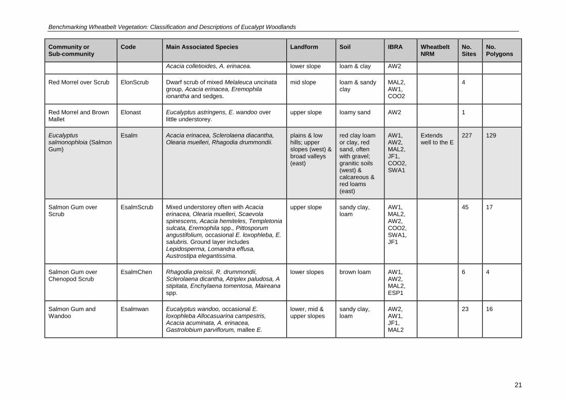
Table 5 The classification of eucalypt woodlands in the Wheatbelt.
Community or Sub-community
Code Main Associated Species Landform Soil IBRA Wheatbelt NRM
No. Sites
No. Polygons
Eucalyptus longicornis (Red Morrel)
Elon Sclerolaena diacantha, Lycium australe, Maireana trichoptera, Rhagodia drummondii.
valley floor dark red loams AW1, MAL2, AW2, COO2
Extends well to the E
46 12
Red Morrel over Melaleuca
ElonMel Melaleuca teuthidoides, M. lanceolata, M. pauperiflora, Olearia muelleri, Atriplex vesicaria and other chenopods & occasional mallee.
mid to lower slopes
calcareous loamy earth, clay loam, loamy sand
AW1, MAL2, AW2, COO2
20 4
Red Morrel and Gimlet Elonsalu Eucalyptus salubris, Melaleuca lanceolata, M. adnata.
mid slope of undulating plain
loam & sandy clay
AW1, MAL2
2 8
Red Morrel over Chenopods
ElonChen Atriplex vesicaria, A paludosa, Rhagodia drummondii, Eucalyptus myriadena.
valley flats loam AW1, AW2
5
Red Morrel on Dunes ElonDune Callitris tuberculata (gypsum), Atriplex paludosa, Scaevola spinescens.
dune gypsum, clayey sand
AW1, MAL2
2
Red Morrel and Wandoo
Elonwan Eucalyptus wandoo, Acacia acuminata, Gastrolobium spp., Olearia dampieri subsp. eremicola or herbs and grasses.
mid to upper slopes
deep grey sandy duplex
AW2 3
Red Morrel and Black Morrel
Elonmelx Eucalyptus melanoxylon, Atriplex vesicaria, A. acutibractea, Olearia muelleri, Eremophila decipiens.
lower slope, lake edge
clay loam AW1, MAL2
3
Red Morrel and York Gum
Elonlox Eucalyptus loxophleba, Acacia acuminata over Austrostipa hemipogon or Desmocladus asper.
upper slope valley or near granite
loamy sand AW2 2
Red Morrel over Mallee ElonMallee Eucalyptus phenax, E. yilgarnensis, E. myriadena over Melaleuca acuminata,
upper slope, laterite, sandy MAL2, AW1,
4
Benchmarking Wheatbelt Vegetation: Classification and Descriptions of Eucalypt Woodlands
21
Community or Sub-community
Code Main Associated Species Landform Soil IBRA Wheatbelt NRM
No. Sites
No. Polygons
Acacia colletioides, A. erinacea. lower slope loam & clay AW2
Red Morrel over Scrub ElonScrub Dwarf scrub of mixed Melaleuca uncinata group, Acacia erinacea, Eremophila ionantha and sedges.
mid slope loam & sandy clay
MAL2, AW1, COO2
4
Red Morrel and Brown Mallet
Elonast Eucalyptus astringens, E. wandoo over little understorey.
upper slope loamy sand AW2 1
Eucalyptus salmonophloia (Salmon Gum)
Esalm Acacia erinacea, Sclerolaena diacantha, Olearia muelleri, Rhagodia drummondii.
plains & low hills; upper slopes (west) & broad valleys (east)
red clay loam or clay, red sand, often with gravel; granitic soils (west) & calcareous & red loams (east)
AW1, AW2, MAL2, JF1, COO2, SWA1
Extends well to the E
227 129
Salmon Gum over Scrub
EsalmScrub Mixed understorey often with Acacia erinacea, Olearia muelleri, Scaevola spinescens, Acacia hemiteles, Templetonia sulcata, Eremophila spp., Pittosporum angustifolium, occasional E. loxophleba, E. salubris. Ground layer includes Lepidosperma, Lomandra effusa, Austrostipa elegantissima.
upper slope sandy clay, loam
AW1, MAL2, AW2, COO2, SWA1, JF1
45 17
Salmon Gum over Chenopod Scrub
EsalmChen Rhagodia preissii, R. drummondii, Sclerolaena dicantha, Atriplex paludosa, A stipitata, Enchylaena tomentosa, Maireana spp.
lower slopes brown loam AW1, AW2, MAL2, ESP1
6 4
Salmon Gum and Wandoo
Esalmwan Eucalyptus wandoo, occasional E. loxophleba Allocasuarina campestris, Acacia acuminata, A. erinacea, Gastrolobium parviflorum, mallee E.
lower, mid & upper slopes
sandy clay, loam
AW2, AW1, JF1, MAL2
23 16

Benchmarking Wheatbelt Vegetation: Classification and Descriptions of Eucalypt Woodlands
22
Community or Sub-community
Code Main Associated Species Landform Soil IBRA Wheatbelt NRM
No. Sites
No. Polygons
sheathiana over Borya spp., Lomandra effusa, Desmocladus spp., Austrostipa spp., Neurachne spp.
Salmon Gum and Gimlet
Esalmsalu Eucalyptus salubris, over acacia and or melaleuca scrub, chenopods, mallee or herbs. Santalum acuminatum, Acacia erinacea, Acacia merrallii, Exocarpos aphyllus, Melaleuca adnata, M. pauperiflora, Olearia muelleri, Rhagodia preissii. Other eucalypts include E. loxophleba, E. longicornis, E. capillosa.
upper slope loam AW1, AW2 MAL2
33 44
Salmon Gum and York Gum
Esalmlox Eucalyptus loxophleba subsp. loxophleba, Acacia acuminata, Acacia erinacea, Rhagodia preissii, R. drummondii, Olearia muelleri, Melaleuca uncinata group, M adnata, Acacia hemiteles, Templetonia sulcata. Mallees E. erythronema. Occasional E. wandoo, E. salubris.
lower slopes loam near granite in the west
AW2, AW1, SWA1
16 33
Salmon Gum over Melaleuca
EsalmMel Melaleuca acuminata, M. uncinata group, M. adnata, M. lateriflora, Templetonia sulcata, Olearia muelleri, Acacia erinacea, Santalum acuminatum.
upper mid & lower slopes
loamy sand, sandy clay, clay
MAL2, AW1, JF1
32 1
Salmon Gum and Red Morrel
Esalmlon Eucalyptus longicornis, Rhagodia preissii, Santalum acuminatum, Templetonia sulcata, Acacia erinacea, Olearia muelleri, Grevillea huegelii.
mid to upper slopes
clay loam, sandy clay
AW1, MAL2, AW2, JF1, COO2
16 2
Salmon Gum over Mallee
EsalmMallee Eucalyptus eremophila, E. sheathiana, E. calycogona, E. phenax, E. loxophleba subsp. lissophloia, E. celastroides, E. yilgarnensis, Olearia muelleri, Acacia erinacea.
mid slopes sand, loamy sand
MAL2, AW1, AW2
38 4

Benchmarking Wheatbelt Vegetation: Classification and Descriptions of Eucalypt Woodlands
23
Community or Sub-community
Code Main Associated Species Landform Soil IBRA Wheatbelt NRM
No. Sites
No. Polygons
Salmon Gum and Wheatbelt Wandoo
Esalmcap Eucalyptus capillaris, E. loxophleba, E. salubris, Acacia acuminata, Santalum acuminata and S. spicatum, Melaleuca uncinata group .Acacia hemiteles, Olearia muelleri.
upper slopes sandy gravel, sandy loam
AW1, AW2
10 8
Salmon Gum on Dunes EsalmDune Eucalyptus kondininensis, E. myriadena, Atriplex vesicaria, Acacia microbotrya, A. erinacea, Olearia dampieri Templetonia sulcata, Austrostipa elegantissima.
around salt lakes
sand MAL2, AW1, AW2, ESP1
6
Salmon Gum and Merrit Esalmurn Eucalyptus urna, E. phenax, Melaleuca adnata, M. lateriflora.
lower slope loam MAL2 2
Eucalyptus salubris (Gimlet)
Esalu Acacia erinacea, Sclerolaena diacantha, Enchylaena lanata.
undulating plains, slopes
red clay loam or loam, yellow or red sand, laterite
AW1, MAL2, COO2, AW2
Extends to the E
65 36
Gimlet over Melaleuca EsaluMel Melaleuca pauperiflora, M. lateriflora, M. acuminata, M. adnata, M. cucullata.
variable variable including gilgais
AW1, MAL2
25 6
Gimlet over Scrub EsaluScrub Olearia muelleri, Acacia erinacea, A. merrallii, A. mackeyana, A. colletioides, Santalum acuminatum, Eremophila oppositifolia, Exocarpos aphyllus, Rhagodia drummondii, Melaleuca pauperiflora.
mid to upper slopes
loams AW1, MAL2, COO2
28 19
Gimlet over Mallee EsaluMallee Eucalyptus celastroides, E. erythronema, E. yilgarnensis, E. sheathiana, Melaleuca pauperiflora, M. lateriflora, M. uncinata.
upper slopes brown loam/clay
AW1, MAL2
10 4
Gimlet and York Gum Esalulox Eucalyptus loxophleba subsp. loxophleba, & Acacia acuminata, A. hemiteles,
lower slopes silty/clay loam AW1 1 7

Benchmarking Wheatbelt Vegetation: Classification and Descriptions of Eucalypt Woodlands
24
Community or Sub-community
Code Main Associated Species Landform Soil IBRA Wheatbelt NRM
No. Sites
No. Polygons
Exocarpos aphylla, Olearia muelleri scrub & various mallees.
Gimlet on Dunes EsaluDune Casuarina obesa (dominant) Hakea preissii, Grevillea acuaria.
dune adj. to degraded salne wetland
gypsum AW1 1
Eucalyptus loxophleba (York Gum)
Elox Acacia acuminata, Allocasuarina huegeliana, herbs and grasses.
around granite & on lower slopes
loam, rocky loam, clay loam, sand
AW1, AW2, MAL2, GS2, JF1, SWA1, GS1
Extends to NW and SW
137 75
York Gum and Jam over Herbs
EloxJamHerbs
Acacia acuminata, Neurachne alopecuroidea, Podolepis lessonii, Austrostipa elegantissima, Trachymene cyanopetala, T. ornata, Goodenia berardiana, Velleia cycnopotamica, Actinobole uliginosum, Parentucellia latifolia, Crassula colorata, Lawrencella rosea, Waitzia acuminata var. acuminata, Borya sphaerocephala. May include rare emergent E. salmonophloia and Allocasuarina huegeliana.
lower to mid slopes often near granite
brown (sandy) loam over granite
AW2, AW1, MAL2, JF1
48 26
York Gum and Jam over Scrub and Herbs
EloxJamScrubHerbs
Acacia acuminata, Allocasuarina huegeliana, Acacia acuaria, A. hemiteles, Enchylaena tomentosa, Scaevola spinescens, Podolepis lessonii, Austrostipa elegantissima, Neurachne alopecuroidea, Borya nitida, Waitzia acuminata.
mid to upper slopes
brown (sandy) loam over granite
AW2, AW1, GS2, GS1, MAL2, JF1
22 12
York Gum and Jam over Scrub
EloxJamScrub
Acacia acuminata, A. micorbotrya, Scaevola spinescens.
mid slope loam AW1, JF1
2 2

Benchmarking Wheatbelt Vegetation: Classification and Descriptions of Eucalypt Woodlands
25
Community or Sub-community
Code Main Associated Species Landform Soil IBRA Wheatbelt NRM
No. Sites
No. Polygons
York Gum over Scrub and Herbs
EloxScrubHerbs
Acacia hemiteles, A. lineolata, A. erinacea, A. microbotrya, Hakea lissocarpha, Podolepis lessonii, Austrostipa elegantissima, Neurachne alopecuroidea.
often around granites
loam AW1, SWA1, AW2, MAL2, GS2, JF1, YAL2
14 9
York Gum over Melaleuca
EloxMel Melaleuca lateriflora, M. uncinata group, M. acuminata, M. radula, M. atroviridis M. adnata, Allocasuarina acutivalvis.
near fresh water lake
clay MAL2, GS2
4 13
York Gum in Saline Areas
EloxSaline Enchylaena tomentosa, Rhagodia drummondii, Comesperma integerrimum, Olearia dampieri, Halosarcia lepidosperma.
lower slopes alluvial AW1, AW2, MAL2, GS2
15
York Gum on Dunes EloxDune Acacia acuminata, Senecio glossanthus, Calandrinia calyptrata, Goodenia berardiana, *Mesembryanthemum nodiflorum.
lower slope sand AW1, AW2
2
York Gum and Sheoak EloxSheoak Allocasuarina huegeliana, A, campestris, Acacia acuminata, Austrostipa nitida, Calandrinia calyptrata.
near granite brown (sandy) loam over granite
AW2, AW1
3 3
York Gum North (Eucalyptus loxophleba subsp. supralaevis)
EloxN Acacia acuminata, Scaevola spinescens, Rhagodia drummondii, scattered dwarf scrub. Rich in herbs (Asteraceae family).
mid to lower slopes
brown sandy loams
AW1, AW2, GS2
28
Eucalyptus wandoo (Wandoo)
Ewan Hakea lissocarpha, Hibbertia commutata, Bossiaea eriocarpa.
undulating terrain
sandy, often gravelly soils over laterite or granite
JF1, AW2, JF2, MAL2, GS2, SWA1, SWA2,
mostly to the W and SW
122 55
Benchmarking Wheatbelt Vegetation: Classification and Descriptions of Eucalypt Woodlands
26
Community or Sub-community
Code Main Associated Species Landform Soil IBRA Wheatbelt NRM
No. Sites
No. Polygons
ESP1
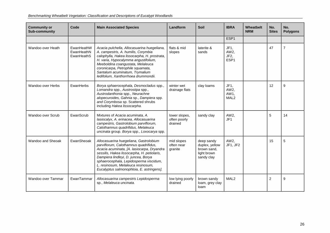
Wandoo over Heath EwanHeathW EwanHeathNEwanHeathS
Acacia pulchella, Allocasuarina huegeliana, A. campestris, A. humilis, Corymbia calophylla, Hakea lissocarpha, H. prostrata, H. varia, Hypocalymma angustifolium, Meeboldina coangustata, Melaleuca coronicarpa, Petrophile squamata, Santalum acuminatum, Trymalium ledifolium, Xanthorrhoea drummondii.
flats & mid slopes
laterite & sands
JF1, AW2, JF2, ESP1
47 7
Wandoo over Herbs EwanHerbs Borya sphaerocephala, Desmocladus spp., Lomandra spp., Austrostipa spp., Austrodanthonia spp., Neurachne alopecuroides, Gahnia sp., Dampiera spp. and Corymbosa sp. Scattered shrubs including Hakea lissocarpha.
winter wet drainage flats
clay loams JF1, AW2, AW1, MAL2
12 9
Wandoo over Scrub EwanScrub Mixtures of Acacia acuminata, A. lasiocalyx, A. erinacea, Allocasuarina campestris, Gastrolobium parviflorum, Calothamnus quadrifidus, Melaleuca uncinata group. Borya spp., Loxocarya spp.
lower slopes, often poorly drained
sandy clay AW2, JF1
5 14
Wandoo and Sheoak EwanSheoak Allocasuarina huegeliana, Gastrolobium parviflorum, Calothamnus quadrifidus, Acacia acuminata, [A. lasiocarpa, Dryandra sessilis, Hakea lissocarpha, H. petiolaris, Dampiera lindleyi, D. juncea, Borya sphaerocephala, Lepidosperma viscidum, L. resinosum, Melaleuca resinosum, Eucalyptus salmonophloia, E. astringens].
mid slopes often near granite
deep sandy duplex, yellow brown sand, light brown sandy clay
AW2, JF1, JF2
15 5
Wandoo over Tammar EwanTammar Allocasuarina campestris Lepidosperma sp., Melaleuca uncinata.
low lying poorly drained
brown sandy loam, grey clay loam
MAL2 2 9
Benchmarking Wheatbelt Vegetation: Classification and Descriptions of Eucalypt Woodlands
27
Community or Sub-community
Code Main Associated Species Landform Soil IBRA Wheatbelt NRM
No. Sites
No. Polygons
Wandoo over Melaleuca
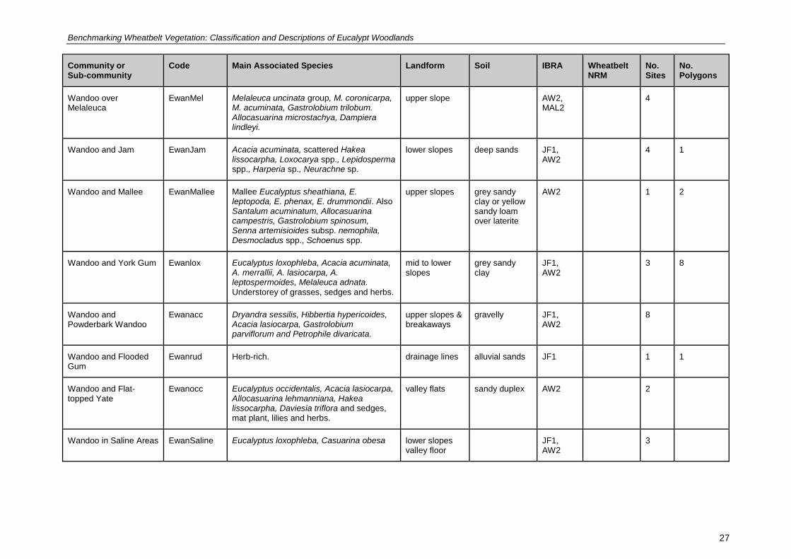
EwanMel Melaleuca uncinata group, M. coronicarpa, M. acuminata, Gastrolobium trilobum. Allocasuarina microstachya, Dampiera lindleyi.
upper slope AW2, MAL2
4
Wandoo and Jam EwanJam Acacia acuminata, scattered Hakea lissocarpha, Loxocarya spp., Lepidosperma spp., Harperia sp., Neurachne sp.
lower slopes deep sands JF1, AW2
4 1
Wandoo and Mallee EwanMallee Mallee Eucalyptus sheathiana, E. leptopoda, E. phenax, E. drummondii. Also Santalum acuminatum, Allocasuarina campestris, Gastrolobium spinosum, Senna artemisioides subsp. nemophila, Desmocladus spp., Schoenus spp.
upper slopes grey sandy clay or yellow sandy loam over laterite
AW2 1 2
Wandoo and York Gum Ewanlox Eucalyptus loxophleba, Acacia acuminata, A. merrallii, A. lasiocarpa, A. leptospermoides, Melaleuca adnata. Understorey of grasses, sedges and herbs.
mid to lower slopes
grey sandy clay
JF1, AW2
3 8
Wandoo and Powderbark Wandoo
Ewanacc Dryandra sessilis, Hibbertia hypericoides, Acacia lasiocarpa, Gastrolobium parviflorum and Petrophile divaricata.
upper slopes & breakaways
gravelly JF1, AW2
8
Wandoo and Flooded Gum
Ewanrud Herb-rich. drainage lines alluvial sands JF1 1 1
Wandoo and Flat-topped Yate
Ewanocc Eucalyptus occidentalis, Acacia lasiocarpa, Allocasuarina lehmanniana, Hakea lissocarpha, Daviesia triflora and sedges, mat plant, lilies and herbs.
valley flats sandy duplex AW2 2
Wandoo in Saline Areas EwanSaline Eucalyptus loxophleba, Casuarina obesa lower slopes valley floor
JF1, AW2
3
Benchmarking Wheatbelt Vegetation: Classification and Descriptions of Eucalypt Woodlands
28
Community or Sub-community
Code Main Associated Species Landform Soil IBRA Wheatbelt NRM
No. Sites
No. Polygons
Wandoo North (Eucalyptus wandoo subsp. pulverea)
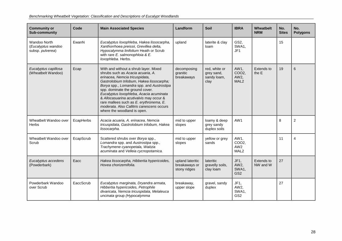
EwanN Eucalyptus loxophleba, Hakea lissocarpha, Xanthorrhoea preissii, Grevillea delta, Hypocalymma linifolium Heath or Scrub with rare E. salmonophloia & E. loxophleba. Herbs.
upland laterite & clay loam
GS2, SWA1, JF1
15
Eucalyptus capillosa (Wheatbelt Wandoo)
Ecap With and without a shrub layer. Mixed shrubs such as Acacia acuaria, A. erinacea, Nemcia tricuspidata, Gastrolobium trilobum, Hakea lissocarpha; Borya spp., Lomandra spp. and Austrostipa spp. dominate the ground cover. Eucalyptus loxophleba, Acacia acuminata & Allocasuarina acutivalvis may occur & rare mallees such as E. erythronema, E. moderata. Also Callitris canescens occurs where the woodland is open.
decomposing granitic breakaways
red, white or grey sand, sandy loam, clay
AW1, COO2, AW2, MAL2
Extends to the E
19 6
Wheatbelt Wandoo over Herbs
EcapHerbs Acacia acuaria, A. erinacea, Nemcia tricuspidata, Gastrolobium trilobum, Hakea lissocarpha.
mid to upper slopes
loamy & deep grey sandy duplex soils
AW1 8 2
Wheatbelt Wandoo over Scrub
EcapScrub Scattered shrubs over Borya spp., Lomandra spp. and Austrostipa spp., Trachymene cyanopetala, Waitzia acuminata and Velleia cycnopotamica.
mid to upper slopes
yellow or grey sands
AW1, COO2, AW2 MAL2
11 4
Eucalyptus accedens (Powderbark)
Eacc Hakea lissocarpha, Hibbertia hypericoides, Hovea chorizemifolia.
upland lateritic breakaways or stony ridges
lateritic gravelly soils, clay loam
JF1, AW2, SWA1, GS2
Extends to NW and W
27
Powderbark Wandoo over Scrub
EaccScrub Eucalyptus marginata, Dryandra armata, Hibbertia hypericoides, Petrophile divaricata, Nemcia tricuspidata, Melaleuca uncinata group (Hypocalymma
breakaway, upper slope
gravel, sandy duplex
JF1, AW2, SWA1, GS2
27

Benchmarking Wheatbelt Vegetation: Classification and Descriptions of Eucalypt Woodlands
29
Community or Sub-community
Code Main Associated Species Landform Soil IBRA Wheatbelt NRM
No. Sites
No. Polygons
angustifolium, Xanthorrhoea drummondii).
MALLETS
Eucalyptus melanoxylon (Black Morrel)
Emelx Eucalyptus salmonophloia, E. longicornis, Olearia muelleri, Melaleuca pauperiflora, Eremophila scoparia, Templetonia sulcata Acacia merrallii, Atriplex vesicaria.
valley floor depressions & flats
sand, clay loam
AW2, COO2
Extends well to the E
2
Eucalyptus astringens (Brown Mallet)
East Eucalyptus wandoo, Gastrolobium tricuspidatum. Few herbs and grasses.
rocky outcrops, ridges, breakaways, hills, occasionally valley floors
Red-brown gravelly clay, brown clayey sand, sandy loam, spongolite, laterite, sandstone
AW2, MAL2, JF2
Extends to the S and SW
25
Brown Mallet over Little Understorey
East Little or no understorey; rare herbs, grasses and sedges. Eucalyptus wandoo often present.
below breakways
gravel over clay
AW2, JF2
7
Brown Mallet over Scrub
EastScrub Scrub over varying heights and cover: Melaleuca uncinata group, Exocarpos aphyllus, Allocasuarina spp., Nemcia tricuspidata. Other trees include E. salmonophloia, E. gardneri, E. urna, E. wandoo and mallees.
breakaways clay beneath breakaway
AW2, MAL2
12
Brown Mallet over Mallee
EastMallee Eucalyptus falcata, E. phaenophylla. AW2 2
Brown Mallet and Merrit Easturn Melaleuca uncinata group. breakaways MAL2 3
Brown Mallet and Flat-topped Yate
Eastocc Eucalyptus occidentalis, E. wandoo. valley floor AW2 1

Benchmarking Wheatbelt Vegetation: Classification and Descriptions of Eucalypt Woodlands
30
Community or Sub-community
Code Main Associated Species Landform Soil IBRA Wheatbelt NRM
No. Sites
No. Polygons
Eucalyptus argyphea (Silver Mallet)
Earg Often with no understorey or scrub of varying ht, cover and species. Occasionally includes E. astringens, E. wandoo, E. gardneri, and some mallee species.
upper slopes, lateritic rises
sandy clay with gravel, sandy loam, yellow sand
MAL2, AW2
Confined to Wheatbelt
44 3
Silver Mallet over Little Understorey
Earg There is little or no understorey, except for scattered Exocarpos aphyllus, Santalum acuminatum, Beyeria brevifolia and Callitris roei.
upper slopes, lateritic rises
sandy clay with gravel, sandy loam, yellow sand
MAL2, AW2
17
Silver Mallet over Scrub EargScrub Melaleuca uncinata group, Westringia cephalantha, Exocarpos aphyllus, Phebalium filifolium, P. tuberculosum, Eucalyptus gardneri, Leptomeria preissiana, Rhadinothamnus rudis and Hakea multilineata.
upper slopes, lateritic rises
sandy clay with gravel, sandy loam, yellow sand
MAL2, AW2
27 3
Eucalyptus urna (Merrit) Eurn Eucalyptus salubris, E. kondininensis, E. longicornis, E. melanoxylon, E. salmonophloia, E. extensa. Mallee E. cylindriflora, E. cylindrocarpa, E. olivina, E. phaenophylla, E. polita, E. subangusta, E. tenera, E. vittata, E. yilganensis, E. eremophila, E. annulata, E. phenax, E. platypus. Melaleuca acuminata subsp. acuminata, M. adnata, M. pauperiflora, M. lateriflora, M. coronicarpa, M. thyoides, M. scalena, Templetonia sulcata, chenopods.
lower slopes reddish brown alkaline sandy loams to soft, grey clay-loams over limestone
MAL2, MAL 1, COO2
22
Eucalyptus gardneri (Blue Mallet)
Egar Eucalyptus argyphea, E. urna, [E. astringens subsp. astringens, E. extensa, E. longicornis, E. recta, & E. wandoo and mallees E. drummondii, E. falcata, E. flocktoniae, E. incrassata, E. pluricaulis, & E. tenera (MF)] over Melaleuca acuminata, M. uncinata group, Allocasuarina acutivalvis.
breakaways, upper lateritic ridges & slopes
gravelly soils, laterite
MAL2, AW1
Largely confined to the Wheatbelt, outlier to SE
4 3

Benchmarking Wheatbelt Vegetation: Classification and Descriptions of Eucalypt Woodlands
31
Community or Sub-community
Code Main Associated Species Landform Soil IBRA Wheatbelt NRM
No. Sites
No. Polygons
Eucalyptus ornata (Ornate Mallet)
Eorn Melaleuca lateriflora, M. pauperiflora, Allocasuarina acutivalvis
ridges laterite MAL2 Confined to Wheatbelt
3
Eucalyptus spathulata (Swamp Mallet)
Espa Eucalyptus platypus, Melaleuca acuminata, M. pauperiflora, M. thyoides, M. preissiana, M. brophyi.
Flats, broad valley floors, saline depressions, edges salt lakes, rises
grey-white sand, pale brown sandy clay over granite, saline soils
MAL2 Largely confined to the Wheatbelt, outliers to SE and NE
3 3
Eucalyptus singularis (Mallet)
Esin Eucalyptus argyphea, Exocarpos aphyllus, Gastrolobium spinosum, Hakea multilineata.
rises shallow sand over laterite
MAL2 Confined to Wheatbelt
2
Eucalyptus densa (Mallet)
Eden Santalum acuminatum, Exocarpos aphyllus Trymalium elachophyllum, Westringia cephalantha, Phebalium lepidotum .
lateritic ridges, flats, drainage lines
clay loam, clay, sandy soils
MAL2 Extends to the S and SE
1
Eucalyptus extensa (Mallet)
Eext Melaleuca acuminata, M. pauperiflora, Eucalyptus salmonophloia.
sandplains, undulating areas
red loam, grey sandy loam, sometimes gravelly
MAL2 Extends to the S and SE
2
Eucalyptus recta (Mallet)
Erec Calothamnus aspera, Allocasuarina campestris, Allocasuarina acutivalvis Acacia lasiocarpa, Alyxia buxifolia, Goodenia scapigera, Austrostipa sp.
upper slopes sandy laterite AW2 Confined to Wheatbelt
1
OTHERS
Eucalyptus kondininensis (Kondinin
Blackbutt)
Ekon Eucalyptus longicornis, Acacia merrallii, Eremophila deserti, Atriplex vesicaria, Olearia muelleri.
salty flats, near salt lakes, seasonally waterlogged areas, rises
clay, sandy clay, gravel, laterite, gypsum
MAL2, AW1, AW2
Confined to Wheatbelt
30 1

Benchmarking Wheatbelt Vegetation: Classification and Descriptions of Eucalypt Woodlands
32
Community or Sub-community
Code Main Associated Species Landform Soil IBRA Wheatbelt NRM
No. Sites
No. Polygons
Kondinin Blackbutt over Chenopods
EkonChen Atriplex paludosa, A. vesicaria, Rhagodia drummondii, Lycium australe, Templetonia sulcata. Occasional Eucalyptus longicornis, E. urna and E. salmonophloia.
usually on salty flats & associated dunes
MAL2, AW1 AW2
13 1
Kondinin Blackbutt over Melaueca
EkonMel Melaleuca acuminata, M. lateriflora M. thyoides, M. pauperiflora thickets and scrub with occasional chenopods.
usually on salty flats & associated dunes
MAL2 17
Eucalyptus myriadena (Blackbutt)
Emyr Eucalyptus urna and mallees E. calycogona, E. yilgarnensis, Rhagodia drummondii, Rhagodia preissii, Senna artemisioides.
valley floors clay, often saline, sandy clay, gravelly loam over kankar
AW1, MAL2, MAL1 COO2,
Mostly confined. Small extension to NW and SW
10
Eucalyptus salicola
(Salt Salmon Gum) Esali Rhagodia drummondii, Olearia dampieri
subsp. eremicola. near salt lakes & salt pans on plains, low rises & dunes
yellow or red sand, red clay, loam & calcareous soils
AW1, MAL2, COO2.
Extends to the E
15
Eucalyptus sargentii (Salt River Gum)
Esar Rhagodia drummondii, Melaleuca uncinata group, M. brevifolia.
salt swamps & flats, along creek lines, flood plains, drainage lines
yellow sand, sandy clay or clay, grey loam; calcareous soils
MAL2, AW1
Largely confined
5
Eucalyptus occidentalis (Flat-topped Yate)
Eocc Melaleuca strobophylla, M. cuticularis. alluvial flats, low-lying wet areas, around salt lakes, hills
sandy or clayey soils
ESP1, ESP2, MAL2 MAL1, AW2
Mostly to the S
74
Flat-topped Yate EoccSWb Melaleuca strobophylla, M. lateritia, M. uncinata group, Olearia dampieri subsp.
bottom saline & freshwater
MAL2, Mostly in wheatbelt;
37
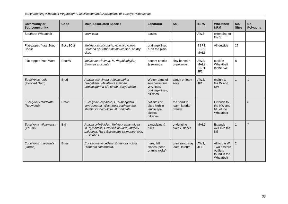
Benchmarking Wheatbelt Vegetation: Classification and Descriptions of Eucalypt Woodlands
33
Community or Sub-community
Code Main Associated Species Landform Soil IBRA Wheatbelt NRM
No. Sites
No. Polygons
Southern Wheatbelt eremicola. basins AW2 extending to the S
Flat-topped Yate South Coast
EoccSCst Melaleuca cuticularis, Acacia cyclops Baumea sp. Other Melaleuca spp. on dry sites.
drainage lines & on the plain
ESP1, ESP2, MAL1
All outside 27
Flat-topped Yate West EoccW Melaleuca viminea, M. rhaphiophylla, Baumea articulata.
bottom creeks & swamps
clay beneath breakaway
AW2, MAL2, ESP1, JF2
outside Wheatbelt to the SW
8
Eucalyptus rudis
(Flooded Gum) Erud Acacia acuminata, Allocasuarina
huegeliana, Melaleuca viminea, Lepidosperma aff. tenue, Borya nitida.
Wetter parts of south-western WA, flats, drainage lines, hillsides
sandy or loam soils
AW2, JF1
mainly to the W and SW
1 1
Eucalyptus moderata (Redwood)
Emod Eucalyptus capillosa, E. subangusta, E. erythronema, Westringia cephalantha, Melaleuca hamulosa, M. undulata.
flat sites or sites high in landscape, slopes, hillsides
red sand to loam, laterite, granite
Extends to the NW and NE of the Wheatbelt
6
Eucalyptus yilgarnensis
(Yorrell) Eyil Acacia colletioides, Melaleuca hamulosa,
M. cymbifolia, Grevillea acuaria, Atriplex paludosa. Rare Eucalyptus salmonophloia, E. salubris.
sandplains & rises
undulating plains, slopes
MAL2 Extends well into the NE
1 7
Eucalyptus marginata (Jarrah)
Emar Eucalyptus accedens, Dryandra nobilis, Hibbertia commutata.
rises, hill slopes (near granite rocks)
grey sand, clay loam, laterite
AW2, JF1
All to the W. Two eastern outliers found in the Wheatbelt
2

Benchmarking Wheatbelt Vegetation: Classification and Descriptions of Eucalypt Woodlands
34
34
The most and least common communities and sub-communities are presented in Table 6 and Table 7 respectively; this is influenced by survey focus, site concentration and distribution.
Table 6 The eucalypt woodland communities and sub-communities most commonly represented in sites and polygons in this Project.
Community No. Sites or Polygons
Eucalyptus salmonophloia (Salmon Gum) 356
Eucalyptus loxophleba (York Gum) 213
Eucalyptus wandoo (Wandoo) 178
Eucalyptus salubris (Gimlet) 101
Eucalyptus occidentalis (Flat-topped Yate) 72
Eucalyptus longicornis (Red Morrel) 58
Sub-community No. Sites or Polygons
Salmon Gum and Gimlet 77
York Gum and Jam over Herbs 74
Salmon Gum over Scrub 62
Wandoo over Heath 54
Salmon Gum and York Gum 49
Gimlet over Scrub 47
Salmon Gum over Mallee 42
Salmon Gum and Wandoo 39
Flat-topped Yate Southern Wheatbelt 37
York Gum and Jam over Scrub and Herbs 34
Salmon Gum over Melaleuca 33

Benchmarking Wheatbelt Vegetation: Classification and Descriptions of Eucalypt Woodlands
35
35
Table 7 The eucalypt woodland communities and sub-communities most poorly represented in sites and polygons in this Project.
Community No. Sites or Polygons
Eucalyptus extensa (Mallet) 2
Eucalyptus melanoxylon (Black Morrel) 2
Eucalyptus singularis (Mallet) 2
Eucalyptus rudis (Flooded Gum) 2
Eucalyptus densa (Mallet) 1
Eucalyptus recta (Mallet) 1
Sub-community No. Sites or Polygons
Brown Mallet over Mallee 2
Red Morrel and York Gum 2
Red Morrel on Dunes 2
Salmon Gum and Merrit 2
Wandoo and Flat-topped Yate 2
Wandoo and Flooded Gum 2
York Gum on Dunes 2
Brown Mallet and Flat-topped Yate 1
Gimlet on Dunes 1
Red Morrel and Brown Mallet 1
3.1 Factsheets
A total of 155 factsheets were prepared: 29 community factsheets, 62 sub-community factsheets, and 63 reference site factsheets, as well as one for the Mallets group.
Reference sites for sub-communities, and some communities where there were no sub-communities, were included when available. There are two reference sites for sub-communities such as Wandoo over Tammar or Melaleuca, and Wandoo and Flooded Gum or Flat-topped Yate.
Reference sites needed to be on public land and accessible (although not all sites have been visited to confirm accessibility).
Common names have been used in the sub-community titles to reduce repetition of lengthy scientific names, and to enable links to be created in the factsheets.
There are references cited on the fact sheets but not cited in this report (Wandoo Recovery Group ; Chippendale 1973; Brooker & Hopper 1991; McArthur 1991; Hussey & Wallace 1993; Rose 1993; Marcar et al. 2002; Nicolle 2005; Veneklaas & Manning 2007; Manning & White 2009)
4. DISCUSSION
This classification of eucalypt woodlands of the Wheatbelt is an attempt to define communities in terms of their dominant Eucalyptus species, structure, and associated understorey species, into a hierarchy of communities and sub-communities. It acknowledges the inherent difficulty in trying to put vegetation into ‘boxes’ and recognised a range of attributes that can be used to define a subcommunity. However there is a need for vegetation classification to enable the conservation, management and mapping native vegetation. The results reveal gaps in our knowledge about woodland communities in the Wheatbelt and so are open for modification and improvement as more data and ecological knowledge becomes available. Its implementation by land managers, vegetation mappers and plant ecologists will evaluate its accuracy and value.

Benchmarking Wheatbelt Vegetation: Classification and Descriptions of Eucalypt Woodlands
36
36
The site-based data is influenced by the availability, focus and distribution of sites; the SAP sites have a good spread but the WWF survey focused on four main species, and the surveys entered into the Wheatbelt Reserves Database concentrated on areas such as the recovery catchments. The Avon Vegetation Mapping polygons are more widespread but, again, their locations were influenced by the purpose of the survey. The number of sub-communities in each community was largely governed by the number of sites and polygons, which didn’t always reflect the common occurrence of the community or dominant eucalypts.
The 28 eucalypt tree species range from having widespread to localised distributions. Some, such as Eucalyptus kondininensis, E. singularis, E argyphea, E. ornata, and E. recta are restricted to the Wheatbelt. Other such as E. myriadena, E spathulata and E gardneri are largely restricted to the area (Western Australian Herbarium 1998 -). Eucalyptus wandoo, E. rudis and E. occidentalis, have most of their distributions outside the Wheatbelt, to the west and south. Eucalyptus longicornis, E. salmonophloia, E. salubris, E. melanoxylon, E. salicola, E. moderata and E. yilgarnensis extend into the Great Western Woodlands (GWW). A considerable part (about a third) of the Wheatbelt NRM region is in the GWW and incorporation of survey data from surveys such as Gibson and Lyons (1998) and further on ground survey, are needed to ascertain whether Wheatbelt communities of these species are similar to or different from those in the GWW.
There may be more than one sub-community to which a site or polygon could have been allocated to, as the sub-communities are defined by a range of perceptible attributes (occurrence of other eucalypts, common associated genera and species, understorey structure, landform features or geographical location). Sub-communities where two eucalypt species were co-dominant were either allocated to the taller species, as in the case of E. salmonophloia, or to the more common species, evident from the majority of the sites’ descriptions and photographs. It is subjective as to how many and what kind of sub-communities exist within each community, and even whether each eucalypt species forms its own community. Several communities, for example E. longicornis and E. loxophleba, have many sub-communities, largely based on the availability of many survey sites. Other communities could be further subdivided according to the attributes mentioned previously but, with the limited amount of sites and information, it was decided not to do so as it would yield sub-communities based on few sites and produce an unmanageable number of options.
Many of the sub-communities were recorded as growing on a range of soils and landforms. This may be accurate or it may reflect the different approaches to sampling and describing soil and landforms. Improved soil mapping and consistent soil sampling and descriptions would help to more accurately ascertain soil preferences of each community (if they exist).
It is not possible to say which sub-communities are restricted to the Wheatbelt as there are not enough samples from outside the Wheatbelt to confirm this. However Wando and Flat-topped Yate sub-community may be restricted to the Wheatbelt as the distributions of these two species barely overlaps (Western Australian Herbarium 1998 -)
Comparing the current classification with Keighery’s list (Appendix 1), the groups and assemblages produced by the SAP analysis of floristic and bioregional variables (Appendix 2), and Griffin’s analysis of floristics (Appendix 3) highlights the influence of the understorey species and the similarities that may exist between communities dominated by different eucalypts e.g. E. salicola and E. kondininensis. These appendices list corresponding communities and sub-communities classified during this project. The similarities with Keighery’s list of Wheatbelt vegetation types (Appendix 1) is high, as shown by the allocation of most of the community and sub-community codes, and highlights the focus on the well sampled E. salmonophloia, E. loxophleba, E. wandoo, E. longicornis and E. salubris woodlands. Species not so well surveyed, such as the mallets, E. occidentalis and E. moderata, can be the focus for further surveys. Communities mentioned by Keighery and not recognised here may be unusual such as E. kondininensis Woodland over Templetonia or Acacia Shrubland, or occur mainly outside the study area such as E marginata communities. This classification did not include occurrences of more that two species of Eucalyptus and so a future task could be to examine the data for occurrences of the mosaics mentioned by Keighery such as E. salmonophloia/E. salubris/E. loxophleba Woodland. A sub-community, E. salmonophloia Woodland over Gahnia trifida Sedgeland, did not emerge from the data although they both occurred in the EsalmDune sub-community and there were other species of Gahnia under E. salmonophloia in EsalmMel and EsalmMallee.

Benchmarking Wheatbelt Vegetation: Classification and Descriptions of Eucalypt Woodlands
37
37
The current classification differs from previous analyses (Gibson et al. 2004; Griffin 2008) which were based on presence/absence data because:
the first consideration is the dominant eucalypt
the vegetation layers are considered, that is, the overstorey is considered separately from the mid (shrub) and lower (ground) strata
the dominant species in each layer is delineated.
The current classification restricted the dominant eucalypt to two species to moderate the potential number of sub-communities. More than two species may co-occur. For example, the SAP analysis grouped Eucalyptus salmonophloia, E. longicornis, E. occidentalis or E. astringens (G5), and Eucalyptus longicornis, E. kondininensis or E. salmonophloia (G4). Again further investigations of the data used in this classification may reveal how common similar groups of eucalypts.
Sub-communities which were similar to groups and assemblages produced by Gibson et al. (see Appendix 2) include:
Salmon Gum and Wandoo similar to G2
Salmon Gum and Gimlet similar to G24
Salmon Gum over Mallee similar to G6
Salmon Gum and Red Morrel could fit into G4 or G5
Salmon Gum over Chenopod Scrub could fit into G4
Salmon Gum and Red Morrel, Salmon Gum and Gimlet, Salmon Gum over Scrub and Salmon Gum over Chenopod Scrub could all fit into Assemblage 3.
Griffin’s analysis (Griffin 2008) was a strong influence on the classification, providing the bases for grouping sites into sub-communities; however, the influence of dominants in the understorey, such as Rhagodia drummondii, was incorporated into the descriptions of the dominant trees (E. salicola, E. kondininensis and E. loxophleba subsp. supralaevis). His groupings, presented in Appendix 3, show the corresponding community and sub-community codes resulting from this classification. Some of the sub-communities in E. occidentalis, E. wandoo and E. loxophleba subsp. loxophleba communities appeared in two or more of Griffin’s groups, highlighting the complexity of the vegetation.
There are several areas needing further investigation and survey.
Mallets especially those listed in Table 7 Eucalyptus extensa, E. singularis, E. densa, and E. recta to see if they are more common than the result show or if they are actually unusual.
There are other mallets such as E. rugulata which occurs near Kondinin and Lake Grace, E. alipes common in the Mallee2 IBRA subregion but probably recorded as E. spathulata, and E. prolixa and E. polita which occur on the eastern edge of the Wheatbelt and into the GWW, which all require further survey before they are included as factsheets
If there are more of the E. melanoxylon Community in the Wheatbelt.
The extent and condition of E. rudis communities as there may be no weed free example of this.
Eucalyptus occidentalis communities in dry sites in the Wheatbelt and the relation with the main distribution south of the study area.
Other sub-communities mentioned in Table 7.
Incorporation of the existing data from the Great Western Woodlands e.g Gibson and Lyons (1998), and further sampling of woodlands of the broad valleys in the GWW, will assist in the comparison of the sub-communities in the cleared and uncleared areas.
Incorporation of Mosaics, which appear to be a real feature at a range of scales greater that at the quadrat scale. This would lead to the possible description of communities with more that 2 species of Eucalyptus.
Benchmarking Wheatbelt Vegetation: Classification and Descriptions of Eucalypt Woodlands
38
38
The classification, based on data from 889 sites and 338 mapped polygons (also taking input from previous analyses, relevant literature and expert knowledge) is still a far cry from what is needed to effectively model the extent of the woodlands considering that in Victoria over 15,000 data points were incorporated in its statewide modelling of native vegetation (VEAC 2010).
5. POSSIBLE PRIORITY OR THREATENED ECOLOGICAL COMMUNITIES
Generally, woodlands in the Wheatbelt have been extensively cleared and are poorly conserved.
Early in 2011, a preliminary nomination to list the WA Wheatbelt Woodlands as a Threatened Ecological Community under the federal Environment Protection and Biodiversity Conservation Act was prepared by the Humane Society International, following a request by the Commonwealth. A draft of this report, and several community profiles (E. salmonophloia, E. loxophleba and E. wandoo), were submitted to assist with this nomination. In 2012 this nomination progressed to be included on the Finalised Priority Assessment List for the Threatened Species Scientific Committee to provide advice to the Federal Minister of the Environment by the 31
st December 2013.
These eucalypt woodland communities have also been identified by DEC as a Priority Ecological Community in the agricultural region of the South West.
Eucalypt woodlands of the Western Australian Wheatbelt Priority 3(iii)
Eucalypt-dominated woodlands in the Western Australian Wheatbelt region as defined by the IBRA Avon Wheatbelt 1 and 2 and Western Mallee subregions with the specific exceptions of: woodlands and forests dominated by Jarrah (E. marginata) or Marri (Corymbia calophylla) where they occur without York Gum present; and non-woodland communities dominated by eucalypts, specifically those dominated by eucalypts with a mallee growth form. Community is defined primarily by its structure as a woodland. The presence in the canopy layer of eucalypt trees - most commonly salmon gum (Eucalyptus salmonophloia), York gum (Eucalyptus loxophleba), red morrel (Eucalyptus longicornis) or gimlet (Eucalyptus salubris) defines the Wheatbelt woodlands. Several of the other emergent eucalypt species which may be present as a defining species (e.g. Kondinin blackbutt (E. kondinensis), E. myriadena, salt river gum (E. sargentii), silver mallet (E. ornata) and mallet (E. singularis) are found
only in the Western Australian Wheatbelt.
DEC also recognises the following specific Priority Ecological Communities that feature Wheatbelt eucalypts.
Red Morrel Woodland of the Wheatbelt Priority 1
Tall open woodlands of Eucalyptus longicornis (red morrell) found in the Wheatbelt on lateritic, ironstone or granitic soil types. Sometimes found with Eucalyptus salmonophloia (Salmon Gum), or E. loxophleba (York Gum) woodlands and has very little understorey. It is also found directly above lake systems in the central and eastern Wheatbelt. The landscape unit in which it is found is valley floors, usually adjacent to saline areas.
Brown mallet Eucalyptus astringens communities in the western Wheatbelt on alluvial flats (previously ‘Beaufort River Flats’) Priority 1
Near York and on the Arthur River on grey clays the understorey is dominated by Melaleuca viminea over sedges (Gahnia trifida) and bunch grasses. At Kojunup and near Tambellup on brown clays sparse shrubs and succulent shrubs (Disphyma crassifolium) dominate the understorey
Yate (Eucalyptus occidentalis) dominated alluvial claypans of the Jingalup Soil System
Priority 2
Some unusual communities were identified in the field during the SAP survey, for example:
E.wandoo and E. occidentalis, corresponding with the Ewanocc sub-community
E. wandoo over Mesomelaena, included in the EwanHeath sub-community
E. astringens over Melaleuca and Gahnia, included in EastScrub Sub community.
Benchmarking Wheatbelt Vegetation: Classification and Descriptions of Eucalypt Woodlands
39
39
6. BENCHMARKING AND VEGETATION CONDITION ASSESSMENT
The underlying purpose of the classification of vegetation such as the Eucalypt Woodlands of the Wheatbelt is to provide a framework for the assessment of vegetation condition measured against benchmark descriptions. Significant loss of, and changes to, native vegetation in Australia since European settlement drives the need to conserve remnant vegetation. Effective conservation programs need accurate information about the extent and condition of the native vegetation that remains.
An effective conservation program must collect vital information and data on native vegetation condition, to assess whether the program is effective and achieving its set goals and outcomes. The management body must be able to measure whether the program’s set goals and outcomes were met, and report accordingly. Monitoring of vegetation condition involves collecting quantitative data to measure trends over time against a list of ‘indicators’. Benchmarks provide a contextual framework but need to relate to an overall question(s) resulting from the goals set by the program.
Benchmarks are defined from vegetation in a mature, long undisturbed state. Benchmarking involves describing the near pristine state of a defined community in terms of species composition, species richness, vegetation structure and habitat values. The definition of a benchmark adopted here is:
“A measure, for the purposes of biodiversity conservation, of indicators of vegetation composition, structure and function relative to a reference state (i.e. within the context of the presence or absence of a threatening processes) at a patch or landscape (community or ecosystem) scale”(Bleby et al. 2008) (
A benchmark can be a synthetic description generated from existing floristic and habitat data collected from reference sites, and/or elicited from experts with knowledge on vegetation units. It aims to equate to the state of the area prior to settlement. It may be taken as the desired or end state for research and restoration activities.
Considerable work on the assessment of vegetation condition as measures against benchmarks has been carried out in Victoria, New South Wales, Queensland and Tasmania. Table 8 presents a comparison of the intentions and definitions of benchmarks in various states. Table 9 lists the attributes measured by each toolkit. These attributes are often given a weighting; for example, with Habitat Hectares and BioMetric (Parkes et al. 2003; Gibbons et al. 2008), in pristine vegetation attribute values adds up to 100%. Then measurements are made, generally as a percentage of the benchmark, to determine the vegetation condition.
Benchmark descriptions have been compiled and included on the factsheets.
WA is a long way off developing these measures but the benchmark descriptions developed in this Project for 17 woodland communities, and the Mallets as a group, are a positive step in that direction. These are loosely based on the descriptions of the Ecological Vegetation Classes (EVCs) developed in Victoria and TASVEG units in Tasmania. In many cases we did not have the all relevant information, for example cover of natives and weeds, or depth of litter. The attributes we have included in the benchmark descriptions such as recruitment, are based on available information relevant to understanding how the woodlands function.

Benchmarking Wheatbelt Vegetation: Classification and Descriptions of Eucalypt Woodlands
40
40
Table 8 Definition of benchmarks: a comparison of major eastern states’ toolkits or approaches.
VIC TAS QLD NSW
Name Habitat Hectares (Parkes et al. 2003)
TASVEG (Michaels 2006)
BioCondition (Eyre et al. 2010)
BioMetric (Gibbons et al. 2008)
Intention
Initially developed for determining offset scenarios for an environmental assessment project.
To enable vegetation condition to be accounted for in planning, monitoring and decision-making processes. Based on Habitat Hectares
To provide a framework that provides a measure of how well a terrestrial ecosystem is functioning for the maintenance of biodiversity values. Based on Habitat Hectares.
To assess the impacts (positive and negative) on terrestrial biodiversity of applications for clearing and applications for incentives in native vegetation under the NSW Native Vegetation Act (2003).
Definition of benchmarks
The ‘benchmark’ represents the average characteristics of a mature and apparently long-undisturbed state for the same vegetation type
Represents the average characteristics of a mature and apparently long-undisturbed state of the same vegetation type.
A quantitative value for each site condition attribute assessed in BioCondition. They are used as a reference value for comparison purposes. They are based on the average or median value of a mature and long undisturbed reference sites, or from Best on Offer.
Benchmarks are quantitative measures of the range of variability in vegetation with relatively little evidence of modification by humans since European settlement. Benchmarks derived from quantitative data and expert knowledge.

Benchmarking Wheatbelt Vegetation: Classification and Descriptions of Eucalypt Woodlands
41
41
Table 9 Structural, compositional and functional attributes to describe benchmarks in the eastern states.
VIC TAS QLD NSW
Name of toolkit/ approach
Habitat Hectares (Parkes et al. 2003)
TASVEG (Michaels 2006)
BioCondition (Eyre et al. 2010)
BioMetric (Gibbons et al. 2008)
Site Large Trees Large Trees Large Trees
Attributes Tree Canopy Cover
Tree Canopy Cover
Tree Canopy Cover Tree Canopy Height
Native over-storey percent cover
Understorey Understorey Life Forms
Shrub Layer Cover Native mid-storey percent cover
Recruitment Recruitment Recruitment of Woody Perennial Species
Proportion of over-storey species occurring as regeneration
Native Plant Species Richness
Native plant species richness
Native Perennial Grass Cover
Native ground percent cover (shrubs)
Native Perennial Non-Grass Cover
Native ground percent cover (other)
Persistence Potential
Native Annual Grass, Forb and Non-Grass Cover
Lack of Weeds Lack of Weeds Weed Cover Exotic plant percent cover
Organic Litter Organic Litter Litter Cover
Logs Logs Fallen Woody Material
Total length of fallen logs
Number of trees with hollows
Landscape Value Measures
Patch Size Patch Size Size of Patch Change in the total cover of native vegetation in the landscape
Neighbourhood Neighbourhood Context Total area of native vegetation adjacent to the proposal
Distance to Core Area
Distance to Core Area
Connection Change in connectivity
Distance to Water Proximity of the site to riparian areas
Most sites selected in the SAP and WWF surveys were not recently burnt, SAP sites were ungrazed and presence of saline soils recorded so they provide useful benchmark information. The presence of weeds is seasonal and can be determined from species lists and an idea of cover obtained from photographs and site descriptions.
Benchmark descriptions for the communities and the mallet group were derived from the site descriptions, field survey, available literature and expert knowledge. Recognising benchmarks and vegetation in pristine condition comes with experience but will be assisted by visiting reference sites and understanding the impacts of fire, grazing and other disturbances.

Benchmarking Wheatbelt Vegetation: Classification and Descriptions of Eucalypt Woodlands
42
42
DEFINITIONS
Woodland
Woodlands are defined as a combination of species composition and structure. The species considered here are commonly recognised as Wheatbelt woodlands species rather that forest species, with the exception of Eucalyptus wandoo which occurs both in the forest and the Wheatbelt. Structurally, woodlands contain trees with projected foliage cover of 10-30%, that is, crowns do not touch, equating to about 5 to 20 trees per hectare. But many of the above species also occur in denser stands with projected foliage cover of 30-70% (strictly speaking, a forest).
Community
An [plant] ecological community has been defined in WA as a naturally occurring biological [plant] assemblage (group) that occurs in a particular type of habitat. Community structure is defined as follows: “The spatial organisation, construction and arrangement of the biological elements comprising a biological assemblage”, for example, Eucalyptus salmonophloia woodland over scattered small shrubs over dense herbs (DEC 2007). It is noted that the scale at which ecological communities are defined will often depend on the level of detail in the information source; therefore no particular scale is specified.
Benchmark
Benchmarking involves describing the near pristine state of a defined community in terms of species composition, species richness, structure and habitat value. The definition of a benchmark adopted here is:
“A measure, for the purposes of biodiversity conservation, of indicators of vegetation composition, structure and function relative to a reference state (i.e. within the context of the presence or absence of a threatening processes) at a patch or landscape (community or ecosystem) scale” (Bleby et al. 2008)
Reference sites
Sites which give an indication of what the sub-community looks like in good condition. They may not be pristine but aim to be the ‘best on offer’. They need to be on public land and easy to access. The terrestrial SAP sites were chosen to sample vegetation in excellent to very good condition. Further survey may reveal other sites worthy of inclusion as reference sites. The fact sheets include reference sites suggested by McQuoid but some of these may not be weed free e.g. Eucalyptus rudis woodland.
Sites
A floristic sampling site, usually a quadrat, which may or may not be permanently marked.
Polygons
Polygon descriptions extracted from the Avon Vegetation Mapping Project which has digitised and documented large scale vegetation maps of reserves and remnants within the Wheatbelt NRM region. These descriptions may apply to many polygons and some polygons may contain many descriptions.
7. ACKNOWLEDGEMENTS
This classification has been carried out by Judith Harvey, with guidance from Greg Keighery. The Authors would like to acknowledge the following people for their important contributions:
Rebecca Palumbo (Wheatbelt NRM) for continuing support and faith in the project
Vanda Longman for help with editing the factsheets and report
Paul Gioia (DEC Science Division) for project management and database advice
Jeff Richardson (ex DEC) for initiating the Project and ongoing support
Ben Bayliss (ex DEC Science Division) for regular support with GIS, in the field, and data interpretation

Benchmarking Wheatbelt Vegetation: Classification and Descriptions of Eucalypt Woodlands
43
43
Peter White (DEC Narrogin) for taxonomic, ecological and editorial assistance
Malcolm French for advice on eucalypt identification, ecology and distribution
Penny Hussey (DEC Species and Communities Branch) for advice on Wandoo woodlands and feedback on the factsheets
Suzanne Prober (CSIRO) for advice on grassy woodlands and York Gum woodland sub-communities
Nathan McQuoid (botanical consultant) for advice on the workings of eucalypt woodlands (ecology, distribution and function)
Mick Davis (ex DEC, now Wheatbelt NRM) for some useful feedback and inputs
Mike Griffiths, Phil Lewis, Chris Curnow, Jenny Borger (WWF), Helena Mills (ex WWF) for data, reports, photographs and advice
Ted Griffin (Department of Agriculture and Food) for initial advice and elaboration of the PATN analysis
Anne Rick and Gil Craig (botanical consultants) for advice on local Wheatbelt woodlands distribution and editorial assistance
Mike Lyons (DEC Science Division) for advice on interpretation of SAP data
Val English (DEC) for advice regarding the requirements for nomination of communities as threatened ecological communities
Brett Beecham (DEC Narrogin) for provision of data and feedback on report
Paul Blechynden (DEC Narrogin) for continuing support for the Project
Ken Wallace (Nat Cons DEC) for comments on earlier drafts
Leah Frith for collating information for Table 8 and Table 9
Wildflower Society of WA (Inc.) herbarium identification team for assistance with plant identification.
A workshop was held to present and discus the development of the classification and fact sheets. The attendees are listed below
Workshop attendees Northam June 11th
2009
Rebecca, Palumbo, ACC, Natural Diversity Program Manager Chris , David, ACC, Communications Facilitator Cilla, Kuiper, ACC, Communications Officer Mike, Fitzgerald, DEC, Ecoscape Planning Officer Margaret, Redfern, DEC, Conservation Officer (Ecoscape Project ) DEC Jill, Symington, DEC, Conservation Officer Mick, Davis, DEC , Ecologist RegSer / WheReg (ex WWF) Ian, Steward, DEC , GIS Analyist Alan, Kietzmann , DEC , District Manager DEC Mike, Griffiths, WWF, Phil, Lewis, WWF, Julia, Murphy, GAWA, Glen, Daniel , DEC, Environmental Officer (Wetlands) Brett, Glossop, DEC, Judith, Harvey, DEC, Ben, Bayliss, DEC, Brett, Beecham, DEC , Dianne, Robinson, ACC, Reception and admin Rhonda, Colyer, ACC, Reception and admin Nathan, Heal, ACC, Aboriginal NRM Officer

Benchmarking Wheatbelt Vegetation: Classification and Descriptions of Eucalypt Woodlands
44
44
8. REFERENCES
Bamford, M. 1995. Exploring Wheatbelt Woodlands. Department of Conservation and Land Management.
Beard, J.S. 1981. Vegetation Survey of Western Australia. 1:1 000 000 Series. Sheet 7. Swan. Map and Expanatory Notes. University of Western Australia Press, Nedlands, Western Australia.
Beard, J.S. 1990. Plant Life of Western Australia. Kangaroo Press, Sydney.
Bleby, K., Harvey, J., Garkaklis, M. & Martin, L. 2008. Resource Condition Monitoring - Native Vegetation Integrity Project. Literature Review: Resource Condition Monitoring http://www.google.com.au/search?sourceid=navclient&ie=UTF-8&rlz=1T4GGLR_enAU335AU335&q=Literature+Review%3a+Vegetation+Condition+Assessment%2c+Monitoring+and+Evaluation.
Brooker, M.I.H. & Hopper, S.D. 1991. A taxonomic revision of Eucalyptus wandoo, E. redunca and allied species (Eucalyptus series Levispermae Maiden - Myrtaceae) in Western Australia. Nuytsia 8: 1-189.
Brooker, M.I.H. & Kleinig, D.A. 2001. Field Guide to Eucalypts Volume 2 western and south-western Australia. Blooming Books, Melbourne.
Centre for Plant Biodiversity Research 2006. EUCLID, Eucalypts of Australia. CSIRO Publishing, Melbourne, Australia.
Chippendale, G.M. 1973. Eucalypts of the Western Australian goldfields (and the adjacent wheatbelt). Department of Primary Industry, Forest and Timber Bureau, Australian Government Printing Service, Canberra.
Coates, A. 1990. General reserve and vegetation survey of selected smaller Nature Reserves of the central Wheatbelt, Pingelly Management District: Corrigin Shire, Department of Conservation and Land Management, Perth, Western Australia.
DEC. 2007. Definitions, categories and Criteria for Threatened and Priority Ecological Communites Department of Environment and Conservation.http://www.dec.wa.gov.au/component/option,com_docman/Itemid,2219/gid,402/task,doc_details.
ESCAVI 2003. Executive Steering Committee for Australian Vegetation Information, Australian vegetation attribute manual, version 6.0., Department of Environment and Heritage, Canberra.
Eyre, T., Kelly, L., Neldner, V., Wilson, B. & Ferguson, D. 2010. BioCondition: A Condition Assessment Framework for Terrestrial Biodiversity in Queensland. Assessment Methodology Manual. Version 2.0, Department of Environment and Resource Management (DERM), Biodiversity and Ecosystem Sciences, Brisbane.
French, M. 2012. Eucalypts of the Western Australia's Wheatbelt. Malcolm French, Perth.
Benchmarking Wheatbelt Vegetation: Classification and Descriptions of Eucalypt Woodlands
45
45
Gibbons, P., Ayers, D., Seddon, J., Doyle, S. & Briggs, S. 2008. BioMetric 2.0 A Terrestrial Biodiversity assessment tool for the NSW Native vegetation assessment Tool, Operation manual., NSW Department of Environment and Climate Change.
Gibson, N., Keighery, G.J., Lyons, M. & Webb, A. 2004. Terrestrial flora and vegetation of the Western Australian Wheatbelt. Records of the Western Australian Museum. Supplement 67: 139-189.
Gibson, N. & Lyons, M.N. 1998. Flora and vegetation of the eastern goldfields ranges: Part 3. Parker Range. Journal of the Royal Society of Western Australia 81: 119-129.
Griffin, E.A. 1994. Floristic Survey of Northern Sandplains between Perth and Geraldton, Department of Agriculture, Perth.
Griffin, E.A. 2008. Analysis of Western Australian Wheatbelt Woodland Floristic Site Data, Species and Communities Branch, Department of Environment and Conservation, , Perth,Western Australia
Harris, S. & Kitchener, A. 2005. From Forest to Fjaeldmark: Descriptions of Tasmania’s Vegetation. Department of Primary Industries, Water and Environment, Printing Authority of Tasmania Hobart, Tasmania.
Hnatiuk, R.J., Thackway, R. & Walker, J. 2009. Vegetation. In: The National Committee on Soil and Terrain (ed.) Australian Soil and Vegetation Survey Field Handbook, Third Edition CSIRO Publishing Canberra.
Hopkins, A.J.M., Beeston, G.B., Shepherd, D.P. & Harvey, J.M. in press. A Database on the Vegetation of Western Australia, Department of Agriculture and Food Western Australia, South Perth, WA.
Hussey, B.M.J. 1999. How to Manage Your Wandoo Woodland. Department of Conservation and Land Management, Perth.
Hussey, B.M.J. & Wallace, K.J. 1993. Managing your Bushland. Department of Conservation and Land Management, Perth.
Keighery, B.J. 1994. Bushland plant survey. A guide to plant community survey for the community. Wildflower Society of WA (Inc.), Perth.
Lyons, M.N., Gibson, N. & Keighery, G.J. 2004. Wetland flora and vegetation of the Western Australian wheatbelt. Records of the Western Australian Museum. Supplement 67: 39-89.
Manning, E. & White, P. 2009. Treasuring wandoo - such a marvellous tree. A tribute to Joanna Seabrook. Wandoo Recovery Group, Department of Environment and Conservation, Perth, WA.
Marcar, N., Crawford, D., Leppert, P., Jovanovic, T., Floyd, R. & Farrow, R. 2002. Trees for Saltland: A Guide to Selecting Native Species for Australia. CSIRO Press, Melbourne Victoria, Australia.

Benchmarking Wheatbelt Vegetation: Classification and Descriptions of Eucalypt Woodlands
46
46
Mattiske, E.M. 1992. Botanical survey of 43 reserves vested in the Water Authority of Western Australia, August 1992. Part A, Part B, Part C, Perth, Western Australia.
Mattiske, E.M. 1995. A Review of Grassy Woodlands in the Western Australian Wheatbelt, Department of Conservation and Land Management funded by Australian Nature Conservation Agency and the National Biodiversity Conservation Program.
May, J.E. & McKenzie, N.L. 2003. A Biodiversity Audit of Western Australia’s Biogeographical Subregions in 2003. Department of Conservation and Land Management, Perth WA.
McArthur, W.M. 1991. Reference soils of south-western Australia. Department of Agriculture, Perth.
McQuoid, N. (in press). Looking under the bonnet, workings of Western Australian wheatbelt woodlands. World Wildlife Fund, Perth.
Michaels, K. 2006. A Manual for Assessing Vegetation Condition in Tasmania, Version 1.0, Resource Management and Conservation, Department of Primary Industries, Water and Environment, Hobart.
Muir, B.G. 1977. Biological Survey of the Western Australian Wheatbelt Part 2 Vegetation and Habitat of Bendering Reserve. Records of the Western Australian Museum Supplement 3.
Neldner, V.J., Wilson, B.A., Thompson, E.J. & Dillewaard, H.A. 2005. Methodology for survey and mapping of regional ecosystems and vegetation communities in Queensland. Version 3.1, Environmental Protection Agency, Brisbane, Queensland.
Newbey, K.R. & Hnatiuk, R.J. 1988. Vegetation and Flora. In The biological survey of the eastern goldfields of Western Australia, Part 4 Lake Johnston – Hyden study area Records of the Western Australian Museum Supplement 30: 17-43.
Newbey, K.R., Keighery, G.J. & Hall, N.J. 1995. Vegetation and Flora. In The biological survey of the eastern goldfields of Western Australia, Part 11 Boorabbin - Southern Cross study area. Records of the Western Australian Museum. Supplement 49: 17-30.
Nicolle, D. 2005. A taxonomic revision and morphological variation within Eucalyptus series Subulatae subseries Decussatae and Decurrentes (Myrtaceae) of Australia. Australian Systematic Botany 18: 473-524.
Nicolle, D. 2006. A classification and census of regenerative strategies in the eucalypts (Angophora, Corymbia and Eucalyptus—Myrtaceae), with special reference to the obligate seeders. Australian Journal of Botany 54: 391-407.
Nicolle, D. & Conran, J.G. 1999. Variation in the Eucalyptus flocktoniae Complex (Myrtaceae and the description of four new taxa from Southern Australia Australian Systematic Botany 12: 207 - 239.

Benchmarking Wheatbelt Vegetation: Classification and Descriptions of Eucalypt Woodlands
47
47
Parkes, D., Newell, G. & Cheal, D. 2003. Assessing the quality of native vegetation: the ‘habitat hectares’ approach. Ecological Management and Restoration 4: S29-S38.
Prober, S.M., Standish, R.J. & Wiehl, G. 2009. After the fence: condition of fenced, unfenced and reference York gum-jam woodlands in the Avon Catchment, CSIRO Sustainable Ecosystems and Sustainable Agriculture Flagship Perth, Western Australia.
Rawlings, K., Freudenberger, D. & Carr, D. 2010. A guide to managing box gum grassy woodands, Department of the Environment, Water, Heritage and the Arts, Canberra, <http://www.nrm.gov.au/publications/books/pubs/bggw-handbook.pdf>.
Richardson, J., Bayliss, B., Glossop, B. & Gamblin, T. 2008. The Vegetation Mapping of the ANRMR Project: Progress, Status and Future Directions, Department of Environment and Conservation, Perth, Western Australia.
Richardson, J. & Gamblin, T. 2009. Project and knowledge gaps that restrict biodiversity conservation in the Avon Natural Resource Management Region(ANRMR), Department of Environment and Conservation, Perth, Western Australia.
Richardson, J., Gamblin, T., Glossop, B. & Hogben, J. 2007. The Biodiversity of the Avon NRM Region: Towards Prioritisation for Conservation Draft Department of Environment and Conservation & Wheatbelt NRM Region http://www.dec.wa.gov.au/content/view/5448/2255/1/1/
http://www.dec.wa.gov.au/content/view/5448/2255/1/2/.
Rick, A.M. 2011. Survey and analysis of plant communities growing on gypsum in the Western Australian Wheatbelt, Wheatbelt NRM Region and the Department of Environment and Conservation Western Australia.
Rose, P.W. 1993. Production of habitat hollows by wheatbelt eucalypts: final report, Department of Conservation and Land Mangement, Perh, Western Australia.
Safstrom, R. 1995. Conservation Values of Small Reserves in the Central Wheatbelt of Western Australia: A Framework for Evaluating the Conservation Values of Small Reserves, Department of Conservation and Land Management, Perth.
Sandiford, E.M. & Barrett, S. 2010. Albany Regional Vegetation Survey, Extent, Type and Status, WA Planning Commission, South Coast NRM, City of Albany, Department of Environment and Conservation.
Shepherd, D., Beeston, G. & Hopkins, A.J.M. 2002. Native Vegetation in Western Australia. Extent, Type and Status, Department of Agriculture, Perth.
Standish, R.J., Cramer, V.A. & Yates, C.J. 2009. A revised state-and-transition model for the restoration of eucalypt woodlands in Western Australia. In: Suding K, H.R. (ed.) New Models for Ecosystem Dynamics and Restoration, pp. 169-188. Island Press, Washington.

Benchmarking Wheatbelt Vegetation: Classification and Descriptions of Eucalypt Woodlands
48
48
VEAC. 2010. Statewide modelling of native vegetation chapter 3. In Remnant Native Vegetation Investigation - Discussion paper for public comment Victorian Environment Assessment Council http://www.veac.vic.gov.au/documents/Chapter%203%20-%20Statewide%20Modelling%20of%20Native%20Vegetation.pdf.
Veneklaas, E. & Manning, E. 2007. Wandoo crown decline linked to a changing environment? LANDSCOPE 22: 17 - 22.
Walker, J. & Hopkins, M.S. 1990. Vegetation. In: McDonald R.C., I., R.F., Speight, J.G., Walker, J. & Hopkins M.S. (ed.) Australian soil and land survey handbook: field handbook (2nd Edition), Inkata Press, Melbourne.
Wandoo Recovery Group. viewed 2012 http://www.dec.wa.gov.au/content/view/2188/1854/.
Western Australian Herbarium. 1998 -. FloraBase - the Western Australian Flora Department of Environment and Conservation.2012. http://FloraBase.dec.wa.gov.au.
Westoby, M., Walker, B. & Noy-Meir, I. 1989. Opportunistic management for rangelands not at equilibrium. Journal of Rangeland Management 42: 266-274.
WWF. 2001-2008. Woodland Watch Worldwide Fund for Nature and Department of Environment and Conservation. viewed 2010 http://florabase.dec.wa.gov.au/wwatch/.
Yates, C.J. & Hobbs, R.J. 1997. Woodland restoration in the Western Australian Wheatbelt: A conceptual framework using State-in-Transition model. Restoration Ecology 5: 28-35.
Yates, C.J., Hobbs, R.J. & Bell, R. 1994. Landscape Scale Disturbances and Regeneration in Semi-arid Woodlands of Southwestern Australia. Pacific Conservation Biology 1.
Yates, C.J., Hobbs, R.J. & True, D.T. 2000. The distribution and status of eucalypt woodlands in Western Australia. In: Hobbs, R.J. & Yates, C.J. (eds.) Temperate Eucalypt Woodlands in Australia: biology, conservation, management and restoration, pp. 86 - 106. Surrey Beatty and Sons, Sydney, Australia.

Benchmarking Wheatbelt Vegetation: Classification and Descriptions of Eucalypt Woodlands
49
49
APPENDICES
APPENDIX 1 Wheatbelt vegetation classification by Keighery
Wheatbelt vegetation types compiled by Greg Keighery from previous mapping and extensive field experience. Non-woodland vegetation is in grey. Vegetation is coded corresponding to communities and sub-communities defined in this Project.
VEGETATION CORRESPONDING CODE
FOREST OR WOODLAND
1 Eucalyptus kondininensis Ekon
a Closed Tall Forest over Melaleuca Tall Shrubland EkonMel
b Closed Tall Forest over Melaleuca Open Shrubland EkonMel
c Woodland over Templetonia or Acacia Shrubland
d /E. salmonophloia Woodland
2 Eucalyptus occidentalis Eocc
a Tall Forest
EoccSWb, EoccSCst, EoccW
b Tall Forest over Melaleuca Low Woodland
c Low Forest
d Woodland
e Woodland over Melaleuca Shrubland
f Low Woodland
g /E. rudis Further to the SW
i Tall Woodland Further to the SW
ii Woodland Further to the SW
3 Eucalyptus wandoo Ewan
a Woodland over Shrubland EwanHeath
b Woodland over Acacia acuminata Low Woodland EwanJam
c Woodland over Allocasuarina campestris Shrubland EwanTammar
d Woodland over Gastrolobium microcarpus Shrubland EwanScrub
e Woodland over Oxylobium parviflorum Shrubland EwanScrub
f Woodland over Melaleuca undulata Shrubland EwanMel
g Woodland over Melaleuca radula Shrubland EwanMel
h Woodland over Melaleuca uncinata group Shrubland EwanMel
i Woodland over mixed Melaleuca Shrubland EwanMel
j Woodland over Acacia/Calytrix Low Shrubland EwanScrub
k Woodland over Low Sedgeland EwanHerbs
l /Allocasuarina huegeliana Woodland EwanSheoak
m /Corymbia calophylla Woodland Further to the W
n /E. decipiens Woodland Further to the W
o /E. loxophleba Woodland Ewanlox
p /E. marginata Woodland Further to the W
q /E. occidentalis Ewanocc

Benchmarking Wheatbelt Vegetation: Classification and Descriptions of Eucalypt Woodlands
50
50
VEGETATION CORRESPONDING CODE
i Tall Woodland Ewanocc
ii Open Tall Woodland Ewanocc
iii Woodland Ewanocc
r /Melaleuca preissiana Woodland
4 Eucalyptus rudis Erud
a Woodland over Open Low Shrubland Erud
b Woodland over Melaleuca viminea Shrubland over Sedgeland Erud
c /E. decipiens Woodland
d /E. wandoo Ewanrud
i Open Tall Woodland
ii Woodland
iii Open Woodland
e /Melaleuca preissiana Woodland
f /Melaleuca rhaphiophylla Woodland
5 Eucalyptus marginata Further to the W
a Woodland over Laterite Shrubland Further to the W
b Woodland over Dryandra Shrubland Further to the W
c /Allocasuarina fraseriana Woodland Further to the W
d /Corymbia calophylla Woodland Further to the W
e /E. falcata Woodland Further to the W
f /E. wandoo Woodland Further to the W
6 Corymbia calophylla Further to the W
a /E. accedens Woodland Further to the W
b /E. decipiens Woodland Further to the W
c /E. marginata Woodland Further to the W
d /E. rudis Woodland Further to the W
e /E. wandoo Woodland Further to the W
7 Eucalyptus longicornis Elon
a Low Forest ElonChen?
b Woodland over Melaleuca Shrubland ElonMel
c /E. astringens Woodland Elonast
d /E. wandoo Woodland Elonwan
8 Eucalyptus loxophleba Elox
a Woodland over Acacia acuminata Low Woodland EloxJamHerbs, EloxJamScrubHerbs, EloxJamScrub
b Woodland over Acacia microbotrya Tall Shrubland EloxScrubHerbs
c Woodland over Acacia nyssophylla Tall Shrubland EloxScrubHerbs
d Woodland over Shrubland or Low Shrubland EloxScrubHerbs
e Woodland over Melaleuca Shrubland EloxMel
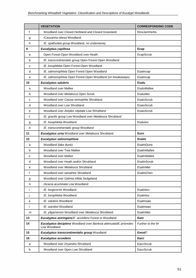
Benchmarking Wheatbelt Vegetation: Classification and Descriptions of Eucalypt Woodlands
51
51
VEGETATION CORRESPONDING CODE
f Woodland over Closed Herbland and Closed Grassland EloxJamHerbs
g /Casuarina obesa Woodland
h /E. spathulata group Woodland, no understorey
9 Eucalyptus capillosa Ecap
a Open Forest-Open Woodland over Heath EcapScrub
b /E. transcontinentalis group Open Forest-Open Woodland
c /E. loxophleba Open Forest-Open Woodland
d /E. salmonophloia Open Forest-Open Woodland Esalmcap
e /E. salmonophloia Open Forest-Open Woodland (on breakaways) Esalmcap
10 Eucalyptus salubris Esalu
a Woodland over Mallee EsaluMallee
b Woodland over Melaleuca Open Scrub EsaluMel
c Woodland over Cassia nemophila Shrubland EsaluScrub
d Woodland over Low Shrubland EsaluScrub
e Woodland over Atriplex stipitata Low Shrubland EsaluScrub
f /E. gracilis group Low Woodland over Melaleuca Shrubland
g /E. loxophleba Woodland Esalulox
h /E. transcontinentalis group Woodland
11 Eucalyptus urna Woodland over Melaleuca Shrubland Eurn
12 Eucalyptus salmonophloia Esalm
a Woodland (lake dune) EsalmDune
b Woodland over Tree Mallee EsalmMallee
c Woodland over Mallee EsalmMallee
d Woodland over Heath and/or Shrubland EsalmScrub
e Woodland over Melaleuca Shrubland EsalmMel
f Woodland over samphire Shrubland EsalmChen
g Woodland over Gahnia trifida Sedgeland
h /Acacia acuminata Low Woodland
i /E. longicornis Woodland Esalmlon
j /E. loxophleba Woodland Esalmlox
k /E. salubris Woodland Esalmsalu
l /E. wandoo Woodland Esalmwan
m /E. yilgarnensis Woodland over Melaleuca Shrubland EsalmMel
13 Eucalyptus astringens/E. accedens Forest or Woodland East
14 Eucalyptus decipiens Woodland over Banksia attenuata/B. prionotes Low Woodland
Further to the W
15 Eucalyptus transcontinentalis group Woodland Emod?
16 Eucalyptus accedens Eacc
a Woodland over Dryandra Shrubland EaccScrub
b Woodland over Open Low Shrubland EaccScrub

Benchmarking Wheatbelt Vegetation: Classification and Descriptions of Eucalypt Woodlands
52
52
VEGETATION CORRESPONDING CODE
17 Eucalyptus gardneri Woodland Egar
18 Eucalyptus falcata Earg or Eorn
a /E. gardneri Woodland Egar or Earg or Eorn
b /E. gardneri/E. astringens Woodland Egar or Earg or Eorn or East
19 Eucalyptus flocktoniae group Woodland Eurn
20 Eucalyptus incrassata Woodland
21 Eucalyptus densa Woodland Edens
22 Eucalyptus spathulata group Open Low Woodland Espa
23 Eucalyptus myriadena Woodland Emyr
24 Eucalyptus platypus Forest or Woodland Further to the S
25 Eucalyptus suggrandis subsp. alipes Woodland over Open Tall
Shrubland
Eali
26 Mosaic Woodlands
a Corymbia calophylla/E. wandoo/E. decipiens/E. occidentalis Woodland Ewanocc
b E. accedens/Corymbia calophylla/E. marginata/E. wandoo Woodland Further to the W
c E. longicornis/E. wandoo/E. salmonophloia Woodland Esalmlon, Elonwan
d E. loxophleba/E. wandoo/E. salmonophloia Woodland Esalmlox, Ewanlox
e E. occidentalis/E. decipiens/E. rudis Woodland
f E. occidentalis/E. rudis/Melaleuca preissiana Woodland
g E. occidentalis/E. rudis/E. wandoo Woodland Ewanocc, Ewanrud
h E. salmonophloia/E. capillosa/E. loxophleba Woodland Esalmcap, Esalmlox
i E. salmonophloia/E. salubris/E. loxophleba Woodland Esalmsalu, Esalmlox, Esalulox
j E. salmonophloia/E. wandoo/E. salubris/E. loxophleba Woodland Esalmwan, Esalmsalu, Esalmlox, Ewanlox, Esalulox
k Eucalyptus urna/E. eremophila group/E. annulata /E. phenax
Woodland Eurn
l E. urna/E. salmonophloia/E. phenax Woodland over Melaleuca Shrubland
Eurn, Esalmurn
m E. wandoo/Corymbia calophylla/Melaleuca preissiana Woodland Further to W
n E. wandoo/E. marginata/E. decipiens Woodland Further to W
o E. wandoo/E. occidentalis/E. decipiens Woodland Further to the W
p E. wandoo/E. occidentalis/E. marginata Woodland Further to the W
27 Acacia acuminata
a Woodland with scattered E. loxophleba EloxJam
b /Allocasuarina huegeliana Woodland
28 Allocasuarina huegeliana
a Forest, no understorey
b Woodland
c Woodland with scattered E. wandoo EwanSheoak
d Woodland over Allocasuarina campestris Shrubland
e /Acacia acuminata/E. wandoo Woodland EwanJam, EwanSheoak
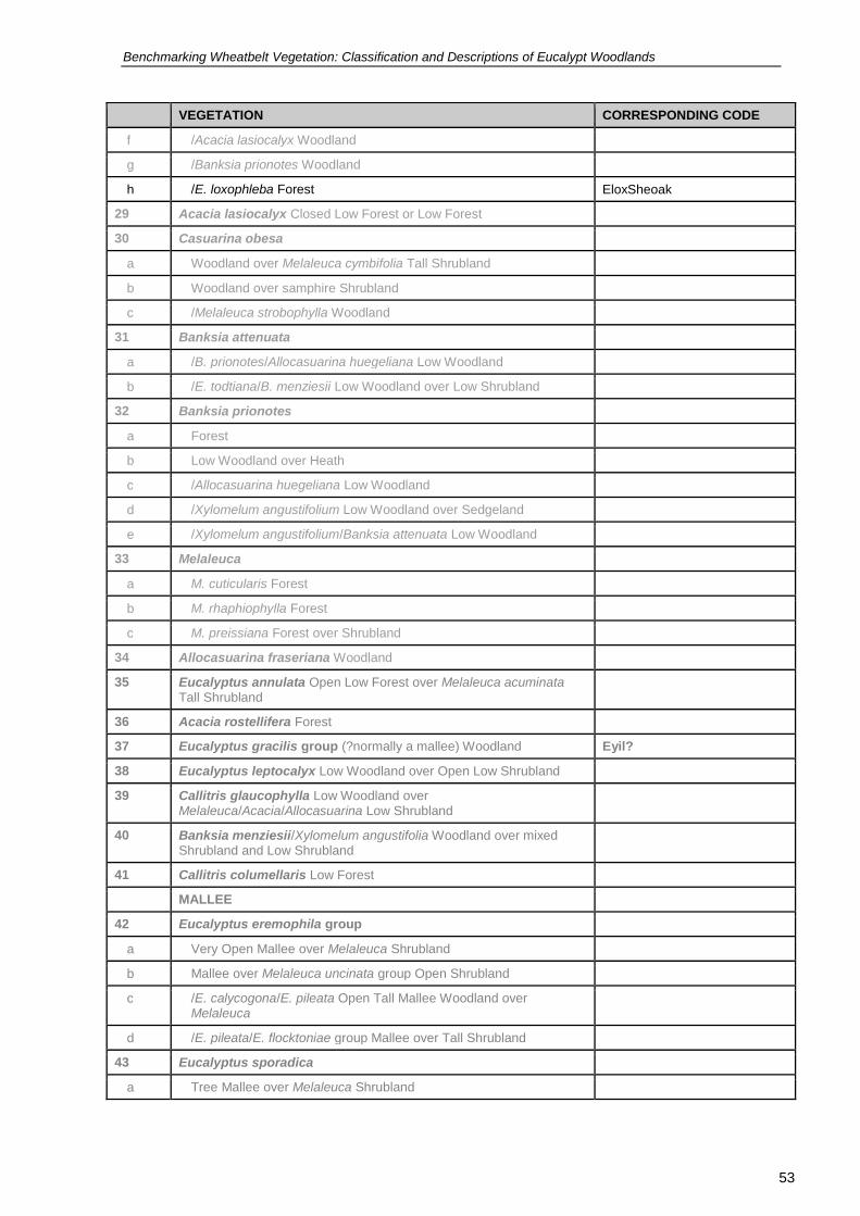
Benchmarking Wheatbelt Vegetation: Classification and Descriptions of Eucalypt Woodlands
53
53
VEGETATION CORRESPONDING CODE
f /Acacia lasiocalyx Woodland
g /Banksia prionotes Woodland
h /E. loxophleba Forest EloxSheoak
29 Acacia lasiocalyx Closed Low Forest or Low Forest
30 Casuarina obesa
a Woodland over Melaleuca cymbifolia Tall Shrubland
b Woodland over samphire Shrubland
c /Melaleuca strobophylla Woodland
31 Banksia attenuata
a /B. prionotes/Allocasuarina huegeliana Low Woodland
b /E. todtiana/B. menziesii Low Woodland over Low Shrubland
32 Banksia prionotes
a Forest
b Low Woodland over Heath
c /Allocasuarina huegeliana Low Woodland
d /Xylomelum angustifolium Low Woodland over Sedgeland
e /Xylomelum angustifolium/Banksia attenuata Low Woodland
33 Melaleuca
a M. cuticularis Forest
b M. rhaphiophylla Forest
c M. preissiana Forest over Shrubland
34 Allocasuarina fraseriana Woodland
35 Eucalyptus annulata Open Low Forest over Melaleuca acuminata Tall Shrubland
36 Acacia rostellifera Forest
37 Eucalyptus gracilis group (?normally a mallee) Woodland Eyil?
38 Eucalyptus leptocalyx Low Woodland over Open Low Shrubland
39 Callitris glaucophylla Low Woodland over Melaleuca/Acacia/Allocasuarina Low Shrubland
40 Banksia menziesii/Xylomelum angustifolia Woodland over mixed Shrubland and Low Shrubland
41 Callitris columellaris Low Forest
MALLEE
42 Eucalyptus eremophila group
a Very Open Mallee over Melaleuca Shrubland
b Mallee over Melaleuca uncinata group Open Shrubland
c /E. calycogona/E. pileata Open Tall Mallee Woodland over Melaleuca
d /E. pileata/E. flocktoniae group Mallee over Tall Shrubland
43 Eucalyptus sporadica
a Tree Mallee over Melaleuca Shrubland

Benchmarking Wheatbelt Vegetation: Classification and Descriptions of Eucalypt Woodlands
54
54
VEGETATION CORRESPONDING CODE
b Shrub Mallee over Melaleuca Shrubland
44 Eucalyptus transcontinentalis group
a /E. conglobata/E. spp. Mallee over Melaleuca Shrubland over Heath
b /E. eremophila group Mallee over Melaleuca Shrubland
c /E. redunca group Mallee over Shrubland
d /E. redunca group/E. calycogona/E. eremophila group Mallee
e /E. scyphocalyx Mallee over Melaleuca Shrubland
45 Eucalyptus incrassata
a Mallee over Banksia media Shrubland over Low Heath
b /E. pluricaulis subsp. pluricaulis Mallee
46 Eucalyptus leptocalyx
a Mallee over Low Shrubland and Low Grassland
b /E. gracilis group over Melaleuca Shrubland over Heath
47 Eucalyptus platypus
a Mallee over Low Shrubland
b Mallee over Melaleuca Shrubland
c /E. annulata/E. transcontinentalis group over Melaleuca Shrubland
over Shrubland
d /E. transcontinentalis group Mallee over Melaleuca Shrubland
48 Eucalyptus scyphocalyx
a /E. transcontinentalis group/E. spp. Mallee over Heath
b /E. eremophila group/E. flocktoniae group Mallee over Open Tall Shrubland
49 Eucalyptus conglobata
a Mallee over Melaleuca Shrubland
b /E. eremophila group Mallee
50 Eucalyptus erythronema
a Mallee over Melaleuca acuminata/M. adnata Shrubland
b /E. myriadena/E. redunca group/E. eremophila group/E. transcontinentalis group Mallee over Very Open Shrubland
c /E. yilgarnensis Mallee
51 Eucalyptus burracoppinensis
a Mallee over Allocasuarina campestris Shrubland
b Mallee over Shrubland
52 Eucalyptus suggrandis subsp. alipes
a /E. calycogona Mallee over Melaleuca Tall Shrubland
b /E. calycogona/E. phenax/E. perangusta Mallee over Melaleuca Tall
Shrubland
53 Eucalyptus phenax
a /E. perangusta/E. scyphocalyx Tall Open Mallee over Melaleuca Tall Shrubland

Benchmarking Wheatbelt Vegetation: Classification and Descriptions of Eucalypt Woodlands
55
55
VEGETATION CORRESPONDING CODE
b /E. perangusta /E. sporadica Tall Open Mallee over Melaleuca Tall Shrubland
c /E. suggrandis/E. perangusta Tall Open Mallee over Melaleuca Tall
Shrubland
54 Eucalyptus phaenophylla
a Mallee over Melaleuca Tall Shrubland
b /E. leptophylla/E. conglobata Mallee
c /E. sporadica Mallee
55 Eucalyptus sheathiana Mallee over Melaleuca acuminata Shrubland
56 Eucalyptus calycogona
a Mallee over Phebalium tuberculosum Shrubland
b /E. calycogona/E. eremophila group Shrub Mallee
c /E. conglobata/E. sargentii Mallee over Shrubland
d /E. eremophila group/E. sheathiana/E. transcontinentalis group Mallee with scattered E. capillosa
e /E. prolixa/E. densa Tree Mallee
f /E. sheathiana Mallee over Melaleuca uncinata group Shrubland
57 Eucalyptus celastroides/E. eremophila group/E. spathulata group/E. flocktoniae group Mallee over Shrubland
58 Eucalyptus perangusta Mallee over Open Tall Shrubland Mallee
59 Mixed Mallee
a E. brachycorys/E. erythronema subsp. marginata/E. flocktoniae group/E. oldfieldii/E. pluricaulis/E. tenera Mallee
b E. flocktoniae group/E. eremophila group/E. conglobata/E. pluricaulis Mallee
c E. transcontinentalis group/E. subangusta Mallee over Allocasuarina acutivalvis Shrubland
d Eucalyptus Shrub Mallee /Melaleuca Shrubland over Low Heath
60 Eucalyptus tenera/E. erythronema subsp. marginata Mallee
61 Eucalyptus oldfieldii/E. flocktoniae group Mallee
62 Eucalyptus rigidula Mallee
63 Eucalyptus capillosa subsp. polyclada Mallee over Melaleuca Tall
Shrubland
64 Eucalyptus flocktoniae group
a Mallee over Heath
b /E. incrassata or E. conglobata Mallee
c /E. phenax Mallee over Melaleuca Tall Shrubland
65 Eucalyptus subangusta subsp. subangusta Mallee over
Allocasuarina campestris Shrubland
66 Eucalyptus pileata Very Tall Open Mallee Forest
67 Eucalyptus falcata Mallee
68 Eucalyptus hypochlamydea Mallee
69 Eucalyptus brachycorys/E. hypochlamydea (E. comitae-vallis)
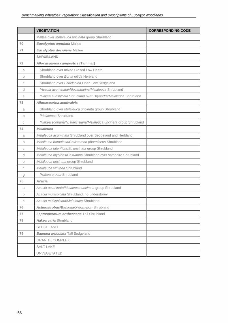
Benchmarking Wheatbelt Vegetation: Classification and Descriptions of Eucalypt Woodlands
56
56
VEGETATION CORRESPONDING CODE
Mallee over Melaleuca uncinata group Shrubland
70 Eucalyptus annulata Mallee
71 Eucalyptus decipiens Mallee
SHRUBLAND
72 Allocasuarina campestris (Tammar)
a Shrubland over mixed Closed Low Heath
b Shrubland over Borya nitida Herbland
c Shrubland over Ecdeicolea Open Low Sedgeland
d /Acacia acuminata/Allocasuarina/Melaleuca Shrubland
e /Hakea subsulcata Shrubland over Dryandra/Melaleuca Shrubland
73 Allocasuarina acutivalvis
a Shrubland over Melaleuca uncinata group Shrubland
b /Melaleuca Shrubland
c /Hakea scoparia/H. francisiana/Melaleuca uncinata group Shrubland
74 Melaleuca
a Melaleuca acuminata Shrubland over Sedgeland and Herbland
b Melaleuca hamulosa/Callistemon phoeniceus Shrubland
c Melaleuca lateriflora/M. uncinata group Shrubland
d Melaleuca thyoides/Casuarina Shrubland over samphire Shrubland
e Melaleuca uncinata group Shrubland
f Melaleuca viminea Shrubland
g /Hakea erecta Shrubland
75 Acacia
a Acacia acuminata/Melaleuca uncinata group Shrubland
b Acacia multispicata Shrubland, no understorey
c Acacia multispicata/Melaleuca Shrubland
76 Actinostrobus/Banksia/Xylomelon Shrubland
77 Leptospermum erubescens Tall Shrubland
78 Hakea varia Shrubland
SEDGELAND
79 Baumea articulata Tall Sedgeland
GRANITE COMPLEX
SALT LAKE
UNVEGETATED

Benchmarking Wheatbelt Vegetation: Classification and Descriptions of Eucalypt Woodlands
57
57
APPENDIX 2 Wheatbelt groups and assemblages produced by the SAP analysis of floristic and bioregional variables
Woodlands groups identified by the SAP analysis (extract from (Gibson et al. 2004). Vegetation is coded corresponding to communities and sub-communities defined in this Project.
ID Description Corresponding code
G2 Northern herb-rich woodlands generally on duplex soils dominated by Eucalyptus loxophleba or E. salmonophloia, with a wider distribution than G1 extending into the Avon 2 and Geraldton Sandplains 3 subregions.
Esalmlox
G4 Central and southern woodland Woodlands dominated by Eucalyptus longicornis, E. kondininensis or E. salmonophloia and almost exclusively recorded from duplex soils. Less species-rich than G1 and G2 and generally lacking many of the herbs. Chenopods were a common component of the understorey with Sclerolaena diacantha and Atriplex vesicaria the most typical species of these quadrats. This group was generally restricted to the Mallee 2 subregion.
ElonChen Esalmlon EkonChen EsalmChen
G5 Central and southern woodlands of Eucalyptus salmonophloia, E. longicornis, E. occidentalis or E. astringens are widespread, occurring from Jarrah Forest 2 through Avon 2, Avon I, Mallee 2 subregions and into Mallee 1 subregion. This group generally lacks the chenopod understorey of G4.
Esalmlon Elonast Eastocc
G6 Mallees and woodlands mostly on duplex soils in the Mallee 2 subregion extending into the Avon 2 and the Avon 1 subregions. Eucalypt dominance was variable but Eucalyptus calycogona was the most typical mallee and Eucalyptus salmonophloia was occasionally present.
EsalmMallee
G7 Woodlands in the wettest part of the study area and generally dominated by Eucalyptus marginata, E. calophylla or E. wandoo. Soil type was variable with quadrats recorded from granite, duplex laterite and deep sand soils. Quadrats were almost totally confined to Jarrah Forest bioregion.
Too far to the W EwanHeath
G12 Woodlands dominated by Eucalyptus loxophleba, Allocasuarina huegeliana, Acacia acuminata or Eucalyptus wandoo are species rich woodland quadrats (mean 48.3 taxa/quadrat) on granite or duplex soils were generally. They generally occurred in the Avon bioregion and the Jarrah Forest 1, and Mallee 2 subregions.
EloxSheoak EloxJam Eloxwan EwanSheoak
G19 Eucalyptus astringens subsp. astringens woodlands generally occurred on breakaways or as mallet stands on laterites. They were typically species poor (mean 11.1 taxa/quadrat) and mainly in Avon 2 bioregion
East
G24 Woodlands of Eucalyptus salubris, some E. salmonophloia and two subspecies of Melaleuca pauperiflora form a group of species-poor eucalypt woodlands and mallee on duplex soils restricted to the Mallee bioregion. Mean species richness was low at 6.3 taxa/quadrat.
Esalmsalu

Benchmarking Wheatbelt Vegetation: Classification and Descriptions of Eucalypt Woodlands
58
58
As a second approach to assessing phytogeographical patterns within the study area, Gibson et al. (2004) classified the 682 quadrats in terms of their relative weighting for the various species assemblages identified from the quadrat classification analysis (described above), and compared the results with the existing bioregions and subregions. For this analysis, species assemblages were weighted equally by using the proportion of an assemblage's maximum species richness recorded at each quadrat as input data.
Assemblages relevant to the current classification are listed below.
ID Description Code
A1. The taxa of assemblage 1 are widespread across the Avon and Coolgardie bioregions with some of the annual and shrub components extending into Acacia shrublands of the Eremaean. It is overwhelmingly composed of annual herbs and geophytes. The species are more abundant on the more fertile duplex and granite soils in drier areas of the SWBP. Typical sp de include the canopy species Eucalyptus loxophleba subsp. loxophleba, Acacia acuminata, E. capillosa subsp. capillosa and Santalum acuminatum and numerous annual herbs that are common in Eucalyptus loxophleba woodlands (e.g. Waitzia acuminata, Rhodanthe laevis, Hyalosperma demissum).
EloxJamHerbs Ecap
A3. Semi-arid and arid woodland species of the duplex soils of broad valley floors in the Coolgardie bioregion, the southern part of the Yalgoo, the eastern part of the Avon and the northern part of the Mallee bioregions form assemblage 3. It also includes woodland species of calcareous soils. Canopy species include Eucalyptus salmonophloia, E. longicornis, E. yilgarnensis, E. salubris, and the shrubs Acacia erinacea, Olearia muelleri, Enchylaena tomentosa, Rhagodia drummondii and Sclerolaena diacantha. Typical herbs include Velleia rosea, Myriocephalus guerinae and Ptilotus exaltatus.
This assemblage faces significant risk from dryland salinity.
Esalmlon Esalmsalu EsalmScrub EsalmChen ElonChen ElonScrub Eyil EsaluScrub EsaluChen
A5. The composition of assemblage 5 is variable, made up of taxa typical of breakaways and/or heavy duplex soils but also including some taxa more common on sandy soils. Most taxa occur from the boundary of the Jarrah Forest and Avon bioregions extending eastward into the Mallee bioregion. Typical taxa of breakaways and duplex soils include Eucalyptus astringens subsp. astringens, mallee E. capillosa subsp. polyclada, over shrubs of Gastrolobium parvifolium, Nemcia tricuspidata, and the orchid Oligochaetochilus sargentii.
East
A6. Woodland and mallee species of the Avon, Mallee and Coolgardie bioregions, occurring on duplex soil associated with uplands and side slopes comprise assemblage 6. Typical mallee eucalypts include E. platypus, E. flocktoniae, E. phenax, E. calycogona, E. conglobata and E. eremophila. The assemblage also includes some species common on low lake dunes sands adjacent to salt lakes (e.g. Swamp Mallet E. spathulata, E. kondininensis). Other typical species include Melaleuca teuthidoides, Melaleuca acuminata, M. adnata, Zygophyllum ovatum and Westringia rigida. This assemblage faces significant risk from dryland salinity in specific topographical positions.
Espa EkonMel
A12. Taxa primarily of granite aprons and seasonally inundated clay flats comprise assemblage 12. Some of the taxa can also occur on sands. ln this assemblage herbs and geophytes predominate, with distributions centred on the Jarrah Forest and Avon bioregions but also extending onto the Swan Coastal Plain bioregion and east into the wetter parts of the Mallee bioregion. Typical taxa include Allocasuarina huegeliana, Eucalyptus occidentalis, Stypandra glauca, Borya laciniata, B. sphaerocephala, Siloxerus multiflorus, Aphelia cyperoides, Waitzia suaveolens, Caesia micrantha, Sowerbaea laxiflora and Centrolepis drummondii.
Eocc
A13. A13 Assemblage 13 is comprised of taxa typical of Eucalyptus EwanHerbs

Benchmarking Wheatbelt Vegetation: Classification and Descriptions of Eucalypt Woodlands
59
59
wandoo (Wandoo) woodlands on duplex soils; some taxa in this assemblage are also common on sandy soils. The distribution patterns of taxa in this assemblage are similar to assemblage 12, being centred on the eastern edge of the Jarrah Forest bioregion. Characteristic taxa include Eucalyptus wandoo, Chamaescilla versicolor, Hyalosperma cotula, Hibbertia commutata, Bossiaea eriocarpa, Diuris corymbosa, Desmocladus asper and Craspedia variabilis. This assemblage faces some risk from dryland salinity in susceptible landscape positions.
A17. Small group of taxa of lateritic and duplex soils form assemblage 17. Distributions are centred on the eastern part of the Jarrah Forest and western part of the Avon bioregions but there is little congruence between the distributions of individual taxa. Some taxa extend into the southwest corner and one extends to the Esperance Sandplains bioregion, other are restricted to the Geraldton Sandplain, Avon and the northern part of the Jarrah Forest bioregion. This assemblage was not we1l sampled in the current survey. Typical taxa include Eucalyptus falcata, E. accedens, Astroloma drummondii, Gahnia australis, Dryandra squarrosa subsp. squarrosa and Gastrolobium microcarpum.
Eorn Earg Eacc

Benchmarking Wheatbelt Vegetation: Classification and Descriptions of Eucalypt Woodlands
60
60
APPENDIX 3 Wheatbelt woodlands classification by Griffin
Classification of Wheatbelt woodlands at the 25 group level by (Griffin 2008). Non-woodland vegetation is in grey. Vegetation is coded corresponding to communities and sub-communities defined in this Project.
Group No
Description Number of Sites
Corresponding Code
1 Eucalyptus wandoo subsp. pulverea 13 EwanN
2 Eucalyptus accedens 14 Eacc
3 Allocasuarina campestris shrublands with a number of distinct different trees, e.g. E. loxophleba, E. salmonophloia, E. wandoo, E. oldfieldii
7 EloxSheoak EwanSheoak
4 Melaleuca undulata shrubland, often with Dodonaea bursariifolia and or Allocasuarina acutivalvis
16
5 Isopogon buxifolius and/or Banksia media shrublands 6
6 Heterogeneous unit. Many apparently distinct units each with a number of different eucalypts
16
7 Eucalyptus myriadena 5 Emyr
8 Eucalyptus astringens subsp. redacta 2 Too far S
9 Eucalyptus capillosa subsp. capillosa 12 Ecap
10 Melaleuca acuminata subsp. acuminata 10
11 Eucalyptus astringens subsp. astringens, often with E. wandoo 14 EastScrub or EastHerbs
12 Eucalyptus loxophleba subsp. lissophloia 23 mallee
13 Eucalyptus longicornis 18 Elon
14 Rhagodia drummondii 16 Esali?
15 Rhagodia drummondii 32 Ekon?
16 Rhagodia drummondii 19 EloxN?
17 Eucalyptus loxophleba subsp. loxophleba 51 Elox
18 Eucalyptus salmonophloia 79 Esalm
19 Eucalyptus salubris, some E. salmonophloia 77 Esalmsalu
20 Eucalyptus wandoo subsp. wandoo 73 EwanScrub Ewanacc
21 Eucalyptus wandoo subsp. wandoo 28 EwanJam
22 Eucalyptus occidentalis 12 Eocc
23 Eucalyptus occidentalis 21 Eocc
24 Eucalyptus occidentalis 21 Eocc
25 Eucalyptus loxophleba subsp. loxophleba & Acacia acuminata 50 EloxJam
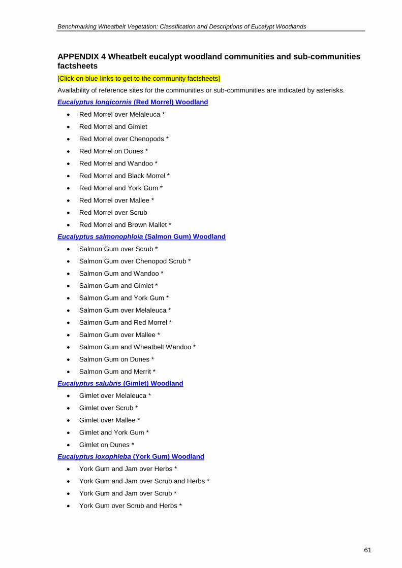
Benchmarking Wheatbelt Vegetation: Classification and Descriptions of Eucalypt Woodlands
61
61
APPENDIX 4 Wheatbelt eucalypt woodland communities and sub-communities factsheets
[Click on blue links to get to the community factsheets]
Availability of reference sites for the communities or sub-communities are indicated by asterisks.
Eucalyptus longicornis (Red Morrel) Woodland
Red Morrel over Melaleuca *
Red Morrel and Gimlet
Red Morrel over Chenopods *
Red Morrel on Dunes *
Red Morrel and Wandoo *
Red Morrel and Black Morrel *
Red Morrel and York Gum *
Red Morrel over Mallee *
Red Morrel over Scrub
Red Morrel and Brown Mallet *
Eucalyptus salmonophloia (Salmon Gum) Woodland
Salmon Gum over Scrub *
Salmon Gum over Chenopod Scrub *
Salmon Gum and Wandoo *
Salmon Gum and Gimlet *
Salmon Gum and York Gum *
Salmon Gum over Melaleuca *
Salmon Gum and Red Morrel *
Salmon Gum over Mallee *
Salmon Gum and Wheatbelt Wandoo *
Salmon Gum on Dunes *
Salmon Gum and Merrit *
Eucalyptus salubris (Gimlet) Woodland
Gimlet over Melaleuca *
Gimlet over Scrub *
Gimlet over Mallee *
Gimlet and York Gum *
Gimlet on Dunes *
Eucalyptus loxophleba (York Gum) Woodland
York Gum and Jam over Herbs *
York Gum and Jam over Scrub and Herbs *
York Gum and Jam over Scrub *
York Gum over Scrub and Herbs *

Benchmarking Wheatbelt Vegetation: Classification and Descriptions of Eucalypt Woodlands
62
62
York Gum over Melaleuca *
York Gum in Saline Areas *
York Gum on Dunes *
York Gum and Sheoak
York Gum North *
Eucalyptus wandoo (Wandoo) Woodland
Wandoo over Heath *
Wandoo over Herbs *
Wandoo over Scrub *
Wandoo and Sheoak *
Wandoo over Tammar or Melaleuca **
Wandoo and Jam *
Wandoo and Mallee
Wandoo and York Gum
Wandoo and Powderbark Wandoo
Wandoo and Flooded Gum or Flat-topped Yate **
Wandoo in Saline Areas *
Wandoo North
Eucalyptus capillosa (Wheatbelt Wandoo) Woodland
Wheatbelt Wandoo over Herbs *
Wheatbelt Wandoo over Scrub *
Eucalyptus accedens (Powderbark Wandoo) Woodland
Powderbark Wandoo over Scrub *
Eucalyptus melanoxylon (Black Morrel) Woodland *
MALLET WOODLANDS
Eucalyptus astringens (Brown Mallet) Woodland
Brown Mallet over Little Understorey *
Brown Mallet over Scrub *
Brown Mallet over Mallee
Brown Mallet and Merrit *
Brown Mallet and Flat-topped Yate *
Eucalyptus argyphea (Silver Mallet) Woodland
Silver Mallet Over Little Understorey *
Silver Mallet over Scrub *
Eucalyptus urna (Merrit) Woodland *
Eucalyptus gardneri (Blue Mallet) Woodland *
Eucalyptus ornata (Ornate Mallet) Woodland
Eucalyptus spathulata (Swamp Mallet) Woodland

Benchmarking Wheatbelt Vegetation: Classification and Descriptions of Eucalypt Woodlands
63
63
Eucalyptus singularis (Mallet) Woodland
Eucalyptus densa (Mallet) Woodland *
Eucalyptus extensa (Mallet) Woodland
Eucalyptus recta (Cadoux Mallet) Woodland
Eucalyptus alipes (Mallet) Woodland
Eucalyptus polita (Mallet) Woodland
OTHERS
Woodlands associated with salt lakes
Eucalyptus kondininensis (Kondinin Blackbutt) Woodland
Kondinin Blackbutt over Chenopods *
Kondinin Blackbutt over Melaleuca *
Eucalyptus myriadena (Blackbutt) Woodland *
Eucalyptus salicola (Salt Salmon Gum) Woodland *
Eucalyptus sargentii (Salt River Gum) Woodland *
Woodlands associated with drainage lines
Eucalyptus occidentalis (Flat-topped Yate) Woodland
Flat-topped Yate Southern Wheatbelt *
Flat-topped Yate South Coast
Flat-topped Yate West
Eucalyptus rudis (Flooded Gum) Woodland
Eastern Woodlands
Eucalyptus moderata (Redwood) Woodland
Eucalyptus yilgarnensis (Yorrell) Woodland *
Outlying Woodlands
Eucalyptus marginata (Jarrah)
See the factsheet glossary for explanation of terms.