Niagara Falls View from Prospect Point, Niagara Falls, New York.
NIAGARA FALLS NATIONAL HERITAGE AREA ACCESS AND PARK RESTORATION PROJECT
Reconfiguration of Two Segments of the Robert Moses Parkway Corridor and Adjoining Roads
Niagara Falls, Niagara County, New York
Application under: AMERICAN RECOVERY AND REINVESTMENT ACT OF 2009
TRANSPORTATION INVESTMENT GENERATING ECONOMIC RECOVERY (TIGER) GRANT PROGRAM
September 15, 2009
Submitted by: City of Niagara Falls, New York
With Cooperation from: New York State Office of Parks, Recreation, & Historic Preservation
Contact: Thomas DeSantis, AICP, Senior Planner
City of Niagara Falls 745 Main Street, P.O. Box 69 Niagara Falls, New York 14303
Phone: (716) 286‐4477 [email protected]
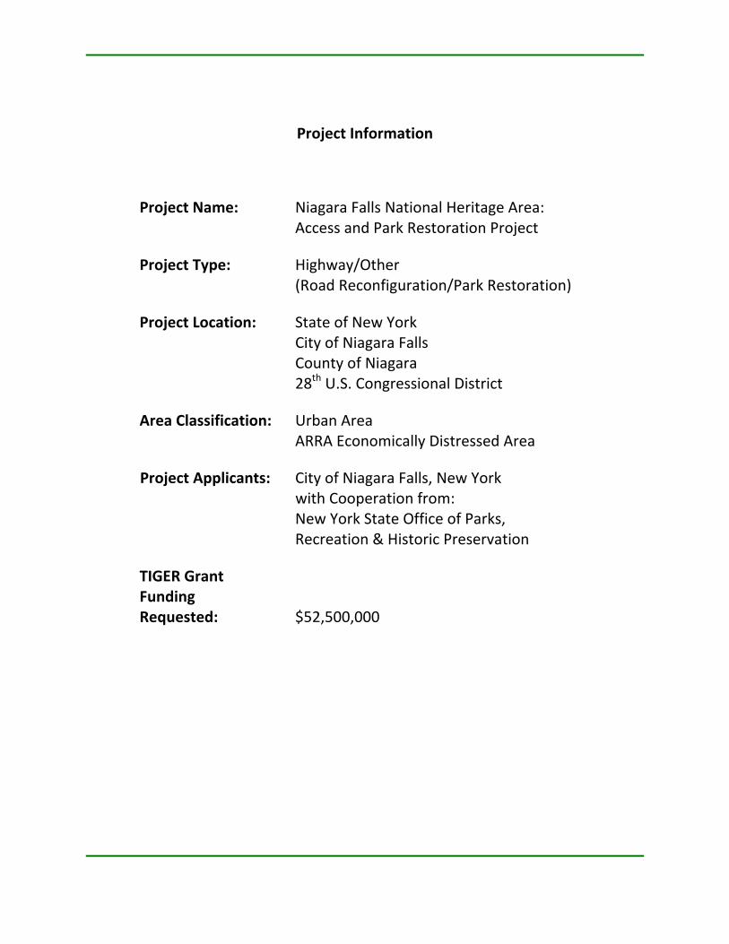
Project Information
Project Name: Niagara Falls National Heritage Area: Access and Park Restoration Project
Project Type: Highway/Other (Road Reconfiguration/Park Restoration)
Project Location: State of New York City of Niagara Falls County of Niagara 28th U.S. Congressional District
Area Classification: Urban Area ARRA Economically Distressed Area
Project Applicants: City of Niagara Falls, New York with Cooperation from: New York State Office of Parks, Recreation & Historic Preservation
TIGER Grant Funding Requested: $52,500,000
Niagara Falls National Heritage Area Niagara Falls Access and Park Restoration Project New York
i
Table of Contents
1. Project Description ........................................................................................1
1.1. Project Name ............................................................................................................ 1
1.2. Description & Need for the Project............................................................................ 1
1.3. Sponsors ................................................................................................................... 9
1.4. Cost and amount of TIGER Grant Request ................................................................. 9
1.5. Status as an Economically Distressed Area ................................................................ 9
2. Project Parties..............................................................................................11
3. Grant Funds .................................................................................................12
4. Primary Selection Criteria ............................................................................13
4.1. Long‐Term Outcomes .............................................................................................. 13
4.2. Summary of Project Benefits ................................................................................... 16
4.3. “Shovel‐Ready” Criteria........................................................................................... 16
4.4. Job Creation & Economic Stimulus .......................................................................... 20
5. Secondary Selection Criteria ........................................................................22
5.1. Innovation............................................................................................................... 22
5.2. Partnership ............................................................................................................. 22
5.3. Environmentally Related Federal, State and Local Actions ...................................... 22
6. Certifications and Contact Information ........................................................24
6.1. Federal Wage Rate Requirement Certification......................................................... 24
6.2. Application and Project Contact Information .......................................................... 24
7. Appendices ..................................................................................................25
Niagara Falls National Heritage Area Niagara Falls Access and Park Restoration Project New York
1
1. PROJECT DESCRIPTION
1.1. Project Name
Niagara Falls National Heritage Area: Access and Park Restoration Project, Niagara Falls, New York.
1.2. Description & Need for the Project Overview
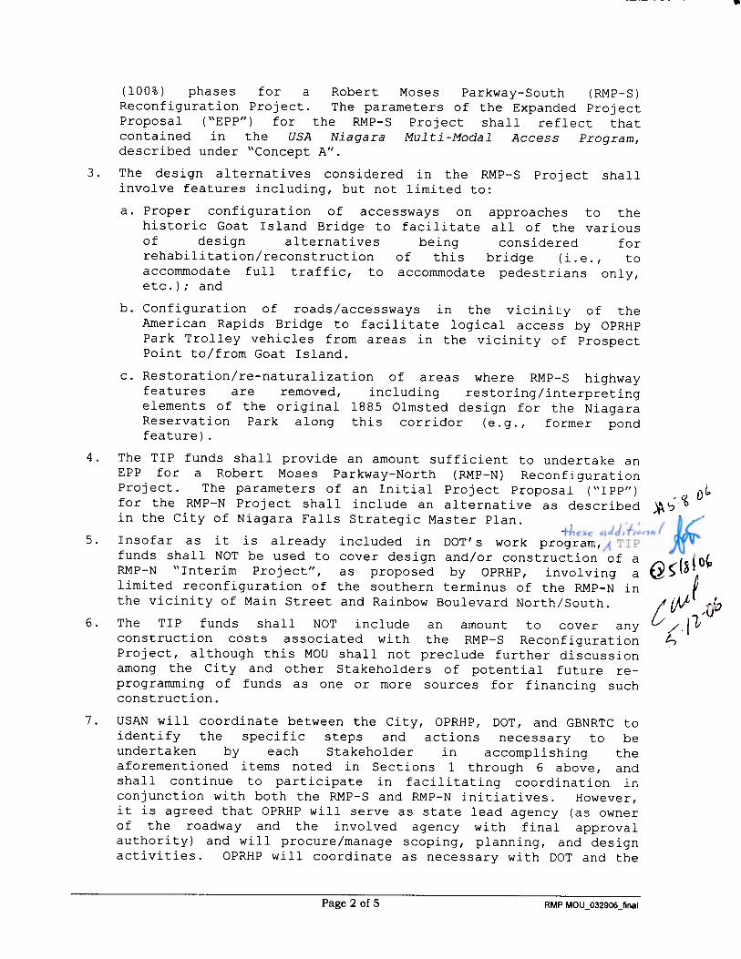
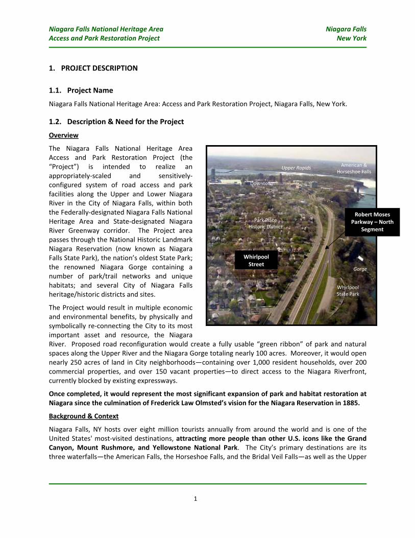
The Niagara Falls National Heritage Area Access and Park Restoration Project (the “Project”) is intended to realize an appropriately‐scaled and sensitively‐configured system of road access and park facilities along the Upper and Lower Niagara River in the City of Niagara Falls, within both the Federally‐designated Niagara Falls National Heritage Area and State‐designated Niagara River Greenway corridor. The Project area passes through the National Historic Landmark Niagara Reservation (now known as Niagara Falls State Park), the nation’s oldest State Park; the renowned Niagara Gorge containing a number of park/trail networks and unique habitats; and several City of Niagara Falls heritage/historic districts and sites.
The Project would result in multiple economic and environmental benefits, by physically and symbolically re‐connecting the City to its most important asset and resource, the Niagara River. Proposed road reconfiguration would create a fully usable “green ribbon” of park and natural spaces along the Upper River and the Niagara Gorge totaling nearly 100 acres. Moreover, it would open nearly 250 acres of land in City neighborhoods—containing over 1,000 resident households, over 200 commercial properties, and over 150 vacant properties—to direct access to the Niagara Riverfront, currently blocked by existing expressways.
Once completed, it would represent the most significant expansion of park and habitat restoration at Niagara since the culmination of Frederick Law Olmsted’s vision for the Niagara Reservation in 1885.
Background & Context
Niagara Falls, NY hosts over eight million tourists annually from around the world and is one of the United States' most‐visited destinations, attracting more people than other U.S. icons like the Grand Canyon, Mount Rushmore, and Yellowstone National Park. The City’s primary destinations are its three waterfalls—the American Falls, the Horseshoe Falls, and the Bridal Veil Falls—as well as the Upper
Whirlpool State Park
American & Horseshoe Falls
Downtown
Park Place Historic District
Whirlpool Street
Robert Moses Parkway – North
Segment
Gorge
Upper Rapids
Niagara Falls National Heritage Area Niagara Falls Access and Park Restoration Project New York
2
and Lower Niagara Rapids and the Niagara Gorge, which extends roughly eight miles north from the base of the Falls.
Historically, the economy of Niagara Falls, NY capitalized primarily upon the Falls as a source of abundant, inexpensive hydroelectric power. The world’s first application of alternating current technology, allowing power to be transmitted over distances without losing in strength, was developed at Niagara in the late 1800s. This spawned a dense concentration of basic manufacturing companies with large power needs—ALCOA, Occidental, Goodyear, Shredded Wheat, and Carborundum, to name just a few—to develop large industrial complexes in the City. Indeed, it was the threat of rampant industrial development upon the Falls that prompted Olmsted to help lead the 19th‐century movement for the State to acquire land around Niagara Falls and preserve its natural beauty for future generations.
In the decades following the end of World War II, a series of regional and national trends in restructuring of U.S. industrial production marked the beginning of a steep decline in basic manufacturing in the City. Throughout this period, many companies in the City progressively downsized, relocated operations elsewhere, or underwent outright shut down, resulting in major losses of employment and associated economic effects to the City. By the turn of the 21st century, with the City’s unemployment rates hovering around ten percent (almost twice the state and national rates), City leaders had come to the realization that the economic future of the City lied not in Niagara’s ability to attract industry, but rather to attract visitors and new residents to marvel at the natural beauty of the Falls, explore the varied landscape and environments of the Rapids and the Gorge, and immerse themselves in about how these phenomena helped shape the history of the region, the nation, and the world.
The Robert Moses Parkway
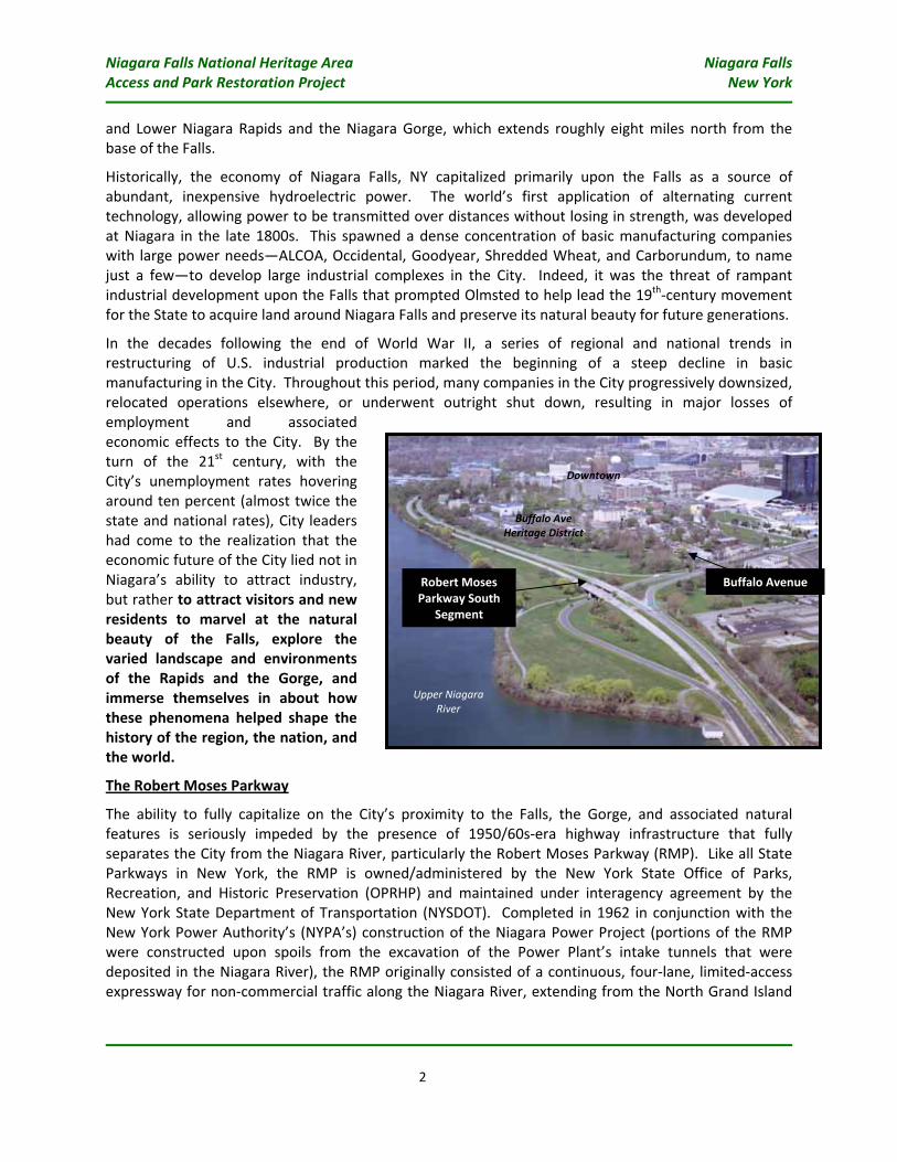
The ability to fully capitalize on the City’s proximity to the Falls, the Gorge, and associated natural features is seriously impeded by the presence of 1950/60s‐era highway infrastructure that fully separates the City from the Niagara River, particularly the Robert Moses Parkway (RMP). Like all State Parkways in New York, the RMP is owned/administered by the New York State Office of Parks, Recreation, and Historic Preservation (OPRHP) and maintained under interagency agreement by the New York State Department of Transportation (NYSDOT). Completed in 1962 in conjunction with the New York Power Authority’s (NYPA’s) construction of the Niagara Power Project (portions of the RMP were constructed upon spoils from the excavation of the Power Plant’s intake tunnels that were deposited in the Niagara River), the RMP originally consisted of a continuous, four‐lane, limited‐access expressway for non‐commercial traffic along the Niagara River, extending from the North Grand Island
Upper Niagara River
Downtown
Buffalo Ave Heritage District
Robert Moses Parkway South
Segment
Buffalo Avenue
Niagara Falls National Heritage Area Niagara Falls Access and Park Restoration Project New York
3
Bridges, through Niagara Falls State Park, north along the rim of the Niagara Gorge to Lewiston, then continuing inland to its termination in the Town of Porter. The RMP was intended to be part of a much larger, unrealized plan for a regional highway network encompassing both Niagara and Erie Counties.
Within its first 20 years in operation, efforts began to be put forth to remove or reconfigure portions of the RMP to attempt to lessen its impact upon enjoyment of the Falls. In the mid‐1980s, the segment of the RMP passing directly past the American Falls at Prospect Point was removed by OPRHP, separating the highway into two segments (North & South), although the remaining highway components passing through the State Park were largely left in place. Later in the decade, the traffic pattern along the Southern segment of the RMP in Niagara Falls State Park was converted to a one‐way entry road (using the northbound lanes), with the southbound lanes converted to street parking along the Upper Rapids.
Most recently in 2001, a “pilot project” for a relatively underutilized segment of the RMP North Segment from Cedar Street in Niagara Falls to I‐190 in Lewiston was implemented by OPRHP and NYSDOT. This involved converting the two southbound lanes of the RMP into a wide recreation/bike trail, and re‐surfacing/re‐striping the northbound section to allow for two‐way traffic (one lane in each direction). The pilot project was intended to test whether a reduction in the amount of traffic access along the RMP would impede regional transportation access. The results of the pilot program indicated that the reduction of lanes largely had no effect on regional mobility; this segment of the RMP continued to attract about the same amount of traffic as under “pre‐pilot” conditions (about 3,000 vehicles per day), accidents were reduced, and there were no noticeable traffic effects on other roadways in the area. With limited State funds available to take further actions on RMP reconfiguration in the economic wake of the events of September 11, 2001, the Pilot program was allowed to continue and remains in place today.
Although undergoing partial removals and reconfigurations to reduce its impact, the RMP still largely contains all of the physical features of its original expressway design, including limited‐access; grade separation on embankments in locations that block views of the River/Gorge; and measures to prevent pedestrian encroachment (e.g., guiderail, high fences, vegetative lines) along the edge of its right‐of‐way. While an unintended consequence of its construction, these features continue to detract from resident/visitor enjoyment of the nation’s oldest State Park and natural features along Upper and Lower Niagara River. It has, in part, impeded efforts to revitalize adjoining neighborhoods with historically respectful rehabilitation/infill development that would capitalize on its proximity to such world‐class natural resources and recreational facilities. Some examples of these effects include the following (see also context photos in Appendix A):
• The South segment of the RMP passing by the Upper Niagara Rapids is situated on a high artificial embankment, fully blocking River access and views from the adjoining Buffalo Avenue Heritage District, containing a collection of 19th century residences in one of the City’s oldest neighborhoods, once home to some of the founders and first families of Niagara Falls. Prior to the construction of the RMP, this area was traversed by the Olmsted‐inspired “Riverway”, a low‐speed carriageway that passed through landscaped areas and viewing points along the River.
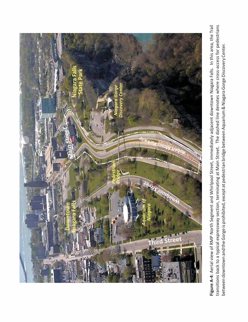
• The beginning of the RMP North segment in downtown Niagara Falls physically divides the Aquarium of Niagara from the Niagara Gorge Discovery Center on the Gorge rim, now connected only by a small pedestrian bridge over the highway. Other, more intuitive routes between downtown and the Gorge edge are blocked by chain‐link fences originally intended to prevent pedestrians from wandering onto the expressway.
Niagara Falls National Heritage Area Niagara Falls Access and Park Restoration Project New York
4
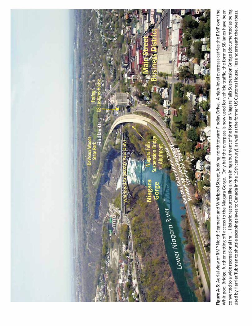
• The RMP North segment runs immediately parallel to Whirlpool Street and past historic neighborhoods and resources like:
- The Park Place Historic District;
- An abutment to former Niagara Falls Suspension Bridge (a documented location of Harriett Tubman’s activities on the Underground Railroad);
- The former U.S. Customs House near the Whirlpool Bridge (being restored to house an Underground Railroad interpretative center as part of a new intermodal rail station project); and
- The Main Street Business District, the City’s original “downtown” (containing a collection of 19th and early‐20th century mixed‐use commercial buildings).
However, rather than enhancing these resources/districts by their location to host retail, lodging, and residential uses that play off of eco‐tourism and recreational uses along the Gorge, these areas suffer from chronic vacancies and decline because they adjoin an expressway that blocks any access to natural resources that virtually are only steps away.
• At Findlay Drive, the RMP North segment approaches DeVeaux Woods State Park, a 50‐acre area containing almost ten acres of old growth forest and a campus containing 19th‐century buildings that were once part of the estate of Judge Samuel DeVeaux of Niagara Falls. The campus was originally endowed to be used as a preparatory school for orphaned and homeless boys; it was later used as a unit of Niagara University before being transferred to OPRHP for State Park use. Ripe for adaptation for a heritage/nature‐based uses, the campus is fully blocked from direct access to the Gorge by the RMP.
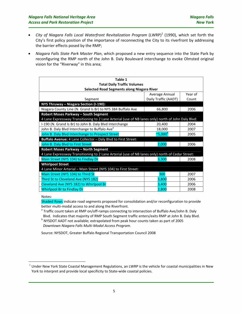
In addition to impeding access and economic revitalization of adjoining City neighborhoods, it is important to note that these segments of RMP actually carry a relatively low level of traffic (see Table 1). In fact, even the most heavily‐used segments of the RMP—not targeted for reconfiguration in this application—carry less than a third of the traffic carried by other nearby interstate expressways like Niagara Section of the NYS Thruway (I‐190). The segments that are the subject of this application are even less utilized, carrying less than ten percent of the daily traffic on the NYS Thruway and less than many conventional arterial roads in the City.
Thus, the current system contains a number of highway facilities and structures (e.g., bridges, overpasses, interchanges, etc.) that will continue to require an inordinate amount of maintenance into the long term, considering relatively low use compared to other facilities in the region.
Plans to Open Access to the Niagara River
Since the early 1990s, City and State officials have recognized the critical importance and set forth numerous proposals for reconfiguring access along the Upper and Lower Niagara River to address the effects of the RMP, including the following:
Niagara Falls National Heritage Area Niagara Falls Access and Park Restoration Project New York
5
• City of Niagara Falls Local Waterfront Revitalization Program (LWRP)1 (1990), which set forth the City’s first policy position of the importance of reconnecting the City to its riverfront by addressing the barrier effects posed by the RMP;
• Niagara Falls State Park Master Plan, which proposed a new entry sequence into the State Park by reconfiguring the RMP north of the John B. Daly Boulevard interchange to evoke Olmsted original vision for the “Riverway” in this area;
Table 1 Total Daily Traffic Volumes
Selected Road Segments along Niagara River
Segment Average Annual
Daily Traffic (AADT) Year of Count
NYS Thruway – Niagara Section (I‐190): Niagara County Line (N. Grand Is Br) to NYS 384 Buffalo Ave 66,800 2006 Robert Moses Parkway – South Segment 4 Lane Expressway Transitioning to 2 Lane Arterial (use of NB lanes only) north of John Daly Blvd: I‐190 (N. Grand Is Br) to John B. Daly Blvd Interchange 20,400 2004 John B. Daly Blvd Interchange to Buffalo Avea 18,000 2007 John B. Daly Blvd Interchange to Prospect Street ~5,000b 2005 Buffalo Avenue: 4 Lane Collector – Daly Blvd to First Street: John B. Daly Blvd to First Street 2,000 2006 Robert Moses Parkway – North Segment 4 Lane Expressway Transitioning to 2 Lane Arterial (use of NB lanes only) north of Cedar Street: Main Street (NYS 104) to Findlay Dr 3,300 2008 Whirlpool Street 4 Lane Minor Arterial – Main Street (NYS 104) to First Street: Main Street (NYS 104) to Third St 300 2007 Third St to Cleveland Ave (NYS 182) 3,800 2006 Cleveland Ave (NYS 182) to Whirlpool Br 3,400 2006 Whirlpool Br to Findlay Dr 2,800 2008
Notes: Shaded Rows indicate road segments proposed for consolidation and/or reconfiguration to provide better multi‐modal access to and along the Riverfront. a Traffic count taken at RMP on/off‐ramps connecting to intersection of Buffalo Ave/John B. Daly Blvd. Indicates that majority of RMP South Segment traffic enters/exits RMP at John B. Daly Blvd.
b NYSDOT AADT not available; extrapolated from peak hour counts taken as part of 2005 Downtown Niagara Falls Multi‐Modal Access Program.
Source: NYSDOT, Greater Buffalo Regional Transportation Council 2008
1 Under New York State Coastal Management Regulations, an LWRP is the vehicle for coastal municipalities in New York to interpret and provide local specificity to State‐wide coastal policies.
Niagara Falls National Heritage Area Niagara Falls Access and Park Restoration Project New York
6
• City of Niagara Falls Waterfront Master Plan (1992), which set forth the first basis for the proposed Project described in this application and estimated economic effects for an “actionable” project involving reconfiguration of two segments of the RMP—from John B. Daly Boulevard to Prospect Street on the RMP South segment and from Main Street to Findlay Drive on the RMP North segment—to provide for an at‐grade riverfront boulevard that would provide full access to and along the Upper and Lower Niagara River;
• Citizens Vision’s for Niagara Falls (1997), which echoed the importance of the 1992 Waterfront Master Plan and called for capitalizing on this new access by focusing rehabilitation/redevelopment in neighborhoods adjoining the riverfront boulevard (e.g., Buffalo Avenue and Park Place Districts);
• Main Street Revitalization Plan (1998), which identified the realization of a fully accessible riverfront boulevard as one of the foundations to revitalizing the City’s Main Street business district;
• Achieving Niagara Falls Future (2002), which inventoried, documented, and set forth an implementation strategy for a number of past revitalization proposals, including reconfiguration of the RMP;
• City of Niagara Falls Strategic Master Plan (2004), which identified reconfiguration of segments of the North and South RMP (similar to that proposed in this application) as a critical “Big Move” to set the stage for revitalization of the City’s economy; and
• Niagara River Greenway Plan (2007), which while not setting forth site‐specific proposals, identified an overall policy direction to establish a comprehensive greenway network of interconnected parks, river access points and waterfront trails along the American bank of the Niagara River from Lake Ontario to Lake Erie, of which the proposed Project area is a part.
• Niagara Falls National Heritage Area Designation (2008), designated by Congress, identified the Project area as part of a corridor along the Niagara River from Youngstown to Niagara Falls as having national importance for its natural, cultural, historic and scenic resources that combine to tell a rich and distinctly American story. This designation established a framework/funding for compatible economic development, preservation/conservation of important resources, increased understanding and appreciation among residents and visitors of the region’s history and contributions in a national context, and greater use of the region’s resources for education, vacation experiences and recreation.
It is important to note that although each of these policy plans and studies involved numerous groups, stakeholders, and consultant teams lead by various planning, economic, and engineering professionals, each came to similar conclusions regarding the importance of capitalizing on the benefits of the City’s location on the Niagara River and next to an immense network of park, unique open space, and recreational facilities administered by OPRHP. Moreover, most of the studies have recognized that the current setting and configuration of the RMP hinders the ability to fully realize the economic benefits of these resources.
Most recently, in mid‐2009, the Niagara Falls City Council issued a unanimous vote on its adoption of the first complete update of its comprehensive plan in over three decades. The plan sets forth very clear policies on the need to for the City to be re‐connected to its Riverfront:
Niagara Falls National Heritage Area Niagara Falls Access and Park Restoration Project New York
7
“Proposals for the redesign of Robert Moses Parkway […] are important first steps in strengthening Niagara Falls as a more inviting city[.] Importantly, […] these initiatives build on the city’s premier assets—the Riverfront, the Falls, and the Olmsted Park system—that frames the Riverfront and plays host to residents and visitors. These natural features are truly unique in the world. They represent unparalleled assets that hold tremendous potential for enhancement, city building and renewal by focusing programs and initiatives aimed at strengthening the urban and natural interface, defining a new image for the city and creating a vibrant place to visit, live, work and invest. […] A focused program that creates high‐quality places and experiences leveraging the value of the Falls—the reason visitors come to the City—and their surroundings, represents the opportunity and catalyst for positive change.”
2006 Memorandum of Understanding
In 2006, OPRHP, together with the City of Niagara Falls, NYSDOT, and the USA Niagara Development Corporation (USAN; the Niagara Falls‐based subsidiary of the NYS Urban Development Corporation d/b/a Empire State Development Corporation [ESDC]), entered into a landmark memorandum of understanding (MOU) to jointly engage in the planning and design for a reconfiguration of two segments of the RMP; to solicit federal funding for such planning/design; and to share in contributing required non‐Federal matching funds (see Appendix E).
Specifically, the MOU called for scoping/preliminary engineering for the National Highway System (NHS) segment of the RMP South from the John B. Daly Boulevard interchange into Niagara Falls State Park, and to engage in a public scoping process for a segment of the RMP North from Main Street to Lewiston. The scoping process for the RMP North was intended to result in identifying “logical termini” for an actionable “phase 1” project, which for purposes of the MOU, was assumed to include the segment from Main Street to Findlay Drive—the termination of the portion of the RMP North that is part of the NHS.
Following the signing of the MOU, a number of activities were initiated to advance components of the Project. This included undertaking a competitive, qualifications‐based selection process undertaken by OPRHP for consultant teams to conduct scoping, preliminary engineering, and final design for both the North and South segments of the RMP discussed in this application. A team led by Hatch Mott McDonald was selected to advance the South segment project; while a team led by Parsons Engineering was selected for the North segment.
The public scoping process for the South segment was conducted in 2009 and a draft public scoping report has been prepared and is in the process of being finalized. Contracts to initiate the public scoping process for the North segment are being finalized and this process should begin in Fall 2009.
Concurrent with these efforts, the City of Niagara Falls has undertaken a number of land use and project activities that would be facilitated by re‐storing access to its Riverfront. These all stemmed from policies in the City’s new Comprehensive Plan and have included:
• Undertaking the Buffalo Avenue Heritage District Revitalization Strategy in conjunction with USAN to identify measures to preserve and revitalize one of the City’s oldest neighborhoods. The strategy includes proposals for infrastructure improvements, historic preservation, infill development, zoning, incentive programs, and design standards to facilitate a mixed‐use development pattern of a scale and type that is sensitive to this neighborhood’s unique setting on the Upper Niagara River
Niagara Falls National Heritage Area Niagara Falls Access and Park Restoration Project New York
8
next to the State Park and an alternative style of tourism venue based on heritage‐based inns, B&Bs, residential, and retail establishments.
• Adopting a complete update of the City’s development regulations that pays particular attention to addressing the land use transition from more naturalized resources along the City’s Riverfront to the center of the City’s core urban area.
• Continuing to advance efforts to revitalize the City’s Main Street Business District, one block from the Niagara Gorge, including the completion of a new $50 million Niagara Falls Courthouse and Public Safety Complex.
• Completing planning, preliminary design and final design efforts for a new Intermodal Rail Station Project near the Whirlpool Bridge, including restoration of the historic former US Customs House for an Underground Railroad Interpretive Center.
Undertaking these activities will ensure that new development and activities facilitated by the proposed Project will be of a scale, type, and consist of uses that are compatible and sensitive to the natural setting along the Upper and Lower Niagara River.
Components of the Proposed Project
The Project would include a series of roadway reconfigurations, reconstructions, and consolidations, along with appropriate landscape/habitat regeneration efforts to restore the natural setting of the State Park facilities along the Niagara River and re‐connect the City to these Park/Riverfront areas.
Specifically, the Project would include the following components (See Figure 1: Project Locations and also concept plans in Appendix B):
• Road reconfiguration and park restoration of an approximate one‐mile segment of the South segment of the RMP from John B. Daly Boulevard to Prospect Street to create a low‐speed park entry roadway, evoking the historic character of Olmsted’s historic design for the “Riverway” in this area (see Appendix B: Figure B‐1), including:
- Elimination of the full interchange at John B. Daly Boulevard and replacement with a more suitable transition (e.g., among alternatives such as a modern roundabout, conventional intersection, etc.) to create a more fitting gateway experience into Niagara Falls State Park and downtown Niagara Falls;
- Removal of the elevated embankment to open views/access to the Upper Niagara River and Rapids;
- Construction of an undulating, two‐lane “Riverway” along the Upper Niagara River to the terminus of Prospect Street, with appropriate scenic overlooks and multi‐purpose trail facilities; and
- A full program of landscape/habitat restoration of reclaimed Riverfront land areas following Olmsted principles.
• Reconstruction and streetscaping of a one‐mile segment of Buffalo Avenue and adjoining streets that parallel the South Segment of the RMP, from John B. Daly Boulevard and First Street. These improvements would be based upon those recommended in the Niagara Falls Comprehensive Plan
Niagara Falls National Heritage Area Niagara Falls Access and Park Restoration Project New York
9
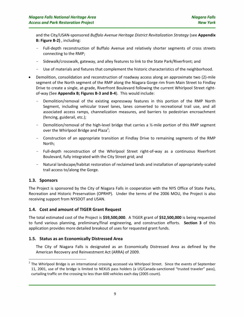
and the City/USAN‐sponsored Buffalo Avenue Heritage District Revitalization Strategy (see Appendix B: Figure B‐2) , including:
- Full‐depth reconstruction of Buffalo Avenue and relatively shorter segments of cross streets connecting to the RMP;
- Sidewalk/crosswalk, gateway, and alley features to link to the State Park/Riverfront; and
- Use of materials and fixtures that complement the historic characteristics of the neighborhood.
• Demolition, consolidation and reconstruction of roadway access along an approximate two (2)‐mile segment of the North segment of the RMP along the Niagara Gorge rim from Main Street to Findlay Drive to create a single, at‐grade, Riverfront Boulevard following the current Whirlpool Street right‐of‐way (See Appendix B; Figures B‐3 and B‐4). This would include:
- Demolition/removal of the existing expressway features in this portion of the RMP North Segment, including vehicular travel lanes, lanes converted to recreational trail use, and all associated access ramps, channelization measures, and barriers to pedestrian encroachment (fencing, guiderail, etc.);
- Demolition/removal of the high‐level bridge that carries a ½‐mile portion of this RMP segment over the Whirlpool Bridge and Plaza2;
- Construction of an appropriate transition at Findlay Drive to remaining segments of the RMP North;
- Full‐depth reconstruction of the Whirlpool Street right‐of‐way as a continuous Riverfront Boulevard, fully integrated with the City Street grid; and
- Natural landscape/habitat restoration of reclaimed lands and installation of appropriately‐scaled trail access to/along the Gorge.
1.3. Sponsors The Project is sponsored by the City of Niagara Falls in cooperation with the NYS Office of State Parks, Recreation and Historic Preservation (OPRHP). Under the terms of the 2006 MOU, the Project is also receiving support from NYSDOT and USAN.
1.4. Cost and amount of TIGER Grant Request
The total estimated cost of the Project is $59,500,000. A TIGER grant of $52,500,000 is being requested to fund various planning, preliminary/final engineering, and construction efforts. Section 3 of this application provides more detailed breakout of uses for requested grant funds.
1.5. Status as an Economically Distressed Area
The City of Niagara Falls is designated as an Economically Distressed Area as defined by the American Recovery and Reinvestment Act (ARRA) of 2009.
2 The Whirlpool Bridge is an international crossing accessed via Whirlpool Street. Since the events of September 11, 2001, use of the bridge is limited to NEXUS pass holders (a US/Canada‐sanctioned “trusted traveler” pass), curtailing traffic on the crossing to less than 600 vehicles each day (2005 count).

Upp
er Niaga
ra River
Robe
rt M
oses Parkw
ay –
South Segm
entBuffalo Avenu
e
Upp
er
Rapids
Falls
Falls
Robe
rt M
oses
Parkway –
North Segmen
t
Whirlpo
ol
Street
Figure 1: P
roject Location
John
B. D
aly Blvd
Interchange
Region
al Location
ProjectLocation
Niagara Falls National Heritage Area Niagara Falls Access and Park Restoration Project New York
11
2. PROJECT PARTIES
Federal Highway Administration (FHWA)
FHWA is the primary Federal agency with the responsibility of overseeing the National Highway System. FHWA’s mission is to “improve mobility on our nation’s highways through national leadership, innovation, and program delivery.” Given that the Project is currently using Federal transportation funds, the FHWA has and would continue to have the overall authority and responsibility for implementing and monitoring compliance with Federal laws, regulations and executive orders.
City of Niagara Falls, New York (the “City”)
The City of Niagara Falls, an Economically Distressed Area as defined under ARRA, is the most populous city in Niagara County, New York. Named after the world famous Falls, the city is located in Western New York on the eastern shore of the Niagara River, and is the second‐largest city in the Buffalo‐Niagara Falls metropolitan area. It has a population of 55,593 (2000) within a metropolitan area of 1,170,111 persons (2000). As a Project partner under the terms of the 2006 MOU, the City shares a responsibility for the conception, planning, programming, environmental review, design, and construction of the Project, particularly for its Buffalo Avenue and Whirlpool Street components.
New York State Office of Parks, Recreation, & Historic Preservation
OPRHP is the primary New York agency that owns/is responsible for administering State Park facilities and the NYS Parkway System, including Niagara Falls State Park, various parks along the Niagara Gorge (i.e., Whirlpool State Park, DeVeaux Woods State Park, etc.), and the RMP. In addition, a division of OPRHP is the designated State Historic Preservation Office (SHPO) for the State of New York. As a Project partner under the terms of the 2006 MOU, OPRHP would share in the conception, planning, programming, environmental review, and design of the Project, It could also be the contracting agency for the design/construction of the RMP components of the Project, or delegate these efforts to NYSDOT under their current interagency agreements (see below).
New York State Department of Transportation
Under agreement with OPRHP, NYSDOT is responsible for all maintenance of the RMP. As a primary signatory to the 2006 MOU, the Project has been considered a key priority by the Governor’s office (exhibited by the programming of State Multi‐Modal Access Program funds) and NYSDOT; regional staff members have been assigned to coordinate with other MOU sponsors to provide oversight/assistance. As with all Locally‐Administered Federal Aid Projects, NYSDOT ensures that activities delegated to local sponsors are completed in conformance with Federal and State requirements. For this Project, NYSDOT will review all project documents for completeness/sufficiency before submitting them to the FHWA for approval. If requested by OPRHP, they could also be a contracting entity for the Project.
USA Niagara Development Corporation/Empire State Development Corporation
USAN was created in 2001 with a mission to support/promote economic development in Niagara Falls by leveraging public/private investment and encouraging growth and renewal of the downtown section of the City. USAN/ESDC helped spearhead the negotiations that led to the 2006 MOU and contributed funding to the effort; it would continue to assist in providing technical support on Project planning/design documents and to help shape/guide redevelopment in areas adjoining the RMP.
Niagara Falls National Heritage Area Niagara Falls Access and Park Restoration Project New York
12
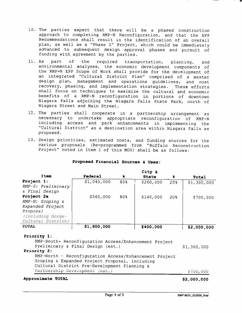
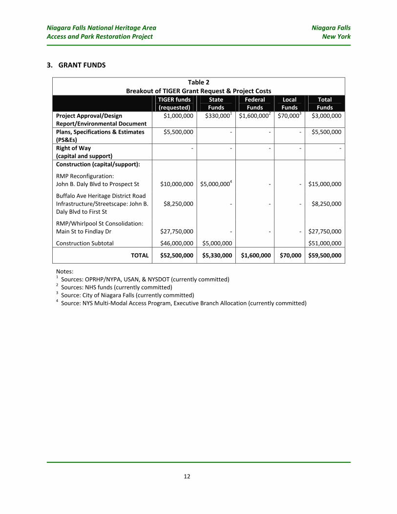
3. GRANT FUNDS
Table 2 Breakout of TIGER Grant Request & Project Costs
TIGER funds (requested)
State Funds
Federal Funds
Local Funds
Total Funds
Project Approval/Design Report/Environmental Document
$1,000,000 $330,0001 $1,600,0002 $70,0003 $3,000,000
Plans, Specifications & Estimates (PS&Es)
$5,500,000 ‐ ‐ ‐ $5,500,000
Right of Way (capital and support)
‐ ‐ ‐ ‐ ‐
Construction (capital/support):
RMP Reconfiguration: John B. Daly Blvd to Prospect St $10,000,000 $5,000,0004 ‐
‐ $15,000,000
Buffalo Ave Heritage District Road Infrastructure/Streetscape: John B. Daly Blvd to First St
$8,250,000 ‐ ‐ ‐ $8,250,000
RMP/Whirlpool St Consolidation: Main St to Findlay Dr $27,750,000 ‐ ‐
‐ $27,750,000
Construction Subtotal $46,000,000 $5,000,000 $51,000,000
TOTAL $52,500,000 $5,330,000 $1,600,000 $70,000 $59,500,000
Notes: 1 Sources: OPRHP/NYPA, USAN, & NYSDOT (currently committed) 2 Sources: NHS funds (currently committed) 3 Source: City of Niagara Falls (currently committed) 4 Source: NYS Multi‐Modal Access Program, Executive Branch Allocation (currently committed)
Niagara Falls National Heritage Area Niagara Falls Access and Park Restoration Project New York
13
4. PRIMARY SELECTION CRITERIA
4.1. Long‐Term Outcomes
4.1.1. Economic Competitiveness
Fully Realizing the Goal of Sustainable and Heritage‐Based Tourism
The Niagara Falls National Heritage Area Access and Park Restoration Project would represent a critical milestone to realizing a resurgence of the local economy by facilitating new visitorship to Niagara Falls and opening the setting/resources to activities necessary to extend the average length of stay. By linking State Park and natural wonders along the Niagara River to all portions of the City, new economic opportunity, activity and jobs would be created to serve these resources. Realizing this Project would be a major step toward the City policy goal of transitioning from an economy based primarily on basic manufacturing and heavy industry to a more diversified one that fully capitalizes on the benefits of ecotourism and environmentally‐sustainable development and business.
The premise of fully facilitating and interpreting the importance of environmental‐ and heritage‐based tourism is one of the main tenets of the National Heritage Area designation, based on the four broad thematic areas identified in the Niagara Falls National Heritage Area Feasibility Study:
• Natural Phenomenon: Niagara Falls, the Niagara River, and the Niagara Gorge are natural phenomena overwhelming in physical magnitude and deeply embedded in the popular consciousness;
• Tourism and Recreation: Niagara Falls has been a leading international tourist attraction for 200 years, influencing the development of tourism and nature conservation in North America;
• Power and Industry: Around 1895, Niagara Falls became the foremost source of hydroelectric power in North America, stimulating the development of innovative heavy industries in Niagara Falls and Buffalo; and
• Borderland/Border Crossing: The Niagara River area, a boundary between the United States and Canada, has played an important role in Indian culture, the French and English colonial struggle to control North America, the American Revolution, the War of 1812, and the Underground Railroad, and it reflects national differences and similarities between the two countries today.
All of these thematic areas would be fully facilitated by the proposed Project. It would result in a major expansion of park, open space, and natural resources along the Niagara River—creating a wide, accessible, green ribbon of resources linked to the City—able to allow for a host of new experiences and activities that would contribute to expanding visitorship and extending stay. This would create new opportunity and demand for various types of support development such as lodging, food‐and‐beverage, retail, and service uses, increased levels of local visitor spending and associated new job opportunities.
Complementing Other Projects
The implementation of the proposed Project would directly complement and build off of a number of other improvements and projects like OPRHP planned improvements of its network of trails leading into the Niagara Gorge (being financed through the Niagara River Greenway funds), as well as the City of Niagara Falls project to construct a new Intermodal Passenger Rail Station at the site of the former
Niagara Falls National Heritage Area Niagara Falls Access and Park Restoration Project New York
14
US Customs House, including a new Underground Railroad Interpretative Center. It would also support long‐term expansion plans at the Aquarium of Niagara, which would directly benefit through reconnection of its site to OPRHP’s Gorge Discovery Center and Gorge trailheads.
In turn, immediately north of the Project area, other Lower Niagara River municipalities have significantly invested in promoting tourism activities (e.g., Village/Town of Lewiston, Village of Youngstown, etc.). The proposed Project would be of mutual benefit to these communities, understanding that their economic future is shared with that of the Falls, and that an attractive linkage along the River would significantly promote regional tourism efforts.
Long‐Term and Continuing Economic Benefits
The City of Niagara Falls Waterfront Master Plan (prepared by Sasaki Associates and Halcyon Real Estate Advisors)—which proposed essentially all components of the Project in this application—included a full evaluation of the long‐term economic benefits of restoring access to the City’s Riverfront through a reconfiguration of access along the RMP corridor. This evaluation was predicated on two scenarios of future effects, a “Moderate Growth” Scenario, which projected a 20 percent increase in annual visitation from a baseline of six million visitors3 (i.e., 1.2 million new person trips) and a “High Growth Scenario”, which projected a 50 percent increase (i.e., three million new person trips). Using only the Moderate Scenario and adjusting the projections to current (2009) dollar levels, realization of the Niagara Falls National Heritage Area Access and Park Restoration Project could result in the following economic benefits:
• An net increase in demand for over one million new hotel room nights;
• A net annual increase in retail/non‐retail spending of $336 million;
• Net additional support (through rehabilitation or new development) of 548,000 SF of new retail space.
• Net additional support (through rehabilitation, new development, or increased occupancy) of 1,036 new hotel rooms.
• Net new retail, lodging, and travel‐related employment totaling 2,880 new jobs;
• Net new permanent annual payroll of $94 million
• New annual State income tax receipts of $2.8 million
• New annual State sales tax receipts of $11.5 million
4.1.2. Livability
The Project is projected to have a significant positive impact on quality of life throughout the City of Niagara Falls; however given that the Falls is an international icon visited by millions worldwide, these positive effects would be better characterized as national in stature.
3 Please note that since publication of this plan, estimates of visitation have increased to approximately eight million annually as a result of the opening of the Seneca Niagara Casino complex in downtown Niagara Falls. However, the effects noted herein do not reflect any expansion of the baseline assumed in the Waterfront Master Plan.
Niagara Falls National Heritage Area Niagara Falls Access and Park Restoration Project New York
15
Restoring full multimodal access to and along the Upper and Lower Niagara River would enhance and build on Niagara Falls State Park’s system of open space facilities designed by Frederick Law Olmsted—the father of American landscape architecture—and capitalize on the natural resources of the Riverfront, while promoting environmentally‐sustainable economic development.
Specifically, the Project would result in a significant expansion of pedestrian and bicycle access connecting core urban areas of the City (e.g., Main Street Business District and Downtown), heritage and historic districts (Park Place, Buffalo Avenue), and various heritage/cultural resources (Aquarium, US Customs House) to the magnificent natural resources along the Riverfront. In turn, linking Riverfront vehicular access with the urban grid would both expand accessibility and route choice, while maintaining enough road infrastructure to satisfy current and projected traffic demand.
Together, this restored access would directly benefit economically disadvantaged populations in the City by improving their enjoyment of such resources, improve their property value, and open various types of economic opportunity through expansion of economic activity and the local job base.
Various communities around the country have realized vast economic benefits to removing expressway facilities along their waterfronts that results in opening access to recreational resources, including significant increases in property values (for example, ranging as high as 300% in San Francisco, CA as a result of the reconfiguration of the Embarcadero Freeway). Even a modest increase of 15 percent in property values within 500 feet of the South and North segments of the RMP (totaling approximately $70 million) could realize $10.5 million in new property value along the corridor.
4.1.3. Sustainability
Considering proposed restoration of natural areas along the Upper River and the Niagara Gorge, the proposed Project would result in significant environmental sustainability benefits. This would include natural restoration of approximately 20 acres of currently paved, impervious surfaces along the River, comprising travel lanes of the RMP South and North segments that would be removed as part of the Project.
The benefits of such natural restoration, while not currently quantifiable in dollar value, would represent a major improvement to the environmental well‐being of habitats and water quality, including:
• Reduction in non‐point source pollutant runoff entering the Niagara River, which is currently designated as one of 42 “Areas of Concern” under the Great Lakes Water Quality Agreement between the US and Canada;
• Incorporation of native vegetation that would help improve water quality in the basin; and
• Restoration of habitat connectivity, including beginning to re‐link Old Growth Woods habitat in DeVeaux Woods State Park to the Gorge.
4.1.4. State of Good Repair
The Long Range Plan adopted by the regional metropolitan planning agency (the Greater Buffalo Niagara Regional Transportation Council [GBNRTC]) indicates that the Plan “allocates approximately 70 percent of the total anticipated funds for infrastructure maintenance over the twenty‐year plus horizon of the Plan.”
Niagara Falls National Heritage Area Niagara Falls Access and Park Restoration Project New York
16
This policy direction—clearly indicative of the mature nature of the region’s transportation infrastructure—indicates the importance of seeking measures to “right‐size” our regional infrastructure to address only what is needed to support mobility. By reducing the scale, extent, and number of lane miles of road and more maintenance‐intensive facilities like bridges and interchanges—particularly those that current/projected travel demand would not necessitate—the proposed project would result in a long‐term savings in resources devoted to regular and capital maintenance.
Using NYSDOT planning estimates for roadway and bridge maintenance, implementation of the proposed Project would result in a 20‐year net present value of $4.5 million in savings for regular maintenance activities like snow plowing, vegetation control, and bridge inspection.
In turn, by removing larger facilities like the RMP North’s high‐level Whirlpool Bridge overpass, implementation of the proposed Project could avoid a host of long‐term maintenance costs associated with activities such a painting and re‐decking. Together with capital maintenance for road segments, it is estimated that such future capital maintenance over 20 years would represent a net present value of roughly $24 million in savings.
4.1.5. Safety
Components of the proposed Project would be designed and built to meet all roadway design standards for safety based upon each components particular roadway type. It would remove some instances of non‐conforming features and some less conventional configurations on the RMP South and North segments that have resulted from past efforts to partially reconfigure the roadway, most recently in 2001 as part of the “pilot project” for the RMP North from Cedar Street to Lewiston.
While not quantifiable in dollar terms absent a full accident assessment, the Project would result in a more conventionally‐designed roadway system that contributes to safety improvements.
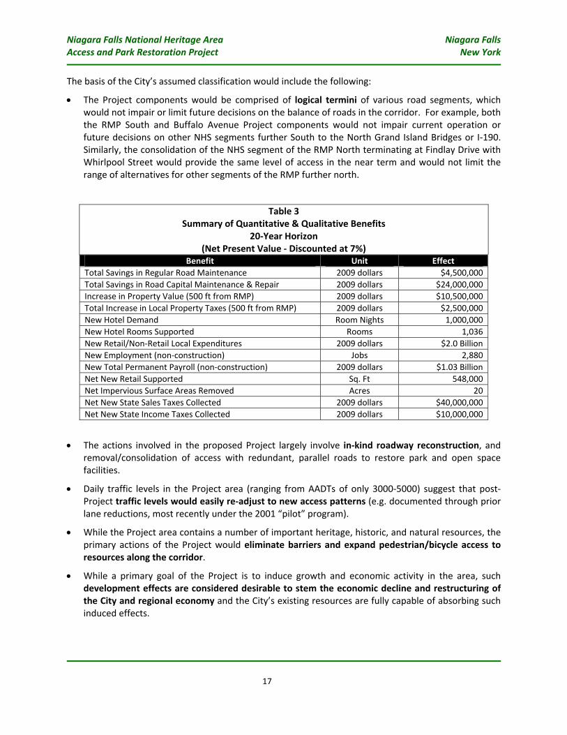
4.2. Summary of Project Benefits
The application of standard methods and traditional metrics for benefit‐cost analysis for transportation project (e.g., use of measures such as travel time savings, fuel savings, etc.) would not provide the full picture of potential benefits that would be generated by the proposed Project. This is primarily because the Project would involve reducing the amount of roadway infrastructure while preserving suitable access along the corridor, with little or no significant increase in travel times or mobility.
Nevertheless, a number of the aforementioned annual benefits of the Project can be quantified over a typical 20‐year horizon. Where applicable, dollar figures are discounted to net present value to illustrate anticipated benefits. These are presented in Table 3.
4.3. “Shovel‐Ready” Criteria 4.3.1. Environmental Approvals
Under FHWA regulations implementing the requirements of the National Environmental Policy Act (NEPA) at Title 23 of the Code of Federal Regulations (CFR) Part 771, the City of Niagara Falls considers that proposed Project could be reasonably classified as a ‘Class II’ Action requiring the filing of a Categorical Exclusion, with sufficient documentation and approval by FHWA, as provided under 23 CFR 771.117.
Niagara Falls National Heritage Area Niagara Falls Access and Park Restoration Project New York
17
The basis of the City’s assumed classification would include the following:
• The Project components would be comprised of logical termini of various road segments, which would not impair or limit future decisions on the balance of roads in the corridor. For example, both the RMP South and Buffalo Avenue Project components would not impair current operation or future decisions on other NHS segments further South to the North Grand Island Bridges or I‐190. Similarly, the consolidation of the NHS segment of the RMP North terminating at Findlay Drive with Whirlpool Street would provide the same level of access in the near term and would not limit the range of alternatives for other segments of the RMP further north.
Table 3 Summary of Quantitative & Qualitative Benefits
20‐Year Horizon (Net Present Value ‐ Discounted at 7%)
Benefit Unit Effect Total Savings in Regular Road Maintenance 2009 dollars $4,500,000 Total Savings in Road Capital Maintenance & Repair 2009 dollars $24,000,000 Increase in Property Value (500 ft from RMP) 2009 dollars $10,500,000 Total Increase in Local Property Taxes (500 ft from RMP) 2009 dollars $2,500,000 New Hotel Demand Room Nights 1,000,000 New Hotel Rooms Supported Rooms 1,036 New Retail/Non‐Retail Local Expenditures 2009 dollars $2.0 Billion New Employment (non‐construction) Jobs 2,880 New Total Permanent Payroll (non‐construction) 2009 dollars $1.03 Billion Net New Retail Supported Sq. Ft 548,000 Net Impervious Surface Areas Removed Acres 20 Net New State Sales Taxes Collected 2009 dollars $40,000,000 Net New State Income Taxes Collected 2009 dollars $10,000,000
• The actions involved in the proposed Project largely involve in‐kind roadway reconstruction, and removal/consolidation of access with redundant, parallel roads to restore park and open space facilities.
• Daily traffic levels in the Project area (ranging from AADTs of only 3000‐5000) suggest that post‐Project traffic levels would easily re‐adjust to new access patterns (e.g. documented through prior lane reductions, most recently under the 2001 “pilot” program).
• While the Project area contains a number of important heritage, historic, and natural resources, the primary actions of the Project would eliminate barriers and expand pedestrian/bicycle access to resources along the corridor.
• While a primary goal of the Project is to induce growth and economic activity in the area, such development effects are considered desirable to stem the economic decline and restructuring of the City and regional economy and the City’s existing resources are fully capable of absorbing such induced effects.
Niagara Falls National Heritage Area Niagara Falls Access and Park Restoration Project New York
18
• The Project would require no right‐of‐way acquisition and would result in no displacement of households or businesses. In fact, the Project would result in a net reduction in land dedicated to road infrastructure while providing an equivalent level of access.
Based on the foregoing, the City considers it feasible to assume that the information documented during the preliminary engineering process that the Project would be classified and processed as a Categorical Exclusion, significantly reducing the time involved in environmental documentation efforts.
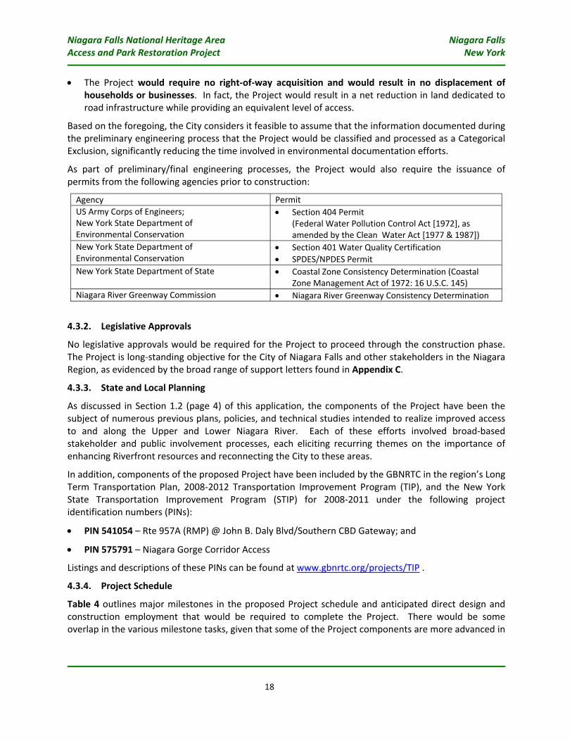
As part of preliminary/final engineering processes, the Project would also require the issuance of permits from the following agencies prior to construction:
Agency Permit US Army Corps of Engineers; New York State Department of Environmental Conservation
• Section 404 Permit (Federal Water Pollution Control Act [1972], as amended by the Clean Water Act [1977 & 1987])
New York State Department of Environmental Conservation
• Section 401 Water Quality Certification • SPDES/NPDES Permit
New York State Department of State • Coastal Zone Consistency Determination (Coastal Zone Management Act of 1972: 16 U.S.C. 145)
Niagara River Greenway Commission • Niagara River Greenway Consistency Determination
4.3.2. Legislative Approvals
No legislative approvals would be required for the Project to proceed through the construction phase. The Project is long‐standing objective for the City of Niagara Falls and other stakeholders in the Niagara Region, as evidenced by the broad range of support letters found in Appendix C.
4.3.3. State and Local Planning
As discussed in Section 1.2 (page 4) of this application, the components of the Project have been the subject of numerous previous plans, policies, and technical studies intended to realize improved access to and along the Upper and Lower Niagara River. Each of these efforts involved broad‐based stakeholder and public involvement processes, each eliciting recurring themes on the importance of enhancing Riverfront resources and reconnecting the City to these areas.
In addition, components of the proposed Project have been included by the GBNRTC in the region’s Long Term Transportation Plan, 2008‐2012 Transportation Improvement Program (TIP), and the New York State Transportation Improvement Program (STIP) for 2008‐2011 under the following project identification numbers (PINs):
• PIN 541054 – Rte 957A (RMP) @ John B. Daly Blvd/Southern CBD Gateway; and
• PIN 575791 – Niagara Gorge Corridor Access
Listings and descriptions of these PINs can be found at www.gbnrtc.org/projects/TIP .
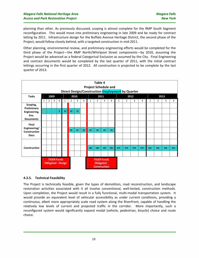
4.3.4. Project Schedule
Table 4 outlines major milestones in the proposed Project schedule and anticipated direct design and construction employment that would be required to complete the Project. There would be some overlap in the various milestone tasks, given that some of the Project components are more advanced in
Niagara Falls National Heritage Area Niagara Falls Access and Park Restoration Project New York
19
planning than other. As previously discussed, scoping is almost complete for the RMP South Segment reconfiguration. This would move into preliminary engineering in late 2009 and be ready for contract letting by 2011. Infrastructure design for the Buffalo Avenue Heritage District, the second phase of the Project, would follow closely behind, with a targeted construction in mid‐2011.
Other planning, environmental review, and preliminary engineering efforts would be completed for the third phase of the Project—the RMP North/Whirlpool Street components—by 2010, assuming the Project would be advanced as a federal Categorical Exclusion as assumed by the City. Final Engineering and contract documents would be completed by the last quarter of 2011, with the initial contract lettings occurring in the first quarter of 2012. All construction is projected to be complete by the last quarter of 2013.
Table 4 Project Schedule and
Direct Design/Construction Employment by Quarter 2009 2010 2011 2012 2013 Tasks
1 2 3 4 1 2 3 4 1 2 3 4 1 2 3 4 1 2 3 4
3 15 15 15
Scoping, Preliminary Engineering,
Env. Documents
15 15 15 15 15 15 15
Final Engineering/ Construction
Docs
181 181 181 181 272 272 272 272 152 152 152 152 Construction
TIGER Funds
Obligated ‐ Design TIGER Funds
Obligated ‐ Construction
4.3.5. Technical Feasibility
The Project is technically feasible, given the types of demolition, road reconstruction, and landscape restoration activities associated with it all involve conventional, well‐tested, construction methods. Upon completion, the Project would result in a fully functional, multi‐modal transportation system. It would provide an equivalent level of vehicular accessibility as under current conditions, providing a continuous, albeit more appropriately scale road system along the Riverfront, capable of handling the relatively low levels of current and projected traffic in the corridor. More importantly, such a reconfigured system would significantly expand modal (vehicle, pedestrian, bicycle) choice and route choice.
Niagara Falls National Heritage Area Niagara Falls Access and Park Restoration Project New York
20
4.3.6. Financial Feasibility
Based upon the conceptual cost estimates (see Appendix D), award of the requested TIGER grant would fully fund planning, design, and construction activities for the proposed Project. Given that the cost estimates are based on a concept level of detail, each carry a contingency of 15‐20% for certain construction items.
The Project partners (OPRHP, City of Niagara Falls) are well adept in contracting and administering planning, design, and construction of infrastructure projects of this scale and magnitude.
4.4. Job Creation & Economic Stimulus
4.4.1. Short‐Term Direct/Indirect Jobs
The Project would generate a considerable level of short‐term economic activity that would create needed jobs in the region. In addition, the Project is expected to generate broad increases in economic activity that would create both low‐ and high‐skilled jobs across various industries.
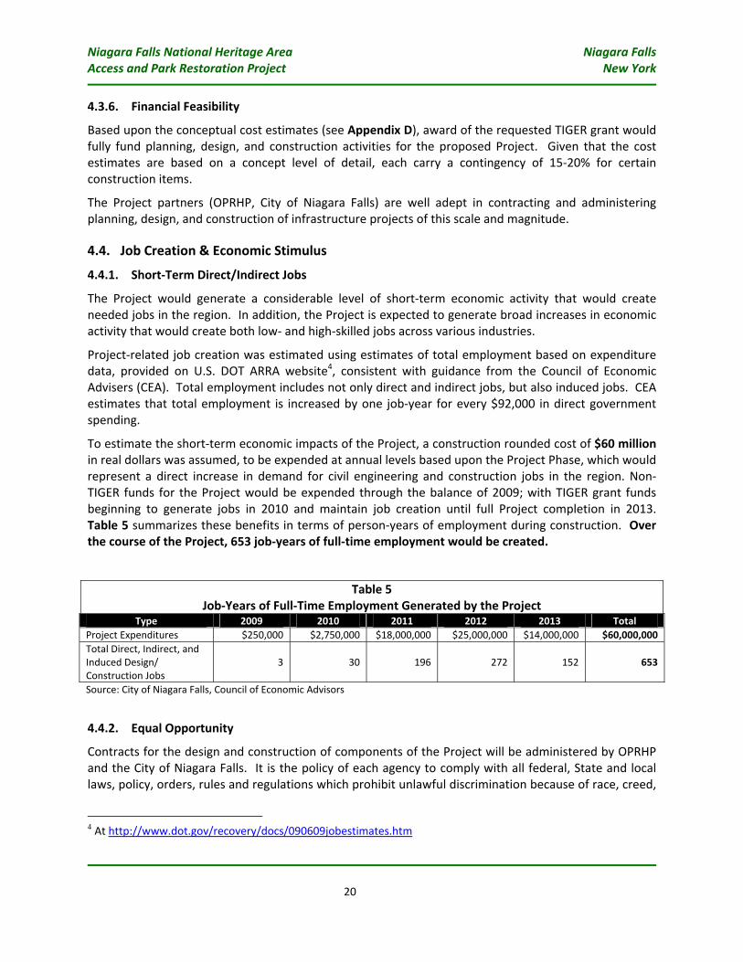
Project‐related job creation was estimated using estimates of total employment based on expenditure data, provided on U.S. DOT ARRA website4, consistent with guidance from the Council of Economic Advisers (CEA). Total employment includes not only direct and indirect jobs, but also induced jobs. CEA estimates that total employment is increased by one job‐year for every $92,000 in direct government spending.
To estimate the short‐term economic impacts of the Project, a construction rounded cost of $60 million in real dollars was assumed, to be expended at annual levels based upon the Project Phase, which would represent a direct increase in demand for civil engineering and construction jobs in the region. Non‐TIGER funds for the Project would be expended through the balance of 2009; with TIGER grant funds beginning to generate jobs in 2010 and maintain job creation until full Project completion in 2013. Table 5 summarizes these benefits in terms of person‐years of employment during construction. Over the course of the Project, 653 job‐years of full‐time employment would be created.
Table 5 Job‐Years of Full‐Time Employment Generated by the Project
Type 2009 2010 2011 2012 2013 Total Project Expenditures $250,000 $2,750,000 $18,000,000 $25,000,000 $14,000,000 $60,000,000 Total Direct, Indirect, and Induced Design/ Construction Jobs
3 30 196 272 152 653
Source: City of Niagara Falls, Council of Economic Advisors
4.4.2. Equal Opportunity
Contracts for the design and construction of components of the Project will be administered by OPRHP and the City of Niagara Falls. It is the policy of each agency to comply with all federal, State and local laws, policy, orders, rules and regulations which prohibit unlawful discrimination because of race, creed,
4 At http://www.dot.gov/recovery/docs/090609jobestimates.htm
Niagara Falls National Heritage Area Niagara Falls Access and Park Restoration Project New York
21
color, national origin, sex, sexual orientation, age, disability or marital status, and to take affirmative action in working with contracting parties to ensure that federal disadvantaged business enterprises (DBEs), New York State Business Enterprises, Minority and Women‐owned Business Enterprises (M/WBEs), Minority Group Members and women share in the economic opportunities generated by each agency’s participation in projects or initiatives, including the establishment of non‐discrimination and affirmative action contracting goals.
4.4.3. Evaluation of Project Performance
The Project partners are committed to monitoring and reporting the actual impacts of the proposed Project. Preliminary studies from the scoping and environmental document would demonstrate the anticipated metrics including refined estimates of construction jobs that the Project will create, budget and schedule, and anticipated positive economic benefits. Upon completion of the Project, the City would undertake monitoring and evaluation efforts to fully document the Project’s performance.
Niagara Falls National Heritage Area Niagara Falls Access and Park Restoration Project New York
22
5. SECONDARY SELECTION CRITERIA
5.1. Innovation While the actual components of the Project involve relatively conventional construction and transportation technologies, the overall initiative to invest in “right‐sizing” our infrastructure systems to that to which is actually needed to support long‐term mobility is clearly innovative in terms of asset management.
Reconfiguring elements of the RMP South and North segments would realize significant long‐term savings in administrative and in‐field resources to maintain and operate transportation facilities in the Project area. At the same time, the Project would greatly expand mobility for non‐vehicular modes and create proximity benefits in neighborhoods and districts adjoining the Riverfront.
5.2. Partnership Project Partners
As evidenced by the 2006 MOU, key agencies have established a critical partnership to jointly solicit/oversee/coordinate funding, planning, design, and construction for the proposed Project. These agencies have and will continue to dedicate personnel, skill sets, and funding to realize this most important effort.
Jurisdictional and Stakeholder Collaboration
The various planning efforts leading to this application have fostered the support and concurrence among a broad range of municipalities, elected officials, and interest groups on the importance of enhancing and improving the setting of the Upper and Niagara Riverfront, given its international, national, and regional significance.
The Project partners strongly believe that this collaboration will allow for timely decisions, fully‐vetted resolutions, and more engaged stakeholders, and are confident that this level of collaboration will allow for the Project to meet the Grant deadlines. Early communication with the stakeholder groups resulted in the gathering of information and ideas from residents, businesses, cultural, and environmental organizations and individuals.
5.3. Environmentally Related Federal, State and Local Actions
As previously discussed, the City assumes that the Project could be classified under NEPA (23 CFR 771, Section 771.115) as a “Class II” Action requiring the filing of a Categorical Exclusion. The Project has received federal funding for a portion of required planning and preliminary engineering studies and will be following the Safe, Accountable, Flexible, Efficient Transportation Equity Act: A Legacy for Users (SAFETEA‐LU) guidance. Within SAFETEA‐LU, Section 6002 guidance prescribes changes to existing procedures for implementing NEPA making the environmental review process more efficient and timely.
Additionally, planning and environmental information documented for the Project under the federal NEPA requirements would also be used to address the requirements of the New York State Environmental Quality Review Act (SEQRA). Under SEQRA, the Project would be classified as a “Type I”
Niagara Falls National Heritage Area Niagara Falls Access and Park Restoration Project New York
23
action, because it would exceed certain thresholds for a particular project (e.g., projects affecting more than ten acres of land). Type I actions require a coordinated environmental review among various regulatory and funding agencies. Using the City’s assumed criteria/considerations for a potential federal Categorical Exclusion, its is similarly assumed that this documentation would contribute to the issuance of a SEQRA “Negative Declaration”, indicating that a SEQRA environmental impact statement would not be required for the Project.
Niagara Falls National Heritage Area Niagara Falls Access and Park Restoration Project New York
25
7. APPENDICES
Appendix A: Existing Context Photographs
Appendix B: Illustrations of Components of the Proposed Project
Appendix C: Support Letters
Appendix D: Conceptual Cost Estimates
Appendix E: 2006 MOU between City of Niagara Falls, OPRHP, NYSDOT, and USAN
Niagara Falls National Heritage Area Niagara Falls Access and Park Restoration Project New York
APPENDIX A:
EXISTING CONTEXT PHOTOGRAPHS
Upper NiagaraRiver
Joh
nB
.D
aly
Blv
d
Fou
rth
St
Bu
ffa
loA
ve
.
Rober
tM
ose
sPa
rkw
ay
South
Segm
ent
Bu
ffa
loA
ve
nu
eH
eri
tag
eD
istr
ict
Do
wn
tow
n
En
tra
nce
to
Nia
ga
raFa
lls
Sta
teP
ark
Up
pe
rR
ap
ids
Fig
ure
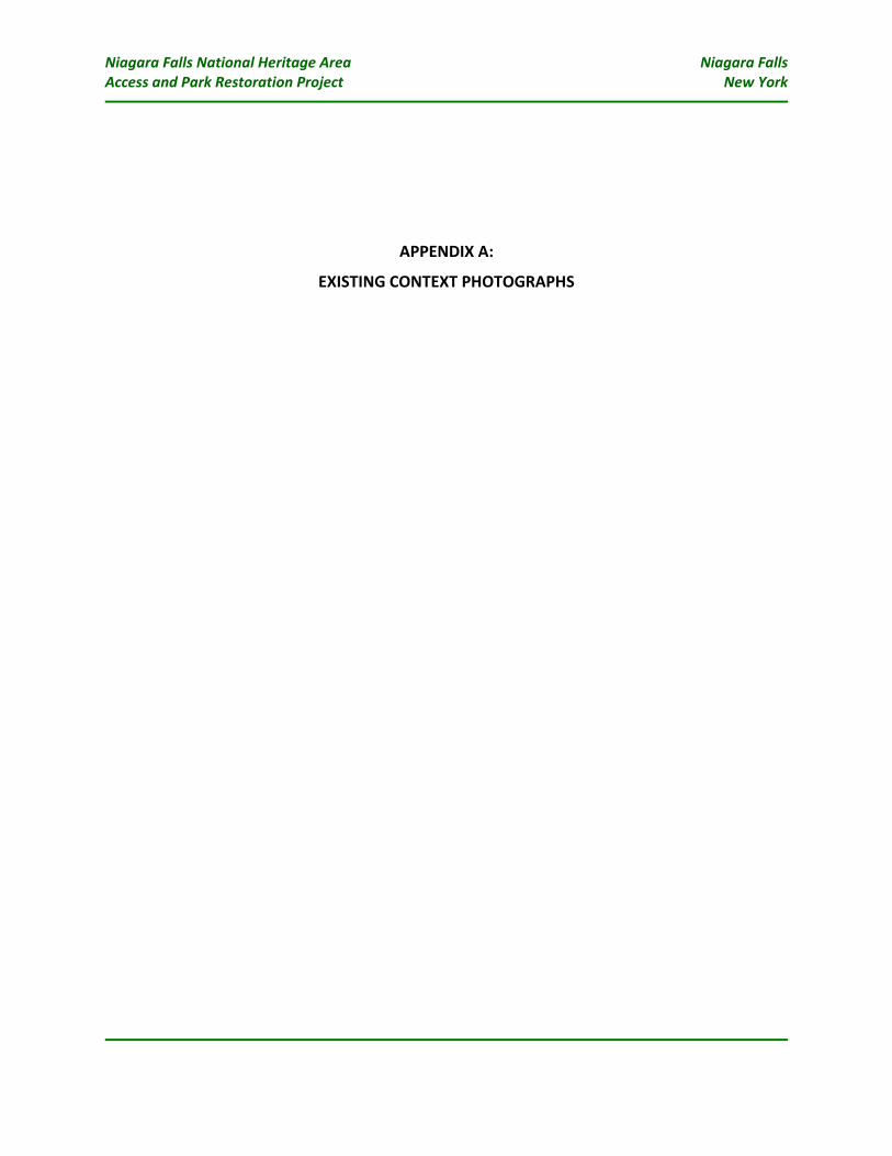
A-1
:A
eri
al
vie
wo
fR
MP
So
uth
Se
gm
en
ta
tJo
hn
B.
Da
lyB
lvd
.in
terc
ha
ng
e.
Am
ajo
rp
ort
ion
of
RM
Ptr
aff
ice
nte
rs/e
xits
the
Cit
ya
tth
isp
oin
t.
InN
iaga
raFa
lls
Sta
teP
ark
,o
nly
ha
lfo
fth
ee
xpre
ssw
ay
(NB
lan
es)
isu
sed
toa
llo
win
bo
un
d-o
nly
acc
ess
toth
eP
ark
;fo
rme
rS
Bla
ne
sh
ave
be
en
stri
pe
dfo
r“o
n-s
tre
et”
pa
rkin
g.
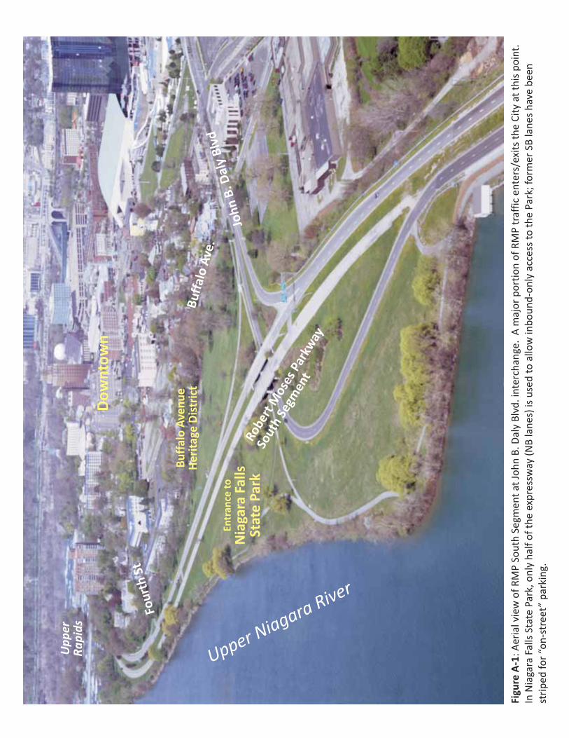
Fig
ure
A-2
Gro
un
d-l
ev
el
vie
ws
fro
mth
eB
uff
alo
Av
en
ue
He
rita
ge
Dis
tric
tto
RM
PS
ou
thS
eg
me
nt
fro
mR
ive
rsid
eD
r(t
op
)a
nd
do
wn
Fo
urt
hS
tre
et
(bo
tto
m).
Th
ee
xp
ress
wa
yin
fra
stru
ctu
reb
lock
sv
iew
sa
nd
imp
ed
es
acc
ess
toth
eR
ive
r’s
ed
ge
.
:
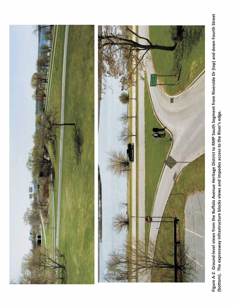
Figure A-3 n: Aerial view of RMP North Segment and Whirlpool Street, looking south toward downtow Niagara
Falls. The two roadways run immediately parallel from downtown to Findlay Drive, each carrying only about
3,000 vehicle trips per day. The former SB lanes of the RMP in this segment have been converted to a wide
bike/recreational “trail”, however the entire right-of-way is secured by fence/guiderail, preventing access to the
Niagara Gorge.
Wh
irlp
oo
l Str
eet
Ro
be
rtM
ose
sP
ark
way
Low
er
Nia
ga
raR
iver
Bic
ycl
e/R
ecr
eati
on
alTr
ail
Downtown
Park PlaceHistoric District
WhirlpoolState Park
NiagaraGorge
American &Horseshoe Falls
Fig
ure
A-4
:A
eri
alv
iew
of
RM
PN
ort
hS
eg
me
nt
an
dW
hir
lpo
olS
tre
et,
imm
ed
iate
lya
dja
cen
td
ow
nto
wn
Nia
ga
raFa
lls.
Inth
isa
rea
,th
eTr
ail
tra
nsi
tio
ns
ba
ckto
aty
pic
al
exp
ress
wa
yse
ctio
n,
term
ina
tin
ga
tM
ain
Str
ee
t.T
he
da
she
dli
ne
de
no
tes
wh
ere
cro
ss-a
cce
ssfo
rp
ed
est
ria
ns
be
twe
en
do
wn
tow
na
nd
the
Go
rge
isp
roh
ibit
ed
,exc
ep
ta
tp
ed
est
ria
nb
rid
ge
be
twe
en
Aq
ua
riu
m&
Nia
ga
raG
org
eD
isco
very
Ce
nte
r.
Do
wn
tow
nN
iag
ara
Fall
s
Nia
ga
raG
org
eD
isco
ve
ryC
en
ter
Aq
ua
riu
mo
fN
iag
ara
Pe
de
stri
an
Bri
dg
e
Nia
ga
raFa
lls
Sta
teP
ark
Whirl
poolStreet
Ma
inS
tre
et
RobertMosesParkway
Third Street
Fig
ure
A-5
:Ae
ria
lvie
wo
fR
MP
No
rth
Se
gm
en
ta
nd
Wh
irlp
oo
lStr
ee
t,lo
ok
ing
no
rth
tow
ard
Fin
dla
yD
rive
.A
hig
h-l
eve
love
rpa
ssca
rrie
sth
eR
MP
ove
rth
e
Wh
irlp
oo
lBri
dg
e,f
urt
he
rcu
ttin
go
ffa
cce
ssto
the
Nia
ga
raG
org
e.
On
lyh
alf
the
ove
rpa
ssis
no
wu
sed
for
veh
icle
tra
ffic
,th
efo
rme
rS
Bla
ne
sh
ave
be
en
con
vert
ed
toa
wid
ere
cre
ati
on
alt
rail
.H
isto
ric
reso
urc
es
like
are
ma
inin
ga
bu
tme
nt
oft
he
form
er
Nia
ga
raFa
lls
Su
spe
nsi
on
Bri
dg
e(d
ocu
me
nte
da
sb
ein
g
use
db
yH
arr
iet
Tub
ma
nto
shu
ttle
esc
ap
ing
sla
ves
toC
an
ad
ain
the
19
thce
ntu
ry),
as
we
lla
sth
efo
rme
rU
SC
ust
om
sH
ou
se,l
ies
un
de
rne
ath
the
ove
rpa
ss.
Wh
irlp
oo
lStr
ee
t
Ro
be
rtM
ose
sP
ark
way
Lo
we
rN
iag
ara
Riv
er
Bic
ycl
e/R
ecr
ea
tio
na
lTra
il
Nia
ga
raG
org
e
Nia
gara
Falls
Susp
ensi
onBr
idge
Abut
men
t
Form
erU
SCu
stom
sH
ouse
Ma
inS
tre
et
Bu
sin
ess
Dis
tric
t
DeV
eaux
Woo
dsSt
ate
Park F
ind
lay
Dr
Wh
irlp
oo
lB
r(N
EX
US
Pa
ssO
nly
)
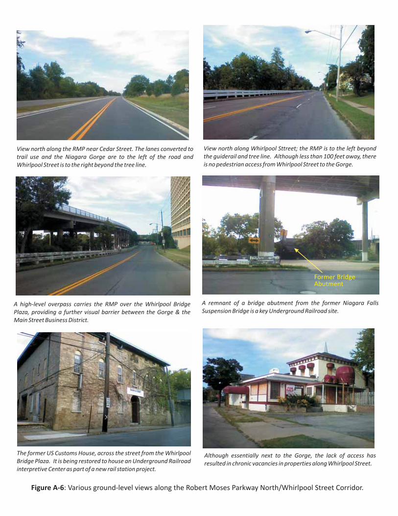
Figure A-6: Various ground-level views along the Robert Moses Parkway North/Whirlpool Street Corridor.
A high-level overpass carries the RMP over the Whirlpool Bridge
Plaza, providing a further visual barrier between the Gorge & the
Main Street Business District.
View north along the RMP near Cedar Street. The lanes converted to
trail use and the Niagara Gorge are to the left of the road and
Whirlpool Street is to the right beyond the tree line.
View north along Whirlpool Sttreet; the RMP is to the left beyond
the guiderail and tree line. Although less than 100 feet away, there
is no pedestrian access from Whirlpool Street to the Gorge.
A remnant of a bridge abutment from the former Niagara Falls
Suspension Bridge is a key Underground Railroad site.
Although essentially next to the Gorge, the lack of access has
resulted in chronic vacancies in properties along Whirlpool Street.
The former US Customs House, across the street from the Whirlpool
Bridge Plaza. It is being restored to house an Underground Railroad
interpretive Center as part of a new rail station project.
Former BridgeAbutment
Niagara Falls National Heritage Area Niagara Falls Access and Park Restoration Project New York
APPENDIX B:
ILLUSTRATIONS OF COMPONENTS OF THE PROPOSED PROJECT
Fig
ure
B-1
Co
nce
ptu
al
Ali
gn
me
nt
-R
ob
ert
Mo
ses
Pa
rkw
ay
So
uth
Se
gm
en
t-
Joh
nB
.D
aly
Blv
dto
Pro
spe
ctS
tre
et
:
Se
lect
ed
as
the
pre
ferr
ed
alt
ern
ati
vea
risi
ng
ou
to
fit
sP
ub
lic
Sco
pin
gP
roce
ss,
the
ali
gn
me
nt
wo
uld
rem
ove
all
exi
stin
ge
xpre
ssw
ay
/in
terc
ha
ng
e
infr
ast
ruct
ure
an
dg
rad
ese
pa
rati
on
tocr
ea
tea
two
-la
ne
en
try
roa
dfr
om
Joh
nB
.D
aly
Blv
dto
Pro
spe
ctS
tre
et.
Th
eco
nce
pt
de
sig
nin
clu
de
sa
full
pro
gra
mo
fla
nd
sca
pe
/ha
bit
at
rest
ora
tio
n,
ne
wtr
ail
con
ne
ctio
ns
to/a
lon
gth
eR
ive
r,sc
en
ico
verl
oo
ks,
an
db
ett
er
tra
nsi
tio
ns
toth
eB
uff
alo
Ave
nu
e
He
rita
ge
Dis
tric
ta
nd
the
Cit
yst
ree
tg
rid
.
Bu
ffa
loA
ven
ue
He
rita
ge
Dis
tric
t
Fig
ure
B-2
Co
nce
ptu
al
Ma
ste
rP
lan
-B
uff
alo
Av
en
ue
He
rita
ge
Dis
tric
tR
oa
dIn
fra
stru
ctu
re-
Joh
nB
.D
aly
Blv
dto
Fir
stS
tre
et
:
Re
com
me
nd
ed
as
pa
rto
fC
ity
/USA
N-s
po
nso
ed
revit
ali
zati
on
stra
teg
yin
lig
ht
of
ne
wa
cce
ss/o
pp
ort
un
ity
pro
vid
ed
by
op
en
ing
Riv
erf
ron
ta
cce
ssin
on
eo
fth
eC
ity
’so
lde
stn
eig
hb
orh
oo
ds,
this
com
po
ne
nt
wo
uld
invo
lve
full
-de
pth
reco
nst
ruct
ion
of
Bu
ffa
loA
ven
ue
an
dcr
oss
-str
ee
tse
gm
en
ts
con
ne
ctin
gto
the
RM
P,st
ree
tsca
pe
/ga
tew
ay
fea
ture
s,a
nd
use
of
ma
teri
als
/fix
ture
sto
com
ple
me
nt
the
his
tori
cre
sou
rce
sin
the
Dis
tric
t.
Robe
rtM
oses
Park
way
-Sou
thSe
gmen
tPl
anne
dfo
rRec
onfig
urat
ion
Figure B-3 Concept Design - Reconfiguration of Robert Moses Parkway North/Whirlpool Street, Main Street to
Findlay Drive:
Figure B-4
:
Originally proposed as part of the and later refined in various
other plans, the concept would remove expressway features of the RMP North segment and consolidate access
along a new Riverfront Boulevard along the current alignment of Whirlpool Street. This would fully open
downtown and the City’s north end to pedestrian/bicycle access to various park and natural resources along the
Niagara Gorge (See also Section in ).
Niagara Falls Waterfront Master Plan
Low
er
Nia
gara
Riv
er/
Nia
gara
Gorg
e
Pine Avenue
Lew
isto
nRo
ad
Park PlaceHistoricDistrict
Th
ird
Str
ee
t
Findlay Drive
Whirpool Br
DeVeaux WoodsState Park
FormerUS Customs
House
GorgeDiscovery
Ctr
WhirlpoolState Park
Niagara FallsState Park
Aquarium
Whirlpool Street:
New Riverfront
Boulevard
Main StreetBusiness District
Downtown
Main
Stre
et
Main
Stre
et
Fig
ure
B-4
Co
nce
ptu
al
Se
ctio
na
nd
Ch
ara
cte
rD
iag
ram
s-
Ro
be
rtM
ose
sP
ark
wa
yN
ort
h/W
hir
lpo
ol
Str
ee
tR
eco
nfi
gu
rati
on
:
Niagara Falls National Heritage Area Niagara Falls Access and Park Restoration Project New York
APPENDIX C:
SUPPORT LETTERS
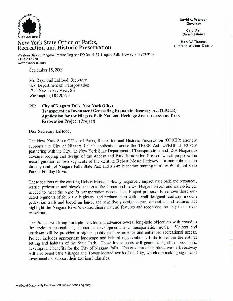
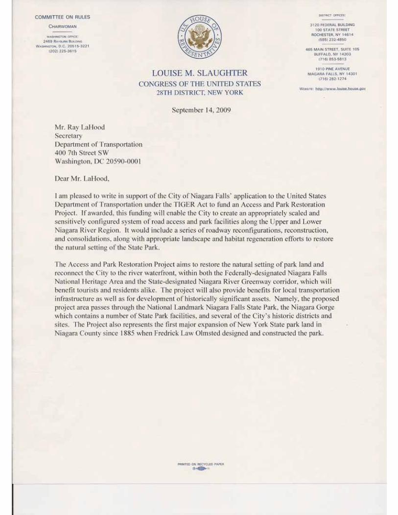
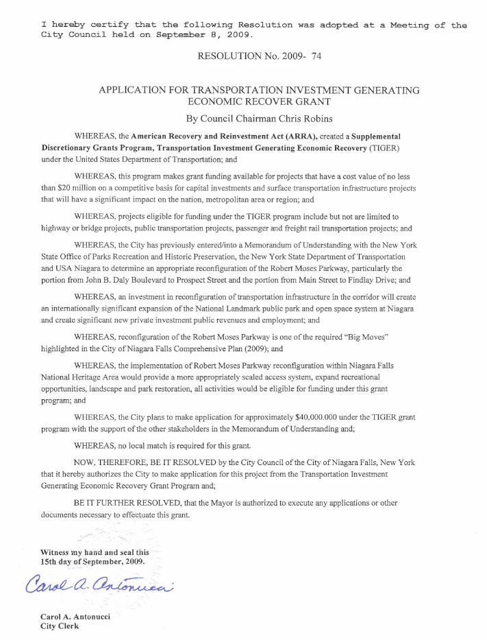

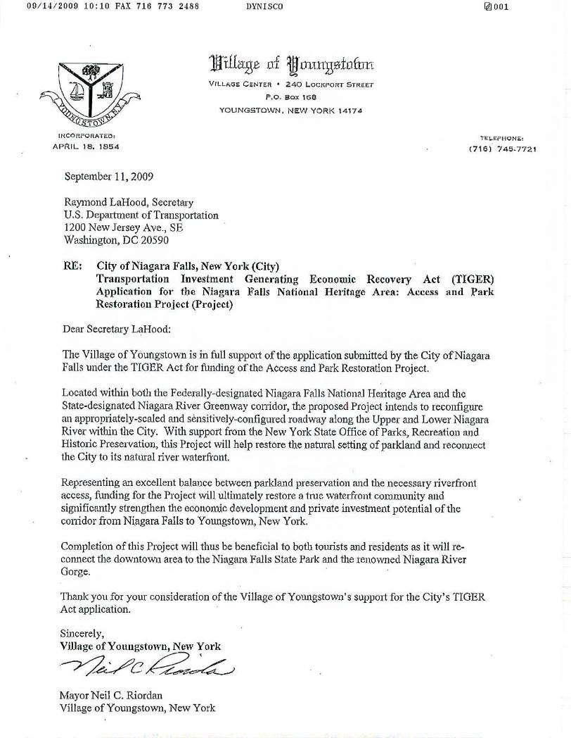
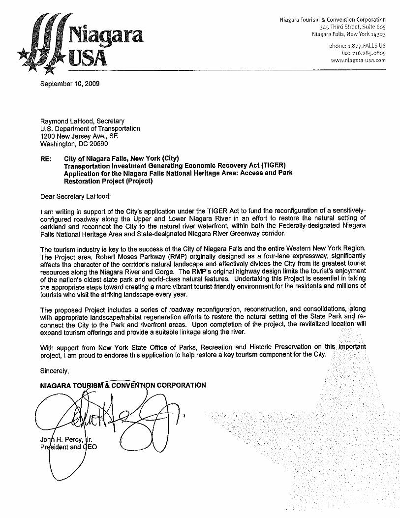
Niagara Falls National Heritage Area Niagara Falls Access and Park Restoration Project New York
APPENDIX D:
CONCEPTUAL COST ESTIMATES
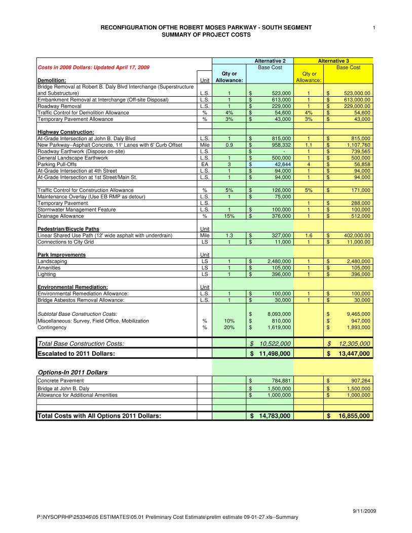
RECONFIGURATION OFTHE ROBERT MOSES PARKWAY - SOUTH SEGMENT
SUMMARY OF PROJECT COSTS
1
Costs in 2008 Dollars: Updated April 17, 2009 Base Cost Base Cost
Demolition: Unit
Qty or
Allowance:
Qty or
Allowance:
Bridge Removal at Robert B. Daly Blvd Interchange (Superstructure
and Substructure) L.S. 1 523,000$ 1 523,000.00$
Embankment Removal at Interchange (Off-site Disposal) L.S. 1 613,000$ 1 613,000.00$
Roadway Removal L.S. 1 229,000$ 1 229,000.00$
Traffic Control for Demolition Allowance % 4% 54,600$ 4% 54,600$
Temporary Pavement Allowance % 3% 43,000$ 3% 43,000$
Highway Construction:
At-Grade Intersection at John B. Daly Blvd L.S. 1 815,000$ 1 815,000$
New Parkway--Asphalt Concrete, 11' Lanes with 6' Curb Offset Mile 0.9 958,332$ 1.1 1,107,760$
Roadway Earthwork (Dispose on-site) L.S. -$ 1 739,565$
General Landscape Earthwork L.S. 1 500,000$ 1 500,000$
Parking Pull-Offs EA 3 42,644$ 4 56,858$
At-Grade Intersection at 4th Street L.S. 1 94,000$ 1 94,000$
At-Grade Intersection at 1st Street/Main St. L.S. 1 94,000$ 1 94,000$
Traffic Control for Construction Allowance % 5% 126,000$ 5% 171,000$
Maintenance Overlay (Use EB RMP as detour) L.S. 1 75,000$
Temporary Pavement L.S. 1 288,000$
Stormwater Management Feature L.S. 1 100,000$ 1 100,000$
Drainage Allowance % 15% 376,000$ 1 512,000$
Pedestrian/Bicycle Paths Unit
Linear Shared Use Path (12' wide asphalt with underdrain) Mile 1.3 327,000$ 1.6 402,000.00$
Connections to City Grid LS 1 11,000$ 1 11,000.00$
Park Improvements Unit
Landscaping LS 1 2,480,000$ 1 2,480,000$
Amenities LS 1 105,000$ 1 105,000$
Lighting LS 1 396,000$ 1 396,000$
Environmental Remediation: Unit
Environmental Remediation Allowance: L.S. 1 100,000$ 1 100,000$
Bridge Asbestos Removal Allowance: L.S. 1 30,000$ 1 30,000$
Subtotal Base Construction Costs: 8,093,000$ 9,465,000$
Miscellaneous: Survey, Field Office, Mobilization % 10% 810,000$ 947,000$
Contingency % 20% 1,619,000$ 1,893,000$
Total Base Construction Costs: 10,522,000$ 12,305,000$
Escalated to 2011 Dollars: 11,498,000$ 13,447,000$
Options-In 2011 Dollars
Concrete Pavement 784,881$ 907,264$
Bridge at John B. Daly 1,500,000$ 1,500,000$
Allowance for Additional Amenities 1,000,000$ 1,000,000$
Total Costs with All Options 2011 Dollars: 14,783,000$ 16,855,000$
Alternative 3Alternative 2
P:\NYSOPRHP\253346\05 ESTIMATES\05.01 Preliminary Cost Estimate\prelim estimate 09-01-27.xls--Summary9/11/2009
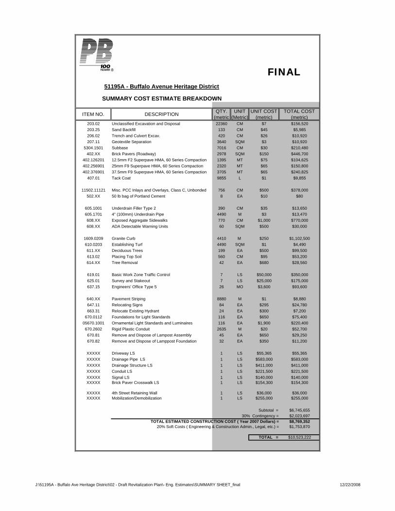
51195A - Buffalo Avenue Heritage District
SUMMARY COST ESTIMATE BREAKDOWN
ITEM NO. DESCRIPTION QTY. (metric
UNIT (Metric)
UNIT COST (metric)
TOTAL COST (metric)
203.02 Unclassified Excavation and Disposal 22360 CM $7 $156,520203.25 Sand Backfill 133 CM $45 $5,985206.02 Trench and Culvert Excav. 420 CM $26 $10,920207.11 Geotextile Separation 3640 SQM $3 $10,920
5304.1501 Subbase 7016 CM $30 $210,480402.XX Brick Pavers (Roadway) 2978 SQM $150 $446,700
402.126201 12.5mm F2 Superpave HMA, 60 Series Compaction 1395 MT $75 $104,625402.256901 25mm F9 Superpave HMA, 60 Series Compaction 2320 MT $65 $150,800402.376901 37.5mm F9 Superpave HMA, 60 Series Compaction 3705 MT $65 $240,825
407.01 Tack Coat 9855 L $1 $9,855
11502.11121 Misc. PCC Inlays and Overlays, Class C, Unbonded 756 CM $500 $378,000502.XX 50 lb bag of Portland Cement 8 EA $10 $80
605.1001 Underdrain Filler Type 2 390 CM $35 $13,650605.1701 4" (100mm) Underdrain Pipe 4490 M $3 $13,470608.XX Exposed Aggregate Sidewalks 770 CM $1,000 $770,000608.XX ADA Detectable Warning Units 60 SQM $500 $30,000
1609.0209 Granite Curb 4410 M $250 $1,102,500610.0203 Establishing Turf 4490 SQM $1 $4,490611.XX Deciduous Trees 199 EA $500 $99,500613.02 Placing Top Soil 560 CM $95 $53,200614.XX Tree Removal 42 EA $680 $28,560
619.01 Basic Work Zone Traffic Control 7 LS $50,000 $350,000625.01 Survey and Stakeout 7 LS $25,000 $175,000637.15 Engineers' Office Type 5 26 MO $3,600 $93,600
640.XX Pavement Striping 8880 M $1 $8,880647.11 Relocating Signs 84 EA $295 $24,780663.31 Relocate Existing Hydrant 24 EA $300 $7,200
670.0112 Foundations for Light Standards 116 EA $650 $75,40005670.1001 Ornamental Light Standards and Luminaires 116 EA $1,900 $220,400670.2602 Rigid Plastic Conduit 2635 M $20 $52,700670.81 Remove and Dispose of Lampost Assembly 45 EA $650 $29,250670.82 Remove and Dispose of Lamppost Foundation 32 EA $350 $11,200
XXXXX Driveway LS 1 LS $55,365 $55,365XXXXX Drainage Pipe LS 1 LS $583,000 $583,000XXXXX Drainage Structure LS 1 LS $411,000 $411,000XXXXX Conduit LS 1 LS $221,500 $221,500XXXXX Signal LS 1 LS $140,000 $140,000XXXXX Brick Paver Crosswalk LS 1 LS $154,300 $154,300
XXXXX 4th Street Retaining Wall 1 LS $36,000 $36,000XXXXX Mobilization/Demobilization 1 LS $255,000 $255,000
Subtotal = $6,745,65530% Contingency = $2,023,697
TOTAL ESTIMATED CONSTRUCTION COST ( Year 2007 Dollars) = $8,769,35220% Soft Costs ( Engineering & Construction Admin., Legal, etc.) = $1,753,870
TOTAL = $10,523,222
FINAL
J:\51195A - Buffalo Ave Heritage District\02 - Draft Revitalization Plan\- Eng. Estimates\SUMMARY SHEET_final 12/22/2008
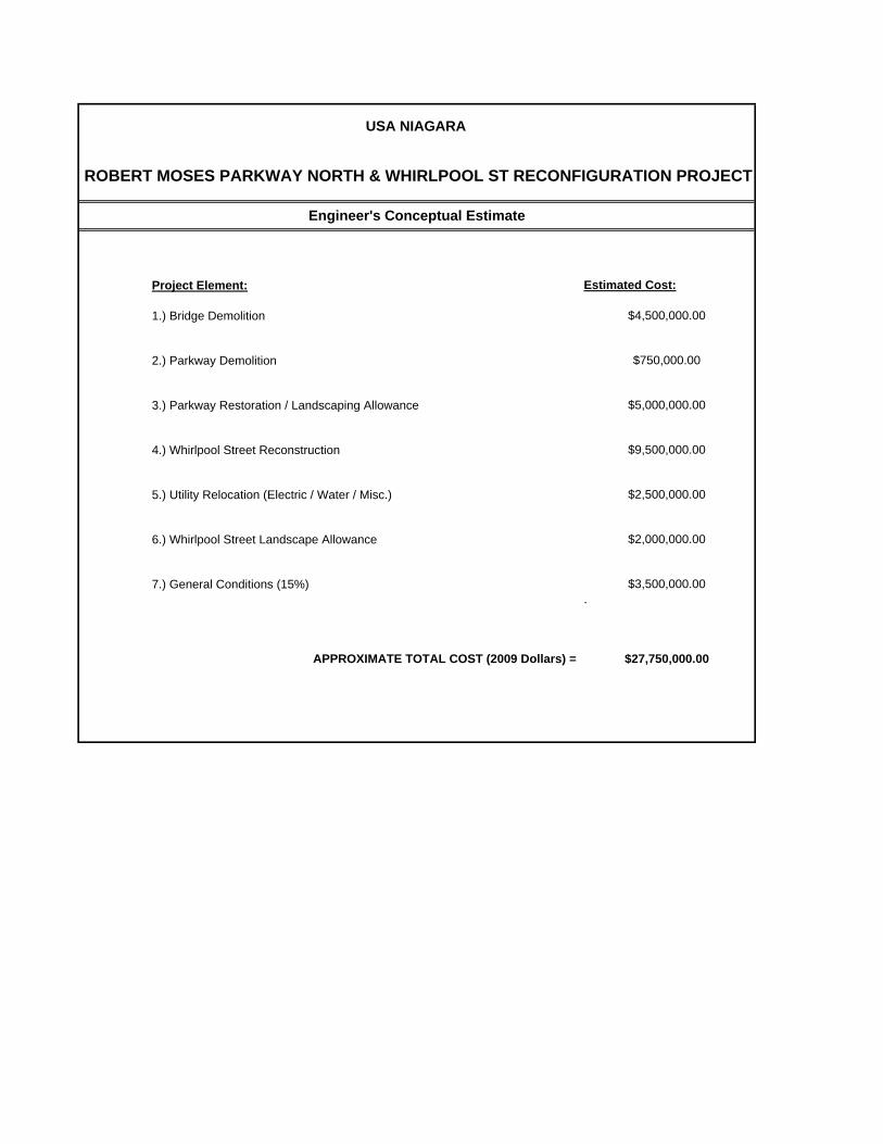
Project Element:
1.) Bridge Demolition
2.) Parkway Demolition
3.) Parkway Restoration / Landscaping Allowance
4.) Whirlpool Street Reconstruction
5.) Utility Relocation (Electric / Water / Misc.)
6.) Whirlpool Street Landscape Allowance
7.) General Conditions (15%).
APPROXIMATE TOTAL COST (2009 Dollars) =
$3,500,000.00
$9,500,000.00
$2,500,000.00
$2,000,000.00
$27,750,000.00
USA NIAGARA
ROBERT MOSES PARKWAY NORTH & WHIRLPOOL ST RECONFIGURATION PROJECT
$4,500,000.00
$750,000.00
$5,000,000.00
Engineer's Conceptual Estimate
Estimated Cost:
Niagara Falls National Heritage Area Niagara Falls Access and Park Restoration Project New York
APPENDIX E:
2006 MOU BETWEEN CITY OF NIAGARA FALLS, OPRHP, NYSDOT, AND USAN