IDAHO INFORMATION GUIDE - nplnews bluebook rev _July 2009_web.pdf · IDAHO INFORMATION GUIDE:...
58
BUREAU OF LAND MANAGEMENT IDAHO STATE OFFICE ======================================================================== IDAHO INFORMATION GUIDE: LOCATING MINING CLAIMS July 2009 1
Transcript of IDAHO INFORMATION GUIDE - nplnews bluebook rev _July 2009_web.pdf · IDAHO INFORMATION GUIDE:...
BUREAU OF LAND MANAGEMENT IDAHO STATE OFFICE
========================================================================
IDAHO INFORMATION GUIDE:
LOCATING MINING CLAIMS
July 2009
1
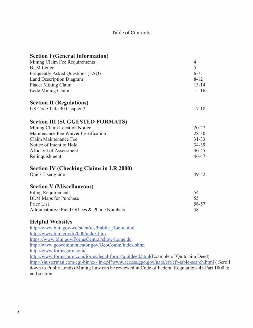
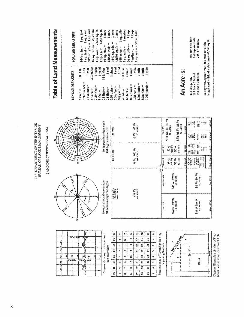
Table of Contents
Section I (General Information) Mining Claim Fee Requirements 4 BLM Letter 5 Frequently Asked Questions (FAQ) 6-7 Land Description Diagram 8-12 Placer Mining Claim 13-14 Lode Mining Claim 15-16
Section II (Regulations) US Code Title 30 Chapter 2 17-18
Section III (SUGGESTED FORMATS) Mining Claim Location Notice 20-27 Maintenance Fee Waiver Certification 28-30 Claim Maintenance Fee 31-33 Notice of Intent to Hold 34-39 Affidavit of Assessment 40-45 Relinquishment 46-47
Section IV (Checking Claims in LR 2000) Quick User guide 49-52
Section V (Miscellaneous) Filing Requirements 54 BLM Maps for Purchase 55 Price List 56-57 Administrative Field Offices & Phone Numbers 58
Helpful Websites http://www.blm.gov/wo/st/en/res/Public_Room.htmlhttp://www.blm.gov/lr2000/index.htmhttps://www.blm.gov/FormsCentral/show-home.dohttp://www.geocommunicator.gov/GeoComm/index.shtmhttp://www.formsguru.com/ http://www.formsguru.com/forms/legal-forms/quitdeed.html(Example of Quitclaim Deed) http://shusterman.com/cgi-bin/ex-link.pl?www.access.gpo.gov/nara/cfr/cfr-table-search.html ( Scroll down to Public Lands) Mining Law can be reviewed in Code of Federal Regulations 43 Part 1000 to end section
2
INTENTIONALLYBLANK
3
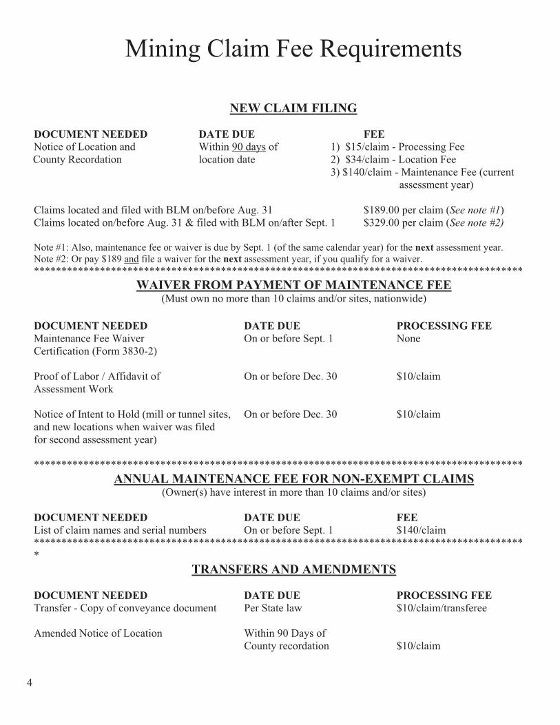
Mining Claim Fee Requirements
NEW CLAIM FILING
DOCUMENT NEEDED DATE DUE FEENotice of Location and Within 90 days of 1) $15/claim - Processing Fee County Recordation location date 2) $34/claim - Location Fee
3) $140/claim - Maintenance Fee (current assessment year)
Claims located and filed with BLM on/before Aug. 31 $189.00 per claim (See note #1)Claims located on/before Aug. 31 & filed with BLM on/after Sept. 1 $329.00 per claim (See note #2)
Note #1: Also, maintenance fee or waiver is due by Sept. 1 (of the same calendar year) for the next assessment year. Note #2: Or pay $189 and file a waiver for the next assessment year, if you qualify for a waiver. *****************************************************************************************
WAIVER FROM PAYMENT OF MAINTENANCE FEE(Must own no more than 10 claims and/or sites, nationwide)
DOCUMENT NEEDED DATE DUE PROCESSING FEEMaintenance Fee Waiver On or before Sept. 1 None Certification (Form 3830-2)
Proof of Labor / Affidavit of On or before Dec. 30 $10/claim Assessment Work
Notice of Intent to Hold (mill or tunnel sites, On or before Dec. 30 $10/claim and new locations when waiver was filed for second assessment year)
*****************************************************************************************ANNUAL MAINTENANCE FEE FOR NON-EXEMPT CLAIMS
(Owner(s) have interest in more than 10 claims and/or sites)
DOCUMENT NEEDED DATE DUE FEEList of claim names and serial numbers On or before Sept. 1 $140/claim ******************************************************************************************
TRANSFERS AND AMENDMENTS
DOCUMENT NEEDED DATE DUE PROCESSING FEETransfer - Copy of conveyance document Per State law $10/claim/transferee
Amended Notice of Location Within 90 Days of County recordation $10/claim
4

United States Department of the InteriorBUREAU OF LAND MANAGEMENT
Idaho State Office 1387 South Vinnell Way
Boise, Idaho 83709 http://www.id.blm.gov
In Reply Refer To: 3830 (933 NP)
Enclosed is information about locating mining claims in Idaho. We do not maintain a general map of existing claims or areas open to mineral entry. We have surface status maps that indicate BLM, Forest, State, and private lands. A map index is included at the back of this brochure to help you identify the map and BLM District Office that covers your area of interest.
BLM records of land status in Idaho, called Master Title Plats (MTPs), are available for inspection at the Idaho State Office or the BLM District Offices for their management area. These records indicate ownership of lands, and whether or not lands are open to mineral entry. You need to know the legal description (township, range, section) of the area in question in order to use these records. Paper copies of the MTPs may be purchased for $1.10 each. MTPs are also accessible at the GLO website http://www.glorecords.blm.gov/ under the LSR tab.
Mining claim files are kept at the Idaho State Office. These files contain location notice(s), map(s), and other filed documents. Copies from these files are available for a fee (see the enclosed fee list).
Active and closed unpatented mining claim data can be viewed on the Land and Mineral LR2000 web page at www.blm.gov/lr2000 or the Land and Mineral Use Records Viewer at www.geocommunicator.gov. You may research by owner name, claim name, IMC number, or legal description (meridian, township, range, section).The legal description is required when searching for claims in a particular area. To completely research what lands are open for mining claim location, a combination of these records, in addition to the applicable County’s records, should be inspected.
We do not provide official forms but provide sample formats for the following: Mining Claim Location Notice, Affidavit of Assessment of Work, Notice of Intent to Hold, Maintenance Fee, and Relinquishment. The only official form is the Small Miners Waiver
The Information Access Center is open Monday through Friday from 9:00 am to 4:00 pm, except Federal holidays. We can also be reached by phone at (208) 373-3889, or fax (208) 373-3899.
5
FREQUENTLY ASKED QUESTIONS
1. What are Locatable Minerals?
Locatable minerals can be obtained by locating a mining claim. Locatable minerals include both metallic minerals (gold, silver, lead, etc.) and nonmetallic minerals (fluorspar, ornamental stone possessing unique characteristics, sulfur, barite, zeolite, gemstones, etc.) Originally, all minerals except for coal were obtained under the General Mining Laws, however, Congress has removed certain minerals from the operation of the General Mining Law.
Leasable Minerals. Leasable minerals today include oil and gas, oil shale, geothermal resources, potash, sodium, native asphalt, solid and semisolid bitumen, bituminous rock, phosphate, and coal.
Mineral Materials. Since 1947, the Federal Government has sold common varieties of sand, gravel, homate, stone, pumice, pumicite, cinders, and ordinary clay. Use of salable minerals requires either a sales contract or a free use permit. The BLM may issue free use permits to a government agency or a non-profit organization. The Forest Service administers the disposal of salable minerals from the National Forest System lands.
2. What is a mining claim?
“ That portion of the public mineral lands which a miner, for mining purposes, takes and holds in accordance with mining laws”. The right is restricted to the development and extraction of a mineral deposit as regulated by the BLM or the Forest Service. The rights granted by a mining claim are valid against a challenge by the United States and other claimants only after the discovery of a valuable mineral deposit. Generally speaking, a mining claim is referred to as a lode claim if mineralization occurs as a vein of ore in place or as a placer claim if minerals are dispersed among particles of sand or gravel. A millsite is used to process minerals from a lode or placer claim.
3. Can I file a mining claim on any Federal land?
Not all Federal lands are open for mining claims. There are Federally administered lands in 19 States where you may file a mineral claim or site: Alaska, Arizona, Arkansas, California, Colorado, Florida, Idaho, Louisiana, Mississippi, Montana, Nebraska, Nevada, New Mexico, North Dakota, Oregon, South Dakota, Utah, Washington, and Wyoming. In these States, the BLM manages the surface BLM lands and the Forest Service manages the surface National Forest System lands. Excepting mineral materials, the BLM is responsible for the minerals on both BLM and National Forest System lands.
You may prospect and locate claims and sites on lands open to mineral entry. Claims may not be staked in areas closed to mineral entry by a special act of Congress, regulation, or public land order. These areas are withdrawn from the operation of the mining laws.
Areas withdrawn from location of mining claims include National Parks, National Monuments, Indian reservations, most reclamation projects, military reservations, scientific testing areas, most wildlife protection areas (such as Federal wildlife refuges), and lands withdrawn from mineral entry for other reasons. Lands withdrawn for power development may be subject to mining location and entry only under certain conditions. Mining claims may not be located on lands that have been:
� designated by Congress as part of the National Wilderness Preservation System, � designated as wild portions of a Wild and Scenic River, or � withdrawn by Congress for study as a Wild and Scenic River.
6
There is usually a 1/4 –mile buffer zone on either side of a river while the river is being studied for inclusion in the Wild and Scenic Rivers System.
Locatable (hard-rock) minerals on most lands acquired by the United States and on Indian reservations are leasable. The Bureau of Indian Affairs is responsible for leasing minerals on Tribal lands and lands held in trust for the benefit of individual American Indians.
4. Can I start mining after I file my mining claim?
No. You must get all necessary permits before you start mining, even if you have completed filing your mining claim. Most Federal agencies have regulations to protect the surface resources of the Federal lands during exploration and mining activities. You must submit a notice or a plan of operations before conducting any surface-disturbing activities, except for casual use activities. You also must reclaim disturbed sites after you complete your exploration and mining activities. Most State governments also have mining and reclamation requirements. To avoid duplication, several States have entered into cooperative agreements with Federal agencies. Operators should check with Federal and State agencies to determine the proper lead agency before submitting a plan of operation. You must also provide a financial guarantee
-BLM Lands: Exploration and mining activities on mining claims on BLM-administered land are subject to the regulations of the Secretary of the Interior in 43 CFR 3809 and for Wilderness Study Areas, 43 CFR 3802. These regulations require an operator to prevent unnecessary or undue degradation of the land. For activities other than casual use, they require the operator to submit either a notice or plan of operations and a reclamation plan.
-Forest Service Lands: Exploration and mining activities on lands administered by the Forest Service are subject to the regulations of the Secretary of Agriculture in 36 CFR 228(A). These regulations require that anyone whose proposed operation could likely cause significant disturbance of surface resources must submit a plan of operations. Miners wishing to prospect or locate claims or sites in National Forests should contact the local Forest Service District Ranger concerning questions about operating plans.
5. How can I get minerals commonly used for construction?
There is no specific application form for requesting removal of mineral materials from public lands. Persons interested in buying mineral materials on public land should contact the nearest BLM Field Office or the Forest Service for mineral materials located in National forests.
6. Can I get mineral materials for free?
The BLM may grant free use permits to governmental agencies, non-profit organizations, and corporations. The permittee is not allowed to barter or sell the mineral materials acquired under the permit. Federal, State and local governmental agencies may be granted free use permits for mineral materials, if they can show that a public need exists for the material. The BLM may allow non-profit organizations and corporations, such as churches and scouting organizations, to remove limited quantities of mineral materials.
7. Who May file a mining claim?
- Citizens of the US over the age of discretion, which for Idaho is 18 - Legal Immigrants who have filed an application for citizenship - Business entity organized under the law of any state - Duly constituted and appointed agent
7
8

9

10
11

Note: Do not part your parcel down to less than 2.5 acres
12
PLACERCLAIM
13

PLACER MINING CLAIMBoundaries and claim corners/angles clearly marked before recording in county courthouse.
�Each post/monument marked with name of claim, position or number of corner (or angle) and direction of boundary lines.
�Corner post or monument at least 4’ high and 4” square or in diameter.
�Post “Notice of Location” at one corner of the claim.
�Placer claims may not exceed 20 acres per locator and 160 acres per claim.
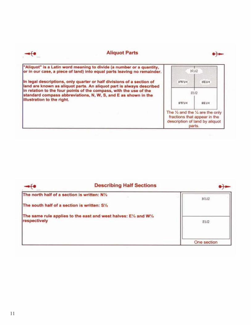
Notice of Location1. Name & address of all locators2. Name of the claim3. Date of Location4. Legal description in aliquot
parts and complete lots (i.e. S1/2NENE)
5. Include map or sketch of claim6. Must record with both county and
BLM within 90 days of location date.
Corner #4 Corner #1
Corner #3 Corner #2
SW ¼ SE ¼
NW ¼NW ¼
SW ¼NW ¼
NE ¼NE ¼ 1 29.75
2 19.55
3 10.75 4 15.75
69524D/C (private) SE ¼NE ¼
Lot number Acres in lot
Sec. 20
14
LODECLAIM
15
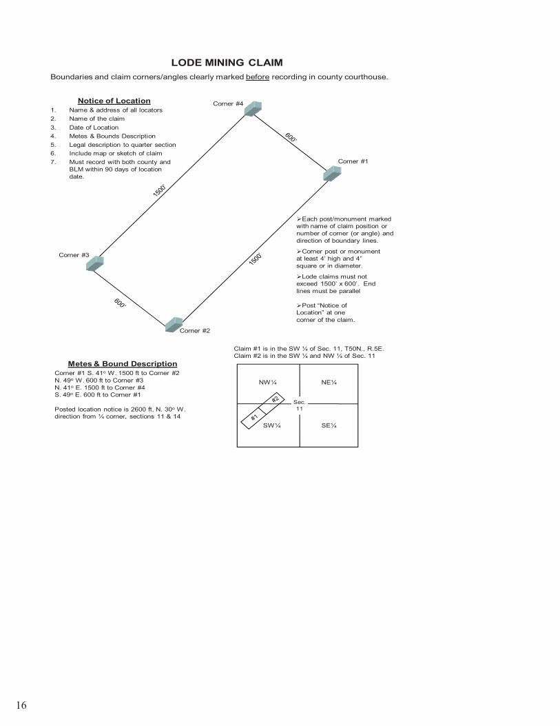
LODE MINING CLAIMBoundaries and claim corners/angles clearly marked before recording in county courthouse.
Claim #1 is in the SW ¼ of Sec. 11, T50N., R.5E.Claim #2 is in the SW ¼ and NW ¼ of Sec. 11
�Each post/monument marked with name of claim position or number of corner (or angle) and direction of boundary lines.
�Corner post or monument at least 4’ high and 4” square or in diameter.
�Post “Notice of Location” at one corner of the claim.
�Lode claims must not exceed 1500’ x 600’. End lines must be parallel
Notice of Location1. Name & address of all locators2. Name of the claim3. Date of Location4. Metes & Bounds Description5. Legal description to quarter section6. Include map or sketch of claim7. Must record with both county and
BLM within 90 days of location date.
Metes & Bound DescriptionCorner #1 S. 41o W. 1500 ft to Corner #2N. 49o W. 600 ft to Corner #3N. 41o E. 1500 ft to Corner #4S. 49o E. 600 ft to Corner #1
Posted location notice is 2600 ft, N. 30o W. direction from ¼ corner, sections 11 & 14
Corner #4
Corner #1
Corner #3
Corner #2
Sec. 11
NW¼ NE¼
SE¼SW¼
16

SECTION II Statutes and Regulations
17
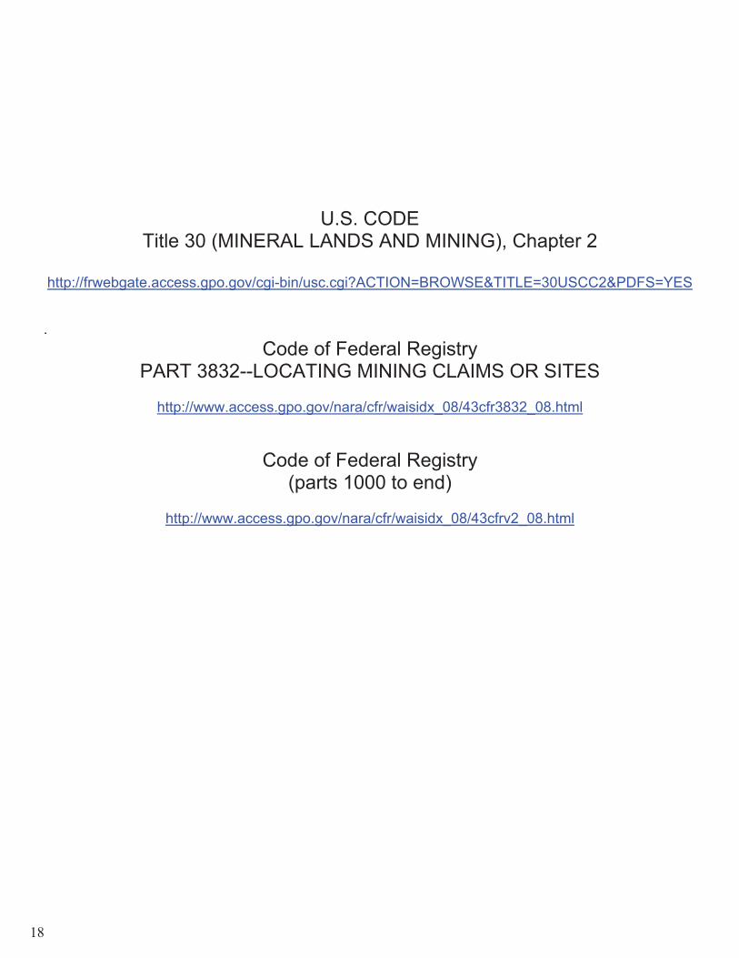
U.S. CODE Title 30 (MINERAL LANDS AND MINING), Chapter 2
http://frwebgate.access.gpo.gov/cgi-bin/usc.cgi?ACTION=BROWSE&TITLE=30USCC2&PDFS=YES
.Code of Federal Registry
PART 3832--LOCATING MINING CLAIMS OR SITES
http://www.access.gpo.gov/nara/cfr/waisidx_08/43cfr3832_08.html
Code of Federal Registry (parts 1000 to end)
http://www.access.gpo.gov/nara/cfr/waisidx_08/43cfrv2_08.html
18
SECTION III SUGGESTED FORMATS
ANDINSTRUCTIONS
19

EXAMPLE LOCATION NOTICE FOR MINING CLAIM
For Bureau of Land Management Use For County Recorder’s Use
1. Name of Claim _______________________ Type of Claim: ( ) Lode ( ) Placer ( ) Millsite ( ) Tunnel site 2. Date of Location _________________________ ( ) Claim is located in P.L. 359, Powersite Withdrawal 3. This claim is located in _____________ County, State of __________, _____________Meridian, Township _______, Range _______, Section __________, Quarter Section__________.
Township ______, Range _______, Section _______, Quarter Section _______________________ Township ______, Range _______, Section _______, Quarter Section _______________________ Township ______, Range _______, Section _______, Quarter Section _______________________ Township ______, Range _______, Section _______, Quarter Section _______________________
4. The boundaries are described as follows using distance & direction (metes & bound) beginning at corner monument where notice is posted which is Corner ___#1__
Thence ______________________ To Corner or Angle __________ Thence ______________________ To Corner or Angle __________ Thence ______________________ To Corner or Angle __________ Thence ______________________ To Corner or Angle __________ TO THE POINT OF BEGINNING.
IF MORE THAN 4 CORNERS OR ANGLES Thence ______________________ To Corner or Angle __________ Thence ______________________ To Corner or Angle __________
Posted location notice is further described as ______feet, _____________direction from ____________ (Permanent survey monument or natural object, i.e., topographic feature).
The adjoining claims/sites are: ____________________________________________________
5. Claimant(s)Name and Address: Name_________________________________________ ______________________________________ Address_______________________________________ (Signature) ______________________________________________ Email _________________________________________
Name_________________________________________ ______________________________________ Address_______________________________________ (Signature) ______________________________________________ Email _________________________________________
Rge ____
Twp. ____
NSec. 11
1. Name of your claim
2. You can only file one type of claim per form. If you want both a placer and a lode claim you must fill out two separate forms and pay two separate claim fees
2a. Mark if your claim is located within a powersite withdrawal area
3. You have 90 days from the date of location to file with the BLM. If you exceed this time the claim will be abandoned.
Note: The location date is the actual date you located on the ground and marked the corners
4. State the county in which the claim is located
5. Idaho 6. Boise Meridian
20

EXAMPLE LOCATION NOTICE FOR MINING CLAIM
For Bureau of Land Management Use For County Recorder’s Use
1. Name of Claim _______________________ Type of Claim: ( ) Lode ( ) Placer ( ) Millsite ( ) Tunnel site 2. Date of Location _________________________ ( ) Claim is located in P.L. 359, Powersite Withdrawal 3. This claim is located in _____________ County, State of __________, _____________Meridian, Township _______, Range _______, Section __________, Quarter Section__________.
Township ______, Range _______, Section _______, Quarter Section _______________________ Township ______, Range _______, Section _______, Quarter Section _______________________ Township ______, Range _______, Section _______, Quarter Section _______________________ Township ______, Range _______, Section _______, Quarter Section _______________________
4. The boundaries are described as follows using distance & direction (metes & bound) beginning at corner monument where notice is posted which is Corner ___#1__
Thence ______________________ To Corner or Angle __________ Thence ______________________ To Corner or Angle __________ Thence ______________________ To Corner or Angle __________ Thence ______________________ To Corner or Angle __________ TO THE POINT OF BEGINNING.
IF MORE THAN 4 CORNERS OR ANGLES Thence ______________________ To Corner or Angle __________ Thence ______________________ To Corner or Angle __________
Posted location notice is further described as ______feet, _____________direction from ____________ (Permanent survey monument or natural object, i.e., topographic feature).
The adjoining claims/sites are: ____________________________________________________
5. Claimant(s)Name and Address: Name_________________________________________ ______________________________________ Address_______________________________________ (Signature) ______________________________________________ Email _________________________________________
Name_________________________________________ ______________________________________ Address_______________________________________ (Signature) ______________________________________________ Email _________________________________________
Rge ____
Twp. ____
NSec. 11
7.�State�your�Township�(North�or�South)�which�can�be�identified�on�a�BLM�surface�management�map�
8.�State�your�Range�(East�or�West)�which�can�be�identified�on�BLM�surface�management�map�
9.�State�your�section�(1�36)�which�can�be�identified�on�BLM�surface�management�map�
10.��See�mining�claim�information�booklet�for�aliquot�part�descriptions.��Most�placer�claims�are�described�using�aliquot�parts�and�lode�claims�are�described�via�metes�and�bounds.��Note:�It�is�not�necessary�to�use�both�when�describing�your�claim�
21

EXAMPLE LOCATION NOTICE FOR MINING CLAIM
For Bureau of Land Management Use For County Recorder’s Use
1. Name of Claim _______________________ Type of Claim: ( ) Lode ( ) Placer ( ) Millsite ( ) Tunnel site 2. Date of Location _________________________ ( ) Claim is located in P.L. 359, Powersite Withdrawal 3. This claim is located in _____________ County, State of __________, _____________Meridian, Township _______, Range _______, Section __________, Quarter Section__________.
Township ______, Range _______, Section _______, Quarter Section _______________________ Township ______, Range _______, Section _______, Quarter Section _______________________ Township ______, Range _______, Section _______, Quarter Section _______________________ Township ______, Range _______, Section _______, Quarter Section _______________________
4. The boundaries are described as follows using distance & direction (metes & bound) beginning at corner monument where notice is posted which is Corner ___#1__
Thence ______________________ To Corner or Angle __________ Thence ______________________ To Corner or Angle __________ Thence ______________________ To Corner or Angle __________ Thence ______________________ To Corner or Angle __________ TO THE POINT OF BEGINNING.
IF MORE THAN 4 CORNERS OR ANGLES Thence ______________________ To Corner or Angle __________ Thence ______________________ To Corner or Angle __________
Posted location notice is further described as ______feet, _____________direction from ____________ (Permanent survey monument or natural object, i.e., topographic feature).
The adjoining claims/sites are: ____________________________________________________
5. Claimant(s)Name and Address: Name_________________________________________ ______________________________________ Address_______________________________________ (Signature) ______________________________________________ Email _________________________________________
Name__________________________________________ ______________________________________ Address________________________________________ (Signature) _______________________________________________ Email _________________________________________
Rge ____
Twp. ____
NSec. 11
11.��Draw�a�picture�of�your�claim.�It�is�recommended�that�you�provide�a�separate�and�more�detailed�map�of�your�claim�site�
12. Place your beginning corner monument here Note: Lode claims are described as metes and bounds and are limited to 600’ x 1500’
13. Describe the direction and distance to each corner. NOTE: In order to close the claim boundaries your last corner must be the same as your beginning corner found in space # 4
22

EXAMPLE LOCATION NOTICE FOR MINING CLAIM
For Bureau of Land Management Use For County Recorder’s Use
1. Name of Claim _______________________ Type of Claim: ( ) Lode ( ) Placer ( ) Millsite ( ) Tunnel site 2. Date of Location _________________________ ( ) Claim is located in P.L. 359, Powersite Withdrawal 3. This claim is located in _____________ County, State of __________, _____________Meridian, Township _______, Range _______, Section __________, Quarter Section__________.
Township ______, Range _______, Section _______, Quarter Section _______________________ Township ______, Range _______, Section _______, Quarter Section _______________________ Township ______, Range _______, Section _______, Quarter Section _______________________ Township ______, Range _______, Section _______, Quarter Section _______________________
4. The boundaries are described as follows using distance & direction (metes & bound) beginning at corner monument where notice is posted which is Corner ___#1__
Thence ______________________ To Corner or Angle __________ Thence ______________________ To Corner or Angle __________ Thence ______________________ To Corner or Angle __________ Thence ______________________ To Corner or Angle __________ TO THE POINT OF BEGINNING.
IF MORE THAN 4 CORNERS OR ANGLES Thence ______________________ To Corner or Angle __________ Thence ______________________ To Corner or Angle __________
Posted location notice is further described as ______feet, _____________direction from ____________ (Permanent survey monument or natural object, i.e., topographic feature).
The adjoining claims/sites are: ____________________________________________________
5. Claimant(s)Name and Address: Name_________________________________________ ______________________________________ Address_______________________________________ (Signature) ______________________________________________ Email _________________________________________
Name_________________________________________ ______________________________________ Address_______________________________________ (Signature) ______________________________________________ Email _________________________________________
Rge ____
Twp. ____
NSec. 11
14. If you have a feature which can easily be identified you can use it to further describe your claim
16. Everyone who has ownership in the claim has to provide their name, mailing address and should sign the form
Note: All locators must meet the age of discretion for their state (Idaho is 18 years of age)
15. Show all adjoining claims to your site
23
Name_________________________________________ _______________________________________ Address_______________________________________ (Signature) ______________________________________________ Email _________________________________________
Name_________________________________________ _______________________________________ Address_______________________________________ (Signature) ______________________________________________ Email _________________________________________
Name__________________________________________ _______________________________________ Address________________________________________ (Signature) _______________________________________________ Email _________________________________________
6. AFFIDAVIT OF LOCATOR STATE OF _________________________, COUNTY OF ________________________, SS.
I, ___________________________________, DO SOLEMNLY SWEAR THAT I AM A CITIZEN OF THE UNITED STATE OF AMERICA (OR HAVE DECLARED MY INTENTION TO BECOME SUCH), AND THAT I AM ACQUAINTED WITH THE MINING GROUND DESCRIBED IN THIS NOTICE OF LOCATION, AND HEREWITH CALLED THE __________________________ LODE/PLACER CLAIM OR SITE; THAT THE GROUND AND CLAIM/SITE THEREIN DESCRIBED OR ANY PART THEREOF HAS NOT, TO THE BEST OF MY KNOWLEDGE AND BELIEF, BEEN PREVIOUSLY LOCATED ACCORDING TO THE LAWS OF THE UNITED STATES AND THIS STATE, OR IF SO LOCATED, THAT THE SAME HAS BEEN ABANDONED OR FORFEITED BY REASON OF THE FAILURE OF SUCH FORMER LOCATOR(S) TO COMPLY IN RESPECT THERETO WITH THE REQUIREMENTS OF SAID LAWS.
SIGNATURE ______________________________________________
State of Idaho Subscribed and sworn to (or affirmed) before me County of ___________________) this ________day of ____________________, 20____.
(Seal)
__________________________________________________ Notary Public or County Recorder (my commission expires _____________)
SUBSCRIBED AND SWORN TO BEFORE ME THIS _______DAY OF ______________________, 20___
SIGNATURE______________________________________________
17. Idaho 18. Should be the same county as you wrote down in step 4. This is the county in which the claim is located.
19. Your legal name
20. Claim name should be the same one you wrote down in step 1 21. Do not sign this unless you
are in front of a public notary.Once the notary has obtained a sworn statement then you sign your name. This can be done at the county or other notary, however the BLM can also notarize the form
24
EXAMPLE LOCATION NOTICE FOR MINING CLAIM
For Bureau of Land Management Use For County Recorder’s Use
1. Name of Claim _______________________ Type of Claim: ( ) Lode ( ) Placer ( ) Millsite ( ) Tunnel site 2. Date of Location _________________________ ( ) Claim is located in P.L. 359, Powersite Withdrawal 3. This claim is located in _____________ County, State of __________, _____________Meridian, Township _______, Range _______, Section __________, Quarter Section__________. 4. The boundaries are described as follows using distance & direction (metes & bound) beginning at corner monument where notice is posted which is Corner ___#1__
Thence ______________________ To Corner or Angle __________ Thence ______________________ To Corner or Angle __________ Thence ______________________ To Corner or Angle __________ Thence ______________________ To Corner or Angle __________ TO THE POINT OF BEGINNING.
IF MORE THAN 4 CORNERS OR ANGLES Thence ______________________ To Corner or Angle __________ Thence ______________________ To Corner or Angle __________
Posted location notice is further described as ______feet, _____________direction from ____________ (Permanent survey monument or natural object, i.e., topographic feature).
The adjoining claims/sites are: ____________________________________________________
Township ______, Range _______, Section _______, Quarter Section ______ Township ______, Range _______, Section _______, Quarter Section ______ Township ______, Range _______, Section _______, Quarter Section ______ Township ______, Range _______, Section _______, Quarter Section ______
5. Claimant(s)Name and Address:
Name_________________________________________ ______________________________________ Address_______________________________________ (Signature) ______________________________________________ Email _________________________________________
Name_________________________________________ ______________________________________ Address_______________________________________ (Signature) ______________________________________________ Email _________________________________________
Rge ____
Twp. ____
NSec. 11 22. You must file with the
county in which your claim is located within 90 days from the date of location.
23. The last step is to file with the Bureau of Land Management State Office located in Boise within 90 days from the date of location.
25
EXAMPLE LOCATION NOTICE FOR MINING CLAIM
For Bureau of Land Management Use For County Recorder’s Use
1. Name of Claim _______________________ Type of Claim: ( ) Lode ( ) Placer ( ) Millsite ( ) Tunnel site 2. Date of Location _________________________ ( ) Claim is located in P.L. 359, Powersite Withdrawal 3. This claim is located in _____________ County, State of __________, _____________Meridian, Township _______, Range _______, Section __________, Quarter Section__________.
Township ______, Range _______, Section _______, Quarter Section _______________________ Township ______, Range _______, Section _______, Quarter Section _______________________ Township ______, Range _______, Section _______, Quarter Section _______________________ Township ______, Range _______, Section _______, Quarter Section _______________________
4. The boundaries are described as follows using distance & direction (metes & bound) beginning at corner monument where notice is posted which is Corner ___#1__
Thence ______________________ To Corner or Angle __________ Thence ______________________ To Corner or Angle __________ Thence ______________________ To Corner or Angle __________ Thence ______________________ To Corner or Angle __________ TO THE POINT OF BEGINNING.
IF MORE THAN 4 CORNERS OR ANGLES Thence ______________________ To Corner or Angle __________ Thence ______________________ To Corner or Angle __________
Posted location notice is further described as ______feet, _____________direction from ____________ (Permanent survey monument or natural object, i.e., topographic feature).
The adjoining claims/sites are: ____________________________________________________
5. Claimant(s)Name and Address:
Name_________________________________________ ______________________________________ Address_______________________________________ (Signature) ______________________________________________ Email _________________________________________
Name_________________________________________ ______________________________________ Address_______________________________________ (Signature) ______________________________________________ Email _________________________________________
Rge ____
Twp. ____
NSec. 11
26

Name_________________________________________ _______________________________________ Address_______________________________________ (Signature) ______________________________________________ Email _________________________________________
Name_________________________________________ _______________________________________ Address_______________________________________ (Signature) ______________________________________________ Email _________________________________________
Name__________________________________________ _______________________________________ Address________________________________________ (Signature) _______________________________________________ Email _________________________________________
6. AFFIDAVIT OF LOCATOR STATE OF _________________________, COUNTY OF ________________________, SS.
I, ___________________________________, DO SOLEMNLY SWEAR THAT I AM A CITIZEN OF THE UNITED STATE OF AMERICA (OR HAVE DECLARED MY INTENTION TO BECOME SUCH), AND THAT I AM ACQUAINTED WITH THE MINING GROUND DESCRIBED IN THIS NOTICE OF LOCATION, AND HEREWITH CALLED THE __________________________ LODE/PLACER CLAIM OR SITE; THAT THE GROUND AND CLAIM/SITE THEREIN DESCRIBED OR ANY PART THEREOF HAS NOT, TO THE BEST OF MY KNOWLEDGE AND BELIEF, BEEN PREVIOUSLY LOCATED ACCORDING TO THE LAWS OF THE UNITED STATES AND THIS STATE, OR IF SO LOCATED, THAT THE SAME HAS BEEN ABANDONED OR FORFEITED BY REASON OF THE FAILURE OF SUCH FORMER LOCATOR(S) TO COMPLY IN RESPECT THERETO WITH THE REQUIREMENTS OF SAID LAWS.
SIGNATURE ______________________________________________
State of Idaho Subscribed and sworn to (or affirmed) before me County of ___________________) this ________day of ____________________, 20____.
(Seal)
__________________________________________________ Notary Public or County Recorder (my commission expires _____________)
SUBSCRIBED AND SWORN TO BEFORE ME THIS _______DAY OF ______________________, 20___
SIGNATURE______________________________________________
Pursuant to 43 U.S.C. 1212 and 18 U.S.C. Section 1001, the filing or recording of a false, fictitious, or fraudulent document with the Bureau of Land Management may result in a fine of up to $250,000, a prison term not to exceed five years, or both. This information is being collected to enable BLM to determine which claims their owner(s) wish to continue to hold under applicable Federal statute. A response is required to obtain a benefit in accordance with Section 314 of the Federal Land and Policy Management Act of 1976, as amended, 43 U.S.C. 299, and 30 U.S.C. 28f-k, as amended.
27
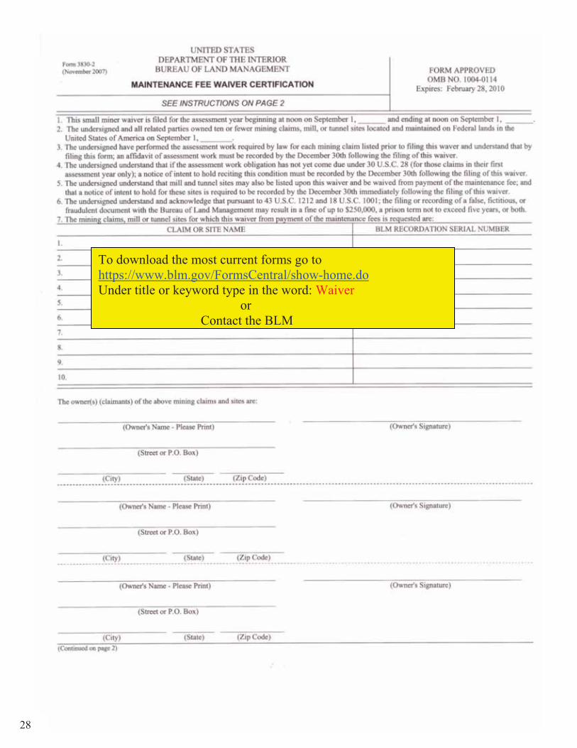
To download the most current forms go to https://www.blm.gov/FormsCentral/show-home.doUnder title or keyword type in the word: Waiver
or Contact the BLM
28

29

1. Dates for a waiver are expressed from 1 Sept – 1 Sept. Also your waiver is filed one year in advance, so for the upcoming September 1, 2009 filing deadline the dates are as follows 1 Blank 2009 2 Blank 2010 3 Blank 2009
Claim name or site name IMC #
Owner’s name Street or PO Box City, State, and Zip Code
Owner’s original signature
Note: You must file the original form with all appropriate signatures with the BLM
Maintenance Fee is due by 1 Sept
30
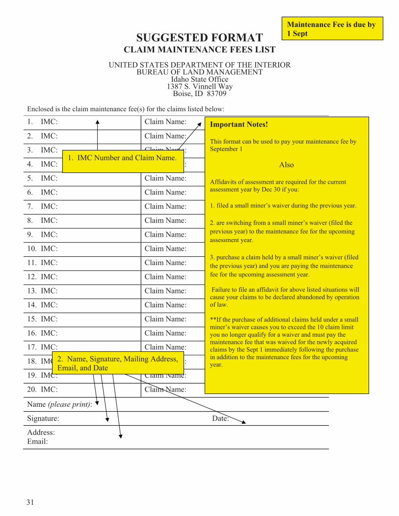
SUGGESTED FORMAT CLAIM MAINTENANCE FEES LIST
UNITED STATES DEPARTMENT OF THE INTERIOR BUREAU OF LAND MANAGEMENT
Idaho State Office 1387 S. Vinnell Way
Boise, ID 83709
Enclosed is the claim maintenance fee(s) for the claims listed below:
1. IMC: Claim Name:
2. IMC: Claim Name:
3. IMC: Claim Name:
4. IMC: Claim Name:
5. IMC: Claim Name:
6. IMC: Claim Name:
7. IMC: Claim Name:
8. IMC: Claim Name:
9. IMC: Claim Name:
10. IMC: Claim Name:
11. IMC: Claim Name:
12. IMC: Claim Name:
13. IMC: Claim Name:
14. IMC: Claim Name:
15. IMC: Claim Name:
16. IMC: Claim Name:
17. IMC: Claim Name:
18. IMC: Claim Name:
19. IMC: Claim Name:
20. IMC: Claim Name:
Name (please print):
Signature: Date:
Address:Email:
Maintenance Fee is due by 1 Sept
Important Notes!
This format can be used to pay your maintenance fee by September 1
Also
Affidavits of assessment are required for the current assessment year by Dec 30 if you:
1. filed a small miner’s waiver during the previous year.
2. are switching from a small miner’s waiver (filed the previous year) to the maintenance fee for the upcoming assessment year.
3. purchase a claim held by a small miner’s waiver (filed the previous year) and you are paying the maintenance fee for the upcoming assessment year.
Failure to file an affidavit for above listed situations will cause your claims to be declared abandoned by operation of law.
**If the purchase of additional claims held under a small miner’s waiver causes you to exceed the 10 claim limit you no longer qualify for a waiver and must pay the maintenance fee that was waived for the newly acquired claims by the Sept 1 immediately following the purchase in addition to the maintenance fees for the upcoming year.
1. IMC Number and Claim Name.
2. Name, Signature, Mailing Address, Email, and Date
31

SUGGESTED FORMAT CLAIM MAINTENANCE FEES LIST
UNITED STATES DEPARTMENT OF THE INTERIOR BUREAU OF LAND MANAGEMENT
Idaho State Office 1387 S. Vinnell Way
Boise, ID 83709
Enclosed is the claim maintenance fee(s) for the claims listed below:
1. IMC: Claim Name:
2. IMC: Claim Name:
3. IMC: Claim Name:
4. IMC: Claim Name:
5. IMC: Claim Name:
6. IMC: Claim Name:
7. IMC: Claim Name:
8. IMC: Claim Name:
9. IMC: Claim Name:
10. IMC: Claim Name:
11. IMC: Claim Name:
12. IMC: Claim Name:
13. IMC: Claim Name:
14. IMC: Claim Name:
15. IMC: Claim Name:
16. IMC: Claim Name:
17. IMC: Claim Name:
18. IMC: Claim Name:
19. IMC: Claim Name:
Name (please print):
Signature: Date:
Address:
Pursuant to 43 U.S.C. 1212 and 18 U.S.C. Section 1001, the filing or recording of a false, fictitious, or fraudulent document with the Bureau of Land Management may result in a fine of up to $250,000, a prison term not to exceed five years, or both. This information is being collected to enable BLM to determine which claims their owner(s) wish to continue to hold under applicable Federal statute. A response is required to obtain a benefit in accordance with Section 314 of the Federal Land and Policy Management Act of 1976, as amended, 43 U.S.C. 299, and 30 U.S.C. 28f-k, as amended. This authority to collect personal information may be found in DOI Privacy Act System Notice LLM-32. The name and address are required for filing and retrieval purposes. Additional authority: 43 U.S.C. 1601, 43 U.S.C. 1701, and 42 U.S.C. 4601.
IMPORTANT NOTICE: The information may be submitted in this format or its local equivalent. Use of this format is suggested but not required. It is not copyrighted and may be reproduced without restriction.
32
Name________________________________________________________________________
20. IMC: Claim Name:
21. IMC: Claim Name:
22. IMC: Claim Name:
23. IMC: Claim Name:
24. IMC: Claim Name:
25. IMC: Claim Name:
26. IMC: Claim Name:
27. IMC: Claim Name:
28. IMC: Claim Name:
29. IMC: Claim Name:
30. IMC: Claim Name:
31. IMC: Claim Name:
32. IMC: Claim Name:
33. IMC: Claim Name:
34. IMC: Claim Name:
35. IMC: Claim Name:
36. IMC: Claim Name:
37. IMC: Claim Name:
38. IMC: Claim Name:
39. IMC: Claim Name:
40. IMC: Claim Name:
41. IMC: Claim Name:
42. IMC: Claim Name:
43. IMC: Claim Name:
44. IMC: Claim Name:
45. IMC: Claim Name:
46. IMC: Claim Name:
47. IMC: Claim Name:
48. IMC: Claim Name:
49. IMC: Claim Name:
50. IMC: Claim Name:
33
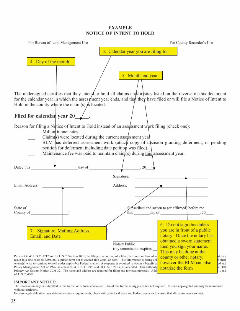
EXAMPLE NOTICE OF INTENT TO HOLD
For Bureau of Land Management Use For County Recorder’s Use
The undersigned certifies that they intend to hold all claims and/or sites listed on the reverse of this document for the calendar year in which the assessment year ends, and that they have filed or will file a Notice of Intent to Hold in the county where the claim(s) is located.
Filed for calendar year 20_____.
Reason for filing a Notice of Intent to Hold instead of an assessment work filing (check one): ___ Mill or tunnel sites. ___ Claim(s) were located during the current assessment year. ___ BLM has deferred assessment work (attach copy of decision granting deferment, or pending
petition for deferment including date petition was filed). ___ Maintenance fee was paid to maintain claim(s) during this assessment year.
Dated this ________________________day of __________________________, 20____.
Signature: _____________________________________
Address: _____________________________________
_____________________________________
State of ________ Subscribed and sworn to (or affirmed) before me County of ___________________) this ________day of ____________________,
20____.
(Seal)
__________________________________________________ Notary Public or County Recorder (my commission expires _____________)
Pursuant to 43 U.S.C. 1212 and 18 U.S.C. Section 1001, the filing or recording of a false, fictitious, or fraudulent document with the Bureau of Land Management may result in a fine of up to $250,000, a prison term not to exceed five years, or both. This information is being collected to enable BLM to determine which claims their owner(s) wish to continue to hold under applicable Federal statute. A response is required to obtain a benefit in accordance with Section 314 of the Federal Land and Policy Management Act of 1976, as amended, 43 U.S.C. 299, and 30 U.S.C. 28f-k, as amended. This authority to collect personal information may be found in DOI Privacy Act System Notice LLM-32. The name and address are required for filing and retrieval purposes. Additional authority: 43 U.S.C. 1601, 43 U.S.C. 1701, and 42 U.S.C. 4601.
IMPORTANT NOTICE: The information may be submitted in this format or its local equivalent. Use of this format is suggested but not required. It is not copyrighted and may be reproduced without restriction.
Because applicable state laws determine certain requirements, check with your local State and Federal agencies to ensure that all requirements are met.
2. You must check the reason(s) for filing a Notice of Intent to Hold.
If you file a small miner’s waiver on a claim locatedbefore Sept 1 (whether the claim is recorded before or after Sept 1) you must file a notice of intent to hold or an affidavit of assessment by Dec 30 of the current year.
A notice of intent to hold can be filed for the first assessment year because assessment work is not required for the assessment year in which the claim is located. An affidavit of assessment is required for each following assessment year for lode and placer claims that are under waiver.
Processing fees must be paid at the time of filing or the document will be returned unprocessed.
1. Calendar Year
34
EXAMPLE NOTICE OF INTENT TO HOLD
For Bureau of Land Management Use For County Recorder’s Use
The undersigned certifies that they intend to hold all claims and/or sites listed on the reverse of this document for the calendar year in which the assessment year ends, and that they have filed or will file a Notice of Intent to Hold in the county where the claim(s) is located.
Filed for calendar year 20_____.
Reason for filing a Notice of Intent to Hold instead of an assessment work filing (check one): ___ Mill or tunnel sites. ___ Claim(s) were located during the current assessment year. ___ BLM has deferred assessment work (attach copy of decision granting deferment, or pending
petition for deferment including date petition was filed). ___ Maintenance fee was paid to maintain claim(s) during this assessment year.
Dated this ________________________day of __________________________, 20____.
Signature: _____________________________________
Email Address: _____________________ Address: _____________________________________
_____________________________________
State of ________ Subscribed and sworn to (or affirmed) before me County of ___________________) this ________day of ____________________, 20____.
(Seal)
__________________________________________________ Notary Public or County Recorder (my commission expires _____________)
Pursuant to 43 U.S.C. 1212 and 18 U.S.C. Section 1001, the filing or recording of a false, fictitious, or fraudulent document with the Bureau of Land Management may result in a fine of up to $250,000, a prison term not to exceed five years, or both. This information is being collected to enable BLM to determine which claims their owner(s) wish to continue to hold under applicable Federal statute. A response is required to obtain a benefit in accordance with Section 314 of the Federal Land and Policy Management Act of 1976, as amended, 43 U.S.C. 299, and 30 U.S.C. 28f-k, as amended. This authority to collect personal information may be found in DOI Privacy Act System Notice LLM-32. The name and address are required for filing and retrieval purposes. Additional authority: 43 U.S.C. 1601, 43 U.S.C. 1701, and 42 U.S.C. 4601.
IMPORTANT NOTICE: The information may be submitted in this format or its local equivalent. Use of this format is suggested but not required. It is not copyrighted and may be reproduced without restriction. Because applicable state laws determine certain requirements, check with your local State and Federal agencies to ensure that all requirements are met.
4. Day of the month.
5. Month and year
6. Do not sign this unless you are in front of a public notary. Once the notary has obtained a sworn statement then you sign your name. This may be done at the county or other notary, however the BLM can also notarize the form
3. Calendar year you are filing for
7. Signature, Mailing Address, Email, and Date
35

IMC No. CLAIM NAME IMC No. CLAIM NAME
1. 26.
2. 27.
3. 28.
4. 29.
5. 30.
6. 31.
7. 32.
8. 33.
9. 34.
10. 35.
11. 36.
12. 37.
13. 38.
14. 39.
15. 40.
16. 41.
17. 42.
18. 43.
19. 44.
20. 45.
21. 46.
22. 47.
23. 48.
24. 49.
25. 50.
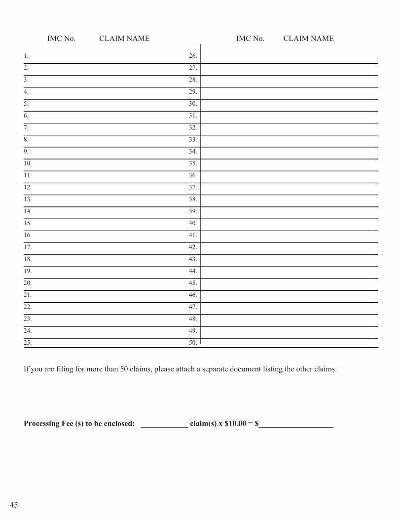
If you are filing for more than 50 claims, please attach a separate document listing the other claims.
Processing Fee(s) to be enclosed: ______________ claim(s) x $10.00 = $___________________
7. IMC Number and Claim Name.
8. Cost is $10 per Claim
36

EXAMPLE NOTICE OF INTENT TO HOLD
For Bureau of Land Management Use For County Recorder’s Use
The undersigned certifies that they intend to hold all claims and/or sites listed on the reverse of this document for the calendar year in which the assessment year ends, and that they have filed or will file a Notice of Intent to Hold in the county where the claim(s) is located.
Filed for calendar year 20_____.
Reason for filing a Notice of Intent to Hold instead of an assessment work filing (check one): ___ Mill or tunnel sites. ___ Claim(s) were located during the current assessment year. ___ BLM has deferred assessment work (attach copy of decision granting deferment, or pending
petition for deferment including date petition was filed). ___ Maintenance fee was paid to maintain claim(s) during this assessment year.
Dated this ________________________day of __________________________, 20____.
Signature: _____________________________________
Address: _____________________________________
_____________________________________
State of ________ Subscribed and sworn to (or affirmed) before me County of ___________________) this ________day of ____________________, 20____.
(Seal)
__________________________________________________ Notary Public or County Recorder (my commission expires _____________)
Pursuant to 43 U.S.C. 1212 and 18 U.S.C. Section 1001, the filing or recording of a false, fictitious, or fraudulent document with the Bureau of Land Management may result in a fine of up to $250,000, a prison term not to exceed five years, or both. This information is being collected to enable BLM to determine which claims their owner(s) wish to continue to hold under applicable Federal statute. A response is required to obtain a benefit in accordance with Section 314 of the Federal Land and Policy Management Act of 1976, as amended, 43 U.S.C. 299, and 30 U.S.C. 28f-k, as amended. This authority to collect personal information may be found in DOI Privacy Act System Notice LLM-32. The name and address are required for filing and retrieval purposes. Additional authority: 43 U.S.C. 1601, 43 U.S.C. 1701, and 42 U.S.C. 4601.
IMPORTANT NOTICE: The information may be submitted in this format or its local equivalent. Use of this format is suggested but not required. It is not copyrighted and may be reproduced without restriction.
Because applicable state laws determine certain requirements, check with your local State and Federal agencies to ensure that all requirements are met.
10. The last step is to file with the Bureau of Land Management State Office located in Boise.
9. You must file with the county in which your claim is located.
37

SUGGESTED FORMAT NOTICE OF INTENT TO HOLD
For Bureau of Land Management Use For County Recorder’s Use
The undersigned certifies that they intend to hold all claims and/or sites listed on the reverse of this document for the calendar year in which the assessment year ends, and that they have filed or will file a Notice of Intent to Hold in the county where the claim(s) is located.
Filed for calendar year 20_____.
Reason for filing a Notice of Intent to Hold instead of an assessment work filing (check one): ___ Mill or tunnel sites. ___ Claim(s) were located during the current assessment year. ___ BLM has deferred assessment work (attach copy of decision granting deferment, or pending
petition for deferment including date petition was filed). ___ Maintenance fee was paid to maintain claim(s) during this assessment year.
Dated this ________________________day of __________________________, 20____.
Signature: _____________________________________
Address: _____________________________________
_____________________________________
State of ________ Subscribed and sworn to (or affirmed) before me County of ___________________) this ________day of ____________________, 20____.
(Seal)
__________________________________________________ Notary Public or County Recorder (my commission expires _____________)
Pursuant to 43 U.S.C. 1212 and 18 U.S.C. Section 1001, the filing or recording of a false, fictitious, or fraudulent document with the Bureau of Land Management may result in a fine of up to $250,000, a prison term not to exceed five years, or both. This information is being collected to enable BLM to determine which claims their owner(s) wish to continue to hold under applicable Federal statute. A response is required to obtain a benefit in accordance with Section 314 of the Federal Land and Policy Management Act of 1976, as amended, 43 U.S.C. 299, and 30 U.S.C. 28f-k, as amended. This authority to collect personal information may be found in DOI Privacy Act System Notice LLM-32. The name and address are required for filing and retrieval purposes. Additional authority: 43 U.S.C. 1601, 43 U.S.C. 1701, and 42 U.S.C. 4601.
IMPORTANT NOTICE: The information may be submitted in this format or its local equivalent. Use of this format is suggested but not required. It is not copyrighted and may be reproduced without restriction.
Because applicable state laws determine certain requirements, check with your local State and Federal agencies to ensure that all requirements are met.
38

Name__________________________________________________________________
1. IMC: Claim Name:
2. IMC: Claim Name:
3. IMC: Claim Name:
4. IMC: Claim Name:
5. IMC: Claim Name:
6. IMC: Claim Name:
7. IMC: Claim Name:
8. IMC: Claim Name:
9. IMC: Claim Name:
10. IMC: Claim Name:
11. IMC: Claim Name:
12. IMC: Claim Name:
13. IMC: Claim Name:
14. IMC: Claim Name:
15. IMC: Claim Name:
16. IMC: Claim Name:
17. IMC: Claim Name:
18. IMC: Claim Name:
19. IMC: Claim Name:
20. IMC: Claim Name:
21. IMC: Claim Name:
22. IMC: Claim Name:
23. IMC: Claim Name:
24. IMC: Claim Name:
25. IMC: Claim Name:
Processing Fee (s) to be enclosed: ____________ claim(s) x $10.00 = $___________________
If you are filing for more than 25 claims, please attach a separate document listing the other claims.
39

EXAMPLE AFFIDAVIT OF ASSESSMENT WORK
For Bureau of Land Management Use For County Recorder’s Use
The undersigned certifies that at least one hundred ($100) dollars per claim was expended for development, labor and improvementsfor each mining claim listed on the reverse of this document. The mining claims are situated in, the County of ____________________, State of __________. OR
Attach report of geological, geochemical, and geophysical surveys, per 43 CFR 3836.
Such expenditure was made by, for, or at the expense of ____________________________________________________ ____________________________________________________________, the owner(s) of said claims, for the purpose of developing the mineral potential of the claims and to maintain and hold said claims. All stakes, monuments or trees marking boundaries of said claims are in proper place and position.
This assessment work was performed for the assessment year ending at 12 o’clock noon onSeptember 1, 20____.
Dated this ________________________day of __________________________, 20____.
Signature: _____________________________________
Address: _____________________________________
_____________________________________
State of _________ Subscribed and sworn to (or affirmed) before me
County of ___________________) this ________day of ____________________, 20_____.
(Seal)
__________________________________________________ Notary Public or County Recorder (My commission expires _____________)
Pursuant to 43 U.S.C. 1212 and 18 U.S.C. Section 1001, the filing or recording of a false, fictitious, or fraudulent document with the Bureau of Land Management may result in a fine of up to $250,000, a prison term not to exceed five years, or both. This information is being collected to enable BLM to determine which claims their owner(s) wish to continue to hold under applicable Federal statute. A response is required to obtain a benefit in accordance with Section 314 of the Federal Land and Policy Management Act of 1976, as amended, 43 U.S.C. 299, and 30 U.S.C. 28f-k, as amended. This authority to collect personal information may be found in DOI Privacy Act System Notice LLM-32. The name and address are required for filing and retrieval purposes. Additional authority: 43 U.S.C. 1601, 43 U.S.C. 1701, and
1. The county in which the claim is located
2. Idaho
3. One or more of the claimants’ names
4. Current Year
Important Notes!
Affidavits of assessment are required for the current assessment year by Dec 30 if you:
1. filed a small miner’s waiver during the previous year.
0. 2. are switching from a small miner’s waiver (filed the previous year) to the maintenance fee for the upcoming assessment year.
.3. purchase a claim held by a small miner’s waiver (filed the previous year) and you are paying the maintenance fee for the upcoming assessment year.
Failure to file an affidavit for above listed situations will cause your claims to be declared abandoned by operation of law.
**If the purchase of additional claims held under a small miner’s waiver causes you to exceed the 10 claim limit you no longer qualify for a waiver and must pay the maintenance fee that was waived for the newly acquired claims by the Sept 1 immediately following the purchase in addition to the maintenance fees for the upcoming year.
Proof of Labor (Affidavit of Assessment is due by 30th Dec)
40

EXAMPLE AFFIDAVIT OF ASSESSMENT WORK
Bureau of Land Management Use For County Recorder’s Use
The undersigned certifies that at least one hundred ($100) dollars per claim was expended for development, labor and improvementsfor each mining claim listed on the reverse of this document. The mining claims are situated in, the County of ____________________, State of __________. OR
Attach report of geological, geochemical, and geophysical surveys, per 43 CFR 3836.
Such expenditure was made by, for, or at the expense of ____________________________________________________ ____________________________________________________________, the owner(s) of said claims, for the purpose of developing the mineral potential of the claims and to maintain and hold said claims. All stakes, monuments or trees marking boundaries of said claims are in proper place and position.
This assessment work was performed for the assessment year ending at 12 o’clock noon onSeptember 1, 20____.
Dated this ________________________day of __________________________, 20____.
Signature: _____________________________________
Email Address: _____________________ Address: _____________________________________
_____________________________________
State of _________ Subscribed and sworn to (or affirmed) before me
County of ___________________) this ________day of ____________________, 20_____.
(Seal)
__________________________________________________ Notary Public or County Recorder (My commission expires _____________)
Pursuant to 43 U.S.C. 1212 and 18 U.S.C. Section 1001, the filing or recording of a false, fictitious, or fraudulent document with the Bureau of Land Management may result in a fine of up to $250,000, a prison term not to exceed five years, or both. This information is being collected to enable BLM to determine which claims their owner(s) wish to continue to hold under applicable Federal statute. A response is required to obtain a benefit in accordance with Section 314 of the Federal Land and Policy Management Act of 1976, as amended, 43 U.S.C. 299, and 30 U.S.C. 28f-k, as amended. This authority to collect personal information may be found in DOI Privacy Act System Notice LLM-32. The name and address are required for filing and retrieval purposes. Additional authority: 43 U.S.C. 1601, 43 U.S.C. 1701, and 42 U.S.C. 4601.
IMPORTANT NOTICE: The information may be submitted in this format or its local equivalent. Use of this format is suggested but not required. It is not copyrighted and may be reproduced without restriction. Because applicable state laws determine certain requirements, check with your local State and Federal agencies to ensure that all requirements are met.
5. Do not sign or date this unless you are in front of a notary public. Once the notary has obtained a sworn statement then you sign your name. This should be done at the county however the BLM can also notarize the form
41
IMC No. CLAIM NAME IMC No. CLAIM NAME
26. 26.
27. 27.
28. 28.
29. 29.
30. 30.
31. 31.
32. 32.
33. 33.
34. 34.
35. 35.
36. 36.
37. 37.
38. 38.
39. 39.
40. 40.
41. 41.
42. 42.
43. 43.
44. 44.
45. 45.
46. 46.
47. 47.
48. 48.
49. 49.
50. 50.
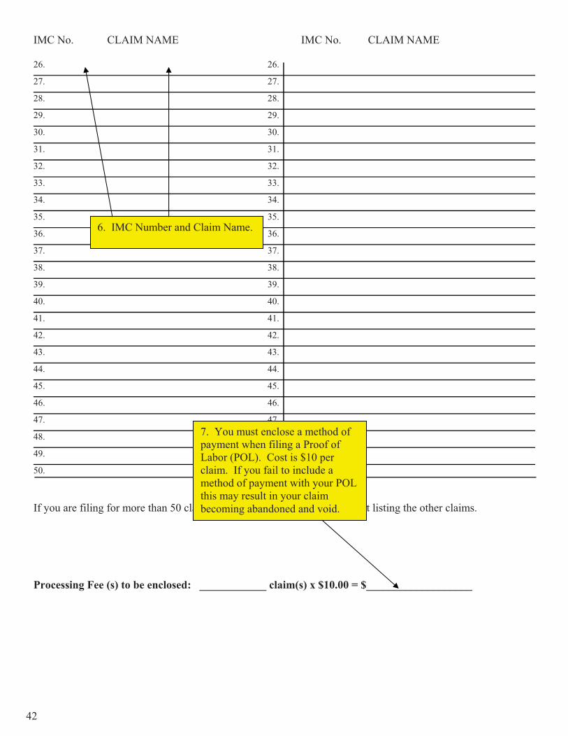
If you are filing for more than 50 claims, please attach a separate document listing the other claims.
Processing Fee (s) to be enclosed: ____________ claim(s) x $10.00 = $___________________
6. IMC Number and Claim Name.
7. You must enclose a method of payment when filing a Proof of Labor (POL). Cost is $10 per claim. If you fail to include a method of payment with your POL this may result in your claim becoming abandoned and void.
42

EXAMPLE AFFIDAVIT OF ASSESSMENT WORK
For Bureau of Land Management Use For County Recorder’s Use
The undersigned certifies that at least one hundred ($100) dollars per claim was expended for development, labor and improvementsfor each mining claim listed on the reverse of this document. The mining claims are situated in, the County of ____________________, State of __________. OR
Attach report of geological, geochemical, and geophysical surveys, per 43 CFR 3836.
Such expenditure was made by, for, or at the expense of ____________________________________________________ ____________________________________________________________, the owner(s) of said claims, for the purpose of developing the mineral potential of the claims and to maintain and hold said claims. All stakes, monuments or trees marking boundaries of said claims are in proper place and position.
This assessment work was performed for the assessment year ending at 12 o’clock noon onSeptember 1, 20____.
Dated this ________________________day of __________________________, 20____.
Signature: _____________________________________
Email Address: _____________________ Address: _____________________________________
_____________________________________
State of _________ Subscribed and sworn to (or affirmed) before me County of ___________________) this ________day of ____________________, 20_____.
(Seal)
__________________________________________________ Notary Public or County Recorder (My commission expires _____________)
Pursuant to 43 U.S.C. 1212 and 18 U.S.C. Section 1001, the filing or recording of a false, fictitious, or fraudulent document with the Bureau of Land Management may result in a fine of up to $250,000, a prison term not to exceed five years, or both. This information is being collected to enable BLM to determine which claims their owner(s) wish to continue to hold under applicable Federal statute. A response is required to obtain a benefit in accordance with Section 314 of the Federal Land and Policy Management Act of 1976, as amended, 43 U.S.C. 299, and 30 U.S.C. 28f-k, as amended. This authority to collect personal information may be found in DOI Privacy Act System Notice LLM-32. The name and address are required for filing and retrieval purposes. Additional authority: 43 U.S.C. 1601, 43 U.S.C. 1701, and 42 U.S.C. 4601.
8. You must file with the county in which your claim is located within 60 days after the end of the assessment year which runs 1 Sept – 1 Sept.
9. The last step is to file with the BLM State Office located in Boise on or before Dec 30th
43

EXAMPLE AFFIDAVIT OF ASSESSMENT WORK
For Bureau of Land Management Use For County Recorder’s Use
The undersigned certifies that at least one hundred ($100) dollars per claim was expended for development, labor and improvementsfor each mining claim listed on the reverse of this document. The mining claims are situated in, the County of ____________________, State of __________. OR
Attach report of geological, geochemical, and geophysical surveys, per 43 CFR 3836.
Such expenditure was made by, for, or at the expense of ____________________________________________________ ____________________________________________________________, the owner(s) of said claims, for the purpose of developing the mineral potential of the claims and to maintain and hold said claims. All stakes, monuments or trees marking boundaries of said claims are in proper place and position.
This assessment work was performed for the assessment year ending at 12 o’clock noon onSeptember 1, 20____.
Dated this ________________________day of __________________________, 20____.
Signature: _____________________________________
Address: _____________________________________
_____________________________________
State of _________ Subscribed and sworn to (or affirmed) before me
County of ___________________) this ________day of ____________________, 20_____.
(Seal)
__________________________________________________ Notary Public or County Recorder (My commission expires _____________)
Pursuant to 43 U.S.C. 1212 and 18 U.S.C. Section 1001, the filing or recording of a false, fictitious, or fraudulent document with the Bureau of Land Management may result in a fine of up to $250,000, a prison term not to exceed five years, or both. This information is being collected to enable BLM to determine which claims their owner(s) wish to continue to hold under applicable Federal statute. A response is required to obtain a benefit in accordance with Section 314 of the Federal Land and Policy Management Act of 1976, as amended, 43 U.S.C. 299, and 30 U.S.C. 28f-k, as amended. This authority to collect personal information may be found in DOI Privacy Act System Notice LLM-32. The name and address are required for filing and retrieval purposes. Additional authority: 43 U.S.C. 1601, 43 U.S.C. 1701, and 42 U.S.C. 4601.
IMPORTANT NOTICE: The information may be submitted in this format or its local equivalent. Use of this format is suggested but not required. It is not copyrighted and may be reproduced without restriction. Because applicable state laws determine certain requirements, check with your local State and Federal agencies to ensure that all requirements are met.
44
IMC No. CLAIM NAME IMC No. CLAIM NAME
1. 26.
2. 27.
3. 28.
4. 29.
5. 30.
6. 31.
7. 32.
8. 33.
9. 34.
10. 35.
11. 36.
12. 37.
13. 38.
14. 39.
15. 40.
16. 41.
17. 42.
18. 43.
19. 44.
20. 45.
21. 46.
22. 47.
23. 48.
24. 49.
25. 50.
If you are filing for more than 50 claims, please attach a separate document listing the other claims.
Processing Fee (s) to be enclosed: ____________ claim(s) x $10.00 = $___________________
45
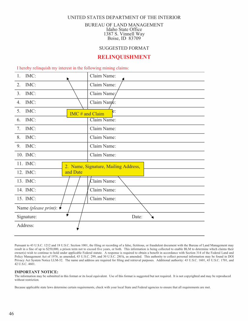
UNITED STATES DEPARTMENT OF THE INTERIOR BUREAU OF LAND MANAGEMENT
Idaho State Office 1387 S. Vinnell Way
Boise, ID 83709
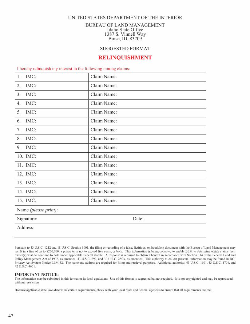
SUGGESTED FORMAT
RELINQUISHMENT
I hereby relinquish my interest in the following mining claims:
1. IMC: Claim Name:
2. IMC: Claim Name:
3. IMC: Claim Name:
4. IMC: Claim Name:
5. IMC: Claim Name:
6. IMC: Claim Name:
7. IMC: Claim Name:
8. IMC: Claim Name:
9. IMC: Claim Name:
10. IMC: Claim Name:
11. IMC: Claim Name:
12. IMC: Claim Name:
13. IMC: Claim Name:
14. IMC: Claim Name:
15. IMC: Claim Name:
Name (please print):
Signature: Date:
Address:
Pursuant to 43 U.S.C. 1212 and 18 U.S.C. Section 1001, the filing or recording of a false, fictitious, or fraudulent document with the Bureau of Land Management may result in a fine of up to $250,000, a prison term not to exceed five years, or both. This information is being collected to enable BLM to determine which claims their owner(s) wish to continue to hold under applicable Federal statute. A response is required to obtain a benefit in accordance with Section 314 of the Federal Land and Policy Management Act of 1976, as amended, 43 U.S.C. 299, and 30 U.S.C. 28f-k, as amended. This authority to collect personal information may be found in DOI Privacy Act System Notice LLM-32. The name and address are required for filing and retrieval purposes. Additional authority: 43 U.S.C. 1601, 43 U.S.C. 1701, and 42 U.S.C. 4601.
IMPORTANT NOTICE: The information may be submitted in this format or its local equivalent. Use of this format is suggested but not required. It is not copyrighted and may be reproduced without restriction.
Because applicable state laws determine certain requirements, check with your local State and Federal agencies to ensure that all requirements are met.
2. Name, Signature, Mailing Address, and Date
IMC # and Claim
46
UNITED STATES DEPARTMENT OF THE INTERIOR BUREAU OF LAND MANAGEMENT
Idaho State Office 1387 S. Vinnell Way
Boise, ID 83709
SUGGESTED FORMAT
RELINQUISHMENT
I hereby relinquish my interest in the following mining claims:
1. IMC: Claim Name:
2. IMC: Claim Name:
3. IMC: Claim Name:
4. IMC: Claim Name:
5. IMC: Claim Name:
6. IMC: Claim Name:
7. IMC: Claim Name:
8. IMC: Claim Name:
9. IMC: Claim Name:
10. IMC: Claim Name:
11. IMC: Claim Name:
12. IMC: Claim Name:
13. IMC: Claim Name:
14. IMC: Claim Name:
15. IMC: Claim Name:
Name (please print):
Signature: Date:
Address:
Pursuant to 43 U.S.C. 1212 and 18 U.S.C. Section 1001, the filing or recording of a false, fictitious, or fraudulent document with the Bureau of Land Management may result in a fine of up to $250,000, a prison term not to exceed five years, or both. This information is being collected to enable BLM to determine which claims their owner(s) wish to continue to hold under applicable Federal statute. A response is required to obtain a benefit in accordance with Section 314 of the Federal Land and Policy Management Act of 1976, as amended, 43 U.S.C. 299, and 30 U.S.C. 28f-k, as amended. This authority to collect personal information may be found in DOI Privacy Act System Notice LLM-32. The name and address are required for filing and retrieval purposes. Additional authority: 43 U.S.C. 1601, 43 U.S.C. 1701, and 42 U.S.C. 4601.
IMPORTANT NOTICE: The information may be submitted in this format or its local equivalent. Use of this format is suggested but not required. It is not copyrighted and may be reproduced without restriction.
Because applicable state laws determine certain requirements, check with your local State and Federal agencies to ensure that all requirements are met.
47

SECTION IV LR 2000 User Guide
48

GO TO THE FOLLOWING WEBSITE:
http://www.blm.gov/wo/st/en/res/Public_Room.html
STEP # 1 Click On
Step # 2 Click on
49
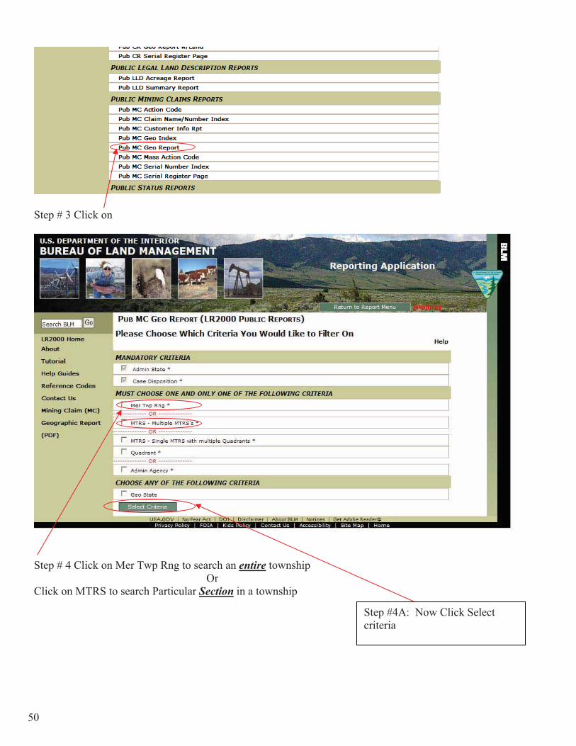
Step # 3 Click on
Step # 4 Click on Mer Twp Rng to search an entire township Or Click on MTRS to search Particular Section in a township
Step #4A: Now Click Select criteria
50

Step # 5 Set Admin State to Idaho Set Case Disposition
Step # 7 Put in yourTownship, Range, Section and Directions
Step # 6 Put in theMeridian -- This will be Boise for Idaho
Step # 8Click on Add to MTR List to place in the window
Step # 10 Click on run report
Step # 9Click Select All
51

Step # 10 Click on PDF Step # 11
Make sure that a ? mark is not showing if so repeat step #10
Step # 12 Select Banner Page in the drop down menu then click on Go
52

SECTION IV Miscellaneous
53

54

55
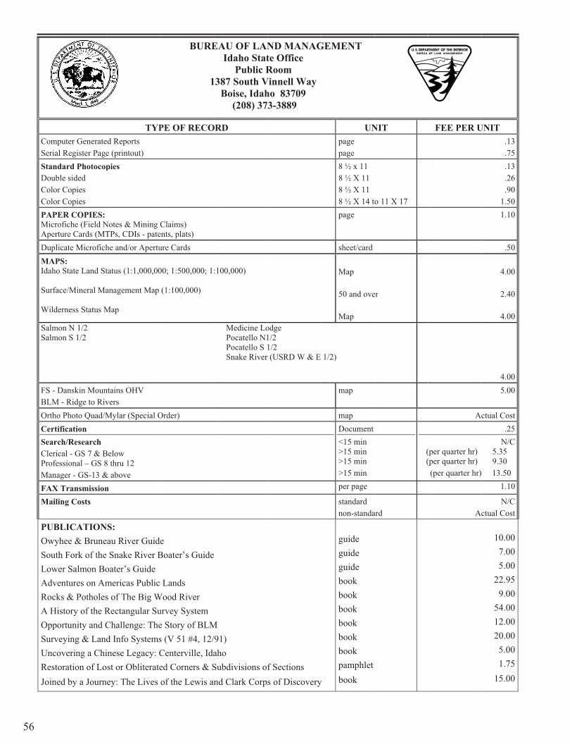
ComSeriStanDouColoColoPAPMicApeDupMAIdah
Surf
Wil
SalmSalm
FS -BLMOrthCerSeaClerProfManFAXMai
PUOwSouLowAdvRocA HOppSurUncResJoin
56
mputer Generateial Register Pagendard Photocopuble sidedor Copies or Copies PER COPIES: crofiche (Field Nerture Cards (MTplicate Microfich
APS: ho State Land St
face/Mineral Ma
derness Status M
mon N 1/2 mon S 1/2
- Danskin MounM - Ridge to Rivho Photo Quad/Mrtification rch/Research rical - GS 7 & Bfessional – GS 8nager - GS-13 &X Transmissioniling Costs
BLICATIONwyhee & Bruneuth Fork of the wer Salmon Boventures on Amcks & PotholesHistory of the Rportunity and Crveying & Landcovering a Chistoration of Loned by a Journ
TYPd Reports e (printout) pies
Notes & Mining CTPs, CDIs - patehe and/or Apertu
tatus (1:1,000,00
anagement Map
Map
ntains OHV vers Mylar (Special O
Below 8 thru 12 & aboven
S:au River GuideSnake River B
oater’s Guide mericas Public s of The Big WRectangular SuChallenge: Thed Info Systemsinese Legacy: Cst or Obliterateey: The Lives
BURE
1
PE OF RECO
Claims) ents, plats) ure Cards
00; 1:500,000; 1:
(1:100,000)
Order)
eBoater’s Guide
Lands Wood Riverurvey System e Story of BLMs (V 51 #4, 12/Centerville, Idaed Corners & Sof the Lewis an
EAU OF LANIdaho Stat
Public R1387 South V
Boise, Idah (208) 37
ORD
:100,000)
Medicine LoPocatello N1Pocatello S 1Snake River
M/91) ahoSubdivisions ofnd Clark Corp
ND MANAGte Office Room
Vinnell Wayho 83709 3-3889
odge 1/2 1/2 r (USRD W & E
f Sections s of Discovery
GEMENT
UNpagepage8 ½ x 11 8 ½ X 11 8 ½ X 11 8 ½ X 14 tpage
sheet/card
Map
50 and ove
Map
1/2)
map
map Document<15 min >15 min >15 min >15 min per page
standardnon-standa
y
guide guide guide book book book book book book pamphletbook
NIT
o 11 X 17
er
( (
ard
FEE PER U
Ac
(per quarter hr) (per quarter hr) (per quarter hr)
Ac
UNIT.13.75.13.26.90
1.501.10
.50
4.00
2.40
4.00
4.005.00
ctual Cost.25
N/C 5.35 9.30 13.50
1.10
N/Cctual Cost
10.007.005.00
22.959.00
54.0012.0020.005.001.75
15.00
M
U
U
57
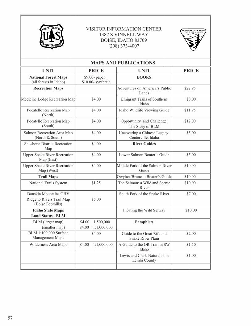
UNNational F
(all forestRecreat
Medicine Lodge
Pocatello Re(No
Pocatello Re(So
Salmon Recre(North &
Shoshone DistM
Upper Snake RMap
Upper Snake RMap Trail
National T
Danskin MoRidge to Riv
(Boise FIdaho St
Land StaBLM (la
(smBLM 1:100
Managem
Wilderness
NITForest Maps ts in Idaho) ion Maps
e Recreation M
ecreation Map orth) ecreation Map outh)
ation Area Ma& South) trict Recreation
MapRiver Recreatio
(East)River Recreatio(West) l Mapsrails System
ountains OHV vers Trail Map Foothills) tate Maps
atus - BLMarger map) maller map) 0,000 Surface ment Maps
s Area Maps
VIS
MPR
$9.00-$10.00-
Map $4
$4
$4
ap $4
n $4
on $4
on $4
$
$5
$4.00 1$4.00 1
$4
$4.00 1
ITOR INFO1387 S VBOISE,
(208
MAPS AND RICE- paper - synthetic
A
4.00
4.00
4.00
4.00
4.00
4.00
4.00 M
O1.25
5.00
1:500,000 1:1,000,000 4.00
1:1,000,000
ORMATIONVINNELL W
IDAHO 837) 373-4007
PUBLICATU
BO
Adventures onL
Emigrant TrI
Idaho Wildlif
Opportunity The Sto
Uncovering aCenterv
River
Lower Salmo
Middle Fork ofG
Owyhee/BruneThe Salmon: a
RSouth Fork of
Floating th
Pam
Guide to theSnake R
A Guide to thI
Lewis and ClLemh
N CENTER WAY
709
TIONSUNITOOKS
n America’s PuLands rails of Southerdaho fe Viewing Gu
and Challengory of BLM a Chinese Legaville, Idaho r Guides
on Boater’s Gu
f the Salmon RGuide eau Boater’s Ga Wild and SceRiverf the Snake Riv
he Wild Selway
mphlets
e Great Rift anRiver Plain
he OR Trail in Sdaho lark-Naturalisthi County
PR
ublic $2
rn $
ide $1
ge: $1
acy: $
ide $
River $1
Guide $1enic $1
ver $
y $
nd $
SW $
t in $
RICE
22.95
$8.00
11.95
12.00
$5.00
$5.00
10.00
10.00 10.00
$7.00
10.00
$2.00
$1.50
$1.00
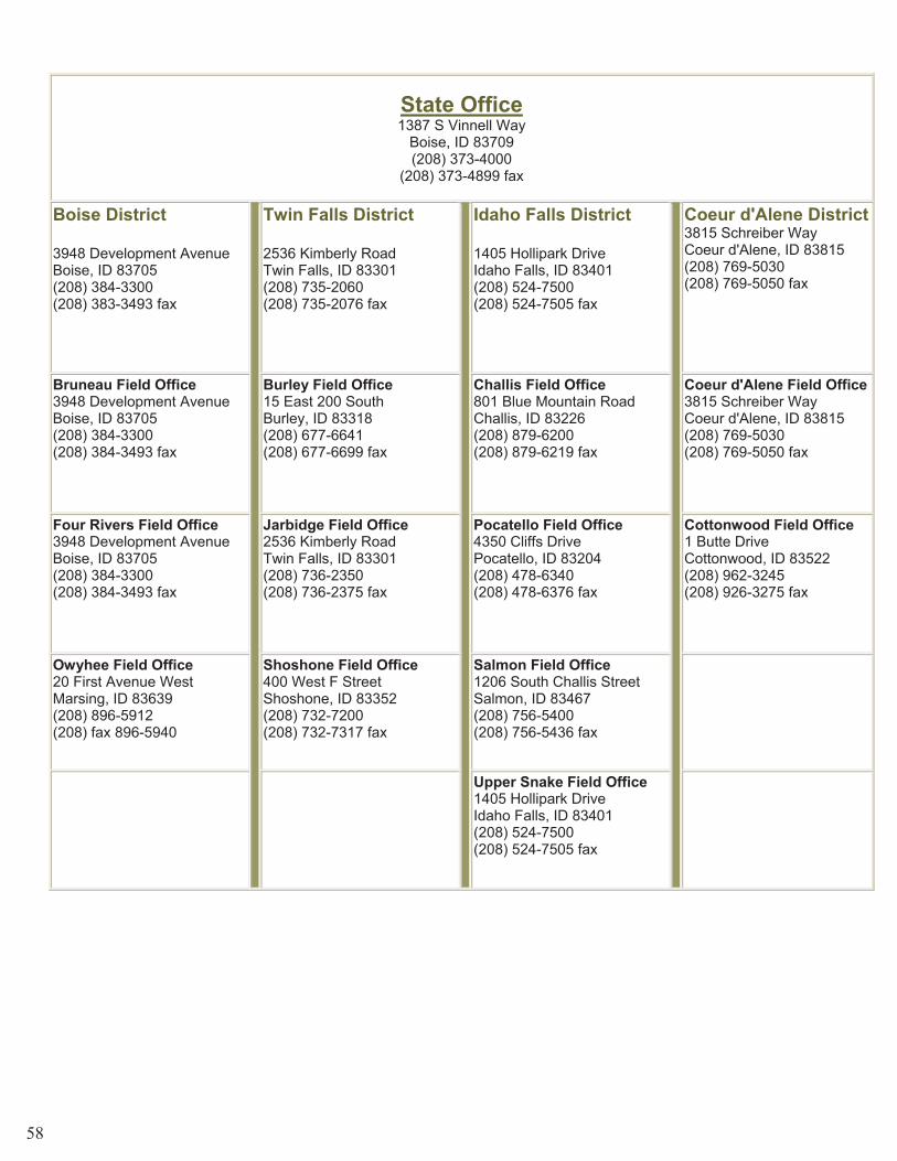
State Office1387 S Vinnell Way
Boise, ID 83709 (208) 373-4000
(208) 373-4899 fax
Boise District
3948 Development Avenue Boise, ID 83705 (208) 384-3300 (208) 383-3493 fax
Twin Falls District
2536 Kimberly Road Twin Falls, ID 83301 (208) 735-2060 (208) 735-2076 fax
Idaho Falls District
1405 Hollipark Drive Idaho Falls, ID 83401 (208) 524-7500 (208) 524-7505 fax
Coeur d'Alene District3815 Schreiber Way Coeur d'Alene, ID 83815 (208) 769-5030 (208) 769-5050 fax
Bruneau Field Office3948 Development Avenue Boise, ID 83705 (208) 384-3300 (208) 384-3493 fax
Burley Field Office15 East 200 South Burley, ID 83318 (208) 677-6641 (208) 677-6699 fax
Challis Field Office801 Blue Mountain Road Challis, ID 83226 (208) 879-6200 (208) 879-6219 fax
Coeur d'Alene Field Office3815 Schreiber Way Coeur d'Alene, ID 83815 (208) 769-5030 (208) 769-5050 fax
Four Rivers Field Office3948 Development Avenue Boise, ID 83705 (208) 384-3300 (208) 384-3493 fax
Jarbidge Field Office2536 Kimberly Road Twin Falls, ID 83301 (208) 736-2350 (208) 736-2375 fax
Pocatello Field Office4350 Cliffs Drive Pocatello, ID 83204 (208) 478-6340 (208) 478-6376 fax
Cottonwood Field Office1 Butte Drive Cottonwood, ID 83522 (208) 962-3245 (208) 926-3275 fax
Owyhee Field Office20 First Avenue West Marsing, ID 83639 (208) 896-5912 (208) fax 896-5940
Shoshone Field Office400 West F StreetShoshone, ID 83352 (208) 732-7200 (208) 732-7317 fax
Salmon Field Office1206 South Challis Street Salmon, ID 83467 (208) 756-5400 (208) 756-5436 fax
Upper Snake Field Office1405 Hollipark Drive Idaho Falls, ID 83401 (208) 524-7500 (208) 524-7505 fax
58