Download the Canadian Aids to Navigation System 2011
61
Safety First, Service Always THE CANADIAN AIDS TO NAVIGATION SYSTEM (TP968)
Transcript of Download the Canadian Aids to Navigation System 2011
Safety First, Service Always
THE CANADIAN AIDS TO NAVIGATION SYSTEM
(TP968)

(TP968)
THE CANADIAN AIDS TO
NAVIGATION SYSTEM
Canadian Coast Guard Maritime Services
Aids to Navigation Program
This publication can also be downloaded from: The Notices to Mariners website at: www.notmar.gc.ca under Available Services Section and the Canadian Coast Guard website at: www.ccg-gcc.gc.ca/eng/Ccg/atn_PublicationsFor all other related inquiries, please contact: [email protected]
Published by: Aids to Navigation ProgramCanadian Coast GuardFisheries and Oceans Canada Ottawa, Ontario Canada K1A 0E6Également disponible en français.
Cat. No. T31-29/2012E-PDF ISBN 978-1-100-15842-6 MPO/2012-1704
© Her Majesty the Queen in Right of Canada 2012.
V
CA
NA
DIA
N C
OA
ST G
UA
RD
– TAB
LE O
F CO
NTE
NTS
Preface .........................................................................................................................................1Notices ........................................................................................................................................2Introduction ...............................................................................................................................3
General ..............................................................................................................................3The Canadian Aids to Navigation System ..........................................................................3Cautions in the Use of Aids to Navigation .........................................................................6
Related Legislation ...................................................................................................................10Canada Shipping Act, 2001 .............................................................................................10Charts and Nautical Publications Regulation, 1995 .........................................................10Collision Regulations .......................................................................................................11Private Buoy Regulations .................................................................................................12Vessel Operation Restriction Regulations .........................................................................13Criminal Code of Canada ................................................................................................14
Canadian Coast Guard Aids to Navigation ..............................................................................15Other Government Aids to Navigation ....................................................................................16Private Aids to Navigation ........................................................................................................17
General ............................................................................................................................17Markings and Dimensions ...............................................................................................18Public Notification ...........................................................................................................19
Canadian Light Flash Characters .............................................................................................20IALA Maritime Buoyage System (Regions A and B) ...............................................................22Floating Aids to Navigation (Buoys) ........................................................................................23
Lateral Buoys ...................................................................................................................24Isolated Danger Buoys .....................................................................................................26Cardinal Buoys ................................................................................................................26Special Buoys ...................................................................................................................27Daytime Identification ..................................................................................................30Nighttime Identification ................................................................................................32Other Characteristics .....................................................................................................35
TABLE OF CONTENTS
VI
CA
NA
DIA
N C
OA
ST
GU
AR
D –
TH
E C
AN
AD
IAN
AID
S T
O N
AVIG
ATIO
N S
YS
TEM
Fixed Aids to Navigation ..........................................................................................................37General ............................................................................................................................37Lighted Fixed Aids ...........................................................................................................37Daybeacons ......................................................................................................................39Ranges .............................................................................................................................40Aural Aids ........................................................................................................................41Sector Lights ....................................................................................................................42
Radio Aids to Navigation .........................................................................................................43Radar Reflectors and Radar Beacons (RACONS) .............................................................43Global Positioning System (GPS) .....................................................................................44Differential Global Positioning System (DGPS) ...............................................................46
Related Publications .................................................................................................................48Canadian Coast Guard Aids to Navigation Offices .................................................................53Provincial Contacts – Office of Boating Safety ........................................................................54United States Aids to Navigation Boating Information...........................................................55
1
CA
NA
DIA
N C
OA
ST G
UA
RD
– PR
EFA
CE
PREFACE
T he Canadian Coast Guard is pleased to release the 2011 edition of the Canadian Aids to Navigation System
booklet. This edition replaces the 2001 edition as the new standard for aids to navigation in Canada.
As you will notice, there have been several improvements made to this edition. These changes include updates to:
• Related Legislation Section with informa-tion on the Canada Shipping Act, 2001.
• Long-range radio and satellite navigation technologies.
• Web page addresses and links to different Maritimes related information for mariners.
1• Related Publications Section with a brief
description of each publication including web addresses and links.
• Provincial contacts for the Canadian Coast Guard offices, Transport Canada Offices of Boating Safety and United States Aids to Navigation Boating information.
The Canadian Coast Guard is confident that the changes made in this version provide the most comprehensive view possible of the Canadian aids to navigation system.

2
CA
NA
DIA
N C
OA
ST
GU
AR
D –
TH
E C
AN
AD
IAN
AID
S T
O N
AVIG
ATIO
N S
YS
TEM
NOTICES
1. Mariners are requested to immediately report any damage or failure of a marine aid to navigation to the nearest Canadian Coast Guard Marine Communications and Traffic Services Centre (Canada Shipping Act 2001, par. 129(1), (2)) on VHF Ch. 16. or to a Canadian Coast Guard office by phone (see Canadian Coast Guard Aids to Naviga-tion offices contact information section on page 53 of this manual).
2. The administration and enforcement of the Private Buoy Regulations, Navigable Waters Protection Act and Vessel Operation Restriction Regulation are under the juris-diction of Transport Canada.
Therefore, it is to be understood that all references to the above noted legislations and/or regulations contained in this publi-cation are now under the responsibility of Transport Canada and all enquiries con-cerning these acts and regulations must be directed to [email protected].
3. It is not necessary to obtain Transport Canada’s permission to place or operate a private aid to navigation; however, all who propose to do so must ensure that such aids conform to the Private Buoy Regulations and Navigable Waters Protection Act. Private buoy owners and operators must also comply with Vessel Operation Restriction Regulations.
4. On August 3rd, 2010 the Canadian Coast Guard and United States Coast Guard jointly terminated the Loran-C service covering the East and West coasts of Canada. Mariners are advised that the Loran-C service is no longer available and therefore cannot be used for navigation.
5. Canadian Coast Guard’s publications of the monthly Notices to Mariners (NOTMAR) are now only available online on the NOTMAR website at: www.notmar.gc.ca. (see related publications for more details)
2
3
CA
NA
DIA
N C
OA
ST G
UA
RD
– INTR
OD
UC
TION
INTRODUCTION
GENERAL
Definition
Aids to Navigation are devices or systems, ex-ternal to a vessel, which are provided to assist mariners in determining position and course, to warn of dangers or obstructions or to advise of the location of the best or preferred route.
Responsibility
The Canadian Coast Guard is mandated, though not obligated, to provide aids to navi-gation in Canadian waters with the exception of waterways such as the Trent Severn and Rideau waterways, which are served by Parks Canada. The Canadian Coast Guard should provide, as deemed practical and necessary, such aids to navigation as justified by existing policies and directives.
Other Publications
To facilitate the proper understanding and interpretation of their function, aids to naviga-tion are to be used in conjunction with other marine publications. In particular, nautical charts, List of Lights, Buoys and Fog Signals, Radio Aids to Marine Navigation, Sailing Directions, the Canadian Aids to Naviga-
tion System, GPS/DGPS publications and the Owner’s Guide to Private Buoys. Information concerning nautical charts and Sailing Directions may be obtained from the Canadian Hydro-graphic Service, Department of Fisheries and Oceans, Ottawa at www.charts.gc.ca
THE CANADIAN AIDS TO NAVIGATION SYSTEM
The Canadian Aids to Navigation System is comprised of a mix of visual (lateral and car-dinal), aural and electronic aids to navigation.
Visual aids
Visual aids are short range aids to navigation including buoys, daybeacons, daymarks and lights. In Canada, a combined Lateral-Cardinal system of visual aids is used. Knowledge of the characteristics of each of these basic types of aids is a prerequisite to the safe use of the system.
Lateral aids
The lateral system of buoyage in use in Canadian waters is IALA System B (see IALA Maritime Buoyage System on page 22 of this manual). Lateral aids may be in the form of either buoys or fixed aids. These aids
3
4
CA
NA
DIA
N C
OA
ST
GU
AR
D –
TH
E C
AN
AD
IAN
AID
S T
O N
AVIG
ATIO
N S
YS
TEM
indicate the location of hazards and the safest or deepest water by indicating the side on which they are to be passed.
The correct interpretation of lateral aids requires knowledge of the direction of buoy-age known as the “upstream direction”. The upstream direction is the direction taken by a vessel when proceeding from seaward, toward the headwaters of a river, into a harbour or with the flood tide.
When a vessel is proceeding in the upstream direction, starboard hand aids must be kept to starboard (right) and port hand aids must be kept to port (left).
Cardinal aids
Cardinal aids may be in the form of either buoys or fixed aids. However, their predomin-ant use is in the form of buoys in the Canadian system.
Cardinal aids indicate the location of hazards and the safest or deepest water by reference to the cardinal points of the compass. There are four cardinal marks, North, East, South and West which are positioned so that the safest or deepest water is to be found to the named side of the mark (e.g. to the north of a north cardinal mark).
Aural aids
Aural aids are sound producing devices which serve to warn the mariner of a danger under low visibility conditions. Such aids include buoy mounted bells and whistles which are activated by wave action and fog signals on shore. Most aural aids are operated when visi-bility is reduced to less than two nautical miles.
Electronic aids
The electronic aids used in the Canadian system include radar reflectors, radar bea-cons (RACONs), and Differential Global Positioning System (DGPS). The advent of e-Navigation and its many possibilities is being monitored for potential impacts and op-portunities, such as the introduction of virtual aids to navigation, along with the Automatic Identification System, to better meet the changing needs of our clients.
Radar reflectors are passive devices which are used to strengthen the radar image of aids to navigation whereas RACONs are active de-vices which, by means of a coded radar image, provide precise identification of the location they are marking.
5
CA
NA
DIA
N C
OA
ST G
UA
RD
– INTR
OD
UC
TION
DGPS is a method of improving the accuracy of the position derived from GPS receivers by correcting the inherent inaccuracies of the GPS signal and comparing it to a known geo-graphic position.
Note: A detailed listing of all lighted visual aids and all fog signals is contained in the publication List of Lights, Buoys and Fog Signals.
A detailed listing of all electronic aids is contained in the publication Radio Aids to Marine Navigation.
Winter Navigation
Winter ice conditions may necessitate the removal of buoys and the closing of the navi-gation season. The operation of aids to naviga-tion on shore may also be discontinued during such times. Some lights may be replaced by lights of lower intensity.
In less severe ice conditions the unlighted summer buoys may be left in place or lighted buoys may be replaced by unlighted winter buoys. Mariners who use channels marked by such buoys before the official opening of the naviga-tion season are cautioned that these aids may not be in their advertised positions due to storms and shifting ice.
The opening and closing of navigation, the sea-sonal removal, substitution or position of buoys and the temporary discontinuance of other aids to navigation are always advertised. Mariners are encouraged to check local marine radio broad-casts, Notices to Shipping at www.ccg-gcc.gc.ca/eng/CCG/Information_for_Mariners, and published Notices to Mariners at www.notmar.gc.ca for this information.
Night Navigation
Most buoys and many fixed aids are equipped with retroreflective material. This retroreflect-ive material is coloured to signify the type of the aid and, for buoys at close range, displays the identification numbers, letters or symbols.
The Canadian Coast Guard recommends that vessels making use of aids to navigation be equipped with searchlights to enable them to identify this reflective material when neces-sary. It is recommended that large vessels be equipped with boat-mounted searchlights with at least 75,000 candelas and that small vessels carry a hand-held searchlight with at least a 3 watt bulb and 6 volt battery with a nominal power of 4,000 candelas.
Speed and Navigation
Canadian aids to navigation systems cannot be expected to perform up to expectations in situations involving excessive speed. The Canadian Coast Guard advises mariners to con-
6
CA
NA
DIA
N C
OA
ST
GU
AR
D –
TH
E C
AN
AD
IAN
AID
S T
O N
AVIG
ATIO
N S
YS
TEM
form to local speed restrictions where applicable and to exercise good judgement in all situations.
Mariners are especially urged to reduce speed and proceed with caution under conditions of poor weather or visibility (i.e. night naviga-tion, in hazard or high traffic areas and where ice has formed). Under these conditions, consideration must be given to the possibility of equipment failures, to limitations of the aids to navigation, and to reduced reaction times; problems which are only compounded by high speeds.
Rule 6 of Collision Regulations, under the Canada Shipping Act 2001, sets out guidelines relating to safe speed.
CAUTIONS IN THE USE OF AIDS TO NAVIGATION
1. Mariners are cautioned not to rely solely on buoys for navigation purposes. Navigation should be by bearings or angles from fixed aids on shore or other charted landmarks and by sounding or through the use of satellite or radio-navigation systems, whenever possible.
2. Most aids to navigation are not under continuous observation and mariners should be aware that failures and dis-placements do occur. The Canadian Coast Guard does not guarantee that all aids to navigation will operate as adver-tised and in the positions advertised at all times. Mariners observing aids to naviga-tion out of operation, out of position, damaged or missing are responsible for reporting such problems to the nearest Canadian Coast Guard Marine Com-munication and Traffic Services Centre on VHF Ch. 16 immediately or to the closest Canadian Coast Guard office.
3. Aids to navigation are subject to dam-age, failure and dislocation. This may be caused by ice, storms, vessel strikes and power failures. Ice and storm damage may be widespread and require consider-able time to repair. Isolated damage may exist for a long time without being discovered and reported. Floating aids
7
CA
NA
DIA
N C
OA
ST G
UA
RD
– INTR
OD
UC
TION
and pier lights in or near the water which are exposed to particularly rigorous strain during ice movement are at the greatest risk of damage.
4. Mariners are cautioned that aids to navi-gation may fail to exhibit their advertised characteristics. Lights may be extinguished or aural signals may not function due to ice, collisions, mechanical failure and, in the case of bell and whistle buoys, calm water. The shape of an aid to navigation may be altered by ice formation or dam-age. The colour of an aid to navigation may be altered by freezing spray, marine growth or fouling by birds.
5. Buoy positions shown on nautical charts should be considered as approximate pos-itions. There are a number of limiting factors in accurately positioning buoys and their anchors. These factors include pre-vailing atmospheric and sea conditions, tidal and current conditions, seabed condi-tions and the fact that buoys are moored to anchors by varying lengths of chain and may drift about their charted positions within the scope of their moorings.
6. Since moving ice is liable to move buoys from their advertised positions, mariners should proceed with extreme caution under these circumstances.
7. Mariners are reminded that because of differences in horizontal datum (i.e. NAD 27, NAD 83), grids on charts of an area may vary from one chart to another. When plotting the positions of aids to navigation by the latitude and longitude method, the results should be checked against other available information.
8. In some instances it is necessary to estab-lish a buoy in close proximity to or on a navigational hazard (e.g. shoal, reef or ledge, etc.). In these instances the buoy symbol may be off set slightly on the chart in the direction of the preferred navigable water so that the existing hazard depicted on the chart will not be overprinted by the buoy symbol. Such off sets will be indi-cated on the chart by means of an arrow.
9. Mariners are cautioned not to navigate too closely to a buoy and risk collision with it, its mooring or with the under-water obstruction which it marks.
10. Many lights are equipped with sun switches. These lights, both on shore and on most buoys, are unlit between sunrise and sunset. Mariners unable to see these lights during the daylight hours should not assume that the equipment is malfunctioning.
8
CA
NA
DIA
N C
OA
ST
GU
AR
D –
TH
E C
AN
AD
IAN
AID
S T
O N
AVIG
ATIO
N S
YS
TEM
11. Many light stations which exhibit a main light 24 hours per day are equipped with an emergency light which is brought into service automatically in the event of failure. These emergency lights are white, have a standard character of group flash-ing (6)15s and operate throughout the hours of darkness. Emergency lights are normally visible at 5 nautical miles on a dark night with a clear atmosphere. The List of Lights, Buoys and Fog Signals publi-cations identify which aids to navigation are equipped with emergency lights.
12. Atmospheric conditions can have a con-siderable effect on light transmission and the visibility of lights. For example:
(a) The distance to a light cannot be reliably estimated from its apparent brightness.
(b) It is difficult to distinguish between a white light and a yellow or blue light seen alone at night, except at a short distance.
(c) Under some atmospheric conditions white and yellow lights take on a reddish hue.
(d) Alternating lights with phases of different luminous intensity may change their apparent characteristics at different distances because some phases may not be visible.
(e) When observed from similar distances, lower intensity lights are more easily obscured by conditions of low visibility than more power-ful lights. Coloured lights are often of lower intensity than white lights and are more quickly lost under unfavourable circumstances.
(f ) Ice, frost or moisture may form on the windows of lantern during cold weather and more particularly this may reduce their visibility and could cause coloured lights to ap-pear white.
(g) A light exhibiting a very short flash may not be visible at as great a range as a light exhibiting a longer flash.
13. The mariner should not rely solely on colour when using a sector light, but should verify the vessel’s line of position by taking a bearing on the light. On either side of the line of demarcation, between white and red, and also between white and green, there is always a small arc of uncertain colour.
9
CA
NA
DIA
N C
OA
ST G
UA
RD
– INTR
OD
UC
TION
14. When the arc of visibility of a light is cut off by sloping land, the bearing at which it disappears or appears will vary with the observer’s distance and height of eye.
15. The sighting of a light may be adver sely affec ted by a strongly illuminated background.
16. In view of the varying distances at which a fog signal can be heard at sea, and the frequent occurrence of fog near, but not observable from, a fog signal, mariners are cautioned that:
(a) When approaching land in fog, they should not rely implicitly upon these fog signals, but should always take soundings, which in nearly all cases will give sufficient warning of danger.
(b) Distance from a fog signal should not be judged by the power of the sound. Under certain atmospheric conditions the sound may be lost at a very short distance from the signal. These conditions may vary within a very short period of time. Mariners should not assume that a fog signal is not in operation because they do not hear it, even when in close proximity.
17. Visual aids to navigation provided by the Canadian Coast Guard are for the purpose of assisting marine navigation. Hunters, snowmobilers and ice fishers are cautioned that aids to navigation installed for marine navigation purposes cannot be relied upon after the close of the marine navigation season. Such aids may stop operating without warning and will not be re-commissioned by the Canadian Coast Guard until the next opening of marine navigation season.
Continuous Improvement
The Canadian Coast Guard continuously strives to improve efficiencies in the provision of the Canadian aids to navigation system. In some instances, these efficiencies are achieved through the use and implementation of new products and technologies. These include but are not limited to changes in the use of plastic buoys rather than steel; and the use of LED lanterns. Mariners are advised that every effort has been made by the Canadian Coast Guard to ensure that new equipment provides safe and reliable aids to navigation systems. If there are any concerns please contact the Superintendent, Aids to Navigation in your region.
10
CA
NA
DIA
N C
OA
ST
GU
AR
D –
TH
E C
AN
AD
IAN
AID
S T
O N
AVIG
ATIO
N S
YS
TEM
CANADA SHIPPING ACT, 2001
Part V, CHAPTER 26, Section 129
Obligation to report damage
129. (1) If a vessel, or anything towed by a vessel, runs down, moves, damages or destroys an aid to navigation in Canadian waters, the person in charge of the vessel shall, without delay, make a report to a marine communi-cations and traffic services officer or, if that is not feasible, to an officer of the Canadian Coast Guard.
Obligation to report – navigation hazard
(2) A person in charge of a vessel in Canadian waters who discovers an uncharted hazard to navigation, or discovers that an aid to naviga-tion is missing, out of position or malfunc-tioning, shall make a report without delay to a marine communications and traffic services officer or, if that is not feasible, to an officer of the Canadian Coast Guard.
CHARTS AND NAUTICAL PUBLICA-TIONS REGULATIONS, 1995
The Charts and Nautical Publications Regulations of the Canada Shipping Act require that the master and vessel owners carry the most recent editions of charts, publications and documents updated with the Monthly Edition of Notices to Mariners, published for the area in which the vessel is navigating.
• Charts (can be electronic form)
• Catalogue of Nautical Charts and Related Publications (published by Canadian Hydrographic Service)
• Annual edition of the Notices to Mariners (published by Canadian Coast Guard)
• Sailing Directions (published by Can-adian Hydrographic Service)
• Tide and current tables (published by Can-adian Hydrographic Service)
RELATED LEGISLATION4
11
CA
NA
DIA
N C
OA
ST G
UA
RD
– RE
LATED
LEG
ISLATIO
N
• Lists of lights, buoys and fog signals (published by Canadian Coast Guard)
if ship is equipped with radio equipment,
• The Radio Aids to Marine Navigation (published by Canadian Coast Guard)
and if ship is making a voyage during which ice may be encountered;
• Ice Navigation in Canadian Waters (published by Canadian Coast Guard)
This requirement may be waived if the person in charge of navigation has sufficient know-ledge of shipping routes; lights, buoys and marks; and navigational hazards, as well as prevailing navigational conditions and weather patterns.
Canadian nautical charts and some publica-tions are available from over 700 authorized Canadian Hydrographic Service Chart Dealers located across the country and internationally. Please visit: www.charts.gc.ca/dealer-deposi-taire/locator-localisateur-eng.asp for more information.
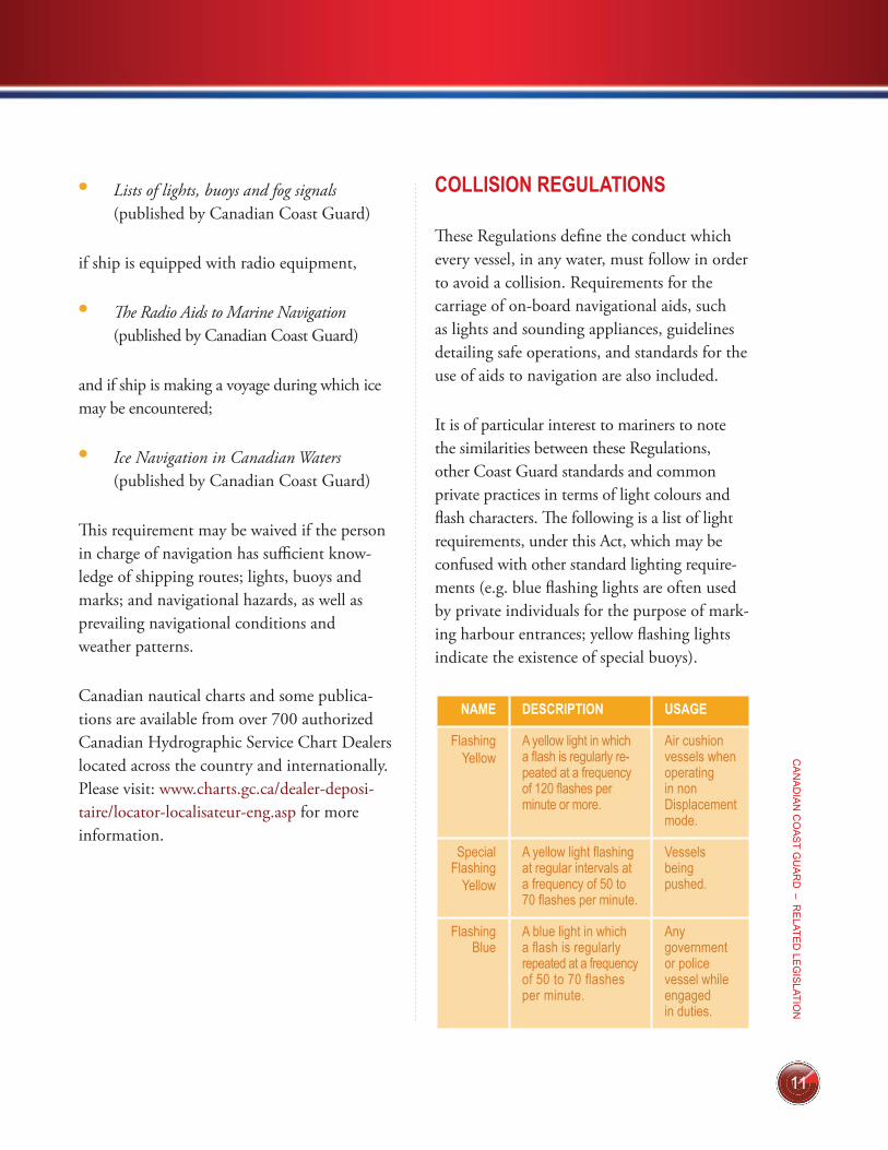
COLLISION REGULATIONS
These Regulations define the conduct which every vessel, in any water, must follow in order to avoid a collision. Requirements for the carriage of on-board navigational aids, such as lights and sounding appliances, guidelines detailing safe operations, and standards for the use of aids to navigation are also included.
It is of particular interest to mariners to note the similarities between these Regulations, other Coast Guard standards and common private practices in terms of light colours and flash characters. The following is a list of light requirements, under this Act, which may be confused with other standard lighting require-ments (e.g. blue flashing lights are often used by private individuals for the purpose of mark-ing harbour entrances; yellow flashing lights indicate the existence of special buoys).
NAME DESCRIPTION USAGE
FlashingYellow
A yellow light in which a flash is regularly re-peated at a frequency of 120 flashes per minute or more.
Air cushion vessels when operating in non Displacement mode.
Special Flashing
Yellow
A yellow light flashing at regular intervals at a frequency of 50 to 70 flashes per minute.
Vessels being pushed.
Flashing Blue
A blue light in which a flash is regularly repeated at a frequency of 50 to 70 flashes per minute.
Any government or police vessel while engaged in duties.
12
CA
NA
DIA
N C
OA
ST
GU
AR
D –
TH
E C
AN
AD
IAN
AID
S T
O N
AVIG
ATIO
N S
YS
TEM
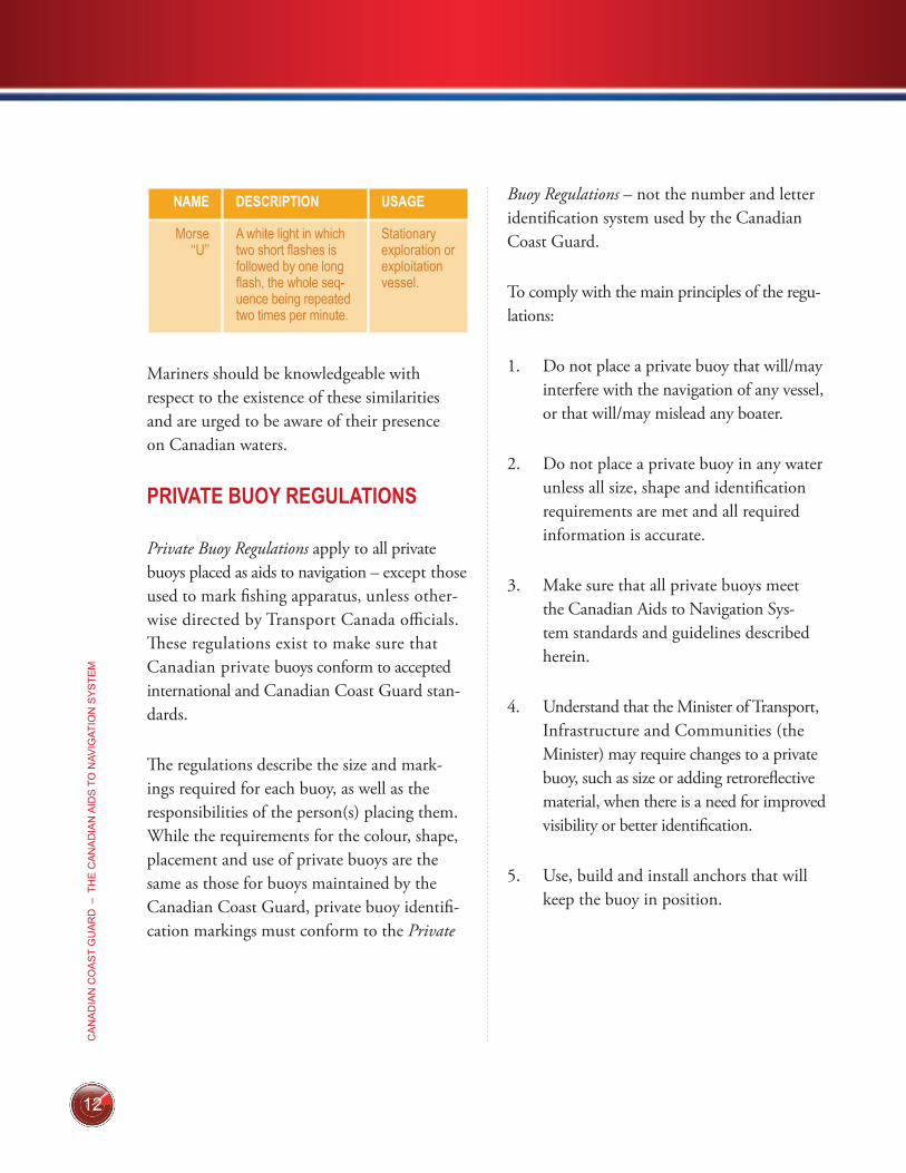
NAME DESCRIPTION USAGE
Morse ‘‘U’’
A white light in which two short flashes is followed by one long flash, the whole sequence being repeated two times per minute.
Stationary exploration or exploitation vessel.
Mariners should be knowledgeable with respect to the existence of these similarities and are urged to be aware of their presence on Canadian waters.
PRIVATE BUOY REGULATIONS
Private Buoy Regulations apply to all private buoys placed as aids to navigation – except those used to mark fishing apparatus, unless other-wise directed by Transport Canada officials. These regulations exist to make sure that Canadian private buoys conform to accepted international and Canadian Coast Guard stan-dards.
The regulations describe the size and mark-ings required for each buoy, as well as the responsibilities of the person(s) placing them. While the requirements for the colour, shape, placement and use of private buoys are the same as those for buoys maintained by the Canadian Coast Guard, private buoy identifi-cation markings must conform to the Private
Buoy Regulations – not the number and letter identification system used by the Canadian Coast Guard.
To comply with the main principles of the regu-lations:
1. Do not place a private buoy that will/may interfere with the navigation of any vessel, or that will/may mislead any boater.
2. Do not place a private buoy in any water unless all size, shape and identification requirements are met and all required information is accurate.
3. Make sure that all private buoys meet the Canadian Aids to Navigation Sys-tem standards and guidelines described herein.
4. Understand that the Minister of Transport, Infrastructure and Communities (the Minister) may require changes to a private buoy, such as size or adding retroreflective material, when there is a need for improved visibility or better identification.
5. Use, build and install anchors that will keep the buoy in position.
13
CA
NA
DIA
N C
OA
ST G
UA
RD
– RE
LATED
LEG
ISLATIO
N
6. When needed, use lighted buoys that meet the Canadian Aids to Navigation System standards, during the hours of darkness or periods of poor visibility.
7. Understand that when a private buoy does not meet legal standards, the Minister may order you to modify it to meet cur-rent standards or remove it.
Note: Consult the full text of the Regulations or The Owner’s Guide To Private Buoys for further details.
VESSEL OPERATION RESTRICTION REGULATIONS
The Vessel Operation Restriction Regulations govern the marking of any private buoy used to restrict navigation (e.g. speed limits, keep-out areas, etc.). Under these regulations, requests for restrictions are (a) originated by local authorities; and then (b) sent to Transport Canada’s Office of Boating Safety for final review and publication in the regulations.
Quebec, Alberta and Ontario each have a designated provincial authority. In those provinces, the Provincial authority reviews the applications before they are submitted to Transport Canada.
To comply with the main principles of the Vessel Operation Restriction Regulations:
1. Do not place a sign that restricts the operation of any vessel in Canadian waters without the authorization of the Minister. Signs must comply with the regulations requirements.
2. Do not change, hide, damage or destroy any authorized sign or use a sign for mooring purposes.
3. Respect restrictions conveyed in an authorized sign when boating.
4. Do not hold a sporting, recreational, or public event in waters specified in Schedule 8 of the regulations, unless authorized by a permit issued by the Minister.
5. Do not hold a sporting, recreational, or public event in any waters in a manner or at a place that would unnecessarily obstruct navigation.
14
CA
NA
DIA
N C
OA
ST
GU
AR
D –
TH
E C
AN
AD
IAN
AID
S T
O N
AVIG
ATIO
N S
YS
TEM
6. Do not place signs or symbols on control buoys and keep-out buoys unless they are otherwise authorized under the Act or another Act of Parliament, such as the Navigable Waters Protection Act.
Under theses regulations, an enforcement of-ficer may direct or prohibit the movement of vessels to ensure compliance with the require-ments for safe vessel operation.
Any person who does not comply with these regulations may be charged with an offence. In provinces where the provisions of the Contraventions Act apply, offenders will normally be ticketed. A schedule of fines is shown in the Contraventions Regulations.
A complete listing of Provincial contacts for boating safety information and permits is included at the end of this publication. For full details of these provisions consult the full text of the Canada Shipping Act 2001, Vessel Operation Restriction Regulations.
CRIMINAL CODE OF CANADA
Section 439 of the Criminal Code of Canada provides:
(i) Everyone who makes fast a ves-sel or boat to a signal, buoy or other seamark that is used for purposes of navigation is guilty of an offence punishable on sum-mary conviction.
(ii) Everyone who wilfully
alters, removes or conceals a sig-nal, buoy or other seamark that is used for purposes of navigation is guilty of an indictable offence and liable for imprisonment for a term not exceeding ten years.
*439.
15
CA
NA
DIA
N C
OA
ST G
UA
RD
– CA
NA
DIA
N C
OA
ST G
UA
RD
AID
S TO
NAV
IGATIO
N
C anadian Coast Guard Aids to Navigation is any aid to naviga-tion owned by the Canadian Coast
Guard. This may include any aid owned by another government authority that is subject to an agreement between the Canadian Coast Guard and that other government authority provided that the Canadian Coast Guard retains operational and maintenance responsibilities
The Canadian Coast Guard and some other government aids to navigation are distinguish-able from private buoys by their distinctive numbering-lettering system.
CANADIAN COAST GUARD AIDS TO NAVIGATION 5
16
CA
NA
DIA
N C
OA
ST
GU
AR
D –
TH
E C
AN
AD
IAN
AID
S T
O N
AVIG
ATIO
N S
YS
TEM
OTHER GOVERNMENT AIDS TO NAVIGATION
O ther government aids to naviga-tion are owned by government authorities which assume full
operational and maintenance responsibilities. These may include any Federal, Provincial, or other government agency, department, Crown Corporation or other authority. For example, the Department of National Defence, Parks Canada, Environment Canada, Harbour and Port Commissions, and Ferry Corporations are current providers of other government aids to navigation.
When charted, these aids will not be identified “PRIV” as other private aids.
6
17
CA
NA
DIA
N C
OA
ST G
UA
RD
– PR
IVATE A
IDS
TO N
AVIG
ATION
GENERAL
In Canada, it is permissible for private indi-viduals, clubs, corporations or other groups to establish aids to navigation or mooring buoys for their own use. Such aids to navigation are known as “private aids” and they are advertised accordingly in the List of Lights, Buoys and Fog Signals as well as on the charts. They are defined as those aids to navigation or mooring buoys which are not operated by a Federal or Provincial government or agency. The Canadian Coast Guard considers any aid owned by a Mu-nicipal government to be private.
The Canadian Coast Guard recognizes the value of these aids in contributing to the safety and well-being of the boating community. The use of private aids shall be encouraged to meet local demands when Canadian Coast Guard aids are not justified by existing policies and directives.
Private Buoys
All private buoys are governed by the Private Buoys Regulations. These regulations specify the required marking, size, and identifica-tion of private buoys and require that they
comply with this publication. The Minister of Transport is responsible for the development, implementation and enforcement of these regulations including the removal or directing the removal or modification of any non-compliant private buoys. The Canadian Coast Guard continues to be responsible for the implementation, management and delivery of the Canadian Aids to Navigation Systems and for all technical publications related thereto.
Private Fixed Aids
Private fixed aids which are in navigable waters and are constructed below the high water mark are considered works under the Navigable Waters Protection Act. The Min-ister of Transport may impose any terms and conditions on the approval of a work, includ-ing lights, marks and buoys. The act authorizes the Minister of Transport to order the removal or alteration and, if the order is not complied with, to remove any work that has not been approved; does not comply with the act; or with the terms and conditions of the approval.
PRIVATE AIDS TO NAVIGATION 7
18
CA
NA
DIA
N C
OA
ST
GU
AR
D –
TH
E C
AN
AD
IAN
AID
S T
O N
AVIG
ATIO
N S
YS
TEM
Private Mooring Buoys
Transport Canada considers mooring buoys as ‘‘works’’ under the Navigable Waters Protection Act, since they usually secure vessels in fixed locations (e.g. docks, piers, or wharves), and do not aid or direct mariners. This means that the placement of a mooring buoy is subject to review and app roval under the act, unless otherwise excluded under Transport Canada’s policies and standards. For more details, go to: www.tc.gc.ca/eng/marinesafety/tp-tp14799-nwpa-181.htm
Liability
In the event of an accident involving a private aid, the person(s) owning that aid to navigation may be held liable for any dam-ages resulting from negligent operation and/or maintenance of the aid. Owners are advised to take all necessary precautions to ensure that private aids conform to international and Canadian Coast Guard standards and are oper-ated and maintained in the proper manner. The purchase of liability insurance is recommended.
References
The Navigable Water Protection Program is responsible for all aspects of the Private Buoy Regulations and Navigable Water Protection Act, including enforcement. For more informa-tion, please contact your local Navigable Water Protection Program office or consult Transport Canada’s publication An Owner’s Guide to Pri-vate Buoys at www.tc.gc.ca/eng/marinesafety/tp-tp14799-menu-634.htm.
MARKINGS AND DIMENSIONS
In the Canada Shipping Act 2001, Private Buoy Regulations, all private buoys in Canada are required to conform to the aids to navigation standards set out herein. As such, all require-ments for buoy identification and marking, apart from those relating to size and lettering, are described throughout this manual.
The Private Buoy Regulations require that private buoys meet minimum above water dimensions of 15.25 cm (6 inches) in width and 30.5 cm (12 inches) in height. This should be regarded as the absolute minimum, suitable only for very sheltered, low traffic areas. In general, the buoy should be large enough to be seen at the distance for which its signal can be interpreted to allow for timely ac-
19
CA
NA
DIA
N C
OA
ST G
UA
RD
– PR
IVATE A
IDS
TO N
AVIG
ATION
tion by the mariner. Consideration should be given to both adverse weather conditions and varying sea states. The Private Buoy Regula-tions allow Transport Canada the authority to require buoys to be larger than the minimum, be equipped with retroreflective material, or be altered in any other way in the interest of safety (e.g. addition of lights, sound appliances, etc.) in accordance with prevailing site conditions.
The Private Buoy Regulations also require that buoys display, on two opposite sides, the capital letters “PRIV”. These letters are to be as large as practical for the size of the buoy and contrasting in colour: white when the background colour is red, green or black, and black when the back-ground colour is white or yellow. Additionally, the current name, address and telephone num-ber of the owner of the buoy must be displayed in a permanent and legible manner.
If the owner of a private buoy wishes to place additional numbers or letters on a buoy for identification purposes, the number or letter system must not correspond to the letter and number system used by the Canadian Coast Guard in that immediate area. This serves
to ensure that there is no confusion between government-operated aids, private aids and any other charted aids.
PUBLIC NOTIFICATION
When a private aid is placed or erected in or near charted waters, it is desirable to provide the Canadian Coast Guard with sufficient information to allow for publication of their positions and characteristics in marine notices (Notices to Mariners; Notices to Shipping) and for charting of the buoy(s) by the Canadian Hydrographic Service. Such information and any changes to existing charted buoys should be transmitted to the nearest Canadian Coast Guard office or to a Canadian Coast Guard Marine Communications and Traffic Services Centre.
20
CA
NA
DIA
N C
OA
ST
GU
AR
D –
TH
E C
AN
AD
IAN
AID
S T
O N
AVIG
ATIO
N S
YS
TEM
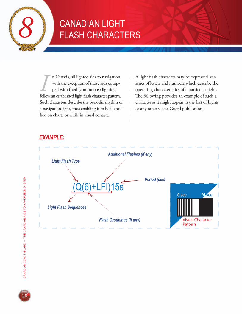
I n Canada, all lighted aids to navigation, with the exception of those aids equip-ped with fixed (continuous) lighting,
follow an established light flash character pattern. Such characters describe the periodic rhythm of a navigation light, thus enabling it to be identi-fied on charts or while in visual contact.
A light flash character may be expressed as a series of letters and numbers which describe the operating characteristics of a particular light. The following provides an example of such a character as it might appear in the List of Lights or any other Coast Guard publication:
CANADIAN LIGHT FLASH CHARACTERS8
EXAMPLE:
(Q(6)+LFI)15s
Light Flash Type
Light Flash Sequences
Additional Flashes (if any)
Flash Groupings (if any)
Period (sec)
Visual CharacterPattern
21
CA
NA
DIA
N C
OA
ST G
UA
RD
– CA
NA
DIA
N LIG
HT FLA
SH
CH
AR
AC
TER
S
In all cases, the first letter(s) in the light flash character gives reference to the general light flash type or classification. This classification is based on the duration of illumination in rela-tion to eclipse (darkness) for each light flash. In the example on page 20, the letter “Q” indicates that the aid is equipped with a quick flashing light; a quick flashing light being one which flashes at a rate of one flash per second.
Where a light exhibits group flashes, the second symbol in the character will indicate the num-ber of flashes in each grouping. In the same example, the ‘‘(6)’’ indicates that flashes occur in groups of 6. Where the aid exhibits a single, ungrouped flash no value will be shown.
Any additional flash that may be included in the sequence will be indicated by the use of a ‘‘+’’ in the character followed by reference to an additional flash or flash grouping. For example, in the illustration on page 20, the quick (Q) six flash grouping (6) is followed by a long flash (+LFl).
The final number in the light flash character identifies the period of time within which the entire flash sequence occurs, as shown in the example on page 20. The character indicates that the entire flash sequence will be repeated every 15 seconds or 4 times every minute.
Once the entire light flash character is taken into account, the mariner should be able to correctly identify the aid (e.g. the example shows a light flash character for a South Cardinal buoy).
22
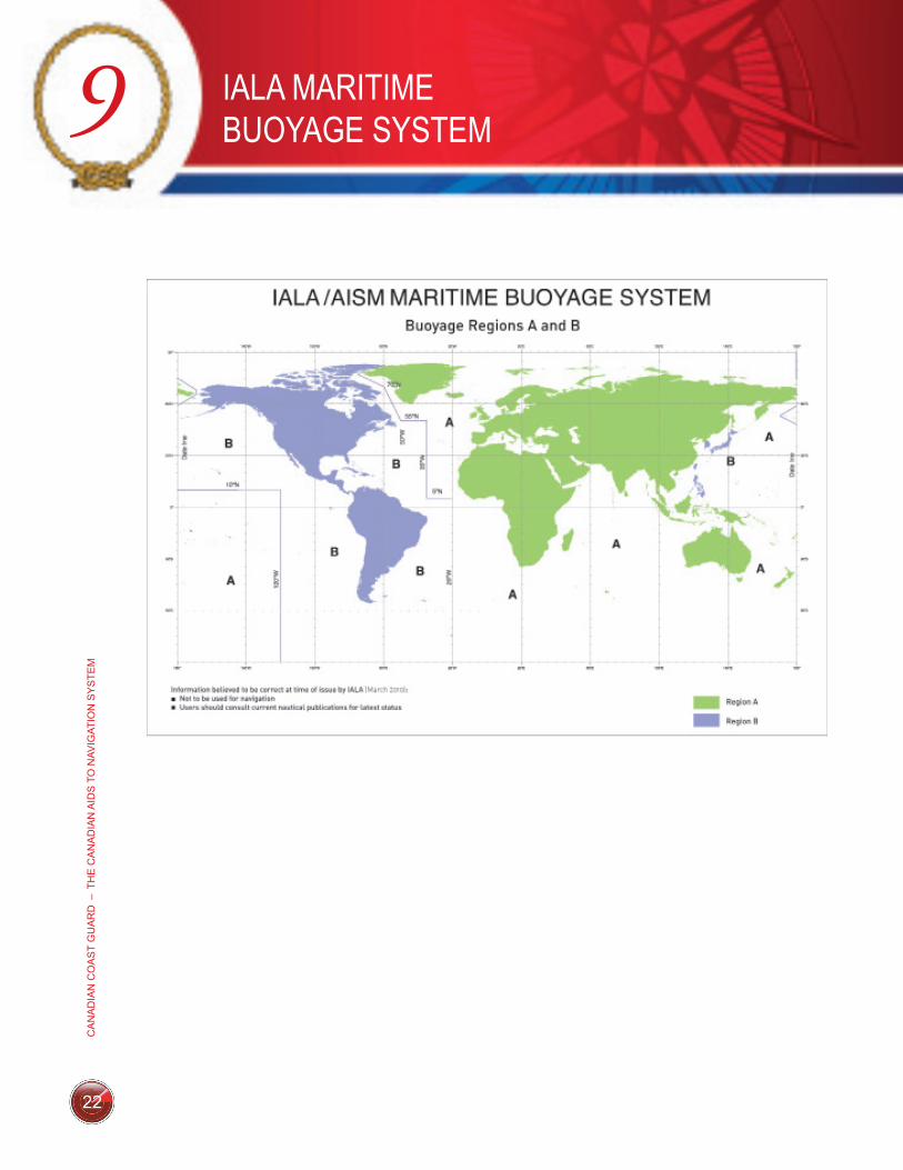
IALA MARITIME BUOYAGE SYSTEM9
CA
NA
DIA
N C
OA
ST
GU
AR
D –
TH
E C
AN
AD
IAN
AID
S T
O N
AVIG
ATIO
N S
YS
TEM
23
CA
NA
DIA
N C
OA
ST G
UA
RD
– FLOATIN
G A
IDS
TO N
AVIG
ATION
(BU
OY
S)
T he buoyage system used in Canada corresponds to the International Association of marine aids to naviga-
tion Lighthouse Authorities (IALA) Maritime Buoyage System which has been adopted by all major maritime nations in the world. This system includes lateral, isolated danger, cardinal and special buoys.
For lateral buoys, the IALA Maritime Buoyage System divides the world into two regions, ‘‘A’’ and ‘‘B’’. Within Region ‘‘B’’, which includes Canada, starboard hand buoys are red and port hand buoys are green. Within Region ‘‘A’’, the application of these colours is reversed with red to port and green to star-board. Bifurcation buoys are similarly affected in that the predominant colour of starboard bifurcation buoys is red in Region ‘‘B’’ and green in Region ‘‘A’’ and that of port bifurcation buoys is green in Region ‘‘B’’ and red in Region ‘‘A’’. All other aspects of the IALA Maritime Buoyage System are the same in both Regions ‘‘A’’ and ‘‘B’’.
Since the shape and/or colour of a buoy and the colour and flash character of the light on the buoy indicate the function of the buoy, it is essential that mariners use up to date nautical charts with this system. Please see the Can-adian Aids to Navigation System map for more details.
LATERAL BUOYS
Lateral buoys indicate the side on which they may be safely passed. There are five types of lateral buoys: port hand, starboard hand, port bifurcation, starboard bifurcation, and fairway.
Port Hand Buoy
(a) A port hand buoy marks the port (left) side of a channel or the location of a danger which must be kept on the vessel’s port (left) side when proceeding in the upstream direction.
(b) A port hand buoy is coloured green, displays identification letter(s) and odd number(s) and
(i) if it carries a light, the light is green and is a flashing (Fl)4s or quick flashing (Q)1s light,
(ii) if it carries retroreflective material, such material is green,
FLOATING AIDS TO NAVIGATION (BUOYS) 10
24
CA
NA
DIA
N C
OA
ST
GU
AR
D –
TH
E C
AN
AD
IAN
AID
S T
O N
AVIG
ATIO
N S
YS
TEM
(iii) if it does not carry a light, it has a flat top, and
(iv) if it carries a topmark, the topmark is a single green cylinder.
Starboard Hand Buoy
(a) A starboard hand buoy marks the star-board (right) side of a channel or the location of a danger which must be kept on the vessel’s starboard (right) side when proceeding in the upstream direction.
(b) A starboard hand buoy is coloured red, displays identification letter(s) and even number(s) and
(i) if it carries a light, the light is red and is a flashing (Fl)4s or quick flashing (Q)1s light,
(ii) if it carries retroreflective material, such material is red,
(iii) if it does not carry a light, it has a pointed (conical) top, and
(iv) if it carries a topmark, the topmark is a single red cone pointing upward.
Port Bifurcation Buoy
(a) A port bifurcation buoy marks the point where a channel divides when viewed from a vessel proceeding in the upstream direction and indicates that the preferred or main channel is on the starboard (right) side of the buoy.
(b) A port bifurcation buoy is coloured green with one broad red horizontal band, displays identification letter(s), and
(i) if it carries a light, the light is green and is a composite group flashing Fl(2+1)6s or Fl(2+1)10s light,
(ii) if it carries retroreflective material, such material is green,
(iii) if it does not carry a light, the top of the buoy is flat, and
(iv) if it carries a topmark, the topmark is a single green cylinder.
25
CA
NA
DIA
N C
OA
ST G
UA
RD
– FLOATIN
G A
IDS
TO N
AVIG
ATION
(BU
OY
S)
Starboard Bifurcation Buoy
(a) A starboard bifurcation buoy marks the point where a channel divides when viewed from a vessel proceeding in the upstream direction and indicates the preferred or main channel is on the port (left) side of the buoy.
(b) A starboard bifurcation buoy is coloured red with one broad green horizontal band, displays identification letter(s), and
(i) if it carries a light, the light is red and is a composite group flashing Fl(2+1)6s or Fl(2+1)10s light,
(ii) if it carries retroreflective material, such material is red,
(iii) if it does not carry a light, the top of the buoy is conical, and
(iv) if it carries a topmark, the topmark is a single red cone pointing upward.
Fairway Buoy
(a) A fairway buoy indicates safe water. It is used to mark landfalls, channel entrances or the centre of a channel. It may be passed on either side but should be kept to the port (left) when proceed-ing in either direction.
(b) A fairway buoy is coloured red and white in wide vertical stripes of equal widths, displays identification letter(s), and
(i) if it carries a light, the light is white and is either a Morse ‘‘A’’ Mo(A)6s light or a long flash (LFl)10s light,
(ii) if it carries retroreflective material, such material is white,
(iii) if it does not carry a light, the top of the buoy is spherical, and
(iv) if it carries a topmark, the topmark is a single red sphere.

26
CA
NA
DIA
N C
OA
ST
GU
AR
D –
TH
E C
AN
AD
IAN
AID
S T
O N
AVIG
ATIO
N S
YS
TEM
ISOLATED DANGER BUOY
(a) An isolated danger buoy is moored on, or above, an isolated danger which has navigable water all around it.
(b) An isolated danger buoy is black with one broad red horizontal band, displays identification letter(s), and
(i) if it carries a light, the light is white and is a group flashing Fl(2)5s or Fl(2)10s light,
(ii) if it carries retroreflective material, such material is white,
(iii) if it does not carry a light, it is normally spar shaped although other shapes may be used, and
(iv) if it carries a topmark, the topmark is two black spheres, one above the other.
CARDINAL BUOYS
Cardinal buoys indicate the location of the safest or deepest water by reference to the cardinal points of the compass. There are four cardinal buoys: North, East, South and West.
If a cardinal buoy carries retroreflective material, such material is white. Where lights are not present, the cardinal buoy will normally be spar shaped although other shapes may be used.
North Cardinal Buoy
(a) A north cardinal buoy is located so that the safest water exists to the north of it.
(b) A north cardinal buoy is coloured black and yellow in approximately equal areas above the waterline, the top half of the buoy being black and the lower half being yellow. It displays identification letter(s) and
(i) if it carries a light, the light is white and is a quick flashing (Q)1s or very quick flashing (VQ)5s light, and
(ii) if it carries a topmark, the topmark is two black cones, one above the other, pointing upward.
East Cardinal Buoy
(a) An east cardinal buoy is located so that the safest water exists to the east of it.
(b) An east cardinal buoy is coloured black with one broad yellow horizontal band. It displays identification letter(s) and
27
CA
NA
DIA
N C
OA
ST G
UA
RD
– FLOATIN
G A
IDS
TO N
AVIG
ATION
(BU
OY
S)
(i) if it carries a light, the light is white and is a group quick flashing three Q(3)10s or a group very quick flashing three VQ(3)5s light, and
(ii) if it carries a topmark, the topmark is two black cones, one above the other, base to base.
South Cardinal Buoy
(a) A south cardinal buoy is located so that the safest water exists to the south of it.
(b) A south cardinal buoy is coloured black and yellow in approximately equal areas above the waterline, the top half of the buoy being yellow and the lower half being black. It displays identification letter(s) and
(i) if it carries a light, the light is white and is a group quick flashing six plus long flash (Q(6)+LFl)15s light or group very quick flashing six plus long flash(VQ(6)+LFl)10s light, and,
(ii) if it carries a topmark, the topmark is two black cones, one above the other, pointing downward.
West Cardinal Buoy
(a) A west cardinal buoy is located so that the safest water exists to the west of it.
(b) A west cardinal buoy is coloured yellow with one broad black horizontal band. It displays identification letter(s) and:
(i) if it carries a light, the light is white and is a group quick flash ing nine Q(9)15s light or a group very quick flashing nine VQ(9)10s light, and
(ii) if it carries a topmark, the topmark is two black cones, one above the other, point to point.
SPECIAL BUOYS
Special buoys are used to convey specific information to the mariner. These buoys are not primarily used to assist in the navigation of the vessel. The shapes of special buoys have no significance and a variety of shapes may be used in practice.
Many special buoys are privately owned and, as such, must conform to the Private Buoy Regulations.
All special buoys, where lighted, will display yellow lights. With the exception of ODAS buoys, these lights will be flashing (Fl)4s, meaning that they will flash regularly at
28
CA
NA
DIA
N C
OA
ST
GU
AR
D –
TH
E C
AN
AD
IAN
AID
S T
O N
AVIG
ATIO
N S
YS
TEM
intervals of 4 seconds. Each ODAS Buoy, if lighted, will also carry yellow lights but will display a group flashing character of 5 flashes every 20 seconds, Fl(5)20s.
In cases where special buoys display retrore-flective material, such material will be yellow. Additionally, where a buoy exhibits an orange symbol (e.g. Hazard), orange retroreflective material may be added to enhance the visibil-ity of the symbol. Where no colour is required (i.e. white swimming and diving buoys) retro-reflective material will be yellow.
Note: Keep-out and Control buoys are governed by the Canada Shipping Act 2001, Vessel Operation Restriction Regulations. ODAS and Diving buoys are governed by the Canada Shipping Act 2001, Collision Regulations.
Anchorage Buoy
(a) An anchorage buoy marks the perimeter of a designated anchorage area.
(b) An anchorage buoy is coloured yellow, displays a black anchor symbol on at least two opposite sides, displays identifi-cation letter(s), and, if it carries a top-mark, the topmark is a single yellow ‘‘X’’ shape.
Cautionary Buoy
(a) A cautionary buoy marks an area where mariners are to be warned of dangers such as firing ranges, racing courses, seaplane bases, underwater structures, aquaculture, of areas where no safe through channel exists, and of traffic separations. The mariner must consult his chart to determine the precise nature of the danger being marked.
(b) A cautionary buoy is coloured yellow, displays identification letter(s) and if it carries a topmark, the topmark is a single yellow “X” shape.
Control Buoy
(a) A control buoy marks an area where boating is restricted.
(b) A control buoy is coloured white and has an orange, open faced circle on two opposite sides and two orange hori-zontal bands, one above and one below the circles. A black figure or symbol inside the orange circles indicates the nature of the restriction in effect. It may display identification letter(s).
29
CA
NA
DIA
N C
OA
ST G
UA
RD
– FLOATIN
G A
IDS
TO N
AVIG
ATION
(BU
OY
S)
Diving Buoy
(a) A diving buoy marks an area where scuba or other such diving activity is in progress.
(b) A diving buoy is coloured white and carries a red flag not less than 50 centi-metres square with a white diagonal stripe extending from the tip of the hoist to the bottom of the fly. It may display identifica-tion letter(s) and if it carries retroreflective material, such material is yellow.
Hazard Buoy
(a) A hazard buoy marks random hazards such as rocks, shoals or turbulent waters located outside the main channel.
(b) A hazard buoy is coloured white and has an orange diamond on two opposite sides and two orange horizontal bands, one above and one below the diamond symbols. Information words or symbols concerning the hazard may be placed within the diamond symbol, or if space doesn’t per-mit, between the orange bands. It may also display identification letter(s).
Information Buoy
(a) An information buoy displays, by means of words or symbols, information of interest to the mariner.
(b) An information buoy is coloured white and has an orange, open faced square sym-bol on two opposite sides and two orange horizontal bands, one above and one below the square symbols. The information words or symbols are black and are placed within the white face of the square symbol. It may display identification letter(s).
Keep-out Buoy
(a) A keep-out buoy marks an area where boats are prohibited.
(b) A keep-out buoy is coloured white and has an orange diamond containing an orange cross on two opposite sides and two orange horizontal bands, one above and one below the diamond symbols. It may display identification letter(s).
Mooring Buoy
(a) A mooring buoy is used for mooring or securing a vessel, seaplane, etc.
(b) A mooring buoy is coloured white and orange, the orange colour covering the top one third of the buoy above the waterline. It may display identification letter(s).
30
CA
NA
DIA
N C
OA
ST
GU
AR
D –
TH
E C
AN
AD
IAN
AID
S T
O N
AVIG
ATIO
N S
YS
TEM
Ocean Data Acquisition System (ODAS) Buoy
(a) An ODAS buoy marks a scientific, meteorological or oceanographic station.
(b) An ODAS buoy shall not exhibit a shape that conflicts with any navigational mark.
(c) An ODAS buoy is coloured yellow, displays identification letter(s) and
(i) if it carries a light, the light is yellow and is a group flashing light of 5 flashes every 20 seconds, Fl(5)20s, and
(ii) if it carries a topmark, the topmark is a single yellow ‘‘X’’ shape.
Swimming Buoy
(a) A swimming buoy marks the perimeter of a swimming area.
(b) A swimming buoy is coloured white, and may display identification letter(s)
DAYTIME IDENTIFICATION
During daytime, the colour and shape of a buoy indicates the buoy type, function and therefore interpretation by the mariner.
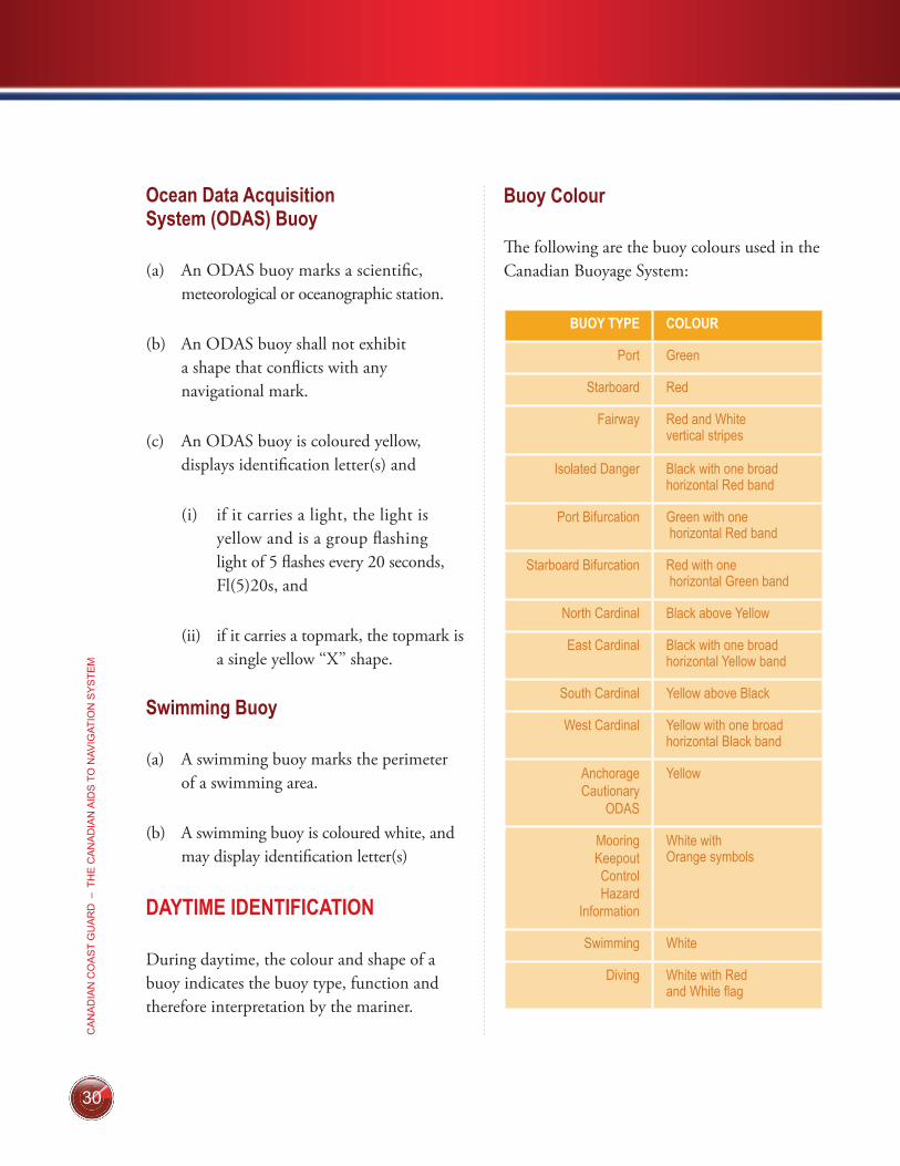
Buoy Colour
The following are the buoy colours used in the Canadian Buoyage System:
BUOY TYPE COLOUR
Port Green
Starboard Red
Fairway Red and White vertical stripes
Isolated Danger Black with one broad horizontal Red band
Port Bifurcation Green with one horizontal Red band
Starboard Bifurcation Red with one horizontal Green band
North Cardinal Black above Yellow
East Cardinal Black with one broad horizontal Yellow band
South Cardinal Yellow above Black
West Cardinal Yellow with one broad horizontal Black band
AnchorageCautionary
ODAS
Yellow
MooringKeepoutControlHazard
Information
White with Orange symbols
Swimming White
Diving White with Red and White flag
31
CA
NA
DIA
N C
OA
ST G
UA
RD
– FLOATIN
G A
IDS
TO N
AVIG
ATION
(BU
OY
S)
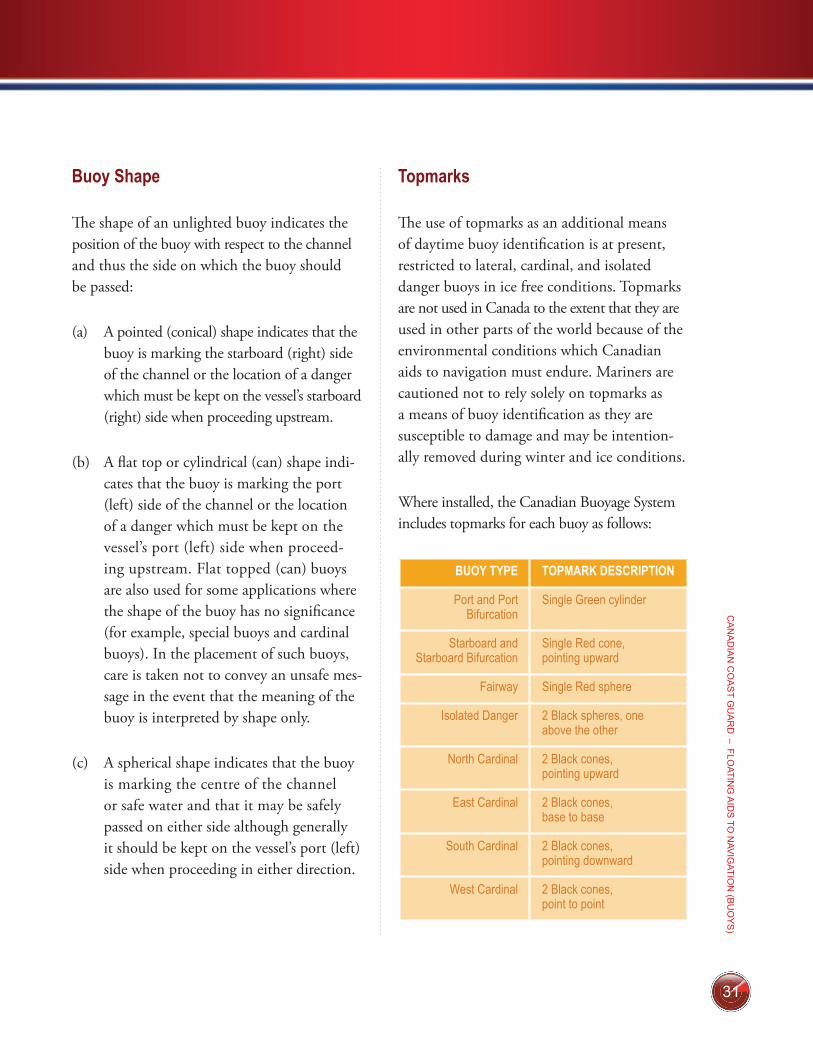
Buoy Shape
The shape of an unlighted buoy indicates the position of the buoy with respect to the channel and thus the side on which the buoy should be passed:
(a) A pointed (conical) shape indicates that the buoy is marking the starboard (right) side of the channel or the location of a danger which must be kept on the vessel’s starboard (right) side when proceeding upstream.
(b) A flat top or cylindrical (can) shape indi-cates that the buoy is marking the port (left) side of the channel or the location of a danger which must be kept on the vessel’s port (left) side when proceed-ing upstream. Flat topped (can) buoys are also used for some applications where the shape of the buoy has no significance (for example, special buoys and cardinal buoys). In the placement of such buoys, care is taken not to convey an unsafe mes-sage in the event that the meaning of the buoy is interpreted by shape only.
(c) A spherical shape indicates that the buoy is marking the centre of the channel or safe water and that it may be safely passed on either side although generally it should be kept on the vessel’s port (left) side when proceeding in either direction.
Topmarks
The use of topmarks as an additional means of daytime buoy identification is at present, restricted to lateral, cardinal, and isolated danger buoys in ice free conditions. Topmarks are not used in Canada to the extent that they are used in other parts of the world because of the environmental conditions which Canadian aids to navigation must endure. Mariners are cautioned not to rely solely on topmarks as a means of buoy identification as they are susceptible to damage and may be intention-ally removed during winter and ice conditions.
Where installed, the Canadian Buoyage System includes topmarks for each buoy as follows:
BUOY TYPE TOPMARK DESCRIPTION
Port and Port Bifurcation
Single Green cylinder
Starboard and Starboard Bifurcation
Single Red cone, pointing upward
Fairway Single Red sphere
Isolated Danger 2 Black spheres, one above the other
North Cardinal 2 Black cones, pointing upward
East Cardinal 2 Black cones, base to base
South Cardinal 2 Black cones, pointing downward
West Cardinal 2 Black cones, point to point
32
CA
NA
DIA
N C
OA
ST
GU
AR
D –
TH
E C
AN
AD
IAN
AID
S T
O N
AVIG
ATIO
N S
YS
TEM
TIP: A way of remembering the arrangement of the conical topmarks on Cardinal Buoys is to relate the direction of the points of the cones to the location of the black portion(s) of the buoy (e.g. on an East Cardinal, the upper cone pointing up and the lower cone pointing down relate to the black colour of the upper and lower portions of the buoy).
NIGHTTIME IDENTIFICATION
At night, the colour and flash character of a buoy’s light indicate its function.
Buoy Light Flash Characters
Lights of different colours are used to assist recognition of the marks in the Canadian Aids to Navigation system. Red and Green lights for the lateral buoys, White lights for the cardinal, isolated danger and safe-water buoys and Yellow lights for special buoys
The buoy light characteristics for all buoys in the Canadian Aids to Navigation System shall conform to the “Specifications for Buoy Light Characteristics” detailed in table below. The primary character shall be used in all cases except for:
1. when there is the need to distinguish between two identical buoys which are close to each other; or
2. where emphasis is required (for example, the use of the secondary character “quick flash” to distinguish buoys marking a turn in a lateral buoy system); or
3. when greater perception requirements demand or to improve the light’s avail-ability in severe waves conditions.
The following are the names, abbreviations and descriptions of the flash characters of the lights used in the Canadian Buoyage System:
33
CA
NA
DIA
N C
OA
ST G
UA
RD
– FLOATIN
G A
IDS
TO N
AVIG
ATION
(BU
OY
S)
TYPE PRIMARY SECONDARY
Port and Starboard
Flashing – (Fl)4s
• A light (red for starboard and green for port) in which the total duration of light in a period is shorter than the total duration of darkness and is regularly repeated at a rate of 15 flashes per minute (1 flash every 4 seconds).
0.5 sec. flash; 3.5 sec. eclipse
Quick Flashing – (Q)1s
• A light (red for starboard and green for port) in which identical flashes are repeated at the rate of 60 flashes per minute (1 flash every second).
0.3 sec. flash; 0.7 sec. eclipse
Fairway Morse Code A – Mo(A)6s
• A white light in which a 0.3 second flash is followed by a 0.6 second eclipse then a 1 second long flash repeated at a rate of 10 times per minute (every 6 seconds).
0.3 sec. flash; 0.6 sec. eclipse;1.0 sec. flash; 4.1 sec. eclipse;
Long Flash – (LFl)10s
• A white light in which a flash of 2 seconds duration is repeated at a rate of 6 flashes per minute (1 long flash every 10 seconds).
2.0 sec. flash; 8.0 sec. eclipse;
Bifurcation Composite Group Flashing Fl(2+1)6s
• A light (red for starboard and green for port) in which a group of 2 flashes is followed by a single flash, the whole sequence being repeated 10 times per minute (every 6 seconds).
0.3 sec. flash; 0.4 sec. eclipse;0.3 sec. flash; 1.2 sec. eclipse;0.3 sec. flash; 3.5 sec. eclipse;
Composite Group Flashing – Fl(2+1)10s
• A light (red for starboard and green for port) in which a group of 2 flashes is followed by a single flash, the whole sequence being repeated 6 times per minute (every 10 seconds).
0.5 sec. flash; 0.7 sec. eclipse;0.5 sec. flash; 2.1 sec. eclipse;0.5 sec. flash; 5.7 sec. eclipse;
Isolated Danger Group Flashing – Fl(2)5s
• A white light in which a group of 2 flashes is regularly repeated 12 times per minute (every 5 seconds).
0.4 sec. flash; 0.6 sec. eclipse;0.4 sec. flash; 3.6 sec. eclipse;
Group Flashing – Fl(2)10s
• A white light in which a group of 2 flashes is regularly repeated 6 times per minute (every 10 seconds).
1.0 sec. flash; 1.0 sec. eclipse;1.0 sec. flash; 7.0 sec. eclipse;
North Cardinal Quick Flashing – (Q)1s
• A white light in which identical flashes are repeated at the rate of 60 flashes per minute (1 flash every second).
0.3 sec. flash; 0.7 sec. eclipse
Very Quick Flashing – (VQ).5s
• A white light in which a flash is regularly repeated at a rate of 120 flashes per minute (1 flash every 0.5 second).
0.2 sec. flash; 0.3 sec. eclipse;
East Cardinal Group Quick Flashing Q(3)10s
• A white light in which a group of 3 flashes is regularly repeated 6 times per minute (every 10 seconds).
0.3 sec. flash; 0.7 sec. eclipse;0.3 sec. flash; 0.7 sec. eclipse;0.3 sec. flash; 7.7 sec. eclipse;
Group Very Quick Flashing – VQ(3)5s
• A very quick flashing white light in which a group of 3 flashes is regularly repeated 12 times per minute (every 5 seconds).
0.2 sec. flash; 0.3 sec. eclipse;0.2 sec. flash; 0.3 sec. eclipse;0.2 sec. flash; 3.8 sec. eclipse;
34
CA
NA
DIA
N C
OA
ST
GU
AR
D –
TH
E C
AN
AD
IAN
AID
S T
O N
AVIG
ATIO
N S
YS
TEM
TYPE PRIMARY SECONDARY
South Cardinal Group quick Flashing + Long Flash – (Q(6)+LFl)15s
• A white light in which a group of 6 quick flashes is followed by a single long flash, the whole sequence being regularly repeated 4 times per minute (every 15 seconds).
0.3 sec. flash; 0.7 sec. eclipse;0.3 sec. flash; 0.7 sec. eclipse;0.3 sec. flash; 0.7 sec. eclipse;0.3 sec. flash; 0.7 sec. eclipse;0.3 sec. flash; 0.7 sec. eclipse;0.3 sec. flash; 0.7 sec. eclipse;2.0 sec. flash; 7.0 sec. eclipse;
Group Very Quick Flashing + Long Flash – (VQ(6)+LFl)10s
• A white light in which a group of 6 very quick flashes is followed by a single long flash, the whole sequence being regularly repeated 6 times per minute (every 10 seconds).
0.2 sec. flash; 0.3 sec. eclipse;0.2 sec. flash; 0.3 sec. eclipse;0.2 sec. flash; 0.3 sec. eclipse;0.2 sec. flash; 0.3 sec. eclipse;0.2 sec. flash; 0.3 sec. eclipse;0.2 sec. flash; 0.3 sec. eclipse;2.0 sec. flash; 5.0 sec. eclipse;
West Cardinal Group Quick Flashing – Q(9)15s
• A quick flashing white light in which a group of 9 flashes is regularly repeated 4 times per minute (every 15 seconds).
0.3 sec. flash; 0.7 sec. eclipse;0.3 sec. flash; 0.7 sec. eclipse;0.3 sec. flash; 0.7 sec. eclipse;0.3 sec. flash; 0.7 sec. eclipse;0.3 sec. flash; 0.7 sec. eclipse;0.3 sec. flash; 0.7 sec. eclipse;0.3 sec. flash; 0.7 sec. eclipse;0.3 sec. flash; 0.7 sec. eclipse;0.3 sec. flash; 6.7 sec. eclipse;
Group Very quick Flashing – VQ(9)10s
• A very quick flashing white light in which a group of 9 flashes is regularly repeated 6 times per minute (every 10 seconds).
0.2 sec. flash; 0.3 sec. eclipse;0.2 sec. flash; 0.3 sec. eclipse;0.2 sec. flash; 0.3 sec. eclipse;0.2 sec. flash; 0.3 sec. eclipse;0.2 sec. flash; 0.3 sec. eclipse;0.2 sec. flash; 0.3 sec. eclipse;0.2 sec. flash; 0.3 sec. eclipse;0.2 sec. flash; 0.3 sec. eclipse;0.2 sec. flash; 5.8 sec. eclipse;
Special (except ODAS)
Flashing – (Fl)4s
• A yellow light in which the total duration of light in a period is shorter than the total dur-ation of darkness and is regularly repeated at a rate of 15 flashes per minute (1 flash every 4 seconds).
0.5 sec. flash; 3.5 sec. eclipse;
ODAS (Ocean Data Acquisition
System)
Group Flashing – Fl(5)20s
• A yellow light in which a group of 5 flashes is regularly repeated 3 times per minute (every 20 seconds).
0.5 sec. flash; 1.5 sec. eclipse;0.5 sec. flash; 1.5 sec. eclipse;0.5 sec. flash; 1.5 sec. eclipse;0.5 sec. flash; 1.5 sec. eclipse;0.5 sec. flash; 11.5 sec. eclipse;
35
CA
NA
DIA
N C
OA
ST G
UA
RD
– FLOATIN
G A
IDS
TO N
AVIG
ATION
(BU
OY
S)
TIP: As a way of remembering the light flash characters of the East, South and West Cardinal buoys, the number of flashes in each group for these lights is the same as the figure on the clock face in the corresponding compass direction (e.g. the 3 flashes in each group for the East cardinal corresponds to three o’clock). The long flash in the South Cardinal character ensures that there is no confusion between the 6 flashes per group of this buoy and the 9 flashes per group of the West Cardinal.
Buoy Light Colour
The following are the colours of the buoy lights used in the Canadian Buoyage System:
BUOY TYPE LIGHT COLOUR
Port and Port Bifurcation Green
Starboard and Starboard Bifurcation
Red
Fairway, Isolated Danger, and all Cardinals
White
All Special buoys Yellow
Retroreflective Material
Retroreflective material is applied to unlighted buoys to aid in their night time identification with a flashlight or other light source and to lighted buoys as a back up to the light. For all buoys other than special buoys the colour of the retroreflective material is the same as that of the light which would be appropriate
for each buoy. In cases where a special buoy is equipped with retroreflective material for use with number or letter plates/backgrounds, the colour of that material will be yellow. Additionally, where a buoy exhibits an orange symbol (e.g. Hazard), orange retroreflective material may be added to enhance visibility of the symbol.
Note: Swimming and diving buoys, which are white in colour, will use yellow retroreflective material.
OTHER CHARACTERISTICS
Buoy Numbering
Only starboard and port hand buoys are numbered; starboard hand buoys with even numbers and port hand buoys with odd numbers. Buoy numbers increase in the upstream direction and are kept in approxi-mate sequence on both sides of the channel by omitting numbers where required. Buoy numbers are usually preceded by one or two letters to facilitate channel identification. All other types of buoys are identified by letters only. All types of buoys may be identified by a name in addition to a number or letter identification. Private buoys are not numbered or lettered as they are not government-owned. Instead, they display the letters ‘‘PRIV’’ and other information required by the Private Buoy Regulations.
36
CA
NA
DIA
N C
OA
ST
GU
AR
D –
TH
E C
AN
AD
IAN
AID
S T
O N
AVIG
ATIO
N S
YS
TEM
Sound Signals
Any of the buoy types in the Canadian Buoyage System may be fitted with a bell or a whistle that is activated by the motion of the buoy in the water. The use of such buoys is gener-ally restricted to coastal waters where there is sufficient buoy motion to activate the sound device and where there is a requirement for an audio signal to enable location of the buoy under low visibility conditions.
Radar Reflectors
Many buoys are fitted with radar reflectors to improve their visibility on the radar screen.
Radar Beacons (RACONS)
When precise identification of a buoy is con-sidered essential, the buoy may be fitted with a radar beacon (RACON). Section 2 of the Radio Aids to Navigation publication provides a com-plete list of RACONS with information such as name and location, range, arc and identifier. The List of Lights, Buoys and Fog Signals publica-tion will also provide some information on the RACON.
Marking of New Dangers
New dangers such as a shipwreck or the discovery of an uncharted shoal or rock can occur suddenly and unexpectedly in waters which mariners have come to regard as safe. The Canadian Buoyage System makes the following special provisions for these hazards:
(a) Primary choice for marking a new danger is the Isolated Danger Aid moored on or installed above the danger. Lateral buoys, cardinal aids or cautionary buoys can also be used.
(b) One or more of the aids marking the new danger may be duplicated, the duplicate being identical to its partner in all respects.
(c) In general, any lighted lateral or cardinal aid used to mark a new danger will dis-play the most rapid flash character available for that aid.
(d) A new danger may be marked by a RACON coded Morse ‘‘D’’.
(e) Special measures taken to mark a new danger may be discontinued when infor-mation concerning the new danger has been sufficiently promulgated.
37
CA
NA
DIA
N C
OA
ST G
UA
RD
– FIXE
D A
IDS
TO N
AVIG
ATION
GENERAL
The characteristics of fixed aids are for iden-tification purposes. They consist of the light colour, flash character, and the colour and shape of the structure, as advertised in the appropriate List of Lights, Buoys and Fog Signals publication.
LIGHTED FIXED AIDS
General
Lighted fixed aids are structures equipped with a light and located at prominent sites to assist the mariner to fix his position. They may be at or near shorelines or on built up, man made piers in or near waterways. The structure and colour(s) of lighted fixed aids are often selected for maximum visibility and ease of identification and may or may not have lateral significance.
Types
The types and shapes of fixed, lighted struc-tures used in Canada are varied. They may have vertical or tapering sides, may be circular, square, polygonal or octagonal in shape, and may be constructed of wood, masonry, con-crete, metal or fibreglass. They may be slender cylindrical structures such as pipes or poles or open skeleton towers.
Major lighed aids are coastal landfall lights that have distinctive characteristics to assist the mariner in determining his exact location.
Minor lighted aids are fixed marks which indicate position or warn of dangers. Typically, minor lighted aids which display a single red, green or black band or a daybeacon mark lat-eral significance. Minor lighted aids which dis-play double red bands provide for secondary landfall. Where these secondary landfall aids are also used to define lateral significance, a directional symbol (e.g. a green square – port) will be displayed between the two red bands.
Note: See the Canadian Aids to Navigation System map for a further explanation of these types.
Isolated Danger Aids: An isolated danger aid is installed above an isolated danger which has navigable water all around it. It is black with one broad red horizontal band and displays identification letter(s). For more characteris-tics, please refer to page 26.
Cardinal Aids: Cardinal Aids indicate the loca-tion of the safest or deepest water by reference to the cardinal points of the compass. There are four cardinal aids:
FIXED AIDS TO NAVIGATION 11
38
CA
NA
DIA
N C
OA
ST
GU
AR
D –
TH
E C
AN
AD
IAN
AID
S T
O N
AVIG
ATIO
N S
YS
TEM
North, East, South and West. Please refer to page 26 for characteristics as they are similar to cardinal buoys characteristics.
Lateral Significance
When proceeding upstream, fixed aids dis-playing a red triangular symbol in the centre of the daymark or a single red band at the top of the tower must be kept on the vessel’s starboard (right) hand side. Fixed aids dis-playing a black or green square symbol in the centre of the daymark or a single green or black band at the top of the tower must be kept on the vessel’s port (left) hand side.
Fixed aids displaying an open faced red dia-mond symbol in the centre of the daymark indicate a division in the channel and may be passed on either side. However, when proceed-ing upstream, a red triangle in the centre of the red diamond indicates that the preferred route is to the left (i.e. the aid should be kept on the vessel’s starboard (right) side). Similarly, a black or green square in the centre of the red diamond indicates that the preferred route is to the right (i.e. the aid should be kept on the vessel’s port (left) side).
Light Characteristics
The following are the names, abbreviations (as they appear on nautical charts), and descrip-tions of the basic types of light flash characters for Canadian light stations:
NAME ABBREVIATION DESCRIPTION
Fixed F A light which appears continuous
Isophase Iso A light in which the alternations of light and darkness are of equal length.
Flashing Fl A light in which the flash is clearly shorter than the duration of darkness (eclipse) and in which the flashes of light are all of equal duration.
Occulting Oc A light in which the flash is clearly longer that the duration of darkness (eclipse) and in which the intervals of darkness are all of equal duration.
Emergency Backup
Fl(6)15s A light in which a group of 6 flashes is regularly repeated at a rate of 4 sets per minute (every 15 seconds)
39
CA
NA
DIA
N C
OA
ST G
UA
RD
– FIXE
D A
IDS
TO N
AVIG
ATION
The duration of flash and darkness of each light may vary and are advertised in the appropriate List of Lights, Buoys and Fog Signals publication. Mariners are advised that there may be more than one light flash character displayed by a light station (e.g. a high intensity flashing light may be superimposed on a fixed light) and thus, the List of Lights, Buoys and Fog Signals should be consulted to ensure proper identification.
Light Colours
The choice of light colour for fixed aids is dependent on individual site conditions (e.g. presence of background light) and the lumin-ous range of the light colour in relation to those conditions. As a result, no set rules exist for such lights and mariners should always consult the chart to determine the function of each light.
There are, however, a few general guidelines which may be followed:
a) Major coastal landfall lights are normally white,
b) Green or red lights are normally used to denote port and starboard lateral significance, and
c) Yellow lights may be used to define areas where caution should be exercised.
Any white, green, or red light may be changed to yellow without warning in situations where a new hazard necessitates the exercise of cau-tion. An example of such a situation is where silting results in a reduction of water depths restricting safe navigation to only small vessels.
DAYBEACONS
General
Generally, daybeacons are unlighted aids used primarily to assist the mariner during daylight hours where night navigation is negligible or where it is not practicable to operate a light. However, they can also be found on minor lighted aids.
Colour, shape and possibly a number are the characteristics that identify the significance of a daybeacon to the mariner. Retroreflective and/or fluorescent material is applied to the daybea-cons to improve their visibility and identifica-tion at night with the aid of a searchlight.
A daybeacon is positioned facing the direction of the mariner’s approach. Where it is necessary to display daybeacons facing two directions, the two daybeacons shall be mounted back-to-back,
40
CA
NA
DIA
N C
OA
ST
GU
AR
D –
TH
E C
AN
AD
IAN
AID
S T
O N
AVIG
ATIO
N S
YS
TEM
or in such a fashion as to not distort the shape or appearance of the daybeacon from either direction of approach.
Starboard Hand Daybeacon
A starboard hand daybeacon is triangular, with a red fluorescent triangular centre on a white background and with a red retrore-flective border. It may display an even number made of white retroreflective material. When proceeding upstream, a starboard hand day-beacon must be kept on the vessel’s starboard (right) side.
Port Hand Daybeacon
A port hand daybeacon is square with a green fluorescent or black square centre on a white background and with a green retroreflective border. It may display an odd number made of white retroreflective material. When proceed-ing upstream, a port hand daybeacon must be kept on the vessel’s port (left) side.
Bifurcation/Junction Daybeacon
A bifurcation/junction daybeacon is of dia-mond shape and marks a point where the channel divides and may be passed on either side. When proceeding in the upstream direction, a bifurcation/junction daybeacon displaying a red retroreflective triangle on a
white diamond with a red fluorescent border indicates that the preferred route is to the left. Similarly a green retroreflective square on a white diamond with a red fluorescent border indicates that the preferred route is to the right. When proceeding downstream, the positions and meanings of these daybeacons are reversed.
No anchorage
A no anchorage daybeacon is square with a black anchor symbol centred on a white back-ground with a red fluorescent diagonal stripe superimposed across it. Do not anchor within the zone indicated on the chart. The area may contain submerged pipelines, power cables, etc.
RANGES
A range consists of a trapezoidal shape fixed navigation marks with the front daymark resembling the lower half of an hourglass and the rear daymark resembling the top half of an hourglass; and consist of a red, white, or black stripe running vertically on the front and rear daymarks, superimposed on a red, white, or black background. Ranges may or may not be lighted. If lighted, the colours of the range daymarks as well as the colours and characters of the lights are advertised in the appropriate List of Lights, Buoys and Fog Signals publication. In some cases, 24 hours range lights may be provided without the addition of daymarks.
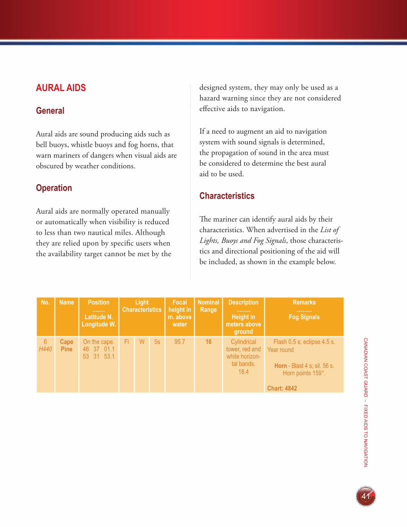
41
CA
NA
DIA
N C
OA
ST G
UA
RD
– FIXE
D A
IDS
TO N
AVIG
ATION
AURAL AIDS
General
Aural aids are sound producing aids such as bell buoys, whistle buoys and fog horns, that warn mariners of dangers when visual aids are obscured by weather conditions.
Operation
Aural aids are normally operated manually or automatically when visibility is reduced to less than two nautical miles. Although they are relied upon by specific users when the availability target cannot be met by the
designed system, they may only be used as a hazard warning since they are not considered effective aids to navigation.
If a need to augment an aid to navigation system with sound signals is determined, the propagation of sound in the area must be considered to determine the best aural aid to be used.
Characteristics
The mariner can identify aural aids by their characteristics. When advertised in the List of Lights, Buoys and Fog Signals, those characteris-tics and directional positioning of the aid will be included, as shown in the example below.
No. Name Position ........
Latitude N. Longitude W.
Light Characteristics
Focal height in m. above
water
Nominal Range
Description .........
Height in meters above
ground
Remarks ..........
Fog Signals
6 H440
Cape Pine
On the cape. 46 37 01.1 53 31 53.1
Fl W 5s 95.7 16 Cylindrical tower, red and white horizon-
tal bands.18.4
Flash 0.5 s; eclipse 4.5 s. Year round
Horn Blast 4 s; sil. 56 s. Horn points 159°.
Chart: 4842
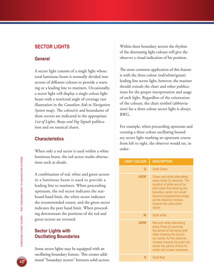
42
CA
NA
DIA
N C
OA
ST
GU
AR
D –
TH
E C
AN
AD
IAN
AID
S T
O N
AVIG
ATIO
N S
YS
TEM
SECTOR LIGHTS
General
A sector light consists of a single light whose total luminous beam is normally divided into sectors of different colours to provide a warn-ing or a leading line to mariners. Occasionally, a sector light will display a single colour light beam with a restricted angle of coverage (see illustration in the Canadian Aids to Navigation System map). The colour(s) and boundaries of these sectors are indicated in the appropriate List of Lights, Buoys and Fog Signals publica-tion and on nautical charts.
Characteristics
When only a red sector is used within a white luminous beam, the red sector marks obstruc-tions such as shoals.
A combination of red, white and green sectors in a luminous beam is used to provide a leading line to mariners. When proceeding ups tream, the red sector indicates the star-board hand limit, the white sector indicates the recommended course, and the green sector indicates the port hand limit. When proceed-ing downstream the positions of the red and green sectors are reversed.
Sector Lights with Oscillating Boundaries
Some sector lights may be equipped with an oscillating boundary feature. This creates addi-tional ‘‘boundary sectors’’ between solid sectors.
Within these boundary sectors the rhythm of the alternating light colours will give the observer a visual indication of his position.
The most common application of this feature is with the three colour (red/white/green) leading line sector light, however, the mariner should consult the chart and other publica-tions for the proper interpretation and usage of each light. Regardless of the orientation of the colours, the chart symbol (abbrevia-tion) for a three colour sector light is always RWG.
For example, when proceeding upstream and crossing a three colour oscillating bound-ary sector light marking an upstream course from left to right, the observer would see, in order:
LIGHT COLOUR DESCRIPTION
G Solid Green
AIGW Green and white alternating every three (3) seconds. The duration of white would be brief when first entering the boundary sector but would become progressively longer as the observer crosses towards the solid white sector.
W Solid white
AIRW Red and white alternating every three (3) seconds, the period of red being brief when entering the bound-ary sector. As the observer crosses towards the solid red sector the period of time for which red is seen increases.
R Solid Red
43
CA
NA
DIA
N C
OA
ST G
UA
RD
– RA
DIO
AID
S TO
NAV
IGATIO
N
RADAR REFLECTORS AND RADAR BEACONS (RACONS)
General
The detection of a radar target is essentially dependent on the level of energy reflected back into the radar receiver from the target. When an aid to navigation gives a poor radar echo, equipment may be fitted to the aid to give an enhanced echo on a radar display. There are two main methods of producing a radar enhanced target. The first is by using a passive device such as a radar reflector to enlarge the apparent echoing area of the target and the second is by the use of a radar beacon (RACON), which is an active device. RACONS can also be used to avoid confusion between radar targets that may look similar, because they produce an easily identifiable coded trace on the radar display. This feature makes RACONS effective in the marking of important or radar inconspicuous features or structures such as gently sloping shorelines and bridge piers.
Radar Reflectors
Certain fixed shore aids and most buoys are designed or equipped to enhance the aids’ ability to reflect radar signals. Radar reflectors may also
be established as independent aids to navigation. Independent radar reflectors are symbolized on charts and those established on lighted aids are advertised in the appropriate List of Lights, Buoys and Fog Signals publication.
Radar Beacons (RACONS)
A RACON is comprised of three main components: a receiver, a transmitter and an antenna common to both the receiver and the transmitter. A radar within the range of the RACON interrogates the RACON each time the radar antenna points towards the RACON. The RACON receiver detects the radar interrogating the signal and triggers the RACON transmitter. The transmitter may reply with a single pulse for each trigger but normally the response consists of a series of coded pulses (Morse code) for RACON identification. After triggering, a finite time must be allowed for the RACON to respond. This results in a transmission that is delayed in time (and range) with respect to the passive echo of the structure on which the RACON is mounted. The delay is generally equivalent to a range of less than 100 metres and, therefore, can often be disregarded at ranges greater than a few nautical miles. It is at short ranges that this error is significant. Normally, the station structure echo is visible and its range can be measured to full radar accuracy.
RADIO AIDS TO NAVIGATION 12
44
CA
NA
DIA
N C
OA
ST
GU
AR
D –
TH
E C
AN
AD
IAN
AID
S T
O N
AVIG
ATIO
N S
YS
TEM
Radar operators may notice some broadening or spoking of the RACON presentation when their vessel approaches closely to the RACON. This effect can be minimized by adjusting the IF gain or sweep gain control of the radar (other targets will also be reduced in intensity).
CAUTIONARY NOTE: Care must be exer-cised in the use of the radar display controls. The RACON presentation can be virtually eliminated by operation of the Fast Time Constant controls of the radar. The RACON replies may also be suppressed by the oper-ation of the automatic video processor which is found in an increasing number of marine radars.
Frequency Agile RACON
This RACON is now the most commonly used RACON in Canadian waters. The Frequency Agile RACON measures the frequency and signal strength of the interrogating radar pulse, then tunes its transmitter to that frequency before responding. This RACON provides service for X band marine radars and some instal-lations also provide service for the marine radar band of 2920 to 3100 MHz (10 cm or S band). While it is possible for a response to be displayed on each antenna scan of every radar within range, in actual practice, these RACONS are pro-grammed to turn off for a pre-selected period at regular intervals to prevent the masking of other echoes.
The locations, codes and operating frequencies (X, S or X and S) of RACONS are published in Notices to Mariners and listed in the appro-priate marine publications, i.e. Radio Aids to Marine Navigation, Sailing Directions and List of Lights, Buoys and Fog Signals. The Canadian Hydrographic Service charts display the Morse code of RACONS only in areas where more than one RACON can be interrogated simul-taneously.
4545
CA
NA
DIA
N C
OA
ST G
UA
RD
– RA
DIO
AID
S TO
NAV
IGATIO
N
GLOBAL POSITIONING SYSTEM (GPS)
System Description
The Global Positioning System (GPS) is a worldwide satellite based radio navigation system developed and operated by the United States Department of Defence.
In the GPS, a transmission originates from satellites orbiting the earth. These transmis-sions contain information providing a receiver with precise, continuous, worldwide, all weather three dimensional position informa-tion for land, sea and air applications. Although the primary mission is to meet military requirements, GPS is also being made available without cost for civil navigation. Two levels of service are being provided, one for civilian use and the second for military use.
Standard Positioning Service (SPS)
SPS, the service provided for civilian use, is a positioning and timing service made available to all GPS users on a continuous, worldwide basis with no direct charge. SPS provides the capability to obtain horizontal positioning accuracy within 20 metres at 95% probability. For more information, please visit: www.gps.gov/technical/ps/2008-SPS-performance-standard.pdf
Current Status
With GPS operational, all of Canada’s navigable waters are effectively blanketed by a continuous, all-weather, accurate positioning signal. It is capable of meeting the need of civil and marine interests in all but the most restrictive navigation situations.
The system enables users equipped with suit-able receivers, on land, at sea or in the air, to establish their position, speed and time at any time of the day or night and in any weather conditions. The system provides a level of accuracy equal to or better than any other radio navigation system available today.
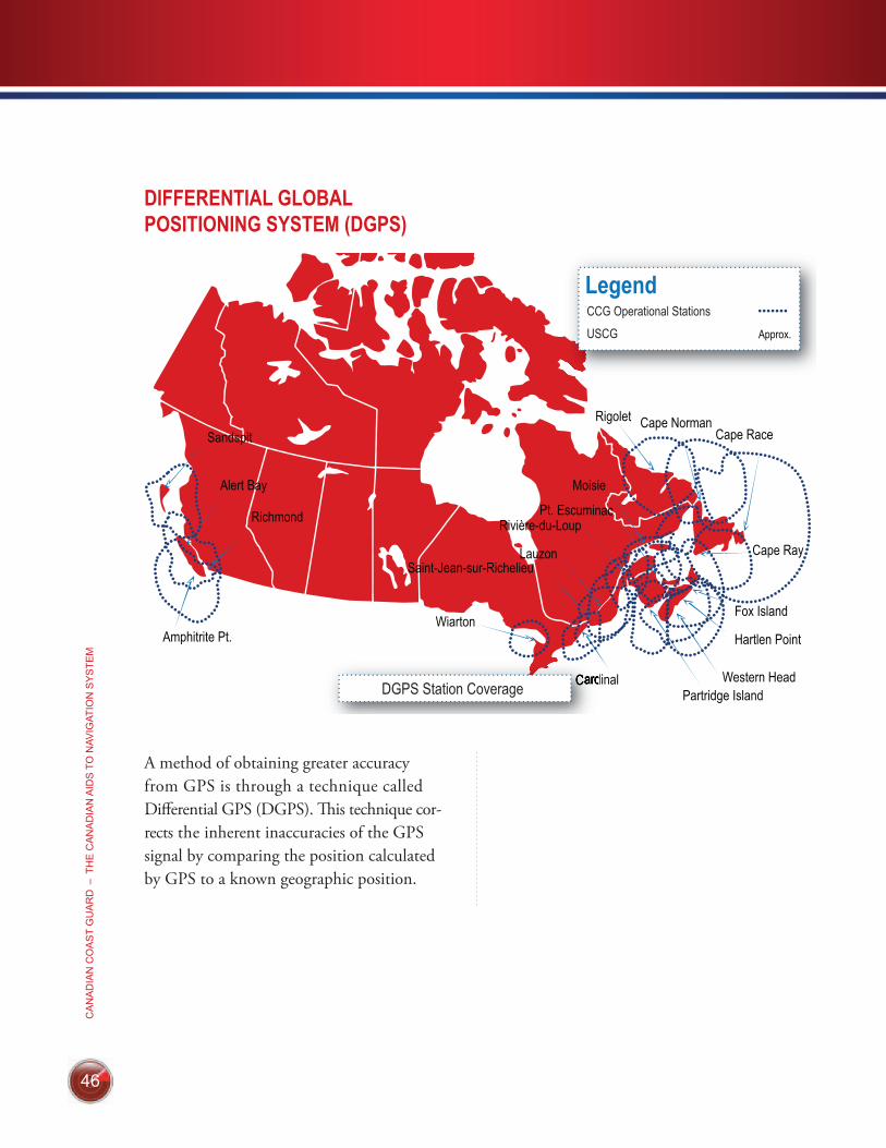
46
CA
NA
DIA
N C
OA
ST
GU
AR
D –
TH
E C
AN
AD
IAN
AID
S T
O N
AVIG
ATIO
N S
YS
TEM
46
DGPS Station Coverage
CCG Operational Stations
USCG
DIFFERENTIAL GLOBAL POSITIONING SYSTEM (DGPS)
A method of obtaining greater accuracy from GPS is through a technique called Differential GPS (DGPS). This technique cor-rects the inherent inaccuracies of the GPS signal by comparing the position calculated by GPS to a known geographic position.
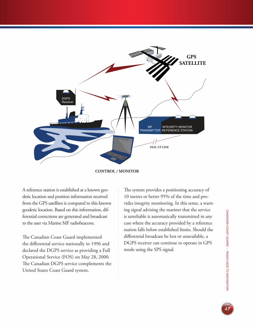
47
CA
NA
DIA
N C
OA
ST G
UA
RD
– RA
DIO
AID
S TO
NAV
IGATIO
N
47
A reference station is established at a known geo-detic location and position information received from the GPS satellites is compared to this known geodetic location. Based on this information, dif-ferential corrections are generated and broadcast to the user via Marine MF radiobeacons.
The Canadian Coast Guard implemented the differential service nationally in 1996 and declared the DGPS service as providing a Full Operational Service (FOS) on May 28, 2000. The Canadian DGPS service complements the United States Coast Guard system.
The system provides a positioning accuracy of 10 metres or better 95% of the time and pro-vides integrity monitoring. In this sense, a warn-ing signal advising the mariner that the service is unreliable is automatically transmitted in any case where the accuracy provided by a reference station falls below established limits. Should the differential broadcast be lost or unavailable, a DGPS receiver can continue to operate in GPS mode using the SPS signal.
DGPSReceiver
MFTRANSMITTER
INTEGRITY MONITORREFERENCE STATION
DIAL UP LINE
CONTROL / MONITOR
48
CA
NA
DIA
N C
OA
ST
GU
AR
D –
TH
E C
AN
AD
IAN
AID
S T
O N
AVIG
ATIO
N S
YS
TEM
1. Safe Boating Guide
The Safe Boating Guide is a valuable source of information for all boat oper-ators. This publication contains informa-tion on equipment requirements, safety practices, operating regulations and other sources of nautical information.
This publication is available at www.tc.gc.ca under marine publications.
2. Catalogues of Nautical Charts and Related Publications
These catalogues identify the available naut-ical charts, explain the various categories of charts, list local chart distributors and give instructions for ordering.
• Catalogue 1 – Atlantic Coast (Montreal – East)
• Catalogue 2 – Pacific Coast
• Catalogue 3 – Great Lakes (Manitoba – Montreal)
• Catalogue 4 – Arctic
These are available at www.charts.gc.ca. This website also contains links and other information on related publications.
3. Chart No. 1
This publication lists all of the symbols and abbreviations used on Canadian naut-ical charts. Chart No.1 is available from www.charts.gc.ca.
4. Charts
Nautical charts show hazards and aids to navigation, features of the coastline, the contour of the seabed and natural and arti-ficial features in the area. They are available in various scales. Consult the catalogues to find the chart that covers the area of inter-est to you. A listing of local chart dealers is available at www.charts.gc.ca.
5. Sailing Directions
These publications include Sailing Directions and Small Craft Guides which give detailed descriptions of various water-ways, including pictures of some harbour entrances, facilities available, etc. Sailing directions are available from local Can-
RELATED PUBLICATIONS13
49
CA
NA
DIA
N C
OA
ST G
UA
RD
– RE
LATED
PU
BLIC
ATION
S
adian Hydrographic Service chart dealers, a listing of which is available at www.charts.gc.ca.
6. Radio Aids to Marine Navigation
Published annually in 2 volumes, this publication provides information concern-ing Marine Communications and Traffic Services Centres, consolidated information concerning Vessel Traffic Services, En-vironment Canada marine and ice warning and forecast programs. In addition, it lists the location and characteristics of marine radio aids to navigation, i.e. Differential Global Positioning System (DGPS), and RACONs.
This publication is available for down-load at: www.ccg-gcc.gc.ca/eng/CCG/MCTS_Radio_Aids.
7. List of Lights, Buoys and Fog Signals
This publication contains information on the characteristics and position of shore lights, lighted buoys and fog signals for various regions. It is available in English and French for the following regions.
• Newfoundland (includes coastal Labra-dor)
• Atlantic Coast (includes Gulf & River St. Lawrence to Montreal)
• Inland Waters (west of Montreal, east of British Columbia)
• Pacific Coast (includes rivers & lakes of British Columbia)
The Lists of Lights, Buoys and Fog Signals are avail-able for download at www.notmar.gc.ca.
8. Notices to Shipping
Notices to Shipping (NOTSHIP) are issued as radio broadcasts through Mar-ine Communication and Traffic Service Centres. These broadcasts contain a variety of information that affects the immediate safety of the mariner (e.g. malfunction of aids to navigation, new hazards or changes to aids). Written NOTSHIP alerts are issued when the location of the hazard is beyond broadcast range, or when the infor-mation remains in effect for an extended period of time.
50
CA
NA
DIA
N C
OA
ST
GU
AR
D –
TH
E C
AN
AD
IAN
AID
S T
O N
AVIG
ATIO
N S
YS
TEM
For more information on NOTSHIP, go to: www.ccg-gcc.gc.ca/eng/CCG/Not-ship
9. Notices to Mariners Web Site
The Canadian Coast Guard’s Notices to Mariners (NOTMAR) website is a free 24-hour service providing mariners with safety advisories and corrections (cur-rent and archived) to charts and nautical publications. It is the continuous means employed by the Canadian Coast Guard to promulgate information required by the master, pilot or person in charge of the navigation of a vessel, as well as other interested parties, to correct charts; List of Lights, Buoys and Fog Signals and other associated publications carried on board ships in Canadian waters. Mariners are also informed of navigational hazards such as shoals and wrecks, as well as the enact-ment of regulations and the establishment of procedures governing vessel entry into and transit in Canadian waters.
The services offered through www.notmar.gc.ca, are as follows:
• Monthly, Notices to Mariners (Eastern and Western)
• Annual Notices to Mariners (national publication)
• List of Lights, Buoys and Fog Signals (4 volumes, Newfoundland, Inland Waters, Atlantic and Pacific Coast)
• Annual summary of Temporary and Preliminary notices (T & P)
• Archive notices dating back to 1996
• A quick search on chart correction notices, updated weekly
• 2 subscription services – tailored services, based on client profiling:
ű weekly/monthly chart updates – subscribe for this service on: www.notmar.gc.ca/search/notmar-eng.php
ű monthly Notices to Mariners com-plete publications – subscribe using the following link: www.notmar.gc.ca/subscribe
51
CA
NA
DIA
N C
OA
ST G
UA
RD
– THE
CA
NA
DIA
N A
IDS
TO N
AVIG
ATION
SY
STE
M
51
10. Annual Notices to Mariners
Published annually at the beginning of each year, it contains information on a wide variety of subjects of concern to the mar iner. Subjects covered include:
• aids to navigation
• military exercise areas
• marine regulations
• charts and publications
• pollution and causalities
• marine safety
• search and rescue
The Annual Notices to Mariners is available for download at www.notmar.gc.ca.
11. Tide and Current Tables
This publication contains daily tide predic-tions for all Canadian reference ports along with tidal differences for secondary ports. Daily current predictions are also included for selected stations. Tide and Current tables are published in 7 volumes and are listed in the Catalogue of Nautical Charts.
Volume 1 – Atlantic Coast and Bay of Fundy Volume 2 – Gulf of St. Lawrence Volume 3 – St. Lawrence and Saguenay Rivers Volume 4 – Arctic and Hudson Bay Volume 5 – Juan de Fuca and Georgia Straits Volume 6 – Barkley Sound and Discovery Passage to Dixon Entrance-Volume 7 – Queen Charlotte Sound to Dixon Entrance
52
CA
NA
DIA
N C
OA
ST
GU
AR
D –
TH
E C
AN
AD
IAN
AID
S T
O N
AVIG
ATIO
N S
YS
TEM
12. Safe Boating Information and Courses
Safe boating information and a complete listing of safe boating courses is available through Transport Canada’s Marine Safety website at www.tc.gc.ca/marinesafety under the Office of Boating Safety.
13. Legislation and Regulations
Regulations such as the Collision Regulations, Private Buoy Regulations, Vessel Operation Restriction Regulations and related legislation including the Canada Shipping Act 2001, and The Oceans Act can be found in full text at www.laws.justice.gc.ca
14. Charts and Nautical Publications Regulations (1995)
These regulations outline the require-ments for carrying the appropriate nautical charts and publications while operating any vessel. Full text for this regulation can also be found at www.laws.justice.gc.ca
15. An Owner’s Guide to Private Buoys
This guide will help private buoy owners to understand and apply Canada’s laws and requirements, and inform them of their responsibilities when placing a private buoy.
This publication can be obtained online through Transport Canada’s Marine Safety website at www.tc.gc.ca/marinesafety under publications.
16. GPS / DGPS Made Easy
This booklet provides mariners with a basic understanding of the Global Positioning System (GPS) and the Differential Global Positioning System (DGPS), and assists them in choosing the most appropriate receiver for their needs. This booklet is available through the Canadian Coast Guard website at www.ccg-gcc.gc.ca/eng/Ccg/atn_Publica-tions under the Aids to Navigation Program.
17. Primer on GPS and DGPS
This publication provides a technical overview of the Global Positioning sys-tem (GPS) and the Differential Global Positioning system (DGPS). It is avail-able through the Canadian Coast Guard website at www.ccg-gcc.gc.ca/eng/Ccg/atn_Publications under the Aids to Navi-gation Program.
53
CA
NA
DIA
N C
OA
ST G
UA
RD
– CA
NA
DIA
N C
OA
ST G
UA
RD
AID
S TO
NAV
IGATIO
N O
FFICE
S
(B) Bilingual Service (E) English Only Service
Region Contact Information
National Capital Region MANAGER, AIDS TO NAVIGATION200 Kent StreetOttawa, ON K1A 0E6Tel: 6139981411 (B)Email: atnaln@dfompo.gc.ca
Newfoundland (and Labrador)
SUPERINTENDENT, AIDS TO NAVIGATIONP.O. Box 5667St. John’s, N.L. A1C 5X1Tel: 17097725195 or 17097722800 (E)
Maritimes (Nova Scotia, New Brunswick
and Prince Edward Island)
SUPERINTENDENT, AIDS TO NAVIGATIONP.O. Box 1000Dartmouth, N.S. B2Y 3Z8Tel: 19024263151 (B)
Quebec SUPERINTENDENT, AIDS TO NAVIGATION 101 Champlain Blvd.Québec, Que. G1K 7Y7Tel: 14186483574 (B)Alert & warning network: 18003634735 (B)(TF) (H/N)or 14186484366 (B) (H/N)Email: aidesnavquebec@dfompo.gc.ca
Central and Arctic (Ontario, Manitoba, Saskachewan, Alberta, Yukon, Northwest Territories and Nunavut)
SUPERINTENDENT, AIDS TO NAVIGATION520 Exmouth StreetSarnia, Ontario N7T 8B1Tel: 15193831859 (E)Regional Operations Centre: 15193831841 (H/N)18002650237 (B) (H/N) (TF)
Pacific (British Columbia)
SUPERINTENDENT, AIDS TO NAVIGATION25 Huron StreetVictoria, B.C. V8V 4V9Tel: 12504802600 (E) or 18006672179 (TF)Email: [email protected]mpo.gc.ca
CANADIAN COAST GUARD AIDS TO NAVIGATION OFFICES 14
(TF) Toll Free (H/N) Holidays & Nights
CA
NA
DIA
N C
OA
ST
GU
AR
D –
TH
E C
AN
AD
IAN
AID
S T
O N
AVIG
ATIO
N S
YS
TEM
54
Region Contact Information
Pacific (British Columbia)
700800 Burrard StreetVancouver, B.C. V6Z 2J8Tel.: 16046662681 Email: obspac[email protected]
Prairie and Northern (Alberta, Saskatchewan, Manitoba, Yukon,
Northwest Territories and Nunavut)
344 Edmonton StreetP.O. Box 8550Winnipeg, Man. R3C 0P6Tel.: 18884630521 Email: obspnr[email protected]
Ontario 100 Front Street SouthSarnia, Ont. N7T 2M4Tel.: 18772818824 Email: obsontario[email protected]
Quebec 1550 Estimauville Avenue, 4th floorQuebec, Que. G1J 0C8Tel.: 14186485331 Email: obsquebec[email protected]
Atlantic (Nova Scotia, New Brunswick
and Prince Edward Island)
45 Alderney Drive, 11th FloorPO Box 1013Dartmouth, N.S. B2Y 4K2Tel.: 18003874999 or: 19024267729Email: obsatl[email protected]
Newfoundland and Labrador 100 New Gower Street, 7 th FloorP.O. Box 1300St. John’s, N.L. A1C 6H8Tel.: 18002303693or: 17097728644Email: obsatl[email protected]
For further information, please visit www.boatingsafety.gc.ca
PROVINCIAL CONTACTS – OFFICE OF BOATING SAFETY15
55
CA
NA
DIA
N C
OA
ST G
UA
RD
– UN
ITED
STATE
S A
IDS
TO N
AVIG
ATION
BO
ATING
INFO
RM
ATION
Aids to Navigation, Boating Information
United States Coast Guard navigation rules may be obtained at all United States Coast Guard District Offices, on their web page at: www.nav-cen.uscg.gov/?pageName=navRule&main=main or by phone:
U.S. Government Printing Office (Bookstore) Tel.: 1-202-512-1800
UNITED STATES AIDS TO NAVIGATION
BOATING INFORMATION 16
Charts
U.S. charts may be purchased from local distributors in both the United States and Canada or through National Oceanic and Atmospheric Administration at:
FAA, AeroNav Products AJV-36500 S. MacArthur BlvdOklahoma City, OK 73169
Tel. : 405-954-3027Email : [email protected] : www.faa.gov/air_traffic/flight_info/aeronav/
Mail orders must be accompanied by a cheque or money order payable (in U.S. funds). For more information please call the number above.
The limits and numbers of U.S. charts along the St. Lawrence Seaway and throughout the Great Lakes can also be found in Canadian Hydrographic Service Chart Catalogue 3.