


Languages
Pages
Legal


Vol K Edition 2013/14. Weekly Edition No. 32, Dated 08 August 2013.Last Updates: Weekly Edition No. 31, dated 01 August 2013.
K0853·5ID, , 2587
- Ug Nibung(ID)
1 04·48 S100 22·38 E
Fl W 5s 15 10 White metal framework10
fl 1
* * * * * * * *
Supplement V
K0853·7ID, , 2587·1
- Ug Nibung(ID)
1 04·41 S100 22·19 E
Fl Y 5s 8 10 Yellow × topmark on yellow metal framework tower3
fl 0·5
* * * * * * * *
K1462·2ID, , 4741
- No 1 Ldg Lts 169·5°. Front(ID)
0 58·22 S117 18·81 E
Q W 1s 10 10 White % on white beacon10
TE 2013
* *
PORT PHILLIP. OUTER HARBOUR. WILSON SPIT CHANNELK2254·9 - Point Wilson Bank 38 06·68 S
144 30·98 EFl G 3s . . . . Green % on green
beacon*
K3390·6 - (ID)
0 52·25 S134 03·51 E
Fl W 4s . . 10 White beacon
* * *
K4220·16 - Mapua. S Side 41 15·00 S173 06·74 E
Fl R 2s 3 2 Pile with red reflective band
*
UPDATES TO ADMIRALTY LIST OF LIGHTS AND FOG SIGNALS
UPDATES TO ADMIRALTY LIST OF RADIO SIGNALSWeekly Edition No. 32 dated 8 August 2013
The Admiralty List of Radio Signals diagrams included in the paper version of the weekly Notice to Mariners (Section VI) areprinted in black and white. If required, a colour version of these diagrams can be downloaded from www.ukho.gov.uk/msi. To obtainthe colour versions select View and download NMs - select Weekly - select Year - select Week - go to Selected Week Content -select File (for example: NP286(3)-WK01-12-PAGE149_Week01_2012.pdf)
VOLUME 5, NP 285, 2013/14Published Wk 24/13
(Last Amendments: Weekly Edition No. 31 dated 1 August 2013)
SECTION 16: DISTRESS, SEARCH AND RESCUE
PAGE401, NAMIBIA, contact table, row 4, column 4,MRCCSOUTHAFRICA (CAPETOWN), (with effect fromapproximately theend of August 2013).Delete: Telex +95 521037 MRCC SA
Riaan Schoeman, Telkom Maritime Radio (RSDRA2013000155155) 32/13
PAGE 413, SOUTH AFRICA, contact table, row 2, column 4, MRCC CAPE TOWN, (with effect from approximately the end ofAugust 2013).Delete: Telex +95 521037 MRCC SA
Riaan Schoeman, Telkom Maritime Radio (RSDRA2013000155155) 32/13
VOLUME 6, PART 4, NP 286(4), 2013/14Published Wk 32/13
––––––––––––––––––(First updates to publication wk 32/13)
The 2012/13 edition is cancelled
PAGE ii, RECORD OF UPDATES, NEW EDITION, First Updates box.
Insert:
This edition was published in week 32/13. The fi rst Weekly Notice to Mariners was issued in week 32/13.
UKHO 32/13
––––––––––––––––––––––––––––––
PAGE 3, AUSTRALIA, GENERAL NOTES.Delete and replace by:
GENERAL NOTESISPS DESIGNATED AUTHORITY:CONTACT DETAILS:
Transport Security Coordination Centre (TSCC)Telephone: +61(0)2 62748187Fax: +61(0)2 62746089E-mail: [email protected]: www.infrastructure.gov.au
VHF CH 67:All Australian Port Radio Stations are fi tted with VHF Ch 67 to supplement the Distress, Safety and Calling VHF Ch 16.
MODERNISED AUSTRALIAN SHIP TRACKING AND REPORTING SYSTEM - MASTREP:For details of the Modernised Australian Ship Tracking and Reporting System (MASTREP), see AUSTRALIA - SHIP REPORTING SYSTEM (MASTREP).
GREAT BARRIER REEF AND TORRES STRAIT VESSEL TRAFFIC SERVICE - REEFVTS:For details of the Great Barrier Reef and Torres Strait Vessel Traffi c Service (REEFVTS), see GREAT BARRIER REEF AND TORRES STRAIT (REEFVTS).
POLLUTION REPORTS:Harmful Substances Report and Marine Pollutants Report, see ALRS Volume 1(2) (NP281(2)).
Australian Maritime Safety Authority, (RSDRA2013000136600), 32/13
PAGE 4, AUSTRALIA, diagram AUSTRALIA Ports (West), text box centred on position 41°S 116°E.Delete text AUSREP See AUSTRALIA - SHIP REPORTING SYSTEM (AUSREP) and replace by:
MASTREP - See AUSTRALIA - SHIP REPORTING SYSTEM (MASTREP)
Australian Maritime Safety Authority, (RSDRA2013000136600), 32/13
PAGE 5, AUSTRALIA, diagram AUSTRALIA Ports (East), text box centred on position 41°S 157°E.Delete text AUSREP See AUSTRALIA - SHIP REPORTING SYSTEM (AUSREP) and replace by:
MASTREP - See AUSTRALIA - SHIP REPORTING SYSTEM (MASTREP)
Australian Maritime Safety Authority, (RSDRA2013000136600), 32/13
PAGES 7 & 10-19, AUSTRALIA, AUSTRALIA - SHIP REPORTING SYSTEM (AUSREP)Delete and replace by:
AUSTRALIA - SHIP REPORTING SYSTEM (MASTREP)
26°46′S 146°14′E
See diagram MODERNISED AUSTRALIAN SHIP TRACKING AND REPORTING SYSTEM (MASTREP).
See diagram Australian Mandatory Reporting Requirements.
Modernised Australian Ship Tracking and Reporting System (MASTREP)USER DEFINITIONS:
Glossary
AIS Automatic Identifi cation System required to be operated in accordance with SOLAS Regulation 19.2.4
AMSA Australian Maritime Safety Authority established under the Australian Maritime Safety Authority Act 1990
MASTREP The Modernised Australian Ship Tracking and Reporting System as prescribed in Marine Order 63 (MASTREP) 2013
DSC Digital Selective CallingGMDSS Global Maritime Distress and Safety SystemIMO International Maritime OrganizationLES Land Earth StationMMSI Maritime Mobile Service IdentityPolling Automatic position reporting using Inmarsat C data packets
RCC Australia
The Rescue Coordination Centre located in Canberra, Australia responsible for coordinating search and rescue across the Australian SRR
REEFVTS
The Great Barrier Reef and Torres Strait Vessel Traffi c Service established by Australia as a means of enhancing navigational safety and environmental protection in Torres Strait and the Great Barrier Reef
SAC Special Access CodeSAR Search and RescueSOLAS International Convention for the Safety of Life at SeaSRR Search and Rescue Region
MODERNISED AUSTRALIAN SHIP TRACKING AND REPORTING SYSTEM (MASTREP):(1) MASTREP is a Ship Reporting System designed to contribute to safety of life at sea and is operated by the Australian Maritime Safety Authority (AMSA) through the Australian Rescue Coordination Centre (RCC Australia) in Canberra. Participation in MASTREP is mandatory for certain vessels but others are encouraged to participate.(2) In 2009 work commenced on identifying AMSA and Australia’s future vessel tracking and reporting needs while considering the IMO published mandates of ship reporting requirements and the need for reduced reporting obligations on vessels. This was the catalyst for the design and subsequent development of MASTREP, offi cially launched on 1 July 2013.

(3) The International Convention on Maritime Search and Rescue was opened for signature in 1979 and, by becoming a signatory to the SAR Convention, Australia has accepted SAR responsibility for the area shown in the diagram MODERNISED AUSTRALIAN SHIP TRACKING AND REPORTING SYSTEM (MASTREP). The MASTREP system allows Australia to meet its obligations under Chapter 5 of the Annex to the SAR Convention as it relates to Ship Reporting Systems.(4) MASTREP, as prescribed in Marine Order 63 (MASTREP) 2013, is used to track the location of vessels. Under this system:
(a) Positional reporting for vessels is sourced from the vessel’s Automatic Identifi cation System (AIS)
(b) Communications with vessels continue to be available through Inmarsat, HF, satellite telephone and other means
(c) Special Reports are required to support AMSA’s role in shipping oversight and incident reporting management
(5) MASTREP provides positional data on vessels transiting Australia’s region via AIS technology which ensures that only the closest vessels are requested to assist in a SAR incident, reducing the need for vessels to steam long distances from their intended voyage plan. The Search and Rescue Offi cers conducting such operations in the Australian region routinely use this facet of MASTREP. Given the expansiveness of Australia’s Search and Rescue Region, merchantmen are often the only resources available that can quickly respond to an incident.
MASTREP COVERAGE AREA:(1) The area of coverage for MASTREP and for the Australian Search and Rescue Region (SRR) are identical. (2) Coordinates of this area are:
(a) The coast of the Antarctic continent in longitude 75°00′·00E thence(b) 6°00′·00S 75°00′·00E(c) 2°00′·00S 78°00′·00E(d) 2°00′·00S 92°00′·00E(e) 12°00′·00S 107°00′·00E(f) 12°00′·00S 123°20′·00E(g) 9°20′·00S 126°50′·00E(h) 7°00′·00S 135°00′·00E(i) 9°50′·00S 139°40′·00E(j) 9°50′·00S 141°00′·00E(k) 9°37′·00S 141°01′·06E(l) 9°08′·00S 143°53′·00E(m) 9°24′·00S 144°13′·00E(n) 12°00′·00S 144°00′·00E(o) 12°00′·00S 155°00′·00E(p) 14°00′·00S 155°00′·00E(q) 14°00′·00S 161°15′·00E(r) 17°40′·00S 163°00′·00E(s) Thence to the coast of the Antarctic continent in longitude 163°00′·00E
COMPETENT AUTHORITY:The Australian Maritime Safety Authority operates MASTREP and is the competent authority for both SOLAS and SAR Convention purposes.
ADMINISTRATION:MASTREP is operated by AMSA as part of the services off ered by the Rescue Coordination Centre (RCC Australia). RCC Australia is manned H24 by persons with considerable maritime and/or aviation experience.
MANDATORY REPORTING REQUIREMENTS:(1) The Commonwealth of Australia Navigation Act 2012 and Marine Order Part 63 makes the provision of Position Reports mandatory for certain vessels. (2) The following vessels must report to MASTREP:
(a) Foreign vessels from the arrival at its fi rst port in Australia until its departure from its fi nal port in Australia; and
(b) All regulated Australian vessels whilst in the MASTREP area.
TRANSMITTING MANDATORY POSITION REPORTS:(1) MASTREP uses Position Reports, which must be transmitted by AIS in accordance with the International Convention for the Safety of Life at Sea (SOLAS), Chapter 5, Regulation 19.2.4. Position Reports must transmit the following information:
(a) Identity(b) Type
(c) Position(d) Course(e) Speed(f) Navigational status(g) Safety related information
(2) Position reporting is automated and the data is fed in to the system using AIS - either collected terrestrially or by satellite. Positional data is updated at time intervals between 5 minutes and fi ve hours depending on the location and source.(3) There is no requirement in MASTREP to transmit Sail Plans (SP), Deviation Reports (DR) or Final Reports (FR).(4) No positive SAR watch is maintained in MASTREP. MASTREP is a passive ship reporting system and does not involve shore to vessel communications. ALL DISTRESS MESSAGES SHOULD BE SENT DIRECTLY TO RCC AUSTRALIA WHILE IN THE MASTREP AREA. Similarly, any vessel copying an SOS, MAYDAY or DSC Alert from a distressed vessel, or otherwise becoming aware that a distress incident has occurred, should contact RCC AUSTRALIA. See COMMUNICATIONS WITH RCC AUSTRALIA, below.(5) The Master of a vessel must report any malfunction of the vessel’s AIS equipment to RCC Australia in accordance with Section 186 of the Navigation Act 2012.
VOLUNTARY PARTICIPATION:Domestic commercial vessels fi tted with Global Maritime Distress and Safety System (GMDSS) and AIS technology are also encouraged to participate in the system as MASTREP assists AMSA in carrying out SAR activities.
REEFVTS INTERACTION:(1) Vessels transiting through the Great Barrier Reef and the Torres Strait must report to the REEFVTS.(2) Procedures for reporting to the REEFVTS are provided in the Great Barrier Reef and Torres Strait Vessel Traffi c Service User Manual available from AMSA and Maritime Safety Queensland (MSQ) offi ces. An electronic copy of the user manual is also located on the AMSA and MSQ websites.
SPECIAL REPORT TYPES:(1) Special report types include those for Dangerous Goods (DG), Harmful Substances (HS) and Marine Pollutants (MP). Special Reports should follow the guidelines for reporting as set out in IMO Resolution A.851 (20), as amended by IMO Resolution MEPC.138 (53).(2) Detailed reporting requirements for special report types are listed in Appendix A.
MARINE INCIDENT REPORTING:(1) All Marine Incidents are to be reported to AMSA using form “AMSA 18” and form “AMSA 19”. Copies of these forms can be obtained from the AMSA website www.amsa.gov.au(2) Examples of incidents include, but are not limited to, the loss, death or serious injury of a person, the loss of or damage to a vessel, equipment failure, a collision or a pollution event.(3) Reports should be made in accordance to the requirements of the Navigation Act 2012, Marine Orders, and the Occupational Health and Safety (Maritime Industry) Act 1993, as applicable.
NON-MANDATORY REPORTING:(1) Masters wishing to send information to RCC Australia or the Maritime Assistance Service, other than that which is mandated to be reported under the relevant legislation identifi ed in the MARINE INCIDENT REPORTING section, should complete an Information Report using the standard international vessel reporting format as set out in IMO Resolution A.851 (20).(2) Examples of non-mandatory reports include notifi cation of navigational hazards, vessel defects or defi ciencies, or other limitations which could adversely aff ect navigation.
COMMUNICATIONS WITH RCC AUSTRALIA:(1) Primary Communications:
(a) The primary means of communication with MASTREP are:(i) Inmarsat C: Messages sent to MASTREP using special access code
(SAC 1243) via the Perth LES (Pacifi c 212 or Indian 312 Ocean Region satellites) will be reverse charged to RCC Australia.
(ii) HF DSC. Messages sent via the AMSA HF DSC network will be free of charge. Initial contact through the AMSA HF DSC station is made by using a DSC safety priority call to MMSI 005030001. The message can then be passed on an appropriate RT frequency. All reports sent by voice should include the mandatory format fi elds including the identifying letter.
(b) If Inmarsat C reports are not sent using SAC 1243 via 212 or 312 it is likely that the message will not be received by RCC Australia and charges will apply to the vessel.
(2) Alternative Communications:(a) If for any reason communications are not possible via Inmarsat C or via the
AMSA HF DSC station, the required information must be passed by alternative means to RCC Australia using one of the following:(i) Other Inmarsat telephone/fax services: Vessels will be charged for
messages sent to RCC Australia using Inmarsat systems other than Inmarsat C
(ii) Other (non Inmarsat) satellite telephone/fax service: A reverse charge telephone call or facsimile may be used to pass reports when in port
(b) Contact details for RCC Australia are:(i) Telephone: +61(0)2 62306811 or free call 1800 641792(ii) Facsimile: +61(0)2 62306868 or free call 1800 622153(iii) E-mail: [email protected]
APPENDIX A - SPECIAL REPORT TYPES DETAILED REPORTING REQUIREMENTS:(1) Dangerous Goods (DG) Reports: When an incident takes place involving the loss or likely loss overboard of packaged dangerous goods, including those in freight containers, portable tanks, road and rail vehicles and shipborne barges into the sea. The primary report should contain message format fi elds A, B, C, M, Q, R, S, T, U of the standard reporting format. If the condition of the vessel is such that there is danger of further loss of packaged dangerous goods into the sea, fi elds P and Q of the standard reporting format should be reported.Example of Dangerous Goods (DG) Report:
Dangerous Goods (DG) ReportID System identifi er and message typeA Vessel’s name/call sign/IMO NoB Date/time of positionC PositionM Coast Radio Stations monitored/Inmarsat numbers
P
P1 Correct technical name or names of goodsP2 UN number or numbersP3 IMO hazard class or classesP4 Names of manufacturers of goods when known, or consignee or consignorP5 Types of packages including identifi cation marks. Specify whether portable tank or tank vehicle, or whether vehicle or freight container or other cargo transport unit containing packages. Include offi cial registration marks and numbers assigned to the unitP6 An estimate of the quantity and likely condition of the goods
Q Q1 An assessment of the defects and damageQ2 The ability of the vessel to transfer cargo and ballast or fuel
R
R1 Correct technical name or names of goodsR2 UN number or numbersR3 IMO hazard class or classesR4 Names of manufacturers of goods when known, or consignee or consignorR5 Types of packages including identifi cation marks. Specify whether portable tank or tank vehicle, or whether vehicle or freight container or other cargo transport unit containing packages. Include offi cial registration marks and numbers assigned to the unitR6 An estimate of the quantity and likely condition of the goodsR7 Whether lost goods fl oated or sankR8 Whether loss is continuingR9 Cause of loss
S Prevailing weather conditions
T Name, address, phone number and e-mail address (if applicable) of the vessel’s owners and representatives (charterer, manager or agent)
U Vessel size and type. Details of length, breadth, tonnage etc
Particulars not immediately available should be inserted in a supplementary message or messages.(2) Harmful Substances (HS) Reports: When an incident takes place involving the discharge or probable discharge of oil (Annex I of MARPOL 73/78) or noxious liquid substances in bulk (Annex II of MARPOL 73/78). In the case of actual discharge the primary report should contain message format fi elds A, B, C, E, F, L, M, N, Q, R, S, T, U, X of the standard reporting format. In the case of probable discharge, fi eld B should also be included.Example of Harmful Substances (HS) Report:
Harmful Substances (HS) ReportID System identifi er and message typeA Vessel’s name/call sign/IMO NoB Date/time of positionC PositionE CourseF SpeedL RouteM Coast Radio Stations monitored/Inmarsat numbersN Nominated daily reporting time
P
P1 Type of oil or the correct technical name of the noxious liquid substances on boardP2 UN number or numbersP3 Pollution category (A, B, C or D), for noxious liquid substancesP4 Names of manufacturers of substances, if appropriate, where they are known, or consignee or consignorP5 Quantity
Q Q1 An assessment of the defects and damageQ2 The ability of the vessel to transfer cargo and ballast or fuel
R
R1 Type of oil or the correct technical name of the noxious liquid discharged into the seaR2 UN number or numbersR3 Pollution category (A, B, C or D), for noxious liquid substancesR4 Names of manufacturers of substances, if appropriate, where they are known, or consignee or consignorR5 An estimate of the quantity of the substancesR6 Whether lost substances fl oated or sankR7 Whether loss is continuingR8 Cause of lossR9 Estimate of movement of the discharge or lost substances, giving current conditions if knownR10 Estimate of the surface area of the spill if possible
S Prevailing weather conditions
T Name, address, phone number and e-mail address (if applicable) of the vessel’s owner and representatives (charterer, manager or agent)
U Vessel’s size and type. Details of length, breadth, tonnage etc
X
X1 Actions being taken with regard to the discharge and the movement of the vesselX2 Assistance or salvage eff orts which have been requested or which have been provided by othersX3 The Master of an assisting or salvaging vessel should report the particulars of the action undertaken or planned
Particulars not immediately available should be inserted in a supplementary message or messages.(3) Assisting Vessel: The Master of any vessel engaged in, or requested to engage in an operation to render assistance or undertake salvage should report, as far as practicable, fi elds A, B, C, E, F, L, M, N, P, Q, R, S, T, U, X of the standard reporting format.(4) Marine Pollutants (MP) Reports: In the case of loss or likely loss overboard of harmful substances in packaged form including those in freight containers, portable tanks, road and rail vehicles and ship borne barges, identifi ed in the International Maritime Dangerous Goods Code as marine pollutants (Annex III of MARPOL 73/78).In the case of actual discharges the primary report should contain message format fi elds A, B, C, M, Q, R, S, T, U, X of the standard reporting format. In the case of probable discharge, fi eld P should also be included.Example of Marine Pollutants (MP) Report:
Marine Pollutants (MP) ReportID System identifi er and message typeA Vessel’s name/call sign/IMO NoB Date/time of positionC PositionM Coast Radio Stations monitored/Inmarsat numbers
P
P1 Correct technical name or names of goodsP2 UN number or numbersP3 IMO hazard class or classesP4 Names of manufacturers of goods when known, or consignee or consignorP5 Types of packages including identifi cation marks or whether in portable tank or tank vehicle or whether vehicle or freight container or other cargo transport unit containing packages. Include offi cial registration marks and numbers assigned to the unitP6 An estimate of the quantity and likely condition of the goods
Q Q1 Condition of the vessel as relevantQ2 Ability to transfer cargo-ballast-fuel
R
R1 Correct technical name or names of goodsR2 UN number or numbersR3 IMO hazard class or classesR4 Names of manufacturers of goods when known, or consignee or consignorR5 Types of packages including identifi cation marks. Specify whether portable tank or tank vehicle, or whether vehicle or freight container or other cargo transport unit containing packages. Include offi cial registration marks and numbers assigned to the unitR6 An estimate of the quantity and likely condition of the goods R7 Whether lost goods fl oated or sankR8 Whether loss is continuingR9 Cause of loss
S Prevailing weather conditions
T Name, address, phone number and e-mail address (if applicable) of the vessel’s owner and representatives (charterer, manager or agent)
U Vessel’s size and type. Details of length, breadth, tonnage etc
X
X1 Actions being taken with regard to the discharge and the movement of the vesselX2 Assistance or salvage eff orts which have been requested or which have been provided by othersX3 The Master of an assisting or salvaging vessel should report the particulars of the action undertaken or planned
Particulars not immediately available should be inserted in a supplementary message or messages. The Master of any vessel engaged in or requested to engage in an operation to render assistance or undertake salvage should report, as far as practicable, fi elds A, B, C, M, P, Q, R, S, T, U, X of the standard reporting format.
Australian Maritime Safety Authority, (RSDRA2013000136600), 32/13
PAGE 8, AUSTRALIA, diagram AUSTRALIAN SHIP REPORTING SYSTEM (AUSREP).Delete and replace by diagram MODERNISED AUSTRALIAN SHIP TRACKING AND REPORTING SYSTEM (MASTREP) on page 6.14
Australian Maritime Safety Authority, (RSDRA2013000136600), 32/13
PAGE 9, AUSTRALIA, diagram AUSREP Reporting Sequence.Delete and replace by diagram Australian Mandatory Reporting Requirements on page 6.15
Australian Maritime Safety Authority, (RSDRA2013000136600), 32/13
PAGE 48, AUSTRALIA, GREAT BARRIER REEF AND TORRES STRAIT (REEFVTS), Vessel Traffi c Service, USER DEFINITIONS, table, line 5.Delete:
AUSREP The Australian Ship Reporting System established under Division 14 of Part IV of the Navigation Act
and replace by:
MASTREP The Modernised Australian Ship Tracking and Reporting System as prescribed in Marine Order 63 (MASTREP) 2013
Australian Maritime Safety Authority, (RSDRA2013000136600), 32/13

MA
ST
RE
P a
rea
App
roxi
mat
e ra
dius
of a
ctio
n fo
r A
ustr
alia
n ba
sed
long
ran
ge s
earc
h ai
rcra
ft
NO
TE
: The
MA
ST
RE
P a
rea
exte
nds
Sou
th to
Ant
arct
ica
MO
DE
RN
ISE
D A
US
TR
ALI
AN
SH
IPT
RA
CK
ING
AN
D R
EP
OR
TIN
GS
YS
TE
M (
MA
ST
RE
P)
KE
Y:
Coc
os Is
land
AU
ST
RA
LIA
Wilu
na
MM
SI 0
0503
0001
DS
C H
F
Ch
arle
ville
MM
SI 0
0503
0001
DS
C H
F
Dig
ital
Sel
ecti
ve C
allin
g (
DS
C)
Ban
d D
SC
V
oice
S
ITO
R
VH
F
Ch
70
Ch
16
MF
21
87·5
kH
z 21
82 k
Hz
2174
·5 k
Hz
HF
4 42
07·5
kH
z 41
25 k
Hz
4177
·5 k
Hz
HF
6 63
12·0
kH
z 62
15 k
Hz
6268
kH
z
HF
8 84
14·5
kH
z 82
91 k
Hz
8376
·5 k
Hz
HF
12
1257
7·0
kHz
1229
0 kH
z 12
520
kHz
HF
16
1680
4·5
kHz
1642
0 kH
z 16
695
kHz
Hal
ifax
JR
CC
Aus
SA
R M
ariti
me
+61
(0)
2 62
3068
11
+61
(0)
2 62
3068
68
E-m
ail:
rcca
us@
amsa
.gov
.au
RC
C A
US
TR
AL
IA
RE
EF
VT
S a
rea
V6(4) A
US
RE
P V
004 26/06/13
80°
100°
120°
140°
160°
80°
100°
60°
60°
120°
140°
160°
10°
20°
30°
40°
50°
60°
0°
10°
20°
30°
40°
50°
60°
0°
6.14

Australian Mandatory Reporting Requirements
*As amended from time to time
¹What constitutes a marine incident is prescribed in subsection 14(1) of the Navigation Act 2012
²Additional Flag or Coastal State reporting requirements may apply
V6(4)A
US
RE
PFLO
W V
005 25/06/13
Yes
Yes
No
No
Yes No
No
No
Refer to reporting requirements for an owner and Master in Section 185 and 186 of the Navigation Act of 2012 and Marine Order 31 (Ship surveys and Certification) 2006.Visit:www.amsa.gov.au/Shipping_Safety/Incident_Reporting/
Follow the guidelines for reporting incidents involving dangerous goods, harmful substances and/or marine pollutants as set out in IMO Resolution A.851 (20), as amended by IMO Resolution MEPC.138 (53)*.Visit: www.amsa.gov.au/Shipping_Safety/Incident_Reporting/MARPOL73_78_Reporting.asp
Do you need to report a marine
incident?¹
Are you an Australian
flagged vessel?
Reporting to AMSA is not
required²
No further action is required
Are you required to submit Special
Reports in accordance with IMO Resolution
A.851 (20)*?
Dangerous Goods
Harmful Substances
Marine Pollutants
Are you in the MASTREP
Area?
Fitting and Operation of AIS
The Master of the vessel must ensure the AIS is operated in accordance with Regulation 19.2.4 of Chapter V of SOLAS.
For INMARSAT Communications
Vessels participating in MASTREP may log in and use LES codes 312 for IOR and 212 for POR. Masters are requested to use SAC 1243 for messages.
6.15
PAGES 53 & 54, AUSTRALIA, GREAT BARRIER REEF AND TORRES STRAIT (REEFVTS), Vessel Traffi c Service, SHIP REPORTING OBLIGATIONS, (3) Entry Report.Delete and replace by:
(3) Entry Report: (a) An Entry Report must be made in respect of a ship as soon as it:
(i) Enters the REEFVTS area.(ii) Departs from a port within the REEFVTS area.
(b) This report covers a vessel’s details, and its intentions and passage through the REEFVTS area.
(c) Ship’s Masters are encouraged to provide a Route Plan (see Route Plan section) when providing an Entry Report. However, it is understood that for some ships this may not be possible until a Pilot boards.
(d) If the required passage details are supplied using one of the methods described in the Route Plan section, then it will not be necessary to provide a separate Route Plan report within an hour of entering the REEFVTS area.
(e) The following information must be provided in the Entry Report:ID Information Required Example
A Ship name, Call sign and IMO number A/HAPPY SAILOR/ABCD/1234567
B Date and Time (UTC) B/010400UTC
C
Current Position:Name of Mandatory Reporting Point, or position (latitude and longitude) if not in the vicinity of a Mandatory Reporting Point.
C/BOOBY
F
Speed:Ship’s anticipated average speed until next report in knots & tenths of a knot) or estimated time of arrival (ETA) at next Mandatory Reporting Point.
F/13
J
Pilot:Pilotage details including whether a Coastal Pilot is on board (indicate “Yes” or “No”) and if so, the Pilot’s last name and licence number.
J/NOorJ/YES/BROWN/9876543
K
Date, Time (UTC) and Point of Exit from the REEFVTS area:Point of Exit can be provided as the name of fi nal Mandatory Reporting Point, or position (latitude and longitude) of anticipated exit from the REEFVTS area.
K/041300UTC/HIGH PEAK
L
Route Information:Route Plan section or, if that is not available name of next two Mandatory Reporting Points or course if not tracking between reporting points.
L/INNER ROUTE DEEPorL/ALPHA NORTH VIA VARZIN PASSAGE/HANNIBAL
ODraught:Draught forward and aft (in metres and decimetres).
O/FORE 11.5/AFT 11.3
P
Cargo on Board:If required, may be passed by non-voice means prior to the fi rst REEFVTS report. Details to include normal name of the cargo and whether cargo is classifi ed as hazardous (indicate “Yes” or “No”).
P/BULK CHEMICALS/DG YES
Q Defects, damage, defi ciencies or other limitations
Include details as required.
UShip Size and Type:Ship description details including ship type, length (metres) and gt.
U/TANKER/180/28000
X
Remarks:Any additional information, which would contribute to the navigational safety of other shipping in the REEFVTS area, should also be reported, where possible.
Include details as required.
Australian Maritime Safety Authority, (RSDRA2013000136600), 32/13
PAGES 57 & 58, AUSTRALIA, GREAT BARRIER REEF AND TORRES STRAIT (REEFVTS), Vessel Traffi c Service, SHIP REPORTING OBLIGATIONS, (12) Final Report.Delete and replace by:
(12) Final Report: (a) A Final Report must be made in respect of a ship:
(i) When exiting the REEFVTS area.(ii) Arriving at a port within the REEFVTS area.
(b) The following information must be provided in the Final Report:ID Information Required Example
A Ship name, Call sign and IMO number A/HAPPY SAILOR/ABCD/1234567
B Date and Time (UTC) B/041320UTC
C
Current Position:Name of Mandatory Reporting Point, or position (latitude and longitude) if not in the vicinity of a Mandatory Reporting Point.
C/HIGH PEAK
X
Remarks:Any additional information, which would contribute to the navigational safety of other shipping in the REEFVTS area.
Include relevant details
Australian Maritime Safety Authority, (RSDRA2013000136600), 32/13
PAGE 73, AUSTRALIA, NEWCASTLE, N.S.W., Pilots, PROCEDURE, section (5).Delete and replace by:
(5) Pilot boards in the following positions:(a) Alpha: 32°57′·85S 151°51′·38E(b) Bravo: 32°58′·87S 151°52′·69E
Australian Notice 627, (RSDRA2013000140381), 32/13
PAGE 297, SHIP REPORTING SYSTEMS, A LIST OF SHIP REPORTING SYSTEMS FOR THE INDIAN SUB-CONTINENT, SOUTH EAST ASIA AND AUSTRALASIA, Ship Reporting Systems, table, line 4.Delete:
AUSTRALIA, SHIP REPORTING SYSTEM AUSREP
Mandatory for certain vessels, voluntary for other vessels
and replace by:
AUSTRALIA, SHIP REPORTING SYSTEM MASTREP
Mandatory for certain vessels, voluntary for other vessels
Australian Maritime Safety Authority, (RSDRA2013000136600), 32/13
PAGE 298, SHIP REPORTING SYSTEMS, diagram PERSIAN GULF including OMAN, INDIAN SUB-CONTINENT, SOUTH EAST ASIA AND AUSTRALIA, legend AUSREP (Australia) centred on position 50°S 120°E.Delete and replace by legend:
MASTREP (Australia)
Australian Maritime Safety Authority, (RSDRA2013000136600), 32/13
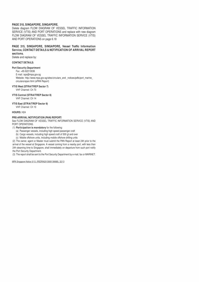
PAGE 310, SINGAPORE, SINGAPORE.Delete diagram FLOW DIAGRAM OF VESSEL TRAFFIC INFORMATION SERVICE (VTIS) AND PORT OPERATIONS and replace with new diagram FLOW DIAGRAM OF VESSEL TRAFFIC INFORMATION SERVICE (VTIS) AND PORT OPERATIONS on page 6.18
PAGE 315, SINGAPORE, SINGAPORE, Vessel Traffi c Information Service, CONTACT DETAILS & NOTIFICATION OF ARRIVAL REPORT sections.Delete and replace by:CONTACT DETAILS:
Port Security DepartmentFax: +65 62213036E-mail: [email protected]: http://www.mpa.gov.sg/sites/circulars_and _notices/pdfs/port_marine_circulars/epan.html (ePAN Report)
VTIS West (STRAITREP Sector 7)VHF Channel: Ch 73
VTIS Central (STRAITREP Sector 8)VHF Channel: Ch 14
VTIS East (STRAITREP Sector 9)VHF Channel: Ch 10
HOURS: H24
PRE-ARRIVAL NOTIFICATION (PAN) REPORT:See FLOW DIAGRAM OF VESSEL TRAFFIC INFORMATION SERVICE (VTIS) AND PORT OPERATIONS.(1) Participation is mandatory for the following:
(a) Passenger vessels, including high speed passenger craft(b) Cargo vessels, including high speed craft of 500 gt and over(c) Mobile off shore units, including mobile off shore drilling units
(2) The owner, agent or Master must submit the PAN Report at least 24h prior to the arrival of the vessel at Singapore. A vessel coming from a nearby port, with less than 24h steaming time to Singapore, shall immediately on departure from such port notify the Port Security Department. (3) The report shall be sent to the Port Security Department by e-mail, fax or MARINET.
MPA Singapore Notice 5/13, (RSDRA2013000136688), 32/13
VTIS MANDATORY REPORTING
VESSELS TRANSITING THE SINGAPORE STRAIT
FLOW DIAGRAM OF VESSEL TRAFFIC INFORMATION SERVICE (VTIS) AND PORT OPERATIONS
VESSELS CALLING AT SINGAPORE
THROUGH TRANSIT
VTIS OPERATIONAL AREA
VTIS REPORT to VTIS East on VHF Ch 10, VTIS Central on VHF Ch 14 or VTIS West on VHF Ch 73
CONFIRMATION OF ARRIVAL
to VTIS East on VHF Ch 10, VTIS Central on VHF Ch 14 or VTIS West on VHF Ch 73
CLEARANCE REPORT to Sector Control Stations on
VHF Chs 05 12 18 21 2225 or 68
ARRIVAL REPORT to Sector Control Stations on
VHF Chs 05 12 18 21 2225 or 68
UNDERWAY REPORT to Sector Control Stations on
VHF Chs 05 12 18 21 2225 or 68
Vessels' information departing from Singapore is
automatically sent to VTIS. No further reporting to VTIS
is necessary
V6(4)SINGFLOW V004 02/07/13
PORT OPERATIONS AREA
PRE-ARRIVAL NOTIFICATION (PAN)
to the Port Security Department by Fax, e-mail or MARINET
6.18
UPDATES TO ADMIRALTY SAILING DIRECTIONS
Nil.

Vol K Edition 2013/14. Weekly Edition No. 33, Dated 15 August 2013.Last Updates: Weekly Edition No. 32, dated 08 August 2013.
SPENCER GULF. PORT WHYALLAK1935 - Ore Jetty Dredged Channel.
Ldg Lts 280°. Front33 02·13 S
137 35·75 EF Bu 15
* * * * *
K1935·1 - Ore Jetty Dredged Channel.Ldg Lts 280°. Rear
33 02·10 S137 35·60 E
F Bu 25
* * * * * *
K1936 - Ore Jetty Dredged Channel.Ldg Lts 251°. Front. Ore Jetty. Head
33 02·20 S137 35·99 E
Iso Bu 2s 11 . . White % on tower
* * *
K1936·1 - Ore Jetty Dredged Channel.Ldg Lts 251°. Rear
33 02·35 S137 35·46 E
Iso Bu 6s 18
* * *
PORT PHILLIP. PORT MELBOURNEK2336·5 - Port Melbourne Channel.
T138 00·00 S
144 55·66 EVQ(4)Y 4s . . . . Beacon
* * * * * * * *
K2336·51 - Port Melbourne Channel. T2
38 00·00 S144 54·87 E
VQ(4)Y 4s . . . . Beacon
* * * * * * * *
K2336·6 - Port Melbourne Channel. T9
37 57·81 S144 55·73 E
VQ(4)Y 4s . . . . Beacon
* * * * * * * *
K2336·61 - Port Melbourne Channel. T10
37 57·77 S144 55·03 E
VQ(4)Y 4s . . . . Beacon
* * * * * * * *
K2336·7 - Port Melbourne Channel. T15
37 55·62 S144 55·80 E
VQ(4)Y 4s . . . . Beacon
* * * * * * * *
K2336·71 - Port Melbourne Channel. T16
37 55·60 S144 55·19 E
VQ(4)Y 4s . . . . Beacon
* * * * * * * *
K2336·8 - Port Melbourne Channel. T20
37 54·54 S144 55·22 E
VQ(4)Y 4s . . . . Beacon
* * * * * * * *
K2338·23 - Port Melbourne Channel. T26
37 52·68 S144 55·28 E
VQ(4)Y 4s . . . . Beacon
* * * * * * * *
K4896·4 - Munda Harbour. Ldg Lts 052°. Front
8 20·17 S157 13·65 E
Fl W 5s 9 5 White column fl 1.Vis 10° each side of leading line
* *
K4896·41 - Munda Harbour. Ldg Lts 052°. Rear. 0·54M from front
8 19·83 S157 14·08 E
Fl(3)W 15s 11 5 White column (fl 0·5, ec 1·5) x 2, fl 0·5, ec 10·5.Vis 10° each side of leading line
* *
K4994·5FR, LC, 55740
- Ohutu. Landing Stage. North-westward(FR)
14 58·30 S147 38·10 W
Fl(2)W 6s 4 3 Black#on black beacon, red band
Isolated danger mark
*
UPDATES TO ADMIRALTY LIST OF LIGHTS AND FOG SIGNALS

UPDATES TO ADMIRALTY LIST OF RADIO SIGNALSWeekly Edition No. 33 dated 15 August 2013
The Admiralty List of Radio Signals diagrams included in the paper version of the weekly Notice to Mariners (Section VI) areprinted in black and white. If required, a colour version of these diagrams can be downloaded from www.ukho.gov.uk/msi. To obtainthe colour versions select View and download NMs - select Weekly - select Year - select Week - go to Selected Week Content -select File (for example: NP286(3)-WK01-12-PAGE149_Week01_2012.pdf)
VOLUME 1, PART 2, NP 281(2), 2012/13Published Wk 38/12
(Last Updates: Weekly Edition No. 31 dated 1 August 2013)
MARITIME RADIO STATIONS
PAGE 60, BRAZIL, MARITIME TELEMEDICAL ASSISTANCE SERVICE (TMAS), Contacts table, row 6, column 2, RCCNorth.Delete fax number +55 91 32414700 and replace by: +55 91 32164030
MRCC Brazil (RSDRA2013000163641) 33/13
PAGE61, diagram, BRAZIL -NORTH,AMAZONASTOARQUIPÉLAGODEFERNANDODENORONHA,MARITIMERADIOSTATIONS, MRCC, in approximate position 2°00′S 47°00′W, BELÉM (MRCC NORTH), row 2.Delete fax number +55 91 32414700 and replace by: +55 91 32164030
MRCC Brazil (RSDRA2013000163641) 33/13
PAGE 64, BRAZIL, BRAZIL MRCC (RIO DE JANEIRO), Contacts table, row 5, column 2, RCC North.Delete fax number +55 91 32414700 and replace by: +55 91 32164030
MRCC Brazil (RSDRA2013000163641) 33/13
VOLUME 2, NP 282, 2013/14Published Wk 9/13
(Last Updates: Weekly Edition No. 31 dated 1 August 2013)
RADAR BEACONS
PAGE 14, UNITED KINGDOM.51930 Sunk Inner Lt Vessel, column 2.Delete position and replace by: 51°51′·17N 1°34′·40E
Trinity House Notice 15/13 (RSDRA2013000146986) 33/13
PAGE 20, GERMANY (North Sea Coast).55490 Platform GNSC-H-7.Delete entry
MV Pacific Osprey (RSDRA2013000160921) 33/13
PAGE 94, CHINA.81830 Changjiang Kou Lt Buoy S12.Delete entry
Chinese Notice 28/1010/13 (RSDRA2013000160493) 33/13
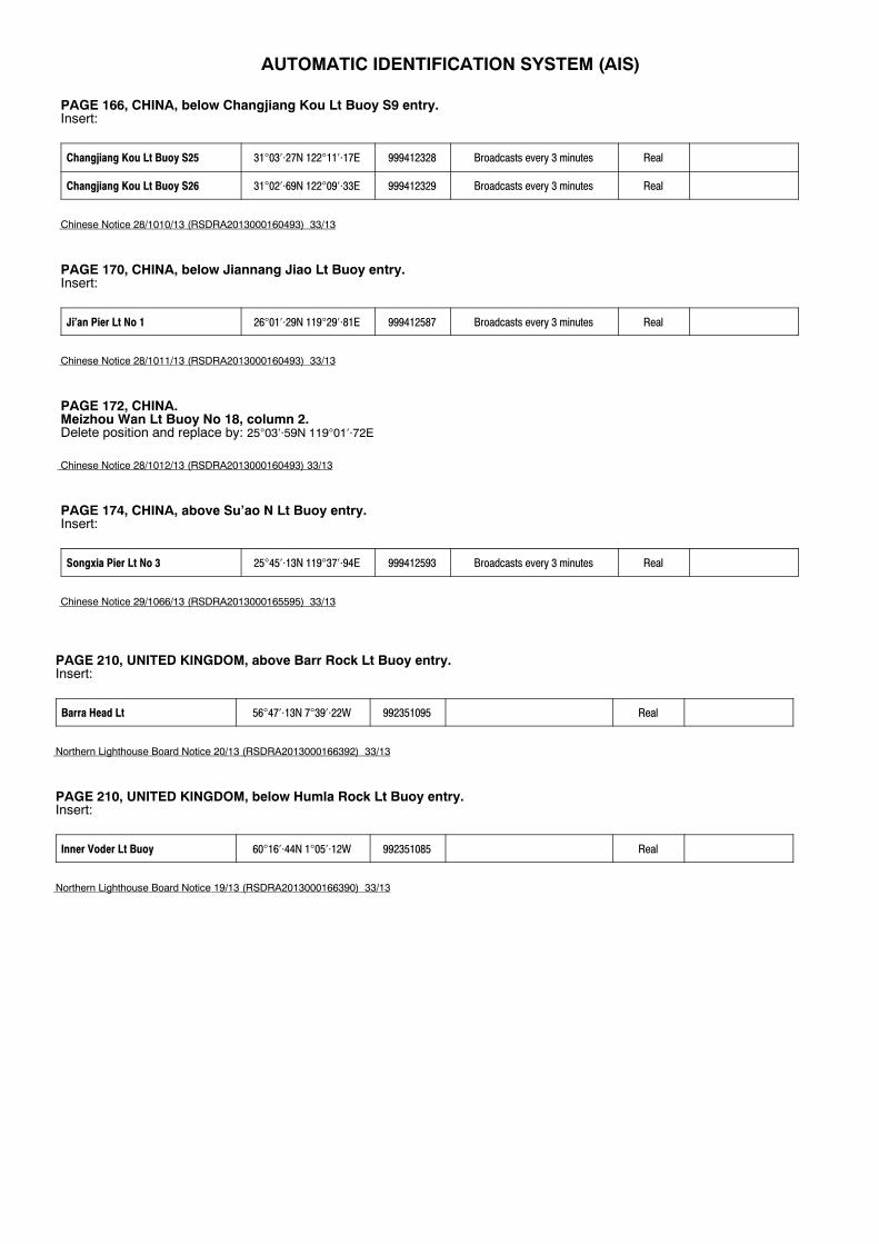
AUTOMATIC IDENTIFICATION SYSTEM (AIS)
PAGE 166, CHINA, below Changjiang Kou Lt Buoy S9 entry.Insert:
Changjiang Kou Lt Buoy S25 31°03′⋅27N 122°11′⋅17E 999412328 Broadcasts every 3 minutes Real
Changjiang Kou Lt Buoy S26 31°02′⋅69N 122°09′⋅33E 999412329 Broadcasts every 3 minutes Real
Chinese Notice 28/1010/13 (RSDRA2013000160493) 33/13
PAGE 170, CHINA, below Jiannang Jiao Lt Buoy entry.Insert:
Ji’an Pier Lt No 1 26°01′⋅29N 119°29′⋅81E 999412587 Broadcasts every 3 minutes Real
Chinese Notice 28/1011/13 (RSDRA2013000160493) 33/13
PAGE 172, CHINA.Meizhou Wan Lt Buoy No 18, column 2.Delete position and replace by: 25°03′·59N 119°01′·72E
Chinese Notice 28/1012/13 (RSDRA2013000160493) 33/13
PAGE 174, CHINA, above Su’ao N Lt Buoy entry.Insert:
Songxia Pier Lt No 3 25°45′⋅13N 119°37′⋅94E 999412593 Broadcasts every 3 minutes Real
Chinese Notice 29/1066/13 (RSDRA2013000165595) 33/13
PAGE 210, UNITED KINGDOM, above Barr Rock Lt Buoy entry.Insert:
Barra Head Lt 56°47′⋅13N 7°39′⋅22W 992351095 Real
Northern Lighthouse Board Notice 20/13 (RSDRA2013000166392) 33/13
PAGE 210, UNITED KINGDOM, below Humla Rock Lt Buoy entry.Insert:
Inner Voder Lt Buoy 60°16′⋅44N 1°05′⋅12W 992351085 Real
Northern Lighthouse Board Notice 19/13 (RSDRA2013000166390) 33/13
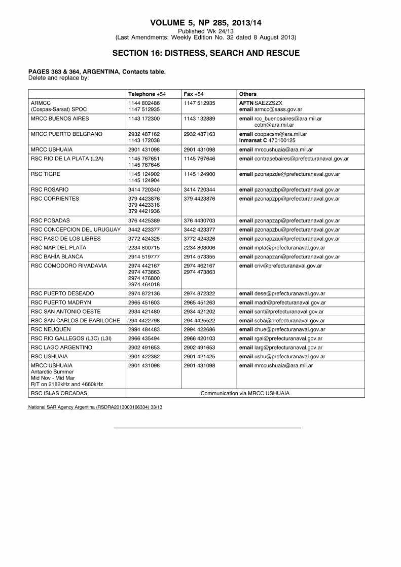
VOLUME 5, NP 285, 2013/14Published Wk 24/13
(Last Amendments: Weekly Edition No. 32 dated 8 August 2013)
SECTION 16: DISTRESS, SEARCH AND RESCUE
PAGES 363 & 364, ARGENTINA, Contacts table.Delete and replace by:
Telephone +54 Fax +54 Others
ARMCC(Cospas-Sarsat) SPOC
1144 8024861147 512935
1147 512935 AFTNSAEZZSZXemail [email protected]
MRCC BUENOS AIRES 1143 172300 1143 132889 email [email protected]@ara.mil.ar
MRCC PUERTO BELGRANO 2932 4871621143 172038
2932 487163 email [email protected] C 470100125
MRCC USHUAIA 2901 431098 2901 431098 email [email protected]
RSC RIO DE LA PLATA (L2A) 1145 7676511145 767646
1145 767646 email [email protected]
RSC TIGRE 1145 1249021145 124904
1145 124900 email [email protected]
RSC ROSARIO 3414 720340 3414 720344 email [email protected]
RSC CORRIENTES 379 4423876379 4423318379 4421936
379 4423876 email [email protected]
RSC POSADAS 376 4425389 376 4430703 email [email protected]
RSC CONCEPCION DEL URUGUAY 3442 423377 3442 423377 email [email protected]
RSC PASO DE LOS LIBRES 3772 424325 3772 424326 email [email protected]
RSC MAR DEL PLATA 2234 800715 2234 803006 email [email protected]
RSC BAHÍA BLANCA 2914 519777 2914 573355 email [email protected]
RSC COMODORO RIVADAVIA 2974 4421672974 4738632974 4768002974 464018
2974 4621672974 473863
email [email protected]
RSC PUERTO DESEADO 2974 872136 2974 872322 email [email protected]
RSC PUERTO MADRYN 2965 451603 2965 451263 email [email protected]
RSC SAN ANTONIO OESTE 2934 421480 2934 421202 email [email protected]
RSC SAN CARLOS DE BARILOCHE 294 4422798 294 4425522 email [email protected]
RSC NEUQUEN 2994 484483 2994 422686 email [email protected]
RSC RIO GALLEGOS (L3C) (L3I) 2966 435494 2966 420103 email [email protected]
RSC LAGO ARGENTINO 2902 491653 2902 491653 email [email protected]
RSC USHUAIA 2901 422382 2901 421425 email [email protected]
MRCC USHUAIAAntarctic SummerMid Nov - Mid MarR/T on 2182kHz and 4660kHz
2901 431098 2901 431098 email [email protected]
RSC ISLAS ORCADAS Communication via MRCC USHUAIA
National SAR Agency Argentina (RSDRA2013000166334) 33/13
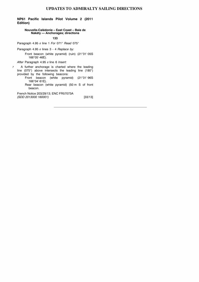
NP61 Pacific Islands Pilot Volume 2 (2011Edition)
Nouvelle-Calédonie – East Coast – Baie deNakéty — Anchorages; directions
133
Paragraph 4.95 6 line 1 For 071° Read 075°
Paragraph 4.95 6 lines 3 - 4 Replace by:
Front beacon (white pyramid) (ruin) (21°31′⋅05S166°05′⋅46E).
After Paragraph 4.95 6 line 6 Insert:
7 A further anchorage is charted where the leadingline (075°) above intersects the leading line (180°)provided by the following beacons:
Front beacon (white pyramid) (21°31′⋅96S166°04′⋅61E).
Rear beacon (white pyramid) (50 m S of frontbeacon.
French Notice 203/29/13; ENC FR57073A(SDD 2013000 160001) [33/13]
UPDATES TO ADMIRALTY SAILING DIRECTIONS
Top Related