


Languages
Pages
Legal

Waikato Expressway Hamilton Section Notice of Requirement to Alter the Designation
Ruakura Interchange
August 2014
Ruakura Interchange – Notice of Requirement i
August 2014
Contents
Volume 1
1 Introduction ....................................................................................................... 4 1.1 Overview ............................................................................................................................ 4 1.2 New Zealand Transport Agency ........................................................................................ 4 1.3 Roads of National Significance ......................................................................................... 4
1.4 Waikato Expressway ......................................................................................................... 4 1.5 Waikato Expressway – Hamilton Section ......................................................................... 6 1.6 Project Specific Objectives ................................................................................................ 7 1.7 Ruakura Interchange – Proposed Alteration .................................................................... 7
2 Background ........................................................................................................ 9 2.1 Existing Designations and Conditions .............................................................................. 9 2.2 Alterations to the Designation ........................................................................................ 10
2.3 Resource Consents ........................................................................................................... 11 2.4 Summary of Alterations and Resource Consents ........................................................... 12
3 Planning Context ............................................................................................... 13 3.1 Local Authority Boundary Changes ................................................................................ 13 3.2 Ruakura Structure Plan .................................................................................................. 13 3.3 Ruakura Development Private Plan Change ................................................................... 14
3.4 Ruakura Interchange Notice of Requirement ................................................................. 16
4 Ruakura Interchange ........................................................................................ 17 4.1 Form 18 ........................................................................................................................... 17 4.2 Consideration of Alternatives ......................................................................................... 20
5 Assessment of Environmental Effects .............................................................. 22 5.1 Baseline for the Environmental Effects Assessment ...................................................... 22 5.2 Traffic Effects .................................................................................................................. 25 5.3 Landscape, Visual Amenity and Urban Design Effects................................................... 27 5.4 Archaeological Effects ..................................................................................................... 29 5.5 Ecological Effects ............................................................................................................ 31 5.6 Vibration Effects ............................................................................................................. 34 5.7 Air Quality Effects ........................................................................................................... 36 5.8 Contamination Effects .................................................................................................... 38 5.9 Stormwater Effects .......................................................................................................... 40
5.10 Social Effects ................................................................................................................... 42 5.11 Noise Effects .................................................................................................................... 43 5.12 Summary of Effects ......................................................................................................... 46
6 Consultation ..................................................................................................... 49 6.1 Overview .......................................................................................................................... 49 6.2 Ruakura Interchange Consultation ................................................................................. 49
Ruakura Interchange – Notice of Requirement ii
August 2014
6.3 Tangata Whenua Consultation ....................................................................................... 50 6.4 Affected Landowner Consultation .................................................................................. 51 6.5 Ruakura Structure Plan and the Ruakura Development PPC Consultation ................... 52 6.6 Summary ......................................................................................................................... 52
7 Statutory Assessment ....................................................................................... 53 7.1 Resource Management Act 1991 ..................................................................................... 53 7.2 National Policy Statements ............................................................................................. 55
7.3 National Environmental Standards ................................................................................ 56 7.4 Other Regulations ........................................................................................................... 57 7.5 Regional Policy and Plans ............................................................................................... 57 7.6 Plans and Proposed Plans ............................................................................................... 62 7.7 Other Plans ...................................................................................................................... 69 7.8 Part 2 ............................................................................................................................... 71
8 Conclusion ....................................................................................................... 74
Appendix A – Proposed Conditions
Appendix B – Certificates of Title
Appendix C – Plans in Support of the Alteration to Designation
Appendix D – Network Connections Summary Report – March 2013
Appendix E – TWWG Position Statement
Volume 2 – Specialist AEE Reports
2A - Traffic
2B – Landscape, Visual and Urban Design
2C - Archaeology
2D - Ecology
2E - Vibration
2F - Air
2G - Contamination
2H - Stormwater
2I - Social
2J – Noise
Ruakura Interchange – Notice of Requirement iii
August 2014
Glossary of Terms:
AEE Assessment of Environmental Effects
Agency New Zealand Transport Agency
CMP Construction Management Plan
GPS Government Policy Statement on Land Transport Funding 2009/10 – 2018/19
HCC Hamilton City Council
HCV Heavy Commercial Vehicle
HPA Historic Places Act 1993
LOS Level of Service
LTMA Land Transport Management Act 2003
NOR Notice of Requirement
HNZ Heritage New Zealand
NZS New Zealand Standard
Opus Opus International Consultants
PIR Project Investigation Report
PPC Private Plan Change
Project The Waikato Expressway-Hamilton Section
PT Public Transport
PWRPS Proposed Waikato Regional Policy Statement – also referred to as PRPS
RLTS Waikato Regional Land Transport Strategy 2007
RMA Resource Management Act 1991
RoNS Roads of National Significance
RPS Waikato Regional Policy Statement
SARA Scheme Assessment Report Addendum
SH1 State Highway 1
TDM Travel Demand Management
TGH Tainui Group Holdings Ltd
TWEAR Tangata Whenua Effects Assessment Report
TWWG Tangata Whenua Working Group
vpd Vehicles per day
WDC Waikato District Council
WRC Waikato Regional Council
WRP Waikato Regional Plan
WRPS Waikato Regional Policy Statement (Operative) – also referred to as RPS
WRTM Waikato Regional Transportation Model
Ruakura Interchange – Notice of Requirement 4
August 2014
1 Introduction
1.1 Overview
The NZ Transport Agency (the Agency) has prepared this Notice of Requirement (NOR) to alter the
designation for the Hamilton Section of the Waikato Expressway (Hamilton Section) in order to
accommodate an interchange at Ruakura, and relocate Ruakura Road. This alteration is required in
response to the Ruakura Development by Tainui Group Holdings (TGH) as described in further
detail later in this report.
This report provides the documentation, including an assessment of environmental effects, to
support the NOR to alter the designation.
1.2 New Zealand Transport Agency
The Agency is a Crown entity, and its objective pursuant to section 94 of the Land Transport
Management Act (LTMA) is to contribute to an integrated, safe, responsive, affordable and
sustainable land transport system. One of the Agency’s current projects is planning for and
delivering Roads of National Significance (RoNS).
1.3 Roads of National Significance
In May 2009, the Government Policy Statement on Land Transport Funding (GPS) was released
which identified seven RoNS, which are considered by the Government to be the country’s most
important transport routes requiring significant development to reduce congestion, improve safety
and support economic growth. The Waikato Expressway is one of the seven RoNS.
The purpose of listing particular roads as nationally significant was to ensure these priority roading
projects are taken into account fully in the development of the National Land Transport Programme.
The Government expects that planning for the future development of the land transport network
should reflect the importance of these roads from a national perspective and the need to advance
them quickly.
Continuing to progress the RoNS (including the Waikato Expressway) has also been identified in the
2012 GPS.
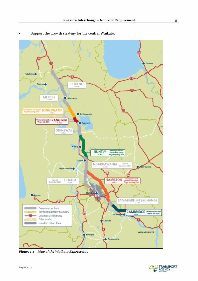
1.4 Waikato Expressway
The Waikato Expressway will extend from the Bombay Hills in the north to just south of Cambridge,
and has been divided into 12 sections (see Figure 1-1). It is expected the Expressway will:
Improve economic growth and productivity for Auckland, Waikato and Bay of Plenty through
more efficient movement of people and freight between Auckland, Hamilton, Tauranga and
Rotorua;
Improve the reliability of the transport network by providing a more robust and safer road
network between Auckland, Hamilton, Tauranga and Rotorua;
Reduce travel times between Waikato and Auckland; and
Ruakura Interchange – Notice of Requirement 5
August 2014
Support the growth strategy for the central Waikato.
Figure 1-1 – Map of the Waikato Expressway
Ruakura Interchange – Notice of Requirement 6
August 2014
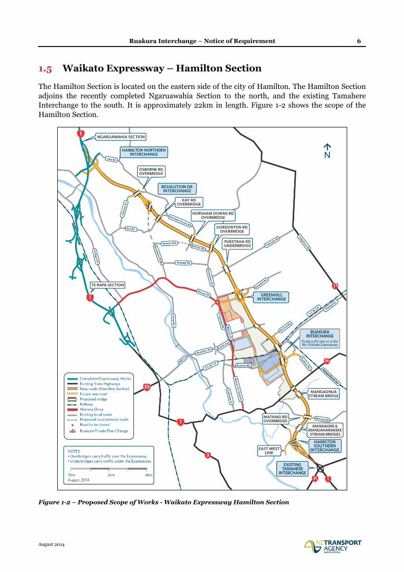
1.5 Waikato Expressway – Hamilton Section
The Hamilton Section is located on the eastern side of the city of Hamilton. The Hamilton Section
adjoins the recently completed Ngaruawahia Section to the north, and the existing Tamahere
Interchange to the south. It is approximately 22km in length. Figure 1-2 shows the scope of the
Hamilton Section.
Figure 1-2 – Proposed Scope of Works - Waikato Expressway Hamilton Section
Ruakura Interchange – Notice of Requirement 7
August 2014
1.6 Project Specific Objectives
The project specific objectives for the Hamilton Section as set out by the Agency are as follows:
a) Contribute to the GPS priorities of national economic growth and productivity;
b) Take into account the principles of the Treaty of Waitangi;
c) Form part of an ultimate expressway facility between Auckland and Cambridge;
d) Provide a high level of service and safety for inter-regional and inter-centre traffic for a
planning horizon of at least 30 years;
e) Provide for the safe and efficient movement of state highway traffic between Hamilton and
major destinations to the north of Hamilton;
f) Minimise any adverse impacts and improve where feasible, the natural, physical, cultural and
social environment of the region;
g) Provide an appropriate return on investment for the project as a whole; and
h) Maximise the economic viability of the project as measured by its Benefit/Cost Ratio and
general value for money principles.
1.7 Ruakura Interchange – Proposed Alteration
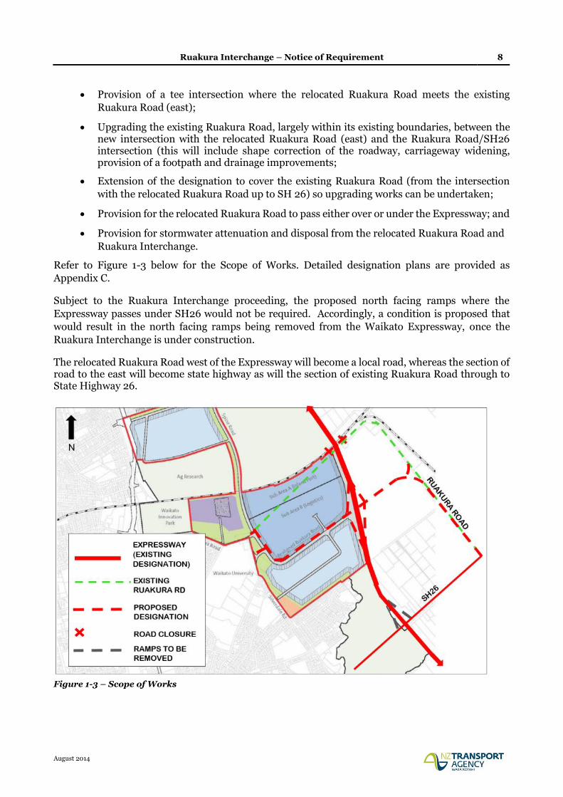
The purpose of this NOR is to alter the existing designation and specifically includes the following:
» Widening of the existing Expressway designation to accommodate the Ruakura Interchange
ramps, connecting roundabouts, and stormwater wetland;
» Closure of the existing Ruakura Road either side of the Expressway and consequently
shortening of the proposed bridge over the East Coast Main Trunk (ECMT) rail line;
» Retention of the existing Ruakura Road either side of the closure at the Expressway in order to
provide continued property access to residents on Ruakura Road, including access to Percival
and Ryburn Roads as currently provided;
» Relocation of Ruakura Road between the Ruakura Road/Silverdale Road intersection and the
existing Ruakura Road near the Vaile Road intersection to connect with the proposed Ruakura
Interchange, including:
Existing Ruakura Road/Silverdale Road intersection closed, with Silverdale Road
terminating in a cul-de-sac (road retained for access) and creation of a new signalised
relocated Ruakura Road/Silverdale Road intersection that will also provide a key access
point to the Ruakura Development Logistics Area;
New relocated Ruakura Road/Existing Ruakura Road (west) priority controlled tee
intersection;
A signalised intersection along the relocated Ruakura Road to provide a second key access
point to the Ruakura Development Logistics Area;
Ruakura Interchange – Notice of Requirement 8
August 2014
Provision of a tee intersection where the relocated Ruakura Road meets the existing
Ruakura Road (east);
Upgrading the existing Ruakura Road, largely within its existing boundaries, between the new intersection with the relocated Ruakura Road (east) and the Ruakura Road/SH26 intersection (this will include shape correction of the roadway, carriageway widening, provision of a footpath and drainage improvements;
Extension of the designation to cover the existing Ruakura Road (from the intersection
with the relocated Ruakura Road up to SH 26) so upgrading works can be undertaken;
Provision for the relocated Ruakura Road to pass either over or under the Expressway; and
Provision for stormwater attenuation and disposal from the relocated Ruakura Road and
Ruakura Interchange.
Refer to Figure 1-3 below for the Scope of Works. Detailed designation plans are provided as
Appendix C.
Subject to the Ruakura Interchange proceeding, the proposed north facing ramps where the
Expressway passes under SH26 would not be required. Accordingly, a condition is proposed that
would result in the north facing ramps being removed from the Waikato Expressway, once the
Ruakura Interchange is under construction.
The relocated Ruakura Road west of the Expressway will become a local road, whereas the section of road to the east will become state highway as will the section of existing Ruakura Road through to State Highway 26.
Figure 1-3 – Scope of Works
Ruakura Interchange – Notice of Requirement 9
August 2014
2 Background
2.1 Existing Designations and Conditions
The route selection and alignment of the Hamilton Section was determined as part of a wider project
which commenced in 1995 and covered the long term development of State Highway 1 (SH1) between
Ohinewai and Cambridge. The NoR for the original designation was lodged in 2001 and the
designation was secured in 2005, following an appeal hearing before the Environment Court in
2004.
Key aspects of the designated route are:
The need for the Hamilton Section of the Expressway to provide convenient and efficient
connections to the City's arterial network - as well as providing for the efficient and
uninterrupted passage of inter-regional traffic on the nation's primary trunk route;
A decision by the Agency that the Hamilton Section should pass to the east of Hamilton City -
rather than to the west;
A decision by the Agency confirming that the southern end of the route is to link into the
existing State Highway at Tamahere - rather than link directly into the designated Cambridge
Bypass via an alignment generally following the Cambridge Branch rail line. This issue was
the main focus of the appeal hearing in 2004.
Table 2-1 summarises the existing designations for the Hamilton Section and other existing relevant
designations by the Agency.
District District Plan Map No.
Code Activity Location Comments
Waikato 1, 3, 4, 8, 13, 14
J1 State Highway 1 (Limited access except those parts within the former boroughs of Huntly and Ngaruawahia as at October 1989, and that part of Taupiri between Mangawara bridge and Kainui Road)
From Franklin District/Waikato District boundary north of Meremere to Hamilton City/Waikato District boundary at Ruffell Road, and then from Hamilton City/ Waikato District boundary at Newell Road to Waipa District/Waikato District boundary at Racecourse Road
Waikato 14, 15, 19 J3 State Highway 26 (limited access)
From Hamilton City/Waikato District boundary at Matangi Road to Matamata Piako District/Waikato District boundary
Waikato 37, 14, 20, 22, 24A
J17 Road for state highway and road for access to state highway (Waikato Expressway, Hamilton Bypass.)
Lake Road to Bollard Road
Designation lapses in 2015
Ruakura Interchange – Notice of Requirement 10
August 2014
District District Plan Map No.
Code Activity Location Comments
Hamilton 2, 3 90 Hamilton Bypass – State Highway and Access to State Highway
Kay Road to Gordonton Road
Designation lapses in July 2022
Hamilton 20, 21, 30, 31, 40, 48, 49
90a To manage the State highway system, including planning, funding, design, supervision, construction, and maintenance and operations, and improvements in accordance with the Land Transport Act 2003 and the Government Roading Powers Act 1989.
Greenhill Road to Mangaonua Gully (rollover from Waikato District Plan)
Designation lapses in 2015
Table 2-1 – Existing Designations
There are four sets of conditions that currently relate to the existing Hamilton Section designation.
These are:
NOR 1 – Waikato District – Horotiu to Tamahere;
NOR 2 – Hamilton City – Horotiu to Tamahere;
NOR1A – Waikato District – Alterations C, U, V, W, T and Z to designation J17; and
NOR1B – Hamilton City – Alteration W to designation E90A.
The conditions referred as NOR1 and NOR2 were confirmed with the original designation in 2005,
following the Environment Court hearing in 2004. The NOR2 conditions only relate to a portion of
the designated Expressway between Kay Road and Horsham Downs Road. These conditions were
required because at that time only this section of the designated Expressway was located within
Hamilton City, with the balance of the designated Expressway being within the Waikato District.
Since that time, the boundary between the two territorial authorities has changed, but the physical
location of the designations has remained the same. As a consequence, the NOR1 conditions
originally for the designation located within the Waikato District now apply to some of the
designation located within Hamilton City. Only the NOR1 conditions apply to the designations to be
altered by this NOR for the Ruakura Interchange, being J17 –Waikato District Plan, and E90a
Hamilton City Proposed District Plan.
During the 2014 hearing of alterations to designation (refer 2.2 below), a revised set of conditions
was developed, based on those contained in NOR1. The revised conditions are referred to as NOR1A
(for those areas within Waikato District) and NOR1B (for those areas within Hamilton City). It is
proposed that these conditions also apply to the Ruakura NOR, with some specific amendments to
address unique aspects of this alteration. A full set of proposed conditions based on the NOR1A and
NOR1B conditions is provided in Appendix A.
2.2 Alterations to the Designation
On 30 September 2013, the Agency lodged a NOR detailing a series of alterations to the existing
designation. The NOR was divided into two bundles. The first bundle included the following
alterations to the designation, which the Agency requested be publicly notified under s95A(2)(b) of
Ruakura Interchange – Notice of Requirement 11
August 2014
the Resource Management Act 1991 (RMA). Accordingly these alterations were notified on 20
November 2013. A total of 18 submissions were received.
Alteration Relevant Council
Resolution Drive Interchange (Alteration U) WDC
Puketaha Road Arrangement (Alteration V) WDC
Greenhill Interchange (Alteration W) WDC & HCC
Southern Interchange and Cambridge Road Widening (Alteration Z) WDC
Table 2-2 – Publicly Notified Alterations
The second bundle included twelve minor alterations providing for local widening at narrow points,
and to make provision for stormwater treatment facilities. These alterations were lodged in a
separate bundle under the expectation that they were likely to be non-notified due to their minor
nature.
The notified alterations were heard by independent Commissioners at a joint hearing in April/May
2014. A recommendation from the Commissioners that the NORs be granted subject to a set of
conditions was released on 30 June 2014. On 8 July 2014, the Transport Agency accepted the
recommendation with only minor modifications. Two appeals have been made by submitters, one
in relation to Alteration U, and the other in relation to Alteration Z. It is anticipated that
recommendations on the non-notified alterations will be provided in early September 2014.
2.3 Resource Consents
On the same date (30 September 2013), the Agency lodged applications for the necessary resource
consents with Waikato Regional Council (WRC). As with the large alterations, the Agency requested
that these applications be publicly notified under s95A(2)(b) of the RMA. Accordingly these resource
consents were publicly notified on 20 November 2013.
The WRC consents were heard at the same time as the notified alterations. The Commissioners’
decision to grant the resource consents was notified on 1 July 2014. No appeals were made in relation
to these consents.
The following resource consents were granted by the WRC:
Land use
AUTH130361.01
Undertake earthworks including: soil disturbance, roading, tracking, and vegetation clearance both within and outside of high risk erosion areas; cleanfill and overburden disposal; and, any associated discharges of contaminants to water or air association with the Hamilton Section of the Waikato Expressway
Water permit
AUTH130361.02
To dam and divert surface water in the Mangaonua and Mangaharakeke/ Mangaone gullies as a consequence of road construction in association with the Hamilton Section of the Waikato Expressway
Land use
AUTH130361.03
Construction, operation, maintenance and removal of temporary bridges over the Mangaonua and Mangaone streams including any associated discharges of contaminants to water or air in association with the Hamilton Section of the Waikato Expressway
Ruakura Interchange – Notice of Requirement 12
August 2014
Land use
AUTH130361.04
Construction, operation and maintenance of the Mangaonua and Mangaone Stream bridges including any associated discharges of contaminants to water or air in association with the Hamilton Section of the Waikato Expressway.
Water Permit
AUTH130361.05
To drill below the water table to install bridge piles in association with the Hamilton Section of the Waikato Expressway.
Water permit
AUTH130361.06
To take and divert groundwater and discharge groundwater to water in association with the Hamilton Section of the Waikato Expressway.
Discharge permit
AUTH130361.07
To divert and discharge stormwater into water, and/or into or onto land, including the installation, operation and maintenance of discharge structures in association with the Hamilton Section of the Waikato Expressway.
Land use
AUTH130361.08
Construction, operation and maintenance of culverts including any associated discharges of contaminants to water or air in association with the Hamilton Section of the Waikato Expressway
Water Permit
AUTH130361.09
To dam and divert surface water in association with culvert construction, operation and maintenance
Table 2-3 – WRC Consents Granted
2.4 Summary of Alterations and Resource Consents
The alterations to the existing designations and the WRC resource consents granted as outlined
above do not specifically address the Ruakura Interchange proposal with the exception of the
following resource consents:
Earthworks associated with the interchange and ramps (AUTH130361.01);
Drilling to install bridge piles (AUTH130361.05); and
Diversion and discharge of stormwater associated with the interchange ramps
(AUTH130361.07).
Accordingly, there is a requirement to seek a separate alteration for the Ruakura Interchange and
connecting roads, and resource consents associated with stormwater discharges not covered by the
existing WRC consents.
Ruakura Interchange – Notice of Requirement 13
August 2014
3 Planning Context
3.1 Local Authority Boundary Changes
Since the original designation was confirmed, boundary changes have occurred between HCC and
WDC as set out in the Strategic Agreement on Future Urban Boundaries, dated March 2005. The
agreement identified the principles, direction and process for transfer of land.
In relation to the Ruakura Interchange NOR, the jurisdictional boundary generally follows the
centreline of the Expressway from Greenhill Road through to the Mangaonua Gully. The NOR is
therefore being made to both the WDC and HCC.
Figure 3-1: Local Authority Boundary
3.2 Ruakura Structure Plan
Boundary changes between HCC and WDC have meant that a significant area of land at Ruakura is
now within the jurisdiction of HCC. The development of this land is identified in a number of high
level documents including: the Hamilton Urban Growth Strategy, the Access Hamilton Transport
Strategy and the Waikato Proposed Regional Policy Statement.
To enable the progressive development of this area, the Ruakura Structure Plan (RSP) was developed
and notified as part of the Hamilton City Proposed District Plan (PDP) in December 2012. The RSP
(as notified) includes an inland port, freight and logistics hub and other industrial land. The inland
port as proposed in the RSP has an intermodal facility so that freight can be transferred to and from
road and rail. The RSP also provides for research and innovation activities, and residential areas for
an eventual population of approximately 1,800 households, including the development of a
neighbourhood centre.
EXISTING
HAMILTON
SECTION
DESIGNATION
HCC/WDC
BOUNDARY
N
Ruakura Interchange – Notice of Requirement 14
August 2014
Submissions and further submissions have been received on the RSP, however hearings and a
decision have been deferred, pending the outcome the Ruakura Development Private Plan Change
(PPC) (refer 3.3 below).
3.3 Ruakura Development Private Plan Change
Tainui Group Holdings Limited (TGH) is the predominant landowner affected by the RSP. It was
identified that rules in the Hamilton District Plan: Waikato Section (as transferred over from the
WDC’s District Plan) prohibit any application being made for urban development within this area.
Given that the WDC rules are currently operative, they continue to apply until the PDP (including
the RSP) is made operative. Given the potential for lengthy delays, TGH have sought a PPC for what
is known as the Ruakura Development, through the Environmental Protection Authority (EPA). The
PPC affects some, but not all, of the land subject to the RSP.
The PPC does not re-zone any land, rather it proposes to adopt mechanisms providing an overlying
‘schedule’. This allows a range of activities to be undertaken in identified areas, as well as existing
rural activities.
The key aspects of the PPC are as follows:
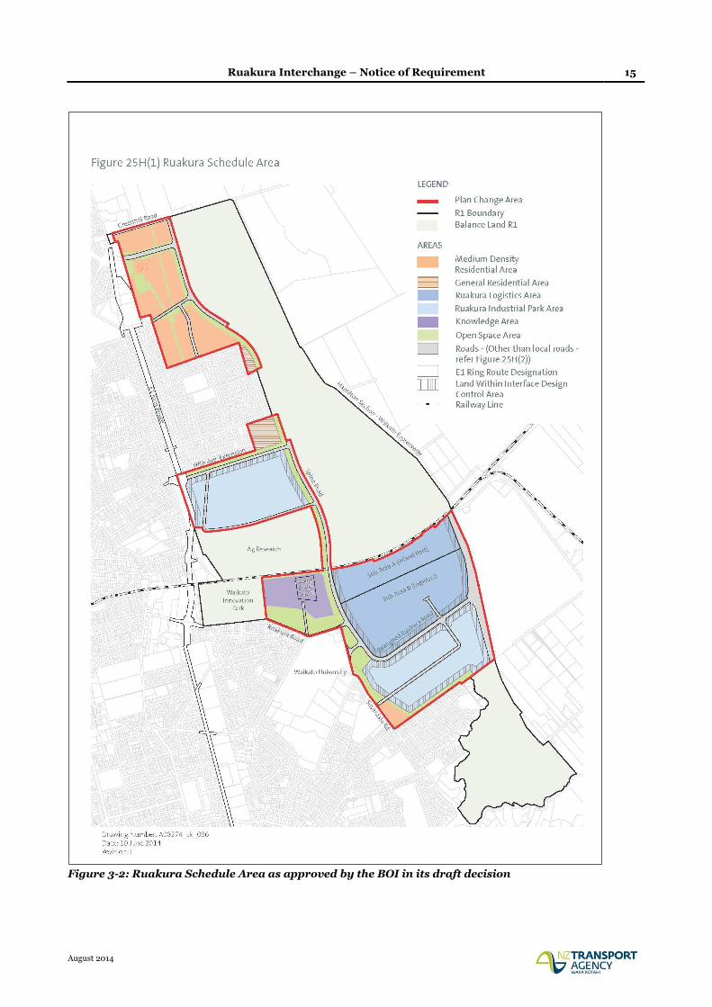
A new ‘Schedule 25H Ruakura’ inserted into Chapter 25: Rural of the PDP, which provides a
Ruakura Logistics Area (incorporating the Inland Port), Ruakura Industrial Park Area,
Knowledge Area, Residential Areas and Open Space Areas along with indicative roads (refer to
Figure 3-2 below).
Amendments to the Prohibited Activity rules to enable the planning and development of the land
covered by Schedule 25H, including the future roading network.
On 31 July 2013, a ministerial direction was released, referring the PPC request to a Board of Inquiry
(BOI) which was held over a number of weeks during May/June 2014. On 5 August 2014, the BOI
issued its draft decision approving the PPC, subject to a number of amendments to the proposed
objectives, policies and rules, as they would apply to the Ruakura Development. Comments on the
draft decision close during the week commencing 1 September 2014, and a final decision is due on
11 September 2014.
The PPC will enable development to occur in the interim, but it is intended that the PPC will also be
incorporated into the framework of the PDP, once the PPC has been confirmed. Accordingly, the
RSP contained within the notified PDP is likely to be superseded by the Board’s decision on the PPC.
Ruakura Interchange – Notice of Requirement 15
August 2014
Figure 3-2: Ruakura Schedule Area as approved by the BOI in its draft decision
Ruakura Interchange – Notice of Requirement 16
August 2014
3.4 Ruakura Interchange Notice of Requirement
The functioning of the Ruakura Development as provided for by the PPC requires the establishment
of a full diamond interchange on to the Hamilton Section of the Waikato Expressway. Accordingly,
in February 2014 the Agency lodged a NOR to alter the designations for the Hamilton Section to
provide for the required interchange, and also to provide appropriate arterial roads linking land to
the east and west of the Expressway to the interchange. The NOR was lodged to provide surety for
the BOI process, and demonstrate that the Agency was committed to establishing the Interchange.
At the Agency’s request, that NOR application was immediately placed on hold pending the outcome
of the BOI process for the PPC. Now that an interim decision has been made approving the PPC, the
Agency has amended the NOR as lodged to be cognisant of the BOI decision, and seeks to have it
publicly notified by the HCC and WDC.
Ruakura Interchange – Notice of Requirement 17
August 2014
4 Ruakura Interchange
The Agency is seeking to alter the existing designations for the Waikato Expressway (Hamilton
Section) in order to accommodate an interchange at Ruakura. This includes the relocation of
Ruakura Road, closing the existing Ruakura Road where it passes under the existing designation,
removing the two north facing ramps at the SH26/Morrinsville Road interchange, and providing for
stormwater drainage along Davison Road1. The NOR will enable a direct link between the Inland
Port/Logistics and Industrial Areas of the Ruakura Development to the Hamilton Section of the
Waikato Expressway, rather than relying on local roads to accommodate heavy vehicle movements.
4.1 Form 18
Section 181 Resource Management Act 1991
To: Waikato District Council
Private Bag 544
Ngaruawahia
And Hamilton City Council
Private Bag 3010
Hamilton
1 The NZ Transport Agency (the Agency), a requiring authority pursuant to section 167 of the
Resource Management Act 1991, and having financial responsibility for this proposed public
work, gives notice to both Waikato District and Hamilton City Councils of a requirement for
alterations to the following designations:
J17 (Hamilton Bypass) of the Waikato District Plan; and
90a (Hamilton Bypass) of the Hamilton City Proposed District Plan.
Designation Purpose:
Alteration to J17: Road Purposes – Road for State Highway & Access to State Highway
Alteration to 90a: To manage the State highway system, including planning, funding,
design, supervision, construction, and maintenance and operations, and improvements in
accordance with the Land Transport Act 2003 and the Government Roading Powers Act
1989
Designation Lapse Period:
Waikato District Plan – 2015
Hamilton City Proposed District Plan – 2022
2 The site to which the requirement applies is as follows:
Waikato District
Lot 3 DPS14267 (SA11D/1380),
1 For the avoidance of doubt, the designation of Davison Road is to provide for stormwater drainage only, and there is no requirement to designate this road for State highway purposes.
Ruakura Interchange – Notice of Requirement 18
August 2014
Lot 8 DPS66853 (SA53C/665); and
Road Reserve – Ruakura Road, Vaile Road and Davison Road
Hamilton City
Lot 1 DPS77458 (SA61C/243),
Lot 8 DPS66853 (SA53C/665); and
Road Reserve – Ruakura Road and Silverdale Road
Please refer to Appendix B for copies of the Certificates of Title.
3 The nature of the alteration work is as follows:
» Widening of the existing Expressway designation to accommodate the Ruakura
Interchange ramps, connecting roundabouts, and stormwater wetland;
» Closure of the existing Ruakura Road either side of the Expressway and
consequently shortening of the proposed bridge over the East Coast Main Trunk
(ECMT) rail line;
» Retention of the existing Ruakura Road either side of the closure at the Expressway
in order to provide continued property access to residents on Ruakura Road,
including access to Percival and Ryburn Roads as currently provided;
» Relocation of Ruakura Road between the Ruakura Road/Silverdale Road
intersection and the existing Ruakura Road near the Vaile Road intersection to
connect with the proposed Ruakura Interchange, including:
Existing Ruakura Road/Silverdale Road intersection closed, with Silverdale
Road terminating in a cul-de-sac (road retained for access) and creation of a
new signalised relocated Ruakura Road/Silverdale Road intersection that will
also provide a key access point to the Ruakura Development Logistics Area;
New relocated Ruakura Road/Existing Ruakura Road (west) priority
controlled tee intersection;
A signalised intersection along the relocated Ruakura Road to provide a second
key access point to the Ruakura Development Logistics Area;
Provision of a tee intersection where the relocated Ruakura Road meets the
existing Ruakura Road (east);
Upgrading the existing Ruakura Road, largely within its existing boundaries, between the new intersection with the relocated Ruakura Road (east) and the Ruakura Road/SH26 intersection (this will include shape correction of the roadway, carriageway widening, provision of a footpath and drainage improvements;
Extension of the designation to cover the existing Ruakura Road (from the
intersection with the relocated Ruakura Road up to SH 26) so upgrading works
can be undertaken;
Provision for the relocated Ruakura Road to pass either over or under the
Expressway; and
Ruakura Interchange – Notice of Requirement 19
August 2014
Provision for stormwater attenuation and disposal from the relocated
Ruakura Road and Ruakura Interchange.
Please refer to Appendix C for plans in support of the NOR.
4 The nature of the proposed restrictions that would apply are:
In the context of the assessment of environmental effects that follows, it is considered that
the existing conditions applying to the altered designation for the Hamilton Section of the
Waikato Expressway (NOR1A and NOR1B), will adequately mitigate any potential
environmental effects associated with the alteration. Further conditions are also proposed
that are unique to this alteration.
A full set of proposed conditions based on the NOR1A and NOR1B conditions is provided in
Appendix A of this report.
5 The effects that the public work will have on the environment and the ways in which any
adverse effects will be mitigated are:
Please refer to the effects assessment in section 5.0 below.
6 Alternative sites have been considered to the following extent:
Please refer to the alternatives assessment in section 4.2 below.
7 The public work and designation are reasonably necessary for achieving the objectives of the
requiring authority because:
The proposed alteration is the outcome of a Network Connections investigation which
concluded that interchanges at Greenhill and Ruakura best served the area if the Ruakura
Structure Plan and in particular the Inland Port were to proceed. The draft BOI decision
has given approval to the Ruakura Development PPC, which will be incorporated into the
RSP. Accordingly, the alteration will achieve the Agency’s project specific objectives: a), d)
and e), as listed under section 1.6 of this report.
The use of a designation is necessary as it is consistent with the approach across the wider
Expressway, including the Hamilton Section.
8 The following resource consents are required from the Waikato Regional Council:
The Transport Agency is also seeking additional resource consents from the WRC to
construct, operate and maintain the connecting roads (being the relocated and existing
Ruakura Road). The interchange ramps and associated earthworks are covered by the
existing consents granted 1 July 2014. Water and discharge permit applications will be
lodged with the WRC shortly.
9 The following consultation has been undertaken with the affected landowners:
Consultation undertaken by the Agency with respect to this NOR is detailed in Section 6 of
this report.
10 The following information is required to be included in this notice by the district plan,
regional plan, or any regulations made under the Resource Management Act 1991:
Notice of requirement assessment of effects;
Notice of requirement alteration plans.
Ruakura Interchange – Notice of Requirement 20
August 2014
4.2 Consideration of Alternatives
In early 2013, transport modelling work was undertaken to inform a network connections study to
ascertain the most favourable network between Greenhill Road and SH26, with a view to integrating
the Waikato Expressway connectivity with the proposed RSP and associated generation of a large
number of heavy commercial vehicle movements.
The study identified that interchanges at Greenhill and Ruakura best served the area if the RSP and
in particular the Inland Port were to proceed. The draft BOI decision has given approval to the
Ruakura Development PPC, which the HCC has advised will be incorporated into the RSP.
The outcomes of the assessment were discussed with HCC, WDC and TGH (and generally accepted
as appropriate) prior to being subject to the Agency’s internal approval process.
The full assessment of options between Greenhill Road and SH26 is contained in the report ‘Network
Connections Summary Report – March 2013 Update’, prepared by Opus and attached as Appendix
D to this report.
In addition to the Network Connections assessment, consideration has been given to network
connectivity to the east of the Ruakura interchange. In particular, how to connect the re-aligned
Ruakura Road back to the existing network. Two alternatives were considered:
Option 1: (the proposed option) connection into the existing Ruakura Road; or
Option 2: connection to SH26 via a new road, running parallel to the Expressway.
The process has included a multi criteria approach, giving consideration to both economic efficiency,
strategic fit, environmental effects, safety and accessibility. Property impacts, geometric design
requirements and road safety matters were of particular interest in this case.
Option 2 was not chosen because:
The length of an alternative alignment (Option 2) is 3 km, and would require the taking of
about 7.5 ha of land.
The alternative alignment cannot run directly alongside the expressway because:
o The design speed of the curves on the new road needs to be 80km/h, that is, the curves
need to have radii in excess of 230 m, and
o The intersection with the relocated Ruakura Rd that crosses the interchange needs to
be separated from the eastern ramp terminal roundabout by about 300 m to meet
sight distance requirements.
The alternative alignment results in a much greater property impact than that created by
Option 1.
The intersection with SH26 (Morrinsville Rd) needs to be separated from the expressway
bridge to meet sight distance requirements and to avoid widening the bridge.
This significantly increase the impact on properties fronting SH26 in the vicinity compared
with Option 1. Option 1 requires no widening of the expressway bridge.
Ruakura Interchange – Notice of Requirement 21
August 2014
In addition, Option 1 provides the opportunity to make use of the existing Ruakura Road, which is
an existing resource, and a road of a suitable status on the road hierarchy for connection, being
classified as an Arterial Road in the Waikato District Plan.

Ruakura Interchange – Notice of Requirement 22
August 2014
5 Assessment of Environmental Effects
This section of the report provides an assessment of the actual and potential effects on the
environment as a result of giving effect to this alteration. The effects assessment is based on the
various specialist reports used to inform this assessment. A full copy of all specialist assessments is
provided in Volume 2 of this report.
5.1 Baseline for the Environmental Effects Assessment
The RMA requires an assessment of the effects on the environment of allowing the requirement
(s171(1)). Consideration therefore needs to be given to what defines the existing environment, as this
will form the baseline that the effects of the proposal will be assessed against.
5.1.1 Waikato Expressway
The Hamilton Section of the Waikato Expressway designations pass to the east of Hamilton City in
a generally north-south direction and enable the construction of a four-lane Expressway and
associated on/off ramps to connect with the local road network (excluding the Ruakura Interchange).
The development of the Expressway is also supported by a number of consents granted by the WRC
as detailed in section 2.3 of this report. For the purpose of assessing this NOR, the Expressway as
currently designated is considered part of the existing environment.
5.1.2 West of the Expressway
The land immediately to the west of the Expressway is currently zoned Rural in the Hamilton District
Plan: Waikato Section. This area adjoining the Expressway is in pasture, with scattered dwellings
and farm buildings. The Waikato University is located to the west of Silverdale Road, and is
surrounded by residential development. There is also residential development to the east of
Silverdale Road, which juts out towards the Expressway and is bounded by a gully (Nevada Road).
North of Ruakura Road is an area of land zoned Country Living, which contains a cluster of
approximately 30 rural residential dwellings.
The environment immediately to the west of the Expressway is subject to a PPC, which a BOI has
approved in its draft decision. Consideration of this NOR by the territorial authority should be in
the context of the future development enabled by the PPC. The need for the Ruakura Interchange is
a direct result of development occurring in this area in accordance with the PPC. Without the PPC
proceeding, the Agency would revert back to the approved north facing ramps at SH26, unless an
alternative justification was provided for establishing an interchange at Ruakura.
It is reasonable to assume that the existing environment for the purpose of assessing the effects of
this NOR will consist of the land use activities indicated in Figure 3-2 of this report, and supported
by the BOI decision2. The BOI has already heard evidence in relation to the associated effects of these
land use activities and their ruling on the PPC has taken such effects into consideration.
2 At the time of lodging this NOR only a draft decision on the Ruakura Development PPC was available, with the final decision scheduled to be issued on 11 September 2014. It has been assumed that any changes to be made between the draft decision and final decision will have no material bearing on the existing environment as applied to this NOR. This will be confirmed once the final decision on the PPC is made, and if necessary the NOR will be amended to reflect any changes.
Ruakura Interchange – Notice of Requirement 23
August 2014
As stated in section 3.3 of this report, the PPC will enable development to occur in Ruakura ahead of
the RSP being approved, and it is intended that the PPC will be incorporated into the framework of
the PDP, superseding aspects of the RSP pertaining to this area. It is for this reason that for the
purposes of this effects assessment the PPC has been adopted as the existing environment, rather
than the RSP.
The PPC adds Schedule 25H Ruakura to Chapter 5 of the PDP and includes the following features:
Ruakura Logistics Area (including Inland Port)
Industrial Park Areas
Knowledge Area
Ruakura Retail Area
Medium Density Residential Areas
General Residential Areas
Open Space Areas
Schedule 25H includes objectives, policies, rules and other methods that will provide for the Ruakura
Development and manage any effects associated with activities locating in this area. The Ruakura
Logistics Area, Industrial Park Area, and Open Space Area are all located in close proximity to the
Ruakura Interchange and are described below.
Ruakura Logistics Area
A key aspect of the Ruakura Logistics Area is its proximity to the Waikato Expressway, ECMT and
Wairere Drive, making its location well suited to the distribution of freight by road and rail. The
Ruakura Logistics Area is divided into two sub-areas being the Inland Port (Sub-Area A) and
Logistics (Sub-Area B). The purpose of Sub-Area B is to provide a distribution precinct, which
naturally sits adjacent to the Inland Port.
Initially, freight will only be transported by road to the Inland Port. In time, rail freight will also be
handled, but this will require the construction of railway sidings. Construction of the sidings will
require the stopping of the existing Ruakura Road to the west of the Expressway. This can only occur
once the Ruakura Interchange and link roads east and west of the Expressway are constructed. The
road closure will also be subject to a separate process under the Local Government Act 1974.
Industrial Park Area
One of the Industrial Park Areas will be located in the southern end of the Ruakura Development,
opposite the Logistics Area. It is anticipated that the Inland Port and Logistics Area will provide
incentives for industry and services to establish in this area. The proximity of the Expressway,
AgResearch, University of Waikato and Innovation Park will also attract industrial business to the
area. The rule regime will encourage industry that is complementary to other activities in the area,
and discourage noxious and offensive industries deemed to be incompatible with those same
activities.
The Industrial Park Area in this location also envisages the inclusion of a transportation service
centre, given its close proximity to the Ruakura Interchange and Expressway.
Ruakura Interchange – Notice of Requirement 24
August 2014
Open Space Areas
The primary function of the Open Space Areas is to provide stormwater and ecological management
areas, as well as corridors for existing electricity transmission lines. The Open Space Areas will also
provide for pedestrian/cycle networks, amenity for new developments, landscaped buffers for
existing residential areas, the University and AgResearch from the Logistics and Industrial areas.
Open Space Areas will also be located adjacent to parts of the relocated Ruakura Road that form part
of the NOR.
Staging of Development
A first stage planning process has been established through the PPC requiring that a Land
Development Plan be approved for large blocks of land before individual activities are able to be
developed within those blocks. The purpose of the Land Development Plans is to ensure that
appropriate consideration is given to Three Waters infrastructure, transport effects, ecological
effects and provision of open space at a macro level.
The relocated Ruakura Road that forms part of the NOR passes through three Land Development
Areas listed as areas A, C and F on Figure 25H(3) of the Plan Change.
The PPC includes a plan3 indicating the year at which certain aspects of the Ruakura Development
will be established. Whilst that plan is only intended as a guide, it demonstrates that development
will take place over a number of years. Based on the dates indicated, the Ruakura Interchange could
be constructed ahead of some aspects of the Logistics and Industrial areas. Accordingly, the effects
assessment for the Ruakura Interchange also needs to consider any temporary effects created by the
staged development, rather than assuming only a fully completed Ruakura Development forms the
existing environment.
5.1.3 East of the Expressway
The land to the east of the Expressway is zoned Rural in the Waikato District Plan. The portion of
land between the ECMT line and Davison Road is characterised by large open paddocks and
scattered buildings, including some dwellings. From Davison Road south, there is significantly more
rural-residential development. The Dairy NZ/LIC site is located on the corner of Ruakura Road and
SH26, comprising of office space and facilities associated with the rural services they provide, and
staff up to 350 people. Ruakura Road itself is identified as an Arterial Road in the Waikato District
Plan (WDP). The function of Arterial Roads is described in the WDP as roads that:
Form a strategic network of regional importance
Provide for the collection and distribution of goods significant to the regional economy
Rural roads that typically provide for more than 2,500 vehicle movements per day
Include rest areas; and
The through traffic function predominates.
3 Indicative Development Timeframes Plan (25 September 2013) – Appendix 6 to the Proposed Ruakura Development Plan Change Draft Decision and Report, 5 August 2014
Ruakura Interchange – Notice of Requirement 25
August 2014
5.1.4 Existing Environment Summary
The following sections of this report includes a summary of the potential environmental effects
associated with the Ruakura Interchange and any subsequent mitigation that is proposed. Specialist
assessments covering the following topics have been prepared, and a full copy of each of those
assessments is included in Volume 2 of this report:
Traffic Effects
Landscape, Visual Amenity and Urban Design Effects
Archaeological Effects
Ecological Effects
Vibration Effects
Air Quality Effects
Contamination Effects
Stormwater Effects
Social Effects
Noise Effects
The effects assessment is based on an existing environment as described above in sections 5.1.1 –
5.1.3.
5.2 Traffic Effects
The potential traffic effects of the Ruakura Interchange and relocated Ruakura Road have been
assessed by a Transportation Engineer familiar with the Expressway project and site. The potential
effects and proposed mitigation are summarised below.
Baseline for Traffic Effects Assessment
Careful consideration has been given to the traffic assessment baseline. A detailed description of the
baseline that has been adopted is set out in section 2 of the traffic assessment report. The traffic
assessment takes into consideration the Ruakura Development when determining the 2021 and 2041
existing traffic baseline. The baseline for the traffic assessment is as follows:
Landuse will reflect that shown on Figure 3-2 above with the associated traffic generation as
prescribed in the Ruakura Development PPC and presented in evidence during the BOI.
The baseline road network will reflect the road hierarchy as outlined and examined during the
BOI. Although this indicates a realigned Ruakura Road between Silverdale Road and the
Expressway, the existing Ruakura Road can remain open when the Inland Port and Logistics
Area is developed under the Stage 1 rules. Hence, in the traffic baseline the Inland Port and
Logistics Area connect to the wider network (Holland Road and SH26) via the western section of
Relocated Ruakura Road and the existing Ruakura Road.
Intersection upgrades at Knighton and Silverdale roads to traffic signals. These upgrades were
considered in detail during the BOI, and both lie within the PPC area on which the BOI has made
its draft decision.
Ruakura Interchange – Notice of Requirement 26
August 2014
Assessment
The traffic assessment includes consideration of traffic flows on the network, intersections, existing
property access, alternative modes of travel, and construction traffic. The intersections assessed are
Ruakura Interchange on/off ramp terminals, existing Ruakura Road/SH26, relocated Ruakura
Road/existing Ruakura Road (east), relocated Ruakura Road/Silverdale Road/Port Access, relocated
Ruakura Road/existing Ruakura Road (west), existing Ruakura Road/Vaile Road/Davison Road,
and relocated Ruakura Road/Port Access East. Property access is considered on Ruakura Road and
SH26, and on Percival Road and Ryburn Road. The key conclusions of the traffic assessment are set
out below.
The proposal encourages traffic to use the expressway, which reduces traffic on local roads such as
Wairere Drive, Cambridge Road and the future Spine Road which travels through a residential area.
It also reduces traffic past the Silverdale School and removes about 300 daily trucks (yr 2041) from
Silverdale Road.
All NOR intersections are expected to operate at least as well as the baseline with little difference in
traffic performance. They also meet the Project and Ruakura Development Level of Service criteria
at opening through to year 2041 during all peak periods. Overall safety of the existing intersections
on relocated Ruakura Road and Ruakura Road is expected to be no worse with the NOR than will
occur under the baseline. Any new crashes on Relocated Ruakura Road as a result of the two
roundabouts at the interchange ramp terminals will most likely be offset by the removal of potential
crashes on SH26, as a result of not constructing the two Tee Intersections at the SH26 ramp
terminals. There is also a significant number of vehicles that are transferring from the local road
network to the expressway which should provide a safety benefit for the remaining traffic using the
local road network.
The extra traffic on Ruakura Road will be accommodated on a widened cross section that provides
two 3.5m lanes with 1.5m shoulder widths. A right turn bay for Vaile/Davison Road intersection will
provide a safer environment for turning vehicles than is offered by the existing intersection.
Effects on alternative modes of transport are expected to be positive due to the inclusion of shared
off road facilities along Relocated Ruakura Road, and a concrete pathway between Vaile Road and
SH26, neither of which exist at present. There are no expected effects on public transport.
No more than a minor effect on property access for Ruakura Road residents (south of Vaile Road) is
expected, despite the increased traffic flows. Residents turning into, or out of, their properties
should not be adversely affected by the increased traffic as it represents on average an extra vehicle
every 30 seconds during the day. The inclusion of a central painted median for right turn traffic into
LIC/Dairy NZ site will ensure a much safer environment than exists at present.
Network effects for travel to the south and east for Percival and Ryburn Road residents are not
expected to be more than minor when the increased trip time (between 1 minute to 2.5minutes) is
compared with the overall trip time, and given that the number of these trips is expected to be less
than 20% of their total daily trips (on average).
Construction traffic effects relate to the additional earthworks required to construct the proposed
works. A Construction Management Plan (CMP) developed by the contractor as a condition to this
NOR will set-out the mitigation measures proposed to deal with any adverse traffic or safety effects
Ruakura Interchange – Notice of Requirement 27
August 2014
arising from construction traffic, based on the contractor’s intended operation. Waikato District
Council and Hamilton City Council will certify the CMP to ensure mitigation is adequately provided.
The traffic assessment also considers the two options (Expressway under or over Ruakura Road),
and concludes that from an expressway operation and safety perspective, Ruakura Road over the
Waikato Expressway is the preferred layout arrangement as this reduces the speed differential
between trucks merging from the northbound on-ramp and vehicles using the outer lane of the
expressway.
Overall, the traffic assessment concludes that the NOR is considered to have no more than a minor
traffic and safety effect. In addition, the NOR provides a positive overall contribution to the network
efficiency by providing a direct connection between the Ruakura Development activities (particularly
the Inland Port and Logistics Area) and the Waikato Expressway, thereby reducing heavy
commercial vehicles on city roads such as Wairere Drive and Cambridge Road.
5.3 Landscape, Visual Amenity and Urban Design Effects
The potential landscape, visual effects and urban design effects of the NOR have been assessed by a
Landscape Architect familiar with the Expressway project and site. The potential effects and
proposed mitigation are summarised below.
Methodology
A number of site visits have been made over the past two years to evaluate the Waikato Expressway
Hamilton Section proposal, including an assessment of the Ruakura Interchange landscape, and
identification of visual receptors. In addition to this, preparation for the assessment has included the
collection of baseline information through desktop studies and collating background planning
information and existing studies.
The methodology for the assessment is modelled on the Transport Agency’s Draft Landscape and
Visual Assessment Guidelines4 and the Transport Agency’s Urban Design Assessment Guidelines,5
which promote best practice for landscape and visual assessments.
The effect of the specific change to the environment in relation to the proposed Ruakura Interchange
and connecting roads is quantified by predicting the magnitude of positive or negative change in
relation to the character of the area. The rating is utilised to determine the need for and then the
degree and extent of landscape mitigation measures. The assessment does not attempt to predict
the visual effects of seasonal changes throughout the year but describes the ‘worst case’ position in
terms of the character types or view of receptors.
Assessment
The assessment states that the landscape effects are related to the effects of the proposal on the
physical landscape and include: landform (earthworks including cut and fill), landcover (loss of
vegetation and existing structures) and the effects on landuse. The visual effects are related to the
effects of the proposal on landscape amenity and include the ‘fit’ within the existing landscape
character and patterns, the visual amenity in relation to the appearance of structures such as bridges
and the visual effects from dwellings and private property. The urban design effects are related to
4 NZTA Draft Landscape Visual Assessment Guidelines, 2013. 5 Bridging the Gap: NZTA Urban Design Guidelines, October 2013.
Ruakura Interchange – Notice of Requirement 28
August 2014
the effects of the proposal on the efficient use and development natural and physical resources and
the maintenance and enhancement of amenity values and the quality of the environment.
The assessment considers the separate components that make up the alteration to designation. A
summary is provided as follows.
The realignment of Ruakura Road to connect with the proposed Ruakura Interchange and local roads
will result in a low landscape and visual effect, due to the minimal earthworks and vegetation
removal. Visibility of the traffic utilising the road is deemed to have a low effect as the road will be
constructed close to existing grade and seen in the context of the Expressway. The realignment of
Ruakura Road will integrate into the existing pattern and form of the area, improve connectivity
(including pedestrian/cycling facilities) and allow for efficient land development opportunities of the
adjacent land.
The integration of the Interchange into the existing Expressway form will provide direct access to
the Expressway, while reducing heavy vehicles on local roads. The Interchange will result in no effect
to landcover as the land use is currently pastoral, a low effect on land use with the loss of productive
land, and a moderate effect on landform with the earthworks required to construct the Interchange.
In terms of visual effects to the east, the Interchange will be discernable but effects will be limited to
properties and local roads in the immediate vicinity and seen in the context of the existing
Expressway. Before the construction of the PPC Development Area, there will be an interim low
visual effect, as the Interchange and realigned Ruakura Road will be able to be seen, dependant on
the proximity of the viewer. Once construction of the Ruakura Development is complete, the built
form created will dominate and screen the visual effect.
The Interchange Option (Option 1: Expressway overpasses Realigned Ruakura Road) is close to
existing grade, promotes accessibility and future land development, provides the opportunity to
create a ‘gateway’ entrance, and makes provision for extending the planting theme and promotes ‘at
grade’ cycling/pedestrian facilities to connect to the area on the eastern side of the Interchange.
Option 2 (Local Road overpasses Expressway) is functional, however the arrangement of the ramps,
roundabouts and realigned Ruakura Road is not considered to be the most optimal arrangement in
terms of development potential of adjacent land, and accessibility for pedestrians and cyclists, as the
overpass requires an ‘up and over’ connection across the Expressway.
The closure and retention of the existing Ruakura Road will continue to provide access and
connectivity between residential dwellings and local roads, although travel times will be slightly
affected for local residents. The closure of the existing Ruakura Road adjacent to the Expressway
will have no significant landscape, visual or urban design effects, as the realigned Ruakura Road will
ensure connectivity with Hamilton City, the Expressway and SH26 will be maintained.
The removal of the northern on/off ramps where SH26 intersects with the Expressway will result in
minimal changes to the landscape with respect to landform, landuse and landcover. Likewise, the
effect on urban design will also be minimal with access and connectivity maintained through local
roads. There will be some visual benefit for Expressway users with continuous planting along cut
slopes providing a better aesthetic. Overall, the broader landscape character, local residents and
users of SH26 will not discern any changes to the visual amenity.
Ruakura Interchange – Notice of Requirement 29
August 2014
Mitigation
Landscape mitigation to the east will utilise occasional groups of trees and hedgerows along the
alignment, which will reflect the sparsely vegetated character of the open rural environment. Around
the Interchange, planting will be used to soften on/off ramps and embankments and complement
the ‘gateway’ environment of the future Ruakura Development. In support of this, the overpass
bridge will be slender and elegant, relative to span and will have a moderate to high aesthetic quality
in form and finish. Accordingly, it will integrate with the ‘family’ of bridges that occur along the
Expressway. To the west, landscape mitigation will respond to the character of the large scale
Ruakura Development area. As such, mitigation measures will need to be developed at a later stage
in conjunction with a comprehensive Ruakura Development Master Plan for consistency with the
overall objectives for the development.
Proposed landscape mitigation conditions are included in Appendix A of Volume 1.
Summary
When considering the combination of all of the above effects; the proposed alteration to designation
for the Hamilton Section including an interchange at Ruakura, and associated connecting roads
(being the realigned Ruakura Road), can be achieved without any significant landscape, visual or
urban design effects. The proposed Ruakura Interchange and connecting roads will be a new element
in the landscape, yet will be seen in the context of the Expressway. There will be interim effects
before the Ruakura Development is established, however in the long term, these will be absorbed by
the built form of that development. Overall, the inclusion of the Interchange and associated
connecting roads sit well within the landscape and any landscape, visual or urban design effects can
be adequately mitigated.
5.4 Archaeological Effects
The potential archaeological effects associated with this proposal have been assessed by an
Archaeologist familiar with the site and the wider Expressway project. The potential effects and
proposed mitigation are summarised below, and a full assessment of archaeological effects is
included as part of this NOR (refer to Volume 2, Appendix 2C).
The archaeological assessment for the Ruakura Interchange is based on a desktop and field
assessment, and includes the following components:
historic map search;
search of the New Zealand Archaeological Association (NZAA) database of recorded
archaeological sites; and
field visits.
Historical Setting
It was identified that the study area is within land confiscated following the Waikato Wars in the
1860s. The land was partitioned into 50 acre farms and awarded to British soldiers to encourage
European settlement in the Waikato. The allotments were difficult for soldiers to farm as the land
generally required draining and only poor access infrastructure (roads and bridges etc.) was provided
Ruakura Interchange – Notice of Requirement 30
August 2014
by the government. Soldiers often did not have the skills or the finances to make their allotments
payable and either abandoned, or on-sold their land.
With better technology and greater demand for produce, the late 19th to early 20th century saw areas
such as Ruakura become favourable for farming. This was compounded during WWI and WWII, and
with the advent of freezing technology enabling meat to be transportable to Europe. The land east of
the city was drained and intensive dairy farms were established.
The study area is not known to have been a focus for either domestic or horticultural activity prior to
European settlement. The vast majority of recorded prehistoric archaeological sites and prehistoric
gardening soils occur within 1km of the Waikato River and its tributaries. The study area is
approximately 3km from the Waikato River and over 1.5 km from the main section of the Mangaonua
Stream gully system.
Archaeological Evidence
Historic plans detailing the allotments have been viewed as part of the research for this assessment.
The earliest plan viewed (SO 143) shows the property boundaries as they were initially planned in
1865. The relocation of Ruakura Road passes through original allotments 243-245. No structures or
buildings are shown on this plan, and no features of pre-European interest are shown.
SO2752 (1883) illustrates property boundaries and shows a sod fence along the southern boundary
of this property. The sod fence location was investigated during a site visit on 27 August 2014.
Currently a hawthorn hedge is planted in this location demarcating the property boundary. It is
possible that this sod fence has been previously destroyed or has eroded as they only feature present
is a low earth rise under the hedge.
A later plan of the Ruakura Agricultural Station (1902) also illustrates the study area (SO 12249).
This plan shows property boundaries and road reserves. No buildings (including dwellings or farm
sheds) are illustrated on the plan.
Neither of the two historical plans indicate that features of historical or pre-European interest were
present within the study area.
The NZAA online database (Archsite) was viewed to identify if archaeological sites have previously
been recorded in, or close to the study area. The database clearly shows that the vast majority of
archaeological sites in the Hamilton area are located within close proximity to the Waikato and
Waipa Rivers, and their tributaries. There are no recorded archaeological sites close to the study
area. The nearest site is S14/52. This is recorded as a pa and is approximately 700m south-east of
the proposal. However, there appears to be differing professional views on whether a pa site ever
existed in this location.
The Archaeologist undertook field visits on 29 January 2014 and 27 August 2014. The survey focus
on both occasions was the portion of land proposed for the relocated Ruakura Road. This is currently
an operating dairy farm and is divided up by modern fencing into paddocks connected by cattle-
races. The fields have been drained and the topography is generally flat with minor undulations
evident. No historical features were identified and no prehistoric features such as borrow pits were
evident. On the basis of the site visit, the likelihood of there being archaeological sites present in the
study area is low.
Ruakura Interchange – Notice of Requirement 31
August 2014
Summary
There remains the possibility that subsurface archaeological features, deposits, or sites are located
in the study area concealed below topsoil. However, there is no evidence to suggest the study area
holds archaeological or historic values, and as such, there are no known reasons to alter or modify
the current proposal on archaeological grounds.
As there are no known archaeological values associated within the area of proposed Ruakura
Interchange alteration, accidental discovery protocol conditions are considered appropriate and with
their implementation any potential effects regarding archaeology will be no more than minor. Such
accidental discovery conditions are included in the recommended conditions for this alteration.
Furthermore, a general authority to disturb archaeological sites will need to be obtained from
Heritage New Zealand for the entire Hamilton Section, including the link roads covered by this
alteration. Such an authority can cover any further investigation of the sod fence if deemed to be
necessary.
5.5 Ecological Effects
The potential ecological effects associated with this proposal have been assessed by Ecologists
familiar with the site and the wider Expressway project. The potential effects and proposed
mitigation are summarised below.
Methodology
The ecological effects assessment is based upon the following:
Walkover vegetation survey;
Incidental bird observations;
Desktop assessment of relevant literature documenting the presence of native bats within the
area;
Desktop assessment of effects on herpetofauna;
Desktop assessment of relevant literature documenting the presence of native fish species;
Walkover survey was carried out to assess the habitat condition of the watercourses;
Sampling of five sites for black mudfish
Stormwater information provided by the stormwater engineers and contained within the
stormwater assessment (Volume 2, Appendix 2H).
Description of the Existing Environment
Flora
The proposed alteration to designation impacts upon a highly modified environment, including a
dairy farm, roadside drains and predominantly exotic ornamental vegetation. The riparian margins
of the Ruakura Road drains are dominated by exotic grasses and common weed species, including
ryegrass (Lolium perenne), blackberry (Rubus fruticosus), chickweed (Stellaria media) and clover
(Trifoium repens). Exotic trees line parts of the drain network, particularly along the eastern section
of Ruakura Rd.
Ruakura Interchange – Notice of Requirement 32
August 2014
The intensively farmed landscape within the alignment supports no natural ecosystems. There are
no mature indigenous trees within the proposed alteration to designation and no indigenous plant
communities.
Terrestrial fauna
Based on observations made during several site visits, the bird species present within the designation
alteration area are common native and exotic species, typical of highly modified landscapes. It is
unlikely that the habitats within the alteration provide significant habitat for threatened bird species.
The very open nature of the landscape means that most of the area within the alteration is unlikely
to be used with any frequency by long-tailed bats (Chalinolobus tuberculatus). The only locations
with the potential to hold roosting and/or feeding bats are the stands of mature trees around the
Ruakura Road/Silverdale Road roundabout and the mature trees around the property at the
proposed junction with Ruakura Road to the east of the Expressway. The results of various surveys
suggest that it is unlikely that the trees around the Silverdale Road roundabout or property adjacent
to Ruakura Road will be regularly used by roosting or feeding bats.
Farm debris, rank grass and wood pile habitat that is present is likely to favour native copper skink
and exotic rainbow skink. Exotic green and golden bell frogs and southern bell frogs are likely to be
present. These species are all commonly found throughout the Waikato landscape and are likely to
be present within the Ruakura Interchange footprint where suitable habitat exists. It is unlikely that
other skink species are present however this cannot be discounted.
Aquatic Habitats and Fauna
The location of watercourses which are directly affected by the NOR are identified within the
ecological assessment report, and divided into four sections (A, B, C and D). The drains along
Ruakura Road which are affected by the NOR are intermittent, meaning seasonally wet (Sections A
and B), ephemeral, wet for a short period after rain (Section C) and permanent (Section D). It is
unlikely that native fish species apart from eels and mudfish inhabit the drains.
The waterway that will receive future stormwater discharges from the proposed Ruakura
Interchange area includes a tributary to the Mangaonua Stream (Figure 4-2). Following
consideration of various surveys undertaken by others, the assessment concludes that the
Mangaonua Stream tributary is currently in a poor ecological condition.
The results of the mudfish survey confirm that black mudfish remain present in the Ruakura Road
drain within 100m of proposed works. The results suggest there is a permanent population, and that
local conditions support both adult fish and spawning habitat.
Assessment
There is no significant indigenous vegetation within the proposed designation footprint and the
ecological effects of the loss of this vegetation will be less than minor.
It is highly unlikely that the area of the designation alteration supports significant habitat for
indigenous terrestrial fauna, and therefore the ecological effects will be minor.
The total length of drain to be converted to culvert as a result of the works is approximately 405m.
Of this, 65m is significant habitat of indigenous fauna (Section B). Section D is a permanent
Ruakura Interchange – Notice of Requirement 33
August 2014
watercourse, which has some prospect of providing regular habitat for native fish. Section A is highly
degraded and large portions of the drain are disconnected and ephemeral, and no significant habitat
of indigenous fauna is present.
Eels may use the drains within Sections B and D for migratory purposes. Given the flat gradient of
the culverts to be installed, eel passage is unlikely to be impeded provided that culverts are correctly
installed. However adverse effects may include potential mortality during the construction phase.
The adverse effects on black mudfish include a loss of habitat in Section B due to the construction of
a 65m long culvert, and potential mortality during the construction phase. Black mudfish
populations within the Waikato are rare, particularly at the south end of Hamilton City. In this
context the effects of culverting on the population remaining in this section of drain are more than
minor and require mitigation.
Consideration has been given to the effects of stormwater discharges on ecological values, where it
was concluded that potential adverse construction, contaminant, pulsed discharge, groundwater
interception and stream bank erosion effects are expected to be no more than minor.
Mitigation
The following measures are recommended to minimise effects on fish and stream habitat during
construction.
Fish recovery and relocation during the installation of culverts, and the re-alignment of the drain
within Section A.
Careful management of the culvert construction and drain re-alignment construction process to
ensure that sediment discharge to the streams is minimised.
The culverts and any associated erosion control structures should be constructed in such a way
that does not impede the passage of fish either upstream or downstream.
These three matters are addressed by the existing resource consent conditions for the Hamilton
Section, and are expected to form part of the conditions associated with the resource consents
required from the WRC for the connecting roads.
In addition, a Mudfish Management Plan (MMP) should be developed for this project. The MMP
should include procedures for the capture and relocation of mudfish associated with temporary and
permanent drain diversions if required during construction.
Approximately 206m2 of black mudfish and longfin eel habitat will be lost through installation of
culverts. Appropriate offset mitigation is required to mitigate for this at 2 times the stream channel
area lost and this will total approximately 412m2. The ecological assessment report recommends
riparian planting of a 300m-long, 1m-wide strip of riparian land within road reserve administered
by the WDC on the farm side of the drain (opposite the road), with perhaps a 0.5m-wide strip
potentially available along the road side (for planting of native sedges or rushes). This will equate to
approximately 450m2 of riparian enhancement.
The assessment concludes that the mitigation proposed is an appropriate response to the potential
effects on black mudfish and longfin eel habitat. Subject to the mitigation outlined, the effects of the
alteration on ecology are expected to be no more than minor.
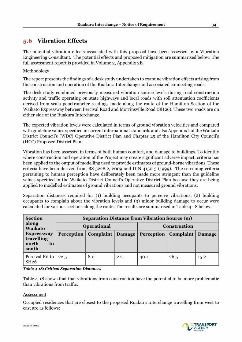
Ruakura Interchange – Notice of Requirement 34
August 2014
5.6 Vibration Effects
The potential vibration effects associated with this proposal have been assessed by a Vibration
Engineering Consultant. The potential effects and proposed mitigation are summarised below. The
full assessment report is provided in Volume 2, Appendix 2E.
Methodology
The report presents the findings of a desk study undertaken to examine vibration effects arising from
the construction and operation of the Ruakura Interchange and associated connecting roads.
The desk study combined previously measured vibration source levels during road construction
activity and traffic operating on state highways and local roads with soil attenuation coefficients
derived from scala penetrometer readings made along the route of the Hamilton Section of the
Waikato Expressway between Percival Road and Morrinsville Road (SH26). These two roads are on
either side of the Ruakura Interchange.
The expected vibration levels were calculated in terms of ground vibration velocities and compared
with guideline values specified in current international standards and also Appendix I of the Waikato
District Council’s (WDC) Operative District Plan and Chapter 25 of the Hamilton City Council’s
(HCC) Proposed District Plan.
Vibration has been assessed in terms of both human comfort, and damage to buildings. To identify
where construction and operation of the Project may create significant adverse impact, criteria has
been applied to the output of modelling used to provide estimates of ground-borne vibrations. These
criteria have been derived from BS 5228.2, 2009 and DIN 4150-3 (1999). The screening criteria
pertaining to human perception have deliberately been made more stringent than the guideline
values specified in the Waikato District Council’s Operative District Plan because they are being
applied to modelled estimates of ground vibrations and not measured ground vibrations.
Separation distances required for (1) building occupants to perceive vibrations, (2) building
occupants to complain about the vibration levels and (3) minor building damage to occur were
calculated for various sections along the route. The results are summarised in Table 4-18 below.
Section along Waikato Expressway travelling north to south
Separation Distance from Vibration Source (m)
Operational Construction
Perception Complaint Damage Perception Complaint Damage
Percival Rd to SH26
22.5 8.0 2.2 40.1 26.5 15.2
Table 4-18: Critical Separation Distances
Table 4-18 shows that that vibrations from construction have the potential to be more problematic
than vibrations from traffic.
Assessment
Occupied residences that are closest to the proposed Ruakura Interchange travelling from west to
east are as follows:
Ruakura Interchange – Notice of Requirement 35
August 2014
63 Ryburn Road (4.7 m from designation boundary and 39.6 m from road edge)
495 Ruakura Road (10.3 m from designation boundary and approximately 76 m from road
edge)
3 Vaile Road ( 5.2 m from designation boundary and 11.2 m from road edge for Vaile Road
frontage and 17.9 m from designation boundary and 23.7 m from road edge for Ruakura Road
frontage)
588 Ruakura Road (16.1 m from designation and 22.4 m from road edge)
188a Morrinsville Road (SH26) (23.0 m from designation boundary and 27.4 m from road
edge).
211 Morrinsville Rd (SH26) (15.8 m from designation boundary and 20.6 m from road edge)
212 Morrinsville Rd (SH26) (13.7 m from designation boundary and 17.8 m from road edge)
215 Morrinsville Rd (SH26) (15.9 m from designation boundary and 20.6 m from road edge)
Traffic induced vibrations once the Ruakura Interchange is operational is unlikely to be issue as in
all cases the separation distance from the closest point of a dwelling to the road edge will be well in
excess of the complaint threshold distance of 8 m. In fact, traffic induced vibrations are unlikely to
be perceived at 495 Ruakura Road, 63 Ryburn Road and 188a Morrinsville Road.
In contrast, designation boundaries in all cases fall within either the complaint (27 m) or damage (16
m) separation distances for general road construction activity. Therefore, this brings a potential risk
that if road construction takes place close to the designation boundary, building damage could result
if control measures are not in place.
Over and Under Expressway Options
From a vibrations perspective, there is no difference between the ‘over’ and ‘under’ interchange
options as a significant amount of earthworks is associated with either option. Therefore, irrespective
of which option is chosen, construction activity will have to be appropriately managed through a
construction vibration management plan (CVMP) to ensure mitigation of any vibrations that could
be potentially damaging to nearby properties.
Peaty Soils
Areas of peaty soil have the potential to generate problematic vibrations during construction of the
Ruakura Interchange and once it is operational. Therefore, there is a need for these areas to be
identified so that appropriate measures can be put in place to limit the disturbance of occupants of
nearby buildings.
Cumulative Effects
There is the potential for cumulative effects at dwellings in Ryburn Road. Therefore, care will need
to be taken in scheduling construction activities in the vicinity of Ryburn Road that generate large
ground vibrations, such as piling and compaction, to ensure they do not occur concurrently at the
Ruakura Interchange project, the Ruakura Development (inland port and logistics hub) and the
Waikato Expressway, Hamilton Section project.
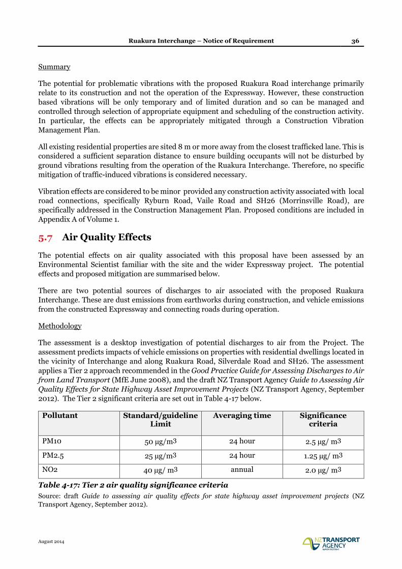
Ruakura Interchange – Notice of Requirement 36
August 2014
Summary
The potential for problematic vibrations with the proposed Ruakura Road interchange primarily
relate to its construction and not the operation of the Expressway. However, these construction
based vibrations will be only temporary and of limited duration and so can be managed and
controlled through selection of appropriate equipment and scheduling of the construction activity.
In particular, the effects can be appropriately mitigated through a Construction Vibration
Management Plan.
All existing residential properties are sited 8 m or more away from the closest trafficked lane. This is
considered a sufficient separation distance to ensure building occupants will not be disturbed by
ground vibrations resulting from the operation of the Ruakura Interchange. Therefore, no specific
mitigation of traffic-induced vibrations is considered necessary.
Vibration effects are considered to be minor provided any construction activity associated with local
road connections, specifically Ryburn Road, Vaile Road and SH26 (Morrinsville Road), are
specifically addressed in the Construction Management Plan. Proposed conditions are included in
Appendix A of Volume 1.
5.7 Air Quality Effects
The potential effects on air quality associated with this proposal have been assessed by an
Environmental Scientist familiar with the site and the wider Expressway project. The potential
effects and proposed mitigation are summarised below.
There are two potential sources of discharges to air associated with the proposed Ruakura
Interchange. These are dust emissions from earthworks during construction, and vehicle emissions
from the constructed Expressway and connecting roads during operation.
Methodology
The assessment is a desktop investigation of potential discharges to air from the Project. The
assessment predicts impacts of vehicle emissions on properties with residential dwellings located in
the vicinity of Interchange and along Ruakura Road, Silverdale Road and SH26. The assessment
applies a Tier 2 approach recommended in the Good Practice Guide for Assessing Discharges to Air
from Land Transport (MfE June 2008), and the draft NZ Transport Agency Guide to Assessing Air
Quality Effects for State Highway Asset Improvement Projects (NZ Transport Agency, September
2012). The Tier 2 significant criteria are set out in Table 4-17 below.
Pollutant Standard/guideline Limit
Averaging time Significance criteria
PM10 50 µg/m3 24 hour 2.5 µg/ m3
PM2.5 25 µg/m3 24 hour 1.25 µg/ m3
NO2 40 µg/ m3 annual 2.0 µg/ m3
Table 4-17: Tier 2 air quality significance criteria
Source: draft Guide to assessing air quality effects for state highway asset improvement projects (NZ
Transport Agency, September 2012).
Ruakura Interchange – Notice of Requirement 37
August 2014
If the screening assessment shows that the levels of PM10, PM2.5 and NO2 are within the significance
criteria, then the levels of other road transport related contaminants will be acceptable, (MfE, June
2008 and NZTA, September 2012).
Assessment of Vehicle Emissions
At all receptor sites, concentrations are below the significance criteria shown in Table 4-17. The
assessed effect of vehicle emissions from the Interchange and new roads on the nearest dwellings
will be less than minor due to the free flowing traffic conditions, moderate traffic volumes and the
long distance from the carriageway. Beyond the areas adjacent to the project, air quality will
generally remain the same depending on the amount of traffic on local roads and further residential
development in these areas.
This assessment considers a conservative scenario, when poor meteorological conditions coincide
with high traffic volumes.
Assessment of Fugitive Dust Emissions from Construction Activities
The assessment of construction dust emissions shows that the deposition of large airborne particles
appears within 100 metres from the source, to perhaps 300 metres from the source under dry and
windy conditions. The nearest residential dwellings will be located more than 300 metres from the
Interchange, and it can be assumed that there will be no dust effects beyond the distance of 300
metres from the Interchange.
Fugitive dust emissions could potentially occur in the vicinity of the construction sites along the
connecting roads. These dust emissions and potential effects can be controlled by a range of
mitigation measures. If dust mitigation measures are implemented as necessary during construction,
fugitive dust emissions from construction activities will be appropriately mitigated.
Control of Dust Emissions
Effective dust management will be achieved through the Construction Management Plan that will be
used by all contractors to manage, mitigate and minimise dust effects. Examples of such appropriate
measures to minimise or eliminate potential impacts on local air quality will include, but not be
limited to, the following:
• Design the construction site to minimise top soil disturbing areas, stockpiles and distances
travelled on unpaved roads.
• Site access roads can be constructed of pavement materials that minimise dust disturbance.
• Water trucks or similar water spraying facilities should be available on the site to keep soil
handling areas and unpaved roads damp in the case of windy and dry weather conditions.
• Wind fencing can be used as a wind control measure.
• Dampening down soil material that needs to be moved or transported during dry and windy
weather conditions.
• Earthworks should be limited as far as practical, or suspended if necessary during dry and
windy weather conditions.
Ruakura Interchange – Notice of Requirement 38
August 2014
• Vehicle speed within the construction site and on access roads should be controlled and
limited as far as practical.
• Trucks used for topsoil stripping and moving soil materials need to be washed down, when
leaving construction sites, particularly in dry and windy weather conditions. In the case of
potential fugitive dust emissions, all loaded material should be covered.
• Liaison with local residents in case of fugitive dust emission complaints, with measures in
place to address complaints as received.
If mitigation measures are implemented as necessary during construction, dust emissions from
construction activities will be appropriately mitigated. It is anticipated that the effect of these
emissions on the local environment will be minor.
Cumulative Effects
The cumulative effect of construction dust emissions from the Interchange and Inland Port
construction sites will be minor. This conclusion is based on the assumption that all required dust
mitigation measures will be implemented at construction sites.
Summary
The assessment demonstrates that the effect of vehicle emissions (once the project is operational)
will be less than minor, and it is anticipated that the ambient air concentrations at the nearest
residential dwellings will remain nearly at the same levels after construction of the interchange.
There is potential for adverse effects during construction as a result of fugitive dust emissions
deposited within 100 metres from the source, to perhaps 300 metres from the source under dry and
windy conditions. However, if mitigation measures are implemented as necessary it is anticipated
that the effect of these emissions on the local environment will be minor. Proposed conditions are
included in Appendix A of Volume 1.
5.8 Contamination Effects
The potential effects associated with disturbing contaminated land have been assessed by an
Engineering Geologist familiar with the site and the overall project. The potential effects and
proposed mitigation are summarised below.
Methodology
Opus has prepared a preliminary site inspection (PSI) report for TGH6 associated with the Ruakura
Development. The Agency has obtained permission from TGH to use the information contained
within that PSI report to inform this NOR in terms of land contamination. The assessment is based
on a desk study and site walkover inspection of the areas of land affected by the proposed
interchange.
6 Ruakura Development Preliminary Site Inspection Report, number G3132. Tainui Group Holdings Limited. June 2013. Referenced 2-32113.00_G3132.
Ruakura Interchange – Notice of Requirement 39
August 2014
Assessment
It has been established through anecdotal evidence, Council records, and historical aerial
photographs that the site has been subject to the following:
Farming operations and since the 1940’s, agricultural research. Associated with this has been
the storage and application of insecticides, pesticides and herbicides.
In the past five years land to the south of Ruakura Road has been tenanted out as a dairy
farm.
A closed landfill area partially within the Ruakura Interchange footprint has been identified.
This landfill had mostly accepted inert type wastes, but did occasionally include dead
livestock.
An effluent pond is located to the east of the closed landfill, and an area formerly used for
solvent / liquid burning pits is located to the north of the landfill. However, both of these
features are located outside of the Ruakura Interchange footprint.
Based on this information, the key issues of concern for potential contamination are the old landfill
in the southern part of the interchange, the potential for asbestos containing materials in the
residential house and the general site wide use as pasture land with the spreading of fertilisers,
herbicides and other products associated with agricultural activities. The report also notes that there
remains a possibility that additional potentially contaminative sources or issues have not yet been
identified and these may come to light as work at the site unfolds.
Approach to managing effects
The management of contaminated land in New Zealand is described in the National Environmental
Standard for Assessing and Managing Contaminants in Soil (NES) and the Contaminated Land
Management Guidelines (CLMG) 1 to 5. Provided the proposed construction works are carried out
in accordance with the procedures described in these documents, the proposed development should
be undertaken without any adverse effects to human health or the environment.
It is noted that remediation of contaminated land under the NES may require a resource consent
from Hamilton City Council and/or Waikato District Council. If required, this consent will be sought
at a later stage, once more detailed design has been undertaken. This approach is consistent with
that proposed and accepted for the recent alterations to the designation (July 2014).
The proposed approach is to develop a Contaminated Soil Management Plan (CSMP) as part of any
future NES consent application, and incorporate it into the Construction Management Plan. The
CSMP will include a methodology describing the requirements for further investigation and
necessary remedial action plans and site validation reports in accordance with the Ministry for the
Environment guidelines. The CSMP for the works must be prepared and managed by a Suitably
Qualified and Experienced Practitioner as defined in the NES.
The CSMP will cover the scenarios likely to be encountered, potential risks and hazards to human
health and the wider environment, the remedial options available and the means of verifying,
controlling and recording remedial works. It will also address procedures for the identification of
potentially contaminated land and any potential re-use of materials on site.
Ruakura Interchange – Notice of Requirement 40
August 2014
Subject to a CSMP required under a future NES resource consent application, it is considered that
the Ruakura Interchange alteration will have no more than minor effects in relation to land
contamination.
5.9 Stormwater Effects
The potential drainage and flooding effects of the Ruakura Interchange and relocated Ruakura Road
have been assessed by an Environmental Engineer familiar with the site. The potential effects
associated with drainage and flooding and proposed mitigation are summarised below.
Factors influencing stormwater design and stormwater design standards
In developing the stormwater design, consideration has been given to a number of influencing
factors, including the Waikato-Tainui Raupatu (Waikato River) Claims Settlement Act 2010, geology
and sub-surface conditions, rainfall data and climate change, existing surface water outfalls, and
land area and elevation.
Consultation with HCC, WDC, and WRC has resulted in stormwater design criteria being adopted
for the Expressway Project and for the proposed NOR works in relation to rainfall, treatment of road
runoff, stream channel erosion control, peak flow attenuation, sediment control during construction
and waterway crossings. These criteria are set out in the stormwater assessment report (Voume 2,
Appendix 2H).
Drainage for the full-diamond interchange (Expressway plus ramps including the wetland) at
Ruakura has already been accounted for in the consent application lodged with the WRC (Ref:
130361). This assessment therefore only relates to the connecting roads.
Assessment
Environmental effects that are associated with the road construction can be divided into short term
effects that occur during construction, and long term effects that occur during the operation and
maintenance of the proposed works.
Short term effects arise during construction as a result of earth working activities including culvert
construction. Stormwater flowing over the proposed works can mobilise sediment, and carry it off-
site into neighbouring watercourses, and eventually into the Waikato River. This sediment laden
runoff reduces stream water quality, and as it settles out can smother the base of the stream
suffocating aquatic life.
Long-term effects arise during the operation of the project, as the creation of impervious road
surfaces causes stormwater to be discharged at a faster rate, and in greater volumes. This can cause
flooding, and increase the rate of erosion within the receiving watercourses. The creation of new
pavement can also result in traffic-generated contaminants such as heavy metals, and hydrocarbons
to be discharged into neighbouring watercourses, and eventually the Waikato River.
Ruakura Interchange – Notice of Requirement 41
August 2014
Cumulative Effects
Both the Waikato Expressway Hamilton Section and the Ruakura Development PPC have now been
consented, and are therefore legally clear to proceed. Although they have not yet been constructed,
these neighbouring projects have been considered as if they already exist for the purpose of this AEE.
Short-term (i.e. construction-related) effects could be exacerbated if multiple projects are
constructed at once. In addition, with regard to long-term effects, each project will release
contaminants to the environment; the ultimate environmental effect will be due to the sum of these
releases. The increased impermeable area associated with each project will result in increased flows
and reduced ground soakage. Stream peak-flow increases will be approximately equal to the sum of
the individual increases, modified by timing effects.
Mitigation
Short-term effects will be mitigated by implementing erosion and sediment control practices that are
consistent with the Erosion and Sediment Control Guidelines for Soil Disturbing Activities (WRC
2009). Opus prepared an indicative Erosion and Sediment Control Plan (ESCP) for the Expressway
as part of the resource consent application. Similar practices will be applied to the proposed works,
but at a much smaller scale and, with the flat topography, should not cause any major erosion or
sediment control risks. A final ESCP will be prepared by the successful contractor as part of their
Construction Environmental Management Plan. This plan will be certified by the WRC and will
address the contractor’s specific construction methodology.
The potential long-term effects will be mitigated by implementing practices that are consistent with
those outlined in the NZTA’s Stormwater Treatment Standard for State Highways Infrastructure.
In particular:
Surface water will be collected and conveyed, ensuring provision of a safe and efficient road,
through the management of surface water depths and the removal of excess water.
Stream erosion will be mitigated by capturing and slowly-releasing flow from what is known as
the extended-detention design storm, as defined in the NZTA standard.
Stormwater runoff created by the new road will be detained and slowly released at 80% of the
pre-development rate for the 1% AEP storm event. Flow from the 10% and 50% AEP storms
will be detained and released at their pre-development rates. This standard will be applied to
all new roads and to existing roads being upgraded in proportion to their new impermeable
area.
Treatment wetlands, wetland and vegetated swales will be used to convey and treat runoff to
remove suspended solids, heavy metals, hydrocarbons, and other traffic-related pollutants such
as scums, foams or floatable materials derived from the new impermeable surfaces. Where
surface water is to be managed by kerb and channel, catchpits will be used to remove gross
pollutants and road-derived sediment before the runoff is discharged to a treatment device
With regard to the potential cumulative effects, the earthworks footprint of the link roads project is
small compared to the other projects, the topography is flat and volume needing to be earth-
worked is relatively small.
Ruakura Interchange – Notice of Requirement 42
August 2014
The moderately-trafficked link roads are likely to be more benign in terms of contaminant
generation than the Expressway and the industrial TGH development. To the extent that the link
roads represent a transfer of traffic from an untreated road to a treated road, there will be some net
benefit, however this is difficult to quantify as the existing Ruakura Road probably contains some
informal stormwater treatment already in the form of berms and vegetated water table drains.
Each project will incorporate peak flow attenuation and extended detention to minimise
downstream flood effects and stream erosion effects. The 1% AEP flow will be detained to less than
80% of the equivalent pre-development flow. This approach is recommended by NZTA’s
Stormwater Treatment Standard to address cumulative effects and timing effects in the absence of
a specific catchment analysis.
On this basis, no specific mitigation is recommended in relation to cumulative effects.
Summary
Providing the works are competently constructed and managed, and the mitigation measures
outlined in this report are applied, the effects on stormwater quality and quantity entering the
receiving environment are expected to be less than minor.
5.10 Social Effects
The potential social effects associated with this proposal have been assessed by a social impact
assessor. The potential effects and proposed mitigation are summarised below. The full assessment
report is provided in Volume 2, Appendix 2I.
Methodology
The social impact assessment employs a framework for assessing social effects based on principles
from the International Association for Impact Assessment, taking into consideration the
requirements of the NZ Transport Agency’s (draft) Z/19 Standard. Effects are considered in relation
to four main themes: way of life; wellbeing; environment and amenity; and community.
The methodology includes a community profile, which describes the existing social environment
around the Project area. The community profile includes a description of the existing environment,
a description of key community facilities and amenities in the area, a discussion of travel patterns
and linkages in the area, and a review of policy and strategic documents.
Social effects have been identified by reviewing a number of sources. The initial desktop review of
communities in the area, combined with aerial images and maps prepared by the project team
identified potential social effects, and community groups of interest to the assessment. Direct
observations of the Project area were carried out in a site visit providing context for the proposed
project. Telephone and face-to-face discussions were held with community groups to better
understand how the project may affect them. Other technical specialists’ assessments were reviewed
from a social perspective to further understand the potential effects of the project.
Assessment
The NOR is expected to result in very slight to significant positive regional social effects and very
slight to moderate positive local social effects. Positive effects as a result of the project include:
Ruakura Interchange – Notice of Requirement 43
August 2014
Improved regional and local connectivity, enabling the movements of people to and from sources
of education, recreation and employment.
Facilitated development of a regionally significant commercial facility.
Support for regional and city-wide community plans and aspirations.
Enhancement of local amenity of active transport networks for pedestrians and cyclists, which
has the potential to encourage greater use among local residents, as well as workers and students
in the area.
Identified negative effects as a result of the project include:
Potential negative effects to safety and amenity of the local road networks for pedestrians and
cyclists during construction, particularly in the location of schools and community facilities in
the Silverdale area.
Potential effects to neighbourhood amenity both during construction and once operational as a
result of changes in traffic volumes and visual changes.
Very localised severance of connectivity at Ruakura Road (Percival/Ryburn Road area) as a result
of partial road closure.
Small amounts of private property acquisition (partial acquisition and one dwelling to be
removed).
The social impact assessment identifies recommended mitigation measures to address identified
social effects. In some cases mitigation proposed by another technical specialist is considered
sufficient to address social concerns, but in other cases additional measures are recommended by
the social impact assessor.
The project includes existing mitigation for potential safety and congestion effects, and there are a
number of conditions on the existing designation for the Hamilton Section which will address most
of the identified social effects.
Additional mitigation has been proposed to conditions 2 and 9 of the existing designation, to include
certain community facilities and sites in notification related to the project, and in the community
liaison details.
Summary
With proposed mitigations in place, negative effects can be managed to result in neutral/very slight
negative regional effects and very slight to minor negative effects at local levels. Overall, the social
effects can be categorised as being positive at the regional level, with a mixture of negative and
positive effects at finer local levels.
5.11 Noise Effects
The potential effects associated with construction and traffic noise have been assessed by a Transport
Research and Noise Specialist. The potential effects and proposed mitigation are summarised below.
It is important to note that the existing designation comprises the original designation (designated
in 2005) with some discrete alterations that were designated in July 2014. Those alterations affected
locations separate from the location of the proposed Ruakura Interchange and connecting roads. In
the area of the Ruakura NOR, the existing designation is as originally designated in 2005.

Ruakura Interchange – Notice of Requirement 44
August 2014
With regard to road-traffic noise, in essence, the noise conditions on the existing designation require
that the road is built with noise levels mitigated to achieve, subject to practicability, the average noise
design levels of the Transit New Zealand Noise Guidelines.
Methodology
The assessment is made to the Noise Guidelines which set average noise design levels based on the
existing noise environment. As described in the Noise Assessment Report (Volume 2, Appendix 2J),
compliance with an average noise design level can be taken as having an effect no more than minor.
Road-traffic noise levels of the NOR were assessed for 2021 and 2041. The baseline environment
incorporates the designated route design, and the assessment includes the two options for the
interchange, being “the Expressway over Ruakura Road” and “the Expressway under Ruakura Road”.
Therefore, six noise environments were modelled:
Baseline (designated route) for 2021 and 2041;
Expressway over Ruakura Road for 2021 and 2041; and
Expressway under Ruakura Road for 2021 and 2041.
To facilitate assessment of the effects of the NOR, assumptions made for the designated “do-
minimum” project were used for the proposed altered “do-minimum” project. For example, the
Expressway and all other roads have been sealed with Grade 3/5 two-coat chipseal as a default
assumption. This is a noisy road surface and roads may in reality be surfaced with a quieter single-
coat chipseal or other road surface. Note that the term “do minimum” is a term with a specific
meaning defined in the New Zealand Standard for road-traffic noise, NZS 6806. The term is not used
to describe an approach of doing the minimum possible. Rather, it describes the roading network
design as it would be without any measures included specifically for noise mitigation purposes.
Operational Noise
The assessment at 2021 demonstrates that where there are exceedances, overall both the presence
and scale of exceedances are almost equivalent across the three noise environments (baseline,
Expressway over and Expressway under). This indicates that the effects of the NOR are comparable
with the effects of the baseline (designated route) which have already been assessed and agreed.
A section of Ruakura Road is included within the NOR. Though the road-traffic noise levels for
houses adjacent to this section of Ruakura Road do change between the baseline (designated route)
and the proposed routes, the total noise levels do not exceed the Noise Guidelines and so the noise
level changes can be considered as having a no more than a minor effect, if any.
The NOR will have little effect for houses on Davison Road; possibly a small noise level decrease but
this would have very slight or negligible effect. The proposed designation alterations do not introduce
effects to houses in the area of Nevada Road. Any other noise level changes caused by the NOR tend
to occur where there are no noise-sensitive receivers.
Some large exceedances are noted, such as for 134C Percival Road, 55 Ryburn Road, and 63 Ryburn
Road. However, the scale of the exceedances is consistent between the three 2021 noise
environments. These exceedances highlight the area of Percival Road and Ryburn Road, which is
consistent with the 2002 evidence for the designation, though the scale of the exceedances is now
identified as larger than that previously identified. It is considered this is due to detail of the current
modelling being greater than that practicable for the modelling for the 2002 evidence.
Ruakura Interchange – Notice of Requirement 45
August 2014
For each exceedance, the baseline (designated route) and the proposed routes have been considered
for differences that could adversely affect the practicability of mitigating that exceedance. No
substantive difference was found.
The noise assessment concludes that for both the existing designation and the NOR, the Noise
Guidelines can be achieved, subject to practicability, and the extent of mitigation is similar.
In terms of the two Ruakura interchange configuration options, the assessment concludes that both
the presence and scale of exceedances are almost equivalent. On this basis, from a noise perspective,
the assessment states that the proposed alteration can be made without requiring the configuration
to be defined.
The 2041 results are consistent with the 2021 results. Therefore, the findings and discussion of the
2021 results outlined above can also be applied to assessment of the 2041 noise environments. To be
clear, the assessment at 2041 indicates that for both the existing designation and the proposed
designation alterations, the Noise Guidelines can be achieved, subject to practicability, and the
extent of mitigation is similar.
Conditions relating to noise assessment and mitigation are proposed, and included as Appendix A of
Volume 1.
The noise assessment also considers cumulative effects on the environment associated with the
Ruakura Development, East Coast Main Trunk Line and the Waikato Expressway. It is noted that
the noise assessment uses traffic modelling data which takes into account the Ruakura Development
and its influence on traffic demands. Noise from the Ruakura Development land use is not included
in the road-traffic noise modelling, and neither is the East Coast Main Trunk Link. The assessment
notes that if these additional noise sources were included, the ambient noise levels upon which Noise
Guidelines average noise design levels are based, may be higher and as a consequence the average
noise design levels would be higher. Therefore, excluding these additional noise sources is a
conservative approach.
Where the Project is the dominant noise source, adding the noise allowable from the Logistics Area
will cause little change to the total noise level. Cumulative noise effects are not expected to be
unreasonable.
Construction Noise
The proposed designation alterations result in only small to moderate changes in separation distance
between the construction activity and nearby receivers, compared with separation distances with the
existing designation. Therefore it is expected that the ability for construction noise effects associated
with the proposed designation alterations to be reasonable is little changed from the ability of the
existing designation, and the periods or extents for which alternate noise management methods may
need to be used will also be similar. Therefore the assessment concludes that provided a Construction
Noise Management Plan is appropriately prepared and implemented, construction noise effects of
the proposed designation alterations will be reasonable.
Construction noise conditions are proposed, and attached as Appendix A of Volume 1.
Ruakura Interchange – Notice of Requirement 46
August 2014
Conclusion
Subject to the mitigation proposed, it is concluded that the noise effects both during construction
and operation, will be no more than minor.
5.12 Summary of Effects
The assessment above has considered the actual and potential effects of the Ruakura Interchange
NOR, as required by s171(1) of the RMA.
The temporary effects associated with construction noise, vibration, dust and traffic have all been
considered. For noise and vibration, there is potential for adverse effects on identified properties. A
Construction Noise and Vibration Management Plan (CNVMP) has been recommended as the most
appropriate way of mitigating these effects.
Similarly, it is recommended that a Construction Management Plan (CMP) be prepared which
identifies measures to mitigate adverse effects associated with construction dust. Effects of
construction traffic are also best addressed through the CMP, which will be certified by Waikato
District Council and Hamilton City Council. Although unlikely, Silverdale Road could be used to
transport earthwork material to the site. It is noted that Silverdale School gets direct access from this
road, hence construction traffic during peak times of the day could create a safety issue. To help
prevent this occurrence a condition is recommended to restrict truck traffic in the vicinity of
Silverdale School, particularly during normal school drop off and pick up times.
Once operational, the air quality assessment demonstrates that the effect of vehicle emissions will be
less than minor, and that the ambient air concentrations at the nearest residential dwellings will
remain nearly at the same levels after construction of the interchange. Similarly, any effects of
vibration from the operational project are assessed as being less than minor and do not require any
mitigation.
Noise from the operating interchange and connecting roads has the potential to affect the properties
closest to the designation. However, the noise assessment has concluded that the Noise Guidelines
can be achieved (subject to practicability), and that the extent of mitigation is similar to what is
required in association with the existing designation.
The traffic assessment concludes that the Ruakura Road interchange and connecting roads will have
no more than a minor traffic and safety effect. In addition, the NOR provides a positive overall
contribution to the network efficiency by providing a direct connection between the PPC activities
(particularly the Inland Port and Logistics area) and the Waikato Expressway, thereby reducing
heavy commercial vehicles on city roads such as Wairere Drive and Cambridge Road. Effects on
alternative modes of transport are expected to be positive due to the inclusion of shared off road
facilities along Relocated Ruakura Road, and a concrete pathway between Vaile Road and SH26,
neither of which exist at present.
The alteration can be given effect to without any significant landscape, visual or urban design effects.
There will be interim effects before the Ruakura Development is established, however in the long
term, these will be absorbed by the built form of the Ruakura Development. Overall, the inclusion
of the Interchange and associated connecting roads are considered to sit well within the landscape
and any landscape, visual or urban design effects can be adequately mitigated.
Ruakura Interchange – Notice of Requirement 47
August 2014
Potential social effects arising during construction and operation have been considered. Effects have
been considered at both the regional and local level. Negative effects of the project, with the exception
of the localised effects of the closure of part of Ruakura Road are able to be mitigated. Identified local
dis-benefits, or negative effects need to be considered in light of the designated Expressway, and
what would be a small scale change in comparison. Overall, the social effects can be categorised as
being positive at the regional level, with a mixture of negative and positive effects at finer local levels.
With regard to the footprint of the designation, there is no evidence to suggest the study area holds
archaeological or historic values, and as such, there are no known reasons to alter or modify the
current proposal on archaeological grounds. Accidental discovery protocol conditions are considered
appropriate and with their implementation any potential effects regarding archaeology will be no
more than minor.
In addition, the potential effects associated with the disturbance of contaminated land have been
considered. The key issues of concern for potential contamination are the old landfill in the southern
part of the Interchange, the potential for asbestos containing materials in the residential house to be
removed and the general site wide use as pasture land with the spreading of fertilisers, herbicides
and other products associated with agricultural activities. Contaminated sites that have not been
identified may also be uncovered during construction. Subject to a Contaminated Soil Management
Plan (CSMP) required under a future National Environmental Standard (NES) resource consent
application, it is considered that any actual or potential disturbance of contaminated land will have
no more than minor effects.
The proposal has the potential to create both short and long term adverse effects associated with
stormwater generation and run-off. Potential effects include sediment laden run-off, flooding,
stream erosion and pollution. These effects have been assessed, and subject to the recommended
mitigation measures, are considered to be no more than minor.
The assessment of ecological effects identifies that for the most part, the effects of the NOR are no
more than minor. However, approximately 206m2 of black mudfish and longfin eel habitat will be
lost through installation of culverts. Offset mitigation is required to mitigate for this at 2 times the
stream channel area lost, totalling approximately 412m2. An appropriate mitigation option is
identified along Ruakura and Holland Roads. Subject to the mitigation proposed, including matters
which will be addressed through the existing WRC consents, and those soon to be lodged, the NOR
is considered to have no more than minor adverse effects on ecology.
Consideration has also been given to the two options for Ruakura Road interchange, with the
Expressway passing either under, or over Ruakura Road. The noise and vibration assessments have
concluded that the two options make no material difference to the assessment of effects. The
landscape, visual and urban design assessment identifies that the Expressway passing over Ruakura
Road provides a number of benefits relating to accessibility for pedestrians and cyclists, and the
development of adjacent land. However, the traffic assessment identifies that from an expressway
operation and safety perspective, the opposite configuration (Expressway passing under Ruakura
Road) is the preferred layout arrangement as this reduces the speed differential between trucks
merging from the northbound on-ramp and vehicles using the outer lane of the expressway.
Overall, it is concluded that the effects on the environment will be no more than minor provided that
mitigation measures are adopted as recommended. Mitigation will be captured by adopting the
recommended conditions listed in Appendix A. These conditions are based on the conditions
Ruakura Interchange – Notice of Requirement 48
August 2014
accepted for the alterations to the same designations (NOR1A and NOR1B), dated July 2014. These
conditions have only been modified where necessary to address matters unique to this alteration.
Other mitigation measures (particularly those relating to ecology and stormwater) will be better
addressed through the WRC consents being assessed in parallel with this NOR application. WRC
consents will need to be obtained prior to giving effect to this alteration.
Ruakura Interchange – Notice of Requirement 49
August 2014
6 Consultation
6.1 Overview
This alteration is part of the wider Hamilton Section of the Waikato Expressway. Extensive
consultation has been undertaken in relation to this project as a whole, including with statutory
bodies, Tangata Whenua, key stakeholders and people who are affected by, or who have an interest
in, the project. This has been undertaken over the past three years, using various consultation
methods.
A full recount of these consultation activities is not provided here, but can be found in the Project’s
Resource Consent applications (WRC reference 130361).
6.2 Ruakura Interchange Consultation
Over the course of the secondary investigation process (which began late 2010) a number of options
were considered for providing connectivity to the Hamilton Section between Greenhill Road and
SH26. These options were presented to the public at various points through both newsletters and
information days.
As a brief summary, the following consultation activities are noted with respect to the Ruakura
Interchange:
Project update newsletters delivered to properties within 200m of the Expressway
designation and to key stakeholders (e.g. Hamilton City and Waikato District Councils, TGH).
o Update 1 (October 2010): The possibility of a Ruakura Interchange was signalled
o Update 2 (December 2010): Advised of up-coming information day and signalled the
possibility of including an interchange at Ruakura
o Update 3 (December 2011): Summarised likely changes to the designation, including
the possibility of a ‘split-diamond’ interchange between Ruakura and SH26.
o Update 4 (September 2012): Presented the possibility of a Fifth Ave interchange and
realigned Holland Road.
o Update 5 (April 2013): Advised of up-coming information day indicated a Ruakura
Interchange located as per this alteration.
o Update 6 (October 2013): Advised that consent applications and alterations had been
lodged and that these alterations excluded the Ruakura Interchange. Also highlighted
the possibility of an alteration for the Ruakura Interchange, subject to the BOI
process.
Project Information Days provided an opportunity for information to be presented and for
the community to discuss the overall project with Agency staff and their consultants:
o Project Information Day (February 2011): Signalled the possibility of an interchange
at Ruakura
Ruakura Interchange – Notice of Requirement 50
August 2014
o Ruakura Information Day (September 2011): This was joint with HCC and presented
the option of the Ruakura/SH26 split diamond interchange.
o Fifth Ave Information Day (September 2012): Presented the option of a Fifth Ave
Interchange (instead of a Ruakura Interchange).
o Project Information Day (April 2013): Presented a Ruakura Interchange located as
per this alteration.
On 6 June 2013 meetings were held with Livestock Improvement and Dairy NZ, both of whom
are based on Ruakura Road and employ 530 and 130 staff on-site respectively. The Ruakura
Interchange and link to Ruakura Road was explained to senior management of both
companies.
In addition to the project update letters, on 10 February 2014 a letter was delivered to all
properties located in the vicinity of Ruakura, Davison, Vaile (in part), Ryburn and Percival
Roads, to advise landowners of the imminent lodgement of a NOR to provide for the Ruakura
Interchange and relocation of Ruakura Road. The same letter was sent to a number of key
stakeholders including the University of Waikato.
The Agency issued a press release on 12 February 2014 outlining the same information
delivered to properties on 10 February 2014.
From February to July 2014, there was no further consultation with stakeholders of the general
public, as the Agency awaited the outcome of the PPC BOI process. With an interim decision from
the BOI being indicated for early August 2014, the project started up once more on the premise of a
favourable outcome to the PPC application. On 17 July 2014, Opus Planners met with the following
stakeholder groups to inform them of the current project status, and also to gather information in
relation to the potential social impacts of the Ruakura Interchange proceeding:
University of Waikato
Silverdale Residents Group
Ruakura Residents Group
Newstead Residents Association
The summary above demonstrates that regular consultation has occurred with key stakeholders and
the general public over the previous 3.5 years regarding the Ruakura Interchange alteration.
6.3 Tangata Whenua Consultation
The following summarises the consultation undertaken with Tangata Whenua for the project as a
whole.
A Statement of Identified Māori Interests (SIMI) was prepared in accordance with Agency
requirements in October 2010. The SIMI identified the Tangata Whenua groups to consult with in
relation to the Hamilton Section of the Waikato Expressway.
An initial workshop was held with Tangata Whenua representatives on 21 October 2010.
Ruakura Interchange – Notice of Requirement 51
August 2014
Waikato Tainui and the Agency entered into detailed discussions in early 2011 with a view to forming
a high level contract enabling a partnership to be established for the Hamilton Section. Through that
process, an appointee from Waikato Tainui established responsibility for determining who the
project team should engage with and how that should occur. As a result, a Hamilton Section specific
Tangata Whenua Working Group (TWWG) was established in late 2011.
A working paper was prepared by the TWWG on 11 December 2011 as a means of expressing the key
issues for Tangata Whenua. This paper was updated in March 2012 following more detailed
discussions with Tangata Whenua.
In December 2012, the TWWG presented the Draft Tangata Whenua Effects Assessment Report
(TWEAR). Following the delivery of this document, the project team held a meeting with the TWWG
in February 2013 and provided a preliminary response to the issues raised in the document.
The TWWG (through its connection with TGH) is very aware of the Ruakura Interchange and have
supported its inclusion as part of the Expressway throughout the period of consultation. This is
evidenced in the Position Statement prepared by the TWWG in relation to the project, which is
provided as Appendix E.
Consultation with the TWWG is on-going, including a recent meeting held 3 July 2014. It is expected
that consultation will continue, and this is also underpinned by the existing consent and designation
conditions which require the preparation of a Waikato Tainui Mitigation Plan (WTMP).
6.4 Affected Landowner Consultation
In order to give effect to this alteration land will need to be taken from the following entities:
WDC
HCC
TGH
Landowner – 11 Davison Road
A Ruakura Transport Reference Group was established, consisting of representatives from the three
Councils, the Agency, and TGH. The purpose of this group was to meet and deal with issues in
respect to the timing and planning of the Expressway, and identify and work through any local
roading issues. Through these discussions all parties have been aware of the need to alter the current
designations in order to provide for the Ruakura Interchange.
The landowner at 11 Davison Road was contacted by Opus on behalf of the Agency and a meeting at
the property was held on 4 February 2014, where the proposal and the requirement to take a portion
of her land adjacent to Ruakura Road was explained. A number of further meetings and discussions
have been held with this landowner, most recently on 18 July 2014. The additional land is required
to improve sight visibility for vehicles turning onto Ruakura Road from Davison Road. Negotiations
with the landowner are continuing.
Ruakura Interchange – Notice of Requirement 52
August 2014
6.5 Ruakura Structure Plan and the Ruakura Development PPC
Consultation
As a part of the Ruakura Development, a series of consultation activities have been undertaken.
These have been implemented primarily by the HCC as a statutory requirement, and also by TGH.
Following feedback on the Draft Hamilton City District Plan in April 2011, TGH facilitated (under
observation from HCC) two public forums held at the University of Waikato, prior to the Proposed
District Plan being notified. Invitations to this event were sent to approximately 8,000 households
in the catchment area. Further to this event, a site visit to the Highbrook Industrial Park in Auckland
was undertaken to show people a working example of an industrial park. 16 residents attended the
site visit.
An initial Ruakura Structure Plan “Open Day” was held in December 2011 (led by TGH), as an
initiation to the Structure Plan process. A further three “Open Days‟ were held in May 2012, led by
HCC as part of consultation on the Draft Hamilton City District Plan. These featured information
panels/graphics outlining details of the Structure Plan, and project representatives from HCC and
TGH were in attendance to answer questions.
6.6 Summary
The descriptions above demonstrate that the Agency has undertaken extensive consultation
regarding the Ruakura Interchange, either as part of the overall Hamilton Section of the Waikato
Expressway, or in specifically addressing the proposed Ruakura Interchange and link to Ruakura
Road. Furthermore, awareness of the need for the Ruakura Interchange has been expressed through
consultation on the Structure Plan and PPC processes.
Ruakura Interchange – Notice of Requirement 53
August 2014
7 Statutory Assessment
7.1 Resource Management Act 1991
The RMA governs the use and development of New Zealand’s natural and physical resources. Part 2
establishes the Purpose and Principles of the RMA. The following section outlines the relevant
sections of the RMA that have been considered with this alteration.
7.1.1 Section 181 – Alteration of Designation
To be processed as an alteration to designation under section 181 of the RMA, the following must be
satisfied:
(1) A requiring authority that is responsible for a designation may at any time give notice to
the territorial authority of its requirement to alter the designation;
(2) Subject to subsection (3), sections 168 to 179 shall, with all necessary modifications, apply
to a requirement referred to in subsection (1) as if it were a requirement for a new
designation;
(3) A territorial authority may at any time alter a designation in its district plan [or a
requirement in its proposed district plan] if—
(a) The alteration—
(i) Involves no more than a minor change to the effects on the environment associated
with the use or proposed use of land or any water concerned; or
(ii) Involves only minor changes or adjustments to the boundaries of the designation
[or requirement]; and
(b) Written notice of the proposed alteration has been given to every owner or occupier of
the land directly affected and those owners or occupiers agree with the alteration; and
(c) Both the territorial authority and the requiring authority agree with the alteration —
and sections 168 to 179 shall not apply to any such [alteration].
(4) This section shall apply, with all necessary modifications, to a requirement by a territorial
authority to alter its own designation [[or requirement]] within its own district.
Assessment
Section 181(3)(a)(i) makes reference to the alteration involving a no more than minor change to the
effects on the environment, or only minor changes or adjustments to the boundaries of the
designation. In the context of the existing Expressway, the proposed alteration will involve a change
in the scale and extent of the designation, which could be seen as more then minor. In addition, it
could be argued that the adjustments to the boundaries are more than minor given their geographical
extend. As such, s181(3) is not considered to be available as an option for addressing this alteration.
The Agency is also requesting that the alteration be publicly notified (in accordance with section
95A(2)(b) of the RMA and is anticipating a section 92 request for further information given that the
application needed to be prepared in a very short timeframe.
As it is not possible to meet all the requirements of section 181(3) the alteration will need to be
processed in accordance with section 181(2), and sections 168 to 179 shall apply with all necessary
Ruakura Interchange – Notice of Requirement 54
August 2014
modifications as if it were a requirement for a new designation. This NOR has been prepared
accordingly.
The Agency is also requesting that the alteration be publicly notified (in accordance with section
95A(2)(b) of the RMA.
7.1.2 Section 171 – Recommendation by Territorial Authority
In accordance with section 171 of the RMA, a territorial authority must take into account the
following when considering a requirement:
(1A) When considering a requirement and any submissions received, a territorial authority
must not have regard to trade competition or the effects of trade competition;
(1) When considering a requirement and any submissions received, a territorial authority
must, subject to Part 2, consider the effects on the environment of allowing the requirement,
having particular regard to:
(a) Any relevant provisions of:
(i) A national policy statement;
(ii) A New Zealand coastal policy statement;
(iii) A regional policy statement or proposed regional policy statement;
(iv) A plan or proposed plan; and
Consideration of the proposed alteration with regard to relevant environmental standards, policies
and plans, and Part 2 is provided below.
(b) Whether adequate consideration has been given to alternative sites, routes, or methods
of undertaking the work if:
(i) The requiring authority does not have an interest in the land sufficient for
undertaking the work; or
(ii) It is likely that the work will have a significant adverse effect on the environment;
and
The Agency as the requiring authority does not have an interest in the land sufficient for undertaking
the proposed works. Accordingly, due consideration has been given to alternatives as discussed in
section 4.2 of this report.
(c) Whether the work and designation are reasonably necessary for achieving the objectives
of the requiring authority for which the designation is sought; and
The proposed alteration is the outcome of a Network Connections investigation which concluded
that interchanges at Greenhill and Ruakura best served the area if the Ruakura Structure Plan (and
in particular the Inland Port) were to proceed. This alteration is lodged on the basis of the BOI’s
approval of the Ruakura PPC. The report on the Network Connections investigation is provided in
Appendix D.
(d) Any other matter the territorial authority considers reasonably necessary in order to
make a recommendation on the requirement..
(2) The territorial authority may recommend to the requiring authority that it:
Ruakura Interchange – Notice of Requirement 55
August 2014
(a) Confirm the requirement:
(b) Modify the requirement:
(c) Impose conditions:
(d) Withdraw the requirement.
(3) The territorial authority must give reasons for its recommendation under subsection (2).
7.2 National Policy Statements
Section 171(1)(a)(i) of the RMA requires consideration of any relevant provisions of “a national
policy statement”.
7.2.1 Electricity Transmission
The NPS for Electricity Transmission sets out the objective and policies to enable management of
the effects of the electricity transmission network. The most relevant aspects of the NPS are
Policies 10 and 11, which relate to managing the adverse effects of third parties on the transmission
network.
Assessment
Transmission lines cross the Expressway alignment in a number of locations, including at Ruakura
to the north of the interchange. However the NOR for Ruakura does not significantly change the
impacts on transmission lines, when compared with the existing designation. Design work associated
with the Transpower lines crossing the designation in this location is currently being undertaken by
Transpower’s consultants. Proposed conditions are included to ensure that construction and
operation of the Expressway will not adversely affect the operation of any transmission lines.
7.2.2 Freshwater Management (2014)
With respect to this NOR, the only relevant national policy statement is the National Policy
Statement for Freshwater Management 2014 (“Freshwater NPS”), which became operative on 1 July
2011. The most relevant aspect of the NPS is Objective A1, which is:
To safeguard (a) the life-supporting capacity, ecosystem processes and indigenous species
including their associated ecosystems, of fresh water; and (b) the health of people and
communities, at least as affected by secondary contact with fresh water; in sustainably managing
the use and development of land, and of discharges of contaminants.
Assessment
As discussed in the ecology assessment report, the treatment proposed is sufficient to ensure that
the life-supporting capacity of ecosystem processes and indigenous species will be safe-guarded. In
addition, the proposed treatment is considered sufficient to ensure that the health of people and
communities will also be safe-guarded, due to the level of treatment proposed.
Ruakura Interchange – Notice of Requirement 56
August 2014
7.3 National Environmental Standards
7.3.1 Air Quality (2004)
The NES for Air Quality includes three ambient (outdoor) air quality standards, which relate to air
emissions from motor vehicles and are therefore relevant to this alteration. Schedule 1 of the NES
sets out ambient air quality concentration limits for carbon monoxide (CO), nitrogen dioxide (NO2),
and fine particulate matter, that is, less than 10 micron in diameter (PM10).
Assessment
The construction and operation of the Ruakura Interchange and relocation of Ruakura Road will
result in construction dust and vehicle emissions, being discharged to air. The air quality effects and
mitigation measures are discussed under section 5.9 of this report, and an Air Quality Effects
Assessment is included in Volume 2 of this NOR report.
The assessment demonstrates that the effect of vehicle emissions (once the project is operational)
will be less than minor, and it is anticipated that the ambient air concentrations at the nearest
residential dwellings will remain nearly at the same levels after construction of the interchange.
There is potential for adverse effects during construction. However, if mitigation measures are
implemented as necessary it is anticipated that the effect of these emissions on the local environment
will be minor. The air quality effects will not exceed any of the relevant standards within the NES.
7.3.2 Assessing and Managing Contaminants in Soil to Protect Human
Health (2011)
The NES for Assessing and Managing Contaminants in Soil to Protect Human Health, provides a
nationally consistent set of planning controls and soil contaminant values. It also ensures that land
affected by contaminants in soil is appropriately identified and assessed before it is developed and if
necessary, the land is remediated or the contaminants contained to make the land safe for human
use.
The NES mandates the methods for setting applicable numerical standards for contaminants in soil
that have the potential to impact on human health. Applicable standards for 12 contaminants (called
“priority contaminants” in regulation 7(2) of the NES) were derived and must be used if the land use
fits within the particular exposure scenario. All territorial authorities are required to give effect to
and enforce the requirements of the NES. The NES does not affect existing land uses.
Assessment
The contamination effects and potential mitigation measures associated with this alteration are
discussed in section 5.5 of this report. A Contaminated Land Effects Assessment is included in
Volume 2 of this NOR report. It is noted that the alignment of the Ruakura Road and part of the
interchange pass over a landfill and that agricultural land use may have led to contaminants being
present in the soil across the site. Any consents required under the NES will be sought at the outline
plan approval stage, once the contractors and final design of the Expressway have been confirmed.
Ruakura Interchange – Notice of Requirement 57
August 2014
7.4 Other Regulations
7.4.1 Waikato-Tainui Raupatu Claims (Waikato River) Settlement Act 2010
On 25 November 2010, the Waikato-Tainui Raupatu Claims (Waikato River) Settlement Act 2010
(the Settlement Act) came into force in its entirety. The Settlement Act effectively creates Iwi co-
management of the Waikato River in partnership with the Crown.
The overarching purpose of the Settlement Act is to restore and protect the health and wellbeing of
the Waikato River for future generations. Although this project is not located directly on or adjacent
to the Waikato River, section 6 of the Settlement Act clearly defines the Waikato River as: “The
Waikato River and its catchments including all water courses, tributaries, streams, and watercourses
flowing into the River”.
Te Ture Whaimana o Te Awa o Waikato – the Vision and Strategy for the Waikato River is set out in
Schedule 2 of the Settlement Act. The Vision and Strategy is the primary direction-setting document
for the Waikato and Waipa Rivers and their catchments. Under the Settlement Act, the Vision and
Strategy is deemed, in its entirety, to be part of the Regional Policy Statement.
Section 171(1)(a)(iii) of the RMA requires consideration of any relevant provisions of “a regional
policy statement”, which includes the Vision and Strategy for the Waikato River.
The Settlement Act is relevant to the NOR as the proposal affects watercourses that ultimately feed
into the Waikato River. The stormwater and ecology assessments have considered the potential
effects in relation to these watercourses. Subject to recommended mitigation, the adverse effects will
be no more than minor. With the recommended mitigation measures in place, the alteration will not
result in any adverse effects on the health and wellbeing of the Waikato River.
It is noted that engagement with the TWWG has been undertaken throughout the overall project,
including with regard to the Ruakura Interchange, which has been supported by the TWWG in their
Position Statement.
Overall, the proposed alteration is considered to be consistent with the Vision and Strategy for the
Waikato River.
7.4.2 Heritage New Zealand Pouhere Taonga Act 2014
There are no recorded archaeological sites within the area of the Ruakura Interchange alteration as
demonstrated in the archaeological effects assessment in section 5 of this report. Proposed
conditions provide a process to be followed should any archaeological matter be discovered during
construction. If necessary, the appropriate authorities would be sought from Heritage New Zealand.
Accordingly, the proposed alteration is in accordance with the requirements of the Heritage New
Zealand Pouhere Taonga Act 2014.
7.5 Regional Policy and Plans
Section 171(1)(a)(iii) of the RMA requires consideration of any relevant provisions of “a regional
policy statement or proposed regional policy statement.”
Ruakura Interchange – Notice of Requirement 58
August 2014
7.5.1 Waikato Regional Policy Statement (October 2000)
The Operative RPS sets out issues, objectives and policies relating to the natural and physical
resources of the Waikato Region. District and Regional Plans must give effect to the Operative RPS.
The Operative RPS addresses a wide variety of significant resource management issues.
Those considered relevant to the alteration are discussed below.
3.3.8 Soil Contamination
Objective: The range of existing and foreseeable uses of the soil resource is not reduced as a result
of the contamination of soils.
Policy One: Discharges of contaminants into or onto land should be carried out in a manner
designed to avoid any adverse effects on the soil resource.
Assessment
The proposed alteration does not involve any direct contamination of soils. During the construction
phase there is potential for the accidental release of hazardous substances, however actions to be
taken when accidental spills occur will be covered in WRC consent conditions, through the
implementation of the Construction Management Plan. Where existing contaminated sites are
affected, earthworks will be managed to address the potential for release of contaminated materials
into the environment.
It is noted that the alignment of the Ruakura Road and part of the interchange pass over a landfill
and that agricultural land use may have led to contaminants being present in the soil across the site.
Any consents required under the NES will be sought at the outline plan approval stage, once the
contractors and final design of the Expressway have been confirmed.
The proposal is considered to be consistent with the Operative RPS.
3.4.5 Water Quality
Objective: Net improvement of water quality across the region
Policy Three: Ensure that the adverse effects of land use on water quality and aquatic habitats are
avoided, remedied, or mitigated
The proposal will treat stormwater to a high standard, through the use of stormwater wetlands and
vegetated swales. The stormwater assessment concludes that the effects will be no more than minor
with the proposed treatment methods in place. The impact of stormwater discharges on aquatic
habitats has been considered in the ecology assessment, where it is concluded that effects will be no
more than minor.
3.11.4 Maintenance of Biodiversity
Objective: Biodiversity within the region maintained or enhanced.
Policy One: Avoid, remedy or mitigate adverse effects on biodiversity
Effects on indigenous biodiversity have been considered in the ecology assessment report. The report
identifies that black mudfish and longfin eel habitat will be lost through installation of culverts,
which has the potential to cause a more than minor effect. However, subject to the mitigation
Ruakura Interchange – Notice of Requirement 59
August 2014
measures proposed, including riparian planting of approximately 412m² of roadside drain (twice the
area lost), it is concluded that the biodiversity affected by the project will be maintained.
3.13.2 Infrastructure
Objective: The continued operation of regionally significant infrastructure (including network
utilities) maintained or enhanced.
Policy One: Avoidance of significant adverse effects (including cumulative effects) on the safe and
efficient operation of regionally significant infrastructure. Where significant adverse
effects on regionally significant infrastructure cannot be avoided they shall be
remedied or mitigated.
The proposal will support the safe and efficient operation of the Waikato Expressway, which is
considered to be nationally significant infrastructure.
7.5.2 Proposed Waikato Regional Policy Statement (February 2013)
The Proposed Waikato RPS sets out issues, objectives and policies relating to the natural and physical
resources of the Waikato Region. It is noted that some parts of the Proposed RPS are still under
appeal, including Table 6-2, which relates to industrial land use allocation and includes Ruakura.
The following Proposed RPS objectives and policies are relevant to the alteration:
Objective 3.1A Resource Use and Development (under Appeal)
The sustainable management of natural and physical resources, and of their use and development,
recognises the social, economic and cultural benefits to the regional and national community.
Assessment
The proposed alteration is part of the wider Waikato Expressway project which is a significant
infrastructure development, expected to deliver multiple social and economic benefits to the region
and nation, whilst ensuring sustainable management of natural and physical resources.
Furthermore, the alteration is required to support the Ruakura Development, which the EPA has
identified as a project of national significance.
Objective 3.8 Relationship of Tāngata Whenua with the Environment
The relationship of tāngata whenua with the environment is recognised and provided for,
including:
a) The use and enjoyment of natural and physical resources in accordance with tikanga Māori,
including mātauranga Māori;
b) The role of tāngata whenua as kaitiaki.
Assessment
The Hamilton Section of the Waikato Expressway project has recognised the relationship of Tangata
Whenua with the environment, through consultation with the TWWG, mandated on behalf of the
local hapu. Matters of relevance to Tangata Whenua have been taken into account during the
development of this entire project.
Ruakura Interchange – Notice of Requirement 60
August 2014
Objective 3.11 Built Environment (under Appeal)
Development of the built environment (including transport and other infrastructure) and
associated land use occurs in an integrated, sustainable and planned manner which provides for
positive environmental, social, cultural and economic outcomes, including by:
a) Promoting positive indigenous biodiversity outcomes;
b) Integrating land use and infrastructure planning, including by ensuring that development of
the built environment does not compromise the safe, efficient and effective operation of
infrastructure corridors;
c) Recognising and protecting the value and long-term benefits of regionally significant
infrastructure;
e) Minimising land use conflicts, including minimising potential for reverse sensitivity;
f) Anticipating and responding to changing land use pressures outside the Waikato region which
may impact on the built environment within the region;
Assessment
The Hamilton Section of the Waikato Expressway (that includes associated alterations) is considered
to be regionally significant infrastructure which will provide for positive environmental, social,
cultural and economic outcomes. The planning of the project has been integrated with the planning
of the environs of Hamilton; both Future Proof and the Proposed RPS recognise and provide for the
Expressway (see Map 6.1A in the Proposed RPS). The proposed alterations are necessary to protect
the value and long-term benefits of the Expressway as regionally significant infrastructure. In
addition, the Ruakura Interchange alteration represents integration of land use and infrastructure
planning, whilst still protecting the benefits of the Expressway as an important piece of regionally
significant infrastructure.
Policy 6.1 Planned and Co-ordinated Development (under Appeal)
Development of the built environment, including transport, occurs in a planned and co-ordinated
manner which:
a) Has regard to the principles in section 6A;
b) Recognises and addresses potential cumulative effects of development; and
c) Is based on sufficient information to allow assessment of the potential long-term effects of
development.
Assessment
The Project, including the Ruakura Interchange alteration is considered to have regard to the
relevant principles in section 6A of the Proposed RPS, in particular it will:
support the existing urban area of Hamilton and connect well with existing and planned
development and infrastructure through the strategic location of interchanges – the Ruakura
Interchange alteration is specifically required for this purpose; and
tie into existing and planned infrastructure, thereby not compromising the safe, efficient and
effective operation and use of existing and planned infrastructure.
Ruakura Interchange – Notice of Requirement 61
August 2014
Policy 6.3 Co-ordinating Growth and Infrastructure (under Appeal)
Management of the built environment ensures:
a) The nature, timing and sequencing of new development is co-ordinated with the development,
funding, implementation and operation of transport and other infrastructure, in order to:
i) Optimise the efficient and affordable provision of both the development and the
infrastructure;
ii) Maintain or enhance the operational effectiveness, viability and safety of existing and
planned infrastructure;
iii) Protect investment in existing infrastructure; and
iv) Ensure new development does not occur until provision for appropriate infrastructure is in
place;
b) The spatial pattern of land use development, as it is likely to develop over at least a 30-year
period, is understood sufficiently to inform reviews of the Regional Land Transport Strategy.
As a minimum, this will require the development and maintenance of growth strategies where
strong population growth is anticipated;
c) The efficient and effective functioning of infrastructure, including transport corridors, is
maintained, and the ability to maintain and upgrade that infrastructure is retained; and
d) A co-ordinated and integrated approach across regional and district boundaries and between
agencies.
Assessment
The Agency is working closely with the WDC, HCC and TGH in order to ensure the appropriate
coordination with development of the surrounding local road network and the Ruakura
Development. This will provide the opportunity to optimise the efficient and affordable provision of
future infrastructure.
The Ruakura Interchange alteration is necessary to achieve the policy above, in that it represents a
co-ordinated and integrated approach to infrastructure and land use development.
Policy 6.6 Significant infrastructure and energy resources (under Appeal)
a) Management of the built environment ensures that the effectiveness and efficiency of existing
and planned regionally significant infrastructure is protected.
b) Regard is given to the benefits that can be gained from the development and use of regionally
significant infrastructure and energy resources, recognising and providing for the particular
benefits of renewable electricity generation.
Assessment
The Project as a whole (including the Ruakura Interchange alteration) is considered to result in
regional and national benefits. Protection of the areas required as alterations to the designation will
ensure that the effectiveness and efficiency of the planned Expressway is protected.
Overall, the proposed alteration is considered to be consistent with the provisions of the Proposed
RPS.
Ruakura Interchange – Notice of Requirement 62
August 2014
7.5.3 Waikato Regional Plan
Section 171(1)(a)(iv) of the RMA requires consideration of any relevant provisions of “a plan or
proposed plan.”
The Waikato Regional Plan (WRP) became operative on 30 August 2007, except those parts of the
plan subject to Proposed Variation Numbers 2 (Geothermal Module), 5 (Lake Taupo Catchment), 6
(Water Allocation) and 7 (Minor Variation and Geothermal Maps). The WRP is intended to provide
direction regarding the use, development, and protection of natural and physical resources in the
Waikato Region. It gives effect to the Operative and Proposed RPS and focuses on WRC’s statutory
functions under the RMA. The WRP contains modules covering Matters of Significance to Maori,
Water, River and Lake Beds, Land and Soil, Air, and Geothermal Resources.
Assessment
Stormwater discharge and drain diversion resource consents will be required from the WRC. These
applications will be lodged shortly.
7.6 Plans and Proposed Plans
7.6.1 Waikato District Plan (Operative April 2013)
The Waikato District Plan promotes the sustainable management of natural and physical resources
in the Waikato District, primarily by managing the effects of land use on the environment.
The eastern portion of the proposed Ruakura Interchange alteration falls within the WDC’s
jurisdiction, and is within the Rural Zone.
The following objectives and policies are relevant to the alteration:
Natural Resources
Objective 4.2.1 Physical, chemical and biological properties necessary for maintaining the life
supporting capacity and productive use of the soil, especially high quality soil, are retained.
Assessment
The location of the proposed alteration is largely a product of the existing designation. Whilst the
proposal will result in some additional loss of high quality soils, this loss is considered minor in the
context of the existing designation.
Natural Hazards
Objective 5.2.1 Risks from natural hazards to health, safety and property, resulting from use,
development or protection of land, are minimised.
Policy 5.2.5 Development should minimise impervious surfaces, provide adequate stormwater
drainage, and mitigate the off-site effects of stormwater drained from the site.
Ruakura Interchange – Notice of Requirement 63
August 2014
Assessment
The proposed alteration will result in some increase to the area of impervious surface – e.g. through
additional ramps at the interchange and roading upgrades. However, adequate stormwater drainage
is provided through the comprehensive stormwater management strategy for the Hamilton Section
of the Waikato Expressway. It has been demonstrated that adequate stormwater management for
the relocation of Ruakura Road can be provided for and any consents required to give effect to this
will be applied for in due course.
Land Transport Network
Objective 8.2.1 An integrated, safe, responsive and sustainable land transport network is
maintained, improved and protected.
Policy 8.2.2 Design, construction and operation of roads should be consistent with their function
in the road hierarchy.
Policy 8.4.1 Land transport networks are provided, while not compromising the qualities and
character of surrounding environments.
Policy 8.4.2 Road and rail maintenance, construction and operation should minimise adverse
effects on people, communities and the environment by managing:
(a) discharge of stormwater
(b) effects of contamination, including discharge of stock effluent
(c) disturbance to natural landforms, soil resources, indigenous vegetation and habitats, and
cultural and heritage sites
(d) severance of property and communities
(e) road surface noise
(f) connections between communities
(g) glare and light spill from street lighting.
Assessment
The Hamilton Section of the Waikato Expressway represents an improvement to the land transport
network, and the alteration for the Ruakura Interchange enables an improvement to the planned
network that will integrate with future land use. The design, construction and operation of the
Expressway (including this alteration), will be consistent with its status as a Road of National
Significance. The entire Hamilton Section will be constructed and operated in such a way as to not
compromise the qualities and character of surrounding environments, through measures such as
landscaping, stormwater management, and the remediation and management of contaminated sites
crossed by the project. Conditions based on those recently approved for other alterations to the
Hamilton Section will be applied to this alteration, and provide controls to manage effects.
Contaminated Land
Objective 9.2.1 Human health or the environment is not harmed by the use or development of
contaminated land.
Ruakura Interchange – Notice of Requirement 64
August 2014
Policy 9.2.4 Remediation of contaminated land should not pose a more significant risk to human
health or the environment than if remediation had not occurred.
Policy 9.2.5 Material removed from contaminated land should be disposed of in a manner that
avoids further adverse effects on human health or on the environment.
Policy 9.2.7 Development or use of land known to have been occupied by a potentially
contaminating activity should not occur until any risk to human health or the environment has
been investigated.
Assessment
Where the proposal crosses contaminated land, contaminated soils will either need to be removed,
or capped and buried. Specific management and mitigation measures and any subsequent
consenting requirements will be addressed at a later date once the proposed alignment is confirmed,
and consents under the NES will be sought where required. Subject to the recommended controls,
the construction of the road is not expected to result in harm to human health or the environment,
and in some cases, locating, characterising and removing contaminated soil may have an
environmental benefit.
Social, cultural and economic wellbeing
Objective 11.2.1 Towns, villages, neighbourhoods and localities have social coherence and a sense
of place.
Policy 11.2.6 Activities should avoid breaking up community and neighbourhood coherence, having
particular regard to the cumulative effects of activities.
Objective 11.4.1 Cultural practices and beliefs of tangata whenua are respected.
Policy 11.4.2 Subdivision, use and development should not compromise the cultural and spiritual
significance of areas, including waahi tapu, urupa, maunga and other landforms, mahinga kai,
and indigenous flora and fauna.
Assessment
The proposal includes the stopping of Ruakura Road either side of the Expressway and its relocation
to coincide with the Ruakura Interchange. Whilst some people may be inconvenienced by the
resulting detour of Ruakura Road, the changes will not result in the severance of communities or
adversely affect neighbourhood coherence.
The Project has recognised the relationship of Tangata Whenua with the environment, through
consultation with the TWWG, mandated on behalf of the local hapu. Matters of relevance to Tangata
Whenua have been taken into account during the development of the overall project.
Amenity Values
Objective 13.2.1 Adverse effects of activities on amenity values are managed so that the qualities
and character of the surrounding environment are not unreasonably compromised.
Ruakura Interchange – Notice of Requirement 65
August 2014
Policy 13.2.2 Adverse effects associated with lighting, litter, electromagnetic radiation, vermin,
traffic, spray drift, and noise should be contained within the site where they are generated.
Policy 13.2.3 Adverse effects associated with offensive or objectionable dust, smoke and odour
should be contained within the site where they are generated.
Policy 13.2.4 Adverse effects that cannot be contained on the site where they are generated must be
remedied or mitigated.
Policy 13.2.5 Amenity values, health and safety should be protected from adverse traffic effects
including:
(a) noise, vibration, dust, lighting and glare
(b) vehicle emissions
(c) accelerated or contaminated stormwater runoff
(d) visual effects of parking and loading areas
(e) traffic safety and congestion.
Assessment
Effects of the proposed alteration with respect to changes in noise, air quality and vibration have
been addressed in section 4, and comprehensive specialist reports on these matters are included in
Volume 2 of this NOR. It is concluded that the effects relating to noise, air quality and vibration will
be no more than minor, subject to mitigation measures being implemented where necessary. Visual
mitigation will be provided in accordance with the existing conditions on the designation relating to
these matters.
Overall, the proposal is considered to be consistent with the Waikato District Plan.
7.6.2 Hamilton City Operative District Plan (July 2012)
The Hamilton City Operative District Plan (Operative District Plan) provides a framework of
resource management policy and implementation methods to manage the effects of the use,
development or protection of land and associated natural and physical resources in the city.
The Operative District Plan is not relevant to the Ruakura Interchange alteration, with the exception
of the relatively small areas of Silverdale Road and Ruakura Road (that the designation boundary
will encompass) which are located within the jurisdiction of Hamilton City, as shown in the Operative
District Plan. The balance of the alteration is located either within the Waikato District Council
jurisdiction, or Hamilton City as provided for by the PDP. Technically, these areas located within
Hamilton City as per the Operative District Plan comprise a new designation, rather than being an
alteration. However, this has no bearing on the assessment undertaken and therefore the technical
distinction is not further referred to within this application.
For clarity, the notice of requirement is to insert the altered designation into the Hamilton Proposed
District Plan. No changes are required to the Operative District Plan.
7.6.3 Hamilton City Proposed District Plan
The Hamilton City Proposed District Plan (Proposed District Plan) was notified in December 2012.
The Proposed District Plan sets the rules for future city development and defines how and where the
Ruakura Interchange – Notice of Requirement 66
August 2014
city grows and how its natural and physical resources are managed. The Proposed District Plan
includes the Ruakura Structure Plan.
Decisions on a number of chapters of the Proposed District Plan have been released (following
hearings), however decisions on the Ruakura Structure Plan have been deferred due to the Ruakura
PPC EPA process.
The Proposed District Plan is relevant to the proposed alteration, as the area of the alteration to the
west of the existing designation is within the Ruakura Structure Plan area. As noted, decisions on
this area have been deferred, and HCC have indicated that the Structure Plan will be amended to
align with the PPC. Therefore, no assessment against the rules of the Structure Plan (as notified in
the PDP) has been undertaken.
7.6.4 Ruakura Private Plan Change
TGH have sought a PPC for what is known as the Ruakura Development, through the Environmental
Protection Authority (EPA). The PPC affects some, but not all, of the land subject to the RSP. On 31
July 2013, a ministerial direction was released, referring the PPC request to a Board of Inquiry (BOI)
which was held over a number of weeks during May/June 2014. On 5 August 2014, the BOI issued
its draft decision approving the PPC, subject to a number of amendments to the proposed objectives,
policies and rules, as they would apply to the Ruakura Development. Comments on the draft decision
close during the week commencing 1 September 2014, and a final decision is due on 11 September
2014.
The following objectives and policies are relevant to the alteration:
Objective: 25H.4.SF.2
Urban development takes place within areas identified for this purpose in a manner which uses
land and infrastructure most efficiently.
Policy: 25H.4.SF.2a Development shall occur in locations that are consistent with the growth management policies of
Future Proof, the Waikato Regional Policy Statement, and the Hamilton Urban Growth Strategy.
Policy 25H.4.SF.2b Any development that is within an identified growth area is to be undertaken in accordance with
Figures 25H(1), 25H(2), 25H(3), 25H(4) and 25H(x).
Assessment
The Ruakura Interchange will provide a direct link from the Inland Port, Logistics and Industrial
Zones to the Hamilton Section of the Waikato Expressway. The interchange will assist in the effective
and efficient roading network within the Ruakura Development. The inland port, industrial and
logistical areas will create heavy vehicle movements. Traffic will be able to use the proposed Ruakura
Interchange to access the Waikato Expressway rather than using local roads and having to travel
further to access the Waikato Expressway, which could potentially cause adverse effects on the local
roading network. This alteration will support the planned activities of the Ruakura Development,
which is generally consistent with policies and strategies including Future Proof, Waikato Regional
Policy Statement and the Hamilton Urban Growth Strategy.
Objective 25H.4.SF.7 Resource management priorities are developed in partnership with Waikato-Tainui.
Ruakura Interchange – Notice of Requirement 67
August 2014
Policy 25H.4.SF.7b Development shall consider effects on the unique relationship, values, aspirations, roles and
responsibilities Waikato-Tainui have with the area.
Policy 25H.4.SF.7c As part of the development process, decisions on land use, subdivision and development shall
include ongoing consultation and collaboration with Waikato-Tainui where appropriate.
Assessment
The Hamilton Section of the Waikato Expressway project has recognised the relationship of Tangata
Whenua with the environment, through consultation with the TWWG, mandated on behalf of the
local hapu. Matters of relevance to Tangata Whenua have been taken into account during the
development of this entire project.
The TWWG (through its connection with TGH) is very aware of the Ruakura Interchange and have
supported its inclusion as part of the Expressway throughout the period of consultation. This is
evidenced in the Position Statement prepared by the TWWG in relation to the project, which is
provided as Appendix E.
Consultation with the TWWG is on-going, including a recent meeting held 3 July 2014. It is expected
that consultation will continue, and this is also underpinned by the existing consent and designation
conditions which require the preparation of a Waikato Tainui Mitigation Plan (WTMP).
Objective 25H.4.SF.8 Protect and enhance natural features, ecosystems and indigenous biodiversity.
Policy 25H.4.SF.8a Land use and development protects natural features and ecosystems and promote positive
outcomes for indigenous biodiversity in the Waikato Region.
Assessment
The landscape within the proposed alteration to the designation is an intensively farmed, modified
landscape with minimal natural features and ecosystems. However, black mudfish and longfin eel
habitat will be lost through installation of culverts, which has the potential to cause a more than
minor effect. Subject to the mitigation measures proposed, including riparian planting of
approximately 412m² of roadside drain (twice the area lost), it is concluded that the biodiversity
affected by the project will be protected.
Objective 25H.4.SF.9 Land use and development is integrated with the provision of infrastructure (including transport, Three Waters services and open space). Policy 25H.4.SF.9e Rail, cycle, pedestrian, passenger transport and motorised vehicle networks shall be well connected and integrated across and beyond the City. Assessment
The purpose of the Ruakura Interchange and other associated roading is to create a more effective
and connected road network for access to the Waikato Expressway from the Ruakura Development.
The Ruakura Interchange is required in the successful operation of the port and associated activities.

Ruakura Interchange – Notice of Requirement 68
August 2014
Objective 25H.4.2 New urban development within the Ruakura Schedule Area is serviced and integrated with the existing and future infrastructure network (including roads and Three Waters) to manage impacts on the network and manage the impacts of infrastructure on new urban development. Policy 25H.4.2a The use of land for urban development shall not be allowed unless appropriate infrastructure is provided. Policy 25H.4.2b New development shall be adequately serviced Three Waters and transport infrastructure. Assessment
The purpose of Ruakura Interchange is to create a more effective, efficient and connected road
network for access to the Waikato Expressway from the Ruakura Development. The Ruakura
Development (PPC) has provided for these activities and the Ruakura Interchange is required in
response.
Objective 25H.4.3 Effective and integrated management of Three Waters so as to sustainably manage the impact of development on the City’s natural and physical resources. Policy 25H.4.3a The impact of development on Three Waters infrastructure shall be managed by: i. Minimising the effects of urban development on downstream receiving waters.
ii. Managing stormwater run-off from the different slopes and soil types in an integrated manner.
iv. Safeguarding and enhancing areas of indigenous vegetation, water features and habitats.
vi. Maintaining stormwater discharge from the catchment to at or below pre-development levels.
x. Ensuring consistency with any approved Integrated Catchment Management Plan.
Assessment
The stormwater design philosophy developed for the Hamilton Section as a whole will also apply to
this alteration to the designation. Drainage for the full-diamond interchange (Expressway plus
ramps including the wetland) at Ruakura has already been accounted for in the consent application
lodged with the WRC (Ref: 130361). Road runoff from the interchange will be collected and conveyed
to a constructed wetland for treatment and attenuation to meet Agency standards. The potential
adverse effects associated with stormwater are assessed as being no more than minor, subject to
implementation of appropriate mitigation measures.
Objective 25H.4.4 An integrated and efficient pattern of land use and transportation so as to sustainably manage the impact of development on existing and planned transport infrastructure. Policy 25H.4.4d The transport network shall support efficient passenger transport and opportunities for walking and cycling. Policy 25H.4.4e Environmental impacts of building new transport corridor infrastructure shall be minimised. Policy 25H.4.4f
Ruakura Interchange – Notice of Requirement 69
August 2014
Opportunities for improved accessibility, connectivity and efficiency within the transportation network shall be provided.
Assessment
The environmental impacts of the alteration to the designation have been accounted for and are
assessed under assessment of environmental effects within section 5. It is considered appropriate
that there will be appropriate conditions of consent to manage the environmental effects. The
Ruakura Interchange improves accessibility, connectivity and efficiency of the transportation
network by providing access to the Waikato Expressway from heavy traffic vehicles from the inland
port, industrial and logistical zones. This interchange is required for the port operations rather than
relying on local roads to accommodate heavy vehicle movements. The Ruakura Interchange assists
in the planned activities within the Ruakura area that will integrate with future land use.
Objective 25H.5.2.1 Logistics and Inland Port land uses establish and operate in an efficient and effective manner. Policy 25H.5.2.1a Logistics, freight-handling services and supportive activities and infrastructure shall be provided for subject to the land allocation set out in Table 25H(1), and the provision of required infrastructure, including roading and Three Waters.
Assessment In order for the logistics, industrial and inland port zones to operate in an efficient and effective manner, the Ruakura Interchange is required for access onto the Waikato Expressway rather than traffic movements utilising local roads and travel further to access the Waikato Expressway which could potentially cause adverse effects on the local roading network and residents within the area. Three Waters will be accommodated within the plan change for the logistics and inland port.
7.7 Other Plans
7.7.1 Regional Land Transport Strategy 2011-2041 (RLTS)
The RLTS is a statutory document prepared under the Land Transport Management Act (LTMA).
The RLTS examines the transport outcomes for the Waikato Region and sets in place a strategic plan
to achieve those outcomes over a 30-year period. The strategic approach for the RLTS is strategic
corridors, road safety, and managing demand and encouraging alternative modes of transport.
Assessment
The strategic corridors aspect is directly relevant to the project, as the Waikato Expressway is
identified in the strategy as the principal strategic transport project for the Waikato Region. The
Project, including alterations proposed, is therefore consistent with the strategic approach of the
RLTS.
7.7.2 Future Proof Growth Strategy and Implementation Plan 2009
(Future Proof)
Future Proof is a 50 year growth strategy for the Hamilton, Waikato, and Waipa sub-region. The
strategy focuses on managing growth within the sub-region, and creating more compact urban areas
based around Hamilton and existing rural townships and villages.
Ruakura Interchange – Notice of Requirement 70
August 2014
Future Proof provides a high level blueprint for development in the form of a preferred settlement
pattern. Future Proof is not a statutory document, but has informed planning and decision making
processes and the key principles of Future Proof have been given statutory weight in the RPS. Future
Proof examines the issues associated with growth, including future urban and rural land use, natural
and cultural resources, roads, and other essential infrastructure and promotes a settlement pattern
aimed at managing these issues.
With respect to future growth, the Proposed RPS also sets out land use and population targets for
the Waikato Region through to 2061. Version 7 of the Waikato Regional Transportation Model
(WRTM v7) is based on the Proposed RPS land use and population projections. However, the Future
Proof project is continuing to refine land use and population projections and update the WRTM
accordingly.
Assessment
The strategy identifies the Expressway as the pre-eminent and key transport project for both the sub-
region and the Waikato region. The location of the Expressway designation is identified on the Future
Proof settlement pattern map, and roughly forms the boundary between the City and the District
(urban and rural). The completion of the Expressway is one of the key assumptions underpinning
the settlement pattern, and progressive implementation of the Expressway as the highest priority
strategic transport corridor, and road of national significance, forms one of the actions to achieve the
strategy.
The Future Proof strategy therefore provides the high level strategic context for development and
growth within the sub-region, including the development of the Expressway corridor. The Ruakura
Interchange will serve the Inland Port development proposed at Ruakura. This development is also
supported by and reflected in Future Proof, as a strategic employment area for the growth of the City,
and Ruakura is also recognised in Table 6-2 of the PRPS for industrial land use allocation.
7.7.3 Access Hamilton Strategy
The purpose of Access Hamilton is to meet the changing travel demands of the city by providing an
affordable, safe, responsive and sustainable transport system that contributes to Hamilton’s strategic
vision and achieves community outcomes in a way that is consistent with national and regional
objectives.
Access Hamilton is one of Hamilton’s eight key strategies that assist the HCC to achieve its strategic
objectives. It guides the city’s development and transport infrastructure planning over the next thirty
years. It is a high-level integrated transport strategy that identifies the strategic transport aspirations
of the city to deliver HCC objectives, and contributes to national goals and regional priorities. Access
Hamilton will meet the changing travel demands of the city by providing an affordable, safe,
responsive and sustainable transport system. Hamilton’s strategic objectives have a long term focus
and are consistent with the objectives of the Land Transport Management Amendment Act and the
NZ Transport Strategy.
In broad terms, Access Hamilton aims to:
Support Hamilton’s economic, social, environmental and cultural well-being;
Support the land use, sustainability and economic development objectives for a compact city
with consolidation and intensification around key nodes and a vibrant city centre;
Ruakura Interchange – Notice of Requirement 71
August 2014
Manage incremental change in the transport and land use system necessary to achieve
Hamilton’s strategic objectives; and
Position infrastructure and land development to meet the city’s long term needs.
To contribute to Hamilton’s strategic vision, Access Hamilton must address transport challenges
over the next 30 years that relate to existing and foreseeable problems, and their exacerbation due
to city growth, demography, technology, employment patterns and the wider economy.
Assessment
The Hamilton Section of the Waikato Expressway is recognised in the Access Hamilton Strategy as a
Major Arterial Road. The Strategy also recognises the proposed future development at Ruakura and
therefore the alteration will assist in meeting the purpose of the Access Hamilton Strategy as it relates
to providing a safe, responsive, and sustainable transport system.
7.8 Part 2
7.8.1 Section 8 – Treaty of Waitangi
Section 8 of the RMA requires those exercising powers or functions under the RMA to take into
account the principles of the Treaty of Waitangi as follows:
“In achieving the purpose of this Act, all persons exercising functions and powers under it, in
relation to managing the use, development, and protection of natural and physical resources,
shall take into account the principles of the Treaty of Waitangi (Te Tiriti o Waitangi)”.
Assessment
The Agency has facilitated Tangata Whenua’s participation in the consultation process to enable the
latter to contribute fully to the investigation and assessment of the overall project and thereby enable
them to take steps to protect their interests. Furthermore, the Agency’s consultation with the
commercial arm of Waikato Tainui (TGH) has ensured that recognition is provided to the iwi’s
economic and development interests. The Treaty signifies a partnership and requires the Crown and
Maori partners to act toward each other reasonably and with good faith. In order for a Treaty partner
to act in good faith, fairly and reasonably towards the other, it is obliged to make informed decisions.
NZTA has consulted with the Tangata Whenua about the effects of the alteration on the latter’s
interests and considers that it has sufficient information to make informed decisions about the
overall project in terms of its impacts on Tangata Whenua. Therefore, the proposed alteration is in
accordance with the purpose of section 8 of the RMA.
7.8.2 Section 7 – Other Matters
Section 7 of the RMA lists certain matters to which particular regard is to be had in making resource
management decisions. Section 7 provides:
“In achieving the purpose of this Act, all persons exercising functions and powers under it, in
relation to managing the use, development, and protection of natural and physical resources,
shall have particular regard to—
(a) Kaitiakitanga:
(b) The efficient use and development of natural and physical resources:
Ruakura Interchange – Notice of Requirement 72
August 2014
(c) The maintenance and enhancement of amenity values:
(d) Intrinsic values of ecosystems
(i) the effects of climate change.”
Assessment
The following matters are considered relevant to this alteration and have been provided for as
described:
Section 7(a) - Kaitiakitanga through the extensive consultation undertaken with Tangata Whenua
during development of the Hamilton Section of the Waikato Expressway.
Section 7(b) - The efficient use and development of the State highway and local road networks
through improvements to connections with local road networks and with planned land use, including
the Ruakura development.
Section 7(c) - The maintenance and enhancement of amenity values and the quality of the
environment by applying conditions which address matters such as noise, vibration, dust and
landscaping.
Section 7(d) – The intrinsic values of ecosystems, by recognising habitat for black mudfish and
enhancing their habitat to offset the effects of the Expressway.
Section 7(i) - The effects of climate change by providing capacity for increased rainfall and associated
management of stormwater runoff from the proposal.
7.8.3 Section 6 – Matters of National Importance
Section 6 of the RMA sets out matters of national importance, which shall be recognised and
provided for as follows:
“In achieving the purpose of this Act, all persons exercising functions and powers under it, in
relation to managing the use, development, and protection of natural and physical resources,
shall recognise and provide for the following matters of national importance:
(c) The protection of significant indigenous vegetation, and significant habitats of indigenous
fauna
(e) The relationship of Maori and their culture and traditions with their ancestral lands,
water, sites, waahi tapu, and other taonga
Assessment
With regard to Section 6(c), effects on indigenous biodiversity have been considered in the ecology
assessment report. The report identifies that black mudfish and longfin eel habitat will be lost
through installation of culverts, which has the potential to cause a more than minor effect. However,
subject to the mitigation measures proposed, including riparian planting of approximately 412m² of
roadside drain (twice the area lost), it is concluded that the habitat of these fauna will be protected.
With regard to Section 6(e), the extensive consultation undertaken with Tangata Whenua during
development of the Hamilton Section of the Waikato Expressway has recognised and provided for
the relationship of Maori and their cultures and traditions with their ancestral lands, and has ensured
Ruakura Interchange – Notice of Requirement 73
August 2014
that any values identified are avoided or protected as appropriate. Throughout this process Tangata
Whenua have demonstrated their support for the interchange.
7.8.4 Section 5 – Purpose of the RMA
The purpose of the RMA is to promote the sustainable management of natural and physical
resources. Sustainable management is defined in section 5(2) as:
“Managing the use, development, and protection of natural and physical resources in a way, or
at a rate, which enables people and communities to provide for their social, economic, and
cultural well-being and for their health and safety while—
(a) Sustaining the potential of natural and physical resources (excluding minerals) to meet
the reasonably foreseeable needs of future generations; and
(b) Safeguarding the life-supporting capacity of air, water, soil, and ecosystems; and
(c) Avoiding, remedying, or mitigating any adverse effects of activities on the environment.”
Assessment
The proposed alteration will allow the construction of an interchange and associated connections at
Ruakura, providing an efficient connection with the Ruakura Development (which has been deemed
to be a project of national significance through the EPA process). This alteration is considered to
represent the use and development of natural and physical resources in a way which enables people
and communities to provide for their social and economic wellbeing. At the same time, the proposal
incorporates measures to avoid, remedy or mitigate adverse effects to ensure that resources are
sustained and the life-supporting capacity of air, water, soils and ecosystems are safeguarded.
Ruakura Interchange – Notice of Requirement 74
August 2014
8 Conclusion
The Agency has prepared this NOR to alter the designation for the Hamilton Section in order to
accommodate an interchange at Ruakura, and relocate Ruakura Road. The alteration is required in
response to the Ruakura Development by Tainui Group Holdings as described in this report.
The Agency is a Crown entity, and its objective pursuant to section 94 of the Land Transport
Management Act is to contribute to an integrated, safe, responsive, affordable and sustainable land
transport system. The Waikato Expressway is one of the seven RoNS, which are considered by the
Government to be the country’s most important transport routes. The Ruakura Interchange will be
an integral component of the overall Expressway.
This report has assessed the potential environmental effects associated with the alteration to
designation as required by s171(1) RMA. It has been demonstrated that the effects on the
environment will be no more than minor, provided that mitigation measures (conditions) are
adopted as recommended in Appendix A. These conditions are based on the conditions accepted for
the alterations to the same designations, dated July 2014. These conditions have only been modified
where necessary to address matters unique to this alteration. Other mitigation measures
(particularly those relating to ecology and stormwater) will be better addressed through the WRC
consents, which will be lodged shortly, and assessed in parallel with this NOR application.
In addition, the report has identified that the NOR is consistent with the relevant provisions of
National Policy Statements, National Environment Standards, the Operative and Proposed Waikato
Regional Policy Statements, Waikato Regional Plan, Waikato District Plan, and the Operative and
Proposed Hamilton City Plans.
As the Agency does not have an interest in the land sufficient for undertaking the work, it has been
demonstrated that adequate consideration has been given to alternatives (as required by s171(1)(b)
RMA). In addition, the report identifies that the designation is reasonably necessary for achieving
the objectives of the Agency for which the designation is sought (s171(1)(c) RMA).
The Agency has been involved in consultation with the public and key stakeholders regarding the
Hamilton Section and proposed Ruakura Interchange for over three years, and that consultation is
on-going. To date, that consultation has assisted the Agency in shaping its proposal and in its
consideration of alternatives.
This assessment has demonstrated that the NOR upholds the sustainable management purpose of
the RMA, adequately provides for Part 2 matters, and is consistent with the relevant policy
statements and plans.
Top Related